ursc 490 final project paper
TRANSCRIPT

University Drive East
Corridor Existing
Conditions Report UF U N I V E R S I T Y F L O W
M o b i l i t y & I n f r a s t r u c t u r e
1
College Station’s Corridor Planning exhibits opportunities for a mix of uses with
an emphasis on walkability and the potential for a unique focus. Corridor planning
areas further incorporate opportunities for resource protection or recreational
activities. College Station’s Comprehensive Plan identifies 13 district and corridor
planning areas. The University Drive Corridor is one of them.
Mobility and Infrastructure
Mobility and Infrastructure are group together because by nature they operate and inter-
twine each other. The “form follows function” mantra groups these two distinct systems
together.
Mobility addresses vehicular, bicycle, and pedestrian movements within and through the
area. The purpose of mobility in corridor planning is to ensure that all modes and routes
of transportation, including an adequate and efficient street network, designated bike
routes, a sufficient sidewalk network, and local transit services, are safe, reliable, and mini-
mize congestion within the corridor.
Infrastructure addresses the support systems beneath and above the streets and side-
walks, water and sewer lines, street lights, gas and electric lines, within the and through
the area. The inclusion of infrastructure in a corridor planning document is to ensure that
all systems, features, and elements are accounted for and centrally located for reference.
Introduction
The dominant element of the University Corridor is University Drive. The section of fo-
cus is bounded by Texas Avenue to the West and Texas State Highway 6 to the East. The
majority of the corridor is flanked by two major collector streets, Lincoln Avenue and
Spring Loop. Presented within this chapter is a baseline collection of mobility and infra-
structure data within the University Corridor.
The Mobility section features data related to traffic, the road network, current sidewalk
conditions, designated bike routes, transit service, walkability, and accessibility.
The Infrastructure section features data about water & sewer lines, storm water manage-
ment infrastructure, electrical lines, and street lights.
The information within this chapter should be used to assist city workers and private in-
terests that want to develop, maintain, or improve conditions within the corridor. This is
only a reference document and should not be used as substitute for primary sources, un-
less specified that the original document features deficiencies.

2
University Flows: Mobility & Infrastructure | April 26, 2013
Un
iversity
Co
rrido
r Existin
g C
on
ditio
ns R
ep
ort
2
Planning Information
This section outlines capital improvement projects that are either recently completed or exist
as of April 2013.
The design of raised medians on University Drive, a TXDOT street improvement. The project
to raise medians is encompassed within the FM 60 (University Drive corridor) from FM 2154
(Wellborn Road) to SH 6 with the exception of Eisenhower to Tarrow. $240,000 has been
budgeted for pedestrian improvements between the project limits. Progress started in the 2012
-13 Fiscal Year.
Lincoln sidewalk improvements, a TXDOT street improvement project, has been completed.
This project was for the acquisition of right of way and the construction of sidewalks on the
north side of Lincoln Avenue extending from the Avenue to University Drive. The completed
project used funds from the Streets Capital Projects Fund and was budgeted for $158,716.
College Heights Rehabilitation
This project includes the rehabilitation of water and wastewater lines in the north side area, in
the vicinity of Eisenhower Street, University Drive, Jane Street, and Nimitz Street. The sanitary
sewer lines are in need of replacement due to an increase in service disruptions caused by dete-
riorating lines, shallow lines, and poor access to mains located near back lot lines. The water
distribution lines are in need of replacement due to an increase in service disruptions caused by
deteriorating lines and inadequate fire protection due to the existence of smaller lines within
the respective area. Design, bidding, and construction of College Heights Utility Rehabilitation
project will include approximately, approximately 4,000 LF of 8-inch water distribution line, ap-
proximately 2,000 LF of 12-inch water distribution line, approximately 1,000 LF of 6-inch sani-
tary sewer collection line, and approximately 5,000 LF of 8-inch sanitary sewer collection line.
This project also includes the milling/overlaying of all existing aging streets in the respective
project area. Project is expected to begin in the 2015-16 fiscal year and cost about $3,726,688.
Functional Classification
Functional classification categorizes streets according to the category’s traffic service function
they are intended to provide. All streets are grouped into a class depending on the character of
traffic and the degree of land access they allow. For the purposes of this, streets in College Sta-
tion are divided into five classes: freeway/expressway; major arterial; minor arterial; major col-
lector; minor collector; and local or residential street. Freeways/expressways are intended to
carry the highest volumes of traffic for the longest distances with the least amount of direct
access. By contrast, local residential streets are intended to carry low volumes of traffic at slow
speeds for short distances, offering the highest level of access and connectivity. Functional clas-
sification identifies the necessary right-of way width, number of lanes, and design speed for the
streets (pg. 12 Chapter 6 Transportation | CStat Comp. Plan)

3
3
Un
iversity
Co
rrido
r Existin
g C
on
ditio
ns R
ep
ort
All five functional classes serve the University Corridor. The numbers of lanes have been
included as a reference to the Street Cross Section Standards presented in the College Sta-
tion Comprehensive Plan. Freeway, Major Arterial 6-Lane, Minor Arterial 4-Lane,
Major Collector 2-Lane, and Minor Collector 2-Lane are all featured within the corridor.
According to Chapter 6 Transportation of the College Station Comprehensive Plan, the
following classifications are what have been outlined to exist in the University Corridor.
***Please note that these classifications may or may not reflect the current conditions of all streets
within the corridor.
Freeway
A major thoroughfare intended to carry the highest volumes of traffic for the longest dis-
tances with the least amount of direct access
Major Arterial | 6-Lane Major Arterial
There is one Major Arterial in the University Corridor: University Drive. Major Arterials
are designed to serve high traffic volumes. University Drive’s traffic volume varies in differ-
ent sections of the thoroughfare. It should be noted that Major Arterials are designed to
serve 40,000-60,000 vehicles per day. University Drive can be divided into two subsections.
The reason for division is that these road sections feature contrasted traffic volumes. The
first subsection can be divided into two segments: The first being bounded by the intersec-
tions of Texas Avenue and Tarrow Street and the second one being bounded by the inter-
section of Lincoln/Spring Loop. The traffic volume of the first subsection is approximately
40,000-65,000. The second subsection can also be divided into two subsections with the
first being bounded by the intersections of Tarrow Street and Lincoln/Spring Loop and the
second bounded by the intersection of Oakhaven Circle and Frontage Road West. The
traffic volume of this second subsection is approximately 25,000-40,000.
Minor Arterial | 4-Lane Minor Arterial
There are two Minor Arterials in the University Corridor: Tarrow Street and Tarrow
Drive. should be noted that Major Arterials are designed to serve 0-25,000 vehicles per
day. Specifically, Tarrow St averages 15,000-25,000 vehicles per day and Tarrow Drive aver-
ages 0-5,000 vehicles per day.
Major Collector | 2-Lane Major Collector
There are four major collectors in the University Corridor: Tarrow Street West, Spring
Loop, Lincoln Avenue, and Eisenhower Street. It should be noted major collectors are de-
signed to serve 5,000-10,000 vehicles per day. Traffic Volumes can be divided into two seg-
ments. The first segments are the streets of Spring Loop and Lincoln Avenue which feature
traffic volumes of 5,000-15,000 vehicles per day. The second segment are the streets of

4
University Flows: Mobility & Infrastructure | April 26, 2013
Un
iversity
Co
rrido
r Existin
g C
on
ditio
ns R
ep
ort
4
Tarrow Street West and Eisenhower Street that feature traffic volumes of 0-5,000 vehicles per
day.
Minor Collector | 2-Lane Minor Collector
There are two Minor Collectors in the University Corridor: Francis Drive and Walton Drive.
The traffic volumes on this street can divide into two segments. The first segment is Walton
Drive that serves 0-5,000 vehicles per day. The second segment is also Walton Drive. This
street features two ranges of traffic volumes. Primarily the streets serve 0-5,000 vehicles per
day. The subsection of Walton Drive. bounded by Munson Avenue and Walton Drive serve
5,000-15,000 vehicles per day. It should be noted that Minor Collector Streets are designed to
serve 1,000-5,000 vehicles per day, however sections of Francis Drive are recorded traffic vol-
ume ranges triple this number.
Perimeter Streets
There are two thoroughfares that bound the University Corridor and connect it to the city of
College Station and the region. These roads consist of a freeway and major arterial (Interstate
Highway 6 and Texas Avenue). Traffic volumes of Interstate Highway 6 are generally in the
range of 65,000-100,000 vehicles per day. The section of Texas Avenue that is bounded to the
corridor features traffic volumes that generally range 25,000-65,000 vehicles per day.
Local Streets | Substandard Thoroughfares
Though most of the local streets in the planning area were constructed early in the City’s his-
tory, many of them meet the current pavement width standard and have curb and gutter sys-
tems. All streets, however, do not meet the current standard for sidewalks on both sides of
the street, which will be discussed further in the Bicycle and Pedestrian Mobility section of this
chapter. Map 3.4, Status of Eastgate Local Streets and Figure 3.2, Eastgate Local Streets Not
Meeting Current Standard, (figures and pictures are still being ordered) provide an illustration
and detailed information in regards to the existing local streets that were identified as deficient
to the current minimum right-of-way, pavement width, or curb and gutter requirements
Arguello Drive- Arguello connects Chimney Hill
Drive and Tarrow Street. It is approximately 530
feet in length and 40 feet wide, and the pavement is
in good shape. Right of way easements are around
40 feet. A small median inhibits traffic turning left
from a nearby parking lot, and lack of sidewalks dis-
courages pedestrian travel. This also makes everyday
things such as getting your mail an automobile de-
pendent task.
Figure M1:Arguello Drive without curb
sidewalk
5
5
Un
iversity
Co
rrido
r Existin
g C
on
ditio
ns R
ep
ort
Local Streets Continued
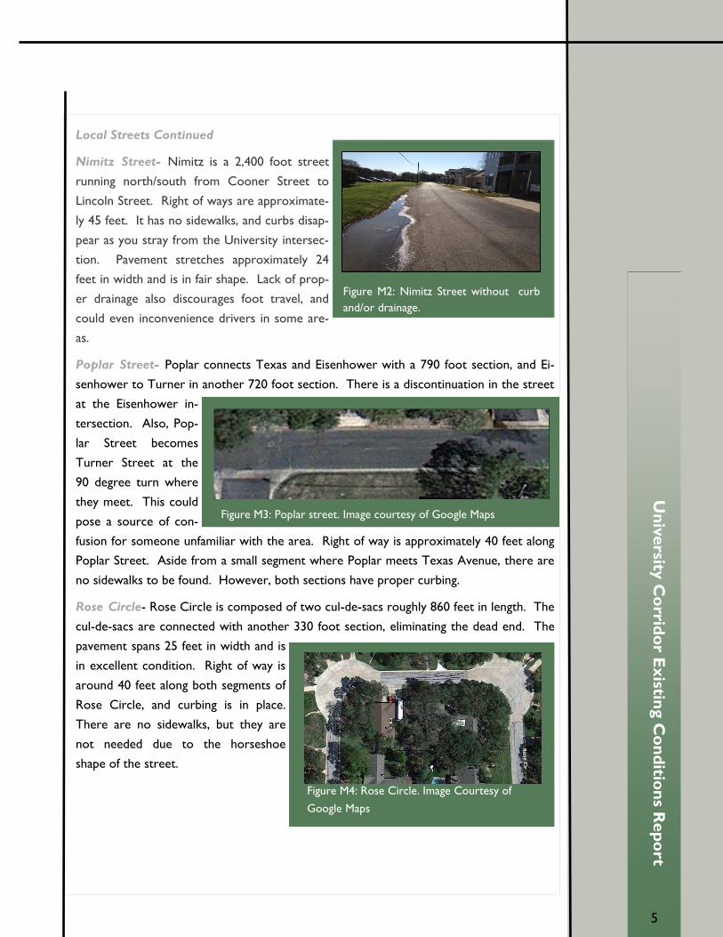
Nimitz Street- Nimitz is a 2,400 foot street
running north/south from Cooner Street to
Lincoln Street. Right of ways are approximate-
ly 45 feet. It has no sidewalks, and curbs disap-
pear as you stray from the University intersec-
tion. Pavement stretches approximately 24
feet in width and is in fair shape. Lack of prop-
er drainage also discourages foot travel, and
could even inconvenience drivers in some are-
as.
Poplar Street- Poplar connects Texas and Eisenhower with a 790 foot section, and Ei-
senhower to Turner in another 720 foot section. There is a discontinuation in the street
at the Eisenhower in-
tersection. Also, Pop-
lar Street becomes
Turner Street at the
90 degree turn where
they meet. This could
pose a source of con-
fusion for someone unfamiliar with the area. Right of way is approximately 40 feet along
Poplar Street. Aside from a small segment where Poplar meets Texas Avenue, there are
no sidewalks to be found. However, both sections have proper curbing.
Rose Circle- Rose Circle is composed of two cul-de-sacs roughly 860 feet in length. The
cul-de-sacs are connected with another 330 foot section, eliminating the dead end. The
pavement spans 25 feet in width and is
in excellent condition. Right of way is
around 40 feet along both segments of
Rose Circle, and curbing is in place.
There are no sidewalks, but they are
not needed due to the horseshoe
shape of the street.
Figure M2: Nimitz Street without curb
and/or drainage.
Figure M3: Poplar street. Image courtesy of Google Maps
Figure M4: Rose Circle. Image Courtesy of
Google Maps

6
University Flows: Mobility & Infrastructure | April 26, 2013
Un
iversity
Co
rrido
r Existin
g C
on
ditio
ns R
ep
ort
6
Munson Avenue- Munson Avenue stretches approxi-
mately 5,000 feet from Lincoln to Harvey. Although it
shares the same thoroughfare context (urban) and speed
limit (30 mph) as the other local streets, it’s thoroughfare
type is classified as avenue rather than street. Also, out-
side of the focus area (south of Dominik) it changes from
a local/residential street to a minor collector. Street
width and right of way are approximately 25 feet and 40
feet respectively. Sidewalks of six feet in width are found
only on the east side of the avenue, and bike lanes are
absent.
Shady Lane- Shady Lane is located north of University
on the edge of the focus area. At 20 feet in width it
is the narrowest of the streets, and has a right of way
easement of approximately 40 feet. Sidewalks and
curbs are both absent, and pavement condition is
poor near the dead end of the street. Also, the in-
tersection shared with South Rosemary Drive is un-
orthodox. The design of the streets makes for a dis-
astrously dangerous intersection.
Figure M5: Munson Avenue blah
balah
Figure M6: Shady Lane. Image courte-
sy of Google Maps

University Drive East
Corridor Existing
Conditions Report UF U N I V E R S I T Y F L O W
M o b i l i t y & I n f r a s t r u c t u r e
7
The University Corridor Through the Eyes of the Pedestrian Cyclist Collage
The center and top left images are the typical sidewalks seen along University Drive. The
six lane major arterial is hostile and unfriendly because it’s primarily scaled for the auto-
mobile. It lacks pedestrian friendly elements such as street trees. The bottom and middle
right images are typical sidewalk obstructions seen in residential areas northwest of Uni-
versity Drive. These obstructions prevent safe pedestrian circulation and significantly in-
hibit movement of wheel-chair or stroller based pedestrians. A Brown Trail is presented
by the bottom left image. Prevalent in areas northwest of University, these trails appear
where a sidewalk should be. The top right displays residential land uses that lack side-
walks. The current system is problematic seeing as most walkways empty directly into the
street.
A major objective in corridor planning is to enhance the walkability of the ar-
ea. By far, the University Corridor is perhaps the most unfriendly of all of the
corridors in College Station. Significant Improvements are needed to trans-
form this perspective. Presented below are the distinct areas throughout the
University Corridor, what unites them is the lack of a safe, friendly, pedestrian
-oriented environment.

8
University Flows: Mobility & Infrastructure | April 26, 2013
Un
iversity
Co
rrido
r Existin
g C
on
ditio
ns R
ep
ort
8
Bicycle and Pedestrian Mobility Introduction
The University Corridor is one of the harshest environments to pedestrians and bicyclists in
College Station. The data presented here is a depiction of baseline conditions of the corridor
from the perspective of a pedestrian or cyclist. Bike and pedestrian routes serve as multi-
modal transportation alternatives to main automobile thoroughfares. The pedestrian friendly
pathways are built to improve connectivity and accessibility, increase safety, encourage envi-
ronmental stewardship, and increase outdoor recreation. The element of pedestrian and cyclist
mobility has become a much larger component of transportation due to the growth of Texas
A&M University. Circulation within the University Corridor features a wide range of travelers
from students to shoppers, employees to out-of-towners.
Sidewalk Widths
Most sidewalks in the University Corridor measure between four to
six feet. Most sidewalks along major arterials are wider than those
featured along smaller, local streets. Tarrow features two sidewalks,
with the first measuring four feet and the second measuring five feet.
The sidewalks of Spring Loop measure four feet on either side. Lin-
coln is comprised of four sidewalks with the first measuring four feet,
the second six feet, the third approximately four and a half feet, and
the fourth six feet again. Many of the neighborhood streets feature
narrow sidewalks, often only on one side. Such is the case with Au-
tumn Court, Park Road, Summer Court, and Chimney Hill. Autumn
Court’s measures three feet and ten inches, while Park Road’s, Sum-
mer Court’s, and Chimney Hill’s all measure four feet. Several neigh-
borhood streets have no sidewalks at all, such as Fall Court, April
Bloom, and Arguello Drive. For a graphical perspective please
see figure PB1.
Sidewalk Nature & Obstructions
Many of the sidewalks are newly constructed and quite smooth.
Sidewalks feature are meagerly landscaped. This landscapes is
often grass. In some areas this grass grows into the cracks of
the sidewalks. This could prove to be an issue in the long term
on from a sidewalk life expectancy standpoint. Throughout the
corridor there are two common sidewalk obstructions: large,
industrial-like trash cans and large mailboxes. Both occur exclu-
sively on sidewalks along neighborhood streets. Less frequent
are gas wells, normally seen along University Drive. All fire hy-
drants, are kept a good distance away from the sidewalks/
potential space for a sidewalk and do not impede foot traffic.
Pedestrian Connectivity
Pedestrian connectivity in the University Corridor needs to be improved upon. While there is
pedestrian infrastructure, such as designated crosswalks and the like, throughout the area,
many spots are still unsafe and unsuitable for walking. The best sidewalks exist along the major
arterials, such as Spring Loop/Lincoln and Tarrow Street. Sidewalks in the along Local Streets
are too narrow. This combined with an overall lack of uniformity amongst Local Street side-
walks makes pedestrian mobility in these areas a chore. There are even some streets with no
sidewalks at all, such as Arguello Drive and Texas Avenue West. Pedestrian mobility is signifi-
cant in this corridor since it’s a major hub of hotel and commercial activity in College Station.
Figure PB2: Mailbox side-
walk obstruction
Figure PB2: Mailbox
sidewalk obstruction

9
9
Un
iversity
Co
rrido
r Existin
g C
on
ditio
ns R
ep
ort
Bicycle Lane Conditions
Bicycle lanes in the University Corridor need to be im-
proved upon. Most of the designated lanes are very
worn and faded. Please note figure PB 3. This is espe-
cially problematic along minor arterials, such as Lincoln/
Spring Loop. Unlike bike routes, bicycle lanes are desig-
nated areas for the safe and efficient travel of cyclists.
As road legal modes of travel, these lanes should be
treated as qualitative equals in terms of lane stripping.
Type of Facilities
Bicycle and pedestrian facilities can include a variety of
items. The following define the various types of bicycle and pedestrian facilities that are uti-
lized or are proposed for the University Corridor:
Bike Lane - a designated part of the roadway that is striped, signed, and has pavement mark-
ings to be used exclusively by bicyclists.
Bike Route - a roadway that is shared by both bicycles and motor vehicles. Wide outside
lanes and shoulders can serve as bike routes with signage.
Sidewalks - walkways alongside roads, typically five to eight feet wide, for pedestrians.
Side Path (Multi-use Path) - a wider sidewalk (10-12 feet wide) alongside a road with minimal
cross flow by motor vehicles to be used by bicyclists and pedestrians.
Bike Lock Elements-places to lock bicycles to that are visible, out of harm’s way, visually ap-
pealing, secure, and can accommodate an adequate number of bikes.
Additional facilities include crosswalks, ramps, medians, street trees, trash cans, signage, and
signals. These items contribute to the overall identification, accessibility, and safety of among
all modes of travel.
Bicycle Connectivity
Bicycle connectivity in the University Corridor is adequate, however the current routes and
lanes lack proper maintenance, and therefore look dismal. In addition to worn down bike
lane stripping, there is a lack of uniformity amongst the lanes. This is due to the fact that
several streets are without bike lanes at all, such as along Walton Drive and Francis Drive.
As of April 2013, the city of College Station has proposed bike lanes for these streets.
Streets that do not have proposals for bike lane extension should provide signage to alert
cyclist of the next closes bike route or lane. This enhancement, along with the increased
maintenance of existing lanes would provide improved bicycle connectivity throughout the
corridor. As College Station grows the importance and prevalence of the cyclist will become
more and more important. The connectivity of these lanes will ensure harmony among mo-
torists and bicyclists alike.
Strategies for Improvement of Pedestrian & Bicycle Connectivity
Below is a list of strategies that could be implemented to improve the overall experience of
pedestrian and bicycle travel throughout the University Corridor:
Signage to notify riders of a terminating route
Provide neighborhood sidewalks along local streets northwest of University Drive.
Increased bicycle infrastructure at properties. There is a significant lack of places to lock
up ones bicycle.
Figure PB3: Bike Lane stripping
peeling away
10
University Flows: Mobility & Infrastructure | April 26, 2013
Un
iversity
Co
rrido
r Existin
g C
on
ditio
ns R
ep
ort
10
Strategies for Improvement of Pedestrian & Bicycle Connectivity Continued
Placement of street trees to provide scale and soften the hostility of University Drive’s
major arterial on the cyclist and pedestrian alike,
Additional signage for pedestrians and bicyclists as necessary.
Widen sidewalks at designated points
Transit Introduction
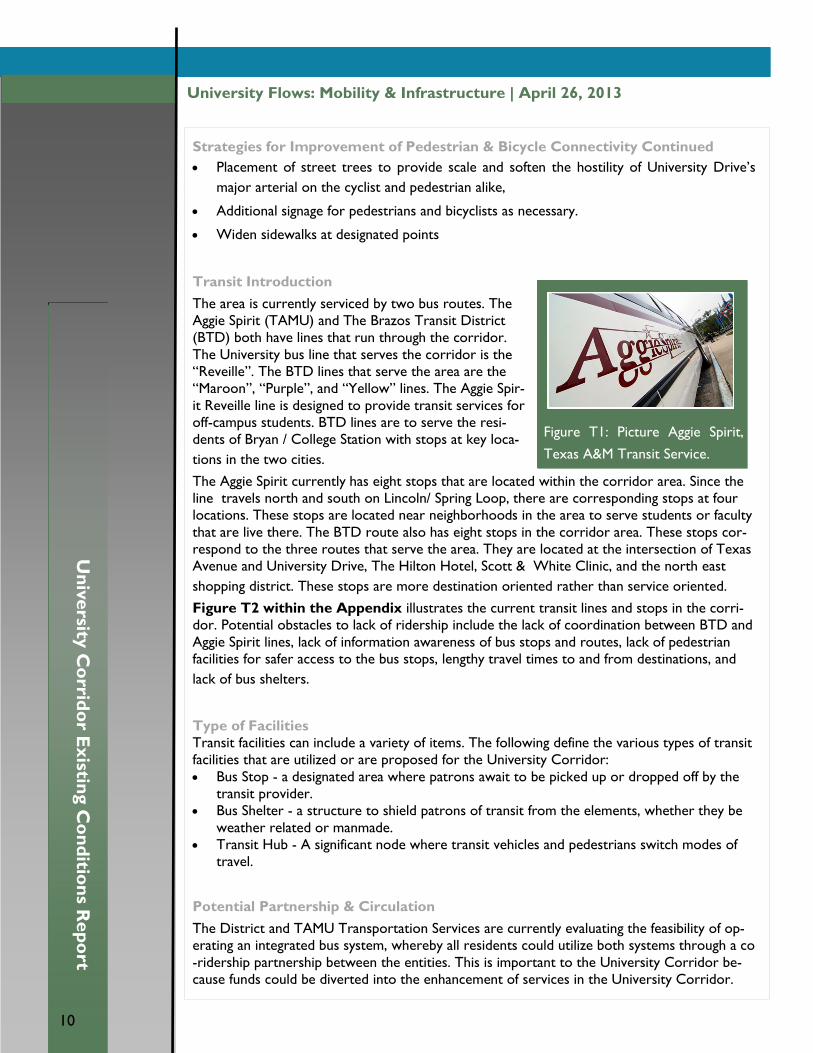
The area is currently serviced by two bus routes. The
Aggie Spirit (TAMU) and The Brazos Transit District
(BTD) both have lines that run through the corridor.
The University bus line that serves the corridor is the
“Reveille”. The BTD lines that serve the area are the
“Maroon”, “Purple”, and “Yellow” lines. The Aggie Spir-
it Reveille line is designed to provide transit services for
off-campus students. BTD lines are to serve the resi-
dents of Bryan / College Station with stops at key loca-
tions in the two cities.
The Aggie Spirit currently has eight stops that are located within the corridor area. Since the
line travels north and south on Lincoln/ Spring Loop, there are corresponding stops at four
locations. These stops are located near neighborhoods in the area to serve students or faculty
that are live there. The BTD route also has eight stops in the corridor area. These stops cor-
respond to the three routes that serve the area. They are located at the intersection of Texas
Avenue and University Drive, The Hilton Hotel, Scott & White Clinic, and the north east
shopping district. These stops are more destination oriented rather than service oriented.
Figure T2 within the Appendix illustrates the current transit lines and stops in the corri-
dor. Potential obstacles to lack of ridership include the lack of coordination between BTD and
Aggie Spirit lines, lack of information awareness of bus stops and routes, lack of pedestrian
facilities for safer access to the bus stops, lengthy travel times to and from destinations, and
lack of bus shelters.
Type of Facilities
Transit facilities can include a variety of items. The following define the various types of transit
facilities that are utilized or are proposed for the University Corridor:
Bus Stop - a designated area where patrons await to be picked up or dropped off by the
transit provider.
Bus Shelter - a structure to shield patrons of transit from the elements, whether they be
weather related or manmade.
Transit Hub - A significant node where transit vehicles and pedestrians switch modes of
travel.
Potential Partnership & Circulation
The District and TAMU Transportation Services are currently evaluating the feasibility of op-
erating an integrated bus system, whereby all residents could utilize both systems through a co
-ridership partnership between the entities. This is important to the University Corridor be-
cause funds could be diverted into the enhancement of services in the University Corridor.
Figure T1: Picture Aggie Spirit,
Texas A&M Transit Service.

11
11
Un
iversity
Co
rrido
r Existin
g C
on
ditio
ns R
ep
ort
Potential Partnership & Circulation Continued
Additionally, a partnership forged between The District and TAMU presents that there
does appear to be a desire to create partnerships where they are mutually beneficial.
A partnership between BTD and the Aggie Spirit could help reach the dead spots the cur-
rent transit lines do not touch. These spots include the placement of bus stops in the
fronts of the hotels and within the large commercial property adjacent to Frontage Road
and Highway 6.
This opportunity could reduce inefficiency in areas of overlap, increase ridership, establish
stronger transfer points, and provide more destinations. Additionally, a unified system
would allow the Brazos Transit funding to be utilized for the upgrade of existing TAMU
Transportation Services stops.
Strategies for Improvement of Transit
Bus shelters to increase visibility of transit lines and provide protection from the ele-
ments, most notably the sun
Placement of a transit hub within the shopping district adjacent to Frontage Road.
Construction of bus turn ins so as to no inhibit the flow of traffic along University
Drive.
Placement of bus stops in front of key locations. I.e. Hilton Hotel and within Shopping
District
Coordination between TAMU and BTD transit systems for greater uniformity of ser-
vice, increased service area, and more diverse riders.
Change transit vehicle color schemes to enhance visibility of the vehicles and set them
apart from traffic.
Retrofit buses with bike carrying abilities to encourage intermodal travel

University Drive East
Corridor Existing
Conditions Report UF U N I V E R S I T Y F L O W
M o b i l i t y & I n f r a s t r u c t u r e
12
Infrastructure can be defined as the most basic level of an organizational structure, com-
piled of public systems and services, serving as the foundation for any modern day devel-
opment. Each aspect of infrastructure plays a vital role in the success and functioning of
the city, College Station is no different. To assess University Corridor’s infrastructure we
examine specifically: Water Facilities- size of lines/location of hydrants, Sewer Facilities-
size of lines/capacity, Storm Sewer Facilities, and Street Lighting-location/type.
Water and Sewer Capacity
Water & Sewer Lines
The water and sewer infrastructure throughout the University Corridor is a mix of new
and old.. The water and sewer infrastructure is primarily composed of distribution and
gravity mains. There are five fire mains throughout the site. These mains are primarily lo-
cated within commercial parcels, with the exception of two. One is at the northeast end
of the intersection of Lincoln and University Drive and the other is approximately 360 ft.
northwest of Spring Loop. The water infrastructure in the southern vicinity is in adequate
condition. This is stated since as of April of 2013 there have been no suggestions for signif-
icant improvements or rehabilitation projects of neither water nor sewer lines in the area.
In the northern vicinity a major rehabilitation project called the College Heights Rehabilita-
tion will commence in the 2015-2016 Fiscal year. The scope of this project includes Eisen-
hower Street, University Drive, Jane Street, and Nimitz Street. The water and sewer infra-
structure has been cited for rehabilitation for numerous reasons. The recent growth of
the area has begun to place significant strain on the current system. This increased usage
has also led some lines to rapidly deteriorate and fail, resulting in service disruptions. Last-
ly, current lines provide inadequate fire protection. The project will include the installation
of approximately 4,000 linear feet (LF) of 8-inch water distribution line, approximately
2,000 LF of 12-inch water distribution line, approximately 1,000 LF of 6-inch sanitary sew-
er collection line, and approximately 5,000 LF of 8-inch sanitary sewer collection line. This
project is set to begin in the 2015-16 fiscal year and has been budgeted to cost $3,726,688.
Fire hydrants
Fire hydrants serve as College Stations primary source of water during a fire emergency.
Fire hydrants in the city of College Station must be placed among the approved fire lane,
must be accessible at all times, must be located on the same side of the street it is intend-
ed to serve, and must have a three foot (3’) clear space on all sides of the fire hydrant. No
part of any structure above ground tanks or fueling station can be more than three hun-
dred feet (300’) from a fire hydrant, and any commercial building must be within
13
13
Un
iversity
Co
rrido
r Existin
g C
on
ditio
ns R
ep
ort
Fire Hydrants Continued
one hundred and fifty feet (150’) arc point from where a fire apparatus can operate.
The number and spacing of fire hydrants within College Station shall be no less the dimen-
sions presented in the chart entitled Number and Distribution of Fire Hydrants in the Ap-
pendix section.
Within the University Corridor there are a total of 67 fire hydrants. Each of the hydrants
are constructed along main water distribution lines. Predominantly, the main distribution
lines run along the main and arterial roads in order to reach every established building.
The highest concentration of fire hydrants lies within the area intersecting with Highway 6.
This area requires more fire hydrants due to the higher concentration of commercial
buildings, residential buildings, and fueling stations.
Fire hydrants provide safety to the affected areas, College Station adheres to city and fed-
eral standards in order to provide adequate and efficient water supply during a fire emer-
gency.
Street Lights
The University Corridor features a total of 269 street lights. All of them can be catego-
rized into one of four types: Cobra Head, Decorative, Flood, or Security.
Of these four types, the Cobra Head is the most common with 183 fixtures throughout
the study area. Most of these lights line major arterial roads, specifically University Drive,
Tarrow Street, and Spring Loop/Lincoln Avenue (73 along University and 22 each along
Tarrow and Spring Loop/Lincoln). 66 cobra heads are not lined along main arteri-
als. Instead, these ones are sparsely placed along the roads of residential neighborhoods.
The second most common type is Security. The corridor features 67 street lights of this
type, located predominately in residential neighborhoods. They have an especially strong
presence in neighborhoods off of Spring Loop and Nimitz Street.
There are 15 Decorative street lights, all placed within one residential neighborhood be-
tween Tarrow Stret and Paster Street. The corridor features only 1 Flood street light. Its
location is at the corner of Tarrow Street and Autumn Circle.
Street lights are a very important attribute to roads and neighborhoods. There should be
an increase in street lights on interior neighborhood streets, such as the area in-between
Tarrow Street and Chimney Hill Drive. This particular area is part residential and part
commercial. The lack of lighting in this area leaves both parts vulnerable to criminal activi-
ty a night. An increase Security lighting in this area would help ensure that both the homes
and businesses in this area are kept safe. A Map of Street Lights is provided in the Appen-
dix Section.
University Drive East
Corridor Existing
Conditions Report UF U N I V E R S I T Y F L O W
M o b i l i t y & I n f r a s t r u c t u r e
14
Appendix & References
The information presented in the university flows section was either created or refer-
enced from other material provided by other parties. Listed here are maps, charts, ta-
bles,, and large figures that couldn’t be comfortably displayed in the main sections. In ad-
dition to these created elements is the list of references the section used as references.
References
Presented below are links and documents that were used to compile this existing conditions
report. All of these links lead to College Station created documents with the exception of the
BCS Unified Design Guidelines.
BCS United. (2012). Bryan college station unified design guideline, manuals, technical
specifications, and standard construction details. (). Bryan-College Station: BCS United.
City of College Station. Street cross sections. Retrieved 04/08, 2013, from http://
www.cstx.gov/Modules/ShowDocument.aspx?documentid=4907
City of College Station. (2009). Existing traffic volumes. Retrieved 03/28, 2013, from
http://www.cstx.gov/Modules/ShowDocument.aspx?documentid=4901
City of College Station. (2009). Thoroughfare context class. Retrieved 03/22, 2013, from
http://www.cstx.gov/Modules/ShowDocument.aspx?documentid=4899
City of College Station. (2009). Thoroughfare functional classification. Retrieved 03/22,
2013, from http://www.cstx.gov/Modules/ShowDocument.aspx?documentid=4898
City of College Station. (2009). Thoroughfare type. Retrieved 03/22, 2013, from Thor-
oughfare Type
City of College Station. (2009). Transportation overview (comprehensive plan). Re-
trieved 04/15, 2013, from http://www.cstx.gov/Modules/ShowDocument.aspx?
documentid=4516
City of College Station. (2010). City of college station existing condit report 2010
. (Existing Conditions). College Station:
City of College Station. (2011). 2011 wastewater master plan, area 1
. Retrieved 04/17, 2013, from http://cstx.gov/modules/ShowDocument.aspx?
documentid=11977
City of College Station. (2012). Bike route map. Retrieved 03/22, 2013, from http://
www.cstx.gov/Modules/ShowDocument.aspx?documentid=15478

15
15
Un
iversity
Co
rrido
r Existin
g C
on
ditio
ns R
ep
ort
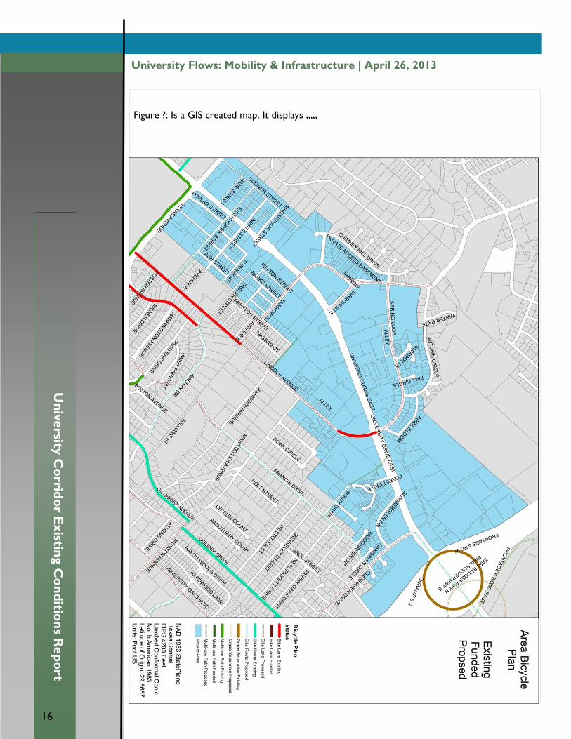
Figure ?: Is a GIS created map. It displays ,,,,,
16
University Flows: Mobility & Infrastructure | April 26, 2013
Un
iversity
Co
rrido
r Existin
g C
on
ditio
ns R
ep
ort
16
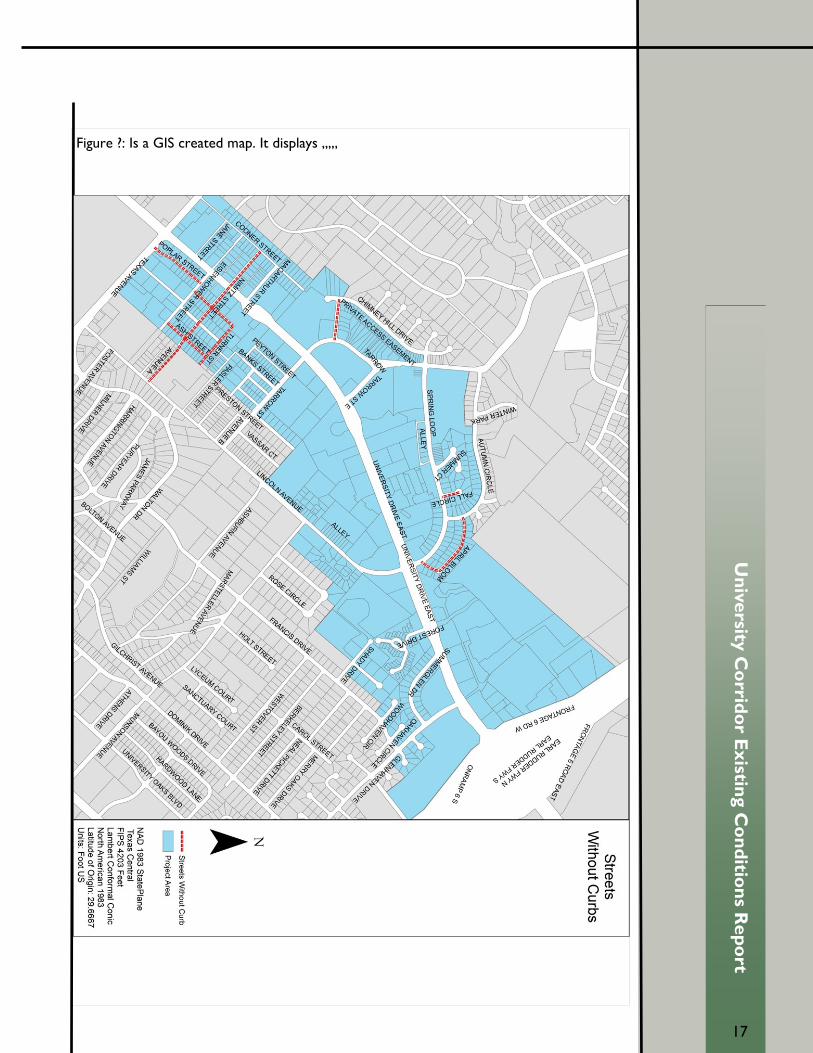
Figure ?: Is a GIS created map. It displays ,,,,,
17
17
Un
iversity
Co
rrido
r Existin
g C
on
ditio
ns R
ep
ort
Figure ?: Is a GIS created map. It displays ,,,,,

18
University Flows: Mobility & Infrastructure | April 26, 2013
Un
iversity
Co
rrido
r Existin
g C
on
ditio
ns R
ep
ort
18
Figure ?: Is a GIS created map. It displays ,,,,,

19
19
Un
iversity
Co
rrido
r Existin
g C
on
ditio
ns R
ep
ort
Figure ?: Is a GIS created map. It displays ,,,,,
20
University Flows: Mobility & Infrastructure | April 26, 2013
Un
iversity
Co
rrido
r Existin
g C
on
ditio
ns R
ep
ort
20
Figure ?: Is a GIS created map. It displays ,,,,,

21
21
Un
iversity
Co
rrido
r Existin
g C
on
ditio
ns R
ep
ort
Figure ?: Is a GIS created map. It displays ,,,,,

22
University Flows: Mobility & Infrastructure | April 26, 2013
Un
iversity
Co
rrido
r Existin
g C
on
ditio
ns R
ep
ort
22
Figure ?: Is a GIS created map. It displays ,,,,,
23
23
Un
iversity
Co
rrido
r Existin
g C
on
ditio
ns R
ep
ort
Figure ?: Is a GIS created map. It displays ,,,,,