upper yellow river watershed (uw05)dnr.wi.gov/water/basin/cwrb/uw05 - uw09.pdf · 49 figure uw05-3....
TRANSCRIPT

48
0%
5%
10%
15%
20%
25%
30%
35%
40%
45%
50%
Per
cen
tag
e
Agricu
lture
Fores
t
Wet
land
Grass
land
Barre
n
Land Cover
Figure UW05-1 Current Land use in the Upper Yellow River Watershed
0
10
20
30
40
50
60
70
80
90
Woodland Grassland Wetland
Figure UW05-2 Pre-Settlement Vegetative Cover for the Upper Yellow River Watershed
UPPER YELLOW RIVER WATERSHED (UW05) WATERSHED SUMMARY The Upper Yellow River Watershed (Map UW05) is located in the counties of Wood, Clark and Marathon. The Upper Yellow River Watershed includes the upper reaches of the Yellow River to the Dexter Lake Dam. This watershed was ranked using the Nonpoint Source Priority Watershed Selection Criteria. Based on surface and ground water data, the overall ranking is high. This overall ranking establishes the watershed as a high priority for future grant eligibility through the Nonpoint Source Program. In 1993, a nonpoint source control plan was approved for the Upper Yellow River Watershed. The anticipated completion date is December 2003 (Haynes, 1994). Surface water erosion is a problem in the watershed. The heavy silt loam soils and steep slopes promote rapid runoff. The Wood County Erosion Control Plan ranked the Upper Yellow River Watershed the highest priority for NPS control management practices. Animal waste runoff from barnyards or pasturelands occurs on the main tributaries of the Yellow River. A 1985 preliminary inventory identified 40 barnyards with approximately 2,000 head of cattle, within 1,000 feet of the major tributaries of the Yellow River.Rapid surface water runoff can carry manure nutrients to these streams because of the poorly drained soils (Aron, 1979). Biotic index values for those streams sampled indicated fair to poor water quality. The Wood County Erosion Control Plan ranked the Upper Yellow River Watershed the highest priority for developing an erosion control plan. With the steep slopes and low infiltration and agriculture taking up 50 percent of the watershed, environmentally safe practices should be established. The study recommends several practices that could be installed to protect the soils from being eroded by wind and thereby protect surface water quality. Some of these practices include; crop rotation, conservation tillage, cover crops, field wind breaks, nutrient management plans, pest management plans, crop residue management and wind barriers. These practices and others are explained further in the final report titled Wind Erosion Impacts on Water Quality in the Sand Plain of Central Wisconsin, 1993. POPULATION DEMOGRAPHICS
49
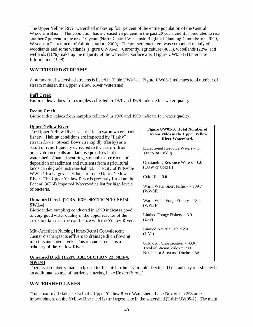
Figure UW05-3. Total Number of Stream Miles in the Upper Yellow
River Watershed.
Exceptional Resource Waters = .3 (ERW or Cold I) Outstanding Resource Waters = 0.0 (ORW or Cold II) Cold III = 0.0 Warm Water Sport Fishery = 109.7 (WWSF) Warm Water Forge Fishery = 13.0 (WWFF) Limited Forage Fishery = 3.0 (LFF) Limited Aquatic Life = 2.0 (LAL) Unknown Classification = 43.0 Total of Stream Miles =171.0 Number of Streams / Ditches= 38
The Upper Yellow River watershed makes up four percent of the entire population of the Central Wisconsin Basin. The population has increased 25 percent in the past 20 years and it is predicted to rise another 7 percent in the next 10 years (North Central Wisconsin Regional Planning Commission, 2000, Wisconsin Department of Administration, 2000). The pre-settlement era was comprised mainly of woodlands and some wetlands (Figure UW05-2). Currently, agriculture (46%), woodlands (22%) and wetlands (16%) make up the majority of the watershed surface area (Figure UW05-1) (Enterprise Information, 1998). WATERSHED STREAMS A summary of watershed streams is listed in Table UW05-1. Figure UW05-3 indicates total number of stream miles in the Upper Yellow River Watershed. Puff Creek Biotic index values from samples collected in 1976 and 1979 indicate fair water quality. Rocky Creek Biotic index values from samples collected in 1976 and 1979 indicate fair water quality. Upper Yellow River The Upper Yellow River is classified a warm water sport fishery. Habitat conditions are impacted by “flashy” stream flows. Stream flows rise rapidly (flashy) as a result of runoff quickly delivered to the streams from poorly drained soils and landuse practices in the watershed. Channel scouring, streambank erosion and deposition of sediment and nutrients from agricultural lands can degrade instream-habitat. The city of Pittsville WWTP discharges its effluent into the Upper Yellow River. The Upper Yellow River is presently listed on the Federal 303(d) Impaired Waterbodies list for high levels of bacteria. Unnamed Creek (T23N, R3E, SECTION 10, SE1/4, SW1/4) Biotic index sampling conducted in 1990 indicates good to very good water quality in the upper reaches of the creek but fair near the confluence with the Yellow River. Mid-American Nursing Home/Bethel Convalescent Center discharges its effluent to drainage ditch flowing into this unnamed creek. This unnamed creek is a tributary of the Yellow River. Unnamed Ditch (T22N, R3E, SECTION 23, NE1/4, NW1/4) There is a cranberry marsh adjacent to this ditch tributary to Lake Dexter. The cranberry marsh may be an additional source of nutrients entering Lake Dexter (Storet). WATERSHED LAKES Three man-made lakes exist in the Upper Yellow River Watershed. Lake Dexter is a 298-acre impoundment on the Yellow River and is the largest lake in the watershed (Table UW05-2). The main
50
portion of the lake lies entirely within the Wood County Forest. The lake is eutrophic with high chlorophyll a and total phosphorus concentrations during the growing season. Nutrient and sediment loading is likely a result of non-point source runoff from the watershed. Wood County maintains two parks on the lake providing recreation opportunities for the public. The lake supports a warm water sport fishery with northern pike, largemouth bass and panfish being the most dominant species. Recent water quality and fishery data is not available. GROUNDWATER The Upper Yellow River Watershed contains two municipal water systems, Spencer on the north end and Pittsville near the south (Table UW05-4). Spencer has a total of three wells, but only two of them are located within this watershed. Wells 1 and 4 are very shallow sand and gravel wells located in small sand and gravel lenses located under the glacial till and above the granite bedrock. These small gravel lenses are relatively low yielding and are often high in iron and manganese. Both Wells 1 and 4 are routed through a gravity filter for removal of iron and manganese. In addition, the water is aerated and injected with chlorine, potassium permanganate, sodium hydroxide and fluoride. The pH adjustment is necessary for optimization of iron and manganese removal as well as to stabilize the corrosive nature of the water. The Village has been searching for an additional source of water to supplement the existing supply and eventually replace Well 1, which was constructed in 1941. Unfortunately, no suitable well locations have been found. The wells have slightly elevated nitrates with concentrations of 3.2 and 3.8 PPM respectively. The wells are also located near a main thoroughfare where gasoline contamination has been identified and low levels of pentachlorophenol have been detected. The Village does not have a well head protection program established at this time. All three wells serving the City of Pittsville are located within the watershed. These wells are drilled into the granite bedrock and are characteristically low yielding. These wells also are high in iron and manganese and are treated with aeration and filtration prior to use. Chemical addition consists of chlorine, potassium permanganate and polyphosphates to inhibit corrosion within the plumbing systems. Nitrate concentrations are near zero in all three wells and therefore not a concern at this time. The Central Wisconsin Groundwater Center conducted nitrate sampling on 193 wells throughout the entire watershed. Of the wells tested 5.2 percent were over the 10 parts per million, the safe drinking water limit of Wisconsin. Of that 5.2 percent nothing reported to be over the 20 parts per million or greater. Of the 230 wells tested for triazine in the Upper Yellow River watershed, 4.8 percent of the wells tested had concentrations at 1.1 parts per billion or greater of triazine. Wells sampled that were over 3.0 parts per billion was at 0.4 percent. Since triazine can not be used to set standards for drinking water limitations, it is strongly recommend that if a test result comes back above 1 parts per billion of triazine, the well should be tested further for total concentrations of atrazine. WATERSHED RECOMMENDATIONS 1. Fish and Aquatic Habitat Staff should conduct baseline monitoring for watershed streams and
Lake Dexter. 2. Watershed Staff should conduct water quality standards review on the unnamed stream (T23N,
R3E, S10, SE ¼, SW ¼) which receives discharge from Bethel Nursing Home. 3. Fish and Aquatic Habitat Staff should conduct fisheries surveys within Rocky Run Creek to
determine the extent of trout waters. 4. Upper Yellow River Watershed should remain a high priority for grant eligibility under the State
Nonpoint Source Pollution Abatement Program. 5. Watershed Staff should evaluate the severity of bacteria problems in the UpperYellow River, as
identified on the 303 (d) List.

51
Table UW05-1.Upper Yellow River Watershed Clark, Marathon & Wood Counties. Square Miles: 224; Stream Miles: 171 NPS Stream Rank: High Stream Name Length
(miles)
Codified Use
Biological Use
(Existing)
Biol. Use
Potential
SUPPORTING USE
FULLY-PART- NOT-THR/MILES
303(d) Listed Water
Assess. Categ. M E U
Trend Integ Indic
Integ Status
Data Leveli
PROBLEMS SOURCE//IMPACT
COM
N R
REF.
Beaver Creek T24NR03ES05 WBIC: 1372400
4.0 DEF WWFF/0-4.0e Same UNK/4.0 E
U B CL/NUT
R 34,109,97,3
Cat Creek T23NR03ES27 WBIC: 1370700
2.0 DEF WWFF/0-2.0e Same UNK/2.0
E U B CL,SB,PWL,PSB, BY/NUT
R 109,3
E. BR. Yellow River T25NR02ES15 WBIC: 1373200
9.0 DEF DEF
WWSF/0-7.0e WWFF/7-9.0e
Same PART/7.0 PART/2.0
E U B CL,PWL,BY URB/NUT
R 34,109,100,8,153
Owl Creek T22NR03ES14 WBIC: 1370300
5.0 DEF WWFF/0-5.0e
Same
UNK/5.0 E U
R 109,103
Puffy Creek T24NR03ES34 WBIC: 1371500
8.0 DEF WWSF/0-8.0e Same PART/8.0 E U F B,P,H CL,PWL,BY/NUT N 34,109,104,3,161
Rocky Creek T23NR03ES21 WBIC: 1370800
17.0 DEF ERW DEF
WWSF/0-14.0e Cold I/14-14.3b WWSF/14.3-17e
Same Same Same
PART/14.0 PART/0.3 PART/2.7
M U F B,P,H CL,BY,PWL/NUT N 109,153,178,3,161
S. BR. Yellow River T25NR02ES08 WBIC: 1372600
18.0 DEF WWSF/0-18.0e Same PART/18.0 E U B CL,BY,PWL/NUT R 34,109,106,3
Yellow River T17NR04ES08 WBIC: 1352800
60.0 DEF WWSF/0-60.0e Same PART/60.0 BAC. M U P – F B,P,C,H
CL,BY,PWL,SB, PSB/SILT,NUT,
PSM/
R 34,109,177, 112,111,23,
16,3,161 Unnamed Creek T23NR03ES10 WBIC: 1371200
5.0 LFF LAL
LFFc/0-3.0c LALc/3-5.0c
Same Same
FULLY/3.0 FULLY/2.0
E U G – VG B,P BY,PWL/NUT BDAM/HAB,FLOW
PSM/
R 34,73,3
Unnamed Ditch T22NR03ES23NENW WBIC:1370000
2.0 DEF UNK/0-2.0 UNK/2.0 UNK/2.0 E U CM R 111
20 Unnamed Creeks 33.0 8 Unnamed Ditches 8.0
Table UW05-2. Upper Yellow River Watershed. Wood, Clark & Marathon Counties. NPS Lake Rank: High
Lake Name Fishery
Use
Access Area (acres) Max/Mean
Depth (Feet)
Lake
Type
Watershed Drainage
Phos. Class
TSI Range
Fish Advis. LMO Impair
Source/Impact
Aquatic Plant Data
Exotics Self-Help Monitoring
Recommends.
Dexter Lake T22NR03ES23 1369900
Panfish LM Bass
N. Pike
BR 298.0 17/6 DG 6.54 1B NT No NPS / Winter Kill . . SECCHI .
Lake Manakiki T24NR03ES34 1371400
Panfish No 8.0 6/UNK DG 135.0 2C NT No NPS / Hab
Lake Kaunewinne T24NR03ES33 1371900
Panfish No 5.0 7/UNK DG 122.0 2C NT No NPS / Hab
1 Unnamed Lake 2.0
52
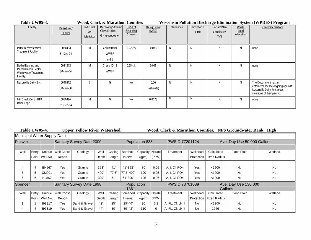
Table UW05-3. Wood, Clark & Marathon Counties Wisconsin Pollution Discharge Elimination System (WPDES) Program Facility Permit No./
Expires
Industrial Or Municipal
Receiving Stream/ Classification G = groundwater
Q710 of Receiving
Stream
Design Flow (MGD)
Variances Phosphorus Limit
Facility Plan Candidate?
Y/N
Waste Load
Allocation
Recommendations
Pittsville Wastewater Treatment Facility
0020494
31-Dec-04
M Yellow River
WWSF
and G
0.22 cfs 0.073 N N N N none
Bethel Nursing and Rehabilitation Center Wastewater Treatment Facility
0031313
30-Jun-04
M Creek 10-12
WWSF
0.25 cfs 0.015 N N N N none
Nasonville Dairy, Inc. 0040312
30-Jun-00
I G NA 0.06
(estimate)
N N N
N The Department has an enforcement case ongoing against Nasonville Dairy for serious violations of their permit..
Mill Creek Corp - DBA River Edge
0060496
31-Dec-04
M G NA 0.0075 N N N N none
Table UW05-4. Upper Yellow River Watershed. Wood, Clark & Marathon Counties. NPS Groundwater Rank: High
Municipal Water Supply Data
Pittsville Sanitary Survey Date 2000 Population 838 PWSID 77201124 Ave. Day Use 50,000 Gallons
Well Entry Unique Well Const. Geology Well Casing Borehole Capacity Nitrate Treatment Wellhead Calculated Flood Plain Wetland
Point Well No. Report Depth Length Interval (gpm) (PPM) Protection Fixed Radius
4 4 BH567 Yes Granite 353' 41' 41'-353' 80 0.05 A, I, Cl, PO4 Yes <1200' No No
5 5 CM201 Yes Granite 400' 77.5' 77.5'-400' 100 0.05 A, I, Cl, PO4 Yes <1200' No No
6 6 HL862 Yes Granite 300' 61' 61'-300' 105 0.06 A, I, Cl, PO4 Yes <1200' No No
Spencer Sanitary Survey Date 1998 Population 1861
PWSID 73701089 Ave. Day Use 130,000 Gallons
Well Entry Unique Well Const. Geology Well Casing Screened Capacity Nitrate Treatment Wellhead Calculated Flood Plain Wetland
Point Well No. Report Depth Length Interval (gpm) (PPM) Protection Fixed Radius
1 1 BG317 Yes Sand & Gravel 42' 25' 25'-40' 90 3.2 A, FL, Cl, pH, I No <1200' No No
4 4 BG319 Yes Sand & Gravel 44' 30' 30'-42' 110 0 A, FL, Cl, pH, I No 1246' No No
53
0%
5%
10%
15%
20%
25%
30%
35%
40%
Pe
rce
nta
ge
Fores
t
Agricu
lture
Grass
land
Wet
land
Barre
n
Shrub
land
Open
Wat
er
Land Cover
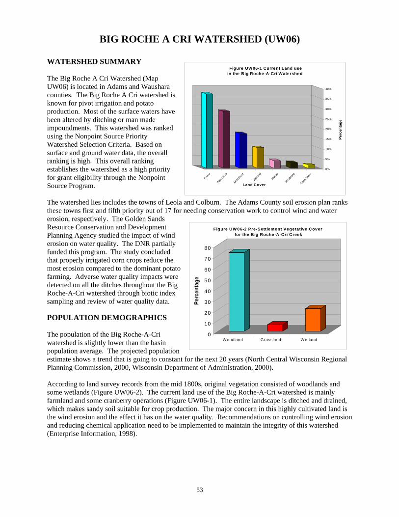
Figure UW06-1 Current Land use in the Big Roche-A-Cri Watershed
0
10
20
30
40
50
60
70
80
W oodland Grassland W etland
Figure UW 06-2 Pre-Settlem ent Vegetative Cover for the Big Roche-A-Cri Creek
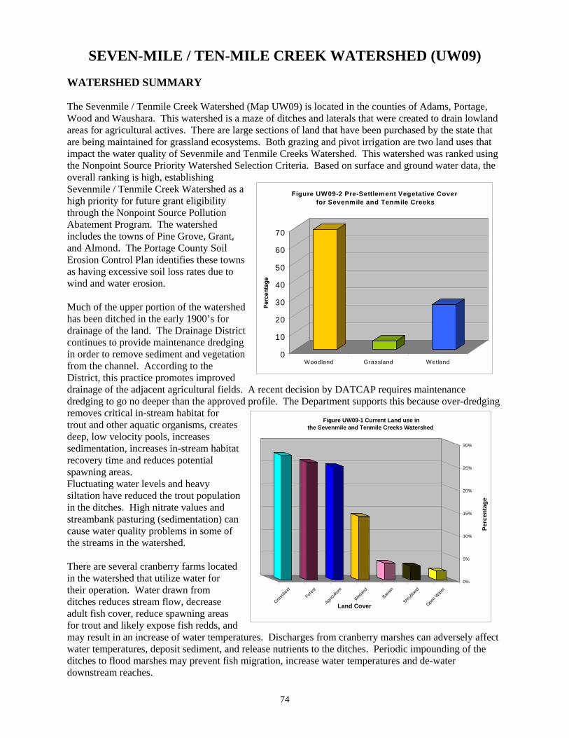
BIG ROCHE A CRI WATERSHED (UW06) WATERSHED SUMMARY The Big Roche A Cri Watershed (Map UW06) is located in Adams and Waushara counties. The Big Roche A Cri watershed is known for pivot irrigation and potato production. Most of the surface waters have been altered by ditching or man made impoundments. This watershed was ranked using the Nonpoint Source Priority Watershed Selection Criteria. Based on surface and ground water data, the overall ranking is high. This overall ranking establishes the watershed as a high priority for grant eligibility through the Nonpoint Source Program. The watershed lies includes the towns of Leola and Colburn. The Adams County soil erosion plan ranks these towns first and fifth priority out of 17 for needing conservation work to control wind and water erosion, respectively. The Golden Sands Resource Conservation and Development Planning Agency studied the impact of wind erosion on water quality. The DNR partially funded this program. The study concluded that properly irrigated corn crops reduce the most erosion compared to the dominant potato farming. Adverse water quality impacts were detected on all the ditches throughout the Big Roche-A-Cri watershed through biotic index sampling and review of water quality data. POPULATION DEMOGRAPHICS The population of the Big Roche-A-Cri watershed is slightly lower than the basin population average. The projected population estimate shows a trend that is going to constant for the next 20 years (North Central Wisconsin Regional Planning Commission, 2000, Wisconsin Department of Administration, 2000). According to land survey records from the mid 1800s, original vegetation consisted of woodlands and some wetlands (Figure UW06-2). The current land use of the Big Roche-A-Cri watershed is mainly farmland and some cranberry operations (Figure UW06-1). The entire landscape is ditched and drained, which makes sandy soil suitable for crop production. The major concern in this highly cultivated land is the wind erosion and the effect it has on the water quality. Recommendations on controlling wind erosion and reducing chemical application need to be implemented to maintain the integrity of this watershed (Enterprise Information, 1998).
54
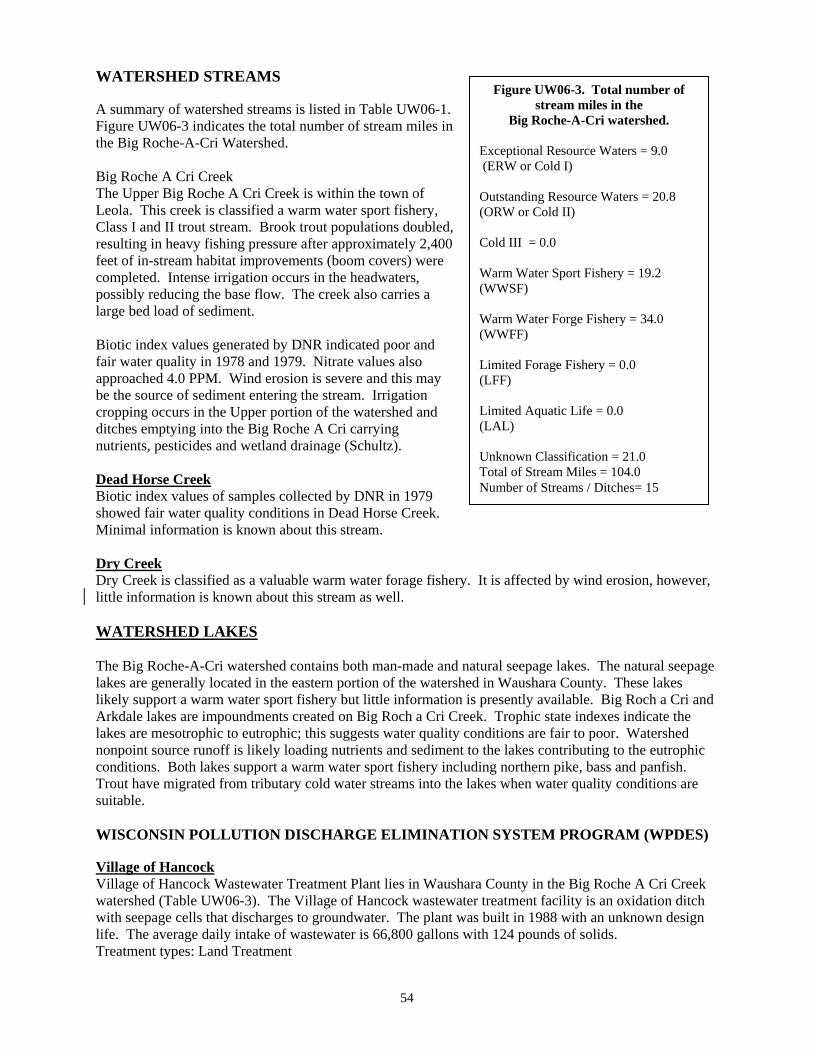
Figure UW06-3. Total number of stream miles in the
Big Roche-A-Cri watershed.
Exceptional Resource Waters = 9.0 (ERW or Cold I) Outstanding Resource Waters = 20.8 (ORW or Cold II) Cold III = 0.0 Warm Water Sport Fishery = 19.2 (WWSF) Warm Water Forge Fishery = 34.0 (WWFF) Limited Forage Fishery = 0.0 (LFF) Limited Aquatic Life = 0.0 (LAL) Unknown Classification = 21.0 Total of Stream Miles = 104.0 Number of Streams / Ditches= 15
WATERSHED STREAMS A summary of watershed streams is listed in Table UW06-1. Figure UW06-3 indicates the total number of stream miles in the Big Roche-A-Cri Watershed. Big Roche A Cri Creek The Upper Big Roche A Cri Creek is within the town of Leola. This creek is classified a warm water sport fishery, Class I and II trout stream. Brook trout populations doubled, resulting in heavy fishing pressure after approximately 2,400 feet of in-stream habitat improvements (boom covers) were completed. Intense irrigation occurs in the headwaters, possibly reducing the base flow. The creek also carries a large bed load of sediment. Biotic index values generated by DNR indicated poor and fair water quality in 1978 and 1979. Nitrate values also approached 4.0 PPM. Wind erosion is severe and this may be the source of sediment entering the stream. Irrigation cropping occurs in the Upper portion of the watershed and ditches emptying into the Big Roche A Cri carrying nutrients, pesticides and wetland drainage (Schultz). Dead Horse Creek Biotic index values of samples collected by DNR in 1979 showed fair water quality conditions in Dead Horse Creek. Minimal information is known about this stream. Dry Creek Dry Creek is classified as a valuable warm water forage fishery. It is affected by wind erosion, however, little information is known about this stream as well. WATERSHED LAKES The Big Roche-A-Cri watershed contains both man-made and natural seepage lakes. The natural seepage lakes are generally located in the eastern portion of the watershed in Waushara County. These lakes likely support a warm water sport fishery but little information is presently available. Big Roch a Cri and Arkdale lakes are impoundments created on Big Roch a Cri Creek. Trophic state indexes indicate the lakes are mesotrophic to eutrophic; this suggests water quality conditions are fair to poor. Watershed nonpoint source runoff is likely loading nutrients and sediment to the lakes contributing to the eutrophic conditions. Both lakes support a warm water sport fishery including northern pike, bass and panfish. Trout have migrated from tributary cold water streams into the lakes when water quality conditions are suitable. WISCONSIN POLLUTION DISCHARGE ELIMINATION SYSTEM PROGRAM (WPDES) Village of Hancock Village of Hancock Wastewater Treatment Plant lies in Waushara County in the Big Roche A Cri Creek watershed (Table UW06-3). The Village of Hancock wastewater treatment facility is an oxidation ditch with seepage cells that discharges to groundwater. The plant was built in 1988 with an unknown design life. The average daily intake of wastewater is 66,800 gallons with 124 pounds of solids. Treatment types: Land Treatment

55
GROUNDWATER There are no high capacity drinking water wells in this watershed and the Village of Hancock is the only municipality that discharges in this watershed. The Central Wisconsin Groundwater Center of the University of Wisconsin-Stevens Point tested 260 wells throughout the entire watershed. Of the 260 wells tested 16.5 percent of the wells had nitrate levels over 10 parts per million which is above the safe drinking water limits. Of the 16.5 percent of the wells over 10 part per million, 8.8 percent of those wells had readings 20 parts per million or greater, which is 6.2 percent greater than the basin average. That is two times greater than the safe drink water standards set by the department of Of the 31 wells tested for triazine in the Big Roche-A-Cri watershed, 3.2 percent of the wells tested had concentrations at 1.1 parts per billion or greater of triazine. None of the wells sampled were over 3.0 parts per billion. Since triazine can not be used to set standards for drinking water limitations, it is strongly recommend that if a test result comes back above 1 parts per billion of triazine, the well should be tested further for total concentrations of atrazine. WATERSHED RECOMMENDATIONS 1. Fish and Aquatic Habitat Staff should conduct baseline monitoring for watershed streams and lakes. 2. Big Roche-a-Cri Watershed should be considered a high priority for grant eligibility under the State
Nonpoint Source Pollution Abatement Program. 3. Watershed staff, in cooperation with Adams County Land Conservation Department and Central Wisconsin
Windshed Partnership, should continue to work with local farmers to encourage wind erosion best management practices.
56
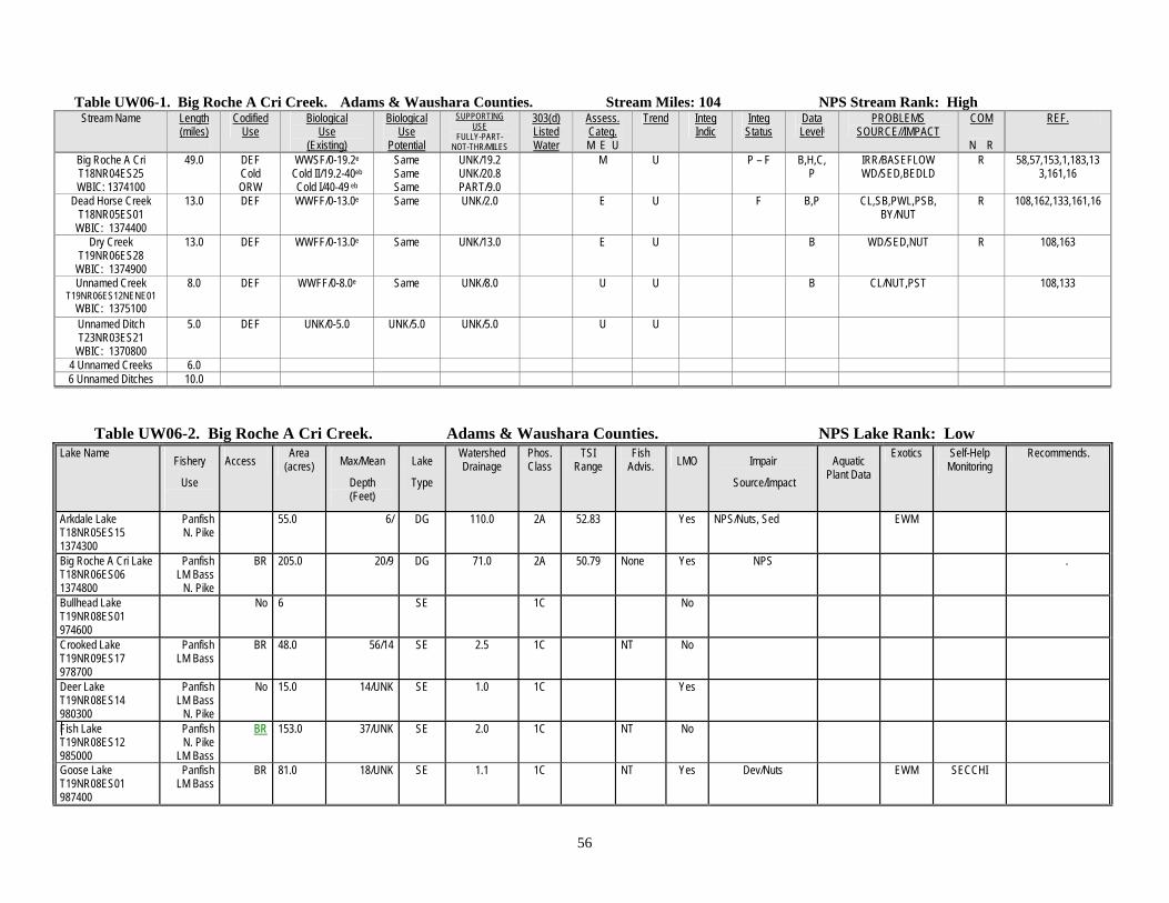
Table UW06-1. Big Roche A Cri Creek. Adams & Waushara Counties. Stream Miles: 104 NPS Stream Rank: High
Stream Name Length (miles)
Codified Use
Biological Use
(Existing)
Biological Use
Potential
SUPPORTING USE
FULLY-PART- NOT-THR/MILES
303(d) Listed Water
Assess. Categ. M E U
Trend Integ Indic
Integ Status
Data Leveli
PROBLEMS SOURCE//IMPACT
COM
N R
REF.
Big Roche A Cri T18NR04ES25 WBIC: 1374100
49.0 DEF Cold ORW
WWSF/0-19.2e Cold II/19.2-40eb Cold I/40-49 eb
Same Same Same
UNK/19.2 UNK/20.8 PART/9.0
M
U P – F B,H,C,P
IRR/BASEFLOW WD/SED,BEDLD
R 58,57,153,1,183,133,161,16
Dead Horse Creek T18NR05ES01
WBIC: 1374400
13.0 DEF WWFF/0-13.0e Same UNK/2.0 E U F B,P CL,SB,PWL,PSB, BY/NUT
R 108,162,133,161,16
Dry Creek T19NR06ES28
WBIC: 1374900
13.0 DEF
WWFF/0-13.0e Same UNK/13.0 E U B WD/SED,NUT R 108,163
Unnamed Creek T19NR06ES12NENE01
WBIC: 1375100
8.0 DEF WWFF/0-8.0e Same
UNK/8.0 U U
B CL/NUT,PST 108,133
Unnamed Ditch T23NR03ES21
WBIC: 1370800
5.0 DEF UNK/0-5.0 UNK/5.0 UNK/5.0 U U
4 Unnamed Creeks 6.0 6 Unnamed Ditches 10.0
Table UW06-2. Big Roche A Cri Creek. Adams & Waushara Counties. NPS Lake Rank: Low Lake Name Fishery
Use
Access Area (acres) Max/Mean
Depth (Feet)
Lake
Type
Watershed Drainage
Phos. Class
TSI Range
Fish Advis. LMO Impair
Source/Impact
Aquatic Plant Data
Exotics Self-Help Monitoring
Recommends.
Arkdale Lake T18NR05ES15 1374300
Panfish N. Pike
55.0 6/ DG 110.0 2A 52.83 Yes NPS/Nuts, Sed EWM
Big Roche A Cri Lake T18NR06ES06 1374800
Panfish LM Bass
N. Pike
BR 205.0 20/9 DG 71.0 2A 50.79 None Yes NPS .
Bullhead Lake T19NR08ES01 974600
No 6 SE 1C No
Crooked Lake T19NR09ES17 978700
Panfish LM Bass
BR 48.0 56/14 SE 2.5 1C NT No
Deer Lake T19NR08ES14 980300
Panfish LM Bass
N. Pike
No 15.0 14/UNK SE 1.0 1C Yes
Fish Lake T19NR08ES12 985000
Panfish N. Pike
LM Bass
BR 153.0 37/UNK SE 2.0 1C NT No
Goose Lake T19NR08ES01 987400
Panfish LM Bass
BR 81.0 18/UNK SE 1.1 1C NT Yes Dev/Nuts EWM SECCHI

57
Lake Name Fishery
Use
Access Area (acres) Max/Mean
Depth (Feet)
Lake
Type
Watershed Drainage
Phos. Class
TSI Range
Fish Advis. LMO Impair
Source/Impact
Aquatic Plant Data
Exotics Self-Help Monitoring
Recommends.
Herrick Lake T20NR09ES31 989600
No 25 SE 1C No
Pine Lake T19NR08ES11 1012000
Panfish LM Bass
BR 93.0 21/8 SE 1.0 1C NT Yes
Piper Lake T20NR09ES10 1012400
No 3 SE 1C No
Reeder Lake T19NR08ES01 1013900
No 5 SE 1C No
Sand Lake T20NR08ES36 1015700
Panfish No 143.0 9/UNK SE 1C NT No
2 Unnamed Lake 12.0
Table UW06-3. POINT SOURCES within the Big Roche A Cri Creek Watershed. Adams & Waushara Counties.
Facility Permit No./ Expires
Industrial Or Municipal
Receiving Stream/ Classification G = groundwater
Q710 of Receiving
Stream
Design Flow (MGD)
Variances Phosphorus Limit
Facility Plan Candidate?
Y/N
Waste Load
Allocation
Recommendations
Village of Hancock Wastewater Treatment Plant
35149-02
12/31/2001
M G None .0668 N N None
58
FOURTEEN-MILE CREEK WATERSHED (UW07) WATERSHED SUMMARY The Fourteen-mile Watershed (Map UW07) is located in the Adams, Wood, Portage and Waushara counties. A large portion of this area is referred to as the Leola Marsh. This area at one time was an extensive wetland that was ditched and drained for agricultural activities. This watershed was ranked using the Nonpoint Source Priority Selection Criteria. Based on surface and ground water data, the overall ranking is medium. This overall ranking establishes the watershed as a medium priority for future grant eligibility through the Nonpoint Source Program. Much of the upper portion of the watershed has been ditched in the early 1900’s for drainage of the land. The Drainage District continues to provide maintenance dredging in order to remove sediment and vegetation from the channel. According to the District, this practice promotes improved drainage of the adjacent agricultural fields. A recent decision by DATCAP requires maintenance dredging to go no deeper than the approved profile. The Department supports this because over-dredging removes critical in-stream habitat for trout and other aquatic organisms, creates deep, low velocity pools, increases sedimentation, increases in-stream habitat recovery time and reduces potential spawning areas. Fluctuating water levels and heavy siltation have reduced the trout population in the ditches. High nitrate values and streambank pasturing (sedimentation) can cause water quality problems in some of the streams in the watershed. There are several cranberry farms located in the watershed that utilize water for their operation. Water drawn from ditches reduces stream flow, decrease adult fish cover, reduce spawning areas for trout and likely expose fish redds, and may result in an increase of water temperatures. Discharges from cranberry marshes can adversely affect water temperatures, deposit sediment, and release nutrients to the ditches. Periodic impounding of the ditches to flood marshes may prevent fish migration, increase water temperatures and de-water downstream reaches. The Adams County Soil Erosion Control plan identified the town of Leola as highest priority for conservation work to control wind erosion. This town is in the upper Fourteenmile Creek Watershed. Intense irrigation farming also occurs in the watershed leading to stream impacts from pesticides/herbicides and nutrients (Schultz). Many of the creeks have also been ditched for wetland drainage (Schultz). Golden Sands Resource Conservation and Development Planning Agency studied wind erosion impacts on water quality in the watershed. The study found that wind eroded soil from agricultural crop fields is a source of sediment, nutrients and pesticides to surface waters in the watershed. Much of the agricultural activity includes potato and processing vegetable production. Typically, these farming activities result in smooth, flat seedbeds that are free of residues and are susceptible to wind erosion. Winter, late fall, and early spring are critical wind erosion periods. Wind erosion removes nutrient rich soils from fields depositing them into the ditches which increases sediment and nutrient loading to downstream lakes. The study recommends several practices that could be installed to protect the soils from being eroded by wind and thereby protect surface water quality. Some of these practices include; crop rotation, conservation tillage, cover crops, field wind breaks, nutrient management, pest management, crop residue management and wind barriers. These practices and others are explained further in the final report titled Wind Erosion Impacts on Water Quality in the Sand Plain of Central Wisconsin, 1993. The watershed mainly consists of farm fields and large parcels of grassland. Prairie chickens, an endangered species of Wisconsin, utilize grasslands, which need constant disturbance. These disturbances include prescribed burns, cuttings and summer cattle grazing. The large tracts of land are

59
0%
5%
10%
15%
20%
25%
30%
35%
Per
cen
tag
e
Fores
t
Grass
land
Agricu
lture
Open
Wat
er
Wet
land
Shrub
land
Barre
n
Land Cover
Figure UW 07-1 Current Land use in the Fourteen M ile Creek W atershed
0
10
20
30
40
50
60
70
80
Per
cen
tag
e
W oodland Grassland W etland
Figure UW07-2 Pre-Settlement Vegetative Cover for Fourteen M ile Creek
set-aside in Fourteenmile Creek watershed for maintaining grassland habitat which are state and partnership owned for the sole purpose of maintaining a prairie land habitat. POPULATION DEMOGRAHICS The population increase in Fourteen-mile Creek watershed has been consistently average with the growth of our basin, increasing at a rate of a little under two percent a year or 2,000 people every 30 years. The population is projected to continue at the same rate for the next 15 years(North Central Wisconsin Regional Planning Commission, 2000, Wisconsin Department of Administration, 2000). According to land survey records from the mid 1800s, original vegetation consisted primarily of woodlands (74%) and 20% grasslands (Figure UW07-2). Currently, the land use consists of woodlands (30%), grassland (21%), and agriculture (20%) and 15% open water (Figure UW07-1) (Enterprise
Information, 1998). WATERSHED STEAMS A summary of watershed streams is listed in Table UW07-1. Figure UW07-3 indicates total number of stream miles in the Fourteenmile Creek Watershed. Chester Creek Chester Creek is a Class I trout stream and Exceptional Resource Water. Ditch No. 7 Ditch No. 7 is a seven-mile cold water tributary of Fourteenmile Creek. Fishery surveys completed in 1998 found cold water forage species, however trout were not captured at any sites. The use classification should be cold water, however the potential of the stream is unknown. Further surveys should be completed to determine the streams potential. The stream is impacted by channel ditching, nutrient and sediment loading from surrounding crop fields, shallow channel depth and the lack of fish cover. HBI results indicate some organic loading to the stream. Fourteenmile Creek Fourteenmile Creek is a nineteen-mile warm water game fishery and is a tributary to the Wisconsin River. The stream has been impounded at three locations to form the Tri-Lakes (Arrowhead, Sherwood, and Camelot) region. Intense housing development occurs around each lake. The Tri-Lakes Lake Association is very active in aquatic plant harvesting.

60
Figure UW07-3. Total number of stream miles in the
Fourteen-mile Creek Watershed
Exceptional Resource Waters = 2.0 (ERW or Cold I) Outstanding Resource Waters = 0.0 (ORW or Cold II) Cold III = 0.0 Warm Water Sport Fishery = 31.5 (WWSF) Warm Water Forge Fishery = 13.5 (WWFF) Limited Forage Fishery = 0.0 (LFF) Limited Aquatic Life = 0.0 (LAL) Unknown Classification = 40.0 Total of Stream Miles =87.0 Number of Streams / Ditches= 31
Fishery surveys completed in 1998 found some game fish and several species of forage fish. Limiting factors to in-stream habitat include; streambank erosion, shallow channel depth, sedimentation from surrounding crop fields and the lack of pools, riffles and fish cover. HBI results suggest there is significant organic loading to the stream. Stream flow fluctuations are evident in the stream channel, likely a result of water usage by upstream cranberry operations. There are several cranberry operations that discharge water to the ditches. These discharges could contain sediment and nutrients that may be impacting the stream. Leola Ditch Leola Ditch is classified as a nine-mile warm water game fishery for its entire length. A portion of the stream (river mile 3.5 - 9.0) used to be Class II trout waters. Continuous temperature monitoring found adequate temperatures for trout in the upper reaches, however dredging and siltation may have eliminated trout spawning habitat. The upper reaches of the stream are impacted by sedimentation from surrounding crop fields, lack of pools and ditching. Cranberry marsh discharges may contribute nutrients and sediment to the stream. Limiting factors of habitat in the lower reaches are sedimentation and the lack of pools and fish cover. HBI results suggest there is fairly significant organic loading to the stream. Water quality sampling in 1999 found nitrate levels in the ditch above 5 ppm. Unnamed Ditch 13-13 Unnamed Ditch 13-13 is an eight-mile tributary to Leola Ditch. The lower portion of the stream supports a warm water game fishery while the upper reaches support a forage fishery. There are several cranberry marshes that can discharge water to the lower reaches of the ditch. These discharges can impact habitat and water quality by delivering sediment and nutrients to the ditch. Stream flow fluctuations are also evident and may be a result of water usage by the marshes. Limiting factors of stream habitat include; channel ditching, sedimentation from surrounding crop fields, nutrification, fluctuating streamflow and the lack of pool, riffles and fish cover. HBI results suggest there is significant organic loading to the ditch. Unnamed Ditch 12-1 Unnamed Ditch 12-1 is a three-mile warm water forage fishery and is a tributary to Fourteenmile Creek. Land use surrounding the ditch is primarily cranberry farms that draw and discharge water from the ditch. The stream is impacted by fluctuating streamflows, sedimentation from surrounding crop fields, channel ditching and the lack of pools, riffles and fish cover. Unnamed Ditch 29-1 Unnamed Ditch 29-1 is a one-mile warm water forage fishery and is a tributary to Unnamed Ditch 13-13. The ditch has little streamflow and a very poor fish community. Limiting factors of in-stream habitat include; low flow, sedimentation from surrounding crop fields, channel ditching and the lack of pools and fish cover.

61
Unnamed Ditch 6-5 Unnamed Ditch 6-5 is a one-mile warm water forage fishery and is a tributary to Unnamed Ditch 12-1. For a majority of its length the stream is actually a road ditch that flows adjacent to STH 73. Limiting factors of in-stream habitat include; low flow, sedimentation, channel ditching and the lack of pools and fish cover. Spring Branch The majority of Spring Branch is now Camelot Lake, which is classified as a warm water game fishery. The tiny portion of Spring Branch above Camelot Lake is classified as a forage fishery. WATERSHED LAKES Three flowages, known as the Tri-Lakes, have been constructed in the late 1960s and early 1970s by impounding Fourteen-mile Creek. The lakes have experienced water quality concerns including severe algae blooms during the summer. In 1997, the lakes had a large die-off of freshwater mussels, the cause of which has never been determined. Copper sulfate has been applied in the past to control nuisance algae. The copper quickly settles out of the water column where it can accumulate in the sediments. One possible theory is the copper may have built up in the sediments to levels that were toxic to the mussels. These water quality concerns has initiated a cooperative effort from the Tri-Lakes Association, Town of Rome, Adams County LCD, Agricultural Growers in the watershed, University of Wisconsin-Stevens Point, The Army CORPs of Engineers and the Department. The objective of the study was to determine how nutrient inputs from streams in the watershed, regional groundwater discharges and internal recycling from lake sediments impacted lake water quality. Results and management recommendations will be available upon completion of the study. WISCONSIN POLLUTION DISCHARGE ELIMINATION SYSTEM (WPDES) Program Table UW09-3 summarizes the WPDES in the Seven-mile and Ten-mile Creek Watershed. Village of Plainfield Village of Plainfield Wastewater Treatment Plant lies in Waushara County in the Big Roche A Cri Creek watershed (Table UW06-3). The Village of Plainfield wastewater treatment facility is an oxidation ditch with seepage cells that discharges to groundwater. The plant has no phosphorus limit and the wastewater discharge permit expires in 12/31/2006. GROUNDWATER The Fourteen-mile Creek Watershed contains one municipal water supply system (Table UW07-4). This system, known as the Rome Water Utility is currently a private organization that serves residents of the Lake Camelot Property Owners Association. Rome Water Utility currently operates two wells to serve their customers. Both wells are very productive sand and gravel wells that are operated below their yield potential due to elevated nitrates in Well 2. Well 2 has nitrate concentrations exceeding 15 ppm, well over the maximum contaminant level of 10 ppm. To use this well, the utility must throttle back the production from Well 2 and blend it with an equal proportion of water from Well 1. Well 1 nitrate levels are currently around 4 parts per million giving a blended average below 10 parts per million. The utility has attempted to reduce the amount of nitrates applied to agricultural fields in the area through voluntary agreements with neighboring land owners and by purchasing acreage up gradient from the wells and taking them out of production. Unfortunately, nitrate concentrations continue to rise in these wells. The Utility is in the process of constructing a new well in a more protective area of wooded land that has shown the potential to be much lower in nitrates. This location was discovered after many years of

62
drilling test holes in which water quantity was often available, but the quality due to nitrates or extremely high iron concentrations was limiting. Due to the tremendous population growth in this recreation area, the addition source capacity is urgently needed. For the new well, a Well Head Protection program is required and should be provided naturally because the area surrounding the well is industrial forest land owned by Georgia Pacific Corporation. Wellhead protection for the existing wells will continue to be conducted through public education with local landowners. The high density of septic systems throughout the Tri Lakes area will also need to be addressed in the near future. All the water provided by the Rome Water Utility is treated with chlorine for disinfecting, fluoride for the prevention of dental caries and polyphosphates to sequester the small amount of iron and manganese found in these waters Well water samples were taken to test for nitrate and triazine concentrations by the Central Wisconsin Groundwater Center of the University of Stevens Point. Of the 211 wells tested for nitrates in the Fourteenmile Creek watershed, 9.5 percent of the tested were above 10 parts per million, with 6.2 percent of them having 20 parts per million or greater. Of the 16 wells tested for triazine in the Fourteenmile Creek watershed, all of the wells tested had concentrations less than 1.1 parts per billion of triazine. Since triazine can not be used to set standards for drinking water limitations, it is strongly recommend that if a test result comes back above 1 parts per billion of triazine, the well should be tested further for total concentrations of atrazine. WATERSHED RECOMMENDATIONS 1. Watershed Staff should conduct a Nonpoint Source assessment study on Chester Creek. 2. The Adams County Land Conservation Department, Fourteen-mile Creek Watershed Advisory
Group, and the Tri-Lakes Management District should continue their effort to reduce nutrient inputs to lakes Arrowhead, Sherwood, and Camelot.
3. Adams County LCD should continue to assist the Tri-Lakes Management District with the
establishment of vegetated shoreline buffers.
4. Fish and Aquatic Habitat Team should monitor Ditch No.7 and Leola Ditch to determine the extent of trout.
5. Fourteenmile Creek Watershed should be considered a priority for future grant eligibility under the State Nonpoint Source Pollution Abatement Program.
6. Drinking and Groundwater Staff should continue to encourage Rome Water Utility to become a publicly owned Sanitary District.
7. Watershed staff, in cooperation with Adams County Land Conservation Department and Central
Wisconsin Windshed Partnership, should continue to work with local farmers to encourage wind erosion best management practices.

63
Table UW07-1. Fourteenmile Watershed Adams, Portage & Waushara Counties. Stream Miles: 157; Square Miles: 87.0 NPS Stream Rank: Medium Stream Name Length
(miles)
Codified Use
Biological Use
(Existing)
Biological Use
Potential
SUPPORTING USE
FULLY-PART- NOT-THR/MILES
303d Listed Water
Assess. Categ. M E U
Tren
Integ Indic
Integ Stat.
Data Leveli
PROBLEMS SOURCE//IMPACT
COM
N R
REF.
Chester Creek T20NR05ES04 WBIC: 1377200
2.0 ERW Cold I/0-2.0b Same UNK/2.0 E
U PST, NUT/CL
153,108,133
Ditch#7 T20NR07ES04NWNW01
WBIC: 1381700
7.0 DEF
CWFF/0-7.0 UNK/7.0 UNK/7.0 M 1998-99
U IBI = 10-40
HBI = 5.8
P – F
F
B, P
PST,NUT,HAB,SED/HM,CL,DCH
108,28,133,161,153
Fourteenmile Creek T25NR02ES15
WBIC: 1373200
19.0 DEF WWSF/0-19.e Same PART/19.0
M 1998-99
U IBI = 10-20
HBI = 6.9
P
FP
B,P,H
SED,HAB,NUT,PST,FLOW/CL,HM,CM,
WD,DCH
153,108,1,58,133, 161
Leola Ditch T20NR06ES13
WBIC: 1378300
9.0 Cold WWSF/0-9.0e
Cold/5.5
NOT/5.5 M
1998-99 U IBI = 0-30
HBI = 5-6.2
VP-F
G – F
B,P,H
SED,HAB,PST,NUT, FLOW/CL,HM,WD,
CM,DCH
153,58,133,161
Spring Branch T23NR03ES21
WBIC: 1370800
4.0 DEF DEF
WWSF/0-3.5e WWFF/3.5-4e
Same Same
PART/3.5 PART/0.5
E U PST,NUT/HM,CL 108,58,133
Unnamed Ditch T20NR06ES13NESE01
WBIC: 1378400
8.0 DEF DEF
WWFF/0-8.0e
Same UNK
PART UNK
M 1998-99
U IBI = 30-40
HBI = 5.8-6.3
F
F
B,P,H
SED,HAB,NUT, FLOW/CL,HM,WD,
CM,DCH
108,133,153
Unnamed Ditch T20NR06ES13SESE01
WBIC: 1378500
5.0 DEF WWFF/0-5.0e Same UNK/5.0 U U CL/PST,NUT HM/
108,133,153
Unnamed Ditch T20NR07ES29 NENE
WBIC: 1379000
1.0 DEF WWFF/0-1.0E Same PART M 1998-99
IBI = 0 VP B
HAB,FLOW,SED/ WD,DCH
153
Unnamed Ditch T20R7ES6 NENW
WBIC: None
1.0 DEF WWFF/0-1.0e Same PART M 1998-99
IBI = 30 F B
HAB,SED,FLOW/WD,DCH,HM
153
Unnamed Ditch T20R6ES12 NENE
WBIC: 1381200
3 DEF WWFF/0-3.0e Same PART M 1998-99
IBI = 30 F B,P,H
HAB,SED,FLOW/CL,HM,WD,CM,DCH
153
22 Unnamed Ditches 29.0
64
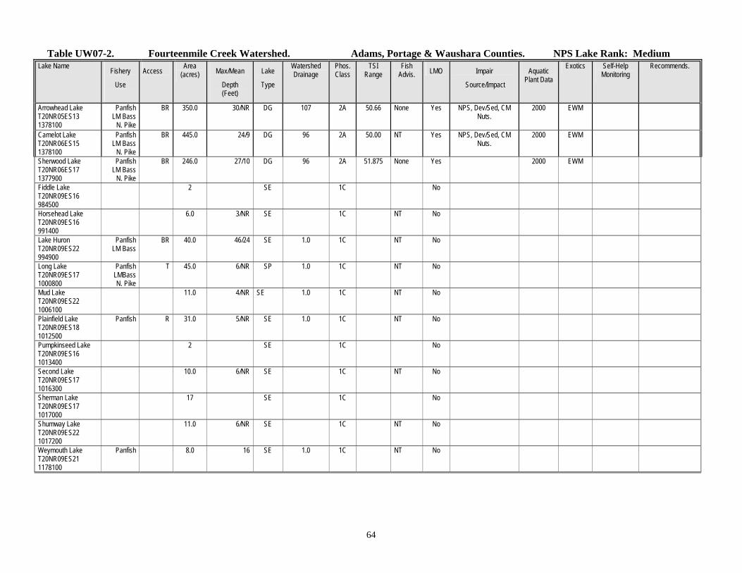
Table UW07-2. Fourteenmile Creek Watershed. Adams, Portage & Waushara Counties. NPS Lake Rank: Medium Lake Name Fishery
Use
Access Area (acres) Max/Mean
Depth (Feet)
Lake
Type
Watershed Drainage
Phos. Class
TSI Range
Fish Advis. LMO Impair
Source/Impact
Aquatic Plant Data
Exotics Self-Help Monitoring
Recommends.
Arrowhead Lake T20NR05ES13 1378100
Panfish LM Bass
N. Pike
BR 350.0 30/NR DG 107 2A 50.66 None Yes NPS, Dev/Sed, CM Nuts.
2000 EWM
Camelot Lake T20NR06ES15 1378100
Panfish LM Bass
N. Pike
BR 445.0 24/9 DG 96 2A 50.00 NT Yes NPS, Dev/Sed, CM Nuts.
2000 EWM
Sherwood Lake T20NR06ES17 1377900
Panfish LM Bass
N. Pike
BR 246.0 27/10 DG 96 2A 51.875 None Yes 2000 EWM
Fiddle Lake T20NR09ES16 984500
2 SE 1C No
Horsehead Lake T20NR09ES16 991400
6.0 3/NR SE 1C NT No
Lake Huron T20NR09ES22 994900
Panfish LM Bass
BR 40.0 46/24 SE 1.0 1C NT No
Long Lake T20NR09ES17 1000800
Panfish LMBass N. Pike
T 45.0 6/NR SP 1.0 1C NT No
Mud Lake T20NR09ES22 1006100
11.0 4/NR SE 1.0 1C NT No
Plainfield Lake T20NR09ES18 1012500
Panfish R 31.0 5/NR SE 1.0 1C NT No
Pumpkinseed Lake T20NR09ES16 1013400
2 SE 1C No
Second Lake T20NR09ES17 1016300
10.0 6/NR SE 1C NT No
Sherman Lake T20NR09ES17 1017000
17 SE 1C No
Shumway Lake T20NR09ES22 1017200
11.0 6/NR SE 1C NT No
Weymouth Lake T20NR09ES21 1178100
Panfish 8.0 16 SE 1.0 1C NT No

65
Table UW07-3. Adams, Portage & Waushara Counties Wisconsin Pollution Discharge Elimination System (WPDES) Program Facility Permit No./
Expires
Industrial Or Municipal
Receiving Stream/ Classification G = groundwater
Q710 of Receiving
Stream
Design Flow (MGD)
Variances Phosphorus Limit
Facility Plan Candidate?
Y/N
Waste Load
Allocation
Recommendations
Village of Plainfield Wastewater Treatment Plant
36048-06
12/31/2005
M G None N N None
Table UW07-4. Municipal Water Supply in Fourteenmile Watershed. NPS Groundwater Rank: High
Rome Water Utility Sanitary Survey Date 1998 Population 250 (Winter) PWSID 70101086 Ave. Day Use 50,000 Gallons 3000 (Summer) (400,000 Summer)
Well Entry Unique Well Const. Geology Well Casing Screened Capacity Nitrate Treatment Wellhead Calculated Flood Plain Wetland
Point Well No. Report Depth Length Interval (gpm) (PPM) Protection Fixed Radius
1 200 BP966 Yes Sand & Gravel 80' 60' 60'-80' 850 4.18 Cl, PO4, FL, B No 2137' No No
2 200 AY368 Yes Sand & Gravel 85' 60' 60'-85' 850 15.6 Cl, PO4, FL, B No 2730' No No

66
0%
5%
10%
15%
20%
25%
30%
Per
cen
tag
e
Agricu
lture
Fores
t
Gra
ssla
nd
Ope
n W
ater
Wet
land
Urban
/Dev
elope
d
Shrub
land
Barre
n
Land Cover
Figure UW08-1 Current Land use in the Wisconsin Rapids Watershed
0
10
20
30
40
50
60
70
80
90
Woodland Grassland Wetland
Figure UW08-2 Pre-Settlement Vegetative Cover for Wisconsin Rapids
WISCONSIN RAPIDS WATERSHED (UW08) WATERSHED SUMMARY The Wisconsin Rapids Watershed (Map UW08) is located in the counties of Juneau, Wood and Portage, in the state of Wisconsin. This area is heavily populated and incorporates the towns of Nekoosa, Port Edwards, Rudolph and part of Wisconsin Rapids. This watershed is highly developed with industry and supports several large paper mills within a relatively small section of the Wisconsin River. The Wisconsin Rapids watershed has an overall Nonpoint Source ranking of low, based upon available stream, lake and groundwater data. The overall NPS ranking establishes the watershed as a low priority for grant eligibility through the Nonpoint Source Program. The watershed was ranked per the Nonpoint Source Priority Watershed Selection Criteria. The watershed ranked low for NPS pollution impacts on surface water quality. This ranking was due to insufficient data. The groundwater portion of the watershed ranked high for NPS pollution control because of documented groundwater quality impacts. The NPS ranking for stream and lakes is ranked low. Currently, a small-scale priority watershed, groundwater demonstration project is being conducted in the Wisconsin Rapids watershed. The Wood County Erosion Control Plan lists the Wisconsin Rapids Watershed as a priority area for wind erosion control. Approximately 98 percent of total acreage in the watershed erodes at greater than the tolerable soil loss level with average annual soil loss of nine tons per acre (Gunderson, 1987). The Juneau County Erosion Control Plan also indicates the need for wind erosion control and improved irrigation management. POPULATION DEMOGRAPHICS The Wisconsin Rapids watershed currently has over six percent of the basins population. The villages of Port Edwards and Rudolph along with the cities of Nekoosa and part of Wisconsin Rapids make up the most populated areas in the watershed. Over the next 15 years, the population is projected to remain constant with the current rate (North Central Wisconsin Regional Planning Commission, 2000, Wisconsin Department of Administration, 2000). According to land surveys in the mid-1800s, the original vegetation consisted primarily of woodlands with some wetlands (Figure UW08-2). The current land use in the watershed consists primarily of agriculture (26%), forested (23%), grassland (19%), wetland (12%) and open water (12%) (Figure UW08-1). With the Wisconsin River being used for such a variety of industries and recreational purposes,
67
Figure UW08-3. Total number of stream miles in the
Wisconsin Rapids Watershed.
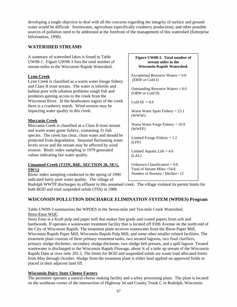
Exceptional Resource Waters = 0.0 (ERW or Cold I) Outstanding Resource Waters = 6.0 (ORW or Cold II) Cold III = 0.0 Warm Water Sport Fishery = 23.1 (WWSF) Warm Water Forge Fishery = 10.9 (WWFF) Limited Forage Fishery = 1.2 (LFF) Limited Aquatic Life = 4.6 (LAL) Unknown Classification = 9.0 Total of Stream Miles =54.8 Number of Streams / Ditches= 12
developing a single objective to deal with all the concerns regarding the integrity of surface and ground water would be difficult. Stormwater, agriculture (specifically cranberry production), and other possible sources of pollution need to be addressed at the forefront of the management of this watershed (Enterprise Information, 1998). WATERSHED STREAMS A summary of watershed lakes is found in Table UW08-1. Figure UW08-3 lists the total number of stream miles in the Wisconsin Rapids Watershed. Lynn Creek Lynn Creek is classified as a warm water forage fishery and Class II trout stream. The water is infertile and habitat poor with siltation problems rough fish and predators gaining access to the creek from the Wisconsin River. In the headwaters region of the creek there is a cranberry marsh. Wind erosion may be impacting water quality in this creek. Moccasin Creek Moccasin Creek is classified as a Class II trout stream and warm water game fishery, containing 31 fish species. The creek has clear, clean water and should be protected from degradation. Seasonal fluctuating water levels occur and the stream may be affected by wind erosion. Biotic index sampling in 1979 generated values indicating fair water quality. Unnamed Creek (T23N, R6E, SECTION 26, SE¼, SW¼) Biotic index sampling conducted in the spring of 1990 indicated fairly poor water quality. The village of Rudolph WWTP discharges its effluent to this unnamed creek. The village violated its permit limits for both BOD and total suspended solids (TSS) in 1988. WISCONSIN POLLUTION DISCHARGE ELIMINATION SYSTEM (WPDES) Program Table UW09-3 summarizes the WPDES in the Seven-mile and Ten-mile Creek Watershed. Stora-Enso WQC Stora Enso is a Kraft pulp and paper mill that makes fine grade and coated papers from soft and hardwoods. If operates a wastewater treatment facility that is located off Fifth Avenue on the north end of the City of Wisconsin Rapids. The treatment plant receives wastewater from the Biron Paper Mill, Wisconsin Rapids Paper Mill, Wisconsin Rapids Pulp Mill, and some other smaller related facilities. The treatment plant consists of three primary treatment tanks, two aerated lagoons, two final clarifiers, primary sludge thickener, secondary sludge thickener, two sludge belt presses, and a spill lagoon. Treated wastewater is discharged to the Wisconsin Rapids Flowage, about ¾ of a mile up stream of the Wisconsin Rapids Dam at river mile 202.3. The limits for BOD and suspended solids are waste load allocated limits from May through October. Sludge from the treatment plant is either land applied on approved fields or placed in their adjacent land fill. Wisconsin Dairy State Cheese Factory The permittee operates a natural cheese making facility and a whey processing plant. The plant is located on the southeast corner of the intersection of Highway 34 and County Trunk C in Rudolph, Wisconsin

68
(Wood County). Cheddar, colby, and mozzarella cheeses are made at the plant. Approximately 60,000 pounds of raw milk is used each day to produce approximately 6,000 pound of cheese and 54,000 pound of whey. Approximately 42,000 gallons per day of process wastewater and permeate from the reverse osmosis system is treated in a complete mix/extended aeration activated sludge system and then discharge to surface water. Sludge from the treatment system, unprocessed whey, and whey permeate are disposed of via landspreading activities. Recommendations: The facility should work with the University of Wisconsin on the Biological Phosphorus Study. Village of Rudolph The Rudolph Wastewater Treatment Facility lies in Wood County in the Wisconsin Rapids Watershed (UW8). The Wastewater treatment plant discharges to an unnamed tributary of the Wisconsin River. The design life of the plant is unknown, with preliminary engineering plans approved in 1980, with major improvements occurred in 1981. The daily design flow is rated at 125,000 gallons a day with a BOD load of 251 (#/day). Treatment types: Two aerated lagoons. Village of Port Edwards The Port Edwards Wastewater Treatment Facility lies in Wood County in the Wisconsin Rapids Watershed (UW8). The WWTF discharges to the Wisconsin River. The design life of the plant is unknown, preliminary engineering plans were approved in 1970 and major improvements occurred in 197. The daily wastewater design flow is rated at 562,000 gallons a day with a BOD load of 575 (#/day). Treatment types: Trickling filter. City of Nekoosa The Nekoosa Wastewater Treatment Facility lies in Wood County in the Wisconsin Rapids Watershed (UW8). The WWTP discharges to Wisconsin River. The design life of the plant is until 2016, preliminary engineering plans were approved in 1995, major improvements occurred in 1996. The design flow is rated at 867,000 gallons a day with a BOD load of 764 (#/day). Treatment types: Activated sludge Vulcan Chemicals Vulcan Chemicals is an inorganic chemical manufacturer in the chlor-alkali subcategory producing primarily chlorine, sodium hydroxide, and potassium hydroxide. They use a mercury cell process in which a thin layer of mercury at the bottom of the cell acts as a cathode in the electrolysis of salt brine. Electric current decomposes the brine liberating chlorine gas at the anode and sodium metal at the cathode. An average of 5.75 MGD of commingled wastewater effluent streams is discharged to the Wisconsin River. Most of the flow is from noncontact cooling water. An average of 110,000 gallons per day of process wastewater and contaminated groundwater receives treatment in a mercury removal system. There are also minor flows from a COD removal system serving sodium hydrosulfite production, intake water strainer bleedoff, and storm water. GROUNDWATER The Wisconsin Rapids Watershed contains two municipal water supply systems (Table UW08-4). The City of Nekoosa and the Village of Port Edwards draw all of their drinking water from this watershed. The City of Nekoosa currently has three sand and gravel wells to serve their customers. Two of their wells are of a unique design known as a Ranney Collector. This consists of a concrete silo constructed below ground. The silo is completely sealed from the surrounding formations with the exception of laterals, which extend out radial near the base of the concrete silo into the most productive portion of the aquifer. Water from the sand and gravel formation is then transmitted via the lateral system into the concrete silo, from where it is pumped to the surface and out to the system. The Ranney wells were

69
developed to minimize the velocity into the screened portion of the well to reduce build up and eventual plugging of the well screens from oxidized iron and manganese. Wells 3 and 4 are both Ranney type collectors which pump to a treatment plant that uses lime softening technology to remove the elevated iron and manganese concentrations from the water. Lime and alum are added to the raw water and thoroughly mixed. The floc formed is then settled and water decanted from the settling basin to a pumping chamber where it is pumped through a pressure sand filter into the system. Chlorine and fluoride is also injected during the treatment process. Due to the cost of treatment, these wells are only used to supplement the supply from Well 5. Well 5 is a conventional sand and gravel well and is the main production well for the City. This well is low in iron and manganese and therefore, after treatment with chlorine, sodium hydroxide and fluoride, the water is pumped directly into the system. All these wells are very shallow; less than 50 feet in depth, but with very good production. Well 5, operating at 625 gpm, has been pumped in excess of 20 hours per day to keep up with peak demand. Nitrate concentrations in all three wells are fairly low, ranging from 0.83 PPM to 1.74 PPM. The City is in the process of searching for an additional well. Unfortunately as one moves south and west from the City, water quality degrades from excessive nitrates and pesticides such as aldicarb. Moving east across the Wisconsin River, the City has discovered a site of excellent water quality and quantity, but the township and the property owners in the vicinity are very adamantly against any development of a municipal well in this area. To the north is the Village of Port Edwards. It is getting increasingly more difficult to find suitable areas to develop a municipal well due to urban sprawl and intense competition for this resource. The Village of Port Edwards has a total of 4 shallow sand and gravel wells. Three of their wells are relatively close together and have all suffered diminishing capacity during drought conditions. The Village constructed Well 5 to supplement their water supply during occasional drought conditions. This well has good capacity at 300 gpm, but is high in iron and manganese, and must be treated to make it suitable for drinking. Wells 2, 3 and 4 are the main production wells for the Village and are provided with chlorine, fluoride and sodium hydroxide before the water is pumped to the distribution system. The combined nitrate concentration from these wells is 2.13 PPM. Well 5 treated with chlorine, sodium hydroxide and potassium permanganate before the water is pumped through a pressure sand filter. Fluoride is also provided before the water is pumped to the system. Nitrate is not a concern at this well, as nitrate concentrations remain at zero. Other than ownership of the land surrounding the wells, no well head protection program is employed. The Central Wisconsin Groundwater Center located out of the University of Wisconsin Stevens Point conducted nitrate samples from 280 wells throughout the Wisconsin Rapids watershed. Of all the wells tested 10.4 percent of them exceed 10 parts per million which is the stand that was set by the Department of Health for safe drinking water. Of the 10.4 percent 1.8 percent of the wells had nitrate concentrations 20 parts per million or greater, which is .8 of a percent below the basin average. Of the 44 wells tested for triazine in the Wisconsin Rapids watershed, none of the wells tested had concentrations at 1.1 parts per billion or greater of triazine. Since triazine can not be used to set standards for drinking water limitations, it is strongly recommend that if a test result comes back above 1 parts per billion of triazine, the well should be tested further for total concentrations of atrazine.

70
WATERSHED RECOMMENDATIONS 1. Fish and Aquatic Habitat Staff should conduct baseline monitoring on watershed streams. 2. Watershed Management should conduct a water quality standards review on the unnamed creek
that receives discharge from the Village of Rudolph and Wisconsin Dairy.

71
Table UW08-1. Wisconsin Rapids Watershed, Wood, Portage & Juneau Counties. Square Miles: 116; Stream Miles: 54.8 NPS Stream Rank: Low Stream Name Length
(miles)
Codified Use
Biological Use
(Existing)
Biological Use
Potential
SUPPORTING USE
FULLY-PART- NOT-THR/MILES
303(d) Listed Water
Assess. Categ. M E U
Trend Integ Indic
Integ Status
Data Leveli
PROBLEMS SOURCE//IMPACT
COM
N R
REF.
Lynn Creek T21NR05ES28 WBIC: 1386600
7.0 DEF Cold DEF
WWFF/0-3.2e Cold II/3.2-4.3 e WWFF/4.3-7e
Same Same Same
PART/3.2 PART/1.1 PART/2.7
M
U B, H, P WD/SED CM/
R 34,123,180,109, 157
Moccasin Creek T21NR05ES03
WBIC: 1388000
18.0 Cold DEF
Cold II/0-4.9 e WWSF/4.9-18e
Same Same
FULLY/4.9 FULLY/13.1
E U F B, H, P WD/BY,PWL/NUT URB/
R 34,123,109,191, 190,2,161
Mosquito Creek T23NR06ES33
WBIC: 1396600
9.0 DEF
WWSF/0-9.0e Same UNK/9.0 E U B WD/BY,PWL/NUT R 34,123,109,102,2
Ripple Creek T22NR05ES35
WBIC: 1388200
5.0 DEF WWFF/0-5.0e
Same
UNK/5.0 E U
B WD/URB/ R 34,123,109,105,2
Wis. R.-Unnamed Ch. T23NR06ES33
WBIC: 1396500
1.0 DEF
WWSF/0-1.0e
Same
U U
Unnamed Creek T23NR06ES26SESW72
WBIC: 1397200
5.8 LFF LAL
LFF/0-1.2ac LAL/1.2-5.8ac
Same Same
FULLY/1.2 FULLY/4.6
E U P B,H,P PSM/ R 71,147
4 Unnamed Creeks 6.0 2 Unnamed Ditches 3.0 Table UW08-2. Wisconsin Rapids Watershed, Wood, Portage, & Juneau Counties NPS Lakes Rank: Low
Lake Name Fishery
Use
Access Area (acres) Max/Mean
Depth (Feet)
Lake
Type
Watershed Drainage
Phos. Class
TSI Range
Fish Advis. LMO Impair
Source/Impact
Aquatic Plant Data
Exotics Self-Help Monitoring
Recommends.
1 Unnamed Lake 3.0

72
Table UW08-3. WPDES Point Sources in Wood, Portage & Juneau Counties Facility Permit No./
Expires
Industrial Or Municipal
Receiving Stream/ Classification
G = groundwater
Q710 of Receiving
Stream
Design Flow (MGD)
Variances Phosphorus Limit
Facility Plan Candidate?
Y/N
Waste Load Allocation
Recommendations
Rudolph Wastewater Treatment Facility
0021288
30-Jun-05
M Unnamed Tributary of the Wisconsin
River LAL
0 cfs 0.125 TSS (50 mg/L) N N N none
Port Edwards Wastewater Treatment Facility
0020451
31-Mar-04
M Wisconsin River
WWSF
Q90,10 = 1630 cfs
0.562 N 1.0 mg/L N Y The facility should meet the copper compliance schedule.
Nekoosa Wastewater Treatment Facility
0020613
31-Mar-04
M Wisconsin River
WWSF
Q90,10 = 1630 cfs
0.867 N 1.0 mg/L N Y none
Wisconsin Dairy State Cheese Wastewater Treatment Facility
0055751
30-June-05 (proposed)
I Unnamed tributary to the Wisconsin
River LAL
0 cfs 0.0419 N 1.0 mg/L or approved alternate - proposed to take effect on 01-
Oct-02
N N The facility should work with the University of Wisconsin's on the Biological Phosphorus
study.
Vulcan Chemicals Wastewater Treatment Facility
0003565
30-Jun-04
I Wisconsin River
WWSF
Q90,10 = 1630 cfs
5.75 N 1 mg/L rolling average
N N none
Stora Enso 6/30/2006
I Wisconsin River
FFAL
1880 and 999 32.6 None 1 mg/L Does Not
Apply
Yes

73
Table UW08-4. Municipal Water Supply. Wisconsin Rapids Watershed NPS Groundwater Rank: High Nekoosa Sanitary Survey Date 1998 Population 2557 PWSID 77201696 Ave. Day Use 350,000 Gallons
Well Entry Unique Well Const. Geology Well Casing Screened Capacity Nitrate Treatment Wellhead Calculated Flood Plain Wetland
Point Well No. Report Depth Length Interval (gpm) (PPM) Protection Fixed Radius
3 200 BH563 Yes Sand & Gravel 39' 35' 5 laterals 325 1.74 Cl, L, Fl No <1200' No No
4 200 BH564 Yes Sand & Gravel 29' 27.75' 3 laterals 345 1.74 Cl, L, Fl No <1200' No No
5 5 BH565 Yes Sand & Gravel 46.5' 36.5' 36.5'-46.5' 625 0.83 Cl, Fl, pH No 3344' No No
Port Edwards Sanitary Survey Date 1999 Population 1866
PWSID 77201135 Ave. Day Use 550,000 Gallons
Well Entry Unique Well Const. Geology Well Casing Screened Capacity Nitrate Treatment Wellhead Calculated Flood Plain Wetland
Point Well No. Report Depth Length Interval (gpm) (PPM) Protection Fixed Radius
2 200 BH568 Yes Sand & Gravel 37' 27' 27'-37' 225 2.13 FL, Cl, pH No 2025' No No
3 200 BH569 Yes Sand & Gravel 42' 30.5' 30.5'-40.5' 310 2.13 FL, Cl, pH No 2284' No No
4 200 BH570 Yes Sand & Gravel 43' 33' 33'-44' 300 2.13 FL, Cl, pH No 2201' No No
5 5 EO679 Yes Sand & Gravel 56' 46' 46'-56' 300 0 FL, Cl, pH, I No <1200' No No
74
0
10
20
30
40
50
60
70
Woodland Grassland Wetland
Figure UW09-2 Pre-Settlement Vegetative Cover for Sevenmile and Tenmile Creeks
0%
5%
10%
15%
20%
25%
30%
Per
cen
tag
e
Grass
land
Fores
t
Agricu
lture
Wet
land
Barre
n
Shrub
land
Open
Wat
er
Land Cover
Figure UW09-1 Current Land use in the Sevenmile and Tenmile Creeks Watershed
SEVEN-MILE / TEN-MILE CREEK WATERSHED (UW09) WATERSHED SUMMARY The Sevenmile / Tenmile Creek Watershed (Map UW09) is located in the counties of Adams, Portage, Wood and Waushara. This watershed is a maze of ditches and laterals that were created to drain lowland areas for agricultural actives. There are large sections of land that have been purchased by the state that are being maintained for grassland ecosystems. Both grazing and pivot irrigation are two land uses that impact the water quality of Sevenmile and Tenmile Creeks Watershed. This watershed was ranked using the Nonpoint Source Priority Watershed Selection Criteria. Based on surface and ground water data, the overall ranking is high, establishing Sevenmile / Tenmile Creek Watershed as a high priority for future grant eligibility through the Nonpoint Source Pollution Abatement Program. The watershed includes the towns of Pine Grove, Grant, and Almond. The Portage County Soil Erosion Control Plan identifies these towns as having excessive soil loss rates due to wind and water erosion. Much of the upper portion of the watershed has been ditched in the early 1900’s for drainage of the land. The Drainage District continues to provide maintenance dredging in order to remove sediment and vegetation from the channel. According to the District, this practice promotes improved drainage of the adjacent agricultural fields. A recent decision by DATCAP requires maintenance dredging to go no deeper than the approved profile. The Department supports this because over-dredging removes critical in-stream habitat for trout and other aquatic organisms, creates deep, low velocity pools, increases sedimentation, increases in-stream habitat recovery time and reduces potential spawning areas. Fluctuating water levels and heavy siltation have reduced the trout population in the ditches. High nitrate values and streambank pasturing (sedimentation) can cause water quality problems in some of the streams in the watershed. There are several cranberry farms located in the watershed that utilize water for their operation. Water drawn from ditches reduces stream flow, decrease adult fish cover, reduce spawning areas for trout and likely expose fish redds, and may result in an increase of water temperatures. Discharges from cranberry marshes can adversely affect water temperatures, deposit sediment, and release nutrients to the ditches. Periodic impounding of the ditches to flood marshes may prevent fish migration, increase water temperatures and de-water downstream reaches.

75
Figure UW09-3. Total number of stream miles in the
Seven-mile/Ten-mile Creek Watershed.
Exceptional Resource Waters = 18.2 (ERW or Cold I) Outstanding Resource Waters = 11.0 (ORW or Cold II) Cold III = 9.3 Warm Water Sport Fishery = 0.0 (WWSF) Warm Water Forge Fishery = 16.5 (WWFF) Limited Forage Fishery = 0.0 (LFF) Limited Aquatic Life = 0.0 (LAL) Unknown Classification = 18.0 Total of Stream Miles =73.0 Number of Streams / Ditches= 19
POPULATION DEMOGRAPHICS The Wisconsin Rapids watershed population makes up two percent of the basin population, which are mainly located in urban areas throughout the watershed. The projected population indicated the watershed would increase very little (North Central Wisconsin Regional Planning Commission, 2000, Wisconsin Department of Administration, 2000). The land use prior to settlement consisted of woodlands (69%), wetlands (29%), and grassland (2%). In contrast, the current land use is equally split up between agriculture, forested and grassland. Wetlands are still present but not to the extent as they were before (Enterprise Information, 1998). WATERSHED STREAMS A summary of watershed streams is listed in Table UW09-1. Figure UW09-3 indicates the total number of stream miles in Seven-mile/Ten-mile Creek Watershed. North Branch of Ten-mile Creek / Ditch No. 5 North Branch of Ten-mile Creek / Ditch 5 is 10 miles long and is managed as a Class I and Class II trout stream. The lower eight miles was ditched in the early 1900’s to drain the land for agricultural use. This portion of the stream is dredged periodically to remove sediment and vegetation from the channel. Other impacts to the stream include heavy irrigation, which reduces base-flow, pesticide use, streambank pasturing, barnyard runoff, and sedimentation from wind erosion and discharges from cranberry marshes. In-stream concentrations of nitrates have on occasion been as high as 15 ppm. Biotic index sampling results indicate good water quality. Seven-mile Creek Seven-mile Creek is classified as a Class I trout stream and forage fishery. Pools and in-stream cover are scarce. Narrowing and deepening this stream would improve its carrying capacity. South Branch of Ten-mile Creek/Ditch No. 6 The South Branch of Ten-mile Creek/Ditch No. 6, 11 miles long is classified as Class I and II trout water. The lower eight miles was ditched in the early 1900’s to drain the land for agricultural use. This portion of the stream is dredged periodically to remove sediment and vegetation from the channel. Other impacts to the stream include heavy irrigation, which reduces base-flow, pesticide use, streambank pasturing and sedimentation from wind erosion. In-stream cover is poor on 60 percent of the creek. Stream habitat work would benefit the stream but cost is prohibitive. Old "V-type" deflectors are still in place but are causing more harms than good by acting as dams. Ten-mile Creek / Ditch No. 10 Ten-mile Creek, 23 miles in length, is managed as Class II and III trout water. The upper portion, approximately 11miles, was ditched in the early 1900’s and is referred to as Ditch No. 10. The biological use of Ditch No. 10 was previously identified as a forage fishery; however, surveys completed in 1999 found brook trout in the lower and upper reaches. Young of the year brook trout were found in the upper
76
reaches indicating reproduction is occurring in the ditch. The use classification should be changed to reflect the presence of trout and more detailed surveys should be completed to determine the extent of the classifications. Limiting factors to in-stream fish habitat in Ditch 10 include; over dredging, lack of in-stream cover and sedimentation. Streambank erosion, pasturing, beaver activity, cranberry marsh discharges, and flashy streamflow limit ten-mile Creek. A shifting sand bottom reduces spawning success. The cranberry marsh discharges are may be increasing stream temperatures and may contain sediment and nutrients that would impact the stream. Stream flow fluctuations are also evident in the stream from the cranberry operations. Ditch 9 Ditch 9 six miles in length, managed as Class I trout water in the upper 1.5 miles. The biological use of the remaining 4.5 miles was unknown, however surveys completed in 1999 suggest the biological use as a warm water forage fishery. Additional surveys should be completed to determine if the trout classification should extend downstream since this portion of the stream still has an unknown use classification. Nonpoint source impacts to the stream include; nutrification, sedimentation, increased water temperatures and lack of suitable in-stream habitat. Impacts to the stream are likely a result of over dredging and wind erosion from crop fields resulting in wide and shallow channels, sluggish baseflow, sedimentation and deposition of organic matter. Lateral Ditch 2 Lateral Ditch 2, four miles in length, receives a biological use classification of warm water forage fishery. Nonpoint source impacts to the stream include nutrient loading, sedimentation, streamflow fluctuations and lack of suitable in-stream habitat. Impacts to the stream are likely a result of ditching, wind erosion and discharges from surrounding cranberry operations. WATERSHED LAKES Only six lakes are located within this watershed. A summary of watershed lakes is found in Table UW09-2. The largest lake is 32 acres in size. More data and research needs to be done to monitor any trends that may be occurring in these lakes. WISCONSIN POLLUTION DISCHARGE ELIMINATION SYSTEM (WPDES) Program Table UW09-3 summarizes the WPDES in the Seven-mile and Ten-mile Creek Watershed. Village of Almond The Village of Almond built a Wastewater Treatment Facility in 1995. It is located north west of the village. It is designed to treat 0.040 MGD of wastewater with an organic load of 87 pounds of BOD per day. The plant consists of two stabilization ponds, a storage pond, spray irrigation on 22 acres of woods, and a groundwater monitoring well system. GROUNDWATER The Central Wisconsin Groundwater Center of the University of Wisconsin Stevens Point conducted 329 well samples for nitrates in the Sevenmile and Tenmile Watershed. Of all the wells tested 11.2 percent of the wells sampled had nitrate concentrations of 10 parts per million or greater. The standard set by the Wisconsin Department of Health for safe drinking water is 10 parts per million of nitrates. Eleven point two percent of the wells tested where over 10 parts per million, 3.0 percent of those wells are 20 parts per million or greater.

77
Of the 57 wells tested for triazine in the Seven-mile and Ten-mile Creeks Watershed, None of the wells tested had concentrations at 1.1 parts per billion or greater of triazine. Since triazine can not be used to set standards for drinking water limitations, it is strongly recommend that if a test result comes back above 1 parts per billion of triazine, the well should be tested further for total concentrations of atrazine. WATERSHED RECOMMENDATIONS 1. Fisheries Staff should consider purchasing easements for cold water sections of Seven-mile
Creek. 2. Seven-mile/Ten-mile Creek Watershed should be considered a high priority for future grant
eligibility under the State Nonpoint Source Pollution Abatement Program. 3. Basin staff will strive to improve fisheries and aquatic habitat within the Buena Vista Marsh area
by furthering partnership efforts with landowners to limit livestock access within sensitive stream corridor areas.
4. Watershed staff, in cooperation with Portage County Land Conservation Department and Central
Wisconsin Windshed Partnership, should continue to work with local farmers to encourage wind erosion best management practices.
78
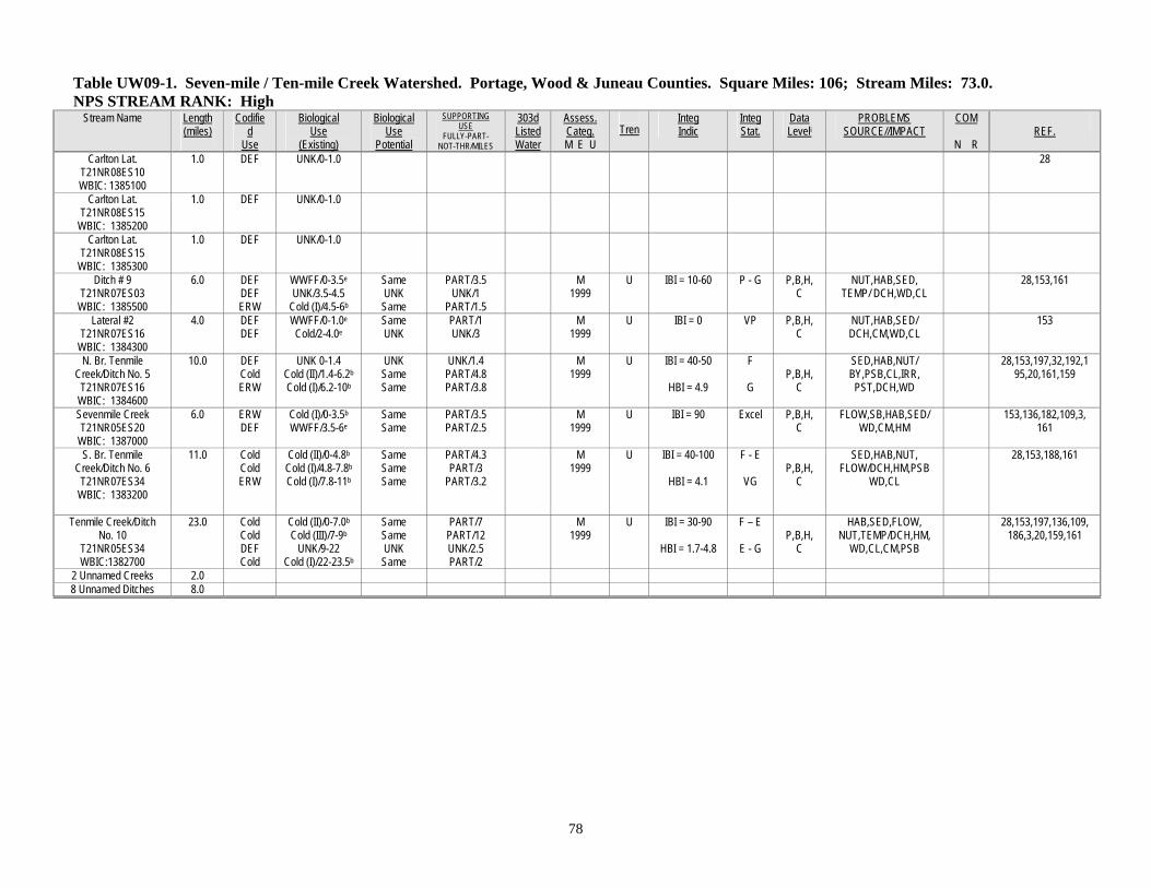
Table UW09-1. Seven-mile / Ten-mile Creek Watershed. Portage, Wood & Juneau Counties. Square Miles: 106; Stream Miles: 73.0. NPS STREAM RANK: High
Stream Name Length (miles)
Codified
Use
Biological Use
(Existing)
Biological Use
Potential
SUPPORTING USE
FULLY-PART- NOT-THR/MILES
303d Listed Water
Assess. Categ. M E U
Tren
Integ Indic
Integ Stat.
Data Leveli
PROBLEMS SOURCE//IMPACT
COM
N R
REF.
Carlton Lat. T21NR08ES10 WBIC: 1385100
1.0 DEF UNK/0-1.0 28
Carlton Lat. T21NR08ES15
WBIC: 1385200
1.0 DEF UNK/0-1.0
Carlton Lat. T21NR08ES15
WBIC: 1385300
1.0 DEF UNK/0-1.0
Ditch # 9 T21NR07ES03
WBIC: 1385500
6.0 DEF DEF ERW
WWFF/0-3.5e UNK/3.5-4.5
Cold (I)/4.5-6b
Same UNK Same
PART/3.5 UNK/1
PART/1.5
M 1999
U IBI = 10-60 P - G P,B,H,C
NUT,HAB,SED, TEMP/ DCH,WD,CL
28,153,161
Lateral #2 T21NR07ES16
WBIC: 1384300
4.0 DEF DEF
WWFF/0-1.0e Cold/2-4.0e
Same UNK
PART/1 UNK/3
M 1999
U IBI = 0
VP P,B,H,C
NUT,HAB,SED/ DCH,CM,WD,CL
153
N. Br. Tenmile Creek/Ditch No. 5
T21NR07ES16 WBIC: 1384600
10.0 DEF Cold ERW
UNK 0-1.4 Cold (II)/1.4-6.2b
Cold (I)/6.2-10b
UNK Same Same
UNK/1.4 PART/4.8 PART/3.8
M 1999
U IBI = 40-50
HBI = 4.9
F
G
P,B,H,
C
SED,HAB,NUT/ BY,PSB,CL,IRR, PST,DCH,WD
28,153,197,32,192,195,20,161,159
Sevenmile Creek T21NR05ES20
WBIC: 1387000
6.0 ERW DEF
Cold (I)/0-3.5b WWFF/3.5-6e
Same Same
PART/3.5 PART/2.5
M 1999
U IBI = 90 Excel P,B,H,C
FLOW,SB,HAB,SED/WD,CM,HM
153,136,182,109,3, 161
S. Br. Tenmile Creek/Ditch No. 6
T21NR07ES34 WBIC: 1383200
11.0 Cold Cold ERW
Cold (II)/0-4.8b Cold (I)/4.8-7.8b
Cold (I)/7.8-11b
Same Same Same
PART/4.3 PART/3
PART/3.2
M 1999
U IBI = 40-100
HBI = 4.1
F - E
VG
P,B,H,
C
SED,HAB,NUT, FLOW/DCH,HM,PSB
WD,CL
28,153,188,161
Tenmile Creek/Ditch No. 10
T21NR05ES34 WBIC:1382700
23.0 Cold Cold DEF Cold
Cold (II)/0-7.0b Cold (III)/7-9b
UNK/9-22 Cold (I)/22-23.5b
Same Same UNK Same
PART/7 PART/12 UNK/2.5 PART/2
M 1999
U IBI = 30-90
HBI = 1.7-4.8
F – E
E - G
P,B,H,
C
HAB,SED,FLOW, NUT,TEMP/DCH,HM,
WD,CL,CM,PSB
28,153,197,136,109,186,3,20,159,161
2 Unnamed Creeks 2.0 8 Unnamed Ditches 8.0
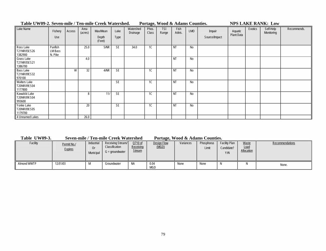
79
Table UW09-2. Seven-mile / Ten-mile Creek Watershed. Portage, Wood & Adams Counties. NPS LAKE RANK: Low Lake Name Fishery
Use
Access Area (acres) Max/Mean
Depth (Feet)
Lake
Type
Watershed Drainage
Phos. Class
TSI Range
Fish Advis. LMO Impair
Source/Impact
Aquatic Plant Data
Exotics Self-Help Monitoring
Recommends.
Ross Lake T21NR05ES26 1382900
Panfish LM Bass N. Pike
25.0 5/NR SE 34.0 1C NT No
Grass Lake T21NR05ES21 1386700
4.0 NT No
Bass Lake T21NR09ES32 970100
W 32 4/NR SE 1C NT No
Walters Lake T20NR09ES04 1177800
SE 1C NT No
Kawalski Lake T20NR09ES04 993600
8 11/ SE 1C NT No
Yonke Lake T20NR09ES05 1179700
20 SE 1C NT No
4 Unnamed Lakes 26.0
Table UW09-3. Seven-mile / Ten-mile Creek Watershed Portage, Wood & Adams Counties.
Facility Permit No./ Expires
Industrial Or Municipal
Receiving Stream/ Classification G = groundwater
Q710 of Receiving
Stream
Design Flow (MGD)
Variances Phosphorus Limit
Facility Plan Candidate?
Y/N
Waste Load
Allocation
Recommendations
Almond WWTP 12/31/03 M Groundwater NA 0.04 MGD
None None N N None.