update of normative seismic zoning in the framework of the...
TRANSCRIPT

ISSN 0747�9239, Seismic Instruments, 2013, Vol. 49, No. 2, pp. 87–114. © Allerton Press, Inc., 2013.Original Russian Text © V.I. Ulomov, 2012, published in Voprosy Ingenernoy Seismologii, vol. 39, no. 1, pp. 5–38.
87
INTRODUCTION
The first step to diminish devastating effects fromstrong earthquakes is reliable zoning of seismic hazardand respective seismic engineering. The importantfactors, on which the number of deaths and damagedone depend, are the knowledge of the local popula�tion and authorities on earthquake hazards and theability to survive a disaster. Solution of these and manyother problems related to diminishing seismic hazardsin the territory of Russia is provided by the FederalSpecial�Purpose Program (FSPP) entitled “Enhance�ment of Seismic Sustainability for Dwellings, MainObjects, and Facilities in the Regions of Russia Proneto Seismic Hazards (2009–2014)” and affirmed onApril 23, 2009. In accord with this FSPP, researchworks were revitalized concerning a series of prob�lems, including those in updating of such regulatingdocuments as SNiP II�7�81* (1995; 2010 update) andmaps of general seismic zoning (GSZ�97) for the ter�ritory of Russia. In order to elaborate suggestions andrecommendations for solving the problems of provi�sional seismic safety of buildings and facilities, theExpert Commission for Seismic Engineering had beenorganized under the jurisdiction of the Minregion(Ministry of Regional Development of the RussianFederation) on August 15, 2009; the author is one ofthe members of this Commission.
Among the most important tasks set by the Minre�gion was the creation of the permanent IntegratedInformation System (IIS) “Seismic Safety of Russia,”which began its operation in test mode in late 2011.The main purpose of the IIS is to provide authorities,interested organizations, and common people with themost complete, up�to�date, and reliable informationon the problems of seismic safety implementation in
the territory of Russia. The leading development orga�nization was the Geological Research Institute forConstruction (AO PNIIIS); the main contractor inthe part of seismology was the Schmidt Institute ofPhysics of the Earth, Russian Academy of Sciences(IPE RAS), which continued its work on updatingseismic zoning (Ulomov, 2008a, 2008b, 2009b). In thesame period, the works on updating the regulatoryframework (SNiP II�7�81*) were revitalized (Aizen�berg, 2010).
At the initiative of the author, together with updat�ing the GSZ�97, development of the new generationof GSZ�2012 maps began in the framework of IIS(however, this was not among the tasks set by Minre�gion). At the first stage of work, in 2010–2011, testmaps for two versions of models depicted the earth�quake source zones (ESZ) in the territory of Russiaand adjacent regions. SNiP II�7�81* and the princi�ples of probabilistic assessment of seismic hazard(PASH) and perfection of general and detailed seismiczoning (GSZ and DSZ) and microzoning (SMZ) werefurther developed. The projects of technical rules forimplementing the works on GSZ (Code of Rules, sta�tuses of GSZ, DSZ and SMZ) (Ulomov and Nikitin,2010).
For the purpose of coordination of the whole com�plex of research in the framework of the FSPP, thededicated groups were organized for updatingthe GSZ (headed by V.I. Ulomov, IPE RAS) andSNiP II�7�81* (headed by N.I. Frolov, NP SRONOSTROI). These groups included leading specialistsfrom different academic institutes and specializedinstitutions of Russia.
The studies of seismic zoning were carried outsimultaneously in two main fields:
Update of Normative Seismic Zoning in the Frameworkof the Integrated Information System
for the Seismic Safety of RussiaV. I. Ulomov
Schmidt Institute of Physics of the Earth, Russian Academy of Sciences, ul. Bol’shaya Gruzinskaya 10, Moscow, 123995 Russiae�mail: [email protected]
Abstract—The article deals with updating databases and the general seismic zoning maps of the Russian ter�ritory (GSZ�97). Development of new maps (GSZ�2012) is considered. Recommendations on updating thebuilding codes are made. The article reports on the development of the Integrated Information System “Seis�mic Safety of Russia” that involves operation of the specialized interactive maps of seismic hazard forecast.
Keywords: seismic zoning, seismic hazard, seismic effect, macroseismic regime, building codes
DOI: 10.3103/S0747923913020047

88
SEISMIC INSTRUMENTS Vol. 49 No. 2 2013
ULOMOV
1) creation of the updated set of GSZ�97* maps(enhanced and supplemented version of the existingGSZ maps for the territory of Russia);
2) development of a new GSZ concept and cre�ation of model maps showing earthquake source zonesin the territory of Russia for the GSZ�2012.
The following are the main results of seismologicalstudies obtained in 2010–2011 by the group consistingof large number of specialists with participation andunder the leadership of the author.
The present paper is published with respect to thejoint proposal of the Science Council of the Problemof Seismology, Russian Academy of Sciences (chair�man is a Corresponding Member of the RAS,G.A. Sobolev) and the Council on the Problems of theEarth’s Seismicity and Natural and Natural–Techno�genic Catastrophes in the IPE RAS (chairman isDr. Phys.�Math. Sci., A.D. Zavyalov) made on Febru�ary 17, 2011: “To ask the member of the Council of theProblem of Seismology of the RAS, Prof. V.I. Ulomov,to deliver the report about the planning and carryingout of works on the improvement of the general seis�mic zoning map of Russia, and to report the methodi�cal points of the prepared changes in a scientific jour�nal” (minutes of meeting no. 1/2011).
INITIAL DATA AND STUDY METHODS
Basic Definitions
Seismic hazard (SH) means the maximal seismiceffects which are expected in a given area and may beexceeded at a set probability during a set time interval.Seismic effects are measured in points of macroseis�mic scale, as well as in peak accelerations and otherquantitative parameters of ground motion, used inseismic engineering. The seismic hazard level anddegree of vulnerability for artificial and natural objectscause the value of seismic risk estimated on the basis ofexpected socio�economic damage.
General seismic zoning (GSZ) means mapping of aseismic hazard over the whole territory of a country;this mapping is based on studies of seismicity and theseismic regime of regional, interregional, and largeglobal seismogenerating structures (SGS). The GSZmaps are the components of a normative and legisla�tive framework that provide well�sounded land use,socio�economic development, environmental protec�tion, seismic engineering, and population safety whenstrong earthquakes occur at the national, regional, andsubregional levels.
Seismicity of Russia
Hereinafter, the term “seismicity” is used in its spe�cific, geological�geophysical sense instead of themeaning implied by Russian designers and builderswith respect to the results of seismic zoning. BeyondRussia and the former Soviet Union, these results of
seismic zoning are called “seismic hazard” or “shake�ability”, after the suggestion by Yu.V. Riznichenko inthe mid�1960s (Riznichenko, 1965, 1966). To preventambiguity and misunderstanding, it seems reasonableto define the results of seismic zoning as “macroseis�micity,” but not seismicity (Ulomov, 2009b).
In terms of seismology, seismicity is the spatio�temporal and energy distribution of earthquakefocuses, characterized by magnitude, depth and size ofsource, seismic regime, and other geophysical param�eters. In other words, seismicity and seismic regimemean what occurs in the earth’s interior, while mac�roseismicity and macroseismic regime imply manifes�tations of the seismic effects on the earth’s surface.These manifestations are estimated in points of mac�roseismic scale, accelerations of ground motions, andother parameters related to the seismic effects.
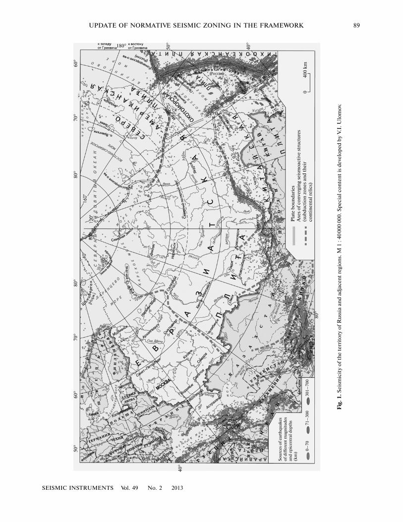
Compared to other countries of the world, locatedin seismoactive zones, the territory of Russian Feder�ation is generally characterized by moderate seismicity(Fig. 1) (Ulomov, 2004, 2007). The only exclusions arethe regions of Northern Caucasus, Southern Siberia,and the Russian Far East, where intensities of seismicshaking reach 8–9 and 9–10 on the MSK�64. A cer�tain hazard can be expected in the zones of 6–7 on theMSK�64, located within the densely populatedregions in the European part of Russia.
In the global framework, the territory of Russiabelongs to Northern Eurasia, whose seismicity iscaused by intensive geodynamical interaction of sev�eral large lithospheric plates: Eurasian, African, Ara�bian, Indo�Australian, Chinese, Pacific, North Amer�ican, and Okhotsk. The most mobile and hence activeare the plate boundaries where large seismogeneratingorogenic belts are formed: Alpine�Himalayan in thesouthwest, Transasian in the south, Chersky in thenortheast, and Pacific in the east of Northern Eurasia.
Every belt is inhomogeneous in structure, strengthproperties, and seismogeodynamics, and consists ofuniquely structured seismoactive regions that can bepictured as ordered and genetically related geostruc�tures (Ulomov, 1993, 1997).
The characteristic feature of all seismoactiveregions is nearly the same length (about 3000 km),which is caused by the sizes of ancient and modernsubduction zones (located in the periphery of oceans)and their orogenic relics within the continents. Thepredominant part of all earthquakes is concentrated inthe uppermost crust at the depths of 15–20 km. Thedeepest (down to 650 km) focuses were reported forthe Kuril�Kamchatka subduction zone. The earth�quakes having an intermediate depth of focuses (70–300 km) occur in East Carpathians (Romania, Vran�cea zone, down to 150 km depth), in Central Asia(Afghanistan, Hindu Kush zone, up to 300 km depth),and beneath the Greater Caucasus and Central Basinof the Caspian Sea (down to 100 km and deeper) (Ulo�mov et al., 2007). The strongest events occurring inthese regions are felt in the territory of Russia.
SEISMIC INSTRUMENTS Vol. 49 No. 2 2013
UPDATE OF NORMATIVE SEISMIC ZONING IN THE FRAMEWORK 89
Sou
rces
of e
arth
quak
es
Pla
te b
oun
dari
esA
xes
of c
onve
rgin
g se
ism
oact
ive
stru
ctur
es40
0 km
(sub
duct
ion
zon
es a
nd
thei
rco
nti
nen
tal r
elic
s)0
40°
50°
60°
180°
70°
80°
80°
70°
60°
50°
40°
80°
of d
iffe
ren
t m
agn
itud
esan
d ep
icen
tral
dep
ths
(km
) 0–70
71–
300
301–
700
Fig
. 1. S
eism
icit
y of
th
e te
rrit
ory
of R
ussi
a an
d ad
jace
nt
regi
ons.
M 1
: 40
000
000.
Spe
cial
con
ten
t is
dev
elop
ed b
y V.
I. U
lom
ov.

90
SEISMIC INSTRUMENTS Vol. 49 No. 2 2013
ULOMOV
Every region has a specific periodicity of earth�quake occurrence (that determines the seismicregime) and migration of seismic activation along theseismoactive faults. Sizes (lengths) of every sourcecause the magnitude value of an earthquake. The rup�ture length in a source of an event with Ms = 7.0 andhigher reach tens and hundreds of kilometers.
Zoning of Seismic Hazard
In 1991–1997, thanks to the development of con�sistent methodology and advances in probabilisticapproaches in seismic zoning of Russia, the paradigmof seismic hazard estimation changed. The unifieddatabase of initial seismological and other geological�geophysical data has been organized for the vast areaof Russia and adjacent seismoactive regions for thefirst time; additionally, the fundamentally new linea�ment�domain�focal model (LDF�model) for ESZswith adequate seismogeodynamical parametrizationhas been developed (Ulomov, 1998). Instead of tradi�tionally one deterministic map, for the first time in theworld’s seismological practice, the set of probabilisticmaps GSZ �97 (Fig. 2) began to be used; this set ofmaps was the first step of the fundamentally new seis�mic zoning, which took into consideration dynamicsand the time factor (Ulomov and Shumilina, 1999a,1999b, 2000; Seismicheskoe…, 2000).
GSZ�97 maps for the territory of the Russian Fed�eration were officially adopted on March 23, 1998 by the
vice�President of the RAS, Academician N.P. Laverov,received a status of normative regulations, and in 2000were included into the modified version of SNiP II�7�81*.The new methodology and GSZ�97 set of maps werewidely discussed at different scientific and govern�mental levels and in 2002 were awarded the State Prizeof the Russian Federation (in the field of Science andTechnics). These maps have proved their validitythrough all the consequent seismic events that haveoccurred in the country for the 15 years that followed.In addition to numerous weak and moderate events,earthquakes of 8–9 and even more on the MSK�64have occurred in this period (including those inSakhalin, Altai Mountain, Koryakia, Kuril Islands).Remarkably, their seismic effects have not violated theprobabilistic estimates given by the GSZ�97 maps.Nevertheless, analogous to the previous editions of theseismic hazard zoning maps that were updated every10 years on average (since 1937), the GSZ�97 mapsneeded to be updated as well due to the new collecteddata on seismicity of the studied territory, and withrespect to the appearing technical rules and new ideas.
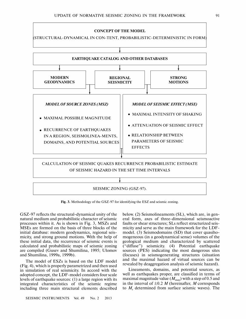
Simulation of Earthquake Sources
The methodology of the construction of GSZ�97maps is based on the regional approach in creating twomutually dependent seismogeological models,namely, the model of source zones (MSZ) and modelof seismic effect (MSE) (Fig. 3). The concept of the
GSZ�97�A
GSZ�97�B
GSZ�97�C
Fig. 2. GSZ�97 standard maps showing general seismic zoning of the territory of the Russian Federation. Edited by V.I. Ulomov.
SEISMIC INSTRUMENTS Vol. 49 No. 2 2013
UPDATE OF NORMATIVE SEISMIC ZONING IN THE FRAMEWORK 91
GSZ�97 reflects the structural�dynamical unity of thenatural medium and probabilistic character of seismicprocesses within it. As is shown in Fig. 3, MSZs andMSEs are formed on the basis of three blocks of theinitial database: modern geodynamics, regional seis�micity, and strong ground motions. With the help ofthese initial data, the recurrence of seismic events iscalculated and probabilistic maps of seismic zoningare compiled (Gusev and Shumilina, 1995; Ulomovand Shumilina, 1999a, 1999b).
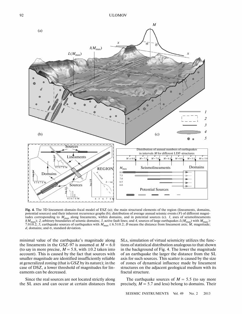
The model of ESZs is based on the LDF model(Fig. 4), which is properly parametrized and then usedin simulation of real seismicity. In accord with theadopted concept, the LDF�model considers four scalelevels of earthquake sources: (1) a large region with itsintegrated characteristics of the seismic regimeincluding three main structural elements described
below. (2) Seismolineaments (SL), which are, in gen�eral form, axes of three�dimensional seismoactivefaults or shear structures; SLs reflect structurized seis�micity and serve as the main framework for the LDF�model. (3) Seismodomains (SD) that cover quasiho�mogeneous (in a geodynamical sense) volumes of thegeological medium and characterized by scattered(“diffuse”) seismicity. (4) Potential earthquakesources (PES) indicating the most dangerous sites(focuses) in seismogenerating structures (situationand the maximal hazard of virtual sources can berevealed by deaggregation analysis of seismic hazard).
Lineaments, domains, and potential sources, aswell as earthquakes proper, are classified in terms ofmaximal magnitude value (Mmax) with a step of 0.5 andin the interval of ±0.2 M (hereinafter, M correspondsto Ms determined from surface seismic waves). The
CONCEPT OF THE MODEL
EARTHQUAKE CATALOG AND OTHER DATABASES
MODERN REGIONAL STRONG
MODEL OF SOURCE ZONES (MSZ)
MAXIMAL POSSIBLE MAGNITUDE
RECURRENCE OF EARTHQUAKES
IN A REGION, SEISMOLINEA�MENTS,
DOMAINS, AND POTENTIAL SOURCES
MODEL OF SEISMIC EFFECT (MSE)
MAXIMAL INTENSITY OF SHAKING
ATTENUATION OF SEISMIC EFFECT
RELATIONSHIP BETWEEN
SEISMIC ZONING (GSZ�97).
CALCULATION OF SEISMIC QUAKES RECURRENCE PROBABILISTIC ESTIMATE
OF SEISMIC HAZARD IN THE SET TIME INTERVALS
(STRUCTURAL�DYNAMICAL IN CON�TENT, PROBABILISTIC�DETERMINISTIC IN FORM)
GEODYNAMICS SEISMICITY MOTIONS
PARAMETERS OF SEISMIC
EFFECTS
Fig. 3. Methodology of the GSZ�97 for identifying the ESZ and seismic zoning.
92
SEISMIC INSTRUMENTS Vol. 49 No. 2 2013
ULOMOV
minimal value of the earthquake’s magnitude alongthe lineaments in the GSZ�97 is assumed at M = 6.0(to say in more precise, M = 5.8, with ±0.2 taken intoaccount). This is caused by the fact that sources withsmaller magnitude are identified insufficiently reliableat generalized zoning (that is GSZ by its nature); in thecase of DSZ, a lower threshold of magnitudes for lin�eaments can be decreased.
Since the real sources are not located strictly alongthe SL axes and can occur at certain distances from
SLs, simulation of virtual seismicity utilizes the func�tions of statistical distribution analogous to that shownin the background of Fig. 4. The lower the magnitudeof an earthquake the larger the distance from the SLaxis for such sources. This scatter is caused by the sizeof zones of dynamical influence made by lineamentstructures on the adjacent geological medium with itsfractal structure.
The earthquake sources of M = 5.5 (to say moreprecisely, M = 5.7 and less) belong to domains. Their
(a)
(b) (c)
L(Mmax)
l(Mmax)
x
x
M
σσ
d
d
d
1
2
3
4
5
log
I/d
log
I/I
log
I/f
log
I/R
4 5 6 7 8 M
4 5 6 7 8 M
4 5 6 7 8 M
4 5 6 7 8 M
b – var
b – const
Mmax
VM ⇒ 8.0
VM = 7.5
VM = 7.0
VM = 6.5
VM = 6.0
VM = 5.5
VM ⇐ 5.0
8.0
7.5
7.0
6.5
6.0
Lineaments
DomainsREGION
Distribution of annual numbers of earthquakes
Seismolineaments Domains
Potential Sources
Sources
Sources
in intervals M for different LDF�structures
Fig. 4. The 3D lineament�domain�focal model of ESZ (a); the main structural elements of the region (lineaments, domains,potential sources) and their inherent recurrence graphs (b); distribution of average annual seismic events (V) of different magni�tudes corresponding to Mmax along lineaments, within domains, and in potential sources (c). 1, axes of seismolineamentsl(Mmax); 2, arbitrary boundaries of seismic domains; 3, active fault lines; and 4, sources of large earthquakes L(Mmax) with Mmax ≥7.0±0.2; 5, earthquake sources of earthquakes with Mmax ≤ 6.5±0.2; D means the distance from lineament axis; M, magnitude;d, domains; and σ, standard deviation.

SEISMIC INSTRUMENTS Vol. 49 No. 2 2013
UPDATE OF NORMATIVE SEISMIC ZONING IN THE FRAMEWORK 93
upper threshold can also be decreased when detailingGSZ maps, while sources proper, which are “scat�tered” within domains, are grouped into clusters withrespect to lineaments of fewer orders, as it is shown inFig. 5 (Ulomov, 2009a). In these constructions, modelvalues of probable deviations of earthquake focuses
from axes of respective lineaments for the GSZ (Table 1),supplemented with values for lower magnitudes, havebeen used.
Determination of seismic regime parameters forthe main structural elements of the LDF�model is themost difficult and the most important part of studies
(a) (b)
D0300
D0301
D0308
D9316
Fig. 5. Transformation of the scattered distribution of earthquake epicenters within domains D (a) into the structurized seismicitylocalized along lineaments of less orders (b). Average annual number of seismic events in the same areas remains the same.
Table 1. Deviation σM for source displacement relative to lineaments' axes
Mmax
σM value (km) for lineaments possessing M = Mmax – n
n = 0.0 n = 0.5 n = 1.0 n = 1.5 n = 2.0 n = 2.5
8.5 12 17 25 35 51 73
8.0 10 15 21 30 43 62
7.5 9 12 18 25 35.5 50
7.0 7 10 15.2 21 30 42
6.5 6 8.4 12.9 18 24.5
6.0 5 7 11 15
5.5 4.2 5.8 9.3
5.0 3.5 4.9
4.5 3

94
SEISMIC INSTRUMENTS Vol. 49 No. 2 2013
ULOMOV
related to seismic zoning, because validity of all thesubsequent constructions depends on this. Thedetailed description of the parameterization techniqueis given in the explanatory note to the GSZ�97 maps(Ulomov and Shumilina, 1999a) and in some otherpublications by the author. Additionally, Fig. 4b illus�trates distribution of earthquakes with different mag�nitudes, and Fig. 4c shows that of seismic event flowsbetween the main structural elements of the wholeregion (lineaments, domains, and potential sources).
The basis of seismological parameterization is theregional approach caused by global ordering of seis�moactive regions (Ulomov, 1993, 1997). The regionalapproach has significant advantages in comparison toother ones used for estimation of the maximal possiblemagnitude (Mmax) and determination of the seismicregime of seismogenerating structures. At first, aregion of about 3000 km in size has a physically sub�stantiated nature and can be considered as a “seis�mogeocenosis” that includes all structural elements.Secondly, the large area of a region (compared to thatof a particular fault) enables one to obtain a quite com�plete catalog of earthquakes with different magni�tudes, and therefore, more reliable data on the seismicregime of a region on the one hand and on structuralelements, between which the integrated flow of seis�mic events distributes with respect to their order (sizeand Mmax), on the other hand.
Probabilistic Analysis of Seismic Hazard
Solution of almost all problems related to the pre�diction of a seismic hazard involves probabilistic andprobability�determined characteristics that take intoaccount both random and regular factors of seismo�genesis, as well as various uncertainties in initial andoutput data, which can violate the validity of the deter�ministic approach to seismic zoning. At present, themost reliable zoning can be implemented only on theprobabilistic basis. In other words, seismic hazards willalways happen, but they should be reduced to a mini�mum and find convenient guidelines in building. Thisprinciple is what GSZ�97 maps and their updated ver�sions GSZ�97* imply, so the degree of seismic hazardfor objects of different categories of importance andservice life can be assessed.
The methodology of PASH has been widely used ininternational seismological practice and has becomethe foundation of GSZ�97 maps; it is still used becausethere is no other, more efficient method.
In the GSZ�97 maps, the PASH results are pre�sented in the form of model seismic intensity I withaverage recurrence of one time per T years. ProbabilityP that this intensity will increase for t years (i.e., atleast one stronger event will occur) is calculated by theformula
P = 1 – exp( –t/T).
E.g., at T = 500 years and t = 50 years, P ≈ 10% (tosay more precisely, 9.52%); at T = 1000 years and t =50 years, P ≈ 5% (the precise value is 4.88), etc.
The GSZ�97 set include three maps that reflectprobabilities of 10% (GSZ�97A), 5% (GSZ�97B) and1% (GSZ�97C) that the model seismic intensity willbe exceeded (or vice versa, will not be exceeded in 90,95 and 99% of cases, respectively) for 50 years; thiscorresponds to the recurrence period of seismic effectmanifestation on the earth’s surface one time per 500,1000 and 5000 (the precise values are 475, 975 and4975) years on average. For very important buildings(nuclear power stations and other objects of nuclearindustry), the map GSZ�97D has been created; ittakes into consideration the seismic effect from veryrare earthquakes that occur in the studied territory onetime per T = 10000 years (P = 0.5%).
DESIGNING OF THE UPDATEDGSZ�97* MAPS
Principles of the GSZ�97 Update
Figure 6 shows the method for updating the mapsof GSZ; in fact, this method follows the pattern onwhich the GSZ�97 maps were created (see Fig. 3).
It should be noted that terminology problems(related to distorted term seismicity) were addressed inthis case as well. E.g., the term “update of initial seis�micity”, which was widely used in the wrong sense bybuilding and surveying specialists, has now “recov�ered” its meaning and implies “update of seismicitymodel” (i.e., update of the ESZ model). As the term“seismic hazard” was introduced into the interna�tional seismological practice, the author proposed in2004 to use the term “update of seismic hazard”(USH), while the term “update of initial seismicity”(UIS) began to be used in its direct sense.
Update of the general seismic zoning (UGSZ)means the studies of seismoactive territories, made inmore details (1 : 500000 and smaller) than the GSZ�97studies were made (initial scale 1 : 2500000), resultedin the USH on the basis of the updated model of initialseismicity (MIS model) and model of intensitydecrease with distance (IDD model) from the source.
Note that the same normative recurrence periods Tshould be kept, at that, because they are incorporatedinto the GSZ�97 and updated GSZ�97* maps (seebelow).
Thus, updating of the initial seismicity model isaimed at both an update of seismicity proper and anupdate of the LDF�model of ESZs that causes predic�tion of the seismic regime. The UHS is used for seis�mic hazard assessment in both particular points (indi�cated as USH�1 instead of the MIS model) and lim�ited areas (USH�2, analog of DSZ in the probabilisticsense).
Note that, independently of whether a particularsite (USH�1) or vast territory (USH�2) is considered,

SEISMIC INSTRUMENTS Vol. 49 No. 2 2013
UPDATE OF NORMATIVE SEISMIC ZONING IN THE FRAMEWORK 95
studies on UIS and IDD should involve quite largeregions around the studied area, depending on themaximal magnitude of a possible event and effectiveattenuation of seismic intensity with distance.
As was noted above, probabilistic maps of GSZ andmethodology of their making (LDF�model, norma�tive recurrence periods, etc.) should be the basis for allworks on DSZ (i.e., USH�1 and USH�2) and SMZ.
Update of the Earthquake Catalog
The earthquake catalogs remain the fundamentalbasis of all studies on GSZ of the territory of Russia.The works on updating the GSZ�97 maps and prepar�ing the next generation of GSZ�2012 maps are alsobased on earthquake catalogs (Ulomov and Peretokin,2010a, 2010b; Danilova and Medvedeva, 2011;
UPDATE OF THE EARTHQUAKE CATALOG AND DATA�BASES
UPDATE OF THE INITIAL
DETAILING THE MODEL OFEARTHQUAKE SOURCES, AND
SEISMOGEODYNAMICALPARAMETERIZATION OF ESZ LINEA�
MENT�DOMAIN STRUCTURE
UPDATE OF THE INTENSITY
DETAILING THE MODELDESCBIBING THE DE�PENDENCE
OF SEISMIC EFFECT ATTENUATIONON MAGNITUDE AND DISTANCE,AND UPDATE OF COEFFICIENTS
IN THE EQUATION I(M,R)
ATTENUATION (UIA)SEISMICITY (UIS)
UPDATE OF SEISMIC HAZARD (USH)
CALCULATION OF SEISMIC EFFECTS AND PROBABILISTIC ESTIMATE
OF SEISMIC HAZARD IN THE SET STANDARD TIME INTERVALS FOR
INDIVIDUAL POINTS (USH�1) AND AREAS (USH�2).
Fig. 6. Technique of updating the general seismic zoning (UGSZ).
20001960194019201900 1980
Earthquakes in Russia
Earthquakes in USSR and Northern Eurasia
(Novyi katalog ..., 1977) Unified Catalog...
Specialized Catalog...
Bulletin...
(Atlas of Earthquakes in USSR, 1962)
(Mushketov and Orlov, 1893)
Fig. 7. The chronology and coverage of earthquake catalogs for the territory of Northern Eurasia. Annual catalogs: Bulletin of theReference Seismic Network (since 1924; since 1962 was titled as Seismological Bulletin…), Earthquakes in USSR (since 1962),Earthquakes in Russia (since 2002), Earthquakes in Northern Eurasia; Unified Catalog of Earthquakes in Northern Eurasia(Ulomov, 1993); Specialized Catalog of Earthquakes in Northern Eurasia (Ulomov, 1996).
96
SEISMIC INSTRUMENTS Vol. 49 No. 2 2013
ULOMOV
Nikonov and Shvarev, 2011; Nikonov, Medvedeva,and Shvarev, 2011).
Figure 7 shows the chronology of the publication ofofficial earthquake catalogs; this timeline includescatalogs for the territories of the Russian Empire,Soviet Union, and modern Russian Federation. Thefirst fundamental work among these publications was“The Catalog of Earthquakes in the Russian Empire”compiled by I.V. Mushketov and A.P. Orlov in 1893.By the time of the GSZ�97 maps publication, the mostcomplete and well�known was the “New Catalog ofStrong Earthquakes in the USSR from Ancient Timesthrough 1975” edited by N.V. Kondorskaya andN.V. Shebalin (Novyi katalog…, 1977). An updatedand modified version of this catalog, entitled “UnifiedEarthquake Catalog for Northern Eurasia” (UEC),was created in 1991–1995 and edited by N.V. Kondor�skaya and V.I. Ulomov; this catalog was the basis of thegeneral seismic zoning edition of 1997. Note that sucha complete catalog was applied for seismic zoning forthe first time, because the previous (and the mostunsuccessful) zoning of 1978 was made before the“New Catalog…” was published.
Simultaneously, under the leadership of the author,the Specialized Earthquake Catalog (SEC) was beingcompiled in 1991–1995; it was purposed for seismo�logical parameterization of the LDF�model andstudying the migration of seismic activation (Ulomov,1993; Danilova and Medvedeva, 2011). The main dif�ference between the SEC and UEC is exclusion ofaftershocks and other swarm events in order to obtaina “pure seismic regime” for further statistical study;other differences are the magnitude representationwith a 0.5 unit step and averaging of magnitude valuesin the interval of ±0.2 Ms. The information aboutsource sizes and orientations for large earthquakes(Ms = 7.0 ± 0.2 and more) was included into the SEC,and this information was introduced into practice bythe author in the mid�1970s (Ulomov, 1974). In thesense of geometry, the SEC is represented in the GSZ�97database in two representations: (a) points with arbi�trary mapping of magnitudes and other geophysicalparameters of earthquake sources, (b) polygons(ellipses and circles) that reflect natural sizes and ori�entation of earthquake sources in the best way.
In the period of 1992–1999, owing to participationof the IPE RAS in the Global Seismic Hazard Assess�ment Program (GSHAP) developed under the aus�pices of UNESCO, Russian catalogs were beingadjusted to the European standards (Ulomov, 1999).
The UEC and SEC include the main parameters ofall the known earthquakes with Ms ≥ 4.5 since ancienttimes until present; since 1960, the catalogs are sup�plemented with events of Ms ≥ 3.3 that are representa�tive for almost the entirety of Northern Eurasia. Atpresent, the UEC and SEC compiled at the IPE RASare regularly supplemented with new data on occur�ring earthquakes thanks to the Geophysical Survey,
RAS. Preparation of the historical, archeological, andpaleoseismic information about the earthquakes thatoccurred in the pre�instrumental period is supervisedby A.A. Nikonov (Nikonov and Medvedeva, 2011;Nikonov and Shvarev, 2011). The general supervisionof the entire work on this project has been carried outby the author since 1991.
Specification of the UEC and SEC when makingtheir updated version (GSZ�97*) was related mostly tothe Eastern European part of Russia, e.g., the Tambovearthquake of December 30, 1954 (M = 4.8) wasexcluded from the catalog because of its technogenicorigin (however, it was believed to be a tectonic one fora long time, and therefore, had been included intoofficial catalogs).
Update of Regional Seismic Regimes
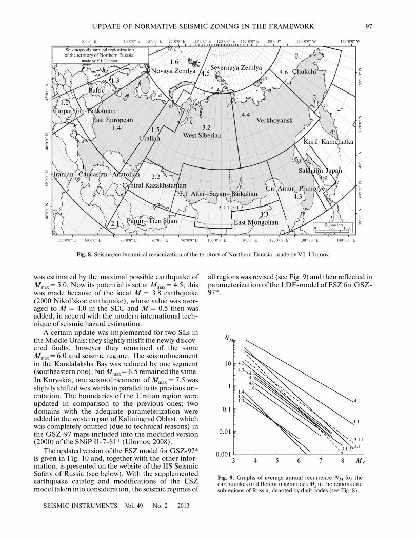
From the geological viewpoint, the territory ofNorthern Eurasia includes two types of structures:(1) four large platforms of different age, characterizedby relatively low and scattered (diffused) seismicity(East European, Turanian, West Siberian, and Sibe�rian); (2) the series of orogenic regions of extremelyhigh seismicity (Iranian–Caucasian–Anatolian, Cen�tral Asian, Altai–Sayan–Baikalian, Kuril�Kamchat�kan, and others). The seismic regionalization usedduring construction of the GSZ�97 and its updatedversion of GSZ�97* is illustrated by Fig. 8. The graphsof average annual recurrence of earthquakes with dif�ferent magnitudes, on the basis of the SEC as of its2010 update, are given in Fig. 9. Along the abscissaaxis, magnitude values are plotted (with ±0.2 intervaland with 0.5 ΔM step). The ordinate axis indicatedaverage annual number NM of earthquakes withM ≥ 4.0 in the main seismoactive regions of Russia.During seismological parameterization of the updatedESZ model, the Altai–Sayan–Baikalian region wasdivided into two subregions along the 104° E meridian.It is seen that the graph of the Kuril–Kamchatkanregion is plotted above of all others (4.1 in Fig. 8); thesecond highest graph is that for the Iranian–Cauca�sian–Anatolian region (1.1 in Fig. 8). The lowestactivity is characteristic for the subregions of the Euro�pean part of Russia.
Update of the Earthquake Source Model
During the works on updating the GSZ�97 mapsand making their updated version GSZ�97*, the mostattention was paid to the European part of Russia,which is characterized by high population density andwhere many nuclear objects are located. In particular,as has been shown above, the M = 4.8 seismic event ofDecember 20, 1954 was excluded from the catalog(explosive blast). In its order, this is reflected in theLDF�model of ESZ. In particular, the seismodomainincluding the Voronezh Crystalline Massif was slightlymodified. Previously, in the framework of the GSZ�97, it
SEISMIC INSTRUMENTS Vol. 49 No. 2 2013
UPDATE OF NORMATIVE SEISMIC ZONING IN THE FRAMEWORK 97
was estimated by the maximal possible earthquake ofMmax = 5.0. Now its potential is set at Mmax = 4.5; thiswas made because of the local M = 3.8 earthquake(2000 Nikol’skoe earthquake), whose value was aver�aged to M = 4.0 in the SEC and M = 0.5 then wasadded, in accord with the modern international tech�nique of seismic hazard estimation.
A certain update was implemented for two SLs inthe Middle Urals: they slightly misfit the newly discov�ered faults, however they remained of the sameMmax = 6.0 and seismic regime. The seismolineamentin the Kandalaksha Bay was reduced by one segment(southeastern one), but Mmax = 6.5 remained the same.In Koryakia, one seismolineament of Mmax = 7.5 wasslightly shifted westwards in parallel to its previous ori�entation. The boundaries of the Uralian region wereupdated in comparison to the previous ones; twodomains with the adequate parameterization wereadded in the western part of Kaliningrad Oblast, whichwas completely omitted (due to technical reasons) inthe GSZ�97 maps included into the modified version(2000) of the SNiP II�7�81* (Ulomov, 2008).
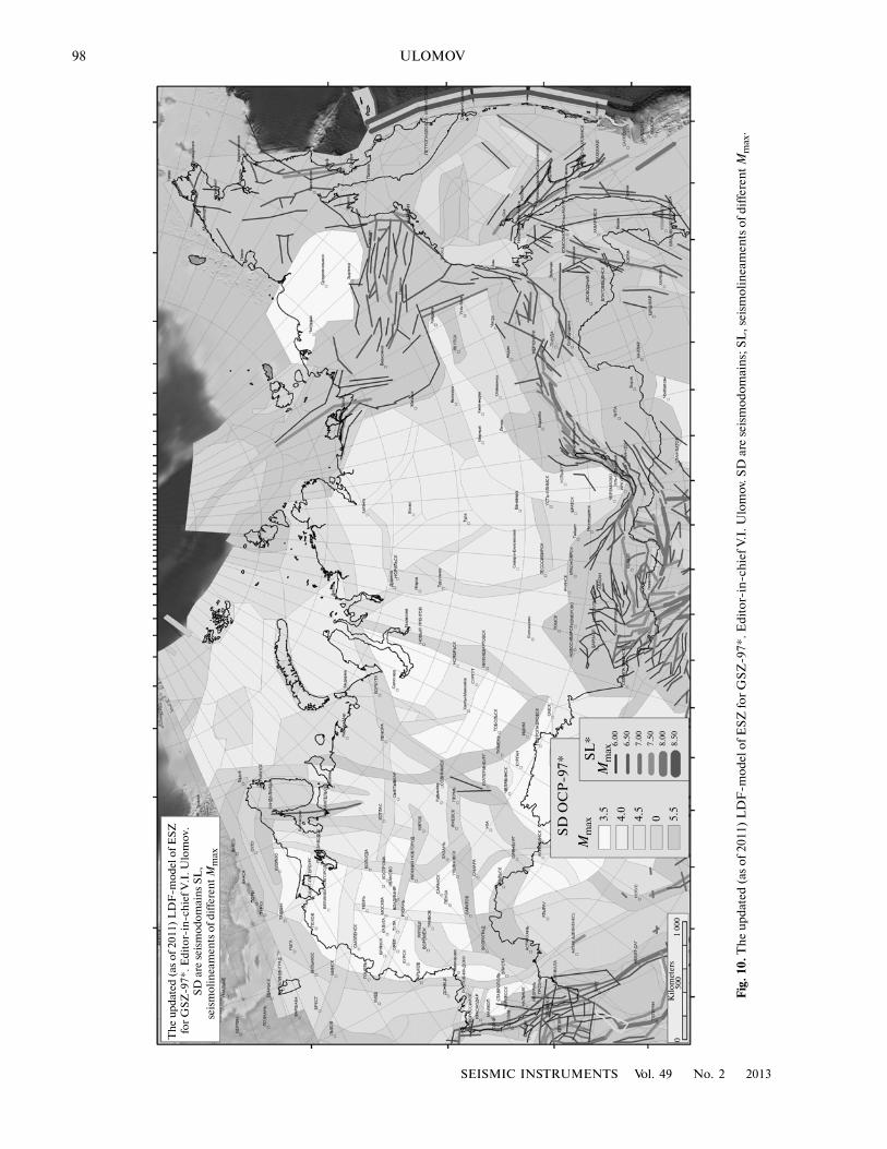
The updated version of the ESZ model for GSZ�97*is given in Fig. 10 and, together with the other infor�mation, is presented on the website of the IIS SeismicSafety of Russia (see below). With the supplementedearthquake catalog and modifications of the ESZmodel taken into consideration, the seismic regimes of
all regions was revised (see Fig. 9) and then reflected inparameterization of the LDF�model of ESZ for GSZ�97*.
1.6
1.5 3.2
1.3
1.2
4.4
4.6
2.2
3.1
3.3
4.2
4.3
4.1
2.1
1.4
4.5
3.1.1 3.1.2
1.1
5°0′0′′ E 10°0′0′′ E 15°0′0′′ E 25°0′0′′ E 55°0′0′′ E 120°0′0′′ E 165°0′0′′ E 180°0′0′′ 170°0′0′′ W 165°0′0′′ W
55°0′
0′′ N
50°0′
0′′ N
45°0′
0′′ N
40°0′
0′′ N
35°0′
0′′ N
45°0′
0′′ N
40°0′
0′′ N
30°0′
0′′ N
35°0′
0′′ N
55°0′0′′ E 60°0′0′′ E 70°0′0′′ E 80°0′0′′ E 90°0′0′′ E 100°0′0′′ E 110°0′0′′ E 120°0′0′′ E 130°0′0′′ E 140°0′0′′ E
0 500 1000 Kilometers
Baltic
Novaya Zemlya
Carpathian�BalkanianEast European
Uralian
Iranian–Caucasian–Anatolian
Severnaya Zemlya
West Siberian
Central Kazakhstanian
Pamir–Tien Shan
Altai–Sayan–Baikalian
East Mongolian
Verkhoyansk
Cis�Amur–Primorye
Sakhalin�Japan
Chukchi
Kuril�Kamchatka
Seismogeodynamical regionizationof the territory of Northern Eurasia,
made by V.I. Ulomov
Fig. 8. Seismogeodynamical regionization of the territory of Northern Eurasia, made by V.I. Ulomov.
0.01
0.001MS863 54 7
0.1
1
10
NM
4.1
1.1
3.1.1
3.13.1.2
1.31.51.4
1.64.6
4.3
4.2
4.54.4
Fig. 9. Graphs of average annual recurrence NM for theearthquakes of different magnitudes Ms in the regions andsubregions of Russia, denoted by digit codes (see Fig. 8).
98
SEISMIC INSTRUMENTS Vol. 49 No. 2 2013
ULOMOV
6.00
6.50
7.00
7.50
8.00
8.50
3.5
4.0
4.5
0 5.5
Th
e up
date
d (a
s of
201
1) L
DF
�mod
el o
f ES
Z SD
OC
P�9
7*
SL
*M
max
Mm
ax
for
GS
Z�9
7*. E
dito
r�in
�ch
ief V
.I. U
lom
ov.
SD
are
sei
smod
omai
ns
SL
,se
ism
olin
eam
ents
of d
iffe
ren
t Mm
ax
Kil
omet
ers
1 0
0050
00
Fig
. 10.
Th
e up
date
d (a
s of
201
1) L
DF
�mod
el o
f ES
Z fo
r G
SZ
�97*
. Edi
tor�
in�c
hie
f V.I
. Ulo
mov
. SD
are
sei
smod
omai
ns;
SL
, se
ism
olin
eam
ents
of d
iffe
ren
t M
max
.
SEISMIC INSTRUMENTS Vol. 49 No. 2 2013
UPDATE OF NORMATIVE SEISMIC ZONING IN THE FRAMEWORK 99
Expansion of Probabilistic Estimates of Seismic Hazard
When constructing the updated GSZ�97 maps, theset of probabilistic maps was expanded by adding twomaps for recurrence periods of 100 and 2500 years.This was caused by a number of circumstances,including the fact that seismic effects cannot be ade�quately assessed for some kinds of building objects;another important argument for this was the sugges�tion that for the purpose of civil and industrial build�ing, the maps for periods T of 100, 500, and 2500 yearswill be used instead of those for 500, 1000, and5000 years. The maps for periods of 100, 500, and2500 years can be referred to as three categories ofresponsibility for building objects (lowered, normal,higher) in terms of the new Federal Law entitled“Technical Rules for Safety of Buildings and Facili�ties” (Federal’nyi…, 2009) and the Urban Develop�ment Code of the Russian Federation (Grados�troitl’nyi…, 2004). These periods do not contradict theinternational recommendations. However, it may benoted that the United States demonstrate a tendencyto increase the estimate of seismic hazard by transitionfrom maps of T = 500 years to those of T = 2000 years.
Table 2 presents the probability values of 90%not exceeding seismic hazard during different timeintervals t. Here, T* means the model period of seismiceffect recurrence, providing a 90% non�exceedingvalue; T, the more usual, averaged values of these peri�ods.
Differentiated Estimate of Seismic Hazard
Traditionally, since 1937 (i.e., since the Seismolog�ical Institute, Academy of Sciences of the USSR, nowIPE RAS, constructed the first normative map of seis�mic zoning of the country—for the first time in theworld), the estimation of seismic intensity has beenmade by utilizing the macroseismic effect expressed ininteger (averaged) units of the MSK�64 macroseismicscale (GOST 6249�52). However, during strong earth�quakes, these values can be referred to as a quite broaddynamical range of seismic effects; this, in its order,often led to over� or underestimation of expected seis�mic hazard. Ultimately this affected the quality andcosts of seismic engineering works.
After changing the paradigm in the GSZ�97 andconstructing the set of dynamically changing maps
instead of one, a series of previously hidden technicalchallenges emerged and complicated the builders’work on the seismic safety provision for buildings andfacilities. For example, it has been found that one unitstep in gradation of the macroseismic scale oftencaused seeming coincidence of macroseismic effect inthe same territories for two and sometimes all maps ofthe GSZ�97 set. The cause of these ”coincidences” isexplained by Fig. 11, which shows the voluminousESZ model with arbitrary GSZ�97 maps (A, B, C, D)above it; the maps depict different recurrence periodsfor the events of 6, 7, and 8 on the MSK�64. In theabove maps the coinciding values of seismic effect forthe same arbitrary settlements in the A, B, and C mapsis indicated. As is seen, the combinations of intensitiesfor this instance were 6–7–7, 6–7–8, and 6–6–6 onthe MSK�64.
Note that such problems were not faced previouslyin the practice of seismic zoning; moreover, it couldnot appear at all because only one map was used andwhen designing the objects of different degree ofimportance specialists used so called “coefficients ofseismicity” from SNiPs to take the seismic hazard intoaccount. Now they have a set of probabilistic mapsinstead of one deterministic map, and these maps aredirectly purposed to provide seismic safety of objectsreferring to different categories of importance and life,therefore there is no need to use any coefficients.However, the developers of the updated SNiPs foundthe solution and applied modified coefficients of seis�micity. In order to avoid “the same” estimates of seis�mic hazard in two or more maps for the same point,the table of modified coefficients has been includedinto the project of SNiP II�7�81* (SNiP 2010); thesecoefficients take into account seismic effects, depend�ing on the combination of model seismic intensityfrom the A, B, and C maps (Aizenberg, 2011).
It is also obvious that “coinciding” estimates ofintensity in GSZ�97 maps is produced by using theinteger units of intensity and the inadequately bigextent of zones of supposedly the same intensity. If toexpress seismic intensity in GSZ maps through half�points (i.e., with the step of 0.5 units of intensity), thenthe number of coincidences will significantly bereduced; in the case of a 0.1 unit step, coincidencescan disappear entirely. Note that even application of ahalf�unit gradation set as a normative would be effec�tive in an economic sense as well. The maps of0.1 units can be assumed as a reference source when
Table 2. Probability (P) of 90% not exceeding of the seismic hazard during t years for the maps with recurrence period T
Parameter Probability of 90% not exceeding during t years
t, years 10 50 100 250 500 1000
T*, years 95 475 975 2475 4975 9975
T, years 100 500 1000 2500 5000 10000

100
SEISMIC INSTRUMENTS Vol. 49 No. 2 2013
ULOMOV
SMZ works and studying the fine structure of a mac�roseismic field. The maps showing the continuous(smooth) representation of seismic effect will not haveany coincidences at all.
As to the acceptable risk that the model value ofseismic effect will be exceeded, the updated GSZ�97*maps is approximated to the international standards(Eurocode�8 etc.) in this sense.
6�7�7 6�7�8 6�6�6
6 7 8 7 6
A
B
C
D
d
dd
Fig. 11. Illustration of coincidences in intensity units for the same points on the maps constructed on the basis of the same earth�quake source model but for different recurrence periods. See explanations in the text.
A B C D MSK�64
10039
50010
10005
25002
50001
100000.5
6 7 8 9
Map in integer units of MSK�64
1 unit step
A, m/s/s MSK
T, yrs:
Recurrence periods Ti, yrs
I, points:
GSZ�78
GSZ�97
GSZ�97*
0.5 unit
0.1 unit
A, m/s/s 2010
P % (t = yrs):
Fig. 12. Scheme of the set of maps given in digital form in the framework of the IIS “Seismic Safety of Russia” (see explanationsin the text).
SEISMIC INSTRUMENTS Vol. 49 No. 2 2013
UPDATE OF NORMATIVE SEISMIC ZONING IN THE FRAMEWORK 101
Expansion of the GSZ�97* Set of Maps
Taking into consideration the mentioned above andother modifications, the GSZ�97* set of maps wasconstructed; it includes 34 digital maps (digital layers),which are hosted on the web�portal of IIS “SeismicSafety of Russia.” Figure 12 schematically shows theGSZ�78, GSZ�97, and GSZ�97* sets of maps; thefirst two are presented in integer units of intensity,while the last one have fractional units (0.5 and 0.1) aswell for all recurrence periods. The GSZ�97* set alsocomprises four maps showing recurrence periods forevents of 6, 7, 8, and 9 on the MSK�64. Figure 13 exem�plifies one of the maps from the GSZ�97* set, compiledfor the period T = 2500 years with a half�unit step.
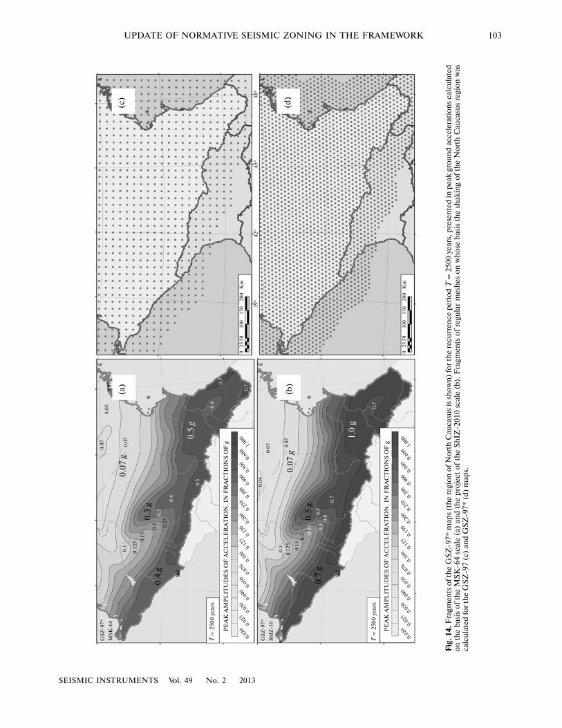
Another important improvement of the GSZ�97*set is construction of maps showing seismic effects interms of peak ground accelerations (Figs. 14, 15).Notwithstanding, it has been noted that the absence ofan efficient service for ground acceleration recordingin Russia does not enable application of PASH rou�tines in terms of ground acceleration with sufficientlyvalid results. Nevertheless, it has been permitted, withcertain limitations, to calculate and map the ampli�tude estimates of seismic effects on the basis of theirrecalculation from fractional unit estimates, as it hasbeen made previously by the IPE RAS in the frame�work of GSHAP (Ulomov, 1999). Additionally, thesuggestion by A.A. Gusev (2011) to construct the GSZmaps in terms of peak accelerations for hard rock (tra�ditionally, in Russia it was made only for the secondcategory of grounds—see SNiP II�7�81*).
At present, it is commonly accepted that theMSK�64 scale significantly underestimates seismichazard and probably will be changed to the ShIZ�2010scale, which was designed and suggested under theleadership of A.A. Aptikaev in 2010 (Aptikaev, 2010;Shkala …, 2011; Aptikaev and Erteleva, 2005). Withrespect to this, the GSZ�97* set contains the groundacceleration maps of two types, utilizing the MSK�64and ShIZ�2010 scales.
ON THE SEISMIC ZONING OF THE NEXT GENERATION
ESZ Map Montages for GSZ�2012
As has been said above, when constructing theGSZ�2012 set of maps, the GSZ�97 methodology iskept for identifying and seismodynamical parameter�ization of the LDF�model of ESZ, as well as the prob�abilistic approach to estimation of seismic hazard.
For constructing the maps of the next generation,two versions of ESZ models have been developed. Ver�sion 1 (Fig. 16) almost completely (excluding the plat�form territories) reproduces the domain componentdeveloped in 1992–1995 by V.G. Trifonov andN.V. Shebalin for GSZ�97 maps and then used in theGSHAP global map (Ulomov, 1999). V.G. Trifonovrecommended revising the domain structure of the
European part of the country and West Siberia due tohis denying the previous models of active faults inthese territories. Thus, the geometry and contents ofthe previous domains were changed by zones sug�gested by V.I. Makarov (however, this work was notcompleted due to Makarov’s death).
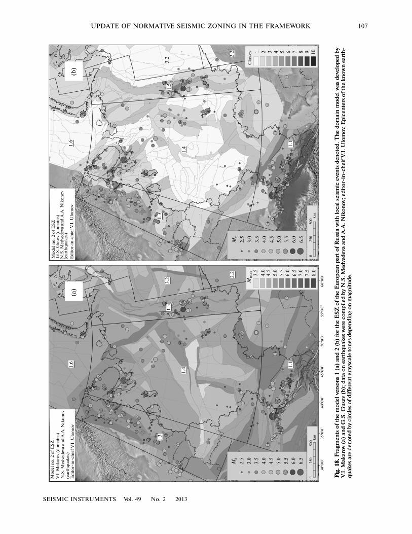
Version 2 (Gusev et al., 2011) is given in Fig. 17.Resulting from discussions at the meeting of the work�ing group on construction of GSZ�2012 maps, thiszoning model for geodynamically active zones hasbeen accepted as fundamental and the most suitable.It was based on the multiannual studies of geodynam�ical settings, under which neotectonic objects hadbeen formed, and on the map of 2001 (“Scheme ofTectonic Zoning of Russia,” M 1 : 5000000) con�structed by G.S. Gusev with colleagues. For the pur�poses of GSZ, this structural zoning was the basis. Asto the zoning of geodynamical activity in the territoryof the Russian Federation, it was developed by distin�guishing nine classes of neotectonic activity, whosegeological�geophysical criteria are based on the well�known classification principles and terminology ofgeodynamical analysis.
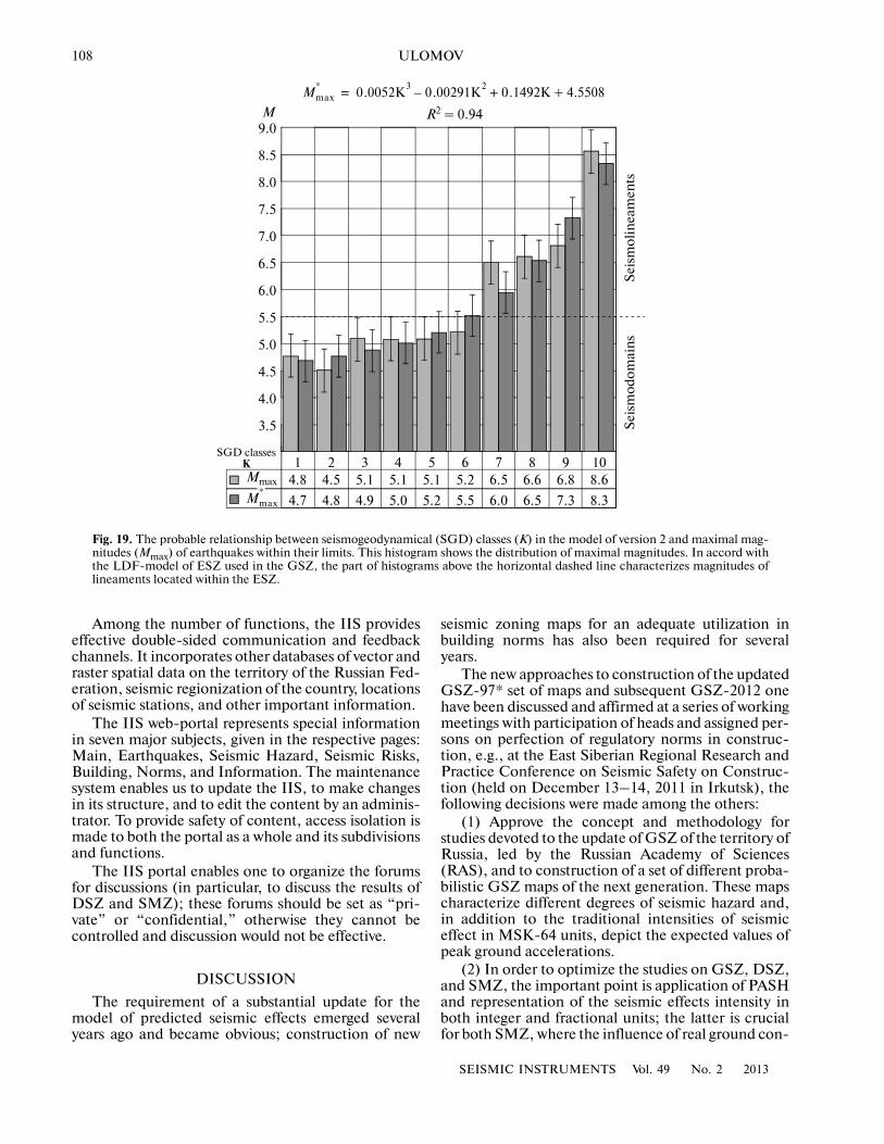
For comparison purposes, Fig. 18 presents the frag�ments of both versions of ESZ models for the Euro�pean part of Russia. Note that the authors of version 1had the whole catalog of earthquakes in NorthernEurasia and used it for correction and parameteriza�tion of distinguished domains. It is also important toemphasize that the authors of version 1 had notaccessed the SEC, so their geodynamical construc�tions were more objective. However, further compari�son of geodynamical activity parameters (comparisonof classes) between those in version 2 and real seismic�ity in the territory of the country has shown quite goodcorrelation; this can be seen in Fig. 19 in the form of aweighted average dependence between maximal mag�
nitudes Mmax and for earthquakes that occurredpreviously in every zone of different classes K of geo�dynamical activity.
Seismic lineaments, which are given in the mapmontages of every ESZ model (see Figs. 17, 18) andmostly taken from the GSZ�97 database, have beenupdated in part. The works on their identification andparameterization are still lead by the author. The stud�ies in this field are carried on with the regional special�ists participating (V.I. Ulomov, A.A. Nikonov, andV.G. Trifonov for the European part of Russia;A.A. Gusev, A.I. Kozhurin, and V.N. Smirnov for theRussian Far East; L.P. Imaeva, V.S. Imaev, and A.V. Chip�izubov for Siberia). In the end of the paper, the com�plete staff of the working group on construction of theGSZ�2012 maps is given.
For a more complete and effective discussion by thescientific society, both versions and the initial data werepublished on the web�portal of the IIS “Seismic Safetyof Russia” (Figs. 20–23) (http.//seismorus.ru/).
max*M

102
SEISMIC INSTRUMENTS Vol. 49 No. 2 2013
ULOMOV
050
010
00
5.0
5.5
6.0
6.5
7.0
7.5
8.0
8.5
9.0
9.5
10.0
Kil
omet
ers
Th
e ex
amp
le o
f th
e u
pd
ated
GS
Z�9
7* m
ap o
f th
eI,
poi
nts
terr
ito
ry o
f R
uss
ian
Fed
erat
ion
fo
r th
e re
curr
ence
per
iod
T =
250
0 ye
ars
wit
h t
he
step
of
0.5
MS
K�6
4u
nit
. Ed
ito
r�in
�ch
ief
V.I
. Ulo
mo
v
Fig
. 13.
Th
e ex
ampl
e of
th
e up
date
d G
SZ
�97*
map
of
the
terr
itor
y of
Rus
sian
Fed
erat
ion
for
th
e re
curr
ence
per
iod
T =
250
0 ye
ars
wit
h t
he
step
of
0.5
MS
K�6
4 un
it. E
dito
r�in
�ch
ief V
.I. U
lom
ov.
SEISMIC INSTRUMENTS Vol. 49 No. 2 2013
UPDATE OF NORMATIVE SEISMIC ZONING IN THE FRAMEWORK 103
010
020
0
(a)
(b)
(c)
(d)
150
2550
010
020
015
025
50
39°
42°
45°
48°
0.02
50.
020
0.04
00.
030
0.07
00.
050
0.12
50.
100
0.20
00.
150
0.30
00.
250
0.50
00.
400
1.00
00.
600
0.02
50.
020
0.04
00.
030
0.07
00.
050
0.12
50.
100
0.20
00.
150
0.30
00.
250
0.50
00.
400
1.00
00.
600
0.04
0.05 0.
07
0.7
0.1
0.12
5
0.15
0.2 0.
25 0.3
0.40.
5
0.7
0.5
0.5
g
1.0
g
0.7
g
0.07
g
T =
250
0 ye
ars
GS
Z�9
7*
Sh
IZ�1
0
T =
250
0 ye
ars
GS
Z�9
7*
MS
K�6
4
0.07
g0.
07
0.05
0.07
0.5
g
0.1
0.12
5 0.15
0.2 0.25
0.3
0.4
0.5
0.3
g0.
4 g
0.3
0.4
0.7
0.7
0.07
Km
Km
PE
AK
AM
PL
ITU
DE
S O
F A
CC
EL
ER
AT
ION
, IN
FR
AC
TIO
NS
OF
g
PE
AK
AM
PL
ITU
DE
S O
F A
CC
EL
ER
AT
ION
, IN
FR
AC
TIO
NS
OF
g
Fig
. 14.
Fra
gmen
ts o
f th
e G
SZ
�97*
map
s (t
he
regi
on o
f Nor
th C
auca
sus
is s
how
n)
for
the
recu
rren
ce p
erio
d T
= 2
500
year
s, p
rese
nte
d in
pea
k gr
oun
d ac
cele
rati
ons
calc
ulat
edon
th
e ba
sis
of t
he
MS
K�6
4 sc
ale
(a)
and
the
proj
ect
of t
he
Sh
IZ�2
010
scal
e (b
). F
ragm
ents
of
regu
lar
mes
hes
on
wh
ose
basi
s th
e sh
akin
g of
th
e N
orth
Cau
casu
s re
gion
was
calc
ulat
ed fo
r th
e G
SZ
�97
(c)
and
GS
Z�9
7* (
d) m
aps.

104
SEISMIC INSTRUMENTS Vol. 49 No. 2 2013
ULOMOV
0.0250.020
0.0400.030
0.0700.050
0.1250.100
0.2000.150
0.3000.250
0.5000.400
1.0000.600
(a)
(b)
(c)
T = 500 year
0.040.05
0.07
0.1
0.1250.15 0.2
0.25
0.3
0.40.25
T = 500 year
5.5 6.0 6.5 7.0 7.5 8.0 8.5 9.0 9.5 10.0 10.5
8.1
6.36.4
6.56.6 6.76.8
77.17.27.5
7.47.3
5.75.65.8
5.96.16.2
6.9
7.7
7.67.8
7.9
8
8.1
8.2
8.3
8.4 8.5 8.6
8.5
8.5
8.4
8.3
8.8
8.7
56–10
11–20
21–50
51–10
0
101–
200
201–500
1001–
2000
2001–5000
501–10
00
PEAK AMPLITUDES OF ACCELERATION, IN FRACTIONS OF g
ZONES OF SHAKING INTENSITY
RECURRENCE OF SHAKING 7 ON MSK�64, YRS
on average grounds, in MSK�64 units
Fig. 15. Fragments of three types of the GSZ�97* maps (the region of North Caucasus is shown), presented in fractions of gravityacceleration g (a), in half�units of seismic intensity (b), and in recurrence periods of earthquakes of 7 on the MSK�64 (c). Madeby V.I. Ulomov.

SEISMIC INSTRUMENTS Vol. 49 No. 2 2013
UPDATE OF NORMATIVE SEISMIC ZONING IN THE FRAMEWORK 105
6.00
6.50
7.00
7.50
8.00
8.50
050
010
00
3.0
3.5
4.0
4.5
5.0
5.5
6.0
7.0
7.5
8.0
Mm
ax
CD
�201
2
CL
�201
2
Mm
ax
Kil
omet
ers
TH
E L
DF
�MO
DE
L O
F E
SZ
FO
R
GS
Z�2
012
MA
PS
(V
ER
SIO
N 1
)
Fig
. 16.
Th
e L
DF
�mod
el o
f ES
Z fo
r G
SZ
�201
2 m
aps
(ver
sion
1).
Th
e se
ism
oact
ive
zon
es th
at g
eom
etri
call
y co
rres
pon
d to
dom
ain
s (m
odel
by
V.G
. Tri
fon
ov a
nd
N.V
. Sh
ebal
in)
are
para
met
eriz
ed o
n t
he
max
imal
ear
thqu
ake
mag
nit
udes
kn
own
in t
hei
r li
mit
s as
of
1995
. Th
e in
form
atio
n o
n li
nea
men
ts d
raw
n a
bove
dom
ain
s (d
ata
are
edit
ed b
y V.
I. U
lo�
mov
) w
as n
ot u
sed.
Th
e w
hit
e co
nto
ur c
onfi
nes
th
e te
rrit
ory
wh
ere
acti
ve fa
ult
tect
onic
s w
ere
stud
ied.

106
SEISMIC INSTRUMENTS Vol. 49 No. 2 2013
ULOMOV
6.00
6.50
7.00
7.50
8.00
8.50
050
010
00
1 2 3 4 5 6 7 8 9 10
Cla
sses
CL
�201
2
Mm
ax
TH
E L
DF
�MO
DE
L O
F E
SZ
FO
R
GS
Z�2
012
MA
PS
(V
ER
SIO
N 2
)
Kil
omet
ers
Fig
. 17.
Th
e L
DF
�mod
el o
f ES
Z fo
r G
SZ
�201
2 m
aps
(ver
sion
2).
Th
e zo
nes
geo
met
rica
lly
corr
espo
nd
to d
omai
ns
and
are
para
met
eriz
ed o
n c
lass
es o
f th
eir
geod
ynam
ical
act
iv�
ity
(mod
el b
y G
.S. G
usev
an
d L
.P. I
mae
va).
In
form
atio
n a
bout
occ
urre
d th
at e
arth
quak
es a
nd
seis
mol
inea
men
ts w
as n
ot u
sed.
SEISMIC INSTRUMENTS Vol. 49 No. 2 2013
UPDATE OF NORMATIVE SEISMIC ZONING IN THE FRAMEWORK 107
Мод
ель
№ 1
зон
ВО
ЗД
ом
ены
– В
.И. М
акар
ов@
Зем
летр
ясен
ия
–Н
.С. М
едве
дева
, А
.А. Н
ик
он
ов
Отв
. ред
. – В
.И. У
лом
ов
Mod
el n
o. 2
of E
SZ
025
050
0
2.5
3.0
3.5
4.0
4.5
5.0
5.5
6.0
6.5
Ms
60°0'
0''
55°0'
0''
50°0'
0''
45°0'
0''
40°0'
0''
35°0'
0''
30°0'
0''
km
1 2 3 4 5 6 7 8 9 10
Cla
sses
2.5
3.0
3.5
4.0
4.5
5.0
5.5
6.0
6.5
Ms
025
050
0km
3.5
4.0
4.5
5.0
5.5
6.0
6.5
7.0
7.5
Mm
ax 8.0
1.5
2.2
3.2
1.1
1.4
1.3
1.6
(a)
1.6
1.4
1.3
3.2 2.
2
1.1
(b)
1.5
Fig
. 18
. F
ragm
ents
of
the
mod
el v
erso
ns
1 (a
) an
d 2
(b)
for
the
ES
Z o
f th
e E
urop
ean
par
t of
Rus
sia
wit
h l
ocal
sei
smic
eve
nts
den
oted
. T
he
dom
ain
mod
el w
as d
evel
oped
by
V.I.
Mak
arov
(a)
an
d G
.S. G
usev
(b)
; da
ta o
n e
arth
quak
es w
ere
com
pile
d by
N.S
. Med
vede
va a
nd
A.A
. Nik
onov
; ed
itor
�in
�ch
eif
V.I.
Ulo
mov
. Epi
cen
ters
of
the
know
n e
arth
�qu
akes
are
den
oted
by
circ
les
of d
iffe
ren
t gr
aysc
ale
ton
es d
epen
din
g on
mag
nit
ude.
Mod
el n
o. 2
of E
SZ
V.
I. M
akar
ov (
dom
ain
s)
N.S
. Med
vede
va a
nd
A.A
. Nik
onov
(e
arth
quak
es)
Edi
tor�
in�c
hie
f V.I
. Ulo
mov
Mod
el n
o. 2
of E
SZ
025
050
0
2.5
3.0
3.5
4.0
4.5
5.0
5.5
6.0
6.5
Ms
60°0'
0''
55°0'
0''
50°0'
0''
45°0'
0''
40°0'
0''
35°0'
0''
30°0'
0''
km
1 2 3 4 5 6 7 8 9 10
Cla
sses
2.5
3.0
3.5
4.0
4.5
5.0
5.5
6.0
6.5
Ms
025
050
0km
3.5
4.0
4.5
5.0
5.5
6.0
6.5
7.0
7.5
Mm
ax 8.0
1.5
2.2
3.2
1.1
1.4
1.3
1.6
(a)
1.6
1.4
1.3
3.2 2.
2
1.1
(b)
1.5
Fig
. 18
. F
ragm
ents
of
the
mod
el v
erso
ns
1 (a
) an
d 2
(b)
for
the
ES
Z o
f th
e E
urop
ean
par
t of
Rus
sia
wit
h l
ocal
sei
smic
eve
nts
den
oted
. T
he
dom
ain
mod
el w
as d
evel
oped
by
V.I.
Mak
arov
(a)
an
d G
.S. G
usev
(b)
; da
ta o
n e
arth
quak
es w
ere
com
pile
d by
N.S
. Med
vede
va a
nd
A.A
. Nik
onov
; ed
itor
�in
�ch
eif
V.I.
Ulo
mov
. Epi
cen
ters
of
the
know
n e
arth
�qu
akes
are
den
oted
by
circ
les
of d
iffe
ren
t gr
aysc
ale
ton
es d
epen
din
g on
mag
nit
ude.
G.S
. Gus
ev (
dom
ain
s)
N.S
. Med
vede
va a
nd
A.A
. Nik
onov
(e
arth
quak
es)
Edi
tor�
in�c
hie
f V.I
. Ulo
mov
108
SEISMIC INSTRUMENTS Vol. 49 No. 2 2013
ULOMOV
Among the number of functions, the IIS provideseffective double�sided communication and feedbackchannels. It incorporates other databases of vector andraster spatial data on the territory of the Russian Fed�eration, seismic regionization of the country, locationsof seismic stations, and other important information.
The IIS web�portal represents special informationin seven major subjects, given in the respective pages:Main, Earthquakes, Seismic Hazard, Seismic Risks,Building, Norms, and Information. The maintenancesystem enables us to update the IIS, to make changesin its structure, and to edit the content by an adminis�trator. To provide safety of content, access isolation ismade to both the portal as a whole and its subdivisionsand functions.
The IIS portal enables one to organize the forumsfor discussions (in particular, to discuss the results ofDSZ and SMZ); these forums should be set as “pri�vate” or “confidential,” otherwise they cannot becontrolled and discussion would not be effective.
DISCUSSION
The requirement of a substantial update for themodel of predicted seismic effects emerged severalyears ago and became obvious; construction of new
seismic zoning maps for an adequate utilization inbuilding norms has also been required for severalyears.
The new approaches to construction of the updatedGSZ�97* set of maps and subsequent GSZ�2012 onehave been discussed and affirmed at a series of workingmeetings with participation of heads and assigned per�sons on perfection of regulatory norms in construc�tion, e.g., at the East Siberian Regional Research andPractice Conference on Seismic Safety on Construc�tion (held on December 13–14, 2011 in Irkutsk), thefollowing decisions were made among the others:
(1) Approve the concept and methodology forstudies devoted to the update of GSZ of the territory ofRussia, led by the Russian Academy of Sciences(RAS), and to construction of a set of different proba�bilistic GSZ maps of the next generation. These mapscharacterize different degrees of seismic hazard and,in addition to the traditional intensities of seismiceffect in MSK�64 units, depict the expected values ofpeak ground accelerations.
(2) In order to optimize the studies on GSZ, DSZ,and SMZ, the important point is application of PASHand representation of the seismic effects intensity inboth integer and fractional units; the latter is crucialfor both SMZ, where the influence of real ground con�
3.5
1
4.0
4.5
5.0
5.5
6.0
6.5
7.0
7.5
8.0
8.5
9.0M
Mmax*
0.0052K3
0.00291K2– 0.1492K + 4.5508+=
R2 = 0.94
Mmax 4.8
4.7
24.5
4.8
35.1
4.9
45.1
5.0
55.1
5.2
65.2
5.5
76.5
6.0
86.6
6.5
96.8
7.3
108.6
8.3
SGD classesK
Sei
smod
omai
ns
Sei
smol
inea
men
ts
Mmax*
Fig. 19. The probable relationship between seismogeodynamical (SGD) classes (K) in the model of version 2 and maximal mag�nitudes (Mmax) of earthquakes within their limits. This histogram shows the distribution of maximal magnitudes. In accord withthe LDF�model of ESZ used in the GSZ, the part of histograms above the horizontal dashed line characterizes magnitudes oflineaments located within the ESZ.
SEISMIC INSTRUMENTS Vol. 49 No. 2 2013
UPDATE OF NORMATIVE SEISMIC ZONING IN THE FRAMEWORK 109
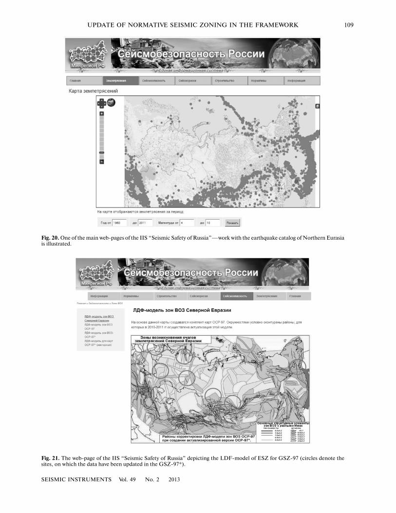
Fig. 20. One of the main web�pages of the IIS “Seismic Safety of Russia”—work with the earthquake catalog of Northern Eurasiais illustrated.
Fig. 21. The web�page of the IIS “Seismic Safety of Russia” depicting the LDF�model of ESZ for GSZ�97 (circles denote thesites, on which the data have been updated in the GSZ�97*).

110
SEISMIC INSTRUMENTS Vol. 49 No. 2 2013
ULOMOV
Fig. 22. The web�page of the IIS “Seismic Safety of Russia” with the GSZ�97* maps available to select: peak ground accelerationsfor two scales and six recurrence periods.
Fig. 23. Work with the zoomed fragment of the Baikalian region map (IIS “Seismic Safety of Russia”).
SEISMIC INSTRUMENTS Vol. 49 No. 2 2013
UPDATE OF NORMATIVE SEISMIC ZONING IN THE FRAMEWORK 111
ditions on seismic effects is taken into account, and forrepresentation of seismic effects in terms of groundaccelerations.
(3) Consider the coordination and cooperation inthis field between seismological and engineering insti�tutions and specialists as absolutely required.
(4) When developing the new edition of generalseismic zoning maps (GSZ�2012), the project of thesemaps must be discussed with a number of specialists inthe fields of seismology and seismic engineering. Thescientifically sound model parameters of seismiceffects, based on the available data for the territory ofthe Russian Federation, should be represented byrespective institutions, including the IPE RAS, Insti�tute of the Earth’s Crust, RAS, Geophysical Survey,RAS, Sergeyev Institute of Environmental Geo�science, RAS, JSC PNIIS with participation ofKucherenko Central Research Institute for BuildingConstructions (CRIBC).
The working meeting devoted to coordination ofstudies on seismic zoning and seismic engineering washeld on December 20, 2011, in the CRIBC, chaired byL.S. Barinova (the Chairman of the InterindustryCouncil on Technical Regulation and Standardizationin the Building Complex of Russia). At this meeting, theauthor reported about the studies on the GSZ update andon the requirement to present agreed design specifica�tions for further development of GSZ�2012 maps inadvance; note that the latter point had been reportedfor the first time at the meeting of the Expert Commis�sion on Seismic Engineering in December 2009.
The same problem arose again at the joint meetingheld on January 19, 2012 in the IPE RAS, with work�ing groups on GSZ and SNiPs participating (the work�shop “Topical Problems in Development of Methodsfor Setting the Model Seismic Effects in RegulatoryDocuments”). Here, the GSZ�2012 working groupmember, A.A. Gusev (Institute of Volcanology andSeismology, Far East Branch, RAS), reported thedetails on the subject. Below, the list of the main tasksformulated by A.A. Gusev (2011a, 2011b) andintended for solution in the nearest future is presented.It is clarified in the end of every task, to which subjectthese belong (GSZ, SMZ, SNiP, seismic engineeringin whole):
(1) Confirm the requirement of updating the regu�latory norms on standard seismic loads in the direc�tions of GSZ–SNiP and SNiP–GSZ with respect toengineering seismology achievements of the recentdecades.
(2) Keep the standard relationship between theMSK�64 intensity unit and ground acceleation onlyfor hard rocks. Revise the coefficients of relationshipbetween the MSK�64 intensity unit and ground accel�eration, assumed in SNiP by increasing the accelera�tion value A approximately 1.5–1.7 times (A = 0.30–0.35 at 8 on the MSK�64). Exclude the strong depen�
dence of intensity and ground acceleration for non�hardrock grounds (seismic engineering, SNiP).
(3) Revise the correlation between lithologicalcomposition and peak ground acceleration, assumedin the SNiP. The relationship used presently implies adouble acceleration at a four�fold decrease in shearwave velocity in ground. Such a relation is reasonablefor maximal velocities, but must be completely revisedfor accelerations. For example, when choosing the ver�sion of nonlinearity account by Eurocode�8, the coeffi�cients for the used categories of ground (first, second,and third; see SNiP II�7�81*)–1, 2, 4—should bechanged to approximately 1, 1.2, and 1.15, respec�tively (seismic engineering, SMZ, SNiP).
(4) Abandon the use of peak acceleration values inaverage ground type (category 2) as the main ampli�tude parameter and apply the peak acceleration valuein hardrock (category 1) instead (seismic engineering,GSZ, SMZ, SNiP).
(5) Abandon the use of normalizing the dimen�sionless response spectra to peak acceleration value ina given ground type. Following the principles of Euro�code�8, accept the normalizing of the response spectrato peak acceleration value in hardrock (category 1);with respect to this, consider the term “coefficient ofdynamicity” obsolete and use the term “normalizedresponse spectra” instead (SNiP, SMZs).
(6) Abandon the characteristics of the groundsbased on frequency�independent parameter “updateof intensity” and change it to the principle of spectralcharacteristics of grounds. The coefficient taking intoaccount the effect of ground layer (coefficient ofground) should depend on vibration period (naturalfrequency) of a building (SMZ, SNiP).
(7) Abandon the indirect use of hypothesis aboutnonlinear behavior of non�hardrock grounds at highvalues on the MSK�64 scale. Affirm the importance ofnonlinear behavior of non�hardrock grounds for amore valid estimation of seismic loads on buildings.Consider the description for the effect of the groundlayer (represented in the form of equivalent linear sys�tem) through an equivalent (effective) coefficient ortransfer functions as completely valid. Such coeffi�cients (or functions) should be taken as substantiallydependent on amplitude of vibrations on bedrocks(arbitrary hardrock). In the simplest case, one can takeonly two versions of transfer functions (in terms ofEurocode�8): for small amplitudes and amplitudes of0.3–0.4 g (SMZ, SNiP).
(8) Approve the need of choice of the generalapproach to taking the nonlinearity of ground behav�ior into account in the construction norms for massbuilding. The following approaches can be chosen:(a) abandoning of taking nonlinearity into account;(b) taking nonlinear effects into account “on average”for a certain range of acceleration values—approachused in Eurocode�8; (c) explicit account of nonlineareffects' dependence on amplitude—approach used in

112
SEISMIC INSTRUMENTS Vol. 49 No. 2 2013
ULOMOV
the norms of the United States (seismic engineering,SNiP, SMZ).
(9) Abandon the principle of integer�valued inten�sity and ground categories; elaborate the more frac�tional classification of grounds and loads. The simplestsolution: introduce half�unit intensity (i.e., with the0.5 step: 6, 6.5, 7, 7.5 etc.) and five ground categories(1, 1.5, 2, 2.5, 3) (SNiP, GSZ).
(10) Emphasize the incorrectness of the update inthe most important aspects of regulatory norms solelyfor SNiP, GSZ, and SMZ. Updating these norms onstandard seismic loads should be implemented on thebasis of a complex approach, and in terms of jointSNiP–GSZ and SNiP–SMZ groups of problems.
(11) Point out an urgent need to develop an instru�mental network for continuous recording of strongground motions in the territory of Russia; without thisnetwork, neither an accurate estimate of seismic loadsfrom local earthquake data nor an appropriate use ofdata from non�Russian studies are possible.
CONCLUSIONS
Resulting from the comprehensive fundamentaland applied studies on the improvement of methodsand technologies for prediction of seismic hazard, theGSZ�97 maps (general seismic zoning of the territoryof Russian Federation) have been updated; the con�cept of new generation GSZ�2012 maps have beendeveloped; the problem of representing the groundacceleration in maps, in addition to the traditionalintensity units, has been investigated. It has beennoted that application of probabilistic analysis proce�dures for seismic hazard estimate in terms of groundacceleration, at poor knowledge of ground motions inthe territory of Russia, cannot yield sufficiently validresults. Instead of this, the amplitude estimates on thebasis of PASH recalculation expressed in fractionalintensity units have been suggested. Additionally, it hasbeen proposed to construct the GSZ maps in terms ofpeak ground accelerations for hardrock.
The updated version of GSZ�97 was named asGSZ�97*. Its new improvements and modificationsare listed below:
(1) The studies on further unification of the earth�quake catalog for the territory of Russia and adjacentregions of Northern Eurasia have been made; the cat�alog is supplemented for the period since ancienttimes until 2010.
(2) The seismic regime of the main seismoactiveregions of Russia, required for numerical parameter�ization of seismogenerating structures (seismolinea�ments, domains, and potential sources of large earth�quakes), has been investigated.
(3) The LDF�model of ESZ for GSZ�97 has beenupdated (on the basis of the updated earthquake cata�log and previously unknown active faults found, cer�tain modifications have been made).
(4) The GSZ�97* set of maps has been expanded.In accord with the new Urban Development Code ofthe Russian Federation and international recommen�dations, the maps of T = 100 and 2500 years have beenincluded.
(5) The big set of digital vector maps (layers) withdifferentiated estimates of intensity (with model stepsof 0.5 and 0.1 of intensity units for all the used recur�rence periods of 100, 500, 1000, 2500, 5000, and10000 years) have been constructed.
(6) For the purpose of a more detailed seismicmapping, all the calculations of seismic effects aremade in the regular triangular mesh (15 km on a side),which is more convenient for a spherical surface thanthe rectangular mesh of 25 km on a side (used in theGSZ�97).
(7) The GSZ�97* maps of peak ground accelera�tions for all the used recurrence periods of 100, 500,1000, 2500, 5000, and 10000 years have been con�structed. The maps of peak ground accelerations arecalculated both in terms of the MSK�64 scale and theproject of the new ShIZ�2010 earthquake intensityscale.
(8) All the new data on the update of the GSZ�97*and on design of ESZ maps for seismic zoning of thenew generation (GSZ�2012) have been included intothe Integrated Information System “Seismic Safety ofRussia” and are available on the Internet for practicalapplication.
(9) The project of the Code of Rules for GSZ stud�ies has been developed and the recommendationsrelated to development of modern methods for modelseismic loads setting in regulatory norms have beenmade.
ACKNOWLEDGMENTS
In all the studies in the framework of the special�purpose Working Group on GSZ�2012, the research�ers from regional institutions and organizations tookpart.
The author is sincerely grateful to his closest col�leagues—A.A. Gusev (Dr. Phys.�Math. Sci.),G.S. Gusev (Dr. Geol.�Mineral. Sci.), A.A. Nikonov(Dr. Geol.�Mineral. Sci.), V.G. Trifonov (Dr. Geol.�Mineral. Sci.), L.P. Imaeva (Cand. Geol.�Mineral.Sci.), T.I. Danilova (Cand. Geol.�Mineral. Sci.),N.S. Medvedeva, K.N. Akatova, S.A. Peretokin(Cand. Tech. Sci.), S.V. Shvarev (Cand. Geol.�Min�eral. Sci.)—and to all the participants of the WorkingGroup for the fruitful collaboration. Below, the staff ofthe Working Group on GSZ�2012 is presented withaffiliations given in the uppercase indexes.
Main performers: V.I. Ulomov1, V.G. Trifonov2,K.N. Akatova1, D.M. Bachmanov2, A.A. Gusev3,G.S. Gusev4, T.I. Danilova1, V.S. Imaev5, A.I. Kozhurin2,V.I. Makarov6, N.S. Medvedeva1, S.A. Peretokin7, andS.V. Shvarev1.

SEISMIC INSTRUMENTS Vol. 49 No. 2 2013
UPDATE OF NORMATIVE SEISMIC ZONING IN THE FRAMEWORK 113
Co�performers and experts: V.A. Bormotov8,I.P. Gabsatarova9, A.N. Gulyaev10, V.S. Druzhinin10,V.Yu. Zabrodin8, L.P. Imaeva5, V.A. Kilipko4,Yu.F. Konovalov11, S.L. Kostyuchenko12, O.N. Krut�kina13, S.N. Nikitin1, 14, V.A. Ogadzhanov15, V.M. Pav�lov16, L.A. Sim1, V.N. Smirnov17, V.V. Snezhko13,I.N. Tikhonov18, and G.V. Shilina19.
Affiliations:1Shmidt Institute of Physics of the Earth, RAS
(Moscow); 2Geological Institute, RAS (Moscow);3Institute of Volcanology and Seismology, Far EastBranch, RAS (Petropavlovsk�Kamchatsky); 4Instituteof Mineralogy, Geochemistry and Crystallochemistryof Rare Elements (Moscow); 5Institute of the Earth’sCrust (Irkutsk); 6Sergeyev Institute of EnvironmentalGeoscience, RAS (Moscow); 7SKTB NAUKA, Kras�noyarsk Science Center (Krasnoyarsk); 8Institute ofTectonics and Geophysics, Far East Branch, RAS(Khabarovsk); 9Geophysical Survey, RAS (Obninsk);10Institute of Geophysics, Ural Branch, RAS (Yekat�erinburg); 11OOO Energoproekttekhnologiya (Moscow);12Central All�Russia Research Institute GEOFIZIKA(Moscow); 13All�Russia Geological Institute (VSEGEI)(Moscow); 14NPP SEISMOTsENTR (Yekaterinburg);15OAO Atomenergoproekt (Moscow, Saratov);16Kamchatkan Division of the Geophysical Survey,RAS (Petropavlovsk�Kamchatsky); 17NortheasternComplex Research Institute, Far East Branch, RAS(Magadan); 18Institute of Marine Geology and Geo�physics, Far East Branch, RAS (Yuzhno�Sakhalinsk);19Uralian Division of the OA PNIIIS (Yekaterinburg).
REFERENCES
Aizenberg, Ya.M., Normative Basis for Seismic Engineer�ing: on the Problem of Update of the SNiP II�7�81*“Building in Regions of Seismic Hazard: DesigningNorms,” Stroit. Ekspert, 2010, nos. 19–20, pp. 19–21.Aptikaev, F.F. and Erteleva, O.O., Quantification of Earth�quake action on structures 1st Workshop of EarthquakeAction on Structures (NATO Project NR.NRCLG981619/2005), Bucharest, 2005, pp. 7–26.Aptikaev, F.F., Instrumental Scale of Seismic Intensity,Seismostoik. Stroit. Bezop. Sooruzh., 2005, no. 5, pp. 33–37.Atlas zemletryasenii v SSSR: Rezul’taty nablyudenii seti seis�micheskikh stantsii SSSR v 1911–1957 gg (Atlas of Earth�quakes in USSR: the Results of Observations in the USSRSeismic Network in 1911–1957), Moscow: Nauka, 1962.Danilova, T.I. and Medvedeva, N.S., On the Assessment ofEfficiency of the OSR�97 Normative General Seismic Zon�ing Maps for the Territory of Russian Federation, Trudy VIIObshcherossiiskoi konferentsii “Perspektivy razvitiya inzhen�ernykh izyskanii v stroitel’stve v Rossiiskoi Federatsii” (Proc.VII All�Russia Conf. “Perspectives of Development inEngineering Survey for Building in Russian Federation”),Moscow, 2011, pp. 217–220.Federal’nyi zakon Rossiiskoi Federatsii ot 30 dekabrya 2009 g. N384�FZ “Tekhnicheskii reglament o bezopasnosti zdanii i
sooruzhenii” (Federal Law of Russian Federation no. 384�FZ: Technical Rules for Safety of Buildings and Facilities,December 30, 2009), 2009.Gradostroitel’nyi Kodeks Rossiiskoi Federatsii ot 29.12.2004N 190�FZ (Urban Development Code of Russian Federa�tion, no. 190�FZ, December 29, 2004), 2004.Gusev, A.A., Principles of Mapping for Regions of SeismicHazard in Russian Federation and Those for Standardiza�tion of Seismic Loads in Terms of Seismic Accelerations(Part 1), Inzh. Izyskaniya, 2011a, no. 10, pp. 20–29.Gusev, A.A., Principles of Mapping for Regions of SeismicHazard in Russian Federation and Those for Standardiza�tion of Seismic Loads in Terms of Seismic Accelerations(Part 2), Inzh. Izyskaniya, 2011b, no. 11, pp. 66–77.Gusev, A.A. and Shumilina, L.S., Some MethodologicalProblems of General Seismic Zoning, in Seismichnost’ iseismicheskoe raionirovanie Severnoi Evrazii (Seismicityand Seismic Zoning of Northern Eurasia), Ulomov, V.I.,Ed., Moscow: OIFZ RAN, 1995, vols. 2–3, pp. 289–300.Gusev, G.S., Imaeva, L.P., and Akatova, K.N., Zonirovaniegeodinamicheskoi aktivnosti neotektonicheskikh strukturdlya tselei obshchego seismicheskogo raionirovaniya terri�torii Rossiiskoi Federatsii—OSR�2012, in Tr. VII Obshche�rossiiskoi konferentsii “Perspektivy razvitiya inzhenernykhizyskanii v stroitel’stve v Rossiiskoi Federatsii” (Proc. VIIAll�Russia Conf. “Perspectives of Development in Engi�neering Survey for Building in Russian Federation”), Mos�cow, 2011, pp. 207–208.Mushketov, I.V. and Orlov, A.P., Katalog zemletryaseniiRossiiskoi imperii (Catalog of Earthquakes in RussianEmpire), St. Petersburg, 1893.Nikonov, A.A., Medvedeva, N.S., and Shvarev, S.V.,Update of the Earthquake Catalog for the European Part ofRussia in the Framework of OSR�12 Maps Preparation, Tr.VII Obshcherossiiskoi konferentsii “Perspektivy razvitiyainzhenernykh izyskanii v stroitel’stve v Rossiiskoi Federatsii”(Proc. VII All�Russia Conf. “Perspectives of Developmentin Engineering Survey for Building in Russian Federa�tion”), Moscow, 2011, pp. 221–222.Nikonov, A.A. and Shvarev, S.V., Earthquakes of the Prehis�toric Period in Terms of Improvement of Seismic HazardAssessment (East European Craton and Its Framing),Tr. VII Obshcherossiiskoi konferentsii “Perspektivy razvitiyainzhenernykh izyskanii v stroitel’stve v Rossiiskoi Federatsii”(Proc. VII All�Russia Conf. “Perspectives of Developmentin Engineering Survey for Building in Russian Federa�tion”), Moscow, 2011, pp. 223–226.Novyi katalog zemletryasenii na territorii SSSR s drevneish�ikh vremen do 1975 g. (New Catalog of Earthquake in USSRfrom Ancient Times trough 1975), Kondorskaya, N.V., andShebalin, N.V., Eds., Moscow: Nauka, 1977.Project of New Russian Seismic Scale, Inzh. Izyskaniya,2011, no. 10, pp. 62–71.Riznichenko, Yu.V., From Activity of Earthquake Sourcesto Shaking of the Earth’s Surface, Izv. Akad. Nauk SSSR,Fiz. Zem., 1965, no. 11, pp. 1–12.Riznichenko, Yu.V., Calculation of Shakeability for Pointson the Earth’s Surface from Earthquakes in the Surround�ing Area, Izv. Akad. Nauk SSSR, Fiz. Zem., 1966, no. 5,pp. 16–32.Seismicheskoe raionirovanie territorii Rossiiskoi Federatsii �OSR�97 (Seismic Zoning of the Territory of Russian Feder�
114
SEISMIC INSTRUMENTS Vol. 49 No. 2 2013
ULOMOV
ation), Strakhov, V.N. and Ulomov, V.I., Eds., Moscow:NPP Tekart, 2000.
SNiP II�7�81*. Stroitel’stvo v seismicheskikh raionakh(Building Norms and Regulations no. II�7�81*, “Buildingin Regions of Seismic Hazard”), Moscow: Mosstroi, 1995.
Ulomov, V.I., Update of General Seismic Zoning for theTerritory of Russian Federation and Construction of OSR�2012 Normative Maps of New Generation, Tr. IX RossiiskoiNatsional’noi Konferentsii po Seismostoikomu Stroitel’stvu iSeismicheskomu Raionirovaniyu (Proc. IX Rus. Nat. Conf.on Seismic Engineering and Seismic Zoning), Sochi, 2011,pp. 232–235.
Ulomov, V.I., Dinamika zemnoi kory Srednei Azii i prognozzemletryasenii (Earth’s Crust in Central Asia: Dynamicsand Earthquake Prediction), Tashkent: FAN, 1974.
Ulomov, V.I., Global Ordering of SeismogeodynamicalStructures and Some Aspects of Seismic Zoning and Long�Term Earthquake Prediction, in Seismichnost’ i seis�micheskoe raionirovanie Severnoi Evrazii (Seismicity andSeismic Zoning of Northern Eurasia), Moscow: IFZ RAN,1993, vol. 1, pp. 24–44.
Ulomov, V.I., Global Ordering of SeismogeodynamicalStructures and Prediction of Seismic Hazard, in Global’nyeizmeneniya prirodnoi sredy i klimata (Global Changes ofNatural Environment and Climate), Moscow: Minnauki,1997. pp. 125–158.
Ulomov, V.I., Focal Zones of Earthquakes Modeled inTerms of the Lattice Regularization, Izv., Phys. Solid Earth,1998, vol. 34, no. 9, pp. 717–733.
Ulomov, V.I., Shumilina, L.S., Trifonov, V.G., Kronrod, T.,Levi, K., Zhalkovsky, N., Imaev, V., Ivastchenko, A.,Smirnov, V., Gusev, A., Balassanian, S., Gassanov, A.,Ayzberg, R., Chelidze, T., Kurskeev, A., Turdukulov, A.,Drumya, A., Negmatullaev, S., Ashirov, T., Pustovitenko, B.,and Abdullabekov, K., Seismic Hazard of Northern Eur�asia, Ann. Geofis., 1999, vol. 42, pp. 1023–1038.
Ulomov, V.I., Seismicity, in Bol’shaya Rossiiskaya entsiklo�pediya. V 30 t (Great Russian Encyclopedia, 30 vols.), Mos�cow, 2004, vol. Rossiya, pp. 34–39.
Ulomov, V.I., Seismicity, in Natsional’nyi atlas Rossii. Tom 2.Priroda. Ekologiya (National Atlas of Russia, vol. 2: Nature,Ecology), Moscow, 2007, pp. 56–57.
Ulomov, V.I., Seismic Hazard Assessment and Update ofEngineering Solutions, Seismostoik. Stroit. Bezop. Sooruzh.,2008a, no. 3, pp. 16–21.Ulomov, V.I., Update of the General Seismic Zoning Mapsfor the Territory of Russian Federation, Seismostoik. Stroit.Bezop. Sooruzh., 2008b, no. 5, pp. 14–20.Ulomov, V.I., Engineering�Seismological Survey in Build�ing, Inzh. Izyskaniya, 2009a, no. 9, pp. 28–39.Ulomov, V.I., Macroseismic Regime and DifferentiatedEstimation of Seismic Effects, GeoRisk, 2009b, pp. 16–19.Ulomov, V.I., Akatova, K.N., and Medvedeva, N.S., Esti�mation of Seismic Hazard in the Kaliningrad Region, Izv.,Phys. Solid Earth, 2008, vol. 44, no. 9, pp. 691–705.Ulomov, V.I., Danilova, T.I., Medvedeva, N.S., Polya�kova, T.P., and Shumilina, L.S., Assessment of SeismicHazard in the North Caucasus, Izv., Phys. Solid Earth,2007, vol. 43, no. 7, pp. 559–572.Ulomov, V.I. and Nikitin, S.N., Technical Regulations ofWorks on General Seismic Zoning for the Territory of Rus�sian Federation: Rules of GSZ, Inzh. Izyskaniya, 2010,no. 6, pp. 62–87.Ulomov, V.I. and Peretokin, S.A., On the Update of Nor�mative Maps for Seismic Zoning of the Territory of RussianFederation, Inzh. Izyskaniya, 2010a, no. 1, pp. 44–53.Ulomov, V.I. and Peretokin, S.A., On the Development ofGeneral Seismic Zoning Methods for the Territory of Rus�sian Federation for the Purpose of the OSR�2012 MapsConstruction, in Problemy seismichnosti i sovremennoi geod�inamiki Dal’nego Vostoka i Vostochnoi Sibiri: doklady nauch�nogo simpoziuma (Abstr. Sci. Symp. “Problems of Seismic�ity and Modern Geodynamics of the Russian Far East andEastern Siberia”), Bykov, V.G. and Didenko, A.N., Eds.,Khabarovsk, 2010b, pp. 177–181.Ulomov, V.I. and Shumilina, L.S., Komplekt kart obshchegoseismicheskogo raionirovaniya territorii Rossiiskoi Federatsii �OSR�97 (The Maps of General Seismic Zoning of the Rus�sian Federation, OSR�97), Moscow: OIFZ RAN, 1999a.Ulomov, V.I. and Shumilina, L.S., Problemy seismicheskogoraionirovaniya territorii Rossii (Problems of Seismic Zoningfor the Territory of Russia), Moscow: VNIINTPI GosstroyaRossii, 1999b.Ulomov, V.I. and Shumilina, L.S., Seismic Zoning, inPrirodnye opasnosti Rossii (Natural Hazards of Russia),Moscow: KRUK, 2000, vol. 2, pp. 66–96.