update of garrison diversion unit principal supply works … · garrison diversion unit principal...
TRANSCRIPT
Update of Garrison Diversion Unit Principal Supply Works Costs
FINAL - October 2005
U.S. Department of the Interior Bureau of Reclamation
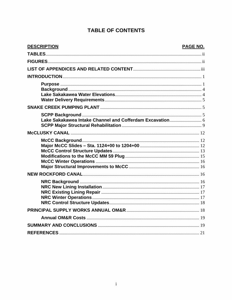
TABLE OF CONTENTS DESCRIPTION PAGE NO. TABLES......................................................................................................................................... ii
FIGURES....................................................................................................................................... ii
LIST OF APPENDICES AND RELATED CONTENT ........................................................... iii
INTRODUCTION .......................................................................................................................... 1
Purpose ............................................................................................................................ 1 Background ..................................................................................................................... 4 Lake Sakakawea Water Elevations............................................................................ 4 Water Delivery Requirements ..................................................................................... 5
SNAKE CREEK PUMPING PLANT ......................................................................................... 5
SCPP Background ......................................................................................................... 5 Lake Sakakawea Intake Channel and Cofferdam Excavation............................ 6 SCPP Major Structural Rehabilitation ...................................................................... 9
McCLUSKY CANAL ................................................................................................................. 12
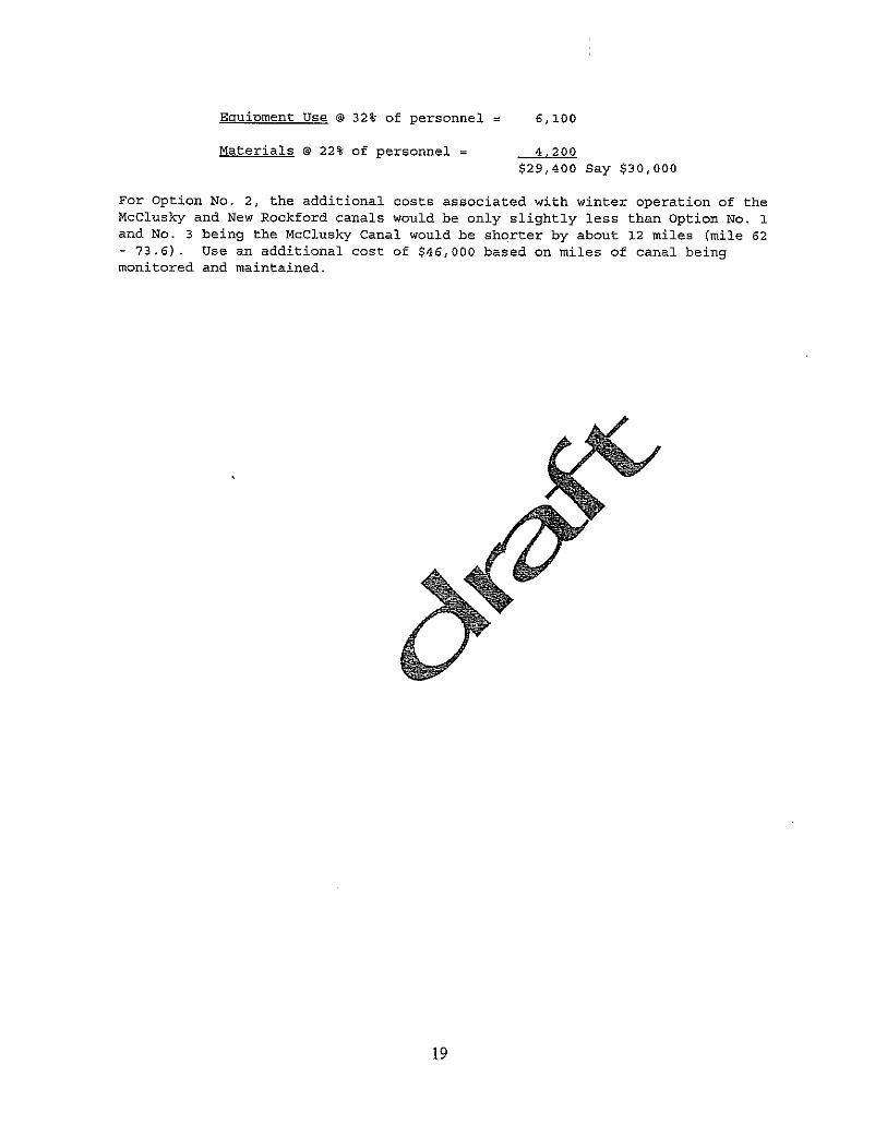
McCC Background....................................................................................................... 12 Major McCC Slides – Sta. 1124+00 to 1204+00 .................................................... 12 McCC Control Structure Updates ............................................................................ 13 Modifications to the McCC MM 59 Plug ................................................................. 15 McCC Winter Operations ........................................................................................... 16 Major Structural Improvements to McCC .............................................................. 16
NEW ROCKFORD CANAL ...................................................................................................... 16
NRC Background ......................................................................................................... 16 NRC New Lining Installation ..................................................................................... 17 NRC Existing Lining Repair ...................................................................................... 17 NRC Winter Operations .............................................................................................. 17 NRC Control Structure Updates............................................................................... 18
PRINCIPAL SUPPLY WORKS ANNUAL OM&R ................................................................ 18
Annual OM&R Costs ................................................................................................... 19
SUMMARY AND CONCLUSIONS ......................................................................................... 19
REFERENCES ........................................................................................................................... 21
i
TABLES Table 1. Principal Supply Works Rehabilitation Work..................................................... 2 Table 2. PSW Construction and Annual OM&R Cost Summary..................................... 3 Table 3. Corps Main Stem Reservoir and Release Forecast (March 3, 2005) ............... 4 Table 4. McCC Control Structure Power ...................................................................... 14 Table 5. NRC Control Structure Power ........................................................................ 18 Table 6. PSW Annual OM&R Costs ............................................................................. 19 Table 7. PSW Construction Cost Summary ................................................................. 20
FIGURES Figure 1. Snake Creek Pumping Plant Cofferdam (December 2004)............................. 7 Figure 2. SCPP Transfer Deck Structural Slab Failure (June 2001)............................. 10 Figure 3. SCPP Bridge Rocker Bearings (June 2002).................................................. 11 Figure 4. McCC Slides (June 2002) ............................................................................. 13 Figure 5. McClusky Canal Radial Gate Structure (June 2002)..................................... 15 Figure 6. Typical New Rockford Canal Section ............................................................ 17
ii
LIST OF APPENDICES AND RELATED CONTENT
Appendix A - Drawings
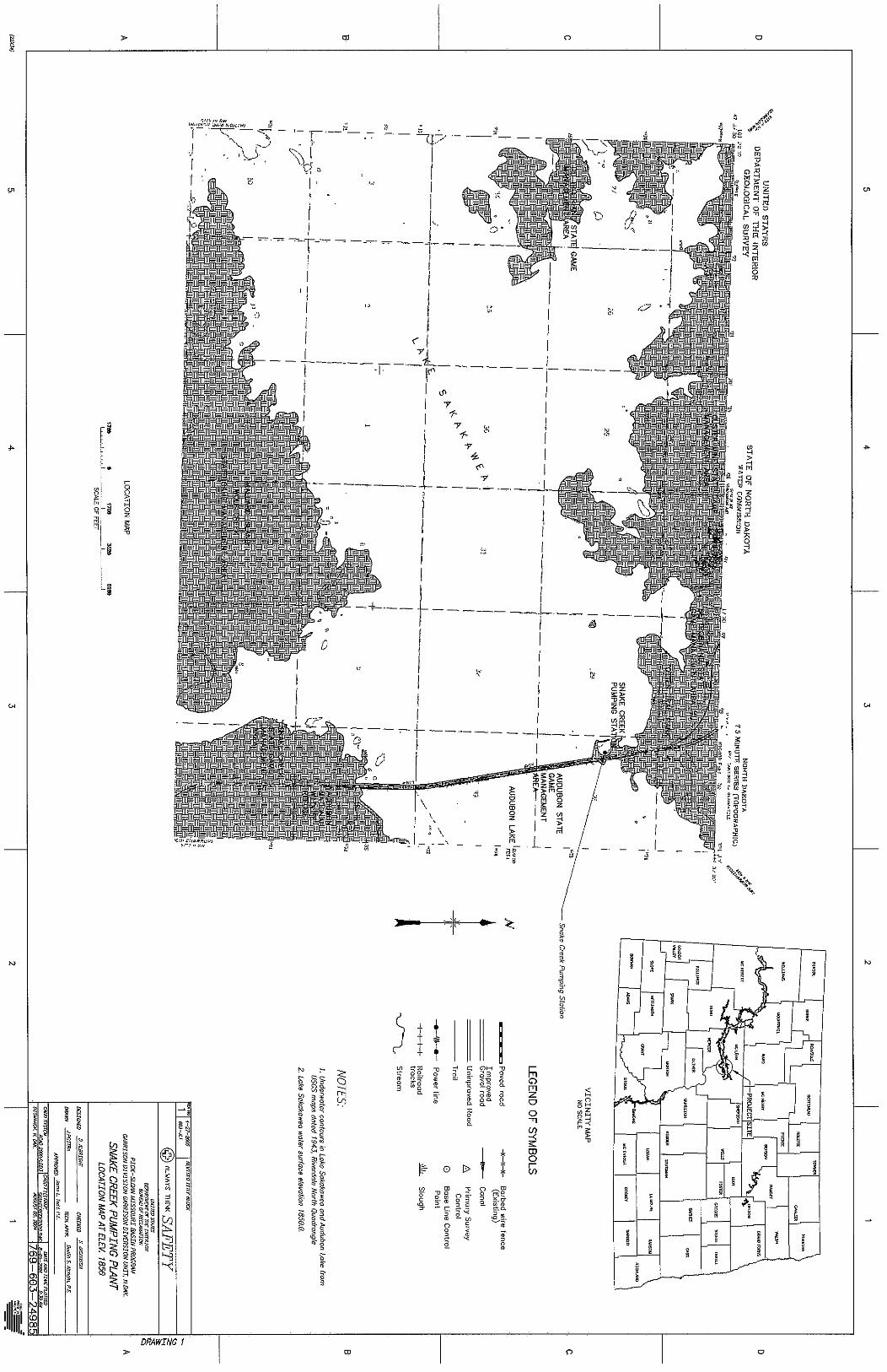
Drawing 1. Snake Creek Pumping Plant, Location Map at Elev. 1850
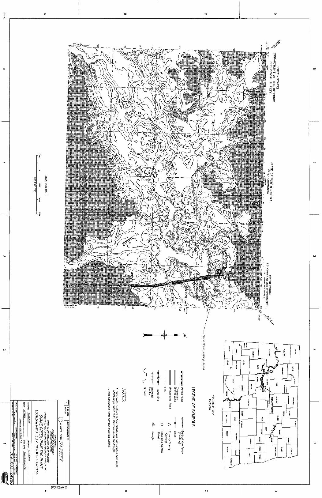
Drawing 2. Snake Creek Pumping Plant, Location Map at Elev. 1850 with Contours
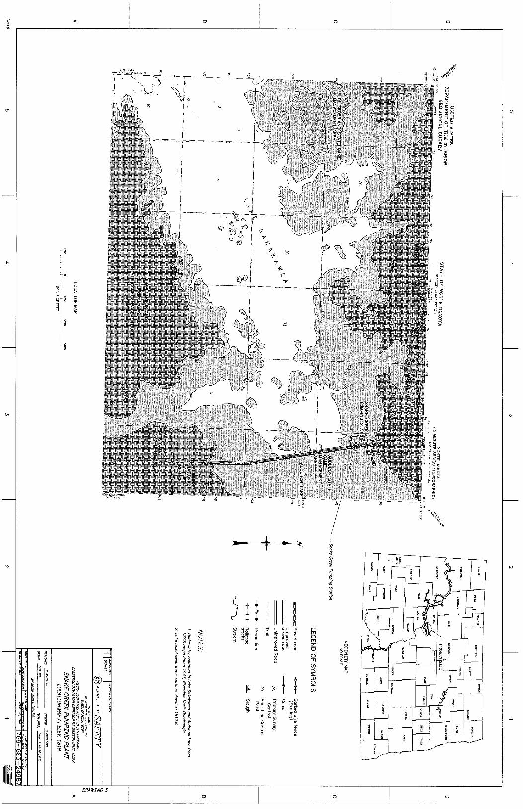
Drawing 3. Snake Creek Pumping Plant, Location Map at Elev. 1810
Drawing 4.
Drawing 5.
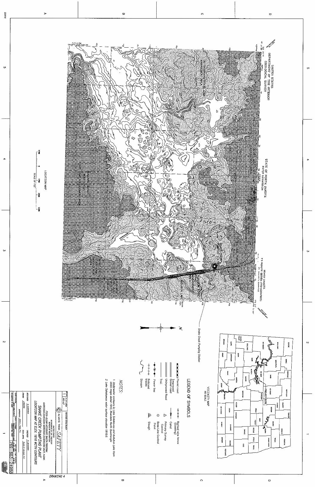
Snake Creek Pumping Plant, Location Map at Elev. 1810 with Contours
Snake Creek Pumping Plant, Proposed Sakakawea Inlet Channel Alignment
Drawing 6.
Drawing 7.
Drawing 8.
Drawing 9.
Snake Creek Pumping Plant, Houston Engineering Cofferdam Survey
Snake Creek Pumping Plant No. 1, Location Plan (769-D-58)
Snake Creek Pumping Plant, Proposed Inlet Channel Plan and Profile
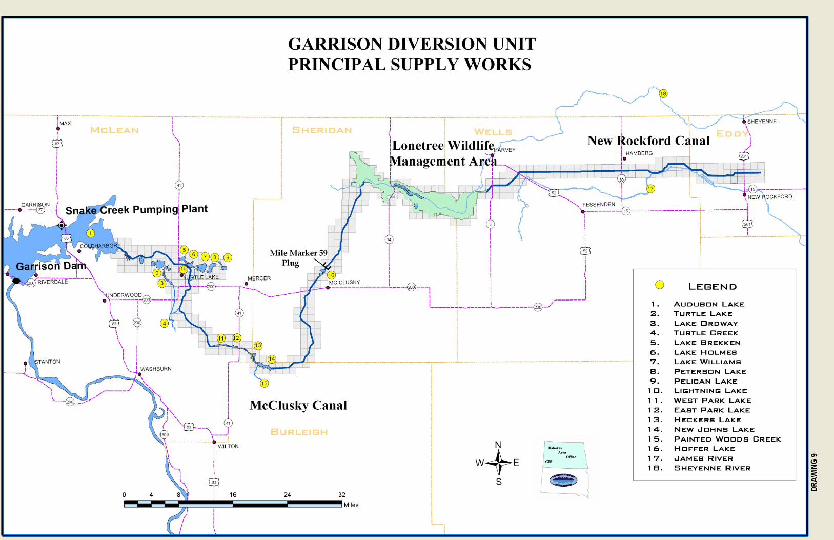
Garrison Diversion Unit Principal Supply Works Map
Appendix B – Cost Estimates
Sheet 1. Cost Estimate – SCPP Intake Channel (Conventional Excavation)
Sheet 2. Cost Estimate – SCPP Intake Channel (Hydraulic Excavation)
Sheet 3. Cost Estimate – SCPP Major Rehabilitation Work
Sheet 4. Cost Estimate – SCPP Bridge Pier Anchor Vault Work
Sheet 5. Cost Estimate – McCC Repair of Major Slides (Sta. 1124+00 to Sta. 1204+00)
Sheet 6. Cost Estimate – McCC Control Structure Updates
Sheet 7. Cost Estimate – McCC Modifications to MM59 Plug
Sheet 8. Cost Estimate – McCC Winter Operations
Sheet 9. Cost Estimate – McCC Major Structural Improvements
Sheet 10. Cost Estimate – NRC New Lining Installation
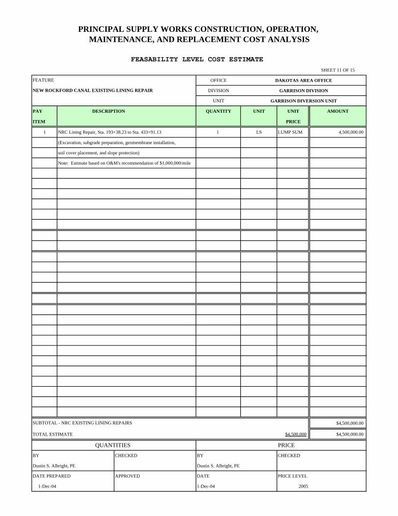
Sheet 11. Cost Estimate – NRC Existing Lining Repair
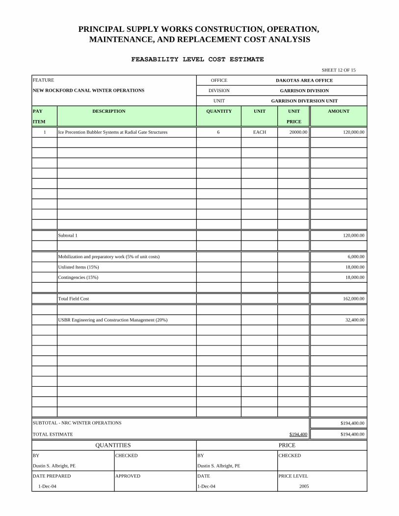
Sheet 12. Cost Estimate – NRC Winter Operations
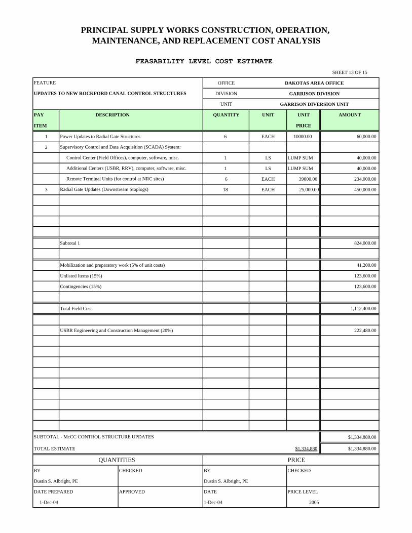
Sheet 13. Cost Estimate – NRC Control Structure Updates
Sheet 14. Cost Estimate – Principal Supply Works OM&R
Sheet 15. Cost Estimate – Principal Supply Works OM&R (Cont.)
iii
Appendix C – Supporting Information
Attachment 1: Corp of Engineers Main Stem Reservoir and Release Forecast – Monthly Study
Attachment 2: Cost Estimate Supporting Data Attachment 3: SCPP Transfer Deck Replacement Cost Estimate Attachment 4: SCPP High Head Pump Bowl Installation Attachment 5: SCPP Unit Alignment and Vibration Testing Travel Report Attachment 6: GDU-PSW Estimated Annual OM&R Associated with the Used and
Unused Capacity
iv

INTRODUCTION Purpose The purpose of this report is to develop updated cost estimates for construction, operation, maintenance, and replacement (OM&R) of features associated with the Principal Supply Works (PSW), Garrison Diversion Unit (GDU) of the Pick-Sloan Missouri Basin Program. The primary features included in the PSW are the Snake Creek Pumping Plant (SCPP), Lake Audubon, McClusky Canal (McCC) and New Rockford Canal (NRC). The PSW has been under continual operation and maintenance since completion of construction in the early 1990s. However, some major rehabilitation activities or improvements to the PSW have been delayed pending final decisions about how the PSW will ultimately be used. This cost estimate identifies what rehabilitation or construction activities are required to update the current facilities so they can be reliably used in the future. Costs are being updated because some of the PSW facilities constructed as part of the GDU are being considered for use in three of the Red River Valley Water Supply Project (Red River Valley Project) alternatives. The costs for rehabilitation, enhancement (construction), and OM&R of these facilities will be included in these Red River Valley project alternatives. This report identifies Red River Valley Project related PSW work and other work required to operate the PSW in the future.
Table 1 lists the features of the PSW that have deficiencies, or uncompleted work, that needs to be addressed in order to satisfy operational purposes of the PSW, as well as potential Red River Valley Project water delivery criteria. PSW deficiencies, or uncompleted work, include SCPP intake channel work, major structural rehabilitation projects, adaptation for winter operations, remote monitoring control structures, canal slide repairs, and installation of new canal lining or repair of existing canal lining.
1
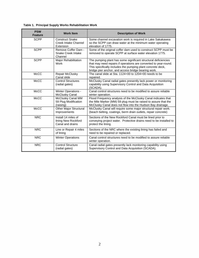
Table 1. Principal Supply Works Rehabilitation Work
PSW Feature Work Item Description of Work
SCPP Construct Snake Creek Intake Channel Extension
Some channel excavation work is required in Lake Sakakawea so the SCPP can draw water at the minimum water operating elevation of 1775.
SCPP Remove Coffer Dam - Snake Creek Intake Channel
Some of the original coffer dam used to construct SCPP must be removed to operate SCPP at surface water elevation 1775.
SCPP Major Rehabilitation Work
The pumping plant has some significant structural deficiencies that may need repairs if operations are converted to year-round. This specifically includes the pumping plant concrete deck, bridge pier anchor, and access bridge bearing work.
McCC Repair McClusky Canal slide
The canal slide at Sta. 1124+00 to 1204+00 needs to be repaired.
McCC Control Structures (radial gates)
McClusky Canal radial gates presently lack power or monitoring capability using Supervisory Control and Data Acquisition (SCADA).
McCC Winter Operations - McClusky Canal
Canal control structures need to be modified to assure reliable winter operation.
McCC McClusky Canal MM 59 Plug Modification (raising)
Flood Frequency analysis of the McClusky Canal indicates that the Mile Marker (MM) 59 plug must be raised to assure that the McClusky Canal does not flow into the Hudson Bay drainage.
McCC Other Major Structural Improvements
McClusky Canal will require some major structural repair work. (beach belting, coatings, berm drain outlets, repair concrete)
NRC Install 14 miles of lining New Rockford Canal and drains
Sections of the New Rockford Canal must be lined prior to conveying project water. Protective drains need to be installed to protect the lining.
NRC Line or Repair 4 miles of lining
Sections of the NRC where the existing lining has failed and need to be repaired or replaced.
NRC Winter Operations Canal control structures need to be modified to assure reliable winter operation.
NRC Control Structure (radial gates)
Canal radial gates presently lack monitoring capability using Supervisory Control and Data Acquisition (SCADA).
2
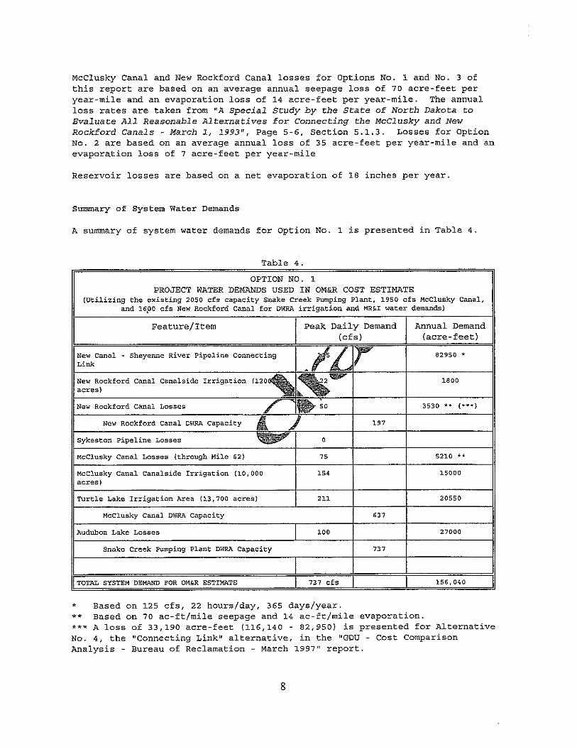
Table 2 summarizes the estimated costs for the PSW rehabilitation work listed in Table 1. These values are estimated and discussed in the following sections.
Table 2. PSW Construction and Annual OM&R Cost Summary
PSW Feature Work Item Estimated 2005
Costs
SCPP Option 1 - Lake Sakakawea Inlet Channel (excavating)* $9,459,000
SCPP Option 2 - Lake Sakakawea Inlet Channel (dredging)* $16,070,000**
SCPP SCPP Major Structural Rehabilitation $1,829,000
Total SCPP $11,288,000
McCC Major McCC Slides – Sta. 1124+00 to 1204+00 $6,204,000***
McCC McCC Control Structure Updates $860,000
McCC Modifications to the McCC MM 59 Plug $45,000
McCC McCC Winter Operations $130,000
McCC Major Structural Improvements to McCC $8,453,000
Total McCC $15,692,000
NRC NRC New Lining and Drain Installation $14,000,000
NRC NRC Existing Lining Repair $4,500,000
NRC NRC Winter Operations $194,000
NRC NRC Control Structure Updates $1,335,000
Total NRC $20,029,000
Total PSW Construction Costs**** $47,010,000
PSW Feature Work Item Estimated 2005 Costs
PSW OM&R SCPP OM&R $266,000
PSW OM&R McCC (Headworks through MM59) $1,184,000
PSW OM&R McCC (MM59 to MM74) $56,000
PSW OM&R New Rockford Canal $394,000
PSW OM&R Fish and Wildlife Mitigation $509,000
PSW OM&R Winter Operations $58,000
PSW OM&R SCADA (SCPP/McCC/NRC) $262,000
Total PSW OM&R $2,729,000* Includes cofferdam removal ** Not included in the Total PSW Construction Costs ***Calculated using DKAO Force Account **** Includes only PSW constructed features
3
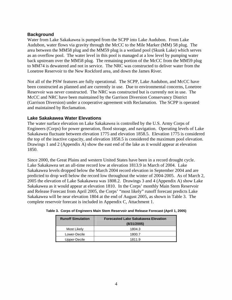
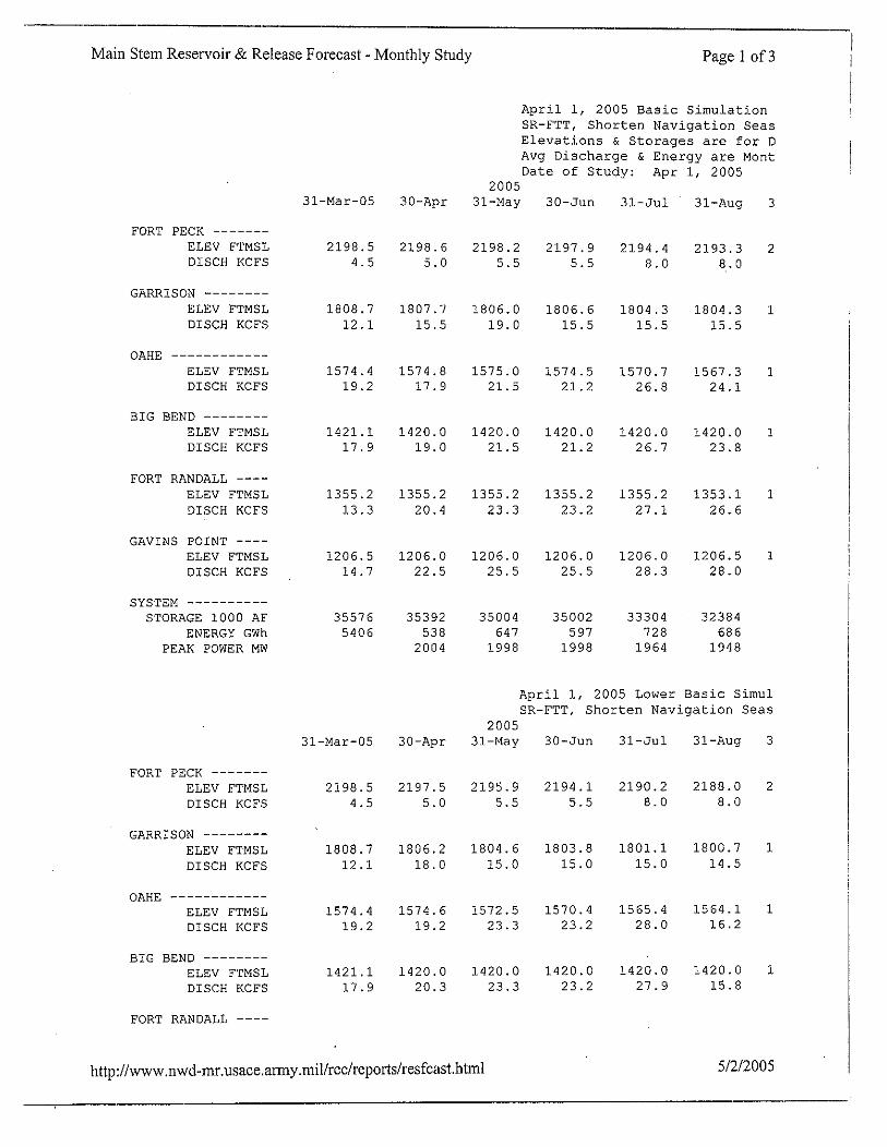
Background Water from Lake Sakakawea is pumped from the SCPP into Lake Audubon. From Lake Audubon, water flows via gravity through the McCC to the Mile Marker (MM) 58 plug. The area between the MM58 plug and the MM59 plug is a wetland pool (Skunk Lake) which serves as an overflow pool. The water level in this pool is managed at a low level by pumping water back upstream over the MM58 plug. The remaining portion of the McCC from the MM59 plug to MM74 is dewatered and not in service. The NRC was constructed to deliver water from the Lonetree Reservoir to the New Rockford area, and down the James River. Not all of the PSW features are fully operational. The SCPP, Lake Audubon, and McCC have been constructed as planned and are currently in use. Due to environmental concerns, Lonetree Reservoir was never constructed. The NRC was constructed but is currently not in use. The McCC and NRC have been maintained by the Garrison Diversion Conservancy District (Garrison Diversion) under a cooperative agreement with Reclamation. The SCPP is operated and maintained by Reclamation. Lake Sakakawea Water Elevations The water surface elevation on Lake Sakakawea is controlled by the U.S. Army Corps of Engineers (Corps) for power generation, flood storage, and navigation. Operating levels of Lake Sakakawea fluctuate between elevation 1775 and elevation 1858.5. Elevation 1775 is considered the top of the inactive capacity, and elevation 1858.5 is considered the maximum pool elevation. Drawings 1 and 2 (Appendix A) show the east end of the lake as it would appear at elevation 1850. Since 2000, the Great Plains and western United States have been in a record drought cycle. Lake Sakakawea set an all-time record low at elevation 1813.9 in March of 2004. Lake Sakakawea levels dropped below the March 2004 record elevation in September 2004 and are predicted to drop well below the record low throughout the winter of 2004-2005. As of March 2, 2005 the elevation of Lake Sakakawea was 1808.2. Drawings 3 and 4 (Appendix A) show Lake Sakakawea as it would appear at elevation 1810. In the Corps’ monthly Main Stem Reservoir and Release Forecast from April 2005, the Corps’ “most likely” runoff forecast predicts Lake Sakakawea will be near elevation 1804 at the end of August 2005, as shown in Table 3. The complete reservoir forecast is included in Appendix C, Attachment 1.
Table 3. Corps of Engineers Main Stem Reservoir and Release Forecast (April 1, 2005)
Runoff Simulation Forecasted Lake Sakakawea Elevation (8/31/2005)
Most Likely 1804.3 Lower-Decile 1800.7 Upper-Decile 1811.9
4
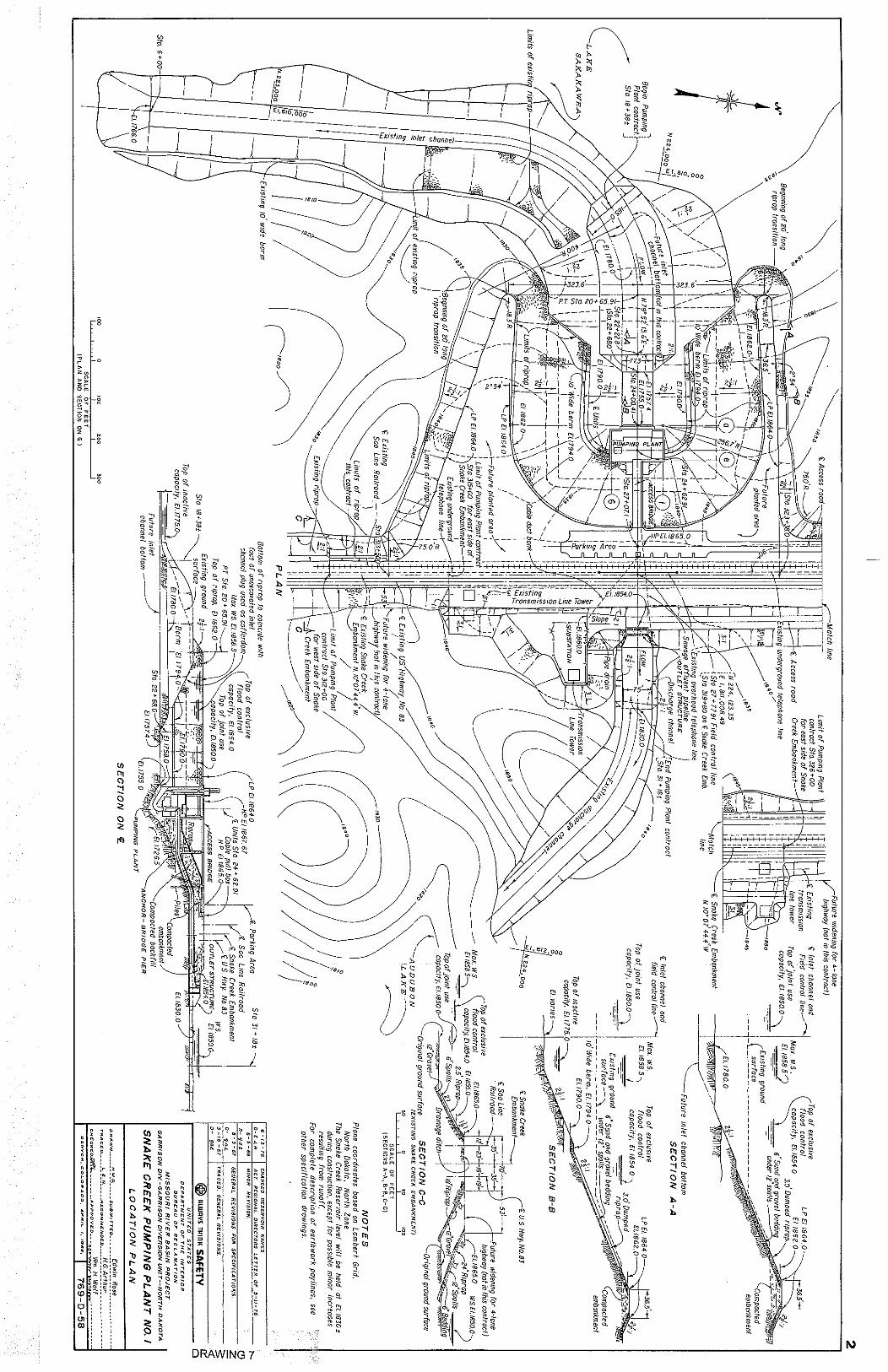
Water Delivery Requirements The PSW provides water for municipal, rural and industrial (MR&I) systems, irrigation, fisheries, wildlife, and recreation as authorized under the Dakota Water Resources Act of 2000 and previous Garrison Diversion Unit legislation. For discussions purposes, it is assumed that the PSW will be used to fulfill the above mentioned purposes including managing Lake Audubon water levels, operation of the McCC for fish, wildlife, recreation, and irrigation purposes. Estimates for partial operation of the NRC are also included in this report, but there are no current plans to operate the canal as originally envisioned. The State of North Dakota and Reclamation have discussed using one of the three intake assemblies at the SCPP for an intake for the Northwest Area Water Supply (NAWS) project. Preliminary data indicate a NAWS intake at the site would require a flow of approximately 40-60 cubic feet per second (cfs). If one pump assembly were to be removed to accommodate an intake for NAWS, the pumping capacity of the SCPP would be reduced by 33% from a maximum flow rate of around 2,050 cfs to 1,370 cfs. Preliminary Red River Valley Project data indicate flow requirements from the SCPP, through the PSW, and to the Red River Valley, could range from 50 to 450 cfs depending on the alternative selected. Additional SCPP capacity is also required for limited irrigation (McClusky canal-side, Turtle Lake Irrigation District and New Rockford area), wildlife and recreation. Given the flow requirements listed above, it is possible that the SCPP could deliver water for the project purposes using one high-head pump at 1000 cfs. In order to do so, modifications to the plant and the existing intake channel would be required, and are discussed in the following sections. SNAKE CREEK PUMPING PLANT This section discusses construction, operation, maintenance, and replacement of features associated with the SCPP. Engineering details and cost estimates regarding the proposed improvements to the facility, and the needs projected for the Red River Valley Project are included. SCPP Background The SCPP is located offshore at the north end, and on the west side of the Snake Creek Embankment, which separates Lake Sakakawea from Lake Audubon (Drawing 1, Appendix A). Constructed in 1975, the plant is located between the towns of Garrison and Coleharbor in central North Dakota. The plant contains three vertical-shaft pumping units. Each unit is powered by an 8,000-horsepower, 200-rpm synchronous motor. Each pumping unit has two interchangeable pump bowl assemblies that cover the pumping head range of 2 to 76 feet, at a capacity of not less than 685 cfs. The low-head pump bowl assembly is suitable for pumping against 2 to 35 foot heads, while the high-head pump bowl assembly is used for the higher heads from 35 to 76 feet. Water
5
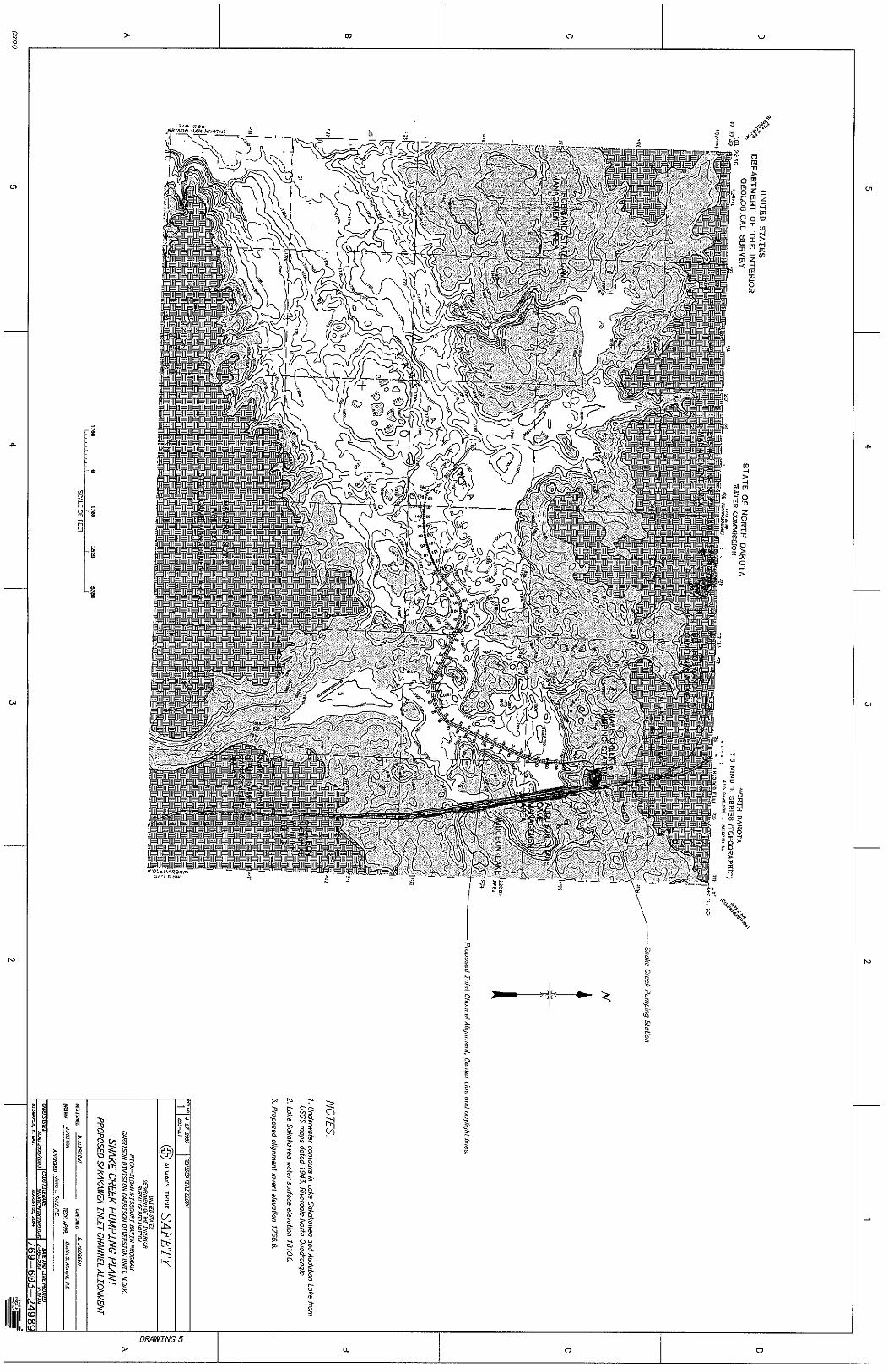
is supplied to each pump from Lake Sakakawea. After passing through the pumps, water is conveyed to Lake Audubon through three 11-foot inside diameter steel and concrete discharge pipes. Lake Audubon water elevations are held at elevation 1847 from ice-out in the spring through Labor Day, and gradually drawn down in the fall to elevation 1845. Power for the pump motors is provided through a 115 KV transmission line along the Snake Creek Embankment, from the Garrison Dam Power Plant to the pumping plant site. Lake Sakakawea Intake Channel and Cofferdam Excavation The east end of Lake Sakakawea represents a dynamic landscape filled with numerous islands and the old Snake Creek bed. Prior to the Corps flooding of the lake, small ponds, the old Snake Creek channel, and an old Highway 83 crossing over the creek between sections 31 and 32 existed. Drawing 4 (Appendix A) shows a general Lake Sakakawea layout with contours at elevation 1810 using topographic information from the U.S. Geological Survey’s Riverdale North Quadrangle map. Conditions for utilizing the PSW for the Red River Valley Project would require the SCPP to be capable of operating at the top of the Lake Sakakawea inactive capacity elevation 1775. Operating at an elevation of 1775 would require a future SCPP intake channel invert constructed to elevation 1766. The topographic data used to calculate excavation quantities for the intake channel and cofferdam is from two sources. Houston Engineering provided topographic data for the cofferdam area and approximately 1,200 feet of the inlet channel. Garrison Diversion provided the topographic data for the remainder of the inlet channel. Reclamation has established a proposed alignment for a future inlet channel in Lake Sakakawea (Drawing 5, Appendix A). The proposed alignment runs approximately 15,300 feet and would begin at Sta. 1+00 (invert elevation 1766) and slope at a rate of 0.00012 ft/ft towards Sta. 154+00 (end of original constructed inlet channel). Proposed channel characteristics include a trapezoidal-shaped, 45-foot wide channel bottom, with 2:1 side slopes. Water depth at lake elevation 1775 would vary between 7 and 9 feet in the channel. The channel has a design capacity of approximately 1,100 cfs based on the assumption that one existing 1000 cfs pump and one new 60 cfs pump for NAWS will be used in the SCPP. This channel design assures that the SCPP will be capable of pumping a minimum of 1,100 cfs at or above elevation 1775, which is the bottom of Lake Sakakawea’s conservation pool. The volume of material required to be excavated from the proposed channel was calculated to be approximately 1,000,000 cubic yards. The proposed methods of construction for this channel are hydraulic dredging and conventional excavation. Prior to any dredging work, significant planning is required to determine detailed lake topography data of the dredging location, physical and chemical properties of the soils, potential disposal alternatives, social and environmental concerns, permits, and selection of a suitable dredging method. Possible spoil sites, above the 1850 elevation, are located an average of 1.5 miles away from the planned channel. Using hydraulic dredging to excavate the channel will require a large spoil area with extensive containment system. Typical dredging activity consumes 2,000 gallons of water per cubic yard of material.
6
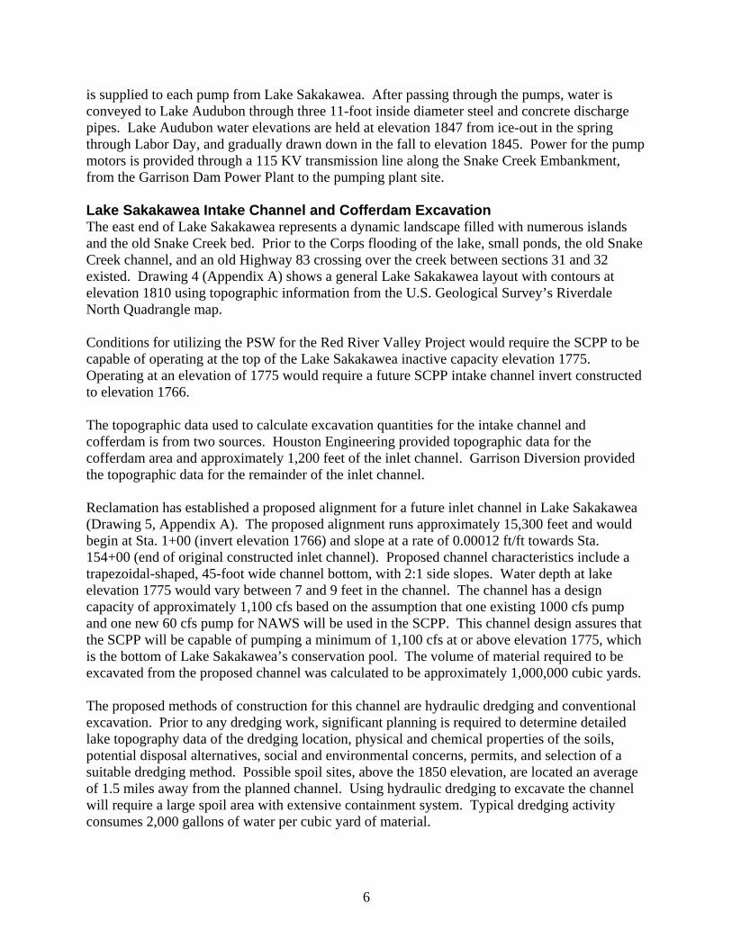
In addition to establishing an inlet channel in Lake Sakakawea for operation of the pumping plant at lake elevation 1775, the original inlet channel and cofferdam used to construct the SCPP must be removed (excavated). During construction of the pumping plant, construction specifications required the cofferdam to be removed down to elevation 1780. However, due to problems encountered during construction, the contractor only excavated the cofferdam down to elevation 1814. Due to extreme drought conditions, Lake Sakakawea fell to its then record low of elevation 1815 in March of 1991. Reclamation removed a portion of the cofferdam in 1991 down to invert elevation 1802 to allow for continued PSW operation. Figure 1 shows the cofferdam and removed portion as they appeared on December 2, 2004 at a Lake Sakakawea elevation of approximately 1810.
Figure 1. Snake Creek Pumping Plant Cofferdam (December 2004)
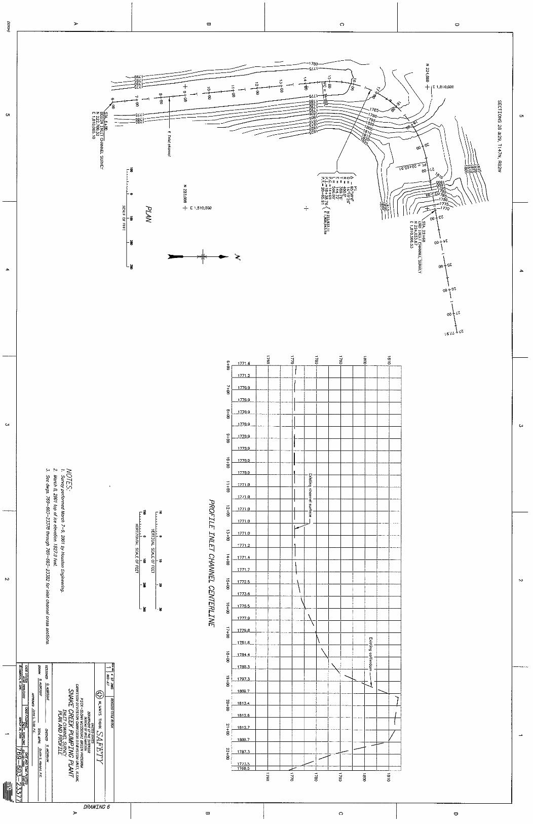
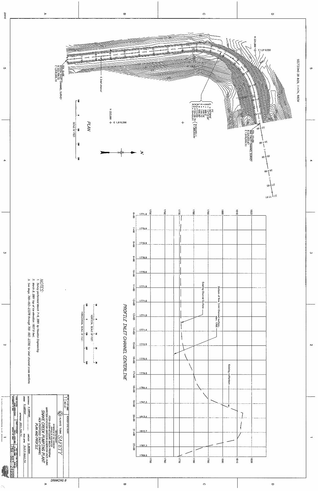
Drawing 6 (Appendix A) shows the inlet channel layout from a survey performed by Houston Engineering in 2001. The channel invert elevations differ from the design drawing (Drawing 7, Appendix A) due to construction errors, or years of lake siltation. The inlet channel portion from Sta. 6+00 to Sta. 18+38 requires dredging to assure reliable access to Lake Sakakawea to elevation 1775. Proposed channel characteristics include a sloped (-0.00012 ft/ft), trapezoidal-shaped, 45-foot wide channel bottom, 2:1 side slopes, and an invert elevation of 1766.19 at Sta. 6+00. Reclamation calculates approximately 25,000 cubic yards of material need to be excavated between these sections (Drawing 8, Appendix A). The same channel characteristics
7
could be used to excavate through the cofferdam sections between Sta. 18+38 and 22+68. The volume of material required to be removed through the cofferdam section is approximately 75,000 cubic yards. Cost estimates to remove the material from the original intake channel and cofferdam total approximately $1,000,000 (Appendix C, Attachment 2). These costs assume difficult excavation conditions and removal of existing cofferdam features that include riprap, steel sheet piling, and other items remaining from the initial construction.
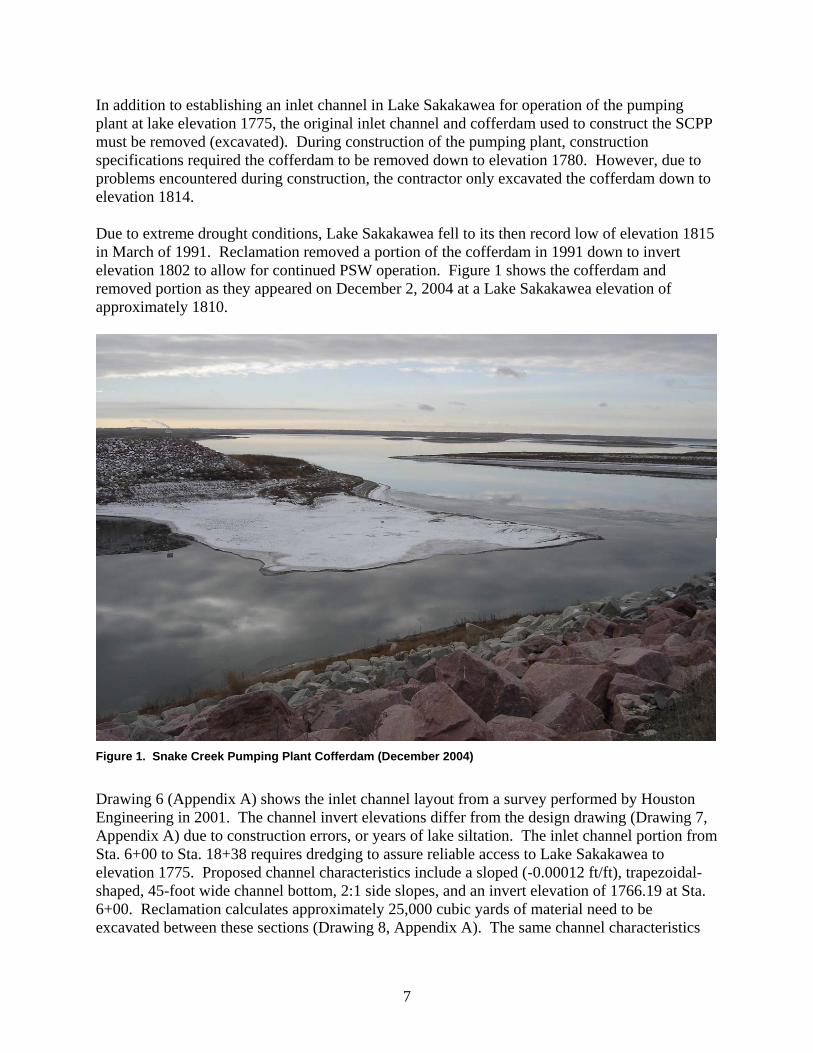
In 2004, Garrison Diversion conducted a water depth survey using sounders and a global positioning unit attached to a motorboat to verify the contour data and proposed inlet channel route. The water depth survey concluded that the existing minimum lake bottom elevation along the proposed intake channel path is near elevation 1785 (See figure 2).
Figure 2. 2004 Snake Creek Water Depth Survey (Sakakawea water elevation approx. 1813).
New topography was created after Garrison Diversion completed the 2004 lake survey. The proposed channel characteristics include a trapezoidal-shaped, 50-foot wide channel bottom, 3:1 side slopes, and an invert elevation of 1766. This would allow 1100 cfs to the pumping plant with a water elevation of 1775. Inlet channel quantities were estimated to be 996,000 cubic yards of material from the pumping plant intake to approximately 4 miles into the lake. Reclamation in cooperation with Garrison Diversion excavated 42,000 cubic yards from the existing cofferdam in Jan-Feb 2005 to elevation 1790. Further cofferdam excavation to 1780 is
8
planned as Lake Sakakawea elevation drops throughout 2005. During the winter of 2005-2006, plans are to excavate an additional 21,000 cubic yards. Two cost estimates for excavating the intake channel have been completed using the new lake contours. One method of estimation includes conventional excavation using scrapers in combination with excavators and haul trucks. This assumes that excavation can be conducted in a dry state, lake elevation 1775-1780. Preliminary cost estimates are included on Sheet 1, Appendix B. Reclamation estimates excavating the intake channel and remaining cofferdam (954,000 cubic yards) costs to be approximately $9,459,000. Supporting cost estimates are detailed in Appendix C, Attachment 2. The second method of estimation involves hydraulic dredging while pumping the channel material to the spoil area. This type of excavation would be recommended if the east end of Lake Sakakawea is under water. Preliminary cost estimates are included on Sheet 2, Appendix B. Reclamation estimates dredging the intake channel and remaining cofferdam (954,000 cu. yds.) costs to be approximately $16,070,000. Supporting cost estimates are detailed in Appendix C, Attachment 2. For this study, the estimated cost of $9,459,000 using conventional excavation is used in the final cost estimate. SCPP Major Structural Rehabilitation The SCPP has structural deficiencies that need to be addressed to assure reliable operation of the facility in the future. These deficiencies include the main transfer deck, bridge rocker bearings, pump assemblies, and bridge pier anchor vault. Transfer Deck The plant is of the island type with access to the main transfer deck by bridge from the Snake Creek Embankment. The main transfer deck, which also serves as the roof over the motor floor, is composed of a lightweight concrete structural slab supported by structural steel beams and girders. The structural slab has a conventional concrete cover slab to provide a protective wearing surface. In June of 2001, pieces of the lightweight concrete structural slab failed and fell approximately 45 feet to the control room floor (See Figure 3). Since the failure event, Reclamation has performed several studies on the deck including concrete cores, deck structural analysis, and concrete monitoring. The cause of the concrete deck failure appears to be freeze-thaw and alkali-silica reactions. As a result of these studies, the load bearing capacity of the deck has been reduced by 15%, and the concrete continues to undergo numerous freeze-thaw cycles each season. The transfer deck will require replacement to remedy this situation. In 2003, Reclamation conducted an appraisal-level cost estimate for replacement of the transfer deck. A copy of the cost estimate is included in Appendix B. The estimate details the costs for complete removal of the cover and structural slabs, as well as construction of a new reinforced concrete structural deck, deck drain piping, and electrical conduits. Based on 2003 Reclamation’s Technical Service Center (TSC) billable rates, the estimate totals $1,100,000 (Appendix C, Attachment 3). Indexed to 2005 values using the Corps’ Civil Works Construction Cost Index System, the estimated total cost is approximately $1,210,000 (Sheet 3, Appendix B).
9
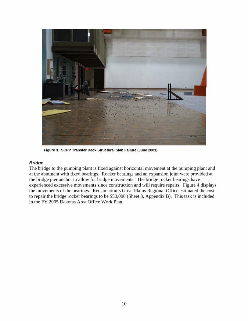
Figure 3. SCPP Transfer Deck Structural Slab Failure (June 2001)
Bridge The bridge to the pumping plant is fixed against horizontal movement at the pumping plant and at the abutment with fixed bearings. Rocker bearings and an expansion joint were provided at the bridge pier anchor to allow for bridge movements. The bridge rocker bearings have experienced excessive movements since construction and will require repairs. Figure 4 displays the movements of the bearings. Reclamation’s Great Plains Regional Office estimated the cost to repair the bridge rocker bearings to be $50,000 (Sheet 3, Appendix B). This task is included in the FY 2005 Dakotas Area Office Work Plan.
10
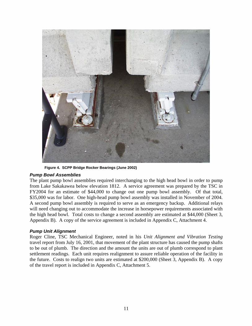
Figure 4. SCPP Bridge Rocker Bearings (June 2002)
Pump Bowl Assemblies The plant pump bowl assemblies required interchanging to the high head bowl in order to pump from Lake Sakakawea below elevation 1812. A service agreement was prepared by the TSC in FY2004 for an estimate of $44,000 to change out one pump bowl assembly. Of that total, $35,000 was for labor. One high-head pump bowl assembly was installed in November of 2004. A second pump bowl assembly is required to serve as an emergency backup. Additional relays will need changing out to accommodate the increase in horsepower requirements associated with the high head bowl. Total costs to change a second assembly are estimated at $44,000 (Sheet 3, Appendix B). A copy of the service agreement is included in Appendix C, Attachment 4. Pump Unit Alignment Roger Cline, TSC Mechanical Engineer, noted in his Unit Alignment and Vibration Testing travel report from July 16, 2001, that movement of the plant structure has caused the pump shafts to be out of plumb. The direction and the amount the units are out of plumb correspond to plant settlement readings. Each unit requires realignment to assure reliable operation of the facility in the future. Costs to realign two units are estimated at $200,000 (Sheet 3, Appendix B). A copy of the travel report is included in Appendix C, Attachment 5.
11
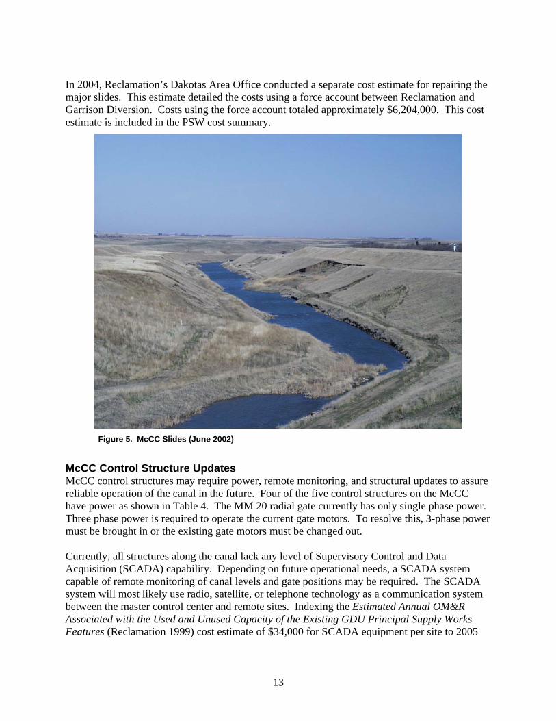
SCPP Bridge Pier Anchor Vault Repairs There is a vault in the bridge pier anchor located below the center of the of the SCPP bridge. The vault provides access to the three steel discharge pipes for the SCPP. The steel pipe coating is severely corroded in some areas and will need to be sandblasted, patched and recoated. Also, the concrete walls and floor of the vault are spalling, collecting mineral deposits, and rusting in several areas. The estimated cost to repair the vault and pipe is $326,000 (Sheet 4, Appendix B). McCLUSKY CANAL This section identifies the McCC repairs and improvements required to assure reliable operation of the facilities in the future. This includes the development of construction (repair and enhancements) and OM&R cost estimates for all features associated with the McCC. McCC Background The McCC is approximately 74 miles long, has a partial to full clay lining in selected areas, a bottom width of 25 feet, an original design operating water depth of 17 feet, 2:1 side slopes, and an original design capacity of 1,950 cfs with an elevation of 1850 on Lake Audubon. The operating level of Lake Audubon has since been lowered to elevation 1847.0 reducing the maximum capacity down the McClusky Canal to 1,350 cfs. Constructed under eight separate contracts between 1969 and 1978, the major canal structures consist of canal headworks, radial gates, in-line lakes, tunnel, drop chute with radial gate check, baffled apron drop, and several bridges. The first 59 miles of the canal are currently watered-up and in use. The last 16 miles of the canal are de-watered and are not in operation. There are no plans to use McCC between MM59-75; therefore, only the first 59 miles are included in the cost estimates. See Drawing 9 (Appendix A) for McCC location map. Major McCC Slides – Sta. 1124+00 to 1204+00 The section of the McCC between stations 1124+00 and 1204+00 continues to experience massive slides (See Figure 5). A feasibility study completed by the TSC developed and evaluated alternative remedies for problems associated with slope failures between these stations. The report, Canal Modification Feasibility Study for McClusky Canal – Reach 2, Station 1124+00 through 1204+00 (Reclamation 2001a), presented five possible repair alternatives to achieve the desired performance standards of the canal. The preferred alternative was to reduce the slope inclination to 4:1 and construct an open-channel trapezoidal prism with a capacity of 1,000 cfs. This design alternative presented a long-term solution to the slope stability problems which could be implemented safely with proper construction. The feasibility study estimated the total amount of cut for a 1000 cfs canal prism with 4:1 side slopes to be approximately three million cubic yards. Cost estimates for this alternative totaled $15,250,000, based on 2001 cost values. Indexed to 2005 levels using the Corps’ Civil Works Construction Cost Index System, the total cost to perform slide repairs is approximately $16,500,000 (Sheet 5, Appendix B).
12
In 2004, Reclamation’s Dakotas Area Office conducted a separate cost estimate for repairing the major slides. This estimate detailed the costs using a force account between Reclamation and Garrison Diversion. Costs using the force account totaled approximately $6,204,000. This cost estimate is included in the PSW cost summary.
Figure 5. McCC Slides (June 2002)
McCC Control Structure Updates McCC control structures may require power, remote monitoring, and structural updates to assure reliable operation of the canal in the future. Four of the five control structures on the McCC have power as shown in Table 4. The MM 20 radial gate currently has only single phase power. Three phase power is required to operate the current gate motors. To resolve this, 3-phase power must be brought in or the existing gate motors must be changed out. Currently, all structures along the canal lack any level of Supervisory Control and Data Acquisition (SCADA) capability. Depending on future operational needs, a SCADA system capable of remote monitoring of canal levels and gate positions may be required. The SCADA system will most likely use radio, satellite, or telephone technology as a communication system between the master control center and remote sites. Indexing the Estimated Annual OM&R Associated with the Used and Unused Capacity of the Existing GDU Principal Supply Works Features (Reclamation 1999) cost estimate of $34,000 for SCADA equipment per site to 2005
13
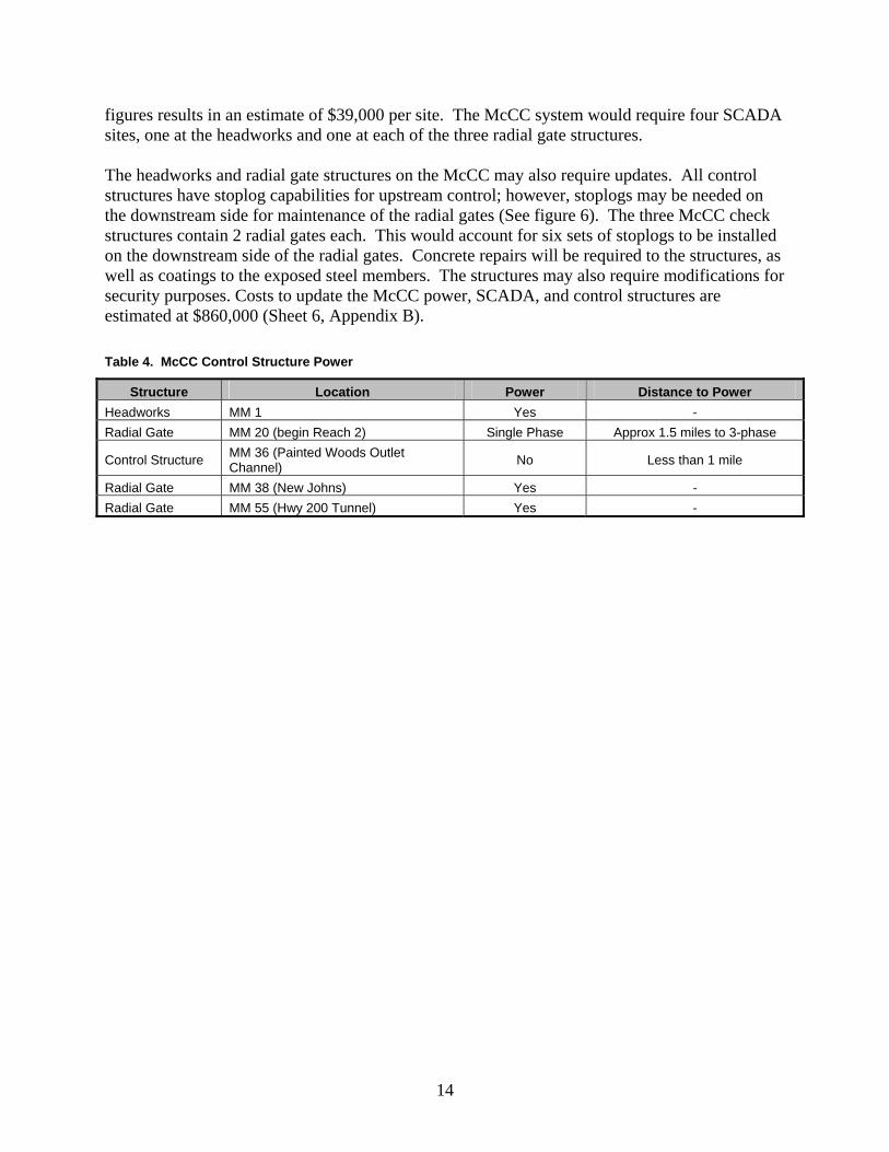
figures results in an estimate of $39,000 per site. The McCC system would require four SCADA sites, one at the headworks and one at each of the three radial gate structures. The headworks and radial gate structures on the McCC may also require updates. All control structures have stoplog capabilities for upstream control; however, stoplogs may be needed on the downstream side for maintenance of the radial gates (See figure 6). The three McCC check structures contain 2 radial gates each. This would account for six sets of stoplogs to be installed on the downstream side of the radial gates. Concrete repairs will be required to the structures, as well as coatings to the exposed steel members. The structures may also require modifications for security purposes. Costs to update the McCC power, SCADA, and control structures are estimated at $860,000 (Sheet 6, Appendix B). Table 4. McCC Control Structure Power
Structure Location Power Distance to Power Headworks MM 1 Yes - Radial Gate MM 20 (begin Reach 2) Single Phase Approx 1.5 miles to 3-phase
Control Structure MM 36 (Painted Woods Outlet Channel) No Less than 1 mile
Radial Gate MM 38 (New Johns) Yes - Radial Gate MM 55 (Hwy 200 Tunnel) Yes -
14
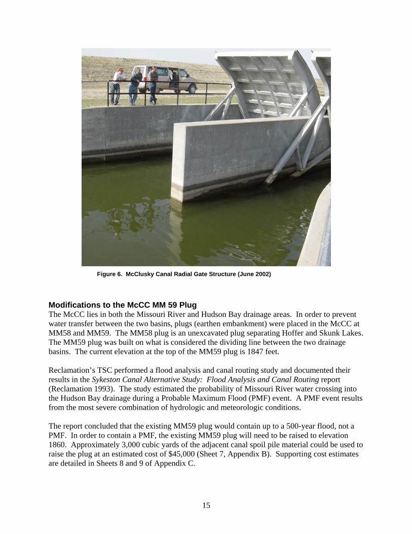
Figure 6. McClusky Canal Radial Gate Structure (June 2002)
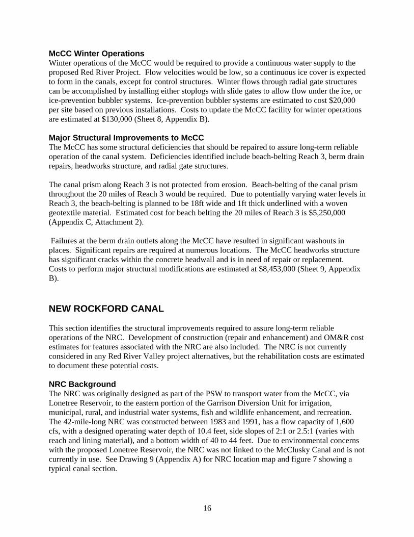
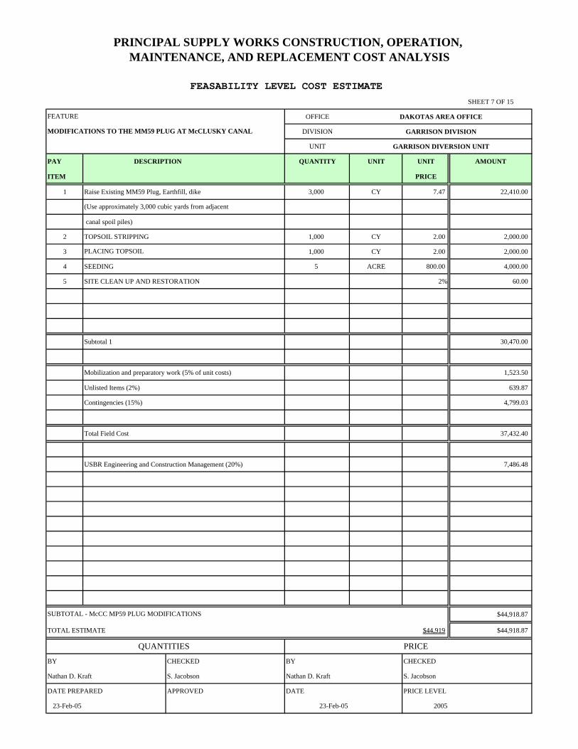
Modifications to the McCC MM 59 Plug The McCC lies in both the Missouri River and Hudson Bay drainage areas. In order to prevent water transfer between the two basins, plugs (earthen embankment) were placed in the McCC at MM58 and MM59. The MM58 plug is an unexcavated plug separating Hoffer and Skunk Lakes. The MM59 plug was built on what is considered the dividing line between the two drainage basins. The current elevation at the top of the MM59 plug is 1847 feet. Reclamation’s TSC performed a flood analysis and canal routing study and documented their results in the Sykeston Canal Alternative Study: Flood Analysis and Canal Routing report (Reclamation 1993). The study estimated the probability of Missouri River water crossing into the Hudson Bay drainage during a Probable Maximum Flood (PMF) event. A PMF event results from the most severe combination of hydrologic and meteorologic conditions. The report concluded that the existing MM59 plug would contain up to a 500-year flood, not a PMF. In order to contain a PMF, the existing MM59 plug will need to be raised to elevation 1860. Approximately 3,000 cubic yards of the adjacent canal spoil pile material could be used to raise the plug at an estimated cost of $45,000 (Sheet 7, Appendix B). Supporting cost estimates are detailed in Sheets 8 and 9 of Appendix C.
15
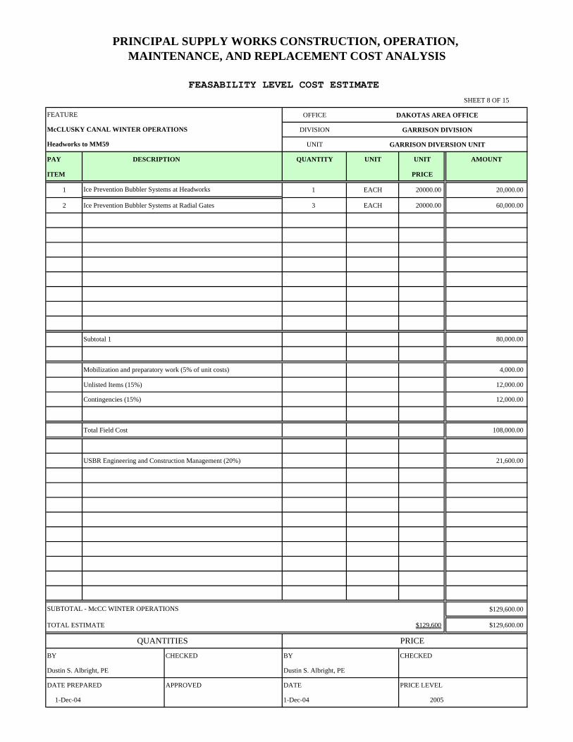
McCC Winter Operations Winter operations of the McCC would be required to provide a continuous water supply to the proposed Red River Project. Flow velocities would be low, so a continuous ice cover is expected to form in the canals, except for control structures. Winter flows through radial gate structures can be accomplished by installing either stoplogs with slide gates to allow flow under the ice, or ice-prevention bubbler systems. Ice-prevention bubbler systems are estimated to cost $20,000 per site based on previous installations. Costs to update the McCC facility for winter operations are estimated at $130,000 (Sheet 8, Appendix B). Major Structural Improvements to McCC The McCC has some structural deficiencies that should be repaired to assure long-term reliable operation of the canal system. Deficiencies identified include beach-belting Reach 3, berm drain repairs, headworks structure, and radial gate structures. The canal prism along Reach 3 is not protected from erosion. Beach-belting of the canal prism throughout the 20 miles of Reach 3 would be required. Due to potentially varying water levels in Reach 3, the beach-belting is planned to be 18ft wide and 1ft thick underlined with a woven geotextile material. Estimated cost for beach belting the 20 miles of Reach 3 is $5,250,000 (Appendix C, Attachment 2). Failures at the berm drain outlets along the McCC have resulted in significant washouts in places. Significant repairs are required at numerous locations. The McCC headworks structure has significant cracks within the concrete headwall and is in need of repair or replacement. Costs to perform major structural modifications are estimated at $8,453,000 (Sheet 9, Appendix B). NEW ROCKFORD CANAL This section identifies the structural improvements required to assure long-term reliable operations of the NRC. Development of construction (repair and enhancement) and OM&R cost estimates for features associated with the NRC are also included. The NRC is not currently considered in any Red River Valley project alternatives, but the rehabilitation costs are estimated to document these potential costs. NRC Background The NRC was originally designed as part of the PSW to transport water from the McCC, via Lonetree Reservoir, to the eastern portion of the Garrison Diversion Unit for irrigation, municipal, rural, and industrial water systems, fish and wildlife enhancement, and recreation. The 42-mile-long NRC was constructed between 1983 and 1991, has a flow capacity of 1,600 cfs, with a designed operating water depth of 10.4 feet, side slopes of 2:1 or 2.5:1 (varies with reach and lining material), and a bottom width of 40 to 44 feet. Due to environmental concerns with the proposed Lonetree Reservoir, the NRC was not linked to the McClusky Canal and is not currently in use. See Drawing 9 (Appendix A) for NRC location map and figure 7 showing a typical canal section.
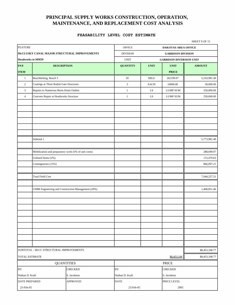
16
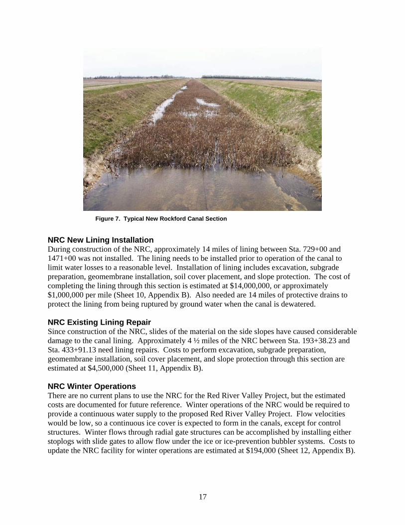
Figure 7. Typical New Rockford Canal Section
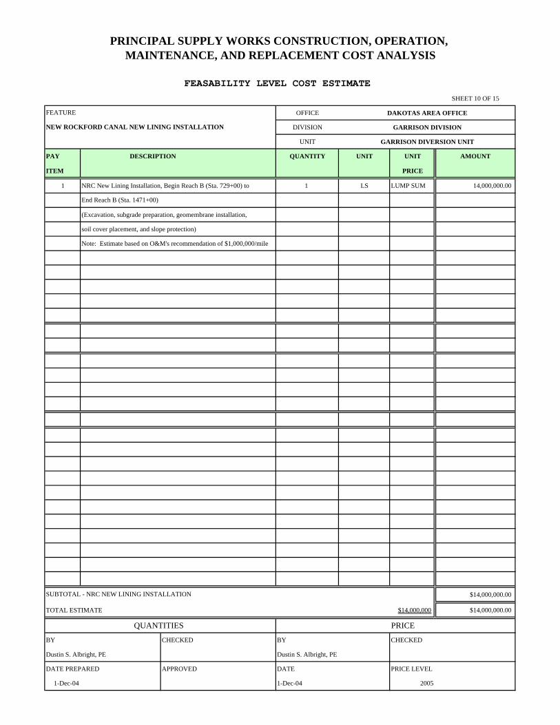
NRC New Lining Installation During construction of the NRC, approximately 14 miles of lining between Sta. 729+00 and 1471+00 was not installed. The lining needs to be installed prior to operation of the canal to limit water losses to a reasonable level. Installation of lining includes excavation, subgrade preparation, geomembrane installation, soil cover placement, and slope protection. The cost of completing the lining through this section is estimated at $14,000,000, or approximately $1,000,000 per mile (Sheet 10, Appendix B). Also needed are 14 miles of protective drains to protect the lining from being ruptured by ground water when the canal is dewatered. NRC Existing Lining Repair Since construction of the NRC, slides of the material on the side slopes have caused considerable damage to the canal lining. Approximately 4 ½ miles of the NRC between Sta. 193+38.23 and Sta. 433+91.13 need lining repairs. Costs to perform excavation, subgrade preparation, geomembrane installation, soil cover placement, and slope protection through this section are estimated at $4,500,000 (Sheet 11, Appendix B). NRC Winter Operations There are no current plans to use the NRC for the Red River Valley Project, but the estimated costs are documented for future reference. Winter operations of the NRC would be required to provide a continuous water supply to the proposed Red River Valley Project. Flow velocities would be low, so a continuous ice cover is expected to form in the canals, except for control structures. Winter flows through radial gate structures can be accomplished by installing either stoplogs with slide gates to allow flow under the ice or ice-prevention bubbler systems. Costs to update the NRC facility for winter operations are estimated at $194,000 (Sheet 12, Appendix B).
17
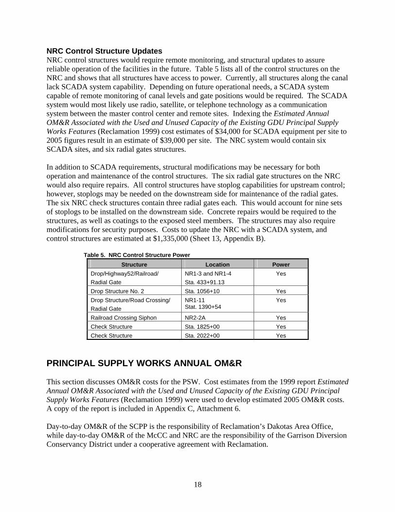
NRC Control Structure Updates NRC control structures would require remote monitoring, and structural updates to assure reliable operation of the facilities in the future. Table 5 lists all of the control structures on the NRC and shows that all structures have access to power. Currently, all structures along the canal lack SCADA system capability. Depending on future operational needs, a SCADA system capable of remote monitoring of canal levels and gate positions would be required. The SCADA system would most likely use radio, satellite, or telephone technology as a communication system between the master control center and remote sites. Indexing the Estimated Annual OM&R Associated with the Used and Unused Capacity of the Existing GDU Principal Supply Works Features (Reclamation 1999) cost estimates of $34,000 for SCADA equipment per site to 2005 figures result in an estimate of $39,000 per site. The NRC system would contain six SCADA sites, and six radial gates structures. In addition to SCADA requirements, structural modifications may be necessary for both operation and maintenance of the control structures. The six radial gate structures on the NRC would also require repairs. All control structures have stoplog capabilities for upstream control; however, stoplogs may be needed on the downstream side for maintenance of the radial gates. The six NRC check structures contain three radial gates each. This would account for nine sets of stoplogs to be installed on the downstream side. Concrete repairs would be required to the structures, as well as coatings to the exposed steel members. The structures may also require modifications for security purposes. Costs to update the NRC with a SCADA system, and control structures are estimated at $1,335,000 (Sheet 13, Appendix B). Table 5. NRC Control Structure Power
Structure Location Power Drop/Highway52/Railroad/ Radial Gate
NR1-3 and NR1-4 Sta. 433+91.13
Yes
Drop Structure No. 2 Sta. 1056+10 Yes Drop Structure/Road Crossing/ Radial Gate
NR1-11 Stat. 1390+54
Yes
Railroad Crossing Siphon NR2-2A Yes Check Structure Sta. 1825+00 Yes Check Structure Sta. 2022+00 Yes
PRINCIPAL SUPPLY WORKS ANNUAL OM&R This section discusses OM&R costs for the PSW. Cost estimates from the 1999 report Estimated Annual OM&R Associated with the Used and Unused Capacity of the Existing GDU Principal Supply Works Features (Reclamation 1999) were used to develop estimated 2005 OM&R costs. A copy of the report is included in Appendix C, Attachment 6. Day-to-day OM&R of the SCPP is the responsibility of Reclamation’s Dakotas Area Office, while day-to-day OM&R of the McCC and NRC are the responsibility of the Garrison Diversion Conservancy District under a cooperative agreement with Reclamation.
18
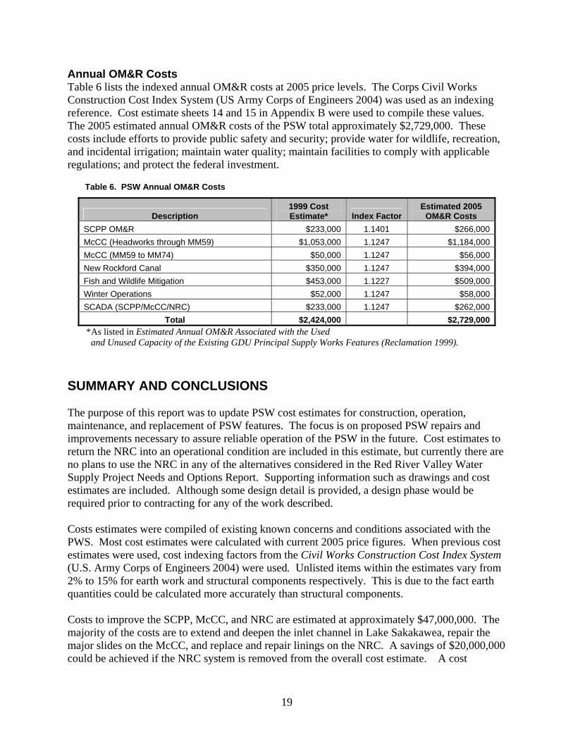
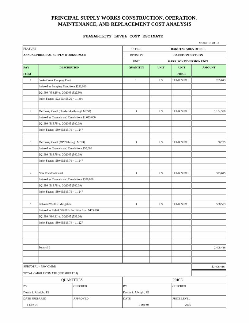
Annual OM&R Costs Table 6 lists the indexed annual OM&R costs at 2005 price levels. The Corps Civil Works Construction Cost Index System (US Army Corps of Engineers 2004) was used as an indexing reference. Cost estimate sheets 14 and 15 in Appendix B were used to compile these values. The 2005 estimated annual OM&R costs of the PSW total approximately $2,729,000. These costs include efforts to provide public safety and security; provide water for wildlife, recreation, and incidental irrigation; maintain water quality; maintain facilities to comply with applicable regulations; and protect the federal investment.
Table 6. PSW Annual OM&R Costs
Description 1999 Cost Estimate* Index Factor
Estimated 2005 OM&R Costs
SCPP OM&R $233,000 1.1401 $266,000McCC (Headworks through MM59) $1,053,000 1.1247 $1,184,000McCC (MM59 to MM74) $50,000 1.1247 $56,000New Rockford Canal $350,000 1.1247 $394,000Fish and Wildlife Mitigation $453,000 1.1227 $509,000Winter Operations $52,000 1.1247 $58,000SCADA (SCPP/McCC/NRC) $233,000 1.1247 $262,000
Total $2,424,000 $2,729,000 *As listed in Estimated Annual OM&R Associated with the Used and Unused Capacity of the Existing GDU Principal Supply Works Features (Reclamation 1999). SUMMARY AND CONCLUSIONS
The purpose of this report was to update PSW cost estimates for construction, operation, maintenance, and replacement of PSW features. The focus is on proposed PSW repairs and improvements necessary to assure reliable operation of the PSW in the future. Cost estimates to return the NRC into an operational condition are included in this estimate, but currently there are no plans to use the NRC in any of the alternatives considered in the Red River Valley Water Supply Project Needs and Options Report. Supporting information such as drawings and cost estimates are included. Although some design detail is provided, a design phase would be required prior to contracting for any of the work described. Costs estimates were compiled of existing known concerns and conditions associated with the PWS. Most cost estimates were calculated with current 2005 price figures. When previous cost estimates were used, cost indexing factors from the Civil Works Construction Cost Index System (U.S. Army Corps of Engineers 2004) were used. Unlisted items within the estimates vary from 2% to 15% for earth work and structural components respectively. This is due to the fact earth quantities could be calculated more accurately than structural components. Costs to improve the SCPP, McCC, and NRC are estimated at approximately $47,000,000. The majority of the costs are to extend and deepen the inlet channel in Lake Sakakawea, repair the major slides on the McCC, and replace and repair linings on the NRC. A savings of $20,000,000 could be achieved if the NRC system is removed from the overall cost estimate. A cost
19
increase of more than $4,500,000 may be associated with the Lake Sakakawea inlet channel if hydraulic dredging is required to excavate the intake channel.
Based on indexed values to 2005 levels, the total annual OM&R costs of the PSW are estimated at $2,729,000. Table 7 summarizes the PSW construction costs and table 8 summaries the annual OM&R costs.
Table 7. PSW Construction Cost Summary
PSW Feature Work Item Estimated 2005
Costs SCPP Option 1 - Lake Sakakawea Inlet Channel (excavating)* $9,459,000SCPP Option 2 - Lake Sakakawea Inlet Channel (dredging)* $16,069,000**SCPP SCPP Major Structural Rehabilitation $1,829,000
Total SCPP $11,288,000McCC Major McCC Slides – Sta. 1124+00 to 1204+00 $6,204,000***
McCC McCC Control Structure Updates $860,000McCC Modifications to the McCC MM 59 Plug $45,000McCC McCC Winter Operations $130,000McCC Major Structural Improvements to McCC $8,453,000
Total McCC $15,692,000NRC NRC New Lining Installation $14,000,000NRC NRC Existing Lining Repair $4,500,000NRC NRC Winter Operations $194,000NRC NRC Control Structure Updates $1,335,000
Total NRC $20,029,000 Total PSW Construction Costs $47,009,000
* Includes cofferdam excavation ** Not included in the Total PSW Construction Costs ***Calculated using DKAO Force Account
Table 8. PSW Annual OM&R Cost Summary
Work Item Estimated 2005 Costs
SCPP OM&R $266,000 McCC (Headworks through MM59) $1,184,000 McCC (MM59 to MM74) $56,000 New Rockford Canal $394,000 Fish and Wildlife Mitigation $509,000 Winter Operations $58,000 SCADA (SCPP/McCC/NRC) $262,000
Total PSW OM&R $2,729,000
20
REFERENCES Bureau of Reclamation, 1993. Sykeston Canal Alternative Study: Flood Analysis and Canal Routing, October 20, 1993. Bureau of Reclamation, 1999. Estimated Annual OM&R Associated with the Used and Unused Capacity of the Existing GDU Principal Supply Works Features, March 28, 1999. Bureau of Reclamation, 2001a. Canal Modification Feasibility Study for McClusky Canal – Reach 2, Station 1124+00 through 1204+00, April 25, 2001. Bureau of Reclamation 2001b. Snake Creek Pumping Plant Unit Alignment and Vibration Testing Report, July 16, 2001. Bureau of Reclamation, 2003. Snake Creek Pumping Plant Deck Replacement Study, August 2003, September 5, 2003. U.S. Army Corps of Engineers, 2004. Civil Works Construction Cost Index System (CWCCIS), March 31, 2004.
21

Appendix A - Drawings
Appendix B - Cost Estimates
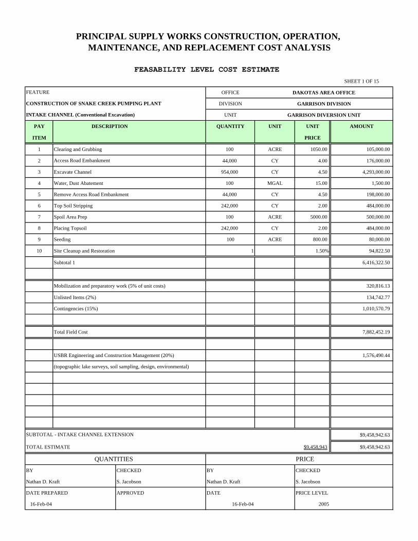
SHEET 1 OF 15
OFFICE DAKOTAS AREA OFFICE
DIVISION GARRISON DIVISION
UNIT GARRISON DIVERSION UNIT
PAY DESCRIPTION QUANTITY UNIT UNIT AMOUNT
ITEM PRICE
1 Clearing and Grubbing 100 ACRE 1050.00 105,000.00
2 44,000 CY 4.00 176,000.00
3 Excavate Channel 954,000 CY 4.50 4,293,000.00
4 Water, Dust Abatement 100 MGAL 15.00 1,500.00
5 Remove Access Road Embankment 44,000 CY 4.50 198,000.00
6 Top Soil Stripping 242,000 CY 2.00 484,000.00
7 Spoil Area Prep 100 ACRE 5000.00 500,000.00
8 Placing Topsoil 242,000 CY 2.00 484,000.00
9 Seeding 100 ACRE 800.00 80,000.00
10 Site Cleanup and Restoration 1 1.50% 94,822.50
Subtotal 1 6,416,322.50
Mobilization and preparatory work (5% of unit costs) 320,816.13
Unlisted Items (2%) 134,742.77
Contingencies (15%) 1,010,570.79
Total Field Cost 7,882,452.19
USBR Engineering and Construction Management (20%) 1,576,490.44
(topographic lake surveys, soil sampling, design, environmental)
$9,458,942.63
TOTAL ESTIMATE $9,458,943 $9,458,942.63
QUANTITIES PRICE
BY CHECKED BY CHECKED
Nathan D. Kraft S. Jacobson Nathan D. Kraft S. Jacobson
DATE PREPARED APPROVED DATE PRICE LEVEL
16-Feb-04 16-Feb-04 2005
Access Road Embankment
SUBTOTAL - INTAKE CHANNEL EXTENSION
FEASABILITY LEVEL COST ESTIMATE
PRINCIPAL SUPPLY WORKS CONSTRUCTION, OPERATION, MAINTENANCE, AND REPLACEMENT COST ANALYSIS
INTAKE CHANNEL (Conventional Excavation)
CONSTRUCTION OF SNAKE CREEK PUMPING PLANT
FEATURE
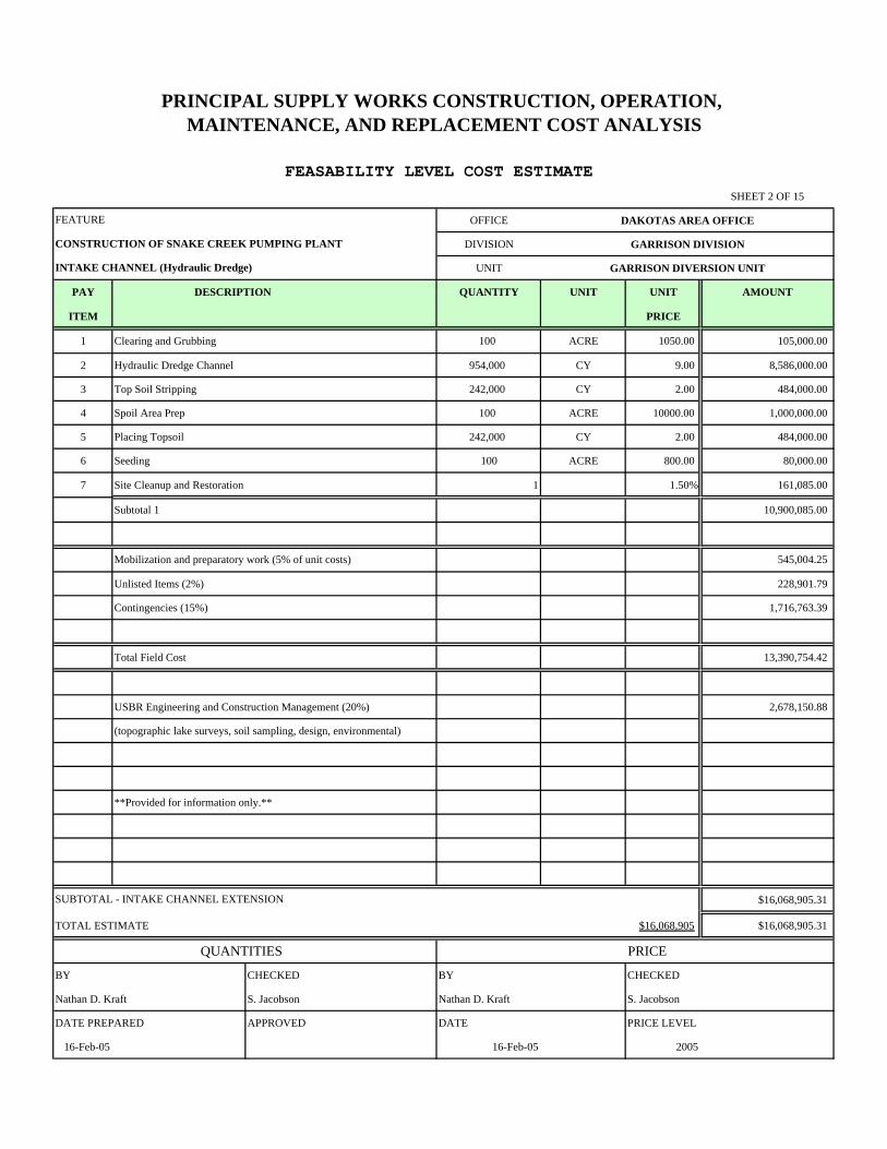
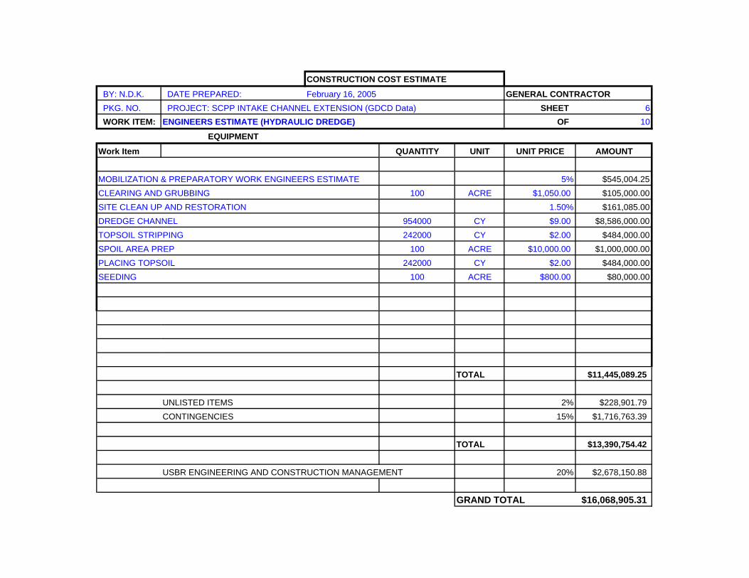
SHEET 2 OF 15
OFFICE DAKOTAS AREA OFFICE
DIVISION GARRISON DIVISION
UNIT GARRISON DIVERSION UNIT
PAY DESCRIPTION QUANTITY UNIT UNIT AMOUNT
ITEM PRICE
1 Clearing and Grubbing 100 ACRE 1050.00 105,000.00
2 Hydraulic Dredge Channel 954,000 CY 9.00 8,586,000.00
3 Top Soil Stripping 242,000 CY 2.00 484,000.00
4 Spoil Area Prep 100 ACRE 10000.00 1,000,000.00
5 Placing Topsoil 242,000 CY 2.00 484,000.00
6 Seeding 100 ACRE 800.00 80,000.00
7 Site Cleanup and Restoration 1 1.50% 161,085.00
Subtotal 1 10,900,085.00
Mobilization and preparatory work (5% of unit costs) 545,004.25
Unlisted Items (2%) 228,901.79
Contingencies (15%) 1,716,763.39
Total Field Cost 13,390,754.42
USBR Engineering and Construction Management (20%) 2,678,150.88
(topographic lake surveys, soil sampling, design, environmental)
**Provided for information only.**
$16,068,905.31
TOTAL ESTIMATE $16,068,905 $16,068,905.31
QUANTITIES PRICE
BY CHECKED BY CHECKED
Nathan D. Kraft S. Jacobson Nathan D. Kraft S. Jacobson
DATE PREPARED APPROVED DATE PRICE LEVEL
16-Feb-05 16-Feb-05 2005
SUBTOTAL - INTAKE CHANNEL EXTENSION
FEASABILITY LEVEL COST ESTIMATE
PRINCIPAL SUPPLY WORKS CONSTRUCTION, OPERATION, MAINTENANCE, AND REPLACEMENT COST ANALYSIS
INTAKE CHANNEL (Hydraulic Dredge)
CONSTRUCTION OF SNAKE CREEK PUMPING PLANT
FEATURE
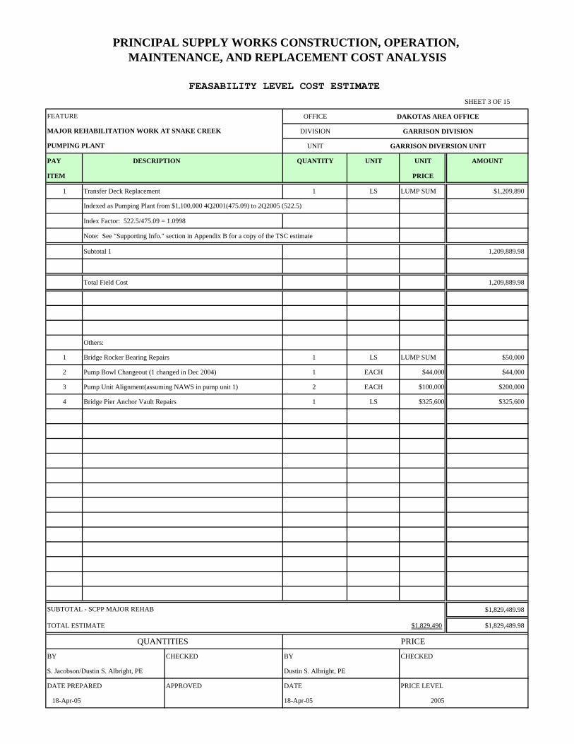
SHEET 3 OF 15
OFFICE DAKOTAS AREA OFFICE
DIVISION GARRISON DIVISION
UNIT GARRISON DIVERSION UNIT
PAY DESCRIPTION QUANTITY UNIT UNIT AMOUNT
ITEM PRICE
1 Transfer Deck Replacement 1 LS LUMP SUM $1,209,890
Index Factor: 522.5/475.09 = 1.0998
Note: See "Supporting Info." section in Appendix B for a copy of the TSC estimate
Subtotal 1 1,209,889.98
Total Field Cost 1,209,889.98
Others:
1 Bridge Rocker Bearing Repairs 1 LS LUMP SUM $50,000
2 Pump Bowl Changeout (1 changed in Dec 2004) 1 EACH $44,000 $44,000
3 Pump Unit Alignment(assuming NAWS in pump unit 1) 2 EACH $100,000 $200,000
4 Bridge Pier Anchor Vault Repairs 1 LS $325,600 $325,600
$1,829,489.98
TOTAL ESTIMATE $1,829,490 $1,829,489.98
QUANTITIES PRICE
BY CHECKED BY CHECKED
S. Jacobson/Dustin S. Albright, PE Dustin S. Albright, PE
DATE PREPARED APPROVED DATE PRICE LEVEL
18-Apr-05 18-Apr-05 2005
SUBTOTAL - SCPP MAJOR REHAB
FEASABILITY LEVEL COST ESTIMATE
Indexed as Pumping Plant from $1,100,000 4Q2001(475.09) to 2Q2005 (522.5)
PRINCIPAL SUPPLY WORKS CONSTRUCTION, OPERATION, MAINTENANCE, AND REPLACEMENT COST ANALYSIS
PUMPING PLANT
MAJOR REHABILITATION WORK AT SNAKE CREEK
FEATURE
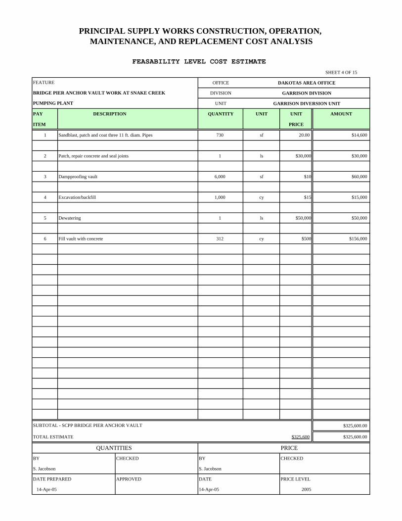
SHEET 4 OF 15
OFFICE DAKOTAS AREA OFFICE
DIVISION GARRISON DIVISION
UNIT GARRISON DIVERSION UNIT
PAY DESCRIPTION QUANTITY UNIT UNIT AMOUNT
ITEM PRICE
1 Sandblast, patch and coat three 11 ft. diam. Pipes 730 sf 20.00 $14,600
2 Patch, repair concrete and seal joints 1 ls $30,000 $30,000
3 Dampproofing vault 6,000 sf $10 $60,000
4 Excavation/backfill 1,000 cy $15 $15,000
5 Dewatering 1 ls $50,000 $50,000
6 Fill vault with concrete 312 cy $500 $156,000
$325,600.00
TOTAL ESTIMATE $325,600 $325,600.00
QUANTITIES PRICE
BY CHECKED BY CHECKED
S. Jacobson S. Jacobson
DATE PREPARED APPROVED DATE PRICE LEVEL
14-Apr-05 14-Apr-05 2005
SUBTOTAL - SCPP BRIDGE PIER ANCHOR VAULT
FEASABILITY LEVEL COST ESTIMATE
PRINCIPAL SUPPLY WORKS CONSTRUCTION, OPERATION, MAINTENANCE, AND REPLACEMENT COST ANALYSIS
PUMPING PLANT
BRIDGE PIER ANCHOR VAULT WORK AT SNAKE CREEK
FEATURE
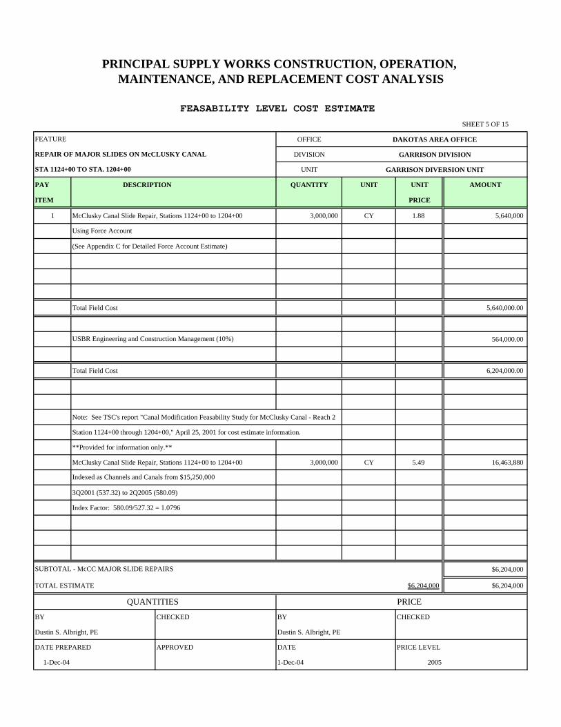
SHEET 5 OF 15
OFFICE DAKOTAS AREA OFFICE
DIVISION GARRISON DIVISION
UNIT GARRISON DIVERSION UNIT
PAY DESCRIPTION QUANTITY UNIT UNIT AMOUNT
ITEM PRICE
1 McClusky Canal Slide Repair, Stations 1124+00 to 1204+00 3,000,000 CY 1.88 5,640,000
(See Appendix C for Detailed Force Account Estimate)
Total Field Cost 5,640,000.00
564,000.00
Total Field Cost 6,204,000.00
Note: See TSC's report "Canal Modification Feasability Study for McClusky Canal - Reach 2
Station 1124+00 through 1204+00," April 25, 2001 for cost estimate information.
**Provided for information only.**
McClusky Canal Slide Repair, Stations 1124+00 to 1204+00 3,000,000 CY 5.49 16,463,880
3Q2001 (537.32) to 2Q2005 (580.09)
Index Factor: 580.09/527.32 = 1.0796
$6,204,000
TOTAL ESTIMATE $6,204,000 $6,204,000
QUANTITIES PRICE
BY CHECKED BY CHECKED
Dustin S. Albright, PE Dustin S. Albright, PE
DATE PREPARED APPROVED DATE PRICE LEVEL
1-Dec-04 1-Dec-04 2005
FEATURE
FEASABILITY LEVEL COST ESTIMATE
SUBTOTAL - McCC MAJOR SLIDE REPAIRS
PRINCIPAL SUPPLY WORKS CONSTRUCTION, OPERATION, MAINTENANCE, AND REPLACEMENT COST ANALYSIS
Indexed as Channels and Canals from $15,250,000
USBR Engineering and Construction Management (10%)
Using Force Account
STA 1124+00 TO STA. 1204+00
REPAIR OF MAJOR SLIDES ON McCLUSKY CANAL
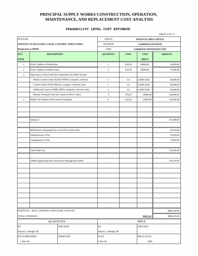
SHEET 6 OF 15
OFFICE DAKOTAS AREA OFFICE
DIVISION GARRISON DIVISION
UNIT GARRISON DIVERSION UNIT
PAY DESCRIPTION QUANTITY UNIT UNIT AMOUNT
ITEM PRICE
1 1 EACH 30000.00 30,000.00
2 3 EACH 25000.00 75,000.00
3
1 LS LUMP SUM 40,000.00
1 LS LUMP SUM 40,000.00
1 LS LUMP SUM 40,000.00
4 EACH 39000.00 156,000.00
4 6 EACH 25000.00 150,000.00
Subtotal 1 531,000.00
Mobilization and preparatory work (5% of unit costs) 26,550.00
Unlisted Items (15%) 79,650.00
Contingencies (15%) 79,650.00
Total Field Cost 716,850.00
USBR Engineering and Construction Management (20%) 143,370.00
$860,220.00
TOTAL ESTIMATE $860,220 $860,220.00
QUANTITIES PRICE
BY CHECKED BY CHECKED
Dustin S. Albright, PE Dustin S. Albright, PE
DATE PREPARED APPROVED DATE PRICE LEVEL
1-Dec-04 1-Dec-04 2005
PRINCIPAL SUPPLY WORKS CONSTRUCTION, OPERATION, MAINTENANCE, AND REPLACEMENT COST ANALYSIS
Headworks to MM59
UPDATES TO McCLUSKY CANAL CONTROL STRUCTURES
FEATURE
Remote Terminal Units (for control at McCC sites)
Supervisory Control and Data Acquisition (SCADA) System:
SUBTOTAL - McCC CONTROL STRUCTURE UPDATES
FEASABILITY LEVEL COST ESTIMATE
Master Control Center (GDCD-HDW), computer, software
Control Center (Field Offices), computer, software, misc.
Additional Centers (USBR, RRV), computer, software, misc.
Power Updates to Headworks
Radial Gate Updates (Downstream Stoplogs)
Power Updates to Radial Gates
SHEET 7 OF 15
OFFICE DAKOTAS AREA OFFICE
DIVISION GARRISON DIVISION
UNIT GARRISON DIVERSION UNIT
PAY DESCRIPTION QUANTITY UNIT UNIT AMOUNT
ITEM PRICE
1 Raise Existing MM59 Plug, Earthfill, dike 3,000 CY 7.47 22,410.00
canal spoil piles)
2 TOPSOIL STRIPPING 1,000 CY 2.00 2,000.00
3 1,000 CY 2.00 2,000.00
4 SEEDING 5 ACRE 800.00 4,000.00
5 SITE CLEAN UP AND RESTORATION 2% 60.00
Subtotal 1 30,470.00
Mobilization and preparatory work (5% of unit costs) 1,523.50
Unlisted Items (2%) 639.87
Contingencies (15%) 4,799.03
Total Field Cost 37,432.40
USBR Engineering and Construction Management (20%) 7,486.48
$44,918.87
TOTAL ESTIMATE $44,919 $44,918.87
QUANTITIES PRICE
BY CHECKED BY CHECKED
Nathan D. Kraft S. Jacobson Nathan D. Kraft S. Jacobson
DATE PREPARED APPROVED DATE PRICE LEVEL
23-Feb-05 23-Feb-05 2005
PRINCIPAL SUPPLY WORKS CONSTRUCTION, OPERATION, MAINTENANCE, AND REPLACEMENT COST ANALYSIS
MODIFICATIONS TO THE MM59 PLUG AT McCLUSKY CANAL
FEATURE
(Use approximately 3,000 cubic yards from adjacent
SUBTOTAL - McCC MP59 PLUG MODIFICATIONS
FEASABILITY LEVEL COST ESTIMATE
PLACING TOPSOIL
SHEET 8 OF 15
OFFICE DAKOTAS AREA OFFICE
DIVISION GARRISON DIVISION
UNIT GARRISON DIVERSION UNIT
PAY DESCRIPTION QUANTITY UNIT UNIT AMOUNT
ITEM PRICE
1 1 EACH 20000.00 20,000.00
2 3 EACH 20000.00 60,000.00
Subtotal 1 80,000.00
Mobilization and preparatory work (5% of unit costs) 4,000.00
Unlisted Items (15%) 12,000.00
Contingencies (15%) 12,000.00
Total Field Cost 108,000.00
USBR Engineering and Construction Management (20%) 21,600.00
$129,600.00
TOTAL ESTIMATE $129,600 $129,600.00
QUANTITIES PRICE
BY CHECKED BY CHECKED
Dustin S. Albright, PE Dustin S. Albright, PE
DATE PREPARED APPROVED DATE PRICE LEVEL
1-Dec-04 1-Dec-04 2005
Ice Prevention Bubbler Systems at Radial Gates
SUBTOTAL - McCC WINTER OPERATIONS
FEASABILITY LEVEL COST ESTIMATE
Ice Prevention Bubbler Systems at Headworks
PRINCIPAL SUPPLY WORKS CONSTRUCTION, OPERATION, MAINTENANCE, AND REPLACEMENT COST ANALYSIS
Headworks to MM59
McCLUSKY CANAL WINTER OPERATIONS
FEATURE
SHEET 9 OF 15
OFFICE DAKOTAS AREA OFFICE
DIVISION GARRISON DIVISION
UNIT GARRISON DIVERSION UNIT
PAY DESCRIPTION QUANTITY UNIT UNIT AMOUNT
ITEM PRICE
1 Beachbelting, Reach 3 20 MILE 262199.07 5,243,981.40
2 3 EACH 10000.00 30,000.00
3 Repairs to Numerous Berm Drain Outlets 1 LS LUMP SUM 250,000.00
4 Concrete Repair at Headworks Structure 1 LS LUMP SUM 250,000.00
Subtotal 1 5,773,981.40
Mobilization and preparatory work (5% of unit costs) 288,699.07
Unlisted Items (2%) 115,479.63
Contingencies (15%) 866,097.21
Total Field Cost 7,044,257.31
USBR Engineering and Construction Management (20%) 1,408,851.46
$8,453,108.77
TOTAL ESTIMATE $8,453,109 $8,453,108.77
QUANTITIES PRICE
BY CHECKED BY CHECKED
Nathan D. Kraft S. Jacobson Nathan D. Kraft S. Jacobson
DATE PREPARED APPROVED DATE PRICE LEVEL
23-Feb-05 23-Feb-05 2005
Coatings at Three Radial Gate Structures
SUBTOTAL - McCC STRUCTURAL IMPROVEMENTS
FEASABILITY LEVEL COST ESTIMATE
PRINCIPAL SUPPLY WORKS CONSTRUCTION, OPERATION, MAINTENANCE, AND REPLACEMENT COST ANALYSIS
Headworks to MM59
McCLUSKY CANAL MAJOR STRUCTURAL IMPROVEMENTS
FEATURE
SHEET 10 OF 15
OFFICE DAKOTAS AREA OFFICE
DIVISION GARRISON DIVISION
UNIT GARRISON DIVERSION UNIT
PAY DESCRIPTION QUANTITY UNIT UNIT AMOUNT
ITEM PRICE
1 NRC New Lining Installation, Begin Reach B (Sta. 729+00) to 1 LS LUMP SUM 14,000,000.00
(Excavation, subgrade preparation, geomembrane installation,
soil cover placement, and slope protection)
Note: Estimate based on O&M's recommendation of $1,000,000/mile
$14,000,000.00
TOTAL ESTIMATE $14,000,000 $14,000,000.00
QUANTITIES PRICE
BY CHECKED BY CHECKED
Dustin S. Albright, PE Dustin S. Albright, PE
DATE PREPARED APPROVED DATE PRICE LEVEL
1-Dec-04 1-Dec-04 2005
PRINCIPAL SUPPLY WORKS CONSTRUCTION, OPERATION, MAINTENANCE, AND REPLACEMENT COST ANALYSIS
NEW ROCKFORD CANAL NEW LINING INSTALLATION
FEATURE
End Reach B (Sta. 1471+00)
SUBTOTAL - NRC NEW LINING INSTALLATION
FEASABILITY LEVEL COST ESTIMATE
SHEET 11 OF 15
OFFICE DAKOTAS AREA OFFICE
DIVISION GARRISON DIVISION
UNIT GARRISON DIVERSION UNIT
PAY DESCRIPTION QUANTITY UNIT UNIT AMOUNT
ITEM PRICE
1 NRC Lining Repair, Sta. 193+38.23 to Sta. 433+91.13 1 LS LUMP SUM 4,500,000.00
(Excavation, subgrade preparation, geomembrane installation,
soil cover placement, and slope protection)
Note: Estimate based on O&M's recommendation of $1,000,000/mile
$4,500,000.00
TOTAL ESTIMATE $4,500,000 $4,500,000.00
QUANTITIES PRICE
BY CHECKED BY CHECKED
Dustin S. Albright, PE Dustin S. Albright, PE
DATE PREPARED APPROVED DATE PRICE LEVEL
1-Dec-04 1-Dec-04 2005
SUBTOTAL - NRC EXISTING LINING REPAIRS
FEASABILITY LEVEL COST ESTIMATE
PRINCIPAL SUPPLY WORKS CONSTRUCTION, OPERATION, MAINTENANCE, AND REPLACEMENT COST ANALYSIS
NEW ROCKFORD CANAL EXISTING LINING REPAIR
FEATURE
SHEET 12 OF 15
OFFICE DAKOTAS AREA OFFICE
DIVISION GARRISON DIVISION
UNIT GARRISON DIVERSION UNIT
PAY DESCRIPTION QUANTITY UNIT UNIT AMOUNT
ITEM PRICE
1 Ice Precention Bubbler Systems at Radial Gate Structures 6 EACH 20000.00 120,000.00
Subtotal 1 120,000.00
Mobilization and preparatory work (5% of unit costs) 6,000.00
Unlisted Items (15%) 18,000.00
Contingencies (15%) 18,000.00
Total Field Cost 162,000.00
USBR Engineering and Construction Management (20%) 32,400.00
$194,400.00
TOTAL ESTIMATE $194,400 $194,400.00
QUANTITIES PRICE
BY CHECKED BY CHECKED
Dustin S. Albright, PE Dustin S. Albright, PE
DATE PREPARED APPROVED DATE PRICE LEVEL
1-Dec-04 1-Dec-04 2005
PRINCIPAL SUPPLY WORKS CONSTRUCTION, OPERATION, MAINTENANCE, AND REPLACEMENT COST ANALYSIS
NEW ROCKFORD CANAL WINTER OPERATIONS
FEATURE
SUBTOTAL - NRC WINTER OPERATIONS
FEASABILITY LEVEL COST ESTIMATE
SHEET 13 OF 15
OFFICE DAKOTAS AREA OFFICE
DIVISION GARRISON DIVISION
UNIT GARRISON DIVERSION UNIT
PAY DESCRIPTION QUANTITY UNIT UNIT AMOUNT
ITEM PRICE
1 6 EACH 10000.00 60,000.00
2
1 LS LUMP SUM 40,000.00
1 LS LUMP SUM 40,000.00
6 EACH 39000.00 234,000.00
3 18 EACH 25,000.00 450,000.00
Subtotal 1 824,000.00
Mobilization and preparatory work (5% of unit costs) 41,200.00
Unlisted Items (15%) 123,600.00
Contingencies (15%) 123,600.00
Total Field Cost 1,112,400.00
USBR Engineering and Construction Management (20%) 222,480.00
$1,334,880.00
TOTAL ESTIMATE $1,334,880 $1,334,880.00
QUANTITIES PRICE
BY CHECKED BY CHECKED
Dustin S. Albright, PE Dustin S. Albright, PE
DATE PREPARED APPROVED DATE PRICE LEVEL
1-Dec-04 1-Dec-04 2005
Remote Terminal Units (for control at NRC sites)
Supervisory Control and Data Acquisition (SCADA) System:
SUBTOTAL - McCC CONTROL STRUCTURE UPDATES
FEASABILITY LEVEL COST ESTIMATE
Control Center (Field Offices), computer, software, misc.
Additional Centers (USBR, RRV), computer, software, misc.
Power Updates to Radial Gate Structures
Radial Gate Updates (Downstream Stoplogs)
PRINCIPAL SUPPLY WORKS CONSTRUCTION, OPERATION, MAINTENANCE, AND REPLACEMENT COST ANALYSIS
UPDATES TO NEW ROCKFORD CANAL CONTROL STRUCTURES
FEATURE
SHEET 14 OF 15
OFFICE DAKOTAS AREA OFFICE
DIVISION GARRISON DIVISION
UNIT GARRISON DIVERSION UNIT
PAY DESCRIPTION QUANTITY UNIT UNIT AMOUNT
ITEM PRICE
1 1 LS LUMP SUM 265,643
2 1 LS LUMP SUM 1,184,309
3 1 LS LUMP SUM 56,235
4 1 LS LUMP SUM 393,645
5 1 LS LUMP SUM 508,583
2,408,416
$2,408,416
TOTAL OM&R ESTIMATE (SEE SHEET 14)
QUANTITIES PRICE
BY CHECKED BY CHECKED
Dustin S. Albright, PE Dustin S. Albright, PE
DATE PREPARED APPROVED DATE PRICE LEVEL
1-Dec-04 1-Dec-04 2005
PRINCIPAL SUPPLY WORKS CONSTRUCTION, OPERATION, MAINTENANCE, AND REPLACEMENT COST ANALYSIS
ANNUAL PRINCIPAL SUPPLY WORKS OM&R
FEATURE
McClusky Canal (Headworks through MP59)
Indexed as Pumping Plant from $233,000
SUBTOTAL - PSW OM&R
FEASABILITY LEVEL COST ESTIMATE
Snake Creek Pumping Plant
2Q1999 (458.29) to 2Q2005 (522.50)
Index Factor: 522.50/458.29 = 1.1401
Indexed as Channels and Canals from $1,053,000
2Q1999 (515.79) to 2Q2005 (580.09)
Index Factor: 580.09/515.79 = 1.1247
McClusky Canal (MP59 through MP74)
Indexed as Channels and Canals from $50,000
2Q1999 (515.79) to 2Q2005 (580.09)
Index Factor: 580.09/515.79 = 1.1247
New Rockford Canal
Indexed as Channels and Canals from $350,000
2Q1999 (515.79) to 2Q2005 (580.09)
Index Factor: 580.09/515.79 = 1.1247
Fish and Wildlife Mitigation
Indexed as Fish & Wildlife Facilities from $453,000
2Q1999 (480.31) to 2Q2005 (539.26)
Index Factor: 580.09/515.79 = 1.1227
Subtotal 1
SHEET 15 OF 15
OFFICE DAKOTAS AREA OFFICE
DIVISION GARRISON DIVISION
UNIT GARRISON DIVERSION UNIT
PAY DESCRIPTION QUANTITY UNIT UNIT AMOUNT
ITEM PRICE
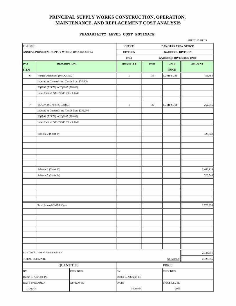
6 1 LS LUMP SUM 58,484
7 1 LS LUMP SUM 262,055
320,540
Subtotal 1 (Sheet 13) 2,408,416
Subtotal 2 (Sheet 14) 320,540
Total Annual OM&R Costs 2,728,955
2,728,955
TOTAL ESTIMATE $2,728,955 2,728,955
QUANTITIES PRICE
BY CHECKED BY CHECKED
Dustin S. Albright, PE Dustin S. Albright, PE
DATE PREPARED APPROVED DATE PRICE LEVEL
1-Dec-04 1-Dec-04 2005
Index Factor: 580.09/515.79 = 1.1247
Subtotal 2 (Sheet 14)
Winter Operations (McCC/NRC)
SUBTOTAL - PSW Annual OM&R
FEASABILITY LEVEL COST ESTIMATE
Indexed as Channels and Canals from $52,000
2Q1999 (515.79) to 2Q2005 (580.09)
Index Factor: 580.09/515.79 = 1.1247
SCADA (SCPP/McCC/NRC)
Indexed as Channels and Canals from $233,000
2Q1999 (515.79) to 2Q2005 (580.09)
PRINCIPAL SUPPLY WORKS CONSTRUCTION, OPERATION, MAINTENANCE, AND REPLACEMENT COST ANALYSIS
ANNUAL PRINCIPAL SUPPLY WORKS OM&R (CONT.)
FEATURE
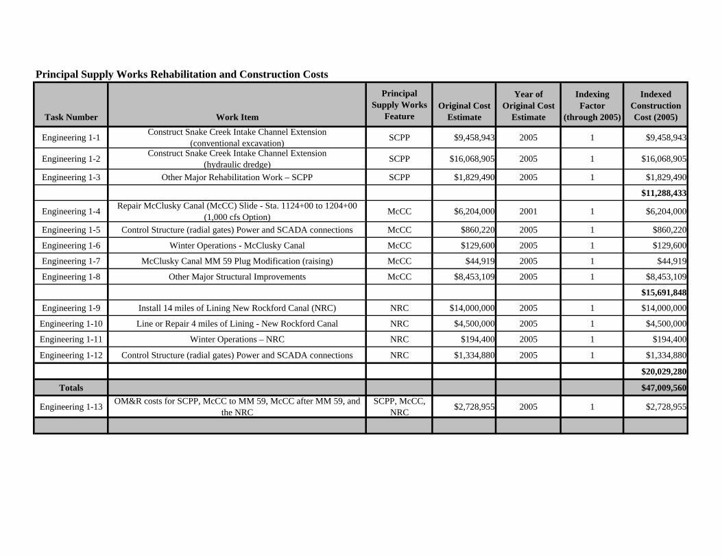
Principal Supply Works Rehabilitation and Construction Costs
Task Number Work Item
Principal Supply Works
FeatureOriginal Cost
Estimate
Year of Original Cost
Estimate
Indexing Factor
(through 2005)
Indexed Construction Cost (2005)
Engineering 1-1 Construct Snake Creek Intake Channel Extension (conventional excavation) SCPP $9,458,943 2005 1 $9,458,943
Engineering 1-2 Construct Snake Creek Intake Channel Extension (hydraulic dredge) SCPP $16,068,905 2005 1 $16,068,905
Engineering 1-3 Other Major Rehabilitation Work – SCPP SCPP $1,829,490 2005 1 $1,829,490
$11,288,433
Engineering 1-4 Repair McClusky Canal (McCC) Slide - Sta. 1124+00 to 1204+00 (1,000 cfs Option) McCC $6,204,000 2001 1 $6,204,000
Engineering 1-5 Control Structure (radial gates) Power and SCADA connections McCC $860,220 2005 1 $860,220
Engineering 1-6 Winter Operations - McClusky Canal McCC $129,600 2005 1 $129,600
Engineering 1-7 McClusky Canal MM 59 Plug Modification (raising) McCC $44,919 2005 1 $44,919
Engineering 1-8 Other Major Structural Improvements McCC $8,453,109 2005 1 $8,453,109
$15,691,848
Engineering 1-9 Install 14 miles of Lining New Rockford Canal (NRC) NRC $14,000,000 2005 1 $14,000,000
Engineering 1-10 Line or Repair 4 miles of Lining - New Rockford Canal NRC $4,500,000 2005 1 $4,500,000
Engineering 1-11 Winter Operations – NRC NRC $194,400 2005 1 $194,400
Engineering 1-12 Control Structure (radial gates) Power and SCADA connections NRC $1,334,880 2005 1 $1,334,880
$20,029,280
Totals $47,009,560
Engineering 1-13 OM&R costs for SCPP, McCC to MM 59, McCC after MM 59, and the NRC
SCPP, McCC, NRC $2,728,955 2005 1 $2,728,955

Appendix C – Supporting Information

Appendix C – Attachment 1
Main Stem Reservoir & Release Forecast – Monthly Study

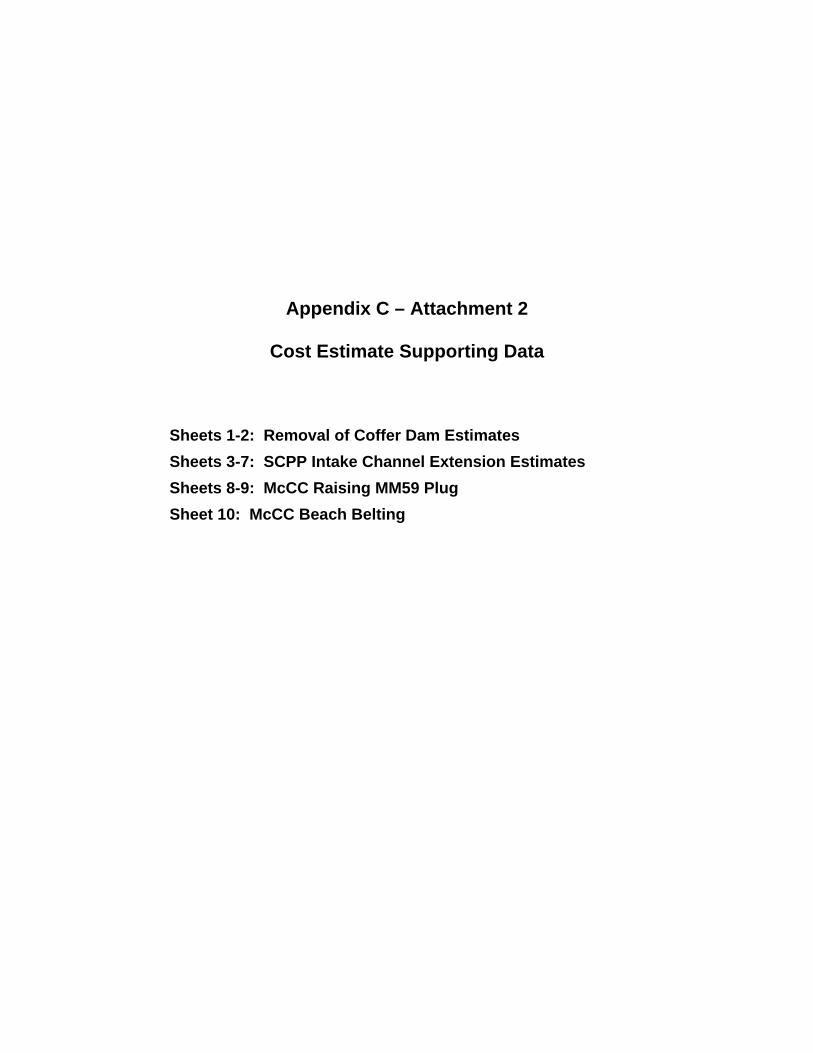
Appendix C – Attachment 2
Cost Estimate Supporting Data
Sheets 1-2: Removal of Coffer Dam Estimates Sheets 3-7: SCPP Intake Channel Extension Estimates Sheets 8-9: McCC Raising MM59 Plug Sheet 10: McCC Beach Belting
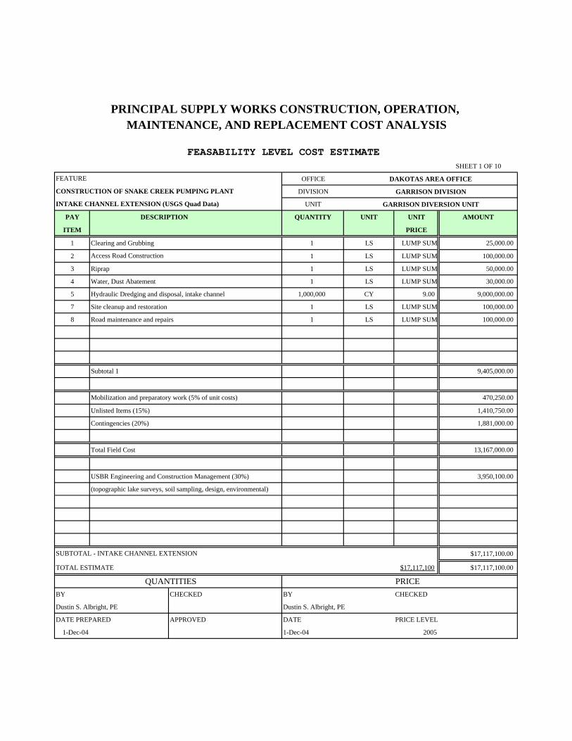
SHEET 1 OF 10
OFFICE DAKOTAS AREA OFFICE
DIVISION GARRISON DIVISION
UNIT GARRISON DIVERSION UNIT
PAY DESCRIPTION QUANTITY UNIT UNIT AMOUNT
ITEM PRICE
1 Clearing and Grubbing 1 LS LUMP SUM 25,000.00
2 1 LS LUMP SUM 100,000.00
3 Riprap 1 LS LUMP SUM 50,000.00
4 Water, Dust Abatement 1 LS LUMP SUM 30,000.00
5 Hydraulic Dredging and disposal, intake channel 1,000,000 CY 9.00 9,000,000.00
7 Site cleanup and restoration 1 LS LUMP SUM 100,000.00
8 Road maintenance and repairs 1 LS LUMP SUM 100,000.00
Subtotal 1 9,405,000.00
Mobilization and preparatory work (5% of unit costs) 470,250.00
Unlisted Items (15%) 1,410,750.00
Contingencies (20%) 1,881,000.00
Total Field Cost 13,167,000.00
USBR Engineering and Construction Management (30%) 3,950,100.00
(topographic lake surveys, soil sampling, design, environmental)
$17,117,100.00
TOTAL ESTIMATE $17,117,100 $17,117,100.00
QUANTITIES PRICEBY CHECKED BY CHECKED
Dustin S. Albright, PE Dustin S. Albright, PE
DATE PREPARED APPROVED DATE PRICE LEVEL
1-Dec-04 1-Dec-04 2005
PRINCIPAL SUPPLY WORKS CONSTRUCTION, OPERATION, MAINTENANCE, AND REPLACEMENT COST ANALYSIS
FEASABILITY LEVEL COST ESTIMATE
SUBTOTAL - INTAKE CHANNEL EXTENSION
FEATURE
CONSTRUCTION OF SNAKE CREEK PUMPING PLANT
INTAKE CHANNEL EXTENSION (USGS Quad Data)
Access Road Construction
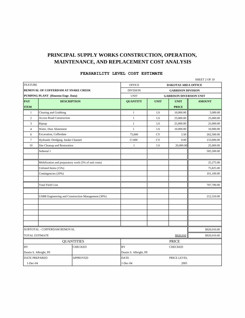
SHEET 2 OF 10
OFFICE DAKOTAS AREA OFFICE
DIVISION GARRISON DIVISION
UNIT GARRISON DIVERSION UNIT
PAY DESCRIPTION QUANTITY UNIT UNIT AMOUNT
ITEM PRICE
1 Clearing and Grubbing 1 LS 10,000.00 5,000.00
2 1 LS 25,000.00 25,000.00
3 Riprap 1 LS 25,000.00 25,000.00
4 Water, Dust Abatement 1 LS 10,000.00 10,000.00
6 75,000 CY 3.50 262,500.00
7 Hydraulic Dredging, Intake Channel 17,000 CY 9.00 153,000.00
10 Site Cleanup and Restoration 1 LS 20,000.00 25,000.00
Subtotal 1 505,500.00
Mobilization and preparatory work (5% of unit costs) 25,275.00
Unlisted Items (15%) 75,825.00
Contingencies (20%) 101,100.00
Total Field Cost 707,700.00
USBR Engineering and Construction Management (30%) 212,310.00
$920,010.00
TOTAL ESTIMATE $920,010 $920,010.00
QUANTITIES PRICEBY CHECKED BY CHECKED
Dustin S. Albright, PE Dustin S. Albright, PE
DATE PREPARED APPROVED DATE PRICE LEVEL
1-Dec-04 1-Dec-04 2005
PRINCIPAL SUPPLY WORKS CONSTRUCTION, OPERATION, MAINTENANCE, AND REPLACEMENT COST ANALYSIS
FEASABILITY LEVEL COST ESTIMATE
Excavation, Cofferdam
SUBTOTAL - COFFERDAM REMOVAL
FEATURE
REMOVAL OF COFFERDAM AT SNAKE CREEK
PUMPING PLANT (Houston Engr. Data)
Access Road Construction
CONSTRUCTION COST ESTIMATE
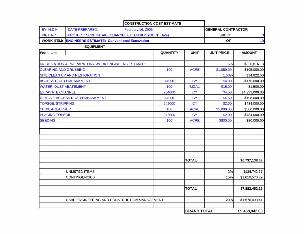
BY: N.D.K. DATE PREPARED: February 16, 2005 GENERAL CONTRACTOR PKG. NO. PROJECT: SCPP INTAKE CHANNEL EXTENSION (GDCD Data) SHEET 3 WORK ITEM: ENGINEERS ESTIMATE: Conventional Excavation OF 10
EQUIPMENT
Work Item QUANTITY UNIT UNIT PRICE AMOUNT
MOBILIZATION & PREPARATORY WORK ENGINEERS ESTIMATE 5% $320,816.13CLEARING AND GRUBBING 100 ACRE $1,050.00 $105,000.00SITE CLEAN UP AND RESTORATION 1.50% $94,822.50ACCESS ROAD EMBANKMENT 44000 CY $4.00 $176,000.00WATER, DUST ABATEMENT 100 MGAL $15.00 $1,500.00EXCAVATE CHANNEL 954000 CY $4.50 $4,293,000.00REMOVE ACCESS ROAD EMBANKMENT 44000 CY $4.50 $198,000.00TOPSOIL STRIPPING 242000 CY $2.00 $484,000.00SPOIL AREA PREP 100 ACRE $5,000.00 $500,000.00PLACING TOPSOIL 242000 CY $2.00 $484,000.00SEEDING 100 ACRE $800.00 $80,000.00
TOTAL $6,737,138.63
UNLISTED ITEMS 2% $134,742.77CONTINGENCIES 15% $1,010,570.79
TOTAL $7,882,452.19
USBR ENGINEERING AND CONSTRUCTION MANAGEMENT 20% $1,576,490.44
GRAND TOTAL $9,458,942.63
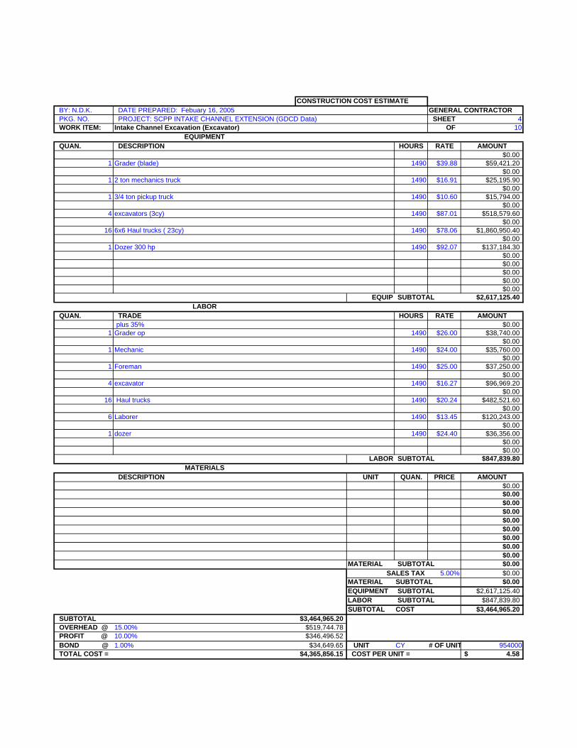
CONSTRUCTION COST ESTIMATE BY: N.D.K. DATE PREPARED: Febuary 16, 2005 GENERAL CONTRACTOR PKG. NO. PROJECT: SCPP INTAKE CHANNEL EXTENSION (GDCD Data) SHEET 4 WORK ITEM: Intake Channel Excavation (Excavator) OF 10
EQUIPMENT QUAN. DESCRIPTION HOURS RATE AMOUNT
$0.001 Grader (blade) 1490 $39.88 $59,421.20
$0.001 2 ton mechanics truck 1490 $16.91 $25,195.90
$0.001 3/4 ton pickup truck 1490 $10.60 $15,794.00
$0.004 excavators (3cy) 1490 $87.01 $518,579.60
$0.0016 6x6 Haul trucks ( 23cy) 1490 $78.06 $1,860,950.40
$0.001 Dozer 300 hp 1490 $92.07 $137,184.30
$0.00$0.00$0.00$0.00$0.00
EQUIP SUBTOTAL $2,617,125.40LABOR
QUAN. TRADE HOURS RATE AMOUNT plus 35% $0.00
1 Grader op 1490 $26.00 $38,740.00$0.00
1 Mechanic 1490 $24.00 $35,760.00$0.00
1 Foreman 1490 $25.00 $37,250.00$0.00
4 excavator 1490 $16.27 $96,969.20$0.00
16 Haul trucks 1490 $20.24 $482,521.60$0.00
6 Laborer 1490 $13.45 $120,243.00$0.00
1 dozer 1490 $24.40 $36,356.00$0.00$0.00
LABOR SUBTOTAL $847,839.80MATERIALS
DESCRIPTION UNIT QUAN. PRICE AMOUNT$0.00$0.00$0.00$0.00$0.00$0.00$0.00$0.00$0.00
MATERIAL SUBTOTAL $0.00SALES TAX 5.00% $0.00
MATERIAL SUBTOTAL $0.00EQUIPMENT SUBTOTAL $2,617,125.40LABOR SUBTOTAL $847,839.80SUBTOTAL COST $3,464,965.20
SUBTOTAL $3,464,965.20 OVERHEAD @ 15.00% $519,744.78 PROFIT @ 10.00% $346,496.52 BOND @ 1.00% $34,649.65 UNIT CY # OF UNIT 954000 TOTAL COST = $4,365,856.15 COST PER UNIT = 4.58$
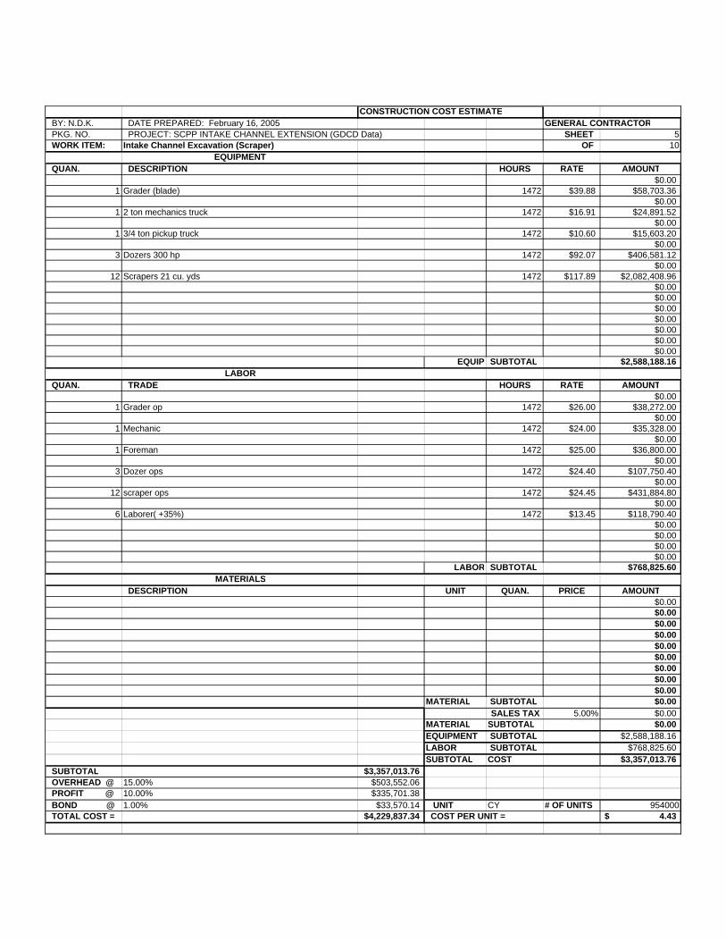
CONSTRUCTION COST ESTIMATE BY: N.D.K. DATE PREPARED: February 16, 2005 GENERAL CONTRACTOR PKG. NO. PROJECT: SCPP INTAKE CHANNEL EXTENSION (GDCD Data) SHEET 5 WORK ITEM: Intake Channel Excavation (Scraper) OF 10
EQUIPMENT QUAN. DESCRIPTION HOURS RATE AMOUNT
$0.001 Grader (blade) 1472 $39.88 $58,703.36
$0.001 2 ton mechanics truck 1472 $16.91 $24,891.52
$0.001 3/4 ton pickup truck 1472 $10.60 $15,603.20
$0.003 Dozers 300 hp 1472 $92.07 $406,581.12
$0.0012 Scrapers 21 cu. yds 1472 $117.89 $2,082,408.96
$0.00$0.00$0.00$0.00$0.00$0.00$0.00
EQUIP SUBTOTAL $2,588,188.16LABOR
QUAN. TRADE HOURS RATE AMOUNT$0.00
1 Grader op 1472 $26.00 $38,272.00$0.00
1 Mechanic 1472 $24.00 $35,328.00$0.00
1 Foreman 1472 $25.00 $36,800.00$0.00
3 Dozer ops 1472 $24.40 $107,750.40$0.00
12 scraper ops 1472 $24.45 $431,884.80$0.00
6 Laborer( +35%) 1472 $13.45 $118,790.40$0.00$0.00$0.00$0.00
LABOR SUBTOTAL $768,825.60MATERIALS
DESCRIPTION UNIT QUAN. PRICE AMOUNT$0.00$0.00$0.00$0.00$0.00$0.00$0.00$0.00$0.00
MATERIAL SUBTOTAL $0.00SALES TAX 5.00% $0.00
MATERIAL SUBTOTAL $0.00EQUIPMENT SUBTOTAL $2,588,188.16LABOR SUBTOTAL $768,825.60SUBTOTAL COST $3,357,013.76
SUBTOTAL $3,357,013.76 OVERHEAD @ 15.00% $503,552.06 PROFIT @ 10.00% $335,701.38 BOND @ 1.00% $33,570.14 UNIT CY # OF UNITS 954000 TOTAL COST = $4,229,837.34 COST PER UNIT = 4.43$
CONSTRUCTION COST ESTIMATE
BY: N.D.K. DATE PREPARED: February 16, 2005 GENERAL CONTRACTOR PKG. NO. PROJECT: SCPP INTAKE CHANNEL EXTENSION (GDCD Data) SHEET 6 WORK ITEM: ENGINEERS ESTIMATE (HYDRAULIC DREDGE) OF 10
EQUIPMENT
Work Item QUANTITY UNIT UNIT PRICE AMOUNT
MOBILIZATION & PREPARATORY WORK ENGINEERS ESTIMATE 5% $545,004.25CLEARING AND GRUBBING 100 ACRE $1,050.00 $105,000.00SITE CLEAN UP AND RESTORATION 1.50% $161,085.00DREDGE CHANNEL 954000 CY $9.00 $8,586,000.00TOPSOIL STRIPPING 242000 CY $2.00 $484,000.00SPOIL AREA PREP 100 ACRE $10,000.00 $1,000,000.00PLACING TOPSOIL 242000 CY $2.00 $484,000.00SEEDING 100 ACRE $800.00 $80,000.00
TOTAL $11,445,089.25
UNLISTED ITEMS 2% $228,901.79CONTINGENCIES 15% $1,716,763.39
TOTAL $13,390,754.42
USBR ENGINEERING AND CONSTRUCTION MANAGEMENT 20% $2,678,150.88
GRAND TOTAL $16,068,905.31
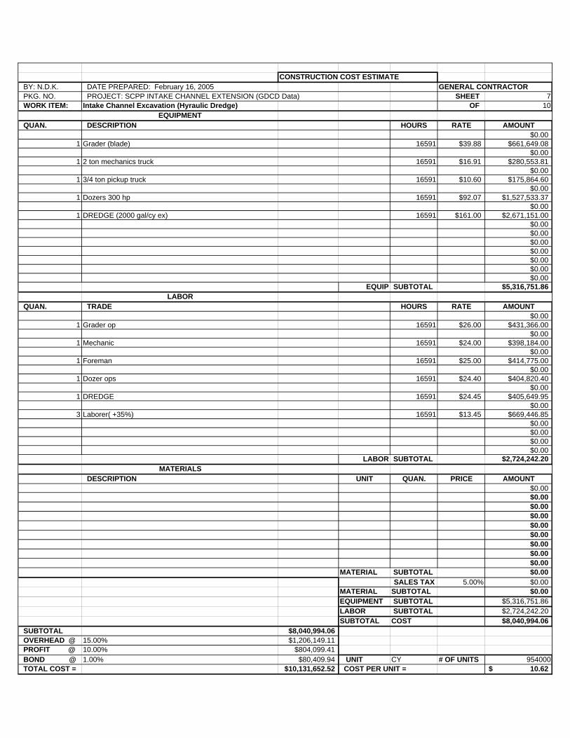
CONSTRUCTION COST ESTIMATE BY: N.D.K. DATE PREPARED: February 16, 2005 GENERAL CONTRACTOR PKG. NO. PROJECT: SCPP INTAKE CHANNEL EXTENSION (GDCD Data) SHEET 7 WORK ITEM: Intake Channel Excavation (Hyraulic Dredge) OF 10
EQUIPMENT QUAN. DESCRIPTION HOURS RATE AMOUNT
$0.001 Grader (blade) 16591 $39.88 $661,649.08
$0.001 2 ton mechanics truck 16591 $16.91 $280,553.81
$0.001 3/4 ton pickup truck 16591 $10.60 $175,864.60
$0.001 Dozers 300 hp 16591 $92.07 $1,527,533.37
$0.001 DREDGE (2000 gal/cy ex) 16591 $161.00 $2,671,151.00
$0.00$0.00$0.00$0.00$0.00$0.00$0.00
EQUIP SUBTOTAL $5,316,751.86LABOR
QUAN. TRADE HOURS RATE AMOUNT$0.00
1 Grader op 16591 $26.00 $431,366.00$0.00
1 Mechanic 16591 $24.00 $398,184.00$0.00
1 Foreman 16591 $25.00 $414,775.00$0.00
1 Dozer ops 16591 $24.40 $404,820.40$0.00
1 DREDGE 16591 $24.45 $405,649.95$0.00
3 Laborer( +35%) 16591 $13.45 $669,446.85$0.00$0.00$0.00$0.00
LABOR SUBTOTAL $2,724,242.20MATERIALS
DESCRIPTION UNIT QUAN. PRICE AMOUNT$0.00$0.00$0.00$0.00$0.00$0.00$0.00$0.00$0.00
MATERIAL SUBTOTAL $0.00SALES TAX 5.00% $0.00
MATERIAL SUBTOTAL $0.00EQUIPMENT SUBTOTAL $5,316,751.86LABOR SUBTOTAL $2,724,242.20SUBTOTAL COST $8,040,994.06
SUBTOTAL $8,040,994.06 OVERHEAD @ 15.00% $1,206,149.11 PROFIT @ 10.00% $804,099.41 BOND @ 1.00% $80,409.94 UNIT CY # OF UNITS 954000 TOTAL COST = $10,131,652.52 COST PER UNIT = 10.62$
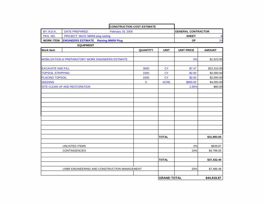
CONSTRUCTION COST ESTIMATE BY: N.D.K. DATE PREPARED: February 16, 2005 GENERAL CONTRACTOR PKG. NO. PROJECT: McCC MM59 plug raising SHEET 8 WORK ITEM: ENGINEERS ESTIMATE Raising MM59 Plug OF 10
EQUIPMENTWork Item QUANTITY UNIT UNIT PRICE AMOUNT
MOBILIZATION & PREPARATORY WORK ENGINEERS ESTIMATE 5% $1,523.50
EXCAVATE AND FILL 3000 CY $7.47 $22,410.00TOPSOIL STRIPPING 1000 CY $2.00 $2,000.00PLACING TOPSOIL 1000 CY $2.00 $2,000.00SEEDING 5 ACRE $800.00 $4,000.00SITE CLEAN UP AND RESTORATION 1.50% $60.00
TOTAL $31,993.50
UNLISTED ITEMS 2% $639.87CONTINGENCIES 15% $4,799.03
TOTAL $37,432.40
USBR ENGINEERING AND CONSTRUCTION MANAGEMENT 20% $7,486.48
GRAND TOTAL $44,918.87
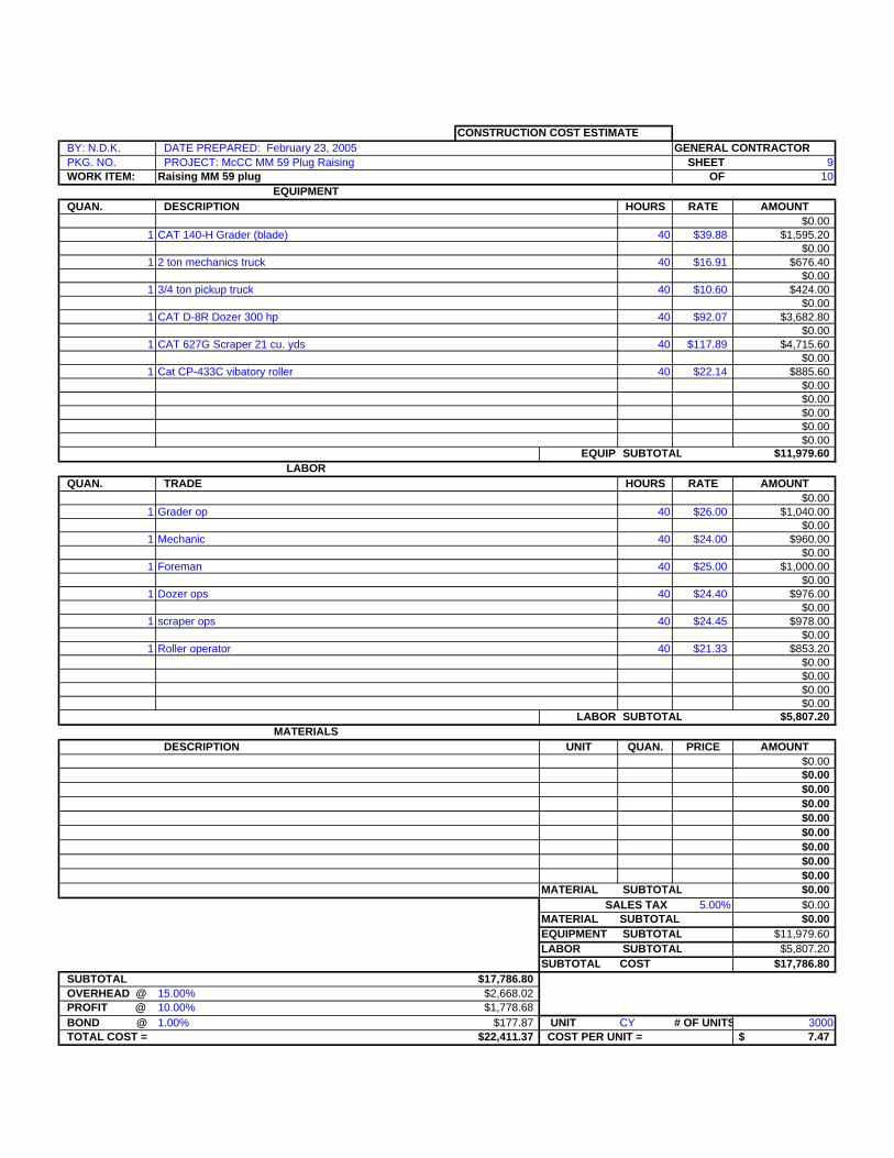
CONSTRUCTION COST ESTIMATE BY: N.D.K. DATE PREPARED: February 23, 2005 GENERAL CONTRACTOR PKG. NO. PROJECT: McCC MM 59 Plug Raising SHEET 9 WORK ITEM: Raising MM 59 plug OF 10
EQUIPMENT QUAN. DESCRIPTION HOURS RATE AMOUNT
$0.001 CAT 140-H Grader (blade) 40 $39.88 $1,595.20
$0.001 2 ton mechanics truck 40 $16.91 $676.40
$0.001 3/4 ton pickup truck 40 $10.60 $424.00
$0.001 CAT D-8R Dozer 300 hp 40 $92.07 $3,682.80
$0.001 CAT 627G Scraper 21 cu. yds 40 $117.89 $4,715.60
$0.001 Cat CP-433C vibatory roller 40 $22.14 $885.60
$0.00$0.00$0.00$0.00$0.00
EQUIP SUBTOTAL $11,979.60LABOR
QUAN. TRADE HOURS RATE AMOUNT$0.00
1 Grader op 40 $26.00 $1,040.00$0.00
1 Mechanic 40 $24.00 $960.00$0.00
1 Foreman 40 $25.00 $1,000.00$0.00
1 Dozer ops 40 $24.40 $976.00$0.00
1 scraper ops 40 $24.45 $978.00$0.00
1 Roller operator 40 $21.33 $853.20$0.00$0.00$0.00$0.00
LABOR SUBTOTAL $5,807.20MATERIALS
DESCRIPTION UNIT QUAN. PRICE AMOUNT$0.00$0.00$0.00$0.00$0.00$0.00$0.00$0.00$0.00
MATERIAL SUBTOTAL $0.00SALES TAX 5.00% $0.00
MATERIAL SUBTOTAL $0.00EQUIPMENT SUBTOTAL $11,979.60LABOR SUBTOTAL $5,807.20SUBTOTAL COST $17,786.80
SUBTOTAL $17,786.80 OVERHEAD @ 15.00% $2,668.02 PROFIT @ 10.00% $1,778.68 BOND @ 1.00% $177.87 UNIT CY # OF UNITS 3000 TOTAL COST = $22,411.37 COST PER UNIT = 7.47$
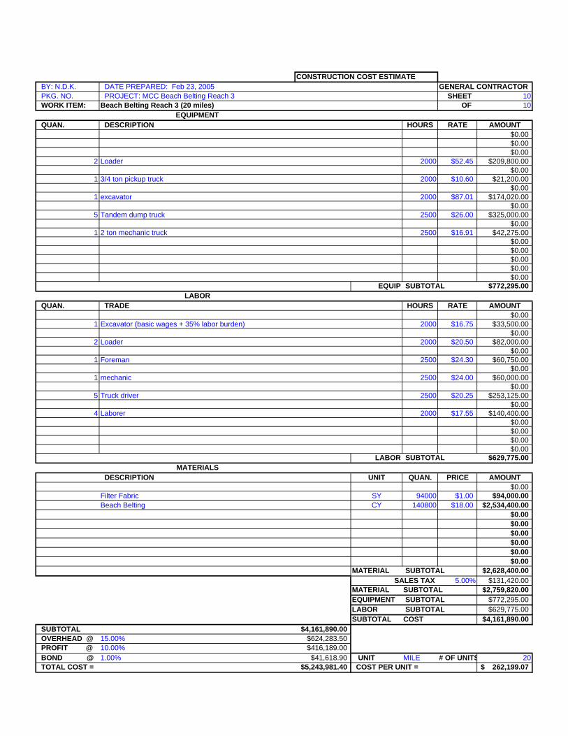
CONSTRUCTION COST ESTIMATE BY: N.D.K. DATE PREPARED: Feb 23, 2005 GENERAL CONTRACTOR PKG. NO. PROJECT: MCC Beach Belting Reach 3 SHEET 10 WORK ITEM: Beach Belting Reach 3 (20 miles) OF 10
EQUIPMENT QUAN. DESCRIPTION HOURS RATE AMOUNT
$0.00$0.00$0.00
2 Loader 2000 $52.45 $209,800.00$0.00
1 3/4 ton pickup truck 2000 $10.60 $21,200.00$0.00
1 excavator 2000 $87.01 $174,020.00$0.00
5 Tandem dump truck 2500 $26.00 $325,000.00$0.00
1 2 ton mechanic truck 2500 $16.91 $42,275.00$0.00$0.00$0.00$0.00$0.00
EQUIP SUBTOTAL $772,295.00LABOR
QUAN. TRADE HOURS RATE AMOUNT$0.00
1 Excavator (basic wages + 35% labor burden) 2000 $16.75 $33,500.00$0.00
2 Loader 2000 $20.50 $82,000.00$0.00
1 Foreman 2500 $24.30 $60,750.00$0.00
1 mechanic 2500 $24.00 $60,000.00$0.00
5 Truck driver 2500 $20.25 $253,125.00$0.00
4 Laborer 2000 $17.55 $140,400.00$0.00$0.00$0.00$0.00
LABOR SUBTOTAL $629,775.00MATERIALS
DESCRIPTION UNIT QUAN. PRICE AMOUNT$0.00
Filter Fabric SY 94000 $1.00 $94,000.00Beach Belting CY 140800 $18.00 $2,534,400.00
$0.00$0.00$0.00$0.00$0.00$0.00
MATERIAL SUBTOTAL $2,628,400.00SALES TAX 5.00% $131,420.00
MATERIAL SUBTOTAL $2,759,820.00EQUIPMENT SUBTOTAL $772,295.00LABOR SUBTOTAL $629,775.00SUBTOTAL COST $4,161,890.00
SUBTOTAL $4,161,890.00 OVERHEAD @ 15.00% $624,283.50 PROFIT @ 10.00% $416,189.00 BOND @ 1.00% $41,618.90 UNIT MILE # OF UNITS 20 TOTAL COST = $5,243,981.40 COST PER UNIT = 262,199.07$
Appendix C – Attachment 3
Snake Creek Pumping Plant Transfer Deck Replacement Cost Estimate
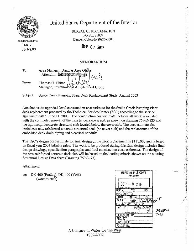
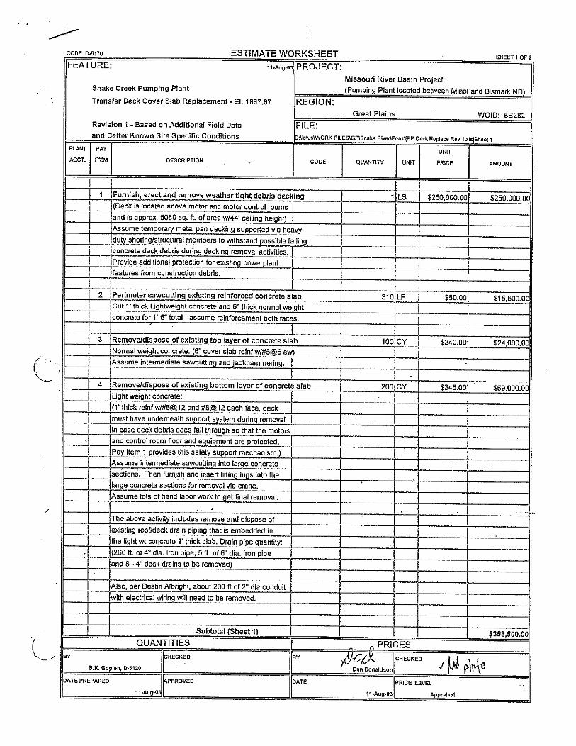
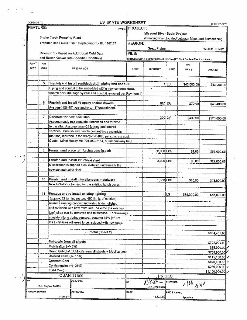
Appendix C – Attachment 4
Snake Creek Pumping Plant High head Pump Bowl Installation
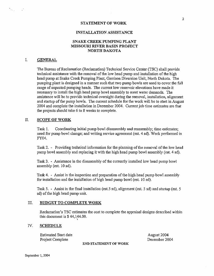
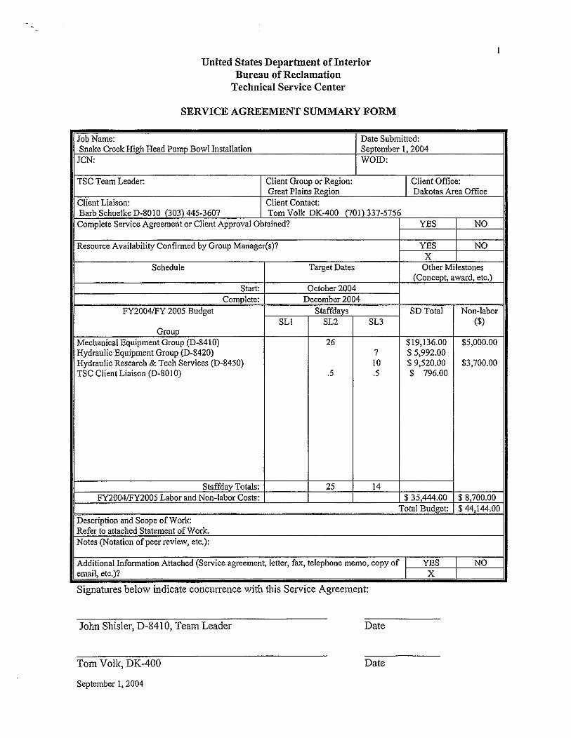
Appendix C – Attachment 5
Snake Creek Pumping Plant Unit Alignment & Vibration Testing Travel Report
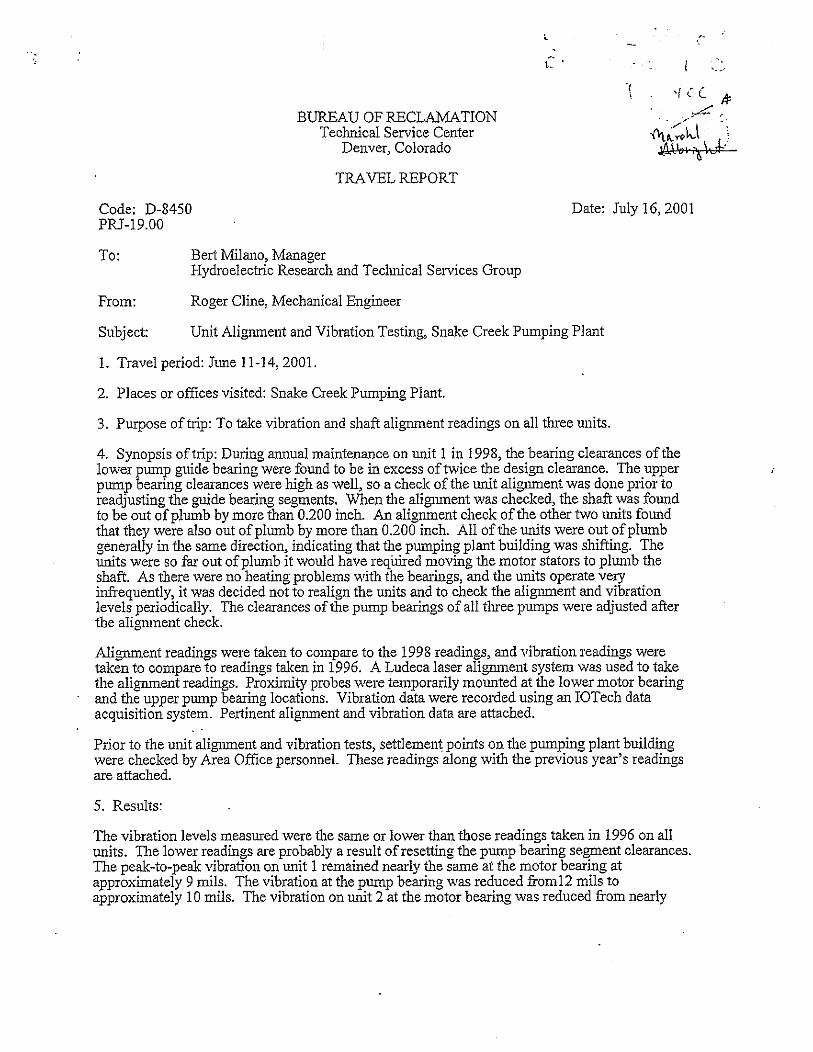
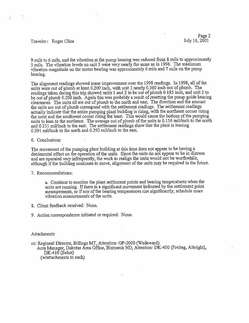
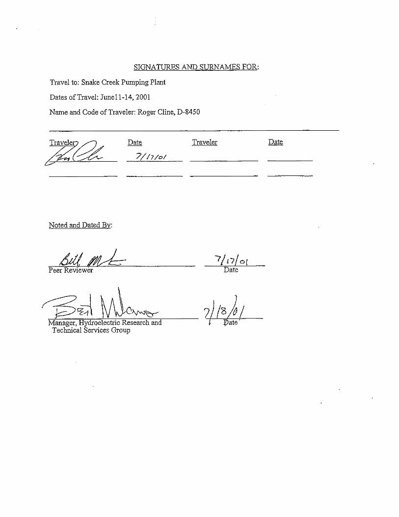
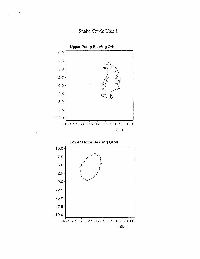
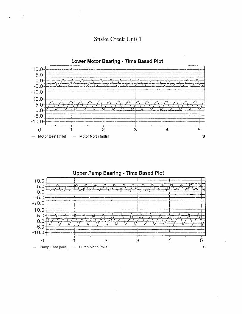
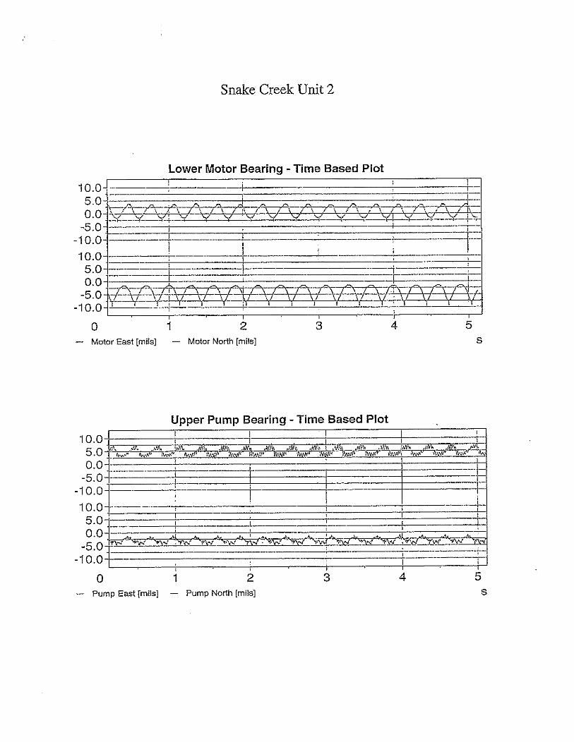
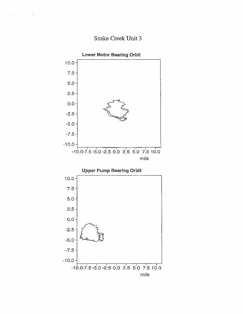
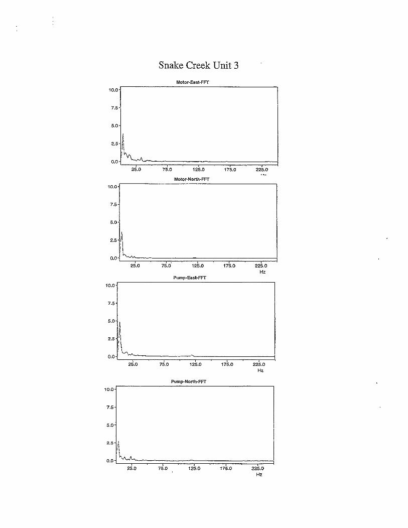
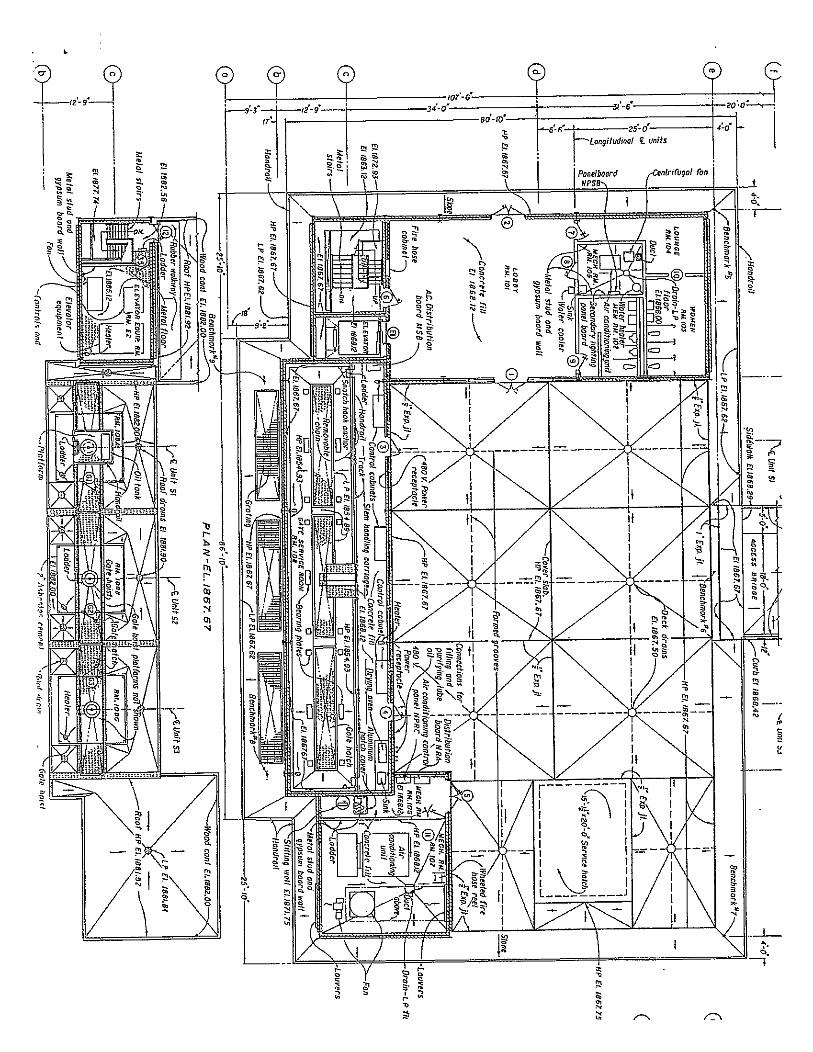
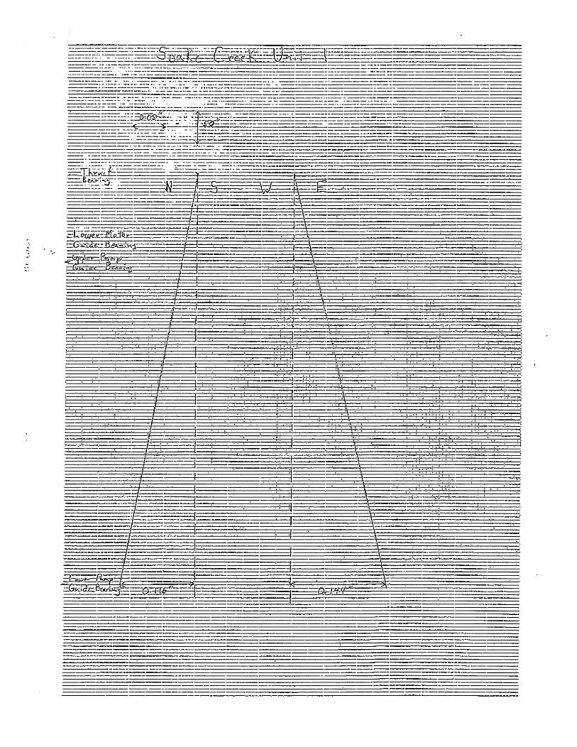
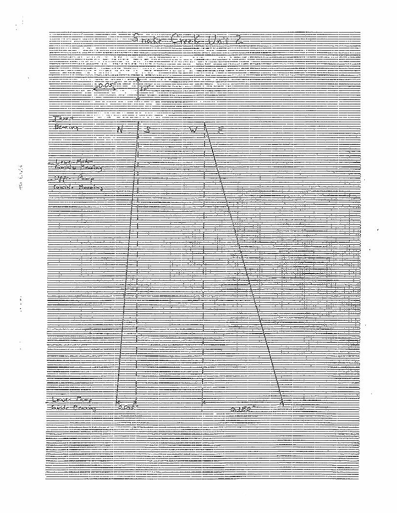
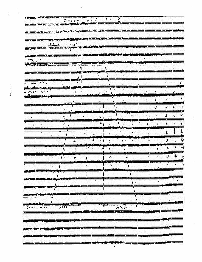
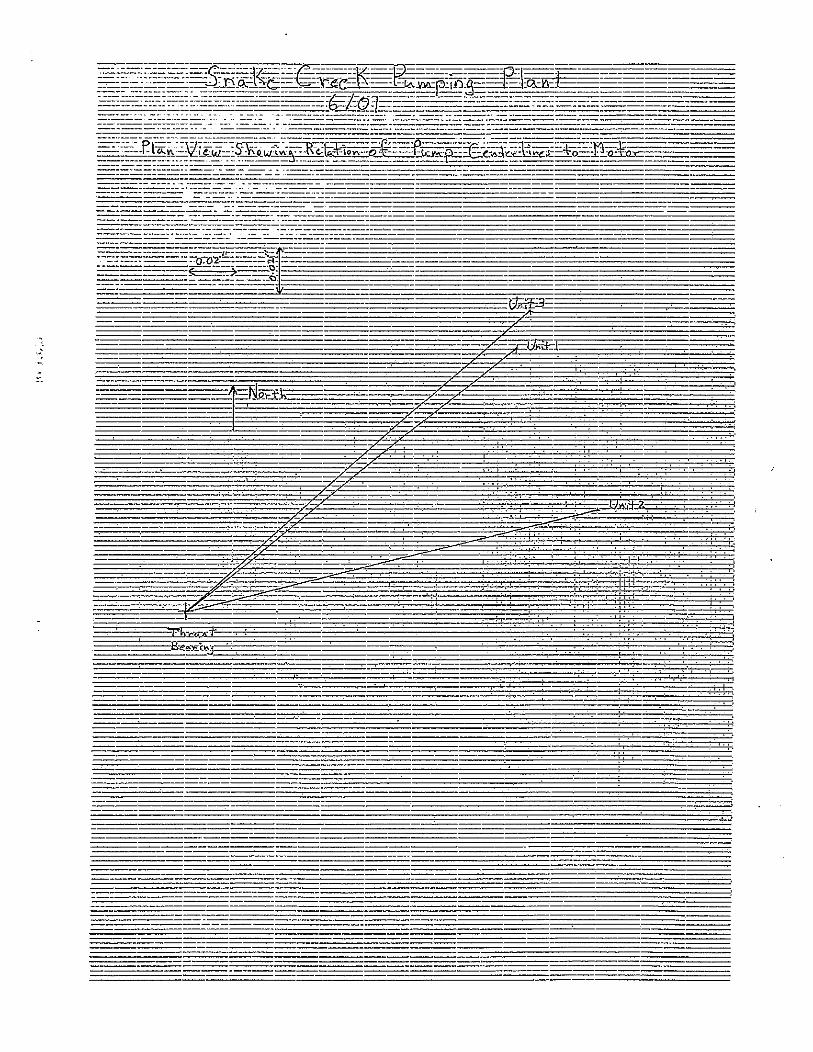

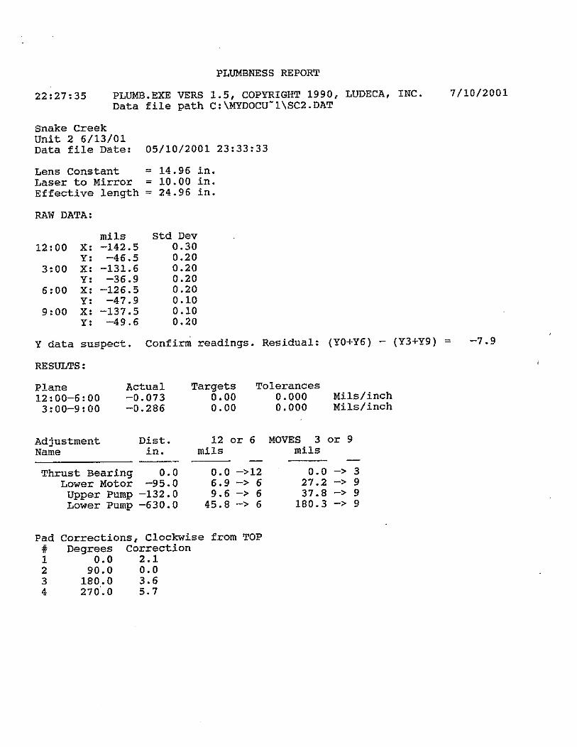
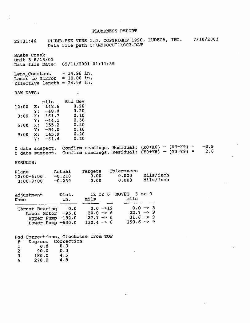
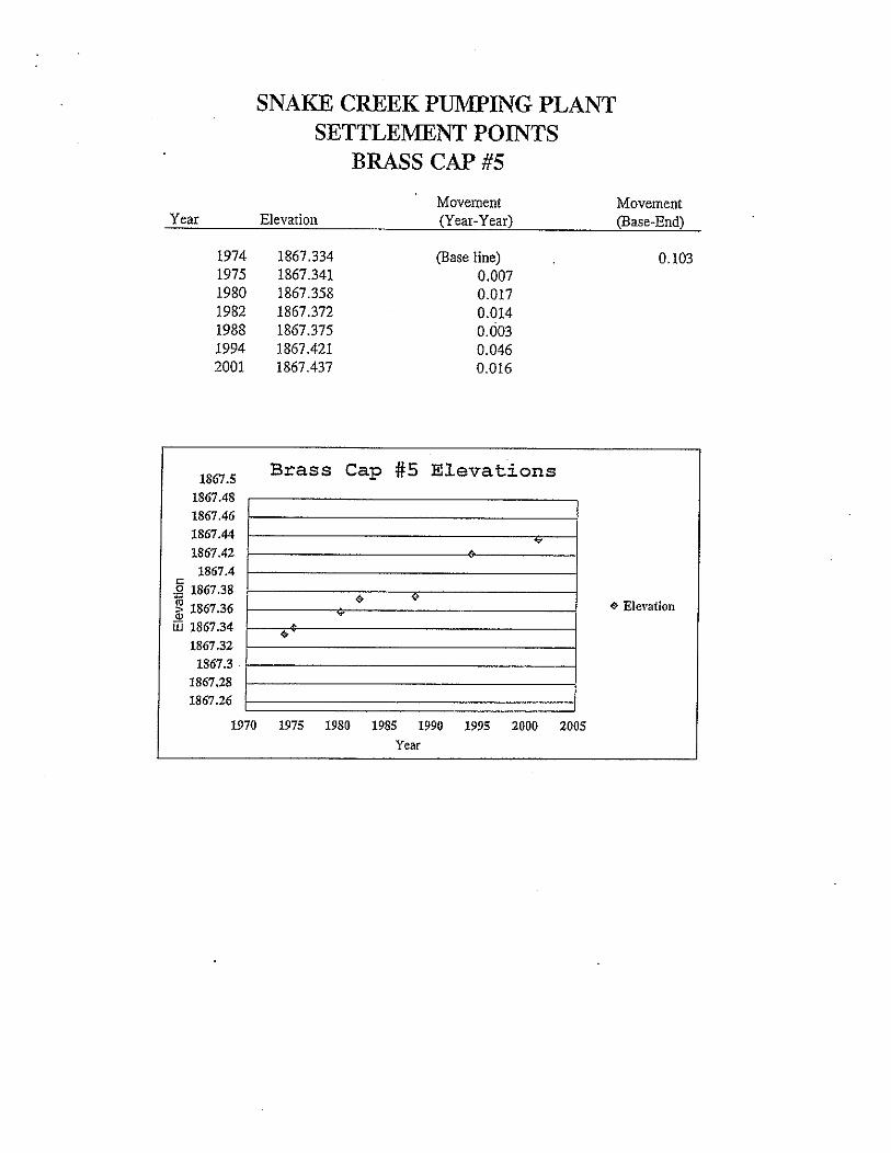
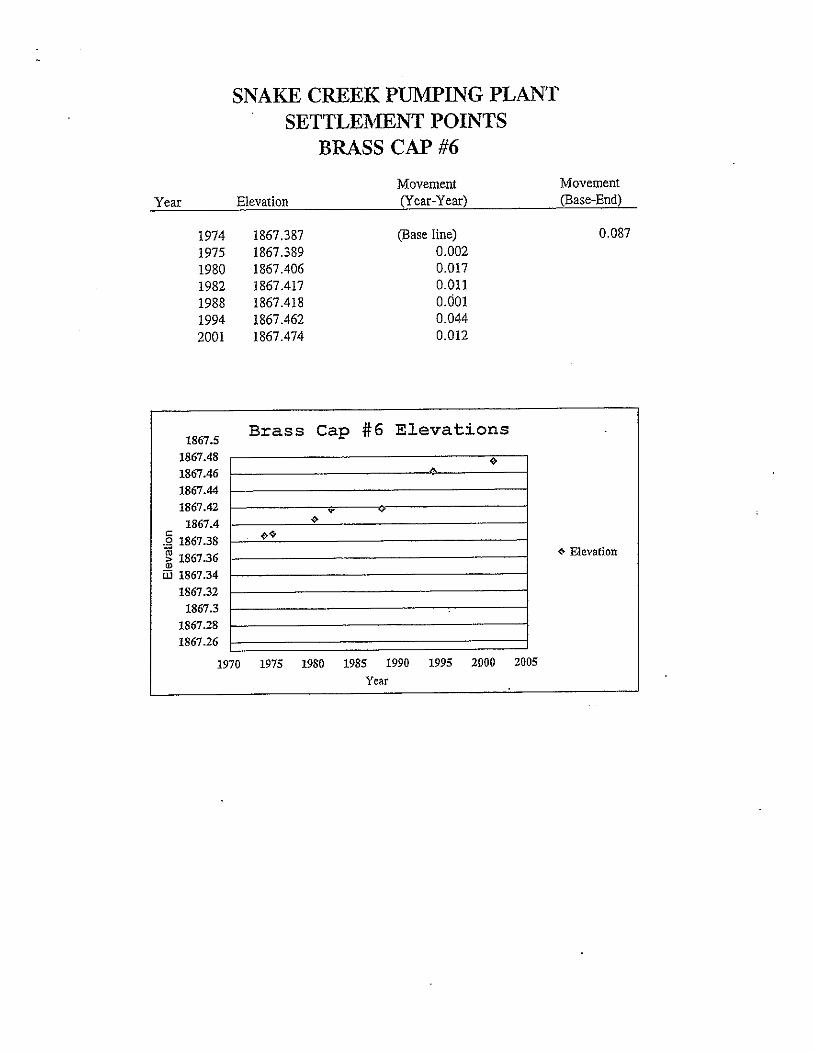

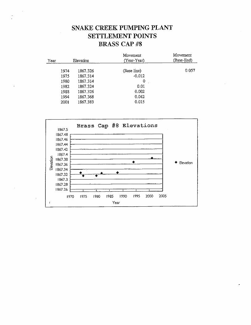
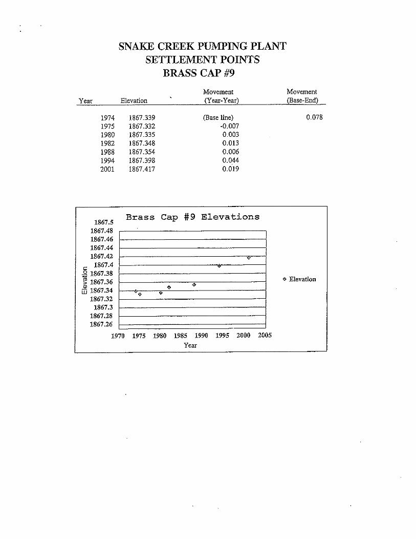
Appendix C – Attachment 6
GDU Principal Supply Works Estimated Annual OM&R Associated With the Used and Unused Capacity
Draft Report, 1999