prepared by the united states geological survey in ... · water resources development plan lands...
TRANSCRIPT

Prepared by the United States Geological Survey in cooperation wit h
the North Dakota State Water Conservation Commission, and th eNorth Dakota Geological Survey
PUBLISHED BY
NORTH DAKOTA STATE WATER CONSERVATION COMMISSION
1301 STATE CAPITOL, BISMARCK, NORTH DAKOTA

-VIL
tERCE 1
R A M S E YfORDV/Lt E
RE SB
DEVIL SI
D V/LS LAKE- C4NR
LAK Ep
C LAKOTA
ENELSON ,DAM
n "06`l *~ 0 rlT
,p ro c._
'
-11Ci .
`:ANNINGBROVCHO S ` • '
.r,,/'e
1 F L GL ARK UN /LITTLE MISSOUR/
!NTE R
R/VER .PRO.t
~LINES
RMFE R/V€ PRO.
OLIVE " RED.
Jan" -MEDORAi
• tKINSON
I
SOU4 RE BUTTE UAR T
MAND
NORTH DAKOTA STATE WATER CONSERVATION COMMISSIO N
WATER RESOURCES DEVELOPMENT PLA NLANDS UNDER IRRIGATION GARRISON DIVERSION CONSERVANCY
DISTRICT BOUNDARYAREAS CONSIDEREO IRRIGABL E
AREAS BEING INVESTIGATED
PROPOSED CANAL SEXISTING
_„-
DAM B RESERVOIR SITES
UNDER CONSTRUCTIONOR PROPOSED .
///////n. GROUNDWATER AQUIFER S
I: !!11 ii iiiii PROPOSED FOR INVESTIGATION
Gov . William L. GuCHAIRMAN
OSCAR LUNSET HVICE CHARAW N
MILD W . HOISVEE NMCPETANV AND STATE FHGM(E(7
RICHARD P . GALLAGHE RMATH DAH L
WILLIAM W . CORWI NEINAR H . DAH L
HENRY J . STEINBERGER

GROUND WATER IN THE ANETA AREA ,
NELSON COUNTY, NORTH DAKOTA
By
P . E . Denni s
North Dakota Ground-Water Studies No . 7
Prepared by the United States Geological Survey in cooperation wit hthe North Dakota State Water Conservation Commission, and th e
North Dakota Geological Surve y
Published ByNORTH DAKOTA STATE WATER CONSERVATION COMMISSIO N
1301 State Capitol, Bismarck, North Dakota
Originally published - 1947
Republished - 1962

CONTENTS
PageAbstract 1
IntroductionScope and purpose of investigation Location and general features of the area Previous investigations and acknowledgmentsPresent water supply and future needs
Geology and hydrologyGeneralRock materials and their water-bearing characteristics
Glacial outwash and stream depositsTill of the morainesShale bedrockDakota sandstone
Test holesExisting wells
Piezometric surfaceFluctuations in water level s
Recharge, movement, and discharge of water in the outwash gravels .
Quality of the ground water 1 4
Summary and conclusions 1 5
Tables 1 8
Analyses of ground waters 1 6Well records 1 9
Well logs 20
ILLUSTRATIONS
Figure 1 . Map of Aneta, Nelson County, and Sharon, Steele County ,showing geologic and hydrologic features 2 1
Figure 2 . Map of Aneta showing hydrologic features and generalizedcross section 22

GROUND WATER NEAR ANETA, NELSON COUNTY ,NORTH DAKOTA
By P. E . Denni s
ABSTRACT
Aneta (population 509) is near the southeast corner of Nelson County o n
the west margin of the Fergus Falls-Leaf Hills recessional moraine . The til l
of the moraine is virtually non-water-bearing, as is also the Pierre shale ,
which forms the bedrock underlying the drift at depths of 5 to 35 feet in thi s
area . No wells have been drilled to the Dakota sandstone, which lies abou t
1,200 or 1,300 feet below the surface at Aneta . However, in adjacent areas
the waters from the Dakota are generally considered unsuitable for culinar y
purposes . Outwash gravels partly fill a glacial channel (or coulee) of a
tributary of the glacial Sheyenne River about a quarter of a mile west of town .
Test drilling indicates that there is from 20 to 30 feet of saturated grave l
in the deeper part of this coulee .
Recharge of the outwash gravels probably comes chiefly from direct pene-
tration of rain water and melting snow, although a considerable contributio n
probably comes from surface runoff from areas tributary to the coulee . The
general direction of movement of ground water in the aquifer is down the slope s
of the coulee into the deeper gravels at its bottom and southward in thi s
deeper gravel to points of discharge . It is estimated that the total amoun t
T 1

of water discharged from the glacial outwash aquifer may be of the order o f
magnitude of about a million gallons a day . The discharge is chiefly by evapo-
ration and transpiration from the lakes and marshes which occupy the lower por-
tions of the coulee . Only part of the total natural discharge could be recovered
by wells but it appears that a perennial supply of at least 30,000 to 50,00 0
gallons a day could be developed .
All the ground waters of the area are rather highly mineralized but thos e
of the outwash aquifer contain the smallest amounts of dissolved minerals .
Analyses indicate that the waters from this aquifer will probably range betwee n
800 and 1,200 parts per million in dissolved solids content .
INTRODUCTION
Scope and purpose of investigatio n
This is a progress report on the general study of the geology and ground -
water resources of Nelson County being made by the U . S . Geological Survey i n
cooperation with the State Water Conservation Commission and the State Geolo-
gical Survey . These general studies are being made to determine the occurrence ,
movement, discharge, and recharge of the ground water and the quantity and
quality of such water available for all purposes including municipal, domestic ,
irrigation, industrial, and other uses . However, the most critical need at the
present time is for adequate and perennial water supplies for numerous town s
and small cities throughout the State which are attempting to construct muni-
cipal water-supply systems for the first time . For this reason, the count y
studies are being started in the vicinity of those towns which have requeste d
2

the help of the State Water Conservation Commission and the State Geologist .
Progress reports are being released as soon as possible in order that the pre-
liminary data may be available for use in connection with the solution of water-
supply problems in the towns shortly after they are obtained and before th e
general studies and conclusions can be completed . The study described in thi s
report was confined chiefly to obtaining information on ground water in tha t
part of Nelson County which is of immediate interest to the village of Aneta i n
its search for sources of water for municipal use .
Location and general features of the are a
Aneta is near the southeast corner of Nelson County, North Dakota, abou t
50 miles southwest of Grand Forks . It is on a branch line of the Great Norther n
Railway which runs from Fargo to Devils Lake . The town has a population o f
about 509 (1940 census) and serves as a shipping point and trading center fo r
the farming area around it .
The part of the Central Lowland 1/ physiographic province in which Anet a
is located has been called the Drift Prairie by Simpson . 2/ It is a plains area
modified by little-eroded glacial drift which forms relatively rough low hill s
along the lines of the end moraines and a gently rolling topography elsewhere .
The Drift Prairie is bordered on the west by the Missouri Plateau and on th e
east by the Red River Valley . Aneta is about 50 miles east of the escarpmen t
which marks the eastern boundary of the Missouri Plateau and about 18 miles wes t
of the highest (Herman) shoreline of Lake Agassiz which marks the western limi t
of the Red River Valley . 3/
1/ Fenneman, N .M ., Physiography of eastern United States, pp . 559-588 ,McGraw-Hill Book Co ., 1938 .
2/ Simpson, H .E ., Geology and ground-water resources of North Dakota : U .S .
Geol . Survey .Water-Supply Paper 598, p . 4,. ;1929 .
:3/ Upham, Warren, The glacial Lake Agassiz : U .S . .Geol . Survey Mon . 25, 1896
3
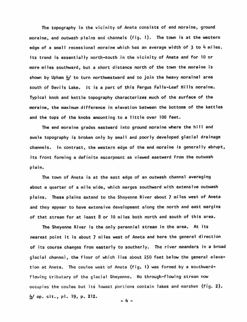
The topography in the vicinity of Aneta consists of end moraine, groun d
moraine, and outwash plains and channels (fig . 1) . The town is at the western
edge of a small recessional moraine which has an average width of 3 to 4 miles .
Its trend is essentially north-south in the vicinity of Aneta and for 10 o r
more miles southward, but a short distance north of the town the moraine i s
shown by Upham 4/ to turn northwestward and to join the heavy morainal are a
south of Devils Lake . it is a part of this Fergus Falls-Leaf Hills moraine .
Typical knob and kettle topography characterizes much of the surface of th e
moraine, the maximum difference in elevation between the bottoms of the kettles
and the tops of the knobs amounting to a little over 100 feet .
The end moraine grades eastward into ground moraine where the hill and
swale topography is broken only by small and poorly developed glacial drainag e
channels . In contrast, the western edge of the end moraine is generally abrupt ,
its front forming a definite escarpment as viewed eastward from the outwas h
plain .
The town of Aneta is at the east edge of an outwash channel averagin g
about a quarter of a mile wide, which merges southward with extensive outwas h
plains . These plains extend to the Sheyenne River about 7 miles west of Anet a
and they appear to have extensive development along the north and east margin s
of that stream for at least 8 or 10 miles both north and south of this area .
The Sheyenne River is the only perennial stream in the area . At its
nearest point it is about 7 miles west of Aneta and here the general directio n
of its course changes from easterly to southerly . The river meanders in a broa d
glacial channel, the floor of which lies about 250 feet below the general eleva-
tion at Aneta. The coulee west of Aneta (fig . 1) was formed by a southward -
flowing tributary of the glacial Sheyenne . No through-flowing stream now
occupies the coulee but its lowest portions contain lakes and marshes (fig . 2) .
4/ op . cit ., pl . 19, p . 212 .
4

Previous investigations and acknowledgment s
The geology and ground water of the Aneta area have been previousl y
treated only in a very general way in connection with studies of broad areas .
A general discussion of the ground water in Nelson County with mention of on e
deep well near Aneta is contained in Simpson's paper on the ground-water re -
sources of North Dakota 5,/ . Other works such as Upham's monograph 6/ and
bulletins of the North Dakota Geological Survey are useful for their treatmen t
of the general geology of the State .
The present study was facilitated by the ready cooperation of townspeople ,
farmers, and local well drillers . Thanks are due especially to those who per-
mitted measurement of water levels in their wells and drilling operations upon
their land .
Present water supply and future need s
Water for culinary purposes is obtained at present from several dug an d
bored wells in the west part of town and by hauling from springs and wells i n
adjacent areas . It is reported that for a number of years most of the towns -
people hauled water from springs along the west margin of the coulee about a
quarter of a mile northwest of town . The domestic supply is supplemented i n
many homes by rain water which is caught on the roofs of buildings and run int o
cisterns .
5/ Op . cit ., p . 177 .
6/ Op . cit .
5

The spring-fed lakes in the coulee about a quarter of a mile west of tow n
serve as a source of water for purposes other than domestic . Early in the pre -
sent century the northernmost lake was deepened by the railroad company by
dredging two long, harrow reservoirs about 20 or 25 feet below the former lak e
bottom. Water from these reservoirs was pumped to a watering tank on the rail -
road in Aneta . For a number of years the engines have not been watering a t
Aneta and it is reported that the town has purchased the old pipe line from th e
reservoir to town in the hope that it might be used in connection with the in-
stallation of a municipal water supply .
It is estimated that approximately 50,000 gallons of water a day will b e
required for a satisfactory municipal water supply for the town, although pro-
bably less than half that amount is used at the present time .
GEOLOGY AND HYDROLOGY
Genera l
Essentially all ground water is derived from precipitation . The water ma y
enter the ground by direct penetration from rainfall or from melting snow, an d
by percolation from streams which cross the area . A part of the ground wate r
in some areas comes from adjacent regions, entering the ground at higher eleva-
tions and moving slowly to lower elevations through the more permeable beds .
The unconsolidated rocks such as clay, sand, and gravel are generally more porous
than consolidated rocks such as sandstones, limestones, etc ., although in some
areas the consolidated rocks are highly porous . The amount of water that a roc k
can hold is measured by its porosity . If the pore spaces are large and inter-
connected, as they commonly are in sand and gravel, the water is transmitte d
more or less freely and the rock is said to be permeable ; but where the pore
spaces are very small, as they are in clay, the water is transmitted very slowl y
6

or not at all and the rock is said to be impermeable . Below a relatively shallow
depth in practically all regions the pore spaces in the rocks are filled wit h
water and the rocks are said to be saturated . This is true of the clay as wel l
as the sand and gravel, but because of the difference in permeability it is pos-
sible to obtain wells only in the coarser materials . Where some part of th e
water-transmitting bed (aquifer) is exposed at the surface or comes in contac t
with another aquifer which is so exposed the water discharged naturally o r
through wells has an opportunity to be replenished each year in this "recharg e
area ." Where the aquifer is more or less completely surrounded by clay, natura l
recharge may be very slow and the water taken by wells from storage in the aqui-
fer is not fully replenished each year . The initial yield of wells in aquifers
cut off from natural recharge may be as large as that from wells in aquifer s
having. good recharge areas, giving an erroneous impression that an abundan t
perennial supply is available .
As ground water moves through an aquifer it dissolves a part of the mor e
soluble mineral constituents of the rock particles . The amount of mineral mat -
ter dissolved in ground water is determined by the amount of the soluble material s
present and the length of time the water is in contact with them . Therefore ,
the waters which have been underground longest and have traveled the greates t
distance are commonly more highly mineralized than those which are relativel y
near the recharge area .
Rock materials and their water-bearing characteristic s
The surface rock in the Aneta area consists of glacial drift of Pleistocen e
age . It forms a thin veneer on the underlying bedrock, which in this area is th e
Pierre shale of Cretaceous age . The drift may be divided conveniently into en d
and ground moraine, consisting chiefly of till ; and glacial outwash and stream
7

deposits, consisting chiefly of sand and gravel .
Glacial outwash and stream deposit s
The ground moraine in the eastern part of the area is crossed by two smal l
glacial channels which originally connected eastward with the Goose River . The
channels are small and indistinct and can be traced with assurance only on th e
areal photographs . The nearest of these channels is nearly 4 miles east of Aneta
and auger holes showed the outwash materials to be very thin, only 0 to 18 inche s
of sand lying above the till . Along this channel between the latitudes of Anet a
and Sharon (fig . 1) are several kames composed of poorly assorted sand and gravel ,
boulders, and till . Some of the sand and gravel has been excavated for road
metal but no evidence of extensive glacio-fluvial deposits was found in this area .
The coulee west of Aneta contains the only extensive outwash deposits in th e
immediate vicinity of the town . The slopes and poorly developed terraces alon g
its sides are veneered with sand and gravel ranging in thickness from less tha n
a foot to about 5 feet, but the bottom of the channel contains from 20 to 30 fee t
of gravel and sand . The outwash materials in some places rest directly on shal e
bedrock, whereas in other places they are separated from the bedrock by a few
feet of till (fig . 2, section) . The gravel is composed of about 70 to 80 pe r
cent of shale pebbles and considerable clay and silt is mixed with the grave l
and sand .
Till of the moraines
The till about 2 miles east of Aneta is reported to be 50 to 60 feet thick .
However, in the immediate vicinity of Aneta the till cover above the shale bed -
rock is very thin, usually ranging from 6 to 15 feet, and having a maximum re -
ported thickness of 35 feet . It is a compact clayey material composed chiefl y
of shale detritus with occasional boulders and pebbles of limestone an d
8

crystalline rocks . It is commonly somewhat more gravelly at the base and a few
wells of small yield obtain water at this horizon in the eastern part of Aneta .
The water is highly mineralized (See analysis for Andreski well .) Numerous holes
have been put down to the shale bedrock (or slate, as it is termed by the wel l
drillers) in and near Aneta in attempts to obtain satisfactory wells . Most the
holes were bored with a large power-driven auger which yields excellent sample s
of the materials penetrated . From drillers' reports of the results of thes e
borings it appears that the materials of the ground and end moraine in the vi-
cinity of Aneta are almost exclusively clayey till which yields little or n o
water to wells .
Shale bedroc k
The shale bedrock is encountered at very shallow depths in the vicinity o f
Aneta and is exposed at the surface a short distance south of the Seim sprin g
(fig . 1) and in the coulee which crosses the highway between Aneta and McVille ,
about 6 miles northwest of Aneta . No wells are known to obtain water from th e
shale in the Aneta area, although wells yielding small amounts of soft but highl y
mineralized water are obtained from this formation at the town of Michigan i n
the same county . Holes several hundred feet deep are reported to have been
drilled into the shale without finding any water-bearing materials . Simpson men-
tions the Edgar Gutormson farm well near Aneta which was drilled 744 feet int o
the shale without finding water . LI Similar deep holes have been drilled int o
the shale at Sharon without finding appreciable quantities of water .
Dakota sandstone
So far as known no wells in the vicinity of Aneta have been drilled to th e
Dakota sandstone, which underlies the Cretaceous shales in this area . Thi s
artesian aquifer is encountered about 600 feet below the surface (about 300 fee t
7_/ Op . cit ., p . 179
9

above sea level) near Northwood and about 1,450 feet below the surface (about a t
sea level) at Devils Lake . The probable depth to this aquifer at Aneta would b e
about 1,200 to 1,300 feet . The water from the Dakota sandstone is highly miner-
alized near Northwood, at Devils Lake, and also west and southwest of Aneta a t
Harvey and Carrington . It is generally considered unsuitable for culinary pur-
poses .
Test holes
Seven test holes were drilled in the Aneta area during the present inves-
tigation . All were drilled to bedrock using the State-owned hydraulic rotar y
machine. Because all the evidence from wells and test holes already drilled o r
bored within and near the town indicated the non-water-bearing character of th e
drift in the end and ground moraine and the shale bedrock, the test drilling wa s
concentrated in the glacial outwash of the coulee west of town . Prior to the
test drilling little information was available concerning either the thicknes s
or the character of the outwash materials in this glacial drainage channel .
Because the sand and gravel is saturated nearly to the land surface, the borin g
machines had been unable to penetrate the entire thickness of the fill . Most of
the test holes were drilled in March and April 1947, when the ground was stil l
deeply frozen, and it was possible to drill two holes in the central part of th e
coulee where it is marshy and soft during other seasons of the year .
Logs of the seven test holes are given in the tables at the end of thi s
report and figure 2 shows graphically the character and thickness of the material s
penetrated . In holes 1, 3, and 4 about 20 to 30 feet of saturated sand an d
gravel was encountered, indicating that the central part of the coulee, in thi s
area at least, is filled to that depth with water-bearing materials .

Existing well sPiezometric surface
Most of the presently accessible wells in Aneta range in depth between 2 6
and 48 feet, and according to reports of the well drillers they were bored to th e
base of the drift or into the upper part of the shale bedrock . Therefore, the
water-bearing horizon is believed to be at or near the base of the drift in mos t
wells . None of the wells are reported to have large yields, although a few fur-
nish water for several families without serious drawdown or seasonal exhaustion .
The depth to water in most of the wells in Aneta was measured at least onc e
and selected wells were measured at intervals for about a year . Elevations were
established on the measuring points at these wells and the elevation of the wate r
surface in the various wells thus determined . Using these data, contours wer e
drawn through points having like elevations . The piezometric map of the wate r
surface thus made is shown in figure 2 . The surface is approximately that of Jun e
1946 but the readings on some of the wells for that date could not be used be -
cause of drawdown caused by recent pumping . Periodic measurements indicated tha t
small discharges caused large drawdowns in many of the wells and several days, or
even weeks, were required for complete recovery of the original static levels .
For these wells interpolations have been made from static levels measured o n
other dates . The water levels in test holes 1-7 could not be measured, owing t o
the method of drilling used .
The piezometric map indicates that the ground water is moving westward towar d
the large coulee and southwestward toward the small tributary of that coulee whic h
skirts the south edge of town . In the north part of town, depression contour s
have been drawn around two of the most heavily used wells where the highest wate r
levels measured were considerably below those of adjacent unused wells . It i s
believed that the depressions are the result of drawdowns caused by the relativel y
- 11 -

heavy withdrawals from these wells and that the water levels had never completel y
recovered between measurements .
Fluctuations in . water level s
The water-level fluctuations caused by pumping are large in the wells i n
Aneta . The poorer wells are reported to "pump dry" after yielding only a few
barrels of water, and measurements on the "stronger" wells 10 to 30 minutes afte r
they had been pumped for stock and domestic use showed residual drawdowns of 5 t o
8 feet .
Seasonal fluctuations are partly masked by the pumping effects, but it i s
clear that in 1946 there was a general decline in water levels during the summe r
months and that general recovery did not occur until April and May of the follow-
ing year .
Recharge, movement, and discharge o fwater in the outwash gravel s
Most of the recharge to the glacial-outwash aquifer in the coulee west of
Aneta probably comes from direct penetration of rain water and from melting snow ,
although considerable contributions probably come from surface runoff from th e
areas tributary to the coulee . The sand and gravel deposits are covered by onl y
a thin layer of sandy soil and there is excellent opportunity for recharge fro m
the moisture which falls upon the area and also from the wet-weather stream s
which cross it .
The piezometric surface (fig . 2) indicates that there is some recharge t o
the gravel and sand in the coulee from the east slopes in the vicinity of Aneta .
There is some evidence to indicate that similar recharge from the west slop e
occurs in considerably larger amounts . Practically all the springs and seep area s
occur at the base of the slope on the west side of the coulee . Test holes and
well records indicate that the covering of sand and gravel on the west slope i s
- 12 -

thicker than it is on the east slope . The water in the reservoir and from spring s
in the coulee is much less highly mineralized than that from wells in Aneta, in-
dicating that only a relatively small amount of the total recharge could come
from the highly mineralized waters from the east slope .
The glacial stream which formed the coulee flowed southward and present sur-
face discharge after heavy rains also is in that direction . All the evidenc e
indicates that the underground drainage is also to the south . Perennial springs
in the bottom of the coulee about a mile north of the Seim spring probably repre-
sent discharge points in this southward movement from the Aneta area . The coulee
is rather broad and receives several tributaries north of Aneta, and it seem s
probable that considerable recharge may be received from that area .
The general movement of water in the aquifer is, therefore, down the slope s
of the coulee into the deeper gravel at its bottom and southward in this deepe r
gravel to points of discharge .
Discharge of the ground water from this aquifer is chiefly through evapo-
ration and transpiration from the lakes, reservoirs, and marsh areas which occup y
the lower portions of the coulee from about 2 miles north to about 3 miles sout h
of Aneta . The total amount of water discharged in this area can be estimated onl y
very roughly from available data . There was a total of approximately 150 acre s
of open-water surface on the lakes and reservoirs west of Aneta on September 1 ,
1941, as shown on areal photographs taken at that time . The amount of open
water varies thoughout the season and from year to year, but assuming that thi s
may represent the average amount and assuming 36 inches of evaporation a yea r
from open water in this latitude 8/, the total evaporation from the lakes an d
reservoirs would be about 450 acre-feet a year . The areas in which most of th e
water loss is by transpiration from cattails, tules, and marsh grasses is mor e
difficult to estimate but is probably considerably larger than the open wate r
8/ Meinzer, O .E ., Hydrology, p . 79, McGraw-Hill Book Co ., Inc ., 1942 .
13 -

surface and may be at least 200 acres . From work in other areas 2/ it appears
that the transpiration from the tule and cattail areas might be between 4 and 5
acre-feet per acre a year and from the marsh grasses between 2 and 3 acre-fee t
per acre a year . Using a conservative figure of 2 .5 acre-feet per acre a yea r
as the transpiration from the 200 acres being considered, the transpiratio n
losses would be about 500 acre-feet a year and the total transpiration and eva-
poration losses would be about 950 acre-feet a year or about 310 million gallon s
a year .
There is also some discharge from the aquifer by southward flow in th e
gravel fill of the coulee . Evidence of this is furnished by the springs whic h
issue in the bottom of the coulee about a mile above the Seim spring . The sur-
face flow from these springs disappears a short distance south of the Seim spring .
The amount of underflow is not known but it is probably considerably smaller tha n
the amount of discharge by evaporation and transpiration . The total discharge
of ground water in the area is probably of the order of magnitude of a millio n
gallons a day .
QUALITY OF THE GROUND WATE R
Analyses of waters from 10 wells and other ground-water sources in the Anet a
area are given in the table on page 18 . Like most of the ground waters in Nort h
Dakota, they are rather highly mineralized . Only one sample showed total dis-
solved solids of less than 1,000 parts per million and the most highly mineralize d
showed 6,537 parts per million of dissolved solids . The wells in the eastern
part of town which draw water from the shale and from the base of the drift ar e
most highly mineralized, as indicated by the analysis for the Andreski well .
2/ Meinzer, O . E ., op . cit ., pp . 294-298 .
- 14 -

The ground water from the gravel fill of the coulee is least mineralized, as in -
dicated by analyses of the spring water and reservoir water .
The table of chemical analyses includes six analyses which were made in 193 5
by G . A. Abbott at the University of North Dakota . Unfortunately no information
was submitted at that time regarding the sources of the samples . Diligent search
failed to reveal any written record of the sources from which the sample s
were collected . Nevertheless, on oral report of O . L. Walhood, who was village
clerk at that time, and Olaf Wangen, who collected the samples, it appears tha t
they were collected from the high school well, the Retzlaff farm well just wes t
of town, the spring just north of the reservoirs, and from the Smallback, Nolen ,
and Larsen wells . Whether the sources have been correctly identified or not, th e
analyses do indicate the general quality of the ground waters of the area .
SUMMARY AND CONCLUSIONS
Only one shallow aquifer of any considerable extent exists in the immediat e
vicinity of Aneta . It is composed of glacial-outwash sand and gravel whic h
partly fills an old glacial channel or coulee . The deepest part of the coulee
averages about a quarter of a mile in width, and the coulee extends at least 3
miles north and more than 6 miles south of Aneta . The sand and gravel are com-
posed chiefly of shale particles and there is considerable silt and clay mixe d
with them . About a quarter of a mile west of Aneta there is a maximum thicknes s
of 20 to 30 feet of saturated gravel in the coulee, composing the principa l
aquifer .
Other aquifers occur at the base of the drift and in the upper part of th e
shale but they yield very small quantities of highly mineralized water . No well s
have been drilled to the Dakota sandstone in the Aneta area, but this aquife r
could probably be reached there at a depth of about 1,200 or 1,300 feet belo w
- 15 -
the surface . The water from the Dakota in this region is highly mineralized an d
generally considered unsuitable for culinary purposes .
Recharge of the outwash materials probably comes chiefly from direct pene-
tration of rain water and melting snow, although a considerable contribution pro-
bably comes from surface runoff from areas tributary to the coulee . The genera l
direction of movement of ground water in the aquifer is down the slopes of th e
coulee into the deeper gravel at its bottom and southward in this deeper grave l
to points of discharge .
Discharge of the ground water is chiefly by evaporation and transpiratio n
from the lakes and marshes which occupy the lower portions of the coulee . The
total amount of water discharged from the aquifer can be estimated only ver y
roughly, but it appears that the figure may be of the order of magnitude of abou t
a million gallons a day . Only a part of the total natural discharge could be re -
covered by wells . However, one or more properly developed wells in the deepe r
gravels penetrated by test holes Nos . 1, 3, and 4, which probably extend som e
distance north and south of the area of test drilling, would probably yield a
total of 30,000 to 50,000 gallons a day without depleting the supply .
There are no wells in the deeper gravels of the coulee and for this reaso n
no pumping tests or other quantitative measurements could be made to determin e
more accurately the amount of water which can be salvaged from the aquifer fo r
beneficial use . Before any large development is attempted it would appear desir-
able to have a test well completed on which such tests could be made . If perma-
nent wells are constructed in the aquifer it would be desirable to obtain con-
tinuous records of water-level fluctuations in permanent observation wells i n
order that data may be available for determining the relations among pumpage, re -
charge, and storage in the aquifer at all times .
- 16 -

The ground waters of the area are rather highly mineralized, those derive d
from wells penetrating the drift and the shale bedrock in the eastern part o f
town containing the largest amount of dissolved mineral matter . The outwas h
gravels contain the least mineralized waters in the area, the analyses of sprin g
and reservoir waters indicating a probable range of 800 to 1,200 parts per million
of total dissolved solids for waters from these gravels .

ANALYSES OF GROUND WATER S
C top 1-
a )4J
m v-o ~
aai
W
I
ro E
U
; 00
.~
L y..
i
4.4 a) aa) C o.% •L) vc u 4.4 -- o to o. LL W3 o c o
I t oo `o
< V
1/ 2/A . Nelson 149-57-32 7-12-46 A 26 .5 3 59
(22-9 )Reservoir 149-57-31 do . A No data 1 .7 82
T . Ringstaddaa
149-57-31 do . A 40 .8 21 6(19-6 )
G . Andreski 149-57-32 -
do. A 37 2 .3 31 1(12-8)
Spring
(?) 149-57-30,
1935 B
/ Spring .i 21 8? cdd ►
High School 149-57-32 do . B 45 1 .0 99
R. Retzloff 149-58-36 '
do . B 42 .04 100
? -
aaaM . Smallback 149-57-31 do . B 36 .4 -
175(?) . (27 .4) L
i
Mrs . Nolen 149-57-31 do . B -- .6 192
? adcL . Larson 149-57-31 do . =
B 28 .6 109adc
1/ First number in parenthesis is block number, the second is lot number .
2/ Analysis by State Laboratories Department .
3/ Analysis by Dr . G . A . Abbott .

O
~~+
C .-`
O
m I
N
N THE ANETA AREA, IN PARTS PER MILLION
m.14
y r,
-
n
C•-
(o _
O
M
D) _
>
m
M
O 'T
r`
o
.o too m
1L rr
•- 0
n - C N UC
O
(0
4- O
O --
00 vl •-
(0 -0 (0 10
m
o . -
(o ~..
•-
....
t ~..
0
0
0 (0
.. ,
Z
N
U
co
of
r V
N -o rn
i- .
12
312
None
482
564
Trace
..
1,369
198
55
158
27 .6
29.3
500
-
28
1,216
435
58
267 .3 ;
None
378
975
50
2,100 _
776
125
1,334
28 .8
588
3,091
163
6,537 ,
1,288
46
2 .5 `
----
495
244
70
861
-
735
57
1,047
----
847
174
1,263
3,243
498
113
303
----
893
208
141
1,387
723
54
128
----
373
479
35
1,106
61 0
62
269
----
421
708
26
1,506
572
61
146
----
443
I
406
-
22
_
1,014
523
f

WELL RECORDS, ANETA AREA ,
O s.o
L.m N
EU
a)
a)0. 3-
cN
a~
C
CCg
0
E v o.J z D Q r.. .
149-57 .19 ccc USGS test well#6 48 5 Drilled149-57-30 ddd H . Samt 35 24 Bored149-57-31 abb USGS test well #2 35 5 Drilled149-57-31 baa do . well #1 36 5 do .
149-57-31 bab do . well #3 56 5 do .149-57-31 bdd do . Well #4 48 5 do .149-57-31
(18-12) 3/ Leo Colbert 39 30 Dug
149-57-31
(19-6) T.
Ringstad 40 18 do .149-57-31
(19-7) A . T.
Retzlaff -- 24 Bored149-57-31
(21-7) Glen Hanson (tenant) 30 -- Dug
149-57-31
(27-4) M. Smaiiback 36 36 Bored149-57-31 adc Mrs . Nolen -- 18 do.
149-57-31
(29-3) Mrs . Lippert 36 24 do.149-57-31 adc L . Larson 28 12 ------ -
149-57-31
(2:9-6) Mrs .
I .
Ulvick 38 -- Bored
149-57-31
(30-5) Ed Olson 33 9 do .
149-57-31
(33-6) Carl Tingstadt 27 36-48 Du g
149-57-31 dac USGS test well #7 33 5 Drilled
149-57-32 (3-3) Henry Solberg 38 18 Bored
149-57-32 (3-8) John Clark 34 .4 36 do .
149-57-32 (12-8) Gus Andreski 37 .0 24 do .149-57-32
(12-21) City well
(city hall) 48 96x96 Dug149-57-32 (22-9) A . Nelson 26 .5 30 do .149-58-25 ddd USGS test well #5 45 5 Drilled149-58-36 aaal R . Retzlaff 42 36 Bored
149-58-36 aaa2 do . 35 36 do.
1/ Land-surface datum.?./ U-unused, S-stock, D-domestic, I-irrigation.3/ First number in parenthesis is block number ,
second number is lot number .4/ Test holes were drilled and refilled . Dat e
given is date of refilling .
- 19a -

NELSON COUNTY, NORTH DAKOT A
4J-o'U i --I
c0 4- C
o N u ao
i 0
E o-L.
" .~ ~+,- Q. tU 4 .J ++ v- L. 7 a.+ NI L.
mo
ill m o 7 > to c N t0
oo
04- N NOv- U aa)
U ++~~ (U W E 0.'-' cc
4-8-47 4/ --•--- ------- ------ U See Log .------ 30 6-26-46 ------ S Pumps dry .11-15-46 4/ --•--- -- ----- ------ U See log .11-15-46 4/ ----- ----- ------ U do .3-31-47
4/ ----- ------- ------ U do .4-1-47
4/ ----- ------- ----- U do .1926 15 .98 6-25-47 1500 .2 D Used by school & neighbors .
1925 17 .44 6-27-47 1498.8 D See analysis .1906 15 .69 6-28-47 ------ U --------------------------------1942 16 .90 6-28-47 1496 .8 D --------------------------------old 25 .76 6-26-47 1497 .5 D --------------------------------
----- 24 .02 6-27-46 1497 .5 DS --------------------------------old 22 .49 8-28-46 1498 .9 DS --------------------------------
------- 24 .07 6-27-46 1497 .9 DS ------------------------------- -------- 23 .70 6-28-46 1498 .6 I Pumps dry .
1934 18 .79 6-28-46 1490 .3 D do .
1935 15 .13 6-28-47 1492 .8 S ------------------------------- -4-9-47
4/ ----- ------- ------ I U See log .------- 16 .43 6-26-46 1503 .9 -- ------------------------------- -
1928 11 .55 6-25-46 1505 .6 S ------------------------------- -------- 5 .96 6-28-46 1502 .1 U See anal .Bottomed in blue shale .
------- 10 .12 6-26-46 1507 .0 D --------------------------------1926 16 .04 .
6-28-1+6 1494 .4 DS See analysis .
4-8-47
4/ ----- ------- ------ -- See log .1929 25 .0 6-26-46 ------ DS --------------------------------
1934 10 .0 6-26-46 ------ DS ------------------------------- -

No .
1, 149-57-31 baa
Logs of test holes near Aneta, Nelson Count y
No . 4,
149-57-31 bdd
Material Thickness Depth Material
Thickness DepthSoil, black, sandy 4Soil, black, sandy 3 3
Gravel and san dwith some black
Gravel with somesand and clay 7 1 1
clay 5 8 Sand, brown, fin e
Sand, gray, fine to to medium 16 27
medium 4 12 Gravel and sand ,
Sand, gray, fine to6 18
coarse, mostl yshale pebblesmedium, silt y
Gravel and sand, and grains 11 38pebbles mostly Gravel & cobbles 6 44
of shale 7 25 Shale 4 48
Gravel and boulders3 28with some clay
Shale 8 36
No . 2, 149-57-31 abb No . 5, 149-58-25 ddd
Soil, yellow, sandy, with5
Soil,
black,gravelly 4 4some pebbles . 5
Till, weathered, yellowclay with sand and
Till, weathered :yellowclay with gravel 11 1 5
gravel 14 19 Till, unweathered : gray
Till,
unweathered, gray clay with gravel 19 34clay with shale Shale 11 45
pebbles 11 30Sand composed of
2 32shale grainsShale 6 38
No . 3, 149-57-31 bab No . 6, 149-57-29 ccc
Soil, black, sandy 5 5 Till, weathered : yellow
Gravel and sand, clay with gravel 19 1 9
mostly shal epebbles and grains 32 37
Till, unweathered :gray clay with
Till : gray clay with gravel 22 4 1
9 46 Shale 7 48gravel and sandShale 10 56
No . 7,
14 .9-57-31 dac
Soil, black,
gravelly 4 4Sand, gravel and boulders 4 8Till, weathered, gravelly 10 1 8
Till, unweathered, gray 8 26Shale 7 33
- 20 -32149

FIGURE I . SKETCH MAP OF ANETA, NELSONCOUNTY, AND SHARON, STEELE COUNTY AND VICINITY
R. 58 W
R . 57 W
EXPLANATIO NGLACIAL OUTWAS H
ANDSTREAM DEPOSITS

FIGURE 2MAP OF ANETA SHOWING HYDROLOGIC FEATURE S
AND GENERALIZED GROSS SECTION
A~~NO 5
1507
-145 7
(MAP)O WELL
U.S.G.S. TEST HOLEt
OPEN WATE R-_ MARSH LAN D
~`- WATER LEVEL CONTOUR
(CROSS SECTION)
(SCALES)
GRAVEL AND SANDHORIZONTA L
0
500 1000 1500 2000 FT.VW: TILL
ELEVATIONS ARE IN FEE TABOVE SEA LEVEL
VERTICA L
0
50
MO FTF-_ SHALE
3214 p
22 .