university of horticultural sciences,...
TRANSCRIPT

University of Horticultural Sciences, Bagalkot
Sujala – III Project(Karnataka Watershed Development Project- II)
Land Resource inventery of Mustari wadi Micro-watershed (4E6E2D1e)Raipalli sub watershed, Tq. Humnabad, Dist. Bidar, Karnataka
University of Horticultural Sciences, BagalkotNational Bureau of Soil Survey & Land Use Planning, Bangalore
Watershed Development Department, Govt. of Karnataka, Bangalore

The Vision
University of Horticultural Sciences, Bagalkot has envisaged a vision to attain, excellence in academics by
imparting quality education to develop professional human resources with entrepreneurial skills addressing the
thrust areas of research to develop advanced technologies and to promote farmer centric technology for further
transfer to achieve holistic growth of Horticulture Sector achieving sustainability, stability and productivity of
UNIVERSITY OF HORTICULTURAL SCIENCES, BAGALKOT AN OVERVIEW:
University of Horticultural Sciences, Bagalkot came into existence through the special ordinance
issued by Government of Karnataka vide No.2 of 20018 on 22-11-2008. The institution has already dedicated for
development of horticulture sector in the state and has developed several varieties, technologies and models and
offering services to farming community and other agencies of the state government with a goal for enhancing and
achieving sustainable productivity.
transfer to achieve holistic growth of Horticulture Sector achieving sustainability, stability and productivity of
resources, and development of farming and allied sectors. The University of Horticultural Sciences, Bagalkot is
catering the needs of farming community stretching from Bidar to Mysore in the state apart from its mandate of
Teaching Research and expansion the university is committed in expanding its services in natural resource
conservation of state through strategic planning and providing critical technical inputs for sustainable development.
University has a separate department on natural resource management through which it is offering technical support
to planning and implementing agencies of the state including agriculture and Horticulture Department. University is
sharing its expertise and infrastructure in development of soil health cards across the state under national soil health
mission. One of its flagship project in natural resource management is SUJALA-III project being implemented in
Bidar District of the state. The programme is envisaged with development and documentation of land resource
inventory of district and providing critical science based site specific inputs for integrated watershed planning and
development.

Chapter Page Chapter Page
Contributors
How to read and use the atlas Soil Fertility Status:
Scientific, Physical and Cultural symbols used Soil Reaction (pH)
1.Introduction Salinity (EC)
2.General Description of Raipalli Sub-watershed Organic Carbon
2.1.Location and Extent Available Nitrogen
2.2. Geology Available Phosphorous
2.3. Landform Available Potassium
2.4. Climate Exchangeable Calcium
CONTENTS:
2.4. Climate Exchangeable Calcium
3. Survey Methodology Exchangeable Magnesium
4.Resorce inventery of microwater sheads Available Sulphur
The Soils : Available Copper
Satellite Image Available Manganese
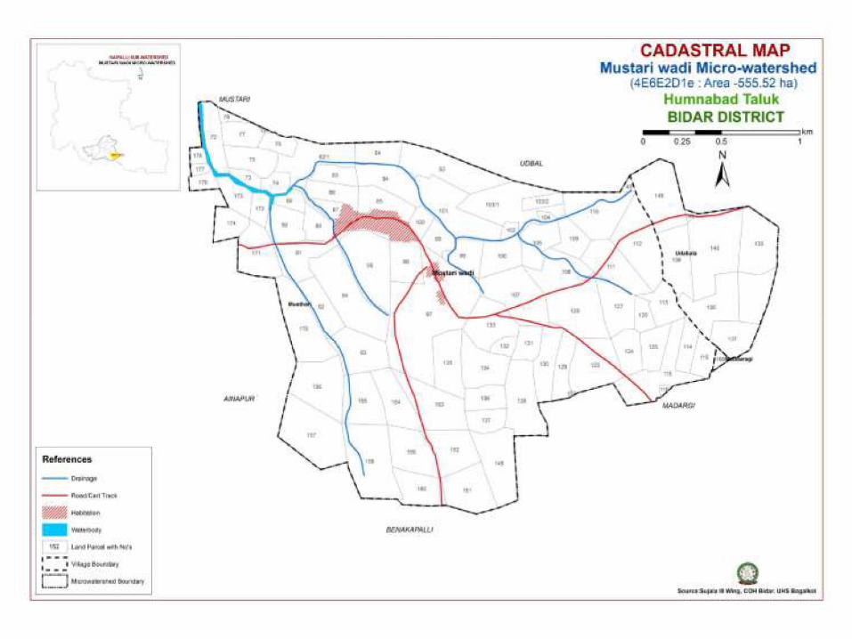
Cadastral map Available Iron
Soil Map Available Zinc
Soil Depth Land Capability Classification
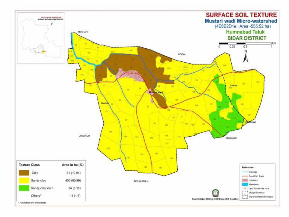
Surface Soil Texture Land Suitability for Major Horticulture crops
Soil Gravelliness Proposed Crop Plan (Table)
Slope Soil & Water Conservation Plan
Soil Erosion Location of wells

Activities Contribution By
Planning, Review, Correlation and Report Finalization
Dr. Ashok S. Alur Dr. Natarajan
Dr. V. Nachegowda Mr. Praveenkumar B.Naikodi
Dr. Ravindra Mulge Dr. Praveen Jholgikar
Dr. Rajendra Hegde Dr. Ganeshgouda Patil
Field Survey and Mapping
Mr. Praveenkumar B.Naikodi Mr. Manjappa. P
Dr. Dhanurkar S. Mr. Veeresh P.H.
Contributors
Dr. Dhanurkar S. Mr. Veeresh P.H.
Dr. Niranjana Mr. Sunil Kishan
Mr. Gautam M. Mr. Nabeesab Sutar
Mr. Kirankumar S. Mr. Basavareddy S. Konda
Mr. Ruben Ashirvadam Mr. Shivanand Elshetty
Socio economic Survey
Dr. Ganeshgouda Patil Mr. Manjunath Burli
Mr. Gautal M. Mr. Umesh Dashyal
Mr. Kirankumar. S Mr. Mahesh Dandekar
Mr. Gururaj Mr. Kashinath Rathod

Laboratory Analysis and Characterization
Mr. Praveenkumar B. Naikodi Mr. Kirankumar S.
Ms. Kalpana P.R. Ms. Shilparani P.K.
Mr. Ruben Ashirvadam Dr. Nair, NBSS & LUP
Mr. Gautam M.
Geographic Information System (GIS) Analysis and Interpretation
Mr. Praveenkumar B.Naikodi Dr. Praveen Jholgikar
Ms, Shakuntala V M Mr. Kirankumar . S
Ms.Sunita A Pattanashetti Mr. Gautam M.
Dr. Srinivas, NBSS & LUPDr. Srinivas, NBSS & LUP
Land Suitability Assessment and Crop Planning
Dr. Praveen Jholgikar Dr. Ganeshgouda Patil
Mr. Praveenkumar B. Naikodi Dr. Srinivas N.

The Land Resource Inventory of Mustari South
micro-watershed (Humanabad taluk, Bidar district) for
Watershed Planning (AESR 6.2) was undertaken to provide
comprehensive site- specific cadastral level information useful for
farm level planning and integrated development of the area under
Sujala – III, Karnataka Watershed Development Project- II.
This atlas contains the basic information on kinds
of soils, their geographic distribution, characteristics and
classification. The soil map and soil based thematic maps derived
from soils data on soil depth, soil gravelliness, slope, land
refer this atlas first by identifying his/her field and survey number
on the village soil map and by referring the soil legend which is
provided in tabular form after the soil map for details pertaining
to his/her area of interest.
The atlas explains in simple terms the different
kinds of soils present in the watershed, their potentials and
problems through a series of thematic maps that help to develop
site-specific plans as well as the need to conserve and manage this
increasingly threatened natural resource through sustainable land
use management. The Land Resource Atlas contains database
How to read and use the Atlas
ii
from soils data on soil depth, soil gravelliness, slope, land
suitability for various crops and land use maps are presented on
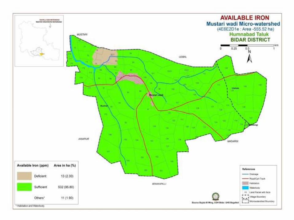
1:12,500 scale. The maps of fertility status (soil reaction, organic
carbon, available phosphorus, available potassium, available
sulphur, available calcium, available copper, available
manganese, available zinc, available iron, available boron and
salinity (EC) on 1:12,500 scale were derived from grid point
sampling of the surface soils from the watershed.
The atlas illustrates 46 maps and tables that depict
the soil resources of the watershed and the need for their
sustainable management.
The user, depending on his/her requirement, can
use management. The Land Resource Atlas contains database
collected at land parcel/ survey number level on soils, climate,
water, vegetation, crops and cropping patterns, socio-economic
conditions, marketing facilities etc. helps in identifying soil and
water conservation measures required, suitability for crops and
other uses and finally for preparing a viable and sustainable land
use options for each and every land parcel.
For easy map reading and understanding the
information contain in different maps, the physical, cultural and
scientific symbols used in the maps are illustrated in the form of
colors, graphics and tables.


INTRODUCTION
With an objective to study, conserve and enhance productivity of various
resource of Bidar district, detailed resource inventory of Raipally sub water shed has been
acomplished by University of Horticultural Sciences, Bagalkot in association with National
Bureau of Soil and Land Use Planning, Bangalore under SUJALA-III project financially
assisted by world bank through WDD Bangalore. The task undertaken was aimed to provide
comprehensive site specific cadastral level information for facilitating farm level planning and
implementation, status of several resources have been studied and compiled to bring out scienceimplementation, status of several resources have been studied and compiled to bring out science
based site specific suitable interventions and their effective implimention through various
government departments and institutions. It is kown that major part of the cultivable land area is
under rainfed cultivation in the Karnataka state. This vast stretch of rainfed area (about 10 m.ha)
is affected by severe soil loss due to erosion, low and uncertain productivity, fodder shortage,
low rainwater use efficiency, rapid depletion of ground water, low level of technological
penetration and very few livelihood opportunities. The extent and severity of various forms of
degradation has affected not only the productivity but also the sustainability of the land
resources in the state.

Among the various forms of land degradation, soil erosion is very widespread in all the
rainfed areas.various conservation measures taken over a period of time is insufficient in many areas to
protect the natural resource due to mismatch between the conservation interventions implemented and
actual requirments. Apart from the widespread degradation witnessed, in many areas, soil erosion, salinity
and alkalinity have become so severe that immediate sustanable and economicaly viable corrective
measures to restore the health of the resource was found most essential. For taking up effective
conservation measures on a scientific foundation, there is an urgent need to undertake the systematic land
resources inventorization of all the existing resources like soils, climate, minerals and rocks, ground
water, vegetation, crops, land use pattern, socio-economic conditions, infrastructure, marketing facilities
etc. Once site-specific farm level database is generated and made available to all developmental
departments, it will help in planning, implementing and monitoring of various land based rural
developmental projects in an effective way. Further, this will help in evolving rational, site-specific and
viable land use options for productivity enhancement and suitable resource management.
In the present study various spatial and non spatial data sets were generated through LRI on a
cadastral base and other information was compiled from different secondary sources for each micro
watershed and assessed for the constraints and potentials of the area, capability of the resources for

planning and development (Land Capability Classification), suitability for irrigation
(Irrigability Classification), suitability of the resources for various carps like cereals, pulses, oilseeds,
commercial crops like cotton, sugarcane, etc.(Land Suitability Classification), suitability for various
horticultural and plantation crops, fodder crops, forestry and other uses and assessing the fertility status
and Soil Health.
The LRI database and thematic outputs generated for each microwatersherd is linked to
individual survey numbers occurring in the watershed area along with farmer details obtained from
Bhoomi website has been pooled for effective implementation and watershed management plan for the 10
micro watersheds spread across in the Raipally subwatershed area of Humanabad taluk, Bidar district.
Thus, availability of bench mark reference in the farm of an resource atlas which includes all
the resource database generated becomes vital tool which can comprehensive site specific cadastral level
decision supporting reference for effective implementation of programs.
The data generated through resource inventory of Raipally subwatersd (4E6E2D) has been
compiled in this atlas to provide a ready reconer for the user as reference in planning and implementation
of various programmes related to effective and sustainable resource management of Raipally sub
watershed inperticullar and district in general. The resources inventory includes indept analysis of various
components like soil, land,water, livestock, crops, natural vegetation socio-economic status of in habitants
and human resource.


0
100
200
300
400
500
600
700
800
900
1000
1957-1966 1967-1976 1977-1986 1987-1996 1997-2006 2007-2014
Ra
infa
ll (
mm
)
Average Rainfall
Average Rainfall
Decadal average rainfall of Humnabad (Dist. Bidar) from 1957-2014
Climate
-10.0010.0030.0050.0070.0090.00
0.0010.0020.0030.0040.0050.00
Rel
ativ
e H
um
idit
y
Tem
per
atu
re (
0C)
2002-2014
Temperature and Relative Humidity
max. Temp min. Temp. RH-8.30 RH-5.30
Decadal average rainfall of Humnabad (Dist. Bidar) from 1957-2014
Average monthly temperature (0 C) and relative humidity (%) as recorded in Humnaba

The Raipalli sub watershed of Bidar
district is a part of Deccan plateau of India and
is derived from solidified lava and shows laterite
developed over basalt. The northern part of the
district is characterized by expanse of level
surface punctuated here and there by flat and
undulating hillocks, black soils and basaltic
rocks. The southern half of the district is a high
Geology
rocks. The southern half of the district is a high
plateau of about 715 m above MSL. The
average elevation of the district is between 580
to 610 m above MSL. Alluvial deposits are
normally found along the banks of Manjra river
and its tributaries. The major minerals found in
the area are Bauxite, Kaoline and Red Ocre. The
district is dominated by two types of soil
viz., lateritic red soils and black soils.
Geology of the area-Laterites over Basalt parent rock


The Soil:


SOIL FERTILITY STATUS


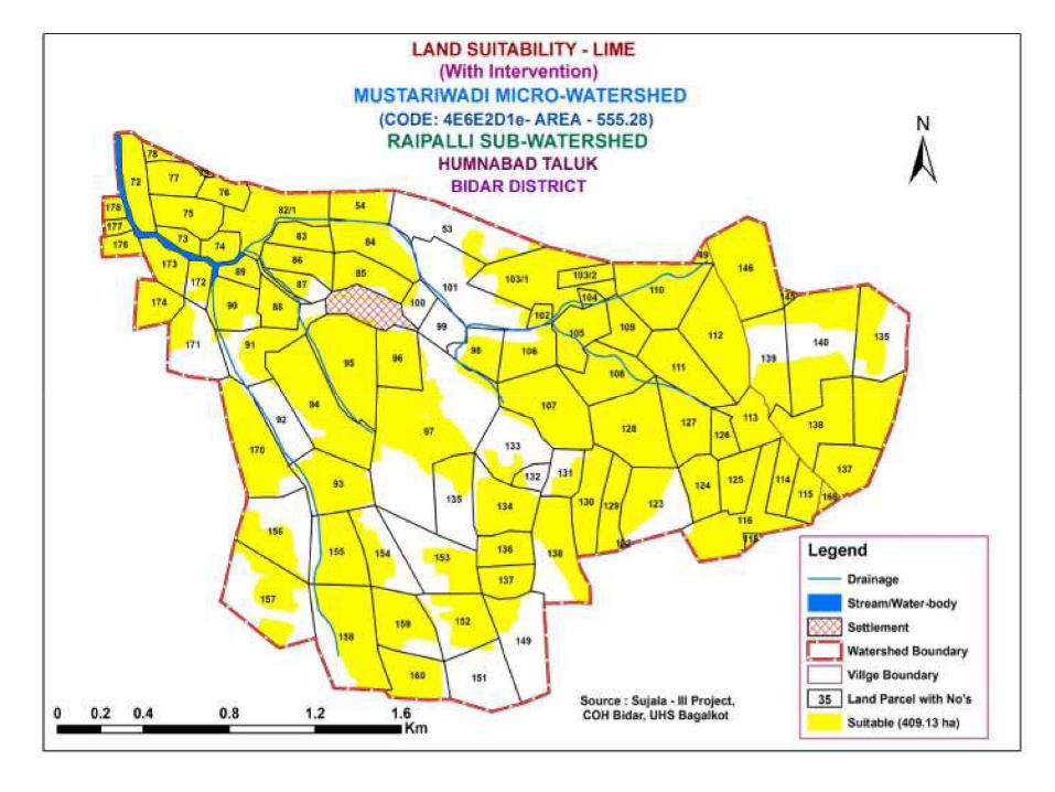
LAND SUITABILITY FOR SOME IMPORTANT HORTICULTURE CROPS


Mapping unit Survey no Characters Crops proposed
Field crops Forestry
Crop/Grasses
Horticulture crops
(Rainfed
Condition)
Horticulture crops
With suitable intervention
Suitable Intervention
BDiA2
BDiB2
BDiB3
138,122,123.
151,149,152.
159,153,154,
135,92,94,91,
171,172,139,
140,135,133,
132,131
Very Shallow
Depth (< 25
cm)
Gravelly clay
(Slope 1-3%)
Erosion:
Moderately
Eroded.
Sole crop:
Bajra,
Navni,Linseed
Red gram +
Ashwagandha
Red gram
+Phundi
Red gram +
Fodder
sorghum
Simaruba,
Glyricidia,
Neem, Jatropa.
Fruit crops:
Custard apple,
Charolli,
Markingnut, Ber,
Cashew, Butea spp,
Karonda, Bael,
woodapple
Mango, custard apple,
cashew, Tamarind, Aonla
Deep and wider size pit,Drip
irrigation with suitable soil
and water conservation
measures.
KDiA1
KDiA2
153,152,137,13
6,91,88,94.
Shallow depth
(25 to 50 cms)
Sole crop;
sorghum,
Simaruba,
Glyricidia,
Fruit crops:
Custard apple,
Mango, Cashew, Gauva,
custardapple,Tamarind,Aonl
Deep and wider size pit,Drip
irrigation with suitable soil
Proposed Crop Plan for Mustariwadi Micro-watershed (4E6E2D1e, Area: 555.18 ha) Tq: Humnabad, Dist: Bidar
KDiA2
KDiB2
MDiB2
MDiB3
6,91,88,94.
156,157,158,15
9,160,170,138.7
5, 76, 82/1, 54.
122,123,129,
130,131,132,
134.
95,96,97,135.
(25 to 50 cms)
Gravelly clay
(Slope – 1-3%)
Moderately
eroded
sorghum,
castor,
Bajra, Navni,
Niger
Red gram +
Soybean
Red gram +
Green gram
Red gram +
Black gram
Red gram +
Phundi
Red gram +
Sisamum,
Red gram +
Fodder
sorghum
Red gram +
Ashwagandha
Glyricidia,
Subabul, Butea
spp. Neem,
Jatropa,
Sandalwood
Grasses:
Styloxanthes
hamata,
styloxanthes
scabra, Hybrid
Napier, Sesbania,
Khus grass
Custard apple,
Tamarind,Ber,
Cashew,Bael,
woodapple,karonda,
Aonla
Vegetables:
clusterbean, bhendi,
Phundi
Flowers:
Gaillardia, Spider
lilly
custardapple,Tamarind,Aonl
a, Lime,
pammelo,jamun,Ber apple
Veg: Onion, Tomato,
Brinjal, Chilli, Bhendi
Flowers-Gaillardia,
marigold, Chrysanthemum,
lilly
irrigation with suitable soil
and water conservation
measures
Cultivation on raised beds
with mulches and drip.

APiB2
MShB2
MSiB2
MSiC3
93,94,95,97,154
,155,158.112,11
3,114,115,116,1
18,124,125,126,
138,139.103/1,1
03/2,104,105,10
6,107, 108,111,
112.49,98,
102,106,
10,123,128,
146.
Depth 50-
75cms
Gravelly Clay
Slope 1-3%
Moderate
erosion
Sole crop;
Khariff
season:
Redgram,
soyabean,
Sugarcane,
Ground nut,
sunflower,
sorghum.
Red gram +
Soybean
Red gram +
Green gram
Red gram +
Black gram
Red gram +
Sesame
-do-
Fruit crops:
Mango, sapota,
Gauva, Lime Jamun,
Tamarind, Jackfruit,
Fig
Vegetable:
Clusterbean, bhendi,
Chilli, curryleaf,
Drumstick
Flower: Gaillardia,
Spider lilly,
Merigold
Fruits:
Mango, Gauva, lime, sweet
orange, Kinnow , Papaya, ,
Banana, coconut.
Vegetables:
Solanaceous, Cucurbits,
Crucifers, tuberous and leafy
vegetables, Drumstick and
curry leaf.
Flower: Gaillardia,
Tuberose, Marigold,
Chrysanthemum, Rose,
Jasmine,
Species: Zinger, turmeric
Drip irrigation with suitable
soil and water conservation
measures
Cultivation on raised beds
with mulches and drip.
Rabi season:
Sorghum,
Bengalgram,
Safflower,
sunflower,
wheat.

CGiA1
CGiB2
MTiB2
MWmA1
132,133,134.
112,127.
53,101,103/1.
53,99,100,101.
Deep clay soil
(Depth 75-
100cm)
Slope 0-1% &
>100cm
slightly –
moderate
erosion
Sole crop;
Khariff
season:
Redgram,
soyabean,
Sugarcane,
Ground nut,
sunflower,
sorghum.
Red gram +
Soybean
Red gram +
Green gram
Red gram +
Black gram
Red gram +
-
Fruit crops:
Mango, sapota,
Gauva, Lime Jamun,
Tamarind, Jackfruit,
Fig
Veg:Beans, Bhendi,
Drumstick,
Clusterbean,
Curryleaf, Coriander
etc.
Flower: Gaillardia,
lilly, Merigold
Fruits:
Banana, Papaya, Mango,
sapota, lime, sweetorange,
Kinnow, Gauva, Coconut,
Vegetables:
Solanaceous, Cucurbits,
Crucifers, tuberous and leafy
vegetables, Drumstick and
curry leaf.
Flower:
Gaillardia, Tuberose,
Marigold, Chrysanthemum,
Rose, Jasmine,
Species:
zinger, turmeric
Drip irrigation with suitable
soil and water conservation
measures
Cultivation on raised beds
with mulches and drip
irrigation system.
Red gram +
Sesam
Rabi season:
Sorghum,
Bengalgram,
Safflower,
sunflower,
wheat

RPiA1
RPiB2
RPiC2
RPmA1
72,
73,74,75,76,
77, 78, 82/1.
113,115,116,1
25,126,135,13
7,138,139,140,
145,146.
105,108,109,1
10,111,112,14
6.
83,84,85,86,87
,88,89,90,100,
171,172,173,1
74,176,177,17
8.
Deep clay soil
(Depth
>100cm)
Slope 0-1% &
slightly –
moderate
erosion
Sole crop;
Khariff season:
Redgram,
Soyabean,
Sugarcane, Ground
nut, sunflower,
Sorghum.
Red gram +
Soybean
Red gram + Green
gram
Red gram + Black
gram
Red gram + Sesame
Rabi season:
Sorghum,
-
Fruit crops:
Sapota, Gauva,
Lime Jamun,
Tamarind,
Jackfruit.
Veg: Beans,
Bhendi, Drumstick,
Clusterbean,
Curryleaf,
Coriander etc.
Flower: Gaillardia,
lilly, Merigold
Fruits:
Banana, Papaya, Sapota,
lime, Sweet orange,
Kinnow, Gauva, Coconut,
Vegetables:
Solanaceous, Cucurbits,
Crucifers, tuberous and
leafy vegetables,
Drumstick and curry leaf.
Flower:
Gaillardia, Tuberose,
Marigold, Chrysanthemum,
Rose, Jasmine,
Species:
zinger, turmeric
Drip irrigation with
suitable soil and water
conservation measures
Cultivation on raised beds
with mulches and drip
irrigation system.
Bengalgram,
Safflower,
sunflower, wheat
Note: Bold no indicates areas covers only < 30% in mapping units