united states department of the interior bureau of land … · 2016-11-04 · united states...
TRANSCRIPT

DOI-BLM-CO-N010-2012-0049EA
1
United States Department of the Interior Bureau of Land Management
Environmental Assessment for the February 2013 Oil and Gas
Lease Sale
Little Snake Field Office
455 Emerson St.
Craig, Colorado 81625
DOI-BLM-CO-N010-2012-0049EA
June 2012

DOI-BLM-CO-N010-2012-0049EA
2
TABLE OF CONTENTS
CHAPTER 1 - INTRODUCTION ........................................................................................................4
1.1 IDENTIFYING INFORMATION .......................................................................................5
1.2 PROJECT LOCATION AND LEGAL DESCRIPTION .................................................6 Map 1 – all nominated parcels in the Little Snake Field Office ..............................................6
1.3 PURPOSE AND NEED .......................................................................................................7
1.4 PLAN CONFORMANCE REVIEW ..................................................................................7
1.5 PUBLIC PARTICIPATION ...............................................................................................8
1.6 DECISION TO BE MADE .................................................................................................9 CHAPTER 2 - PROPOSED ACTION AND ALTERNATIVES ........................................................10
2.1 INTRODUCTION ...............................................................................................................10 2.2 ALTERNATIVES ANALYZED IN DETAIL ......................................................................10
2.2.1 Proposed Action ..................................................................................................................10
2.2.2 No Action Alternative .........................................................................................................11
2.3 ALTERNATIVES CONSIDERED BUT NOT ANALYZED IN DETAIL……...................11
CHAPTER 3 - AFFECTED ENVIRONMENT AND EFFECTS .......................................................12
3.1 INTRODUCTION .................................................................................................................12
3.2 PHYSICAL RESOURCES ...............................................................................................14
3.2.1 Air Quality and Climate.....................................................................................................14
3.2.2 Floodplains……………. ...................................................................................................20
3.2.3 Fluid Mineral Resources ...................................................................................................21
3.2.4 Soils (includes a finding on Standard 1) ...........................................................................21
3.2.5 Water Quality/Ground (includes a finding on Standard 5) ...............................................24
3.2.6 Water Quality/Surface.......................................................................................................25
3.3 BIOLOGICAL RESOURCES .........................................................................................29
3.3.1 Invasive, Non-native Species ...........................................................................................29
3.3.2 Migratory Birds ................................................................................................................30
3.3.3 Special Status Animals .....................................................................................................32
3.3.4 Wetlands & Riparian Zones (includes a finding on Standard 2) ......................................36
3.3.5 Wildlife (Aquatic)..............................................................................................................39
3.3.6 Wildlife (Terrestrial) (includes a finding on Standard3).....................................................40
3.4 HERITAGE RESOURCES AND HUMAN ENVIRONMENT .....................................41
3.4.1 Cultural Resources .............................................................................................................41
3.4.2 Wastes, Hazardous or Solid................................................................................................46
3.4.3 Tribal and Native American Religious Concerns ..............................................................48
3.4.4 Paleontological Resources..................................................................................................49
3.4.5 Environmental Justice and Socioeconomics.......................................................................50
3.5 LAND RESOURCES ..........................................................................................................52
3.5.1 Prime and Unique Farmlands .............................................................................................52
CHAPTER 4 - CONSULTATION AND COORDINATION ....................................................54
4.1 LIST OF PREPARERS AND PARTICIPANTS .............................................................54

DOI-BLM-CO-N010-2012-0049EA
3
FINDING OF NO SIGNIFICANT IMPACT .....................................................................................55
DECISION RECORD ....................................................................................................................….iv
Attachment A - Pre-EA Parcels Proposed for Lease .....................................................................….vi
Attachment B - Parcels Recommended for Deferral from Leasing ....................................................xix
Attachment C - Parcels Available for Lease with Applied Stipulations .............................................xxvi
Attachment D - Exhibits Description ................................................................................................. xxviii
Attachment E – Map Book ................................................................................................................. xxxix
Attachment E – Public Comment Review........................................................................................... xxxx

DOI-BLM-CO-N010-2012-0049EA
4

DOI-BLM-CO-N010-2012-0049EA
5
CHAPTER 1 - INTRODUCTION
1.1 IDENTIFYING INFORMATION
BACKGROUND: It is the policy of the Bureau of Land Management (BLM) as derived from various
laws, including the Mineral Leasing Act of 1920 and the Federal Land Policy and Management Act of
1976, to make mineral resources available for disposal and to encourage development of mineral
resources to meet national, regional, and local needs.
The BLM’s Colorado State Office conducts quarterly competitive lease sales to sell available oil and gas
lease parcels. A Notice of Competitive Lease Sale, which lists lease parcels to be offered at the auction,
is published by the Colorado State Office at least 45 days before the auction is held. Lease stipulations
applicable to each parcel are specified in the Sale Notice. The decision as to which public lands and
minerals are open for leasing and what leasing stipulations may be necessary, based on information
available at the time, is made during the land use planning process. Constraints on leasing and any future
development of split estate parcels are determined by the BLM in consultation with the appropriate
surface management agency or the private surface owner.
In the process of preparing a lease sale, the Colorado State Office sends a draft parcel list to each field
office where the parcels are located. Field Office staff then review the legal descriptions of the parcels to
determine if they are in areas open to leasing; if appropriate stipulations have been included; if new
information has become available which might change any analysis conducted during the planning
process; if appropriate consultations have been conducted, and if there are special resource conditions of
which potential bidders should be made aware. Once the draft parcel review is completed and returned to
the State Office, a list of available lease parcels and stipulations is made available to the public through a
Notice of Competitive Lease Sale (NCLS). Lease sale notices are posted on the Colorado BLM website
at: http://www.blm.gov/nm/st/en/prog/energy/oil_and_gas/lease_sale_notices.html. On rare occasions,
additional information obtained after the publication of the NCLS may result in withdrawal of certain
parcels prior to the day of the lease sale.
The inclusion of a parcel listed in the lease sale notice may be protested. A protest must be received at
the BLM’s Colorado State Office no later than close of business on the 30th calendar day after the
posting of the notice of the lease sale. Nominated parcels that receive no bids during the February lease
sale become available for noncompetitive sale beginning the day after the lease sale. Parcels offered
noncompetitively remain available on a first-come, first-served basis for a two-year period beginning
the day after the sale.
Fifty-nine parcels comprising 63137.27 acres within the Little Snake Field Office (LSFO) were
nominated for the February 2013 Competitive Oil and Gas Lease Sale. This figure is comprised of
31848.89 acres of federal land and 31227.82 acres of split-estate land. The legal descriptions of the
nominated parcels are in Attachment A.
Colorado BLM Instruction Memorandum No. CO-2010-027 provided guidance and direction for
implementing Washington Office (WO) IM 2010-117, Oil and Gas Leasing Reform-Land Use
Planning and Parcel Review, and WO IM 2010-118, Energy Policy Act Section 390 Categorical
Exclusion (CX) Policy Revision. That IM requires the field office to complete an environmental
assessment and provide a 30 day public review and comment period for lease sales. It also provides
guidance for parcel review, timeframes, leasing recommendations and attachments to be included with

DOI-BLM-CO-N010-2012-0049EA
6
the Environmental Assessment (EA) as well as guidance for use of Master Leasing Plans. This EA
has been prepared in accordance with IM CO-2010-027 by the LSFO to analyze leasing of 59 parcels
nominated.
PROJECT NAME: February 2013 Competitive Oil and Gas Lease Sale
PLANNING UNIT: Little Snake Field Office
1.2 PROJECT LOCATION AND LEGAL DESCRIPTION
LEGAL DESCRIPTION: Please see Attachments A, B, and C and Map 1 Below.
Map 1 – all nominated parcels in the LSFO

DOI-BLM-CO-N010-2012-0049EA
7
1.3 PURPOSE AND NEED
The purpose of the Proposed Action is to offer parcels for competitive oil and gas leasing is to allow
private individuals or companies to explore for and develop federal oil and gas resources for sale on
public markets.
The need for the action is to satisfy the conditions of the Mineral Leasing Act of 1920 as described in
43CFR 3100 and the Federal Land Policy and Management Act of 1976. The sale of oil and gas leases is
needed to meet the growing energy needs of the United States public (43 U.S.C. § 1702 (c)). Production
of oil and gas resources on public lands contributes to decreasing the dependence of the United States on
foreign energy sources, which is a BLM policy that complies with the Mining and Minerals Policy Act
of 1970. Continued leasing is necessary to maintain options for production as oil and gas companies seek
new areas for production or attempt to develop previously inaccessible or uneconomical reserves.
1.4 PLAN CONFORMANCE REVIEW
The Proposed Action was reviewed for conformance (43 CFR 1610.5, BLM 1617.3) with the following
plan:
Name of Plan: Little Snake Record of Decision and Resource Management Plan (LSFO ROD/RMP
[October 2011]).
Date Approved: October 2011
Decision Language: The Proposed Action is in conformance with the LUP because it is specifically
provided for in the following LUP goals, objectives, and management decisions:
Allow for the availability of the federal oil and gas estate (including coalbed natural gas)
for exploration and development. Objectives for achieving these goals include:
Identify and make available the federal oil and gas estate (including coalbed natural gas)
for exploration and development.
Facilitate reasonable, economical, and environmentally sound exploration and
development of oil and gas resources (including coalbed natural gas).
Section/Page: Section 2.13 Energy and Minerals/ page RMP-36
In January 1997, the Colorado State Office of the BLM approved the Standards for Public Land Health
and amended all RMPs in the State. Standards describe the conditions needed to sustain public land
health and apply to all uses of public lands.
Standard 1: Upland soils exhibit infiltration and permeability rates that are appropriate to soil type,
climate, land form, and geologic processes.
Standard 2: Riparian systems associated with both running and standing water function properly
and have the ability to recover from major disturbance such as fire, severe grazing, or 100-year

DOI-BLM-CO-N010-2012-0049EA
8
floods.
Standard 3: Healthy, productive plant and animal communities of native and other desirable species
are maintained at viable population levels commensurate with the species and habitat’s potential.
Standard 4: Special status, threatened and endangered species (federal and state), and other plants
and animals officially designated by the BLM, and their habitats are maintained or enhanced by
sustaining healthy, native plant and animal communities.
Standard 5: The water quality of all water bodies, including ground water where applicable, located
on or influenced by BLM lands will achieve or exceed the Water Quality Standards established by
the State of Colorado.
Because standards exist for each of these five categories, a finding must be made for each of them
in an environmental analysis. These findings are located in Chapter 3 of this document.
1.5 SCOPING AND ISSUES IDENTIFIED
1.5.1 Scoping: NEPA regulations (40 CFR §1500-1508) require that the BLM use a scoping process to
identify potential significant issues in preparation for impact analysis. The principal goals of scoping are
to allow public participation to identify issues, concerns, and potential impacts that require detailed
analysis.
External Scoping Summary: There was a two week public scoping period of nominated lease parcels
including preliminary recommendations and stipulations from June 13 to June 27, 2012. Stipulation
summaries, GIS shapefiles, and maps were posted on the BLM Colorado State Office website:
http://www.blm.gov/co/st/en/BLM_Programs/oilandgas/oil_and_gas_lease/2013/february_2013_lease_s
ale.html. This allows the public an opportunity to provide comments, which are then analyzed and
incorporated into the environmental analysis as appropriate. Letters were also mailed to affected private
land surface owners whose land overlies federal minerals proposed for leasing.
Issues Identified: 1 letter of comment was received from Dinosaur National Park, 3 letters of comment
were received from landowners and 3 letters were received from environmental groups. The letters
identified a wide range of issues including, but not limited to: landowner rights and offsets from structure
on private property, water, soil, and air quality, noise and light pollution, cultural resource protection,
wildlife, forestry, and transportation.
Internal Scoping Summary: Parcels deferred that were in Preliminary Priority Habitat for Greater Sage-
Grouse.
1.5.1 Public Comment Period: The action in this Environmental Assessment (EA) is included in the
NEPA log posted on the Little Snake Field Office (LSFO) web site:
http://www.blm.gov/co/st/en/BLM_Information/nepa/lsfo.html.

DOI-BLM-CO-N010-2012-0049EA
9
The preliminary draft of this EA and the unsigned Finding of No Significant Impact (FONSI) have been
posted in the public room of the LSFO for a 30-day public review period beginning August 17, 2012 and
ending September 18, 2012. The document may be viewed during regular business hours (7:45 a.m. to
4:30 p.m.), Monday through Friday, except holidays. Comments received from the public will be
analyzed and incorporated into the EA as appropriate.
Persons/Agencies Consulted: Colorado Parks and Wildlife, Uintah and Ouray Tribal Council, Colorado
Native American Commission, Colorado State Historic Preservation Office, Dinosaur National Park,
USFS Routt National Forest.
Issues Identified: The BLM received XXX letters as a result of this comment period; XX letter from
environmental organizations, XXX letter from XXX County, and XXX letter from a private individual. These
letters provided the BLM information on the concerns of the public and local government. No significant
issues requiring further analysis or alternative development in the EA were identified in the review of the
comments. However, several minor clarifications, corrections, and additions were made to the final EA in
order to more clearly disclose the impacts of the proposed action with regard to the concerns raised in the
letters. The review of these comments is included as Attachment E.
1.6 DECISION TO BE MADE
The LSFO will decide which parcels to offer for sale in the February 2013 Competitive Oil and Gas
Lease Sale based on the analysis contained in this EA. The BLM may choose to: a) offer all of the
nominated parcels for sale, b) offer a subset of the parcels for sale, or c) not offer any parcels at this time.
The finding associated with this EA may not constitute the final approval for the proposed action. The
final decision on which parcels will be sold will be made by the State Director.

DOI-BLM-CO-N010-2012-0049EA
10
CHAPTER 2 - PROPOSED ACTION AND ALTERNATIVES
2.1 INTRODUCTION
The purpose of this chapter is to provide information on the Proposed Action and alternatives.
Alternatives considered but not analyzed in detail are also discussed.
2.2 ALTERNATIVES ANALYZED IN DETAIL
2.2.1 Proposed Action: The Proposed Action is to lease Federal mineral estate from lands reviewed and
found suitable for leasing in the resource area through the LSFO ROD/RMP (October 2011). The current
lease sale includes parcels in Moffat, Rio Blanco, and Routt Counties. Those lands proposed for lease
total 12037.95 acres of federal mineral estate and are described in Attachment C and are a mix of federal
and private surface. The lands have been grouped into appropriate lease parcels for purposes of offering
lands via competitive lease sale as oil and gas leases. Offered lease parcels are grouped according to
regulatory requirements as prescribed in the 43 CFR 3100 regulations, setting parameters for acreage
limitations, public lands, acquired lands, and excepted acreage. Regulations also set certain lease terms
and conditions under which development of the surface of oil and gas leases may occur. Stipulations for
other surface protection will be applied where regulatory lease terms and conditions are not adequate to
protect those resources. These stipulations are described in Attachment C and will be attached as
stipulations to any of the parcels that are leased in areas where the stipulations apply.
If the parcels are not leased at the proposed lease sales, then they will remain available to be leased for a
period of up to two years to any qualified lessee at the minimum bid cost. Parcels obtained in this way
may be re-parceled by combining or deleting other previously offered lands.
Mineral estate that does not get leased after an initial offering, and is not leased within a two year period,
must go through a competitive lease sale process again prior to being leased.
The act of leasing does not authorize any development or use of the surface of lease lands, without
further application and approval by the BLM.
The BLM may receive future Applications for Permit to Drill (APDs) for those parcels that are leased.
When those APDs are received, additional site-specific NEPA analysis will be done.
Justification for deferrals: The deferral process for nominated parcels was established to address
situations in which legitimate questions or controversy arises over the leasability of a parcel. The deferral
process does not necessarily withdraw a parcel from the leasing arena, but merely indicates that further
analysis is needed before possibly being reintroduced in a future lease sale. The following parcels are
recommended for deferral in the proposed action for the lease sale.
Attachment A of this document lists all pre EA parcels proposed for lease. Attachment B parcels are
those deferred or with deferred portions and Attachment C are those parcels determined by this analysis
to be available for lease with applied stipulations. Definitions of applied stipulations can be found in
Attachment D and maps of the parcels are found in Attachment E.

DOI-BLM-CO-N010-2012-0049EA
11
2.2.2 No Action Alternative
The BLM NEPA Handbook (H-1790-1) states that for EAs on externally initiated proposed actions,
the No Action Alternative generally means that the Proposed Action would not take place. In the case
of a lease sale, this would mean that an expression of interest to lease (parcel nomination) would be
denied or rejected.
The No Action Alternative would withdraw the lease parcels from the February 2013 lease sale. The
parcels would remain available for inclusion in future lease sales. Surface management would remain
the same and ongoing oil and gas development would continue on surrounding private, state, and
federal leases.
No mitigation measures would be required as no new oil and gas development would occur on the
unleased lands. No rental or royalty payments would be made to the Federal Government. It is not
expected that demand would decrease. It is likely that continuing demand would be addressed through
production elsewhere.
It is an assumption that the No Action Alternative (no lease option) may result in a slight reduction in
domestic production of oil and gas. This would likely result in reduced federal and state royalty
income. Oil and gas consumption is driven by a variety of complex interacting factors including energy
costs, energy efficiency, availability of other energy sources, economics, demographics, and weather or
climate. If the BLM were to forego its leasing decisions and potential development of those minerals,
the assumption is that the public’s demand for the resource would not be expected to change. Instead,
the resource foregone would be replaced by other sources that may include a combination of imports,
fuel switching, alternative fuels, and other domestic production.
2.3 ALTERNATIVES CONSIDERED BUT NOT ANALYZED IN DETAIL____
Originally, 59 parcels, comprising 63137.27 acres within the LSFO (see map 1) were nominated for the
February 2013 lease sale (see Attachment A for complete legal descriptions). An alternative considered
but eliminated involved leasing all the nominated parcels as provided in Attachment A, with no deferrals.
This alternative was dropped from further consideration and not analyzed in detail because the BLM
identified the need for temporary deferral on all but 20 of the parcels in order to allow for further
analysis of several resource concerns on these parcels. These resource concerns included Preliminary
Priority Habitat for Greater Sage Grouse (an ESA candidate species). Leasing the deferred parcels could
be analyzed in a future leasing EA when these resource concerns have been addressed.

DOI-BLM-CO-N010-2012-0049EA
12
CHAPTER 3 - AFFECTED ENVIRONMENT AND EFFECTS
3.1 INTRODUCTION
Affected Resources:
The CEQ Regulations state that NEPA documents “must concentrate on the issues that are truly
significant to the action in question, rather than amassing needless detail” (40 CFR 1500.1(b)). While
many issues may arise during scoping, not all of the issues raised warrant analysis in an environmental
assessment (EA). Issues will be analyzed if: 1) an analysis of the issue is necessary to make a reasoned
choice between alternatives, or 2) if the issue is associated with a significant direct, indirect, or
cumulative impact, or where analysis is necessary to determine the significance of the impacts. Table 1
lists the resources considered and the determination as to whether they require additional analysis.
Table 3-1: Resources and Determination of Need for Further Analysis
Determination1 Resource Rationale for Determination
Physical Resources
PI Air Quality See 3.2.1 Air Quality and Climate
PI Floodplains See 3.2.2 Flood Plains
PI Hydrology, Ground See Water Quality, Ground
PI Hydrology, Surface See Water Quality, Surface
PI Minerals, Fluid See 3.2.3 Minerals, Fluid
PI Minerals, Solid CO-01 stipulations required to protect active coal mining on leases
COC6336, COC6348, and COC6426.
PI Soils See 3.2.4 Soils
PI Water Quality, Ground See 3.2.5 Water Quality/Ground
PI Water Quality, Surface See 3.2.6 Water Quality/Surface
Biological Resources
PI Invasive, Non-native
Species See 3.3.1 Invasive/Non-Native Species
PI Migratory Birds See 3.3.2 Migratory Birds
PI Special Status
Animal Species See 3.3.3 Special Status Animals
NP Special Status
Plant Species
There are no federally listed threatened or endangered plants or the BLM
sensitive plant species present on any of the proposed parcels.
NI Upland Vegetation Potential impacts to vegetation cannot be determined until site specific
proposals have been submitted to LSFO for analysis.
PI Wetlands and
Riparian Zones See 3.3.8 Wetlands and Riparian Zones
PI Wildlife, Aquatic See 3.3.9 Wildlife (Aquatic)

DOI-BLM-CO-N010-2012-0049EA
13
Determination1 Resource Rationale for Determination
PI Wildlife, Terrestrial 3.3.10 Wildlife (Terrestrial)
NP Wild Horses The proposed lease parcels do not fall within the Sand Wash HMA.
Heritage Resources and the Human Environment
PI Cultural Resources
See 3.4.1 Cultural Resources
NP Environmental Justice According to the most recent Census Bureau statistics (2000), there are no
minority or low income populations within the LSFO.
PI Hazardous or Solid
Wastes See 3.4.2 Hazardous or Solid Wastes
PI Native American Religious
Concerns
See 3.4.3 Native American Religious Concerns
PI Paleontological
Resources
See 3.4.4 Paleontological Resources
PI Environmental Justice and
Socioeconomics See 3.4.5 Environmental Justice and Socioeconomics
NI Visual Resources
The proposed parcels 6296, 6297, and 6298 are located in a VRM Class III
area where moderate change to the characteristic landscape would be
allowed as long as the existing characteristics of the landscape are partially
retained. The Scenic Quality Rating is a C. The Sensitivity Level Rating
would have maintenance of visual quality with a low value.
Parcel 6403, is also located in VRM Class III. The Scenic Quality Rating
was identified as A. Sensitivity Level Rating would have maintenance of
visual quality with a high value.
Both project areas are within the foreground-middle ground zone where
management activities and proposed projects may be viewed in more detail
in the zone. This is due to the number of primary transportation corridors
throughout the field office.
The Proposed Action allows the subsequent exploration and development
of the lease. Exploration and development includes activities which would
physically disturb soils (e.g., building well pads, access roads, installation
of pipelines, etc.) that could impact visual resources. However,
stipulations (see Exhibit B, e.g., CO-26, LS-111), would rectify some
visual impacts over short term and long term during and after proposed
project time period.
Resource Uses
NI Access and
Transportation
No immediate impact. Any future developments would be analyzed on a
case-by-case basis to avoid or mitigate any issues that could develop.
NI Fire Management There would not be any substantial changes to the Fire Management Plan
due to the leasing of the proposed parcels.
NI Forest Management Potential impacts to forest management cannot be determined until site
specific proposals have been submitted to LSFO for analysis.
NI Livestock Operations
The proposed parcels are located on allotments permitted for livestock use.
Any future developments would be analyzed on a case-by-case basis to
avoid or mitigate any issues that could develop.
PI Prime and Unique
Farmlands See 3.5.4 Prime and Unique Farmlands

DOI-BLM-CO-N010-2012-0049EA
14
Determination1 Resource Rationale for Determination
NI Realty Authorizations, Land
Tenure
The proposed parcels are located in areas of existing Realty Authorizations
or Land Tenure areas. Any future developments of the leases would be
analyzed on a case-by-case basis to avoid or mitigate any issues that could
develop. Parcels 6296, 6297, and 6298 are adjacent to Dinosaur National
Monument Park boundary. The Deerlodge Road has a 1000’ corridor that
has been withdrawn from the public domain for Park Service purposes
(50FR36923-36924). The use of government roads within the park by
commercial vehicles is prohibited by 36 CFR 5.6.
NI Recreation No immediate impact. Any future developments would be analyzed on a
case-by-case basis to avoid or mitigate any issues that could develop.
Special Designations
NP Areas of Critical
Environmental Concern There are no ACECs in the proposed project areas.
NP Lands with Wilderness
Characteristics
The proposed parcels were evaluated for suitability as lands with
wilderness characteristics and did not meet the roadless criteria for an area
greater than 5,000 acres. Parcels 6296, 6297, and 6298, identified as CO-
010-272, did not meet the roadless criteria due to the presence of the
Yampa Valley Trail, numerous roads, seismic and grazing trails, and
improvements.
NI Wilderness Study Areas
There are no WSAs in the proposed parcels. However, Cross Mountain
WSA is located less than 5 miles north of proposed parcels 6296, 6297,
and 6298.
NP Wild and Scenic Rivers There are no WSRs within the proposed parcels.
1 NP = Not present in the area impacted by the Proposed Action or Alternatives. NI = Present, but not affected to a degree that detailed
analysis is required. PI = Present with potential for impact analyzed in detail in the EA.
3.2 PHYSICAL RESOURCES
3.2.1 Air Quality and Climate
Affected Environment: The proposed lease parcels are primarily located in rural portions of the Little
Snake Field Office planning area boundaries. The nominated parcels are located in Moffat (6302, 6348,
6385, 6386, 6422, 6424, 6525, 6548), Routt (6423, 6427, 6425, 6426, 6531, 6453), and Rio Blanco
(6527, 6336, 6296, 6297, 6298) Counties. The Colorado Oil and Gas Conservation Commission
(COGCC) parcel maps shown in figure 3-1 below provide a relative scale of current or proposed oil and
gas well activity within the vicinity of the nominated parcels. The wells indicators (shown as red dots)
include producing, dry, abandoned, shut in, and located but not yet drilled well locations. An analysis of
the COGCC database for producing wells near the parcel areas showed limited activity for most of the
parcels. The average number of producing wells within 10km of the center of the each parcel cluster
shown below is 13 wells. The highest producing well cluster (39 wells) is located around parcel 6336
(3N93W).
Figure 3-1. COGCC Area Maps1
1 Maps also show surface area ownership within parcel vicinities (BLM lands shown in yellow).

DOI-BLM-CO-N010-2012-0049EA
15
6N93W 5N95W
5N92W 11N89W
7N86W 5N92W

DOI-BLM-CO-N010-2012-0049EA
16
The U.S. Environmental Protection Agency (EPA) has established national ambient air quality standards
(NAAQS) for criteria pollutants, including carbon monoxide (CO), nitrogen dioxide (NO2), ozone (O3),
particulate matter (PM10 and PM2.5), sulfur dioxide (SO2), and lead (Pb). Exposure to air pollutant
concentrations greater than the NAAQS has been shown to have a detrimental impact on human health
and the environment. The EPA has delegated regulation of air quality under the federal Clean Air Act to
the State of Colorado. The Colorado Department of Public Health and Environment (CDPHE), Air
Pollution Control Division (APCD) administers Colorado’s air quality control programs and is
responsible for issuing permits for emission sources. The State has established the Colorado Ambient
Air Quality Standards (CAAQS), which can be more, but not less stringent then the NAAQS. In
addition to the criteria pollutants, regulations also exist to control the release of hazardous air pollutants
(HAPs). HAPs are chemicals that are known or suspected to cause cancer or other serious health effects,
such as reproductive effects or birth defects, or adverse environmental effects. EPA currently lists 188
identified compounds as hazardous air pollutants, some of which can be emitted from oil and gas
development operations, such as benzene, toluene, and formaldehyde. Ambient air quality standards for
HAPs do not exist; rather these emissions are regulated by the source type, or specific industrial sector
responsible for the emissions.
Ambient air quality in the affected environment (i.e. compliance with the NAAQS) is demonstrated by
monitoring for ground level (i.e. receptor height) atmospheric air pollutant concentrations. In general, the
ambient air measurements show that existing air quality in the region is good. Concentrations for the
4N88W 3N86W
3N93W 3N89W
DOI-BLM-CO-N010-2012-0049EA
17
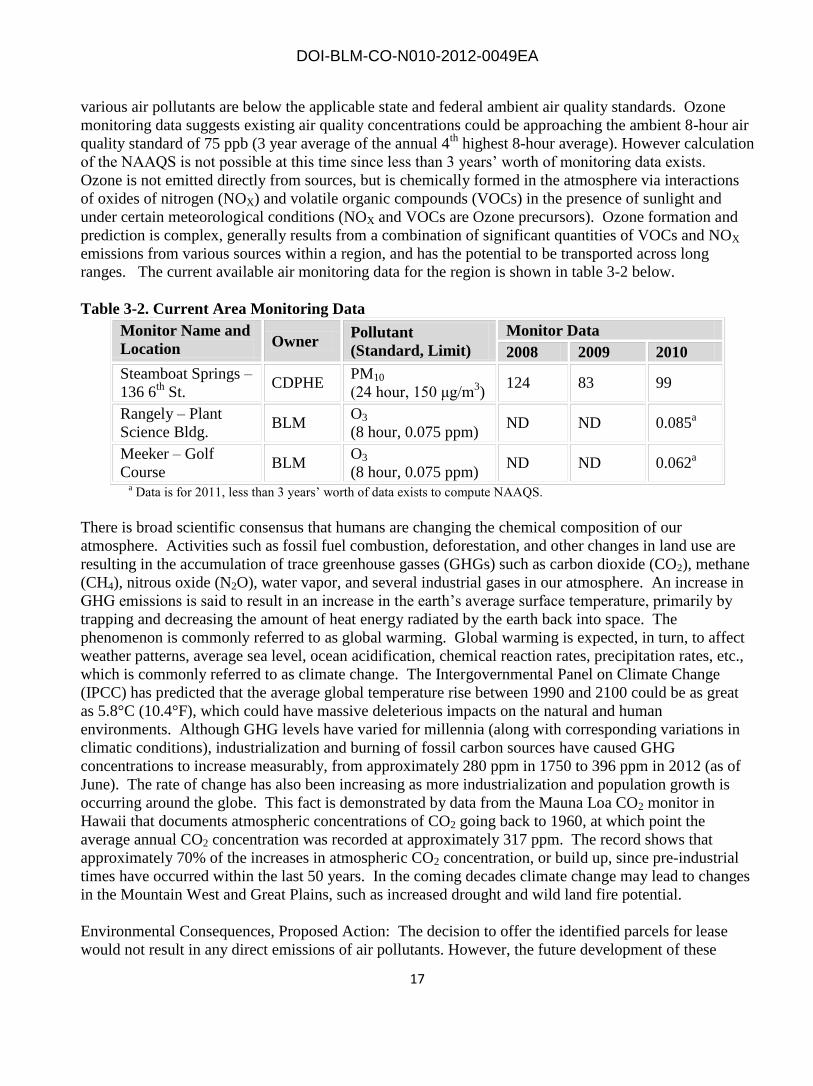
various air pollutants are below the applicable state and federal ambient air quality standards. Ozone
monitoring data suggests existing air quality concentrations could be approaching the ambient 8-hour air
quality standard of 75 ppb (3 year average of the annual 4th
highest 8-hour average). However calculation
of the NAAQS is not possible at this time since less than 3 years’ worth of monitoring data exists.
Ozone is not emitted directly from sources, but is chemically formed in the atmosphere via interactions
of oxides of nitrogen (NOX) and volatile organic compounds (VOCs) in the presence of sunlight and
under certain meteorological conditions (NOX and VOCs are Ozone precursors). Ozone formation and
prediction is complex, generally results from a combination of significant quantities of VOCs and NOX
emissions from various sources within a region, and has the potential to be transported across long
ranges. The current available air monitoring data for the region is shown in table 3-2 below.
Table 3-2. Current Area Monitoring Data
Monitor Name and
Location Owner
Pollutant
(Standard, Limit)
Monitor Data
2008 2009 2010
Steamboat Springs –
136 6th
St. CDPHE
PM10
(24 hour, 150 μg/m3)
124 83 99
Rangely – Plant
Science Bldg. BLM
O3
(8 hour, 0.075 ppm) ND ND 0.085
a
Meeker – Golf
Course BLM
O3
(8 hour, 0.075 ppm) ND ND 0.062
a
a Data is for 2011, less than 3 years’ worth of data exists to compute NAAQS.
There is broad scientific consensus that humans are changing the chemical composition of our
atmosphere. Activities such as fossil fuel combustion, deforestation, and other changes in land use are
resulting in the accumulation of trace greenhouse gasses (GHGs) such as carbon dioxide (CO2), methane
(CH4), nitrous oxide (N2O), water vapor, and several industrial gases in our atmosphere. An increase in
GHG emissions is said to result in an increase in the earth’s average surface temperature, primarily by
trapping and decreasing the amount of heat energy radiated by the earth back into space. The
phenomenon is commonly referred to as global warming. Global warming is expected, in turn, to affect
weather patterns, average sea level, ocean acidification, chemical reaction rates, precipitation rates, etc.,
which is commonly referred to as climate change. The Intergovernmental Panel on Climate Change
(IPCC) has predicted that the average global temperature rise between 1990 and 2100 could be as great
as 5.8°C (10.4°F), which could have massive deleterious impacts on the natural and human
environments. Although GHG levels have varied for millennia (along with corresponding variations in
climatic conditions), industrialization and burning of fossil carbon sources have caused GHG
concentrations to increase measurably, from approximately 280 ppm in 1750 to 396 ppm in 2012 (as of
June). The rate of change has also been increasing as more industrialization and population growth is
occurring around the globe. This fact is demonstrated by data from the Mauna Loa CO2 monitor in
Hawaii that documents atmospheric concentrations of CO2 going back to 1960, at which point the
average annual CO2 concentration was recorded at approximately 317 ppm. The record shows that
approximately 70% of the increases in atmospheric CO2 concentration, or build up, since pre-industrial
times have occurred within the last 50 years. In the coming decades climate change may lead to changes
in the Mountain West and Great Plains, such as increased drought and wild land fire potential.
Environmental Consequences, Proposed Action: The decision to offer the identified parcels for lease
would not result in any direct emissions of air pollutants. However, the future development of these
DOI-BLM-CO-N010-2012-0049EA
18
leases would result in emissions of criteria, HAP and GHG pollutants. The assessment of the relationship
between GHG emissions and climate change is in a formative phase. While it is not possible to
accurately quantify potential GHG emissions in the affected areas as a result of making the proposed
tracts available for leasing, some general assumptions can be made (e.g., selling the proposed tracts may
lead to the drilling of new wells). Subsequent development of any leases sold would result in an
incremental increase in overall emissions of pollutants, including GHGs.
While the act of leasing the parcels would produce no significant air quality impacts, potential future
development of the lease could lead to increases in area and regional emissions. Since it is unknown if
the parcels would be developed, or the extent of the development, it is not possible to reasonably
quantify potential air quality impacts through dispersion modeling or another applicable method at this
time. Additional air impacts would be addressed in a subsequent analysis when lessees file an
Application for Permit to Drill (APD). All proposed activities including, but not limited to, exploratory
drilling activities would be subject to applicable local, State, and federal air quality laws and regulations.
Any subsequent activity authorized after APD approval could include soil disturbances resulting from
the construction of well pads, access roads, pipelines, power lines, and drilling. Any disturbance is
expected to cause increases in fugitive dust and potentially inhalable particulate matter (specifically
PM10 and PM2.5) in the project area and immediate vicinity. Particulate matter, mainly dust, may
become airborne when drill rigs and other vehicles travel on dirt roads to drilling locations. Air quality
may also be affected by exhaust emissions from engines used for drilling, transportation, gas processing,
compression for transport in pipelines, and other uses. These sources would contribute to potential short
and longer term increases in the following criteria pollutants: carbon monoxide, ozone (a secondary
pollutant, formed photochemically by combining VOC and NOX emissions), nitrogen dioxide, and
sulfur dioxide would also occur due to combustion of fossil fuels during exploration and development
activities. Non-criteria pollutants (for which no national standards have been set) such as carbon
dioxide, methane and nitrous oxide (GHGs), air toxics (e.g., benzene), and total suspended particulates
(TSP), as well as impacts to visibility, and atmospheric deposition, may also increase as a result of
exploration and development.
During exploration and development, ‘natural gas’ may at times be flared and/or vented from
conventional, coal bed methane, and shale wells. The gas is likely to contain volatile organic compounds
that could also be emitted from reserve pits, produced water disposal facilities, and/or tanks located at
the site. The development stage may likely include the installation of pipelines for transportation of raw
product. New centralized collection, distribution and/or gas processing facilities may also be necessary.
The BLM will continue to evaluate the impacts of oil and gas exploration and development on the global
climate, and apply appropriate management techniques and BMPs to address changing conditions.
Research has identified the general potential impacts of anthropogenic GHG emissions and their effects
on global climatic conditions. Anthropogenic GHGs differentially absorb and emit thermal radiation in
the atmosphere and therefore may contribute incrementally to climate change. Changes in global
temperatures and climate vary significantly with time, and are subject to a wide range of driving factors
and complex interrelationships. Research on climate change impacts is an emerging and rapidly
evolving area of science, but given the lack of adequate analysis methods it is not possible to identify
specific local, regional, or global climate change impacts based on potential GHG emissions from any
specific project’s incremental contributions to the global GHG burden.

DOI-BLM-CO-N010-2012-0049EA
19
Substantial emission-generating activities cannot occur without further BLM analysis and approval of
proposals for exploration and development operations. BLM would make its approval of these activities
subject to conditions of approval addressing air pollutant emissions, as appropriate.
Environmental Consequences, No Action Alternative: There would be no additional impacts to air
quality or climate from the No Action Alternative. Leasing the parcels would not occur, nor would any
subsequent potential development of the parcels occur.
Environmental Consequences, Cumulative Impacts: This lease sale, when combined with the past,
present and reasonably foreseeable actions (including increased traffic and the need for water disposal
facilities) may contribute incrementally to the deterioration of air quality in the region. Increased
development of fluid minerals would result in a cumulative increase in surface and subsurface
disturbances as well as increase emissions during drilling and completion activities and production. The
type of impacts would be the same as described under environmental impacts associated with the
proposed action. However, the severity of the impacts could be elevated based on any contemporaneous
development in surrounding areas.
An adequate regional air quality analysis was conducted as part of the EIS that was prepared for the
recently updated LSFO RMP. The long range dispersion model CALPUFF-lite was used, combined
with several conservative oil and gas construction and production operating assumptions, to make the
assessment results conservative (likely to over-predict potential air quality and air quality-related value
impacts). No impact-significance thresholds were exceeded other than a potential 0 to 2 days greater
than a 1.0 deciview (dv) “just noticeable change” in visibility at the mandatory federal prevention of
significant deterioration (PSD) Class I Mount Zirkel Wilderness Area. The impacts were predicted for
the worst case emissions year which is typically the last inventory year analyzed where linear
construction emissions/pace would occur with along with full field production operations. The analysis
may or may not be entirely relevant for initial inventory years. Further, any variability or deviation in
the pace of development or emissions inventory assumptions (including projected changes to background
sources) can have significant positive or negative impacts that would ‘nudge’ the analysis as far as
project level significance is concerned, and thus it is appropriate to require re-evaluation of project level
emissions prior to authorizing future lease parcel development. Further, the Hayden and Craig coal-fired
power plants have historically been shown to have a significant impact on visibility at the Mount Zirkel
Class I area (Watson et al. 1996). As a result of that study, and a subsequent legal consent decree, the
Hayden and Craig Power Plants have installed pollution controls resulting in emission reductions of
approximately 14,000 tons/year SO2 and 7,000 tons/year NOx for each plant. These two power plants
are located closer to the mandatory federal Class I PSD areas (Mount Zirkel, Flat Tops, and Eagles Nest)
than most of the assumed oil and gas activity in the Little Snake RMP area. The alternatives analyzed in
the Little Snake RMP are projected to bring a maximum increase of 15 and 1,066 tons/year of SO2 and
NOX to the region, respectively. These increases are approximately 0.2% and 8% of the SO2 and NOX
total emissions reductions from these two power plants combined. Thus, as total SO2 and NOX
emissions in the Little Snake RMP area are lowered in the future, cumulative air quality and AQRV will
be reduced from historic levels.
For more detailed information on the modeling analysis, please see the air quality technical support
document prepared for the LSFO RMP at the following link:
http://www.blm.gov/style/medialib/blm/co/field_offices/little_snake_field/rmp_revision/documents.Par.
60711.File.dat/04_LS_RMP-EIS_AQSupportDoc_AppB_FinalAQTSD_071808.pdf

DOI-BLM-CO-N010-2012-0049EA
20
Mitigation: Oil and or gas may be developed and produced subsequent to the proposed lease sale and
ultimately be utilized to produce energy. The BLM will evaluate potential emissions of regulated air
pollutants (including GHGs) associated with the development of the oil and gas resources in a
subsequent analysis at the APD stage of the lease life cycle.
Conditions of approval (COAs) may be added at the permitting stage based on the review of site specific
proposals, other applicable analysis of future exploration/development activities, or if new information
becomes available and the mitigation proposed is supported by concise site specific NEPA analysis.
COAs cannot take away lease rights or prevent development. All proposed activities including, but not
limited to, exploration drilling activities would be subject to local, State, Tribal, and Federal air quality
laws and regulations.
Project specific emissions can generally be quantified and compared to overall sector, regional, or global
(GHGs) estimates, as well as current air quality monitoring data and trends to provide some
measures/context of the level and significance of any potential impacts. The BLM will continue to
evaluate climatic variability and change in the future, and apply appropriate management techniques and
policy to address changing conditions as developments occur.
3.2.2 Flood Plains
Affected Environment: Based on USDA NRCS Web Soil Survey data, several parcels contain FEMA-
identified 100-year floodplains. Flooding is the temporary inundation of an area caused by overflowing
streams or by runoff from adjacent slopes (water standing for short periods after rainfall or snowmelt is
not considered flooding). Flooding frequency is expressed as none, very rare, rare, occasional, frequent,
and very frequent. Parcels proposed for lease have floodplains that flood rarely (primarily ephemeral or
intermittent drainages) to frequently (perennial drainages).
Environmental Consequences, Proposed Action: Development within identified floodplains could result
in the removal or compression of vegetation, as well as soil compaction, depending on moisture content
of the soils at the time of disturbance. Prohibiting development activities within the 100-year floodplain
boundaries may eliminate a very small amount of area that is proposed for exploration and development,
but would also limit or prevent impacts to overall floodplain function.
Environmental Consequences, No Action Alternative: Implementing the No Action Alternative would
have no additional impacts to floodplain health and function, since no leasing would occur in these areas.
Environmental Consequences, Cumulative Impacts: The potential for cumulative impacts to floodplains
as a result of implementing the proposed action combined with past, present, and reasonably foreseeable
future actions is negligible, since modification of identified floodplains is prohibited.
Mitigation: No ground-disturbing activities or structure development will occur within FEMA-identified
100-year floodplain.

DOI-BLM-CO-N010-2012-0049EA
21
3.2.3 Minerals, Fluid
Affected Environment: The nominated parcels are within favorability zone 4 (highest for oil and gas
potential). Geologic formations would be analyzed during the APD NEPA process.
Environmental Consequences, Proposed Action: The LSFO ensures the APD submitted casing and
cementing program would be adequate to protect all of the resources, minerals and fresh water zones.
The blowout prevention system would be analyzed to ensure Onshore Order No. 2 standards are
adequately met.
Environmental Consequences, No Action Alternative: If the lease parcels were withdrawn from the
current lease sale, recoverable natural gas and oil resources in the oil and gas bearing formations would
not be developed at this time. Oil and gas would not be available to the national economy. Revenues
would be unavailable to federal, state and local treasuries.
Environmental Consequences, Cumulative Impacts: The proposed drilling of the wells would further
deplete the hydrocarbon resources of the targeted formations.
Mitigation: None.
3.2.4 Soils
Affected Environment: The type and classification of soils, as well as the magnitude and location of
direct and indirect effects on soil resources cannot be predicted until site-specific proposals are made for
exploration and development. However, the following table indicates which proposed lease parcels have
the potential for sensitive soils. Because many of the parcels are under private surface ownership, the
nature and condition of soils there would not be known unless a field visit can be conducted.
Table 3-3: Sensitive soil potential for proposed lease sale parcels
PARCEL ID POTENTIAL FOR FRAGILE SOILS? (CSU)
1 SLOPES >35% PRESENT? (CSU)
6296 Not likely Yes
6297 Not likely Yes
6298 Not likely Yes
6302 Not likely Yes
6336 Yes Yes
6348 Not likely Yes
6385 Not likely Yes
6386 Not likely Not likely
6403 Not likely Yes
6422 Not likely Yes
6423 Yes Yes
6424 Not likely Not likely
6425 Not likely Not likely
6426 Not likely Yes

DOI-BLM-CO-N010-2012-0049EA
22
PARCEL ID POTENTIAL FOR FRAGILE SOILS? (CSU)
1 SLOPES >35% PRESENT? (CSU)
6427 Not likely Yes
6453 Not likely Yes
6525 Yes Yes
6527 Not likely Yes
6531 Yes Yes
6548 Yes Yes
1 – Controlled Surface Use
Environmental Consequences, Proposed Action: The Proposed Action allows the subsequent exploration
and development of the lease. Exploration and development includes activities which would physically
disturb soils (e.g., building well pads, access roads, installation of pipelines, etc.). The size of well pads
would depend on the number of wells and the type of drilling that is being done. Access roads, pipelines
and other infrastructure would be developed during both exploration and development activities.
Direct impacts resulting from the construction of well pads, access roads, pipelines and reserve pits
would include removal of vegetation, exposure of the soil, mixing of horizons, compaction, and loss of
topsoil productivity, susceptibility to wind and water erosion, and possible contamination of soils with
petroleum constituents. These impacts would likely result in increased indirect impacts such as runoff,
erosion, and off-site sedimentation. This increased surface run-off could be expected in areas
downstream of surface disturbance and could cause increased sheet, rill, and gully erosion in some areas.
Impacts to soils will also depend on the type of pad constructed. Although single-well pads are smaller
in size than multi-well sites, they result overall in greater soil disturbance since many more pads and
access roads are required. Consequently, vehicle trips for well pad services are also greater since wells
are spread out, increasing the potential for dust creation, erosion, and soil compaction.
Decreased soil productivity as a result of the loss of topsoil has the potential to hinder revegetation
efforts and leave soils further exposed to erosion. Grading, trenching, and backfilling activities may
cause mixing of the soil horizons which could diminish soil fertility and reduce the potential for
successful revegetation. Segregation and reapplication of surface soils would result in the mixing of
shallow soil horizons, resulting in a blending of soil characteristics and types. This blending would
modify physical characteristics of the soils, including structure, texture, and rock content, which
could lead to reduced permeability and increased runoff from these areas.
The erosion potential for the soil types likely to be disturbed ranges from slight to very high. Impacts
are directly related to the erosion potential of soils and the steepness of the slopes in the proposed lease
areas.
Contamination of surface and subsurface soils can occur from leaks or spills of oil, produced water,
and condensate liquids from wellheads, produced water sumps, and condensate storage tanks. Leaks or
spills of drilling and hydraulic fracturing chemicals, fuels, and lubricants could also result in soil
contamination. Such leaks or spills could compromise the productivity of the affected soils. Of these
materials, leaks or spills of condensate would have the greatest potential environmental impact.
Depending on the size and type of spill, the impact to soils would primarily consist of the loss of soil

DOI-BLM-CO-N010-2012-0049EA
23
productivity. Typically, contaminated soils would be removed and disposed of in a permitted facility or
would be bioremediated in place using techniques such as excavating and mulching to increase biotic
activities that would break down petrochemicals into inert and/or common organic compounds.
The Little Snake ROD/RMP has lease stipulations for the protection of soils occurring on slopes 35%
or greater and fragile soils. These lease stipulations were reviewed and applied based on data from the
USDA Soil Surveys for Moffat and Routt Counties.
Based on USDA NRCS Web Soil Survey data, many of the proposed lease parcels have areas with
slopes that are greater than 35%. The 2011 Little Snake Field Office ROD/RMP applies a CSU in areas
that are considered unstable are unstable and may require an engineering or reclamation plan before
surface disturbance can occur, based on onsite impact analysis. Construction and use of roads,
structures, and drill pad locations in areas with slopes that are greater than 35% would likely destabilize
soils, would result in severe cut and fill slopes, and would be extremely difficult to reclaim. These direct
impacts would result in increased potential to make these areas unstable and subject to slumping and
mass movement even after reclamation.
The 2011 Little Snake Field Office ROD/RMP also applies a CSU for fragile soils, defined as areas rated
as highly or severely erodible by wind or water (as described in NRCS soil survey reports) or as
determined by onsite inspection. Proposed lease parcels are likely to have soils classified as such.
Fragile soil criteria are also slopes greater than 35%, particularly if they have one of the following
characteristics: a) a surface texture that is sand, loamy sand, very fine sandy loam, fine sandy loam, silty
clay, or clay; b) a depth to bedrock that is < 20 inches; c) an erosion hazard rating of high or very high;
and d) a K (soil erodibility potential) factor>0.32. Surface disturbing activities can still occur on isolated
sites that meet fragile soil criteria, but only when performance standards and objectives can be met. Site-
specific engineered designs are likely to be required in these circumstances since often construction and
maintenance of these facilities based solely in accordance with guidelines established in The Gold Book
will not be adequate in the prevention of erosion, slumping, and structural failure. Prior to locating new
structures/infrastructure, particularly structures highly sensitive to movement, site specific geologic
hazard studies, movement monitoring, and mapping may also be required.
Environmental Consequences, No Action Alternative: There would be no impacts to the soils from the
No Action Alternative.
Environmental Consequences, Cumulative Impacts: This lease sale, when combined with the past,
present and reasonably foreseeable actions would elevate potential for the deterioration of soil health.
Increased development of fluid minerals would result in a cumulative increase in surface disturbances as
well as increase potential for leaks or spills during drilling and completion activities. The type of
impacts will be the same as described under environmental impacts associated with the proposed action.
However, the severity of the impacts would be elevated with increased development in the watershed.
Mitigation: For the purpose of protecting areas from slumping and mass movement of soils or landslides,
LS-110 lease stipulation would be applied on all appropriate locations within lease areas. For the purpose
of minimizing erosion and sediment transport from slopes equal to or greater than 35%, LS-111 lease
stipulation would be applied on all appropriate locations within the lease areas. Specific locations having
slopes steeper than 35% would be identified during site specific proposals for exploration and
development.

DOI-BLM-CO-N010-2012-0049EA
24
• When saturated soil conditions exist on or along the right-of-way, construction shall be halted
until soil material dries out sufficiently for construction to proceed without undue damage and erosion to
the right-of way.
• The grant holder shall provide satisfactory reclamation of all sites disturbed by their activity. This
may include installation of additional erosion control devices and seeding at the discretion of the BLM
Authorized Officer.
• Topsoil shall be conserved during excavation and reused as cover on disturbed areas to facilitate
re-growth of vegetation. Topsoil shall only be used for reclamation and shall not be used to bed or pad
the pipe during backfilling.
• To control erosion and sediment transport, roads shall be crowned or sloped, ditched, surfaced,
drained with culverts and/or water dips, and constructed to BLM Gold Book standards. Culvert outlets
shall incorporate controls such as rip-rap, sediment catchments, and anchored straw bales, to slow water
velocity and prevent erosion and soil transport. Initial gravel application shall be a minimum of four
inches.
• The operator shall provide timely year-round road maintenance and cleanup on roads. A regular
schedule for maintenance shall include, but not be limited to, crown or slope reconstruction, blading,
ditch, culvert and catchment cleaning, road surface replacement, and dust abatement. When rutting
within the traveled way becomes greater than three inches, blading, and/or gravelling shall be conducted
as approved by the BLM Authorized Officer.
• Top soil segregation will not occur when soils are saturated or frozen unless special authorization
is granted by the BLM Authorized Officer.
• A Winter Construction 1 Plan will be submitted and approved by the BLM Authorized Officer
before a Notice to Proceed will be authorized for construction activities in frozen soils.
• All erosion and sediment control practices and measures shall be constructed, applied, and
maintained in accordance with the approved erosion and sediment control plan.
• Topsoil stripping shall be confined to the immediate construction areas. A 4 to 6-inch stripping
depth is common, but depth may vary depending on the particular soil. All perimeter dikes, basins, and
other sediment controls shall be in place prior to stripping.
• After the areas to be reclaimed have been brought to grade, and immediately prior to spreading
the topsoil, the subgrade shall be loosened by disking or scarifying to a depth of at least two inches (or as
site specific analysis determines 1 appropriate for soil type) to ensure bonding with subsoil.
• Topsoil shall not be placed while in a frozen or muddy condition, when the subgrade is
excessively wet, or in a condition that may otherwise be detrimental to proper grading or proposed
sodding or seeding.
3.2.5 Water Quality/Ground
Affected Environment: The geologic formations at or near the surface in the area of the nominated
parcels consist of Tertiary Age formations: Wasatch (Tw), Browns Park (Tbp); and, Cretaceous Age
formations: Iles (Ki), Lewis shale (Kls), Williams Fork (Kw), Fort Union (Tf) and Mancos Shale (Km).
These formations can and do contain potable, useable water.
Environmental Consequences, Proposed Action: If drilling were to occur on these parcels, the potential
of encountering useable groundwater while drilling the surface holes exists. Fresh to moderately saline
groundwater (TDS < 10,000 ppm) could be found within the formations listed above.

DOI-BLM-CO-N010-2012-0049EA
25
Environmental Consequences, No Action Alternative: There would be no impacts to the ground water
from the No Action Alternative.
Environmental Consequences, Cumulative Impacts: This area has been the location of energy
development for over 50 years. There has been no communication or contamination as a result of the
energy development. Operators have been diligent in the design and placement of surface casing and
cement. It is unlikely that ground water quality would be impacted in the area.
Mitigation: Federal onshore orders require lessees to submit an Application to Drill (APD) prior to the
commencement of a drilling operation. Specific casing and cement designs must be included in each
APD for the purpose of isolating and protecting useable groundwater from other water, hydrocarbons
and minerals. The lessee would be required to submit a report showing the depth and analysis of
groundwater encountered during the drilling operation.
3.2.6 Water Quality/Surface
Affected Environment: The following table summarizes only those proposed lease parcels that have the
potential to influence surface water quality and conditions of perennial waters that are identified by the
State of Colorado Department of Public Health and Environment (CDPHE) as having impairments
(Clean Water Act 303(d) List) or as having suspected water quality problems (Monitoring and
Evaluation List):
Table 3-4: Surface water quality issues associated with proposed lease parcels Proposed Parcel
IDs
Water body ID Segment
Description
Portion Monitoring &
Evaluation
Parameter(s)
Clean Water Act
Section 303(d)
Impairment
6296, 6297, 6298 COLCLY02 Yampa River,
Elkhead Creek to
Green River
All Sediment Iron (total
recoverable); high
priority
6386, 6403, 6423,
6424, 6548
COLCLY18 Slater Creek,
including
tributaries from
source to Second
Creek
All E. coli, Iron (total
recoverable);
selenium
Reference: Colorado Department of Public Health and Environment Water Quality Control Commission. 2012. Regulations
#33, 37, and 93. http://www.cdphe.state.co.us/regulations/wqccregs/index.html
See Wetland and Riparian Zones discussion for a list of proposed lease parcels with known or potential
perennial surface waters.
Environmental Consequences, Proposed Action: The lease sale would lease parcels with lease
stipulations to protect surface water resources, including municipal and domestic use sources. The
perennial water source lease stipulation in the LSFO ROD/RMP (October 2011) (LS-105) identifies
measures to protect of water resources. Steep slope and fragile soils lease stipulations (LS-110 and LS-
111) are protective of sensitive soils that could contribute to surface water quality degradation if
disturbed. CO-28 protects both perennial streams and perennial/ephemeral riparian zones. Collectively,
these lease stipulations and BMPs (see Mitigation) will help protect areas from excessive erosion that
could impact surface water quality.

DOI-BLM-CO-N010-2012-0049EA
26
Clearing, grading, and soil stockpiling activities associated with exploration and development actions
would alter overland flow and natural groundwater recharge patterns. Potential impacts include surface
soil compaction caused by construction equipment and vehicles, which would likely reduce the soil’s
ability to absorb water, increasing the volume and rate of surface runoff. New oil and gas roads and pads
could intersect shallow groundwater along cut slopes and alter channel and floodplain characteristics at
drainage crossings. The combination of increased surface runoff, decreased infiltration, and changes in
drainage features would likely result in increased peak flows and an increase in the frequency and extent
of flooding for downstream streams in proportion to the amount of area in a watershed that is impacted
by oil and gas development activity.
The success or failure of BMPs designed to manage storm water and reduce erosion during construction
and operation of oil and gas facilities will determine much of the impact with regard to surface waters.
Runoff associated with storm events would likely increase sediment/salt loads in surface waters down
gradient of the disturbed areas. Sediment may be deposited and stored in minor drainages where it would
be readily moved downstream during heavy convection storms. Some sediment from future
development activity may eventually be carried into perennial tributaries where water quality
classifications would limit the amount of sediment and salts that could be present and meet standards.
The distance to impacted surface waters would have an attenuating effect on the amount of sediment
contributed by lease exploration and development activities. Surface erosion would be greatest during
construction and would be controlled using BMPs for storm water.
The magnitude of the impacts to surface water resources from future development activities depends on
the proximity of disturbances to drainage channels, slope aspect and gradient, degree and area of soil
disturbance, soil character, duration of construction activities, and the timely implementation and
success/failure of mitigation measures. Natural factors which attenuate the transport of sediment into
creeks include water available for overland flow; the texture of the eroded material; the amount and kind
of ground cover; the slope shape, gradient, and length; and surface roughness. Impacts would likely be
greatest shortly after the start of construction activities and would likely decrease in time due to
stabilization, reclamation, and revegetation efforts.
Environmental Consequences, No Action Alternative: No impacts identified. Implementation of the no
action alternative would result in no additional impacts to existing surface water quality conditions.
Environmental Consequences, Cumulative Impacts: This lease sale, when combined with the past,
present and reasonably foreseeable actions would elevate potential for the deterioration of surface and
groundwater quality in the Plateau Valley. Increased development of fluid minerals would result in a
cumulative increase in surface and subsurface disturbances as well as increase potential for leaks or spills
during drilling and completion activities. The type of impacts would be the same as described under
environmental impacts associated with the proposed action. However, the severity of the impacts would
be elevated with increased development in the watershed.
Mitigation:
• Fresh water utilized for drilling and dust suppression would be acquired from private sources
with valid existing rights.

DOI-BLM-CO-N010-2012-0049EA
27
For soil stabilization:
For the purpose of protecting areas from slumping and mass movement of soils or landslides, LS-110
lease stipulation should be applied on all appropriate locations within lease areas. For the purpose of
minimizing erosion and sediment transport from slopes equal to or greater than 35%, LS-111 lease
stipulation should be applied on all appropriate locations within the lease areas. Specific locations having
slopes steeper than 35% would be identified during site specific proposals for exploration and
development.
• When saturated soil conditions exist on or along the right-of-way, construction shall be halted
until soil material dries out sufficiently for construction to proceed without undue damage and erosion to
the right-of way.
• The grant holder shall provide satisfactory reclamation of all sites disturbed by their activity. This
may include installation of additional erosion control devices and seeding at the discretion of the BLM
Authorized Officer.
• Topsoil shall be conserved during excavation and reused as cover on disturbed areas to facilitate
re-growth of vegetation. Topsoil shall only be used for reclamation and shall not be used to bed or pad
the pipe during backfilling.
• To control erosion and sediment transport, roads shall be crowned or sloped, ditched, surfaced,
drained with culverts and/or water dips, and constructed to BLM Gold Book standards. Culvert outlets
shall incorporate controls such as rip-rap, sediment catchments, and anchored straw bales, to slow water
velocity and prevent erosion and soil transport. Initial gravel application shall be a minimum of four
inches.
• The operator shall provide timely year-round road maintenance and cleanup on roads. A regular
schedule for maintenance shall include, but not be limited to, crown or slope reconstruction, blading,
ditch, culvert and catchment cleaning, road surface replacement, and dust abatement. When rutting
within the traveled way becomes greater than three inches, blading, and/or gravelling shall be conducted
as approved by the BLM Authorized Officer.
• Top soil segregation will not occur when soils are saturated or frozen unless special authorization
is granted by the BLM Authorized Officer.
• A Winter Construction 1 Plan will be submitted and approved by the BLM Authorized Officer
before a Notice to Proceed will be authorized for construction activities in frozen soils.
• All erosion and sediment control practices and measures shall be constructed, applied, and
maintained in accordance with the approved erosion and sediment control plan.
• Topsoil stripping shall be confined to the immediate construction areas. A 4 to 6-inch stripping
depth is common, but depth may vary depending on the particular soil. All perimeter dikes, basins, and
other sediment controls shall be in place prior to stripping.
• After the areas to be topsoiled have been brought to grade, and immediately prior to spreading the
topsoil, the subgrade shall be loosened by disking or scarifying to a depth of at least two inches (or as
site specific analysis determines 1 appropriate for soil type) to ensure bonding with subsoil.
• Topsoil shall not be placed while in a frozen or muddy condition, when the subgrade is
excessively wet, or in a condition that may otherwise be detrimental to proper grading or proposed
sodding or seeding.
BMPs will be applied as appropriate at the time of APD application. Examples of BMPs that may be
applied include:

DOI-BLM-CO-N010-2012-0049EA
28
For riparian resource protection:
• No surface occupancy and surface-disturbing activities within stream channels, stream
banks, and the area 2,500 horizontal feet either side of the ordinary high-water mark
(bank-full stage) of major river corridors.
• No surface occupancy and surface disturbing activities within a minimum buffer distance
of 325 horizontal feet for all perennial waters, including fens and wetlands, streams,
springs and seeps. For perennial streams, the buffer will be measured from ordinary high
water mark (bankfull stage), whereas for wetland features, the buffer will be measured
from the edge of the mapped extent. For unmapped wetlands, the vegetative boundary
(from which the buffer originates) will be determined in the field. Where the riparian zone
extends beyond 325 feet, the NSO would be extended to include the entire riparian zone.
From 325 to 500 horizontal feet from the perennial water body, controlled surface use
restrictions will apply.
• No surface occupancy of 50 horizontal feet as measured from the top of the stream bank
for all intermittent or ephemeral streams. If riparian vegetation extends beyond the top of
the stream bank, the buffer will be measured from the extent of the riparian vegetation.
Controlled surface use restrictions will apply from the edge of NSO buffer to 100
horizontal feet.
• If development in riparian areas cannot be avoided then design, construction, and
reclamation activities should be professionally engineered. Site-specific mitigation is
developed during the NEPA review of APDs.
For water quality protection:
No surface occupancy or use is allowed on lands within 1,000 horizontal feet of either
side of a classified surface water supply stream segment (as measured from the average
high water mark of a water body) for a distance of five (5) miles upstream of a public
water supply intake with the classification “Water Supply”2 by the State of Colorado
used as a public (municipal) water supply. For all domestic water supplies using a
groundwater well or spring, no surface occupancy will be allowed within a minimum
distance of 1000 horizontal feet.
Surface occupancy or use is subject to the following special operating constraints: Oil and
Gas operations located greater than 1,000 horizontal feet but less than 2300 horizontal
feet of a classified surface water supply stream segment (as measured from the average
high water mark of a water body) for a distance of five (5) miles upstream of a public
water supply intake with the classification “Water Supply” by the State of Colorado will
require the following protective measures. The buffer may be extended beyond 2300
horizontal feet if site specific conditions warrant it. This also applies to domestic wells
and springs:
o Pitless drilling systems
o Flowback and stimulation fluids contained within tanks that are placed on a well
pad or in an area with down-gradient berming.

DOI-BLM-CO-N010-2012-0049EA
29
o Use green fracing fluids only.
o Berms or other containment devices shall be constructed in compliance with rule
603.e. (12) around crude oil condensate and produced water storage tanks.
o Notification of potentially impacted Public Water Systems 15 miles downstream.
o The use of evaporation ponds for means of disposing of produced water shall not
be permitted on the BLM administered lands or split estate within the municipal
watershed.
o Collection of baseline water quality data (surface and/or groundwater) consisting
of a pre drilling sample collected within a 100 feet of well pad, or where sufficient
water exists to collect a sample per EPA or USGS collection methods. Additional
sampling must be conducted during drilling operations and immediately following
well completion. Each sample should analyze at a minimum:
o pH, alkalinity, specific conductance, major cations, major anions, total dissolved
solids, BTEX/GRO/DRO, TPH, PAH’s (including benzo (a) pyrene; and metals
(arsenic, barium, calcium, iron, magnesium, manganese, lead, and selenium. For
municipal watersheds, a coordinated water resources monitoring plan must be
developed with the Bureau of Land Management and municipality. Each office
will determine the sampling site, intensity, and need for groundwater sampling,
depending on site specific geology and risk. Results must be submitted to the
BLM within 3months of data collection per Section 317b of the Colorado Oil and
Gas Conservation Commission regulations.
Additional site-specific mitigation measures will be implemented at the APD stage based
on the submitted Surface Use and Drilling Plans.
3.3 BIOLOGICAL RESOURCES
3.3.1 Invasive/Non-Native Species
Affected Environment: Invasive species and noxious weeds occur within the affected area. Downy
brome (cheatgrass), yellow alyssum, blue mustard and other annual weeds are common along roadsides
and in other disturbed areas. Perennial species in the affected area include hoary cress (white top), leafy
spurge, Russian knapweed, houndstongue, Canada thistle and several species of biennial thistles. Other
species of noxious weeds can be introduced by vehicle traffic, livestock and wildlife. The LSFO, Moffat
County, livestock operators, and oil and gas companies collaborate to control weeds and find the best
integrated approaches to achieve positive results. For all actions on public lands that involve surface
disturbance or rehabilitation, reasonable steps are required to prevent the introduction or spread of
noxious weeds. These steps may include power washing or air blasting of construction equipment to
remove soil and vegetative parts and requirements for using certified weed-free seed and weed-free hay,
mulch, and straw. In addition, any actions that result in the introduction or spread of invasive non-native
or noxious weeds would be mitigated by standard weed management guidelines under the direction of
the LSFO.
Environmental Consequences, Proposed Action: If drilling were to occur on these parcels, subsequent
activities would create an environment and provide a mode of transport for invasive species and other
noxious weeds to become established. Construction equipment and any other vehicles or equipment

DOI-BLM-CO-N010-2012-0049EA
30
brought onto the site can introduce weed species. Wind, water, recreation vehicles, livestock and
wildlife would also assist with the distribution of weed seed into the newly disturbed areas. The annual
invasive weed species (downy brome, yellow alyssum, and other annual weeds) that occur on adjacent
rangelands would occupy the disturbed areas. The bare soils and the lack of competition from a perennial
plant community would allow these weed species to grow unchecked and can affect the establishment of
seeded plant species. Establishment of perennial grasses and other seeded plants is expected to provide
the necessary control of invasive annual weeds within 2 or 3 years.
The perennial and biennial noxious weeds in the area less frequently establish on the uplands, but some
potential exists for their establishment in draws and swales or areas that would collect additional water.
The largest concern in the project area would be for these species to become established and not be
detected, providing seed which can move onto adjacent rangelands. At the APD stage the operator
would be required to control any invasive and/or noxious weeds that become established within the
disturbed areas involved with drilling and operating the well.
Environmental Consequences, No Action Alternative: There would be no new impacts to invasive
species under the No Action Alternative.
Environmental Consequences, Cumulative Impacts: The Proposed Action would not add substantially to
existing or proposed disturbances in the LSFO, as there would be no surface disturbing activities due to
the sale of the lease. A more site specific analysis would be done at the APD stage to identify any
populations or vectors. Invasive species would be treated as COAs require and populations should be
kept in check or even eradicated through timely pesticide application and reclamation procedures.
Mitigation: Mitigation attached to the APD as Conditions of Approval (COA) to minimize disturbance
and obtain successful reclamation of the disturbed areas, as well as weed control utilizing integrated
practices, including herbicide applications would help to control the noxious weed species. A Pesticide
Use Proposal (PUP) is required prior to application of herbicide on the BLM land. All principles of
Integrated Pest Management should be employed to control noxious and invasive weeds on public lands.
3.3.2 Migratory Birds
Affected Environment: BLM Instruction Memorandum No. 2008-050 provides guidance towards
meeting the BLM’s responsibilities under the Migratory Bird Treaty Act (MBTA) and Executive Order
(EO) 13186. The guidance emphasizes management of habitat for species of conservation concern by
avoiding or minimizing negative impacts and restoring and enhancing habitat quality.
Migratory bird habitats on the proposed lease parcels are comprised primarily of sagebrush stands,
saltbrush, pinyon-juniper (PJ) woodlands, mixed mountain shrublands and oakbrush. Aspen woodlands
and mixed coniferous forests can be found on parcels in higher elevations. A variety of migratory birds
may utilize these vegetation communities during the nesting period (May through July) or during spring
and fall migrations. The proposed lease parcels provide potential habitat for several species on the
USFWS’s Birds of Conservation Concern (BCC) List. Those species associated with the Southern
Rockies/Colorado Plateau region and the proposed lease parcels are presented by habitat affiliation
below.

DOI-BLM-CO-N010-2012-0049EA
31
The primary BCC species associated with shrubland habitats in the LSFO is Brewer’s sparrow.
Brewer’s sparrows are a summer resident in Colorado and nest in sagebrush stands. Nests are
constructed in sagebrush and other shrubs in denser patches of shrubs. This species would likely be
nesting in the proposed lease area from mid-May through mid-July. Sagebrush is present on most of the
parcels and may provide potential habitat for this species.
BCC species associated with PJ woodlands include pinyon jay and juniper titmouse. Pinyon jays are
loosely colonial nesters and can be found in most PJ woodlands within the LSFO. The juniper titmouse
is a cavity nester and also utilizes most of the PJ woodlands within the field office. Both species can be
found within Colorado year-round. Parcels 6296, 6297, 6298, 6385 and 6525 provide potential habitat
for these two species.
BCC species that utilize mixed conifer and aspen stands include Cassin’s finch and flammulated owl.
The Cassin’s finch is a year round resident of Colorado. This species nests in higher elevation forests
and move to lower elevations for the winter. Flammulated owls nest in tree cavities and inhabit higher
elevation aspen and conifer forests during the summer months. Parcels 6302, 6386, 6403, 6423, 6424,
6427, 6453, 6527, 6531 and 6548 provide potential habitat for these two species.
Raptor species are tied to several different habitat types with in the LSFO. Sagebrush and other
shrublands provide open spaces for hunting, while rocky outcrops, woodlands, sporadic trees and
cottonwood forests provide nesting substrates. Red-tailed hawk and golden eagle nests are associated
with Parcels 6426, 6403 and 6525. Other raptor species (bald eagle, northern goshawk, ferruginous
hawk and burrowing owl) are also known to inhabit several of the parcels. Because these raptors are also
BLM sensitive species, more information is provided in the T&E and Sensitive Animal Section of this
EA.
More generally, birds associated with these lease parcels are well distributed in extensive suitable
habitats throughout the LSFO and northwest Colorado and habitat-specific bird assemblages appear to be
composed and distributed appropriately to the normal range of habitat variability.
Environmental Consequences, Proposed Action: The actual lease sale would not impact any migratory
bird species or their habitat, however, potential future development of the proposed leased parcels may
impact migratory birds. Impacts to wildlife species from oil and gas development are discussed in the
LSFO ROD/RMP (October 2011). Impacts include, but are not limited to, displacement into less
suitable habitat, increased stress and loss of habitat. Indirectly, habitat effectiveness adjacent to potential
development would be reduced as a result of noise and human activity during construction, drilling and
completion activities. Inglefinger and Anderson (2004) documented 40-60% declines in Brewer’s
sparrow abundance within 100 meters of well access roads in Wyoming, and it is likely that this effect is
similar within the LSFO. Indirect habitat loss attributable to this behavioral response adds substantially
to the effects of habitat loss due to long term facility occupation and habitat modification.
If drilling activities occur during the nesting season, there could be negative impacts to migratory bird
species through nest destruction or increased stress leading to nest abandonment. Combined NSO and
TL lease stipulations for nesting raptors are used to prevent reproductive failures and maintain the
integrity of nest substrates for subsequent years’ nesting activities. Encouraging the use of BMPs that
reduce vehicle traffic, reducing public use of well access roads and promoting clustered development

DOI-BLM-CO-N010-2012-0049EA
32
would help reduce impacts to migratory birds. Impacts to specific species would be addressed at the
APD level and appropriate mitigation or COAs would be developed.
Environmental Consequences, No Action Alternative: There would be no impacts to migratory bird
species or their habitat from the No Action Alternative.
Cumulative Effects: Development of one or more of these lease parcels would contribute to activity
simultaneous with and in addition to ongoing natural gas and mineral development and recreation use
(primarily hunting) in the LSFO. Initial disturbance to migratory birds (e.g., construction, drilling, and
completion activities), would be relatively localized and temporary. After these initial activities have
subsided, human activity and effects of habitat fragmentation would continue throughout the production
phase and persist for the life of well or field. The consequences of these behavioral influences on
migratory birds would vary according to species-specific response through time as modified by
habituation or circumstance.
Mitigation: Mitigation would include RMP derived NSO, CSU and TL stipulations (See Attachment C).
3.3.3 Special Status Animals
Affected Environment: There are no Endangered Species Act (ESA) listed or proposed species that
inhabit or derive important benefit from any of the lease parcels. In 2010 and 2011, the Routt National
Forest, in coordination with USFWS, re-mapped lynx habitat based on new information regarding habitat
specifics. The BLM used the Routt Forest’s new map to edge map potential lynx habitat. Habitat was
mapped on two BLM parcels adjacent to the forest and consists of 428 acres. None of the proposed lease
sale parcels are within the 2010/2011 mapped lynx habitat or within a forest service Lynx Analysis Unit.
Parcels 6296 and 6297 are located near the confluence of the Green and Yampa Rivers and are in close
proximity to DCH for razorback sucker and Colorado pikeminnow. All parcels occur within the Little
Snake and Yampa River Basins and development on these parcels is expected to result in water
depletions to the Colorado River Basin which will indirectly affect critical habitat of the bonytail chub,
humpack chub, Colorado pikeminnow and razorback sucker.
In 2012, Colorado Parks and Wildlife (CPW) updated greater sage-grouse habitat mapping. Preliminary
general habitat (PGH) and preliminary priority habitat (PPH) were designated at this time. Since the
LSFO ROD/RMP (October 2011) did not analyze several recommendations outlined in WO IM 2012-
043, all parcels located in sage-grouse PPH are being deferred at this time. Parcels 6296, 6297, 6302,
6348, 6403, 6424 and 6525 are located in greater sage-grouse PGH. Greater sage-grouse are a BLM
sensitive species and a candidate for listing under ESA. Habitat loss and fragmentation resulting from
wildfire, energy development, urbanization, agricultural conversion, conversion of sagebrush to other
vegetation types (such as PJ woodlands) and infrastructure development are the primary threats to the
species (USFWS 2010). Sage-grouse are considered a sagebrush ecosystem obligate species. Sagebrush
provides nesting, brooding, and fall and winter cover, as well as forage for sage-grouse throughout the
year.
A number of additional BLM sensitive animal species are known to inhabit or may be directly influenced
from development of the proposed lease parcels, including white-tailed prairie dog, bald eagle,

DOI-BLM-CO-N010-2012-0049EA
33
burrowing owl, ferruginous hawk, northern goshawk, Columbian sharp-tailed grouse, Brewer’s sparrow,
northern leopard frog, Great Basin spadefoot and Colorado River cutthroat trout.
White-tailed prairie dogs are found primarily on lands that contain salt desert shrub and sagebrush
habitats within the LSFO. White-tailed prairie dog towns create unique vegetative conditions and burrow
systems that provide potential habitat for several other species. Documented prairie dog colonies occur
on Parcel 6297.
Bald eagles are known to winter and nest along portions of the Yampa River within the LSFO. Large,
mature cottonwood trees along the river are used as nesting, roosting and perching sites. Upland habitats
adjacent to these water ways are used as scavenging areas primarily for winter killed big game species.
Parcels 6296 and 6297 are in close proximity to the Yampa River and known roosting sites for this
species.
Burrowing owls and ferruginous hawks are associated with white-tailed prairie dog colonies in the
LSFO. Burrowing owls utilize prairie dog burrows for shelter and nesting and are primarily a summer
resident of Colorado. Ferruginous hawks prey on small mammals, including prairie dogs and usually
nest in single trees or rocky outcrops/cliffs near this prey species. The LSFO has several documented
nest locations for both of these raptors. Parcel 6296 provides habitat for burrowing owls and several
lower elevation sites with saltbush, sagebrush and cliffs provide potential habitat for ferruginous hawks.
The northern goshawk occupies coniferous and riparian forests. The LSFO has very few goshawk nests
documented on BLM lands within the resource area. One documented goshawk nest is in close
proximity to Parcels 6386 and 6424.
Columbian sharp-tailed grouse inhabit sagebrush stands and mixed mountain shrublands in the eastern
portion of the LSFO. There are no leks located within the boundary of any of the proposed lease parcels,
however, there is one lek located .15 mile from Parcel 6525. Several parcels (6348, 6386, 6403, 6422,
6423, 6424, 6425, 6426, 6427, 6525, 6531 and 6548) provide nesting and/or winter habitat for this
species.
Brewer’s sparrows are common in sagebrush stands and mixed brush communities throughout the LSFO.
Potential habitat for this species occurs on most parcels that have a sagebrush component.
Northern leopard frogs are found throughout the LSFO and are associated with riparian communities.
Leopard frogs have been documented using riparian habitat along streams, springs, wet meadows and
stock ponds in several locations scattered throughout the resource area. There are no know occurrences
of this species on any of the proposed lease parcels, however, potential habitat does exist on most
parcels.
Northwest Colorado lies on the eastern margin of Great Basin spadefoot toad distribution. Several
locations have been documented in Moffat County within the LSFO. Spadefoot toads appear to be
associated with ephemeral stock ponds in valley and basin terrain. Although seemingly sporadically
distributed in the LSFO, it remains possible that toads occupy shrublands and woodlands near some type
of water source. Therefore, several parcels provide potential habitat for this species.

DOI-BLM-CO-N010-2012-0049EA
34
The Colorado River cutthroat trout (CRCT) is a native trout species of the Colorado River Basin. It is
one of 3 sub-species of cutthroat that currently reside in Colorado. CRCT, like all cutthroat subspecies,
inhabit cold-water streams and lakes with adequate spawning habitat present in the spring. Their primary
source of food is aquatic and terrestrial insects. Habitat for this species occurs on/near Parcels 6348,
6336, 6527 and 6548.
Environmental Consequences, Proposed Action:
Colorado River Fish - Cumulative water depletions from the Colorado River Basin are considered likely
to jeopardize the continued existence of the Colorado pikeminnow, humpback chub, bonytail and
razorback sucker and result in the destruction or adverse modification of their critical habitat. In 2008,
the BLM prepared a Programmatic Biological Assessment (PBA) that addressed water depleting
activities associated with the BLM’s fluid minerals program in the Colorado River Basin in Colorado,
including water used for well drilling, hydrostatic testing of pipelines and dust abatement on roads. In
response, the U.S. Fish and Wildlife Service (FWS) prepared a Programmatic Biological Opinion (PBO)
that addressed water depletions associated with fluid minerals development on BLM lands. The PBO
included reasonable and prudent alternatives which allowed the BLM to authorize oil and gas wells that
result in water depletions while avoiding the likelihood of jeopardy to the endangered fishes and
avoiding destruction or adverse modification of their critical habitat. The reasonable and prudent
alternative authorized the BLM to solicit a one-time contribution to the Recovery Implementation
Program for Endangered Fish Species in the Upper Colorado River Basin (Recovery Program) in an
amount based on the average annual acre-feet depleted by fluid minerals activities on BLM lands.
Development associated with this lease sale would be covered by this agreement and water use would be
entered into the LSFO water depletion log that is summited to the Colorado State Office at the end of
each fiscal year.
Greater sage-grouse - Impacts to greater sage-grouse from oil and gas development are discussed in the
LSFO RMP EIS (Section 4.5.6). Impacts include, but are not limited to, displacement into less suitable
habitat, nest abandonment, destruction of nests and loss of habitat. Other impacts, such as habitat
fragmentation and the spread of weedy plants can also degrade habitat. Noise and increased human
activity related to drilling can disrupt breeding and nesting activities. Recent research on sage-grouse
suggest that reduced lek attendance, avoidance and displacement from areas of energy development,
lower survival of nesting hens and reduced nest success can occur even under moderate levels of fluid
minerals development (Holloran 2005, Doherty et al. 2008, Walker et al. 2007). These impacts do not
only occur during the drilling phase, but continue during normal operations and maintenance of sites.
Sage grouse may avoid otherwise suitable habitat as density of roads, powerlines or energy development
increases (Lyon and Anderson 2003; Holloran 2005; Kaiser 2006; Doherty et al. 2008).
If lease development is successful, impacts would continue during routine maintenance and operations of
the wells. Sage-grouse would likely avoid habitat in the vicinity of the producing well, due to human
presence and infrastructure located at the well site. Indirect habitat loss attributable to this behavioral
response adds substantially to the effects of habitat loss due to long term facility occupation. In addition,
noise and an increase in traffic on access roads would disturb and likely displace grouse. The LSFO
requires mufflers to be placed on any equipment that produces sound/noise in sage-grouse habitat.
Additional BMPs and site specific COAs developed at the APD stage (e.g. clustering of wells, limiting
traffic) would potentially help mitigate impacts from habitat losses. Controlled surface use stipulations

DOI-BLM-CO-N010-2012-0049EA
35
(5% disturbance thresholds) designed to reduce fragmentation in medium priority sagebrush habitat will
reduce habitat fragmentation on parcels containing greater sage-grouse PGH.
Columbian sharp-tailed grouse – Impacts to sharp-tailed grouse from oil and gas development include:
loss of habitat, habitat fragmentation, disturbance and displacement, increased stress, facilitation of
predation and direct mortality from vehicles (Hoffman and Thomas 2007). Most oil and gas research has
focused on greater sage-grouse; however, it is likely that these impacts would be similar to sharp-tailed
grouse. Although timing limitations can limit disturbances to birds during the lekking season from
drilling activities, impacts from long term disturbances (e.g. roads and facilities) are more difficult to
minimize. BMPs and COAs at the APD stage that limit traffic, encourage clustered development and
reduce habitat fragmentation would be needed to minimize impacts to Columbian sharp-tailed grouse if
development exceeds one disturbance per section. In addition, controlled surface use stipulations (5%
disturbance thresholds) designed to reduce fragmentation in medium priority sagebrush habitat will
reduce habitat fragmentation potential in sharp-tailed grouse habitat associated with parcels 6348, 6403,
6425, 6426, 6427, 6525 and 6531.
Brewer’s Sparrow – Impacts to Brewer’s sparrow are discussed in the Migratory Bird section.
Sensitive raptor species – Raptor nest surveys are required prior to project implementation in areas with
suitable nesting habitat or with records of nest locations. Information on functional nest sites found in
the course of surveys are used as the basis for developing siting alternatives or applying timing
limitations that reduce the risk of nest activity disruptions that could result in reproductive failure. In
addition, NSOs are used to maintain the integrity of nest substrates for subsequent years’ nesting
activities. RMP derived TLs and NSOs are also used to protect important bald eagle roosting sites.
Sensitive fish, northern leopard frogs and Great Basin spadefoot – Considering RMP-derived
management emphasis on protecting riparian and aquatic habitats (See Riparian and Water Quality,
Surface Sections), it is unlikely that lease development would have any substantive consequence on the
condition or function of aquatic habitats occupied by special status species. Implementation of State and
federally imposed design measures to control erosion and spills would limit the risk of contaminants
migrating off-site and degrading water quality in the Yampa River and its contributing tributaries.
However, it is likely that populations of fish and amphibians would be subject to water depletion-related
effects, to which the development of proposed lease parcels would incrementally contribute.
White-tailed prairie dog - Increased road development and vehicle traffic could result in the direct
mortality of prairie dogs and ferrets through vehicular collisions. Indirect impacts could also occur
through the introduction of noxious and invasive weeds. The construction of well pads and ROWs could
benefit the prairie dogs by creating tracts of open habitat, a preferred characteristic of prairie dogs, which
could promote establishment of new colonies. In addition, reclamation activities associated with energy
development could potentially enhance habitats by establishing re-growth vegetation preferred by prairie
dogs.
Although oil and gas development and white-tailed prairie dogs currently coexist throughout much of the
Little Snake RMP area, stipulations for white-tailed prairie dogs (timing limitations for all prairie dog
colonies and controlled surface use active prairie dog towns less than 10 acres in size) would provide
habitat protection for this species.

DOI-BLM-CO-N010-2012-0049EA
36
Environmental Consequences, No Action Alternative: There would be no impacts to special status
species or their habitat from the No Action Alternative.
Cumulative Effects: Development of one or more of these lease parcels would contribute to activity
simultaneous with and in addition to ongoing natural gas and mineral development and recreation use
(primarily hunting) in the LSFO. Initial disturbance to special status species (e.g., construction, drilling,
and completion activities), as conditioned by timing limitations, CSU and COAs would be relatively
localized and temporary. After these initial activities have subsided, human activity and effects of habitat
fragmentation would continue throughout the production phase and persist for the life of well or field.
The consequences of these influences on special status species would vary according to species-specific
response through time as modified by habituation or circumstance, such as the use of access restrictions
or BMPs that reduce the frequency and duration of well visitation. Development would result in further
modifications and reductions in habitat. Roads and working surfaces of pads represent incremental
accumulation of acreage removed from habitat base for the life of the well or field.
Mitigation: Mitigation that is used to reduce the duration or severity of impacts to special status species
is presented integral with the discussions above. Mitigation applied to subsequent lease development
includes RMP-derived CSU, and Timing Limitation (TL) stipulations (see Attachment A). All parcels
are also subject to Exhibit CO-34 to alert lessee of potential habitat for a threatened, endangered,
candidate, or other special status plant or animal.
3.3.4 Wetlands and Riparian Zones
Affected Environment: The following table indicates which proposed lease parcels have known or the
potential for presence of both perennial and ephemeral surface waters. Because many of the parcels are
under private surface ownership, the type and condition of riparian resources there would not be known
unless a field visit is be conducted. Where present, the magnitude and location of direct and indirect
effects on riparian resources cannot be predicted until site-specific proposals are made for exploration
and development.
Table 3-5: Potential for surface water presence in proposed lease parcels
PARCEL ID
KNOWN/POTENTIAL FOR PERENNIAL WATER PRESENT?
KNOWN/POTENTIAL FOR EPHEMERAL WATER PRESENT?
6296 Not likely Yes
6297 Not likely Yes
6298 Not likely Yes
6302 Yes Yes
6336 Not likely Yes
6348 Yes Yes
6385 Not likely
6386 Not likely Yes
6403 Not likely Yes
6422 Not likely Yes

DOI-BLM-CO-N010-2012-0049EA
37
PARCEL ID
KNOWN/POTENTIAL FOR PERENNIAL WATER PRESENT?
KNOWN/POTENTIAL FOR EPHEMERAL WATER PRESENT?
6423 Yes Yes
6424 Yes Yes
6425 Not likely Not likely
6426 Yes Yes
6427 Not likely Not likely
6453 Yes Not likely
6525 Not likely Yes
6527 Not likely Not likely
6531 Yes Not likely
6548 Yes Yes
Environmental Consequences, Proposed Action: Although specific influences associated with lease
development cannot be predicted at the leasing stage, management direction in the LSFO ROD/RMP
(October 2011) requires that land use activity that maintain existing riparian acreage and diversity in
riparian plant communities. BLM policy and current LSFO ROD/RMP (October 2011) decisions allow
for the site-specific development of COAs at the APD stage that are effective in substantially reducing
direct involvement and indirect influences on riparian vegetation and channel function, including facility
relocations of up to 200 meters and providing for rapid stabilization and restoration in the event of
unavoidable involvement (e.g., typically linear alignments).
Environmental Consequences, No Action Alternative: There would be no action authorized that would
have potential to influence riparian zones and wetlands.
Environmental Consequences, Cumulative Impacts: This lease sale, when combined with the past,
present and reasonably foreseeable actions would elevate potential for the deterioration of riparian
resources within the affected watersheds. Effects on riparian zones should be limited due to existing
lease stipulations and best management practices that provide protection to these areas. Some impacts
could occur if creek crossings cannot be avoided during oil and gas exploration and development
activities.
Mitigation:
For soil stabilization:
For the purpose of protecting areas from slumping and mass movement of soils or landslides, LS-110
lease stipulation should be applied on all appropriate locations within lease areas. For the purpose of
minimizing erosion and sediment transport from slopes equal to or greater than 35%, LS-111 lease
stipulation should be applied on all appropriate locations within the lease areas. Specific locations having
slopes steeper than 35% would be identified during site specific proposals for exploration and
development.
• When saturated soil conditions exist on or along the right-of-way, construction shall be halted

DOI-BLM-CO-N010-2012-0049EA
38
until soil material dries out sufficiently for construction to proceed without undue damage and erosion to
the right-of way.
• The grant holder shall provide satisfactory reclamation of all sites disturbed by their activity. This
may include installation of additional erosion control devices and seeding at the discretion of the BLM
Authorized Officer.
• Topsoil shall be conserved during excavation and reused as cover on disturbed areas to facilitate
re-growth of vegetation. Topsoil shall only be used for reclamation and shall not be used to bed or pad
the pipe during backfilling.
• To control erosion and sediment transport, roads shall be crowned or sloped, ditched, surfaced,
drained with culverts and/or water dips, and constructed to BLM Gold Book standards. Culvert outlets
shall incorporate controls such as rip-rap, sediment catchments, and anchored straw bales, to slow water
velocity and prevent erosion and soil transport. Initial gravel application shall be a minimum of four
inches.
• The operator shall provide timely year-round road maintenance and cleanup on roads. A regular
schedule for maintenance shall include, but not be limited to, crown or slope reconstruction, blading,
ditch, culvert and catchment cleaning, road surface replacement, and dust abatement. When rutting
within the traveled way becomes greater than three inches, blading, and/or gravelling shall be conducted
as approved by the BLM Authorized Officer.
• Top soil segregation will not occur when soils are saturated or frozen unless special authorization
is granted by the BLM Authorized Officer.
• A Winter Construction 1 Plan will be submitted and approved by the BLM Authorized Officer
before a Notice to Proceed will be authorized for construction activities in frozen soils.
• All erosion and sediment control practices and measures shall be constructed, applied, and
maintained in accordance with the approved erosion and sediment control plan.
• Topsoil stripping shall be confined to the immediate construction areas. A 4 to 6-inch stripping
depth is common, but depth may vary depending on the particular soil. All perimeter dikes, basins, and
other sediment controls shall be in place prior to stripping.
• After the areas to be topsoiled have been brought to grade, and immediately prior to spreading the
topsoil, the subgrade shall be loosened by disking or scarifying to a depth of at least two inches (or as
site specific analysis determines 1 appropriate for soil type) to ensure bonding with subsoil.
• Topsoil shall not be placed while in a frozen or muddy condition, when the subgrade is
excessively wet, or in a condition that may otherwise be detrimental to proper grading or proposed
sodding or seeding.
BMPs will be applied as appropriate at the time of APD application. Examples of BMPs that may be
applied include:
DOI-BLM-CO-N010-2012-0049EA
39
No surface occupancy and surface-disturbing activities within stream channels, stream banks, and
the area 2,500 horizontal feet either side of the ordinary high-water mark (bank-full stage) of
major river corridors.
No surface occupancy and surface disturbing activities within a minimum buffer distance of 325
horizontal feet for all perennial waters, including fens and wetlands, streams, springs and seeps.
For perennial streams, the buffer will be measured from ordinary high water mark (bankfull
stage), whereas for wetland features, the buffer will be measured from the edge of the mapped
extent. For unmapped wetlands, the vegetative boundary (from which the buffer originates) will
be determined in the field. Where the riparian zone extends beyond 325 feet, the NSO would be
extended to include the entire riparian zone. From 325 to 500 horizontal feet from the perennial
water body, controlled surface use restrictions will apply.
No surface occupancy of 50 horizontal feet as measured from the top of the stream bank for all
intermittent or ephemeral streams. If riparian vegetation extends beyond the top of the stream
bank, the buffer will be measured from the extent of the riparian vegetation. Controlled surface
use restrictions will apply from the edge of NSO buffer to 100 horizontal feet.
If development in riparian areas cannot be avoided then design, construction, and reclamation
activities should be professionally engineered. Site-specific mitigation is developed during the
NEPA review of APDs.
3.3.5 Wildlife (Aquatic)
Affected Environment: There are multiple perennial and ephemeral riparian resources (including
streams, wetlands, seeps, and springs) and associated habitats that provide habitat for aquatic wildlife
species. The Yampa River, Good Spring Creek, Trout Creek, Slater Creek and tributaries to the
William’s Fork River support populations of native fish. Riparian habitats provide potential habitat for
amphibians (western chorus and northern leopard frogs).
Environmental Consequences, Proposed Action: RMP-derived management emphasis on protecting
riparian habitats effectively avoids impacts to aquatic wildlife. Implementation of state and federally-
imposed design measure to control erosion and spills also work to limit the risk of contaminants
migrating off-site and degrading water quality in these systems (See Riparian and Special Status Animals
Sections of this EA).
Environmental Consequences, No Action Alternative: There would be no impacts to aquatic wildlife or
associated habitats from this alternative.
Cumulative Effects: Cumulative effects to aquatic wildlife species are similar to those described in the
Special Status Animals Section of this EA.
Mitigation: Mitigation designed to protect riparian habitats and perennial water would be adequate to
protect aquatic wildlife.

DOI-BLM-CO-N010-2012-0049EA
40
3.3.6 Wildlife (Terrestrial)
Affected Environment: A variety of wildlife habitats and their associated species occur within proposed
leasing area. Each habitat type provides food, cover and shelter for a variety of mammal, bird and reptile
species common to northwest Colorado. The lease area provides nesting and staging habitat for greater
sandhill cranes (Parcels 6403, 6423, 6424, 6425 and 6548).
Large ungulates in the area include pronghorn, mule deer and elk, with some parcels providing important
winter range for these species. Parcels 6296, 6297, 6298, 6336, 6348, 6403 and 6525 are mapped as
mule deer critical winter range. Parcels 6385, 6403, 6426, 6453, 6525 and 6531 are located within elk
winter concentration areas. In addition, Parcels 6302, 6336, 6403 and 6423 provide elk calving habitat.
Large predators include mountain lion and black bear. Coyotes, bobcats, jackrabbits, cottontail rabbits
and a variety of small rodents, reptiles and birds likely inhabit the general area. Although all of the
species are important members of native communities and ecosystems, most are common and have wide
distributions within the state, region and field office.
Environmental Consequences, Proposed Action: Although the lease sale itself has no direct effects on
wildlife in the area, future potential drilling would impact wildlife species and their habitat. Impacts to
wildlife species from oil and gas development are discussed in the LSFO RMP EIS (Section 4.5.5).
Impacts include, but are not limited to, displacement into less suitable habitat, increased stress and loss
of habitat. These impacts are more significant during critical seasons, such as winter or reproduction.
Big game species are often restricted to smaller areas during the winter months and may expend high
amounts of energy to move through snow, locate food and maintain body temperature. Disturbances
during the winter can displace big game, depleting much needed energy reserves and may lead to
decreased over winter survival. Timing limitations would help protect wildlife during critical time
periods, however direct and indirect habitat loss is more difficult to minimize. BMPs and site specific
COAs developed at the APD stage (e.g. clustering of wells, limiting traffic) would potentially help
mitigate impacts from habitat losses. In addition, controlled surface use stipulations (5% disturbance
thresholds) designed to reduce fragmentation in medium priority sagebrush habitat will reduce habitat
fragmentation on Parcels 6296, 6297, 6302, 6336, 6348, 6385, 6403, 6425, 6426, 6427, 6525 and 6531.
Lease development’s influence on small mammal populations, at least in the short team, is likely
confined to on-site mortality and direct habitat loss attributable to facility occupation and vegetation
clearing. Due to relatively small extent of actual surface occupation and large areas of undisturbed
lands, development of the proposed lease parcels would have limited impacts to small mammal
populations. Impacts to specific species would be addressed at the APD level and appropriate mitigation
or COA would be developed.
Environmental Consequences, No Action Alternative: There would be no impacts to wildlife species or
their habitat from the No Action Alternative.
Environmental Consequences, Cumulative Impacts: Cumulative effects to wildlife species are similar to
those described in the Special Status Animals Section of this EA.
Mitigation: Mitigation includes Controlled Surface Use to limit fragmentation, No Surface Occupancy
stipulations to protect raptor nest sites and Timing Limitations to protect wildlife during critical time
period, such as winter and reproduction (See Attachment C).

DOI-BLM-CO-N010-2012-0049EA
41
3.4 HERITAGE RESOURCES AND HUMAN ENVIRONMENT
3.4.1 Cultural Resources
Affected Environment: The BLM has the legal responsibility to take into account the effects of its
actions on cultural resources located on federal land or affected by federal undertakings. BLM Manual
8100 Series, the Colorado State Protocol and BLM Colorado Handbook of Guidelines and Procedures
for Identification, Evaluation, and Mitigation of Cultural Resources provide guidance on how to
accomplish Section 106 requirements with the appropriate cultural resource standards. Section 106 of
NHPA requires federal agencies to: 1) inventory cultural resources to be affected by federal
undertakings, 2) evaluate the importance of cultural resources by determining their eligibility to the
National Register of Historic Places (National Register), and 3) consult with the federal and state
preservation agencies regarding inventory results, National Register eligibility determinations, and
proposed methods to avoid or mitigate impact to eligible sites. Within the state of Colorado, BLM's
NHPA obligations are carried out under a Programmatic Agreement between BLM, the Advisory
Council on Historic Preservation, and the State Historic Preservation Officer (SHPO). If the undertaking
is determined to have “no effect” by the BLM Little Snake Field Office archaeologist then it may
proceed under the terms of the Colorado State Protocol. If the undertaking is determined to have
“adverse effects” then consultation is initiated with the SHPO.
The prehistoric and historic cultural context for northwestern Colorado has been described in several
recent regional contexts. Reed and Metcalf’s (1999) context for the Northern Colorado River Basin is
applicable for the prehistoric context and historical contexts include overviews compiled by Frederic J.
Athearn (1982) and Michael B. Husband (1984). A historical archaeology context has also been prepared
for the state of Colorado by Church and others (2007). In addition, significant cultural resources
administered by the BLM-LSFO have been discussed in a Class 1 overview (McDonald and Metcalf
2006) and valuable contextual information is available in synthesis reports of archaeological
investigations for a series of large pipelines in the area (Metcalf and Reed 2011; Rhode and others 2010;
Reed and Metcalf 2009).
BLM conducted a literature review of records in the BLM-LSFO field office and database, and reviewed
relevant information in the Compass database maintained by the Colorado Office of Archaeology and
Historic Preservation. This information is summarized below:
Parcel 6296-Four cultural resource studies have been conducted within the parcel resulting in the
inventory of 14 acres (less than 1 percent) of the total 2,112 acres within the parcel. These studies did
not result in the discovery of any cultural resources. Potential undocumented cultural resources were
identified on the 1882 and 1907 Government Land Office (GLO) plats. A “cabin” is depicted on the
1882 plat and the “Lily Park to Maybell Road” and a fenceline are depicted on the 1907 plat. The cabin
is likely plotted in the wrong location as it is indicated on the North Side of the Bear (Yampa) River. It
is therefore not likely to be within the lease area. The road and the fenceline have likely been obliterated
by the presence of the modern highway. The potential for undocumented cultural resources and their
respective eligibilities for the National Register are unknown due to a lack of inventory. However due to
the proximity of the Yampa River it is very likely that there are undocumented aboriginal and historic

DOI-BLM-CO-N010-2012-0049EA
42
cultural resources within the parcel. Any undiscovered cultural resources have the potential to be
recommended eligible for the National Register.
Parcel 6297-Two cultural resource studies have been conducted within the parcel resulting in the
inventory of 25 acres (1 percent) of the total 2,428 acres within the parcel. These studies did not result in
the discovery of any cultural resources. Potential undocumented cultural resources were identified on
the 1907 Government Land Office (GLO) plat. These include a fenceline and an “Irrigating Ditch”. The
road and the fenceline have likely been obliterated by the presence of the modern highway. The potential
for undocumented cultural resources and their respective eligibilities for the National Register are
unknown due to a lack of inventory. However due to the proximity of the Yampa River it is very likely
that there are undocumented aboriginal and historic cultural resources within the parcel. Any
undiscovered cultural resources have the potential to be recommended eligible for the National Register.
Parcel 6298- One cultural resource studies have been conducted within the parcel resulting in the
inventory of 17 acres (2 percent) of the total 960 acres within the parcel. This study resulted in the
discovery of three prehistoric isolated finds. None of these isolates are recommended eligible for the
National Register. A potential undocumented cultural resource was identified on the 1907 Government
Land Office (GLO) plat. The “Lily Park to Maybell Road” has likely been obliterated by the modern
highway. The potential for undocumented cultural resources and their respective eligibilities for the
National Register are unknown due to a lack of inventory. However due to the proximity of the Yampa
River it is very likely that there are undocumented aboriginal and historic cultural resources within the
parcel. Any undiscovered cultural resources have the potential to be recommended eligible for the
National Register.
Parcel 6302- One cultural resource studies have been conducted within the parcel resulting in the
inventory of 7 acres (2 percent) of the total 320 acres within the parcel. This study did not result in the
discovery of any cultural resources. No potential unrecorded historic resources were identified on the
GLO plats or topographic maps. The potential for undocumented cultural resources is unknown due to
the lack of inventory. However, the terrain is extremely rugged which is not generally conducive to
aboriginal and historic site locations. Any undiscovered cultural resources have the potential to be
recommended eligible for the National Register.
Parcel 6336-Six cultural resource studies have been conducted within the parcel resulting in the
inventory of 160 acres (100 percent) of the total 160 acres within the parcel. These studies resulted in the
discovery of one aboriginal and three historic isolated finds. None of these isolates are recommended
eligible for the National Register. The potential for undocumented cultural resources in the parcel is very
low due to the amount of prior inventory. It is possible but unlikely that there are undocumented buried
cultural resources within the parcel. A potential undocumented cultural resource consisting of a
“fenceline” is depicted on the 1908 GLO plat. It is unlikely that the fenceline retains any integrity. Any
undiscovered cultural resources have the potential to be recommended eligible for the National Register.
Parcel 6348-Six cultural resource studies have been conducted within the parcel resulting in the
inventory of 589 acres (71 percent) of the total 825 acres within the parcel. These studies resulted in the
discovery of two historic roads (the Meeker-Craig Road [5MF.1938 and 5RB.2607] and State Highway
13 [5MF.5138 and 5RB.4486], and a historic telegraph line (5RB.2607). The segment of the Meeker-
Craig road within the parcel has been evaluated as not contributing to the overall eligibility of the road.
The segment of State Highway 13 within the parcel has been evaluated as eligible for the National

DOI-BLM-CO-N010-2012-0049EA
43
Register. The telegraph line requires additional data before its eligibility for the National Register can be
evaluated. The telegraph line and the Meeker-Craig road are depicted on the 1885 GLO plat. The
Meeker-Craig road is also depicted on the 1908 GLO plat along with an “Irrigating Ditch” and fenceline.
Based on the prior cultural resource inventory it is estimated that a few additional cultural resources will
be discovered. There resources will likely be discovered along State Highway 13. The surrounding
terrain is extremely rugged which is generally not conducive to aboriginal and historic site locations.
Any reevaluated or undiscovered cultural resources have the potential to be recommended eligible for
the National Register.
Parcel 6385-No cultural resource studies have been conducted within the parcel. No potential
unrecorded historic resources were identified on the GLO plats or topographic maps. The potential for
undocumented cultural resources is unknown due to the lack of inventory. However, the terrain is
extremely rugged which is not generally conducive to aboriginal and historic site locations. Any
undiscovered cultural resources have the potential to be recommended eligible for the National Register.
Parcel 6386-One cultural resource studies have been conducted within the parcel resulting in the
inventory of 6 acres (1 percent) of the total 476 acres within the parcel. This study did not result in the
discovery of any cultural resources. Three unnamed roads and “Gould Ditch” are depicted on the 1914
GLO. It is unlikely that any of these potential undocumented cultural resources are eligible for the
National Register. The potential for undocumented cultural resources is unknown due to the lack of
inventory. Any undiscovered cultural resources have the potential to be recommended eligible for the
National Register.
Parcel 6403-No cultural resource studies have been conducted within the parcel. No potential
unrecorded historic resources were identified on the GLO plats or topographic maps. The potential for
undocumented cultural resources is unknown due to the lack of inventory. However, the terrain is
extremely rugged which is not generally conducive to aboriginal and historic site locations. Any
undiscovered cultural resources have the potential to be recommended eligible for the National Register.
Parcel 6422-No cultural resource studies have been conducted within the parcel. No potential
unrecorded historic resources were identified on the GLO plats or topographic maps. The potential for
undocumented cultural resources is unknown due to the lack of inventory. However, the terrain is
extremely rugged which is not generally conducive to aboriginal and historic site locations. Any
undiscovered cultural resources have the potential to be recommended eligible for the National Register.
Parcel 6423-No cultural resource studies have been conducted within the parcel. Four potential
undocumented historic resources are depicted on the 1922 GLO plat. These include a fenceline, an
unnamed road, and two irrigation ditches. It is unlikely that any of these potential undocumented cultural
resources are eligible for the National Register. The potential for undocumented cultural resources is
unknown due to the lack of inventory. Any undiscovered cultural resources have the potential to be
recommended eligible for the National Register
Parcel 6424-No cultural resource studies have been conducted within the parcel. Two potential
undocumented historic resources are depicted on the 1914 GLO plat. These include an unnamed road
and the “Gould Ditch”. It is unlikely that any of these potential undocumented cultural resources are
eligible for the National Register. The potential for undocumented cultural resources is unknown due to

DOI-BLM-CO-N010-2012-0049EA
44
the lack of inventory. Any undiscovered cultural resources have the potential to be recommended eligible
for the National Register
Parcel 6425-One cultural resource a study has been conducted within the parcel resulting in the
inventory of 14 acres (18 percent) of the total 80 acres within the parcel. This study did not result in the
discovery of any cultural resources. A potential undocumented historic resource consisting of a fenceline
is depicted on the 1915 GLO plat. It is unlikely that this potential undocumented cultural resource is
eligible for the National Register. The potential for undocumented cultural resources is low considering
the results of prior inventory. In addition a substantial amount of the parcel has been developed as a
substation and associated power lines. Any undiscovered cultural resources have the potential to be
recommended eligible for the National Register.
Parcel 6426-Three cultural resource studies have been conducted within the parcel resulting in the
inventory of 4 acres (2 percent) of the total 160 acres within the parcel. These studies did not result in the
discovery of any cultural resources. No potential unrecorded historic resources were identified on the
GLO plats or topographic maps. The potential for undocumented cultural resources is high due to the
discovery of numerous cultural resources nearby and the proximity to the Yampa River. Any
undiscovered cultural resources have the potential to be recommended eligible for the National Register
Parcel 6427-No cultural resource studies have been conducted within the parcel. No potential
unrecorded historic resources were identified on the GLO plats or topographic maps. The potential for
undocumented cultural resources is unknown due to the lack of inventory. Any undiscovered cultural
resources have the potential to be recommended eligible for the National Register
Parcel 6453- One cultural resource studies has been conducted within the parcel resulting in the
inventory of 7 acres (3 percent) of the total 228 acres within the parcel. This study did not result in the
discovery of any cultural resources. Two potential undocumented historic resources consisting of a
“County Road” and an “Irrigating Ditch” are depicted on the 1915 GLO plat. It is unlikely that these
potential undocumented cultural resources are eligible for the National Register. The potential for
undocumented cultural resources is unknown due to the lack of inventory. Any undiscovered cultural
resources have the potential to be recommended eligible for the National Register
Parcel 6525- No cultural resource studies have been conducted within the parcel. No potential
unrecorded historic resources were identified on the GLO plats or topographic maps. The potential for
undocumented cultural resources is unknown due to the lack of inventory. Any undiscovered cultural
resources have the potential to be recommended eligible for the National Register.
Parcel 6527- No cultural resource studies have been conducted within the parcel. A potential unrecorded
historic resources consisting of a fenceline is depicted on the 1915 GLO plat. It is unlikely that this
potential undocumented cultural resource is eligible for the National Register. The potential for
undocumented cultural resources is unknown due to the lack of inventory. . However, the terrain is
extremely rugged which is not generally conducive to aboriginal and historic site locations. Any
undiscovered cultural resources have the potential to be recommended eligible for the National Register
Parcel 6531- No cultural resource studies have been conducted within the parcel. No potential
unrecorded historic resources were identified on the GLO plats or topographic maps. The potential for
undocumented cultural resources is unknown due to the lack of inventory. Any undiscovered cultural
resources have the potential to be recommended eligible for the National Register

DOI-BLM-CO-N010-2012-0049EA
45
Parcel 6548- One cultural resource studies has been conducted within the parcel resulting in the
inventory of 11 acres (1 percent) of the total 908 acres within the parcel. This study did not result in the
discovery of any cultural resources. Five potential undocumented cultural resources are depicted on the
1914 GLO plat. These consist of two unnamed roads, the “Slater to Deckers Mill” road, and two
fencelines. It is unlikely that these potential undocumented cultural resources are eligible for the National
Register. The potential for undocumented cultural resources is unknown due to the lack of inventory.
Any undiscovered cultural resources have the potential to be recommended eligible for the National
Register
Environmental Consequences, Proposed Action: Because the proposed lease sale does not involve
ground disturbance, the proposed undertaking will have no effect on historic properties. Any future
development of parcels that are purchased as a result of the lease sale will be subject to additional
Section 106 compliance, including identification, effects assessment, consultation, and if necessary,
resolution of adverse effects.
Environmental Consequences, No Action Alternative: While a no action alternative alleviates potential
damage from energy development, cultural resources are constantly being subjected to site formation
processes or events after deposition (Binford 1981, Schiffer 1987). These processes can be both cultural
and natural and take place in an instant or over thousands of years. Cultural processes include any
activities directly or indirectly caused by humans. Natural processes include chemical, physical, and
biological processes of the natural environment that impinge and or modify cultural materials. A no
action alternative will also result in a cultural study not being completed. Without cultural studies it can
become difficult to make the appropriate decisions regarding eligibility of resources and appropriate
forms of mitigation. Without a cultural resource study, cultural a natural processed may obliterate
important cultural resources before they can be documented and evaluated.
Cumulative Effects: The cumulative impacts to cultural resources are broad and include impacts within
the project area, adjacent to the project area, and within the viewshed of the project area. Oil and gas
have been extracted on the BLM-LSFO for over 50 years. This activity has created a vast amount of
surface disturbance including well pads, pipelined, facilities, and access roads. This infrastructure has the
potential to detract from the integrity of cultural resources directly through physical disturbance or
indirectly through the degradation of the historical environmental setting. The increased utilization of the
area also increases the change of illegal collection of cultural material. Alternatively, the development of
the area has resulted in a large amount of cultural resource studies. The information and data gained from
these studies would never have been obtained without the presence of energy development.
Mitigation: All lands are subject to Exhibit CO-39 to protect cultural resources. Before any APDs are
approved for exploration or drilling, a Class III cultural resource survey will be undertaken to comply
with Section 106 of the National Historic Preservation Act. The LSFO requires a minimum 10-acre
inventory block around any proposed well location. Class III cultural resource surveys are also required
for associated roads (new or improved) and pipelines. Because most cultural resources are unidentified,
irreplaceable, and highly sensitive to ground disturbance, it is necessary that the resources are properly
identified, evaluated, and reported prior to any future activity that may affect their integrity or condition.
Where potential adverse effects to eligible cultural resources are identified, the preferred mitigation is to
relocate the proposed well pad(s) or infrastructure to avoid the sites by more than 100 meters, or
relocation such that the undertaking’s APE does not adversely affect eligible sites. Data recovery of

DOI-BLM-CO-N010-2012-0049EA
46
eligible sites may also be initiated in consultation with the Colorado SHPO. Specific mitigation is
developed during NEPA review of individual APDs or related undertakings.
References
Athearn, Frederic J.
1982 An Isolated Empire: A History of Northwest Colorado. Bureau of Land
Management-Colorado. Cultural Resource Series No. 2, Second Edition. Denver.
Binford, Lewis R.
1981 Behavioral archaeology and the "Pompeii Premise". Journal of Anthropological Research 37(3):195-208.
Church, Minette C ., Steven G. Baker, Bonnie J. Clark, Richard f. Carrillo, Jonathan C. Horn,
Carl D. Spath, David R. Guilfoyle, and E. Steve Cassells
2007 Colorado History: A Context for Historical Archaeology. Colorado Council of
Professional Archaeologists, Denver.
Husband, Michael B.
1984 Plateau Country Historic Context. Office of Archaeology and Historic Preservation, State Historic
Preservation Office, Denver.
Metcalf, Michael D and Aland D. Reed
2011 Synthesis of Archaeological Data Compiled for The Piceance Basin Expansion, Rockies Express Pipeline,
and Uinta Basin Lateral Projects Moffat and Rio Blanco Counties, Colorado and Sweetwater County,
Wyoming. Volume 2. Metcalf Archaeological Consultants, Eagle, CO.
McDonald Kae and Michael Metcalf
2006 Regional Class I Overview of Cultural Resources for the BLM Little Snake Field Office. Metcalf
Archaeological Consultants, Inc. Eagle, Colorado.
Reed, Alan D. and Michael Metcalf
1999 Colorado Prehistory: A Context for the Northern Colorado River Basin.
Colorado Council of Professional Archaeologists, Denver, Colorado.
2009 Synthesis of Archaeological Data Compiled for The Piceance Basin Expansion, Rockies Express Pipeline,
and Uinta Basin Lateral Projects Moffat and Rio Blanco Counties, Colorado and Sweetwater County,
Wyoming. Volume 1. Alpine Archaeological Consultants, Inc, Montrose, CO.
Rhode, David, Lisbeth A. Louderback, David Madsen, and Michael D. Metcalf
2010 Synthesis of Archaeological Data Compiled for The Piceance Basin Expansion, Rockies Express Pipeline,
and Uinta Basin Lateral Projects Moffat and Rio Blanco Counties, Colorado and Sweetwater County,
Wyoming. Volume 3. Metcalf Archaeological Consultants, Eagle, CO.
Schiffer, Michael B.
1987 Formation Processes of the Archaeological Record. Formation Processes of the Archaeological Record.
Albuquerque: University of New Mexico Press.
3.4.2 Hazardous or Solid Wastes
Affected Environment: Air, water, soil, and biological resources may potentially be affected by an
accidental release of hazardous materials during transportation to and from the project area, storage, and
use in construction and operations. Sensitive areas for hazardous materials releases include areas

DOI-BLM-CO-N010-2012-0049EA
47
adjacent to water bodies, above aquifers, and areas where humans or wildlife would be directly
impacted.
The most pertinent of the Federal laws dealing with hazardous materials are as follows:
The Oil Pollution Act (Public Law 101-380, August 18, 1990) prohibits discharge of pollutants
into waters of the US, which by definition would include any tributary, including any dry wash that
eventually connects with the Colorado River.
The Comprehensive Environmental Response, Compensation, and Liability Act of 1980
(CERCLA), as amended by the Superfund Amendments and Reauthorization Act of 1986 (42
U.S.C. 9601–9673), provides for liability, risk assessment, compensation, emergency response,
and cleanup (including the cleanup of inactive sites) for hazardous substances. The act requires
federal agencies to report sites where hazardous wastes are or have been stored, treated, or
disposed of, and requires responsible parties, including federal agencies, to clean up releases of
hazardous substances.
The Resource Conservation and Recovery Act (RCRA), as amended by the Federal Facility
Compliance Act of 1992 (42 U.S.C. 6901–6992), authorizes the EPA to manage, by regulation,
hazardous wastes on active disposal operations. The act waives sovereign immunity for federal
agencies with respect to all federal, State, and local solid and hazardous waste laws and
regulations. Federal agencies are subject to civil and administrative penalties for violations and to
cost assessments for the administration of the enforcement.
The Emergency Planning and Community Right-To-Know Act of 1986 (42 U.S.C. 11001–
11050) requires the private sector to inventory chemicals and chemical products, report those in
excess of threshold planning quantities, inventory emergency response equipment, provide
annual reports and support to local and State emergency response organizations, and maintain a
liaison with the local and State emergency response organizations and the public.
Environmental Consequences, Proposed Action: The leased parcels would fall under environmental
regulations that impact disposal practices and impose responsibility and liability for protection of human
health and the environment from harmful waste management practices or discharges. The direct impact
would be if a solid waste or hazardous material is discarded and contaminates land surface either by
solid, semi-solid, liquid, or contained gaseous material. Hazardous, civil, and criminal penalties may be
imposed if the waste is not managed in a safe manner, and according to EPA regulations.
Environmental Consequences, No Action Alternative: Under the No Action alternative no parcels would
be leased, as a result, no drilling or construction activities would be permitted; therefore, there would be
no effects.
Environmental Consequences, Cumulative Effects: Historic and continued energy development in the
area would not likely have an additive effect on the amount of solid or hazardous waste introduced in the
environment if laws and regulations are followed and enforced.
Mitigation: These laws, regulations, standard lease stipulations, and contingency plans and emergency
response resources are expected to adequately mitigate any potential hazardous or solid waste issues
associated with the Proposed Action.

DOI-BLM-CO-N010-2012-0049EA
48
3.4.3 Native American Religious Concerns
Affected Environment: Four Native American tribes have cultural and historical ties to lands have
administered by the BLM LSFO. These tribes include the Eastern Shoshone Tribe, Ute Mountain Ute
Tribe, Uinta and Ouray Agency Ute Indian Tribe, and the Southern Ute Indian Tribe.
American Indian religious concerns are legislatively considered under several acts and Executive Orders,
namely the American Indian Religious Freedom Act, the Native American Graves Environmental
Assessment Protection and Repatriation Act, and Executive Order 13007 ( Indian Sacred Sites). In
summary, these require, in concert with other provisions such as those found in the NHPA and
Archaeological Resources Protection Act, that the federal government carefully and proactively take into
consideration traditional and religious Native American culture and life and ensure, to the degree
possible, that access to sacred sites, the treatment of human remains, the possession of sacred items, the
conduct of traditional religious practices, and the preservation of important cultural properties are
considered and not unduly infringed upon. In some cases, these concerns are directly related to “historic
properties” and “archaeological resources”. In some cases elements of the landscape without
archaeological or other human material remains may be involved. Identification of these concerns is
normally completed during the land use planning efforts, reference to existing studies, or via direct
consultation.
Tribal consultation was conducted for this undertaking. Letters were sent to the tribes in mid July 2012
regarding this specific lease sale. No comments were received. Additional consultation may be
conducted during the APD stage. The decision to consult will occur when Class III inventory is
completed.
Environmental Consequences, Proposed Action: Cultural items, sites, or landscapes determined to by
culturally significant to the tribes can be directly or indirectly adversely impacted by oil and gas
development. Direct impacts could include but are not limited to physical damage, removal of cultural
objects or items, and activities thought to be disrespectful. Indirect impacts include but are not limited to
prevention of access (hindering the performance of traditional ceremonies and rituals), increased
visitation of a previously little used area, and loss of integrity related to religious feelings and
associations.
There are no known cultural items, sites, or landscapes determined to be culturally significant to the
tribes within and near the undertaking area. The proposed action does not prevent access to any known
sacred sites, prevent the possession of sacred objects, or interfere or otherwise hinder the performance of
traditional ceremonies and rituals.
Environmental Consequences, No Action Alternative: None.
Environmental Consequences, Cumulative Effects: Continued energy development in the area has an
additive effect of changing the landscape from that ancestrally known by the tribes. There are no specific
sites of concern identified in the Project Area; it is rather the broader continued change that modern
culture brings to the landscape.
Mitigation: There are no known adverse impacts to any cultural items, sites, or landscaped determined to
by culturally significant to the tribes. If new information is provided by Native Americans, additional or

DOI-BLM-CO-N010-2012-0049EA
49
edited terms and conditions for mitigation may have to be negotiated or enforced to protect resource
values.
3.4.4 Paleontological Resources
Affected Environment: Geologic formations at or near the surface in the area of the nominated parcels
consist of Tertiary Age formations: Wasatch (Tw) Class Ia PFYC 4-5, Browns Park (Tbp) Class Ia,
PFYC 4-5; and, Cretaceous Age formations: Iles (Ki) Class II PFYC 3, Lewis shale (Kls) Class II, PFYC
3, Williams Fork (Kw) Class Ia PFYC 4-5, Fort Union (Tf) Class II PFYC 3 and Mancos Shale (Km)
Class II PFYC 3. Class Ia PFYC 4-5 formations have a high potential for occurrence of scientifically
significant fossils. The potential for discovery of significant fossils within Class II PFYC 3 formations is
considered to be moderate.
Environmental Consequences, Proposed Action: Likely outcrop, of any PFYC 4-5 areas, and in some
cases any likely PFYC 3 areas, in or adjacent to particular potential ground-disturbing project areas
within the lease parcels, devoid of thick soils and vegetation, should be 100% pedestrian surveyed for
fossils by a BLM permitted paleontologist (list available from the BLM Regional Paleontologist). If any
such fossils of paleontological interest are located, construction activities could damage the fossils and
the information that could have been gained from them would be lost. The significance of this impact
would depend upon the significance of the fossil. The proposed action could also constitute a beneficial
impact to paleontological resources by increasing the chances for discovery of scientifically significant
fossils.
Environmental Consequences, No Action Alternative: Under the No Action alternative, because no
ground disturbance would occur, there would be no effects to paleontological resources.
Environmental Consequences, Cumulative Impacts: The cumulative impacts to the moderate potential
for significant fossil discovery are broad within the project area and adjacent to the project area. This
area has been the location of energy development for over 50 years. This activity has created a vast
amount of surface disturbance including well pads, pipelines, facilities, and access roads. To date, there
have been fossil discoveries recorded. Continued activity could prove additional discoveries.
Mitigation: During construction activities, monitoring of surface disturbance to any PFYC 4-5 areas
should take place by a BLM permitted paleontologist. Ceasing operations and notifying the Field Office
Manager immediately upon discovery of a fossil during construction activities. Appropriate measures to
mitigate adverse effects to significant paleontological resources will be determined by the authorized
officer after consulting with the operator. The operator is responsible for the cost of any investigation
necessary for the evaluation and for any mitigation measures. The operator may not be required to
suspend operations if activities can avoid further impacts to a discovered site or be continued elsewhere,
however, the discovery shall be brought to the attention of the authorized officer as soon as possible and
protected from damage or looting. (modified from 43CFR3802.3-2(f)(2), 43CFR3809.420(b)(8), and
BLM IM 2009-011). An assessment of the significance is made and a plan to retrieve the fossil or the
information from the fossil is developed.
Reference:

DOI-BLM-CO-N010-2012-0049EA
50
Armstrong, Harley J. and Wolney, David G., 1989, Paleontological Resources of Northwest Colorado: A Regional
Analysis, Museum of Western Colorado, Grand Junction, CO, prepared for Bur. Land Management, Vol. I of V.
Miller, A.E., 1977, Geology of Moffat County, Colorado, Colo. Geol. Surv. Map Series 3, 1:126,720.
3.4.5 Environmental Justice and Socioeconomics
Affected Environment: Executive Order 12898 requires federal agencies to assess projects to “identify
and address the disproportionately high and adverse human health or environmental effects of its
programs, policies, and activities on minority populations and low-income populations.” There are no
environmental justice communities in the study area, either based on race, ethnicity, or income. The
areas involved in the lease sale are rural in nature, and small communities and sparsely populated
subdivisions exist within variable distances from the proposed lease parcels.
Profile of County Demographics, 2000-2010
Mo
ffat
Ri
o
Blanco
Routt Colora
do
U.S.
Population (2010*) 13,
519
6,4
94
22,924 5,029,
196
303,965,
272
Population (2000) 13,
184
5,9
86
19,690 4,301,
261
281,421,
906
Population Percent Change (2000-
2010*)
2.5
%
8.5
%
16.4% 16.9% 8.0%
* The data in this table are calculated by ACS using annual surveys conducted during 2006-2010 and are representative
of average characteristics during this period.
Data Sources: U.S. Department of Commerce. 2012. Census Bureau, American Community Survey Office, Washington,
D.C.; U.S. Department of Commerce. 2000. Census Bureau, Systems Support Division, Washington, D.C.
The three-county region has experienced varying degrees of fluid mineral development. Currently there
is oil and gas development dispersed roughly equally throughout the counties of the field office. Rio
Blanco County contains the highest number of active wells, though most of these are in the western
portion of the county, outside the boundaries of the field office. Employees in the oil and gas sector
within these counties earn an average of approximately $60,000 per year (US Census Bureau, County
Business Patterns 2010).
The following table reports the average annual fluid minerals production for each county, including an
estimated revenue value, figured using the average state wellhead prices from 2009: Oil at $52.33/bbl
and natural gas at $3.21/MCF (IPAA, August 2011 Report http://ipaa.org/reports/docs/2010-
2011IPAAOPI.pdf). The production values are averaged over the past ten full years of production (2002-
2011); (Colorado Oil and Gas Conservation Commission http://cogcc.state.co.us/).
Average Annual Production and Revenue
Moffat Rio Blanco Routt Total
Oil Production
(Thousand bbl) 279 5,409 76.9 4,027
Oil Revenue
($Thousand) 14,579 283,068 4,027 301,673
Gas Production 18,182 53,992 35.3 72,209
DOI-BLM-CO-N010-2012-0049EA
51
(MMCF)
Gas Revenue
($Thousand) 58,365 173,314 113.4 231,792
Federal oil and gas leases generate a one-time lease bonus bid as well as annual rents. The minimum
competitive lease bid is $2.00 per acre. If parcels do not receive the minimum bid they may be leased
later as noncompetitive leases that don’t generate bonus bids. Within the Little Snake field office,
average bonus bids are approximately $170 per acre for oil and gas leases. Lease rental is $1.50 per acre
per year for the first five years and $2.00 per acre per year thereafter. Typically, oil and gas leases expire
after 10 years unless held by production. During the lease period annual lease rents continue until one or
more wells are drilled that result in production and associated royalties. The royalty rate is 12.5 percent
of revenue associated with mineral extraction on federal leases.
Federal mineral lease revenue for the State of Colorado is divided thusly: 48.3 percent of all state
mineral lease rent and royalty receipts are sent to the State Education Fund (to fund K-12 education), up
to $65 million in FY 2009 – FY 2011, and growing at four percent per year thereafter. Any amounts
greater than the upper limit flow to the Higher Education Capital Fund. 10 percent of all state mineral
lease rent and royalty receipts are sent to the Colorado Water Conservation Board (CWCB), up to $13
million in FY 2009, and growing at four percent per year thereafter. Any amounts greater than the upper
limit flow to the Higher Education Capital Fund. 41.4 percent of all state mineral lease rent and royalty
receipts are sent to the Colorado Department of Local Affairs, which then distributes half of the total
amount received to a grant program, designed to provide assistance with offsetting community impacts
due to mining, and the remaining half directly to the counties and municipalities originating the FML
revenue or providing residence to energy employees.
Bonus payments are allocated separately from rents and royalties, in the following manner: 50 percent of
all state mineral lease bonus payments are allocated to two separate higher education trust funds: the
“Revenues Fund” and the “Maintenance and Reserve Fund”. The Revenues Fund receives the first $50
million of bonus payments to pay debt service on outstanding higher education certificates of
participation (COPs). The Maintenance and Reserve Fund receives 50 percent of any bonus payment
allocations greater than $50 million. These funds are designated for controlled maintenance on higher
education facilities and other purposes. The remaining 50 percent of state mineral lease bonus payments
are allocated to the Local Government Permanent Fund, which is designed to accumulate excess funds in
trust for distribution in years during which FML revenues decline by ten percent or more from the
preceding year.
Environmental Consequences, Proposed Action: No minority or low income populations would be
directly affected in the vicinity of the proposed action.
The direct effect of the proposed action would be the payments received, if any, from the leasing of the
11,307.36 acres of federal mineral estate, or a subset thereof. Indirect effects that might result, should
exploration and development of the leases occur, could include increased employment opportunities
related to the oil and gas and service support industry in the region as well as the economic benefits to
federal, state, and county governments related to lease payments, royalty payments, severance taxes, and
property taxes. Other effects could include the potential for a small increase in transportation, roads and

DOI-BLM-CO-N010-2012-0049EA
52
noise disturbance associated with development. These effects would apply to all public land users in the
project area.
It is, however, highly speculative to predict exact effects of this action, as there are no guarantees that the
leases will receive bids, that any leased parcels will be developed, or that any developed parcels will
produce any fluid minerals. A rough estimate for the amount to be raised in the lease sale can be
determined using recent lease sales in the field office as a guideline. Approximately 95% of all acres
proposed for leasing are bid upon, with an average bid of approximately $170 per acre. Using these
values, the lease sale could result in $1,826,139 in total bonus bids, though the actual amount may vary
widely. To predict the results of future development would be too speculative in nature. Any APD
received in would result in future NEPA analysis taking place, in which further socio-economic effects
would be examined. Likewise, any negative socio-economic effects resulting from disturbance and
drilling on leased parcels would also be examined in future site-specific analysis. It is unknown when,
where, how, or if future surface disturbing activities associated with oil and gas exploration and
development such as well sites, roads, facilities, and associated infrastructure would be proposed. It is
also not known how many wells, if any, would be drilled and/or completed, the types of technologies and
equipment would be used and the types of infrastructure needed for production of oil and gas. Thus, the
types, magnitude and duration of potential impacts cannot be precisely quantified at this time, and would
vary according to many factors.
Environmental Consequences, No Action Alternative: Under the no action alternative the proposed
parcels will not be leased and therefore there would be no impacts.
Environmental Consequences, Cumulative Impacts: Any possible future development of fluid mineral
resources resulting from this lease sale would be in addition to the current level of development, as
examined in the affected environment.
Mitigation: None.
3.5 RESOURCE USES ______________________________
3.5.1 Prime and Unique Farmlands
Affected Environment: Soils designated as prime and unique farmlands as well as farmland of
statewide importance occur within several of the proposed lease parcels. To conditionally qualify as
prime farmland, soils in these areas must be irrigated and/or reclaimed of excess salts and sodium.
Generally, farmlands of statewide importance include those that are nearly prime farmland and that
economically produce high yields of crops when treated and managed according to acceptable farming
methods. Some may produce as high a yield as prime farmlands if conditions are favorable.
Environmental Consequences, Proposed Action: Irrigating or otherwise manipulating these soil types so
as to create conditions favorable to create prime farmland on public land is against BLM management
policy. Therefore, any disturbance to or development on these soil types on public lands would have no
impact to prime and unique farmlands on public lands. However, development or disturbance to these
soils on private lands within the proposed parcels for lease may preclude any opportunity to develop
these soils to their full agricultural potential.

DOI-BLM-CO-N010-2012-0049EA
53
Environmental Consequences, No Action Alternative: There would be no action authorized that would
have potential to influence special status farmlands.
Environmental Consequences, Cumulative Impacts: This lease sale, when combined with the past,
present and reasonably foreseeable actions will elevate potential for the degradation of special status
farmlands on private lands, effectively reducing the total amount of farmland potentially available under
certain conditions. The sale has little to no impact on these farmlands on public lands, since
conventional farming practices are not permitted per agency policy.
Mitigation: None.

DOI-BLM-CO-N010-2012-0049EA
54
CHAPTER 4 - CONSULTATION AND COORDINATION
4.1 TRIBES, INDIVIDUALS, ORGANIZATIONS, OR AGENCIES CONSULTED
Prior to the development of the EA, notification letters were sent to Dinosaur National Park,
Colorado Parks and Wildlife, Native American Tribes, USFS, and effected surface owners.
4.2 LIST OF PREPARERS AND PARTICIPANTS
INTERDISCIPLINARY REVIEW
Name Title
Resource
Chad Meister Air Quality Scientist
Air Quality
Shawn Wiser
Natural Resource Specialist Invasive/Non-native Species, Hazardous or Solid
Wastes, Fire Management, Forest Management,
Wild Horses
Emily Spencer
Ecologist Floodplains, Surface Hydrology, Soils, Water
Quality (Surface), Wetlands & Riparian Zones,
Prime and Unique Farmlands
Marty O’Mara
Petroleum Engineer Ground Hydrology, Fluid Minerals,
Paleontological
Resources, Water Quality (Ground)
Jennifer Maiolo Mining Engineer
Minerals, Solid
Desa Ausmus Wildlife Biologist Migratory Birds, Special Status
Animal Species, Wildlife (Aquatic & Terrestrial),
Hunter Seim Rangeland Management Specialist Special Status
Plant Species
Mark Lowrey Rangeland Management Specialist
Upland Vegetation, Livestock Operations
Ethan Morton Archeologist Cultural Resources, Native American Religious
Concerns
Louis McMinn Realty Specialist Environmental Justice, Social and Economic
Conditions, Realty Authorizations, Land Tenure
Gina Robison
Recreation Planner Visual Resources, Areas of Critical
Environmental Concern, Lands with Wilderness
Characteristics, Wilderness Study Areas, Wild
and Scenic Rivers
Shane Dittlinger Recreation Planner Access and
Transportation, Recreation

DOI-BLM-CO-N010-2012-0049EA
55
UNITED STATES
DEPARTMENT OF THE INTERIOR
BUREAU OF LAND MANAGEMENT
LITTLE SNAKE FIELD OFFICE
FINDING OF NO SIGNIFICANT IMPACT
February 2013 Oil and Gas Lease Sale
DOI-BLM-CON010-2012-0049EA
BACKGROUND
It is the policy of the Bureau of Land Management (BLM) as derived from various laws, including the
Mineral Leasing Act of 1920 and the Federal Land Policy and Management Act of 1976, to make mineral
resources available for disposal and to encourage development of mineral resources to meet national,
regional, and local needs.
The BLM’s Colorado State Office conducts quarterly competitive lease sales to sell available oil and gas
lease parcels. This EA was prepared to analyze the impacts of leasing parcels nominated with the Little Snake
Field Office in the February 2013 lease sale.
The EA considered a range of alternatives from leasing all nominated parcels to leasing no parcels.
Some of the nominated parcels will be deferred from the February 2013 lease sale due to resource
concerns and, therefore, were not analyzed in detail. The proposed action was to lease 20 parcels in the
Little Snake Field Office area.
Context
The action would occur within the LSFO boundary and would have local impacts on the resources
similar to and within the scope of those described and considered within the LSFO RMP/ROD (October
2011) and its respective EIS. The project is a site-specific action on BLM administered land and/or
mineral estate that by itself does not have known or identified international, national, regional, or state-
wide importance.
Intensity
The following discussion is organized around the Ten Significance Criteria described in 40 CFR 1508.27
and incorporated into resources and issues considered (includes supplemental authorities Appendix 1 H-
1790-1) and supplemental Instruction Memorandum, Acts, regulations, and Executive Orders.
The following have been considered in evaluating intensity for this proposal:
1. Impacts that may be both beneficial and adverse. This project may have minor short term impacts to
soils, vegetation, and wildlife; however these impacts are not expected to be significant and will be
further analyzed in site specific NEPA documents at the development stage.

DOI-BLM-CO-N010-2012-0049EA
56
2. The degree to which the proposed action affects public health and safety. The proposed action is
not expected to significantly impact public health and safety. Oil and gas development is a common
practice in the area and no significant impacts to health and safety are known.
3. Unique characteristics of the geographic area such as proximity of historic or cultural resources,
park lands, prime farmlands, wetlands, wild and scenic rivers, or ecologically critical areas. There are no prime farmlands, wild and scenic rivers, or ecologically critical areas within the affected
area. No significant impacts to riparian vegetation, parklands, wetlands, or municipal water supplies are
expected and will be further analyzed and minimized in site specific NEPA documents at the
development stage.
4. The degree to which the effects on the quality of the human environment are likely to be highly
controversial. Oil and gas development is a common practice in the area and the effects are generally well understood.
NEPA documents at the development stage will incorporate all new information to analyze impacts.
5. The degree to which the possible effects on the human environment are highly uncertain or involve
unique or unknown risks. Oil and gas development is a common practice in the area and the effects are generally well understood.
NEPA documents at the development stage will incorporate all new information to analyze impacts.
6. The degree to which the action may establish a precedent for future actions with significant effects
or represents a decision in principle about a future consideration. This decision is like one of many that have previously been made and will continue to be made by the
BLM responsible officials regarding leasing on public lands. The decision is within the scope of the
Resource Management Plan and is not expected to establish a precedent for future actions. It will allow
for site specific development on the leases however that development will be analyzed in future NEPA
documents and is not expected to have significant impacts.
7. Whether the action is related to other actions with individually insignificant but cumulatively
significant impacts. There are no significant cumulative effects on the environment, either when combined with the effects
created by past and concurrent projects, or when combined with the effects from natural changes taking
place in the environment or from reasonably foreseeable future projects. Additional analysis will take
place at the development stage to ensure cumulative impacts are disclosed.
8. The degree to which the action may adversely affect districts, sites, highways, structures, or objects
listed in or eligible for listing in the National Register of Historic Places or may cause loss or
destruction of significant scientific, cultural, or historic resources. This undertaking will have no
effect on historic properties from leasing. Site specific surveys and consultation with SHPO will take
place at the development stage and we expect to minimize impacts to these resources through that
process.
9. The degree to which the action may adversely affect an endangered or threatened species or its
habitat that has been determined to be critical under the Endangered Species Act of 1973. No
impacts are expected to endangered or threatened species or their designated critical habitats.
DOI-BLM-CO-N010-2012-0049EA
57
10. Whether the action threatens a violation of Federal, State, or local law or requirements imposed
for the protection of the environment. This decision complies with other Federal, State, or local laws
and requirements imposed for the protection of the environment.
FINDING OF NO SIGNIFICANT IMPACT
On the basis of the information contained in the EA, and all other information available to me, it is my
determination that: 1) the implementation of the Proposed Action or alternatives will not have significant
environmental impacts beyond those already addressed in the: Little Snake Record of Decision and
Resource Management Plan (October 2011); (2) the Proposed Action is in conformance with the
Resource Management Plan; and (3) the Proposed Action does not constitute a major federal action
having a significant effect on the human environment. Therefore, an environmental impact statement or a
supplement to the existing environmental impact statement is not necessary and will not be prepared.
This finding is based on my consideration of the Council on Environmental Quality’s (CEQ) criteria for
significance (40 CFR 1508.27), both with regard to the context and to the intensity of the impacts
described in the EA.
This is an unsigned FONSI for public
comment
Deputy State Director
Division of Energy, Lands, and Minerals
Date