u.s. department of the interior bureau of land...
TRANSCRIPT

U.S. Department of the Interior
Bureau of Land Management
Preliminary Environmental Assessment
DOI-BLM-NV-L030-2013-0003-EA
Grazing Permit Renewal
For Authorizations
#2703753 and #275108
on the
Gourd Spring Allotment (#01071)
July 18, 2014
Lincoln County, Nevada
U.S. Department of the Interior
Bureau of Land Management
Caliente Field Office
P.O. Box 237
Caliente, Nevada 89008
Phone: (775) 726-8100
Fax: (775) 726-8111

1
1.0 Introduction
This document identifies issues, analyzes alternatives, and discloses the potential environmental
impacts associated with the proposed term grazing permit renewals for authorization numbers
2703753 and 275108 on the Gourd Spring Allotment (#01071)
1.1 Background
The Gourd Spring Allotment, a land based allotment having two permittees, is located in
southern Lincoln County, Nevada. It is approximately 50 miles south of Caliente, Nevada and
approximately 10 miles west of Mesquite, Nevada (Appendix A, Map #1). It is located within
the Toquop Wash, Garden Wash and Halfway Wash/Virgin River Watersheds, and is
approximately 97,700 acres in size. Cattle and horses are the types of livestock grazed on the
allotment. Elevations range from approximately 5,300 feet in the East Mormon Mountains to
approximately 2,400 feet along the east boundary.
Neither the allotment nor any of its portions are located within a Wild Horse Herd Management
Area (HMA) or Wilderness Study Area. However, the west portion (Approximately 12,900
acres) of the allotment is in the Mormon Mountains wilderness. The allotment also contains
habitat for the federally threatened Agassiz’s desert tortoise (Gopherus agassizii) (Appendix A,
Map #2) and U.S. Fish and Wildlife Service (USFWS) designated desert tortoise critical habitat
(approximately 3,000 acres). Approximately 40,000 acres of the allotment were removed from
grazing with the creation of desert tortoise Areas of Critical Environmental Concern (ACEC) in
the year 2000.
No formal grazing system exists within the allotment. Current management practices are a
reflection of Best Management Practices (BMPs) as coordinated between the permittee and the
appropriate Bureau of Land Management (BLM) Range Management Specialist.
Allotment General Location:
T.11S, R 70E, Mount Diablo Base and Meridian (MDBM), many sections
T.10, 11, 12S, R 69E, MDBM, many sections
T.10, 11, 12S, R 68E, MDBM, many sections
1.2 Introduction of the Proposed Action.
The BLM, Caliente Field Office, proposes to renew the aforementioned term grazing permits on
the Gourd Spring Allotment.
Standards and Guidelines for Grazing Administration were developed by the Mojave-Southern
Great Basin Resource Advisory Council (RAC) and approved by the Secretary of the Interior on
February 12, 1997.
The BLM collected and analyzed monitoring data, and conducted professional field
observations, as part of the permit renewal process. This information was used to evaluate

2
livestock grazing management and rangeland health within the Gourd Spring Allotment.
Subsequently, an evaluation of rangeland health along with recommendations associated with
grazing management practices, in the form of a Standards Determination Document (SDD), was
completed in 2013 (Appendix II).
Changes to grazing management are recommended which would establish Best Management
Practices (BMPs) within the allotment. Such BMPs would assist in maintaining/meeting the
Standards. A summary of the RAC Standards assessment is found in Table 1.2, below.
Table 1.2 Summary of Assessment of the Mojave-Southern Great Basin Area
Standards for the Gourd Spring Allotment.
Standard Status
1. Soils Not Achieved*
2. Riparian and Wetland Sites Standard Upland portion – Not Achieved*
Riparian Portion – Not Applicable
3. Habitat and Biota Standard Not Achieved*
*The analysis indicated that the reasons for not meeting the standard are due to other factors. In
this case the factor is fires.
1.3 Need for the Proposed Action.
The need for the proposal is to authorize grazing use on public lands in a manner which satisfies
the Federal Land Policy and Management Act (FLPMA) (1976) while being consistent with
multiple use, sustained yield and the Nevada’s Mojave-Southern Great Basin Area Standards for
Rangeland Health; to manage livestock in accordance with all applicable laws, regulations, and
policies; and, to renew the term grazing permits for authorization numbers 2703753 and 275108
on the Gourd Spring Allotment (#01071) while introducing BMPs – along with specific
(mandatory) terms and conditions – directed toward achieving and/or maintaining the applicable
Standards and Guidelines for Grazing Administration.
An additional need for the Proposed Action is to introduce range improvements, such as
additional watering locations and permanent fencing, designed to promote livestock distribution
and allow for rotational grazing while reducing the potential for negative grazing impacts on the
soil and plant resource.
1.3.1 Objectives for the Proposed Action.
To renew the term grazing permits for authorization numbers 2703753 and 275108; while
authorizing grazing in accordance with applicable laws, regulations, and land use plans
(LUPs) on approximately 57,700 acres of public land.
To improve/maintain vegetative health and growth conditions on the allotment while
either making progress toward or maintaining achievement of the Standards and

3
Guidelines for rangeland health as approved and published by Mojave-Southern Great
Basin RAC.
1.4 Relationship to Planning
The proposed action is in conformance with the Ely District Record of Decision and Approved
Resource Management Plan (RMP) (August 2008), which states as a goal (p. 85): “Manage
livestock grazing on public lands to provide for a level of livestock grazing consistent with
multiple use, sustained yield, and watershed function and health.” It further states as an
objective (p. 86): “To allow livestock grazing to occur in a manner and at levels consistent with
multiple use, sustained yield, and the standards for rangeland health.”
Management Action LG-1 states, “Make approximately 11,246,900 acres and 545,267 animal
unit months available for livestock grazing on a long-term basis.”
Management Action LG-3 states, “Allow allotments or portions of allotments within desert
tortoise habitat, but outside of Areas of Critical Environmental Concern (ACECs) to remain at
current stocking levels unless a subsequent evaluation indicates a need to change the stocking
level.”
Management Action LG-5 states: “Maintain the current grazing preference, season-of-use, and
kind of livestock until the allotments that have not been evaluated for meeting or making
progress toward meeting the standards or are in conformance with the policies are evaluated.
Depending on the results of the standards assessment, maintain or modify grazing preference,
seasons-of-use, kind of livestock and grazing management practices to achieve the standards for
rangeland health. Changes, such as improved livestock management, new range improvement
projects, and changes in the amount and kinds of forage permanently available for livestock use,
can lead to changes in preference, authorized season-of-use, or kind of livestock. Ensure changes
continue to meet the RMP goals and objectives, including the standards for rangeland health.”
Management Action LG-8 states, “Implement management actions for desert tortoise habitat
contained in the 2008 Biological Opinion.” We are currently conducting consultation under
section 7 of the Endangered Species Act with USFWS, which will update the 2008 Biological
Opinion.
1.5 Relationship to Other Plans
The proposed action was analyzed within the scope of the Revised Recovery Plan for the Mojave
Population of the Desert Tortoise (Gopherus agassizii) (2011) and found to be in conformance.
The proposed action is also consistent with the Lincoln County Public Lands Policy Plan (2010)
which states (p. 38):
“Policy 4-4: Grazing should utilize sound adaptive management practices consistent with the
BLM Mojave-Southern Great Basin Resource Advisory Council’s Standards and Guidelines for
Grazing Administration. Lincoln County supports the periodic updating of the Nevada
Rangeland Monitoring Handbook to help establish proper levels of grazing. Lincoln County

4
supports accountability between BLM and Lincoln County Commission to assure these
management practices are carried out in a timely and professional manner.
Policy 4-5: Allotment management strategies should be developed that provide incentives to
optimize stewardship by the permittee. Flexibility should be given to the permittee to reach
condition standards for the range. Monitoring should utilize all science-based relevant studies, as
described in the current Nevada Rangeland Monitoring Handbook. Changes to these standards
should involve pre-planning collaborative consultation with the permittee and Lincoln County
Commission.”
1.6 Relationship to Acts, Executive Orders, Agreements and Guidance
The proposed action was analyzed within the scope of other relevant Acts, Executive Orders and
associated regulations, Agreements and Guidance listed below and found to be in compliance:
State Protocol Agreement between the BLM, Nevada and the Nevada State Historic
Preservation Office (October 26, 2009)
National Historic Preservation Act (1966) (Public Law 89-665; 16 U.S.C. 470 as amended
through 2000)
Archaeological Resources Protection Act (ARPA) (1979)
Migratory Bird Treaty Act (1918 as amended) and Executive Order 13186 (1/11/01).
Executive Order 13186: Responsibilities of Federal Agencies to Protect Migratory Birds
(2001)
Bald and Golden Eagle Protection Act (1940 as amended)
Memorandum of Understanding between the BLM and the U.S. Fish and Wildlife Service
To Promote the Conservation of Migratory Birds (2010)
The National Environmental Policy Act (1969) (42 U.S.C. §§ 4321-4347, January 1, 1970,
as amended 1975 and 1994)
The Federal Land Policy and Management Act (1976) (43 U.S.C. §§ 1701-1782, October
21, 1976, as amended 1978, 1984, 1986, 1988, 1990-1992, 1994 and 1996)
Mojave-Southern Great Basin Resource Advisory Council (RAC) Standards and
Guidelines (12 February 1997).
Endangered Species Act (ESA) (1973).
1.7 Tiering

5
This document is tiered to the Ely Proposed Resource Management Plan/Final Environmental
Impact Statement (Ely PRMP/FEIS, Volumes I and II) (November 2007).
1.8 Relevant Issues and Internal Scoping/Public Scoping.
On April 2, 2013 a BLM internal meeting was held in coordination between the Caliente Field
Office and the Ely BLM District Office. The term permit renewal proposal for authorization
numbers 2703753 and 275108 was presented and scoped by resource specialists to identify any
relevant issues. Issues were identified by both, the staff wildlife biologist and archaeologist,
which were addressed.
On April 18, 2013 a meeting was held with the permittees on the Gourd Spring Allotment to
discuss and identify range improvements needed on the allotment. These improvements are now
part of proposed action and will be analyzed in this document.
On August 19, 2013 a hard copy of the Standard Determination Document (SDD) was mailed to
all interested publics who had expressed an interest in grazing permit renewals during the 2013
calendar year. Comments to the SDD were received by the Nevada Department of Wildlife. The
department was supportive of livestock management actions intended to improve overall
ecosystem functions, although they were “unsure of the degree to which this tool can be effective
in and of itself.”
Comments were also received by Resource Concepts, Inc. They expressed that they were aware
of the difficulty of establishing native perennial vegetation in the Mojave Desert following
wildfires. They also noted the opportunity and value of test plots to evaluate selected desert
adapted species (native and non-native); the installation of green strips as a viable option to
restrict the movement of wildfire; and, that grazing is “the only practical tool currently in use to
address unprecedented fuel loading before fire occurs in the Mojave Desert ecosystem.” They
further stated that “grazing is a sound and proven tool to reduce biomass, thereby lessening the
potential for major wildfire.”
2.0 Alternatives Including the Proposed Action 2.1 Proposed Action
The BLM, Caliente Field Office, proposes to fully process the term grazing permits for
authorization numbers 275108 and 2703753 on the Gourd Spring Allotment (#01071).
The Proposed Action is to maintain current permitted use for each permittee. No change in the
season of use would be implemented. The season of use would remain 10-1 to 5-31.
There has been concern regarding the possibility of an unusually high moisture year and the
resulting influx of annual grasses, to address this we have analyzed the allotment for use of
“temporary nonrenewable forage” in the amount of 25% above the permitted AUMs (§ 4110.3-1
(a)), if resource conditions require reduction of fine fuels buildup. Annual use of any AUMs for

6
temporary nonrenewable must be evaluated by the ID Team and approved by the Authorized
Officer. There will be triggers initiating the use of temporary nonrenewable forage, which may
include precipitation amounts and/or pounds/acre or forage (photo cards are currently being
developed to evaluate forage production), with grazing authorizations being based on annual
forage availability.
The Proposed Action would also add other terms and conditions (BMPs) to the permit that would
aid in maintaining the Mojave-Southern Great Basin Standards: Allowable utilization levels
would be adjusted to not exceed 40% use on key shrub, forb and perennial grasses species. No
other changes to the permits would be made.
The fence which was built after the 2005 fires (along the Carp/Elgin road) would be converted to
a permanent range improvement and maintenance responsibility would be given to the
permittees. This fence would provide an additional pasture which would help in livestock
control. There is a need for gap fences along the southwest allotment boundary to be maintained
/rebuilt to control livestock movement through the mountains along the allotment boundary.
An extension to the Sam’s Camp pipe line at the Toquop Gap corrals would be installed which
would supply water to various locations on the east side of the East Mormon Mountains in the
vicinity of Toquop gap. This pipeline would be on the surface except where crossing roads, the
wash and within 30 feet of the troughs, the ground disturbance would be about 200 yards, this
pipeline will be about two miles long. The addition of dependable water on the east side of the
mountains would contribute to the distribution of livestock (Map 1).
A holding tank would be installed at the Horse Spring Water haul site in section 14, T 11S. R
68E. (outside wilderness). This holding tank would help reduce the number of truck trips made
to the existing water troughs, reducing the potential for tortoise encounters and road damage.
In 2007, there were several temporary water haul locations designated to assist in livestock
distribution. These would be converted to permanent water hauls to be used in coordination with
other watering locations on the allotment to assist in livestock management and distribution.
A livestock water development (catchment or guzzler) would be installed in the southwest
portion of the allotment east of the Carp/Elgin road and west of the East Mormon Mountains
(section 31 T. 11S R. 69 E). This water development would collect rain and snow water from
approximately 5,000 square feet of apron and store in a 20,000 gallon tank to supply needed
water in this area for livestock and wildlife. The apron will be fenced to exclude animals.
In addition, water hauling would be limited to existing roads; the placement of salt would not be
allowed closer than one-half mile from any water source, unless authorized for specific
ecological purposes; and the permittee would be required to install wildlife escape ramps in all
watering troughs. Furthermore, with coordination of the BLM, water hauling locations will be
used in a manner which will yield better livestock management within the allotment.
All current range improvements needed for livestock management on the allotment will be
maintained to standards.

7
Several five-acre experimental plots would also be established, some fenced to exclude grazing
and others unfenced, and seeded to determine if rehabilitation of the Mojave ecosystem can be
accomplished post fire. This would include native and non-native species with potential to
restore ecological function to the areas which have been burned, an appropriate seed mix would
be chosen by an Inter-Disciplinary Team (IDT). The objectives of the experimental seedings
would be to help restore thermal cover for desert tortoise, habitat enhancement for small wildlife
and nutrient cycling for the desert soils. These seedings would provide valuable information
which could be used in other areas of the Mojave Desert that have burned and help move the
ecosystem in the direction of meeting/achieving the BLM’s Resource Advisory Council (RAC)
standards.
Planting of fire resistant “green strips,” at strategic locations throughout the allotment outside
wilderness, could also be implemented to help in the management of future fires in the Mojave
Desert. Fuel Break projects are being analyzed in the Tule-Toquop Watershed Assessment
(2014).
2.1.1 Current Permits
Table 2.1.1, below, displays the mandatory terms and conditions for the current term grazing
permits for authorization numbers 2703753 and 275108 on the Gourd Spring Allotment.
Table 2.1.1 Current Term Grazing Permits
ALLOTMENT
Authorization
Num. LIVESTOCK
GRAZING
PERIOD
** %
Public
Land AUMs
Name Number
* Number Kind Begin End Active
Use
Hist. Susp.
Use
Total
Use
Gourd
Spring
01071 275108
207 cattle 10/1 5/31 100% 1661 0 1661
9 horses 10/1 5/31 100% 72 0 72
01071 2703753
207 cattle 10/1 5/31 100% 1661 0 1661
9 horses 10/1 5/31 100% 72 0 72
*These numbers are approximate ** This is for billing purposes only.
2.1.2 Proposed Term Permits
The new term permits would contain the same mandatory terms and conditions as the current
term permits.
The renewal of the term grazing permits would be for a period of up to 10 years. If the grazing
preferences, associated with either of the permits, are transferred during this 10-year period –
with no changes to the terms and conditions of the permit in question – the new term permit
would be issued for the remainder of the 10-year period.
The new term permits would also include standard terms and conditions which further assist in
maintaining the Standards and Guidelines for Grazing Administration in addition to other
pertinent land use objectives for livestock use (Appendix III).
The following Terms and Conditions (BMPs) would also be added to the Term Grazing Permits

8
to assist in maintaining the Standards:
1. Allowable Use Levels on current year’s growth of upland perennial vegetation (grasses, forbs
and shrubs) within the Gourd Spring Allotment - during the authorized grazing use period
(10/1 to 5/31) - will not exceed 40%.
2. With coordination of the BLM, water hauling locations will be used in a manner which will
yield better livestock management within the allotment. Water hauling will be limited to
existing roads. No roads will be bladed or improved in any way, with mechanical equipment,
without the expressed consent of the authorized officer.
To address the Mormon Mountain Wilderness area, created through the Lincoln County
Conservation Recreation and Development Act P.L. 108-424, the following term and condition
will be added to comply with the Wilderness Act of 1964 (P.L. 88-577) (see Congressional
Grazing Guidelines in Appendix V of this EA):
3. No motorized access is permitted within the designated Mormon Mountain Wilderness Area
without approval of the District Manager. Except in the case of emergency, as defined in
BLM Handbook 6340 (Management of Designated Wilderness Areas (Public), 2012)
permittees must obtain written authorization from the District Manager prior to using any
motorized vehicles, mechanical transport or mechanized devices within the wilderness area.
The use of motor vehicles, mechanical transport, or motorized equipment is not allowed for
herding animals or routine inspection of the condition of developments or the condition of
the range.
The following terms and conditions, from the Programmatic Biological Opinion for the Bureau
of Land Management’s Ely District Resource Management Plan (File No. 84320-2008-F-0078)
(RMP 2; pp. 132-133), would be included in the term grazing permits to minimize incidental
take of desert tortoises that may result from the implementation of programs in general:
4. Prior to initiation of an activity within desert tortoise habitat, a desert tortoise awareness
program shall be presented to all personnel who will be onsite, including but not limited to
contractors, contractors' employees, supervisors, inspectors, and subcontractors. This
program will contain information concerning the biology and distribution of the desert
tortoise and other sensitive species, their legal status and occurrence in the project area; the
definition of "take" and associated penalties; speed limits; the terms and conditions of this
biological opinion including speed limits; the means by which employees can help facilitate
this process; responsibilities of workers, monitors, biologists, etc.; and reporting procedures
to be implemented in case of desert tortoise encounters or noncompliance with this biological
opinion.
5. Tortoises discovered to be in imminent danger during projects or activities covered under this
biological opinion, may be moved out of harm's way in accordance with Service guidelines
(2009).
6. Desert tortoises shall be treated in a manner to ensure that they do not overheat, exhibit signs
of overheating (e.g., gaping, foaming at the mouth, etc.), or are placed in a situation where
they cannot maintain surface and core temperatures necessary to their well-being. Desert

9
tortoises will be kept shaded at all times until it is safe to release them. No desert tortoise
will be captured, moved, transported, released, or purposefully caused to leave its burrow
when the ambient air temperature is above 95° F. Ambient air temperature will be measured
in the shade, protected from wind, at a height of 2 inches above the ground surface. No
desert tortoise will be captured if the ambient air temperature is anticipated to exceed 95° F
before handling and relocation can be completed. If the ambient air temperature exceeds
95° F during handling or processing, desert tortoises will be kept shaded in an environment
that does not exceed 95° F and the animals will not be released until ambient air temperature
declines to below 95° F.
7. Although it is unlikely desert tortoises would be moved, tortoises shall be handled by
authorized individuals following recognized protocol (Service 2009).
8. A litter-control program shall be implemented to minimize predation on tortoises by ravens
drawn to the project site. This program will include the use of covered, raven-proof trash
receptacles, removal of trash from project areas to the trash receptacles following the close of
each work day, and the proper disposal of trash in a designated solid waste disposal facility.
Appropriate precautions must be taken to prevent litter from blowing out along the road
when trash is removed from the site. The litter-control program will apply to all actions. A
litter-control program will be implemented by the responsible Federal agency or their
contractor, to minimize predation on tortoises by ravens and other predators drawn to the
project site.
The following terms and conditions, also from the Programmatic Biological Opinion
(RMP 7; pp. 138-140) would be included in the term grazing permits to minimize incidental take
of desert tortoises that may result from permitting livestock grazing:
9. Livestock grazing in desert tortoise habitat shall be managed in accordance with the most
current version of the Desert Tortoise Recovery Plan, including allotments or portions of
allotments that become vacant and occur within desert tortoise critical habitat outside of
ACECs. Grazing may continue in currently active allotments until such time they become
vacant. BLM will work with the permittees of active allotments to implement changes in
grazing management to improve desert tortoise habitat which may include use of water, salt
mineral licks, or herding to move livestock; changes in season of use and/or stocking rates;
installation of exclusionary fences; reconfiguring pasture or allotment boundaries; and
retiring pastures or allotments.
10. Livestock grazing utilization levels or other thresholds shall be incorporated into the
allotment term permits.
11. The permittee shall be required to take immediate action to remove any livestock that moves
into areas unavailable for grazing. If straying of livestock becomes problematic, BLM, in
consultation with the Service, will take measures to ensure straying is prevented.
12. All vehicle use in listed species habitat associated with livestock grazing, with the exception
of range improvements, shall be restricted to existing roads and trails. Permittees and
associated workers will comply with posted speed limits on access roads. No new access
roads will be created.

10
13. Use of hay or grains as a feeding supplement shall be prohibited within grazing allotments.
Where mineral and salt blocks are deemed necessary for livestock grazing management,
they will be placed in previously-disturbed areas at least 0.5 mile from riparian areas. In
some cases, blocks may be placed in areas that have a net benefit to tortoise by distributing
livestock more evenly throughout the allotment, and minimizing concentrations of livestock
that result in habitat damage.
14. Site visits shall be made to active allotments by BLM rangeland specialists and other
qualified personnel, including Service biologists, to ensure compliance with the terms and
conditions of the grazing permit. Any item in non-compliance will be rectified by BLM and
permittee, and reported to the Service.
15. Livestock levels shall be adjusted to reflect significant, unusual conditions that result in a
dramatic change in range conditions (e.g., drought and fire) and negatively impact the
ability of the allotment to support both listed species and cattle.
In relation to grazing, there would be no additional terms and conditions needed for management
practices to conform to guidelines to either make progress toward or to maintain achievement of
the Standards for Rangeland Health.
2.1.3 Invasive, Non-Native Species and Noxious Weeds
A Weed Risk Assessment was completed for this project (Appendix IV). In addition to weed
surveys in the field, the Ely District weed inventory data was consulted, which accurately
reflected field observation. The following species are documented within the project area:
Brassica tournefortii Sahara mustard
Onopordum acanthium Scotch thistle
Tamarix spp. Salt cedar
There is also a probability that include a list of undocumented weeds found in the area scattered
along roads in the area. The project area was last inventoried for noxious weeds in 2013.
A list of species undocumented in the District follows:
Arctium minus Common burdock
Bromus rubens Red brome
Bromus tectorum Cheatgrass
Ceratocephala testiculata Bur buttercup
Elaeagnus angustifolia Russian olive
Erodium circutarium Filaree
Halogeton glomeratus Halogeton
Marrubium vulgare Horehound
Salsola kali Russian thistle
Sysimbrium altissimum Tumble mustard
Tragopogon dubius Yellow salsify

11
2.1.4 Wilderness
Within wilderness, authorization for the use of motorized equipment or mechanized transport for
range development maintenance or repair would be granted – consistent with the NEPA analysis
– through a BLM letter of authorization. Such authorization letters would be consistent with
terms and conditions listed in the Final Grazing Decision, and would include specified design
features or mitigation measures along with any specified follow-up actions.
Authorization letters would designate exact travel routes to be followed if any motorized
equipment or mechanical transport is authorized as well as habitat rehabilitation requirements.
They would also include the specific management guidelines outlined in Appendix V, as
appropriate.
2.1.5 Monitoring
The Ely District Approved Resource Management Plan (August 2008) identifies monitoring to
include (p. 88): “Monitoring to assess rangeland health standards will include records of actual
livestock use, measurements of forage utilization, ecological site inventory data, cover data, soil
mapping, and allotment evaluations or rangeland health assessments. Conditions and trends of
resources affected by livestock grazing will be monitored to support periodic analysis/evaluation,
site-specific adjustments of livestock management actions, and term permit renewals”.
Under guidance of the Endangered Species Act and through Section 7 consultation with the U.S.
Fish and Wildlife Service, a species specific monitoring plan was developed to monitor desert
tortoise habitat.
2.2 Description of Alternatives Analyzed in Detail
2.2.1 No Action Alternative
The No Action Alternative, for livestock grazing, permit renewals is defined as “continuing to
graze under current terms and conditions” in IM-2000-022, Change 1 (re-authorized by
IM-2010-063).
Therefore, the No Action Alternative would reflect the status quo. The term permits would be
issued without changes to grazing management, or modifications to the existing terms and
conditions of the permit. The fence along the Carp/Elgin road would be removed which would
return the allotment to one pasture with no ability for rotational use, also under the no action
there would be no improvements to the water systems resulting in livestock concentrated on the
several waters presently in the west side of the allotment. The gap fences would not be built
along the southern allotment border allowing the livestock to cross the ridge line unrestricted into
the Mormon Peak allotment and the desert tortoise ACEC to the south.
The renewal of the term grazing permits would be for a period of up to 10 years. If the grazing
preferences, associated with any of the permits, are transferred during this 10-year period – with

12
no changes to the terms and conditions of the permit in question – the new term permit would be
issued for the remainder of the 10-year period.
2.2.2 No Grazing Alternative
Under this alternative a new term grazing permit would not be issued, once the current term
permit expired, resulting in no authorized livestock grazing on the allotment.
This alternative was also considered and analyzed in the Ely Proposed Resource Management
Plan/Final Environmental Impact Statement (Ely PRMP/FEIS) (November, 2007) which is
addressed below.
2.3 Alternatives Considered but Eliminated from Further Analysis
The Ely PRMP/FEIS (Volume II) analyzed the Environmental Impacts of livestock grazing
under the Proposed RMP, along with four alternatives (p.4.16-1 to 4.16-15.), which included a
no-grazing alternative (Alternative D). It also analyzed Environmental impacts on vegetative
resources from livestock grazing under the Proposed RMP and the four alternatives (4.5-1 to 4.5-
28), which included the no-grazing alternative. No further analysis is necessary in this document
for Alternatives A, B and C. However, the no-grazing alternative is additionally analyzed in this
EA. The following is a list of the four Alternatives contained within the PRMP/FEIS
(Volume II):
Alternative A, The Continuation of Current Existing (No Action alternative)
Alternative B, the maintenance and restoration of healthy ecological systems
Alternative C, commodity production
Alternative D, conservation alternative (no-grazing alternative)
3.0 Description of the Affected Environment and Associated Environmental
Consequences
3.1 Allotment Information
The Gourd Spring Allotment is intersected by three Watersheds (Toquop Wash, Garden Wash
and Halfway Wash/Virgin River) and is approximately 97,700 acres in size. Elevations range
from approximately 2,400 feet along the eastern boundary to approximately 5,300 feet in the
East Mormon Mountains in the central portion of the allotment.
Neither the allotment nor any of its portions are located within a Wild Horse Herd Management
Area (HMA) or Wilderness Study Area. However, the western portion of the allotment (about
12,900 acres) is in the Mormon Mountain Wilderness. The allotment also contains habitat for
the federally threatened desert tortoise (Gopherus agassizii) (Appendix I, Map #2). The
Mormon Mesa Area of Critical Environmental Concern (ACEC) includes 39,852 acres of desert
tortoise critical habitat within the allotment. The ACEC was closed to grazing in 2000 with the
signing of the Record of Decision for the Caliente Management Framework Plan Amendment.

13
Another 2,962 acres of desert tortoise critical habitat is located within the allotment but outside
of the ACEC boundary.
There are three known developed springs (Abe Spring, Gourd Spring and Peach Spring) that
service livestock watering locations on the allotment. There are no riparian areas associated with
these springs. The Sam’s Camp pipeline provides water to the northern portion of the allotment.
In addition reservoirs are used to collect runoff in favorable years and water hauling is used to
service the remainder of the allotment.
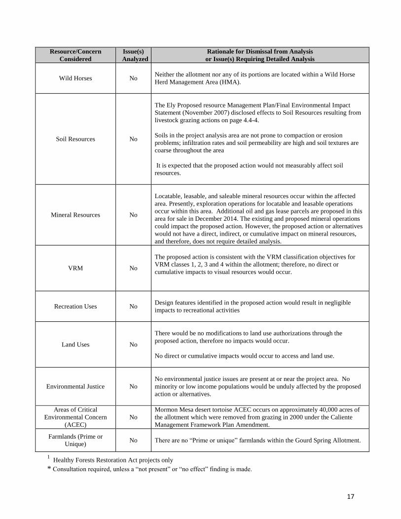
3.2 Resources/Concerns Considered for Analysis - Proposed Action
The following items have been evaluated for the potential for significant impacts to occur, either
directly, indirectly, or cumulatively, due to implementation of the proposed action.
Consideration of some of these items is to ensure compliance with laws, statutes or Executive
Orders that impose certain requirements upon all Federal actions. Other items are relevant to the
management of public lands in general and to the Ely BLM in particular.
Resource/Concern
Considered
Issue(s)
Analyzed
Rationale for Dismissal from Analysis
or Issue(s) Requiring Detailed Analysis
Air Quality No
Air quality in Lincoln County is classified by the State of Nevada as being
“unclassifiable” since no monitoring has been conducted to determine the
classification and National Ambient Air Quality Standards; violations would
not otherwise be expected in the county.
The proposed action would not have a measurable affect the air quality of
Lincoln County. Any dust created would be expected to be ephemeral.
Cultural Resources No
Impacts from livestock grazing on Cultural Resources are analyzed on page 4.9-
5 of the Ely Proposed Resource Management Plan/Environmental Impact
Statement (November 2007).
A findings for Cultural Resources Needs Assessment was completed. All range
improvements, surface disturbing projects, and changes in grazing patterns that
will concentrate grazing and may create impacts related to this permit will be
subject to Section 106 review and, if needed, SHPO consultation as per the
BLM Nevada's implementation of the Protocol for cultural resources.
There are no known conflicts between current grazing practices and cultural
resources within the allotment associated with this permit renewal. The
proposed action will not cause the loss or destruction of significant scientific,
cultural or historical resources. The Bureau of Land Management reserves the
right to expeditiously mitigate or eliminate impacts to cultural resources
discovered after this permit is issued.
Paleontological Resources No
No currently identified paleontological resources are present in the project area.

14
Resource/Concern
Considered
Issue(s)
Analyzed
Rationale for Dismissal from Analysis
or Issue(s) Requiring Detailed Analysis
Native American Religious
Concerns and other
concerns
No
Letters notifying Native American Tribes of proposed term grazing permit
renewals scheduled for 2012/2013 were sent out on June 15, 2012 for a 30 day
comment period. The Gourd Spring Allotment was included in the notification.
No concerns were identified.
Direct impacts and cumulative impacts would not occur, because there were no
identified concerns through coordination.
Noxious and Invasive
Weed Management No
Livestock grazing has the potential to spread noxious and invasive weeds. On
May 18, 2013 a Weed Risk Assessment was completed for this project
(Appendix IV).
The design features of the proposed action, in addition to the vigilant practices
described in the Noxious Weed Risk Assessment, will help prevent livestock
grazing from spreading noxious and non-native, invasive weeds.
No additional analysis is needed.
Vegetative Resources Yes
Impacts from livestock grazing on Vegetation Resources were analyzed on page
4.5-9 in the Ely Proposed Resource Management Plan/Environmental Impact
Statement (November 2007). Beneficial impacts to vegetative resources are
consistent with the need and objectives for the proposed action.
This resource has been further analyzed in the EA.
Rangeland Standards and
Health Yes
Impacts from livestock grazing on Rangeland Standards and Health are
analyzed on pages 4.16-3 through 4.16-4 of the Ely Proposed Resource
Management Plan/Environmental Impact Statement (November 2007).
Beneficial impacts to rangeland standards and health are consistent with the
need and objectives for the proposed action.
Analysis of the proposed action and alternatives is provided in the affected
environment and environmental impacts sections of this EA.
Grazing Uses Yes
Livestock grazing is analyzed in this EA.
Forest Health1 No
There are no woodlands located in the Gourd Spring Allotment.
Wastes, Hazardous or Solid No
No hazardous or solid wastes exist on the permit renewal area, nor would any
be introduced by the proposed action or alternatives.
Wilderness Yes The west portion of the allotment (about 13%) is in the Mormon Mountain
Wilderness.
Lands with Wilderness
Characteristics No
In the original 1979/1980 wilderness characteristics inventory, 12 units were
inventoried which overlap the Gourd Spring allotment, one of which was found
to possess wilderness characteristics. It was designated in 2004 as the Mormon
Mountains Wilderness.
In the 2011-2014 inventory update, 11 units extend into the allotment, of which
two inventory units found to possess wilderness characteristics based on the
adjacent wilderness. One other unit was found to possess wilderness
characteristics on its own merit. There are no anticipated impacts to Size,

15
Resource/Concern
Considered
Issue(s)
Analyzed
Rationale for Dismissal from Analysis
or Issue(s) Requiring Detailed Analysis
Solitude or Primitive forms of Recreation from the proposed action, no action
or no grazing alternatives. Special Designations other
than Designated
Wilderness
No No Special Designations occur within the project area.
Wetlands/Riparian Zones No No riparian areas occur on public land in the analysis area.
Water Quality,
Drinking/Ground No
The Ely Proposed Resource Management Plan/Final Environmental Impact
Statement (November 2007) disclosed effects to Water Resources from
livestock grazing on page 4.3-5.
The proposed action would not affect water quality (surface or groundwater
sources) or drinking water in the project area. No surface water in the project
area is used as human drinking water sources and no impaired water bodies of
the State on Nevada are present in the project area.
Water Resources
(Water Rights) No
The Proposed Action would not affect existing or pending water rights vicinal
to or within the project analysis area.
Floodplains No
The project analysis area is not included on FEMA flood maps. The resource
does not exist in the proposed project area.
Migratory Birds No
The migratory bird species that occur in or near the project area are listed in
Appendix VI.
It is anticipated that the establishment of Allowable Use Levels would aid in
maintaining achievement of the Standards and Guidelines for rangeland health;
thereby, maintaining or improving habitat conditions for all migratory birds of
concern.
There is always a possibility that the nests, and/or developing young, of ground
nesting birds during the spring nesting period could be trampled by cattle.
However, the potential for nest trampling is anticipated to be remote and upon
occurrence, would be limited to an occasional individual or nest. If nests were
lost due to trampling, birds would likely re-nest.
Grazing would also reduce the height of existing vegetative structure and cover
to some degree. However, with the establishment of Allowable Use Levels it is
anticipated that vegetative structure and cover would be negligibly affected.
In view of the aforementioned, it is anticipated that negative impacts to
migratory bird populations, as a whole, would be negligible.
U.S. Fish and Wildlife
Service (USFWS) Listed or
proposed for listing
Threatened or Endangered
Species or critical habitat.*
Yes
Impacts from livestock grazing on Special Status Species, including Threatened
and Endangered Species were analyzed on pages 4.7-28 through 4.7-33in the
Ely Proposed Resource Management Plan/Environmental Impact Statement
(November 2007).
Species (plant and animal) that occur in or near the project area are listed in
Appendix VI.

16
Resource/Concern
Considered
Issue(s)
Analyzed
Rationale for Dismissal from Analysis
or Issue(s) Requiring Detailed Analysis
The allotment contains habitat for the federally threatened Agassiz’s desert
tortoise (Gopherus agassizii) (Appendix I, Map #2). Formal section 7
consultation for this species is being pursued.
The aforementioned species is analyzed in detail in this EA.
Special Status Plant
Species, other than those
listed or proposed by the
USFWS as Threatened or
Endangered
Yes
Impacts from livestock grazing on Special Status Species, including Threatened
and Endangered Species were analyzed on pages 4.7-28 through 4.7-33in the
Ely Proposed Resource Management Plan/Environmental Impact Statement
(November 2007).
Plant species that occur in or near the project area are listed in Appendix VI.
The allotment contains a population of the BLM sensitive plant species Las
Vegas buckwheat (Eriogonum corymbosum var. nilesii). The aforementioned
species is analyzed in detail in this EA.
Special Status Animal
Species, other than those
listed or proposed by the
UFWS as Threatened or
Endangered
Yes
Impacts from livestock grazing on Special Status Species, including Threatened
and Endangered Species were analyzed on pages 4.7-28 through 4.7-33in the
Ely Proposed Resource Management Plan/Environmental Impact Statement
(November 2007).
Wildlife species that occur in or near the allotment are listed in Appendix VI.
The allotment contains the following BLM sensitive species:
desert bighorn sheep (Ovis canadensis nelsoni), banded Gila monster
(Heloderma suspectum cinctum), golden eagle (Aquila chrysaetos); Brewer’s
sparrow (Spizella breweri), LeConte’s thrasher (Toxostoma lecontei),
loggerhead shrike (Lanius ludovicianus), western burrowing owl (Athene
cunicularia), and sage thrasher (Oreoscoptes montanus).
The aforementioned species are analyzed in detail in this EA.
Fish and Wildlife No
There are no lentic or lotic riparian areas located within the Gourd Spring
Allotment on BLM managed lands. Therefore, there are no fish within the
allotment.
Wildlife species – including sensitive species – that occur in or near the project
area are listed in Appendix VI.
Impacts from livestock grazing on Fish and Wildlife are analyzed on pages 4.6-
10 through 4.6-11 in the Ely Proposed Resource Management Plan/Final
Environmental Impact Statement (November 2007).
Grazing would reduce the amount of available forage (grass and forbs);
however, compliance with Ely Resource Management Plan standards for
utilization percentages ensures that forage is present in the allotment after cattle
are removed.
The allotment contains general habitat for mule deer (Odocoileus hemionus),
small mammals and reptiles. No population level impacts are anticipated to
these species.
Therefore, it is anticipated that the proposed action would have no a measurable
affect this resource.
17
Resource/Concern
Considered
Issue(s)
Analyzed
Rationale for Dismissal from Analysis
or Issue(s) Requiring Detailed Analysis
Wild Horses No
Neither the allotment nor any of its portions are located within a Wild Horse
Herd Management Area (HMA).
Soil Resources No
The Ely Proposed resource Management Plan/Final Environmental Impact
Statement (November 2007) disclosed effects to Soil Resources resulting from
livestock grazing actions on page 4.4-4.
Soils in the project analysis area are not prone to compaction or erosion
problems; infiltration rates and soil permeability are high and soil textures are
coarse throughout the area
It is expected that the proposed action would not measurably affect soil
resources.
Mineral Resources No
Locatable, leasable, and saleable mineral resources occur within the affected
area. Presently, exploration operations for locatable and leasable operations
occur within this area. Additional oil and gas lease parcels are proposed in this
area for sale in December 2014. The existing and proposed mineral operations
could impact the proposed action. However, the proposed action or alternatives
would not have a direct, indirect, or cumulative impact on mineral resources,
and therefore, does not require detailed analysis.
VRM No
The proposed action is consistent with the VRM classification objectives for
VRM classes 1, 2, 3 and 4 within the allotment; therefore, no direct or
cumulative impacts to visual resources would occur.
Recreation Uses No
Design features identified in the proposed action would result in negligible
impacts to recreational activities
Land Uses No
There would be no modifications to land use authorizations through the
proposed action, therefore no impacts would occur.
No direct or cumulative impacts would occur to access and land use.
Environmental Justice No
No environmental justice issues are present at or near the project area. No
minority or low income populations would be unduly affected by the proposed
action or alternatives.
Areas of Critical
Environmental Concern
(ACEC)
No
Mormon Mesa desert tortoise ACEC occurs on approximately 40,000 acres of
the allotment which were removed from grazing in 2000 under the Caliente
Management Framework Plan Amendment.
Farmlands (Prime or
Unique) No
There are no “Prime or unique” farmlands within the Gourd Spring Allotment.
1 Healthy Forests Restoration Act projects only
* Consultation required, unless a “not present” or “no effect” finding is made.

18
An analysis of grazing impacts on the following resources – noted in the above table as being
negligibly affected – may be found in the Ely Proposed Resource Management Plan/Final
Environmental Impact Statement (November 2007) on the noted pages: Cultural Resources
(page 4.9-5); Water Quality, Drinking/Ground (page 4.3-5); Fish and Wildlife (pages 4.6-10
through 4.6-11); and Soil Resources (page 4.4-4). Consequently, these resources do not require a
further detailed analysis.
3.3 Resources/Concerns Analyzed
The following resources were assigned a “Yes” under the “Issue(s) Analyzed” column in the
above table and have been identified by the BLM interdisciplinary team as resources within the
affected environment that merit a detailed analysis: Vegetative Resources; Rangeland Standards
and Health; Grazing Uses; USFWS Listed or proposed for listing Threatened or Endangered
Species or critical habitat; Special Status Plant Species, other than those listed or proposed by the
USFWS as Threatened or Endangered and Special Status Animal Species other than those listed
or proposed by the USFWS as Threatened or Endangered. An analysis of grazing impacts on the
former two resources may also be found in the Ely Proposed Resource Management Plan/Final
Environmental Impact Statement (November 2007) (Volume II), on the following noted pages:
Vegetative Resources (page 4.5-9); Rangeland Standards and Health (pages 4.16-3 through 4.16-
4); Special Status Species, including Threatened and Endangered Species (pages 4.7-28 through
4.7-33).
3.3.1 Vegetative Resources; Rangeland Standards and Health; Grazing Uses
3.3.1.1 Affected Environment
Sections 1.1, 2.1 and 3.1 describe and/or reference basic information about the Gourd Spring
Allotment.
As described under section 1.2, an assessment of livestock grazing management and rangeland
health on the allotment, in the form of a SDD was completed in conjunction with the permit
renewal process (Appendix II).
The assessment indicated that Standards 1 and 3, and the upland portion of Standard 2 are not
being achieved. The riparian portion of Standard 2 is not applicable. Spring rest will be
accomplished through adaptive management and manipulation of water sources to allow a
deferred rotation within the allotment.
3.3.1.2 Environmental Consequences
Proposed Action
The Proposed Action is to change the current utilization levels from 50% of current year’s
growth to 40% of current year’s growth, with grazing authorizations being based on annual
forage availability. Spring rest will be accomplished through adaptive management and
manipulation of water sources to allow a deferred rotation of areas within the allotment.

19
This would favor plant growth and seed set requirements in cool and warm season grasses. It
would also allow the potential for grazed cool season plants, which may have begun some spring
growth, to continue growth which would aid in allowing such plants: to develop above ground
biomass to protect soils and provide desirable perennial cover for wildlife; to contribute to litter
cover; and to continue to develop root masses which would lend itself to improved carbohydrate
storage for vigor and reproduction.
Consequently, the benefits to plant physiology, added soil protection and wildlife cover would be
enhanced; the plant quality and volume of existing forage species would be promoted; and the
potential for loss of desired plant species, due to repeated grazing during the critical growing
period for plants, would decline. Summarily, this would impact the desired forage base in a
positive manner.
With the availability to use “temporary nonrenewable forage” during those years with abundant
annual grass production it is anticipated that the fine fuel build up will be somewhat reduced in
reference to fire. This will reduce the fire starts and if a fire were to be ignited in the area it
would help in reducing the spread and intensity of the fire, thus benefiting the habitat for the
desert tortoise.
A concentrated influence on vegetation, vicinal to water troughs, is expected due to typical
ungulate behavior associated with point water sources. Typically, there is an area immediately
surrounding the troughs where soil and vegetation is the most affected as a result of cattle
trampling and/or grazing while drinking. Varying degrees of grazing use/trampling subsequently
occurs, in a radial pattern, with such affects decreasing as distance from the watering source
increases.
However, having existing permanent watering haul locations spread throughout the Gourd
Spring Allotment provides a means to help control livestock. Strategically using multiple
watering locations during a grazing season can improve livestock distribution to achieve a more
uniform utilization level within the allotment. This will be critical in reducing fuel continuity
and fire intensity and severity.
Seasonal rotation of watering locations – whereby, those locations used during one grazing
season are not used during the next – provides the benefit of allowing the periodic rest of areas
directly influenced by point water sources with regards to trampling and levels of grazing use.
Creating a more uniform utilization level within the portion of the allotment being grazed,
coupled with the periodic rest resulting from the seasonal rotation of watering locations, should
result in achieving/maintaining enhanced forage production, ground cover, plant vigor and
overall range condition. In addition, the potential for unacceptable utilization levels can be
dramatically reduced; while providing benefits to wildlife regarding not only forage and cover,
but additional water availability during the livestock grazing season.
The Nevada Department of Wildlife (NDOW) developed and completed a statewide
Comprehensive Wildlife Conservation Plan in September 2012. The plan was approved by the
USFWS on March 1, 2013 (Wildlife Action Plan Team 2013). It serves as a comprehensive,
landscape level plan, identifying the species of greatest conservation need and the key habitats
on which they depend, with the intent to prevent wildlife species from becoming threatened or
endangered.

20
According to the Nevada Wildlife Action Plan, range improvements resulting in better
distribution of livestock can reduce impacts. The plan notes: “Livestock facilities such as
springs developments, water pipelines, and fencing have distributed livestock use over areas that
were sporadically or lightly used prior to agricultural development. Distribution of livestock
over a greater area, can also reduce impacts associated with concentrated livestock – trampling,
soil compaction, eroding trails, etc.”
The Nevada Wildlife Action Plan goes on to discuss habitat benefits of water developments
further: "The presence of livestock water developments can also improve the quality of
surrounding habitat, allowing wildlife species to expand into previously unoccupied areas.
Pronghorn antelope generally require permanent water sources at intervals of less than five miles
within their home range. Ranchers have become increasingly interested in, with the help of
various federal programs, developing water systems that are wildlife friendly (e.g., wildlife
escape ladders, using structures of different size, shape or position to enhance wildlife use).
Strategically placed water developments that are managed to eliminate excessive diversion and
that incorporate wildlife friendly features can be used to enhance rangeland for both livestock
and wildlife. Food, cover, and space are habitat needs for both wildlife and livestock. Grazing
management can be focused to managing livestock in a manner that supports these basic habitat
elements while maintaining native plant community integrity – the plant communities to which
native wildlife have adapted.”
The installation and maintenance of wildlife escape ramps in all water troughs would allow a
means of escape for wildlife.
It is anticipated and reasonable to expect, then, that Standards 1, 3 and the upland portion of
Standard 2 would move toward being achieved.
The Proposed Action would also add other terms and conditions (BMPs) to the permit that would
aid in achieving/maintaining the Mojave-Southern Great Basin Standards. In changing the
allowable use levels from 50% to 40% of the annual growth would help the native perennial
vegetation maintain vigor and assist in storage of nutrients in the root systems thereby aiding in
plant vigor and health.
No Action Alternative
All of the mandatory terms and conditions of the current permit, as displayed under section 2.1.1,
would remain unchanged.
Also under the no action alternative, the standard terms and conditions referenced under 2.1.2 in
the Proposed Action and in Appendix III of this EA - which further assist in maintaining the
Standards and Guidelines for Grazing Administration in addition to other pertinent land use
objectives for livestock use - would not be included in the new permit.
The range improvements, such as the addition of watering locations, would not be implemented
under the no action alternative. Better livestock distribution would not be achieved under this
alternative.

21
In addition, all the terms and conditions from the Programmatic Biological Opinion (PBO),
intended to minimize incidental take of the desert tortoise, would not be included in the new
permit. This would ignore PBO directives (and the efforts associated with threatened and
endangered species consultation with the U.S. Fish and Wildlife Service) designed to mitigate
impacts to the desert tortoise; and, could subsequently have negative impacts on the currently
listed species.
The ability to use grazing as a management tool to help reduce fine fuels by increasing grazing
use during years of high annual grass production, while targeting weed species, when such
species are most palatable and vulnerable to grazing would be lost.
In summary, all of the benefits listed under the Environmental Consequences for the Proposed
Action would not occur.
No Grazing Alternative
For a short period of time following implementation, this may accomplish the same desired
result as allowing periodic rest during the critical growing period for plants as presented under
the proposed action by allowing perennial forage plants rest during the vital phonological stages
of their annual growing cycle. However, according to studies this benefit would be relatively
short-lived.
In fact it is realized in the scientific community that, over time and without outside influences
such as fire, grasses may become wolfy from lack of grazing use. If this occurs, substantial
forage can become wasted, because current year’s growth is intermixed with older, cured
materials that are nutritionally deficient and present a physical barrier to grazing animals. Such
plants would also lose vigor and become less palatable, thereby contributing to less productive
rangelands for either wildlife or domestic livestock that depend on such a forage base.
Anderson (1993) elaborated on the consequences of choosing a No Grazing option. He states:
“After a period of time, ungrazed herbaceous fibrous-rooted plant species become decadent or
stagnant. Annual above-ground growth is markedly reduced in volume and height. Root systems
likely respond the same. The result is reduction in essential features of vegetational cover,
including the replacement of soil organic matter and surface residues, and optimum capture of
precipitation.” He also lists two other consequences: “(1) loss of quality herbaceous forage for
wild herbivores, causing them to move to areas where regrowth following livestock grazing
provides succulent forage (Anderson 1989), and (2) increased hazard from wildfires that can be
devastating, from a rangeland watershed standpoint.” This is due to accumulating fine fuels
which remain on the land over several years, in this environment, unless eaten or trampled into
the soil.
Courtois et. al. (2004) found that 65 years of protection from grazing on 16 exclosures, at
different locations across Nevada, resulted in relatively few differences between vegetation
inside the exclosures and that exposed to moderate grazing outside the exclosures. Where
differences occurred, total vegetation cover was greater inside the exclosures while density was
greater outside the exclosures. Protection from grazing failed to prevent expansion of cheatgrass
into the exclosures (Ely PRMP/FEIS pg. 4.5–27).

22
The no grazing alternative was also considered and analyzed in the Ely Proposed Resource
Management Plan/Final Environmental Impact Statement (November, 2007) which is addressed
below. However The RMP did not go into depth on the altered ecosystem due to the 2005 fires
and the resulting type change from a desert shrub community to an annual grass community for
portions of the Mojave Desert. This type change has shown to be more receptive to repeat fires
which further erode the native desert plant community be eliminating the seed bank and re-
burning the sprouting native plants. The no grazing alternative would allow the invasive grasses
to grow without restriction adding to the continuity of fine fuels which could potentially add to
fire starts and fire growth. When looking at the Mormon Peak allotment to the west of Gourd
Spring we have a good comparison of an allotment with “No Grazing” use and the Gourd Spring
allotment with “seasonal use”. There are little measurable differences in vegetation on the
burned areas of the two allotments.
3.3.2 USFWS Listed or proposed for listing Threatened or Endangered Species or
critical habitat; and Special Status Animal Species other than those listed or
proposed by the USFWS as Threatened or Endangered
3.3.2.1 Affected Environment
The Gourd Spring allotment is located within habitat for the federally threatened Agassiz’s
desert tortoise (Gopherus agassizii). The allotment also contains approximately 39,643 acres of
the Mormon Mesa ACEC and 401 acres of the Beaver Dam Slope ACEC, which were closed to
grazing in 2000. There are 2,383 acres of desert tortoise critical habitat in the Beaver Dam Slope
Critical Habitat Unit and 579 acres of desert tortoise habitat in the Mormon Mesa Critical
Habitat Unit in the allotment, primarily located on the southern and eastern portions of the
allotment.
The allotment is located within the desert tortoise Northeast Mojave Recovery Unit (NE RU).
Line Distance Sampling (LDS) desert tortoise density estimates in the last ten years for the NE
RU range from 0.84 to 3.4 tortoises/km2 (Table 3.3.2.1.a.).
Table 3.3.2.1.a. Desert Tortoise Density Estimates for NE RU
Area Year Density (km2) Std Error
NE RU 2002 0.84 0.476
NE RU 2003 3.01 0.465
NE RU 2004 1.42 0.342
NE RU 2005 2.15 0.400
NE RU 2007 1.7 25.0 = CV
NE RU 2008 0.9 28.3 = CV
NE RU 2009 3.4 34.0 = CV
23
NE RU 2010 3.2 15.8 = CV
NE RU 2011 3.4 21.3 = CV
NE RU 2012 3.4 20.1 = CV
CV=Coefficient of Variance
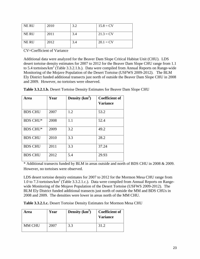
Additional data were analyzed for the Beaver Dam Slope Critical Habitat Unit (CHU). LDS
desert tortoise density estimates for 2007 to 2012 for the Beaver Dam Slope CHU range from 1.1
to 5.4 tortoises/km2 (Table 3.3.2.1.b.). Data were compiled from Annual Reports on Range-wide
Monitoring of the Mojave Population of the Desert Tortoise (USFWS 2009-2012). The BLM
Ely District funded additional transects just north of outside the Beaver Dam Slope CHU in 2008
and 2009. However, no tortoises were observed.
Table 3.3.2.1.b. Desert Tortoise Density Estimates for Beaver Dam Slope CHU
Area Year Density (km2) Coefficient of
Variance
BDS CHU 2007 1.2 53.2
BDS CHU* 2008 1.1 52.4
BDS CHU* 2009 3.2 49.2
BDS CHU 2010 3.3 28.2
BDS CHU 2011 3.3 37.24
BDS CHU 2012 5.4 29.93
* Additional transects funded by BLM in areas outside and north of BDS CHU in 2008 & 2009.
However, no tortoises were observed.
LDS desert tortoise density estimates for 2007 to 2012 for the Mormon Mesa CHU range from
1.0 to 7.3 tortoises/km2 (Table 3.3.2.1.c.). Data were compiled from Annual Reports on Range-
wide Monitoring of the Mojave Population of the Desert Tortoise (USFWS 2009-2012). The
BLM Ely District funded additional transects just north of outside the MM and BDS CHUs in
2008 and 2009. The densities were lower in areas north of the MM CHU.
Table 3.3.2.1.c. Desert Tortoise Density Estimates for Mormon Mesa CHU
Area Year Density (km2) Coefficient of
Variance
MM CHU 2007 3.3 31.2

24
MM CHU 2008 1.9 38.0
MM2 CHU* 2008 1.0 44.1
MM CHU 2009 7.3 37.7
MM2 CHU* 2009 2.4 49.4
MM CHU 2010 5.5 20.7
MM CHU 2011 6.3 33.21
MM CHU 2012 4.3 30.03
* Additional transects funded by BLM in areas outside and north of MM CHU in 2008 & 2009.
BLM desert tortoise triangular transects (surveyed in 1980s to 1990) estimated tortoise densities
from very low to low in this allotment.
The proposed pipeline extension, livestock water development, holding tank at the Horse Spring
water haul, and temporary water haul locations to be converted to permanent water haul
locations would be located within desert tortoise habitat. The gap fences to be maintained and/or
replaced would also be located within desert tortoise habitat.
3.3.2.2 Environmental Consequences
Proposed Action
The Revised Recovery Plan for the Mojave Population of the Desert Tortoise (2011), states
under Recovery Action 2.16 (minimize impacts to tortoises from livestock grazing): “Grazing by
livestock (cattle and sheep) affects desert tortoises through crushing animals or their burrows,
destroying or altering vegetation (which may introduce weeds and change the fire regime),
altering soil, and competition for food (Boarman 2002). There is currently no evidence that
cattle grazing will restore habitat or prevent fire in Mojave Desert environments.”
The Revised Recovery Plan goes on to recommend: “The [U.S. Fish and Wildlife] Service
should work to assist grazing managers to develop experimental application of more flexible
grazing practices, such as allowing or reducing grazing during specific times of the year (e.g.,
after ephemeral forage is gone or winter only) or under certain environmental conditions (e.g.,
following a specified minimum amount of winter rain), in order to investigate the compatibility
of grazing with desert tortoise populations.” The Revised Recovery Plan identifies outside of
desert tortoise conservation areas as the most appropriate areas to collect data on these sorts of
experimental applications.
Some management actions recommended in the Revised Recovery Plan are incorporated into the
proposed action for the Gourd Spring allotment, such as: removing trespass cattle, monitoring,
and prohibiting supplemental feeding.
The introduction of new watering locations and the extension of a water pipeline in the allotment
has the potential to relieve grazing pressure within portions of desert tortoise habitat by

25
displacing livestock to the areas serviced by the waters. Additionally, the strategic use of
multiple watering locations during the grazing season by the permittees should improve livestock
distribution to achieve a more uniform utilization level within the allotment. This would
potentially further decrease overall impacts to the soil and plant resources, including desert
tortoise habitat. In addition, the potential for unacceptable utilization levels would be reduced
due to the better distribution of livestock. This would provide benefits to wildlife with more
forage and cover.
Maintenance and/or repairs of gap fences would benefit desert tortoise habitat within the ACEC.
These gap fences could offer a measure of protection to the desert tortoise population within the
ACEC and the Mormon Mesa CHU, which has higher densities than the non-critical desert
tortoise habitat.
The terms and conditions listed in the Proposed Action would minimize impacts to desert
tortoise and its associated habitat. For example, a 40% utilization limit on vegetation would
benefit vegetative thermal cover and forage species for tortoise.
In Boarman’s Threats to Desert Tortoise Populations: A Critical Review of the Literature
(2002), he summarizes livestock grazing as a threat to desert tortoise in the following way:
“Surprisingly little information is available on the effects of grazing on the Mojave Desert
ecosystem (Oldemeyer 1994, Rundel and Gibson 1996, Lovich and Bainbridge 1999).
Differences in rainfall patterns, nutrient cycling, and foraging behavior of herbivores and how
these three factors interact make applications of research from other areas of limited value in
understanding the range ecology of the Mojave Desert. The paucity of information is surprising
given the controversy surrounding grazing in the Mojave and the importance of scientific
information for making resource management decisions affecting grazing. Studies, mostly from
other arid and semi-arid regions tells us that grazing can alter community structure, compact soil,
disturb cryptogamic soils, increase fugitive dust and erosion. Some impacts to tortoises or their
habitat have been demonstrated, but the evidence is not overwhelming.”
BLM sent a memorandum to the U.S. Fish and Wildlife Service requesting Section 7
consultation, regarding the proposed action, for the federally threatened Agassiz’s desert tortoise
(Gopherus agassizii).
Additionally, with the coordination of the BLM the strategic use of multiple watering locations
during the grazing season, by each permittee, should maintain livestock distribution to achieve a
uniform utilization level within the allotment. When coupled with the introduction of allowable
use levels, it would aid in preventing overall negative impacts to the soil and plant resources
while also allowing grazing to address increased fuel loading from invasive annual plants.
As a result, it would promote the potential for native plants: to develop above ground biomass to
protect soils and provide desirable perennial cover for wildlife; to contribute to litter cover; and
to continue to develop root masses which would lend itself to improved carbohydrate storage for
vigor and reproduction.
Consequently, the following would be promoted: the potential benefits to plant physiology,
added soil protection and wildlife cover; the plant quality and volume of existing forage species;
and the reduction in the potential for loss of desired plant species. As a result, this would
influence the desired forage base in a positive manner.

26
A concentrated influence on vegetation, vicinal to watering locations, is expected due to typical
ungulate behavior associated with point water sources. Typically, there is an area immediately
surrounding the troughs where soil and vegetation is the most affected as a result of cattle
trampling and grazing while drinking. Varying degrees of grazing use/trampling subsequently
occurs, in a radial pattern, with such affects decreasing as distance from the watering source
increases. However, with the establishment of new watering locations, logic dictates that the
overall degree of such impacts should further decline, because of additional water sources
servicing the same number of previously grazed livestock.
Standards 1, 3, and the upland portion of Standard 2 should progress towards achievement as
long as the historic fire regime is maintained. The addition of watering locations and the
increased dispersal of grazing will help to achieve this goal.
The Proposed Action would also add other terms and conditions (BMPs) to the permit that would
aid in maintaining the Mojave-Southern Great Basin Standards: Allowable utilization levels
would be adjusted to not exceed 40% use on key shrub, forb and perennial grasses species.
No Action Alternative
Because authorization of new watering locations would not occur, grazing would not be as well
distributed in this allotment. This could have a negative impact on the plant resources that could
otherwise serve as thermal cover or forage species for the desert tortoise.
All of the mandatory terms and conditions of the current permits, as displayed under section
2.1.1, would remain unchanged.
Under the no action alternative, the standard terms and conditions referenced under 2.1.2 under
the Proposed Action and in Appendix III of this EA - which further assist in maintaining the
Standards and Guidelines for Grazing Administration in addition to other pertinent land use
objectives for livestock use - would not be included in the new permits.
The BMPs listed under 2.1.2, intended to assist in maintaining the Standards, would not be
included in the new permits. Consequently, the setting of allowable use limits; the rotation of
watering locations directed at allowing periodic rest for areas serviced by each watering location;
the strategic use of watering locations, and requirement of herding as needed, directed at yielding
maximum livestock distribution; and the restriction of water hauling to existing roads would not
become integrated into the permits.
Consequently, the benefits to plant physiology and added soil protection, and wildlife cover – as
described under 2.1 of the Proposed Action – would be dramatically reduced; and, the plant
quality and volume of existing forage species could decrease, thereby, impacting the desired
forage base in a negative manner. This would have overall negative impacts on vegetative
resources and the health of the land.
In addition, all other terms and conditions referenced under 2.1.2 – intended to minimize
incidental take of the desert tortoise – would not be included in the new permits. This could
have negative impacts on a currently listed species.

27
The needed range improvements analyzed in this document would not be completed and the
benefits to the resources would not be realized.
No Grazing Alternative
Not grazing the allotment could be beneficial to desert tortoise by eliminating a perceived threat
of grazing in desert tortoise habitat. Grazing is one of the few perceived threats to desert tortoise
that can be managed.
However, the absence of grazing could lead to greater fuel loading and increase fire intensity and
severity. If this fuel loading resulted in wildfires, then the absence of grazing could be
detrimental. The Revised Recovery Plan states: “There is currently no evidence that cattle
grazing will restore habitat or prevent fire in Mojave Desert environments.” Further study would
be needed to determine the long-term consequences of not grazing this area and how the absence
of grazing impacts desert tortoise.
3.3.3 Special Status Plant and Animal Species other than those listed or proposed by the
USFWS as Threatened or Endangered
3.3.3.1 Affected Environment
Plants
Las Vegas buckwheat (Eriogonum corymbosum var. nilesii)The population of Las Vegas
buckwheat within this allotment is in the vicinity of Toquop Wash.
Animals
The allotment contains the following BLM sensitive species: desert bighorn sheep (Ovis
canadensis nelsoni), banded Gila monster (Heloderma suspectum cinctum), golden eagle (Aquila
chrysaetos); Brewer’s sparrow (Spizella breweri), LeConte’s thrasher (Toxostoma lecontei),
loggerhead shrike (Lanius ludovicianus), western burrowing owl (Athene cunicularia), and sage
thrasher (Oreoscoptes montanus).
3.3.3.2 Environmental Consequences
Proposed Action
Plants
The location of the Las Vegas buckwheat population on the Gourd Spring allotment receives
little to no livestock grazing. Livestock from this allotment rarely, if ever, travel east of Toquop
Wash into the far eastern corner of this allotment. The lack of water in this portion of the
allotment limits livestock use as well. The permittee does not encourage his livestock to use this
area with mineral supplements due to the type of forage in this area of gypsum soils. Therefore,
impacts are anticipated to be minimal, if at all. Therefore, this species has been eliminated from
further analysis in this document.
Animals
Golden eagles and loggerhead shrike typically nest at a height greater than what livestock can
reach (3 feet and above), therefore, no direct impacts to this bird species are anticipated.

28
Livestock grazing is generally not listed as a potential threat or conservation issue for the some
of the sensitive bird species that may potentially occur on this allotment, such as the golden eagle
(Ehrlich et al. 1988, Great Basin Bird Observatory 2010, and Paige and Ritter 1999).
Some species show no clear response or a positive response to livestock grazing. For example,
burrowing owls showed positive or mixed responses to grazing (Paige and Ritter 1999 and Saab
et al. 1995). Light to moderate grazing may provide open habitat for loggerhead shrike foraging
(Paige and Ritter 1999). Sage thrasher showed mixed responses to grazing with a positive
response to grazing in two studies and a negative response in one study (Saab et al. 1995).
Overgrazing and high densities of livestock could be a threat to LeConte’s thrasher (Shuford and
Gardali (2008), however the proposed action establishes utilization limits that would minimize
this potential impact.
Brewer’s sparrow is often found within 1,000 m of water (Great Basin Bird Observatory 2010),
therefore, the additional waters in the Proposed Action may be beneficial to this species.
Due to their lower nest locations (Ehrlich et al. 1988), Western burrowing owl, Brewer’s
sparrow, sage thrasher, and LeConte’s thrasher may experience individual impacts from grazing,
but no population-level effects are anticipated from the Proposed Action.
Studies on dietary overlap between desert bighorn sheep and cattle vary. One study between
desert bighorn sheep and cattle in the Virgin Mountains of the northern Mojave Desert in
Arizona did not find forage competition to be apparent (Morgart 1990). However, according to
Nevada Department of Wildlife’s (NDOW) Bighorn Sheep Management Plan (2001), it is
important that bighorn sheep habitats are maintained in good to excellent ecological condition
because livestock directly compete with bighorns for forage, water, and space. The current
condition of this habitat is unknown. The proposed action is designed to maintain or move
toward good to excellent ecological condition, therefore minimizing effects to desert bighorn
sheep.
Very few studies have shown disease transmission between desert bighorn sheep and cattle as an
issue. Experiments that put bighorn sheep in contact with species that were not domestic sheep
(i.e. cattle, horses, elk, etc.) do not support a stress or transmission of fatal microbes hypothesis
(Schommer and Woolever 2008).
In a study on ecology and behavior of Gila monsters in southwestern Utah, Beck found that all
shelters used by Gila monsters were in rocky areas (1990). Therefore, trampling of Gila monster
shelters by livestock is unlikely. These lizards spend a large percentage of their time
underground and feed primarily on eggs and young small mammals taken from nests. Given the
carnivorous diet and secretive nature of Gila monsters, no impacts to this species are anticipated
from the proposed action.
According to the Nevada Wildlife Action Plan (Wildlife Action Plan Team 2013), range
improvements resulting in better distribution of livestock, can reduce impacts, “livestock
facilities such as springs developments, water pipelines, and fencing have distributed livestock
use over areas that were sporadically or lightly used prior to agricultural development.
Distribution of livestock over a greater area can also reduce impacts associated with concentrated
livestock – trampling, soil compaction, eroding trails, etc.”

29
The Nevada Wildlife Action Plan goes on to discuss habitat benefits of water developments
further, "the presence of livestock water developments can also improve the quality of
surrounding habitat, allowing wildlife species to expand into previously unoccupied areas.
Pronghorn antelope generally require permanent water sources at intervals of less than five miles
within their home range. Ranchers have become increasingly interested in, with the help of
various federal programs, developing water systems that are wildlife friendly (e.g., wildlife
escape ladders, using structures of different size, shape or position to enhance wildlife use).
Strategically placed water developments that are managed to eliminate excessive diversion and
that incorporate wildlife friendly features can be used to enhance rangeland for both livestock
and wildlife. Food, cover, and space are habitat needs for both wildlife and livestock. Grazing
management can be focused to managing livestock in a manner that supports these basic habitat
elements while maintaining native plant community integrity – the plant communities to which
native wildlife have adapted.”
In general, terms and conditions (such as a 40% utilization limit on vegetation) incorporated in
the Proposed Action would benefit sensitive species that may occur within the allotment.
No Action Alternative
According to the Nevada Comprehensive Bird Conservation Plan (2010), “Domestic livestock
(cattle and sheep) are a long-established component of most publicly managed lands in
Nevada….Livestock grazing, however, is not invariably harmful to birds, and it may sometimes
be beneficial for achieving particular management objectives.” The Plan concludes that
“overgrazing” may be a conservation concern when it involves the removal of understory
vegetation at sensitive times or leads to permanent changes in vegetation composition and
structure.
Also, under the no action alternative, the terms and conditions listed under 2.1.2 in the Proposed
Action and in Appendix III of this EA would not be included in the new permit. Special status
species and their associated habitats would not benefit from utilization limits (meant to prevent
overgrazing) that are incorporated in the Proposed Action.
No Grazing Alternative
The no grazing alternative would remove any pressure from invasive annual grasses and could
allow fuel loading to increase. Increased fire frequency and severity removes and prevents the
re-establishment of native perennial species. Recovery and survival of perennial habitat
components is dependent on maintaining historic disturbance regimes. If invasive annual grasses
are allowed to flourish without any competitive pressure, fuel loading will eventually lead to
more frequent and more intense fires. Wildfires could be detrimental to sensitive species and
their associated habitats.
3.3.4 Wilderness
3.3.4.1 Affected Environment

30
Approximately 13% (12,690 acres) (GIS) of the allotment occurs within the Mormon Mountains
Wilderness area which encompasses approximately 157,938 acres (Appendix I of the EA for a
map).
Planning related to grazing operations would be guided by the Congressional Grazing Guidelines
(House Report 105-405 Appendix L, 1990); BLM Manual 6340 (Management of Designated
Wilderness Areas (Public)) (dated 7/13/2012); and the Delamar Mountains, Meadow Valley
Range and Mormon Mountains Wilderness Management Plan issued December 16, 2009.
Activities and necessary facilities used to support livestock grazing would be permitted to
continue in wilderness. Two fence lines currently exist within the allotment in wilderness
(Appendix V).
Wilderness character
The four qualities of wilderness character are described in the Wilderness Act of 1964 as:
untrammeled (unhindered and free from modern human control or manipulation), natural,
undeveloped, and outstanding opportunities for solitude or a primitive unconfined form of
recreation. Other features of scientific, educational, scenic or historical value may also be
present.
Untrammeled
Few trammeling activities occur within this wilderness and include management of wildland fire
and weeds, and the presence of wildlife water developments, pipelines and fences.
Natural
The naturalness and primeval character of the wilderness is mostly preserved. Some changes to
the native vegetation composition have occurred, including the introduction of the non-native
annual grass (red brome) over portions of the wilderness.
Undeveloped
There are approximately 2 fence lines within the Gourd Springs allotment in the Mormon
Mountains Wilderness. Range improvements that occur within the Mormon Mountains
Wilderness are identified in Appendix V.
Outstanding opportunities for solitude or a primitive form of recreation
Visitors can enjoy outstanding opportunities for solitude and primitive, unconfined recreation in
the wilderness. The many canyons provide excellent opportunities for solitude as does the sheer
size of the wilderness. Outstanding recreation opportunities for hiking, exploration and camping
are present throughout the area. Only the 14-day stay limit for camping confines primitive
recreational opportunities.
3.3.4.2 Environmental Consequences
Proposed Action
Untrammeled
Trammeling activities would continue in the form of vegetation removal due to livestock
grazing. The potential 25% increase in AUMs for reduction of invasive annual grasses would
increase the trammeling activity; however, this would be offset by improvements in naturalness.
31
Natural
Allowing the “temporary nonrenewable forage” in the amount of 25% above the permitted
AUMs for the reduction of invasive annual grasses would have the potential to improve the
natural quality by reducing red brome.
Undeveloped
Inspection and routine maintenance of range developments within the wilderness would be
accomplished on foot or horseback; therefore, those actions would not impact the undeveloped
quality. Major maintenance or repair for which motorized equipment or mechanized transport
would be authorized (e.g., fence repairs) would negatively impact the undeveloped character for
the duration of the motorized or mechanized use. It is anticipated that the use of motorized
vehicles or mechanical transport would be infrequent and the minimum tool would be
determined through the use of an MRDG. See Appendix V for a list of range developments and
wilderness-specific maintenance information.
Outstanding opportunities for solitude or a primitive form of recreation
Occasionally, visitors may encounter permittees and cattle. However, these impacts would be
fairly low.
No Action Alternative
The term and condition in Section 2.1.2 designed to control permitted range-related specific
activities while mitigating associated impacts within wilderness, as described in BLM Handbook
6340 for grazing facilities, would not be implemented. This would defeat the objective of
striving to meet minimum requirements for the administration of wilderness areas, as set forth in
BLM Manual 6340 (1.6.B.3.c, p. 1-16), in an effort to preserve wilderness character for the
purpose of the Wilderness Act.
Untrammeled
The untrammeled quality of wilderness character would continue to be marginally impacted
through removal of vegetation by livestock grazing.
Natural
Naturalness would not either be degraded or improved under this alternative.
Undeveloped
The potential for an increased frequency of maintenance of the range improvements with
motorized equipment or mechanical transport would exist, thus impacting this quality of
wilderness character for the duration of the use in wilderness life span of the permit.
Outstanding opportunities for solitude or a primitive form of recreation
Occasionally, visitors may encounter permittees and cattle.
No Grazing Alternative
Untrammeled
No grazing would occur on the allotment under this alternative, and thus no trammeling impacts
to the vegetation or soils would occur.
Natural

32
Naturalness would not be impacted as grazing would not be occurring.
Undeveloped
Under the No Grazing Alternative, the undeveloped quality would be improved as range
developments within wilderness are no longer needed, and subsequently removed. Occasional
maintenance of the range developments with motorized equipment or mechanical transport
would not need to occur.
Outstanding opportunities for solitude or a primitive form of recreation
The “outstanding opportunities” quality would be improved over the other two alternatives as no
cattle or permittees would be in the area impacting solitude.
4.0 Cumulative Effects
According to page 36 of the 1994 BLM publication Guidelines for Assessing and Documenting
Cumulative Impacts, the cumulative analysis should be focused on those issues and resource
values where the incremental impact of the Proposed Action results in a meaningful change in
the cumulative effect from other past, present and reasonably foreseeable future actions within
the Cumulative Effects Study Area (CESA). The CESA for this project is defined as the Tule
Desert and Toquop Wash Watersheds. This area was chosen based on natural boundaries, the
special scale of activities, and relevant concerns.
Additionally, the guidance provided in The National BLM NEPA Handbook H-1790-1 (USDOI
2008), for analyzing cumulative effects issues states, “determine which of the issues identified
for analysis may involve a cumulative effect with other past, present, or reasonably foreseeable
future actions. If the proposed action and alternatives would have no direct or indirect effects on
a resource, you do not need a cumulative effects analysis on that resource” (p.57).
A comprehensive cumulative impacts analysis can be found on pages 4.28-1 through 4.36-1 of
the Ely Proposed Resource Management Plan/Final Environmental Impact Statement (November
2007). Also, a more detailed analysis of cumulative impacts in the CESA is located on pages
77-84 of the Ely District Record of Decision and Approved Resource Management Plan signed
August 20, 2008.
4.1 Past Actions
Livestock grazing operations in the planning area developed during the mid to late-1800s. The
Ely PRMP/FEIS summarizes livestock grazing history in the region on pages 3.16–1 to 3.16–3.
Range improvements have occurred on the allotment to improve grazing management and
include fencing and stockwater developments.
Vegetation treatments on the allotment include historic blackbrush burns that were conducted in
the 1950’s and 1960’s, as well as a small out planting conducted following the 2005 fires (see
SDD).
The Ely PRMP/FEIS summarizes wild horse history in the west, specifically on the Ely
District on pages 3.8–1 to 3.8–7. Wild horse use has occurred throughout the project area since
the 1800s.

33
Other past actions include:
Historic mining activities associated with the Viola Mining District.
Invasive species introduction, including tamarisk and annual grasses, have occurred since
European settlement.
Multiple utility corridor rights-of-way have been granted within the CESA (pages 77-84
of the Ely RMP 2008).
Historic fire return interval has been shortened while fire severity has increased due to
invasive species.
Catastrophic fires during 2005 burned an unprecedented approximate total of 38,321acres
– within the Gourd Spring Allotment - according to Landsat measurements.
Records indicate off-road races have occurred in the area since the 1980s and ended in
2009. Races are no longer permitted in the area.
Recreational OHV use occurred in the areas near Mesquite, Nevada.
Well drilling has occurred as part of the Lincoln County Lands Act (LCLA) Groundwater
Project. The wells are currently capped and unused. Other wells are in production for
livestock benefit.
Kern River natural gas pipeline was put in to service in February of 1992.
UNEV petroleum pipeline has been constructed within the utility corridor specified in the
Ely RMP (2008), which is also used by the Kern River Pipeline.
4.2 Present Actions
UNEV petroleum pipeline is being constructed and near completion within the utility
corridor specified in the Ely RMP (2008), which is also used by the Kern River Pipeline.
Recreational OHV use in the CESA including un-permitted OHV events, are on the
increase in the area surrounding Mesquite, Nevada.
Blue Nose mining exploration is currently being pursued in the northern area in relation to
the allotment analyzed. This action has increased traffic in the area as they access the site
from the south through Gourd Spring Allotment.
4.3 Reasonably Foreseeable Future Actions

34
Transwest Express transmission line construction is expected to proceed within the next 6
years.
Installation of water pipeline for LCLA Groundwater Project is expected to occur within
the next 10 years.
LCLA Groundwater Pumping begins for municipal and/or industrial use after completion
of related pipeline and infrastructure.
The disposal of 0-300 acres of land located in the east portion of Gourd Spring Allotment
as described in the Ely RMP (2008) and related to the Toquop power project.
Toquop power generation is proceeding as a 1.2GW natural gas fired plant.
4.4 Cumulative Effects Summary
4.4.1 Proposed Action
Proposed Action
The proposed action in conjunction with the past, present and reasonable foreseeable future
actions would result in no noticeable overall changes to the affected environment. Grazing under
the proposed permit renewal would aid in achievement of the Standards for Rangeland Health,
with the understanding that adjustments to grazing management would occur when any of the
Standards are not being achieved if livestock is the causal factor. Appropriate action would be
taken as soon as practicable but not later than the start of the next grazing year upon determining
that existing grazing management practices or levels of grazing use on public lands are
significant factors in failing to achieve the standards and conform with the guidelines (43 CFR
§4180.2 (c)).
No cumulative impacts of concern are anticipated as a result of the proposed action in
combination with any other existing or planned activity.
Other livestock grazing permits in the CESA also affect the overall rangeland health of the area.
All grazing permits are designed to allow for progress towards achievement or maintenance of
land health standards. If existing livestock grazing management practices are found to be
significant factors in failing to achieve the standards for rangeland health, appropriate action is
taken as soon as practicable or no later than start of the next grazing season (43 CFR 4180.2(c)).
Where the SDDs for the allotments within the CESA found that rangeland health standards were
not being met due to cattle grazing, changes have been made to the related grazing permit.
No Grazing Alternative
The no grazing alternative, in combination with interrelated projects, would not have a
cumulative effect on rangeland health outside of what was analyzed under the no grazing
alternative in section 3.3.1.2.

35
No Action Alternative
This resource would have the same cumulative effect as the proposed action with respect to
cumulative impacts.
No cumulative impacts of concern are anticipated as a result of the proposed action in
combination with any other existing or planned activity.
4.4.2 No Action Alternative
The No Action Alternitive would have the same cumulative effect as the Proposed Action,
above.
4.4.3 No Grazing Alternative
The No Grazing Alternative will not have any cumulative effects on rangeland health.
4.6.2 Special Status Animal Species Habitats
Proposed Action
The proposed action, in combination with interrelated projects, will have the same effect as
discussed in Environmental Consequences section 3.3.1.2.
No Grazing Alternative
The no grazing alternative, in combination with interrelated projects, will have the same effect as
discussed in Environmental Consequences section 3.3.1.2.
No Action Alternative
The no action alternative, in combination with interrelated projects, will have the same effect as
discussed in Environmental Consequences section 3.3.1.2.
4.6.3 Noxious and Invasive Weed Spread
Transportation activities, including existing road maintenance, grazing, recreation, energy and
water development, and wildland fire operations within the CESA can contribute to the chance
of spreading noxious and non-native, invasive weeds. Past activities have facilitated the spread
of non-native, invasive species, especially along transportation routes and drainages.
Establishment of non-native, invasive species has occurred and would likely continue under the
proposed action and other interrelated projects. The spread of non-native invasive species would
be minimized through the measures listed in the Risk Assessment for Noxious and Invasive
Weeds for this project and for other interrelated projects. In addition, the active BLM Ely
District Weed Management Program would minimize the spread of weeds throughout the CESA.

36
5.0 Proposed Mitigation and Monitoring
5.1 Proposed Mitigation
Outlined design features incorporated into the proposed action are sufficient. No additional
mitigation is proposed based on the analysis of environmental consequences.
5.2 Proposed Monitoring
Appropriate monitoring has been included as part of the Proposed Action. No additional
monitoring is proposed as a result of the impact analysis.
6.0 Consultation and Coordination
6.1 List of Preparers - BLM Resource Specialists
Daniel Condie Rangeland Management Specialist/Project Lead
Chris Mayer Supervisory Rangeland Management Specialist
Nick Pay NEPA Coordinator
Alicia Styles Wildlife, Special Status Species, Migratory Birds
Clinton Wertz Soil, Water, Wetlands and Riparian, Floodplains
Cameron Boyce Noxious and Invasive, Non-native Species
Nick Pay Cultural Resources
Elvis Wall Native American Cultural Concerns
Randy Johnson Hazardous & Solid Waste/Safety
Lisa Domina Recreation, Visual Resources
6.2 Persons, Groups or Agencies Consulted
The BLM is in the process of conducting consultation with the U.S. Fish and Wildlife Service,
regarding livestock grazing in desert tortoise habitat. The terms and conditions of the resulting
associated Biological Opinion will be incorporated into the permit.
Public Notice of Availability
The Ely District Office mails an annual Consultation, Cooperation and Coordination (CCC)
letter, for various program areas, to individuals and organizations who have previously expressed
an interest in federal actions on the Ely District. Through the CCC letter, the public has the
opportunity to submit a request to be a interested public for grazing management actions on the
Ely BLM District; and to specify the specific grazing management actions and grazing
allotments in which they are interested. Grazing permittees are automatically included on the
Grazing Interested Public Mailing List for any allotment on which they have a grazing permit.
On June 15, 2012, a letter was sent to local Native American tribes initiating the consultation
compliance process in accordance with Section 106 of the National Historic Preservation Act of

37
1966, as amended. The letter solicited input for various permit renewals scheduled during 2012,
including those on the Gourd Spring Allotment.
On October 11, 2012, the two permittees on the Gourd Spring Allotment (authorization numbers
2703753 and 275108) were each sent a letter informing them of the proposed term grazing
permit renewal process scheduled during 2012-13. Each of the permittees responded that they
would like to be involved in the Term Permit Renewal process.
On January 3, 2013, the aforementioned Ely BLM annual CCC letter was mailed.

38
References
Anderson, E. William. 1993. Prescription grazing to enhance rangeland watersheds.
Rangelands, 15 (1): 31–35.
Beck, D.B. 1990. Ecology and behavior of the Gila monster in southwestern Utah. Journal of
Herpetology 24: 54-68.
Boarman, W.I. 2002. Threats to Desert Tortoise Populations: A Critical Review of the Literature.
USGS Western Ecological Research Center, Sacramento, CA
Courtois, D.R., B.L. Perryman and H.S. Hussein. 2004. Vegetation Changes After 65 Years of
Grazing and Grazing Exclusion. Journal of Range Management 57: 574–582.
Dietz, Harland E. 1989. Grass: the Stockman’s Crop, How to Harvest More of It. Special
Report. Sunshine Unlimited, Inc. 15 pp.
Ehrlich, P.R., D.S. Dobkin, and D. Wheye. 1988. The Birder’s Handbook: A Field Guide to the
Natural History of North American Birds. New York: Simon and Schuster.
Floyd T, Elphick CS, Chisholm G, Mack K, Elston RG, Ammon EM, and Boone JD. 2007.
Atlas of the Breeding Birds of Nevada. Reno: University of Nevada Press.
Great Basin Bird Observatory. 2010. Nevada Comprehensive Bird Conservation Plan, ver. 1.0.
Great Basin Bird Observatory, Reno, NV. Available online at
www.gbbo.org/bird_conservation_plan.html.
Nevada Division of Wildlife. 2001. Bighorn Sheep Management Plan. Nevada Division of
Wildlife, Reno, NV.
Paige, C., and S.A. Ritter. 1999. Birds in a sagebrush sea: managing sagebrush habitats for bird
communities. Partners in Flight Western Working Group, Boise, ID.
Saab, V.A., C.E. Bock, T.D. Rich, and D.S. Dobkin. 1995. Livestock grazing effects in western
North America. Pages 311-353 in T.E. Martin and D.M. Finch, editors, Ecology and
management of Neotropical migratory birds. Oxford University Press, New York.
Schommer, TJ and Woolever, MM. 2008. A review of disease related conflicts between
domestic sheep and goats and bighorn sheep. Gen. Tech. Rep. RMRS-GTR-209 Fort Collins,
CO: U.S. Department of Agriculture, Forest Service, Rocky Mountain Research Station. 16pp.
Shuford, W. D., and Gardali, T., editors. 2008. California Bird Species of Special Concern: A
ranked assessment of species, subspecies, and distinct populations of birds of immediate

39
conservation concern in California. Studies of Western Birds 1. Western Field Ornithologists,
Camarillo, California, and California Department of Fish and Game, Sacramento.
State of Nevada Department of Conservation and Natural Resources. Nevada Natural Heritage
Program. 2006. http://heritage.nv.gov.
Swanson, Sherman, Ben Bruce, Rex Cleary, Bill Dragt, Gary Brackley, Gene Fults, James
Linebaugh, Gary McCuin, Valerie Metscher, Barry Perryman, Paul Tueller, Diane Weaver,
Duane Wilson. 2006. Nevada Rangeland Monitoring Handbook. Second Edition. Educational
Bulletin 06-03.
USDA - NRCS 1997. National Range and Pasture Handbook.
USDI - BLM. 1997. Standards and Guidelines for Nevada’s Mojave-Southern Great Basin Area.
USDOI. 2007. Ely Proposed Resource Management Plan/ Final Environmental Impact
Statement. U.S. Department of the Interior, Bureau of Land Management. BLM/EL/PL-
07/09+1793. DOI No. FES07-40. November 2007.
USDOI. 2008. Ely District Record of Decision and Approved Resource Management Plan. U.S.
Department of the Interior, Bureau of Land Management. BLM/NV/EL/PL-GI08/25+1793.
USDOI, Bureau of Land Management. 2008. National Environmental Policy Act. Handbook
H-1790-1.
USDOI, Bureau of Land Management. 1994. Guidelines for assessing and documenting
cumulative impacts. WO-IB-94-310.
U.S. Fish and Wildlife Service. 2006. Range-wide Monitoring of the Mojave Population of the
Desert Tortoise: 2001-2005 Summary Report. Report by the Desert Tortoise Recovery Office,
U.S. Fish and Wildlife Service, Reno, Nevada.
U.S. Fish and Wildlife Service. 2009. Range-wide Monitoring of the Mojave Population of the
Desert Tortoise: 2007 Annual Report. Report by the Desert Tortoise Recovery Office, U.S. Fish
and Wildlife Service, Reno, Nevada.
U.S. Fish and Wildlife Service. 2011. Revised recovery plan for the Mojave population of the
desert tortoise (Gopherus agassizii). U.S. Fish and Wildlife Service, Pacific Southwest Region,
Sacramento, California. 222 pp.
U.S. Fish and Wildlife Service. 2012. Range-wide Monitoring of the Mojave Population of the
Desert Tortoise: 2008 and 2009 Reporting. Report by the Desert Tortoise Recovery Office, U.S.
Fish and Wildlife Service, Reno, Nevada.

40
U.S. Fish and Wildlife Service. 2012. Range-wide Monitoring of the Mojave Population of the
Desert Tortoise: 2010 Annual Report. Report by the Desert Tortoise Recovery Office, U.S. Fish
and Wildlife Service, Reno, Nevada.
U.S. Fish and Wildlife Service. 2012. DRAFT Range-wide Monitoring of the Mojave Population
of the Desert Tortoise: 2011 Annual Report. Report by the Desert Tortoise Recovery Office, U.S.
Fish and Wildlife Service, Reno, Nevada.
U.S. Fish and Wildlife Service. 2012. DRAFT Range-wide Monitoring of the Mojave Population
of the Desert Tortoise: 2012 Annual Report. Report by the Desert Tortoise Recovery Office, U.S.
Fish and Wildlife Service, Reno, Nevada.
Wildlife Action Plan Team. 2013. Nevada Wildlife Action Plan. Nevada Department of Wildlife,
Reno.

APPENDIX I (EA)
MAP(S)


Gourd Springs Allotment July 18, 2014 Page 45 of 88
APPENDIX II (EA)
STANDARDS DETERMINATION DOCUMENT

Standards and Determinations Document Gourd Springs Allotment
Gourd Spring Allotment 7/18/14 Page 46 of 88
STANDARDS DETERMINATION DOCUMENT
Permit Renewals for Authorization Numbers 275108 and 2703753
On the Gourd Spring Allotment (#01071)
(DOI-BLM-NV-L030-2013-0003-EA)
Standards and Guidelines Assessment
The Mojave-Southern Great Basin Standards and Guidelines for grazing administration were
developed by the Mojave-Southern Great Basin Resource Advisory Council (RAC) and
approved by the Secretary of the Interior on February 12, 1997.
Standards of rangeland health are expressions of physical and biological conditions required for
sustaining rangelands for multiple uses. Guidelines point to management actions related to
livestock grazing for achieving the Standards. Guidelines are options that move rangeland
conditions toward the multiple use Standards. Guidelines are based on science, best rangeland
management practices and public input. Therefore, determination of rangeland health is based
upon conformance with these Standards. Thus Guidelines indicate the types of grazing methods
and practices for achieving the Standards for multiple use, are developed for functional
watersheds and implemented at the allotment level.
This Standards Determination Document evaluates livestock grazing management and
achievement of the Standards and Guidelines for the Gourd Spring Allotment. It does not
evaluate or assess the Standards or Guidelines for Wild Horses and Burros. Publications used in
assessing and determining achievement of the Standards include: Ely Record of Decision and
Approved Resource Management Plan (RMP; Bureau of Land Management 2008); Sampling
Vegetation Attributes(U.S. Forest Service et al. 1996); National Range and Pasture Handbook
Natural Resources Conservation Service (NRCS) 1997; Nevada Rangeland Monitoring
Handbook; Utilization Studies and Residual Measurements (U.S. Forest Service et al.1999);
Nevada Plant List (NRCS 1998); and Major Land Resource Area (MLRA 29 and MLRA 30)
Rangeland Ecological Site Descriptions (NRCS 2002;2003). A complete list of references is
included at the end of this document. These documents are available for public review at the
Caliente Field Office during business hours.
The Gourd Spring Allotment, a land-based allotment having two permittees, is located in
southern Lincoln County, Nevada. It is approximately 50 miles south of Caliente, Nevada and
approximately 10 miles northwest of Mesquite, Nevada (Appendix A, Map #1). It is located
within the Toquop Wash Watershed, and is approximately 97,700 acres in size. Cattle and
horses are the types of livestock grazed on the allotment. Elevations range from approximately
2,400 feet along the eastern boundary to approximately 5,300 feet in the East Mormon
Mountains in the central portion of the allotment.

Standards and Determinations Document Gourd Springs Allotment
Gourd Spring Allotment 7/18/14 Page 47 of 88
Neither the allotment nor any of its portions are located within a Wild Horse Herd Management
Area (HMA) or Wilderness Study Area. However, the western portion of the allotment (about
13,000 acres) is in the Mormon Mountain Wilderness. The allotment also contains habitat for
the federally threatened desert tortoise (Gopherus agassizii) (Appendix A, Map #2). The
Mormon Mesa Area of Critical Environmental Concern (ACEC) includes 39,852 acres of desert
tortoise critical habitat within the allotment. Another 2,981 acres of desert tortoise critical
habitat is located within the allotment but outside of the ACEC boundary. The ACEC acreage
was closed to grazing in 2000 with the signing of the Record of Decision for the Caliente
Management Framework Plan Amendment.
There are three known developed springs (Abe Spring, Gourd Spring and Peach Spring) that
service livestock watering locations on the allotment. There are no riparian areas associated with
these springs. The Sams Camp pipeline provides water to the northern portion of the allotment.
In addition reservoirs are used to collect runoff in favorable years and water hauling is used to
service the rest of the allotment.
Key Areas
Three key areas (KAs) were originally established on the Gourd Spring Allotment in 1981. A
key area is a relatively small portion of a pasture or allotment selected because of its location,
use, or grazing value as a monitoring point for grazing use. It is assumed that key areas, if
properly selected, will reflect the current grazing management over the pasture or allotment as a
whole (NRCS 1997). Key areas represent range conditions, trends, seasonal degrees of use, and
resource production and values.
The key areas, range improvements and water locations are depicted on Map 2 within the Gourd
Spring allotment. Supplemental study sites, also shown on Map 2, were selected to represent
major soil types within the allotment. These study sites are not key areas, but were chosen in
effort to assess recovery of rangeland health in the entire allotment following the 2005 Halfway
Fire, not just key forage or use areas. While these sites are not considered key areas they do
represent major ecological sites on the allotment. The key areas and transects map in Map 2
depicts the locations of these supplemental study sites.
The Key Species Method was used in determining grazing use according to the Nevada
Rangeland Monitoring Handbook (2006). This method is based on percent utilization of current
year’s growth, by weight.
However, due to the fires of 2005 the burned portions of the allotment are lacking in perennial
grasses. These burn areas are represented by Key Areas 1 and 2. The utilization data does not
represent the total forage use. In light of this information field observation in April 2013 found
that livestock are selecting for annual grasses and other invasive species. Research suggests this
may be helping the few perennial species remaining to have an opportunity to produce seed.
Cover data were obtained using Line Point Intercept and Line Intercept Methods. These
methods are described in Monitoring Manual for Grassland, Shrub land and Savanna Ecosystems
(J. Herrick et. al., 2005).

Standards and Determinations Document Gourd Springs Allotment
Gourd Spring Allotment 7/18/14 Page 48 of 88
Permits # 2703753 & 275108 were previously issued under the authority of Section 416, Public
Law 111-88 for the period 3/1/2013 – 9/30/2013. The new grazing permit will reflect terms and
conditions in accordance with the Final EA.
Table 1. Current Term Grazing Permits, with Mandatory Terms & Conditions for the Gourd
Spring Allotment:
ALLOTMENT
Authorization
Num.
LIVESTOCK
GRAZING
PERIOD ** %
Public
Land
AUMs
Name Number * Number Kind Begin End
Active
Use
Hist.
Susp. Use
Total
Use
Gourd
Spring
01071 275108
207 cattle 10/1 5/31 100% 1661 0 1661
9 horses 10/1 5/31 100% 72 72
01071 2703753
207 cattle 10/1 5/31 100% 1661 0 1661
9 horses 10/1 5/31 100% 72 72
* These numbers are approximate
** This is for billing purposes only.
Table 1 shows the authorized use on the Gourd Spring allotment. Annual livestock grazing use
for authorization numbers 275108 and 2703753 on the Gourd Spring Allotment is found in
(Appendix B, Table 1).
Fire History
Since the 1980s several fires have burned portions of the Gourd Spring allotment (see Gourd
Spring fire map). According to Ely District’s fire data several fires have burned over the same
ground within the last 30 years. The management concern on the allotment is that repeat fires
have almost eliminated the native Mojave vegetation in those areas and may be a factor in the
ability to recover to pre-fire Mojave ecosystem. In 2005 the Halfway Fire burned a large portion
of the allotment (38,321 acres) and 7 additional study plots were established to monitor fire
rehabilitation (Map 2).
The Halfway Fire of 2005, the largest fire on the allotment, burned some 38,321 acres within the
allotment. This fire was lightening caused and the primary fuel source was invasive annual
grasses (Bromus spp.). This fine fuel enables rapid fire spread which was exacerbated by winds.
Fire policy and tactics at the time were not well suited for fire in this environment and
constraints were in place due to concern of desert tortoise habitat. The fires of 2005 proved to be
a learning experience for the BLM and the U. S. Fish and Wildlife Service (FWS). The outcome
resulted in changes in firefighting tactics for the Mojave Desert and desert tortoise habitat. Due
to the enormous amount of burned area nationally in 2005, and the lack of suitable seed, there
were no reseeding efforts on the Gourd Spring Allotment.
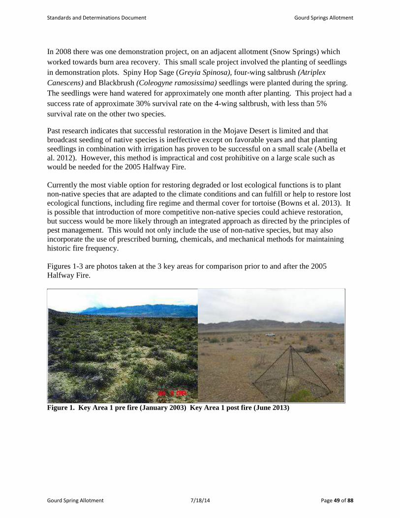
Standards and Determinations Document Gourd Springs Allotment
Gourd Spring Allotment 7/18/14 Page 49 of 88
In 2008 there was one demonstration project, on an adjacent allotment (Snow Springs) which
worked towards burn area recovery. This small scale project involved the planting of seedlings
in demonstration plots. Spiny Hop Sage (Greyia Spinosa), four-wing saltbrush (Atriplex
Canescens) and Blackbrush (Coleogyne ramosissima) seedlings were planted during the spring.
The seedlings were hand watered for approximately one month after planting. This project had a
success rate of approximate 30% survival rate on the 4-wing saltbrush, with less than 5%
survival rate on the other two species.
Past research indicates that successful restoration in the Mojave Desert is limited and that
broadcast seeding of native species is ineffective except on favorable years and that planting
seedlings in combination with irrigation has proven to be successful on a small scale (Abella et
al. 2012). However, this method is impractical and cost prohibitive on a large scale such as
would be needed for the 2005 Halfway Fire.
Currently the most viable option for restoring degraded or lost ecological functions is to plant
non-native species that are adapted to the climate conditions and can fulfill or help to restore lost
ecological functions, including fire regime and thermal cover for tortoise (Bowns et al. 2013). It
is possible that introduction of more competitive non-native species could achieve restoration,
but success would be more likely through an integrated approach as directed by the principles of
pest management. This would not only include the use of non-native species, but may also
incorporate the use of prescribed burning, chemicals, and mechanical methods for maintaining
historic fire frequency.
Figures 1-3 are photos taken at the 3 key areas for comparison prior to and after the 2005
Halfway Fire.
Figure 1. Key Area 1 pre fire (January 2003) Key Area 1 post fire (June 2013)

Standards and Determinations Document Gourd Springs Allotment
Gourd Spring Allotment 7/18/14 Page 50 of 88
Figure 2. Key Area 2 pre-fire (January 2003) Key Area 2 post-fire (June 2013)
Figure 3. Key Area 3 pre-fire (January 2003) Key Area 3 post-fire (June 2013)
The preceding photos illustrate a drastic change in the vegetation at each of these key areas. This
type change is typical in the majority of the burned portions of the allotment. Of note, Key Area
2 was burned in 1992, the photo illustrates some recovery in 2003 but the subsequent fire in 2005
eliminated all native perennial grasses and most of the perennial shrubs from the site. Key Area
3 shows reestablishment of desert peach, purple three awn and big galleta. Higher elevation burn
areas tend to be more resilient and are showing a higher level of recovery.
The following is an analysis of monitoring data which were used to evaluate applied
management practices during the evaluation period. These data were used in determining if such
management practices yielded results that were in conformance with the Mojave - Southern
Great Basin Standards.

Standards and Determinations Document Gourd Springs Allotment
Gourd Spring Allotment 7/18/14 Page 51 of 88
STANDARD 1. SOILS:
“Watershed soils and stream banks should have adequate stability to resist accelerated
erosion, maintain soil productivity, and sustain the hydrologic cycle.”
Soil indicators:
- Ground cover (vegetation, litter, rock, bare ground);
- Surfaces (e.g., biological crusts, pavement); and
- Compaction/infiltration.
Riparian soil indicators:
- Stream bank stability.
All of the above upland indicators have been deemed appropriate to the potential of the
ecological site.
Determination:
Achieving the Standard
Not achieving the Standard, but making significant progress towards meeting the
Standard.
X Not achieving the Standard, not making significant progress towards meeting the
Standard.
Causal Factors:
Livestock are a contributing factor to not meeting the standard.
X Livestock are not a contributing factor to not meeting the standard.
X Failure to meet the standard is related to other issues or conditions.
Guidelines Conformance:
X In conformance with the Guidelines
Not in conformance with the Guidelines
Soil Mapping Units and corresponding Rangeland Ecological Site Descriptions, as determined
by the NRCS, combined with professional field observations were used to determine the
ecological site represented by each key area. Approximately 60% of the allotment which is open
to grazing burned in the “Halfway” Fire in 2005. There has been little recovery in the majority
of the burned area when compared to the Mojave Potential Natural Community (PNC), there has
been a great influx of invasive annual grass (Bromus spp.) with limited re-establishment of the
native perennial grasses. Several shrub species have re-sprouted in the burn including; Nevada
ephedra; desert almond; wolf berry; creosote; and rabbit brush.
The following photos (Figures 4-6) show the vegetation and soil surface characteristics of each
of the key areas (January 2012).

Standards and Determinations Document Gourd Springs Allotment
Gourd Spring Allotment 7/18/14 Page 52 of 88
Figure 4. Key Area 1 showing existing vegetation.
Key Area 1 is located soil map unit 1340 which is described as a Claypan receiving 5-7” of
precipitation. Range site (030XB043NV) Latr/Plri (Larrea tridentate/Pleuraphis rigida) Slopes are 2-
4% with soil surface comprised of gravelly sandy loam.
The range site description allows for a maximum of 3% annual grasses. This site has 80-90%
annual grasses after the fires with minimal shrub re-sprouting and few perennial grasses have re-
established. This site is not showing progress toward meeting the standards.
Figure 5. Key Area 2 showing existing vegetation.
Key Area 2 is located in soil map unit 1300 with a range site of (R030XB029NV_1) Cora/Plri
(Coleogyne ramosissima /Pleuraphis rigida) with shallow gravelly loam and within a 5-8” precipitation
zone.

Standards and Determinations Document Gourd Springs Allotment
Gourd Spring Allotment 7/18/14 Page 53 of 88
This site is highly departed from the ESD, which originally shows a blackbrush site. There is
regeneration of desert almond, wolfberry, ephedra and snakeweed, however there is no recovery
of perennial grasses or blackbrush. This site is not making progress toward meeting the
standard.
Figure 6. Key Area 3 showing existing vegetation.
Key Area 3 is located in soil map unit 1300 with a range site of (R030XB029NV_1) Cora/Plri
containing shallow gravelly loam and within a 5-8” precipitation zone.
Blackbrush is not re-establishing at this site, however shrubs and perennial grasses are re-
establishing at a greater rate when compared to other burned blackbrush sites within the
allotment, see Figure 6 above, which indicate significant progress toward meeting the standard.
Table 2 includes comparison summary of cover data, collected at each key area on the Gourd
Spring Allotment, to the potential natural community (PNC) for the applicable range site.
Table 2. Cover data at Key Areas
Key Area Range Site
Associated Vegetation
Type
% Cover
Collected at
Key Area
% Cover at PNC In
Applicable Rangeland
Site Description
KA-1 * 030XB043NV LATR2/HIRI 2.9%+ 10%-20%
KA-2 *030XB029NV CORA/HIRI 1%+ 20%-35%
KA-3 * 030XB029NV CORA/HIRI 7.5%+ 20%-35%
* Based upon Soil Mapping Units as provided by the Natural Resource Conservation Service (NRCS).
+ Collected in June 2013.
Conclusion: Standard 1 Not achieved

Standards and Determinations Document Gourd Springs Allotment
Gourd Spring Allotment 7/18/14 Page 54 of 88
According to the site description applicable to the key areas, potential ground cover (basal and
crown) should range between 10–35%. As the above table shows, cover values at each key area
is lower than the range listed in the ESD.
An allotment inspection on June 24, 2013 showed that only one key area (KA-3) had adequate
“key species” to take utilization according to protocol. The utilization on big galleta (Pleuraphis
rigida), was at slight to light use levels and on Arpu9 (purple three awn) there was no use. At Key
Area 2 no perennial grasses were present to measure utilization; however two ephedra plants
(Ephedra nevadensis) indicated light to moderate use levels. At Key Area 1 several big galleta
plants were present, the first protected by a cage and the second showing heavy to severe use.
Of the six supplemental study sites (fire monitoring points) visited, two points had no perennial
grasses; two had no utilization on the perennial grasses; one had slight use and one had heavy to
severe use. According to field observation by Caliente Field Office range staff, grazing on the
Gourd Spring Allotment is predominately on annual forage (red brome and red stem storks bill).
Field observations on the allotment have shown that soils were stable, native plants were not
pedestalled and there were no signs of soil compaction. Soil cover (from perennial plants) at all
key areas was less than the “site description”, at present the soils are protected with litter from
the annual grasses which protect the soil from erosion however it does little to aid in the soil’s
nutrient cycling. The soil has little chance to reestablish potential natural community type due to
the presence of invasive annual grasses and their advantageous use of resources and increased
fire return interval which adversely impact the native seed bank.

Standards and Determinations Document Gourd Springs Allotment
Gourd Spring Allotment 7/18/14 Page 55 of 88
STANDARD 2 ECOSYSTEM COMPONENTS:
"Watersheds should possess the necessary ecological components to achieve state water
quality criteria, maintain ecological processes, and sustain appropriate uses."
"Riparian and wetlands vegetation should have structural and species diversity characteristic of
the stage of stream channel succession in order to provide forage and cover, capture sediment,
and capture, retain, and safely release water (watershed function)."
Upland indicators:
Canopy and ground cover, including litter, live vegetation, biological crust, and rock
appropriate to the potential of the ecological site.
Ecological processes are adequate for the vegetative communities.
Riparian indicators:
Stream side riparian areas are functioning properly when adequate vegetation, large
woody debris, or rock is present to dissipate stream energy associated with high water
flows.
Elements indicating proper functioning condition such as avoiding acceleration erosion,
capturing sediment, and providing for groundwater recharge and release are determined
by the following measurements as appropriate to the site characteristics:
- Width/Depth ratio;
- Channel roughness;
- Sinuosity of stream channel;
- Bank stability;
- Vegetative cover (amount, spacing, life form); and
- Other cover (large woody debris, rock).
Natural springs, seeps, and marsh areas are functioning properly when adequate
vegetation is present to facilitate water retention, filtering, and release as indicated by
plant species and cover appropriate to the site characteristics.
Water quality indicators:
Chemical, physical and biological constituents do not exceed the state water quality
standards.
Determination:
Meeting the Standard
Not meeting the Standard, but making significant progress towards meeting the Standard.
X Not meeting the Standard, not making significant progress towards meeting the
Standard.
Causal Factors:
Livestock are a contributing factor to not meeting the standard.
X Livestock are not a contributing factor to not meeting the standard.

Standards and Determinations Document Gourd Springs Allotment
Gourd Spring Allotment 7/18/14 Page 56 of 88
X Failure to meet the standard is related to other issues or conditions.
Guidelines Conformance:
X In conformance with the Guidelines
Not in conformance with the Guidelines
Conclusion: Standard 2
Upland Ecosystem Components – Not Achieved
Riparian Habitat Components – Not Applicable due to development of all water sources
Uplands
Data and field observations relating to soils, hydrologic processes, canopy and ground cover
(including litter and rock) were discussed in Standard 1 which was not achieved. Observed live
vegetation species are discussed in Standard 3.
The unburned portion of the allotment supports a healthy, diverse variety of native shrubs with a
small component of perennial forbs and grasses. The burned portion of the allotment is
dominated by invasive annual grasses. The fluctuating amount of annual grass on the allotment
does help in protecting the soil from rain drop action but does little in the way of nutrient
recycling.
Currently, some ecological processes are functional; soils are stable and are protected from
erosion, forage is available and thermal cover continues to improve for desert tortoise. However,
some ecological processes will continue to be out of balance and a threat to the system as long as
invasive annual grasses dominate the system; altering nutrient cycling and the disturbance
regime. Grazing is the only practical tool currently in use to address unprecedented fuel loading
in the Mojave Desert ecosystem.
Riparian
Not applicable
There are no known riparian areas associated with the three springs within the Gourd Spring
Allotment. Therefore, it would be unlikely that these springs would support riparian species in
its pristine condition. Abe, Gourd and Peach Springs have been highly developed. It should be
noted that Gourd and Peach Springs areas lack saturation at or near the surface and is not
inundated by water at or near the surface. Gourd Spring produces about 1.5 gallons/minute, into
a metal tank located 100 yards down the slope from the spring. (Figures 7 and 8 below) Peach
Spring is not currently providing water at the development. All three springs have been fenced
to exclude livestock.

Standards and Determinations Document Gourd Springs Allotment
Gourd Spring Allotment 7/18/14 Page 57 of 88
Figure 7. Water trough at Gourd Spring
Figure 8. Gourd Spring fenced area

Standards and Determinations Document Gourd Springs Allotment
Gourd Spring Allotment 7/18/14 Page 58 of 88
STANDARD 3 HABITAT AND BIOTA:
"Habitats and watersheds should sustain a level of biodiversity appropriate for the
area and conducive to appropriate uses. Habitats of special status species should be
able to sustain viable populations of those species."
Habitat indicators:
Vegetation composition (relative abundance of species);
Vegetation structure (life forms, cover, height, and age classes);
Vegetation distribution (patchiness, corridors);
Vegetation productivity; and
Vegetation nutritional value.
Wildlife indicators:
Escape terrain;
Relative abundance;
Composition;
Distribution;
Nutritional value; and
Edge-patch snags.
The above indicators shall be applied to the potential of the ecological site.
Determination:
Achieving the Standard
Not achieving the Standard, but making significant progress towards meeting the
Standard.
X Not achieving the Standard, not making significant progress towards meeting the
Standard.
Causal Factors:
Livestock are a contributing factor to not meeting the standard.
X Livestock are not a contributing factor to not meeting the standard.
X Failure to meet the standard is related to other issues or conditions.
Guidelines:
X In conformance with the Guidelines
Not in conformance with the Guidelines

Standards and Determinations Document Gourd Springs Allotment
Gourd Spring Allotment 7/18/14 Page 59 of 88
Allotment monitoring revealed at least 14 perennial species of shrubs; six perennial species of
grass, a variety of perennial forb species, and five different species of cactus distributed in a
patchy network within the allotment. The following table displays these observations.
Table 3. Species diversity list for Gourd Springs Allotment
Shrubs Grasses Forbs Cacti & Yucca
blackbrush
(Coleogyne ramosissima)
big galleta
(Pleuraphis rigida)
desert globemallow
(Sphaeralcea ambigua)
Cholla
(Opuntia spp.)
Cheesebush
(Hymenoclea salsola)
fluffgrass (low whollygrass)
(Dasyochloa pulchella)
desert trumpet
(Eriogonum inflatum)
hedgehog cactus
(Echinocereus
engelmannii)
Turpentine broom
(Thamnosma montana)
Indian ricegrass
(Achnatherum hymenoides)
Buckwheat species
(Eriogonum sp.)
Beavertail
(Opuntia basilaris)
creosote bush
(Larrea tridentata)
Sand dropseed
(Sporobolus sp.)
Penstemon sp.
(Penstemon sp.)
prickly pear
(Opuntia spp.)
Virgin River brittlebush
(Encelia virginensis)
squirreltail
(Elymus elymoides)
Indian paintbrush
(Castilleja sp.)
Barrel cactus
(Ferrocactus
cylindraceus)
Nevada ephedra
(Ephedra nevadensis)
Purple three-awn
(Aristida purpurea)
Evening primrose
(Oenothera sp.)
Indigo bush
(Psorothamnus fremontii)
Desert marigold
(Baileya multiradiata)
banana yucca
(Yucca baccata)
snakeweed
(Gutierrezia spp.)
Mariposa lily
(Calochortus sp.)
Joshua tree
(Yucca brevifolia)
white bursage
(Ambrosia dumosa)
Six weeks fescue
(Vulpia octiflora)
Easterbonnets
(Eriophyllum or
Antheropeas sp.)
Clark Mountains
agave (Agave
utahensis var.
nevadensis)
Desert almond
(Prunus fasciculata)
Red brome
(Bromus madritensis)
Blue dicks
(Dichelostemma capitatum)
Anderson’s wolfberry
(Lycium andersonii)
Gilia species
(Gilia spp.)
spiny hopsage
(Grayia spinosa)
Stork’s bill
(Erodium cicutarium)
Four wing saltbush (Atriplex
canescens)
Pepperweed
(Lepidium sp.)
Paper bag bush
(Salazaria mexicana)
White forget-me-nots
(Cryptantha spp.)
Milkvetches
(Astragalus spp.)
Bristly fiddleneck
(Amsinckia tessellata)
Rattlesnake weed
(Euphorbia or Chamasyce
sp.)
Lupine (Lupinus sp.)
Mustard species
Russian thistle
(Salsola tragus)
Las Vegas buckwheat
(Eriogonum corymbosum
var. nilesii)

Standards and Determinations Document Gourd Springs Allotment
Gourd Spring Allotment 7/18/14 Page 60 of 88
Figure 9. Plant with root damage by rodents.
Figure 9 illustrates a Paperbag bush (Salazaria mexicana) with root damage by rodents, and the
many rodent mounds and trails observed throughout the allotment. No perennial grasses were
found in this area. Native perennial grasses have been impacted by the predation of seed and
seedlings by rodents (Anderson et al 2001).
Conclusion: Standard 3 Not Achieved
Habitat indicators for Standard 3 refer to vegetative composition, structure, distribution,
productivity, and nutritional value. Vegetative conditions on the Gourd Spring Allotment within
the burned portion do not reflect these attributes, however in those portions which have not
burned (approximately 13,000 acres) these attributes are present.
Field observations revealed a diversity of vegetation types that are distributed in a patchy nature
across the landscape within the unburned portions of the allotment. Observations indicate that
species composition for each occurring range site is lacking the perennial grass and shrub
diversity/component within the burned areas of the allotment.
A variety of forb species were noted on the allotment providing a diverse and productive forage
base for livestock and wildlife as well as desert tortoise. Nevada ephedra, bud sagebrush, Indian
ricegrass, galleta and squirreltail are known to be nutritious, palatable plant species for livestock
and wildlife. Desert tortoise use many of the shrubs found on the allotment for thermal cover
and consume a variety of the forbs such as desert globemallow (Sphaeralcea ambigua), desert
trumpet (Eriogonum inflatum), and Easterbonnets (Eriophyllum sp. and Antheropeas sp.; Avery
1998; Burge 1978). The native species present in the unburned areas of the allotment will also
provide a seed source for those portions of the allotment which have burned. Field observations
indicate that cattle prefer foraging on invasive annual species including brome grass, filaree, and
Russian thistle over the perennial grasses. The browsing preference cattle exhibit for non-native
annuals observed by range staff and the permittee favor perennial plants by reducing competition

Standards and Determinations Document Gourd Springs Allotment
Gourd Spring Allotment 7/18/14 Page 61 of 88
for resources, reducing fire severity and allowing for greater productivity. Figure 10 shows a
cage (Study Site #4, Map 2) which has not been moved in two years and shows the accumulation
of fine fuel inside the cage while the area outside the cage shows less accumulation of fine fuel
due to grazing by livestock.
Figure 10. Cage at Study Site 2 with accumulation of fine fuel
An extensive rehabilitation of the area may be required to promote plant productivity and ensure
appropriate vegetative structure and diversity.
The various plant communities within the unburned portion of the allotment provide escape
terrain and thermal cover for wildlife. The southwest end of the allotment shows good re-
establishment of shrub species at the higher elevations of the burned area. The mix of short and
tall statured woody species create perching/nesting habitat for the avian community. These
habitats also offer a desirable environment for a variety of small mammals and reptiles.
PART 2. ARE LIVESTOCK A CONTRIBUTING FACTOR TO NOT MEETING THE
STANDARDS?
Livestock are not a contributing factor to not meeting the standards.
Failure to meet standards is the result of invasive annual grasses which develop abnormal fuel
loading and continuity for the region. The Mojave Desert ecosystem is considered an infrequent
fire-type with a natural fire return interval of greater than 500 years (Brooks 2000). Increased
fuel loading allows for catastrophic high severity fires which result in nearly 100% plant
mortality. Recovery from fire in this arid ecosystem is extremely slow and will be unobtainable
without effectively addressing the increased fire return interval and increased fire severity.
However, even within a historic fire regime, the recovery of blackbrush will not occur given the
current climate regime and these former blackbrush sites will continue to be dominated by

Standards and Determinations Document Gourd Springs Allotment
Gourd Spring Allotment 7/18/14 Page 62 of 88
invasive annuals (Bowns 2013). The introduction of non-native species should be considered as
a restoration technique.
PART 3. GUIDELINE CONFORMANCE REVIEW and SUMMARY
GUIDELINES for SOILS (Standard 1):
See Conclusion for Standard 1, and Part 2 above.
Current livestock grazing management practices conform to Guideline 1.1. The remaining three
Guidelines are not applicable to the assessment area at this time.
GUIDELINES for ECOSYSTEM COMPONENTS (Standard 2):
See Conclusion for Standard 2, and Part 2 above.
Uplands
Current livestock grazing management practices conform to Guidelines 2.3 and 2.4. The
remaining six Guidelines are not applicable to the assessment area at this time.
Riparian
There are three known springs found within the Gourd Spring Allotment, all of which are
developed with pipeline and troughs, they are all fenced to exclude livestock. Therefore,
Standard 2 and associated Guidelines, regarding the riparian portion of this standard, are not
applicable.
GUIDELINES for HABITAT AND BIOTA (Standard 3):
See Conclusion for Standard 3, and Part 2 above.
Current livestock grazing management practices conform to Guidelines 3.1, 3.2, 3.3, 3.4, 3.5 and
3.6. The remaining three Guidelines are not applicable to the assessment area at this time.

Standards and Determinations Document Gourd Springs Allotment
Gourd Spring Allotment 7/18/14 Page 63 of 88
PART 4. MANAGEMENT PRACTICES TO CONFORM WITH GUIDELINES AND
ACHIEVE STANDARDS
Place 40% of AUMS into voluntarily non-use for the management of annual non-native
grasses resulting in fine fuels, while the remaining 60% will remain in Active Use for a
period of 10 years in the Gourd Spring Allotment. Voluntary non-use of AUMs is for
fuels management purposes and is not a permanent revocation of grazing privileges.
Voluntarily non-use AUMs will be determined on an ANNUAL BASIS, and be available
through temporary nonrenewable grazing (§ 4110.3-1 (a)), if resource conditions require
reduction of fine fuels buildup. Annual use of any AUMs in voluntary non-use must be
evaluated by the ID Team and approved by the Authorized Officer.
Maintain the current season of use (10/1-5/31).
Extend the Sam’s Camp pipeline approximately 2 miles east of the East Mormon
Mountains, and north of Toquop Gap, and establish additional watering locations.
Establish test plots of up to 5 acres to determine if desirable perennial plants (native or
introduced) which can be successfully established in this portion of the Mojave Desert.
Establish fire resistant strip plantings to aid in fire control (Harrison et al 2002).
Retain and repair the temporary fence east of the Carp/Elgin road and convert it to a
permanent range improvement, to help in the distribution of livestock.
Construct gap fences on south end of allotment boundary.
Incorporate the following Best Management Practices into the new Term Grazing Permits:
1. Allowable Use Levels on current year’s growth of upland vegetation (perennial grasses,
forbs and shrubs) within the Gourd Spring Allotment will not exceed 40%.
2. Watering locations will be rotated, to better distribute the livestock throughout the
allotment.
3. Water hauling will be limited to existing roads. No roads will be bladed or improved in
any way, with mechanical equipment, without the expressed consent of the authorized
officer.
Measures from the Programmatic Biological Opinion for the Bureau of Land Management’s Ely
District Resource Management Plan (File No. 84320-2008-F-0078):
4. Prior to initiation of an activity within desert tortoise habitat, a desert tortoise awareness
program shall be presented to all personnel who will be onsite, including but not limited

Standards and Determinations Document Gourd Springs Allotment
Gourd Spring Allotment 7/18/14 Page 64 of 88
to contractors, contractors’ employees, supervisors, inspectors, and subcontractors. This
program will contain information concerning the biology and distribution of the desert
tortoise and other sensitive species, their legal status and occurrence in the project area;
the definition of “take” and associated penalties; speed limits; the terms and conditions of
this biological opinion including speed limits; the means by which employees can help
facilitate this process; responsibilities of workers, monitors, biologists, etc.; and reporting
procedures to be implemented in case of desert tortoise encounters or noncompliance
with this biological opinion.
5. Tortoises discovered to be in imminent danger during projects or activities covered under
this biological opinion, may be moved out of harm’s way.
6. Desert tortoises shall be treated in a manner to ensure that they do not overheat, exhibit
signs of overheating (e.g., gaping, foaming at the mouth, etc.), or are placed in a situation
where they cannot maintain surface and core temperatures necessary to their well-being.
Desert tortoises will be kept shaded at all times until it is safe to release them. No desert
tortoise will be captured, moved, transported, released, or purposefully caused to leave its
burrow for whatever reason when the ambient air temperature is above 95ºF. Ambient air
temperature will be measured in the shade, protected from wind, at a height of 2 inches
above the ground surface. No desert tortoise will be captured if the ambient air
temperature is anticipated to exceed 95ºF before handling and relocation can be
completed. If the ambient air temperature exceeds 95ºF during handling or processing,
desert tortoises will be kept shaded in an environment that does not exceed 95ºF and the
animals will not be released until ambient air temperature declines to below 95ºF.
7. Desert tortoises shall be handled by qualified individuals. For most projects, an
authorized desert tortoise biologist will be onsite during project activities within desert
tortoise habitat. Biologists, monitors, or anyone responsible for conducting monitoring or
desert tortoise field activities associated with the project will complete the Qualifications
Form (Appendix D) and submit it to the Service for review and approval as appropriate.
The Service should be allowed 30 days for review and response.
8. A litter-control program shall be implemented to minimize predation on tortoises by
ravens drawn to the project site. This program will include the use of covered, raven-
proof trash receptacles, removal of trash from project areas to the trash receptacles
following the close of each work day, and the proper disposal of trash in a designated
solid waste disposal facility. Appropriate precautions must be taken to prevent litter from
blowing out along the road when trash is removed from the site. The litter-control
program will apply to all actions. A litter-control program will be implemented by the
responsible federal agency or their contractor, to minimize predation on tortoises by
ravens and other predators drawn to the project site.

Standards and Determinations Document Gourd Springs Allotment
Gourd Spring Allotment 7/18/14 Page 65 of 88
9. Livestock grazing in desert tortoise habitat shall be managed in accordance with the most
current version of the Desert Tortoise Recovery Plan, including allotments or portions of
allotments that become vacant and occur within desert tortoise critical habitat outside of
ACECs. Grazing may continue in currently active allotments until such time they
become vacant. BLM will work with the permittees of active allotments to implement
changes in grazing management to improve desert tortoise habitat which may include use
of water, salt/mineral licks, or herding to move livestock; changes in season of use and/or
stocking rates; installation of exclusionary fences; reconfiguring pasture or allotment
boundaries; and retiring pastures or allotments.
10. BLM and Service will cooperatively develop livestock grazing utilization levels or other
thresholds, as appropriate for each of the listed species. These levels or thresholds shall
be incorporated into each of the allotment term permits for those allotments that overlap
with habitat for the listed species.
11. The permittee shall be required to take immediate action to remove any livestock that
move into areas unavailable for grazing. If straying of livestock becomes problematic,
BLM, in consultation with the Service, will take measures to ensure straying is prevented.
12. All vehicle use in listed species habitat associated with livestock grazing, with the
exception of range improvements, shall be restricted to existing roads and trails.
Permittees and associated workers will comply with posted speed limits on access roads.
No new access roads will be created.
13. Use of hay or grains as a feeding supplement shall be prohibited within grazing
allotments. Where mineral and salt blocks are deemed necessary for livestock grazing
management they will be placed in previously disturbed areas at least 0.5 mile from
riparian areas wherever possible to minimize impacts to flycatchers and listed fishes and
their habitat. In some cases, blocks may be placed in areas that have a net benefit to
tortoise by distributing livestock more evenly throughout the allotment, and minimizing
concentrations of livestock that result in habitat damage. Water haul sites will also be
placed at least 0.5 mile from riparian areas.
14. Site visits shall be made to active allotments by BLM rangeland specialists and other
qualified personnel, including Service biologists, to ensure compliance with the terms
and conditions of the grazing permit. Any item in non-compliance will be rectified by
BLM and permittee, and reported to the Service.
15. Livestock levels shall be adjusted to reflect significant, unusual conditions that result in a
dramatic change in range conditions (e.g., drought and fire) and negatively impact the
ability of the allotment to support both listed species and cattle.

Standards and Determinations Document Gourd Springs Allotment
Gourd Spring Allotment 7/18/14 Page 66 of 88
In relation to grazing, there would be no additional terms and conditions needed for management
practices to conform to guidelines to either make progress toward or to maintain achievement of
the Standards for Rangeland Health.
REFERENCES
BLM – August 2008. Ely Record of Decision and Approved Resource Management Plan (RMP)
USDA – USFS, NRCS, USDI - BLM, Cooperative Extension Service. 1996. Sampling
Vegetative Attributes.
USDA – NRCS. 1997. National Range and Pasture Handbook.
USDA – USFS, USDA – NRCS, USDI – BLM, Univ. of Nevada Cooperative Extension. 2006.
Nevada Rangeland Monitoring Handbook (Second Edition).
USDA – USFS, USDA – NRCS, USDI – BLM, Utah Cooperative Extension Service. 1999.
Utilization Studies and Residual Measurements; Interagency Technical Reference 1734 – 3.
USDA – NRCS. 1998. Nevada Plant List.
USDA – NRCS. 2003. Major Land Resource Area 29, Southern Nevada Basin and Range
Ecological Site Descriptions.
USDA – NRCS. 2002. Major Land Resource Area 30, Southern Nevada Basin and Range
Ecological Site Descriptions.
Anderson, C. J., and J. A. MacMahon. 2001. Granivores, exclosures, and seed banks:
harvester ants and rodents in sagebrush-steppe, Journal of Arid Environments 49:343-
355.
Abella, Scott R. and Craig, Donvan, and Alexis A Suazo. Outplanting but not seeding
establishes native desert perennials, Native Plants Journal 13.2 (2012): 81-89. Project MUSE.
Web. 3 Jan. 2013. <http://muse.jhu.edu/>.
Bowns, J. E. Southern Utah and Northern Arizona Range Tour 2013
Brooks. 2000. Competition Between Alien Annual Grasses and Native Annual Plants in the
Mojave Desert
Brooks, Mathew L., The American Midland Naturalist, 2000 144 (1), 92-108
Harrison, R. Deane - Waldron, Blair L. - Jensen, Kevin B. –Page, Richard – Monaco, Thomas A.
- Horton, W. Howard – and Palazzo, Antonio J. Forage Kochia Helps Fight Range Fire,
Rangelands 24(5) October 2002

Gourd Springs Allotment July 18, 2014 Page 67 of 88
Specialists:
Alicia Styles – Wildlife Biologist Date
Clinton Wertz – Soil, Water & Air Quality, Floodplains & Riparian Date
Cameron Boyce – Noxious and Invasive Weeds Date
Prepared by:
Daniel Condie – Rangeland Management Specialist Date
Reviewed by:
Chris Mayer – Supervisory Rangeland Management Specialist Date
I concur:
Victoria Barr – Caliente Field Manager Date

Standards and Determinations Document Gourd Springs Allotment
MAPS
APPENDIX A (Standards Determination Document)
MAPS 1-3
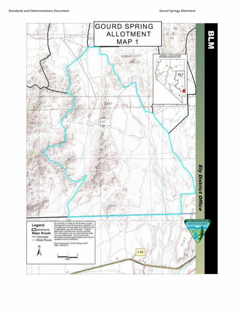
Standards and Determinations Document Gourd Springs Allotment

Standards and Determinations Document Gourd Springs Allotment

Standards and Determinations Document Gourd Springs Allotment

APPENDIX B
(Standards Determination Document)
Annual livestock grazing use for authorization numbers 275108 and 2703753 on the Gourd Spring Allotment –
as AUMs licensed each year by each permittee; total AUMs licensed each year on the allotment for both
permittees; and, total AUMs licensed each year on allotment as a percent of the total Active Use of both
permittees - from March 1, 2002 through February 28, 2013 (10 years). The table also displays the individual
Total Active Use for both permittees and the Season of Use on the allotment.
Table 1- Licensed livestock use 2003-2012
Current Term Grazing Permit
Information
- - - - - - - - - - - - - -
Permittees/Season of
Use/Active Use
Grazing Year
(10/1-5/31)
Permittee
Authorization #
AUMs Licensed
Each Year
(by permittee)
AUMs Licensed
Each Year as
% of Total
Active Use (by
permittee)
Total AUMs
Licensed Each Year
on Allotment
(all permittees)
Total AUMs
Licensed Each
Year on the
Allotment, as a
% of the Total
Active Use for
both Permittees
(AUMs)
Gourd Spring season of use =
10/1 to 5/31
Active Use
# 2703753 1729 AUMs
#275108 1729 AUMs
TOTAL 3480 AUMs
2003 2705107 354 20.4%
926 26.7% 275108 572 33%
2004 2705107 481 27.5%
1449 41.8% 275108 968 55.8%
2005 2705107 210 12.1%
753 21.7% 275108 543 31.3%
2006 2705107 123 7.1%
324 9.3% 275108 201 11.6%
2007 2705107 424 24.5%
1006 29% 275108 582 33.6%
2008 2705107 538 31%
1561 45% 275108 1023 59%
2009 2705107 591 34.1 %
1541 44.5% 275108 950 54.8%
2010 2705107 677 39.1%
1643 47.4% 275108 966 55.7%
2011 2705107/2703753* 363 & 1333* 97.8%
2418 69.8% 275108 722 41.6%
2012 2703753 963 55.6%
1738 50.1% 275108 775 44.7%
AVERAGE 38.5%
*) Permit transferred to current permittee.
As the table indicates during the 10 year timespan, the total AUMs licensed each year on the allotment as a
percent of the total active use of both permittees, ranged from 9% in 2006 to 70% in 2011 with an average of
38.5%. This indicates that the allotment has received moderate use over the past 10 years.

APPENDIX III (EA)
STANDARD TERMS AND CONDITIONS
1. Livestock numbers identified in the Term Grazing Permit are a function of seasons of use
and permitted use. Deviations from those livestock numbers and seasons of use may be
authorized on an annual basis where such deviations are consistent with multiple-use
objectives. Such deviations will require an application and written authorization from the
authorized officer prior to grazing use.
2. The authorized officer is requiring that an actual use report (Form 4130-5) be submitted
within 15 days after completing your annual grazing use.
3. Grazing use will be in accordance with the Standards and Guidelines for Grazing
Administration. The Standards and Guidelines have been developed by the respective
Resource Advisory Council and approved by the Secretary of the Interior on February 12,
1997. Grazing use will also be in accordance with 43 CFR Subpart 4180 - Fundamentals
of Rangeland Health and Standards and Guidelines for Grazing Administration.
4. If future monitoring data indicates that Standards and Guidelines for Grazing
Administration are not being met, the permit will be reissued subject to revised terms and
conditions.
5. The permittee must notify the authorized officer by telephone, with written confirmation,
immediately upon discovery of any hazardous or solid wastes as defined in 40 CFR Part
261.
6. The permittee is responsible for all maintenance of assigned range improvements
including wildlife escape ramps for both permanent and temporary water troughs.
7. When necessary, control or restrict the timing of livestock movement to minimize the
transport of livestock-borne noxious weed seeds, roots, or rhizomes between weed-
infested and weed-free areas.
8. Livestock will be moved to another authorized pasture (where applicable) or removed
from the allotment before utilization objectives are met or no later than 5 days after
meeting the utilization objectives. Any deviation in livestock movement will require
authorization from the authorized officer.
9. The placement of mineral or salt supplements will be a minimum distance of 1/2 mile
from known water sources, riparian areas, winterfat dominated sites, sensitive sites,
populations of special status plant species, and cultural resource sites. Mineral and salt
supplements will also be one mile from active sage-grouse leks. Placing supplemental
feed (i.e. hay, grain, pellets, etc.) on public lands without authorization is prohibited.

Standards and Determinations Document Gourd Springs Allotment
74
APPENDIX IV
(EA)
WEED RISK ASSESSMENT

Standards and Determinations Document Gourd Springs Allotment
RISK ASSESSMENT FOR NOXIOUS & INVASIVE WEEDS
Gourd Spring Term Permit Renewal
Lincoln, Nevada
On March 22, 2014 a Noxious & Invasive Weed Risk Assessment was completed for the Gourd Spring Term Permit
Renewal in Lincoln County, NV. The proposed action is to renew the grazing term permit for grazing permittees on
the Gourd Spring Allotment. NEPA level is EA and grazing permit will be for ten years. A Standards Determination
Document has been prepared as an in-depth analysis of grazing. An EA will be prepared and the proposed actions
will be analyzed.
In addition to weed surveys in the field, the Ely District weed inventory data was consulted, which accurately
reflected field observation. The following species are documented within the project area:
Brassica tournefortii Sahara mustard
Onopordum acanthium Scotch thistle
Tamarix spp. Salt cedar
There is also a probability that include a list of undocumented weeds found in the area scattered along roads in the
area. The project area was last inventoried for noxious weeds in 2013.
A list of species undocumented in the District follows:
Arctium minus Common burdock
Bromus rubens Red brome
Bromus tectorum Cheatgrass
Ceratocephala testiculata Bur buttercup
Elaeagnus angustifolia Russian olive
Erodium circutarium Filaree
Halogeton glomeratus Halogeton
Marrubium vulgare Horehound
Salsola kali Russian thistle
Sysimbrium altissimum Tumble mustard
Tragopogon dubius Yellow salsify
Factor 1 assesses the likelihood of noxious/invasive weed species spreading to the project area.
None (0) Noxious/invasive weed species are not located within or adjacent to the project area. Project
activity is not likely to result in the establishment of noxious/invasive weed species in the project
area.
Low (1-3) Noxious/invasive weed species are present in the areas adjacent to but not within the project area. Project activities can be implemented and prevent the spread of noxious/invasive weeds into the
project area.
Moderate (4-7) Noxious/invasive weed species located immediately adjacent to or within the project area. Project activities are likely to result in some areas becoming infested with noxious/invasive weed
species even when preventative management actions are followed. Control measures are
essential to prevent the spread of noxious/invasive weeds within the project area.
High (8-10) Heavy infestations of noxious/invasive weeds are located within or immediately adjacent to the project area. Project activities, even with preventative management actions, are likely to result in
the establishment and spread of noxious/invasive weeds on disturbed sites throughout much of
the project area.

Standards and Determinations Document Gourd Springs Allotment
For this project, the factor rates as Moderate (6) at the present time. Currently salt cedar is established in the project
area. However, the spread of this species is limited to wet areas. Currently salt cedar can be found in the few wet
areas located within the allotments, but is regularly treated by the permittees to prevent it dominance of the areas.
Further spread is not a concern.
Scotch thistle has also been found within 3 miles of the project area. However, it is not prevalent and is easily
identified and can be readily treated using spot treatments. The permittees are aware of this species and understands
that it is in the best interest of their operation to remove this species upon detection, as has been done historically.
Sahara mustard (Brassica tournefortii) is establishing in the region. In this region, it was first detected in the south
near Las Vegas and is moving north following the prevailing winds and the Interstate 15 corridor. It has now been
observed moving outward from the City of Mesquite with unmanaged OHV use. Currently Sahara mustard is located
on the southernmost boundary of the Gourd Spring Allotment. This portion of the allotment has restricted grazing
due to desert tortoise critical habitat and lack of improvements. Grazing would occur in this area only when Sahara
mustard is undergoing vegetative growth. Turnout is in the early winter and cattle are removed before seed
production. Cattle have been observed eating Sahara mustard early in its growth cycle, but preference appears to
taper off as the plant matures. The germination period for Sahara mustard is normally in the early fall and winter
months. Seed transport is primarily wind, but also travels by animal and vehicle; especially in wet conditions.
Because of Sahara mustard’s rapid growth and ability to quickly out compete native plants, control of this species if
paramount. Even though the area has been heavily altered due to annual grasses and fire, it still has the ability to
support native species. With establishment of Sahara mustard, this ability could be drastically reduced. Because
grazing permittees tend to spend more time in this area than anyone else, they can provide valuable monitoring
information and detection. Through education, it will be shown to be in the grazing operation’s best interest to
protect the resource and will be highly motivated to address the spread of Sahara mustard.
Factor 2 assesses the consequences of noxious/invasive weed establishment in the project area.
Low to Nonexistent (1-3) None. No cumulative effects expected.
Moderate (4-7) Possible adverse effects on site and possible expansion of infestation within the project area. Cumulative effects on native plant communities are likely but limited.
High (8-10) Obvious adverse effects within the project area and probable expansion of
noxious/invasive weed infestations to areas outside the project area. Adverse
cumulative effects on native plant communities are probable.
This project rates as High (8) at the present time. This rating is primarily the result of Sahara mustard’s ability to
outcompete native plants in the Mojave desert region. However, this number is lower because the area has already
been altered due to other non-native annuals. These annuals include red brome (Bromus rubens) and cheatgrass
(Bromus tectorum) and are the species primarily responsible for the altered disturbance regime. Sahara mustard
would simply result in a further decrease in native species. The effects of Sahara mustard on wildlife habitat are
complex and not completely understood. The growth habit of Sahara mustard in this northern most portion of the
Mojave Desert is not fully understood, and it may prove to not be as competitive with cooler temperatures.
The Risk Rating is obtained by multiplying Factor 1 by Factor 2.
None (0) Proceed as planned.
Low (1-10) Proceed as planned. Initiate control treatment on noxious/invasive weed populations that get
established in the area.
Moderate (11-49) Develop preventative management measures for the proposed project to reduce the risk of introduction of spread of noxious/invasive weeds into the area. Preventative management
measures should include modifying the project to include seeding the area to occupy disturbed
sites with desirable species. Monitor the area for at least 3 consecutive years and provide for control of newly established populations of noxious/invasive weeds and follow-up treatment
for previously treated infestations.
High (50-100) Project must be modified to reduce risk level through preventative management measures, including seeding with desirable species to occupy disturbed site and controlling existing
infestations of noxious/invasive weeds prior to project activity. Project must provide at least 5
consecutive years of monitoring. Projects must also provide for control of newly established

Standards and Determinations Document Gourd Springs Allotment
populations of noxious/invasive weeds and follow-up treatment for previously treated
infestations.
For this project, the Risk Rating is Moderate (48). This indicates that the project can proceed as planned as long as the
following measures are followed:
Continue to use integrated weed management to treat weed infestations and use principles of integrated pest
management to meet management objectives and to reestablish resistant and resilient native vegetation
communities.
Develop weed management plans that address weed vectors, minimize the movement of weeds within public lands,
consider disturbance regimes, and address existing weed infestations.
When manual weed control is conducted, remove the cut weeds and weed parts and dispose of them in a manner
designed to kill seeds and weed parts.
When managing in areas of special status species, carefully consider the impacts of the treatment on such species.
Wherever possible, hand spraying of herbicides is preferred over other methods.
Control or restrict the timing of livestock movement to minimize the transport of livestock-borne noxious weed
seeds, roots, or rhizomes between weed-infested and weed-free areas.
All applications of approved pesticides will be conducted only be certified pesticide applicators or by personnel
under the direct supervision of a certified applicator.
Prior to entering public lands, the contractor, operator, or permit holder will provide information and training
regarding noxious weed management and identification to all personnel who will be affiliated with the
implementation of the project. The importance of preventing the spread of weeds to un-infested areas and
importance of controlling existing populations of weeds will be explained.

APPENDIX V (EA)
Specific Management Guidelines for Range Improvements
within the Mormon Mountains Wilderness

Standards and Determinations Document Gourd Springs Allotment
2
Range Improvements on the Mormon Peak Allotment Located within Wilderness.
Improvement
Name
Range
Improvement.
Project #
Improvement
Type
Length within
Wilderness
(miles)*
F14 Mormon Mountain HMA Fence Fence 0.4
Unknown Fence (T10S R68E S26,34,35) 570506 Fence 1.8
*Measurements are calculated for the length that lies within the Wilderness boundary
Fences
Fences throughout the planning area require routine maintenance. Additional maintenance may
be required due to damage from wildfires, animals, or intentional destruction.
For any single segment of pre-existing fence at least one-quarter mile from any designated
motorized route and at least one-half mile in length, the use of the motorized vehicles or
equipment may be allowed for replacement or repair to damage otherwise unpreventable through
routine inspection and maintenance (i.e., destruction by wildfire, or extensive damage from
livestock, wild horses and/or wildlife). It is anticipated that damage which would require the use
of motorized equipment or vehicles to replace segments longer than one-half mile would not
occur frequently. Alternative fence locations, materials, construction techniques, and the use of
additional gates would be evaluated prior to authorizing more frequent use of motorized
equipment or vehicles for fence that repeatedly requires repairs.
Additional Range Specific Management
Inspection and routine maintenance of range developments would be accomplished on foot or
horseback. Management direction for the use of motorized equipment and vehicles for the
maintenance and reconstruction of range developments would apply to those developments
identified in this EA and which are included in a current decision or document (i.e., final
multiple use decision, allotment management plan, grazing decision, permit, lease, or
cooperative agreement).
All authorizations for the use of motorized equipment (e.g., chainsaw, generator, gas-powered
posthole digger, etc.) or vehicles (e.g., ATV, truck, snowmobile, bulldozer, trackhoe etc.) would
specify the type of vehicle and number of vehicle passes, the route(s) to be used and period of
use for motorized equipment. The number of vehicle passes authorized would be based upon the
minimum number necessary to safely accomplish maintenance objectives. The selection of
vehicles to be used would be based upon readily available and cost-effective equipment which
minimizes soil disturbance, compaction and resource damage. Approved motorized access
would be confined to previously utilized routes except in cases where the potential for resource

Standards and Determinations Document Gourd Springs Allotment
3
damage is determined to be unacceptable; in such a case an alternate route may be identified.
Some previously utilized routes have been restored to their natural condition in order to prevent
unauthorized motorized use. It is anticipated that most repair or reconstruction of range
developments requiring motorized vehicles would be accomplished with a single trip using one
vehicle and trailer. For scheduled repair or construction, the use of motorized vehicles or
equipment would be scheduled to minimize disturbance to riparian areas, soils, wildlife, and the
visiting public.
Except in the case of emergency, permittees must obtain written authorization from the District
Manager prior to using any motorized equipment or vehicles within the wilderness areas. For
uses evaluated as part of this document, authorizations would typically be issued within one to
two weeks from the time of request.
For the purposes of allowing motorized equipment and/or vehicles for grazing management, an
emergency is defined as any unpreventable or reasonably unforeseeable set of circumstances
which, without immediate action, would likely result in the death of livestock or result in long-
term or irreversible impact to the wilderness resource. At a minimum, grazing permittees must
obtain verbal authorization from the District Manager for each instance in which motorized
equipment or vehicles are to be used in the wilderness. Verbal authorization must be followed
up with a written authorization for the wilderness file. In the event that the District Manager is
not immediately available, the permittee must notify the District Manager as soon as practicable
but not later than 48 hours following the use of motorized equipment or vehicles.
Excerpt from BLM Manual 6340 – Management of Designated Wilderness Areas (Public)
(July 13, 2012):
“8. Grazing
a. Background. The Wilderness Act, Section 4(d)(4)(2) states: “the grazing of livestock,
where established prior to the effective date of this Act, shall be permitted to continue
subject to such reasonable regulations as are deemed necessary by the [administering
agency].” In 1990, the House of Representatives issued House Report 101-405,
Appendix A— Grazing Management Guidelines, in association with the Arizona Desert
Wilderness Act of 1990. Although the Wilderness Act provides the authority for
managing grazing in wilderness, this report (and its predecessor, House Report 96-1126,
issued in association with the Colorado Wilderness Act of 1980) has been cited in many
subsequent wilderness bills and provides helpful information. Grazing is specifically
permitted in wilderness under Section 4(d)(4)(2) of the Act. After designation of an area
as wilderness, Allotment Management Plans may need to be revised or developed for
allotments within a wilderness to ensure they are consistent with this policy.
b. Continuation of livestock grazing. Where grazing of livestock has been authorized by a
grazing permit or grazing lease for land within a wilderness, and the use was established
Standards and Determinations Document Gourd Springs Allotment
4
before Congress established the wilderness area, under Section 4(d)(4)(2) of the Act it
“shall be permitted to continue subject to such reasonable regulations as are deemed
necessary by the [administering agency].” The continuation of existing grazing may
apply to not only the utilization of the forage resource, but also the use and maintenance
of livestock management developments and facilities that were associated with the
grazing activity at the time of designation and have been authorized by the BLM.
Grazing management activities, including the construction, use, and maintenance of
livestock management developments, must comply with the BLM grazing regulations 43
CFR 4100, as well as this manual.
c. Adjustments in levels of authorized use
There will be no automatic reduction in the amount of livestock use permitted simply
because an area is designated as wilderness. Reductions should be made only as a result
of normal changes in grazing management based on range condition and in accordance
with the BLM’s grazing regulations. For example, an increase in the number of livestock
may be permitted if it can be demonstrated that the increase will have no negative impact
on wilderness character.
d. Grazing facilities
i. Structures and installations used for livestock management existing at the time of
designation may be maintained. Maintenance may be done by the occasional use of
motorized equipment where:
A. practical non-motorized alternatives do not exist; and
B. the motorized use is expressly authorized in the grazing permit and advanced
written permission for each maintenance activity is granted by the BLM; and
C. the motorized use was allowed prior to wilderness designation.
In most situations, authorization for motorized use would be considered on a case-
by-case basis—for example, to remove sediment from a stock reservoir. In some
cases, a schedule could be established—for example, hauling water to fill a tank.
In all cases, authorization should be for no more than is practically necessary to
support the livestock grazing program and for actions that would not have a
significant adverse impact on the natural environment. The use of an existing
route and mode of travel also must cause the least impact on wilderness character
and be similar to what was allowed prior to wilderness designation. These
decisions are made during the grazing permitting process with the use of a
Minimum Requirements Analysis, completed in conjunction with the associated
NEPA analysis, through which alternatives are analyzed to determine the method

Standards and Determinations Document Gourd Springs Allotment
5
that least impacts wilderness character while remaining consistent with the rule of
practical necessity and reasonableness in supporting the livestock grazing
program. Actual authorization is granted, consistent with the NEPA analysis, in a
letter of authorization. Authorizations need to be consistent with the Decision
Document, including specified design features or mitigation measures and any
specified follow-up actions. Authorizations will include exact travel routes to be
followed by any motorized equipment or mechanical transport, as well as
rehabilitation requirements.
Where practical alternatives to the use of motor vehicles exist—for example,
using horses to distribute small quantities of salt or repair short sections of
fence—the BLM will only authorize non-motorized activities.
ii. Reconstruction or replacement of existing facilities will require the use of natural
materials if their use would not impose unreasonable added cost for the grazing
permittee. An exception is when use of other materials would require less frequent
motorized or mechanized access to perform maintenance.
iii. New facilities will be permitted by the BLM only for the purpose of enhancing the
protection of wilderness character.
e. Use of motorized equipment. Except as allowed under sub-section 9.d [sic], above, the
use of motor vehicles, motorized equipment, or mechanical transport to carry out a lawful
grazing-associated activity is limited to emergencies only, such as rescuing sick animals
or placing feed in emergency situations. In emergencies, permittees do not need prior
authorization for these uses, but must notify the BLM of their use reasonably soon
thereafter. The use of motor vehicles, motorized equipment, or mechanical transport is
not allowed for herding animals or routine inspection of the condition of developments or
the condition of the range.”

Standards and Determinations Document Gourd Springs Allotment
6
APPENDIX VI (EA)
Wildlife and Plant Species
Wildlife & Plants for Gourd Spring Allotment 3/25/13
Highlighted species are BLM Sensitive Species in Nevada. Data accessed from Ely RMP, NV
Natural Heritage Data, and NDOW Diversity Data.
The allotment contains the Beaver Dam Slope and Mormon Mesa critical habitat units for desert
tortoise as well as general habitat for desert tortoise. The allotment also contains the Beaver
Dam Slope and Mormon Mesa ACECs. Desert tortoise triangular transects (surveyed in 1980s
to 1990) estimated densities from very low to low.
Federal T&E Species
Agassiz’s desert tortoise (Gopherus agassizii) federally threatened
Wildlife
desert bighorn sheep (Ovis canadensis nelsoni) occupied habitat
banded Gila monster (Heloderma suspectum cinctum)
Mule deer (Odocoileus hemionus) general habitat
White-tailed antelope squirrel (Ammospermophilus leucurus)
Yellow-backed spiny lizard (Sceloporus uniformis)
Plants
Las Vegas buckwheat (Eriogonum corymbosum var. nilesii)
Clark Mountains agave (Agave utahensis var. nevadensis)

Standards and Determinations Document Gourd Springs Allotment
7
Migratory birds
The following data reflect survey blocks and/or incidental sightings of bird species within the
allotment boundaries from the Atlas of the Breeding Birds of Nevada (Floyd et al. 2007). These
data represent birds that were confirmed, probably, or possibly breeding within the project area
boundaries. These data are not comprehensive, and additional species not listed here may be
present within the project area boundary. Survey blocks were located within the allotment.
American kestrel (Falco sparverius)
Black-chinned hummingbird (Archilocus alexandri)
Ash-throated flycatcher (Myiarchus cinerascens)
Black-tailed gnatcatcher (Polioptila melanura)
Blue-gray gnatcatcher (Polioptila caerulea)
Black-throated sparrow (Amphispiza bilineata)
Brewer’s sparrow (Spizella breweri)
Bullock’s oriole (Icterus bullockii)
Cactus wren (Campylorhynchus brunneicapillus
Common poorwill (Phalaenoptilus nuttallii)
Common raven (Corvus corax)
Costa’s hummingbird (Calypte costae)
Gambel’s quail (Callipepla gambelii)
Greater roadrunner (Geococcyx californianus)
Green-tailed towhee (Pipilo chlorurus)
Horned lark (Eremophila alpestris)
Le Conte’s thrasher (Toxostoma lecontei)
Loggerhead shrike (Lanius ludovicianus)
Mourning dove (Zenaida macroura)
Mountain bluebird (Sialia currucoides)

Standards and Determinations Document Gourd Springs Allotment
8
Northern mockingbird (Mimus polyglottos)
Red-tailed hawk (Buteo jamaicensis)
Rock wren (Salpinctes obsoletus)
Turkey vulture (Cathartes aura)
Western kingbird (Tyrannus verticalis)
Western meadowlark (Sturnella neglecta)
Wilson’s warbler (Wilsonia pusilla)
Western burrowing owl (Athene cunicularia)
Prairie falcon (Falco mexicanus)
Golden eagle (Aquila chrysaetos)
Sage thrasher (Oreoscoptes montanus)
Sage sparrow (Amphispiza belli)
Vesper sparrow (Pooecetes gramineus)
Violet-green swallow (Tachycineta thalassina)
White-crowned sparrow (Zonotrichia leucophrys)
Savannah sparrow (Passerculus sandwichensis)
Yellow warbler (Dendroica petechia)
Yellow-rumped warbler (Dendroica coronata)
Cliff swallow (Petrochelidon pyrrhonota)
Works Cited
Floyd T, Elphick CS, Chisholm G, Mack K, Elston RG, Ammon EM, and Boone JD. 2007. Atlas
of the Breeding Birds of Nevada. Reno: University of Nevada Press.

Standards and Determinations Document Gourd Springs Allotment
9
McIvor, DE. 2005. Important Bird Areas of Nevada. Lahontan Audubon Society. Reno, Nevada.
State of Nevada Department of Conservation and Natural Resources. Nevada Natural Heritage
Program. 2012. http://heritage.nv.gov.
USDOI. 2008. Ely District Record of Decision and Approved Resource Management Plan. U.S.
Department of the Interior, Bureau of Land Management. BLM/NV/EL/PL-GI08/25+1793.

Standards and Determinations Document Gourd Springs Allotment
10