united states department of agriculture antelope grazing...
TRANSCRIPT

United States Department of Agriculture
Antelope Grazing Allotments Project Draft Environmental Impact Statement
Forest Service
Fremont-Winema National Forest
Silver Lake and Chemult Ranger Districts December 2014

The U.S. Department of Agriculture (USDA) prohibits discrimination in all its programs and activities on the basis of race, color, national origin, age, disability, and where applicable, sex, marital status, familial status, parental status, religion, sexual orientation, genetic information, political beliefs, reprisal, or because all or part of an individual's income is derived from any public assistance program. (Not all prohibited bases apply to all programs.) Persons with disabilities who require alternative means for communication of program information (Braille, large print, audiotape, etc.) should contact USDA's TARGET Center at (202) 720-2600 (voice and TDD). To file a complaint of discrimination, write to USDA, Director, Office of Civil Rights, 1400 Independence Avenue, SW, Washington, DC 20250-9410, or call (800) 795-3272 (voice) or (202) 720-6382 (TDD). USDA is an equal opportunity provider and employer.
Antelope Grazing Allotments Project Draft Environmental Impact Statement Lake and Klamath Counties, Oregon
Lead Agency: USDA Forest Service
Responsible Official: Constance Cummins Forest Supervisor Fremont-Winema National Forest 1301 South G Street Lakeview, OR 97630
For Information Contact: Lucas Phillips Interdisciplinary Team Leader (541) 947-2151
Abstract: The Draft Environmental Impact Statement documents the analysis for reissuing a grazing permit for the Antelope Cattle and Horse Allotment, the Antelope Grazing Allotment, and a portion of the Jack Creek Sheep and Goat Allotment on the Silver Lake and Chemult Ranger Districts of the Fremont–Winema National Forest. The project area encompasses approximately 169,599 acres of which 137,189 acres are on National Forest System lands and 32,410 acres are non-National Forest System lands. The purpose of the proposed action is to permit a maximum of 419 cow/calf pairs under a term grazing permit and 75 cow/calf pairs under a term private land grazing permit for a season of use (May 15–September 30) within the project area under an adaptive management strategy that meets or moves towards applicable Land and Resource Management Plan desired conditions and project-specific desired conditions.
Four action alternatives were evaluated. Alternative 2 is the current management, Alternative 3 is the proposed action, and Alternatives 4 and 5 were developed to address issues raised through public involvement.
It is important that reviewers provide their comments at such times and in such a way that they are useful to the agency’s preparation of the environmental impact statement Therefore, comments should be provided prior to the close of the comment period and should clearly articulate the reviewer’s concerns and contentions. The submission of timely and specific comments can affect a reviewer’s ability to participate in subsequent administrative review or judicial review. Comments received in response to this solicitation, including names and addresses of those who comment, will be part of the public record for this proposed action. Comments submitted anonymously will be accepted and considered; however, anonymous comments will not provide the commenter with standing to participate in subsequent administrative or judicial reviews.
Send Comments to: Attn: Lucas Phillips or Katie Blazer 1301 South G Street Lakeview, OR 97630
Comments Must Be Received by: February 2, 2015


Range and Nonforested Vegetation Antelope Grazing Project Draft Environmental Impact Statement Chapter 3
Chapter 3–Affected Environment and Environmental Consequences
3.1 Range and Nonforested Vegetation
3.1.1 Affected Environment The area currently known as the Antelope Allotments was first grazed in the 1870s with livestock belonging to Oregon homesteading families. Thousands of cattle, sheep, and horses are known to have used the project area during this early period. In 1930 the Antelope and Tobin Cabin allotments were established on the Fremont National Forest. The current multiple-allotment configuration, using the “spring” allotment on the Silver Lake RD and the “summer” allotment on the Chemult RD, began prior to 1945. In 1961 the Winema National Forest was created, and the “summer” allotment was placed under Chemult RD administration. In 1969 the Tobin Cabin and Antelope Flat allotments were added to the Antelope Allotment as pastures. In 2002 the Fremont and Winema National Forests were combined into a single administrative unit. However, the “spring” and “summer” allotments remained as separate grazing administrative units managed by the Silver Lake and Chemult RDs.
Vegetation found on the allotments can be generally characterized as forested uplands, sagebrush flats, dry meadows, and riparian areas associated with drainages or springs. Range vegetation assessments were first conducted on the allotments in 1955 with a number of permanent vegetation transects established across different forage vegetation types. These transects were reread in 1969, 1980, 2008, and 2010. An AMP was developed through a Coordinated Resource Management Planning effort in 1985. This AMP has been implemented since its inception and was updated with a new AMP developed for the Antelope Cattle and Horse Allotment (Chemult Pasture) in 1995. The 1995 AMP continued the season-long grazing, with no change in the number of livestock or the season of use.
An appendix to the 1985 Range Environmental Assessment (REA) (Swanson 1984) included a table that displayed stocking history from 1930 through 1981, including estimated annual permitted numbers, season of use, and animal units. Sheep grazed under permit on the Tobin Cabin portion of the allotment until 1969 at numbers ranging from 500 to 860 ewe/lamb pairs from June 15/July 1 to September 30. Cattle have grazed under permit on the North Willow, Halfway, Antelope Flat, and Chemult pastures since 1908. Stocking records indicate some combined livestock-class grazing (cow/calf and ewe/lamb) on these pastures in the 1930s and early 1940s, but since 1945, the class of livestock on these pastures has been cow/calf pairs only.
3.1.1.1 National Forest System Rangelands
3.1.1.1.1 Antelope Grazing Allotment and Antelope Cattle and Horse Allotment The Antelope Grazing Allotment and Antelope Cattle and Horse Allotment, as currently configured, have 8 pastures (North Willow, Halfway, Antelope Flat 1–4, Tobin Cabin, and Chemult Pasture) across the Silver Lake and Chemult RDs of the Fremont-Winema National Forest. The Antelope Allotments are permitted for a combined maximum of 3,218 AUMs from May 15 through September 30, while the northeast portion of the Jack Creek Sheep and Goat Allotment is not currently in use. Cattle will typically enter the Antelope Allotments in May from private or BLM allotments to the east and move west as the range becomes ready for livestock grazing.
3-1
Range and Nonforested Vegetation Chapter 3 Antelope Grazing Project Draft Environmental Impact Statement
North Willow Pasture North Willow Pasture is a 4,860-acre management unit located in the northeast corner of the allotment. North Willow is bordered by Forest Service McCarty Butte / South Wastina Pasture to the north, JWTR LLC to the west, BLM to the south, and Forest Service / BLM / Ward Lake Allotment / North Stratton Pasture to the east. No private lands are inventoried in this pasture. Historically the pasture has been used in May/June and serves as an entry pasture for cattle to travel across the Antelope Allotments. The adjacent BLM-managed Ward Lake Allotment permits grazing to the Antelope Allotments permittee for the months of March/April.
Past management plans describe rest rotation used in conjunction with Halfway Pasture. Early season (mid-May to June) has been the grazing strategy since 2000, with the consolidation of grazing permits. The North Willow Pasture receives the first herd of approximately 230 cow/calf pairs on or around May 15 as range forage becomes ready for grazing. The herd remains in this pasture until forage utilization is met or water availability is limited, usually around June 30.
Approximately 13 miles of allotment and pasture boundary fences and 3 springs are present in North Willow Pasture. Ross Spring was developed in 1938 and is currently not functioning. North Willow Spring was developed in 1979 and is currently not functioning. Baskin Spring was developed after 1985 and is currently not functioning.
North Willow Pasture has 8 stock ponds that were inventoried by Swanson (1984). Line Pond (SE of the NW of Section 30, T27S R13E) is a high priority for cleanout. Oat Pond (NW of SE, T27S R13E) provides perennial water for the north portion of this pasture (this pond was half full in October 2010). Most of the remaining ponds in this pasture occur along NFS road 2780.
Halfway Pasture Halfway Pasture is an 8,462-acre unit in the southeast corner of the Antelope Allotments. NFS lands comprise 8,302 acres of this pasture. North Willow Pasture is to the northeast, and the BLM Ward Lake Pasture is to the east. Tobin Cabin Pasture and Antelope Flat pastures 1 and 4 are to the west of Halfway Pasture.
Past management plans describe rest rotation used in conjunction with North Willow Pasture. Historically, the pasture has been used in May/June and serves as an entry pasture to the Antelope Allotment. The adjacent BLM-managed Ward Lake Allotment permits grazing to the Antelope Allotment permittee for the months of March/April.
Early season (mid-May to June) has been the grazing strategy since 2000, when the grazing permits were consolidated. Herd 2, consisting of approximately 189 cow/calf pairs, enters the Forest in the Halfway Pasture on or around June 1 and remains until range forage utilization is met or until June 30, although movement generally occurs approximately 15 days after entry into this pasture. Early season use is necessary for these high-desert areas because water holes and springs may become inadequate to support livestock by early July.
No developed springs are present in Halfway Pasture. At one time, a well and pipeline/trough development existed at Halfway Lake. The groundwater feeding this well dropped below the bottom of the well, so the source is lost. Adjacent to the lake bed are 2 small dugout ponds, but these only catch and hold water on years of above normal runoff.
Halfway Pasture has 12 stock ponds, inventoried by Swanson in the 1984 REA (Swanson 1984). Corner Pond (SE of NW, Section 1, T28S R13E), Junction Pond (a borrow pit/stock pond located just north of the junction of the Bear Flat Highway and NFS road 2780), Cinder Pond (SW of SW, Section 13, T27S R13E), and Post Pond (SE of Section 35, T27S R13E) have been identified as high
3-2

Range and Nonforested Vegetation Antelope Grazing Project Draft Environmental Impact Statement Chapter 3
priority for livestock water opportunities. Several locations are identified for permanent water haul locations that are high-priority livestock water opportunities in this pasture.
Antelope Flat Pastures 1 through 4 The Antelope Flat pasture complex is made up of 4 pastures. Historically, this flat was a season-long holding field that was subject to unauthorized use and drift from surrounding allotments. The flat was fenced in 1943 to curtail some of the unauthorized use and to bring management to the area. The interior fences were constructed in 1959.
Cattle are moved through the Antelope Flat pastures for short durations and for varying lengths of time as necessary for transition between larger pastures and holding during fall gather. Herd 2 (189 pairs) spends 3–4 days in the southwest pasture (Antelope Flat Pasture 2) and is then taken to the Tobin Cabin Pasture in mid-June (in most years) or no later than July 5. Additionally, the southwest pasture on Antelope Flat is used for another 3–4 days in early July to rest and hold Herd 1 (approximately 230 pairs) during their move from North Willow Pasture to Chemult Pasture.
The northeast pasture (Antelope Flat Pasture 3) is sometimes used by approximately 40 pairs as utilization is reached in the Tobin Cabin Pasture in August or September. The northeast pasture is also used in conjunction with a private inholding and the northwest pasture (Antelope Flat Pasture 4) to hold livestock during fall gather from the Chemult Pasture, which starts around September 15. Once enough livestock are placed in this pasture to constitute a load, the animals are trucked off the Forest to the home ranch. This gathering and trucking occurs until all of the permittee’s livestock are removed from the Forest.
The southeast pasture (Antelope Flat Pasture 1) is permitted to a different permittee than the rest of the Antelope Allotment. With the waiver of a term grazing permit from the Pitcher Ranch to Tom O’Leary Ranch, this pasture is incorporated into the Buck Creek Allotment for management purposes. This pasture is permitted for 200 pairs from June 1 through June 30. Additional livestock are allowed to trail through this pasture on their way to other Antelope Flat pastures in order to avoid dangers associated with trailing livestock down the highway. However, utilization of forage by these trailing livestock is generally minimal.
Tobin Cabin Pasture The Tobin Cabin Pasture is located west of Halfway Pasture and east of the Chemult RD boundary and consists of NFS lands (35,179 acres) and private lands (27,099 acres) under a term private land grazing permit; the total area of Tobin Cabin Pasture is 62,278 acres. The majority of private acres were owned and managed by Weyerhaeuser. Weyerhaeuser sold these lands in 1998, and the lands are currently owned and managed by JWTR LLC, a Klamath Falls, Oregon, timber holding corporation.
Tobin Cabin Pasture was formed with the establishment of the Fremont National Forest and managed primarily as a sheep allotment until 1969, when the class of livestock was converted to cattle. Records prior to 1930 are not available, but notes indicate the allotment was used intermittently by both sheep and cattle. From 1930 until 1969, permitted and authorized sheep numbers varied from 700 to 2,000 for a grazing season from July 1 to September 30. Sheep were permitted under G5/term private land grazing permits, with Weyerhaeuser leasing the grazing to permittees. The first term permits were issued in 1969 for 225 AUMs on NFS lands and 300 AUMs on the private lands.
In 1979, a production/utilization study was conducted in Tobin Cabin Pasture in order to verify proper stocking capacity. Some of the observations for the study took place in 1981. The study concluded that the capacity of this pasture was 1,350 AUMs (550 AUMs on NFS lands, 800 AUMs
3-3

Range and Nonforested Vegetation Chapter 3 Antelope Grazing Project Draft Environmental Impact Statement
on private lands). The study continued in 1982 with some focused observations on management objectives for the Weyerhaeuser lands. Due to the addition of new ponds on these lands, the study concluded the capacity was 700–800 AUMs. The study noted that as stands developed and forage grasses were shaded out, the capacity would decline. Weyerhaeuser reduced the allowable stocking level over the years to the current 560 AUMs. Currently, the grazing permits authorize 105 AUMs under term grazing permit and 560 AUMs under term private land grazing permit.
Herd 2 (189 pairs) is taken to the Tobin Cabin Pasture in mid-June (in most years) or no later than July 5. A portion of Herd 2, approximately 149 of 189 pairs, is then placed in the Chemult Pasture around August 1 or as forage utilization is met in the Tobin Cabin Pasture. The 40 “extra” pairs are either left in the Tobin Cabin Pasture until September 15 or until utilization is met; then they are moved to private land or to 1 of the 3 permitted Antelope Flat pastures.
Over 20 miles of fence stand along the boundary of this pasture, and unfenced natural boundaries extend an additional 20 miles. Currently inventoried in nonfunctional condition, 10 miles of division fence separate Tobin Cabin Pasture and Chemult Pasture. Another 10 miles of allotment boundary fence stand between the Jack Creek Sheep and Goat Allotment and Tobin Cabin Pasture. This fence is in an unknown condition; it was constructed by Weyerhaeuser in the 1970s when Weyerhaeuser created a private pasture on Jack Creek ridge.
Tobin Cabin Pasture has 3 developed springs. Mud Springs has a spring box, pipeline, and trough system inside a small livestock holding trap. The source protection fence is in poor condition. Bull Jack Spring has a protection fence that is still functional, but the pipeline and trough were abandoned when a pond was dug just downstream of the spring. Tobin Spring is fenced, and a pipeline feeds a trough below the spring. This development is in good condition.
Several undeveloped springs are present in this pasture, as identified through an inventory of springs conducted during the 2010 season. Those identified as important for consideration in future livestock allotment and pasture management are Corral Spring, an unnamed spring in the drainage south of Timber Well, Section 9 Spring, and Tinhead Spring in the northeast corner of the pasture.
A total of 26 stock ponds are inventoried in this pasture. Most hold water seasonally and are dry before the end of the grazing season. Those identified as high priority for future livestock management objectives include Lake Pond (SW of NW of Section 27, T28SR11E), Coyote Pond (SW of NE of Section 10, T28SR11E), and Wallows Pond in Bear Draw (SE of NW of Section 32, T27S R11E).
Also in this pasture are 2 small trick tank/guzzler structures (#1 is at T27S R11E, Section 29, NWSE; #2 is at T27S R11E, Section 17, SWNE). These consist of small collection pads, about 50 feet by 100 feet, constructed with sheet roofing material, draining into 500-gallon storage tanks that feed troughs. These structures are nonfunctional and no longer necessary for livestock management in this pasture.
Chemult Pasture Grazed as the “upper forest” since the Antelope Allotments were established, the 66,118-acre Chemult Pasture provides mid- to late-summer foraging opportunities. The Chemult Pasture consists of NFS lands and private lands under a term private land grazing permit; 379 pairs graze until approximately September 15, when the permittee begins to gather livestock and place them in the northern pastures of Antelope Flat. Gathering continues until all livestock are located and removed from NFS lands. Any livestock remaining on the Antelope Allotments pastures after October 10 are considered to be excess use, as defined in the Rangeland Management Handbook; fees for these remaining livestock are billed in accordance with the handbook guidelines.
3-4
Range and Nonforested Vegetation Antelope Grazing Project Draft Environmental Impact Statement Chapter 3
The Chemult Pasture is the primary forage base for the Antelope Allotment, offering the greatest capacity and best-quality feed. Starting in the mid-2000s, extensive fencing was constructed to exclude grazing from riparian areas, including one large meadow and several smaller ones. This reduction in available forage base continued through 2008 with the exclusion of cattle from the Jack Creek meadows. The Jack Creek meadow fenced riparian area was considered in the authorized use, resulting in a permit modification that reduced the herd size from 419 pairs to 379 pairs. However, no modifications have been made in numbers or seasons for the other fenced riparian areas. Several other large meadows within the Chemult Pasture are privately owned. Most of them are considered in overall grazing capacity through a term private land grazing permit.
The following range improvement structures are assigned to the grazing permit for maintenance; this information, without the condition assessments, is accurately recorded in the I-Web (INFRA) database:
• The Antelope / Jack Creek boundary fence west of Tea Table Mountain is 2.2 miles of 3-strand barbed wire fence, constructed prior to 1960, and is in critical condition.
• The Antelope / Jack Creek boundary fence west of the Jamison Ranch is 2.7 miles of 3-strand barbed wire fence, constructed prior to 1980, and is in critical condition.
• The Antelope / Jack Creek boundary fence east of Tea Table Mountain is 3.0 miles of 3-strand barbed wire fence, constructed prior to 1960, and is in critical condition.
• The Chemult Pasture / Tobin Cabin Pasture division fence (aka ANTELOPE WIN EAST BDRY) is 6.77 miles of 3-strand barbed wire fence, constructed prior to 1960, and is in critical condition.
• The Chemult Pasture / Jack Creek riparian division fence is 3.12 miles of 3-strand barbed wire fence, constructed in 2008, and is in satisfactory condition.
The following wildlife and watershed structures in the Chemult Pasture are assigned to the Chemult RD for maintenance; this information, without the condition assessments, is accurately recorded in the I-Web (INFRA) database:
• The Dry Meadow fenced riparian area is 1.13 miles of 4-strand barbed wire, with approximately 300 feet of buck and pole. T-posts are 18–22 feet apart with single 4-inch wood posts every 50–60 feet. Constructed in 2005, this fence was not built to Forest Service standards for “H” bracing fences, a fact which may limit the life span of the fence. The brace posts are too small (4 inches), and the cross members of the line braces are less than 6 feet. Construction standards call for a minimum of 8 feet (ideally 10 feet) for cross braces. Wire tie-off to the braces is poor or substandard in at least 3 places. This fence was constructed using 2-×-4s for stays between T-posts. Stays of this size are heavy and put additional weight on the fence, possibly limiting the life of the fence. The buck and pole section, across the meadow at the north end, was constructed using lodgepole pine cut locally. The material used to construct this section of fence is adequate from a construction-standard perspective but will require considerable maintenance if impacted by falling trees. Current condition of the improvement as a whole cannot be assessed, because approved Forest Service fence construction specifications were not used.
• The Dry Meadow spring, pipeline, and trough is approximately 300 feet of buried pipe from a vintage (1950s-era) spring box to a 10-foot Powder River trough. The pipeline may be compressed or bent, and flows seem restricted, especially in below-average water years. A pumper chance at Dry Meadow is currently unavailable to livestock because of the installation of the fenced riparian area.
3-5

Range and Nonforested Vegetation Chapter 3 Antelope Grazing Project Draft Environmental Impact Statement
• The Sproats Meadow spring fenced riparian area is approximately 0.84 miles of 3-strand barbed wire fence constructed in 1994 or 1995 and rebuilt to extend the fence north in 2005. The fence construction standard is the same as the standard used for other, non-range fences of this era, and current condition cannot be assessed, because approved Forest Service fence construction specifications were not used.
• Sproats Meadow spring, pipeline, and trough is approximately 300 feet of buried pipe from a new spring box to a Powder River trough outside the fenced riparian area.
• The Johnson Meadow spring fenced riparian area is approximately 0.58 miles of 3-strand barbed wire let-down fence, with approximately 500 feet of buck and pole fence on the east side, and was constructed in 2005. Spot checks of line braces found small (4-inch) posts and cross braces less than 6 feet in length. The buck and pole section, along the meadow at the east side, was constructed using lodgepole pine cut locally. The material used to construct this section of fence is adequate from a construction-standard perspective but will require considerable maintenance if impacted by falling trees. The fence construction standard is the same as the standard used for other fences of this era, and current condition cannot be assessed on the improvement as a whole, because approved Forest Service fence construction specifications were not used throughout.
• The Johnson Meadow spring, pipeline, and trough is approximately 50 feet of over-the-ground pipeline from a vintage spring box to a Powder River trough. The system is solar powered, and (unlike a gravity-fed system) it pumps water slightly uphill. The system was installed with Resource Advisory Council funds, and the current condition is good.
• The Rider’s / Cow Camp fenced riparian area is approximately 1.39 miles of 3-strand barbed wire fence constructed in 1995. The fence was not constructed to Forest Service standards for corner and line braces, and failure of these structures is considered imminent. The fence construction standard is the same as the standard used for other fences of this era, and current condition cannot be assessed, because approved Forest Service fence construction specifications were not used.
• The Squirrel Camp fenced riparian area is approximately 1.24 miles of 3-strand let-down fence constructed in 2005. This fence was not constructed to Forest Service standards for line and corner braces. The let-down components are not standard but function. The fence dead-ends and ties off into timber slash windrowed in the uplands at the northeast corner and at the southwest corner. The fence construction standard is the same as the standard used for other, non-range fences of this era, and current condition cannot be assessed, because approved Forest Service fence construction specifications were not used.
• The Squirrel Camp spring, pipeline, and trough system is approximately 300 feet of buried pipeline from a vintage spring box to a Powder River trough. The system was installed in 2005. Flow is restricted, indicating the pipeline may be compromised by kinks or bends. Further assessment is necessary to determine the condition of this structure and whether heavy maintenance or reconstruction is required to resolve functionality issues.
• The Wilshire Meadow spring fenced riparian area is 0.36 miles of 3-strand barbed wire fence with approximately 130 feet of log-worm fence on the south side. The fence was constructed in 2005 and was not constructed to standard for line and corner braces. The log-worm section was constructed with locally harvested lodgepole pine and seems solid.
• Wilshire Meadow spring, pipeline, and trough system is approximately 500 feet of buried pipeline from a vintage spring box to a Powder River trough and is considered in good condition.
3-6
Range and Nonforested Vegetation Antelope Grazing Project Draft Environmental Impact Statement Chapter 3
• Round Meadow fenced riparian area is 3.5 miles of 3-strand barbed wire let-down fence constructed in 2005. The fence was not constructed to Forest Service standards for line and corner braces. The let-down components are not standard but function. The fence construction standard is the same as the standard used for other, non-range fences of this era, and current condition cannot be assessed, because approved Forest Service fence construction specifications were not used.
• Cannon Well fenced riparian area is 1.75 miles of 3-strand barbed wire fence constructed in 2007. The fence was not constructed to Forest Service standards for line and corner braces. The fence construction standard is the same as the standard used for other, non-range fences of this era, and current condition cannot be assessed because approved Forest Service fence construction specifications were not used.
Approximately 27 stock ponds or developed water sources are inventoried on the Chemult Pasture. Most are dugout ponds, created to water livestock or for pumper chances and firefighting. Ponds that are not in the inventory may be present, particularly ponds that were attained by the Forest Service through land exchanges. Maintenance of ponds is a condition in the Term Grazing Permit Part 3, but current implementation instructions need to be developed. The ponds were not surveyed for other resources when they were created, so some inventory may be needed before pond maintenance can occur.
3.1.1.1.2 Jack Creek Sheep and Goat Allotment The Jack Creek Sheep and Goat Allotment consists of approximately 135,700 acres. Historic livestock use is primarily sheep grazing except for a few years of cattle utilization in the mid-1970s. Allotment inspection reports from the early 1960s mention cattle drift from the Antelope Allotments onto Davis Flat and Little Round Meadow. Sheep numbers have varied from over 5,000 in the 1930s and 1940s to around 1,400 in the 1950s and 1960s, and currently 1,000–2,000.
For this analysis, only the area considered for possible conversion to part of the Antelope Allotments is analyzed. This area is north of NFS road 83 and east of Jackie’s Thicket. The area has not been authorized for livestock use since around 2003 because the current permittee has reduced his band, and after repeated partial non-use, his permit was modified from 2,000 ewe/lambs to 1,100 ewe/lambs from June 1 through September 30. Currently sheep use the southern portion of the allotment south of NFS road 83, with most of the current use occurring south of the Silver Lake Highway.
The portion being analyzed for use by cattle is primarily the Jack Creek corridor where the majority of the meadows are located. Primary forage areas are available in Bull Frog, O’Connor, Davis Flat, and Cabin Springs meadows and in several small meadow complexes to the east and west. A majority of the O’Connor Meadow is privately owned and is fenced out of the allotment. Jack Creek flows intermittently through this portion of the allotment and is often dry early in the season; water is left in small pools and potholes late into the season. The potential livestock capacity from this acreage is estimated to be approximately 619 AUMs. However, the actual capacity will be determined and adjusted through monitoring of utilization levels and other resource objectives if appropriate.
The following structural improvements exist on the portion of the Jack Creek Sheep and Goat Allotment being considered and analyzed in this document (maintenance responsibilities may change as appropriate):
• No interior fences are present in the portion of the Jack Creek Sheep and Goat Allotment being considered; however, North O’Connor Meadow has 0.5 acres of fenced riparian area.
3-7

Range and Nonforested Vegetation Chapter 3 Antelope Grazing Project Draft Environmental Impact Statement
• Cabin Spring is developed, including a spring box and a 2,000-gallon redwood tank placed in the meadow. This spring box was installed in 1962 and is still functioning. Although the location in the meadow is not in line with current management practices, moving this trough or preventing livestock use may not be practical due to other resource considerations.
• Dempsey Spring has a small reservoir that was originally built in 1963 and is not functional.
• Huckleberry Spring has a small reservoir that was originally built in 1963 and is not functional.
• Yellow Jacket Spring consists of a culvert headbox that fills a 100-gallon steel trough in a small meadow. The system is currently functional but may be inadequate to meet future livestock management objectives considered later in this document.
• Little Round Meadow pond is a man-made stock pond in the meadow; the pond is functioning.
• Cleary Spring is a spring-fed stock pond in the meadow. The pond was built in 1963 and is functioning.
• Bartley Headquarters Pond is a stock pond in the meadow. The pond was built in 1963 and is functioning.
• Lily Camp is a reservoir in Jack Creek that is accessible to water tenders and livestock.
3.1.1.2 Private Rangelands There are several large meadows within the Chemult Pasture that are privately owned, one of which is considered in overall grazing capacity through a Term Private Land Grazing Permit (Stimson Meadow) and others are owned by the grazing permit holder and grazed separately (Jamison Ranch) or are unfenced and grazed as part of the larger Chemult Pasture (Moffit) without adjustment of numbers or seasons to account for this extra forage availability.
Jamison Ranch private lands consist of several meadows along Jack Creek within the Chemult Pasture that are not under Forest Service grazing permit. These two parcels (Upper Jamison and Lower Jamison) are 160 acres each and provide feed for 75 pairs of cattle for 3 to 3.5 months. These numbers are not included in current permitted numbers.
The Jack Creek Pasture is divided into private and NFS lands; NFS lands have been rested since 2008 with the exception of a small portion (less than 40 acres) of NFS land at the southern end of Jamison Ranch private lands. Livestock exclusion has been attempted through the use of temporary electric fence, but with limited success. Administrative process detailed in the Rangeland Management Handbook has been used to address any noncompliance with current resource protection objectives or current legal rulings.
3.1.1.3 Plant Community Types Methods for describing, characterizing, and mapping vegetation community types differ across the project area because the analysis area crosses District- and Forest-level administrative boundaries and private lands. For this reason, descriptions of nonforested vegetation are organized by ranger district. Total acreages of described vegetation may not match total project area acreage because some private land was excluded from plant community type surveys and more accurate mapping techniques were used to calculate project area acreage. Because of the differences in vegetation mapping techniques used at the Forest and District levels, no map was developed to show management areas or vegetation community types for this report. However, GIS layers were used to calculate the acreages discussed throughout.
3-8
Range and Nonforested Vegetation Antelope Grazing Project Draft Environmental Impact Statement Chapter 3
3.1.1.3.1 Silver Lake Ranger District The 1984 REA describes plant associations existing on the Silver Lake RD portion of the Antelope Allotments and provides a summary of acreage of each plant community type. This plant association mapping, completed by J. Swanson in 1982, remains accurate, while the Fremont Ecoclass GIS layer has validation issues associated with meadows not being classified by soil or vegetation types. Consequently, the range acre summary forms from the 1984 REA were used to describe current plant associations for the Silver Lake RD portion of the project area.
North Willow Pasture is characterized primarily by low sage/Idaho fescue flats (1,582 acres) scattered between ponderosa pine/bitterbrush/Idaho fescue timber stands (3,197 acres). Intermingled in these timbered stands are several Cusick’s bluegrass dry meadows (81 acres) and mountain mahogany–dominated ecotones.
The vegetation inventoried in the Halfway Pasture is dominated by ponderosa pine/bitterbrush/ fescue plant associations (6,576 acres) with low sage flats and mountain mahogany types intermingled (1,637 acres). Western juniper is common on dry forest sites and has invaded onto big sagebrush and low sagebrush types, but current acreage of invaded shrubland is unknown. Cusick’s bluegrass dry meadow type has been inventoried on 39 acres, primarily represented by the Halfway Lake (dry) area.
Poor forage production and extensive sagebrush in the Antelope Flat pastures led to a plowing and reseeding program in 1944, with revegetation work continuing in 1947, 1948, and 1953. Various sagebrush conversion projects were implemented using herbicides and fire followed by revegetation seeding with introduced wheatgrasses, shrubs, and forbs. These projects had limited success, and sagebrush reoccupied the treatment areas. Crested wheatgrass is still a major component in Antelope Flat pastures 2 and 3.
The Tobin Cabin Pasture is characterized by forested vegetation types that represent both primary and transitory forage for livestock and wildlife. These forested types include ponderosa pine/shrub/grass types, lodgepole pine, and mixed conifer/shrub/grass types. Shrub species such as antelope bitterbrush and manzanita dominate the understory of drier forested types, while blueberry, huckleberry, and bearberry are common as understory in wetter lodgepole pine types. Forage species common in the forest understory include western needlegrass, Idaho fescue, and upland sedge species in drier forest types and riparian sedge, tufted hairgrass, and Kentucky bluegrass communities in wetter lodgepole communities.
Meadows comprise approximately 427 acres within the Tobin Cabin Pasture, and these are generally characterized by Cusick’s bluegrass communities in drier meadows and tufted hairgrass, riparian sedges, and Kentucky bluegrass in wetter meadow types. The 1984 REA also characterizes 16,530 acres within Tobin Cabin Pasture as non-range acres, due to dense forested canopy cover. Generally, forested types are considered marginal or non-range acres if canopy closure exceeds 40%–50% unless sufficient soil moisture exists to support forage species that are shade tolerant.
3.1.1.3.2 Chemult Ranger District Since 1962, several protocols have been established and used to describe the vegetation community types present on the Winema National Forest. Among these protocols are the 1962 long-term range vegetation assessments, Plant Associations of the Central Oregon Pumice Zone (1988), and the Terrestrial Ecological Unit Inventory (TEUI) (GTR W0-68 2005). Each of these protocols built on previous information, and the TEUI information has been determined to be the most relevant to the current vegetation conditions for the Chemult RD portion of the project area (Chemult Pasture and a portion of the Jack Creek Sheep and Goat Allotment, including private lands).
3-9
Range and Nonforested Vegetation Chapter 3 Antelope Grazing Project Draft Environmental Impact Statement
TEUIs are an attempt to characterize, map, and interpret distinct combinations of landform, soil, potential natural vegetation, near-surface geology/hydrology, and climate. Ecological types are the taxonomic units of a TEUI and represent categories of land with a distinct combination of landscape elements; ecological types differ in the kind and amount of vegetation they can produce and in their ability to respond to management actions and natural disturbances. The landscape elements that distinguish ecological types include climate, landform, lithology, near-surface hydrology, and soil.
The TEUI describes 23 distinct ecological types representing 11 plant community types within the Chemult RD portion of the project area. The majority of these plant communities are dominated by forest species, which cover most of the acreage in this portion of the project area.
Approximately 26,907 acres within the Chemult RD portion of the project area (20,754 acres in Chemult Pasture; 6,153 acres in North Sheep Pasture) are dominated by lodgepole pine plant communities representing both upland and riparian soil types. Lodgepole pine communities with upland soils (TEUs 1003 and 1004) represent 96% of the total acreage dominated by lodgepole pine (19,952 acres in Chemult Pasture; 5,780 acres in North Sheep Pasture). These communities are characterized by antelope bitterbrush, western needlegrass, and mixed upland grasses as the major understory forage species. The remaining 4% of the lodgepole pine plant communities (802 acres in Chemult Pasture; 373 acres in North Sheep Pasture) are present within riparian soil types (TEUs 2001, 2002, 2005, 2006, 2016, and 2017) and are characterized by rose spirea, widefruit sedge, bog blueberry, and/or kinnikinnick as understory species.
In addition, approximately 37,937 acres within the Chemult RD portion of the project area (26,461 acres in Chemult Pasture; 11,476 acres in North Sheep Pasture) are dominated by ponderosa pine plant communities completely within upland soil types (TEUs 1016, 1026 [one-half the acreage], and 1053). These plant communities are characterized by understories of antelope bitterbrush, snowbrush ceanothus, and/or western needlegrass.
The remaining forested plant community types represented within the Chemult RD portion of the project area are dominated by white fir, and all exist on upland soil types (TEUs 1013, 1018, 1023, 1026 [one-half the acreage], and 1031). White fir communities cover approximately 18,473 acres (17,882 in Chemult Pasture; 591acres in North Sheep Pasture) and support snowbrush ceanothus, greenleaf manzanita, and giant chinquapin as understory species. None of these plants are considered forage species for livestock.
The remaining plant communities represented within the project area exist on riparian soil types and are considered nonforested communities. The areas they occupy include approximately 20 acres of big sagebrush with bunchgrasses in the Chemult Pasture (TEU 2019); this acreage is considered primary range for livestock. Other lands considered primary range for livestock include approximately 3,777 acres of moist meadow types (TEUs 2000 and 2004) within the Chemult RD portion of the project area (3,002 acres in Chemult Pasture; 775 acres in North Sheep Pasture). These moist meadow areas are primarily dominated by tufted hairgrass or Cusick’s bluegrass with components of sedges, rushes, and other meadow species. Approximately 134 acres (133 acres in Chemult Pasture; 1 acre in North Sheep Pasture) represent a willow wetland–dominated plant community.
3.1.1.4 Condition and Trend Ratings The Winema Forest Plan standards and guidelines for Range (9-1) state that “the forage and browse resource shall be managed to at least satisfactory range condition” (USDA Forest Service 1990, p. 4-62). Satisfactory range condition is defined as follows: “[O]n suitable range, forage condition is at least fair, with stable trend, and allotment is not classified PC (basic resource damage) or
3-10

Range and Nonforested Vegetation Antelope Grazing Project Draft Environmental Impact Statement Chapter 3
PD (other resource damage)” (USDA Forest Service 1990, Glossary, p. 39). The Fremont Forest Plan uses the same standards and guidelines and definitions (USDA Forest Service 1989, p. 75).
For this analysis on the Chemult and Silver Lake RDs, 20 condition and trend and paced transects were read and reread to determine forage condition and to determine trend. An additional 3 transects were established on the north end of the Jack Creek Sheep and Goat Allotment.
Overall, the forage conditions for the Antelope Allotments are in satisfactory condition for livestock grazing (Table 3-1). The meadow sites that are rated in poor condition are expected to improve with adjustments to the grazing system, such as shortening the duration of grazing and deferring season of use or reducing allowable utilization levels.
Table 3-1. Summary of forage condition and trend (C&T) ratings by year Pasture (site) 1963 1967 1980 1993 2008 2010 2011
North Willow (C&T7) n/a n/a Poor (40) n/a n/a Fair (62) n/a North Willow (P1) n/a n/a Poor (33) n/a n/a Fair (55) n/a North Willow (C&T4) Poor (26) n/a Very Poor (21) n/a n/a Poor (25) n/a Halfway (C2) n/a n/a Good (78) n/a n/a Good (85) n/a Halfway (P2) n/a n/a Fair (63) n/a n/a Good (89) n/a Tobin Cabin (C3) Poor (47) n/a Poor (47) n/a n/a Fair (55) n/a Antelope Flat 2 (P5) n/a n/a Fair (61)a n/a n/a Fair (58) n/a Chemult (T1) n/a n/a n/a n/a Fair (60) n/a n/a Chemult (T4) n/a n/a n/a n/a Fair (59) n/a n/a Chemult (T7) n/a n/a n/a n/a Fair (58) n/a n/a Chemult (S10) n/a n/a n/a n/a Fair (50) n/a n/a Chemult (S8) n/a n/a n/a Poor (25) Poor (27) n/a n/a Chemult (C&T13) Fair (54)b Fair (49) n/a Fair (52) Fair(64) n/a n/a Chemult (C&T20/S7)
n/a n/a n/a Poor (27) Poor (49) n/a n/a
Chemult (C&T24/S2)
n/a n/a n/a Fair (51) Fair (57) n/a n/a
Chemult (S4) n/a n/a n/a Fair (61) Good (75) n/a n/a Chemult (S5) n/a n/a n/a Poor (45) Fair (67) n/a n/a North Sheep (Bull Frog)
n/a n/a n/a n/a n/a n/a Poor (26)
North Sheep (O’Connor)
n/a n/a n/a n/a n/a n/a Good (79)
North Sheep (Davis Flat)
n/a n/a n/a n/a n/a n/a Fair (60)
aData collected in 1981 bData collected in 1962
3-11
Range and Nonforested Vegetation Chapter 3 Antelope Grazing Project Draft Environmental Impact Statement
3.1.2 Direct and Indirect Effects This section discloses effects of no livestock grazing or some level of livestock grazing on nonforested vegetation communities, both upland and riparian. Effects are analyzed by comparing how well each of the alternatives meets the plant physiological needs deemed essential for the desired conditions in the Forest Plans. Direct environmental effects are those occurring at the same time and place as the initial cause or action. Indirect effects are those that occur later in time or are spatially removed from the activity.
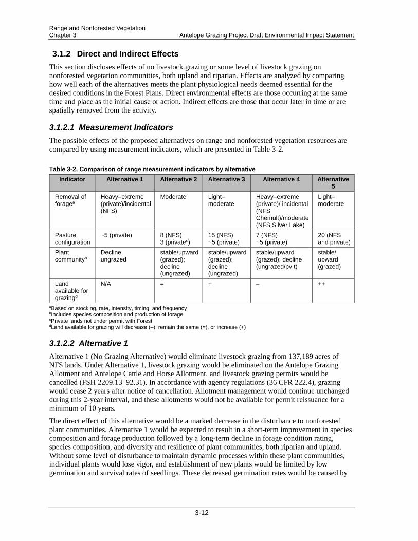
3.1.2.1 Measurement Indicators The possible effects of the proposed alternatives on range and nonforested vegetation resources are compared by using measurement indicators, which are presented in Table 3-2.
Table 3-2. Comparison of range measurement indicators by alternative Indicator Alternative 1 Alternative 2 Alternative 3 Alternative 4 Alternative
5 Removal of foragea
Heavy–extreme (private)/incidental (NFS)
Moderate Light–moderate
Heavy–extreme (private)/ incidental (NFS Chemult)/moderate (NFS Silver Lake)
Light–moderate
Pasture configuration
~5 (private) 8 (NFS) 3 (privatec)
15 (NFS) ~5 (private)
7 (NFS) ~5 (private)
20 (NFS and private)
Plant communityb
Decline ungrazed
stable/upward (grazed); decline (ungrazed)
stable/upward (grazed); decline (ungrazed)
stable/upward (grazed); decline (ungrazed/pv t)
stable/ upward (grazed)
Land available for grazingd
N/A = + – ++
aBased on stocking, rate, intensity, timing, and frequency bIncludes species composition and production of forage cPrivate lands not under permit with Forest dLand available for grazing will decrease (–), remain the same (=), or increase (+)
3.1.2.2 Alternative 1 Alternative 1 (No Grazing Alternative) would eliminate livestock grazing from 137,189 acres of NFS lands. Under Alternative 1, livestock grazing would be eliminated on the Antelope Grazing Allotment and Antelope Cattle and Horse Allotment, and livestock grazing permits would be cancelled (FSH 2209.13–92.31). In accordance with agency regulations (36 CFR 222.4), grazing would cease 2 years after notice of cancellation. Allotment management would continue unchanged during this 2-year interval, and these allotments would not be available for permit reissuance for a minimum of 10 years.
The direct effect of this alternative would be a marked decrease in the disturbance to nonforested plant communities. Alternative 1 would be expected to result in a short-term improvement in species composition and forage production followed by a long-term decline in forage condition rating, species composition, and diversity and resilience of plant communities, both riparian and upland. Without some level of disturbance to maintain dynamic processes within these plant communities, individual plants would lose vigor, and establishment of new plants would be limited by low germination and survival rates of seedlings. These decreased germination rates would be caused by
3-12
Range and Nonforested Vegetation Antelope Grazing Project Draft Environmental Impact Statement Chapter 3
the low incidence of seed finding a viable niche (location where seed-soil interaction is possible) for establishment. With the buildup of fuels and reduced resiliency of these plant communities, other disturbances such as fire could create unintended and major impacts to nonforested plant communities.
Additionally, lands outside the allotment but under control of the permittee may be indirectly affected by the exclusion of grazing on NFS lands. The effects to these lands outside the project area are unknown. Private lands within the project area may experience higher levels of grazing due to the cancellation of permits that designate appropriate levels of grazing (term private land grazing permits). Alternative 1 is not consistent with the purpose and needs identified for this project. Specifically, this alternative does not support the following objectives:
• Where consistent with other multiple-use goals and objectives, meet congressional intent to allow grazing on suitable lands as identified in the Forest Plans (as addressed in the Multiple-Use Sustained-Yield Act of 1960, Wilderness Act of 1964, Forest and Rangeland Renewable Resources Planning Act of 1974, Federal Land Policy and Management Act of 1976, National Forest Management Act of 1976, and Forest Service Manual 2202.1).
• Continue contributing to the economic and social well-being of people by providing opportunities for economic diversity and by promoting stability for communities that depend on range resources for their livelihood (FSM 2202.14).
Indirect effects under this alternative include the loss of both professional rangeland management and permittee awareness of on-the-ground conditions within the project area. With decreased emphasis on management of the area, excess use and other unauthorized uses could go unnoticed.
This alternative would decrease the number of pastures (5 private pastures under private landowner control) and the overall acreage available for grazing within the project area; these decreases would result in a concentration of grazing effects to small areas. Grazing would likely continue on private lands (approximately 245 cow/calf pairs) within the project area, and livestock grazing levels would probably be higher than current levels; heavy to extreme livestock use could occur. Crossing permits for the purpose of trailing cattle to private inholdings may be necessary, thus increasing the potential for unauthorized cattle.
Structural range improvements would fall into disrepair until their removal, and removal may not be allowed due to the historic and cultural nature of these structures or if the structures provide additional water availability to wildlife. Preventing livestock from entering NFS lands not permitted for livestock grazing is the sole responsibility of the livestock owner or adjacent landowner (FSM 2230.6). Placing unauthorized livestock on NFS lands or allowing unauthorized livestock to enter NFS lands is prohibited and subject to fines, as stated in 36 CFR 261.7(a).
3.1.2.3 Alternative 2 Under Alternative 2, the current grazing system of early-season, continuous rotation and season-long grazing would continue. Cattle numbers and rotations through the various pastures would remain the same. The majority of the rangeland plant community types are at mid- to late-ecological stage. These riparian or meadow sites would continue to advance along their respective successional pathways. However, Alternative 2 will most likely result in a slower rate of improvement than Alternatives 1 or 4. Alternatives 3 and 5 would result in rates of improvement similar to those under Alternative 2.
Under this alternative, and through proper levels of administration, plant communities would be expected to remain in a steady ecological state (i.e., forage condition rating) or show slow levels of
3-13

Range and Nonforested Vegetation Chapter 3 Antelope Grazing Project Draft Environmental Impact Statement
improvement through the update of appropriate utilization levels based on current range conditions. Fenced riparian areas and the northern portion of the Jack Creek Sheep and Goat Allotment would continue to see no authorization of livestock grazing and may show some declines in condition over time because of the lack of disturbance in these plant communities.
Alternative 2 would maintain the current number of pastures (8 permitted; 3 private pastures not under permit) and the overall acreage available for grazing within the project area; therefore, the distribution of grazing effects across the landscape would be the same as under current management. Grazing would continue on private lands within the project area, and levels of use would likely be similar to current levels (moderate).
3.1.2.4 Alternative 3 This alternative would permit grazing in the Dry Meadow unit, Squirrel Camp unit, Rider’s Camp unit, Round Meadow unit, and Cannon Well unit. Alternative 3 would also add the northern portion of the Jack Creek Sheep and Goat Allotment to allow for some deferment in use on the west side. Alternative 3 would result in additional private lands being placed into a term private land grazing permit. These areas would be grazed in addition to the current pastures being used for grazing. The fenced riparian areas (units) are currently rated in fair or good forage condition and satisfactory range condition; these ratings are expected to be maintained under all alternatives. Current implementation monitoring indicates that utilization standards can be met under current management and would be expected to be met under all alternatives. Effectiveness monitoring indicates that trends can improve or be maintained.
Under this alternative, and through proper levels of administration, plant communities would be expected to remain in a steady ecological state (forage condition rating) or show slow levels of improvement through the update of appropriate utilization levels based on current range conditions. Some fenced riparian areas and the northern portion of the Jack Creek Sheep and Goat Allotment would be authorized for grazing and would also be expected to see steady ecological states or show slow levels of improvement caused by appropriate levels of disturbance that could create a potential increase in plant community composition, diversity, and resiliency. Fens would not be expected to decline in condition, because livestock generally avoid areas of highly saturated soil and mitigation measures are being identified to minimize potential impacts.
Alternative 3 would increase the number of pastures (15; both NFS and private lands) and the overall acreage available for grazing within the project area; these increases would result in a dilution of grazing effects across the landscape and an increase of flexibility in grazing management options on an annual basis. Grazing would continue on private lands within the project area, and levels of use would likely be similar to current levels (moderate). However, some new private lands would fall under Forest Service administration through a term private land grazing permit. This change would further increase the flexibility of grazing options (and options for rest or deferment of use) on an annual basis.
3.1.2.5 Alternative 4 Under this alternative, no term grazing permits would be issued for the Chemult RD portion of the project area, and only incidental grazing would be expected there through crossing permits. Cancellation of term permits must follow direction in Forest Service Manual (FSM) 2231.62d; Forest Service Handbook (FSH) 2209.13, Chapter 10, Section 16.24; and Part 2 item1b of the term permit. Grazing would continue to be permitted at current levels on the Silver Lake RD portion of the project area. The direct effect of this alternative would be a marked decrease in the disturbance to nonforested plant communities on the Chemult RD portion of the project area.
3-14
Range and Nonforested Vegetation Antelope Grazing Project Draft Environmental Impact Statement Chapter 3
This alternative would be expected to result in a short-term improvement in species composition and forage production followed by a long-term decline in forage condition rating, species composition, and diversity and resilience of plant communities, both riparian and upland. Without some level of disturbance to maintain dynamic processes within these plant communities, individual plants would lose vigor, and establishment of new plants would be limited by low germination and survival rates of seedlings. These decreased germination rates would be caused by the low incidence of seed finding a viable niche (location where seed-soil interaction is possible) for establishment. With the buildup of fuels and reduced resiliency of these plant communities, other disturbances such as fire could create unintended and major impacts to nonforested plant communities on the Chemult RD portion of the project area.
Under this alternative, and through proper levels of administration, plant communities would be expected to remain in a steady ecological state (forage condition rating) or show slow levels of improvement through the update of appropriate utilization levels based on current range conditions on the Silver Lake RD portion of the project area.
Alternative 4 would decrease the current number of pastures (7 permitted; 5 private pastures not under permit) and the overall acreage available for grazing within the project area; these decreases would result in a concentration of grazing effects across the landscape. Proper use would still be enforced on NFS lands. Additionally lands outside the allotment but under control of the permittee may be indirectly affected by the exclusion of grazing on NFS lands. The effects to these lands outside the project area are unknown. Private lands within the project area may experience higher levels of grazing due to the cancellation of permits that designate appropriate levels of grazing (term private land grazing permits). Alternative 4 is not consistent with the purpose and needs identified for this project. Specifically, this alternative does not support the following objectives:
• Where consistent with other multiple-use goals and objectives, meet congressional intent to allow grazing on suitable lands as identified in the Forest Plans (as addressed in the Multiple-Use Sustained-Yield Act of 1960, Wilderness Act of 1964, Forest and Rangeland Renewable Resources Planning Act of 1974, Federal Land Policy and Management Act of 1976, National Forest Management Act of 1976, and Forest Service Manual 2202.1).
3.1.2.6 Alternative 5 This alternative would permit grazing in the Dry Meadow unit, Squirrel Camp unit, Rider’s Camp unit, Cannon Well unit, Sproats Meadow unit, Johnson Meadow unit, Round Meadow unit, and Wilshire Meadow unit. Alternative 5 would also add the northern portion of the Jack Creek Sheep and Goat Allotment to allow for some deferment in use on the west side. This alternative would result in additional private lands being placed under a term private land grazing permit. These areas would be grazed in addition to the current pastures being used for grazing. The fenced riparian areas (units) are currently rated in fair or good forage condition and satisfactory range condition; these ratings are expected to be maintained under all alternatives. Current implementation monitoring indicates that utilization standards can be met under current management and would be expected to be met under all alternatives. Effectiveness monitoring indicates that trends can improve or be maintained.
Under this alternative, and through proper levels of administration, plant communities would be expected to remain in a steady ecological state (forage condition rating) or show slow levels of improvement through the update of appropriate utilization levels based on current range conditions. All fenced riparian areas and the northern portion of the Jack Creek Sheep and Goat Allotment would be authorized for grazing and would also be expected to see steady ecological states or show slow levels of improvement caused by appropriate levels of disturbance that could create a potential
3-15
Range and Nonforested Vegetation Chapter 3 Antelope Grazing Project Draft Environmental Impact Statement
increase in plant community composition, diversity, and resilience. Fens would not be expected to decline in condition, because livestock generally avoid areas of highly saturated soil and mitigation measures are being identified to minimize potential impacts.
Alternative 5 would maximize the number of pastures (20; both NFS and private lands) and the overall acreage available for grazing within the project area; these increases would result in the greatest dilution of grazing effects across the landscape and the greatest flexibility in grazing management options on an annual basis. Grazing would continue on private lands within the project area, and levels of use would likely be lower than current levels (light to moderate); some new private lands would fall under Forest Service administration through a term private land grazing permit. This change would further increase the flexibility of grazing options (and options for rest or deferment of use) on an annual basis.
All standards and guidelines from the Forest Plans would continue to be enforced under any alternative, as would the terms and conditions of the term grazing permits and term private land grazing permits. The Forest Plan standards and guidelines for range management determine the allowable use levels, which are based on current forage condition ratings of the key areas (USDA Forest Service 1989, pp. 75–76; USDA Forest Service 1990, pp. 4-62 and 4-63). Appropriate utilization levels are outlined in the descriptions of the alternatives, above. Of the 4 sites that currently have poor (unsatisfactory) forage condition ratings (Table 3-1), 3 may show rating improvements as Forest Plan utilization standards are adjusted to reflect the current forage condition ratings. The site rated in poor condition in the Jack Creek Sheep and Goat Allotment may continue under non-use, and the potential for change in condition (positive or negative change) if the area were grazed (Alternatives 3 and 5) is unknown.
3.1.3 Cumulative Effects Activities on all lands over the course of the reasonably foreseeable future (30 years) within these subwatersheds have been considered for their cumulative impacts on livestock management and nonforested vegetation. Activities considered in the analysis of cumulative effects are listed in Appendix C of the EA and include other ongoing and future known forested vegetation management activities, fuels reduction efforts, and authorized land uses. Past actions are included by use of the existing condition as a proxy for the effects past actions have had on the nonforested vegetation resource.
Cumulative effects are effects that result when the impact of an action is added to past, present, and reasonably foreseeable future actions within or adjacent to the analysis area. Cumulative effects determined in this report have a duration of about 10 years. Any detectable or measurable changes in nonforested vegetation that are caused by project activities are not expected to last longer than 10 years.
3.1.3.1 Alternative 1 and Alternative 4—Chemult Ranger District Portion No cumulative effects on the livestock grazing program or nonforested vegetation are expected under Alternative 1 or Alternative 4 because grazing would be eliminated in the project area (Alternative 1) or in the Chemult RD portion of the project area (Alternative 4).
3-16
Range and Nonforested Vegetation Antelope Grazing Project Draft Environmental Impact Statement Chapter 3
3.1.3.2 Alternative 2 (Current Management), Alternative 3, Alternative 4 (Silver Lake Ranger District Portion), and Alternative 5—Active Grazing Management Alternatives
No cumulative effects are expected to impact the livestock grazing program or nonforested vegetation on other allotments considered as part of the cumulative effects analysis area. McCarty Butte, Bear Flat, and Buck Creek allotments will continue to be managed through current Rangeland Management Handbook and Forest Plan directions, current NEPA decisions, and current permits, AMPs, and AOIs.
Cumulative effects from past, present, or foreseeable future projects associated with livestock water improvements (including development of additional improvements or reconstruction of existing improvements) would have a beneficial effect to the livestock grazing program and nonforested vegetation within the cumulative effects area. These potential benefits include improvements in livestock distribution and consequential reductions in duration, frequency, and intensity of grazing in some areas.
Beneficial cumulative effects to livestock grazing and nonforested vegetation are expected from treatments to invasive plants on the Fremont-Winema National Forest. Beneficial cumulative effects would include improvements to forage and nonforested vegetation communities through the treatment and/or removal of non-native invasive plant species.
Allowing conifers to continue encroaching into historic meadow sites could eventually lead to loss of native plant species, productive soil characteristics, and ground cover, as the ecological threshold approaches woodland phase (Laycock 1991). Ongoing and future timber management, fuels reduction, and meadow restoration activities would reduce forested canopy closure and woody shrub cover where these types of growth are occurring. Acres from surrounding NFS land management activities with these objectives would contribute improvements in available forage as well as livestock distribution. The cumulative effects analysis area is within the boundaries of or surrounded by several ongoing or future NFS timber and fuels management proposals. Permittees or their agents may have to spend additional time on placement and distribution of livestock to minimize immediate utilization of forage in newly burned areas, because cattle are attracted to burned areas (Vermeire et al. 2004). Beneficial effects would be expected within 3–5 years following fuel treatment, as early and mid seral plants establish on burned sites (Wrobleski and Kauffman 2003). This increase in potential forage base may improve livestock distribution across the landscape and pull grazing to areas that were previously considered marginal or transitory range. Benefits of burning to herbaceous vegetation are improved vigor and seed viability of perennial bunchgrasses (Dyer 2002). The management proposals within the project area would contribute improvements in forage conditions that would not be obtained if these proposals are not implemented. Therefore, beneficial cumulative effects to livestock management and nonforested vegetation are anticipated when proposed project activities are considered with other NFS land timber and fuels management activities.
In addition, while term private land grazing permits exist on some private timberlands within the project area, grazing and nonforested plant community health are not the primary management objectives. Grazing management and forage conditions in these areas would not be expected to change when considered in combination with the incremental changes provided to these resources on lands with other ownerships. Because the timeline for timber management (pre-commercial or commercial thinning) is unknown, the assumption is made that current forested community conditions will progress into the foreseeable future. Forage conditions would likely continue to decline as the areas remain untouched by fire and canopy closures progress. Use of these areas by livestock is already low because existing conditions have declined to a point where herbaceous
3-17
Range and Nonforested Vegetation Chapter 3 Antelope Grazing Project Draft Environmental Impact Statement
nonforested vegetation grows at a level of abundance that no longer allows the majority of these sites to be considered primary foraging areas. Because conditions are currently limiting forage growth and livestock use, the incremental changes to forage provided from outside these areas would be beneficial. These unmanaged landscapes could affect nonforested plant community extent and function. Recovery rates for degraded areas could decrease or become static. With continued conifer encroachment, actual condition may trend downward as nonforested species are replaced by upland and forested species. Once nonforested vegetation is reduced and no longer functioning as a nonforested community type, recovery of this community type would be slow if a large-scale wildfire were to occur in and around the project area; recovery might require some input (seeding) to establish. Such events may negatively impact livestock management in the area, because forage base might be reduced or eliminated for prolonged periods of time.
Private lands within the analysis area that are not owned by timber companies represent a number of current uses, including grazing and no management. Within the foreseeable future, livestock use would vary depending on which alternative is selected; the potential indirect effects of each alternative are described in section 3.1.1. Private lands not considered for term private land grazing permits in this analysis would not be expected to change primary use. Therefore, no cumulative effects are expected to impact livestock management or nonforested vegetation on these private lands (O’Connor Meadow, Sellers Marsh, and Parker Meadow).
The Travel Management Decision effectively decreased the motorized road accesses available to the public. However, permitted motorized use for grazing allotments is described in the permit and AOI and generally allows for administrative use of closed roads for allotment management purposes, as well as limited off-road use. Because of the permit specifications, no effects to permitted grazing are anticipated, despite the decrease in open roads within the allotments.
Other uses of public lands—such as dispersed recreation, developed recreation, motorized vehicle recreation, firewood collection, cone collection, mushroom collection, or the special-use permit for the Tree of Life Christian Wilderness Experience—may have cumulative effects to livestock grazing and short- or long-term cumulative effects to nonforested vegetation, due to varying levels of ground disturbance. For instance, repeated use of the same area for dispersed camping can alter the soil and vegetation and have prolonged effects to forage condition ratings and plant community ecological status and potential. If this type of disturbance occurs on the landscape, appropriate utilization levels for livestock may be reduced, even if livestock were not the cause of the downward trend. These potential effects would not be expected to cause a shift in suitability of livestock grazing in these areas, since grazing would not be the cause of the disturbance or trend.
All other management actions identified in Appendix C of the EA are expected to have either no cumulative effects or possible beneficial effects to the livestock management program or nonforested vegetation communities discussed in this document.
Overall, cumulative effects to livestock management and nonforested vegetation would be anticipated to result from the incremental effects of proposed actions combined with other land management and uses, as described above. No cumulative effects to the permitted grazing program would result from ongoing or reasonably foreseeable future land management. Any unforeseen effects to permit administration that come as a result of the proposed action may be mitigated without further NEPA analysis through the legal framework for Range Permit Administration (adaptive management).
3-18

Botanical Resources Antelope Grazing Project Draft Environmental Impact Statement Chapter 3
3.2 Botanical Resources and Invasive Plants This discussion includes an analysis of botanicals, fens, cultural plants, non-native invasive plants, and upland and riparian forage. The botanical analysis evaluates 13 sensitive species within the project area (no federally listed endangered or threatened botanical species or habitat exist within the project area). The cultural plants analysis evaluates 52 plant species, as selected in consultation with the Culture and Heritage Department of the Klamath Tribes.
3.2.1 Affected Environment The Antelope Grazing Allotments project area contains a variety of upland and riparian habitats for plants. Existing conditions on NFS lands are described below by pasture, species, and habitat. In general, from west (Chemult Pasture) to east (Halfway and North Willow pastures) across the project area, the depth of the Mount Mazama pumice/ash layer, the amount of precipitation, and the amount of riparian habitat decrease.
3.2.1.1 Pastures
3.2.1.1.1 Chemult Pasture The majority of the Chemult Pasture consists of forested uplands that have limited forage for livestock. Lodgepole pine forests dominate the flats and basins. The primary species are lodgepole pine, bitterbrush, and western needlegrass. These habitats have excessively drained deep pumice soils and cold-air drainage. They provide little understory growth and low plant species diversity. The shrubs and forbs that do occur are often small in stature and sparse compared to those in other areas of the Forest. Ponderosa pine forests with bitterbrush and needlegrass are found on the lower slopes. These habitats contain excessively drained pumice soils but are slightly warmer than the flats. Compared to lodgepole pine habitats, ponderosa pine habitats in the project area tend to have more species present; however, these habitats are still depauperate compared to ponderosa pine forests with well-developed soils. Past logging has converted some of the ponderosa pine forest to seral lodgepole stands. White fir mixed-conifer occurs on the upper slopes and tops of buttes and ridges. Like the other forest types, these stands have reduced species diversity compared to mixed conifer elsewhere on the Forest.
The Chemult Pasture also contains approximately 3,985 acres of riparian habitats associated with surface flow, seasonal flooding or ponding, and/or groundwater. These habitats include moist to wet meadows, willow wetlands, fens, and lodgepole wetlands in various seral stages. Riparian areas contain higher plant species diversity than the uplands in the Chemult Pasture and also have much higher forage productivity for livestock. Of particular botanical importance are the TEUI map unit 2006 wetlands. The 2006 wetland type includes fen habitats, characterized by groundwater discharge and accumulation of peat soils. These habitats are discussed in more detail below.
3.2.1.1.2 North Sheep Pasture The North Sheep Pasture has habitats similar to those in the Chemult Pasture but contains less riparian habitat (1,095 acres) and fewer fens.
3-19

Botanical Resources Chapter 3 Antelope Grazing Project Draft Environmental Impact Statement
3.2.1.1.3 Tobin Cabin Pasture NFS lands in the Tobin Cabin Pasture are dominated by low-diversity upland forest similar to the dominant habitat in the Chemult Pasture. Lodgepole pine/bitterbrush/western needlegrass forest occurs over the majority of the pasture on the flats. Small amounts of ponderosa pine forest are located on the lower slopes. White fir mixed-conifer habitat occurs along the eastern edge of the pasture, from Bald Butte at the north to Timothy Butte at the south.
The Tobin Cabin Pasture has less perennial water and fewer riparian areas than the Chemult Pasture. Approximately 1,511 acres of riparian habitats associated with intermittent surface flow, seasonal flooding or ponding, and springs are mapped in the Fremont Forest ecoclass layer. These habitats include dry to moist meadows and forested lodgepole pine/blueberry habitat. Like riparian habitats in the Chemult Pasture, the Tobin Cabin riparian areas contain higher plant species diversity than the uplands and also have much higher forage productivity for livestock. Fen habitats appear to be limited to a small fen at Section 9 Spring.
3.2.1.1.4 Halfway and North Willow Pastures These 2 pastures on the eastern edge of the project area are a mix of ponderosa pine/ bitterbrush/Idaho fescue forest with juniper woodlands, low sagebrush scablands, big sagebrush shrublands, and dry-to-moist meadows. All of these vegetation types provide forage for livestock. Riparian areas are associated with 3 perennial springs, intermittent drainages, and areas that pond in the spring. Halfway Lake is a small seasonal lake. Devils Ball Diamond is a shallow, seasonally ponded area.
3.2.1.1.5 Antelope Flat Pastures 1–4 Antelope Flat Pastures 1–4 are small pastures on the southeast edge of the allotment. Antelope Flat 1, 2, and 4 overlap “Antelope Flat” and consist entirely of sagebrush flats with a seasonal high water table and intermittent drainages. Antelope Flat 3 overlaps Antelope Flat along its western edge but also includes ponderosa pine and juniper habitats.
3.2.1.2 Fen Habitats Fens are groundwater-driven ecosystems (Bedford and Godwin 2003). They have hydric soils with an aquic soil moisture regime, and an accumulation of peat in the histic epipedon (Weixelman and Cooper 2009). These peat or muck soils contain a minimum of 40 centimeters (cm) of organic horizons within the upper 80 cm of the soil profile. Many or most fens have areas of thinner peat soils. These could be on the margins of a basin or the edges of a spring complex. However, all wetland areas connected to the main peat body should be considered to be part of the fen complex (Weixelman and Cooper 2009). Fens form where waterlogging causes the long-term rate of organic matter production by plants to exceed the rate of decomposition. Peat accumulates very slowly, from 11 to 41 cm (4.3–16.2 inches) per thousand years in the Rocky Mountains (Cooper 1990).
The project area contains an unusually high concentration of fen habitats; it also contains the majority of TEUI map unit 2006 on the Forest. Fens may also be found in other vegetation types where groundwater discharge is sufficient to form peat soils, although these “fen inclusions” tend to be smaller and have less species diversity. Fen habitats are the most abundant in the Chemult Pasture (approximately 470 acres) but also continue south of the Chemult Pasture into the North Sheep Pasture (approximately 144 acres). Fens are uncommon on the east side of the project area; a single fen has been found at Section 9 Spring in the Tobin Cabin Pasture (6 acres).
3-20
Botanical Resources Antelope Grazing Project Draft Environmental Impact Statement Chapter 3
All of the fens in the project area have similar dominant species. These include graminoids, such as fewflower spikerush, widefruit sedge (Carex angustata), analogue sedge (Carex simulata), water sedge (Carex aquatilis), Baltic rush (Juncus balticus), and Sierra rush (Juncus nevadensis); shrubs, such as dwarf birch, bog blueberry, and willow (Salix) species; and bryophytes, such as ribbed bog moss (Aulacomnium palustre), common green bryum moss (Bryum pseudotriquetrum), Drepanocladus species, three ranked humpmoss (Meesia triquetra), fountain moss (Philonotis fontana), Sphagnum species, and fuzzy hypnum moss. Lodgepole pine grows scattered on hummocks in the fens and frequently encroaches around the margins. Cutting and hand piling of encroaching trees has been conducted at many of the fens in the project area during the past 5 years.
Natural disturbances in the project area fens include fire, windthrow, and grazing/trampling by native ungulates. The fire regime in adjacent lodgepole pine stands is described by Hadley (2008) as moderate to high-severity (stand-replacing) fires with a mean fire return interval of 60–100+ years. Because of their perennially wet conditions, fens are likely to burn less frequently and less completely than the surrounding stands. Windthrow can be locally important (creating canopy gaps) and regionally important (leading to the "unraveling" of the forest canopy) (Hadley 2008). Windthrow is frequently observed around the edges of fens, supplying woody debris and creating microtopography. Elk sign was observed in almost every fen visited in 2010 and 2011. Trampling by elk was evident in portions of some fens. Occasionally, bare areas created by elk wallowing were observed. Bare areas apparently caused by water flow and pooling occur in most fens. These bare areas were observed in ungrazed fens such as Bull Swamp on the Klamath RD and Gearhart Marsh on the Bly RD. Natural bare peat patterns can be difficult to distinguish from low levels of livestock trampling.
Fens are characterized by the pH and cation concentration of the groundwater. At sites where the water chemistry has been sampled, the Chemult fens appear to be “medium rich” with pH around 6.5 (A. Aldous, freshwater scientist, The Nature Conservancy, pers. comm., email dated March 3, 2011). The term “rich” does not apply to nutrient content, and a distinctive feature of fens is low availability of nitrogen (N) and phosphorus (P) (Bedford and Godwin 2003). Aldous (pers. comm., email dated May 17, 2011) sampled N and P in groundwater at 2 fens inside fenced riparian areas in the project area and compared the results with samples from the fen at Sycan Marsh, which lies about 35 miles to the southeast and has not been grazed for approximately 20 years. Concentrations of total N were an order of magnitude higher at Johnson Meadow fenced riparian area than at Wilshire Meadow fenced riparian area and Sycan Marsh. Total P was an order of magnitude higher at the Johnson and Wilshire fenced riparian areas than at Sycan Marsh. Aldous (pers. comm., email dated May 17, 2011) stated that “higher N in the groundwater at Johnson fen, and higher P in the groundwater at Johnson and Wilshire fens indicate some potential nutrient loading issues in the allotment. These nutrients likely came from cattle excrement. The fens were grazed relatively recently so cattle-derived N and P may continue to reside in the soils and groundwater. Second, the uplands surrounding the fens are grazed, so nutrients may have leached through the soil into the groundwater, and subsequently were transported to the fens.” However, this interpretation was questioned by Cummings (Department of Geology, Portland State University, pers. comm., email dated August 3, 2011), who stated that the N levels did not appear to be out of line and that P is likely being leached from the silica of the pumice soils.
Existing studies indicate water extraction for livestock is not causing drying of fen habitats in the project area. A study conducted at fens in Johnson, Dry, and Wilshire meadows concluded that pumping water out of the fens to livestock troughs at a rate of 0.7 gpm (gallons per minute) or less did not lower the groundwater table (Gurrieri et al. 2011). This rate of 0.7 gpm is
3-21

Botanical Resources Chapter 3 Antelope Grazing Project Draft Environmental Impact Statement
approximately 3 times the average pumping rate used under current grazing management at those locations. Many of the fens in the project area are larger and wetter than the study sites.
Although surveys throughout the Forest are not complete, sensitive plants associated with fen habitats are found at disproportionately higher rates in the Chemult Pasture than in other areas of the Forest. The high number of sensitive plants is a result of both the large number of fens present and the quality of the habitat. Fens also provide suitable habitat for evening fieldslugs (Deroceras hesperium), although this species occurs in a variety of riparian habitats (see Wildlife section). In 2010 and 2011, an effort was made to assess the relative value of fen habitats in the project area in terms of size, wetness, and sensitive species occurrence. During field visits, fen condition was also recorded, and an ocular estimate of soil disturbance (bare soil, hummocking, and/or postholing) was made. The condition rating was based in part on Cooper et al. (2005), who studied the effects of grazing on the carbon budget of peat soils. Cooper et al. (2005) found cattle grazing that caused 20% or more of the soil surface to be bare of vegetation resulted in oxidation of peat and a negative carbon budget, while less-intense grazing was similar in effect to no grazing.
All of the fens appeared to have 75% cover by native peat-forming species (see Appendix B of Weixelman and Cooper 2009), and few exotics were found. Soil disturbance estimates ranged from less than 10% in some areas to 20% or greater in others. In general, heavier livestock use and trampling were observed around the margins and drier portions of the fens than out in the middle of large wet areas. This pattern may reflect the livestock’s preference for firmer paths; the pattern could also reflect the distribution of preferred forage species. Tall, dense shrubs limited livestock trampling in portions of some fens. Twenty-five fens totaling 413.2 acres were found to be in good condition, 8 fens totaling 65.5 acres were found to be in fair condition, and 6 fens totaling 82.2 acres were found to be in poor condition. The majority of fens that were observed to be in poor condition are located in the southeast corner of the Chemult Pasture. These fens are near the entry/exit gate for the pasture. All of the North Sheep Pasture fens are currently in good condition.
Eight fens totaling 120 acres were ranked as high value (Table 3-3). These fens contain relatively large, open, wet areas and provide habitat for 4 or more species of sensitive plants. Twenty-one fens were ranked as medium value; 14 of these were in good condition, 3 fair, and 4 poor. Compared to high-value fens, medium-value fens tended to be smaller and less wet, or had greater shrub, tall sedge, or tree cover, reducing their value as sensitive plant habitat. Low-value fens tended to be small “fen inclusions,” or lacked fen habitat altogether. Many low-value fens lacked sensitive plants or contained only small patches of fuzzy hypnum moss.
Although sensitive species have been found inside most of the fenced riparian areas, only one of the fens ranked as high value is currently inside a fenced area. Middle Jack 8802 North is inside the Jack Creek riparian fence. Some of the proposed alternatives include fencing a portion of the high-value fens at Crooked Meadow, Jack Creek N2, and Little Parker (88-780). Some alternatives would also reconstruct the fence at Section 9 Spring, in the Tobin Cabin Pasture. Fen habitats in the fenced riparian areas at Johnson, Wilshire, and Dry meadows were ranked as medium value. Small “fen inclusions” in the Cannon Well and Round Meadow fenced riparian areas were ranked as low value. The Sproats Meadow fenced riparian area is not known to contain any sensitive plants, although habitat is present. The fenced riparian area at Rider’s Camp does not contain fen habitat or provide suitable habitat for sensitive plants. The Botany report (available in the project record) shows the distribution of sensitive plants in existing fenced riparian areas of the Chemult Pasture.
3-22

Botanical Resources Antelope Grazing Project Draft Environmental Impact Statement Chapter 3
Table 3-3. High-value fen locations, acres, and current conditions
Fen Location
Occupied Sensitive Plant
Habitat
Map Unit 2006 or Fen
Inclusion
Inside Fenced Riparian Area?
Current Conditiona
Crooked Meadow 2.26 acres 18.4 acres No Fairb to Goodc
Jack Creek N 2 2.84 acres 24.3 acres No Good
Johnson East 0.45 acres 7.75 acres No Good
Middle Jack 8802 North
1.95 acres 9.99 acres Yes Good
8821-510 5.11 acres 73.64 acres No Good
8821 4.3 acres 12.32 acres No Good
Little Parker (88-780) 0.85 acres 15.53 acres No Poor
9418-495 1.64 acres 25.97 acres No Good aGood = less than 10% soil disturbance observed; Fair = estimated 10%–20% soil disturbance; Poor = 20% or more soil
disturbance b2010 survey results c2011 survey results
3.2.1.3 Sensitive Species Of the botanical species currently on the 2011 Region 6 sensitive species list, 81 are known or suspected to occur on the Forest (see Botany report available in the project record). However, the project area contains known or potential habitat for only 38 of these 81 sensitive plant, lichen, and fungi species. Of these 38 species with known or potential habitat, 19 have a low potential to occur within the project area, and 6 have a moderate potential to occur within the project area (Table 3-4). A total of 13 sensitive species—8 vascular plants and 5 bryophytes—have been documented in the project area (Table 3-4 and Table 3-5).
3-23

Botanical Resources Chapter 3 Antelope Grazing Project Draft Environmental Impact Statement
Table 3-4. Sensitive botanical species with known or potential habitat in the project area and effects determinations by alternative Common Name Scientific Name Potential to
Occur Alternative 1 Alternative 2 Alternative 3 Alternative 4 Alternative 5
Crenulate moonwort Botrychium crenulatum Low MIIH MIIH MIIH MIIH MIIH Short seeded waterwort
Elatine brachysperma Low BI MIIH MIIH MIIH MIIH
Bolander’s spikerush Eleocharis bolanderi Low BI MIIH MIIH MIIH MIIH Boggs Lake hedge-hyssop
Gratiola heterosepala Low BI MMIIH MIIH MIIH MIIH
Bog clubmoss Lycopodiella inundata Low MIIH MIIH MIIH MIIH MIIH Disappearing monkeyflower
Mimulus evanescens Low BI MIIH MIIH MIIH MIIH
Annual dropseed Muhlenbergia minutissima
Low MIIH MIIH MIIH MIIH MIIH
Blue-leaved penstemon
Penstemon glaucinus Low NI MIIH MIIH MIIH MIIH
American pillwort Pilularia Americana Low BI MIIH MIIH MIIH MIIH Salty popcornflower Plagiobothrys salsus Low BI MIIH MIIH MIIH MIIH Profuse-flowered pogogyne
Pogogyne floribunda Low BI MIIH MIIH MIIH MIIH
Diverse-leaved pondweed
Potamogeton diversifolius Low NI MIIH MIIH MIIH MIIH
Columbia cress Rorippa columbiae Low NI MIIH MIIH MIIH MIIH Lowland toothcup Rotala ramosior Low MIIH MIIH MIIH MIIH MIIH American scheuchzeria
Scheuchzeria palustris Low BI MIIH MIIH BI MIIH
Swaying bulrush Schoenoplectus subterminalis
Low BI MIIH MIIH BI MIIH
Northern bladderwort Utricularia ochroleuca Low BI MIIH MIIH BI MIIH Racomitrium moss Codriophorus depressus Low BI MIIH MIIH BI MIIH None Schistidium
cinclidodonteum Low BI MIIH MIIH MIIH MIIH
Spiny threadwort Cephaloziella spinigera Moderate BI MIIH MIIH BI MIIH
3-24
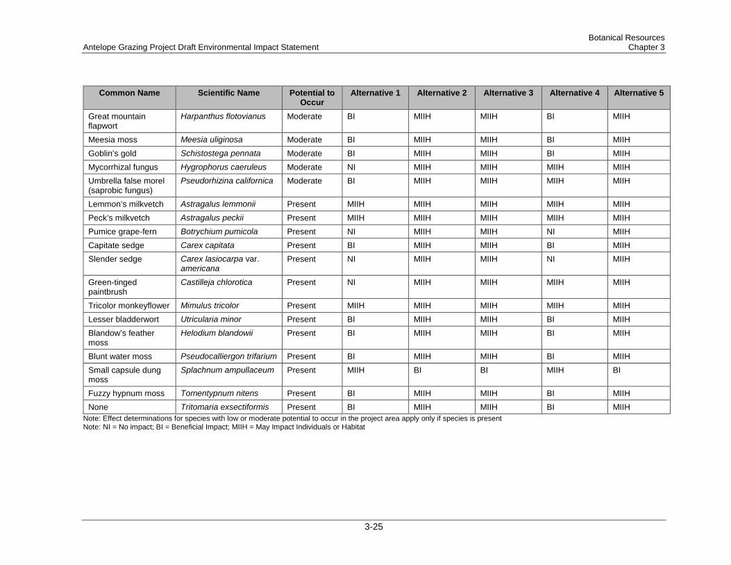
Botanical Resources Antelope Grazing Project Draft Environmental Impact Statement Chapter 3
Common Name Scientific Name Potential to Occur
Alternative 1 Alternative 2 Alternative 3 Alternative 4 Alternative 5
Great mountain flapwort
Harpanthus flotovianus Moderate BI MIIH MIIH BI MIIH
Meesia moss Meesia uliginosa Moderate BI MIIH MIIH BI MIIH Goblin’s gold Schistostega pennata Moderate BI MIIH MIIH BI MIIH Mycorrhizal fungus Hygrophorus caeruleus Moderate NI MIIH MIIH MIIH MIIH Umbrella false morel (saprobic fungus)
Pseudorhizina californica Moderate BI MIIH MIIH MIIH MIIH
Lemmon’s milkvetch Astragalus lemmonii Present MIIH MIIH MIIH MIIH MIIH Peck’s milkvetch Astragalus peckii Present MIIH MIIH MIIH MIIH MIIH Pumice grape-fern Botrychium pumicola Present NI MIIH MIIH NI MIIH Capitate sedge Carex capitata Present BI MIIH MIIH BI MIIH Slender sedge Carex lasiocarpa var.
americana Present NI MIIH MIIH NI MIIH
Green-tinged paintbrush
Castilleja chlorotica Present NI MIIH MIIH MIIH MIIH
Tricolor monkeyflower Mimulus tricolor Present MIIH MIIH MIIH MIIH MIIH Lesser bladderwort Utricularia minor Present BI MIIH MIIH BI MIIH Blandow’s feather moss
Helodium blandowii Present BI MIIH MIIH BI MIIH
Blunt water moss Pseudocalliergon trifarium Present BI MIIH MIIH BI MIIH Small capsule dung moss
Splachnum ampullaceum Present MIIH BI BI MIIH BI
Fuzzy hypnum moss Tomentypnum nitens Present BI MIIH MIIH BI MIIH None Tritomaria exsectiformis Present BI MIIH MIIH BI MIIH
Note: Effect determinations for species with low or moderate potential to occur in the project area apply only if species is present Note: NI = No impact; BI = Beneficial Impact; MIIH = May Impact Individuals or Habitat
3-25

Botanical Resources Chapter 3 Antelope Grazing Project Draft Environmental Impact Statement
Table 3-5. Location of sensitive botanical species documented within the Antelope Grazing Allotments project area
Name Type Location
Lemmon's milkvetch Vascular Halfway and Antelope 2–4
Peck's milkvetch Vascular North Sheep
Pumice grape-fern Vascular Chemult & North Sheep
Capitate sedge Vascular Chemult
Slender sedge Vascular Chemult
Green-tinged paintbrush Vascular Tobin Cabin
Tricolor monkeyflower Vascular Halfway and Antelope Flats 1–4
Lesser bladderwort Vascular Chemult
Blandow's feather moss Bryophyte Chemult and North Sheep
Blunt water moss Bryophyte Chemult
Small capsule dung moss Bryophyte Chemult
Fuzzy hypnum moss Bryophyte Chemult and North Sheep
Tritomaria exsectiformis Bryophyte Chemult and North Sheep
3.2.1.3.1 Vascular Plants Occupied and potential habitats for species with known sites or a moderately high likelihood of occurring in the project area are described below. Potential habitats for species with a low likelihood of occurring in the project area are summarized in the botanical technical report (project record). The likelihood of a species being present in the project area was determined by looking at factors such as habitat suitability, the location of known sites, and the degree to which potential habitat has already been surveyed.
Lemmon’s milkvetch is a low-growing perennial with a fleshy taproot. To date on the Forest, this species has been located only on the Silver Lake RD, occurring almost entirely in the project area. This species is associated with soil mapping unit 14, as defined in the Fremont Soil Resource Inventory (Wenzel 1979). Potential habitat in the project area has been surveyed. In the Halfway Pasture, over 40,000 plants occupy 31 acres around Halfway Lake and in the adjoining shrublands. A second cluster of populations and subpopulations occurs in Antelope Flat 2–4 pastures. Plants on Antelope Flat are more scattered than at Halfway Lake. A total of 23.1 acres of occupied habitat and an estimated 1,200 individuals were documented on Antelope Flat (Lynch 2011).
Peck’s milkvetch is a low-growing perennial with a long taproot. This species occurs at 6 sites on the Chemult and Chiloquin RDs and occupies approximately 160 acres in forest openings and meadow edges. Within the project area, a single known population exists along a meadow edge near an intermittent reach of Jack Creek in the Lower Davis Flat area of the North Sheep Pasture. Additional potential habitat is present in lodgepole pine and ponderosa pine forested upland areas and along dry meadow edges in the North Sheep, Chemult, and Tobin Cabin pastures. The
3-26
Botanical Resources Antelope Grazing Project Draft Environmental Impact Statement Chapter 3
known population has declined from 1,260 plants first recorded in 2001. One hundred plants were found in 2011, and 200 plants were found in 2013. Cushman (2006) states that an increase in grass and forb cover may be partly or wholly responsible for the apparent decline in Peck’s milkvetch plants. A 5-year study on the Forest and Prineville BLM lands looked at the effects of fire, soil disturbance, clipping, and removal of competing vegetation on this species (Carr et al. 2009). Results of the study were inconclusive. Carr et al. (2009) speculated that Peck’s milkvetch may be somewhat resistant to occasional disturbance but that repeated disturbance could be detrimental. Martin and Meinke (2010) found Peck’s milkvetch habitat most closely associated with reduced litter cover, indicating occasional disturbance may be beneficial.
Pumice grape-fern is a small fleshy fern endemic to south-central Oregon and northern California (Mount Shasta). On the Forest, this species occurs at 71 sites on the Chemult, Silver Lake, and Chiloquin RDs and occupies 173 acres. Habitat is primarily lodgepole pine basins with pumice soils, although the species is also found at high elevations. A population of 75 plants was found in the North Sheep Pasture. In the north part of the Chemult Pasture, 3 small sites containing a total of 5 plants were found. Two of the northern sites are outside the current boundary but would be included with the proposed boundary adjustment. The sites in the watershed are managed as part of the Chemult Pasture under the draft conservation strategy (Powers 2011). The plants are small (less than 2 inches tall), do not emerge every year, and have a large amount of potential habitat in the project area, so other sites may be present but not yet detected. Botrychium species are highly dependent on mycorrhizal relationships. Because the fungal partner provides the primary ecological interactions, Botrychiums are thought to be less directly sensitive to environmental conditions than many vascular plants (Farrar 2004). Johnson-Groh et al. (2002) found Botrychiums have a large belowground reserve of gametophytes and juvenile sporophytes that are essentially protected belowground and can easily withstand dry years, fires, herbivory, or other aboveground disturbances. A multiyear study (Amsberry and Meinke 2003) looked at the effects of mechanical disturbance and clipping on pumice grape-fern. The study found that burial was detrimental at all sites; aerial leaf removal did not have a negative effect on emergence; and recovery from scraping and compaction occurred at some sites.
Capitate sedge is a cespitose sedge with short rhizomes. It has been found at 14 sites totaling about 4.4 acres on the Chemult, Klamath, Silver Lake, and Bly RDs. The Chemult Pasture contains 10 of the known sites, and other sites may also exist in this pasture. Occupied and potential habitat consists of moist to wet meadows and fens, where the species often forms small hummocks. Capitate sedge is found in meadows as well as fens, but meadow sites are associated with patches of fewflower spikerush (Eleocharis quinqueflora), suggesting a groundwater influence, although peat soils may not be present. Capitate sedge is reported to respond positively to burning (Walsh 1994), and the presence of the species in a recently burned area of Round Meadow supports this view. Other disturbance effects are not documented. Plants in the allotment generally appeared ungrazed in 2009, 2010, and 2011. The presence of leaf litter at the base of most plants also suggested low levels of grazing use.
Slender sedge is a tall, strongly rhizomatous sedge that occurs in the northern latitudes of North America and Eurasia. On the Forest, this species has been found at 5 sites totaling 5.2 acres on the Chemult and Klamath RDs. Occupied and potential habitat consists of wet areas of meadows, fens, and lakeshores; the species is often found in standing water. Currently this species is known to occupy less than 0.1 acre in the Chemult Pasture, in a fen that had very little grazing use in 2009 and 2010.
Green-tinged paintbrush is a perennial forb in the Figwort family that forms hemiparasitic associations with sagebrush and bitterbrush and occurs in forest openings and shrublands. The
3-27
Botanical Resources Chapter 3 Antelope Grazing Project Draft Environmental Impact Statement
species occupies 179 sites and 15,694 acres on the Forest. The project area provides marginal habitat for this species. A single 6-acre site has been reported on top of Bald Mountain in the Tobin Cabin Pasture. The draft conservation strategy for this species (Anderson 2011a) states that green-tinged paintbrush appears to tolerate, even avoid, impacts from livestock grazing. The presence of mature shrubs may mitigate impact by providing shelter from grazing/trampling. The Bald Mountain site is not near a water source and is unlikely to provide adequate forage to attract livestock.
Tricolor monkeyflower is a small annual forb. It has been found at 13 sites on Chiloquin and Silver Lake RDs and occupies about 575 acres of open, vernally wet pools, swales, mudflats, and channels in pine and sagebrush habitats. Potential habitat in the project area has been surveyed. Yearly plant counts vary widely and appear to be tied to precipitation and runoff occurring in spring and early summer. Seed for this species is contained within capsules, which require a lengthy exposure to water before they open and disperse the seeds (Meinke 1995). The seeds are also dispersed by water, but the dispersal distance may not be great unless precipitation is ample enough to flood vernal pools or depressions (Meinke 1995). Approximately 47% of the known habitat for this species occurs in the project area. The majority of the tricolor monkeyflower habitat in the project area occurs in the Antelope 1 Pasture. The population also overlaps portions of the Halfway Pasture and portions of the Antelope 2, 3, and 4 pastures, extending south into the Little Antelope Pasture of the Buck Creek Allotment. The Antelope Flat population totaled an estimated 1,000,000 plants in 2006, up from 16,000 plants observed in 1993.
Lesser bladderwort is a small, carnivorous, aquatic forb adapted to nutrient-poor conditions. Hydrology and water quality are thought to be important in maintaining habitat (Neid 2006). Lesser bladderwort has been found at 16 sites on the Chemult, Chiloquin, and Klamath RDs, where it occupies approximately 7.4 acres of fen habitats. The Chemult Pasture contains 12 of the known sites. The species is typically found in mucky shallow pools with fewflower spikerush. Lesser bladderwort has creeping branches, highly divided leaves, and small, clear bladders that trap and digest tiny organisms. The small stature and aquatic habit of the species make it difficult to detect; additional, undetected sites may be present in fens in the project area. Northern bladderwort and lesser bladderwort occur in similar habitats, but the likelihood of northern bladderwort occurring in the project area is considered low, because this species has never been found on the Fremont-Winema National Forest, despite extensive fen surveys.
3.2.1.3.2 Bryophytes Blandow’s feather moss is a relatively large, upright, branching moss found in medium-rich to rich fen habitats throughout the northern latitudes. This species forms mats and small hummocks in or around edges of montane fens and is often along streamlets on peat or decayed wood (Christy and Huff 2007a). On the Forest, the species has been found at 14 sites occupying 6.6 acres on Klamath, Bly, and Chemult RDs. The Chemult Pasture contains 5 of the known sites, and the North Sheep Pasture contains 4 sites. The small stature of the species makes it difficult to detect; additional, undetected sites may be present in fens in the project area.
Blunt water moss is a sparingly branched moss with round, blunt, wormlike shoots. This species is found intermixed with other bryophytes in medium to rich montane fens, where it grows submerged to emergent in pools or on saturated ground, usually in full sunlight (Christy et al. 2007a). Like lesser bladderwort, this species is typically found in mucky shallow pools. Currently, blunt water moss is known only from the Deschutes and Winema side of the Fremont-Winema National Forest in Region 6. The species has been found at 7 sites occupying 0.8 acres on the Klamath and Chemult RDs. The Chemult Pasture contains 5 of the known sites on the Forest. The small stature and aquatic habit of the species make it difficult to detect; additional, undetected sites may be present in fens in the project area.
3-28
Botanical Resources Antelope Grazing Project Draft Environmental Impact Statement Chapter 3
Small capsule dung moss is a small, green, upright moss that forms dense sods on dung in peatlands (Christy et al. 2007b). Dung mosses depend on flies to disperse their sticky spores (Christy et al. 2007b). Because the substrate is ephemeral, small capsule dung moss can arise and disappear over time. The species has a circumboreal distribution, but currently known to occur only on the Fremont-Winema National Forest in Region 6, where it is typically found on cow manure. Of the 23 known sites on the Forest, 22 sites totaling 4.5 acres are located in the Chemult Pasture. Additional sites containing this species may have developed in the project area since surveys were conducted.
Fuzzy hypnum moss is a yellow-green to brown, branched, upright moss. This species grows in loose or dense sods or intermixed with other bryophytes in medium to rich montane fens, where it favors slightly elevated sites such as logs, stumps, or hummocks formed by bog blueberry (Vaccinium uliginosum) and dwarf birch (Betula nana) (Christy and Huff 2007b). On the Fremont-Winema National Forest, fuzzy hypnum moss has been found at 42 sites occupying 35.7 acres on the Klamath, Chiloquin, Chemult, and Silver Lake RDs. The majority of sites (32) are located in the Chemult Pasture. The North Sheep Pasture contains 2 sites, and a single site was found at Section 9 Spring in the Tobin Cabin Pasture. This species is small in stature and therefore difficult to detect, and it has been found at a range of fen habitats, including small “fen inclusions.” Additional, undetected sites likely exist in the project area.
Tritomaria exsectiformis is a minute leafy liverwort with circumboreal distribution. This species is typically found with other liverworts on peaty or humic soil, or rotting wood, often on creek banks where habitat is perpetually shady, cool, and moist (Wagner and Huff 2008). In the Chemult Pasture, this species is generally found along the forested margins of fens. Currently all 12 of the known sites exist on the Forest: 11 sites (1.12 acres) in the Chemult Pasture and 1 site (0.1 acre) in the North Sheep Pasture to the south. The small stature of the species makes it difficult to detect; additional, undetected sites may be present in fens in the project area.
Spiny threadwort, great mountain flapwort, meesia moss, and goblin’s gold are small bryophytes with circumboreal distribution. They have been previously found in fen habitats on the Fremont-Winema National Forest and the Deschutes National Forest, outside the project area. These species may be present in the project area, but they were not detected during recent fen surveys, possibly because of the species’ small size.
3.2.1.3.3 Fungi The project area contains potential habitat for 2 sensitive species of fungi, mycorrhizal fungus and umbrella false morel (saprobic fungus). Mycorrhizal fungus could occur in white fir mixed-conifer forest on the upper slopes and tops of buttes and ridges in the project area. Umbrella false morel (saprobic fungus) could occur in mixed conifer or lodgepole pine forest in both upland and riparian habitats.
3.2.1.4 Cultural Plants The Klamath Tribes and other American Indian tribes use the Forest for collecting plants that are used to make things, such as basketry, and for eating or medicinal purposes. Traditional gathering is an essential part of maintaining tribal traditions and culture. The Forest Service does not know the location of cultural plant collecting areas or the specific plants used by tribal members. In keeping with the wishes of the Klamath Tribes, it is the intent of the Forest Service not to reveal these locations or the names of the specific plants that are collected. The biological evaluation and botanical specialist report (available in the project record) contains a tabular display of 52 culturally important plant species that are considered in this analysis. The habitat, grazing use, and ecological information in the table are based on a literature search, Forest
3-29
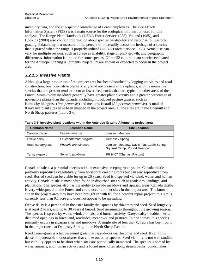
Botanical Resources Chapter 3 Antelope Grazing Project Draft Environmental Impact Statement
inventory data, and the site-specific knowledge of Forest employees. The Fire Effects Information System (FEIS) was a main source for the ecological information used for this analysis. The Range Plant Handbook (USDA Forest Service 1988), Volland (1985), and Hopkins (2000) also contain information about species palatability and response to livestock grazing. Palatability is a measure of the percent of the readily accessible herbage of a species that is grazed when the range is properly utilized (USDA Forest Service 1988). Actual use can vary for multiple reasons, such as forage availability, stage of plant growth, and geographic differences. Information is limited for some species. Of the 52 cultural plant species evaluated for the Antelope Grazing Allotments Project, 39 are known or expected to occur in the project area.
3.2.1.5 Invasive Plants Although a large proportion of the project area has been disturbed by logging activities and road construction, few non-native plants of any kind are present in the uplands, and the nonnative species that are present tend to occur at lower frequencies than are typical in other areas of the Forest. Moist-to-dry meadows generally have greater plant diversity and a greater percentage of non-native plants than the uplands, including introduced pasture grasses such as Kentucky bluegrass (Poa pratensis) and meadow foxtail (Alopecurus pratensis). A total of 8 invasive plant sites have been mapped in the project area; all the sites are in the Chemult and North Sheep pastures (Table 3-6).
Table 3-6. Invasive plant locations within the Antelope Grazing Allotments project area
Common Name Scientific Name Site Location Canada thistle Cirsium arvense Jamison Meadow
Oxeye daisy Leucanthemum vulgare Dempsey Spring
Reed canarygrass Phalaris arundinacea Jamison Meadow, Davis Flat, Cabin Spring, Squirrel Camp, Round Meadow
Tansy ragwort Senecio jacobaea FR 9407 (Chemult Pasture)
Canada thistle is a perennial species with an extensive creeping root system. Canada thistle primarily reproduces vegetatively from horizontal creeping roots but can also reproduce from seed. Buried seed can be viable for up to 26 years. Seed is dispersed via wind, water, and human activity. Canada thistle is most often found in disturbed sites such as roadsides, landings, and plantations. The species also has the ability to invade meadows and riparian areas. Canada thistle is very widespread on the Forest and could occur at other sites in the project area. The known site in the project area may have been brought in with fill for a headcut repair project; this site is currently less than 0.1 acre and does not appear to be spreading.
Oxeye daisy is a perennial in the aster family that spreads by rhizomes and seed. Seed longevity is at least 2 years, and up to 30 years if buried. Seed germinates throughout the growing season. The species is spread by water, wind, animals, and human activity. Oxeye daisy inhabits mesic, disturbed openings in forestland, roadsides, meadows, and pastures. In drier areas, this species primarily occurs in riparian sites and meadows. A single site of less than 0.1 acre has been found in the project area, at Dempsey Spring in the North Sheep Pasture.
Reed canarygrass is a tall perennial grass that reproduces via rhizomes and seed. It can form dense, impenetrable monocultures that choke out other species. Seed viability is not well studied, but viability appears to be short when sites are periodically inundated. The species is spread by water, animals, and human activity and is found most often along stream banks, ponds, lakes,
3-30

Botanical Resources Antelope Grazing Project Draft Environmental Impact Statement Chapter 3
irrigation canals, and ditches, and in moist to wet meadows. Because reed canarygrass can be used for hay, forage, and erosion control, some meadows on the Forest may have been seeded with the species. Small patches (<0.1 acre) of reed canarygrass occur in the watershed at headcut repair sites in Jamison Meadow (same vicinity as Canada thistle) and Davis Flat. Reed canarygrass is also located at Cabin Spring and near the pond in the Squirrel Camp fenced riparian area and occurs in scattered patches in Round Meadow. Both elk and livestock appear to eat this species within the project area.
Tansy ragwort is a biennial in the aster family that reproduces primarily by seed. After seed production, individual plants generally die. However, the crown and the root system from a flowering plant can produce new rosettes. Seeds require light for germination, but they can remain viable in soils for 10–16 years. Tansy ragwort contains toxic alkaloids that can be lethal to cattle and horses. This species is more common west of the Cascades, and few sites have been reported in Lake and Klamath counties. The site in the Chemult Pasture may have been introduced on logging or chipping equipment brought to the landing. This infestation is a priority for treatment and has been declining with annual manual control. Few plants remain.
3.2.2 Direct and Indirect Effects Direct and indirect effects of each alternative are analyzed on NFS lands and non-NFS lands under term private land grazing permits within the boundary of the allotment for each alternative. Current management (Alternative 2) serves as a baseline for comparing the potential effects to botanical resources from the other alternatives. The time frame for analysis is 10 years. Effects include both short-term (season of use) and long-term (life of the permit, or 10 years) impacts for the project area. Plants are unlikely to migrate great distances in 10 years. The area of analysis for each species includes potential and occupied habitats on NFS lands in the project area and any adjoining areas that are occupied by the same populations.
3.2.2.1 Measurement Indicators Indicators used to measure effects are selected so that the effects of the project alternatives can be compared and contrasted. The selection of indicators was based on professional judgment and a thorough review of literature on the interaction of the species and grazing. The possible effects of the alternatives on botanical resources and invasive plants are disclosed quantitatively in Table 3-7.
3-31

Botanical Resources Chapter 3 Antelope Grazing Project Draft Environmental Impact Statement
Table 3-7. Comparison of botanical resources and invasive plant measurement indicators by alternative
Management Indicator
Alternative 1 Alternative 2 Alternative 3 Alternative 4a Alternative 5
Acres of fen habitat subject to grazing
0 372 555 6 568
Number of sites with sensitive fen plant speciesb subject to grazing
0 62 67 1 71
Acres of occupied sensitive fen plant speciesb habitat subject to grazing
0 25.1 29.5 0.1 30.7
Number of sites of small capsule dung moss subject to grazing
0 20 19 0 19
Acres of small capsule dung moss occupied habitat subject to grazing
0 4.3 4.3 0 4.3
Relative Intensityc of Grazing in Key Pastures Containing Sensitive Plants Chemult Pasture outside fenced riparian areas
Not grazed High Low Not grazed Medium-high, variable
Chemult Pasture inside fenced riparian areas
Not grazed Not grazed Low / not grazed
Not grazed Low
North Sheep Pasture
Not grazed Not grazed Low Not grazed Low-medium, variable
Antelope Flat 1 Pasture
Not grazed High Medium Medium Medium
Halfway Pasture Not grazed Medium Medium Medium Low aAll fen habitat in the Tobin Cabin Pasture would be excluded in 5–6 years, after fencing is completed. bExcludes small capsule dung moss, which benefits from grazing and is considered separately. cComparative ranking within each pasture by alternative, based on proportion of AUMs to acres grazed; grazing duration;
and/or percent utilization allowed. Rankings are not comparable across pastures.
3.2.2.2 Common to All Action Alternatives
3.2.2.2.1 Species Not Affected by the Project None of the alternatives would have any direct or indirect impact on sensitive species whose range does not overlap the project area; and none of the alternatives would affect sensitive species for which no suitable habitat exists in the project area (40 of the sensitive species listed on the Region 6 list fall into this category). The alternatives would also have no direct or indirect impact on species that may occur but are not likely to be affected by grazing, such as species that grow on trees and rock outcrops. For some species, adequate surveys have already been completed to determine they are not present. Species not impacted by the project because of the factors listed here are discussed in the Botany report (available in the project record).
3-32
Botanical Resources Antelope Grazing Project Draft Environmental Impact Statement Chapter 3
3.2.2.2.2 Potential Grazing Effects
Effects of Associated Actions on Plants Actions associated with allotment management—such as salting, riding, herding, fence maintenance, water hauling, stock pond maintenance, wheeled motorized access, and occasional excess use grazing—were considered to be similar for all action alternatives and are expected to cause either no impacts or minimal short-term impacts to plants.
Effects of Grazing on Plants A literature search failed to find any studies that evaluated grazing effects on the sensitive species that occur in the project area. Available information on cultural plants is displayed in the Botany report (available in the project record). The direct and indirect effects of livestock grazing include selective consumption of plant materials, trampling, soil compaction, and nutrient redistribution (Allen-Diaz et al. 1999). Selective grazing by livestock can result in reduced vigor, lower productivity, and altered species composition. The magnitude of the effects is shaped by grazing intensity, grazing frequency, season of use, and the kind and class of animal (Allen-Diaz et al. 1999), as well as the individual characteristics and habitat requirements of the plant species. Numerous studies have shown differences in vegetation and soil conditions between heavily grazed and ungrazed areas (Allen-Diaz et al. 1999). Less is known about the effects of low to moderate levels of grazing and different types of grazing systems. Some plant species may benefit from moderate levels of grazing that create open sites for seed germination and/or reduce competition for light and nutrients.
Because much of the project area has been similarly grazed for decades, many of the effects of livestock grazing have already been manifested. Information is not available about the original distribution of plant species in the project area. In general, graminoids have a greater potential to be eaten, while forbs are less likely to be palatable, and small or prostrate species are unlikely to be grazed. Species that occur in riparian areas and near water sources where livestock concentrate are at risk for trampling. Grazing is likely to cause minimal effects to upland species in the Chemult, North Sheep, and Tobin Cabin pastures, because upland habitats in those pastures provide minimal forage to attract livestock.
Effects of Grazing on Fens and Fen Species Species fact sheets list livestock grazing as a potential threat to all of the sensitive bryophytes in the project area (Christy and Huff 2007a,b; Christy et al. 2007a; Christy et al. 2007b; Wagner and Huff 2008). These documents state that livestock may trample and destroy bryophyte cover. In addition to direct impacts, fen species could also be affected by alteration of fen condition. Few studies of grazing effects in fens in North America could be found. Cooper et al. (2005) determined that cattle grazing that caused 20% or more of the soil surface to be bare of vegetation resulted in oxidation of peat and a negative carbon budget, while less-intense grazing was similar in effect to no grazing. Changes to water flow or soil–water interactions through compaction or creation of trails that divert water could also affect fen species. Cooper et al. (2005) note that long-term intensive cattle grazing in some Sierra Nevada fens resulted in loss of the clonal plant species that formed the peat body, and that loss of peat-forming vegetation can lead to erosion and hydrologic changes in fens.
European studies have evaluated grazing effects on fen bryophytes. The European fens are dominated by different vascular plant species than the fens in the project area but have some overlap in bryophyte species. Bergamini et al. (2001) found bryophyte diversity was 20% higher in grazed calcareous fens in Switzerland than in mowed fens, although intense grazing seemed to
3-33
Botanical Resources Chapter 3 Antelope Grazing Project Draft Environmental Impact Statement
negate this effect. Peintinger and Bergamini (2006) found reduced bryophyte diversity and biomass in fens that had been abandoned and were no longer mowed or grazed. The potential benefits of grazing in both studies were presumed to be a result of decreased litter and increased light availability to bryophytes. Bergamini and Pauli (2001) looked at nutrient loading and found decreased bryophyte biomass and bryophyte species density in response to fertilization treatments in calcareous fens in Switzerland. They attributed the decline in bryophytes primarily to increased vascular plant growth and shading. Bergamini and Pauli (2001) did note direct effects of nutrient loading may be possible for some species.
Effects of Grazing on Fungi A literature search conducted by Region 6 failed to find any studies that evaluated grazing effects on sensitive species of fungi (Ferriel and Grenier 2010). The most likely effect of livestock grazing would be impacts to underground mycelia from localized trampling and soil disturbance. Grazing would not change habitat features such as forest stand structure, canopy cover, humidity, availability of coniferous host plants, or woody debris levels. Grazing is likely to have little-to-no effect on mycorrhizal fungus. The white fir mixed conifer stands that provide potential habitat for this species in the project area contain little forage and no water sources to attract livestock. The habitat of umbrella false morel (saprobic fungus) is more likely to be impacted by trampling and soil impacts. This species, if it is present in the project area, could occur in riparian areas where livestock use is more concentrated.
3.2.2.2.3 Alternative 1
Fen Habitats Alternative 1 is expected to maintain or improve fen habitats in the project area. Existing information suggests that soil disturbance is the primary impact of livestock on these groundwater systems. Fen habitats in the project area are likely to show improved soil conditions over the 10-year time frame. Observation suggests improvements may occur in as little as 3–4 years. During the 2005 mollusk inventory, the Johnsons Meadow fen survey form stated that the fence was down and cow pies were prevalent. The photo taken of the site in 2005 showed considerable hoof action. In 2007, the riparian fence at Johnson Meadow fen was reconstructed. By the 2009 field season, little postholing or pedestaling was evident at this fen (Aldous 2011a). Tall pedestaling may be evident for longer periods, but bare soil conditions caused by livestock would likely recover within the 10-year time frame. Without grazing disturbance, some shifts in plant species abundance and distribution may occur. Seral forbs, such as primrose monkeyflower (Mimulus primuloides) and tinker’s penny (Hypericum anagalloides), may decline. Preferred livestock forage species, such as widefruit sedge and willow species, may have increased growth.
Sensitive Plant Species Low Likelihood of Occurrence Blue-leaved penstemon and diverse-leaved pondweed—Alternative 1 is expected to cause no impact to these species. These 2 species are minimally affected by grazing, so removal of grazing disturbance would have no effect.
3-34

Botanical Resources Antelope Grazing Project Draft Environmental Impact Statement Chapter 3
Short seeded waterwort, Bolander’s spikerush, Boggs Lake hedge-hyssop, disappearing monkeyflower, American pillwort, salty popcornflower, profuse-flowered pogogyne, American scheuchzeria, swaying bulrush, northern bladderwort, racomitrium moss, and Schistidium cinclidodonteum—Alternative 1 may reduce impacts to these species if they are present in the project area. These are species that have potential habitat in riparian areas and near water sources that could benefit from reduced trampling and/or herbivory. Over time, habitat conditions could improve for these species, and vigor and reproduction may increase.
Crenulate moonwort, bog clubmoss, annual dropseed, Columbia cress, and lowland toothcup—Alternative 1 may reduce habitat suitability for these species if they are present. These 5 species could potentially be negatively impacted by lack of grazing disturbance and increased competition from graminoids. However, most of these species would likely continue to persist in natural openings or as a result of natural disturbance processes, although the amount of habitat may be reduced under Alternative 1.
Moderate Likelihood of Occurrence Spiny threadwort, great mountain flapwort, meesia moss, and goblin’s gold—Potential habitat in fens for these species is likely to benefit from the removal of grazing disturbance under Alternative 1, due to reduced trampling. Alternative 1 would not likely cause a decline of habitat suitability due to vascular plant growth, litter accumulation, and shading in the absence of grazing.
Mycorrhizal fungus—Alternative 1 would have no impact on potential habitat for this species. Potential habitat for this species is in white fir mixed-conifer forest on the upper slopes, buttes, and ridges. These habitats have minor livestock use, and habitat suitability would not be affected by removal of grazing disturbance.
Umbrella false morel (saprobic fungus)—Alternative 1 may have a beneficial impact (BI) on potential habitat located in forested riparian areas. Removal of grazing disturbance and trampling in these areas could improve habitat suitability.
Known Occurrence Lemmon’s milkvetch—Lemmon's milkvetch plants do not appear to be grazed but may be trampled by livestock. Removal of grazing disturbance and trampling under Alternative 1 could initially result in improved vigor and reproduction of plants. However, in the absence of grazing, plants may be less able to compete with graminoids over time and could decline. This effect would likely be more pronounced in the moist habitat around Halfway Lake, where the associated meadow-like vegetation forms nearly a sod (Lynch 2011), than in the sparser upland sagebrush/bunchgrass vegetation type. Lemmon's milkvetch is likely to persist under Alternative 1, but population levels may decrease. Fence removal and unauthorized grazing would have little-to-no effect on this species.
Peck’s milkvetch—Occupied habitat for Peck's milkvetch is located in the North Sheep Pasture, where grazing currently does not occur. Alternative 1 would have no impact on occupied habitat. Removal of grazing disturbance under Alternative 1 is likely to cause no impact to potential habitat in upland areas of the Chemult and Tobin Cabin pastures but may result in increased graminoid growth and vigor in potential habitat located along meadow edges. Increased graminoid growth could reduce habitat suitability for this species in some areas but is not likely to eliminate any populations that may be present during the 10-year time frame of the analysis. Conversely, discontinuing grazing could result in less trampling and soil impacts in potential habitat located along meadow edges.
3-35
Botanical Resources Chapter 3 Antelope Grazing Project Draft Environmental Impact Statement
Pumice grape-fern—This species is unlikely to be affected by livestock grazing. The species has short stature and is located in lodgepole pine basins that provide little forage and lack water sources to attract livestock. Removal of grazing disturbance under Alternative 1 is likely to have no impact on this species. Likewise, fence removal or minor unauthorized use would not likely impact pumice grape-fern.
Capitate sedge—Plants observed during the 2009–2011 field seasons have generally not been grazed; however, trampling can occur. Removal of grazing disturbance and trampling under Alternative 1 could result in improved vigor and reproduction of plants. No evidence exists to indicate that the species would decline without grazing. Capitate sedge tends to grow with other low vegetation (fewflower spikerush) rather than taller graminoids, reducing the potential for competition effects. Monitoring of populations inside existing fenced riparian areas at Squirrel Camp and Round Meadow in 2011 showed vigorous reproductive plants with 30%–40% cover and 15% cover, respectively (Anderson 2011b). Healthy populations were also found at ungrazed fens in other areas of the Forest (Bull Swamp, Gearhart Marsh). Fence removal and unauthorized grazing could cause minor short-term impacts to this species, but overall, Alternative 1 is expected to have a BI on capitate sedge.
Slender sedge—This species is a tall, strongly rhizomatous sedge of wet habitats. Because it reproduces vegetatively and grows in standing water, this species is unlikely to be sensitive to grazing effects. The known site in the Chemult Pasture is in a fen that received minimal livestock use during the 2009–2010 field seasons. Unauthorized use is not likely to occur. No existing fences are present near the known site. Because of these factors, Alternative 1 is likely to have no impact on this species.
Green-tinged paintbrush—The known green-tinged paintbrush site in the Tobin Cabin Pasture is on top of Bald Mountain in an area with limited forage and no water sources to attract livestock. Substantial grazing disturbance is not likely to be occurring there; therefore, removal of grazing under Alternative 1 would not likely result in improved habitat conditions. No existing fences are present near the known site, and unauthorized use is not likely to occur in this area. Because of these factors, Alternative 1 is likely to have no impact on green-tinged paintbrush.
Tricolor monkeyflower—This species has a low potential to be grazed, due to its short stature. Trampling during spring or early summer could prevent seeding by this annual species. Removal of grazing disturbance and trampling under Alternative 1 could result in improved vigor and reproduction of plants in the short term. Over the long term, without grazing disturbance, some of the bare swales and mudflats that support tricolor monkeyflower could become vegetated with graminoids, reducing the amount of suitable habitat present. Disturbance from seasonal flooding/ponding would likely be adequate to provide sufficient habitat to maintain the Antelope Flat population over the 10-year time frame. Removal of existing pasture fences under Alternative 1, and the occasional unauthorized grazing that might occur, could have minor short-term impacts on tricolor monkeyflower.
Lesser bladderwort—Livestock grazing is listed as a potential threat for lesser bladderwort by Neid (2006). Neid (2006) states that field observations of lesser bladderwort and common bladderwort (Utricularia macrorhiza) populations show a decline or localized elimination of populations that undergo trampling by cattle, humans, or motorized vehicles. Although lesser bladderwort is sometimes found growing in livestock hoofprints, this species is not likely helped or maintained by grazing disturbance. Naturally formed shallow pools are generally abundant in the wetter fens, and lesser bladderwort populations have been found at ungrazed fens on the Forest (Bull Swamp, Mares Egg Spring). Under Alternative 1, fence removal at riparian areas in Johnson Meadow and subsequent unauthorized use could cause minor short-term impacts from
3-36
Botanical Resources Antelope Grazing Project Draft Environmental Impact Statement Chapter 3
trampling. However, overall, Alternative 1 would be expected to have a BI on lesser bladderwort.
Blandow’s feather moss—Observations on the Forest suggest removal of grazing disturbance under Alternative 1 is not likely to result in a decline of Blandow's feather moss due to vascular plant growth, litter accumulation, and shading. In the Chemult and North Sheep pastures, Blandow's feather moss is often found along the edges of fens in partially shaded areas. Six of the 14 known sites on the Forest have not been recently grazed. These include the North Sheep Pasture sites, which have not been grazed for 5–7 years, and sites at Forked Horn Springs and Bull Swamp, which have not been grazed for decades. Although litter is seen in ungrazed fens, monitoring in 2011 indicates that accumulation is minimal and often associated with drier areas containing tufted hairgrass. Litter accumulation is generally absent from low-growing vegetation dominated by fewflower spikerush, which characterizes the best habitat for Blandow’s feather moss in the project area. Minor short-term impacts to Blandow's feather moss could occur during removal of the Squirrel Camp riparian fence, or as a result of occasional unauthorized grazing. Overall, Alternative 1 is expected to have a BI on Blandow's feather moss, due to reduced trampling.
Blunt water moss—This species is generally found out in the middle of wet fens with other low-growing vegetation. Alternative 1 would not likely cause a decline of this species due to vascular plant growth, litter accumulation, and shading in the absence of grazing. As described under lesser bladderwort, natural pool habitat is generally abundant in the wetter fens, and livestock hoofprints are not needed to maintain habitat for blunt water moss. Minor short-term impacts to blunt water moss could occur during removal of the Jack Creek riparian fence, or as a result of occasional unauthorized grazing. Overall, Alternative 1 is expected to have a BI on blunt water moss, due to reduced trampling.
Small capsule dung moss—This species grows on dung and is found on cow manure in the Chemult Pasture. Although removal of livestock grazing under Alternative 1 could reduce trampling of this species, any potential benefit would be outweighed by loss of the key substrate. Within the 10-year time frame, most of the existing cow manure in wet fen habitats would completely decompose. Elk and deer droppings are sometimes colonized by small capsule dung moss, and native ungulate use of fens may increase after livestock are removed. Occasional unauthorized livestock could also provide substrate for this species in some areas. Alternative 1 is likely to result in a large reduction of habitat for small capsule dung moss. Although habitat would return to a more natural condition, substrate to maintain this species on NFS lands in the project area might not be adequate over the 10-year time frame.
Fuzzy hypnum moss— This species is generally found on hummocks with other low-growing vegetation. Alternative 1 would not likely cause a decline of this species due to vascular plant growth, litter accumulation, and shading in the absence of grazing. Sites of the species occur in several fens that have not been recently grazed, including fenced riparian areas, the North Sheep Pasture, and Bull Swamp. Minor short-term impacts to fuzzy hypnum moss could occur during removal of riparian fences, or as a result of occasional unauthorized grazing. Overall, Alternative 1 is expected to have a BI on fuzzy hypnum moss, due to reduced trampling.
Tritomaria exsectiformis—This species is generally found in moist, shady areas around the margins of fens with other liverworts. Alternative 1 would not likely cause a decline of this species due to vascular plant growth, litter accumulation, and shading in the absence of grazing. Minor short-term impacts to Tritomaria exsectiformis could occur during removal of the Jack Creek riparian fence, or as a result of occasional unauthorized grazing. Overall, Alternative 1 is expected to have a BI on Tritomaria exsectiformis, due to reduced trampling.
3-37
Botanical Resources Chapter 3 Antelope Grazing Project Draft Environmental Impact Statement
Cultural Plants Discontinuing grazing in the project area is expected to have a minor effect on cultural plant species with poor to fair palatability for cattle, especially those species occurring in upland sites at low risk for trampling. Species listed as decreasers by Volland (1985) or Hopkins (2000), and species with fair to good palatability, especially those that occur in meadows or riparian areas where livestock concentrate, may remain static or increase in vigor and abundance under Alternative 1. Species listed as increasers (i.e., species that respond positively to grazing disturbance) may decline over the 10-year time frame. Overall, Alternative 1 is expected to have a positive effect on 16 cultural plant species, a negative effect on 10 species, and a variable effect or no effect on 26 species (including those that are unlikely to be present in the project area) (see the biological evaluation and botanical specialist report available in the project record).
Invasive Plants The risk of invasive plant introduction and spread would be lowest under Alternative 1. Compared to the action alternatives, Alternative 1 would result in reduced vehicle traffic, reduced ground disturbance, and reduced movement of livestock, decreasing the potential for spread of existing sites and introduction of new sites.
3.2.2.2.4 Alternative 2
Fen Habitats Under Alternative 2, roughly 372 acres of fen habitat in the Chemult Pasture would be grazed. One of the high-value fens, Middle Jack 8802 North would be excluded from grazing. Livestock use patterns are expected to remain similar to those of recent years. Therefore, Alternative 2 is expected to maintain fen habitats in a condition similar to the existing condition, with most (33) in good or fair condition (see the biological evaluation and botanical specialist report available in the project record). Fens in the North Sheep Pasture would experience no effects from grazing. Fens and “fen inclusions” located in the Squirrel Camp, Round Meadow, Johnson Meadow, Wilshire Meadow, Dry Meadow, Cannon Well, Sproats Meadow, and Jack Creek fenced riparian areas would be maintained or would improve under this alternative. Six fens in poor condition would likely remain in poor condition, and they may continue to decline with repeated heavy trampling. One of these 6 is Little Parker, a high-value fen. In heavily trampled fens, sensitive plant species habitat could be reduced, and a shift to grasses and forbs that prefer drier habitats could occur on top of the taller pedestals. As noted by Cooper et al. (2005), fens in poor condition could experience loss of peat due to oxidation in localized areas. Observations in the project area indicate that a major shift in the vegetative composition of poor-condition fens over the 10-year time frame is unlikely, unless long-term drought or hydrological changes occur.
As described in Appendix D, monitoring and adaptive management would be used to ensure that all 8 fens ranked as high value for sensitive plants are maintained in good condition or trend toward good condition during the 10-year time frame of the analysis. Little Parker, currently listed in poor condition, is one of these high-value fens. An assumption is made that fen habitat for sensitive plant species would be best maintained in the project area by maintaining proper functioning condition, as defined by Weixelman and Cooper (2009), in the high-value fens. As shown in the biological evaluation and botanical specialist report (available in the project record), all of the sensitive plant species either have the majority of their sites in high-value fen habitats or are well distributed in the project area, including the high-value fens.
3-38
Botanical Resources Antelope Grazing Project Draft Environmental Impact Statement Chapter 3
Sensitive Plants Low Likelihood of Occurrence Blue-leaved penstemon and diverse-leaved pondweed—Livestock grazing under Alternative 2 is expected to have minimal effects on potential habitat for the upland species blue-leaved penstemon and the aquatic species diverse-leaved pondweed.
Short seeded waterwort, Bolander’s spikerush, Boggs Lake hedge-hyssop, disappearing monkeyflower, American pillwort, salty popcornflower, profuse-flowered pogogyne, American scheuchzeria, swaying bulrush, northern bladderwort, racomitrium moss, and Schistidium cinclidodonteum—These species have potential habitat in riparian areas and near water sources in the project area. If these species are present in the project area, they may be impacted by trampling and/or herbivory under Alternative 2.
Crenulate moonwort, bog clubmoss, annual dropseed, Columbia cress, and lowland toothcup—Grazing disturbance (at moderate levels) and reduced competition from graminoids could improve habitat conditions for these riparian species. However, individual plants may be impacted by trampling.
Moderate Likelihood of Occurrence Spiny threadwort, great mountain flapwort, meesia moss, and goblin’s gold—Potential habitat in fens for these species in the Chemult and Tobin Cabin pastures would be grazed under Alternative 2. Effects to fen habitats are described below. The effects of grazing on these 4 species are not known but are expected to be negative, primarily because of trampling. Because goblin’s gold occurs on rootwads, it may be less susceptible to trampling than the other 3 species.
Mycorrhizal fungus—Alternative 2 would have minor impacts on potential habitat for mycorrhizal fungus. Potential habitat for this species is in white fir mixed-conifer forest on the upper slopes, buttes, and ridges. These habitats provide little forage and lack water sources to attract livestock and are likely to be minimally affected by grazing disturbance.
Umbrella false morel (saprobic fungus) —Alternative 2 may impact potential habitat for umbrella false morel (saprobic fungus) located in forested riparian areas. Trampling by livestock could impact fungi mycelium, compact soils, and reduce habitat suitability for this species in localized areas with concentrated use. Potential habitat in forested upland areas is likely to be minimally affected by grazing disturbance.
Known Occurrence Lemmon’s milkvetch—Nearly all (99%) of the known occupied habitat of Lemmon’s milkvetch on the Forest would be grazed under the action alternatives. Grazing intensity in the habitat in Halfway Pasture would be similar under Alternatives 2, 3, and 4, but Alternative 2 proposes a shorter duration (15 days). Habitat in Antelope 2, 3, and 4 pastures would be used more heavily under Alternative 2 than under any of the other action alternatives. Little information is available about the effects of grazing on Lemmon’s milkvetch. Given its prostrate growth form, the species is unlikely to be eaten by livestock. Trampling likely occurs during early-season grazing, especially around Halfway Lake when water is present. Removal of competing grasses through grazing could have a beneficial effect. During the 2009–2011 field seasons, the Lemmon’s milkvetch population at Halfway Lake appeared stable under the current management strategy. Monitoring and adaptive management are recommended to maintain this species. A reduction below 10% cover at Halfway Lake or a 10% reduction in total acres of occupied habitat in the project area would trigger construction of exclosures to protect the main Halfway Lake and Antelope 3 populations (see Appendix D).
3-39

Botanical Resources Chapter 3 Antelope Grazing Project Draft Environmental Impact Statement
Peck’s milkvetch—Occupied habitat of Peck’s milkvetch located in the North Sheep Pasture would not be grazed under Alternative 2. In the Chemult and Tobin Cabin pastures, potential habitat located in forested upland areas would likely be little affected by grazing disturbance. Potential habitat located along the edges of meadows could be trampled by livestock. Trampling could have a negative effect in localized areas with concentrated livestock use. Conversely, removal of competing grasses through grazing may have a beneficial effect; existing information (Martin and Meinke 2010) indicates Peck’s milkvetch habitat is correlated with reduced litter.
Pumice grape-fern—This species is unlikely to be eaten or trampled. The species has short stature and is located in lodgepole pine basins that provide little forage and lack water sources to attract livestock. Livestock might walk through occupied or potential habitat, but the potential for concentrated use is very low.
Capitate sedge—Six of the 14 known sites on the Forest and approximately 1.7 acres of occupied habitat would be grazed. Alternative 2 would graze less occupied habitat than Alternative 3 or Alternative 5, but more than Alternative 4. Effects to fen habitats, which provide the majority of occupied and potential habitat for this species, are discussed below. The palatability of capitate sedge is unknown, and its response to grazing has not been studied. The species occurs in meadows and fens with other graminoids and may be eaten by livestock; however, during the 2009–2011 field seasons, little use was observed. Cespitose sedge species, such as capitate sedge, are more dependent on seeds for reproduction than highly rhizomatous species and may decline with repeated grazing (Wilson et al. 2008). Some cespitose sedges have been noted to increase with moderate grazing that reduces grass competition, but they decline under heavier use (Wilson et al. 2008). Capitate sedge may also be impacted by trampling.
Capitate sedge often forms small hummocks that may be sheared along the edges by hoof action. Eight of the 10 known sites in the project area were located in fens that were rated in good condition in 2010–2011, one was rated fair to good, and one poor. These conditions are likely to be maintained with continuation of the current management. This species has been found in 4 of the 8 high-value fens, where monitoring and adaptive management would be used to maintain habitat in proper functioning condition (see Appendix B of the botanical technical report, available in the project record). Additionally, capitate sedge populations in the Round Meadow, Squirrel Camp, Jack Creek, and Wilshire Meadow fenced riparian areas would not be grazed.
Slender sedge—This species is a tall, strongly rhizomatous sedge of wet habitats. Because it reproduces vegetatively and grows in standing water, this species would not likely experience substantial grazing effects. The known site in the Chemult Pasture is in a fen that received minimal livestock use during the 2009–2010 field seasons. Minimal use is likely to continue under Alternative 2.
Green-tinged paintbrush—Grazing of green-tinged paintbrush is generally light to moderate (Phillips and Wooley 1994). The plants are found under shrubs, which help protect this species from grazing (Phillips and Wooley 1994). In heavily used areas, livestock may browse on bitterbrush host shrubs, reducing their ability to support green-tinged paintbrush plants. The primary host plant, big sagebrush, would not likely be affected by grazing. The known green-tinged paintbrush site in the project area is on top of Bald Mountain in an area with limited forage and no water sources to attract livestock. The Bald Mountain site contains less than 1% of the known habitat on the Forest.
Tricolor monkeyflower—The majority (63%) of the Antelope Flat tricolor monkeyflower population would be grazed under the action alternatives. Due to its short stature, tricolor monkeyflower has a low potential to be grazed. Trampling during early-season grazing and collecting/moving of livestock in the Antelope 1 and 2 pastures is more likely to affect this species, because tricolor monkeyflower occurs around water holes and seasonally wet swales.
3-40

Botanical Resources Antelope Grazing Project Draft Environmental Impact Statement Chapter 3
Use of the Antelope 3 and 4 pastures in September is likely to have little impact on tricolor monkeyflower, because the species is annual and has completed its life cycle by then. Meinke (1995) noted that even though livestock had heavily utilized an occupied area prior to a major bloom, the population seemed largely unaffected. Meinke states that the timing of cattle grazing is probably crucial and that, ideally, grazing should occur only after fruits have been set, to facilitate replenishment of the seed pool. However, Wilson and Malaby (2009) observed that during the June 24, 2009, tricolor monkeyflower survey in the adjacent Bear Flat Allotment, the majority of the plants had completed flowering and set seed and were beginning to disperse their capsules, despite continual grazing throughout the life cycle of the plant. Alternative 2 would allow early-season grazing in the primary tricolor monkeyflower habitat in Antelope 1 Pasture at 4 times the AUMs and grazing intensity of the other action alternatives. To prevent decline of the Antelope Flat population, mitigation is recommended. Mitigation would require utilization monitoring in Antelope 1 Pasture, to ensure that habitat for tricolor monkeyflower is grazed at no more than 50% utilization (see Appendix D).
Lesser bladderwort—Ten of the 16 known sites on the Forest and approximately 1.5 acres of occupied habitat would be grazed. Alternative 2 would graze a similar amount of habitat as Alternative 3 or Alternative 5, but more than Alternative 4. Effects to fen habitats, which provide all of the occupied and potential habitat for this species, are discussed below. The effects of grazing on lesser bladderwort are not known, but they are expected to be negative, primarily because of trampling and potential nutrient loading. Although trampling and nutrient loading may be a threat to lesser bladderwort, local observations suggest the species has some level of tolerance to these impacts. Dewey (botanist, Deschutes National Forest, pers. comm., email dated May 3, 2011) found a surprisingly large population of lesser bladderwort growing in hoofprint pools in a heavily trampled (25%–30% bare peat) portion of the Buck-Indian Allotment. Dewey (botanist, Deschutes National Forest, pers. comm., email dated May 3, 2011) noted that cow pies were mixed in with lesser bladderwort in hoofprint pools, indicating nutrient loading. Seven of the 12 known sites in the Chemult Pasture were located in fens rated in good condition in 2010–2011, with soil disturbance estimated at less than 10%. The remaining sites were in fens rated fair to poor. These conditions are likely to be maintained with continued current management. Lesser bladderwort has been found in 7 of the 8 high-value fens, where monitoring and adaptive management would be used to maintain habitat in proper functioning condition (see Appendix D). Lesser bladderwort populations in the Johnson Meadow and Jack Creek fenced riparian areas would not be grazed.
Blandow’s feather moss—Four of the 14 known sites on the Forest and approximately 1.5 acres of occupied habitat would be grazed. Alternative 2 would graze less habitat than Alternative 3 or Alternative 5, but more than Alternative 4. Effects to fen habitats, which provide all of the occupied and potential habitat for this species, are discussed below. The effects of grazing on Blandow’s feather moss are not known, but they are expected to be negative, primarily because of trampling. Three of the 5 known sites in the Chemult Pasture were located in fens rated in good condition in 2010–2011, with soil disturbance estimated at less than 10%. The remaining sites were in fens rated poor, with estimated soil disturbance greater than 20%. These conditions are likely to be maintained with continued current management. Blandow’s feather moss has been found in 3 of the 8 high-value fens, where monitoring and adaptive management would be used to maintain habitat in proper functioning condition (see Appendix D). Blandow’s feather moss populations in the Squirrel Camp fenced riparian area and the North Sheep Pasture would not be grazed.
Blunt water moss—Four of the 7 known sites on the Forest and approximately 0.4 acres of occupied habitat would be grazed. Alternative 2 would graze more habitat than any of the other action alternatives. Effects to fen habitats, which provide all of the occupied and potential habitat
3-41
Botanical Resources Chapter 3 Antelope Grazing Project Draft Environmental Impact Statement
for this species, are discussed below. The effects of grazing on blunt water moss are not known, but they are expected to be negative, primarily because of trampling. Blunt water moss is often found in the open wet areas of fens, which livestock tend to avoid. All 5 of the known sites in the Chemult Pasture were located in fens rated in good condition in 2010–2011, with soil disturbance estimated at less than 10%. These conditions are likely to be maintained with continued current management. Blunt water moss has been found only in high-value fens, where monitoring and adaptive management would be used to maintain habitat in proper functioning condition (see Appendix D).The site in the Jack Creek fenced riparian area would not be grazed.
Small capsule dung moss—Twenty of the 23 known sites on the Forest and approximately 4.3 acres of occupied habitat would be grazed. Alternative 2 would graze a similar amount of habitat as Alternative 3 or Alternative 5. Effects to fen habitats, which provide all of the occupied and potential habitat for this species, are discussed below. The effects of grazing on small capsule dung moss are not known, but grazing is expected to have an overall positive effect, because livestock would provide substrate in the form of manure. Small capsule dung moss is likely to be maintained in the project area outside of fenced riparian areas with continuation of current management. Two sites located within the Jack Creek fenced riparian area could disappear during the next 10 years under Alternative 2.
Fuzzy hypnum moss—Twenty-six of the 42 known sites on the Forest and approximately 20.4 acres of occupied habitat would be grazed. Alternative 2 would graze less habitat than Alternative 3 or Alternative 5, but more than Alternative 4. Effects to fen habitats, which provide all of the occupied and potential habitat for this species, are discussed below. The effects of grazing on fuzzy hypnum moss are not known, but they are expected to be negative, primarily because of trampling. Fuzzy hypnum moss is well distributed in the Chemult Pasture, occurring in almost every fen surveyed, including small “fen inclusions.” The wide distribution in the Chemult Pasture, coupled with the location of fuzzy hypnum moss in fens found to be in good to poor condition in 2010–2011, indicates some level of tolerance to grazing. Fuzzy hypnum moss has been found in all of the 8 high-value fens, where monitoring and adaptive management would be used to maintain habitat in proper functioning condition (see Appendix D). Under Alternative 2, occupied habitat in the Squirrel Camp, Round Meadow, Wilshire Meadow, Dry Meadow, Cannon Well, Johnson Meadow, and Jack Creek fenced riparian areas and the North Sheep Pasture would not be grazed.
Tritomaria exsectiformis—Eleven of the 12 known sites on the Forest and approximately 1.1 acres of occupied habitat would be grazed. Alternative 2 would graze a similar amount of habitat as Alternative 3 or Alternative 5, but more than Alternative 4. Effects to fen habitats, which provide all of the occupied and potential habitat for this species, are discussed below. The effects of grazing on Tritomaria exsectiformis are not known, but they are expected to be negative, primarily because of trampling. Eight of the 11 known sites in the Chemult Pasture were located in fens that were rated in good condition in 2010–2011, with soil disturbance estimated at less than 10%. Two were rated fair and one poor. These conditions are likely to be maintained under continued current management. Tritomaria exsectiformis has been found in 7 of the 8 high-value fens, where monitoring and adaptive management would be used to maintain habitat in proper functioning condition (see Appendix B of the botanical technical report available in the project record). The site in the Jack Creek fenced riparian area would not be grazed.
Cultural Plants Alternative 2 is expected to cause no effects or minor effects to cultural plant species with poor to fair palatability that occur outside of riparian areas. Low levels of use or trampling may occur. Species that benefit from grazing disturbance, listed as increasers by Volland (1985) or
3-42
Botanical Resources Antelope Grazing Project Draft Environmental Impact Statement Chapter 3
Hopkins (2000), may remain static or increase in vigor and abundance with continued grazing. Species listed as decreasers, and species with fair to good palatability, especially those that occur in meadows or riparian areas where livestock concentrate, may remain static or decline in vigor and abundance with continued grazing (Botany Report, Table A-4).
Overall, Alternative 2 is expected to have a positive effect on 10 cultural plant species, a negative effect on 16 cultural plant species, and variable effect or no effect on 26 cultural plant species (including those that are unlikely to be present in the project area) (see the biological evaluation and botanical specialist report available in the project record).
Invasive Plants Alternative 2 would allow grazing across the existing allotment boundaries, encompassing 146,155 acres. This is less grazing acreage than proposed under Alternatives 3 and 5, but more than under Alternative 4. Livestock grazing can increase the amount of habitat susceptible to invasive plant infestation, due to localized ground disturbance and reduction in the reproduction and vigor of desirable plants. Cattle can spread existing invasive plants from one site to another when weed seeds that attach to their coats or muddy hooves, or in some cases, cattle may ingest the seeds and then excrete them in a different location. While these effects are possible, livestock do not appear to have played a major role in the spread of invasive plants in the project area, and continued grazing under Alternative 2 would likely have a low risk of spreading invasive plants. The project area currently has few infestations, and existing infestations appear to have been caused by contaminated equipment, contaminated fill, or historical pasture seeding. Livestock grazing may suppress seed production of reed canarygrass in some areas of the Chemult Pasture. Required Forest Plan invasive species prevention standards and recommended Fremont-Winema prevention practices apply to livestock grazing and would be used where applicable to reduce the risk of weed spread (see Design Criteria, Chapter 2).
3.2.2.2.5 Alternative 3
Fen Habitats Alternative 3 would allow grazing of approximately 555 acres of fen habitat in both the Chemult and North Sheep pastures. The amount of grazed habitat is more than Alternative 2 or Alternative 4 proposes, and slightly less than Alternative 5. Portions of 2 high-value fens (Jack Creek N 2; Little Parker) would be excluded. Under Alternative 3, livestock use of fens in the Chemult Pasture is expected to be less intensive than under Alternative 2, due to a shorter grazing season and fewer AUMs. Therefore, Alternative 3 is expected to be more effective at maintaining and improving fen habitats in the Chemult Pasture than Alternative 2, even though more habitat would be grazed. Fens and “fen inclusions” located at Section 9 Spring, Squirrel Camp, Round Meadow, Johnson Meadow, Wilshire Meadow, Dry Meadow, Jack Creek North of Moffit, Little Parker fen, and a portion of Crooked Meadow would all be excluded from grazing, once fencing is completed. Fen habitat inside the Jack Creek fenced riparian area would be grazed under Alternative 3 but would likely remain in good condition. The duration of grazing would be limited to 30 days, and the utilization would be limited to 35%–40%. In the North Sheep Pasture, grazing would be limited to 15 days. Fens in the North Sheep Pasture are expected to remain in good condition under this level of use.
Monitoring and adaptive management would be used to ensure that all 8 fens ranked as high value for sensitive plants are maintained in good condition or trend toward good condition during the 10-year time frame (Appendix D). An assumption is made that fen habitat for sensitive species would be best maintained in the project area by maintaining proper functioning condition, as defined by Weixelman and Cooper (2009), in the high-value fens. All of the
3-43
Botanical Resources Chapter 3 Antelope Grazing Project Draft Environmental Impact Statement
sensitive plant species either have the majority of their sites in high-value fen habitats or are well distributed in the project area, including the high-value fens (see the biological evaluation and botanical specialist report available in the project record).
Sensitive Plants Low Likelihood of Occurrence Blue-leaved penstemon and diverse-leaved pondweed—Livestock grazing under Alternative 3 is expected to have minimal effects on potential habitat for the upland species blue-leaved penstemon and the aquatic species diverse-leaved pondweed.
Short seeded waterwort, Bolander’s spikerush, Boggs Lake hedge-hyssop, disappearing monkeyflower, American pillwort, salty popcornflower, profuse-flowered pogogyne, American scheuchzeria, swaying bulrush, northern bladderwort, racomitrium moss, and Schistidium cinclidodonteum—These species have potential habitat in riparian areas and near water sources. If these species are present in the project area, they may be impacted by trampling and/or herbivory under Alternative 3.
Crenulate moonwort, bog clubmoss, annual dropseed, Columbia cress, and lowland toothcup—Grazing disturbance (at moderate levels) and reduced competition from graminoids could improve habitat conditions for these 5 riparian species. However, individual plants may be impacted by trampling.
Moderate Likelihood of Occurrence Spiny threadwort, great mountain flapwort, meesia moss, and goblin’s gold—Potential habitat for these species in fens in the Chemult and North Sheep pastures would be grazed under Alternative 3. Effects to fen habitats are described below. The effects of grazing on these 4 species are not known but are expected to be negative, primarily because of trampling. Because goblin’s gold occurs on rootwads, it may be less susceptible to trampling than the other 3 species.
Mycorrhizal fungus—Alternative 3 would have minor impacts on potential habitat for mycorrhizal fungus. Potential habitat for this species is in white fir mixed-conifer forest on the upper slopes, buttes, and ridges. These habitats provide little forage and lack water sources to attract livestock and are likely to be minimally affected by grazing disturbance.
Umbrella false morel (saprobic fungus) —Alternative 3 may impact potential habitat for umbrella false morel (saprobic fungus) located in forested riparian areas. Because Alternative 3 would graze riparian habitats in the North Sheep Pasture in addition to those in the Chemult and Tobin Cabin pastures, more potential habitat would be subjected to grazing impacts than under Alternative 2. Trampling by livestock could impact fungi mycelium, compact soils, and reduce habitat suitability for this species in localized areas with concentrated use. Potential habitat in forested upland areas is likely to be minimally affected by grazing disturbance.
Known Occurrence Lemmon’s milkvetch—Alternative 3 proposes a longer duration of grazing in Halfway Lake Pasture than Alternative 2, but these alternatives propose similar AUMs. Antelope 2, 3, and 4 pastures would only be used for collecting and moving livestock. Effects to Lemmon’s milkvetch would likely be the same as or less intensive than those described under Alternative 2. As described in Appendix D, monitoring and adaptive management would be used to maintain habitat for this species.
3-44
Botanical Resources Antelope Grazing Project Draft Environmental Impact Statement Chapter 3
—Peck’s milkvetch—Alternative 3 would graze Peck’s milkvetch habitat located in the North Sheep Pasture. Little information is available about the effects of grazing on Peck’s milkvetch. Given its prostrate growth form, the species is unlikely to be eaten by livestock. Trampling may occur, because the species is located along the edge of Lower Davis Flat meadow near an intermittent reach of Jack Creek. Livestock may be attracted to the area by water that remains in the deeper pools of the creek for part of the summer. Loafing may occur in shaded areas along the forested edge. Removal of competing grasses through grazing could have a beneficial effect. Martin and Meinke (2010) found that Peck’s milkvetch habitat is correlated with reduced litter. Cushman (2006) noted a declining population at Lower Davis Flat, with increased grass and forb cover. The population at Lower Davis Flat has declined in recent years in the absence of grazing. Grazing of occupied habitat under Alternative 3 would be subject to monitoring and adaptive management. Monitoring would be conducted to determine the degree to which livestock use the habitat area and whether they appear to be contributing to a downward trend. A 20% reduction in the number of individuals located in 4 monitoring plots established in 2013, combined with evidence of concentrated livestock use, would trigger construction of an exclosure to protect Peck’s milkvetch plants (see Appendix C Botany Report).
Potential habitat located in the North Sheep, Chemult, and Tobin Cabin pastures would be grazed under Alternative 3. Potential habitat located in forested upland areas would likely be little affected by grazing disturbance. Potential habitat located along the edges of meadows could be trampled by livestock. Trampling could have a negative effect in localized areas with concentrated livestock use. Conversely, as described above, removal of competing graminoids through grazing could have a beneficial effect on potential habitat.
Pumice grape-fern—Alternative 3 would allow grazing in pumice grape-fern habitat located in both the Chemult and North Sheep pastures. Effects would be minimal and the same as those described under Alternative 2.
Capitate sedge—Eight of the 14 known sites on the Forest and approximately 2.5 acres of occupied habitat would be grazed. This is slightly less habitat than Alternative 5 would graze, but more than Alternative 2 or Alternative 4. Effects to fen habitats, which provide the majority of occupied and potential habitat for this species, are discussed below. Although more occupied habitat would be grazed under Alternative 3 than under Alternative 2, impacts would be less intensive in the Chemult Pasture. In the Chemult Pasture, the duration of grazing would be reduced to 2 months, and the AUMs would be reduced and spread across a larger area. Outside of fenced areas, habitat in good condition is likely to remain so with reduced grazing duration. Habitat in fair to poor condition may improve over time. Capitate sedge occurs in 4 of the high-value fens. Monitoring and adaptive management are recommended to ensure that habitat in the high-value fens is maintained in good condition or trends toward good condition during the 10-year time frame (Appendix D). Some of the fenced riparian areas containing capitate sedge would be grazed under Alternative 3. The duration would be limited to 15–30 days, and the utilization would be limited to 35%–40%. Monitoring and adaptive management are recommended to maintain the relatively large populations in the Squirrel Camp and Round Meadow fenced riparian areas. A reduction below 30% cover in the Squirrel Camp population and below 10% cover in the Round Meadow population would trigger either a reduction in AUMs within the fenced riparian areas or construction of small exclosures to protect populations (see Appendix C Botany Report). The capitate sedge population in the Jack Creek North of Moffit fenced riparian area and the Wilshire Meadow fenced riparian area would not be grazed under Alternative 3.
Slender sedge—Effects to slender sedge would be the same as those described under Alternative 2.
3-45
Botanical Resources Chapter 3 Antelope Grazing Project Draft Environmental Impact Statement
Green-tinged paintbrush—Effects to green-tinged paintbrush would be the same as those described under Alternative 2.
Tricolor monkeyflower—As discussed under Alternative 2, the primary impact of grazing on tricolor monkeyflower would be trampling prior to seed maturation. Alternative 3 would reduce early-season grazing in the Antelope 1 Pasture from 200 pairs to 50 pairs, resulting in less-intensive trampling. Mitigation would require utilization monitoring in Antelope 1 Pasture, to ensure that habitat for tricolor monkeyflower is grazed at 50% utilization or less. Additional protection could be provided through adaptive management.
Lesser bladderwort—Nine of the 16 known sites on the Forest and approximately 1.5 acres of occupied habitat would be grazed. This is similar to the amount of habitat Alternative 2 or Alternative 5 would graze, but more than Alternative 4. Effects to fen habitats, which provide all of the occupied and potential habitat for this species, are discussed below. The effects of grazing on lesser bladderwort are not known, but they are expected to be negative, primarily because of trampling and potential nutrient loading. As noted under Alternative 2, local observations suggest the species has some level of tolerance to these impacts. Seven of the 12 known sites in the Chemult Pasture were located in fens rated in good condition in 2010–2011, with soil disturbance estimated at less than 10%. The remaining sites were in fens rated fair to poor. These conditions are likely to be maintained or improved under Alternative 3. Alternative 3 reduces season of use to 2 months, and compared to current management, the AUMs would be reduced and spread across a larger area. Lesser bladderwort occurs in 7 of the high-value fens. Monitoring and adaptive management are recommended to ensure that habitat in the high-value fens is maintained in good condition or trends toward good condition during the 10-year time frame (Appendix D). Lesser bladderwort habitat in the Johnson Meadow fenced riparian area would not be grazed. New resource protection fences would be built around habitat in the Little Parker fen and the Jack Creek North of Moffit.
Blandow’s feather moss—Seven of the 13 known sites on the Forest and approximately 4.0 acres of occupied habitat would be grazed. This is more habitat than Alternative 2 or Alternative 4 would graze, and the same amount as Alternative 5. Effects to fen habitats, which provide all of the occupied and potential habitat for this species, are discussed below. The effects of grazing on Blandow’s feather moss are not known, but they are expected to be negative, primarily because of trampling. Three of the 5 known sites in the Chemult Pasture were located in fens rated in good condition in 2010–2011, and 2 sites were in fens rated poor. These conditions are likely to be maintained or improved under Alternative 3. Alternative 3 reduces season of use to 2 months, and compared to current management, the AUMs would be reduced and spread across a larger area. Blandow’s feather moss occurs in 3 of the high-value fens. Monitoring and adaptive management are recommended to ensure that habitat in the high-value fens is maintained in good condition or trends toward good condition during the 10-year time frame (Appendix D). Blandow’s feather moss populations in the Squirrel Camp fenced riparian area and the Little Parker fen fenced riparian area would not be grazed. All 4 of the known sites in the North Sheep Pasture could be impacted by grazing under Alternative 3. Given the short duration of grazing (15 days), use of fen habitats in the North Sheep Pasture is expected to be light to moderate, and the fens are expected to remain in good condition.
Blunt water moss—Four of the 7 known sites on the Forest and approximately 0.4 acres of occupied habitat would be grazed. This is less habitat than Alternative 2 would graze and the same amount as Alternative 5. Effects to fen habitats, which provide all of the occupied and potential habitat for this species, are discussed below. The effects of grazing on blunt water moss are not known, but they are expected to be negative, primarily because of trampling. All 5 of the known sites in the Chemult Pasture were located in fens rated in good condition in 2010–2011, with soil disturbance estimated at less than 10%. These conditions are likely to be maintained
3-46
Botanical Resources Antelope Grazing Project Draft Environmental Impact Statement Chapter 3
under Alternative 3. Alternative 3 reduces season of use to 2 months, and compared to current management, the AUMs would be reduced and spread across a larger area. Additionally, all 5 of the known sites occur in high-value fens. Monitoring and adaptive management are recommended to ensure that habitat in the high-value fens is maintained in good condition or trends toward good condition during the 10-year time frame (Appendix D). Sites in the Jack Creek North of Moffit fenced riparian area would not be grazed.
Small capsule dung moss—Nineteen of the 23 known sites on the Forest and approximately 4.3 acres of occupied habitat would be grazed. The amount of grazed habitat under this alternative is similar to the amounts proposed under Alternatives 2 and 5. The effects of grazing on small capsule dung moss are not known, but grazing is expected to have an overall positive effect, because livestock would provide substrate in the form of manure. Small capsule dung moss distribution and abundance are likely to be maintained in the project area under Alternative 3. Grazing in some of the fenced riparian areas and North Sheep Pasture fens could provide additional habitat for the species, compared to Alternative 2. Three sites located in the Jack Creek North of Moffit and Little Parker fen fenced riparian areas could disappear during the next 10 years under Alternative 3.
Fuzzy hypnum moss—Twenty-seven of the 42 known sites on the Forest and approximately 20 acres of occupied habitat would be grazed. This is less habitat than Alternative 2 or Alternative 5 would graze, but more than Alternative 4. Effects to fen habitats, which provide all of the occupied and potential habitat for this species, are discussed below. The effects of grazing on fuzzy hypnum moss are not known, but they are expected to be negative, primarily because of trampling. Fuzzy hypnum moss is well distributed in the project area, occurring in almost every fen surveyed, including small “fen inclusions.” The wide distribution, coupled with the location of fuzzy hypnum moss in fens found to be in good to poor condition, indicates some level of tolerance to grazing. Fuzzy hypnum moss occurs in all 8 of the high-value fens. Monitoring and adaptive management are recommended to ensure that habitat in the high-value fens is maintained in good condition or trends toward good condition during the 10-year time frame (Appendix D). Under Alternative 3, occupied habitat in the Section 9 Spring, Squirrel Camp, Wilshire Meadow, Dry Meadow, Johnson Meadow, Jack Creek North of Moffit, and Little Parker fen fenced riparian areas would not be grazed. Four sites of fuzzy hypnum moss in the North Sheep Pasture would be grazed. Given the short duration of grazing (15 days) in the North Sheep Pasture, use of fen habitats is expected to be light to moderate, and the fens are expected to remain in good condition.
Tritomaria exsectiformis—Eleven of the 12 known sites on the Forest and approximately 1.1 acres of occupied habitat would be grazed. This is similar to the amount of habitat Alternative 2 or Alternative 5 would graze, but more than Alternative 4. Effects to fen habitats, which provide all of the occupied and potential habitat for this species, are discussed below. The effects of grazing on Tritomaria exsectiformis are not known, but they are expected to be negative, primarily because of trampling. Nine of the 12 known sites in the Chemult Pasture and North Sheep Pasture were located in fens that were rated in good condition in 2010–2011, with soil disturbance estimated at less than 10%. Two were rated fair and one poor. The condition of the habitat in the Chemult Pasture is likely to be maintained or improved under Alternative 3, due to reduced grazing duration and reduced AUMs. Tritomaria exsectiformis occurs in 7 of the high-value fens. Monitoring and adaptive management are recommended to ensure that habitat in the high-value fens is maintained in good condition or trends toward good condition during the 10-year time frame (Appendix D). The site at Little Parker fen would be excluded from grazing. The site inside the Jack Creek fenced riparian area would be grazed under Alternative 3 but would likely remain in good condition. The duration of grazing would be limited to 30 days, and the utilization would be limited to 35%–40%. The site at Cabin Springs in the North Sheep
3-47

Botanical Resources Chapter 3 Antelope Grazing Project Draft Environmental Impact Statement
Pasture would also be grazed under this alternative. Given the short duration of grazing (15 days) in the North Sheep Pasture, use of the Cabin Springs site is expected to be light to moderate, and this fen is expected to remain in good condition.
Cultural Plants As discussed under Alternative 2, cattle grazing in the project area is expected to cause no effects or minor effects to species with poor to fair palatability that occur outside of riparian areas. Low levels of use or trampling may occur. Species that benefit from grazing disturbance, listed as increasers by Volland (1985) or Hopkins (2000), may remain static or increase in vigor and abundance. Species listed as decreasers, and species with fair to good palatability, especially those that occur in meadows or riparian areas where livestock concentrate, may remain static or decline in vigor and abundance (see Botany report, project record). Because Alternative 3 would also graze cultural plant habitat inside some of the fenced riparian areas and the North Sheep Pasture, effects to cultural plants would be spread over a larger landscape than under Alternative 2. Overall, Alternative 3 is expected to have a positive effect on 10 cultural plant species, a negative effect on 16 cultural plant species, and variable effect or no effect on 26 cultural plant species (including those that are unlikely to be present in the project area) (see the biological evaluation and botanical specialist report available in the project record).
Invasive Plants Alternative 3 would allow grazing across the 169,599-acre project area. The area of disturbance is larger than the acreages proposed under Alternatives 2 and 4; therefore, the risk of invasive plant spread and introduction could also be larger. However, the risk would still remain low. Livestock grazing and associated activities do not appear to have played a major role in the spread of invasive plants in the project area. The project area currently has few infestations, and existing infestations appear to have been caused by contaminated equipment, contaminated fill, or historical pasture seeding. Livestock grazing may suppress seed production of reed canarygrass in some areas of the Chemult Pasture. Required Forest Plan invasive species prevention standards and recommended Fremont-Winema prevention practices apply to livestock grazing and would be used where applicable to reduce the risk of weed spread (see Design Criteria, Chapter 2).
3.2.2.2.6 Alternative 4
Fen Habitats Alternative 4 would not graze any of the fens located in the Chemult and North Sheep pastures. The fen at Section 9 Spring in the Tobin Cabin pasture would be grazed in the short term but would be fenced to exclude grazing within 5–6 years. Over the long term, Alternative 4 would cause the same effects to fen habitats as Alternative 1.
Sensitive Plants Low Likelihood of Occurrence Blue-leaved penstemon and diverse-leaved pondweed—Livestock grazing under Alternative 4 is expected to have minimal effects on potential habitat for the upland species blue-leaved penstemon and the aquatic species diverse-leaved pondweed.
3-48

Botanical Resources Antelope Grazing Project Draft Environmental Impact Statement Chapter 3
Short seeded waterwort, Bolander’s spikerush, Boggs Lake hedge-hyssop, disappearing monkeyflower, American pillwort, salty popcornflower, profuse-flowered pogogyne, and Schistidium cinclidodonteum—These species could occur in riparian areas and near water sources located on the east side of the project area. If these species are present, they may be impacted by trampling and/or herbivory under Alternative 4.
Crenulate moonwort, bog clubmoss, annual dropseed, Columbia cress, and lowland toothcup—Grazing disturbance (at moderate levels) and reduced competition from graminoids could improve habitat conditions for these 5 riparian species. However, individual plants may be impacted by trampling. Because grazing would not occur in the Chemult and North Sheep pastures, Alternative 4 may also benefit species sensitive to trampling that have potential habitat in fens and other wetlands (racomitrium moss, American scheuchzeria, swaying bulrush, and northern bladderwort). Over time, habitat conditions could improve for these species, and vigor and reproduction may increase.
Known Occurrence Lemmon’s milkvetch—Effects would be the same as those described under Alternative 3. Monitoring and adaptive management would occur as described in Appendix D.
Peck’s milkvetch—Alternative 4 would not graze Peck’s milkvetch habitat located in the North Sheep and Chemult pastures. Therefore, occupied habitat would experience no effects, and only potential habitat located in the Tobin Cabin pasture would be grazed. Potential habitat located in forested upland areas would likely be little affected by grazing disturbance. Potential habitat located along the edges of meadows could be trampled by livestock. Trampling could have a negative effect in localized areas with concentrated livestock use. Conversely, removal of competing graminoids through grazing may have a beneficial effect; existing information (Martin and Meinke 2010) indicates Peck’s milkvetch habitat is correlated with reduced litter.
Capitate sedge—Alternative 4 would not graze occupied or potential capitate sedge habitat located in the Chemult and North Sheep pastures. Potential habitat in the Tobin Cabin pasture would be grazed in the short term, and then excluded after construction of a new exclosure in 5–6 years. Over the long term, effects would be the same as described under Alternative 1.
Slender sedge—Alternative 4 would not graze occupied or potential slender sedge habitat located in the Chemult and North Sheep pastures. Potential habitat in the Tobin Cabin pasture would be grazed in the short term, and then excluded after construction of a new exclosure in 5–6 years. Over the long term, effects would be the same as described under Alternative 1.
Green-tinged paintbrush—Effects would be the same as those described under Alternative 2.
Tricolor monkeyflower—Effects to tricolor monkeyflower would be the same as those described under Alternative 3. Recommended mitigation would require utilization monitoring in Antelope 1 Pasture, to ensure that habitat for tricolor monkeyflower is grazed at 50% utilization or less. Additional protection could be provided through adaptive management.
Lesser bladderwort, Blandow’s feather moss, blunt water moss, small capsule dung moss, fuzzy hypnum moss, Tritomaria exsectiformis—Alternative 4 would not graze occupied or potential habitat located in the Chemult and North Sheep pastures. Potential habitat in the Tobin Cabin pasture would be grazed in the short term, and then excluded after construction of a new exclosure in 5–6 years. Over the long term, effects would be the same as described under Alternative 1.
3-49
Botanical Resources Chapter 3 Antelope Grazing Project Draft Environmental Impact Statement
Cultural Plants Cattle grazing in the east half of the project area is expected to cause no effects or minor effects to species with poor to fair palatability that occur outside of riparian areas. Low levels of use or trampling may occur. Species that benefit from grazing disturbance, listed as increasers by Volland (1985) or Hopkins (2000), may remain static or increase in vigor and abundance. Species listed as decreasers, and species with fair to good palatability, especially those that occur in meadows or riparian areas where livestock concentrate, may remain static or decline in vigor and abundance (see the biological evaluation and botanical specialist report available in the project record). In the Chemult and North Sheep pastures, the effects would be the same as those described for Alternative 1.
Invasive Plants Alternative 4 would allow grazing across 80,060 acres in the eastern half of the project area. The area of disturbance is smaller than the acreages proposed under Alternatives 2, 3, and 5; therefore, the risk of invasive plant spread and introduction may also be smaller. No known infestations are present in the eastern half of the allotment. Required Forest Plan invasive species prevention standards and recommended Fremont-Winema prevention practices apply to livestock grazing and would be used where applicable to reduce the risk of weed spread (Design Criteria, Chapter 2).
3.2.2.2.7 Alternative 5
Fen Habitats Alternative 5 would allow grazing in approximately 568 acres of fen habitat in the Chemult and North Sheep pastures. Portions of 2 high-value fens (Jack Creek N 2; Little Parker) would be excluded, as would fens and “fen inclusions” located at Section 9 Spring, Squirrel Camp, Round Meadow, Dry Meadow, and a portion of Crooked Meadow. Whether Alternative 5 would maintain or improve fen conditions outside of fenced areas in the Chemult Pasture is uncertain. In the Chemult Pasture, Alternative 5 proposes a grazing duration and intensity similar to current management, but the 3-year rotation schedule would result in variable impacts from year to year and may shift livestock use at individual fens. As discussed under Alternative 3, monitoring and adaptive management would be used to ensure that all 8 fens ranked as high value for sensitive plants are maintained in good condition or trend toward good condition during the 10-year time frame. Fen habitat inside the Jack Creek, Johnson Meadow, Wilshire Meadow, and Sproats Meadow fenced riparian areas would be grazed but would likely remain in good condition. The duration of grazing would be limited to 10–30 days, and utilization would be limited to 35%–40%. Fens in the North Sheep Pasture would also be grazed. Grazing duration in the North Sheep Pasture would increase to 45 days under Alternative 5, although total AUMs would be similar to those proposed under Alternative 3. The longer duration may increase livestock dispersal throughout the North Sheep Pasture and may result in more impacts to some of the fen habitats than would occur under Alternative 3. Overall, Alternative 5 is likely to be less effective at maintaining and improving fens than Alternative 2 or Alternative 3. Alternative 5 would graze much more fen habitat than Alternative 2 and would graze the Chemult Pasture for a longer duration with more AUMs than Alternative 3.
3-50

Botanical Resources Antelope Grazing Project Draft Environmental Impact Statement Chapter 3
Sensitive Plants Low Likelihood of Occurrence Blue-leaved penstemon and diverse-leaved pondweed—Livestock grazing under Alternative 5 is expected to have minimal effects on potential habitat for the upland species blue-leaved penstemon and the aquatic species diverse-leaved pondweed.
Short seeded waterwort, Bolander’s spikerush, Boggs Lake hedge-hyssop, disappearing monkeyflower, American pillwort, salty popcornflower, profuse-flowered pogogyne, American scheuchzeria, swaying bulrush, northern bladderwort, racomitrium moss, and Schistidium cinclidodonteum—These species have potential habitat in riparian areas and near water sources. If these species are present, they may be impacted by trampling and/or herbivory under Alternative 5.
Crenulate moonwort, bog clubmoss, annual dropseed, Columbia cress, and lowland toothcup—Grazing disturbance (at moderate levels) and reduced competition from graminoids could improve habitat conditions for these 5 riparian species. However, individual plants may be impacted by trampling.
Moderate Likelihood of Occurrence Spiny threadwort, great mountain flapwort, meesia moss, and goblin’s gold—Potential habitat for these species in fens in the Chemult and North Sheep pastures would be grazed under Alternative 5. Effects to fen habitats are described below. The effects of grazing on these 4 species are not known but are expected to be negative, primarily because of trampling. Because goblin’s gold occurs on rootwads, it may be less susceptible to trampling than the other 3 species.
Mycorrhizal fungus—Alternative 5 would have minor impacts on potential habitat for mycorrhizal fungus. Potential habitat for this species is in white fir mixed-conifer forest on the upper slopes, buttes, and ridges. These habitats provide little forage and lack water sources to attract livestock and are likely to be minimally affected by grazing disturbance.
Umbrella false morel (saprobic fungus) —Alternative 5 may impact potential habitat for umbrella false morel (saprobic fungus) located in forested riparian areas. Like Alternative 3, Alternative 5 would graze riparian habitats in the North Sheep Pasture in addition to those in the Chemult and Tobin Cabin pastures; therefore, more potential habitat would be subjected to grazing impacts than under Alternative 2. Trampling by livestock could impact fungi mycelium, compact soils, and reduce habitat suitability for this species in localized areas with concentrated use. Potential habitat in forested upland areas is likely to be minimally affected by grazing disturbance.
Known Occurrence Lemmon’s milkvetch—Alternative 5 proposes fewer AUMs in the Halfway Pasture than the other action alternatives propose. Alternative 5 also limits use of Antelope 2, 3, and 4 pastures to collecting and moving livestock. Effects to Lemmon’s milkvetch would likely be less intensive under Alternative 5 than under the other action alternatives. As described in Appendix D, monitoring and adaptive management would be used to maintain habitat for this species.
Peck’s milkvetch—Alternative 5 would graze occupied Peck’s milkvetch habitat located in the North Sheep Pasture. Use of the North Sheep Pasture would be similar to Alternative 3 in terms of AUMs (325), but fewer animals would be grazed for a longer period (45 days), and in 1 out of 3 years, the pasture would be rested. Although the grazing strategy would differ from Alternative 3, the effects would likely be similar. Little information is available about the effects of grazing
3-51
Botanical Resources Chapter 3 Antelope Grazing Project Draft Environmental Impact Statement
on Peck’s milkvetch. Given its prostrate growth form, the species is unlikely to be eaten by livestock. Trampling may occur, because the species is located along the edge of Lower Davis Flat meadow near an intermittent reach of Jack Creek. Livestock may be attracted to the area by water that remains in the deeper pools of the creek for part of the summer. Loafing may occur in shaded areas of the habitat. Removal of competing graminoids through grazing could have a beneficial effect on Peck’s milkvetch. Martin and Meinke (2010) found Peck’s milkvetch habitat is correlated with reduced litter. Cushman (2006) noted a declining population at Lower Davis Flat, with increased grass and forb cover. The population at Lower Davis Flat has declined in recent years in the absence of grazing. Grazing of occupied habitat under Alternative 5 would be subject to monitoring and adaptive management. Monitoring would be conducted to determine the degree to which livestock use the habitat area and whether they appear to be contributing to a downward trend. A 20% reduction in the number of individuals located in 4 monitoring plots established in 2013, combined with evidence of concentrated livestock use, would trigger construction of an exclosure to protect Peck’s milkvetch plants (see Appendix C of the botanical technical report, available in the project record).
Potential habitat located in the North Sheep, Chemult, and Tobin Cabin pastures would be grazed under Alternative 5. Potential habitat located in forested upland areas would likely be little affected by grazing disturbance. Potential habitat located along the edges of meadows could be trampled by livestock. Trampling could have a negative effect in localized areas with concentrated livestock use. Conversely, as described above, removal of competing graminoids through grazing could have a beneficial effect on potential habitat.
Pumice grape-fern—Alternative 5 would allow grazing in pumice grape-fern habitat located in both the Chemult and North Sheep pastures. Effects would be minimal and the same as those described under Alternative 2.
Capitate sedge—Nine of the 14 known sites on the Forest and approximately 2.6 acres of occupied habitat would be grazed under Alternative 5, a slightly larger area than proposed under Alternative 3. Effects to fen habitats, which provide the majority of the occupied and potential habitat for this species, are discussed below. Eight of the 10 known sites in the project area were located in fens that were rated in good condition in 2010–2011, one was rated fair to good, and one poor. Whether Alternative 5 would maintain current habitat conditions in unfenced areas is uncertain. In the Chemult Pasture, Alternative 5 proposes a grazing duration and intensity similar to current management, but livestock distribution and use would likely change. Capitate sedge occurs in 4 of the high-value fens. Monitoring and adaptive management are recommended to ensure that habitat in the high-value fens is maintained in good condition or trends toward good condition during the 10-year time frame (Appendix D). Habitat in the Jack Creek, Squirrel Camp, and Round Meadow fenced riparian areas is likely to be maintained. Grazing in fenced riparian areas would be limited to 15–30 days, and utilization would be limited to 35%–40%. Monitoring and adaptive management are recommended to maintain populations at Squirrel Camp and Round Meadow (Appendix D). The capitate sedge population in the Jack Creek North of Moffit fenced riparian area would not be grazed under Alternative 5.
Slender sedge—Effects to slender sedge would be the same as those described under Alternative 2.
Green-tinged paintbrush—Effects to green-tinged paintbrush would be the same as those described under Alternative 2.
Tricolor monkeyflower—Effects to tricolor monkeyflower would be the same as those described under Alternative 3. Recommended mitigation would require utilization monitoring in Antelope 1 Pasture, to ensure that habitat for tricolor monkeyflower is grazed at 50% utilization or less. Additional protection could be provided by construction of a resource protection fence
3-52
Botanical Resources Antelope Grazing Project Draft Environmental Impact Statement Chapter 3
around a portion of the main concentration of plants in the Antelope 1 Pasture if monitoring determines an unacceptable level of disturbance. This is an adaptive management strategy for the pasture.
Lesser bladderwort—Ten of the 16 known sites on the Forest and 1.6 acres of occupied habitat would be grazed. This is similar to the amount of habitat Alternatives 2 and 3 would graze, but more than Alternative 4. Effects to fen habitats, which provide all of the occupied and potential habitat for this species, are discussed below. The effects of grazing on lesser bladderwort are not known, but they are expected to be negative, primarily because of trampling and potential nutrient loading. As noted under Alternative 2, local observations suggest the species has some level of tolerance to these impacts. Seven of the 12 known sites in the Chemult Pasture were located in fens rated in good condition in 2010–2011, with soil disturbance estimated at less than 10%. The remaining sites were in fens rated fair to poor. Whether Alternative 5 would maintain current habitat conditions in unfenced areas is uncertain. In the Chemult Pasture, Alternative 5 proposes a grazing duration and intensity similar to current management, but livestock distribution and use would likely change. Lesser bladderwort occurs in 7 of the high-value fens. Monitoring and adaptive management are recommended to ensure that habitat in the high-value fens is maintained in good condition or trends toward good condition during the 10-year time frame (Appendix D). Habitat in the Jack Creek and Johnson Meadow fenced riparian areas is likely to be maintained. Grazing in fenced riparian areas would be limited to 15–30 days, and utilization would be limited to 35%–40%. The lesser bladderwort populations in the Jack Creek North of Moffit and Little Parker exclosures would not be grazed under Alternative 5. Habitat at Little Parker is expected to improve over the 10-year time frame.
Blandow’s feather moss—Seven of the 13 known sites on the Forest and approximately 4.0 acres of occupied habitat would be grazed. This is more habitat than Alternative 2 or Alternative 4 would graze, and the same amount as Alternative 3. Effects to fen habitats, which provide all of the occupied and potential habitat for this species, are discussed below. The effects of grazing on Blandow’s feather moss are not known, but they are expected to be negative, primarily because of trampling. Three of the 5 known sites in the Chemult Pasture were located in fens rated in good condition in 2010–2011, and 2 sites were in fens rated poor. Whether Alternative 5 would maintain current habitat conditions outside of fenced areas is uncertain. In the Chemult Pasture, Alternative 5 proposes a grazing duration and intensity similar to current management, but livestock distribution and use would likely change. Blandow’s feather moss occurs in 3 of the high-value fens. Monitoring and adaptive management are recommended to ensure that habitat in the high-value fens is maintained in good condition or trends toward good condition during the 10-year time frame (Appendix D). Blandow’s feather moss populations in the Little Parker fen exclosures would not be grazed. All 4 of the known sites in the North Sheep Pasture could be impacted by grazing under Alternative 5. Grazing duration in the North Sheep Pasture would increase to 45 days under Alternative 5, although total AUMs would be similar to those proposed under Alternative 3. The longer duration may increase livestock distribution throughout the North Sheep Pasture and may result in more impacts to fen habitats and Blandow’s feather moss than would occur under Alternative 3.
Blunt water moss—Four of the 7 known sites on the Forest and approximately 4.0 acres of occupied habitat would be grazed. This is the same amount of habitat as Alternatives 2 and 3 would graze, and less than Alternative 4. Effects to fen habitats, which provide all of the occupied and potential habitat for this species, are discussed below. The effects of grazing on blunt water moss are not known, but they are expected to be negative, primarily because of trampling. All 5 of the known sites in the Chemult Pasture were located in fens rated in good condition in 2010–2011. Additionally, all 5 of the known sites occur in high-value fens. Monitoring and adaptive management are recommended to ensure that habitat in the high-value
3-53

Botanical Resources Chapter 3 Antelope Grazing Project Draft Environmental Impact Statement
fens is maintained in good condition or trends toward good condition during the 10-year time frame (Appendix D). The blunt water moss population in the Jack Creek North of Moffit exclosure would not be grazed. This exclosure is partially constructed and construction will be completed before livestock enter the pasture.
Small capsule dung moss—Nineteen of the 23 known sites on the Forest and approximately 4.3 acres of occupied habitat would be grazed. The amount of grazed habitat under this alternative is similar to the amounts proposed under Alternatives 2 and 3. The effects of grazing on small capsule dung moss are not known, but grazing is expected to have an overall positive effect, because livestock would provide substrate in the form of manure. Small capsule dung moss distribution and abundance are likely to be maintained in the project area under Alternative 5.
Grazing in the fenced riparian areas and North Sheep Pasture fens could provide additional habitat for the species, compared to Alternative 2. Three sites located in the Jack Creek North of Moffit and Little Parker fen exclosures could disappear during the next 10 years under Alternative 5.
Fuzzy hypnum moss—Twenty-nine of the 42 known sites and approximately 21 acres of occupied habitat would be grazed. This is slightly more habitat than Alternative 2 or Alternative 3 would graze, and less than Alternative 4. Effects to fen habitats, which provide all of the occupied and potential habitat for this species, are discussed below. The effects of grazing on fuzzy hypnum moss are not known, but they are expected to be negative, primarily because of trampling. Fuzzy hypnum moss is well distributed in the project area, occurring in almost every fen surveyed, including small “fen inclusions.” The wide distribution, coupled with the location of fuzzy hypnum moss in fens found to be in good to poor condition, indicates some level of tolerance to grazing. Fuzzy hypnum moss occurs in all 8 of the high-value fens. Monitoring and adaptive management are recommended to ensure that habitat in the high-value fens is maintained in good condition or trends toward good condition during the 10-year time frame (Appendix D). Habitat in the fenced areas of Section 9 Spring, Jack Creek North of Moffit, and Little Parker fen would not be grazed. Like Alternative 3, Alternative 5 would graze 4 sites of fuzzy hypnum moss in the North Sheep Pasture. Grazing duration in the North Sheep Pasture would increase to 45 days under Alternative 5, although total AUMs would be similar to those proposed under Alternative 3. The longer duration may increase livestock dispersal throughout the North Sheep Pasture and may result in more impacts to fen habitats and fuzzy hypnum moss than would occur under Alternative 3.
Tritomaria exsectiformis—Eleven of the 12 known sites on the Forest and approximately 1.1 acres of occupied habitat would be grazed. This is the same amount of habitat that Alternative 2 or Alternative 3 would graze, and less than Alternative 4. Effects to fen habitats, which provide all of the occupied and potential habitat for this species, are discussed below. The effects of grazing on Tritomaria exsectiformis are not known, but they are expected to be negative, primarily because of trampling. Nine of the 12 known sites in the Chemult and North Sheep pastures were located in fens rated in good condition in 2010–2011. Two sites were in fens rated fair, and 1 site was in a fen rated poor. Whether Alternative 5 would maintain current habitat conditions outside of fenced areas is uncertain. In the Chemult Pasture, Alternative 5 proposes a grazing duration and intensity similar to current management, but livestock distribution and use would likely change. Tritomaria exsectiformis occurs in 7 of the high-value fens. Monitoring and adaptive management are recommended to ensure that habitat in the high-value fens is maintained in good condition or trends toward good condition during the 10-year time frame (Appendix D). The Tritomaria exsectiformis habitat in the Little Parker fen exclosure would not be grazed and would likely improve. The site inside the Jack Creek fenced riparian area would be grazed under Alternative 5 but would likely remain in good condition.
3-54
Botanical Resources Antelope Grazing Project Draft Environmental Impact Statement Chapter 3
The duration of grazing would be limited to 30 days, and utilization would be limited to 35%–40%. The site at Cabin Springs in the North Sheep Pasture would also be grazed. Grazing duration in the North Sheep Pasture would increase to 45 days under Alternative 5, although total AUMs would be similar to those proposed under Alternative 3. The longer duration may increase livestock distribution throughout the North Sheep Pasture and may result in more impacts to fen habitats and Tritomaria exsectiformis than would occur under Alternative 3.
Cultural Plants As discussed under Alternative 2, cattle grazing in the project area is expected to cause no effects or minor effects to species with poor to fair palatability that occur outside of riparian areas. Low levels of use or trampling may occur. Species that benefit from grazing disturbance, listed as increasers by Volland (1985) or Hopkins (2000), may remain static or increase in vigor and abundance. Species listed as decreasers, and species with fair to good palatability, especially those that occur in meadows or riparian areas where livestock concentrate, may remain static or decline in vigor and abundance (see Botany Report, Table A-4). Effects to cultural plants would be similar to the effects described under Alternative 3. Because Alternative 5 would graze cultural plant habitat inside all of the fenced riparian areas and the North Sheep Pasture, effects to cultural plants would be spread over a larger area than under Alternatives 2 and 4. Overall, Alternative 5 is expected to have a positive effect on 10 cultural plant species, a negative effect on 16 cultural plant species, and variable effect or no effect on 26 cultural plant species (including those that are unlikely to be present in the project area) (see the biological evaluation and botanical specialist report available in the project record).
Invasive Plants Alternative 5 would allow grazing across the 169,599-acre project area. The effects would be the same as those described under Alternative 3.
3.2.3 Cumulative Effects In order to assess the contribution of past actions to the cumulative effects of the proposed action and alternatives, this analysis relies on current environmental conditions as a proxy for the impacts of past actions. Existing conditions reflect the aggregate impact of all prior human actions and natural events that have affected the environment and might contribute to cumulative effects. Past projects within the project area of particular influence to the project area are listed in Appendix C and were considered relevant during the analysis of cumulative effects for the Antelope Grazing Allotments Project.
For the reasons stated above, the analysis of past actions in this section is based on current environmental conditions. Consideration of current and reasonably foreseeable future actions includes grazing management, known Forest projects, and known Forest uses, as identified in Appendix C.
3.2.3.1 Fen Habitats The analysis area for cumulative effects on fen habitats includes fens on NFS lands within the project area. Ongoing and future foreseeable activities include vegetation treatments such as thinning adjacent to fens, removal of encroaching lodgepole pine around the margins of fens, and hand piling and burning of thinning slash. These activities may have effects on fen habitat that would overlap with the effects of grazing under the action alternatives. Vegetation treatments may cause compaction or displacement of soils, reduced shade, and loss of woody debris inputs. Removal of encroaching lodgepole pine around fens is primarily accomplished by hand cutting
3-55

Botanical Resources Chapter 3 Antelope Grazing Project Draft Environmental Impact Statement
and piling of material, reducing the potential for detrimental soil effects. Mitigation requires burn piles to be located outside of fens, reducing the potential for detrimental burning of peat soils. Encroachment treatments may help maintain fen habitats in the project area over the long term.
3.2.3.1.1 Alternatives 1 and 4 With all direct, indirect, and cumulative effects discussed above, Alternatives 1 and 4 are expected to maintain or improve fen habitats in the project area, due to the removal of grazing disturbance.
3.2.3.1.2 Alternative 2 With all direct, indirect, and cumulative effects discussed above, continuing the current grazing management under Alternative 2 is expected to maintain fen habitats in the project area in a condition similar to the existing condition. Most fen habitats in the project area are in good or fair condition (see the biological evaluation and botanical specialist report available in the project record). The 6 fens in poor condition would likely remain in poor condition and may continue to decline with repeated heavy trampling.
3.2.3.1.3 Alternative 3 With all direct, indirect, and cumulative effects discussed above, Alternative 3 is expected to maintain or improve fen habitats in the project area. Grazing in the Chemult Pasture would be less intensive than under current management. Grazing in the North Sheep Pasture would be limited to 15 days. Monitoring and adaptive management would be used to ensure that all 8 fens ranked as high value for sensitive plants are maintained in good condition or trend toward good condition during the 10-year time frame.
3.2.3.1.4 Alternative 5 With all direct, indirect, and cumulative effects discussed above, the ultimate impact of Alternative 5 on fen habitats in the project area is uncertain. In the Chemult Pasture, Alternative 5 proposes a grazing duration and intensity similar to current management (Alternative 2). However, the 3-year rotation schedule would result in variable impacts from year to year and may shift livestock use at individual fens. Monitoring and adaptive management would be used to ensure that all 8 fens ranked as high value for sensitive plants are maintained in good condition or trend toward good condition during the 10-year time frame.
3.2.3.2 Sensitive Plants
3.2.3.2.1 Low Likelihood of Occurrence Impact determinations for these 19 species are based on the potential direct, indirect, and cumulative effects. Impact determinations range from no impact (NI) to beneficial impact (BI) to may impact individuals or habitat (MIIH) (Table 3-4). For at least one alternative, direct and indirect effects for all 19 species determined that actions proposed have a MIIH determination if the species was present. However, the likelihood of occurrence for most of these species is low, either because they have not been found near the project area or because they are associated with riparian habitats, which have been the focus of recent surveys (i.e., if these species were present, they likely would have been found during the surveys).
Little information is available to help evaluate cumulative effects to these species. Therefore, this analysis will use effects to potential habitat as a proxy for determining cumulative effects to these species. The analysis area for cumulative effects to these species is the project area. Known
3-56
Botanical Resources Antelope Grazing Project Draft Environmental Impact Statement Chapter 3
present and reasonably foreseeable future projects, when combined with the actions analyzed here, are anticipated to maintain available potential habitat for all 19 species. While some actions could reduce or alter existing available habitat in specific locations, other actions could improve existing habitat or create habitat in new locations.
3.2.3.2.2 Moderate Likelihood of Occurrence
Spiny Threadwort, Great Mountain Flapwort, Meesia Moss, and Goblin’s Gold The analysis area for cumulative effects on spiny threadwort, great mountain flapwort, meesia moss, and goblin’s gold includes potential habitat in fens on NFS lands in the Chemult, North Sheep, and Tobin Cabin pastures. The residual impacts of past actions in these areas have resulted in the distribution of spiny threadwort, great mountain flapwort, meesia moss, and goblin’s gold habitat described in the existing condition.
Alternatives 1 and 4 With all direct, indirect, and cumulative effects discussed above, Alternatives 1 and 4 would have a BI on spiny threadwort, great mountain flapwort, meesia moss, and goblin’s gold. Alternatives 1 and 4 would remove grazing impacts from all occupied and potential habitat in the project area.
Alternatives 2, 3, and 5 With all direct, indirect, and cumulative effects discussed above, Alternatives 2, 3, and 5 may impact individuals or habitat of spiny threadwort, great mountain flapwort, meesia moss, and goblin’s gold but are not likely to cause a loss of viability for the populations, or for any of these species as a whole, or cause a trend toward federal listing (MIIH). Grazing may cause trampling of plants and impacts to fen habitats. No known sites of these species exist in the project area. Monitoring and adaptive management would ensure that habitat in the high-value fens is maintained in good condition or trends toward good condition (Appendix B in the botanical technical report, available in the project record).
Mycorrhizal Fungus For mycorrhizal fungus, the potential impacts from grazing are minimal. Therefore, the effects of the alternatives are unlikely to accumulate with the effects of past, ongoing, and future foreseeable actions.
Alternative 1 With all direct, indirect, and cumulative effects discussed above, Alternative 1 would have no impact (NI) on individuals or habitat of mycorrhizal fungus.
Alternatives 2, 3, and 5 With all direct, indirect, and cumulative effects discussed above, Alternatives 2, 3, and 5 may impact individuals or habitat of mycorrhizal fungus but are not likely to cause a loss of viability for the populations, or this species as a whole, or cause a trend toward federal listing (MIIH). The effects of these alternatives are expected to be minimal. Mycorrhizal fungus occurs in habitats that provide little forage and lack water sources to attract livestock.
Alternative 4 Effects to mycorrhizal fungus are expected to be minimal. This species occurs in habitats that provide little forage and lack water sources to attract livestock. Alternative 4 may impact
3-57

Botanical Resources Chapter 3 Antelope Grazing Project Draft Environmental Impact Statement
individuals or habitat of mycorrhizal fungus but is not likely to cause a loss of viability for the populations, or this species as a whole, or cause a trend toward federal listing (MIIH).
Umbrella False Morel (saprobic fungus) The analysis area for cumulative effects on umbrella false morel (saprobic fungus) includes forested uplands and riparian areas on NFS lands in the Chemult, North Sheep, and Tobin Cabin pastures. The residual impacts of past actions in these areas have resulted in the distribution of umbrella false morel (saprobic fungus) habitat described in the existing condition.
Alternative 1 With all direct, indirect, and cumulative effects discussed above, Alternative 1 would have a BI on umbrella false morel (saprobic fungus). Alternative 1 would remove grazing impacts from all occupied and potential habitat in the project area.
Alternatives 2, 3, 4, and 5 With all direct, indirect, and cumulative effects discussed above, Alternatives 2, 3, 4, and 5 may impact individuals or habitat of umbrella false morel (saprobic fungus) but are not likely to cause a loss of viability for the population, or for the species as a whole, or cause a trend toward federal listing (MIIH). Grazing may cause trampling of fungal mycelia and localized areas of soil disturbance that would add to the effects of past and ongoing vegetation management. The species is not known to occur in the project area. Because the species could occur in both riparian and upland sites, a large amount of potential habitat would remain relatively undisturbed under all alternatives.
3.2.3.2.3 Known Occurrence Impact determinations for these 13 species are based on potential direct and indirect effects (Table 3-4). For at least one alternative, direct and indirect effects to these species determined that actions proposed have a MIIH determination for these species.
Peck’s Milkvetch The analysis area for cumulative effects on Peck’s milkvetch includes occupied habitat at Lower Davis Flat. The residual impacts of past actions in this area have resulted in the distribution of Peck’s milkvetch described in the existing condition. Ongoing and future foreseeable activities are not anticipated to have cumulative effects on Peck’s milkvetch habitat. These projects may have effects on Peck’s milkvetch habitat that overlap with the effects of grazing under the action alternatives. Projects include commercial and non-commercial vegetation treatments and hand piling and burning of thinning slash. Part of the known population in the Lower Davis Flat area is included in Riparian Unit 52 of the Middle Jack EA. Vegetation treatments may cause ground disturbance and impacts to individuals but are likely to improve habitat conditions by reducing shade, woody debris, and litter. Mitigation requires slash piles to be placed outside the known occupied habitat at Lower Davis Flat.
Alternative 1 With all direct, indirect, and cumulative effects discussed above, Alternative 1 may impact individuals or habitat of Peck’s milkvetch but is not likely to cause a loss of viability for the population, or for the species as a whole, or cause a trend toward federal listing (MIIH). Removal of grazing disturbance under Alternative 1 may result in increased growth of competing vegetation and litter accumulation in potential habitat located along meadow edges. Habitat
3-58
Botanical Resources Antelope Grazing Project Draft Environmental Impact Statement Chapter 3
suitability may be reduced in some areas, but any populations that are present would not likely be eliminated.
Alternatives 2, 3, 4, and 5 With all direct, indirect, and cumulative effects discussed above, Alternatives 2, 3, 4, and 5 may impact individuals or habitat of Peck’s milkvetch but are not likely to cause a loss of viability for the population, or for the species as a whole, or cause a trend toward federal listing (MIIH). Trampling of individuals may occur, but removal of competing graminoids through grazing could have a beneficial effect. Ongoing commercial and non-commercial vegetation treatments may improve habitat conditions for the species. Monitoring and adaptive management would be required under Alternatives 3 and 5 to maintain known occupied habitat, as described in Appendix D.
Pumice Grape-fern, Slender Sedge, and Green-tinged Paintbrush For pumice grape-fern, slender sedge, and green-tinged paintbrush, the potential impacts from grazing are minimal. Therefore, the effects of the alternatives are unlikely to accumulate with the effects of past, ongoing, and future foreseeable actions.
Alternative 1 With all direct, indirect, and cumulative effects discussed above, Alternative 1 would have no impact (NI) on individuals or habitat of pumice grape-fern, slender sedge, and green-tinged paintbrush.
Alternatives 2, 3, and 5 With all direct, indirect, and cumulative effects discussed above, Alternatives 2, 3, and 5 may impact individuals or habitat of pumice grape-fern, slender sedge, and green-tinged paintbrush, but are not likely to cause a loss of viability for the populations, or for any of these species as a whole, or cause a trend toward federal listing (MIIH). The effects of these alternatives are expected to be minimal. Pumice grape-fern and green-tinged paintbrush occur in habitats that provide little forage and lack water sources to attract livestock. Slender sedge is a tall, strongly rhizomatous sedge of wet habitats. Because it reproduces vegetatively and grows in standing water, this species would not likely experience substantial grazing effects. The known site in the Chemult Pasture is in a fen that received minimal livestock use during the 2009–2010 field seasons.
Alternative 4 With all direct, indirect, and cumulative effects discussed above, Alternative 4 would have no impact (NI) on individuals or habitat of pumice grape-fern and slender sedge. Habitat for these species would not be grazed under Alternative 4. Effects on green-tinged paintbrush are expected to be minimal. These species occur in habitats that provide little forage and lack water sources to attract livestock. Alternative 4 may impact individuals or habitat of green-tinged paintbrush but is not likely to cause a loss of viability for the populations, or for either of these species as a whole, or cause a trend toward federal listing (MIIH).
Capitate Sedge The analysis area for cumulative effects on capitate sedge includes occupied habitat in fens and “fen inclusions” on NFS lands in the Chemult Pasture. The residual impacts of past actions in these areas have resulted in the distribution of capitate sedge habitat described in the existing condition. Of the ongoing and future projects, meadow encroachment vegetation treatments and Round Meadow ditch repair are the most likely to have effects on capitate sedge habitat that
3-59

Botanical Resources Chapter 3 Antelope Grazing Project Draft Environmental Impact Statement
would overlap with the effects of grazing under the action alternatives. Vegetation treatments are expected to improve habitat conditions but may cause short-term trampling of individuals. Round Meadow ditch repair may result in slightly wetter habitat conditions, which could benefit the population at Round Meadow.
Alternatives 1and 4 With all direct, indirect, and cumulative effects discussed above, Alternatives 1 and 4 would have a BI on capitate sedge. Alternatives 1 and 4 would remove grazing impacts from all occupied and potential habitat in the project area.
Alternative 2 With all direct, indirect, and cumulative effects discussed above, Alternative 2 may impact individuals or habitat of capitate sedge but is not likely to cause a loss of viability for the population, or for the species as a whole, or cause a trend toward federal listing (MIIH). Grazing may cause trampling of plants and impacts to fen habitats. Eight of the 10 known sites in the project area were located in fens rated in good condition in 2010–2011; these conditions are likely to be maintained with continuation of the current management. Four of the 10 known sites of capitate sedge and nearly half of the known occupied habitat would be excluded from grazing. Vegetation treatments and Round Meadow ditch repair may improve habitat conditions for this species.
Alternatives 3 and 5 With all direct, indirect, and cumulative effects discussed above, Alternatives 3 and 5 may impact individuals or habitat of capitate sedge but are not likely to cause a loss of viability for the population, or for the species as a whole, or cause a trend toward federal listing (MIIH). Grazing may cause trampling of individuals and impacts to fen habitats. Monitoring and adaptive management would ensure that habitat in the high-value fens is maintained in good condition or trends toward good condition (Appendix B in the botanical technical report, available in the project record). Monitoring and adaptive management would also be used to maintain known sites in the Squirrel Camp, Round Meadow, and Jack Creek fenced riparian areas; adaptive management could include construction of exclosures (see Appendix C in the botanical technical report, available in the project record). Vegetation treatments and Round Meadow ditch repair may improve habitat conditions for this species.
Tricolor Monkeyflower The analysis area for cumulative effects on tricolor monkeyflower includes the Antelope Flat population in Antelope 1–4 pastures and the Little Antelope Pasture of the Buck Creek Allotment. The residual impacts of past actions in these areas have resulted in the distribution of tricolor monkeyflower described in the existing condition. Of the ongoing and future projects, continued grazing in the Buck Creek Allotment would have effects on the Antelope Flat tricolor monkeyflower population that overlap with the effects of the alternatives. The portion of the population in the Buck Creek Allotment is grazed at a similar time and intensity as would occur under Alternatives 2 through 5. Effects at this site include loss of seed production from trampling and maintenance of suitable bare soil habitat.
Alternative 1 With all direct, indirect, and cumulative effects discussed above, Alternative 1 may impact individuals or habitat of tricolor monkeyflower but is not likely to cause a loss of viability for the population, or for the species as a whole, or cause a trend toward federal listing (MIIH). In the Antelope Flat portion of the population, Alternative 1 would remove trampling impacts and
3-60

Botanical Resources Antelope Grazing Project Draft Environmental Impact Statement Chapter 3
could result in improved vigor and reproduction of plants. Without grazing disturbance, the amount of suitable open habitat may decline over time. The Buck Creek portion of the population would continue to be grazed at current levels.
Alternatives 2, 3, 4, and 5 With all direct, indirect, and cumulative effects discussed above, Alternatives 2, 3, 4, and 5 may impact individuals or habitat of tricolor monkeyflower but are not likely to cause a loss of viability for the populations, or for the species as a whole, or cause a trend toward federal listing (MIIH). Trampling by livestock prior to seed set may impact reproduction of this species. Grazing may help maintain suitable open habitat. To prevent decline of the Antelope Flat population, mitigation would require utilization monitoring in Antelope 1 Pasture and possible construction of an exclosure around the main concentration of plants if monitoring results show unacceptable levels of disturbance by livestock through adaptive management.
Lesser Bladderwort The analysis area for cumulative effects on lesser bladderwort includes occupied habitat in fens on NFS lands in the Chemult Pasture. The residual impacts of past actions in these areas have resulted in the distribution of lesser bladderwort habitat described in the existing condition. Of the ongoing and future projects, vegetation treatments and hand piling and burning of thinning slash created by encroachment treatments around fens may have effects on lesser bladderwort that would overlap with the effects of grazing under the action alternatives. Vegetation treatments may cause minor disturbance and trampling of plants. However, maintaining open fens by removing encroaching trees and slash may benefit the species over the long term.
Alternatives 1 and 4 With all direct, indirect, and cumulative effects discussed above, Alternatives 1 and 4 would have a BI on lesser bladderwort. Alternatives 1 and 4 would remove grazing impacts from all occupied and potential habitat in the project area.
Alternatives 2, 3, and 5 With all direct, indirect, and cumulative effects discussed above, Alternatives 2, 3, and 5 may impact individuals or habitat of lesser bladderwort but are not likely to cause a loss of viability for the population, or for the species as a whole, or cause a trend toward federal listing (MIIH). Grazing may cause trampling of plants and impacts to fen habitats. Local observations suggest lesser bladderwort has some level of tolerance to grazing. Alternatives 2 and 5 exclude 2 of the 12 known sites from grazing; Alternative 3 excludes 3 sites. Monitoring and adaptive management would ensure that habitat in the high-value fens is maintained in good condition or trends toward good condition (Appendix B in the botanical technical report, available in the project record). Ongoing vegetation treatments may help maintain suitable open fen habitat for the species.
Blandow’s Feather Moss The analysis area for cumulative effects on Blandow’s feather moss includes occupied habitat in fens on NFS lands in the Chemult and North Sheep pastures. The residual impacts of past actions in these areas have resulted in the distribution of Blandow’s feather moss habitat described in the existing condition. Of the ongoing and future projects, vegetation treatments and hand piling and burning of thinning slash created by encroachment treatments around fens may have effects on Blandow’s feather moss that would overlap with the effects of grazing under the action alternatives. Vegetation treatments may cause minor disturbance and trampling of plants.
3-61

Botanical Resources Chapter 3 Antelope Grazing Project Draft Environmental Impact Statement
However, maintaining open fens by removing encroaching trees and slash may benefit the species over the long term.
Alternatives 1 and 4 With all direct, indirect, and cumulative effects discussed above, Alternatives 1 and 4 would have a BI on Blandow’s feather moss. Alternatives 1 and 4 would remove grazing impacts from all occupied and potential habitat in the project area.
Alternative 2 With all direct, indirect, and cumulative effects discussed above, Alternative 2 may impact individuals or habitat of Blandow’s feather moss but is not likely to cause a loss of viability for the population, or for the species as a whole, or cause a trend toward federal listing (MIIH). Trampling of plants and impacts to fen habitat may occur. Three of the 5 known sites in the Chemult Pasture were located in fens rated in good condition in 2010–2011; these conditions are likely to be maintained with continued current management. Five of the 9 known Blandow’s feather moss sites would not be grazed, including 4 sites in the North Sheep Pasture. Ongoing vegetation treatments may help maintain suitable open fen habitat for the species.
Alternatives 3 and 5 With all direct, indirect, and cumulative effects discussed above, Alternatives 3 and 5 may impact individuals or habitat of Blandow’s feather moss but are not likely to cause a loss of viability for the population, or for the species as a whole, or cause a trend toward federal listing (MIIH). Grazing may cause trampling of plants and impacts to fen habitats. Two of the 9 known occupied sites would be excluded from grazing. Monitoring and adaptive management would ensure that habitat in the high-value fens is maintained in good condition or trends toward good condition (Appendix B in the botanical technical report, available in the project record). Ongoing vegetation treatments may help maintain suitable open fen habitat for the species.
Blunt Water Moss The analysis area for cumulative effects on blunt water moss includes occupied habitat in fens on NFS lands in the Chemult Pasture. The residual impacts of past actions in these areas have resulted in the distribution of blunt water moss habitat described in the existing condition. Of the ongoing and future projects, vegetation treatments and hand piling and burning of thinning slash created by encroachment treatments around fens may have effects on blunt water moss that would overlap with the effects of grazing under the action alternatives. Vegetation treatments may cause minor disturbance and trampling of plants. However, maintaining open fens by removing encroaching trees and slash may benefit the species over the long term.
Alternatives 1 and 4 With all direct, indirect, and cumulative effects discussed above, Alternatives 1 and 4 would have a BI on blunt water moss. Alternatives 1 and 4 would remove grazing impacts from all occupied and potential habitat in the project area.
Alternatives 2, 3, and 5 With all direct, indirect, and cumulative effects discussed above, Alternatives 2, 3 ,and 5 may impact individuals or habitat of blunt water moss but are not likely to cause a loss of viability for the population, or for the species as a whole, or cause a trend toward federal listing (MIIH). Grazing may cause trampling of plants and impacts to fen habitats. One of the 5 known occupied sites would be excluded from grazing. All 5 known sites are located in high-value fens. Monitoring and adaptive management would ensure that habitat in the high-value fens is
3-62

Botanical Resources Antelope Grazing Project Draft Environmental Impact Statement Chapter 3
maintained in good condition or trends toward good condition (Appendix B in the botanical technical report, available in the project record). Ongoing vegetation treatments may help maintain suitable open fen habitat for the species.
Capsule Dung Moss The analysis area for cumulative effects on small capsule dung moss includes occupied habitat in fens on NFS lands in the Chemult Pasture. The residual impacts of past actions in these areas have resulted in the distribution of small capsule dung moss habitat described in the existing condition. Of the ongoing and future projects, vegetation treatments and hand piling and burning of thinning slash created by encroachment treatments around fens may have effects on small capsule dung moss that would overlap with the effects of grazing under the action alternatives. Vegetation treatments may cause minor disturbance and trampling of plants. However, maintaining open fens by removing encroaching trees and slash may benefit the species over the long term.
Alternatives 1 and 4 With all direct, indirect, and cumulative effects discussed above, Alternatives 1 and 4 may impact individuals or habitat of small capsule dung moss but are not likely to cause a loss of viability for the population, or for the species as a whole, or cause a trend toward federal listing (MIIH). By eliminating grazing in the Chemult Pasture, Alternatives 1 and 4 would result in loss of suitable substrate for the species over the 10-year time frame of the analysis.
Alternatives 2, 3, and 5 With all direct, indirect, and cumulative effects discussed above, Alternatives 2, 3, and 5 would have a BI on small capsule dung moss. These alternatives allow grazing in the Chemult Pasture, and grazing livestock would provide key substrate for this species.
Fuzzy Hypnum The analysis area for cumulative effects on fuzzy hypnum moss includes occupied habitat in fens on NFS lands in the Chemult and North Sheep pastures. The residual impacts of past actions in these areas have resulted in the distribution of fuzzy hypnum moss habitat described in the existing condition. Of the ongoing and future projects, vegetation treatments and hand piling and burning of thinning slash created by encroachment treatments around fens may have effects on fuzzy hypnum moss that would overlap with the effects of grazing under the action alternatives. Vegetation treatments may cause minor disturbance and trampling of plants. However, maintaining open fens by removing encroaching trees and slash may benefit the species over the long term.
Alternatives 1 and 4 With all direct, indirect, and cumulative effects discussed above, Alternatives 1 and 4 would have a BI on fuzzy hypnum moss. Alternatives 1 and 4 would remove grazing impacts from all occupied and potential habitat in the project area.
Alternatives 2, 3, and 5 With all direct, indirect, and cumulative effects discussed above, Alternatives 2, 3, and 5 may impact individuals or habitat of fuzzy hypnum moss but are not likely to cause a loss of viability for the population, or for the species as a whole, or cause a trend toward federal listing (MIIH). Grazing may cause trampling of plants and impacts to fen habitats. Fuzzy hypnum moss is well distributed in the project area, occurring in almost every fen surveyed, including small “fen inclusions.” The wide distribution, coupled with the presence of fuzzy hypnum moss in fens
3-63
Botanical Resources Chapter 3 Antelope Grazing Project Draft Environmental Impact Statement
found to be in good to poor condition, indicates some level of tolerance to grazing. Monitoring and adaptive management would ensure that habitat in the high-value fens is maintained in good condition or trends toward good condition (Appendix B in the botanical technical report, available in the project record).
Tritomaria exsectiformis The analysis area for cumulative effects on Tritomaria exsectiformis includes occupied habitat in fens on NFS lands in the Chemult, North Sheep, and Tobin Cabin pastures. The residual impacts of past actions in these areas have resulted in the distribution of Tritomaria exsectiformis habitat described in the existing condition. Of the ongoing and future projects, vegetation treatments and hand piling and burning of thinning slash created by encroachment treatments around fens may have effects on Tritomaria exsectiformis that would overlap with the effects of grazing under the action alternatives. Vegetation treatments may cause trampling of plants, reduced shade, and loss of woody debris substrate. Mitigation would include avoiding known occupied habitat during vegetation treatment activities.
Alternatives 1 and 4 With all direct, indirect, and cumulative effects discussed above, Alternatives 1 and 4 would have a BI on Tritomaria exsectiformis. Alternatives 1 and 4 would remove grazing impacts from all occupied and potential habitat in the project area.
Alternative 2 With all direct, indirect, and cumulative effects discussed above, Alternative 2 may impact individuals or habitat of Tritomaria exsectiformis but is not likely to cause a loss of viability for the population, or for the species as a whole, or cause a trend toward federal listing (MIIH). Grazing may cause trampling of plants and impacts to fen habitats. Eight of the 11 known sites in the Chemult Pasture were located in fens rated in good condition in 2010–2011; these conditions are likely to be maintained under continued current management. Two of the 12 known occupied sites and habitat in the North Sheep Pasture would not be grazed.
Alternatives 3 and 5 With all direct, indirect, and cumulative effects discussed above, Alternatives 3 and 5 may impact individuals or habitat of Tritomaria exsectiformis but are not likely to cause a loss of viability for the population, or for the species as a whole, or cause a trend toward federal listing (MIIH). Grazing may cause trampling of plants and impacts to fen habitats. One of the 12 known sites would be excluded from grazing. Monitoring and adaptive management would ensure that habitat in the high-value fens is maintained in good condition or trends toward good condition (Appendix B in the botanical technical report, available in the project record).
3.2.3.3 Cultural Plants The analysis area for cumulative effects on cultural plants includes NFS lands in the project area. Ongoing and future foreseeable activities may have effects on cultural plant species that would overlap with the effects of grazing under the action alternatives. As shown in the biological evaluation and botanical specialist report (available in the project record), cultural plant species have variable ecology and therefore would have variable responses to past, ongoing, and future foreseeable actions.
3-64

Botanical Resources Antelope Grazing Project Draft Environmental Impact Statement Chapter 3
3.2.3.3.1 Alternative 1 With all direct, indirect, and cumulative effects discussed above, Alternative 1 is expected to have variable effect on cultural plant species. Species that benefit from grazing disturbance (increasers) may decline. Species vulnerable to trampling or with fair to good palatability may have improved growth and vigor once grazing is discontinued.
3.2.3.3.2 All Action Alternatives With all direct, indirect, and cumulative effects discussed above, the action alternatives are expected to have variable effect on cultural plant species in areas that are grazed. Species that benefit from grazing disturbance (increasers) may be maintained at current levels or increase in abundance. Species vulnerable to trampling or with fair to good palatability may be maintained at current levels or decrease in abundance and vigor.
3.2.3.4 Invasive Plants The analysis area for cumulative effects on invasive plants includes NFS lands in the project area. Ongoing and future foreseeable activities may have effects on invasive plant introduction and spread that would overlap with the effects of grazing under the action alternatives. Invasive plants may be introduced or spread by vehicles or equipment used in these activities. Ground disturbance caused by these activities may create bare soil susceptible to infestation. The potential for invasive plant introduction and spread would be reduced by implementation of Forest Plan prevention standards. The Fremont-Winema Invasive Plant Treatment Project would reduce the potential for invasive plant introduction and spread by allowing for timely treatment of invasive plant sites in the project area. Implementation of the Travel Rule in 2012 would also help prevent spread by limiting off-road travel in the project area.
3.2.3.4.1 Alternative 1 With all direct, indirect, and cumulative effects discussed above, Alternative 1 would pose little risk of invasive plant introduction and spread. Alternative 1 would result in only minor, short-term disturbances in the project area.
3.2.3.4.2 All Action Alternatives With all direct, indirect, and cumulative effects discussed above, the action alternatives would pose a low risk of invasive plant introduction and spread. Livestock grazing and associated activities do not appear to have played a major role in the spread of invasive plants in the project area. The project area currently has few infestations, and existing infestations appear to have been caused by other activities. Required Forest Plan invasive species prevention standards and recommended Fremont-Winema prevention practices apply to livestock grazing and would be used where applicable to reduce the risk of invasive plant spread.
3-65

Wildlife Resources Chapter 3 Antelope Grazing Project Draft Environmental Impact Statement
3.3 Wildlife The USFWS identified the TEPC species that should be considered during project planning on the February 20, 2012, list. This list was reviewed for species that may be present on the Fremont-Winema National Forest and found within or immediately adjacent to the project area. While Candidate species are not afforded protection under the ESA, the USFWS advises that they be evaluated for effects for any given project. As such, Candidate species are analyzed as Sensitive species in Region 6, and impact determinations are provided accordingly.
All TEPC and sensitive species and management indicator species (MIS) were initially considered for this analysis. Of the 43 species considered, the analysis determined there would be no effects/impacts from Alternative 1 or the action alternatives on 9 TEPC species, 14 sensitive species, and 10 MIS because source habitat for these species would not be impacted by proposed activities, the project area is outside their current and historical range, there is a lack of source habitat and/or key habitat features within the project area, or no populations are known to be present within the project area (Table 3-8). Therefore, these species will not be addressed further in this document. Of the 43 species considered, 8 could potentially be affected by the proposed action (Table 3-8). These species are analyzed in detail below and include 1 threatened species and 7 sensitive species.
3-66

Wildlife Resources Antelope Grazing Project Draft Environmental Impact Statement Chapter 3
Table 3-8. Threatened, endangered, proposed, candidate and sensitive wildlife species considered Common Name Scientific Name Statusa Species or
Habitat Present Potentially Affected
Lost River sucker Deltistes luxatus Endangered No No Shortnose sucker Chasmistes brevirostris Endangered No No Gray wolf Canis lupis Endangered Habitat—Yes;
Species—No No
Canada lynx Lynx canadensis Threatened No No Northern spotted owl Strix occidentalis caurina Threatened No No Bull trout Salvelinus confluentus Threatened No No Oregon spotted frog Rana pretiosa Threatened Yes Yes Yellow-billed cuckoo Coccyzus americanus
occidentalis Proposed No No
Greater sage-grouse Centrocercus urophasianus
Candidate/ Sensitive
No No
Pacific fisher Pekania pennanti Proposed No No North American Wolverine Gulo luscus Sensitive No No
Pygmy rabbit Brachylagus idahoensis Sensitive No No Pallid bat Antrozous pallidus Sensitive Yes Yes Fringed bat Myotis thysanodes Sensitive Yes Yes Townsend’s big-eared bat
Corynorhinus townsendii Sensitive Yes Yes
Bald eagle Haliaeetus leucocephalus
Sensitive/MIS No No
American peregrine falcon
Falco peregrinus Sensitive No No
Horned grebe Podiceps auritus Sensitive No No Red-necked grebe Podiceps grisegena Sensitive No No Bufflehead Bucephala albeola Sensitive No No Yellow rail Coturnicops
noveboracensis Sensitive Yes Yes
Upland sandpiper Bartramia longicauda Sensitive No No Tricolored blackbird Agelaius tricolor Sensitive No No Lewis’ woodpecker Melanerpes lewis Sensitive Yes Yes White-headed woodpecker
Picoides albolarvatus Sensitive Yes Yes
Purple martin Progne subis Sensitive No No America white pelican
Pelecanus erythrorhynchos
Sensitive No No
Columbia spotted frog
Rana luteiventris Sensitive No No
Northern leopard frog Rana boylii Sensitive Yes No Northwestern pond turtle
Clemmys marmorata Sensitive No No
Johnson’s hairstreak Callophrys johnsoni Sensitive Yes No
3-67

Wildlife Resources Chapter 3 Antelope Grazing Project Draft Environmental Impact Statement
Common Name Scientific Name Statusa Species or Habitat Present
Potentially Affected
Mardon skipper Polites mardon Sensitive No No Evening field slug Deroceras hesperium Sensitive Yes Yes Mule deer Odocoileus hemionus MIS Yes No American marten Martes MIS Yes No Goshawk Accipiter gentilis MIS Yes No Northern spotted owl Strix occidentalis caurina MISb No No Pileated woodpecker Dryocopus pileatus MIS Yes No Red-naped sapsucker
Sphyrapicus nuchalis MISc Yes No
Black-backed woodpecker
Picoides arcticus MISc Yes No
Three-toed woodpecker
Picoides tridactylus MIS Yes No
Peregrine falcon Haliaeetus leucocephalus
MISc No No
Primary excavators Various MISc Yes No aMIS = Management Indicator Species bMIS on Winema portion of the Fremont-Winema National Forest only cMIS on Freemont portion of the Fremont-Winema National Forest only
3.3.1 Oregon Spotted Frog The Jack Creek OSF population was discovered in 1996 and was known to exist between the Moffit private and Lower Jamison private parcels. In 2013, OSF were detected south of Lower Jamison private land near the junction of NFS road 8821 and just south of Davis Flat Bridge near Yellow Jacket Spring. Potential habitat also exists south of Davis Flat to NFS road 83. This discovery indicates a larger area of use and an increase in numbers for the Jack Creek population. This area has received very little attention and the extent of breeding, summer, or overwintering habitat within this area is unknown. Breeding surveys will commence in this area in 2014 to gain additional knowledge of the potential habitat and use by OSF. This area of Jack Creek is intermittent and much of the late summer habitat is remnant pools that are probably hydrologically influenced by springs or seeps.
OSFs have been found using undercut banks, beaver runs, and deep pools in the main creek channel at Jack Creek. In addition, there are several seeps and springs along Jack Creek that likely provide overwintering habitat. Breeding sites on Jack Creek tend to occur in ephemeral pools in open sunny conditions. Water depths range from 4 cm to 37 cm. In low water years, egg masses located in water depths <10 cm are susceptible to desiccation and stranding, which has been documented at Jack Creek. With the loss of beavers in the Jack Creek system, open water habitat has declined so OSFs are increasingly confined to the main channel of Jack Creek.
A Conservation Assessment for the Oregon Spotted Frog (Rana pretiosa), which is incorporated by reference, includes a detailed account of the life history, threats, and management considerations for this species (Cushman and Pearl 2007). In addition, a Conservation Agreement for the Oregon Spotted Frog (Rana pretiosa) in the Klamath Basin of Oregon, was completed in May of 2010 in partnership between the Fremont-Winema National Forest, Klamath Falls Fish and Wildlife Service, Klamath Marsh National Wildlife Refuge, Lakeview District of the Bureau of Land Management and Medford District of the Bureau of Land Management. This document
3-68

Wildlife Resources Antelope Grazing Project Draft Environmental Impact Statement Chapter 3
includes the following information about the life history and threats to the OSF Region-wide and within the Klamath Basin.
Species Description, Habitat, and Life History The OSF is the most aquatic ranid frog in western North America (Leonard et al. 1993). The back usually has black spots or rings with uneven edges and light centers (Leonard et al. 1993, Corkran and Thoms 1996). The belly and groin region display a mottled wash of red-to-orange in adults, but coloration in juveniles can be absent or occurs over small portions of underside of thighs or groin (Hayes 1998). The eyes are upturned relative to other Northwestern native frogs, and the feet can be fully webbed (Corkran and Thoms 1996). The hind legs are relatively short compared to body length. Eggs are laid in fist-sized spherical masses containing 300 to 1500 embryos, and tadpoles are brown or gray with gold flecks, and the tail is about twice the body length (Leonard et al. 1993, Corkran and Thoms 1996).
Oviposition sites tend to be near the shore in shallow water, and are usually positioned above vegetated, gently-sloped substrates (Pearl et al. 2009a) Eggs are generally laid above sedges, grasses, and rushes in early spring before plant growth has begun (Pearl et al. 2009a). Post-breeding habitats used by OSFs are typically aquatic and often have areas of floating, emergent, or submergent vegetation that is near refuge that can be used to escape predators. One study in Oregon found that egg mass numbers were positively related to the presence of other OSF breeding sites nearby and the amount of emergent and submergent vegetation coverage (Pearl et al. 2009a). Habitats used during winter include flowing channels and springs (Shovlain 2005, Chelgren et al. 2008).
Based on a telemetry study at one lowland site in western Washington, Watson et al. (2003) summarized seasonal requirements for OSFs as 1) stable, shallow water for egg and tadpole survival in the breeding season; 2) deep, moderately vegetated pools for adult and juvenile survival in the dry season; and 3) shallow water levels over emergent vegetation for protecting all age classes during the cold weather in the wet season.
OSFs typically oviposit communally and these aggregations can contain eggs from 100 or more females in larger populations (Pearl et al. 2009a). Communal oviposition may be linked to the female’s affinity for depositing egg masses on top of previously laid egg masses (Licht 1969). Licht (1969) reported that initial breeding activity from one low elevation site in British Columbia began when air temperatures were at least 5 degrees Celsius (41 degrees Fahrenheit). However, the trigger for breeding is not well understood and is likely to vary geographically and with elevation (C. Pearl, pers. comm).
High breeding site fidelity is suspected because oviposition often occurs within 0.5 meters (20 inches) of previous years locations (Licht 1969). Use of traditional oviposition sites that may have limited availability because of unique characteristics, and the possibility that adults may have limited flexibility to switch sites, makes the OSF particularly vulnerable to habitat changes at oviposition sites (Hayes 1994).
The species is currently known from less than 50 population complexes in southwestern British Columbia; western and south-central Washington; and western, central, and south-central Oregon; no populations are known to persist in California (Cushman and Pearl 2007). Revisits of historic localities led Hayes (1997) to conclude that the species may be lost from 70 to 90% of its historic range.
Most of the extant sites in the Klamath Basin are relatively higher in elevation and maintain the least altered hydrology (Hayes 1997). These sites also have the fewest exotic aquatic predators when compared to historic sites (Hayes 1997). In general, habitat modifications and aquatic
3-69

Wildlife Resources Chapter 3 Antelope Grazing Project Draft Environmental Impact Statement
predators have been more substantial at lower elevations than higher elevations, suggesting that either one or a combination may be responsible for the failure to record the species at lowland historical sites (Hayes 1997).
Species Vulnerability and Threats to the Species The following aspects of the OSF's life history have been proposed as contributing to the species’ vulnerability to habitat alterations (Hayes 1994, 1997, Watson et al. 2003, Pearl et al. 2004, Cushman and Pearl 2007, Pearl et al. 2009b):
• Communal egg laying at sites used year after year restricts the number of reproductive sites
• The species' warm water requirement results in habitat overlap with introduced warm water fish
• The active season warm water requirement may limit suitable habitat in the cool climates of the Pacific Northwest
• The species may be vulnerable to the potential loss or alteration of springs used for overwintering
• Changes that increase deep, permanent water components are likely to favor establishment of non-native bullfrogs and fish, both of which may be detrimental to OSFs
Several threats or stressors occur across the range of the species (detailed information about these stressors is available in the wildlife technical report in the project record):
• Loss and alteration of wetland habitat—Fluctuating water levels at critical periods in the species’ lifecycle may negatively affect the species.
• Plant succession and other vegetative changes—Succession by native and non-native vegetation has the potential to modify conditions at wetlands associated with OSF habitat (Cushman and Pearl 2007).
• Livestock grazing—Factors such as grazing intensity, timing of grazing relative to vulnerable life stages of the OSF, and habitat type and extent all contribute to whether grazing has a positive or negative effect on the species.
• Water quality degradation—Water quality and the absorption of contaminants in water through the skin and gills in immature forms may threaten this species (Marco et al. 1999).
• Isolation and ownership—With the exception of the upper Deschutes Basin sites, distances separating most of the known OSF populations are generally at least 2 kilometers (1.2 miles) from one another (Cushman and Pearl 2007). Long-distance movements by OSF appear to be infrequent and strongly linked to aquatic corridors (Watson et al. 2003). Most of the known populations of OSF in the Klamath Basin are found in mixed ownerships, including federal and private lands, which may provide challenges for conservation and restoration.
• Climate change— Changes in water levels or localized drought from climate change can cause seasonal loss of habitat and degradation of essential shoreline vegetation. In general, the water supply in the Klamath Basin is expected to become more variable. Therefore, the magnitude of stressors to OSF are expected to increase as they interact with water supply.
• Disease—Disease can strongly impact small populations that are already stressed by other factors (e.g., drought or low food availability).
3-70
Wildlife Resources Antelope Grazing Project Draft Environmental Impact Statement Chapter 3
In general, little information is known about the prevalence and magnitude of threats to this species in the Klamath Basin. More importantly, the relative importance of each stressor and the potential for interaction is not well understood. However, because multiple stressors can interact, all potential threats to OSF in addition to grazing must be addressed.
Jack Creek Oregon Spotted Frog Management Plan The Jack Creek OSF Site Management Plan, which is incorporated by reference, provides an overview of conservation challenges and opportunities for Jack Creek and it summarizes possible actions that may help to achieve the management goals for that particular site for a species of interest (Gervais 2011). The goal of this management plan is to restore habitat so that OSF can expand and recolonize formerly occupied habitat along Jack Creek.
This management plan lists altered hydrologic regimes as a conservation challenge. Hydrological regimes in Jack Creek may be affected by grazing, particularly in drought years when removing water for livestock may be proportionately greatest. However, whether or not cattle remove enough water to be of concern is not known. Cattle trails may increase water flow off of meadows, reducing the amount of water in shallow, flooded habitat. In addition, cattle–frog conflicts may increase under limited stream flow, especially if cattle are using the same few pools as frogs; direct risks, such as trampling, and indirect risks, such as reduced water quality, increase.
Desired conditions for Jack Creek include restored hydrological conditions with unshaded open water for breeding and rearing and plentiful off-channel shallows. Deep water and springs for overwintering would also help maintain summer water. Desired site conditions also include maintenance of appropriate vegetation structure in breeding pools and summer areas, and a restored water table. Other desired conditions include off-channel habitat in the form of ponds and springs that maintain water throughout the active season, and pools and channels within the creek that are sufficiently deep to provide overwinter habitat.
The Jack Creek OSF population is at critically low numbers, with fewer than 20 known breeding females. Because such small populations are prone to wide fluctuations solely due to chance, frog numbers are not a reliable benchmark for management actions. Instead, habitat characteristics can serve as restoration goals and triggers for changes in management strategy. Even if frogs are not detected, maintaining habitat would protect any undetected animals and maintain the integrity of the riparian wetlands and allow for reintroduction if the population becomes extinct.
Several management actions are identified in the management plan, including reinforcing existing beaver dams, planting and protecting willow, reintroducing beaver, repairing channels, removing lodgepole pine, reintroducing fire, removing invasive species, preventing disease introductions, minimizing the risk of research, mowing oviposition habitat, restoring cattle trails, and implementing adaptive management. Cattle grazing is also identified as a potential management action.
Distribution Whether or not Round Meadow provides the habitat variables necessary for all life stages of OSF, including suitable overwintering habitat, is unknown. The site appears to provide breeding habitat in the spring and maintains open water through the summer. The site is hydrologically isolated and no perennial connection with other OSF populations exists. Therefore, the likelihood of discovering OSFs at Round Meadow is low, and relocation would likely be the only potential for establishing a population at Round Meadow (A. Markus, forest wildlife biologist, Fremont-Winema National Forest, pers. observation 2009). OSF surveys were conducted at
3-71
Wildlife Resources Chapter 3 Antelope Grazing Project Draft Environmental Impact Statement
Round Meadow in 2001 and 2002 and no detections of OSF were made. Round meadow will not be considered potential habitat for OSF in this assessment.
Potential habitat includes only those lands that are capable of supporting OSFs based on ground knowledge and professional judgment. Other areas exist within the project area (e.g., Upper Jack to the headwaters of Jack Creek, and Johnson and Jamison Tributaries) that could become potential habitat with intensive restoration such as pond creation or beaver establishment. Restoration within these areas is not a reasonable foreseeable future action and is not likely to occur within the next 10 years. Therefore, these areas are not considered to provide potential habitat for this species and therefore are not considered in the analysis.
The newly discovered habitat at South of Lower Jamison (NFS lands) is based on TEUI data and general habitat surveys conducted in 2013. Ground surveys were not completed at South Lower Jamison Private, so the habitat generalizations are based on the TEUI data only.
Table 3-9 lists the OSF habitat on Jack Creek used in this analysis. OSF mark and recapture surveys, egg mass surveys and water quality surveys were conducted on Jack Creek (see the wildlife technical report [available in the project record] for details on these surveys). Water quality surveys from 2002 to 2007 indicated high levels of Escherichia coli. However, effects of E. coli on OSF are unknown. Water quality data in 2009 and 2010 indicate that all parameters are within water quality standards and expected levels.
Table 3-9. Oregon spotted frog habitat on Jack Creek Location Land Ownership Acres
Chemult Pasture National Forest System and private lands 49 Jack Creek Unit Pasture 1 National Forest System lands 8 Jack Creek Unit Pasture 2 National Forest System lands 56 Jack Creek Unit Pasture 3 National Forest System and private lands 57 Jack Creek Unit Pasture 4 National Forest System and private lands 94 North Sheep Pasture National Forest System and private lands 261
3.3.1.1 Direct and Indirect Effects
3.3.1.1.1 Measurement Indicators Indicators used to measure effects are selected so that the effects of the project alternatives can be compared and contrasted (Table 3-10). Measures were selected for project effects based on professional judgment and a thorough review of literature on the interaction between wildlife and grazing. Indicators for wildlife species are based on the amount of potential and/or occupied habitat for each species.
3-72

Wildlife Resources Antelope Grazing Project Draft Environmental Impact Statement Chapter 3
Table 3-10. Comparison of effects to Oregon spotted frog (OSF) by alternative using the measurement indicators
Indicator Alternative 1 Alternative 2 Alternative 3 Alternative 4 Alternative 5
Acres of OSF habitat permitted for grazing on National Forest System lands
0 34 366 0 366
Acres of OSF habitat not permitted for grazing on National Forest System lands
377 343 11 377 11
Number of threats improved 3 0 0 3 0
Number of threats maintained 17 20 11 17 11
Number of threats reduced 0 0 9 0 9
3.3.1.1.2 Potential Threats and Impacts Matrix The potential effects of the alternatives were compared using a matrix of potential threats and impacts (Table 3-11). This matrix integrates the biological and habitat conditions to arrive at an impact determination for each alternative. Because of the potential interaction between threats or stressors, evaluating each potential threat to habitat indicators such as breeding, late summer, overwintering, tadpole, and open water habitat is important. Rationale for each rating in Table 3-11 is included in the wildlife technical report (project record).
3-73

Wildlife Resources Chapter 3 Antelope Grazing Project Draft Environmental Impact Statement
Table 3-11. Matrix of threats and potential impact for the current condition and the alternatives Threat Current Condition Alternatives 1 and 4 Alternative 2 Alternatives 3 and 5
Lack of beaver presence FUR Maintain Maintain Maintain Climate change, extended drought, or low water FAR Maintain Maintain Reduce Isolation FUR Maintain Maintain Maintain Invasive plant species FAR Maintain Maintain Reduce Low population numbers FUR Maintain Maintain Maintain Nonnative aquatic species FA Maintain Maintain Maintain Disease FAR Maintain Maintain Maintain Anthropogenic disturbances FA Maintain Maintain Maintain
Livestock Grazing Impacts Direct trampling FA Maintain Maintain Reduce Changes in stream channel morphology FA Maintain Maintain Reduce Water quality FA Maintain Maintain Maintain Vegetation reduction FA Maintain Maintain Reduce Loss of water FA Maintain Maintain Reduce Livestock trail management and/or establishment FAR Improve Maintain Reduce Low end-of-season residual vegetation FA Maintain Maintain Reduce
Loss and Alteration of Wetland Habitat Disconnection with floodplain FA Improve Maintain Reduce Headcuts FUR Maintain Maintain Maintain Loss of overhanging banks FAR Improve Maintain Maintain
Succession Toward Woody Vegetation Lodgepole encroachment FA Maintain Maintain Maintain Willow expansion FA Maintain Maintain Maintain
Note: FA = Functioning Appropriately, FAR = Functioning at Risk, FUR = Functioning at Unacceptable Risk; Improve= the function of an indicator changed to a better rating compared to the environmental baseline; the scale, intensity, and duration of effects are all considered in this rating Maintain = the rating of an indicator did not change compared to the environmental baseline Reduce = the function of an indicator changed to a worse rating compared to the environmental baseline; the scale, intensity, and duration of effects are all considered in this rating
3-74
Wildlife Resources Antelope Grazing Project Draft Environmental Impact Statement Chapter 3
3.3.1.1.3 Alternatives 1 and 4 Under Alternative 1, the project area would be administratively closed to grazing, while under Alternative 4, the Chemult Pasture would be administratively closed to grazing (Table 3-10). In addition, grazing would not be expanded into the North Sheep Pasture and new exclosures would be constructed around sensitive springs and fens on the Silver Lake side of the Antelope Allotment under Alternative 4. However, some unauthorized use from livestock grazing on private land may enter OSF habitat on NFS lands. Although this potential is small, it could result in trampling of frogs. This potential unauthorized use would have negligible impacts to water quality and quantity, vegetation, and trail establishment.
Alternatives 1 and 4 would positively and negatively impact OSF and its habitat. Removing livestock grazing from Jack Creek will remove the potential to maintain an early seral vegetation structure or remove biomass from oviposition sites (White 2002). In addition, moderate, controlled grazing can be beneficial if it is the only practical method for controlling invasive, nonnative vegetation and sustaining short vegetation characteristics (early seral habitat) needed for egg laying (FR 78, No. 162, p. 51675). Removing grazing from 258 acres of NFS lands with critical habitat could negatively impact the primary constituent elements related to critical habitat. These elements include, but are not limited to, the exclusion of breeding animals from their breeding sites and subsequent reduction in breeding potential.
The hydrology section of the EIS report that removing livestock grazing would improve stream channel morphology and allow for further improvements in bank stability. The hydrology section also reports that stream width-to-depth rations would decrease over time; pool frequency, size, and longevity would increase; and water quality would improve. See section 2.4 for a complete discussion of the hydrologic effects of Alternatives 1 and 4.
Overall, Alternatives 1 and 4 would maintain all of the indicators for threats and potential impacts to OSF habitat at the current environmental baselines except for the establishment of livestock trails, disconnection from floodplain, and loss of overhanging banks—these alternatives would improve those indicators to a better rating (Table 3-11).
3.3.1.1.4 Alternative 2 Under Alternative 2, grazing would not be permitted on NFS lands within the Jack Creek Unit Pastures 1–4. As under Alternatives 1 and 4, some unauthorized grazing may occur in these areas, but it would be minimal and the effects would be negligible.
Removing grazing from 343 acres of OSF habitat would remove the potential benefit of removing biomass from oviposition sites. Moderate, controlled grazing can be beneficial if it is the only practical method for controlling invasive, nonnative vegetation and sustaining short vegetation characteristics (early seral habitat) needed for egg laying (FR 78, No. 162, p. 51675). Removing grazing from 235 acres of NFS lands with critical habitat could negatively impact the primary constituent elements related to critical habitat. These elements include, but are not limited to, the exclusion of breeding animals from their breeding sites and subsequent reduction in breeding potential.
Under Alternative 2, approximately 23 acres of OSF habitat on NFS lands would be grazed within the Chemult Pasture. In general, these areas may experience some negative effects from cattle grazing, including a potential decline in water quality, reduction in vegetation that provides cover and prey habitat, establishment of cattle trails that may divert water, loss of water from livestock drinking, and a reduction in residual vegetation in breeding habitat. The potential
3-75
Wildlife Resources Chapter 3 Antelope Grazing Project Draft Environmental Impact Statement
benefit of removing biomass from oviposition sites would be expected on the approximately 23 acres that would be grazed.
The hydrology section of this EIS reports that implementing Alternative 2 would maintain, but generally not improve the current hydrologic conditions within the project area. However, hydrologic conditions are currently within acceptable levels. The hydrology section also reports that water quality would likely be maintained under Alternative 2. See section 2.4 for a complete discussion of the hydrologic effects of Alternative 2.
Alternative 2 would maintain all of the indicators for threats and potential impacts to OSF habitat at the current environmental baselines (Table 3-11).
3.3.1.1.5 Alternatives 3 and 5 Under Alternatives 3 and 5, grazing management would incorporate the recommendations from the Jack Creek Oregon Spotted Frog Site Management Plan (Gervais 2011) on both NFS and private lands as summarized in Chapter 2.
The following direct and indirect effects to the species and its habitat may occur under these alternatives:
• Potential destruction of riparian habitat
• Potential alteration of the hydrology within the Jack Creek system
• Potential to trample individuals
• Potential to introduce non-native species, parasites, or pathogens
Modifying riparian habitat includes the direct removal of vegetation either through consumption or trampling, which can be detrimental or beneficial, depending on the extent of the impact, the duration, and the features impacted (e.g., springs, banks). Altering the hydrology of the system includes spring trampling, which can reduce the amount of water entering the creek; reduction in water from cattle consumption; bank erosion, which eliminates potential breeding habitat and increases sedimentation in the system; and removal of vegetation, which creates a “flashy’ hydrologic system. In addition, cattle moving across the landscape can maintain existing or potentially create new cattle trails throughout the riparian area. These trails behave like conduits and shunt water rapidly across the landscape, which can result in draining of channel breeding areas more rapidly than naturally expected and threatening egg masses with desiccation. Cattle also bed down in specific areas, which can have detrimental impacts to OSFs and their habitat.
The advantage of converting to a deferred-rotation grazing strategy is better control of animal distribution. Unlike the open season system, cows would be herded between pastures and pressure would be relieved on the heavily used Chemult Pasture. In addition, forage use and timing can be scheduled to meet the ability of the stream habitat to maintain itself productively. The grazing season would be shorter, and changes in timing, frequency, and intensity of grazing would allow for longer periods of ecosystem recovery. The disadvantage, with respect to the soil resource, is that livestock would continue to concentrate in riparian areas and could have major impacts on riparian vegetation, streambanks, and soils.
Grazing under a deferred-rotation system would also allow grazing to occur early, mid, and late season. This factor would vary the timing of plant exposure to grazing each year. Thus, species favored one year may be less favored another year.
Grazing would be permitted for the different pastures for different time periods beginning June 15 to September 30, based on forage conditions, an average 35% utilization standard, weather variations, or resource conditions. Ranges in good or excellent condition should be
3-76
Wildlife Resources Antelope Grazing Project Draft Environmental Impact Statement Chapter 3
maintained in a stable condition. However, ranges in poor or fair conditions, may need management aimed at improving their condition. Light-to-moderate grazing and proper stocking levels sustain and improve degraded rangeland areas, thus restoring long-term productivity.
In many instances, proper stocking levels and grazing practices improve declining range and riparian areas faster than total exclusion of livestock. One measurement of utilization specific to riparian areas is residual greenline stubble height. A relationship between stubble height and percent utilization has been developed for many riparian forage species where a 6-inch-stubble height equates to approximately 25%–35% utilization while a 4-inch-stubble height is approximately equal to 35%–45% utilization. Thus, 3–4 inches of stubble height would maintain plant vigor and sustain riparian conditions. However, a minimum recommendation to improve riparian ecosystem function is a residual standing height of 4–6 inches.
Research indicates that High Intensity/Low Frequency (HI/LF) grazing systems can change the spatial distribution of grazing and cause animals to graze the landscape more uniformly by decreasing the time of exposure to grazing and trampling. The long periods of rest provide for adequate litter and ground cover, but can cause soil compaction if grazed when soils are wet. In some of the HI/LF units, exclosures were constructed to protect sensitive species habitat from the direct effects of cattle grazing and restore soil/hydrologic conditions. However, if the HI/LF grazing strategy is not carefully managed, the riparian areas within these units could experience unacceptable levels of disturbance.
Monitoring will be necessary for managing this allotment in conjunction with OSF habitat. A monitoring plan would accompany the implementation of these alternatives. This plan would consist of monitoring the different resources associated with the allotment and OSF, including but not limited to, hydrologic, range, and wildlife resources. Monitoring would be intended to evaluate progress toward the management goals, detect changes in the resources, and determine trends in resource condition. The data collected would provide a basis for implementing adaptive management in order to meet the management objectives associated with this permitted action.
When controlled, grazing animals can positively influence vegetative resources as follows:
• Remove excessive vegetation that may negatively affect net carbohydrate fixation and increase water transpiration losses
• Maintain an optimal leaf area index of plant tissue
• Incorporate seed into the soil
• Reduce excessive accumulations of standing dead vegetation and mulch that may chemically and physically inhibit new growth
• Inoculate plant parts with saliva that may stimulate plant regrowth
In addition, research shows that lightly or moderately grazed plants are more productive than those left ungrazed (Holechek et al. 1989). Grazing duration would be limited by a utilization standard of an average 35% within OSF habitat. Under this grazing intensity and duration, these areas would likely remain in healthy condition, and the reduction in overall grazing intensity would lead to improvements across the pastures. However, reintroducing grazing on Jack Creek could cause negative impacts, such as soil compaction, removal of vegetation, and altered hydrology even while providing a benefit to the overall health of the pastures and allotments (see section 2.4 for a full discussion of the hydrologic effects of these alternatives).
A potential for unauthorized use to occur within the allotment and its associated pastures exists. However, as described above, this potential would be minimal and the effects would be negligible.
3-77
Wildlife Resources Chapter 3 Antelope Grazing Project Draft Environmental Impact Statement
Overall, Alternatives 3 and 5 would maintain all of the indicators for threats and potential impacts to OSF habitat at the current environmental baselines except for climate change, invasive plant species, direct trampling, changes in stream channel morphology, vegetation reduction, loss of water, livestock trail management or establishment, low end-of-season residual vegetation, and disconnection with floodplain—these alternatives would reduce the rating of those indicators (Table 3-11).
3.3.1.2 Cumulative Effects The cumulative effects analysis area extends to the OSF habitat on Jack Creek within the Antelope Allotments. All actions included in Appendix C were considered for cumulative effects. The potential effects of the alternatives were compared using a matrix of potential threats and impacts (Table 3-12). This matrix integrates the biological and habitat conditions to arrive at an impact determination for each alternative. Because of the potential interaction between threats or stressors, evaluating each potential threat to habitat indicators such as breeding, late summer, overwintering, tadpole, and open water habitat is important. Rationale for each rating is included in the wildlife technical report (project record).
3.3.1.2.1 Oregon Spotted Frog Conservation and Population Status On the Forest, occupied OSF habitat occurs at Sevenmile Creek, Fourmile Creek, and Williamson River; potential habitat occurs at Buck Lake. Adult OSF were recently detected near Wood River day use area. In general, OSF populations appear low across the Klamath Basin. However, undiscovered populations probably occur on private lands within the Klamath Basin; and 3 new populations were discovered by the USFWS in 2010. As stated in A Conservation Assessment for the Oregon Spotted Frog (Rana pretiosa) in the Klamath Basin of Oregon, several efforts are occurring on the Forest and adjacent lands to restore and conserve populations (USDI FWS et al. 2010). Activities on the Forest include developing site management plans for the Jack Creek, Sevenmile Creek, and Buck Lake populations; completing a Conservation Agreement in 2010; surveying for egg masses annually; collaborating with the Regional Interagency Oregon Spotted Frog Working Group; collaborating with the United States Geological Survey on research studies; and implementing various restoration activities at Jack Creek. This project impacts a very small portion of suitable habitat across the Forest, and the overall direct, indirect, and cumulative effects will result in small-scale negative impacts to habitat, as well as some positive impacts to habitat. The impacts to habitat will be unmeasurable at the scale of the Forest. Therefore, this project will not contribute to a negative trend in OSF viability on the Forest.
3-78

Wildlife Resources Antelope Grazing Project Draft Environmental Impact Statement Chapter 3
Table 3-12. Matrix of cumulative effects threats and potential impact for the current condition and the alternatives Threat Current Condition Alternatives 1, 2, and 4 Alternatives 3 and 5
Lack of beaver presence FUR Maintain Maintain Climate change, extended drought, or low water FAR Maintain Maintain Isolation FUR Maintain Maintain Invasive plant species FAR Improve Improve Low population numbers FUR Maintain Maintain Nonnative aquatic species FA Maintain Maintain Disease FAR Maintain Maintain Anthropogenic disturbances FA Maintain Maintain
Livestock Grazing Impacts Direct trampling FA Maintain Maintain Changes in stream channel morphology FA Maintain Maintain Water quality FA Maintain Maintain Vegetation reduction FA Maintain Maintain Loss of water FA Maintain Maintain Livestock trail management and/or establishment FAR Maintain Maintain Low end-of-season residual vegetation FA Maintain Maintain
Loss and Alteration of Wetland Habitat Disconnection with floodplain FA Maintain Maintain Headcuts FUR Improve Improve Loss of overhanging banks FAR Maintain Maintain
Succession toward Woody Vegetation Lodgepole encroachment FA Improve Improve Willow expansion FA Maintain Maintain
Note: FA = Functioning Appropriately, FAR = Functioning at Risk, FUR = Functioning at Unacceptable Risk Improve= the function of an indicator changed to a better rating compared to the environmental baseline; the scale, intensity, and duration of effects are all considered in this rating Maintain = the rating of an indicator did not change compared to the environmental baseline Reduce = the function of an indicator changed to a worse rating compared to the environmental baseline; the scale, intensity, and duration of effects are all considered in this rating
3-79

Wildlife Resources Chapter 3 Antelope Grazing Project Draft Environmental Impact Statement
3.3.1.2.2 Alternative 1 and 4 When all direct, indirect, and cumulative effects were considered, none of the threats changed to a lower rating than the environmental baseline. In fact, the rating for establishment and/or maintenance of livestock trails, disconnection with floodplain, headcuts, loss of overhanging banks, and invasive plants improved while the ratings for all other threats remained the same. Under Alternatives 1 and 4, the private landowner would not waive management of private lands to the Forest Service; therefore, the timing, intensity, and duration of grazing on private land is unknown. Opportunities to enhance habitat on the private lands as described in the Jack Creek Oregon Spotted Frog Site Management Plan are unknown. The incremental effects of Alternatives 1 and 4 to OSF and OSF habitat, when added to all of the past, present and reasonably foreseeable future actions are not expected to impact the viability of OSF populations.
Effects determination—Alternatives 1 and 4 “may impact individuals or habitat, but will not likely contribute to a trend towards federal listing or cause a loss of viability to the population or species”.
3.3.1.2.3 Alternative 2 When all direct, indirect, and cumulative effects are considered, the rating for headcuts and invasive plants improve while the rating for all other threats remain the same. Under Alternative 2, the private landowner would not waive management of private lands to the Forest Service; therefore, the timing, intensity, and duration of grazing on private lands is unknown. Opportunities to enhance habitat on the private lands as described in the Jack Creek Oregon Spotted Frog Site Management Plan are unknown. The incremental effects of Alternative 2 to OSF and OSF habitat, when added to all of the past, present and reasonably foreseeable future actions are not expected to impact the viability of OSF populations.
Effects determination—Alternative 2 “may impact individuals or habitat, but will not likely contribute to a trend towards federal listing or cause a loss of viability to the population or species”.
3.3.1.2.4 Alternatives 3 and 5 When all direct, indirect, and cumulative effects are considered, global climate change, extended drought or low water, direct trampling, changes in stream channel morphology, reduction in vegetation, loss of water, establishment and/or maintenance of livestock trails, low end of season residual vegetation, and loss and disconnection from floodplain are all changed to a lower overall rating than the environmental baseline. The overall rating for headcuts would improve and the ratings for all other threats would remain the same. Under Alternatives 3 and 5, the private landowner would waive management of Upper Jamison Private, Lower Jamison Private, and Moffit Private to the Forest Service, which includes the implementation of the recommendations in the Jack Creek Oregon Spotted Frog Site Management Plan. The incremental effects of Alternatives 3 and 5 to OSF and OSF habitat, when added to all of the past, present and reasonably foreseeable future actions are not expected to impact the viability of OSF populations.
Effects determination—Alternative 5 “may impact individuals or habitat, but will not likely contribute to a trend towards federal listing or cause a loss of viability to the population or species”.
3-80
Wildlife Resources Antelope Grazing Project Draft Environmental Impact Statement Chapter 3
3.3.2 Pallid Bat Pallid bat is found throughout southern and eastern Oregon but is absent from coastal Oregon and higher elevations in the Cascades. This large species roosts in colonies and may use multiple day roosts (Cross and Waldien 1995). Pallid bats use rock crevices, trees, cliffs and snags, abandoned mines, buildings, and bridges for roosting and/or nesting. They hibernate in the winter but little is known about winter locations. Pallid bats are among the few bats typically bearing multiple young (two), which are born in May or June. Pallid bats use various arid habitat types including open forests, sagebrush, juniper and salt-desert scrub, as well as open, large-diameter ponderosa pine stands (Csuti et al. 2001, Cross and Waldien 1995). They roost in large diameter snags and live trees with deep furrowed bark, old buildings, tree hollows, and creviced rock outcrops. Pallid bats forage on the ground, which is unusual for a bat, and feed on Jerusalem crickets, beetles, grasshoppers, and scorpions, and have even been known to eat lizards and pocket mice. Pallid bats will readily abandon a roost site if disturbed.
Cross and Kerwin (1995), with Southern Oregon State College, surveyed for bats on the Winema National Forest in 1994 and detected pallid bats. However, there are no detections within the project area. Potential habitat exists within the project area in the areas with open ponderosa pine habitats.
3.3.2.1 Direct and Indirect Effects
3.3.2.1.1 Measurement Indicators Indicators used to measure effects are selected so that the effects of the project alternatives can be compared and contrasted. Measures were selected for project effects based on professional judgment and a thorough review of literature on the interaction between wildlife and grazing. Indicators for wildlife species are based on the amount of potential and/or occupied habitat for each species. No measurement indicators were used for the pallid bat.
3.3.2.1.2 Alternative 1 Fence removal under Alternative 1 could disturb roost sites and result in the displacement of animals from a specific location. These effects would be short term and localized and would be expected to have little impact on pallid bats.
3.3.2.1.3 Action Alternatives Livestock grazing would not modify habitat because grazing does not affect snag, tree, or cliff habitat. Because pallid bats forage on the ground, the loss of forage from grazing could reduce habitat for prey (insects). The type of grazing strategy or season of use would not be expected to result in substantial differences between alternatives. Developing water structures may increase water availability for pallid bats across the allotments. Roost sites could be disturbed during fence construction, reconstruction, maintenance, or removal and permitted motorized use could displace animals from a specific location. In general, these effects would be short term and localized and would be expected to have little impact on pallid bats. Overall, the scale of the effects would be less with Alternative 4, which does not propose to graze in the North Sheep or Chemult Pastures, than Alternatives 2, 3, and 5.
3-81

Wildlife Resources Chapter 3 Antelope Grazing Project Draft Environmental Impact Statement
3.3.2.2 Cumulative Effects The geographic boundary for analyzing cumulative effects is the area of the allotments, including all NFS lands and non-NFS lands (private). Pallid bat habitat within the cumulative effects analysis area primarily occurs in open ponderosa pine habitat. All activities listed in Appendix C were reviewed for potential impacts to pallid bats within the cumulative effects analysis area. The residual impacts of past actions in these areas have resulted in the distribution of pallid bat habitat described in the existing condition. The following past actions may have affected the species:
• Timber harvest that removed snags and large trees
• Personal use firewood gathering that removed snags
• Livestock grazing that caused the loss of forage that reduced habitat for prey (insects)
Ongoing and reasonably foreseeable future timber sales and personal use firewood gathering would continue to affect pallid bats.
3.3.2.2.1 Alternative 1 The effects from Alternative 1 would be short term and localized and would be expected to have little impact on pallid bats. Therefore, the incremental effects of Alternative 1 to pallid bat and pallid bat habitat, when added to all of the past, present, and reasonably foreseeable future actions would be minimal.
Effects determination—Alternative 1 “may impact individuals or habitat, but will not likely contribute to a trend towards federal listing or cause a loss of viability to the population or species.”
3.3.2.2.2 Action Alternatives The action alternatives (Alternatives 2–5) could disturb individuals, which could result in the displacement of animals from a specific location. In general, these effects would be short term and localized and would be expected to have little impact on pallid bats. Insects for foraging may also be reduced due to the reduction in vegetation from grazing. The incremental effects of Alternatives 2–5, when added to all of the past, present and reasonably foreseeable future actions, would not result in a loss of viability to pallid bats.
Effects determination—Alternative 2–5 “may impact individuals or habitat, but will not likely contribute to a trend towards federal listing or cause a loss of viability to the population or species.”
3.3.3 Fringed Myotis Fringed myotis is found throughout western North America. In Oregon, it occurs along the Coast Range, Willamette Valley, southern Cascades, and Blue Mountains. Found in a variety of habitats, the fringed myotis prefers forested or riparian areas (Csuti et al. 2001). In Washington, fringed myotis can be found in interior sagebrush/grassland habitats, but it is apparently absent from the Olympic peninsula (O’Farrell and Studier 1980). It is considered to have a patchy distribution and is rare in the Pacific Northwest.
One young is born in late June to mid-July. Maternity colonies may number several hundred individuals. Roosts include caves, mines, rock crevices, tree cavities, conifer snags, bridges, and buildings (Cross and Waldien 1995). Fringed myotis migrate between summer and winter roosts, but little is known about the type or locations of winter roosts. They eat beetles, moths, crickets, and other insects captured in flight or by gleaning from a surface.
3-82

Wildlife Resources Antelope Grazing Project Draft Environmental Impact Statement Chapter 3
Known locations in Oregon are caves, mines, old buildings, and old-growth Douglas-fir forest. Elsewhere they have been found in sagebrush, oak, and pinyon near willow or alder dominated riparian areas. The “hovering gleaner” picks insects off surfaces, especially beetles and moths.
Cross and Kerwin (1995) surveyed for bats on the Forest in 1994 and detected fringed myotis. In addition, surveys conducted by Forest Service personnel (Pat Ormsbee) detected fringed myotis in several locations on the Forest (USDA Forest Service, unpublished data). Although habitat exists within the project area, no known detections have occurred within the project area.
3.3.3.1 Direct and Indirect Effects
3.3.3.1.1 Measurement Indicators No measurement indicators were used for the fringed myotis.
3.3.3.1.2 Alternative 1 Fence removal under Alternative 1 could disturb roost sites and result in the displacement of animals from a specific location. These effects would be short term and localized and would be expected to have little impact on fringed myotis.
3.3.3.1.3 Action Alternatives Livestock grazing would not modify habitat because grazing does not affect snag, tree, or cliff habitat. Because fringed myotis forage on the ground, the loss of forage from grazing could reduce habitat for prey (insects). The type of grazing strategy or season of use would not be expected to result in substantial differences between alternatives. Developing water structures may increase water availability for fringed myotis across the allotments. Roost sites could be disturbed during fence construction, reconstruction, maintenance, or removal and permitted motorized use could displace animals from a specific location. In general, these effects would be short term and localized and would be expected to have little impact on fringed myotis. Overall, the scale of the effects would be less with Alternative 4, which does not propose to graze in the North Sheep or Chemult Pastures, than Alternatives 2, 3, and 5.
3.3.3.2 Cumulative Effects The geographic boundary for analyzing cumulative effects is the area of the allotments, including all NFS lands and non-NFS lands (private). Fringed myotis habitat within the project cumulative effects analysis area primarily occurs near caves, mines, rock crevices, tree cavities, conifer snags, bridges, and buildings. All activities listed in Appendix C were reviewed for potential impacts to fringed myotis within the cumulative effects analysis area. The residual impacts of past actions in these areas have resulted in the distribution of fringed myotis habitat described in the existing condition. The following past actions may have affected the species:
• Timber harvest that removed snags and large trees
• Personal use firewood gathering that removed snags
• Livestock grazing that caused the loss of forage that reduced habitat for prey (insects)
Ongoing and reasonably foreseeable future timber sales and personal use firewood gathering would continue to affect fringed myotis.
3-83

Wildlife Resources Chapter 3 Antelope Grazing Project Draft Environmental Impact Statement
3.3.3.2.1 Alternative 1 The effects from Alternative 1 would be short term and localized and would be expected to have little impact on fringed myotis. Therefore, the incremental effects of Alternative 1 to fringed myotis and fringed myotis habitat, when added to all of the past, present, and reasonably foreseeable future actions would be minimal.
Effects determination—Alternative 1 “may impact individuals or habitat, but will not likely contribute to a trend towards federal listing or cause a loss of viability to the population or species.”
3.3.3.2.2 Action Alternatives The action alternatives (Alternatives 2–5) could disturb individuals, which could result in the displacement of animals from a specific location. In general, these effects would be short term and localized and would be expected to have little impact on fringed myotis. Insects for foraging may also be reduced due to the reduction in vegetation from grazing. The incremental effects of Alternatives 2–5, when added to all of the past, present and reasonably foreseeable future actions, would not result in a loss of viability to fringed myotis.
Effects determination—Alternative 2–5 “may impact individuals or habitat, but will not likely contribute to a trend towards federal listing or cause a loss of viability to the population or species.”
3.3.4 Townsend’s Big-eared Bat The Townsend’s big-eared bat is a large bat with unusually long ears. This bat occurs from southern British Columbia and the western U.S. to southeastern U.S. and southern Mexico. Townsend’s big-eared bats inhabit a wide variety of habitats from old-growth forests to extreme desert. It roosts in buildings, caves, mines, rock crevices, and bridges. One young is born from April to July (Maser et al. 1981). This bat feeds primarily on moths, but will also eat beetles, true bugs, and flies. It captures prey in flight or by gleaning from foliage (Csuti et al. 1997). Big-eared bats hibernate in winter and are not known to migrate long distances. These bats are very intolerant of human disturbance at either winter hibernacula or summer roosts (Csuti et al. 1997). Large declines in total number of animals and average colony size have been documented. Pierson (1988) found one-third of historic roost sites no longer being used.
Cross and Kerwin (1995) surveyed for bats on the Winema National Forest in 1994 and detected Townsend’s big-eared bats. In addition, surveys conducted by Forest Service personnel (Pat Ormsbee) detected Townsend’s big-eared bat in several locations on the Forest. However, no known detections have occurred within the project area.
3.3.4.1 Direct and Indirect Effects
3.3.4.1.1 Measurement Indicators No measurement indicators were developed and used for the Townsend’s big-eared bat.
3.3.4.1.2 Alternative 1 Fence removal under Alternative 1 could disturb roost sites and result in the displacement of animals from a specific location. These effects would be short term and localized and would be expected to have little impact on Townsend’s big-eared bat.
3-84
Wildlife Resources Antelope Grazing Project Draft Environmental Impact Statement Chapter 3
3.3.4.1.3 Action Alternatives Livestock grazing would not modify habitat because grazing does not affect snag, tree, or cliff habitat. Because Townsend’s big-eared bats forage on insects, the loss of forage from grazing could result in reduced habitat for prey (insects). The type of grazing strategy or season of use would not be expected to result in substantial differences between alternatives. Developing water structures may increase water availability for Townsend’s big-eared bats across the allotments. Roost sites could be disturbed during fence construction, reconstruction, maintenance, or removal and permitted motorized use could displace animals from a specific location. In general, these effects would be short term and localized and would be expected to have little impact on Townsend’s big-eared bats. Overall, the scale of the effects would be less with Alternative 4, which does not propose to graze in the North Sheep or Chemult Pastures, than Alternatives 2, 3, and 5.
3.3.4.2 Cumulative Effects The geographic boundary for analyzing cumulative effects is the area of the allotments, including all NFS lands and non-NFS lands (private). Townsend’s big-eared bats habitat within the cumulative effects analysis area primarily occurs near buildings, caves, mines, rock crevices, and bridges. All activities listed in Appendix C were reviewed for potential impacts to Townsend’s big-eared bats within the cumulative effects analysis area. The residual impacts of past actions in these areas have resulted in the distribution of Townsend’s big-eared bat habitat described in the existing condition. The following past actions may have affected the species:
• Road development increased habitat by creating bridges across the landscape
• Timber sales or road maintenance near existing bridges may have disturbed Townsend’s big-eared bats
• Livestock grazing that caused the loss of forage that reduced habitat for prey (insects)
Ongoing and reasonably foreseeable future timber sales or road maintenance near existing bridges could disturb Townsend’s big-eared bats.
3.3.4.2.1 Alternative 1 The effects from Alternative 1 would be short term and localized and would be expected to have little impact on Townsend’s big-eared bats. Therefore, the incremental effects of Alternative 1 to this species and its habitat, when added to all of the past, present, and reasonably foreseeable future actions would be minimal.
Effects determination—Alternative 1 “may impact individuals or habitat, but will not likely contribute to a trend towards federal listing or cause a loss of viability to the population or species.”
3.3.4.2.2 Action Alternatives The action alternatives (Alternatives 2–5) could disturb individuals, which could result in the displacement of animals from a specific location. In general, these effects would be short term and localized and would be expected to have little impact on Townsend’s big-eared bats. Insects for foraging may also be reduced due to the reduction in vegetation from grazing. The incremental effects of Alternatives 2–5, when added to all of the past, present and reasonably foreseeable future actions, would not result in a loss of viability to Townsend’s big-eared bats.
Effects determination—Alternative 2–5 “may impact individuals or habitat, but will not likely contribute to a trend towards federal listing or cause a loss of viability to the population or species.”
3-85
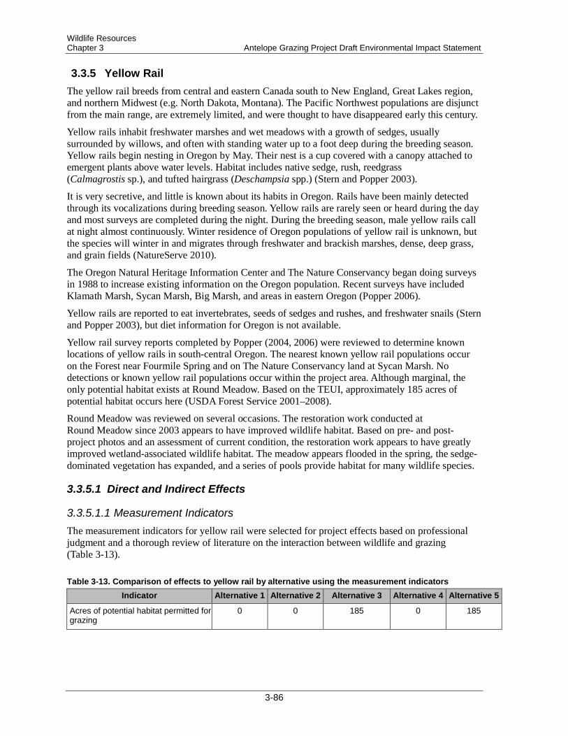
Wildlife Resources Chapter 3 Antelope Grazing Project Draft Environmental Impact Statement
3.3.5 Yellow Rail The yellow rail breeds from central and eastern Canada south to New England, Great Lakes region, and northern Midwest (e.g. North Dakota, Montana). The Pacific Northwest populations are disjunct from the main range, are extremely limited, and were thought to have disappeared early this century.
Yellow rails inhabit freshwater marshes and wet meadows with a growth of sedges, usually surrounded by willows, and often with standing water up to a foot deep during the breeding season. Yellow rails begin nesting in Oregon by May. Their nest is a cup covered with a canopy attached to emergent plants above water levels. Habitat includes native sedge, rush, reedgrass (Calmagrostis sp.), and tufted hairgrass (Deschampsia spp.) (Stern and Popper 2003).
It is very secretive, and little is known about its habits in Oregon. Rails have been mainly detected through its vocalizations during breeding season. Yellow rails are rarely seen or heard during the day and most surveys are completed during the night. During the breeding season, male yellow rails call at night almost continuously. Winter residence of Oregon populations of yellow rail is unknown, but the species will winter in and migrates through freshwater and brackish marshes, dense, deep grass, and grain fields (NatureServe 2010).
The Oregon Natural Heritage Information Center and The Nature Conservancy began doing surveys in 1988 to increase existing information on the Oregon population. Recent surveys have included Klamath Marsh, Sycan Marsh, Big Marsh, and areas in eastern Oregon (Popper 2006).
Yellow rails are reported to eat invertebrates, seeds of sedges and rushes, and freshwater snails (Stern and Popper 2003), but diet information for Oregon is not available.
Yellow rail survey reports completed by Popper (2004, 2006) were reviewed to determine known locations of yellow rails in south-central Oregon. The nearest known yellow rail populations occur on the Forest near Fourmile Spring and on The Nature Conservancy land at Sycan Marsh. No detections or known yellow rail populations occur within the project area. Although marginal, the only potential habitat exists at Round Meadow. Based on the TEUI, approximately 185 acres of potential habitat occurs here (USDA Forest Service 2001–2008).
Round Meadow was reviewed on several occasions. The restoration work conducted at Round Meadow since 2003 appears to have improved wildlife habitat. Based on pre- and post-project photos and an assessment of current condition, the restoration work appears to have greatly improved wetland-associated wildlife habitat. The meadow appears flooded in the spring, the sedge-dominated vegetation has expanded, and a series of pools provide habitat for many wildlife species.
3.3.5.1 Direct and Indirect Effects
3.3.5.1.1 Measurement Indicators The measurement indicators for yellow rail were selected for project effects based on professional judgment and a thorough review of literature on the interaction between wildlife and grazing (Table 3-13).
Table 3-13. Comparison of effects to yellow rail by alternative using the measurement indicators Indicator Alternative 1 Alternative 2 Alternative 3 Alternative 4 Alternative 5
Acres of potential habitat permitted for grazing
0 0 185 0 185
3-86
Wildlife Resources Antelope Grazing Project Draft Environmental Impact Statement Chapter 3
3.3.5.1.2 Alternatives 1, 2, and 4 No grazing within Round Meadow is proposed for these alternatives; therefore, these alternatives would not impact potential yellow rail habitat. Grazing outside of Round Meadow would not impact yellow rails or their habitat because this area does not contain suitable habitat. Fence construction, reconstruction, maintenance, and removal; water developments; and permitted motorized use would not impact yellow rail.
3.3.5.1.3 Alternatives 3 and 5 Grazing within Round Meadow under Alternatives 3 and 5 would impact yellow rail habitat on approximately 185 acres. The loss of vegetation could negatively impact nesting and foraging habitat. Riparian pasture standards are expected to maintain the overall integrity of the riparian area, including vegetation and bank stability. Direct impacts to yellow rail are not likely because yellow rail have not been detected at Round Meadow. Outside of Round Meadow, livestock grazing would not impact yellow rails or their habitat because these areas do not contain suitable habitat.
Within Round Meadow, fence construction and permitted motorized use could displace animals from a specific location. In general, these effects would be short term and localized and would be expected to have little impact on yellow rail. Fence construction, reconstruction, maintenance, and removal; water developments; and permitted motorized use outside Round Meadow would have no impact to yellow rails.
3.3.5.2 Cumulative Effects The geographic boundary for analyzing cumulative effects is the area of the allotments, including all NFS lands and non-NFS lands (private). Round Meadow contains the only known potential habitat within the project area, so the cumulative effects analysis only includes those past, present, and reasonably foreseeable future actions within the existing fenced riparian area at Round Meadow. The residual impacts of past actions in these areas have resulted in the distribution of yellow rail habitat described in the existing condition. All past restoration efforts in Round Meadow, including plugging the ditches, have increased riparian habitat and potential yellow rail habitat. Past grazing may have reduced the suitability of habitat for yellow rail within Round Meadow. All future restoration work within Round Meadow would likely improve yellow rail habitat.
3.3.5.2.1 Alternatives 1, 2, and 4 Yellow rail and its habitat would not be affected under Alternatives 1, 2, and 4. Therefore, no incremental effects from this project would be added to past, present, and reasonably foreseeable future actions.
Effects determination—Alternatives 1, 2, and 4 would have “no impact” on yellow rail.
3.3.5.2.2 Alternatives 3 and 5 Yellow rail habitat at Round Meadow is considered to be marginal and no detections of yellow rail have occurred within the cumulative effects analysis area. Past and future restoration work is expected to increase the suitability of habitat at Round Meadow, and riparian pasture standards are expected to maintain the overall integrity of the riparian area, including vegetation and bank stability. Therefore, the incremental effects of Alternatives 3 and 5, when added to all of the past, present and reasonably foreseeable future actions would be minimal.
3-87
Wildlife Resources Chapter 3 Antelope Grazing Project Draft Environmental Impact Statement
Effects determination—Alternative 3 and 5 “may impact individuals or habitat, but will not likely contribute to a trend towards federal listing or cause a loss of viability to the population or species.”
3.3.6 Lewis’ Woodpecker The Lewis’ woodpecker was placed on the Region 6 sensitive species list in January 2008. It is also identified as a focal species in burned pine forest in the Conservation Strategy for Landbirds of the East Slope of the Cascade Mountains in Oregon and Washington (Altman 2000).
Habitat for the Lewis’ woodpecker, a migrant in this part of its range, includes old-forest, single-storied ponderosa pine with a brush understory. Lewis’ woodpeckers are aerial insectivores during the breeding season, relying on flying insects as forage. They require large snags in an advanced state of decay that are easy to excavate, or they use old cavities created by other woodpeckers because they are not strong cavity excavators. Nest trees generally average 17–44 inches diameter at breast height (dbh) (Saab and Dudley 1998, Wisdom et al. 2000). Burned ponderosa pine forests created by stand-replacing fires provide highly productive habitats as compared to unburned pine (Wisdom et al. 2000).
Abele et al. (2004) completed a Technical Conservation Assessment for the Rocky Mountain Region of the Forest Service that identified perceived threats to the conservation of the Lewis’ woodpecker. Cattle grazing was identified as a threat by altering the historic fire regimes with a reduction of understory vegetation. In addition, altering understory can influence the composition and abundance of prey (flying insects) (Abele et al. 2004).
One Lewis’ woodpecker was detected in 2010 within a recently burned area at Round Meadow. Potential habitat occurs in open ponderosa pine habitat.
3.3.6.1 Direct and Indirect Effects
3.3.6.1.1 Measurement Indicators No measurement indicators were developed or used for the Lewis’ woodpecker.
3.3.6.1.2 Alternative 1 Fence removal could disturb Lewis’ woodpecker, which could displace animals from a specific location. In general, these effects would be short term and localized and would be expected to have little impact on Lewis’ woodpecker.
3.3.6.1.3 Action Alternatives Livestock grazing would not reduce Lewis’ woodpecker nesting habitat because it would not affect large trees or snags. However, grazing is expected to reduce understory vegetation, which can reduce the abundance of flying insects (Abele et al. 2004). This reduction in insects could result in reduced foraging habitat for Lewis’ woodpecker. Some individuals could be disturbed during fence construction, reconstruction, maintenance, and removal and permitted motorized use, which could displace animals from a specific location. Design features for the project would reduce the potential for disturbance. In general, these effects would be short term and localized and would be expected to have little impact on Lewis’ woodpeckers. Overall, the scale of the effects would be less with Alternative 4, which does not propose to graze in the North Sheep or Chemult Pastures, than Alternatives 2, 3, and 5.
3-88

Wildlife Resources Antelope Grazing Project Draft Environmental Impact Statement Chapter 3
3.3.6.2 Cumulative Effects The geographic boundary for analyzing cumulative effects is the area of the allotments, including all NFS lands and non-NFS lands (private). Lewis’ woodpecker habitat within the cumulative effects analysis area primarily occurs in open ponderosa pine habitat. All activities listed in Appendix C were reviewed for potential impacts to this species within the cumulative effects analysis area. The residual impacts of past actions in these areas have resulted in the distribution of Lewis’ woodpecker habitat described in the existing condition. The following past actions may have affected the species:
• Past timber harvest on federal and private lands that removed or degraded some nesting habitat by removing large diameter trees
• Fire exclusion that has increased stand densities, which has reduced Lewis’ woodpecker habitat by creating heavily stocked stands with higher canopy cover than historically occurred
• Fuelwood cutting that reduced snag and down wood habitat in ponderosa pine stands
• Road development has likely not had a significant impact on Lewis’ woodpeckers, other than increased disturbance associated with the development and presence of the transportation system
• Livestock grazing may have caused a reduction in understory vegetation that reduced prey habitat
Future timber sales within ponderosa pine–dominated habitat would likely improve habitat for Lewis’ woodpeckers due to the maintenance and increased resiliency of large trees and a conversion to more open-stand conditions. Personal use firewood gathering would reduce snag habitat; however, snag habitat may increase from wildfire and bark beetle activity.
3.3.6.2.1 Alternative 1 The effects from Alternative 1 would be short term and localized and would be expected to have little impact on Lewis’ woodpecker. Therefore, the incremental effects of Alternative 1 to this species and its habitat, when added to all of the past, present, and reasonably foreseeable future actions would be minimal.
Effects determination— Alternative 1 “may impact individuals or habitat, but will not likely contribute to a trend towards federal listing or cause a loss of viability to the population or species.”
3.3.6.2.2 Action Alternatives Some individuals could be disturbed, which could result in the displacement of animals from a specific location. In general, these effects would be short term and localized and would be expected to have little impact on Lewis’ woodpeckers. Insects for foraging may also be reduced from a reduction in vegetation from grazing. The incremental effects of Alternatives 2–5, when added to all of the past, present and reasonably foreseeable future actions, would not result in a loss of viability to Lewis’ woodpeckers.
Effects determination—Alternative 2–5 “may impact individuals or habitat, but will not likely contribute to a trend towards federal listing or cause a loss of viability to the population or species.”
3-89
Wildlife Resources Chapter 3 Antelope Grazing Project Draft Environmental Impact Statement
3.3.7 White-headed Woodpecker The white-headed woodpecker was placed on the Region 6 sensitive species list in January 2008. It is also identified as a focal species in pine forests in the Conservation Strategy for Landbirds of the East Slope of the Cascade Mountains in Oregon and Washington (Altman 2000).
White-headed woodpecker habitat typically consists of large, open ponderosa pine; low shrub levels; and large snags. The white-headed woodpecker is a primary cavity excavator of soft snags. The white-headed woodpecker is the only woodpecker species to rely heavily on seeds of ponderosa pine for food (Marshall et al. 2003, p. 364).
A long-term study on the white-headed woodpecker occurred on the Deschutes and Winema National Forests from 1997 to 2004. Frenzel (2000) calculated the mean diameter for white-headed woodpecker nest trees to be 26.2 inches dbh, while Dixon (1995) found similar results (mean diameter of 25.6 inches dbh). Frenzel (2003) found that nests located at sites with a high density of large diameter trees had a higher survival rate than nests in recently harvested sites. Unharvested sites, or sites with greater than 12 trees per acre greater than 21 inches dbh, had a success rate of 63.1% while nests at previously harvested sites or lower densities of large trees had a success rate of 39.8%. Therefore, white-headed woodpeckers were positively associated with higher densities of large trees. On the Winema National Forest, white-headed woodpeckers were found to be using small-diameter trees, logs in a slash pile and upturned roots (6–13 inches dbh) where large snags were uncommon (Frenzel 2002).
Although several sightings of white-headed woodpeckers likely occurred within the project area in the past, only 3 documented sightings occur in the NRIS wildlife database: 2 sightings in 1993 and 1 sighting in 1997 (NRIS 2011).
3.3.7.1 Direct and Indirect Effects
3.3.7.1.1 Measurement Indicators No measurement indicators were developed or used for the white-headed woodpecker.
3.3.7.1.2 Alternative 1 Fence removal could disturb white-headed woodpecker, which could displace animals from a specific location. In general, these effects would be short term and localized and would be expected to have little impact on white-headed woodpecker.
3.3.7.1.3 Action Alternatives Livestock grazing would not reduce white-headed woodpecker nesting habitat because it would not affect large trees or snags. The loss of forage and season of use associated with grazing would not affect white-headed woodpecker habitat or prey habitat. Some individuals could be disturbed during fence construction, reconstruction, maintenance, and removal and permitted motorized use, which could displace animals from a specific location. Design features for the project would reduce the potential for disturbance. In general, these effects would be short term and localized and would be expected to have little impact on white-headed woodpeckers. Overall, the scale of the effects would be less with Alternative 4, which does not propose to graze in the North Sheep or Chemult Pastures, than Alternatives 2, 3, and 5.
3-90

Wildlife Resources Antelope Grazing Project Draft Environmental Impact Statement Chapter 3
3.3.7.2 Cumulative Effects The geographic boundary for analyzing cumulative effects is the area of the allotments, including all NFS lands and non-NFS lands (private). White-headed woodpecker habitat within the cumulative effects analysis area primarily occurs in open ponderosa pine habitat. All activities listed in Appendix C were reviewed for potential impacts to this species within the cumulative effects analysis area. The residual impacts of past actions in these areas have resulted in the distribution of white-headed woodpecker habitat described in the existing condition. The following past actions may have affected the species:
• Past timber harvest on federal and private lands that removed or degraded some nesting habitat by removing large diameter trees
• Fire exclusion that has increased stand densities, which has reduced white-headed woodpecker habitat by creating heavily stocked stands with higher canopy cover than historically occurred
• Fuelwood cutting that reduced snag and down wood habitat in ponderosa pine stands
• Road development has likely not had a significant impact on white-headed woodpeckers, other than increased disturbance associated with the development and presence of the transportation system
• Livestock grazing may have caused short-term disturbance to individuals
Future timber sales within ponderosa pine–dominated habitat would likely improve habitat for white-headed woodpeckers due to the maintenance and increased resiliency of large trees and a conversion to more open-stand conditions. Personal use firewood gathering would reduce snag habitat; however, snag habitat may increase from wildfire and bark beetle activity.
3.3.7.2.1 Alternative 1 Alternative 1 could disturb individuals. In general, these effects would be short term and localized and would be expected to have little impact on white-headed woodpecker. Therefore, the incremental effects of Alternative 1 to this species and its habitat, when added to all of the past, present, and reasonably foreseeable future actions would be minimal.
Effects determination— Alternative 1 “may impact individuals or habitat, but will not likely contribute to a trend towards federal listing or cause a loss of viability to the population or species.”
3.3.7.2.2 Action Alternatives Alternatives 2–5 could disturb individuals. In general, these effects would be short term and localized and would be expected to have little impact on white-headed woodpecker. Therefore, the incremental effects of Alternatives 2–5 when added to all of the past, present and reasonably foreseeable future actions would be minimal.
Effects determination—Alternative 2–5 “may impact individuals or habitat, but will not likely contribute to a trend towards federal listing or cause a loss of viability to the population or species.”
3-91

Wildlife Resources Chapter 3 Antelope Grazing Project Draft Environmental Impact Statement
3.3.8 Evening Field Slug The evening field slug is a small (1/4–1/2 inch) slug found in perennially wet habitats. Most of the documented sites for this species occur on the eastern slope of the Oregon Cascades (Duncan 2005). It has been found at 84 grazed and ungrazed sites across the Forest associated with springs, small streams, fens, wet meadows, the shores of lakes and ponds, and forested riparian areas. The slugs use a variety of low vegetation, litter, and woody debris for shelter. Within the project area, 17 sites have been located. One site is in the Tobin Cabin Pasture and the rest are in the Chemult Pasture. The species is not considered “practical to survey for” (USDA and USDI 2001), meaning a reasonable survey effort may not detect presence. Enough sampling has been conducted in the project area to indicate a likelihood that more sites exist. Based on existing evening field slug records, TEUI and ecoclass riparian mapping, and observations during the 2010 and 2011 field seasons, an estimated 599 acres of potential habitat for this species is present within the existing allotments’ boundary, with another 337 acres of potential habitat in the North Sheep Pasture. Within potential habitat, evening field slug is not likely to be evenly distributed, but would most likely be found near perennially wet areas.
Livestock grazing is listed as a potential threat to evening field slugs (Duncan 2005). Terrestrial mollusks have limited mobility and can be injured or killed by livestock trampling. Livestock grazing can also alter habitat for mollusks, by removing cover, compacting soils, changing plant communities, or otherwise causing changes to microsite conditions. The degree of impact to mollusk species from grazing is related to the timing, duration, and intensity of the grazing action, as well as the habitat condition. Mollusks are less likely to be directly impacted by trampling during warm and dry months, when they tend to bury deeper into soil, debris, or logs for moisture and thermal protection. Livestock trampling may be partly mitigated by the presence of large amounts of downed wood that provide physical protection.
3.3.8.1 Direct and Indirect Effects
3.3.8.1.1 Measurement Indicators Indicators used to measure effects are selected so that the effects of the project alternatives can be compared and contrasted (Table 3-14). Measures were selected for project effects based on professional judgment and a thorough review of literature on the interaction between wildlife and grazing. Indicators for wildlife species are based on the amount of potential and/or occupied habitat for each species.
3-92
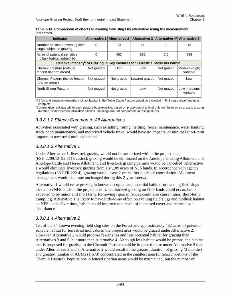
Wildlife Resources Antelope Grazing Project Draft Environmental Impact Statement Chapter 3
Table 3-14. Comparison of effects to evening field slugs by alternative using the measurement indicators
Indicator Alternative 1 Alternative 2 Alternative 3 Alternative 4a Alternative 5
Number of sites of evening field slugs subject to grazing
0 10 11 1 13
Acres of potential sensitive mollusk habitat subject to
0 462 862 2.5 896
Relative Intensityb of Grazing in Key Pastures for Terrestrial Mollusks Within Chemult Pasture (outside fenced riparian areas)
Not grazed High Low Not grazed Medium–high; variable
Chemult Pasture (inside fenced riparian areas)
Not grazed Not grazed Low/not grazed Not grazed Low
North Sheep Pasture Not grazed Not grazed Low Not grazed Low–medium; variable
aAll fen and sensitive terrestrial mollusk habitat in the Tobin Cabin Pasture would be excluded in 5–6 years once fencing is complete.
bComparative rankings within each pasture by alternative, based on proportion of animal unit months to acres grazed, grazing duration, and/or percent utilization allowed. Rankings are not comparable across pastures.
3.3.8.1.2 Effects Common to All Alternatives Activities associated with grazing, such as salting, riding, herding, fence maintenance, water hauling, stock pond maintenance, and motorized vehicle travel would have no impacts, or minimal short-term impacts to terrestrial mollusk habitat.
3.3.8.1.3 Alternative 1 Under Alternative 1, livestock grazing would not be authorized within the project area, (FSH 2209.13–92.31) livestock grazing would be eliminated on the Antelope Grazing Allotment and Antelope Cattle and Horse Allotment, and livestock grazing permits would be cancelled. Alternative 1 would eliminate livestock grazing from 137,189 acres of NFS lands. In accordance with agency regulations (36 CFR 222.4), grazing would cease 2 years after notice of cancellation. Allotment management would continue unchanged during this 2-year interval.
Alternative 1 would cease grazing in known occupied and potential habitat for evening field slugs located on NFS lands in the project area. Unauthorized grazing on NFS lands could occur, but is expected to be minor and short term. Removing riparian fences could also cause minor, short-term trampling. Alternative 1 is likely to have little-to-no effect on evening field slugs and mollusk habitat on NFS lands. Over time, habitat could improve as a result of increased cover and reduced soil disturbance.
3.3.8.1.4 Alternative 2 Ten of the 84 known evening field slug sites on the Forest and approximately 462 acres of potential suitable habitat for terrestrial mollusks in the project area would be grazed under Alternative 2. However, Alternative 2 would propose fewer sites and less potential habitat for grazing than Alternatives 3 and 5, but more than Alternative 4. Although less habitat would be grazed, the habitat that is proposed for grazing in the Chemult Pasture could be impacted more under Alternative 2 than under Alternatives 3 and 5. Alternative 2 would result in the greatest duration of grazing (3 months) and greatest number of AUMs (1,673) concentrated in the smallest area (unfenced portions of the Chemult Pasture). Populations in fenced riparian areas would be maintained, but the number of
3-93

Wildlife Resources Chapter 3 Antelope Grazing Project Draft Environmental Impact Statement
individuals in grazed habitats of the Chemult Pasture may decline under Alternative 2 in areas where livestock concentrate. Despite more intensive grazing under this alternative, the presence of large amounts of woody debris would provide protected microsites and would likely be sufficient to maintain evening field slugs in most of the unfenced wetlands. Evening field slugs have been found at a variety of grazed and ungrazed sites across the Forest, indicating an ability to persist under grazed conditions.
3.3.8.1.5 Alternative 3 Eleven of the 84 known sites of evening field slugs on the Forest and 863 acres of potential suitable habitat for terrestrial mollusks in the project area would be available for grazing under Alternative 3. Similar to Alternative 5, Alternative 3 would allow grazing of mollusk habitat in the North Sheep Pasture. Alternative 3 excludes grazing from all or a portion of the mollusk habitat in the Squirrel Camp, Johnson, Wilshire, Dry Meadow, and Sproats fenced riparian areas. New exclosures would be built to maintain habitat at Jack Creek North of Moffit, a portion of Crooked Meadow, and at Little Parker fen. The known evening field slug site at Tobin Cabin spring and approximately 2.5 acres of potential habitat in the Tobin Cabin Pasture would be excluded after reconstruction of spring fences in 5-6 years. Grazing would occur in habitat located in the Cannon Well riparian fence, and a portion of the Jack Creek fenced riparian areas. Grazing of Lower Jack/Upper Jamison areas behind the Jack Creek riparian fence would be delayed until restoration of OSF habitat has occurred in that area.
Under Alternative 3, more potential mollusk habitat would be impacted than under Alternative 2, but impacts would be less intensive in the Chemult Pasture. In the Chemult Pasture, the duration of grazing would be reduced to 2 months, the AUMs would be reduced to 1,364, and use would be spread across a larger area. Although some of the fenced riparian areas would be grazed, the duration would be limited to 15 to 30 days and the utilization would be limited to 35%–40%. Grazing in the North Sheep Pasture would also be of short duration (15 days).
Populations in excluded habitats would be maintained, and habitat at Little Parker fen and Crooked Meadow would likely improve. With reduced grazing duration, sensitive mollusk habitat in the greater Chemult Pasture is expected to improve compared to the existing condition. Compared to Alternative 2, additional impacts would occur to mollusk habitat within some of the fenced riparian areas and in the North Sheep Pasture. Mollusk habitat in these areas typically contains large amounts of woody debris that provide protected microsites, similar to the Chemult Pasture.
3.3.8.1.6 Alternative 4 Under Alternative 4, only the known evening field slug site at Tobin Cabin spring and approximately 2.5 acres of potential habitat in the Tobin Cabin Pasture would be grazed in the short-term. These areas would be excluded after construction or reconstruction of spring fences in 5–6 years. None of the known sites or potential habitat in the Chemult and North Sheep pastures would be impacted by permitted grazing. Over the long term, Alternative 4 would likely have effects similar to Alternative 1.
3.3.8.1.7 Alternative 5 Thirteen of the 84 known sites of evening field slugs on the Forest and 896 acres of potential suitable habitat for sensitive terrestrial mollusks in the project area would be available for grazing. The known evening field slug site at Tobin Cabin spring and approximately 2.5 acres of potential habitat in the Tobin Cabin Pasture would be excluded after reconstruction of spring fences in 5–6 years. Habitat would be excluded in a portion of Squirrel Camp and Dry Meadow fenced riparian areas.
3-94
Wildlife Resources Antelope Grazing Project Draft Environmental Impact Statement Chapter 3
New exclosures would be built to maintain habitat at Jack Creek North of Moffit, a portion of Crooked Meadow, and at Little Parker fen.
Under Alternative 5, more potential mollusk habitat would be impacted than under Alternatives 2 and 3. Impacts would vary by year under this alternative. Use of the North Sheep Pasture would be similar to Alternative 3 in terms of AUMs (325) but fewer animals would be grazed for a longer period (45 days), and in 1 out of 3 years, the pasture would be rested. In the Chemult Pasture, grazing duration would be 3 months, similar to Alternative 2. AUMs would be greater (1,789) for 2 years out of 3, with impacts concentrated in either the north or south half of the pasture. Every third year, use would be less (1,357 AUMs) and evenly distributed. Impacts in the Chemult Pasture would be spread over all of the fenced riparian areas. Although this alternative proposes more AUMs in fenced riparian areas, utilization would still be limited to 35%–40% and duration would be 15–30 days, similar to Alternative 3.
As a result of the year to year variation and alternating concentration of use in the north and south half of the Chemult Pasture, it is difficult to predict the effects of Alternative 5 on mollusk habitat. Alternative 5 would graze for a similar duration and intensity in the Chemult Pasture as Alternative 2, but would utilize all of the existing fenced riparian areas and impact more known evening field slug sites. Compared to Alternative 3, Alternative 5 has a longer duration and intensity of grazing in the Chemult Pasture and shifts AUMs from the east side of the allotment to the west side, where the best quality mollusk habitat is located. For these reasons, Alternative 5 is expected to have more impacts to terrestrial mollusks than both Alternatives 2 and 3.
3.3.8.2 Cumulative Effects In order to understand the contribution of past actions to the cumulative effects of the proposed action and alternatives, this analysis relies on current environmental conditions as a proxy for the impacts of past actions. This is because existing conditions reflect the aggregate impact of all prior human actions and natural events that have affected the environment and might contribute to cumulative effects. Past projects within the project area of particular influence to the project area have been listed in Appendix C and have been considered as appropriate in conducting cumulative effects analysis for the Antelope Project.
For these reasons, the analysis of past actions in this section is based on current environmental conditions. Consideration of current and reasonably foreseeable future actions includes grazing management, known Forest projects, and known Forest uses, as identified in Appendix C. The analysis area for cumulative effects on evening field slug habitat includes springs, seeps, riparian areas along perennial streams, and other wetlands located on NFS lands in the project area.
3.3.8.2.1 Alternative 1 The residual impacts of past actions in these areas have resulted in the distribution of evening field slug habitat described in the existing condition. On-going and future foreseeable activities may have effects on evening field slug habitat that overlap with the effects of grazing under the alternatives. Projects include culvert replacements, non-commercial vegetation treatments, and hand piling and burning of thinning slash created by encroachment treatments around fens and meadows. Culvert replacement would have minor localized impacts. Roadsides do not provide important habitat for mollusks. Vegetation treatments may cause trampling of individuals and alter habitat by reducing shade and woody debris and disturbing soils and ground cover. Associated piling and burning may have also impact individuals and alter habitat in localized areas.
Impact determinations—Alternative 1 would have “no impact” on evening field slug
3-95
Wildlife Resources Chapter 3 Antelope Grazing Project Draft Environmental Impact Statement
3.3.8.2.2 All Action Alternatives The residual impacts of past actions in these areas have resulted in the distribution of evening field slug habitat described in the existing condition. On-going and future foreseeable activities may have effects on evening field slug habitat that overlap with the effects of grazing under the alternatives. Projects include culvert replacements, non-commercial vegetation treatments, and hand piling and burning of thinning slash created by encroachment treatments around fens and meadows. Culvert replacement would have minor localized impacts. Roadsides do not provide important habitat for mollusks. Vegetation treatments may cause trampling of individuals and alter habitat by reducing shade and woody debris and disturbing soils and ground cover. Associated piling and burning may have also impact individuals and alter habitat in localized areas.
Impact determinations—Alternatives 2–5 “may impact individuals or habitat, but are not likely to cause a loss of viability to the population or species as a whole or cause a trend toward federal listing” for evening field slug
3.3.9 Management Indicator Species The wildlife technical report assessed the effects of Alternative 1 on the population trend and habitat trend of Forest Plan MIS potentially present in the project area. That report documents that Alternative 1 would not have an effect on the existing quantity of source habitat for mule deer, American marten, goshawk, pileated woodpecker, red-naped sapsucker, black-backed woodpecker, three-toed woodpecker, white-headed woodpecker, black-backed woodpecker, pileated woodpecker, or any of the primary excavators analyzed. Alternative 1 would not affect individuals of these species or populations on either the Fremont or Winema portions of the Forest.
The effects of Alternatives 2–5 on the population trend and habitat trend of mule deer, American marten, goshawk, pileated woodpecker, red-naped sapsucker, black-backed woodpecker, three-toed woodpecker, white-headed woodpecker, black-backed woodpecker, pileated woodpecker, or any of the primary excavators analyzed would be insignificant at the Forest scale. Effects from disturbance, if any, would be short term and localized and expected to have little impact on these species. The incremental impacts of the action alternatives when added to all past, ongoing, and future activities would be minimal. The Antelope Grazing Project is consistent with the Fremont and Winema Forest Plans, and thus continued viability of the MIS analyzed is expected on the Forest.
3-96
Socioeconomics Antelope Grazing Project Draft Environmental Impact Statement Chapter 3
3.4 Socioeconomics
3.4.1 Affected Environment The affected environment for an economic and sociological impact assessment involves the discussion of the current economic state, the current social culture, and the current state of Indian tribes within the project area.
3.4.2 Economic State The approximately 169,599-acre project area comprises land in Klamath County (87% of the project area) and Lake County (13%). Livestock production and livestock products comprise approximately 47% of Klamath County’s agriculture commodity sales and 44% of Lake County’s agriculture commodity sales (Oregon State University 2007). Gross sales of cattle and calves for 2007 were $116,649,000 for Klamath County and $28,200,000 for Lake County (Oregon State University 2008). According to the USDA National Agricultural Statistics Service (2008), the number of livestock in Klamath County is 94,500 head and in Lake County 85,000 head. Because 77% of the lands in Lake County and over 50% of the lands in Klamath County are in public ownership, the current level of livestock production depends on the use of public lands.
Federal rangelands are critical to the economic viability of the livestock industry in 11 western states, including Oregon. An estimated 21,000 federal permits have been issued in the western states, representing roughly 22% of all livestock producers in the region (report produced by Economic Profile System-Human Dimensions Toolkit, available in the project record). Locally, the percentage of livestock producers with federal permits is probably higher, because almost all the producers on the Fremont-Winema National Forest depend on the forage produced on federal lands to support their livestock operations.
The Fremont Forest Plan notes that the demand for acres of land permitted for grazing on the Forest far exceeds the available supply (USDA Forest Service 1989). The Fremont Forest Plan recognizes that livestock production is the second most important industry in Lake County, and states that “[c]oordination of livestock grazing use and management of other Forest resources is a major emphasis item in this Plan” (USDA Forest Service 1989, p. 65). The Fremont Forest Plan establishes almost all of the over 1 million NFS acres across the Forest as suitable rangelands and divides the Forest into 71 grazing allotments. This portion of the Forest now has 75 active allotments.
The Winema Forest Plan notes that the demand for acres of land permitted for grazing on the Forest is far less than the available supply. Because demand is low, the Winema Forest Plan states that “[r]angelands and grazing on the Forest will continue to play a minor role in the economic growth of Klamath County” (USDA Forest Service 1990, p. 2-6). The Winema Forest Plan establishes 335,000 acres as suitable rangelands, divided into 25 grazing allotments to provide this land use on the Forest. This portion of the Forest now has 12 active allotments.
Both of the Forest Plans and the NFS grazing permit program share the goal of providing stability to local ranch operations. Permittees within the project area depend on NFS-administered rangelands. NFS allotments are an important part of the total year-round ranch operation. They provide high-quality forage for cow/calf herds when home pastures are growing and being harvested for winter hay.
This analysis presents 2 methods of calculating the economic effects of grazing in Lake and Klamath counties. Both methods use employment, labor income, and output as indicators for measuring the economic effects of grazing in the project area. These indicators are used to compare the economic
3-97
Socioeconomics Chapter 3 Antelope Grazing Project Draft Environmental Impact Statement
effects of the project alternatives. However, the 2 methods produce different results so both methods and the associated results are presented for comparison.
This analysis also presents estimated costs of implementing each alternative and identifies the parties responsible for assuming the costs. Costs are presented here merely to provide a comparison across alternatives and should not be considered final costs, as market prices will likely have changed before the chosen alternative is implemented.
3.4.2.1 Social Culture The Antelope Grazing Allotments project area was first grazed in the 1870s with livestock belonging to Oregon homesteading families. Thousands of cattle, sheep, and horses are known to have used the area during this early period. Grazing in the project area watersheds occurred seasonally during spring and summer months while lower-elevation homesteads were growing and putting up hay to feed livestock during the winter months.
Within the communities of Silver Lake and Fort Rock, agriculture, forestry, fishing, and hunting constitute the largest industry for men (52%) and the second largest industry for women (18%) (City-Data.com 2011). These communities, like much of Lake and Klamath counties, largely depend on local ranching operations for jobs and livelihoods. The Antelope Allotments are currently permitted to the Iverson Management Limited Partnership, a ranch that provides sole income to 4 households within the town of Silver Lake. Raising cattle has been the primary or only occupation for the Silver Lake population of the Iverson family since they settled in the area 5 generations ago, around the 1870s.
Grazing on federal lands garners mixed levels of support nationally, statewide, and locally. Bruson and Steel (1996) discovered that attitudes, values, and beliefs regarding rangeland management on federal lands varied most sharply between responses from urban, amenity-driven communities and responses from rural communities driven by traditional practices, regardless of their location in the United States (i.e., eastern or western). This study also analyzed eastern, rangeland-dominated Oregon counties and compared their attitudes to the attitudes of Oregon residents as a whole. Differences were found in all value and belief categories between the eastern Oregon sample and the statewide sample. The eastern Oregon sample was found to be “the most supportive of a multiple benefits approach like that of the U.S. Forest Service and Bureau of Land Management” (Bruson and Steel 1996). However, as clearly expressed through comments received for this project, local support for multiple-use management is conflicted.
The project area provides multiple Forest user opportunities, including dispersed camping, hunting, hiking, wildlife viewing, motor vehicle recreation, scenic views, moderate levels of solitude, and spiritual retreat. Grazing within the project area, like other land management practices, currently has differing levels of impact to Forest users; for some Forest users, the impact influences the value of their Forest experience. However, the majority of the landscape included within the project area would be classified as Roaded Natural or Roaded Modified in the Recreation Opportunity Spectrum classifications. Both classifications indicate a certain level of inherent likelihood that Forest users will encounter people, see signs of Forest use by people, and see signs of multiple-use land management. Expectations of solitude or absence of signs of land management are not appropriate for recreation classifications within the project area.
3-98

Socioeconomics Antelope Grazing Project Draft Environmental Impact Statement Chapter 3
3.4.2.2 Indian Tribes The lands within the project area also encompass lands assigned to Indian tribes under the 1864 Klamath Lake Treaty. This treaty, signed between the United States and the Klamath, Modoc, and Yahooskin Paiute tribes ceded land for a reservation and ensured the retention of tribal rights to hunt, fish, and gather “in perpetuity.” In 1954, the Klamath Tribes were terminated as a federally recognized tribe; however, the Termination Act also expressly recognized and affirmed the continuation of the tribes’ treaty rights on former reservation lands. In 1961, many of the reservation lands were transferred to NFS management with the establishment of the Winema National Forest. The Klamath Tribes were restored as a federally recognized tribe in 1986, and a Memorandum of Agreement (MOA) was signed between the Klamath Tribes and the Forest Service in 1999 (amended 2005). This MOA established “policies and procedures that implement a government-to-government consultation process between the two parties.” While members of the Klamath Tribes now retain treaty rights only on former reservation lands, the MOA clearly identifies that the availability of resources for which treaty right practices depend on “include interests in off reservation areas” (USDA Forest Service and Klamath Tribes 2005, p. 5).
The project area is not within the former reservation lands boundary but is within the land boundary associated with the 1864 treaty. Government-to-government consultations prior to public scoping identified this project as a project of interest to the Klamath Tribes. The project was first presented to the Natural Resources and Cultural departments of the Klamath Tribes in July 2010. Grazing projects are of general interest and concern to the Klamath Tribes because of potential impacts to ethnobotanical plants of importance to tribal practices. The Antelope Grazing Allotments Project could impact such plants and is therefore of interest to the Klamath Tribes. Potential habitat and effects for species of concern to the Klamath Tribes are being analyzed as part of this project (see the “Botanical Resources and Invasive Plants” section).
While traditional-use practices do occur on lands within the project area, government-to-government consultations did not identify any specific geographical areas of concern or highly repeated use within the project area. Surveys conducted within the project area, combined with local knowledge, identified that 39 of the known 54 ethnobotanical species of concern to the Klamath Tribes exist within the project boundary (see the “Botanical Resources and Invasive Plants” section). However, where found, these species are not known to be in densities or levels of production that would make the project area an economical or prolific area for these treaty right practices. The nearest area specifically identified through public comments as an area of special interest or concern is Yamsay Mountain, which is approximately 9 miles from the project area.
3.4.2.3 Civil Rights Impact Analysis One comment claimed that civil rights impact analyses (CRIA) are not completed for Forest projects, specifically claiming that statistics of members of the Klamath Tribes employed or given contracts within the Forest should be disclosed. This comment misinterprets the role of a CRIA assessment at project-level analysis. A CRIA assessment will be completed on the selected alternative for the Antelope Grazing Allotments Project, disclosing all applicable information. Preliminary analysis to this point has not identified any measurement variables with any potential for significant impacts. No alternatives are currently determined to contain proposed actions that would constitute a “major action.” Comments received during the 30-day comment period will be factored into final considerations and the final CRIA assessment prior to the Decision.
3-99

Socioeconomics Chapter 3 Antelope Grazing Project Draft Environmental Impact Statement
3.4.3 Economic Analysis Methodology
3.4.3.1 Forest Service Economic Contribution Analysis The regional economic contributions of grazing to the economies of Lake and Klamath counties are estimated using permitted head months (HMs), which are a measure of access to forage by cattle. Employment, income, and output are estimated using a 2009 IMPLAN® model for Lake and Klamath counties. IMPLAN® (Impact Analysis for Planning, Minnesota IMPLAN Group, Inc.) is a regional economic impact analysis system. The IMPLAN® model determines how much a given activity, such as the sale of livestock, contributes to the local economy. The interactions between different sectors within the local economy are traced by the model, and it calculates the employment, income, and output effects that directly result from an impact on the economy. In this case, the direct impact is the sale of cattle, which are raised in part on forage from NFS lands. The sale of cattle stimulates private-sector activity that contributes to employment, income, and output in the project area.
The first step of this analysis uses IMPLAN® to derive the response coefficient specific for the cattle sector in Lake and Klamath counties. The response coefficient for the cattle sector represents the employment, income, and output associated with each million dollars of final demand to the cattle industry. Final demand represents the cattle industry’s goods and services sold to all the other sectors in the local economy. A Forest Service computer program called FEAST (Forest Economic Analysis Spreadsheet Tool) applies the cattle sector response coefficients to the total industrial output in order to generate the estimated economic contributions. FEAST calculates the total industrial output by using data on price and inventory to convert Forest Service permitted HMs to an estimate representing a change in total industrial output attributable to grazing. These estimates of economic contribution do not include the total number of ranchers and their employees. This is a conservative method of calculation, because it takes into account only the proportion of the total industrial output that is attributable to forage provided from the allotment. A less conservative method of analysis would claim that all of the income from the sale of the cattle, along with all of the associated labor and output, is made possible by grazing on NFS lands.
3.4.3.2 Bureau of Land Management Economic Contribution Analysis The BLM recently developed a revised methodology to measure the economic contribution of BLM forage; this methodology is based on AUMs. The method is still under review by the Department of the Interior. The main difference between the BLM’s approach and that of the Forest Service is the incorporation of unpaid, family labor into the BLM calculation. In agricultural operations, family members often provide significant amounts of the labor. Excluding unpaid, family labor, as the Forest Service method does, may lead to an underestimation of employment effects.
In order to demonstrate the difference in results between the BLM and the Forest Service approaches, the BLM method is also used to make economic contributions estimates based on permitted AUMs. This BLM approach estimates the economic effects of grazing by first deriving the “contribution to AUM” ratios for employment, labor income, and output. The “contribution to AUM” ratio for employment, for example, is the number of full- and part-time jobs associated with a certain level of grazing. In this case, the level of grazing is per 1,000 AUMs. The BLM calculates these contribution ratios for 17 western states. The ratios for Oregon are presented here. An internal BLM briefing paper describes the methodology in detail (USDI BLM, unpublished data).
3-100

Socioeconomics Antelope Grazing Project Draft Environmental Impact Statement Chapter 3
3.4.3.3 Baseline Costs The evaluation of economic costs for allotment infrastructure discussed below is based on current market estimates (Table 3-15). These estimates are not intended to establish the final costs of proposed improvements but instead are meant to allow a comparison across alternatives. The estimates are based on the following assumptions:
• Fence materials are for 4-strand barbed wire fence.
• Labor rates were estimated at $20/person, for a 5-person crew working 10-hour days, achieving 0.5 miles/day.
• The average rate of $300/acre for clearing and leaving slash is thought to not be adequate for linear feature, so the rate was doubled to more adequately represent costs expected.
• Reconstruction labor costs are higher because older materials must be removed and new materials installed, increasing the time needed to accomplish distances.
• Reconstruction right-of-way (ROW) costs were estimated to be lower than construction costs since maintaining a clearing is less labor-intensive.
• Spring construction materials include trough, pipeline, headbox, and associated plumbing parts.
• Pond construction/reconstruction materials include bentonite, but this material is not always necessary. The application rate was estimated to be 3pounds per square foot on a 50-by-50-foot pond dimension.
• Spring and pond labor costs include average rental cost of machines to complete the work.
Table 3-15 Baseline costs used for infrastructure economic comparisons
Infrastructure Materials Labor Right-of-Way Clearing Fence Construction $8,000/mile $2,000/mile $600/mile Fence Reconstruction $8,000/mile $2,500/mile $200/mile Fence Removal n/a $500/mile n/a Spring Construction $2,500/each $1,000/each n/a Spring Reconstruction $2,500/each $1,000/each n/a Pond Reconstruction $975/each $1,000/each n/a
3.4.4 Direct and Indirect Effects Direct and indirect effects of each alternative are analyzed on NFS lands and non-NFS lands under term private land grazing permits (where appropriate) within Klamath and Lake counties when analyzing the economic impacts. The boundary of the allotment for each alternative was used for analyzing social and tribal impacts. Alternative 2 (current management) served as a baseline for comparing the effects from the other alternatives. For all alternatives, effects were analyzed for economic impacts, sociological concerns, and tribal concerns. The analysis of effects considered both short-term (season of use) and long-term (life of the permit, or 10 years) impacts for economic, social, and tribal impacts. All calculations disclosed are estimates and should be used only for comparative purposes.
3-101
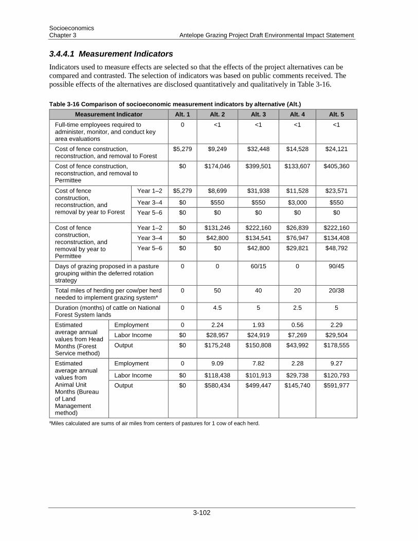
Socioeconomics Chapter 3 Antelope Grazing Project Draft Environmental Impact Statement
3.4.4.1 Measurement Indicators Indicators used to measure effects are selected so that the effects of the project alternatives can be compared and contrasted. The selection of indicators was based on public comments received. The possible effects of the alternatives are disclosed quantitatively and qualitatively in Table 3-16.
Table 3-16 Comparison of socioeconomic measurement indicators by alternative (Alt.) Measurement Indicator Alt. 1 Alt. 2 Alt. 3 Alt. 4 Alt. 5
Full-time employees required to administer, monitor, and conduct key area evaluations
0 <1 <1 <1 <1
Cost of fence construction, reconstruction, and removal to Forest
$5,279 $9,249 $32,448 $14,528 $24,121
Cost of fence construction, reconstruction, and removal to Permittee
$0 $174,046 $399,501 $133,607 $405,360
Cost of fence construction, reconstruction, and removal by year to Forest
Year 1–2 $5,279 $8,699 $31,938 $11,528 $23,571
Year 3–4 $0 $550 $550 $3,000 $550 Year 5–6 $0 $0 $0 $0 $0
Cost of fence construction, reconstruction, and removal by year to Permittee
Year 1–2 $0 $131,246 $222,160 $26,839 $222,160 Year 3–4 $0 $42,800 $134,541 $76,947 $134,408 Year 5–6 $0 $0 $42,800 $29,821 $48,792
Days of grazing proposed in a pasture grouping within the deferred rotation strategy
0 0 60/15 0 90/45
Total miles of herding per cow/per herd needed to implement grazing system*
0 50 40 20 20/38
Duration (months) of cattle on National Forest System lands
0 4.5 5 2.5 5
Estimated average annual values from Head Months (Forest Service method)
Employment 0 2.24 1.93 0.56 2.29 Labor Income $0 $28,957 $24,919 $7,269 $29,504 Output $0 $175,248 $150,808 $43,992 $178,555
Estimated average annual values from Animal Unit Months (Bureau of Land Management method)
Employment 0 9.09 7.82 2.28 9.27
Labor Income $0 $118,438 $101,913 $29,738 $120,793 Output $0 $580,434 $499,447 $145,740 $591,977
aMiles calculated are sums of air miles from centers of pastures for 1 cow of each herd.
3-102
Socioeconomics Antelope Grazing Project Draft Environmental Impact Statement Chapter 3
3.4.4.2 Alternative 1 Alternative 1 (No Grazing Alternative) would eliminate livestock grazing from 137,189 acres of NFS lands. Under Alternative 1, livestock grazing would be eliminated on the Antelope Grazing Allotment and Antelope Cattle and Horse Allotment, and livestock grazing permits would be cancelled (FSH 2209.13–92.31). In accordance with agency regulations (36 CFR 222.4), grazing would cease 2 years after notice of cancellation. Allotment management would continue unchanged during this 2-year interval, and these allotments would not be available for permit reissuance for a minimum of 10 years.
3.4.4.2.1 Economic Economically, Alternative 1 would be the least expensive alternative to implement, because no allotment infrastructure (e.g., fences, stock ponds, spring developments) construction, reconstruction, or maintenance would be required. Removal of the allotments from Forest range management duties would not significantly reduce the overall workload of the Forest range program or the number of full-time employees (FTEs) on the Forest. Current range personnel would continue to administer the remaining 87 allotments across the Forest.
Associated costs of implementing Alternative 1 are restricted to removing approximately 10.6 miles of fence that encloses meadows within the Chemult Pasture (estimated at $5,279). This cost would be the responsibility of the Forest. With the removal of cattle from the surrounding area, fences to protect the sensitive resources would not be needed. These fences would be removed to eliminate the long-term costs of their maintenance by the District.
Existing internal pasture and allotment division fences and range-related water developments (ponds and springs) in the project area would not be removed. These infrastructures would be left in place to deteriorate or to await removal for utilization elsewhere. If any infrastructures of benefit to other resources (e.g., water developments providing water for wildlife) need to be maintained or improved, subsequent decisions would need to be made, and funding for maintenance of these improvements would need to be secured.
Alternative 1 would cause the most economically adverse impacts to the ranch operation permitted for the allotments. Currently, the allotments provide approximately 85% of the grazed summer pasture for the permittee. This livestock operation is a family business. Comparable grazing opportunities would be difficult to find near the home ranch, due to the high demand and high cost for grazing lands in Klamath and Lake counties. If the permittee is not permitted continuing use of the allotments, the operation would likely be forced to downsize (comment letter from Keith Little, Iverson Management, to Barbara Machado, Forest Service, available in project record). Estimated annual employment, labor income, and output from Alternative 1 is zero under both analysis methods reviewed for this project (Table 3-16).
Alternative 1 would have beneficial direct and indirect impacts to Forest range administration costs because removing the allotments from the program would reduce expenditures on infrastructure and would not increase FTEs within the range program. However, Alternative 1 would have adverse direct and indirect impacts on the permittee ranching operation, including the potential need for downsizing and dismissal of employees.
3.4.4.2.2 Social Commenters expressed concern that cattle reduce the quality of social experiences on the Forest by reducing wildlife and water availability and impacting recreational opportunities, aesthetics, and spiritual values. With the removal of cattle from the landscape, short-term benefits would include the
3-103
Socioeconomics Chapter 3 Antelope Grazing Project Draft Environmental Impact Statement
presence of more wildlife and fewer impacts to recreational opportunities and aesthetic values. Long-term benefits would include the improved aesthetics of unaltered natural surroundings as meadows and other visibly grazed areas return to an ungrazed state.
Removing this landscape from suitable grazing would impact the local grazing community and permitted ranch operation. The operation is currently the primary-source or sole-source income for 4 households within the community of Silver Lake, which has a population of 149 people (U.S. Census 2011). Downsizing would likely eliminate the current employment for at least one of these households. The community of Silver Lake does not have many other opportunities for employment, so downsizing would likely require any released employees to change their livelihood or travel longer distances to regain employment.
Alternative 1 would have beneficial direct and indirect impacts on public social values associated with social Forest use. However, Alternative 1 would cause adverse direct and indirect impacts to the permitted ranching operation and the local ranching community.
3.4.4.2.3 Tribal Cattle would be removed from the landscape and would no longer be present to cause potential conflicts with traditional tribal practices, uses of plants, or aesthetics within the project boundary. Alternative 1 would have beneficial direct and indirect impacts to tribal resources.
3.4.4.3 Alternative 2
3.4.4.3.1 Economic Under Alternative 2, grazing would continue as currently managed within the project area. Continuing with current management would be the least expensive action alternative to implement, because minimal allotment infrastructure construction, reconstruction, or maintenance would be completed. Continued management of the current permit and the allotment boundaries would not change the workload or number of Forest range management personnel. The Forest allotments would be administered as part of one FTE’s program of work; approximately 24 other allotments would be administered by the assigned range management specialist. Rangeland technicians would also be assigned duties within these 24 allotments and within any number of the Forest’s 87 allotments.
Associated costs of implementing Alternative 2 include reconstructing 17.3 miles of fence and removing 1.1 miles of fence, totaling $9,249 for costs to the Forest and $174,046 for costs to the permittee (Table 3-16). Construction and maintenance of 3.6 miles of fence would be shared between the two permittees; the Forest Service would be responsible for the cost of materials. Alternative 2 also includes the cleaning out and sealing of 11 ponds, reconstructing 3 spring developments, and constructing 3 new spring developments, totaling $25,725. Costs for these improvements would be spread out over approximately 6 years and are not extraordinarily more than would be anticipated for any Forest allotment where infrastructure had not been reconstructed since the 1960s. Therefore, these costs were not used as measurement indicators for comparing alternatives. Maintenance of allotment and pasture boundary fences would remain the responsibility of the permittee. Costs to the permittee for fence maintenance would likely increase, as newly constructed and reconstructed fence not previously assigned to the permittee because of substandard construction quality would be built to standards and assigned to the permittee for maintenance. Fences around interior fenced riparian areas would remain the maintenance responsibility of the District.
Alternative 2 would keep the costs of management for the permitted ranch operation about the same as the costs currently being accrued. Alternative 2 would allow the ranch operation to continue
3-104

Socioeconomics Antelope Grazing Project Draft Environmental Impact Statement Chapter 3
management at the existing size. The allotments would continue to provide the needed summer forage lands for approximately 85% of the ranching operation, saving the permittee the increased grazing expenses associated with Alternative 1. Total livestock under permitted grazing at the peak of the grazing season is 419 cow/calf pairs (3,218 AUM). In an average summer grazing, the calves could each gain approximately 1.5 to 2 pounds per day. The permitted season, mid-May through the end of September, is approximately 135 days, so calves should realize between 200 and 270 pounds live weight gained. In total, between 83,800 and 113,130 pounds of live weight production may be realized. Depending on market conditions, the financial gain could be up to $156,119 ($1.38 per 1 pound of live weight calves). Annual averages for employment, labor income, and output for Alternative 2 were used as the baseline for comparing the effects between alternatives (Table 3-16).
Alternative 2 would most closely maintain economic commitments by both the Forest and the permitted ranching operation at cost levels similar to those of the past few years. Costs to the permittee for infrastructure improvements are within comparable ranges of improvement costs in other allotments of similar size and infrastructure age. Spreading the costs over 6 years should not create any adverse direct or indirect impacts to continued management of the allotments. Increased miles of fence assigned to the permittee for additional fence maintenance are within reasonable amounts for a ranching operation. The potential increase in operational costs would be expected to be minimal, but this increase could have some adverse direct and indirect impacts to the operation, including the potential need to hire additional workers or pay extra hours to current employees.
3.4.4.3.2 Social Under Alternative 2, grazing would continue as currently managed within the project area. Commenters noted that the presence of cattle reduces the quality of social experiences by reducing wildlife and water availability and impacting recreational opportunities, aesthetics, and spiritual values. Continued management would retain similar availability and opportunities for these social experiences and maintain their existing quality. Alternative 2 would maintain short-term negative direct and indirect impacts to Forest users whose experience of the Forest is diminished by the presence or evidence of cattle within the project boundary. However, cattle are fairly antisocial animals and would move away quickly at the sound of Forest users approaching; this livestock behavior would reduce negative direct impacts from the physical presence of cattle. Long-term direct and indirect impacts would also be maintained, because evidence of grazed meadows would be present during snow-free, off-season Forest use.
Comments expressed a concern that permittees receive special use privileges of NFS lands. Commenters stated that the financial benefit the Forest gains from these permits does not outweigh the social costs, such as those discussed above. Rates for permit fees are set at a national level, and permit fees are not meant to produce profits to the Forest, but are instead intended to assist with management costs. The social impacts discussed above are no greater than impacts from other nonsocial Forest multiple use (such as timber harvest or prescribed burning) and are within an acceptable range of impacts to Forest users as a result of multiple-use land management.
Continuing use of the allotments would not impact ranching operations for the permittee; no downsizing would be required. The ranching operation would continue to provide income for 4 households within the community of Silver Lake. Cattle would move in 2 herds throughout the pastures, traveling approximately 50 miles each and moving approximately every 15 to 30 days until July 1 when no additional pasture changes occur before cattle are removed from the allotments 3 months later. Operational viability would remain the same as the past several years, with use, movements, and number of cattle moving through the allotment remaining unchanged. Alternative 2 would cause no short- or long-term direct or indirect impacts to the ranching operation.
3-105

Socioeconomics Chapter 3 Antelope Grazing Project Draft Environmental Impact Statement
Alternative 2 would maintain current levels of negative direct and indirect impacts on public social values associated with social Forest use. However, Alternative 2 would maintain beneficial direct and indirect impacts to the permitted ranching operation’s way of life and the local ranching community.
3.4.4.3.3 Tribal Under Alternative 2, no changes to grazing management practices would occur. Opportunities for tribal traditional practices within the project area would remain the same as they have been for the past several years. Short-term impacts include disturbance from cattle, which consume, trample, and defecate on plants; disperse wildlife; and impose on visual aesthetics by their physical presence and by forage consumption that changes the visual appeal of the landscape. Alternative 2 would have short-term impacts for the approximately 4.5 months the cattle would be on the allotments each year. Long-term impacts include the maintenance and availability of opportunities similar to those that have been present for the 30+ years that cattle have been grazing the project area under current management practices. Plant populations would not change (increase or decrease) in size, and off-season signs of cattle (e.g., dung, grazed meadows, allotment infrastructure) would remain. Alternative 2 would cause no direct or indirect impacts to opportunities for tribal traditional practices to continue within the project area. Impacts to tribal opportunities would be similar to those discussed under social impacts discussed above.
No highly utilized or spiritually significant locations have been identified within the project area. Therefore, continuing impacts of grazing are not expected to affect continuation of traditional practices. The nearest area specifically identified through public comments as an area of special interest or concern is Yamsay Mountain, which is approximately 9 miles from the project area. Alternative 2 would cause no direct or indirect impacts to Yamsay Mountain.
3.4.4.4 Alternatives 3 and 5
3.4.4.4.1 Economic Under Alternatives 3 and 5, grazing would continue across the Antelope Grazing Allotment and the Antelope Cattle and Horse Allotment and within additional acreages assigned to the allotments at Cannon Well, Tobin Cabin, and the North Sheep Pasture. Deferred-rotation grazing would also be permitted within some of the fenced meadows where grazing is currently excluded. Alternatives 3 and 5 would be the most expensive alternatives to implement for all alternatives. Continued management of the permit and the allotment boundaries would not change the workload or number of Forest range management personnel. The Forest allotments would be administered as part of one FTE’s program of work; approximately 24 other allotments would be administered by the assigned range management specialist. Rangeland technicians would also be assigned duties within these allotments and within any number of the Forest’s 87 allotments.
Associated costs of implementing Alternatives 3 and 5 include approximately 20.7 miles of fence reconstruction, 20 miles of fence construction, and 1.4 miles (Alternative 3) and 1.1 miles (Alternative 5) of fence removal, totaling $32,448 for the Forest and $399,501 for the permittee under Alternative 3, and $24,121 for the Forest and $405,360 for the permittee under Alternative 5. These alternatives also include the cleaning out and sealing of 14 ponds, reconstruction of 5 spring developments, and construction of 4 new spring developments, totaling $36,150 for each alternative. Costs for these improvements would be spread out over approximately 6 years in order of priority for completion. These costs are higher than what is generally available within the Forest’s rangeland management budget for allotment infrastructure, and successful acquisition of these funds would
3-106

Socioeconomics Antelope Grazing Project Draft Environmental Impact Statement Chapter 3
depend on partnerships or on additional resources being allocated to the Forest for this allotment. Maintenance of allotment and pasture boundary fences would remain assigned to the permittee. Costs to the permittee for fence maintenance would likely increase, as newly constructed and reconstructed fence not previously assigned to the permittee for maintenance because of substandard construction quality would be built to standards and assigned to the permittee.
For Alternatives 3 and 5, additional economic effects (specific to these alternatives) were considered, with particular attention given to past investments within currently fenced meadows on the Chemult RD portion of the allotments that would be grazed. Commenters expressed concern about restoration efforts and associated costs invested by the District and partner groups for restoration efforts within the fenced areas. Past investments from the District and partner groups are estimated at $473,542. Grazing within locations that received restoration investments could alter current conditions, particularly in areas where grazing does not now occur. However, project-specific design criteria (section 2.3.7) would impede detrimental changes to these areas. Securing the investments made to restore lands within the project area to maintain or allow restoration conditions to improve would be accomplished through implementation of these design criteria, monitoring, and adaptive management.
Alternatives 3 and 5 would allow the ranch operation to continue management at the existing size. The allotments would continue to provide the needed summer forage lands for approximately 85% of the ranching operation, saving the permittee the increased grazing expenses associated with Alternative 1. Total livestock under permitted grazing at the peak of the grazing season is 494 cow/calf pairs (2,769 AUM under Alternative 3 and 3,282 AUM under Alternative 5]). In an average summer grazing, the calves could each gain approximately 1.5 to 2 pounds per day. The permitted season, mid-May through mid-October, is approximately 150 days, so calves should realize between 225 and 300 pounds live weight gained. In total, between 111,150 and 148,200 pounds of live weight production may be realized. Depending on market conditions, the financial gain could be up to $204,516 ($1.38 per 1 pound of live weight calves).
Average annual employment, labor income, and output for Alternative 3 are estimated to be 86% of the current (Alternative 2) averages. Average annual employment, labor income, and output for Alternative 5 are estimated to be 102% of the current averages. Both methods of calculating these outputs, while producing different values for these measures (Table 3-16), produced the same percent change from current management operation averages.
However, allotment management costs to the permittee under Alternatives 3 and 5 would likely increase, because more riding and on-the-ground management would be required with the proposed deferred-rotation grazing strategy than with an open-season grazing strategy. Costs to the permitted ranching operation could increase if additional riders need to be hired and/or current employees need to be paid for more days of work. In addition to the increased costs associated with a deferred-rotation grazing system, Alternatives 3 and 5 have increased costs associated with allotment management requirements for hauling water to the eastside pastures. With the increased on-the-ground management, costs under Alternatives 3 and 5 would be higher than the costs incurred under current management.
Alternatives 3 and 5 would require increased economic commitments by both the Forest and the permitted ranching operation; costs under either of these alternatives would be higher than the costs of the past few years. Costs would be higher than what is generally available within the Forest’s rangeland management budget for allotment infrastructure, and successful acquisition of these funds would depend on partnerships or on additional resources being allocated to the Forest for this allotment. Spreading the costs over 6 years (as opposed to having to pay the full amounts in 1 year) would reduce any adverse direct or indirect impacts to continued rangeland management on the
3-107

Socioeconomics Chapter 3 Antelope Grazing Project Draft Environmental Impact Statement
Forest. Increased miles of fence assigned to the permittee (from additional fence maintenance) and increased on-the-ground allotment management (from a deferred-rotation grazing system and water hauling) are within reasonable amounts to be assigned to a ranching operation. Increased operational costs could cause adverse direct and indirect impacts under these alternatives; however, these alternatives also present the greatest potential for financial return on calf weight gain, which would directly and indirectly benefit the ranching operation.
3.4.4.4.2 Social Under Alternatives 3 and 5, grazing would continue within the project area. A deferred-rotation grazing strategy would be implemented, and the allotment boundary would be extended to include currently ungrazed areas within the North Sheep Pasture. Continued grazing throughout the project area would retain similar availability and opportunities for these social experiences and maintain their existing quality. However, under these alternatives, cattle would be less concentrated in individual locations, and monitoring and riding requirements would reduce the length of time cattle would be in any one location. As a result, forage utilizations would likely be less evident, and cattle would be less likely to be found in any one location for more than a month during most years. This grazing strategy would maintain or decrease short-term negative direct and indirect impacts to Forest users whose experience of the Forest is diminished by the presence or evidence of cattle within the project boundary. Additionally, cattle are fairly antisocial animals and would move away quickly at the sound of Forest users approaching; this livestock behavior would reduce negative direct impacts from the physical presence of cattle. Long-term direct and indirect impacts would be maintained or decrease if less grazing evidence remains during snow-free, off-season periods of use.
Comments expressed a concern that permittees receive special privileges of NFS lands. Comments stated that the financial benefit the Forest gains from these permits does not outweigh the social costs, such as those discussed above. As discussed in Alternative 2, rates for permit fees are set at a national level, and permit fees are not meant to produce profits to the Forest, but are instead intended to assist with management costs. The social impacts discussed above are no greater than impacts from other non-social Forest multiple use (such as timber harvest or prescribed burning) and are within an acceptable range of impacts to Forest users as a result of multiple-use land management.
Continuing use of the allotments would not impact ranching operations for the permittee. The ranching operation would continue to provide income for 4 households within the community of Silver Lake, and no downsizing of the operation would be required. However, the management strategies proposed under these alternatives would require changes to existing operational methods and would potentially require hiring of additional riders, as discussed in the economic effects section (above). Under Alternative 3, cattle would move in 1 herd throughout the pastures, traveling approximately 40 miles and moving every 15 to 30 days until the herd is removed from the allotment. Under Alternative 5, cattle would move in 2 herds throughout the pastures, traveling approximately 20–38 miles each and moving every 15 to 30 days until July 1; after July 1 cattle would move every 1.5 months until the herds are removed from the allotments. Under Alternatives 3 and 5, operational viability for the ranch would remain; however, financial and management changes would be required to implement either alternative successfully. Implementing the new management strategy would have negative short-term direct and indirect effects on the operation’s viability while ranch employees and managers identify internal needs for successful management. No long-term negative direct or indirect impacts to the ranching operation are anticipated under Alternatives 3 and 5, as off-season management of the ranch would not be impacted.
Alternatives 3 and 5 would maintain or reduce current levels of negative direct and indirect impacts on public social values associated with social Forest use. Alternatives 3 and 5 would maintain current
3-108

Socioeconomics Antelope Grazing Project Draft Environmental Impact Statement Chapter 3
beneficial direct and indirect impacts to the permitted ranching operation’s way of life and the local ranching community, although some minimal short-term negative impacts to the permittee’s ranching management are anticipated.
3.4.4.4.3 Tribal Under Alternatives 3 and 5, grazing management would employ a deferred-rotation system and incorporate additional lands, including the North Sheep Pasture. Opportunities for tribal gathering and traditional practices within the project area would remain the same as they have been for the last several years or improve. Short-term impacts include disturbance from cattle, which consume, trample, and defecate on plants; disperse wildlife; and impose on visual aesthetics by their physical presence and by forage consumption that changes the visual appeal of the landscape. Alternatives 3 and 5 would have short-term impacts for the approximately 5 months the cattle would be on the allotment each year. However, duration of grazing on the western pastures would decrease by 1 month from what is currently permitted. Many ecosystems supporting summer game wildlife and botanical species of tribal importance occur on the western pastures; these pastures also contain visually diverse landscapes. Short-term impacts in these locations would be decreased by 1 month. Additionally, the expansion of the current allotment boundary to include the North Sheep Pasture, along with the deferred-rotation strategy and on-the-ground active management by the permittee, would decrease the indirect impacts of concentrated grazing areas, decreasing the visibility of cattle disturbance in the pastures. However, the North Sheep Pasture would undergo some short-term impacts that do not occur under current management. Long-term impacts include the maintenance and availability of opportunities similar to those that have been present for the 30+ years that cattle have been grazing the project area under current management practices. Plant populations would vary, some increasing, some decreasing, depending on the plant’s responsiveness to impacts from grazing (see Botany Report). Off-season signs of cattle (e.g., dung, grazed meadows, allotment infrastructure) would remain: in some areas, these signs would be less concentrated or intense; in the North Sheep Pasture, however, signs of cattle would be introduced. Alternatives 3 and 5 would cause no direct or indirect impacts to opportunities for tribal traditional practices to continue within the project area. Impacts to tribal opportunities would be similar to those discussed under social impacts discussed above.
No highly utilized or spiritually significant locations have been identified within the project area. Therefore, continuing impacts of grazing are not expected to affect continuation of traditional practices. The nearest area specifically identified through public comments as an area of special interest or concern is Yamsay Mountain, which is approximately 9 miles from the project area. Alternatives 3 and 5 would cause no direct or indirect impacts to Yamsay Mountain.
3.4.4.5 Alternative 4
3.4.4.5.1 Economic Under Alternative 4, grazing would continue only on the eastside pastures (North Willow, Halfway, Tobin Cabin, and Antelope Flat 1–4). Alternative 4 would be the second least expensive alternative to implement of all the action alternatives, because infrastructure improvements associated with the west pastures would not be implemented under this alternative. Continued management of the permit and the allotment boundaries would not change the workload or number of Forest range management personnel. The Forest allotments would be administered as part of one FTE’s program of work; approximately 24 other allotments would be administered by the assigned range management specialist. Rangeland technicians would also be assigned duties within these allotments and within any number of the Forest’s 87 allotments.
3-109

Socioeconomics Chapter 3 Antelope Grazing Project Draft Environmental Impact Statement
Associated costs of implementing Alternative 4 include approximately 8.8 miles of fence reconstruction, 4.5 miles of fence construction, and 11.7 miles of fence removal, totaling $14,528 for the Forest and $133,607 for the permittee. Alternative 4 also includes the cleaning out and sealing of 11 ponds, reconstruction of 2 spring developments, and construction of 2 new spring developments, totaling $20,725. Costs for these improvements would be spread out over approximately 6 years in order of priority for completion. These costs are not extraordinarily more than would be anticipated for any Forest allotment where infrastructure had not been reconstructed since the 1960s. Maintenance of allotment and pasture boundary fences would remain assigned to the permittee. Costs to the permittee for fence maintenance would likely remain the same or decrease. Newly constructed and reconstructed fence not previously assigned for maintenance by the permittee because of substandard construction quality would be built to standards and assigned to the permittee, but all fences on the west pastures would be removed from the permittee’s maintenance responsibilities. With the removal of cattle from the surrounding area, fences to protect the sensitive resources within would not be needed. These fences would be removed to eliminate the long-term costs of their maintenance by the District.
Alternative 4 would not allow the ranch operation to continue management at the existing size. The eastside pastures generally provide early-season forage lands, which would not sustain 85% of the operation’s cattle through the summer months. This livestock operation is a family business. Comparable grazing opportunities would be difficult to find near the home ranch, due to the high demand and high cost for grazing lands in Klamath and Lake counties. Total livestock under permitted grazing at the peak of the grazing season is 419 cow/calf pairs (1,534 AUMs). In an average summer grazing, the calves could each gain approximately 1.5 to 2 pounds per day. The permitted season, mid-May through end of July, is approximately 75 days, so calves should realize between 113 and 150 pounds live weight gained. In total, between 47,347 and 62,850 pounds of live weight production may be realized. Depending on market conditions, the financial gain could be up to $86,733 ($1.38 per 1 pound of live weight calves).
Average annual employment, labor income, and output for Alternative 4 are estimated to be 25% of the current (Alternative 2) averages. Both methods of calculating these outputs, while producing different values for these measures (Table 3-16), produced the same percent change from current management operation averages.
Operations costs would increase because the permittee would have to find suitable replacement pastures or provide feed for the cattle. Costs associated with developing new range and trucking cattle to new pastures would also increase. If the permittee is not permitted continuing use of the allotments, the operation would likely be forced to downsize (comment letter from Keith Little, Iverson Management, to Barbara Machado, Forest Service, available in project record). The allotments that would be removed under this alternative are most beneficial to the ranching operation for the summer forage they provide; without that forage, downsizing of the operation would be likely to occur.
Costs to the permittee for allotment management would likely remain the same or decrease. Costs associated with hauling water to the pastures would increase, but all on-the-ground allotment management associated with the west pastures would be removed from the permittee’s maintenance responsibilities.
Alternative 4 would have beneficial short-term and long-term direct and indirect economic impacts on Forest range administration costs, because removal of the Antelope Cattle and Horse Allotment would reduce expenditures on infrastructure and not impact FTEs within the range program. However, Alternative 4 would have adverse direct and indirect impacts on the permittee ranching operation, including potential downsizing and dismissal of employees.
3-110

Socioeconomics Antelope Grazing Project Draft Environmental Impact Statement Chapter 3
3.4.4.5.2 Social Under Alternative 4, grazing would continue on the eastern pastures and be removed from the western pastures. Short-term and long-term direct and indirect effects on social opportunities, perceptions, and quality of experiences for Forest users under Alternative 4 would be the same as under Alternative 1 for the western pastures and the same as under Alternative 3 for the eastern pastures.
Removal of the western pastures from available pastureland would impact the local ranching community and the permitted ranch operation. On the eastern pastures, cattle would move in one herd, traveling approximately 20 miles and moving every 15 to 30 days. Short-term and long-term direct and indirect effects on operational viability for the permittee under Alternative 4 would be the same as under Alternative 1 for the western pastures and the same as under Alternative 3 for the eastern pastures.
For western pastures, Alternative 4 would have beneficial direct and indirect impacts on public social values associated with social Forest use. For eastern pastures, Alternative 4 would maintain current levels of negative direct and indirect impacts on public social values associated with social Forest use. However, Alternative 4 would have overall adverse direct and indirect impacts to the permitted ranching operation’s way of life and the local ranching community, because the ranching operation would likely have to downsize with the loss of the western pastures for grazing.
3.4.4.5.3 Tribal Under Alternative 4, grazing would cease on the Chemult RD portion of the Antelope Grazing Allotment. Opportunities for tribal gathering and traditional practices within the project area would remain the same as they have been for the last several years or improve, particularly on the western pastures. Short-term impacts include disturbance from cattle, which consume, trample, and defecate on plants; disperse wildlife; and impose on visual aesthetics by their physical presence and by forage consumption that changes the visual appeal of the landscape. Alternative 4 would eliminate these short-term impacts on the western pastures and maintain existing short-term impacts for the approximately 2.5 months the cattle would be on the allotment each year. Long-term impacts include the maintenance and availability of opportunities similar to those that have been present for the 30+ years that cattle have been grazing the project area under current management practices. Plant populations would vary, some increasing, some decreasing, depending on the plant’s responsiveness to impacts from grazing (see “Botany” section). Off-season signs of cattle (e.g., dung, grazed meadows, allotment infrastructure) would be removed from the western pastures; these signs would remain on the eastern pastures but would be less concentrated or intense in some areas. Alternative 4 would cause no direct or indirect impacts to opportunities for tribal traditional practices to continue within the project area. Impacts to tribal opportunities would be similar to those discussed under social impacts discussed above.
No highly utilized or spiritually significant locations have been identified within the project area. Therefore, continuing impacts of grazing are not expected to affect continuation of traditional practices. The nearest area specifically identified through public comments as an area of special interest or concern is Yamsay Mountain, which is approximately 9 miles from the project area. Alternative 4 would cause no direct or indirect impacts to Yamsay Mountain.
3-111

Socioeconomics Chapter 3 Antelope Grazing Project Draft Environmental Impact Statement
3.4.5 Cumulative Effects This analysis considers economic factors within Lake and Klamath counties, and social and tribal factors within the overlapping drainages (Deschutes, Klamath, and Oregon closed basins). Lake and Klamath counties have been determined to be appropriate bounds for measurement because common economic elements occur in this geographical area. The drainages have been determined to be appropriate bounds for social and tribal considerations because opportunities similar to those offered within the project area are most likely to occur within these bounds.
3.4.5.1 All Alternatives When considering cumulative effects of actions for analysis, the context and intensity of impacts within the analysis area are important for overall evaluations.
3.4.5.1.1 Economics No alternative considered would measurably change economic conditions for Klamath or Lake counties. Changes in the average annual employment, labor income, and output do not contribute to measurable changes within the bounds of the analysis under any alternative. Additionally, the lands included in the project area do not provide a unique opportunity for grazing. The inclusion or exclusion of the project area as land available for grazing would not create measurable changes in the opportunities for grazing within Lake and Klamath counties.
3.4.5.1.2 Social No alternative considered would measurably change the availability or quality of social Forest uses within the overlapping drainages. Ongoing multiple-use land management would continue to cause changes on the landscape, but none of these uses would likely change primary uses of these lands. Recreational and spiritual opportunities would remain the same as they have been for the past several years; grazing would continue on lands within portions of these drainages under all alternatives. The lands included in these drainages do not provide a unique opportunity for any one social Forest use or multiple-use land management. The inclusion or exclusion of the project area as land available for grazing would not create measureable changes in the opportunities within the drainages.
3.4.5.1.3 Tribal No alternative considered would measurably change the availability or quality of tribal traditional practices within the overlapping drainages. Ongoing multiple-use land management would continue to cause changes on the landscape, none of these uses would likely change primary uses of these lands. Subsistence practices and spiritual opportunities would remain the same as they have been for the past several years; grazing would continue on lands within portions of these drainages under all alternatives.
3-112

Hydrology Antelope Grazing Project Draft Environmental Impact Statement Chapter 3
3.5 Hydrology
3.5.1 Affected Environment The project area is located within both Lake and Klamath counties and includes mainly the headwater portions of 3 river basins: Deschutes River, Klamath River, and Oregon closed basins. The project is located in the Little Deschutes, Williamson, and Summer Lake subbasins (Figure 3-1). The Hydrologic Unit Code (HUC) for each subbasin and subwatershed in the Antelope Grazing Allotments project area is listed in Table 3-17.
Figure 3-1. Hydrologic Unit Code (HUC) location of the Antelope Grazing Allotments project area
3-113

Hydrology Chapter 3 Antelope Grazing Project Draft Environmental Impact Statement
Table 3-17. Basins, subbasins, and subwatersheds in the project area Basina Subbasin Subwatershed Hydrologic Unit
Code (HUC) 12 Acres within Project Area
Deschutes (170703)
Little Deschutes (17070302)
Corral Springs 171200050501 9 Crescent Butte 170703020505 413 Lower Sellers Creek 170703020404 942 Marmot Butte 170703020503 861 Sellers Marsh 170703020402 12,383 Upper Sellers Creek 170703020401 9,300
Klamath (180102)
Williamson (18010201)
Dillon Creek 180102010402 979 Lower Jack Creek 180102010403 19,590 Mosquito Creek 180102010404 1,239 Shoestring Creek 180102010202 2,367 Upper Jack Creek 180102010401 23,115
Oregon closed basins (171200)
Summer Lake (17120005)
Bear Creek 171200050105 9,697 Buck Creek 171200050107 864 Dry Creek 171200050403 36 Lower Bear Flat Draw 171200050102 28,201 Lower Rock Creek 171200050104 8,963 Oak Butte 171200050201 713 Oatman Flat 171200050202 3,174 Timothy Creek 171200050106 4,869 Upper Bear Flat Draw 171200050101 16,172 Upper Rock Creek 171200050103 25,689
aHUCs are listed for each basin (6 digits), subbasin (8 digits), and subwatershed (12 digits).
3.5.1.1 Groundwater-dependent Ecosystems Riparian and wetland areas play an essential role in the health of a watershed. Properly functioning riparian zones, the land adjacent to a stream channel, trap and filter sediments traveling to the stream channel, act as giant sponges during flood events, and provide vegetation necessary to stabilize stream banks and shade the stream channel (Kauffman and Krueger 1984; Belsky et al. 1999). A wetland is an area of land where soil remains saturated with water. Wetlands provide similar ecosystem services, such as water storage and filtration.
Many riparian and wetland areas are GDEs. GDEs are ecosystems that depend on surface or near-surface expressions of groundwater (Eamus et al. 2006; Brown et al. 2007) and are located in areas where the groundwater table remains at or near the ground surface. GDEs are often associated with springs, which are concentrated discharges of groundwater that flow at the ground surface (USGS 2012a). Springs form when the side of a hill, a valley bottom, or other excavation intersects a flowing body of groundwater at or below the local water table, below which the subsurface material is saturated with water (USGS 2012b). An example of a GDE is a wetland adjacent to a spring that often has little-to-no sign of surface inflow (e.g., a stream channel) and remains saturated after extended periods with no precipitation (Brown et al. 2007).
The hydrology within the project area is dominated by an extensive complex of GDEs, including meadows, riparian zones, wetlands, seeps, springs, and fens. Approximately 8,070 acres of riparian
3-114
Hydrology Antelope Grazing Project Draft Environmental Impact Statement Chapter 3
and wetland area exist within the project area, with 2,929 of those acres on the Silver Lake RD and the remaining 5,141 acres on the Chemult RD.
The numerous wetlands within the project area can be divided into 4 classifications (Cummings 2012):
• Wetlands associated with basalt lava flows that were deposited about 4–5 million years ago (Ma)
• Wetlands associated with the morphology of lava flows that erupted between about 1.5 and 1.0 Ma
• Wetlands associated with the valley bottom of Jack Creek valley
• Wetlands associated with changes in permeability
Fens are common on the west side of the project area in the Chemult RD. Fens are groundwater-influenced/supported peatlands with high water tables (USDA Forest Service 2007, 2012a). The consistently high water table creates anaerobic conditions that slow decomposition and lead to the development of peats or mucks, which are comprised of plant material in various stages of decomposition (USDA Forest Service 2007, 2012a). Fens have hydric soils with an aquic soil moisture regime, and an accumulation of peat in the histic epipedon, with a minimum of 40 cm of organic horizons within the upper 80 cm of the soil profile (Weixelman and Cooper 2009). Fens are often associated with springs, are characterized by water with a neutral or slightly alkaline pH, and are able to support a diverse plant community (USEPA 2011).
Fens within the project area are characterized in Aldous and Gurrieri (2012). The fens generally occur on the edges of eroded pumice terraces on valley edges. The pumice has been eroded down to the bedrock surface and is thickest at the head of the fens and pinches out toward the toe. In meadow bottoms, sparse herbaceous vegetation is present and does not appear to receive a continuous supply of water from fens. This vegetation is likely supported in the summer by high soil moisture that results from spring snowmelt and precipitation. An unusual concentration of “fen inclusions” exists on the west side of the project area. These “fen inclusions” occur in areas where groundwater discharge is sufficient for forming peat soils. “Fen inclusions” are smaller in size and have less plant species diversity than traditional fens. See the “Botanical Resources and Invasive Plants” section for a more detailed characterization of fens within the project area.
Surveys of 67 springs and fens within the project area were conducted in 2010 and 2011. On the Chemult RD, the surveys identified 32 fens (the majority associated with springs) and 19 springs not associated with fens. On the Silver Lake RD, the surveys identified 1 fen and 15 springs. Information collected included estimates of bare soil, erosion, soil compaction, pedestaling, and water quality (Table 3-18). The surveys also assessed impacts to hydrologic resources, such as water quality and wetland vegetation, at each location (Table 3-19). The assessment of negative hydrologic impacts at fens and springs was based on conditions across the entire fen or spring area. “Excessive” conditions for the project area were determined by members of the IDT who based their decision on professional judgment and Forest Plan standards and guidelines (USDA Forest Service 1989, 1990).
3-115
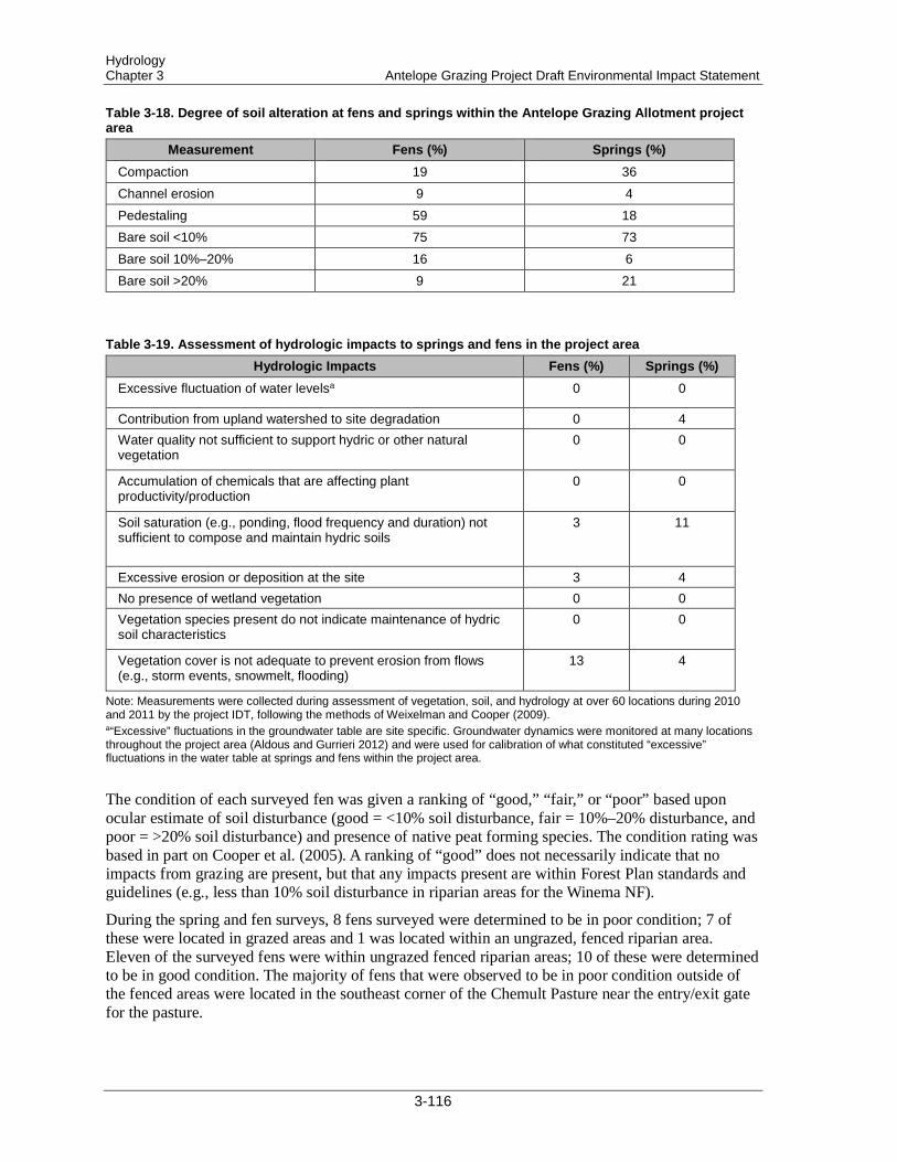
Hydrology Chapter 3 Antelope Grazing Project Draft Environmental Impact Statement
Table 3-18. Degree of soil alteration at fens and springs within the Antelope Grazing Allotment project area
Measurement Fens (%) Springs (%) Compaction 19 36 Channel erosion 9 4 Pedestaling 59 18 Bare soil <10% 75 73 Bare soil 10%–20% 16 6 Bare soil >20% 9 21
Table 3-19. Assessment of hydrologic impacts to springs and fens in the project area Hydrologic Impacts Fens (%) Springs (%)
Excessive fluctuation of water levelsa 0 0
Contribution from upland watershed to site degradation 0 4 Water quality not sufficient to support hydric or other natural vegetation
0 0
Accumulation of chemicals that are affecting plant productivity/production
0 0
Soil saturation (e.g., ponding, flood frequency and duration) not sufficient to compose and maintain hydric soils
3 11
Excessive erosion or deposition at the site 3 4 No presence of wetland vegetation 0 0 Vegetation species present do not indicate maintenance of hydric soil characteristics
0 0
Vegetation cover is not adequate to prevent erosion from flows (e.g., storm events, snowmelt, flooding)
13 4
Note: Measurements were collected during assessment of vegetation, soil, and hydrology at over 60 locations during 2010 and 2011 by the project IDT, following the methods of Weixelman and Cooper (2009). a“Excessive” fluctuations in the groundwater table are site specific. Groundwater dynamics were monitored at many locations throughout the project area (Aldous and Gurrieri 2012) and were used for calibration of what constituted “excessive” fluctuations in the water table at springs and fens within the project area.
The condition of each surveyed fen was given a ranking of “good,” “fair,” or “poor” based upon ocular estimate of soil disturbance (good = <10% soil disturbance, fair = 10%–20% disturbance, and poor = >20% soil disturbance) and presence of native peat forming species. The condition rating was based in part on Cooper et al. (2005). A ranking of “good” does not necessarily indicate that no impacts from grazing are present, but that any impacts present are within Forest Plan standards and guidelines (e.g., less than 10% soil disturbance in riparian areas for the Winema NF).
During the spring and fen surveys, 8 fens surveyed were determined to be in poor condition; 7 of these were located in grazed areas and 1 was located within an ungrazed, fenced riparian area. Eleven of the surveyed fens were within ungrazed fenced riparian areas; 10 of these were determined to be in good condition. The majority of fens that were observed to be in poor condition outside of the fenced areas were located in the southeast corner of the Chemult Pasture near the entry/exit gate for the pasture.
3-116
Hydrology Antelope Grazing Project Draft Environmental Impact Statement Chapter 3
During scoping, the public expressed concern about grazing in Round Meadow. To determine current conditions at Round Meadow, the project IDT conducted spring and riparian surveys at 4 locations. At all 4 locations, bare soil estimates was less than 10%, one area showed signs of channel erosion, and another area exhibited pedestaling. However, these undesirable conditions were minimally localized, and surveys determined Round Meadow to be in good condition. The public also expressed concern about grazing at Rock Springs. The results of the spring survey indicated that Rock Springs was in poor condition: soil disturbance was >20% and channel erosion, soil compaction, and pedestaling were documented.
3.5.1.1.1 Groundwater Dynamics Aldous and Gurrieri (2012) quantified groundwater dynamics as part of their investigation on environmental flows and levels (EF/L) for GDEs at 3 fens (Johnson, Wilshire, and Dry meadows) within the project area where water is provided to livestock through pipes that lead to watering troughs outside of the fen exclosures. For this project, the EF/L for the fens describe the amount of allowable drawdown of the groundwater table within the fen—that is, the maximum drawdown that can occur without affecting the integrity of the resident wetland plant community or peat saturation (peat saturation is essential so that the peat layer does not oxidize and continues to accrete).
Aldous and Gurrieri (2012) found that over a 32-hour period of constant withdrawal of groundwater—at one-third of the pumping rate used to fill the livestock watering trough (0.7 gallons per minute [gpm])—fluctuations in the height of the groundwater table were at most 0.9 cm and within the range of measurement error. Aldous and Gurrieri (2012) suggested that a sustained groundwater table drawdown in excess of 30 cm would lead to the loss of some wetland indicator plant species, and that a sustained drawdown in excess of 70 cm would lead to complete loss of wetland indicator species. They concluded that the pumping rate caused a negligible drawdown of the groundwater table because the pumping only caused approximately 3% of the drawdown necessary to initiate the loss of wetland indicator plant species.
In addition, Aldous and Gurrieri (2012) estimated the water budget at these locations (i.e., the movement of water into and out of a system). They found that groundwater outflow and evapotranspiration accounted for over 90% of the water leaving the system, while pumping groundwater to feed off-site livestock watering troughs accounted for less than 10% of water leaving the system (5% for Johnson Meadow, 0.5% for Wilshire Meadow, and 7% for Dry Meadow). The results of Aldous and Gurrieri (2012) further support the conclusion that continued groundwater withdrawal to feed livestock watering troughs on the height of the groundwater table would be negligible.
In addition to the pump tests at the 3 fens, Aldous and Gurrieri (2012) constructed transects to investigate the variability of vegetation and groundwater table dynamics across the fens. Along each transect they installed 14–25 groundwater wells, depending on the size of the fen. In the middle of the fens, the height of the groundwater table was relatively stable and remained near the ground surface. In contrast, the height of the groundwater table was more dynamic near the edges of the fens; there, the groundwater table was high during spring snowmelt, and then declined over the course of the summer (by over 100 cm at some locations). Aldous and Gurrieri (2012) also measured peat depth throughout the fens. They found that the greatest peat accumulation occurred in areas with a high groundwater table. Their results also indicated that peat accumulation was inversely related to the degree of groundwater table fluctuation. Lower peat depths were found in areas with high groundwater table fluctuations, particularly on the edges of the fens. The results of Aldous and Gurrieri (2012) agree with the results of other studies, which found thinner peat soils on the margins of fens (Craft and Richardson 1993; Weixelman and Cooper 2009). This variability in groundwater
3-117
Hydrology Chapter 3 Antelope Grazing Project Draft Environmental Impact Statement
dynamics and peat accumulation illustrates the spatial and temporal complexity and the dynamics of the hydrologic system within the project area.
3.5.1.2 Streamflow Streamflow can be divided into 2 components: baseflow and stormflow. Baseflow is the water in the stream channel that originates from the inflow of groundwater. In contrast, stormflow is water that enters the stream channel from overland flow during precipitation and snowmelt events, as well as from direct precipitation onto the stream surface. In dry climates, the majority of the water in the stream channel is composed of baseflow, with an increasing proportion of stormflow during snowmelt or extended periods of precipitation.
Deep pumice deposits from the eruption of Mount Mazama created a landscape in the project area where stream channels are disconnected from tributaries and/or spring sources. Therefore, water within the project area does not leave in appreciable amounts as surface flow. Peak streamflow is driven by snowmelt and historically occurs between March and June, with the highest monthly streamflow during May. Spring snowmelt ultimately controls groundwater recharge and storage, and thus stream baseflow, since spring snowmelt is the main input of water to soil. Summer precipitation is low and provides a relatively small contribution to streamflow and soil water storage. Stormflow (overland flow) generally occurs only during snowmelt or large precipitation events.
The project area contains 7 miles of perennial streams (year-round water flow), 287 miles of intermittent streams (seasonal water flow), and 15 miles of ephemeral streams (short-term, precipitation- or snowmelt-induced water flow). Drainage density is a useful numerical measure of runoff potential, or the potential for water to be exported from a watershed via streamflow. Drainage density is defined as the total length of all streams in a watershed divided by the total area of the watershed. On a highly permeable landscape, drainage densities are sometimes less than 1 kilometer per square kilometer (km/km2), indicating a small potential for runoff. In areas with high runoff potential, drainage densities are often over 500 km/km2. The drainage density for the Antelope Grazing Allotments project area is 0.075 km/km2, indicating a very low potential for export of water by streams.
All of the perennial flow within the project area occurs in Jack Creek. The geology along Jack Creek is characterized in Cummings (2012). The headwaters of Jack Creek are on the flank of Walker Rim northeast of Chemult. From there, Jack Creek flows south to the Williamson River. Year-round surface flow is present in upper reaches of the valley but occurs infrequently in lower reaches. Jack Creek streamflow generally goes subsurface near its intersection with NFS road 8821 in late summer. Pools often persist in the downstream reaches through much of the year, with surface flow appearing and subsiding through the North Sheep Pasture. Jack Creek can be divided into three sections based upon geology:
1. Headwaters (including Johnson Meadow) to Davis Flat
2. Davis Flat to NFS road 83
3. NFS road 83 to its confluence with the Williamson River.
In the headwaters section of Jack Creek, 2 subdivisions are recognized. In the upper reaches of the valley, horizontal geologic units overlap geologic units of Walker Mountain and associated units. Broad, low-relief valleys lie between lava flow capped ridges. The Wilshire site is in this setting. The Dry Meadow site may also be in such a setting, but at the headwaters of the Sellers Marsh system. The lower reaches of this section start where younger basalt lava flows partially blocked the drainage and formed intracanyon flows that moved down the valley to near Davis Flat. These flows arrested
3-118

Hydrology Antelope Grazing Project Draft Environmental Impact Statement Chapter 3
erosion of valleys in the upper reaches. The vents for the basalt lava flows appear to lie to the east and west of the Johnson Meadow site. Jack Creek is cutting into the lava flows from the western center. Some of the lava flows entered the Jack Creek valley and flowed south as intracanyon flows to near NFS road 88. Since these flows were erupted, Jack Creek has cut head-ward on the east side of these flows in the area now occupied by Davis Flat.
From Davis Flat to NFS road 83, Jack Creek is segmented into broad meadows such as Davis Flat and O’Conner Meadow, where pumice deposits overlie bedrock and are separated by areas where younger lava flows, erupted from vents to the east, intersected Jack Creek valley. The pumice deposits are locally overlain by fans of glassy silt washed from neighboring highlands, particularly east of the valley.
From NFS road 83 to the confluence of Jack Creek with the Williamson River, lava flows blocking the valley are more common, and at least one intracanyon flow occupies the valley as far south as near Rakes Meadow. Near Silver Lake Highway, the creek cuts through an older lava flow (3.63 Ma) that erupted from a center southeast of Rakes Meadow. Jack Creek then flows south to join the broad valley of the Williamson River south of Silver Lake Highway.
3.5.1.3 Channel Morphology and Water Quality Channel morphology and water quality are hydrologic factors for perennial streams and are closely tied to fisheries habitat; they are often presented with terminologies associated with the Inland Native Fish Strategy (INFISH) standards. Because Jack Creek is the only perennial stream within the project area and provides habitat for fish species analyzed for this project, data associated with these elements are presented under the “Fisheries” section and will not be repeated here. Some headcuts are present within the project area; some restoration of headcuts has been completed and still other areas have restoration activities ongoing. Restoration activities occurring within the project area are not expected to affected by the proposed grazing strategy in these areas; livestock grazing is often excluded from these active restoration sites until the site has met desired recovery conditions. Grazing in areas where some headcuts are located would be at a duration and intensity where potential impacts would be within Forest Plan standards and guidelines.
3.5.2 Direct and Indirect Effects The bounds of analysis for determining direct effects from the alternatives to hydrologic resources are the project area and the time period allowed for grazing each year (3–5 months, depending on alternative). The bounds of analysis for determining short-term indirect effects are the project area and the time period allowed for grazing (3–5 months, depending on alternative) plus an additional 2 weeks beyond the grazing time period. For the measurement indicators pertaining to Jack Creek, the boundary for spatial analysis is extended to include approximately 2 miles of Jack Creek downstream of the project area. This spatial area and the longer time period were selected because potential impacts to water quality could extend downstream of the project area and/or beyond the grazing time period, but these impacts would be expected to dissipate within the additional stream distance and the additional time period specified. For determination of long-term indirect effects, the time period is extended to the duration of the grazing permit (10 years). Alternative 2 (current management) serves as a baseline for comparing the potential effects of the other alternatives.
3-119
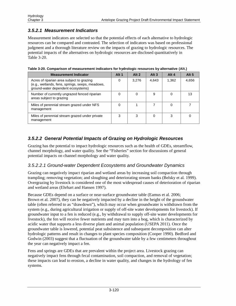
Hydrology Chapter 3 Antelope Grazing Project Draft Environmental Impact Statement
3.5.2.1 Measurement Indicators Measurement indicators are selected so that the potential effects of each alternative to hydrologic resources can be compared and contrasted. The selection of indicators was based on professional judgment and a thorough literature review on the impacts of grazing to hydrologic resources. The potential impacts of the alternatives on hydrologic resources are disclosed quantitatively in Table 3-20.
Table 3-20. Comparison of measurement indicators for hydrologic resources by alternative (Alt.)
Measurement Indicator Alt 1 Alt 2 Alt 3 Alt 4 Alt 5 Acres of riparian area subject to grazing (e.g., wetlands, fens, springs, seeps, meadows, ground-water dependent ecosystems)
0 3,276 4,643 1,362 4,656
Number of currently ungrazed fenced riparian areas subject to grazing
0 0 9 0 13
Miles of perennial stream grazed under NFS management
0 1 7 0 7
Miles of perennial stream grazed under private management
3 3 0 3 0
3.5.2.2 General Potential Impacts of Grazing on Hydrologic Resources Grazing has the potential to impact hydrologic resources such as the health of GDEs, streamflow, channel morphology, and water quality. See the “Fisheries” section for discussions of general potential impacts on channel morphology and water quality.
3.5.2.2.1 Ground-water Dependent Ecosystems and Groundwater Dynamics Grazing can negatively impact riparian and wetland areas by increasing soil compaction through trampling; removing vegetation; and sloughing and deteriorating stream banks (Belsky et al. 1999). Overgrazing by livestock is considered one of the most widespread causes of deterioration of riparian and wetland areas (Ehrhart and Hansen 1997).
Because GDEs depend on a surface or near-surface groundwater table (Eamus et al. 2006; Brown et al. 2007), they can be negatively impacted by a decline in the height of the groundwater table (often referred to as “drawdown”), which may occur when groundwater is withdrawn from the system (e.g., during agricultural irrigation or supply of off-site water developments for livestock). If groundwater input to a fen is reduced (e.g., by withdrawal to supply off-site water developments for livestock), the fen will receive fewer nutrients and may turn into a bog, which is characterized by acidic water that supports a less diverse plant and animal population (USEPA 2011). Once the groundwater table is lowered, potential peat subsistence and subsequent decomposition can alter hydrologic patterns and result in changes to plant species composition (Cooper 1990). Bedford and Godwin (2003) suggest that a fluctuation of the groundwater table by a few centimeters throughout the year can negatively impact a fen.
Fens and springs are GDEs that are prevalent within the project area. Livestock grazing can negatively impact fens through fecal contamination, soil compaction, and removal of vegetation; these impacts can lead to erosion, a decline in water quality, and changes in the hydrology of fen systems.
3-120

Hydrology Antelope Grazing Project Draft Environmental Impact Statement Chapter 3
3.5.2.2.2 Streamflow Livestock grazing can impact both stream baseflow and stormflow because grazing causes increased soil compaction (Greenwood and McKenzie 2001; Tate et al. 2004), loss of vegetation (Kauffman and Krueger 1984), and reduced soil water infiltration (Warren et al. 1986; Kauffman et al. 2004). As soils become compacted and vegetation is removed, the ability of water to infiltrate the soil decreases, which can increase the amount of water traveling to the stream as overland flow (stormflow). This increase in overland flow can also increase the amount and velocity of peak streamflow during snowmelt or precipitation events (Belsky et al. 1999). Further, the reduction in soil water infiltration due to compaction and loss of vegetation can lead to a decline in the height of the groundwater table and thus a decline in the amount of groundwater entering the stream channel (baseflow) (Belsky et al. 1999; Wondzell and Swanson 1999; Agouridis et al. 2005). This reduction in groundwater inputs to the stream channel has the potential to change weakly defined perennial streams (year-round water flow) to intermittent (seasonal water flow) or ephemeral (short-term, precipitation- or snowmelt-induced water flow) streams (Li et al. 1994; Belsky et al. 1999), particularly in dry climates. A decrease in the height of the groundwater table may also lead to disconnecting the stream channel from its floodplain (Schilling et al. 2004). The floodplain acts as a large sponge during flood events, and disconnection can further increase the amount and velocity of water in a stream channel during snowmelt and precipitation events.
3.5.2.3 Alternative 1—No Grazing Alternative 1 (No Grazing Alternative) would eliminate livestock grazing from 137,189 acres of NFS lands. Under Alternative 1, livestock grazing would be eliminated on the Antelope Grazing Allotment and Antelope Cattle and Horse Allotment, and livestock grazing permits would be cancelled (FSH 2209.13–92.31). In accordance with agency regulations (36 CFR 222.4), grazing would cease 2 years after notice of cancellation. Allotment management would continue unchanged during this 2-year interval, and these allotments would not be available for permit reissuance for a minimum of 10 years.
Removing grazing under Alternative 1 would improve hydrologic resources the most. Soil compaction from cattle trampling would no longer occur, and vegetative cover would increase. Existing soil compaction would decrease over time due to root growth and expansion and frequent freeze–thaw cycles. The increase in vegetative cover and reduction in soil compaction could increase water infiltration and storage and decrease overland flow. Some existing water structures may not be maintained, and increased streamflow in Jack Creek could occur. This streamflow increase could add perennial streamflow to sections of Jack Creek that currently flow intermittently; however, this possibility would be unlikely due to the porous geology of the project area.
The health of GDEs, such as springs and fens, within the project area would see the greatest improvements under Alternative 1. Livestock grazing would no longer occur within riparian and meadow areas where most, if not all, of the GDEs are located within the project area. Riparian vegetative cover would increase, and cattle would no longer compact sensitive wet soils characteristic of GDEs. Off-site livestock water developments may no longer be used, and the potential for a livestock grazing–related decline in the groundwater table would be eliminated. Round Meadow is rated in “good” condition, due to a low degree of soil disturbance (<10%) and presence of native peat-forming plant species but did show signs of channel erosion and pedestaling in some areas. Under Alternative 1, conditions in Round Meadow would be maintained or improved. Rock Springs is rated in “poor” condition due to soil disturbance greater than 20%; under Alternative 1, conditions at Rock Springs would improve over time as vegetative cover increased and soil compaction decreased.
3-121
Hydrology Chapter 3 Antelope Grazing Project Draft Environmental Impact Statement
The 2003 stream survey of the sections of Jack Creek on NFS lands (Ruda and Hogen 2008) documented that stream bank stability was 98%–100%, and stream width:depth ratios were generally within INFISH standards (see section 3.4.5.3). Because no grazing would occur on this section of the creek, bank stability and stream width:depth ratios would be maintained. Pool frequency, size, and longevity would have the potential to increase if stream baseflow increased, but attainment of INFISH standards for pool frequency would be unlikely. However, INFISH pool frequency objectives may not be appropriate in small, low-gradient headwater streams such as Jack Creek. Large woody debris would remain at low levels, but this would not necessarily indicate poor stream health, because large wood is not a major component of meadow stream systems.
Under Alternative 1, water quality within Jack Creek would continue to meet state water quality standards for stream temperature, and Jack Creek would remain off the ODEQ 303(d) list of impaired waters. Fecal coliform levels and stream nutrient concentrations may decrease because livestock urine and manure would no longer have the potential to be deposited in or near the stream channel, although the potential for deposition from wildlife would continue.
While implementing Alternative 1 would lead to the greatest improvements to hydrologic resources, some negative impacts would still occur. For example, private parcels along Jack Creek at Moffit, Upper Jamison, and Lower Jamison would not be waived to the NFS for grazing management under a term private grazing permit. Because grazing would not occur on NFS lands, increased grazing intensity could occur along the 3-mile private section of Jack Creek. This grazing intensity could negatively impact water quality and channel morphology in Jack Creek on NFS land downstream from the private lands. Monitoring of key areas would no longer occur, and long-term trends in allotment health would remain unknown. Some short-term (1–2 years) ground disturbance would occur during removal of fences between pastures and around currently fenced riparian areas; however, the impacts would be minimal. Once fences were removed, vehicular use necessary for allotment management would be eliminated. Vegetation cover would increase on user-created roads, reducing the potential for erosion of road surfaces and sediment input to riparian/wetland areas and streams.
Under Alternative 1, grazing by wildlife would continue and possibly increase due to the removal of livestock competition. Some impacts from wildlife, such as soil compaction and removal of vegetation, would likely occur at riparian and wetland areas. However, these impacts would be less than the impacts that would occur if livestock were present.
Of the proposed alternatives, Alternative 1 would lead to the greatest improvements in hydrologic resources. In areas where livestock grazing has negatively impacted the land, livestock exclusion has consistently resulted in the most dramatic and rapid rates of ecosystem recovery (Belsky et al. 1999).
3.5.2.4 Alternative 2—Proposed Action (Current Management) Alternative 2 proposes to continue permitted livestock grazing under current management systems for 2 herds at 419 cow/calf pairs per month from May 15 to September 30. Implementing Alternative 2 (current management) would maintain, but generally not improve, the current hydrologic conditions within the project area. The fen and spring surveys documented various degrees of soil alteration within the project area. For example, pedestaling was documented at 59% of the fens and 18% of the springs, and over 20% of the springs had bare ground that exceeded 20% (Table 3-18). The assessments of soil alteration were based on the presence/absence of disturbance and do not necessarily indicate widespread disturbance across the survey location. For example, while 59% of the fens had pedestaling, the pedestaling was not necessarily widespread and often did not result in soil disturbance greater than 10% across the fen. Thus, while some negative impacts were noted, overall good hydrologic conditions were found at many areas. Bare ground was less than 10% at
3-122

Hydrology Antelope Grazing Project Draft Environmental Impact Statement Chapter 3
75% of the fens that were surveyed, and channel erosion was found at only 9% of the fens surveyed. None of the locations exhibited excessive fluctuations of the groundwater table or lack of wetland vegetation, and soil saturation that was not sufficient to maintain hydric soils was found at only 3% of the fens and 11% of the springs (Table 3-19). Implementing Alternative 2 would likely maintain these conditions. Negative impacts—such as pedestaling and erosion—would continue to occur at some locations. Those fens and springs currently rated in “poor” condition would likely remain in “poor” condition due to continued soil compaction and vegetation removal.
Grazing would not be authorized within the existing fenced meadows (Round Meadow, Dry Meadow, Squirrel Camp, Rider’s Camp, Cannon Well, Sproats Meadow, Johnson Meadow, and Wilshire Meadow), and conditions within these areas would be maintained or continue to improve. Comparing survey results at springs and fens within and outside of ungrazed fenced riparian areas documented better hydrologic conditions within ungrazed fenced riparian areas. Under Alternative 2, Round Meadow would continue to not be grazed, so conditions would be maintained or improved; Rock Springs would likely remain in a “poor” condition with continued livestock use.
Under Alternative 2, 3 springs are proposed for reconstruction or improvement, and 3 new springs are proposed for development. Withdrawing groundwater from these spring developments could impact the associated GDEs, which are sensitive to even small fluctuations in the height of the groundwater table. A recent study by Aldous and Gurrieri (2012) at 3 fens within the project area concluded that current levels of groundwater withdrawal were not negatively impacting the fens. Their results indicated that an extraction rate of 0.7 gpm is the “tipping point” at which drawdown of the groundwater table would be large enough to negatively impact fen vegetation that is dependent upon a surface or near-surface groundwater table. The average extraction rate at the locations where the study took place was approximately one-third of the 0.7 gpm “tipping point,” and, therefore, continued groundwater withdrawal to feed off-site water developments would not likely negatively impact fens. Further, many of the wetlands within the project area are larger and wetter than the study locations. The average size of the wetlands within the project area is approximately 12.7 acres, while the 3 fens used in the study are 1.4 acres, 2.9 acres, and 11.3 acres. In theory, the larger and wetter the wetland, the more resistant it is to drawdown of the groundwater table during groundwater extraction (i.e., as the size of the “pool” of water increases, more groundwater can be extracted without causing a decline in the height of the water in the “pool”).
Under Alternative 2, some short-term negative impacts, such as soil compaction and impacts to vegetation, may occur during maintenance and construction/reconstruction of spring developments, but these impacts would be minimal and localized. Once spring development fences were operational, the hydrologic conditions within the fenced areas would improve. Some soil disturbance would also occur with the maintenance and construction of allotment boundary fences. However, these impacts would also be minimal and localized, and conditions would improve over time after the work was completed.
Under Alternative 2, grazing would not occur along the 3-mile section of Jack Creek on NFS lands. Stream bank stability and stream width:depth ratios would continue to meet INFISH standards. Current streamflow trends would be maintained, and stream water temperature would remain within acceptable levels specified by INFISH and ODEQ. Inputs of cattle urine and feces to the stream channel would continue to occur but would not increase from current levels. Sediment inputs to the stream from overland flow and stream bank erosion would continue at current levels, and stream turbidity would not change in appreciable amounts.
As with Alternative 1, private parcels along Jack Creek (Moffit, Upper Jamison, and Lower Jamison) would not be waived for grazing management to the NFS under a term private grazing permit, and grazing intensity and duration along the 3-mile private section of Jack Creek would be at the private
3-123
Hydrology Chapter 3 Antelope Grazing Project Draft Environmental Impact Statement
landowner’s discretion. Depending on the grazing duration and intensity, negative impacts to water quality and channel morphology could occur in Jack Creek on NFS lands downstream from the private lands.
Implementing Alternative 2 would maintain, but generally not improve, the current hydrologic conditions within the project boundary. Hydrologic conditions within areas rated in “fair” or “good” condition would be maintained. Areas currently rated in “poor” condition (e.g., where soil disturbance is greater than 20%) would remain in that state.
3.5.2.5 Alternative 3 The amount of riparian area subject to grazing would increase from 3,276 acres under Alternative 2 to 4,643 acres under Alternative 3, which would increase the amount of land susceptible to negative grazing impacts such as soil compaction and removal of vegetation. However, the Chemult Pasture, where nearly all the GDEs are located, would be grazed for only 2 months under a deferred-rotation grazing system, whereas 3 months of continuous grazing would occur under Alternative 2. The reduction in grazing duration and the use of a rotational grazing system under Alternative 3 would reduce the grazing intensity and give plants more time to recover from being grazed the prior year. In general, deferred-rotation grazing systems have less of a negative impact to hydrologic resources than continuous season-long grazing (Leonard et al. 1997) because livestock is rotated through different pastures for shorter time periods and not allowed to concentrate in one pasture for an entire grazing season. Ungrazed fenced riparian areas generally support GDEs. Alternative 3 would allow grazing in 6 currently ungrazed fenced riparian areas (Round Meadow, Jack Creek, Squirrel Camp, Cannon Well, Dry Meadow, Rider’s Camp), whereas no such grazing would occur under Alternative 2. These riparian areas were determined to be in “good” condition during the spring and fen surveys, and reintroducing grazing into these areas could cause negative impacts, such as soil compaction and removal of vegetation. Grazing duration would be limited to 15–30 days, and utilization would be limited to 35%–45%. Under this grazing intensity and duration, these areas would likely remain healthy. Reintroduction of grazing may lead to some negative impacts at Round Meadow. Round Meadow was determined to be in “good” condition during the spring and fen surveys, and widespread negative impacts are not likely to occur there with the reintroduction of grazing proposed under Alternative 3, because the grazing would be limited to 1 month. Further, fences would be constructed around the springs and fens within Round Meadow, and these GDEs would be protected from grazing. Grazing duration at Rock Springs would also be reduced under Alternative 3, but Rock Springs would likely remain in “poor” condition.
Under Alternative 3, 5 springs are proposed for reconstruction, and 4 new springs are proposed for development. Construction/reconstruction would occur over approximately 6 years; the springs would remain unprotected until fences were operational. Some short-term negative impacts, such as soil compaction and vegetation disturbance, may occur during construction/reconstruction, but impacts would be minimal and localized. Once fences were operational, the hydrologic conditions within the fenced areas would improve because these areas would not be grazed. Vegetation growth would increase, and soil compaction would decrease over time due to root growth and expansion and frequent freeze-thaw cycles. Water quality downstream of the springs would improve because sediment inputs from cattle trampling would be reduced and/or eliminated.
As discussed under the analysis of Alternative 2, spring developments could cause negative impacts to the GDEs, due to drawdown of the groundwater table. However, Aldous and Gurrieri (2012) documented that groundwater withdrawal at 3 fens within the project area did not negatively impact the fens. While the number of spring developments would increase to 9 under Alternative 3 (from 6 under Alternative 2), the new spring developments would be located in a similar hydrologic setting.
3-124

Hydrology Antelope Grazing Project Draft Environmental Impact Statement Chapter 3
The results of Aldous and Gurrieri (2012) suggest that groundwater pumping rates would not likely cause water table drawdown large enough to negatively impact fen vegetation or lead to peat oxidation.
Reintroducing grazing in the NFS-managed section of Jack Creek that is currently within an ungrazed fenced riparian area would likely cause some negative impacts, such as soil compaction, decreased bank stability, and impacts to streamside vegetation (see section 3.4.5.2 for a discussion of general effects on streams from livestock grazing). Widespread impacts are not likely under the proposed deferred-rotation grazing system, intensity, and duration. Water quality would likely be maintained and would continue to meet ODEQ water quality standards, and stream channel morphology would likely continue to meet INFISH riparian management objectives (RMOs). The addition of the North Sheep Pasture would increase the length of Jack Creek that is grazed, however Jack Creek flows intermittently through the North Sheep Pasture, and negative impacts to water quality and/or channel morphology within perennial reaches of Jack Creek would not be likely due to incorporation of the North Sheep Pasture.
One of the differences between Alternative 3 and Alternative 2 is that grazing management of the private parcels along Jack Creek, Upper Jamison, and Lower Jamison would be waived to the NFS under a term private grazing permit under Alternative 3. Grazing would occur in a manner consistent with Winema Forest Plan (USDA Forest Service 1990) standards and guidelines. Grazing intensity on private land would decrease from current levels, and vegetation cover would likely increase. Stream baseflow would be expected to be maintained under Alternative 3 and may even increase due to increased soil water infiltration that would occur with decreased soil compaction and increased vegetation cover along the 3-mile private section of Jack Creek. The private section of Jack Creek was not included in the 2003 stream survey of Jack Creek (Ruda and Hogen 2008), so stream channel conditions along this section are unknown. But because grazing intensity and duration would decrease under NFS management, improvements to bank stability and vegetation cover would likely occur.
Alternative 3 would increase the grazing duration on the pastures on the Silver Lake RD by 2 weeks, which may increase soil compaction. These pastures are much drier than the pastures located farther west, and impacts from the increased grazing duration would likely be minimal, because dry soils are more resistant to soil compaction than wet soils.
Alternative 3 would maintain and likely improve hydrologic resources within the project area, due to reduced grazing intensity and duration, implementation of a deferred-rotation grazing system, and improved grazing management on private lands. However, the benefits to hydrologic resources would not be as great as those that would occur under Alternative 1, the No Grazing alternative.
3.5.2.6 Alternative 4 The main difference between Alternative 4 and Alternative 2 is that under Alternative 4, grazing would no longer be permitted on the Chemult RD. Therefore, the impact of Alternative 4 to hydrologic resources within the Chemult Pasture would be the same as the impact of Alternative 1 in that pasture. Removing grazing on the Chemult Pasture would lead to decreased soil compaction, decreased overland flow, and increased vegetation cover. The majority of GDEs, such as fens and springs, are located within the Chemult Pasture, so implementing Alternative 4 would provide these sensitive GDEs with the same improvements discussed under Alternative 1.
Grazing would still occur in riparian areas on the Silver Lake RD. Soils on the Silver Lake RD are drier and less susceptible to compaction than soils on the Chemult RD, and conditions would likely
3-125

Hydrology Chapter 3 Antelope Grazing Project Draft Environmental Impact Statement
continue to meet Forest Plan standards and guidelines with the continuation of grazing on the Silver Lake RD proposed under Alternative 4.
Grazing would not be reintroduced into any of the currently ungrazed fenced riparian areas, and hydrologic conditions within these areas would be maintained or continue to improve. The number of spring developments would decrease to 4 under Alternative 4 (from 6 under Alternative 2), due to the removal of livestock grazing from the Chemult Pasture. However, this change would likely cause negligible effects to hydrologic resources.
Under Alternative 4, Jack Creek would not be grazed on NFS land; therefore, the impact to Jack Creek on NFS land would be the same as the impact discussed under Alternative 1. Alternative 4 is similar to Alternative 2 in that private parcels along Jack Creek at Upper Jamison and Lower Jamison would not be waived to the NFS for grazing management under a term private land grazing permit, and 3 miles of Jack Creek would be grazed under private management. Without reauthorization of grazing on NFS lands, grazing intensity may increase on the private section of Jack Creek, which could negatively impact water quality in Jack Creek on NFS lands downstream from the private land.
Compared to the other action alternatives, Alternative 4 would lead to the greatest improvements in hydrologic resources. However, improvements under Alternative 4 would not be as great as those under Alternative 1. Under Alternative 4, the greatest improvements to hydrologic resources would occur in the Chemult Pasture, due to the removal of grazing there.
3.5.2.7 Alternative 5 Riparian area subject to grazing would increase from 3,276 acres under Alternative 2 to 4,656 acres under Alternative 5, which would increase the amount of riparian area where negative hydrologic impacts could potentially occur. The Chemult Pasture would be grazed under a deferred-rotation system, instead of the continuous grazing system used under Alternative 2 (current management). As discussed under the analysis of Alternative 3, deferred-rotation grazing systems generally cause fewer negative impacts to hydrologic resources than continuous grazing systems (Leonard et al. 1997). With implementation of Alternative 5, reductions in soil compaction and increases in vegetation cover would likely occur in areas that have been negatively impacted under current management.
Of all the alternatives, Alternative 5 has the highest number of currently ungrazed fenced riparian areas that would be subject to grazing. As discussed under the analysis of Alternative 3, reintroducing grazing into these areas could negatively impact hydrologic resources, because soil compaction and vegetation removal may occur. However, grazing duration would be limited to 15–30 days, and utilization would be limited to 35%–45%. Under this grazing intensity and duration, these areas would likely remain in healthy condition and meet Forest Standards and Guidelines. Grazing would be reintroduced to Round Meadow, which was determined to be in “good” condition during the spring and fen surveys. While some negative impacts, such as soil compaction and vegetation removal, would likely occur, grazing would be limited to 1 month, and Round Meadow would likely remain in “good” condition and continue to meet Forest Plan standards and guidelines. The reduction in grazing intensity at Rock Springs would reduce soil compaction and lead to increased vegetation cover, but Rock Springs would likely remain in “poor” condition with continued livestock use.
Alternative 5 would likely improve the overall health of GDEs, such as springs and fens within the project area. The majority of the springs and fens are on the Chemult Pasture, and using a deferred-rotation grazing system would reduce negative impacts to GDEs within this area. As described
3-126

Hydrology Antelope Grazing Project Draft Environmental Impact Statement Chapter 3
above, some negative impacts, such as soil compaction and vegetation removal, would likely occur with reintroduction of grazing in currently ungrazed fenced riparian areas, but widespread impacts would be unlikely under the proposed grazing system and utilization standards. Alternative 5 includes 9 spring developments, which could potentially impact the associated GDEs through drawdown of the groundwater table. The results of Aldous and Gurrieri (2012) indicated that groundwater withdrawal to feed off-site livestock water developments would not lead to water table drawdown, and negative impacts to GDEs at these locations would be unlikely.
The addition of the North Sheep Pasture under Alternative 5 would increase the length of Jack Creek that is grazed. However, Jack Creek flows intermittently through the North Sheep Pasture, and negative impacts to water quality and/or channel morphology within perennial reaches of Jack Creek would not be expected. Grazing management along the 3-mile section of Jack Creek that flows through private land would be waived to the Forest under a term private land grazing permit. This area would be grazed under a deferred-rotation grazing system, and conditions in Jack Creek both within and downstream of the private area would likely improve. However, some negative impacts to stream bank stability would likely occur with livestock grazing. Some ground disturbance may occur during general allotment maintenance, such as fence and stock pond maintenance, water hauling, and limited off-road use, but impacts would be minimal.
Compared to Alternative 3, Alternative 5 would permit grazing for a longer duration in the Chemult Pasture and the North Sheep Pasture. The increased grazing duration would increase the potential for negative impacts to hydrologic resources, such as soil compaction and removal of vegetation. Alternative 5 would also allow for an earlier turnout and a longer grazing duration on the pastures on the Silver Lake RD. This additional grazing time would increase the potential for soil compaction, overland flow, and removal of vegetation. However, these pastures are generally much drier than those on the Chemult RD and therefore not as susceptible to soil compaction.
Alternative 5 would cause fewer negative impacts to hydrologic resources across the project area than current management (Alternative 2). However, Alternative 5 would cause more negative impacts than would occur under Alternatives 1, 3, or 4.
3.5.3 Cumulative Effects Cumulative effects are defined as impacts on the environment that result when the incremental impact of an action is added to past, present, or reasonably foreseeable future actions. In order to assess the contribution of past actions to the cumulative effects of the proposed action and alternatives, this analysis relies on current environmental conditions as a proxy for the impacts of past actions. Existing conditions reflect the aggregate impact of all prior human actions and natural events that have affected the environment and might contribute to cumulative effects. Past, present, and reasonably foreseeable future activities in the allotments’ subwatersheds are listed in Appendix C and include livestock grazing, road construction and maintenance, invasive plant management, and continued land management such as commercial and non-commercial thinning and fuels treatments. Potential cumulative effects to streamflow, channel morphology, stream water quality, and health of GDEs such as fens and springs were analyzed and are reported below. The temporal boundary of this analysis is the time period for the term grazing permit (10 years).
3.5.3.1 Groundwater-dependent Ecosystems The spatial area for analysis of cumulative effects to the health of GDEs is the total amount of fen and spring habitat within the project area.
3-127

Hydrology Chapter 3 Antelope Grazing Project Draft Environmental Impact Statement
3.5.3.1.1 All Action Alternatives Ongoing and future foreseeable activities include thinning and/or removal of encroaching conifers and hand piling and burning of thinning slash. These activities may impact GDEs through soil compaction and reduced shading; the impacts could overlap with the effects of grazing under the action alternatives. However, the effects would be minimal, and combined with the actions of any of the alternatives, negative cumulative impacts would not be likely. Thinning and removal of encroaching conifers may improve the health of GDEs by reducing consumption of groundwater that is essential to maintain the health of GDEs.
3.5.3.2 Streamflow The spatial boundary for the analysis of cumulative effects to streamflow is the entire length of Jack Creek within and downstream of the project area. This analysis area has been determined to be appropriate because potential changes in streamflow would impact this stretch of Jack Creek.
3.5.3.2.1 All Action Alternatives All action alternatives, combined with reasonably foreseeable future actions, such as prescribed burning and removal of encroaching conifers, have the potential to increase streamflow within Jack Creek, due to the removal of grazing, reduction in grazing duration, and/or use of deferred-rotation grazing systems. Due to the porous geology of the project area, any potential increases in streamflow would be small and not substantial enough to add perennial streamflow to those sections of Jack Creek that currently flow intermittently, and cumulative impacts to streamflow are not likely.
3.5.3.3 Channel Morphology and Stream Water Quality The spatial boundary for the analysis of cumulative effects to channel morphology and stream water quality is the 7-mile segment of Jack Creek within the project area that has perennial streamflow. This analysis area has been determined to be appropriate because any potential cumulative effects, such as increased sedimentation, would not be substantially transported downstream beyond the perennial section. Future activities that have the potential to impact stream channel morphology and water quality include habitat restoration for Oregon spotted frog, which would occur adjacent to Jack Creek within the project area. Some instream restoration projects that could impact stream channel morphology and water quality are also proposed for completion in the foreseeable future.
3.5.3.3.1 All Alternatives The residual impacts of past actions along the 7-mile section of Jack Creek with perennial flow have resulted in the current conditions of stream channel morphology and stream water quality, which generally meet standards imposed by both INFISH and ODEQ. Depending on the chosen alternative, grazing intensity and duration would remain the same or be reduced, and future conditions within Jack Creek would be maintained or improved under all alternatives. Some recent activities, such as the creation of off-channel ponds to improve Oregon spotted frog habitat and future stream restoration projects, have the potential to negatively impact stream water quality and/or stream channel morphology, due to compaction and increased sediment delivery to the stream. However, potential negative impacts would be minimal and short-term (i.e., <2 years), and cumulative effects are not expected.
3-128
Fisheries Antelope Grazing Project Draft Environmental Impact Statement Chapter 3
3.6 Fisheries This section analyzes the potential effects to fish and aquatic mollusk species from the Antelope Grazing Allotments Project. The analysis addresses federally listed threatened, endangered, or proposed species, as well as critical habitats, in the project area (Forest) pursuant to Section 7 of the Endangered Species Act of 1973 (ESA) (16 U.S.C. 1531–1544), as amended. In addition, impacts from the proposed management action on Forest Service (FS) aquatic sensitive species, as identified by the Region 6 Regional Forester (USDA 2011), are also assessed, as required in the Forest Service Manual.
All aquatic federally listed and candidate species, proposed critical habitats (October 2011), MIS, and Regional Forester sensitive species (RFSS) within Klamath and Lake counties in Oregon were reviewed for this analysis. No aquatic federally listed or candidate species, proposed or designated critical habitats, or MIS are present within the project area. Only one aquatic RFSS species, Miller Lake lamprey (Lampetra [Entosphenus] minima), is present within the project area. Additionally, because of limited connectivity of consistent fish habitat within the project area, other threatened, endangered, proposed, or RFSS would not be likely to migrate to the perennial portions of Jack Creek within the project area. A series of natural waterfalls in Kirk Canyon would prevent any fishes from Upper Klamath Lake from accessing the Williamson River above Klamath Marsh or Jack Creek if flow conditions were such to allow fish passage.
3.6.1 Affected Environment
3.6.1.1 Jack Creek Analysis of the existing condition of aquatic species habitat in the project area is restricted to Jack Creek. The Antelope Grazing Allotments project area has over 300 miles of intermittent and ephemeral stream courses; perennial flows occur only in the upper 6–7 miles of Jack Creek. This perennial water provides the only consistent fish habitat within the project area. Deep pumice deposits from the eruption of Mount Mazama, over 7,000 years ago, have created a landscape where stream channels may be disconnected from tributaries and/or spring sources by the end of summer, often earlier, depending on the amount of winter precipitation and runoff. Stringer meadows and isolated pools that retain some water have no consistent overland connection to the perennial portion of Jack Creek, nor does the perennial section of Jack Creek have more than ephemeral connection to the Williamson River, which is over 15 miles downstream.
Jack Creek is best described as a Class II stream, which is a perennial or intermittent stream that is used by moderate numbers of fish for spawning, rearing, or migration; and/or may be a tributary to a Class I stream or other Class II stream (USDA Forest Service 1990). Several surveys have been conducted to evaluate the conditions of Jack Creek for varying measures, including Level II stream surveys, INFISH standards, and water quality.
3.6.1.1.1 Level II Surveys Jack Creek is the only creek within the project area with perennial flow, and analysis of stream channel morphology is therefore restricted to Jack Creek.
A Hankin and Reeves Level II stream survey was completed for Jack Creek by the Forest in 2003 (Ruda and Hogen 2008). This survey documented habitat conditions in the perennial portion of Jack Creek from NFS road 8821-000 road crossing to the headwaters downstream of NFS road 9400-000 road crossing on NFS lands. No data are available for the privately owned sections. From the survey, Jack Creek can be characterized as low gradient (<1%–2%), narrow
3-129
Fisheries Chapter 3 Antelope Grazing Project Draft Environmental Impact Statement
(3–4 feet wetted width), and shallow (residual pool depths 1–2 feet). The dominant substrate is silt-sized pumice. At the time of the survey, the Jack Creek riparian fence had not yet been constructed (USDA Forest Service 2008), and the riparian area adjacent to Jack Creek was grazed. Grazing is noted in several reaches, but impacts are described as “minimal.”
Banks in the perennial section of Jack Creek are 98%–99% stable. The Region 6 Stream Inventory Handbook (USDA Forest Service 2002b, 2010b) instructs stream surveyors on the correct procedure for measuring bank stability and provides the following discussion:
Bank stability is a measure of actively eroding banks at an elevation above the bankfull stream margin. That is, naked substrate within the bankfull channel is the normal condition due to the dynamic nature of the bankfull channel, and is not necessarily an indication of eroding banks. An eroding bank is characterized by any one, or a combination of the following factors provided they occur at an elevation above the bankfull flow: bare exposed colluvial or alluvial substrates, exposed mineral soil, evidence of tension cracks, or active sloughing. A bank that is composed of only cobbles and gravels may, nonetheless, be stable; the sand, silt and clay components no longer present in a naked bank may be quite resistant to erosion. If there is no sloughed material perched atop the lower banks, do not consider a naked bank unstable.
The perennial portion of Jack Creek is described as Rosgen “E” and “C” types. “E” type channels are considered highly stable systems, provided the floodplain and low channel width-to-depth characteristics are maintained (Rosgen 1996). “E” channels are found within broad valleys and meadows. They are highly sinuous with stable, well-vegetated banks. The primary features of “C” type streams are a sinuous, low-gradient channel, with well-developed floodplains, and point bars within the active channel (Rosgen 1996). “C” channel streams are found in broad valleys with terraces. Both “E” and “C” channel types are sensitive to disturbance and can rapidly adjust and convert to other stream types in a relatively short time (Rosgen 1996).
3.6.1.1.2 INFISH Riparian Management Objectives INFISH riparian management objectives (RMOs) are landscape-scale values describing good habitat for fish. All of the described habitat features may not occur in a specific segment of stream within a watershed, but all generally should occur at the watershed scale for stream systems of moderate to large size (3rd–6th order). Jack Creek is a 1st- to 3rd-order stream, which is also called a headwater stream and constitutes any waterways in the upper reaches of the watershed. Although Jack Creek is a smaller-sized stream than INFISH RMOs are designed to represent, the habitat conditions in Jack Creek have been assessed according to INFISH standards (Table 3-21).
3-130
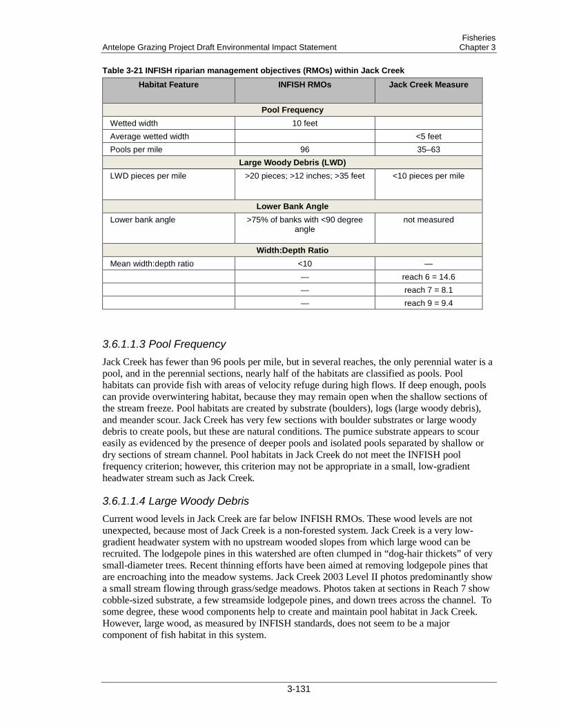
Fisheries Antelope Grazing Project Draft Environmental Impact Statement Chapter 3
Table 3-21 INFISH riparian management objectives (RMOs) within Jack Creek
Habitat Feature INFISH RMOs Jack Creek Measure
Pool Frequency Wetted width 10 feet Average wetted width <5 feet Pools per mile 96 35–63
Large Woody Debris (LWD) LWD pieces per mile >20 pieces; >12 inches; >35 feet <10 pieces per mile
Lower Bank Angle Lower bank angle >75% of banks with <90 degree
angle not measured
Width:Depth Ratio Mean width:depth ratio <10 — — reach 6 = 14.6 — reach 7 = 8.1 — reach 9 = 9.4
3.6.1.1.3 Pool Frequency Jack Creek has fewer than 96 pools per mile, but in several reaches, the only perennial water is a pool, and in the perennial sections, nearly half of the habitats are classified as pools. Pool habitats can provide fish with areas of velocity refuge during high flows. If deep enough, pools can provide overwintering habitat, because they may remain open when the shallow sections of the stream freeze. Pool habitats are created by substrate (boulders), logs (large woody debris), and meander scour. Jack Creek has very few sections with boulder substrates or large woody debris to create pools, but these are natural conditions. The pumice substrate appears to scour easily as evidenced by the presence of deeper pools and isolated pools separated by shallow or dry sections of stream channel. Pool habitats in Jack Creek do not meet the INFISH pool frequency criterion; however, this criterion may not be appropriate in a small, low-gradient headwater stream such as Jack Creek.
3.6.1.1.4 Large Woody Debris Current wood levels in Jack Creek are far below INFISH RMOs. These wood levels are not unexpected, because most of Jack Creek is a non-forested system. Jack Creek is a very low-gradient headwater system with no upstream wooded slopes from which large wood can be recruited. The lodgepole pines in this watershed are often clumped in “dog-hair thickets” of very small-diameter trees. Recent thinning efforts have been aimed at removing lodgepole pines that are encroaching into the meadow systems. Jack Creek 2003 Level II photos predominantly show a small stream flowing through grass/sedge meadows. Photos taken at sections in Reach 7 show cobble-sized substrate, a few streamside lodgepole pines, and down trees across the channel. To some degree, these wood components help to create and maintain pool habitat in Jack Creek. However, large wood, as measured by INFISH standards, does not seem to be a major component of fish habitat in this system.
3-131
Fisheries Chapter 3 Antelope Grazing Project Draft Environmental Impact Statement
3.6.1.1.5 Lower Bank Angle (non-forested systems) Bank angle and undercut banks were not measured during the Jack Creek 2003 Level II stream survey, so no data are available to compare to INFISH criteria. Surveyors did not indicate the presence of undercut banks (Ruda and Hogen 2008).
3.6.1.1.6 Width:Depth Ratio The width:depth ratio displays how wide a stream is relative to its depth. The Jack Creek Level II Stream Survey Summary Report (Ruda and Hogen 2008) states that for Reach 2 and Reach 4, width:depth ratios were not calculated because of the lack of fast water habitat. These reaches are a series of pools, each separated by dry channels. Width:depth ratios were calculated for the remaining reaches.
Rosgen (1996) provides expected width:depth ratios for various stream types. According to his characterizations, “E” channels are expected to have width:depth ratios of less than 12, but “C” channels are expected to have width:depth ratios of greater than 12. A conflict exists between the expected width:depth ratios provided by Rosgen (1996) and those provided by INFISH RMOs. This conflict could possibly be explained by the somewhat unique flow characteristics of Jack Creek—as runoff recedes, flows subside into the pumice. Stream channels retain their capacity to allow relatively high runoff flows to pass, but during the summer, water becomes subsurface. These flow characteristics may have skewed the width:depth ratio measurements at the time of the survey.
3.6.1.1.7 Water Quality Water quality can be defined as the physical, chemical, and biological characteristics of water. Measurements of stream flow and stream water quality parameters such as pH, temperature, conductivity, dissolved oxygen, and nitrate concentrations were collected at least once a month from June through September during 2009, 2010, and 2011 in Jack Creek. The monitoring locations were at the crossing of NFS road 8821 (Water Quality Monitoring Station #5526, downstream location) and at the crossing of NFS road 9418 (Water Quality Monitoring Station #5430, approximately 5 miles upstream from Station #5526). At Station #5526 (downstream location), stream flow became intermittent in July in 2009 and 2010, but not until August in 2011, following a heavy snow year and a cool, wet spring. At Station #5430 (upstream location), perennial flow was observed during all measurements.
Dissolved oxygen (DO) data collected from Jack Creek for the summer months (June through September) in 2009, 2010, and 2011 are generally above the minimum DO levels for freshwater fish (5.0–6.0 mg/L [ppm]). However, reported DO levels fell below 4.0 mg/L in July 2010 and August 2011, indicating that low DO is a potential concern for aquatic life in Jack Creek.
Field observations confirm the presence of solid waste from cattle, but plant growth does not seem to be affecting water quality. Lamprey have been observed even in small, isolated pools (within the Jack Creek channel) late in the summer, (Gorman and Smith, 2001; Ruda and Hogen 2008). The pools may have scoured enough that they receive groundwater input that helps reduce stagnation. In the perennial portion of the system, flowing water appears to be adequate for maintaining water quality. Additionally, areas that have been excluded from grazing (e.g., the area of Jack Creek that has been within the riparian fence since 2008) have a well-vegetated floodplain. Riparian vegetation, litter layers, and soils filter incoming sediments and pollutants, thereby assisting in the maintenance of high water quality needed for healthy fish populations.
INFISH water temperature RMOs call for no measurable increase in maximum water temperature (7 day moving of daily maximum temperature measured as the average of the
3-132
Fisheries Antelope Grazing Project Draft Environmental Impact Statement Chapter 3
maximum daily temperature of the warmest consecutive 7-day period) (USDA Forest Service 1995). While the daily maximum water temperatures have not been calibrated with air temperature, the data for Jack Creek indicate fairly consistent average daily maximums for the recorded period, and no measurable increase in daily maximum water temperatures is apparent.
Summertime water temperature samples collected from 2 locations in Jack Creek indicate that temperatures are within ODEQ water quality standards for redband trout (data on file at the Forest Service Supervisor’s Office, Lakeview, Oregon). ODEQ determined that “if a source can meet the redband trout criterion of 20°C plus the human use allowance, their increase will not impair cool water species, which have more tolerance of warm temperatures than trout” (ODEQ 2008). Therefore, water temperatures in Jack Creek meet standards for cool-water aquatic life, which includes Miller Lake lamprey. More-recent water temperature data also show summer water temperatures in Jack Creek remaining within ODEQ standards for cool-water species. Spot-check water temperature samples collected near Water Quality Monitoring Stations #5526 and 5430 in June through September during 2009, 2010, and 2011 had temperatures ranging between 8 °C and 20 °C.
3.6.1.2 Miller Lake Lamprey Miller Lake lamprey are found throughout the perennial portion of Jack Creek. The Miller Lake lamprey is the world’s smallest predatory lamprey, reaching a length of only 3–6 inches, and is endemic to the Klamath Basin (Bond and Kan 1973; Gill et al. 2003; Lorion et al. 2000). Miller Lake lamprey is also one of the few species to have “recovered” from extinction. At the species’ rediscovery in 1992, concern for the species’ tenuous status and apparently low abundance prompted consideration of emergency listing under the federal ESA. The immediate need to list was avoided by the discovery of relatively numerous populations in Miller Creek, the upper Williamson River drainage, and the upper Sycan River drainage above Sycan Marsh (Lorion et al. 2000).
Miller Lake lampreys occupy relatively cool, clear streams (Gunckel and Reid 2004; Kan and Bond 1981; Lorion et al. 2000; Reid pers. comm. 2004). Adults are generally associated with structural cover, including loose rocks and woody debris. Ammocoetes (larvae) live in the substrate and are generally associated with depositional environments. In streams, ammocoetes are frequently found in silty backwater areas, low-energy stream edges, and pool eddies, where leaf litter and other organics (including adult lamprey carcasses) tend to accumulate. At night, ammocoetes may move into the water column to disperse downstream or into more favorable habitat. Recent extensive collections of Pacific lamprey ammocoetes along the coast indicate that ammocoetes do not occupy otherwise suitable sediments if the upper layer is poorly oxygenated (Reid and Goodman, pers. obs., 2004).
Miller Lake lampreys feed on fish only as adults. Ammocoetes have no eyes or teeth and are purely filter feeders, burrowing in the sediment and feeding on suspended microorganisms and algae. The ammocoete phase lasts about 5 years, during which time the ammocoetes grow to around 150 millimeters (mm). After transformation, adults enter a predatory phase before spawning that generally lasts for less than a year (from transformation in the summer/fall to spawning in summer of the following year). Adults use the sucking disk to feed on flesh that is gouged and rasped out of a small wound (≤11 mm) (Cochran and Jenkins 1994; Kan and Bond 1981). Adults show little apparent selectivity for prey. In Jack Creek, lampreys feed on speckled dace, the only other fish present in the stream; in the Upper Sycan, lampreys feed on both trout and dace. Unlike other predatory lampreys, but similar to non-feeding brook lampreys, adult Miller Lake lampreys lose body length and mass between the time they transform and actual spawning, indicating that the amount of food they consume does not compensate for energetic needs and gonadal development (Hubbs 1971; Kan and Bond 1981; Lorion et al. 2000).
3-133
Fisheries Chapter 3 Antelope Grazing Project Draft Environmental Impact Statement
No immediate threats to the Miller Lake lamprey are currently known (Kostow 2002). However, the species is of considerable conservation concern due to its relatively limited range in 2 small subdrainages of the Klamath Basin and its evolutionary distinctiveness as the smallest known predatory lamprey in the world, maturing at <4 inches. An additional concern considered in the Miller Lake Lamprey Conservation Plan is the species’ “continued absence in the ecologically unique setting of Miller Lake (type locality) (ODFW 2005),” which has been addressed by Miller Lake Science Team actions. A lamprey barrier, installed in 1959 as part of the original eradication, was removed from Miller Creek in September 2005. Miller Lake lamprey were reintroduced into Evening Creek, a tributary to Miller Lake, and into Miller Lake itself in 2010 (ODFW 2010), and survival of the reintroduced lamprey in Evening Creek was documented in 2011 (ODFW 2011).
3.6.2 Direct and Indirect Effects The bounds of analysis for determining direct and indirect effects on the project’s fisheries resources are the fish-bearing perennial reaches of Jack Creek. This area was selected because the direct and indirect effects from the proposed actions would occur where management is proposed to take place and are not expected to extend outside of the project area. Effects include both short-term (season of use) and long-term (life of the permit, or 10 years) impacts for these areas. Because livestock have few direct effects on aquatic species, direct effects to aquatic habitat were evaluated instead.
3.6.2.1 Measurement Indicators Indicators used to measure effects are selected so that the effects of the project alternatives can be compared and contrasted. The selection of indicators was based on professional judgment and a thorough review of literature on the interaction of the Miller Lake lamprey and cattle and grazing. The possible effects of the alternatives on aquatic habitat are disclosed quantitatively in Table 3-22.
Table 3-22 Comparison of the effects of the alternatives (Alts.) using measurement indicators for aquatic habitat
Measurement Indicator Alt. 1 Alt. 2 Alt. 3 Alt. 4 Alt. 5 Miles of fish habitat under permitted grazing 0 1 6 0 6 Miles of fish habitat grazed under private management
3 3 0 3 0
Days permitted grazing would occur in riparian areas adjacent to fish habitat
0 90 75 0 105
Days grazing would occur in riparian areas adjacent to fish habitat under private management
unknown unknown 0 unknown 0
3.6.2.2 General Effects on Aquatic Systems from Livestock Grazing Livestock grazing can affect all components of the aquatic system. Grazing can affect the streamside environment by changing, reducing, or eliminating vegetation bordering the stream. In addition to providing key habitat requirements for many aquatic species, vegetation next to water bodies plays a major role in sustaining the long-term integrity of aquatic systems. Values provided include thermal regulation, bank stability, fish cover, woody debris input, storage and release of sediment, flood attenuation, surface-groundwater interactions, and plant-and-animal habitats. Riparian zones provide critical services for all ecosystem types and are especially
3-134
Fisheries Antelope Grazing Project Draft Environmental Impact Statement Chapter 3
important in arid regions, where they supply the primary source of moisture for plants and wildlife (Meehan et al. 1977). Properly functioning riparian zones protect aquatic systems by acting as giant sponges during flood events, raising groundwater tables, and maintaining a source of stream water during dry seasons (Belsky et al. 1999). The most extensive human-caused influence on riparian zones in the western United States has been livestock grazing (Ehrhart and Hansen 1997). Overgrazing by livestock is considered the most widespread cause of deterioration of riparian systems on public lands (Knopf and Cannon 1982).
Properly functioning riparian systems contribute to channel stability and morphology, water quality, and prey food production. Channel morphology can be changed by accrual of sediment, alteration of channel substrate, disruption of the relation of pools to riffles, and widening of the channel. The water column can be affected by increasing water temperatures, nutrients, and suspended sediment, and by changes in the timing and volume of stream flow. Livestock can trample stream banks, causing banks to slough off, creating false banks, and accelerating bank erosion (Platts 1991). Increased turbidity in the stream and severe erosion can be caused by animals walking in the stream channel. Fish spawning periods and associated incubation of eggs within streambeds are very important to the success of a healthy fish population. Spawning fish can be disturbed by livestock during spawning periods. Trampling of spawning sites can also occur if grazing takes place when fish are spawning or while eggs are incubating within streambeds. Lamprey ammocoetes, which have multiple year classes that remain in substrate for several years, can be especially vulnerable to increased sediment loads from stream bottom and stream bank disturbance; ammocoetes are also vulnerable to being stepped on by cattle.
Grazing can impact stream channel morphology by changing stream bank stability, sediment inputs and transport, and streamside vegetation (Belsky et al. 1999). For example, stream bank stability can decrease as cattle trample stream banks and cause soil to slough (Kauffman et al. 1983; Trimble and Mendel 1995). As stream banks deteriorate, the stream becomes wider and stream width:depth ratios increase, which can impact stream temperature (see section 2.5.1.1.3, “Water Quality”). Trampling of soil by cattle can also reduce streamside vegetation cover (Kauffman and Krueger 1984) and, thus, the availability of plant roots to protect stream banks from erosive stream flow (Trimble and Mendel 1995). Stream bank erosion may be further exacerbated by increased peak stream flows that may be attributed to grazing (Meehan and Platts 1978). In addition, decreased vegetation cover often leads to greater sediment inputs to the stream from overland flow (Trimble and Medel 1995; Wondzell 2001). Impacts from grazing may also result in stream channel downcutting (Belsky et al. 1999) and disconnection of the stream from its floodplain (Schilling et al. 2004).
Grazing has the potential to impact numerous water quality parameters, including stream water temperature, turbidity, nutrient concentrations, and fecal coliform levels (Belsky et al. 1999). Water quality is generally evaluated by measuring DO, nutrient levels, and water temperature. Oxygen enters the water by diffusion from the atmosphere or through plant photosynthesis. DO levels are constantly changing and represent a balance between respiration and decomposition, which deplete oxygen, and photosynthetic activity, which increase oxygen levels. Because it requires light, photosynthesis occurs only during daylight hours. Respiration and decomposition occur 24 hours a day. This difference alone can account for large daily variations in DO concentrations. During the night, when photosynthesis cannot counterbalance the loss of oxygen through respiration and decomposition, the DO concentration may steadily decline. DO is lowest just before dawn when photosynthesis resumes. Seasonal changes also affect DO concentrations. Warmer temperatures during summer speed up the rates of photosynthesis and decomposition. Other seasonal events, such as changes in flow volume and presence of ice cover, also cause natural variations in DO concentrations.
3-135
Fisheries Chapter 3 Antelope Grazing Project Draft Environmental Impact Statement
Animal waste deposited directly into the water can also affect water quality. The nitrogen and phosphorus contained in the waste produces excessive plant growth, which can affect water quality parameters such as DO. Organic waste may overload a natural system, causing a serious oxygen depletion in the water, and the depleted oxygen level may in turn lead to fish kills. Likewise, water that is rich in nutrients may cause algal blooms whose eventual decomposition uses up the available DO (Alken-Murray Corp. 2011). Grazing cattle, beavers, and other wild animals are likely to deposit their waste into the water and all contribute to impacts to water quality.
Livestock grazing is often associated with increased nutrient concentrations in stream water, due to deposits of livestock urine and manure in and near the stream, increased sediment inputs from overland flow and stream bank erosion, and a reduction in the amount of water in the stream (which leads to higher nutrient concentrations) (Belsky et al. 1999).
Fecal coliform is a bacteria that is commonly present in animal feces. Cattle can increase fecal coliform levels in streams by defecating in or near the stream channel. Although generally not harmful itself, fecal coliform is often used as an indicator of the presence of harmful bacteria in water from fecal contamination (Tiedemann et al. 1987; Agouridis et al. 2005). Such contamination brings the threat of bacterial infection to people who come in direct contact with contaminated water (Hubbard et al. 2004).
Stream shade provided by riparian vegetation reduces the amount of solar radiation that reaches the stream, which lowers water temperature. Other factors influencing water temperature include discharge, channel morphology, air temperature, and interactions with groundwater. A large amount of vegetation would need to be removed to affect water temperature in the stream, and that vegetation would have to be the only source of shade.
Riparian vegetation also provides habitat for terrestrial insects, which are important food for salmonids and other fish species (Murphy and Meehan 1991). Riparian vegetation also provides organic material to the stream, which becomes the nutrient base for aquatic insect production. Therefore, riparian vegetation supports both the terrestrial and aquatic components of aquatic species’ diets. In watersheds where soils provide insufficient nutrients to the stream, riparian vegetation assumes a major role in the production of fish food by providing habitat for terrestrial insects that fall directly into the stream. Detritus from incoming terrestrial plants is a principal source of food for aquatic invertebrates that eventually become prey items that support fish communities (Minshall 1967) and many other types of wildlife.
Lampreys may be relatively tolerant to water pollution, but high pollution levels are likely not good for them, especially when toxins accumulate in the silt that houses lamprey ammocoetes (Kostow 2002). Ammocoetes reside in the substrate for numerous years, but they are capable of moving to seek improved habitat conditions. Seeps, higher-gradient areas, and areas of improved water quality are available in Jack Creek, so lamprey could move to those areas if water quality becomes locally poor. The effects of low DO concentrations, eutrophication, or turbidity on Pacific lamprey are unknown (Luzier et al. 2011). Although Miller Lake lamprey differ from Pacific lamprey in distribution and adult life history requirements (anadromy), their water quality preferences are probably similar.
3.6.2.3 Alternative 1 Alternative 1 (No Grazing Alternative) would eliminate livestock grazing from 137,189 acres of NFS lands. Under Alternative 1, livestock grazing would be eliminated on the Antelope Grazing Allotment and Antelope Cattle and Horse Allotment, and livestock grazing permits would be cancelled (FSH 2209.13–92.31). In accordance with agency regulations (36 CFR 222.4), grazing would cease 2 years after notice of cancellation. Allotment management would continue
3-136
Fisheries Antelope Grazing Project Draft Environmental Impact Statement Chapter 3
unchanged during this 2-year interval, and these allotments would not be available for permit reissuance for a minimum of 10 years.
Riparian exclosure fences in Jack Creek would be removed. No fence maintenance or fence reconstruction would occur on NFS lands. Existing water structures would not be removed or maintained but would be allowed to deteriorate, possibly providing for a net increase in stream flows in Jack Creek.
Because permitted grazing would be extremely limited within NFS lands on Jack Creek, the current permit holder may increase grazing on privately owned lands. In some cases, these privately owned lands contain suitable habitat for Miller Lake lamprey. Impacts in these areas may be greater than they would be if permitted grazing were continued on NFS lands.
3.6.2.4 Alternative 2 Alternative 2 proposes to continue permitted livestock grazing under current management systems for 2 herds at 419 cow/calf pairs per month from May 15 to September 30. The available range in the Chemult Pasture is virtually all riparian meadows and wetlands with little upland forage. Continuous season-long grazing throughout the growing period with little control over cattle distribution may result in the overgrazing of riparian areas (Leonard et al. 1997). Under Alternative 2, no permitted grazing would occur within the following existing fenced meadows: Round Meadow, Dry Meadow, Squirrel Camp, Rider’s Camp, Cannon Well, Sproats Meadow, Johnson’s Meadow, Wilshire Meadow, and the NFS fenced portion of Jack Creek perennial reach. Only Johnson’s Meadow and the NFS fenced portion of Jack Creek have a hydrologic connection to Miller Lake lamprey habitat in Jack Creek, but Johnson’s Meadow itself does not provide habitat.
Historically, cattle grazed the entire length of perennial Jack Creek, with minimal impacts. In 2008, a fence was constructed to further protect sensitive Oregon spotted frog habitat in Jack Creek. Under Alternative 2, no grazing would occur behind the Jack Creek riparian fence, so impacts to Miller Lake lamprey from livestock grazing would be minimal. Although the riparian fence does not prevent all access to Miller Lake lamprey habitats, it does protect the majority of the habitats in Jack Creek from livestock grazing. Continued management under Alternative 2 would prohibit grazing on most of the lamprey habitat; therefore, the direct and indirect effects of Alternative 2 would be expected to remain the same or improve on NFS lands.
Because permitted grazing would be extremely limited within NFS lands on Jack Creek, the current permit holder may increase grazing on privately owned lands. In some cases, these privately owned lands contain suitable habitat for Miller Lake lamprey. Impacts in these areas may be greater than they would be if permitted grazing were continued on NFS lands.
3.6.2.5 Alternative 3 Alternative 3 proposes to continue permitted livestock grazing with additional acreage identified from the Jack Creek Sheep and Goat Allotment. The addition of the North Sheep Pasture increases the length of Jack Creek that is grazed, because Jack Creek flows through the North Sheep Pasture. However, Jack Creek has intermittent flows in this portion of the project area and would only provide seasonal habitat for Miller Lake lamprey. Any ammocoetes that move downstream into this area during high flows will have to move upstream into the perennial sections as flows recede or else be stranded and perish. The effects of adding the North Sheep Pasture to the allotment would therefore be minimal.
Under Alternative 3, the Chemult and the North Sheep pastures would be managed together using a deferred-rotation system with alternating seasons of use. The private land along Jack
3-137

Fisheries Chapter 3 Antelope Grazing Project Draft Environmental Impact Statement
Creek known as Moffit, Upper Jamison and Lower Jamison would be managed under a term private land permit, which would allow the Forest Service to authorize and direct grazing on these private lands. Alternative 3 proposes a deferred-rotation grazing system for one herd of 494 cow/calf pairs per month from May 20 through October 15. Typically, a deferred-grazing rotation, as proposed under Alternative 3, has fewer negative impacts on riparian systems than season-long grazing, as proposed under Alternative 2.
However, grazing behind riparian fenced areas may concentrate livestock within the riparian area, which could impact Miller Lake lamprey habitat. Effects of concentrated grazing include loss of riparian vegetation and woody debris input. Stream banks without adequate vegetation can become unstable, leading to high width:depth ratios, increased sedimentation, and diminished water quality. The grazing system proposed within the Jack Creek Unit, which includes the area behind the Jack Creek riparian fence, would allow authorized grazing for 75 cow/calf pairs for 1 month. Adhering to riparian grazing standards and a pasture rotation schedule and limiting the number of livestock and the season of use should maintain lamprey habitat at acceptable standards.
3.6.2.6 Alternative 4 Alternative 4 proposes to continue permitted livestock grazing for one herd of 419 cow/calf pairs per month from May 20 to July 30 without using the Chemult RD portion of the allotment. Because the Chemult RD portion contains the only suitable habitat for Miller Lake lamprey in the allotment, effects to lamprey on NFS lands would be similar to those discussed under Alternative 1.
Because permitted grazing would be extremely limited within NFS lands on Jack Creek, the current permit holder may increase grazing on privately owned lands. In some cases, these privately owned lands contain suitable habitat for Miller Lake lamprey. Impacts in these areas may be greater than they would be if permitted grazing were continued on NFS lands.
3.6.2.7 Alternative 5 Alternative 5 proposes to continue permitted livestock grazing with additional acreage identified from the Jack Creek Sheep and Goat Allotment. Under Alternative 5, the Chemult and the North Sheep pastures would be managed together using a deferred-rotation system with alternating seasons of use. The private land along Jack Creek known as Moffit, Upper Jamison and Lower Jamison would be managed under a term private land grazing permit, which would allow the Forest Service to authorize and direct grazing on these private lands. The addition of the Jack Creek Sheep and Goat Allotment increases the length of Jack Creek that is grazed, because Jack Creek flows through the North Sheep Pasture. However, Jack Creek has intermittent flows in this portion of the project area and would only provide seasonal habitat for Miller Lake lamprey. Any ammocoetes that move downstream into this area during high flows will have to move upstream into the perennial sections as flows recede or else be stranded and perish. The effects of adding the North Sheep Pasture to the allotment would therefore be minimal.
The primary difference between Alternative 5 and the other action alternatives is that Alternative 5 proposes dividing the livestock into 2 separate herds. This division allows the permit holder greater flexibility in distributing livestock so that grazing animals can be spread more uniformly across the project area, potentially reducing impacts caused from high livestock concentration. Alternative 5 proposes an earlier grazing season than Alternatives 2 and 3 propose. Greater impacts to riparian habitats would be expected under earlier season of use. Early season grazing in riparian areas may cause greater impacts to Miller Lake lamprey habitat.
3-138

Fisheries Antelope Grazing Project Draft Environmental Impact Statement Chapter 3
Earlier in the year, riparian areas are more likely to be wet; in the case of Jack Creek, standing water is likely to be present. Grazing under these conditions would retard vegetation regrowth because the livestock may consume the plants as they are growing. Reduced plant vigor and the inability of the plants to set seed would reduce the ability of riparian vegetation to protect against stream bank erosion. Hoof action and associated stream bank shear would expose soils. Runoff would introduce sediment and animal waste into the stream, increasing nutrients and reducing water quality. In the grazing strategy proposed under Alternative 5, the 2-herd rotations allow earlier season use in the North Sheep Pasture every third year and early use each year in the privately owned Lower Jamison. Both of these pastures are at the downstream end of the perennial section of Jack Creek and may be dry, or nearly so, by the time livestock arrive, depending on precipitation. The grazing system proposed within the riparian pastures, Jack Creek Unit, Upper Jamison, Lower Jamison, and Jack Creek (NFS) would allow authorized grazing for 75 cow/calf pairs for 1 month throughout the season. Adhering to riparian grazing standards, range readiness criteria, and a pasture rotation schedule, and limiting the number of livestock and the season of use, should maintain lamprey habitat at acceptable standards.
3.6.3 Cumulative Effects The analysis area is defined as the perennial portion of Jack Creek and adjacent riparian vegetation within the project boundary. The time frame for analysis extends back to the late 1800s, when timber harvest and livestock grazing began to impact vegetative communities. This time frame includes all past actions that have altered stream habitat, as well as potential future actions that could alter stream habitat. Interrelated activities are part of the proposed action and depend on the action for their justification. Interdependent activities have no independent utility apart from the action. Grazing was assumed to continue on the permit holder’s private lands under all alternatives.
Relative abundance data for Miller Lake lamprey are incomplete, so increases or decreases in the number of individuals comprising the Jack Creek population would be impossible to detect. Thus, the proposed actions would be considered significant if they are likely to result in the disappearance of Miller Lake lamprey from Jack Creek.
In order to assess the contribution of past actions to the cumulative effects of the proposed action and alternatives, this analysis relies on current environmental conditions as a surrogate for the impacts of past actions. Existing conditions reflect the aggregate impact of all prior human actions and natural events that have affected the environment and might contribute to cumulative effects. Past projects within the project area of particular influence to the project area are listed in Appendix C.
Consideration of current and reasonably foreseeable future actions includes grazing management, known Forest projects, and known Forest uses, as identified in Appendix C. This analysis considers cumulative impacts to fisheries resources within the perennial portion of Jack Creek and adjacent riparian vegetation within the project boundary. This analysis area has been determined to be appropriate due to the intermittent and isolated flow condition of Jack Creek. The population of Miller Lake lamprey residing in Jack Creek have no perennial habitat downstream of the project area, due to intermittent flows. Fishes from beyond the project boundary cannot access fish habitats in Jack Creek, because Jack Creek lacks connectivity with any other stream.
Ongoing and future actions within the Jack Creek population of Miller Lake lamprey include habitat restoration work for Oregon spotted frogs; creation of up to 4 off-channel ponds (2014) and planting of willows (decision memo signed September 2011). The scoping letter for the off-channel ponds and planting of willows decision memo also disclosed future potential activities,
3-139
Fisheries Chapter 3 Antelope Grazing Project Draft Environmental Impact Statement
including beaver reestablishment (2012), additional pond construction, headcut rehabilitation, and channel reconstruction; separate decisions on these activities will occur. Additionally, the Oregon Spotted Frog Site Management Plan recommends restoration activities throughout Miller Lake lamprey habitat on Jack Creek (Appendix C, Table C.7). Some proposals have potential to benefit lamprey, while others have potential to negatively impact this population. Effects determinations for lamprey will be conducted in the preparation of each future decision to authorize any currently proposed or recommended Oregon spotted frog habitat restoration activities.
Impact determinations were based on potential direct and indirect effects to species and habitats. The proposed grazing systems (deferred-rotation versus season-long) have subtle differences regarding Miller Lake lamprey and their habitat. In general, deferred-rotation grazing would be preferred over season-long grazing. However, the season-long grazing described under Alternative 2 would prevent livestock from grazing in the majority of Miller Lake lamprey habitats, due to the riparian fencing. The deferred-rotation strategies described in Alternatives 3 and 5 would allow livestock to graze within these riparian fenced areas throughout the season.
3.6.3.1 Alternatives 1 and 4 Under these alternatives, grazing would continue on privately owned sections at the landowner’s discretion. About one-half of the available fish habitats in Jack Creek would continue to be grazed (Table 3-22). Effects to fish habitat from livestock grazing in riparian areas are discussed above and may impact lamprey and their habitat where grazing occurs, as well as downstream through the perennial flowing sections both on and off NFS lands.
Oregon spotted frog habitat restoration activities would cause minimal impacts to lamprey and their habitats. Beaver reintroduction and beaver dam building would cause no effect to lamprey. Beavers do not prey on lamprey, and lamprey are able to negotiate beaver dams either by swimming around or through them. Impoundments behind beaver dams may seasonally compromise water quality by increasing water temperatures, decreasing DO concentrations, and increasing nutrients, but lampreys will be capable of leaving these areas. Impoundments will also trap sediments, providing desired substrate for ammocoetes.
Building 4 off-channel ponds as overwintering sites for Oregon spotted frogs is not likely to affect lamprey. While adult lamprey require a stream channel to swim through, pond designs indicate that the ponds will not connect to Jack Creek itself but will be in the floodplain. During high-water events, such as runoff, the ponds would become inundated, providing overland connection between the channel and the ponds, but as water recedes, the ponds would become completely separate from Jack Creek. Downstream migrating ammocoetes are not likely to select pond habitat if the ponds become accessible during high flows because the ponds will not have flowing water required by filter feeders.
Willow planting, fence building, stock water development, and other activities occurring on the floodplain would cause minimal effects to lamprey. These activities are limited in duration and localized. In the long term, these activities could provide benefits to lamprey habitat by controlling livestock and improving riparian conditions.
Effects Determination—Since no grazing would occur along Miller Lake lamprey habitat on NFS lands along Jack Creek under Alternatives 1 and 4, these alternatives would have “no effect” on Miller Lake lamprey or their habitat.
3-140
Fisheries Antelope Grazing Project Draft Environmental Impact Statement Chapter 3
3.6.3.2 Alternatives 2, 3, and 5 Alternative 2 limits grazing on NFS lands to about 1 mile along Jack Creek in the headwater section. Lamprey and their habitat would benefit under this alternative because the majority of riparian areas adjacent to Miller Lake lamprey habitat on NFS land would develop to natural potential, providing shade, vegetative vigor, reduced erosion, and improved water quality. This alternative also potentially increases grazing pressure on lamprey habitats in the privately owned sections. If livestock are not controlled and riparian habitats are not appropriately managed, increased grazing could negatively impact lamprey.
Alternatives 3 and 5 propose grazing throughout the length of perennial Jack Creek on both NFS lands and privately owned lands. This area encompasses all of the habitats available for Miller Lake lamprey in Jack Creek. Effects to lamprey and their habitats from various proposed grazing strategies and seasons of use are discussed above.
Oregon spotted frog habitat restoration activities would cause minimal impacts to lamprey and their habitats. Beaver reintroduction and beaver dam building would cause no effect to lamprey. Beavers do not prey on lamprey, and lamprey are able to negotiate beaver dams either by swimming around or through them. Impoundments behind beaver dams may seasonally compromise water quality by increasing water temperatures, lowering DO concentrations, and increasing nutrients, but lampreys are capable of leaving these areas. Impoundments will also trap sediments, providing desired substrate for ammocoetes.
Building 4 off-channel ponds as overwintering sites for Oregon spotted frogs is not likely to affect lamprey, as described above.
Willow planting, fence building, stock water development, and other activities occurring on the floodplain would cause minimal effects to lamprey. These activities are limited in duration and localized. In the long term, these activities could provide benefits to lamprey habitat by controlling livestock and improving riparian conditions.
The preceding discussion analyzes the magnitude of impacts to Miller Lake lamprey and lamprey habitat from livestock grazing, comparing and contrasting the likely effects of each proposed alternative. An important factor to consider, however, is the historical context of this project. The impacts from this project would be less than the impacts that have historically occurred from livestock grazing along Jack Creek. Beginning as early as the 1870s, thousands of cattle, sheep, and horses have used the project area, and they likely altered the aquatic and riparian resources and hydrologic processes of Jack Creek to an unknown extent. Yet Miller Lake lamprey persist in Jack Creek. The population is isolated from any other Miller Lake lamprey populations; colonization from either upstream or downstream is not possible. Because of these factors, the impact of livestock grazing on Miller Lake lamprey is considered to be not significant.
Effects Determination—Alternatives 2, 3, and 5 “may affect individuals or habitat, but would not likely contribute to a trend towards federal listing or loss of viability to the population or species”
3-141
Soils Chapter 3 Antelope Grazing Project Draft Environmental Impact Statement
3.7 Soils Soil condition is a major component of ecosystem health and is fundamental to range site potential and sustainability. Soil condition directly relates to stability, hydrology, and nutrient cycling functions, which are the determining factors of soil productivity. Both Forest Plans mandate that soil productivity be maintained or improved, and detrimental soil conditions, including compaction, rutting, and erosion, are not to exceed 20% of an activity area (USDA Forest Service 1989, 1990).
Livestock grazing activities have the potential to impact the soil resource. These activities were analyzed for their potential effects on soil condition and productivity within the project area. Because the project boundary straddles two soil survey areas, information from the Fremont National Forest Soil Resource Inventory (SRI) (Wenzel 1979) and the Winema National Forest TEUI (USDA Forest Service 2001–2008) were merged to assess the affected environment and analyze the environmental effects of the action.
3.7.1 Affected Environment
3.7.1.1 West Pastures Soils on the west side of the project area were derived primarily from pumice and ash deposits from Mt. Mazama. Studies infer that the last major eruption of Mt. Mazama occurred about 6,000 to 7,000 years ago (McDaniel et al. 1997); thus, the landscape is “young” from a geologic standpoint. The terrain is characterized by lava plateaus that trend from nearly level to moderately steep slopes. Elevation ranges from 4,700 feet to over 6,400 feet. The region experiences warm, dry summers and cold, wet winters, with most precipitation falling as snow.
The Winema TEUI identifies 22 ecological units in the western portion of the allotment area; however, 7 units individually comprised less than 100 acres, and thus were analyzed with similar soil types (Table 3-23).
Table 3-23 Terrestrial ecological (TE) units in the west side of the project area Landscape
Position TE Unit Soils and
Slopes Surface Texturea
Compaction Resistanceb
Rutting Hazardc
Hydro Groupd
Acrese
Upland Soils Level-to-Gentle Slopes
1003 Pumice Lapine 1%–6%
SL/LS Moderate Moderate A 18,770 Cf 5,700 NSg
1004 Deepdish 0%–1%
SL/LS NIA NIA A 1180 C 100 NS
1016; 1031
Pumice Lapine
2%–12%
SL/LS Moderate Moderate A 36,030 C 12,000 NS
Gentle-to-Steep Slopes
1018 Lapine 12%–35%
SL Moderate Moderate A 5,060 C
1023; 1026
Pumice Lapine
12%–35%
SL/LS Moderate Moderate A 2,550 C 950 NS
Steep Slopes
1013 Lapine 35%–70%
SL/LS Moderate Moderate A 710 C
3-142

Soils Antelope Grazing Project Draft Environmental Impact Statement Chapter 3
Landscape Position
TE Unit Soils and Slopes
Surface Texturea
Compaction Resistanceb
Rutting Hazardc
Hydro Groupd
Acrese
Riparian Soils Moist Meadow
2000 Moist Meadow
Chinchallo 0%–1% Moist
SI NIA NIA C/D 2,800 C 600 NS
2004 Meadow Chocknott 1%–4%
SL NIA NIA C/D 210C
Wet Meadow
2001 Mesquito 1%–8%
SL NIA NIA C/D 90 C
2005 Wickiup 0%–1%
SI Low-Moderate
Severe C/D 190 C 150 NS
Very Wet Meadow
2006 Cosbie-Stirfry
Complexh
1%–15% Salix
Wetlands
SI & Peat Low Severe C/D 520 C 100 NC
2008 Chemult 0%–2%
Peat/SI NIA NIA C/D 140 C
2017 Cosbie 1%–3%
SI Low Severe C/D 100 NS
aSL: sandy loam; LS: loamy sand; SI: silt. bRating of each soil for its resistance to compaction. “High” resistance indicates that the soil has features that are very
favorable to resisting compaction. “Moderate” resistance indicates that the soil has features that are favorable to resisting compaction. “Low” resistance indicates that the soil has one or more features that favor the formation of a compacted layer. Literate search infers that those riparian soils where no information is available (NIA) have moderate to low compaction resistance.
cHazard of surface rut formation through the operation of forestland equipment. Soil displacement and puddling (soil deformation and compaction) may occur simultaneously with rutting.
dSource: Wenzel 1979. “Hydrologic Groups” indicates the general infiltration and water movement ability of the soil and bedrock materials. This rating has been developed by the Natural Resources Conservation Service, with the deep, well-drained sands of Group A soils having the highest infiltration and transmission rates, and the lowest runoff potential. Group D soils have the highest runoff potential, and water movement through these soils is restricted.
eApproximate acres fC = Chemult Pasture gNS = North Sheep Pasture hVaries from official series. TEUI Units 1000 through 1031 include expansive upland areas dominated by lodgepole pine
stands. The conifer ecological types comprise a majority of the allotment area, providing forage for wildlife and cattle early in the season. The dominant soils of the upland units are the Lapine and Lapine-like series. These coarse sandy loam and loamy sand soils form in deep pumice and ash deposits. They have a moderate resistance to compaction.
Displacement of surface horizons can occur on the Lapine soils but is not likely to occur in the project area due to predominantly gentle slopes. Likewise, the erosion potential is low, with the exception of those areas with steeper slopes or reduced vegetative cover. Lapine soils occur in various mapping units throughout the west side of the allotment and are segregated by features such as slope, ecological type, landscape position, and volume or size of pumice in the profile.
Riparian soils of the 2000-series map units are less common. These soils are subject to prolonged wetness during the growing season, whereby some units always remain moist. The 2000-series map units include the moist and dry meadows, wetlands, fens, and stream corridors. Although comprising a minor component of the project area, the riparian areas contain the bulk of the forage and are typically the most prone to grazing pressure (USDI BLM 2006). Soils in the 2000 units are apt to receive the most resource impacts from grazing in the form of compaction,
3-143

Soils Chapter 3 Antelope Grazing Project Draft Environmental Impact Statement
rutting (in the form of post-holes or pedestals), and streambank erosion. Overall, approximately 4,000 acres (or 6% of the total project area) of riparian soil types are documented in the Chemult RD portion of the current project boundary.
MA 8 (A-D [stream class types]) of the Winema Forest Plan outlines specific management objectives and standards for resource protection of forest riparian areas (USDA Forest Service 1990). Within these wetter environments, MA 8 direction mandates that soil disturbance remains below 10%. In general, MA 8 and the corresponding standards apply to the 2000-series map units. Although the upland soils are much more extensive throughout the allotment, soil analyses focused primarily on the 2000-series units because they are more susceptible to resource impacts, have sensitive species present, are exposed to intense grazing pressures, and have more restrictive standards applied to them.
Moist meadows of the 2000 and 2004 units; wet meadows of the 2001 and 2005 units; and the very wet meadows and fens of the 2006 and 2008 units are included in the MA 8 designation (Table 3-23). The riparian soils were stratified by moisture characteristics because drainage conditions are useful for determining grazing management strategies regarding timing, duration, and intensity. All riparian soils in the project area could be impacted by too early turnout, high stocking levels, or prolonged grazing in one area. However, not all “wet soils” respond the same to similar grazing strategies.
If not over-utilized, the moist meadow Chinchallo (TEU 2000) and Chocknott (TEU 2004) soils tend to be the most resilient to cattle grazing. These soils are dispersed throughout the west side of the allotment. They typically have a thick turf-like herbaceous layer that cushions the surface soil, preventing it from forming post-holes and compacted layers. Since these soils generally dry in the surface horizons by early July, they can withstand earlier turnout dates and tend to receive higher grazing pressure. High cattle concentrations and long-duration grazing in these moist meadow areas, however, can result in detrimental soil conditions such as compaction, large connected areas of bare ground, decreased infiltration, and high runoff.
Land use and management of TEU 2000 and 2004 riparian areas is further complicated by their frequent association and intermingling with wet meadow soils (TEU 2001 and 2005). The 2001 and 2005 units correspond to the Mesquito and Wickiup series. These soils are found primarily at the south end of Parker Meadow, Stimson Meadow, Rock Springs, and along Jack Creek. These poorly drained soils may remain saturated to the surface for prolonged periods, extending into July in some years. Here again, adverse soil impacts can occur in these wet meadows when turnout occurs under wet surface conditions.
In some areas, the wet meadows intermix with and grade into very wet meadows and fen units, also referred to as groundwater-dependent ecosystems (GDEs). Most correspond to TEUI 2006, with minor components in 2017 and 2008. GDEs contain very poorly drained peat soils and wetland vegetation.
Many of these very wet meadows meet the definition of fens. Weixelman and Cooper (2009) define fen ecosystems as “hydric soils with an aquic soil moisture regime and an accumulation of peat in the histic epipedon.” In other words, fens are composed of at least 40 cm (16 inches) of organic soils (such as peat or muck) that are saturated for a prescribed period of time. Fens form where the long-term rate of organic matter production by plants exceeds the rate of decomposition. Research conducted in the Rocky Mountains postulates that peat layers accumulate very slowly, from 11 to 41 cm (4.3 to 16.2 inches) per thousand years (Cooper 1990, Chimner et al. 2002). Peat-forming wetland plant species and a persistent shallow groundwater table are the other critical components of fen ecosystems.
3-144

Soils Antelope Grazing Project Draft Environmental Impact Statement Chapter 3
3.7.1.1.1 Grazing Related Disturbances—West Pastures Historically, livestock grazing has been considered the primary threat to riparian ecosystems and is often associated with soil compaction, pedestalling, post-holing, trampling, and erosion (Krueger et al. 2002; Poff et al. 2011). Cattle tend to congregate in riparian zones and as such, these zones absorb a disproportionate share of grazing impacts (Hunter et al. 1996). If timing, duration, or intensity is not properly managed, grazing can degrade soil aggregates and vegetation and reduce litter cover. Improper livestock grazing can affect the riparian-stream habitat by reducing riparian vegetation, widening stream channels, causing channel aggradation through increased sediment transport, changing streambank morphology, and lowering surrounding water tables (Platts 1986). Reduced vegetative cover and livestock trampling and trailing affect soil stability and can contribute to loose dust or soil compaction (Edwards and Canter 1999). Ultimately, decreased vegetative cover will diminish soil organic matter and root biomass, resulting in a loss of soil nutrients and productivity.
Grazing impacts are widely dispersed and considerably less severe in forested uplands than in riparian areas. Cattle typically graze the upland areas as they traverse between pastures and water sources. Cows may also graze on upland forage early in the season when palatability is higher and the riparian areas are still inaccessible (USDI BLM 2006). Most upland soil resource impacts results from cattle trailing and loafing activity around water sources and salting locations.
To assess soil impacts from cattle grazing, field investigations were conducted before, after, and during the 2010 and 2011 grazing seasons. Soils were evaluated for impacts from current management activities, potential impacts from proposed actions, and conformance with the Forest Plan. The extent and degree of compaction, erosion, bare ground, post-holing, and pedestalling were documented, and determinations were made regarding site productivity. Field studies focused on the riparian areas in general and various fens in particular. The forested uplands were evaluated while traversing between riparian areas and travelling on project area roads.
Existing soil conditions and productivity varied throughout the allotments. Results of the field reconnaissance indicated most of the wetter areas were meeting Forest Plan standards and riparian objectives (USDA Forest Service, unpublished data [project record]). However, detrimental soil conditions approaching or exceeding the 10% threshold were documented at seven locations—sections of Rider’s Camp (above the fenced riparian area), Rock Springs, Sproats Meadow, and four unnamed fens (Table 3-24). Site evaluations suggest that these seven “riparian areas of concern” were not meeting Forest Plan soil productivity objectives or have greater than 10% detrimental soil conditions. The presence of extensive bare ground, compacted soil, and/or deep post-holes and pedestals substantiated this conclusion. Soil disturbance was particularly evident in areas of prolonged use.
3-145

Soils Chapter 3 Antelope Grazing Project Draft Environmental Impact Statement
Table 3-24. Riparian areas of concern, Terrestrial Ecological (TE) Unit, and current conditions—west pastures
TE Unit, Soil Series Area of Concerna Conditions 2000, Chinchallo 2004, Chocknott
Rider’s Camp, within fenced riparian area (27 acres)
Sproats Meadow (125 acres)
Compaction due to early turnout on wet soils, long-duration, and/or high intensity grazing.
Reduced ground cover and possible decreased infiltration and increased runoff.
2005, Wickiup Rock Springs (25 acres) Compaction and post-holing caused by grazing on wet soils.
Reduced ground cover caused by overgrazing and trampling.
2006, Cosbie-Stirfry complex
Rider’s Camp, above fenced riparian areas (27 acres)
Rock Springs (west end, 10 acres)
Fens off NFS roads: • 88-780 (Little Parker) (16 acres) • 8821-322 (unnamed) (20 acres) • 8829-010 (unnamed) (9 acres), • 9400-460 (unnamed) (5 acres)
Post-holes and pedestals; compressed peat soils;
Trampled plants caused by grazing on wet soils.
aAcres represent total size of riparian/wetland area, and not total acres of disturbance
Segments of Crooked and Johnson fens also exhibited prolonged use. The trampled soils contained deep post-holes and pedestals resulting from grazing on wet ground. These poorly to very poorly drained soils correspond to TE units 2001, 2005, 2006, and 2008. The presence of a surface groundwater table throughout most, if not all, of the year renders these soils particularly susceptible to impacts from intense cattle grazing.
Compaction, when present, was more apparent in the seasonally dry meadows and riparian areas. Compacted soils typically result from early turnout on wet soils, long-duration grazing, and/or high concentrations of cattle. The effects are more pronounced on finer-textured soils with sparse ground cover. Areas displaying compacted soil conditions included the 2000 TE units of Rider’s Camp and Sproats Meadow.
A fence was constructed around the perimeter of Rider’s Camp (TE unit 2000), presumably intended to exclude cattle and advance soil and streambank recovery. Within the fenced riparian areas, down-cutting and sloughing were observed, evidence that the site was still in recovery. Soil compaction, post-holing, and pedestalling were documented outside of the fenced riparian areas and in the adjacent fens where cattle were actively grazing. Large burn piles of charred soil were present within the fenced riparian areas. Soil detrimental conditions were estimated at greater than 10%.
The areas of Rock Springs and south along Rock Creek were also highly impacted by grazing. Shovel penetration tests for localized compaction were performed at various locations throughout the meadow and creek corridor with similar results: soil compaction was extensive (>20%), with about 1- to 2-inch stubble height. Consequently, runoff potential was also very high.
Other riparian areas showing signs of detrimental soil conditions from grazing included Sproats Meadow, Little Parker Meadow (off road 88-780), and three unnamed fens. Sproats displayed poor conditions outside of the existing fenced riparian areas, with evidence of compaction, post-holing, and pedestalling. The unnamed fens and Little Parker Meadow were
3-146
Soils Antelope Grazing Project Draft Environmental Impact Statement Chapter 3
highly impacted, likely due to ease of access and lack of resource protection fencing. Detrimental conditions from hummocks and post-holes often exceeded the 10% threshold.
Over 60 meadows, fens, and riparian sites were surveyed that neither exceed nor approached the detrimental threshold. Areas with favorable soil conditions were stable or trending upward from historical lows recorded in previous environmental assessments (Swanson 1984). Soil productivity appeared to be improving or remaining at the current level, as evidenced by less than 10% observed detrimental conditions. Included in this category were Round, Squirrel, Johnson (most), Dry, and Wilshire Meadows. Range reports confirm the upward trend in forage condition ratings over the past decades (PBS Engineering and Environmental 2008).
Overall, riparian areas that sustained minimal soil impacts were either inaccessible to cattle or relatively large; had experienced prolonged dry periods; contained a thick organic surface layer; and/or provided limited grazing conditions that discouraged cattle loafing for extended periods. In some of the aforementioned meadows, resource protection fences had been erected at some time in the past to shield sensitive fen sites, restore impacted soils, or protect springs. Soils within the fenced riparian areas were in various stages of recovery and functionality.
The total extent of detrimental soil conditions of the west side riparian areas is estimated at 300 to 350 acres (GIS analysis, unpublished data). These figures represent the total acreage of riparian areas currently not meeting Forest Plan goals and objectives. The GIS analysis, supported by findings from field investigations, suggests that the extent of detrimental soil conditions of the west side of the project area is below the 10% threshold required in MA 8.
Several meadows and fens contain habitat or have recorded sightings of sensitive wildlife and botanical species. To protect species and restore habitat, several fen ecosystems have been fenced and excluded from grazing over the last 10 years. Conditions within the fenced riparian areas have shown considerable soil recovery, whereby evidence of grazing impacts is negligible to non-existent. Conversely, detrimental soil conditions such as post-holing, pedestalling, and trampling have been documented in unprotected fens.
The forested upland sites exhibited less than 20% soil resource impact from grazing activities. Most of the upland areas consist of dense stands of lodgepole pine, and in contrast to the riparian areas, were not heavily grazed. Not only do the forested sites contain less forage, but generally they are less accessible to cattle. Dense lodgepole thickets and dead “jack-strawed” trunks tend to concentrate cattle into the flat, open riparian areas. Field observations concluded that grazing impacts in the forested uplands were limited primarily to areas where cattle congregate, such as watering holes, troughs, and salting locations.
3.7.1.2 East Pastures The east side of the allotment continues the trend of pumiceous soils over buried soils derived from basalt, andesite, or tuff. The eastern pastures receive less precipitation than the western pastures, and many of the riparian areas and stock ponds are dry by late summer. Twenty-seven landtype (LT) units were identified on the Fremont National Forest side (Table 3-25). Of those, 22 are over 100 acres in size. Five units that individually comprised less than 100 acres were analyzed with similar soil types, and are thus omitted from the table. Coarse-textured soils of LT units 80 through 90 cover a majority of the analysis area.
3.7.1.2.1 Grazing-related Disturbances—East Pastures Riparian, meadow, and other fine-textured soils are mapped as LT units 13 and 14. Similar to the west pastures, these wet soils comprise a small fraction of the land mass (about 1,400 acres) but experience higher utilization rates due to the presence of seasonal water sources, shade, and
3-147

Soils Chapter 3 Antelope Grazing Project Draft Environmental Impact Statement
more desirable forage. LT 14 was found to provide habitat for a sensitive botanical species not found elsewhere on the Forest.
The drier climate of the eastern allotments allows for earlier turnout. Cattle are rotated between seven pastures to take advantage of early season forage and water sources. Range reports and previous EAs indicate that the eastern pastures were historically in poor condition, primarily from overgrazing. The riparian areas, in particular, were trending downward from high cattle concentrations in these areas.
Isolated areas of detrimental compaction, puddling, and lack of ground cover have been observed in a few locations where cows tend to congregate. Areas of high grazing pressure include Rock Springs, Halfway Lake, and several other springs scattered throughout the Tobin Cabin and North Willow Pastures. Detrimental soil conditions exceeding the Fremont Forest Plan standards, however, have not been documented. Table 3-25. Soil and landtypes in the project area
LT Unit Surface Texturea
Slope %
Compaction Hazardb
Erosion Potential
Sheet/Rillc
Hydrologic Groupd
Total Acres (approx)
Riparian Units 13 CL 0–5 High Mod/High D 380 14 fSL 0–5 Low-Mod Low/High B 1,020
Miscellaneous Units 7 NR 0–5 NR NR NR 370 8 NR 10–70 NR NR NR 520 10 NR 10–50 Low Low/High A 670
0%–8% slopes 28 vstCL 0–5 Low-
summer; High-winter
High/High D 390
83 LS 0–5 High Mod/Mod D 3,690 95 LS 0–6 Moderate Low/Mod B 18,270 99 LS 0–8 Low Low/Mod A 2,690
3-148
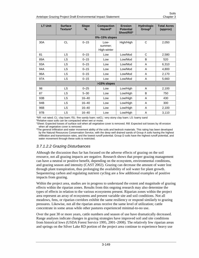
Soils Antelope Grazing Project Draft Environmental Impact Statement Chapter 3
LT Unit Surface Texturea
Slope %
Compaction Hazardb
Erosion Potential
Sheet/Rillc
Hydrologic Groupd
Total Acres (approx)
0%–15% slopes 30A CL 0–15 Low-
summer; High-winter
High/High C 2,050
81 LS 0–15 Low Low/Mod C 2,580 89A LS 0–15 Low Low/Mod B 520 93A LS 0–15 Low Low/Mod A 6,310 94A LS 0–15 Low Low/Mod A 4,800 96A LS 0–15 Low Low/Mod A 2,170 97A LS 0–15 Low Low/Mod A 5,660
>15% slopes 98 LS 0–25 Low Low/High A 2,100 87 LS 5–30 Low Low/High B 750 93B LS 16–40 Low Low/High A 430 94B LS 16–40 Low Low/High A 300 96B LS 16–40 Low Low/High A 2,100 97B LS 16–40 Low Low/High A 3,110
aNR: not rated; CL: clay loam; fSL: fine sandy loam; vstCL: very stony clay loam; LS: loamy sand bRelative ease soils can be compacted when wet or moist. cSheet: Expected losses of surface soil when all vegetative cover is removed. Rill: Expected soil losses by rill erosion
when all vegetative cover is removed. dThe general infiltration and water movement ability of the soils and bedrock materials. This rating has been developed
by the Natural Resources Conservation Service, with the deep well drained sands of Group A soils having the highest infiltration and transmission rates, and the lowest runoff potential. Group D soils have the highest runoff potential, and water movement through these soils is restricted.
3.7.1.2.2 Grazing Disturbances Although the discussion thus far has focused on the adverse effects of grazing on the soil resource, not all grazing impacts are negative. Research shows that proper grazing management can have a neutral or positive benefit, depending on the ecosystem, environmental conditions, and grazing season and intensity (CAST 2002). Grazing can decrease the amount of water lost through plant transpiration, thus prolonging the availability of soil water for plant growth. Sequestering carbon and regulating nutrient cycling are a few additional examples of positive impacts from grazing.
Within the project area, studies are in progress to understand the extent and magnitude of grazing effects within the riparian zones. Results from this ongoing research may also determine the types of effects in relation to the various ecosystems present. Riparian zones within the project area represent an array of ecosystems and present variable site and soil conditions. Not all meadows, fens, or riparian corridors exhibit the same resiliency or respond similarly to grazing pressures. Likewise, not all the riparian areas receive the same level of utilization; cattle concentrate in some areas while other pastures experienced minimal-to-no use.
Over the past 30 or more years, cattle numbers and season of use have dramatically decreased. Range analyses indicate changes in grazing strategies have improved soil and site conditions from historical lows (USDA Forest Service 1995, 2001–2008). The relatively few riparian areas and springs on the Silver Lake RD portion of the project area continue to experience heavy use
3-149
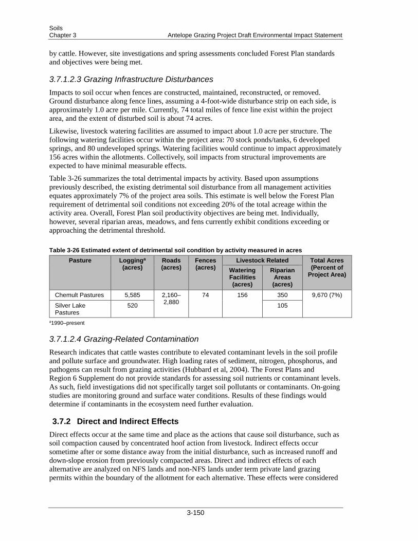
Soils Chapter 3 Antelope Grazing Project Draft Environmental Impact Statement
by cattle. However, site investigations and spring assessments concluded Forest Plan standards and objectives were being met.
3.7.1.2.3 Grazing Infrastructure Disturbances Impacts to soil occur when fences are constructed, maintained, reconstructed, or removed. Ground disturbance along fence lines, assuming a 4-foot-wide disturbance strip on each side, is approximately 1.0 acre per mile. Currently, 74 total miles of fence line exist within the project area, and the extent of disturbed soil is about 74 acres.
Likewise, livestock watering facilities are assumed to impact about 1.0 acre per structure. The following watering facilities occur within the project area: 70 stock ponds/tanks, 6 developed springs, and 80 undeveloped springs. Watering facilities would continue to impact approximately 156 acres within the allotments. Collectively, soil impacts from structural improvements are expected to have minimal measurable effects.
Table 3-26 summarizes the total detrimental impacts by activity. Based upon assumptions previously described, the existing detrimental soil disturbance from all management activities equates approximately 7% of the project area soils. This estimate is well below the Forest Plan requirement of detrimental soil conditions not exceeding 20% of the total acreage within the activity area. Overall, Forest Plan soil productivity objectives are being met. Individually, however, several riparian areas, meadows, and fens currently exhibit conditions exceeding or approaching the detrimental threshold.
Table 3-26 Estimated extent of detrimental soil condition by activity measured in acres Pasture Logginga
(acres) Roads (acres)
Fences (acres)
Livestock Related Total Acres (Percent of
Project Area) Watering Facilities (acres)
Riparian Areas (acres)
Chemult Pastures 5,585 2,160–2,880
74 156 350 9,670 (7%)
Silver Lake Pastures
520 105
a1990–present
3.7.1.2.4 Grazing-Related Contamination Research indicates that cattle wastes contribute to elevated contaminant levels in the soil profile and pollute surface and groundwater. High loading rates of sediment, nitrogen, phosphorus, and pathogens can result from grazing activities (Hubbard et al, 2004). The Forest Plans and Region 6 Supplement do not provide standards for assessing soil nutrients or contaminant levels. As such, field investigations did not specifically target soil pollutants or contaminants. On-going studies are monitoring ground and surface water conditions. Results of these findings would determine if contaminants in the ecosystem need further evaluation.
3.7.2 Direct and Indirect Effects Direct effects occur at the same time and place as the actions that cause soil disturbance, such as soil compaction caused by concentrated hoof action from livestock. Indirect effects occur sometime after or some distance away from the initial disturbance, such as increased runoff and down-slope erosion from previously compacted areas. Direct and indirect effects of each alternative are analyzed on NFS lands and non-NFS lands under term private land grazing permits within the boundary of the allotment for each alternative. These effects were considered
3-150
Soils Antelope Grazing Project Draft Environmental Impact Statement Chapter 3
for temporary (season of use), short-term (duration of the permit, or 10 years), and long-term (beyond 10 years) impacts to soils.
Effects, or impacts, are described in terms of the type, intensity, and spatial and temporal scales of the impacts. They can be adverse or beneficial and are so stated. The intensity or magnitude of the effects is described as follows:
• Negligible—The effects on soil productivity or fertility would be at or below the level of detection.
• Minor—The effects on soil productivity or fertility would be small, as would the area affected. If needed to offset adverse effects mitigation would be relatively simple to implement and would likely be successful.
• Moderate—The effect on soil productivity or fertility would be readily apparent and result in a change in the soil character over a relatively wide area. Mitigating measures would probably be necessary to offset adverse effects and would likely be successful.
• Major—The effect on soil productivity or fertility would be readily apparent and long term and would measurably change the character of the soils over a large area. Extensive mitigating measures to offset adverse effects would be needed, and their success could not be guaranteed.
The baseline used for the potential effects analysis was the existing conditions described previously. For each alternative, an analysis was conducted to assess the effects of proposed management actions on the soil resource.
3.7.2.1 Measurement Indicators To compare and contrast the effects of each alternative, Table 3-27 presents three measurement indicators: riparian acres open to grazing; riparian acres grazed—acres of concern; and changes in soil surface features (riparian areas). These measurement indicators were selected based on professional judgment and a thorough review of literature on the interaction between soils and grazing.
3-151
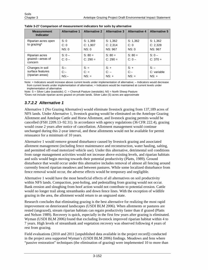
Soils Chapter 3 Antelope Grazing Project Draft Environmental Impact Statement
Table 3-27 Comparison of measurement indicators for soils by alternative
Measurement Indicator
Alternative 1 Alternative 2 Alternative 3 Alternative 4 Alternative 5
Riparian acres open to grazinga
S: 0 C: 0 NS: 0
S: 1,369 C: 1,907 NS: 0
S: 1,362 C: 2,314 NS: 967
S: 1,362 C: 0 NS: 0
S: 1,362 C: 2,328 NS: 967
Riparian acres grazed—areas of concern
S: 0 – C: 0 –
S: 80 = C: 290 =
S: 80 = C: 290 =
S: 80 = C: 0 –
S: 0 – C: 370 +
Changes in soil surface features (riparian areas)
S:– C:– NS:–
S: = C: = NS: =
S: + C: – NS: +
S: + C:– NS: =
S: – C: variable NS: +
Note: + Indicators would increase above current levels under implementation of alternative; – Indicators would decrease from current levels under implementation of alternative; = Indicators would be maintained at current levels under implementation of alternative
Note: S = Silver Lake (eastside); C: = Chemult Pasture (westside); NS = North Sheep Pasture aDoes not include riparian acres grazed on private lands. Silver Lake (S) acres are approximate
3.7.2.2 Alternative 1 Alternative 1 (No Grazing Alternative) would eliminate livestock grazing from 137,189 acres of NFS lands. Under Alternative 1, livestock grazing would be eliminated on the Antelope Grazing Allotment and Antelope Cattle and Horse Allotment, and livestock grazing permits would be cancelled (FSH 2209.13–92.31). In accordance with agency regulations (36 CFR 222.4), grazing would cease 2 years after notice of cancellation. Allotment management would continue unchanged during this 2-year interval, and these allotments would not be available for permit reissuance for a minimum of 10 years.
Alternative 1 would remove ground disturbance caused by livestock grazing and associated allotment management (including fence maintenance and reconstruction, water hauling, salting, and permitted off-road motorized vehicle use). Under this alternative, detrimental soil conditions from range management activities would not increase above existing levels, and riparian habitats and soils would begin moving towards their potential productivity (Platts, 1989). Ground disturbance that would occur under this alternative includes removal of almost all fencing around currently fenced riparian meadows and between pastures. While some localized disturbance from fence removal would occur, the adverse effects would be temporary and negligible.
Alternative 1 would have the most beneficial effects of all alternatives on soil productivity within NFS lands. Compaction, post-holing, and pedestalling from grazing would not occur. Bank erosion and sloughing from hoof action would not contribute to potential erosion. Cattle would no longer trail along streambanks and down fence lines. With the exception of wildlife grazing in the area, the allotment would return to an ungrazed state.
Research concludes that eliminating grazing is the best alternative for realizing the most rapid improvement on deteriorated landscapes (USDI BLM 2006). When allotments or pastures are rested (ungrazed), stream riparian habitats can regain productivity faster than if grazed (Platts and Nelson 1989). Recovery is quick, especially in the first few years after grazing is eliminated. Wyman (USDI BLM 2006) found that excluding livestock improved riparian habitat within 4 to 7 years. High levels of streambank and vegetation recovery was observed following 4 years of rest from grazing.
Field evaluations (2010 and 2011 [unpublished data available in the project record]) conducted in the project area supported Wyman’s (USDI BLM 2006) findings. Meadows and fens where “passive restoration” techniques (the elimination of grazing) were implemented 10 to more than
3-152

Soils Antelope Grazing Project Draft Environmental Impact Statement Chapter 3
15 years ago exhibit improved soil conditions when compared to their grazed counterparts. These positive changes correlate with a decrease in soil features indicative of grazing. Round Meadow; the fenced areas of Rider’s Camp, Dry Meadow, Johnson fen and Little Round Meadow are but a few examples of riparian areas where recovery occurred after livestock grazing was eliminated through resource protection fencing or from lack of use. Removing grazing activities from the project area would likely result in similar impacts to those realized in the currently ungrazed portions of the project area.
Vehicle and Off Highway Vehicle (OHV) use associated with allotment management is expected to decrease, but no roads would be closed under this alternative.
The riparian areas of concern with greater than 10% detrimental soil disturbance would begin to recover and their productivity would being to improve. Compaction, pedestalling, post- holing, and trampling from grazing on wet soils and in sensitive sites would no longer occur. Upward trends in soil and site productivity would be expected, not only in the areas of greater than 10% detrimental impact, but in all pastures throughout the entire allotment.
Eliminating grazing on the allotments would lessen localized impacts within uplands, riparian areas, and individual meadows and would ultimately reduce overall detrimental soil conditions throughout the project area. Long-term beneficial effects to soils are anticipated under this alternative.
3.7.2.3 Alternative 2 Alternative 2 would continue the current permitting strategy within the existing allotment boundaries. Livestock grazing would be authorized at the current stocking levels, season, and duration. Under this alternative, the existing boundaries would remain unchanged. No grazing would be authorized within the existing fenced meadows or on NFS lands within the fenced portion of Jack Creek’s perennial reach. The cow/calf pair numbers would remain at 419 and would be permitted for 4.5 months on the grazing allotments.
The direct and indirect effects to soils would essentially be the same as described under the existing condition. Livestock impacts would mostly be confined to riparian areas and around water developments. Localized effects from livestock movement and grazing would not be expected to create unsatisfactory soil conditions over extensive areas of the project area. However, minor-to-moderate, localized, short-term impacts, particularly on wetland and riparian soils and in heavily used areas, would continue at current levels.
3.7.2.3.1 West Pastures Under Alternative 2, existing trends are anticipated to continue. On the west side of the Chemult Pasture, current management allows 3 months of continuous or season-long grazing outside of fenced riparian areas. Relative to other grazing strategies, season-long grazing has the greatest adverse impact on soil resources because cows linger for extended periods in the unprotected riparian areas, which puts stress on wet soils, streambanks, and vegetation (Platts and Nelson 1989). Kothmann (2009) notes that unrestricted access to the entire grazing area throughout the season permits livestock to repeatedly graze preferred plants and areas while other plants and areas receive little-to-no use. Selective grazing on preferred areas leads to long-term rangeland degradation. Season-long grazing does not provide deferment to reduce the detrimental effects of selective grazing and rarely works well for the maintenance or recovery of riparian function (USDI BLM 2006).
Within the project area, unfenced meadows and fens that are approaching or have exceeded detrimental levels would not be shielded from grazing impacts. Major impacts would likely
3-153

Soils Chapter 3 Antelope Grazing Project Draft Environmental Impact Statement
persist in these riparian areas. Unprotected springs would also remain accessible to cattle and incur associated impacts. With the exception of the fenced areas of Rider’s Camp, the riparian areas of concern would continue to be impacted by cattle grazing. Detrimental soil conditions would likely approach or exceed Forest Plan standards. In the short term, minor-to-moderate adverse effects could be expected in the degraded riparian areas. Continued grazing in these areas would cause conditions to deteriorate and could result in chronic, long-term, moderate impacts.
Conversely, riparian areas within the existing fenced riparian areas are trending upward and would continue to recover toward improved productivity at the current rate (if all factors remain the same). Short- and long-term beneficial effects on soil stability, hydrology, and nutrient cycling would continue within the fenced riparian areas.
Negligible localized temporary impacts from fence construction along the north boundary, as well as actions associated with allotment management, would be expected. Effects from road sediment transport and OHV use would continue at current levels.
Overall soil productivity in the allotment should be maintained under this alternative. The fenced riparian areas would continue to be restored, whereas the unprotected fens, meadows, and springs would remain at their current condition. A long-term soil monitoring plan of select riparian areas would occur under Alternative 2. Annual monitoring would identify triggers of detrimental threshold limits, provide adaptive management recommendations, and ensure compliance with Forest Plan standards. Meadows included for initial monitoring include the unfenced portions of Little Parker, Rider’s Camp, Rock Springs, Sproats, and the unnamed fens identified in Table 3-24.
3.7.2.3.2 East Pastures Soil disturbance from grazing and associated activities would continue at current levels under this alternative. Minor short-term adverse effects would primarily occur in isolated areas where cows tend to congregate. Effects from early-season grazing, such as compaction and post-holing on wet soils in Halfway and North Willow Pastures, would continue. To ensure compliance with Forest Plan objectives and goals, annual monitoring and adaptive management would occur near Halfway Lake.
Other areas, particularly the springs scattered throughout the Tobin Cabin and North Willow pastures, would continue to experience high grazing pressure. Detrimental soil conditions exceeding the Fremont Forest Plan standards, however, have not been documented. Continuing grazing under the existing permit would be expected to meet Forest Plan standards of less than 20% detrimental conditions within a project area.
With the exception of the riparian areas of concern, this alternative meets Forest Plan soils, riparian, and grazing management objectives and goals.
3.7.2.4 Alternative 3 Under Alternative 3, the permitted cattle numbers would increase from 419 to 494 cow/calf pairs in the Chemult Pasture; however, AUMs in this pasture would decrease from current management (see Range section). This reduction is a result of increased land from private in-holdings that would be waived to the Forest; inclusion of acreage (and riparian areas) from the Jack Creek Sheep and Goat Allotment; and a reduced grazing season (from 3 to 2 months). Slightly fewer riparian acres would be grazed on the east side of the allotment than under current management.
3-154

Soils Antelope Grazing Project Draft Environmental Impact Statement Chapter 3
3.7.2.4.1 West Pastures Alternative 3 includes grazing on the North Sheep Pasture, which is part of the Jack Creek Sheep and Goat Allotment. This pasture would add acres and be used as part of a deferred rotation with the Chemult Pasture. This deferred-rotation grazing strategy would allow the North Sheep and the Chemult pastures to be managed together so that one pasture would remain ungrazed during part of the grazing season (Table 2-2 and Table 2-3).
Deferred-rotation grazing allows better control of animal distribution. Unlike the season-long system, cows would be herded between pastures and grazing pressure would be reduced on the Chemult Pasture. An additional benefit of deferred rotation is that forage use and timing can be scheduled to meet the ability of the stream habitat to maintain its productivity (Platts and Nelson 1989). The grazing season would be shorter, and changes in timing, frequency, and intensity of grazing would allow for longer periods of ecosystem recovery (USDI BLM 2006). The disadvantage with respect to the soil resource is that livestock would continue to concentrate in riparian areas annually and could result in major impact to riparian vegetation, streambanks, and soils.
Grazing would once again resume on six riparian areas that are currently fenced and in various stages of recovery. The six fenced riparian areas open to grazing would be managed under a HI/LF grazing strategy. The proposed number of cow/calf pairs would vary by pasture, and grazing would be permitted for 15 to 30 days from July 15 to September 30, based on forage conditions, weather variations, or resource conditions.
Research indicates that HI/LF grazing systems can change the spatial distribution of grazing and cause animals to graze the landscape more uniformly (Kothmann 2009). Wyman (USDI BLM 2006) found that HI/LF grazing decreases the time of exposure to grazing and trampling. The long periods of rest provide for adequate litter and ground cover, but can cause soil compaction if grazed when soils are wet. In some of the HI/LF units, resource protection fences were constructed to protect sensitive species habitat from the direct effects of cattle grazing and restore soil/hydrologic conditions. If the HI/LF grazing strategy is not carefully managed, the riparian areas within these units could experience major impacts as defined above.
Five of the riparian pastures proposed for grazing (Jack Creek, Dry Meadow, Cannon Well, Squirrel Camp, and Round Meadow) contain fens that are currently excluded from grazing and are in good condition (spring and botanical assessments, 2010 and 2011 [available in the project record]). Alternative 3 proposes to allow grazing within these fenced riparian areas. Grazing within fens can result in trampling and pedestalling of sensitive peat soils. Annual monitoring and adaptive management would be required to mitigate soil impacts within these fens. Adaptive management would provide the flexibility to make needed adjustments in permitted actions to meet the desired conditions and management objectives. Resource protection fences may need to be constructed around springs and fens within Dry Meadow, Squirrel Camp, and Round Meadow to further protect soil resources. Managing Jack Creek for Oregon spotted frog habitat requirements would also provide soil protection. Effectively implemented mitigations would limit impacts on the soil resource to acceptable thresholds required by the Forest Plans.
The following potential effects could occur from grazing riparian soils:
• Round Meadow Unit—The portion grazed would be TEU 2000, which contains the more resilient moist meadow soil type. The meadow would be grazed by 114 cow/calf pairs for 1 month. Evaluations from the 2010 post-grazing and 2011 pre-season grazing of 67 cow/calf pairs in the meadow for 3 weeks revealed less than 10% detrimental soil conditions within the total meadow area (unpublished data available in the project record).
3-155
Soils Chapter 3 Antelope Grazing Project Draft Environmental Impact Statement
To continue the trend toward improved productivity, soil monitoring and adaptive management would be conducted for the unfenced portion of the meadow.
• Squirrel Camp Unit—A portion of this meadow would be excluded from grazing. The grazed portion contains the moist meadow soils found in TEU 2000. To ensure Forest Plan objectives and goals are met, soil monitoring and adaptive management would be conducted.
• Dry Meadow, Cannon Well Units—These areas are drier habitats, and adverse effects are not anticipated if opened to grazing. The fen portion of Dry Meadow would be excluded from grazing.
• Jack Creek Unit—Spring assessments from 2010 and 2011 (unpublished data available in the project record) indicate a range of conditions and soil types along the mainstem of Jack Creek and its tributaries. Managing Jack Creek for Oregon spotted frog habitat would result in beneficial effects to soils.
• Riders Camp Unit—This unit is one of the riparian areas of concern. Opening the fenced riparian area to grazing may exacerbate detrimental soil conditions. Use would need to be limited to 1 of every 3 years to ensure the soil resource is moving toward meeting Forest Plan goals and objectives. Soil monitoring, coupled with adaptive management principles, would identify changes in conditions, determine if management goals and objectives are being met, and recommend adaptive management as needed.
Over 18,000 acres of the North Sheep pasture are classified as TEUI 1000-series with upland vegetation/soil types. The remaining 900+ acres are soils and vegetation of the 2000-series types. These are the riparian areas that are highly favored by cattle for the water and desirable forage they provide. TEUI maps of the area indicate riparian soils in the North Sheep Pasture are predominantly moist meadow types that dry out earlier in the season. Grazing-related impacts, such as compaction, post-holing, pedestalling, and rutting, are most likely to occur on these wetter soil types from early season turnout and/or high use. With the proposed 494 cow/calf pairs grazing the pasture for 15 days, localized temporary to short-term adverse effects would be expected, particularly in the riparian areas and around watering holes where cattle concentrate.
By incorporating the North Sheep Pasture into the Antelope Grazing Allotments, however, beneficial long-term local impacts in the larger Chemult Pasture could be expected. Using additional grazing lands, coupled with a shortened grazing season, deferred rotation strategy, and utilization of riparian units, would distribute the cattle across a broader landscape. Additionally, opening the six fenced riparian units (Dry Meadow, Squirrel Camp, Rider’s Camp, Cannon Well, Jack Creek Riparian Unit, and Round Meadow) to grazing would help alleviate soil resource impacts within the riparian areas of concern. The riparian areas of concern would continue to be impacted by cattle grazing. Although soil compaction, post-holing, pedestalling, and trampling would continue to occur, adverse impacts would be less than under current management. To ensure Forest Plan standards are met, soil monitoring would be conducted in these riparian areas, in addition to resource protection fences being constructed at some locations (Appendix D).
3.7.2.4.2 East Pastures Under this alternative, cattle would spend 2 additional weeks on the Silver Lake Pastures than under the existing permit. Turnout dates would allow for 1 month of grazing on Halfway Pasture; Tobin Cabin Pasture would be grazed for 1.5 months.
Early season grazing for an entire month on Halfway Pasture could adversely affect its finer textured soils, particularly in the vicinity of Halfway Lake (SRI unit 14). Range and soil conditions must be ideal to avert detrimental disturbance and diminished site productivity. To minimize potential impacts, soil monitoring would be conducted. Post-season monitoring of soil
3-156
Soils Antelope Grazing Project Draft Environmental Impact Statement Chapter 3
conditions would be used to determine soil response and identify any needed adaptive management.
The proposed boundary between Chemult and Tobin Cabin Pastures encompasses Rock Springs meadow with the Tobin Cabin Pasture. Rock Springs meadow is one of the riparian areas of concern. Reducing the grazing season by almost 2 months would likely benefit the soil resource by decreasing the amount and extent of compaction, improving infiltration, and decreasing runoff. To ensure soil productivity standards are met, soil monitoring would be conducted in the Rock Springs meadow.
This alternative requires building additional fencing. Approximately 42 miles of fence construction, reconstruction, and removal are proposed under this alternative. Soil disturbance associated with fence management activities is estimated at 42 acres. Albeit minimal, it would be slightly higher than the other alternatives. Since this alternative would require more herding and driving, effects from road sediment transport and OHV use are expected to be higher than the current levels but still within acceptable regulation limits.
Alternative 3 would have fewer adverse effects on the soil resource than the current management on the Chemult RD portion of the project area. Alternative 3 meets Forest Plan soils and grazing management objectives and goals. To ensure compliance with riparian management objectives and goals, monitoring would be required, and the design features would be incorporated.
3.7.2.5 Alternative 4 Under this alternative, the grazing season and duration of grazing would be similar to Alternative 3 on the east side pastures. Unlike Alternative 3, however, grazing on the Chemult Pasture and North Sheep Pasture would not occur and the pasture boundary fence at Rock Springs Meadow would not be relocated under Alternative 4. Likewise, the permitted season of use and stocking rates on NFS lands would decrease accordingly. The total grazing season would be 2.5 months, with cows on the Tobin Cabin pasture for less than half that period of time. The acres of riparian areas grazed in the project area would be slightly less than allowed under the current permit.
3.7.2.5.1 West Pastures Under Alternative 4, grazing and associated grazing-management activities would cease on the Chemult Pasture. Consequently, riparian areas and soils would no longer be impacted by cattle, and Alternative 4 would result in minor-to-moderate long-term beneficial soil impacts on the west side of the allotment similar to effects under Alternative 1. Grazing-related impacts, including compaction, post-holing, and pedestalling, would not occur. Bank erosion and sloughing via hoof action would not contribute to potential erosion. Cattle would no longer trail along stream banks and down fence lines. Adverse impacts of grazing on soil stability, hydrology, and nutrient cycling would diminish as the Chemult Pasture would return to an ungrazed state. Grazing would continue on private in-holdings, the effects of which are unknown.
Meadows and fens in the project area where livestock exclusion or elimination of grazing occurred have exhibited improved soil conditions over the last 10 to 15 years. These positive changes correlate with a decrease in soil features indicative of grazing. Round Meadow; the fenced areas of Rider’s Camp, Dry Meadow, Johnson fen, and Little Round Meadow are but a few examples of riparian areas where recovery occurred after livestock grazing was eliminated through resource protection fencing or from lack of use. Removing grazing activities from the project area would likely result in similar impacts to those realized in the currently ungrazed portions of the allotment.
3-157

Soils Chapter 3 Antelope Grazing Project Draft Environmental Impact Statement
The seven riparian areas with greater than 10% detrimental soil conditions would begin to recover and their productivity would being to improve. Compaction, pedestalling, post-holing, and trampling from grazing on wet soils and in sensitive sites would no longer occur. Upward trends in soil and site productivity would be expected, not only in the areas of greater than 10% detrimental impact, but in all west side pastures.
3.7.2.5.2 East Pastures Impacts from grazing on the east pastures would increase from current levels in response to an increase in cattle numbers and use. In terms of the extent and magnitude of disturbance, effects on the soil resource would be similar to those under Alternative 3. Under Alternative 4, cattle would spend an additional 2 weeks on the Silver Lake Pastures than under the existing permit. Turnout dates would allow for 1 month of grazing on Halfway Pasture; Tobin Cabin Pasture would be grazed for 1.5 months.
Early season grazing for an entire month on Halfway Pasture could adversely affect its finer textured soils, particularly in the vicinity of Halfway Lake (SRI unit 14). Range and soil conditions must be ideal to avert detrimental disturbance and diminished site productivity. To minimize potential impacts, soil monitoring would be conducted. Post-season monitoring of soil conditions would be used to determine soil response and identify any needed adaptive management.
Minimal impact from fence construction and actions associated with allotment management would be expected. Effects from road sediment transport and OHV use would continue at current levels.
Alternative 4 would have the least impact of the action alternatives on the soil resource. Implementing this alternative would improve soil cover, fertility, and moisture holding capacity and reduce erosion and compaction, enhance riparian areas, and improve range conditions on the west side of the Chemult Pasture. Under Alternative 4, minor-to-moderate, localized, short-term effects would be expected on the east side pastures. Soil productivity would be maintained, and this alternative would meet Forest Plan soils, riparian, and grazing management objectives and goals.
3.7.2.6 Alternative 5 Grazing under Alternative 5 would be similar to Alternative 3. The notable difference is that Alternative 5 incorporates three additional fenced riparian areas into the proposed grazing system and creates a rotational grazing system within the Jack Creek unit. Alternative 5 would permit an earlier turnout on Halfway Pasture and a longer grazing season on the Chemult and North Sheep Pastures than Alternative 3. The Chemult Pasture would be separated at NFS road 94 into a “North” and “South” division.
Under this alternative, all 9 of the existing fenced riparian areas would be grazed for 10 to 30 days. The larger Jack Creek Unit would be grazed for 3.5 months, and sub-units within the Jack Creek Pasture would be rotationally grazed by 75 cow/calf pair for 1 month within each sub-unit. The riparian units would all utilize a HI/LF system of grazing. The herd would be divided into two herds (referred to as “Herd 1” and “Herd 2”) that would be moved between the larger pastures and meadow units. Several of the fens and meadows that are currently excluded would be open to grazing; new resource protection fences would be constructed in others.
3-158

Soils Antelope Grazing Project Draft Environmental Impact Statement Chapter 3
3.7.2.6.1 West Pastures Alternative 5 would use a deferred-rotation strategy on the west pastures, incorporating the North Sheep Pasture with the Chemult Pastures and meadow units. Timing, intensity, duration, and pastures of use would vary between the two herds. AUMs would increase on both the North Sheep and Chemult Pastures in 2 of 3 years. With the inclusion of additional acreage from the North Sheep Pasture and grazing on the private land parcels along Jack Creek, total AUMs on the west pastures would decrease every 2 out of 3 years, and variable localized impacts to the soil resource could be expected.
Deferred-rotation grazing would leave at least one pasture ungrazed during part of the grazing season. The advantage of dividing the herd and converting to a deferred-rotation grazing strategy is better control of animal distribution and dispersal of impacts across a larger land mass. Unlike the season-long system, cattle would be moved frequently and would not concentrate in desirable areas for extended periods of time. An additional benefit is that forage use and timing can be programmed to meet the ability of the stream habitat to maintain its productivity (Platts 1989). With more intense herd management, impacts to the soil resource outside of the existing fenced riparian areas are expected to be slightly less than under current management.
A disadvantage of the grazing strategy with respect to soils is that Herd 2 would be on the Chemult Pasture for 3 months of every year. Every third year, Herd 1 would graze the North or South Chemult pastures for 2 months of the rotation cycle. Furthermore, every year, livestock would graze the unfenced riparian areas early in the season when soils may be susceptible to impacts. Grazing pressures would resume on protected riparian areas in various stages of recovery.
The 9 riparian areas that are currently fenced and Jack Creek sub-units that would be open to grazing would be managed under a HI/LF grazing strategy. The proposed number of cow/calf pairs would vary by pasture. Grazing would be permitted for 10 to 15 days in the smaller meadow units, and 1 to 3.5 months in the larger units. Turnout dates would vary from June15 to September 30 based on forage conditions, weather variations, or resource conditions.
Research indicates that HI/LF grazing systems can change the spatial distribution of grazing and cause animals to graze the landscape more uniformly (Kothmann, 2009). Wyman (USDI 2006) found that HI/LF grazing decreases the time of exposure to grazing and trampling. The long periods of rest provide for adequate litter and ground cover, but can cause soil compaction if grazed when soils are wet. In some of the HI/LF units, fenced riparian areas were constructed to restore soil/hydrologic conditions. If the HI/LF grazing strategy is not carefully managed, the riparian areas within these units could experience major impacts as defined above. Many of the proposed fenced riparian area units contain wet or very wet soils. As noted previously, these soils can incur major impacts if not sufficiently dry on the surface horizons. Some of the soils proposed for early season turnout (in this case prior to August 1) remain saturated throughout the grazing season.
Five of the riparian pastures proposed for grazing (Jack Creek, Dry Meadow, Cannon Well, Squirrel Camp, and Round Meadow) contain fens that are currently excluded from grazing and are in good condition (spring and botanical assessments, 2010 and 2011 [available in the project record]). Alternative 5 proposes to allow grazing within these fenced riparian areas. Grazing within fens can result in trampling and pedestalling of sensitive peat soils. Annual monitoring and adaptive management would be required to mitigate soil impacts within these fens. Adaptive management would provide the flexibility to make needed adjustments in permitted actions to meet the desired conditions and management objectives. Effectively implemented mitigations would limit impacts on the soil resource to below Forest Plan thresholds.
3-159
Soils Chapter 3 Antelope Grazing Project Draft Environmental Impact Statement
The following potential effects could occur from grazing riparian soils:
• Round Meadow Unit—The fen within this unit is proposed for exclusion from grazing. The portion grazed would be TEU 2000, the more resilient moist meadow soil type. The meadow is proposed for grazing by 114 cow/calf pairs for 1 month. Evaluations from the 2010 post-grazing and 2011 pre-season grazing of 67 cow/calf pairs in the meadow for 3 weeks revealed less than 10% detrimental soil conditions within the total meadow area. To continue the trend towards improved productivity, soil monitoring and adaptive management would be conducted for the unfenced portion of the meadow.
• Squirrel Camp Unit—A portion of this meadow is proposed for exclusion from grazing. The grazed portion contains the moist meadow TEU 2000 soils. To ensure Forest Plan objectives and goals are met, soil monitoring and adaptive management would be conducted.
• Dry Meadow, Cannon Well Units—A small fenced riparian area is proposed for retention in Dry Meadow to protect sensitive habitat; the meadow areas proposed for grazing are drier habitats. Adverse effects are not anticipated if these areas are opened to grazing.
• Rider’s Camp Unit—This unit is one of the riparian areas of concern. Opening the fenced riparian area to grazing may exacerbate adverse effects. Very wet meadows (TEU 2006) are found in the northeast arm. As such, grazing within this fenced riparian area would need to be limited to 1 out of every 3 years to help trend conditions toward Forest Plan goals and objectives. Soil monitoring would be conducted to identify changes in conditions and recommend adaptive management as needed.
• Sproats Meadow Unit—Alternative 5 proposes grazing 5 cow/calf pairs for 10 days on this unit. This meadow is one of seven riparian areas where detrimental soil conditions exceeding Forest Plan standards have been documented in the unfenced drier portions TEUs 2000 and 2004 (
• Table 3-23). The northwest section of the meadow contains a resource protection fence around the very wet 2006 fen soils. Field reconnaissance in 2011 revealed the fens were in good condition and would likely remain so if open to grazing (botanical technical reports, available in the project record). Given the limited number of cows and duration on the landscape, impacts are expected to remain within acceptable Forest Plan limits. Soil monitoring would be conducted to determine changes in conditions, if management goals and objectives are being met and promote adaptive management as needed.
• Jack Creek Unit—Spring assessments from 2010 and 2011 indicate a range of conditions along the mainstem of Jack Creek and its tributaries. The northeast tributary was rated in “poor” condition. As such, a 15-acre resource protection fence is proposed for construction to protect this segment of the creek. Soil monitoring and adaptive management would be conducted in the grazed portion of the unit to ensure soil conditions remain within Forest Plan limits.
• Upper and Lower Jamison—Soils in both meadows are predominantly 2000 and 2008, intermingled with the fen soils of the 2006 units. Soil monitoring would be conducted to ensure that turnout occurs when soils are at their driest to minimize resource impacts.
• Johnson and Wilshire Meadow Units—These meadows are the moist meadow types (TEU 2000) that typically dry out by early July. Both units contain very wet fen habitat (TEU 2006) that has been identified to be in good condition (botanical technical reports, available in the project record). Opening these fenced riparian areas within these units to grazing would have unknown effects on the soil resource. Field investigations confirmed that cows trail through and graze the wetter sites even with an abundance of forage in drier areas
3-160
Soils Antelope Grazing Project Draft Environmental Impact Statement Chapter 3
(personal observation, 2010 and 2011). However, given the limited number of cows and duration in the units, impacts are expected to remain within acceptable Forest Plan standards. Soil monitoring would be conducted to determine changes in conditions, if management goals and objectives are being met and to recommend adaptive management as needed.
The seven riparian areas of concern would continue to be impacted by cattle grazing. While soil compaction, post-holing, pedestalling, and trampling would continue to occur, adverse impacts would be less than those under current management. By converting to a deferred-rotation grazing system between the west pastures, grazing would be better distributed across the landscape and result in slightly less pressure on these identified riparian areas. With the exception of Rider’s Camp, the opening of nine fenced riparian units for HI/LF grazing would help alleviate soil resource impacts within the other riparian areas of concern.
Similar to Alternative 3, Alternative 5 incorporates about 19,000 acres of the North Sheep Pasture into the allotment. Under this alternative, 163 cow/calf pairs would rotate between the North Sheep and the Chemult Pastures with alternating seasons of rotation. Unlike Alternative 3, the cows would be on the North Sheep Pasture for 1.5 months at a time, which would result in greater soil impacts.
Over 18,000 acres of the North Sheep Pasture are classified as TEUI 1000-series upland types. The remaining 900+ acres are soils of the 2000-series TEUI types. These are the riparian areas that are highly favored by cattle for the water and desirable forage they provide. Adverse effects to the soil resource are likely to be less than under Alternative 3. Although AUMs are similar between Alternatives 3 and 5, under Alternative 5 the North Sheep pasture would be rested 1 out of every 3 years as part of a deferred-rotation system with the Chemult and Tobin Cabin Pastures. Soil productivity objectives and goals would be met, and it is unlikely that Forest Plan Standards would be exceeded under this alternative.
The proposed boundary between the Chemult and Tobin Cabin Pastures straddles Rock Springs meadow, which is one of the riparian areas of concern (Table 3-24). Alternative 5 proposes grazing Rock Springs for the same length of time and with the same turnout date as under current management (Alternative 2). Effects to soils in Rock Springs meadow under Alternative 5 would be expected to be the same as those disclosed under Alternative 2.
3.7.2.6.2 East Pastures The first leg of the rotation for both herds would begin on the east side. Each herd would graze either Halfway or North Willow Pastures for 1 month of all 3 years. Herd 1 would then rotate between Tobin Cabin, North Sheep, and the north/south Chemult Pastures. Herd 2 would rotate between the north and south Chemult Pastures. Under Alternative 5, the permitted turnout date is earlier and the grazing duration longer than allowed under the existing grazing permit. Early season grazing for an entire month in Halfway Pasture could adversely affect its finer-textured soils (SRI unit 14), causing compaction, reducing infiltration, and diminishing site productivity. Overall, total AUMs in the east pastures would be less than under current management in 1out of every 3 years. Soil monitoring would be conducted and adaptive management implemented in the Halfway Lake area to ensure Forest Plan objectives and goals are met.
This alternative also requires building the most fence. Soil disturbance associated with fence construction, albeit minimal, would be highest under this alternative. Since this alternative would require more herding and driving, effects from road sediment transport and off- road vehicle use are expected to be higher than the current levels.
In summary, Alternative 5 would have fewer adverse effects on the soil resource than the current management, but effects would occur over a larger area with the inclusion of the North Sheep
3-161
Soils Chapter 3 Antelope Grazing Project Draft Environmental Impact Statement
Pasture and fenced riparian areas. However, effects would be greater than under Alternatives 1, 3, or 4. Anticipated impacts would be minor and short-term and limited to local areas. Alternative 5 meets Forest Plan soils and grazing management objectives and goals. To ensure compliance with riparian management objectives and goals, monitoring would be required, and the design features would be incorporated.
3.7.3 Cumulative Effects Cumulative effects include all past, present, and reasonably foreseeable future actions that cause soil disturbance within the same activity areas (range allotment pastures). Past, present, and future activities in the project area include, but are not limited to, timber sales, vegetation and fuels treatments, grazing, dispersed recreation, road construction and maintenance, and watershed improvement projects. Wildfires have occurred and continue to occur throughout the watershed. The physical bounds of analysis for cumulative effects to the soils resource are the project area. The temporal bounds of analysis are the 10 years covered under the time limit of a term grazing permit. These bounds have been deemed appropriate since the level of risk to the area’s soils resource is directly tied to management practices proposed in this project.
Former management treatments, human activities, and naturally occurring events have resulted in various degrees of soil disturbance within the project area. As a consequence, soil productivity has been impacted to various degrees. Research, GIS analysis, and field investigations conducted in 2010 and 2011 (unpublished data available in the project record) established baseline soil conditions for productivity and current trends. Soils were evaluated for impacts from past management activities and conformance with the Forest Plans. The extent and degree of impacts on the soil resource from past management activities are not known; therefore, current conditions were used as a proxy for past management activities.
No evidence of detrimental soil conditions associated with past wildfires, mass movements (landslides), or other natural disturbance events exists within the project area. Fire history data indicate that the Fall Fire (1994) burned vegetation and natural fuels on the Chemult RD (west side pasture). All other wildfires have been small. Prescribed burns have been reintroduced into the riparian system as a tool for creating complexity and reducing vegetative debris. Since 2004, pile burning associated with thinning projects and meadow restoration has occurred on approximately 10,000 acres. Evidence of severely burned soils was limited to isolated areas along the perimeter of a few meadows, primarily concentrated under former fire rings.
Road building and timber harvest have the highest potential for adversely affecting soils and producing detrimental conditions. Roads are typically the principal cause of accelerated erosion in forests throughout the western United States (Harr and Nichols 1993). Roads, skid trails, and landings have the greatest impact on soils because of their long-lasting effects of compaction, rutting, displacement, erosion, and subsequent loss of soil productivity. Loss of soil productivity occurs when roads are compacted and established. Erosion occurs when concentrated water creates a gully or other feature where soil particles (sediment) are washed from the road. This sediment could enter a watercourse after leaving a road.
Ground-based logging was used during the 1970s and 1980s throughout the project area to harvest ponderosa pine and lodgepole pine. Per local knowledge, most of the sales in the project area at that time were in response to the pine beetle outbreak in central Oregon (E. Brown, pers. comm., email dated 2011). Timber harvest occurred primarily in the uplands, where the pumice soils are found. These coarse-grain soils resist compaction. Where compaction from management activities did occur, natural processes have gradually restored soil quality over the past 30 to 40 years. Many abandoned skid trails and roads now support a dense growth of lodgepole pine in the travel bed.
3-162
Soils Antelope Grazing Project Draft Environmental Impact Statement Chapter 3
The extent of existing detrimental disturbance caused by road building and timber harvest activities was estimated by using study results of contemporary logging practices on adjacent public lands. Using GIS analysis, BLM timber staff estimated that skid trails, landings, and temporary road construction detrimentally disturbed 10%–15% of total area soil (KFRA 2004). This estimate is based on skid trail spacing distances and the average size of log landings. The Deschutes National Forest uses 17% disturbance, adjusted upwards from soil monitoring data. For this analysis, 17% was used to calculate existing amounts of detrimental soil conditions from ground-based harvest treatments within the project area.
Vegetation treatment acres from 1990 to the present were used to calculate the effects of timber harvest on the soil resource. Prior to 1990, natural processes, such as root penetration, frost heave, rodent activity, freeze-thaw and wetting-drying cycles, were assumed to have slowly restored soil porosity on previously compacted sites. The extent of detrimentally disturbed soil from timber harvest activities is estimated at 6,105 acres.
Roads, unless decommissioned and obliterated, create a permanent disturbance footprint of 3 to 4 acres per mile for a bladed 14-foot-wide road (B. McCartie, personal communication, 2011). With approximately 720 miles of roads in the project area, permanent soil disturbance estimates are 2,160 to 2,880 acres (Table 3-26).
3.7.3.1 All Alternatives Detrimental soil conditions likely resulted from prior activities, but detrimental conditions exceeding the standards enumerated in the Fremont Forest Plan have not been documented. Although the precise extent and degree of disturbance is unknown, the addition of organic matter residues, root penetration, rodent activity, and freeze-thaw cycles have presumably improved soil productivity and advanced recovery over the past several decades.
Although activities proposed within and adjacent to the analysis area and analyzed in other NEPA documents would still occur, the current environmental conditions and trends would continue, regardless of the alternative selected for this project. Soil and site productivity in the project area have been slowly trending upward due to improved grazing management (see Range technical report available in the project record). These changes in grazing strategies have allowed the soils and vegetation communities to begin to recover and improve their productivity. If no soil disturbing treatments are implemented and all factors remain the same, the slow upward trend in soil and site productivity could be expected to continue at the present rate.
Under all alternatives, the extent and magnitude of grazing pressures on adjoining private lands and in-holdings could potentially impact soils within the project area. With respect to soils, the potential for increased erosion and compaction rates on private lands from high stocking levels and prolonged seasons of use remains. Consequently, NFS lands could be impacted by amplified sediment transport and runoff from adjacent land management activities. Under Alternatives 1, 2, and 4, the potential for increased runoff would be greater on NFS lands along the perennial reaches of Jack Creek, as cattle would be grazed at privately managed timings and concentrations on private lands within this reach.
Under all alternatives, no additional land would be removed from production to build other structural improvements. Therefore, the cumulative amount of detrimentally disturbed soil from structural improvements and all other management facilities would remain well within both allowable Forest Plan limits for maintaining soil productivity within each of the allotment pastures. All proposed alternatives would continue to manage the forage vegetation and soil resource for long-term sustained productivity through attainment of upward or stable vegetation trends. No cumulative impacts to soils are anticipated from actions associated with this alternative.
3-163
Transportation and Access Chapter 3 Antelope Grazing Project Draft Environmental Impact Statement
3.8 Transportation and Access
3.8.1 Affected Environment Although very little documentation exists to show when the roads were built within the allotment boundaries, road building began on both the Fremont and Winema National Forests in the late 1940s, primarily due to increased demands for timber products. After Congress began to appropriate money for road building, many of the mainline roads were constructed by the Bureau of Public Roads, now known as the Federal Highway Administration. Road building continued to expand from 1960 through 1990 in response to timber management needs. In the late 1990s, road construction began decreasing, and the emphasis now is to decrease miles of NFS roads and decommission NFS roads no longer needed.
The allotment areas are accessed via open NFS roads, and approximately 957 miles of roads exist within the allotments. Roads within the allotment areas have differing maintenance level (ML) standards:
• ML 1 roads are considered closed roads, placed in storage between intermittent uses. Traffic is prohibited on these roads, and they are not shown on MVUMs.
• ML 2 roads are roads maintained for use by high-clearance vehicles.
• ML 3 roads are open roads maintained for travel in standard passenger cars. These roads are normally low-speed, single-lane roads with turnouts.
• ML 4 roads are maintained to provide a moderate degree of user comfort and convenience at moderate travel speeds. These roads are usually two lanes and aggregate surfaced.
In addition to road maintenance level descriptions, roads also have designations indicating their open/closed status and the type of motorized vehicle class permitted. These designations are identified in the Fremont-Winema National Forests Environmental Assessment for Motorized Travel Management Decision (Travel Management Decision) (USDA Forest Service 2010a), signed July 8, 2010. The Travel Management Decision determines which roads, trails, and areas will be available for motorized use, as well as the season of use and the class of vehicles allowed. Under the Travel Management Decision, ML 2, ML 3, and ML 4 roads are open and maintained for motor vehicle use by the public.
Several miles of un-inventoried non-system roads and user-created routes also exist within the allotments. These roads may be accessible by motorized vehicles of various class sizes. The use of these roads/routes is considered cross-country use. Cross-country use without a permit is not allowed under the current Travel Management Decision.
3.8.2 Direct and Indirect Effects Analysis of the direct and indirect effects of each alternative focuses on the effects on NFS roads within allotment boundaries. The analysis of effects to the transportation system includes both short-term and long-term effects. “Short-term” is defined as the end of one field season and the beginning of the next. “Long-term” is defined as the duration of the permit. These boundaries provide a tangible outline in both space and time, allowing reproducible analysis for each proposed alternative.
3-164

Transportation and Access Antelope Grazing Project Draft Environmental Impact Statement Chapter 3
3.8.2.1 Measurement Indicators Indicators used to measure effects are selected so that the effects of the project alternatives can be compared and contrasted. The selection of indicators is based on professional judgment. The possible effects of the alternatives on NFS roads are disclosed quantitatively in Table 3-28 according to the measurement indicators.
Table 3-28. Comparison of effects to transportation by alternative using the measurement indicators Indicator Alternative 1 Alternative 2 Alternative 3 Alternative 4 Alternative 5
Miles of Maintenance Level 1 roads 343 341 425 165 425
Miles of Maintenance Level 2 roads 443 438 492 237 492
Miles of Maintenance Level 3 roads 29 29 40 24 40
Total National Forest System road miles
815 808 957 426 957
3.8.2.2 Alternative 1 Under Alternative 1, livestock grazing would not be authorized within the project area, (FSH 2209.13–92.31) livestock grazing would be eliminated on the Antelope Grazing Allotment and Antelope Cattle and Horse Allotment, and livestock grazing permits would be cancelled. Alternative 1 would eliminate livestock grazing from 137,189 acres of NFS lands. In accordance with agency regulations (36 CFR 222.4), grazing would cease 2 years after notice of cancellation. Allotment management would continue unchanged during this 2-year interval.
Under Alternative 1, the amount of motorized traffic accessing and using the transportation system within the allotment boundary would decrease. Currently, grazing activity occurs in the project area. This activity would not continue under Alternative 1. The reduction of motorized travel within the allotment boundary under Alternative 1 would cause no direct or indirect effects on the transportation system.
3.8.2.3 Alternatives 2–5 Under Alternatives 2 through 5, motor vehicle traffic on roads designated by the Travel Management Decision for administration activities within the allotment boundaries would either stay the same or increase in volume. In either case, this level of use, combined with normal public use, is not expected to have direct or indirect measurable effects on road system maintenance levels. The road system has been designed to withstand an average daily traffic load of up to 400 vehicles. The current level of activity does not exceed this number, nor is the potential increase in traffic expected to exceed this volume of traffic under Alternatives 2 through 5.
The use of ML 1 roads under the permit could result in seasonally increased visibility to road entrances by matting down the vegetation and showing signs of continual use, and prolong the establishment of vegetation along and within the roadbed. With continued seasonal use, the long-term effect would be the same, with an increased chance of creating a better-defined road. No indirect effect is expected from public use of ML 1 roads, because public use is restricted by the Travel Management Decision. The short- and long-term effects to ML 1 roads under the action alternatives are expected to be minimal because of the project design features (section 2.3.7). Any such effects would be expected to resolve naturally within 2 field seasons under “no use” conditions.
3-165

Transportation and Access Chapter 3 Antelope Grazing Project Draft Environmental Impact Statement
With the project design features in place, the effects to ML 1 roads within the allotment boundary would range from no effect to minimal effect. Many of the effects expected would resolve naturally within 2 field seasons under “no use” conditions.
The effect to the transportation system caused by cross-country travel and/or off-road use would not vary by alternative and is difficult to determine. All action alternatives allow for cross-country travel and off-road use. The amount of off-road use that would be required to administer the permit under each action alternative cannot be determined, but off-road use is limited to allotment administration activities, such as infrastructure maintenance and repair, water hauling, salting, and emergency cattle retrieval.
Cross-country travel, as defined in the transportation and access design features, would produce the same short- and long-term effects as allowing use of ML 1 roads within the allotment boundary. Cross-country travel during a field season could result in increased visibility to road entrances and prolong the establishment of vegetation along and within the roadbed. With continued seasonal use, the long-term effect would be the same—an increased chance of creating a better-defined road. No indirect effects are expected from public use, because public use of ML 1 roads is restricted by the Travel Management Decision. Short- and long-term effects of off-road travel are expected to be minimal due to the project design features included in the action alternatives (section 2.3.7) and would be expected to resolve naturally within 2 field seasons.
With the outlined project design features in place, effects of off-road use are expected to range from no effect to minimal effect. No long-term effects are expected, due to protection measures, and short-term effects would be expected to resolve naturally within 1 to 2 field seasons.
3.8.3 Cumulative Effects The conditions of the transportation system located within the boundaries of the Antelope Grazing Allotments have been impacted by innumerable actions over the last century (Appendix C). These actions include but are not limited to fire suppression, vegetation restoration, allotment management, timber activity, and road maintenance. Past actions have each affected the current transportation system located within the boundaries of the Antelope Grazing Allotments, and the effects of those past actions are the current condition of the road system.
Past activities, current activities of the permit and public use, and reasonably foreseeable future actions will have little-to-no effect on the transportation system within the allotment boundaries under each alternative. Historically, grazing on the allotments has not been reported to impact the transportation system that required restoration activity beyond routine road maintenance.
3-166
Cultural Resources Antelope Grazing Project Draft Environmental Impact Statement Chapter 3
3.9 Cultural Resources
3.9.1 Affected Environment The Antelope Grazing Allotments project area lies on the somewhat indistinct historic territorial boundary line between the Klamath Tribe and the Yahooskin Band of Northern Paiutes (Spier 1930). Today, descendants of the Klamath and Yahooskin people, along with the Modoc people, are members of the Klamath Tribes, a federally recognized Indian tribe. In 1864, the Klamath Tribes signed the Klamath Lake Treaty, ceding over 13 million acres of their lands to the U.S. government. About 1.1 million acres were retained for the Klamath Indian Reservation. The reservation shrank to 862,622 acres by 1954, when Congress terminated the Klamath Tribes’ federal status under the Federal Termination Act, termination of their federal status resulted in several land exclusions (Zucker et al. 1983:107–108). Private entities bought some of the old reservation land, but the majority of it became the Winema National Forest in 1961 (Zucker et al. 1983:110). The Fremont National Forest was created in 1908 from the Goose Lake and Fremont forest reserves, which were created from public lands in 1907. The Winema and Fremont National Forests combined administratively in 2003 (Tonsfeldt and Gray 2009). The project area does not lie within former reservation lands.
Prior to 1864, the Klamath people were semisedentary hunter-gatherers who practiced a subsistence and settlement strategy based on seasonal availability of local plant and animal resources, with a focus on riverine and lacustrine resources, such as the Williamson River and Klamath Marsh (Silvermoon 1985). The Klamath people were divided into 5 tribelets. The group that occupied the Klamath Marsh area were called A’ukckni (Spier 1930). According to Spier (1930), the Klamath informants he spoke with considered “the country north of Klamath marsh [generally where the Antelope Grazing Allotments Project is located]… too open and cold for settlement.”
The territory of the Yahooskin Band of Northern Paiutes included the area west of Silver Lake. This area was once occupied by the Northern Paiute subgroup called Dubuteyatikadu (Deer Eaters) (Stern 1966; Silvermoon 1985). The Yahooskin people are sometimes referred to as the Snakes, the Yahooskin Band of Snake Indians, or the Yahooskin Snake Paiutes in official census records of the 1880s to 1920s.
Unfortunately, ethnographic work at the turn of the 20th century did not focus on the Yahooskin culture. Details concerning the Yahooskin lifeway are inferred by studying the ethnographies of Northern Paiute tribes from the Harney Valley area (near Burns, Oregon) and Surprise Valley.
Like the Klamath people, the Yahooskin practiced hunting and gathering, following an annual subsistence round based on local plant and animal resource availability. However, whereas the Klamath tended to be more sedentary, the Yahooskin tended to be more nomadic.
Euro-American settlement and development of the region began in earnest once knowledge of the landscape (gained by early expeditions) was disseminated, legislation such as the Homestead Act of 1862 was passed, and the Oregon Central Military Wagon Road was developed. Sheepherders began settling the Silver Lake valley in the 1870s. Grazing of horses and cattle soon followed (Hatton 1988). However, according to General Land Office records, the Antelope Grazing Allotments project area was not settled until 1893, when George L. Beckwith petitioned the U.S. government for the N1/2 of the NW1/4 and the SW1/4 of the NW1/4 of Section 33, Township 28 South, Range 12 East. He was alone there until 1904, when other homesteaders finally arrived, along with the Santa Fe Pacific Railroad and Saginaw and Manistee Lumber Company. Soon after came the Aztec Land and Cattle Co. LTD and the establishment of the Fremont National Forest in 1908.
3-167
Cultural Resources Chapter 3 Antelope Grazing Project Draft Environmental Impact Statement
Grazing administration was the primary function of the Fremont National Forest from its conception to the 1940s (Silvermoon 1985; Bach 1981). However, the 1930s brought changes in grazing practices on NFS lands. Competition between stock raisers had grown fierce, and the effects of overgrazing on the landscape had become apparent. In response to these developments, Congress passed the Taylor Grazing Act on June 28, 1934. The act provided for better administration of the range by defining season of use and carrying capacity that were suitable for local conditions (Beckham 2000; Bach 1981).
Although the local economy has always relied heavily on agriculture, the establishment of the railroad in the mid-1920s contributed to the growth of Chemult, Oregon, and opened the project area to intensive logging. The first commercial timber sale on the Fremont National Forest occurred in 1911 (Silvermoon 1985). Western pine logging began later in the project area than in other West Coast areas because the stands in the project area were generally located far from navigable waters. Thus, the logging industry did not develop in the project area until after railroad construction made remote areas accessible (Tonsfeldt 1987). Logging infrastructure within the project area include several historic tie mills around Sproats Meadow. Though railroads contributed to the expansion of logging in the region, railroad logging never occurred within the project area, so railroad logging grades and other logging features are absent. The town of Silver Lake supported a small lumber mill for a time, but the railway never came through, so the town’s growth was restricted (Hatton 1988). Lands acquired from Shevlin-Hixon in 1945, Big Box Lake in 1943, and Weyerhaeuser in 1987 were logged by the companies prior to land exchanges.
Prehistoric (pre-1825), historic (post-1825 to the mid-1960s), and multicomponent (combination of prehistoric and historic) cultural resources exist within the Antelope Grazing Allotments project area. Cultural resources, also known as historic properties, are generally more than 50 years old and include prehistoric or historic districts, sites, buildings, structures, or objects listed in or eligible for inclusion in the National Register of Historic Places (NRHP). Cultural resources also include artifacts, records, and remains that are related to and located within such properties, as well as properties that have traditional religious and cultural importance to an Indian tribe or Native Hawaiian organization and that meet the National Register criteria as defined in 36 CFR 800.16(l)(1).
The first archaeological research within the region was conducted by Luther Cressman in the 1930s (Minor et al. 1979). Recent archaeological investigations at Paisley Cave, located approximately 60 air miles southeast of the project area, have shown that Native Americans lived in the vicinity 14,300 years ago (Barnard 2008). A total of 133 cultural resource sites have been recorded during past pedestrian cultural inventories (or surveys) in the Antelope Grazing Allotments project area. The activity that occurred at a site defines the type of site it is (Table 3-29 and Table 3-30). For example, a place where Native Americans once manufactured tools would be assigned the site type of “lithic scatter.” Cultural resource sites are irreplaceable and nonrenewable, as are the artifacts (portable objects modified by humans), ecofacts (floral and faunal remains that result from human activity), and features (structural remains and concentrations of artifacts and/or ecofacts) that they contain. Of the 133 sites recorded within the project area, 73 are prehistoric sites, 60 are historic sites, and 3 are multicomponent sites.
3-168
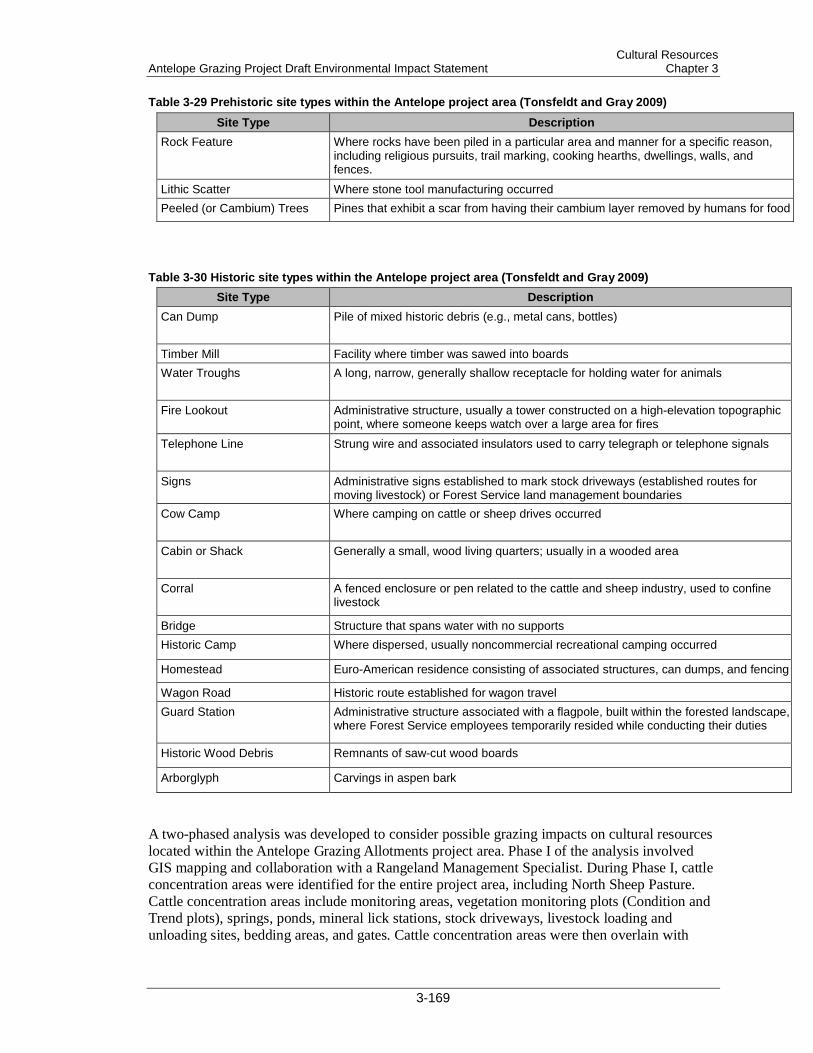
Cultural Resources Antelope Grazing Project Draft Environmental Impact Statement Chapter 3
Table 3-29 Prehistoric site types within the Antelope project area (Tonsfeldt and Gray 2009)
Site Type Description Rock Feature Where rocks have been piled in a particular area and manner for a specific reason,
including religious pursuits, trail marking, cooking hearths, dwellings, walls, and fences.
Lithic Scatter Where stone tool manufacturing occurred Peeled (or Cambium) Trees Pines that exhibit a scar from having their cambium layer removed by humans for food
Table 3-30 Historic site types within the Antelope project area (Tonsfeldt and Gray 2009) Site Type Description
Can Dump Pile of mixed historic debris (e.g., metal cans, bottles)
Timber Mill Facility where timber was sawed into boards Water Troughs A long, narrow, generally shallow receptacle for holding water for animals
Fire Lookout Administrative structure, usually a tower constructed on a high-elevation topographic point, where someone keeps watch over a large area for fires
Telephone Line Strung wire and associated insulators used to carry telegraph or telephone signals
Signs Administrative signs established to mark stock driveways (established routes for moving livestock) or Forest Service land management boundaries
Cow Camp Where camping on cattle or sheep drives occurred
Cabin or Shack Generally a small, wood living quarters; usually in a wooded area
Corral A fenced enclosure or pen related to the cattle and sheep industry, used to confine livestock
Bridge Structure that spans water with no supports Historic Camp Where dispersed, usually noncommercial recreational camping occurred
Homestead Euro-American residence consisting of associated structures, can dumps, and fencing
Wagon Road Historic route established for wagon travel Guard Station Administrative structure associated with a flagpole, built within the forested landscape,
where Forest Service employees temporarily resided while conducting their duties
Historic Wood Debris Remnants of saw-cut wood boards
Arborglyph Carvings in aspen bark
A two-phased analysis was developed to consider possible grazing impacts on cultural resources located within the Antelope Grazing Allotments project area. Phase I of the analysis involved GIS mapping and collaboration with a Rangeland Management Specialist. During Phase I, cattle concentration areas were identified for the entire project area, including North Sheep Pasture. Cattle concentration areas include monitoring areas, vegetation monitoring plots (Condition and Trend plots), springs, ponds, mineral lick stations, stock driveways, livestock loading and unloading sites, bedding areas, and gates. Cattle concentration areas were then overlain with
3-169
Cultural Resources Chapter 3 Antelope Grazing Project Draft Environmental Impact Statement
known cultural resource site locations. Of the 133 known cultural resource sites, 55 were found to be associated with the cattle concentration areas.
Phase II of the analysis was a field review of the 55 sites within cattle concentration areas. This review was conducted to assess and document current site conditions and potential grazing impacts. Of the 55 sites associated with cattle concentration areas, 51 were relocated during the site condition assessment; 4 could not be relocated.
Assessments were visual, surface-only examinations. No subsurface techniques were employed in accordance with the 2005 Memorandum of Agreement with the Klamath Tribes. Observations were recorded in detail on Range Impact Inspection Forms so that assessments could serve as the baseline for measuring impacts during future monitoring efforts and for determining appropriate management direction. Descriptive narration was supported by visual media (i.e., photography). Results of the condition assessments were documented in a report prepared for the Oregon State Historic Preservation Office (SHPO) (Durant 2012).
Of the 51 relocated sites, 44 were found to have no impacts associated with cattle grazing, while 7 (or 13.7%) had impacts. The 7 that were found to have impacts were sites 6, 32, 34, 42, 52, 81, and 126.
Site 6, located in the Chemult Pasture, is a lithic scatter. The condition assessment found that the site has been impacted by cattle manure, and the potential for trailing exists at the current location. Manure has impacted an estimated 5% of the surface area of the site, which lies next to a riparian exclosure fence.
Site 32, located in the Chemult Pasture next to a riparian exclosure, is a cabin with associated can dump. The cabin remains were found buried under jack-straw blowdown, which has protected the site from cattle impacts. However, light trailing, manure, and hoofprints were found within the site boundary.
Site 34, located in the Chemult Pasture, is a timber mill site. Approximately three-quarters of the site area is within a riparian exclosure. However, a cattle trail follows along the outside of the fenceline, leading from a native-surface road to a water tank that has been established along the outside of the southeastern fenceline. Much of the trail lies within the roadbed located along the southwestern portion of the pasture. The trail is approximately 3 inches deep.
Site 42, located in the Chemult Pasture, is a guard station. The condition assessment found moderate trailing within the site boundary. Approximately three-quarters of Site 42 lies within a riparian exclosure. What remains of the site has been highly disturbed by recreation, in addition to the impacts from cattle. A water trough has been established northwest of the site, and 3 or 4 cattle trails weave in and out from the trough area, leading across the dispersed camp site to the meadow located southeast of the site. The trails are 3–5 inches deep.
Site 52, located in the Chemult Pasture, is a historic camp next to an undeveloped spring. Much of the site is covered by jack-straw blowdown, except for a small area along the eastern side of the site near the meadow edge. Light trampling was found in this area. From the trampled area, a trail heads into the distance, crossing the site toward the northwest. The trail is 3 inches deep.
Site 81, located in the North Willow Pasture, is a lightly scattered lithic scatter. The site lies around a spring that was once enclosed within a riparian exclosure. The exclosure is now historic and collapsed. Moderate trampling was found around the spring and outside the exclosure. Postholing hoofprints were approximately 1 to 2.5 inches deep.
Site 126, located in the Antelope Flat 1 pasture, is a very lightly scattered lithic scatter. Shallow postholing, manure, and one cow trail were noted during the condition assessment. The trail was approximately 1.5 inches deep.
3-170

Cultural Resources Antelope Grazing Project Draft Environmental Impact Statement Chapter 3
3.9.2 Direct and Indirect Effects The following analysis of direct and indirect effects to cultural resources in the Antelope Grazing Allotments project area is based on the 51 site condition assessments conducted in winter and spring 2012 (Durant 2012). The 51 sites were selected by GIS analysis, which indicated the sites’ association with cattle concentration areas. The time frame of this analysis is the life of the permit, or 10 years. The spatial limit of this analysis is the project area. The alternatives were compared to assess how much their proposed grazing activities would affect the selected cultural resource sites. Alternative 2 (current management) served as a baseline for comparing all the other alternatives.
3.9.2.1 Measurement Indicators The measurement indicators used in this analysis are duration and intensity (Table 3-31). Duration represents the grazing season—early or late. The early, or wet, season occurs from spring (in May, after the snow melts) to midsummer (July). The late, or dry, season occurs from midsummer (August) to late fall (October). Direct impacts to cultural resources can occur in the early or late grazing seasons. Impacts caused by erosion occurs during both seasons. However, erosion during spring runoff and rains is slowed a little by spring vegetation regeneration, whereas erosion from fall rains is increased when vegetation is removed by grazing. Erosion from ground disturbance (e.g., trailing and postholing, hoof shearing, and trampling) in the early season is greater due to increased soil moisture. Artifact exposure increases in the late season due to vegetation die-off.
However, project design features, including soil moisture thresholds that are designed to prevent cattle turnout in overly wet conditions are included for all action alternatives.
The size of a pasture combined with the number of cow/calf pair, or intensity, can influence potential impact amounts. Intensity, in this analysis, is defined by how many acres each cow/calf pair has available to occupy. The smaller the space combined with a greater number of cows could result in a higher degree of impacts. In general, the degree of impacts decreases as the amount of space increases and the number of cattle decreases. Of course, site location is key. If a site is located in a relatively small pasture crowded with cattle but lies on a rocky ledge with no palatable vegetation, the probability is higher that the site will not be impacted. If that same site was instead located next to a spring, the probability of negative impacts increases due to the availability of water and palatable vegetation.
Table 3-31 Comparison of cultural resource measurement indicators by alternative (Alt.)
Measurement Indicator Alt 1 Alt 2 Alt 3 Alt 4 Alt 5 Duration (grazing season) No grazing early and late early and late early early and late Intensity (acres per cow/calf
0 352 343 195 343
3.9.2.2 Potential Direct and Indirect Effects The potential effects on cultural resources from livestock grazing have been discussed in a number of documents (Flenniken and Haggarty 1979; Horne and McFarland 1993; Logsdon 1976; Osborn et al. 1987; Roney 1977; Shea and Klenck 1993). The effects of livestock grazing depend on various factors, including livestock behavior, such as congregation (particularly at water sources and salting locations), trailing, and trampling; livestock management; fence construction; and water source development or reconstruction. For this
3-171

Cultural Resources Chapter 3 Antelope Grazing Project Draft Environmental Impact Statement
analysis, efforts were focused on the measurement of 3 primary classes of effects: direct effects on artifacts and features; artifact displacement; and the presence or absence of on-site vegetation.
Direct effects on artifacts and features include rubbing, trailing, crushing, and trampling. Livestock can affect prehistoric features such as cairns, rock alignments, pictographs, and petroglyphs by rubbing against them. Livestock can topple rock cairns by rubbing against the rocks or kicking them. Ground-surface historic artifacts (cans, bottles, railroad grades, and other campsite items) can be crushed and broken by trailing, trampling, and congregating livestock. Standing wooden structures can be impacted and sometimes toppled by livestock rubbing or pushing on them as they congregate for cover from sun, wind, or rain.
Trailing measurements are based on observable depth. Light trailing means the cattle trail is slightly compressed into the surface of the ground and may still retain grass cover. Such trails are not cut into the soil matrix and are not actively eroding or deteriorating. Moderate trailing means the cattle trail exhibits wear and erosion that has cut into the soil matrix. The paths are well defined and cross the landform below the surface level. The trail remains above the level of the cultural horizon, and few or no artifacts are visible in the pathway. Severe trailing is present when the cattle trail is actively eroding into the site surface, thereby exposing cultural material or damaging the integrity of cultural features.
Trailing can also lead to artifact displacement, an indicator of impacts to soil matrix and associated context of artifacts. Buried historic sites are often quite shallow and susceptible to trampling, especially during the spring and early summer when soils are moist. The effects on the spatial relationship between artifacts are more difficult to identify during visual site inspection, but they cause greater effects on the quality of the site when they occur. These spatial relationships occur both vertically and horizontally (Osborne et al. 1987). In vertical relationships, the artifacts are situated in the stratigraphy of the soil matrix. Unfortunately, many factors cause the artifacts to get mixed up within the matrix, including periodic erosion events, animal burrowing, freeze/thaw effects, the growth of trees (pushing artifacts down in the roots), and the falling of trees (pulling artifacts up in the root-balls). Over many centuries, the cumulative effects of these actions can be extreme. Sites with intact buried components are extremely important to preserve and study so that the prehistoric record of the region can be understood. The identification of intact buried deposits generally requires limited test excavation and analysis of soils and artifacts. Test excavation is currently not a favored technique with the Klamath Tribes. The Forest Service has consulted with the Klamath Tribes on impacts to cultural resources and will follow the agreements and procedures stipulated in the 1999 (as amended in 2005) Memorandum of Agreement between the Klamath Tribes and the Forest Service. Where intact buried sites are identified, the potential for livestock to affect the deposits can generally be recognized through an understanding of the potential effect grazing cattle have on the soil (Trimble and Mendel 1995).
Other potential impacts from grazing include the removal of vegetation or vegetation regeneration. The absence of vegetation can increase visibility of surface artifacts, exposing the artifacts to increased erosion, displacement, and illegal surface collecting. Vegetation regeneration can decrease erosion and opportunities for illegal surface collecting. However, regenerating vegetation attracts grazing livestock, and upheaval caused by root growth can cause artifact displacement. Increases in vegetation can also lead to increased fuel loads, potentially feeding wildfires that can impact sites by consuming or altering artifacts such as glass, metal, wood, or lithics. Heavy fuel loads can increase fire intensity, generating higher temperatures during a wildfire. Low-intensity fires (those with temperatures lower than 212 °F at a depth of 1–2 cm) have less adverse effects on many cultural resources than high-intensity fires (those with temperatures lower than 662–842 °F at 1–2 cm and greater than 212 °F at 5 cm) (Fowler 2008). Obsidian hydration rinds are compromised at 400–650 °F (Green et al. 1997 [cited in
3-172
Cultural Resources Antelope Grazing Project Draft Environmental Impact Statement Chapter 3
Skinner 2002]). Cherts are physically altered at 350–550 °F, and basalt fractures around 400 °F. Fire also causes potlidding and discoloration to ground stone (Deal 2002).
3.9.2.3 Direct and Indirect Effects Common to All Alternatives
3.9.2.3.1 Existing Infrastructure All of the action alternatives include proposed improvement/maintenance of grazing infrastructure (e.g., spring developments, fence maintenance, and pond cleaning). And Alternative 1 proposes fence removal. Fence removal and reconstruction and pond sealing and cleaning are expected to occur in the existing footprint of a livestock management structure; any new ground disturbance would be minimal. In addition, as mandated by regulation, possible effects to cultural resources were considered and addressed with mitigations or project design features before the existing structures were developed. Therefore, existing fence removal/reconstruction and pond cleaning/sealing have no potential to affect cultural resources.
3.9.2.3.2 New Infrastructure Only new fence construction and new construction and reconstruction of nonhistoric water developments were considered in this analysis due to the potential for new ground disturbance. Cultural surveys would be conducted prior to new fence construction to ensure that fencelines avoid or exclude sites and do not channel animals through sites. The type of new fence does not vary between alternatives; only the length of the fenceline varies, and ground disturbance associated with installing new fenceline is the same no matter its length. The following fencelines are proposed in the action alternatives:
• 20 miles under Alternatives 3 and 5
• 4.5 miles under Alternative 4
The proposed new fence consists of 3 strands of barbed wire stretched between steel T-posts driven vertically (approximately 12–18 inches) into the ground and/or wooden support posts driven vertically (approximately 12–24 inches) into the ground. The fence would be strengthened using railroad tie bracing posts (H-braces). Digging would be required to secure the bracing posts to a depth of 30 inches. Construction of the new fence would take the path of least resistance and would require clearing vegetation to create an 8-foot-wide corridor (4 feet on each side of the fence). Ground disturbance associated with the corridor clearance depends on the vegetation type the fence would traverse. Brushing/slashing would be accomplished by hand if the fence traverses shrub environments. If the fence traverses heavy forest, blading or harvesting equipment may be needed to clear the corridor. Once the fence is constructed, the right-of-way corridor would be maintained using hand-clearing methods.
3.9.2.4 Alternative 1 Under Alternative 1, livestock grazing would not be authorized within the project area, (FSH 2209.13–92.31) livestock grazing would be eliminated on the Antelope Grazing Allotment and Antelope Cattle and Horse Allotment, and livestock grazing permits would be cancelled. Alternative 1 would eliminate livestock grazing from 137,189 acres of NFS lands. In accordance with agency regulations (36 CFR 222.4), grazing would cease 2 years after notice of cancellation. Allotment management would continue unchanged during this 2-year interval.
After the initial 2 years, no direct effects would be expected from implementing Alternative 1 since potential direct effects from livestock grazing (e.g., trampling, trailing, crushing, rubbing) would be eliminated.
3-173
Cultural Resources Chapter 3 Antelope Grazing Project Draft Environmental Impact Statement
All known cultural resource sites within the project area would continue to be managed according to stipulations outlined in current regulation.
Grass regeneration would be an indirect effect of Alternative 1. Vegetation reduces erosion and restores site visual context. As noted above, reducing erosion decreases artifact displacement and exposure to possible illegal surface collecting. These benefits would occur within the first no-grazing season and would increase over time.
3.9.2.5 Alternative 2 Alternative 2 reauthorizes the current grazing permit, which allows for multiple herds at 419 cow/calf pairs per month from May 15 to September 30. Each cow/calf pair would have 352 acres of pasture. At this threshold, 7 sites out of 51 relocated sites (13.7%) within cattle concentration areas were found to have been impacted by cattle. All the impacted sites except Site 126 are located near water sources. Although Site 126 does not currently lie next to a water source, it did in the past. Site 126 once lay along the shoreline of an ancient lake bed. Humans, like cattle, are drawn to life-sustaining water, so cultural sites are often associated with water features.
The most common impacts noted during the condition assessment were light-to-moderate trailing, light trampling (postholing), and the presence of manure. Alternative 2 includes 3 spring development reconstructions and 3 new spring developments. The soils around springs are perennially wet, which increases the probability of postholing impacts. The potential for impacts to unknown cultural resources, especially buried cultural resources, is higher around springs. Areas proposed for ground-disturbing activities would need to be surveyed for cultural resources and monitored during implementation, according to stipulations outlined in current regulation. With the incorporation of resource-protective design criteria, however, Alternative 2 is not expected to cause negative direct or indirect effects on cultural resources.
3.9.2.6 Alternative 3 Alternative 3 would authorize one herd of 494 cow/calf pairs per month from May 20 to October 15. Each cow/calf pair would have 343 acres to graze, 9 acres less than proposed under Alternative 2. Alternative 3 would have a slightly higher probability of impacts to cultural resources than Alternative 2 because cattle would be slightly more confined.
The potential for conflicts between grazing and cultural resources increases once livestock are reintroduced into the North Sheep Pasture. Site condition assessments should be conducted within the first season of use, and any sites detected should be monitored in the third season to document any effects from grazing and recommend appropriate mitigations.
Under Alternative 3, grazing would be authorized within existing fenced meadows of Round Meadow, Jack Creek, Dry Meadow, Rider’s Camp, Squirrel Camp, and Cannon Well. The potential exists for conflicts between grazing and cultural resources located within these exclosures. Potential impacts to cultural resources would be similar to those described in Alternative 2. Site condition assessments within the exclosures should be conducted within the first season of use, and any sites detected should be monitored in the third season to document any effects from grazing and recommend appropriate mitigations.
Alternative 3 includes reconstructing 5 developed springs and developing 4 new spring sites. As noted in Alternative 2, the potential is high for unearthing previously undisturbed and unknown cultural resources during these ground-disturbing activities. Prior to implementing these activities, a cultural survey would need to be conducted according to stipulations outlined in current regulation. Construction should also be monitored during implementation. However, with
3-174
Cultural Resources Antelope Grazing Project Draft Environmental Impact Statement Chapter 3
the incorporation of resource-protective design criteria, Alternative 3 is not expected to cause negative direct or indirect effects on cultural resources.
3.9.2.7 Alternative 4 Under this alternative, the Chemult and North Sheep pastures on the Chemult RD would not be included in the Antelope Allotment. These pastures would be removed from the overall Antelope Allotment. Direct and indirect effects to cultural resources in these pastures would be the same as those described under Alternative 1.
Grazing would be allowed only on the Silver Lake RD side of the allotment. Alternative 4 would authorize 410 cow/calf pairs. Each cow/calf pair would have 195 acres for grazing but would only be allowed to graze in the early season, from May 20 to July 30. Potential impacts due to high soil moisture content (e.g., postholing) could be similar to those described under Alternative 2, but impacts associated with late-season grazing would be much smaller than under Alternatives 2, 3, and 5. The cattle would be more crowded in Alternative 4, due to the reduced acreage. Compared to the other alternatives, Alternative 4 could have the highest probability of potential impacts, due to the lack of grazing space.
Alternative 4 also includes reconstructing 2 spring developments and developing 2 new springs. As noted in Alternative 2, the number of new spring developments does not increase or decrease the potential for disturbing cultural resources. These developments are associated with water and thus have a high probability of disturbing cultural sites (both known and buried). Areas proposed for ground-disturbing activities would need to be surveyed for cultural resources prior to implementation and monitored during implementation, according to stipulations outlined in current regulation. However, with the incorporation of resource-protective design criteria, Alternative 4 is not expected to cause negative direct or indirect effects on cultural resources.
3.9.2.8 Alternative 5 Alternative 5 proposes grazing 2 herds for a total of 494 cow/calf pairs per month, with grazing from May 15 to October 15. The Antelope Allotment size would increase with the addition of acreage from the Jack Creek Sheep and Goat Allotment. Each cow/calf pair would have 343 acres of grazing space, the same as under Alternative 3. Despite the increased acreage, grazing space would still be 9 acres less than under Alternative 2. Like Alternative 3, a slightly higher probability of impacts to cultural resources exists than Alternative 2 because cattle would be slightly more confined.
Like Alternative 3, Alternative 5 has the potential to affect sites in the North Sheep Pasture. Once livestock are introduced there, palatable vegetation within the site boundaries could attract livestock grazing. Drawing livestock into site areas increases the potential for livestock to trample and trail through sites, impacting individual artifacts. However, since cattle have not previously been allowed to graze in this pasture, impacts of cattle grazing within these areas are yet unknown. Potential effects would be similar to those described in Alternative 3.
Alternative 5 also includes reconstructing 5 spring developments and constructing 4 new spring developments. Effects would be the same as those described in Alternative 2. However, with the incorporation of resource-protective design criteria, Alternative 5 is not expected to cause negative direct or indirect effects on cultural resources.
3-175
Cultural Resources Chapter 3 Antelope Grazing Project Draft Environmental Impact Statement
3.9.3 Cumulative Effects This cumulative effects analysis considered effects to the entire Antelope Grazing Allotments project area, including the Antelope Cattle and Horse Allotment, Antelope Allotment, and Jack Creek Sheep and Goat Allotment (169,599 acres) on the Chemult and Silver Lake RDs over the next 10 years. The project area would not remain static over time. Like all features on the landscape, cultural resource sites and artifacts are susceptible to the ravages of time and weather. Known and unknown cultural sites could receive direct effects from natural events such as vegetation growth, blowdown, and wildfire. As vegetation grows, deadfall accumulates, which increases fuel loading over time. The greater the fuel load, the greater the fire intensity and soil temperatures, which can alter or destroy cultural resources. Fire events consume perishable artifacts such as wood. Increased vegetation leads to increased forage that could attract grazing wildlife, which could cause negative impacts such as trampling and artifact displacement. Increased vegetation can also lead to upheaval from root growth. Blowdown events could impact or displace rock features found in sites. Activities such as wood gathering, hunting, cross-country travel, and other recreational pursuits have the potential for direct and indirect effects. Illegal artifact collecting, if conducted, would affect site inventory and integrity. However, sites can be protected from ground disturbances caused by human activities. The Forest Service would continue to protect cultural resources as mandated.
Under Alternatives 1, 2, and 4, private landowners may fence off private lands within Jack Creek. If they do so, grazing would be the primary land use on those private parcels. The Forest would have no administrative power over those parcels.
3-176
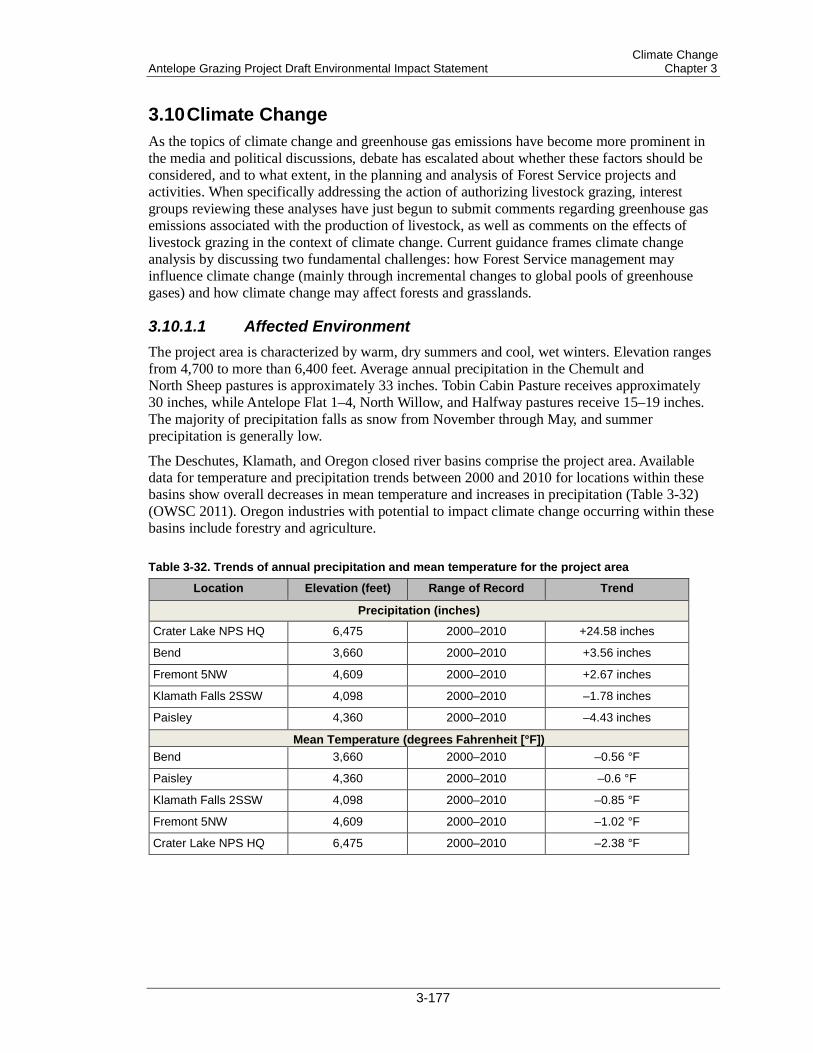
Climate Change Antelope Grazing Project Draft Environmental Impact Statement Chapter 3
3.10 Climate Change As the topics of climate change and greenhouse gas emissions have become more prominent in the media and political discussions, debate has escalated about whether these factors should be considered, and to what extent, in the planning and analysis of Forest Service projects and activities. When specifically addressing the action of authorizing livestock grazing, interest groups reviewing these analyses have just begun to submit comments regarding greenhouse gas emissions associated with the production of livestock, as well as comments on the effects of livestock grazing in the context of climate change. Current guidance frames climate change analysis by discussing two fundamental challenges: how Forest Service management may influence climate change (mainly through incremental changes to global pools of greenhouse gases) and how climate change may affect forests and grasslands.
3.10.1.1 Affected Environment The project area is characterized by warm, dry summers and cool, wet winters. Elevation ranges from 4,700 to more than 6,400 feet. Average annual precipitation in the Chemult and North Sheep pastures is approximately 33 inches. Tobin Cabin Pasture receives approximately 30 inches, while Antelope Flat 1–4, North Willow, and Halfway pastures receive 15–19 inches. The majority of precipitation falls as snow from November through May, and summer precipitation is generally low.
The Deschutes, Klamath, and Oregon closed river basins comprise the project area. Available data for temperature and precipitation trends between 2000 and 2010 for locations within these basins show overall decreases in mean temperature and increases in precipitation (Table 3-32) (OWSC 2011). Oregon industries with potential to impact climate change occurring within these basins include forestry and agriculture.
Table 3-32. Trends of annual precipitation and mean temperature for the project area
Location Elevation (feet) Range of Record Trend
Precipitation (inches) Crater Lake NPS HQ 6,475 2000–2010 +24.58 inches
Bend 3,660 2000–2010 +3.56 inches
Fremont 5NW 4,609 2000–2010 +2.67 inches
Klamath Falls 2SSW 4,098 2000–2010 –1.78 inches
Paisley 4,360 2000–2010 –4.43 inches
Mean Temperature (degrees Fahrenheit [°F]) Bend 3,660 2000–2010 –0.56 °F
Paisley 4,360 2000–2010 –0.6 °F
Klamath Falls 2SSW 4,098 2000–2010 –0.85 °F
Fremont 5NW 4,609 2000–2010 –1.02 °F
Crater Lake NPS HQ 6,475 2000–2010 –2.38 °F
3-177

Climate Change Chapter 3 Antelope Grazing Project Draft Environmental Impact Statement
3.10.2 Direct and Indirect Effects The proposed action would affect 169,599 acres of NFS lands by determining the appropriate level of grazing for rangelands within the project area. This scope and the associated degree of change would be minor compared to the total amount of rangeland being grazed. A project of this size would create such minimal contributions of greenhouse gases that its impact on global climate change would be infinitesimal. Therefore, at the global scale, the proposed action’s direct and indirect contributions to greenhouse gases and climate change would be negligible.
In addition, because the direct and indirect effects would be negligible, the proposed action’s contribution to cumulative effects of greenhouse gases and climate change would also be negligible.
3.10.2.1 General Discussions of Climate Change on Land Management The Intergovernmental Panel on Climate Change (IPCC) has summarized the contributions to climate change by global human activity sectors in its Fourth Assessment Report (IPCC 2007). The top 3 anthropogenic (human-caused) contributors to greenhouse gas emissions (from 1970 to 2004) are fossil fuel combustion (56.6% of global total), deforestation (17.3%), and agriculture/waste/energy (14.3%). IPCC subdivides the deforestation category into land use conversions and large-scale deforestation. Deforestation is defined as removal of all trees, most notably the conversion of forest and grassland into agricultural land or developed landscapes (IPCC 2000).
The proposed action does not fall within any of these main contributors of greenhouse gas emissions. Forested land will not be converted into a developed or agricultural condition. In fact, forest stands are being retained and thinned to maintain a vigorous forested condition that can continue to support trees and sequester carbon over the long term.
The proposed action is also consistent with IPCC recommendations for land use to help mitigate climate change. The 2007 IPCC report summarizes sector-specific key mitigation "technologies." For the rangeland sector, the report recommends “[i]mproved… grazing land management for increased soil carbon storage…” as one of the “key mitigation technologies and practices currently commercially available.” The proposed action is consistent with this direction because mitigations applied under Alternatives 2, 3, 4, and 5 could be categorized as both facilitated adaptation and mitigation, as described in the October 2, 2008, Forest Service Strategic Framework for Responding to Climate Change. Like Alternative 1, Alternatives 2 through 5 would reduce grazing impacts and would therefore improve vegetative conditions in riparian areas that are currently in less-than-satisfactory condition; this improvement would be expected to increase the efficacy of the riparian areas as carbon sinks. Alternative 4 would provide for this improvement in riparian areas in the Chemult RD portion of the project area more quickly than Alternatives 2, 3, or 5.
During public scoping, several commenters expressed concern about the impacts of climate change on available water for ecological systems within the project area. A great deal of uncertainty still remains when analyzing effects of climate change. It is important to remember to relate impacts in the appropriate contexts and intensities associated with the project and proposed action.
In response to the concerns raised during public scoping, the IDT considered trends in general terms to determine what changes to climate could potentially cause on the landscape for the resources analyzed. Ultimately, projections regarding climate change contain some uncertainty. “[U]ncertainty about climate projections are much greater at the local and regional scales important to land managers, because uncertainties amplify as data and model outputs are
3-178

Climate Change Antelope Grazing Project Draft Environmental Impact Statement Chapter 3
downscaled.… [C]hanges in annual precipitation,…have higher uncertainties associated with them.… Ecological response to climate related changes is highly likely to be more difficult than climate to model accurately at local scales.… Uncertainty does not imply a complete lack of understanding of the future or a basis for a No Action decision. Managing in the face of uncertainty will best involve a suite of approaches, including planning analyses that incorporate modeling with uncertainty, and short-term and long-term strategies that focus on enhancing ecosystem resistance and resilience, as well as actions taken that help ecosystems and resources move in synchrony with the ongoing changes that result as climates and environments vary.… Flexibility to address the inherent uncertainty about local effects of climate change could be achieved through enhancing the resiliency of forests.… Efforts to mitigate existing stressors would address current management needs, and potentially reduce the future interactions of these stressors with climate change” (Joyce et al. 2009).
Although an ecosystem’s sensitivity to grazing pressure and threshold for degradation changes with bioclimatic setting, resulting in lower sustainability in very dry and very humid ecosystems (Asner et al. 2004), the future bioclimatic setting within the project area is highly uncertain. As future average temperatures increase, snowpack will very likely be reduced, and snowmelt, runoff, and peak flows will occur earlier in the year (Hauser et al. 2009). In addition, grazing lands play an important role in carbon cycling, carbon sequestration, and climate change. The carbon cycle is the mechanism that controls carbon dioxide (CO2) in the atmosphere. Many factors influence this complex process, with soils performing a large function in the cycle. The capture and storage of CO2 in the soil is known as carbon sequestration. Productive, sustainable grazing lands provide high-quality vegetation and soils, which lead to high rates of carbon sequestration and low levels of CO2 emissions.
Krueger et al. (2002) argue that grazing lands, due to their diversity of climates and soils, contribute to carbon sequestration and help mitigate the greenhouse effect and other aspects of global climate change. They assert that: Increased soil C[carbon] due to sequestration would have a positive effect on soil quality and enhance plant production. Grazing lands may be used in the future to influence the global C cycle and to take up more CO2 from the atmosphere. With careful, appropriate management of these soils and vegetation, biomass productivity on grazing lands can be enhanced, and a significant contribution to offsetting U.S. emissions of CO2 can be made (Krueger et al. 2002).
3-179