environmental assessment -...
TRANSCRIPT

Environmental Assessment
For
Turkey Creek Ecological Management Unit
Compartments 1279, 1284, 1285, 1286, 1293
Scott County, Arkansas
Responsible Agency:
USDA Forest Service
Ouachita National Forest
Poteau-Cold Springs Ranger District
Responsible Official:
Steven N. Cole
District Ranger
PO Box 2255
Waldron, AR 72958
For Further Information Contact:
Donna S. Reagan
Cold Springs Ranger District
PO Box 417
Booneville, AR 72927
479-675-3233
The U.S. Department of Agriculture (USDA) prohibits discrimination in all its programs and activities on the basis of race, color, national origin, age, disability, and where applicable, sex, marital status, familial status, parental status, religion, sexual orientation, genetic information, political beliefs, reprisal, or because all or part of an individual’s income is derived from any public assistance program. (Not all prohibited bases apply to all programs.) Persons with disabilities who require alternative means for communication of program information (Braille, large print, audiotape, etc.) should contact USDA's TARGET Center at (202) 720-2600 (voice and TDD). To file a complaint of discrimination, write to USDA, Director, Office of Civil Rights, 1400 Independence Avenue, S.W., Washington, DC 20250-9410, or call (800) 795-3272 (voice) or (202) 720-6382 (TDD). USDA is an equal opportunity provider and employer.

Turkey Creek Project Environmental Assessment Poteau-Cold Springs Ranger District Ouachita National Forest
2
Chapter 1 Purpose of and Need for the Proposed Action .......................................................................... 3
Proposed Action ...................................................................................................................................... 3
Location .................................................................................................................................................. 4 Purpose and Need for the Action ............................................................................................................. 5
Scope of This Environmental Analysis ................................................................................................... 12
Public Involvement ................................................................................................................................ 12
Relevant Planning Documents ............................................................................................................... 12 Resources that will have Further Study................................................................................................... 13
Resources Eliminated from Further Study .............................................................................................. 14
Significant Issues ................................................................................................................................... 15 Decisions to be Made ............................................................................................................................. 15
Chapter 2 Alternatives Including the Proposed Action ........................................................................... 16 Introduction ........................................................................................................................................... 16
Alternative Design and Evaluation Criteria............................................................................................. 16 Technical Requirements ......................................................................................................................... 16
Forest Plan Mitigations .......................................................................................................................... 16
Project Specific Protective Measures ...................................................................................................... 16 Monitoring ............................................................................................................................................. 18
Project Objective Requirements ............................................................................................................. 18
Alternatives Considered But Eliminated from Detailed Study ................................................................. 19 Alternatives Documented in Detail ......................................................................................................... 20
Other Past, Present, and Reasonably Foreseeable Future Actions ............................................................ 32
Summary Comparison of All Alternatives .............................................................................................. 33
The Preferred Alternative ....................................................................................................................... 34
Chapter 3 Environmental Disclosures...................................................................................................... 35
Introduction ........................................................................................................................................... 35
Air Quality............................................................................................................................................. 36 Soils .................................................................................................................................................. 42
Water Resources and Quality ................................................................................................................ 48
Wildfire Hazards &/or Fuels .................................................................................................................. 53 Transportation and Infrastructure ........................................................................................................... 55
Vegetation ............................................................................................................................................. 61
Wildlife, Habitat, and Fisheries .............................................................................................................. 66
Proposed, Endangered, and Threatened and Sensitive (PETS) Species .................................................... 76 Insect and Disease .................................................................................................................................. 88
Local or County Economy (Project Financial or Economic Efficiency)................................................... 90
Public Health and Safety ........................................................................................................................ 92 Recreation Resources ............................................................................................................................. 95
Visual Resources ................................................................................................................................... 97
Climate Change ................................................................................................................................... 101
Chapter 4 ID Team Members and Primary Authors ............................................................................ 103
Chapter 5 Persons and Agencies Contacted &.or Consulted ................................................................ 103
Chapter 6 Literature Cited ..................................................................................................................... 104
List of Appendices
Map(s)

Turkey Creek Project Environmental Assessment Poteau-Cold Springs Ranger District Ouachita National Forest
3
Chapter 1
Purpose of and Need for the Proposed Action
Proposed Action The District Ranger on the Poteau-Cold Springs Ranger District, Ouachita National Forest, proposes to
implement management activities in Turkey Creek Ecological Management Unit (Compartments 1279, 1284,
1285, 1286, and 1293, henceforth referred to as Turkey Creek. Activities proposed include timber harvesting,
prescribed burning, silvicultural treatments, wildlife treatments, road system improvements, special use permits (ex. firewood and rock collection) and heritage resource protection. These activities should move this project
area toward prevention of insect infestations, continued mast development for wildlife, and towards the design
criteria for Management Areas 22 (Renewal of the Shortleaf Pine-Bluestem Grass Ecosystem and Red-cockaded Woodpecker Habitat) and Management Area 9 (Water and Riparian Communities) in the Revised Forest Plan
(USDA Forest Service. 2005a.). These activities should begin in 2011, if an action alternative is selected.
Turkey Creek project area contains 7,156 acres of national forest lands. These forested acres include 3,936
acres suitable for timber production (Table 1.1). Stand map in appendix.
(TABLE 1. 1) Summary of existing National Forest lands, private ownership and total watershed acreage in the Turkey Creek analysis area. These are approximate acres only based on field examinations, Geographical Information Systems (GIS), and Global Positioning Systems (GPS).
Land Designation 1279 1284 1285 1286 1293 Sub Total
National Forest Management Areas MA 9 (Water and Riparian Communities-unsuitable) 105 301 423 255 99 1183
Total MA 9 Acres 1183
MA 22 (Renewal of the Shortleaf Pine-Bluestem Grass Ecosystem and RCW Habitat-unsuitable)
149 625 495 293 475 2037
MA 22 (Renewal of the Shortleaf Pine-Bluestem Grass Ecosystem and RCW Habitat-suitable)
368 602 1211 1167 588 3936
Total MA22 Acres 5973
Total Acres of National Forest (MA 9/22) 622 1528 2129 1715 1162 7156 7156
Total Acres of Private Land in EMU 1622
Total Acres of PVT and NF in EMU 8778
(TABLE 1. 2) Summary of watershed acres used for Aquatic Cumulative Effects Analysis. These are
approximate acres only based on field examinations, Geographical Information Systems (GIS),and Global Positioning Systems (GPS). See Watershed Map in appendix.
Watershed Entire Watershed (Including Project Area) Total Watershed Acres
111102060108 3,323 ac. (private) 11,480 ac (NF lands) 14,803
111102060107 10,272 ac. (private) 15,566 ac (NF lands) 25,838
TOTAL 13,595 ac. (private) 27,046 ac (NF lands) 40,641
This project area falls within two 6
th level watershed (40,641 acres). These watersheds are considered “low
risk”.

Turkey Creek Project Environmental Assessment Poteau-Cold Springs Ranger District Ouachita National Forest _______________________________________________________________________________________________________________________________________________________________________________________________________________________________________________________________________________________
Page 4 of 111
Location Turkey Creek, comprised of Compartments 1279, 1284, 1285, 1286, and 1293 on the Poteau-Cold Springs
Ranger District on the Ouachita National Forest, is located in Scott County. It lies east of Highway 71 and the Boles Community and south of Highway 28 and the Parks Community. County Road 9013 forms most of the
northern border; Forest Service Road 163 forms the eastern border. Mill Creek Mountain forms the southern
boundary. The project area is in T2N, R28W, and all or portions of S32-36; T2N, R27W, S31 and T1N, R28W,
S1-5, 8-12, 13-17.
A summary of the Proposed Action is listed below:
Stand management consists of managing the suitable stands in the project area by even-age management on
approximately 3,936 acres.
Timber harvesting consists of harvesting shortleaf pine and/or hardwood products on approximately 1,606 acres by commercial thinning to a target average basal area (BA) of 60 for pine; approximately 1,378 acres by
commercial thinning on a 20 ft. spacing; approximately 179 acres of modified shelterwood harvest and
approximately 100 acres of clearcut of an off-site species (loblolly pine). All stands would retain 10-20% of quality hardwood, where available. In active, inactive, and recruitment clusters, retain no more than 10 square
feet of basal area per acre in overstory hardwoods. Remove all hardwoods within 50 feet of cavity trees.
Prescribed burning is proposed for multiple purposes (site preparation, wildlife habitat improvement, and the
Healthy Forest Initiative consisting of fuel reduction) on approximately 6,774 acres on an approximate 3-5 year
rotation.
Silvicultural Treatments consist of reforestation treatments and timber stand improvements.
Shortleaf pine shelterwood stands (179 acres) would be mechanically scarified with hand tool site prep and burning. There would be an option to herbicide, rip, and plant, if necessary. Shelterwood stands would be
planted with Shortleaf pine if the sites are not stocked with a minimum of 150 seedlings per acre within 5 years
after harvest.
Loblolly clearcut stands (100 acres) would be ripped and planted with Shortleaf pine with the option to use
herbicides, if necessary. Clearcut area would be planted approximately one year after harvest.
Timber stand improvements consist of 284 acres of hand tool release and 425 acres of pre-commercial thinning.
Wildlife activities proposed consist of 1,764 acres of wildlife stand improvements (midstory) consisting of prescribed burning, hand tool treatments, and herbicides if necessary. The method chosen would be site-specific
and should result in little, if any, impact on non-target plant species. There would be 45 woodland ponds
reconstructed. A total of 90 nest structures (wood duck/squirrel boxes and bluebird boxes) would be installed.
Red-cockaded woodpecker (RCW) treatments/activities, including the use of cavity restrictors, snake and
squirrel excluder devices, artificial cavities, single-bird augmentations, multiple-bird group-initiations, , removal
of southern flying squirrels, population/nest monitoring, brush hogging around cavity trees, cavity maintenance, and southern pine beetle (SPB) control efforts could occur.
Transportation system consists of proposing road closures, approximately 1.85 miles of road construction, 12.19 miles of road reconstruction, 12.0 miles of temporary road construction, 3.54 miles of prehaul
maintenance and a total of 1.75 miles of road obliteration.

Turkey Creek Project Environmental Assessment Poteau-Cold Springs Ranger District Ouachita National Forest
5
Other permits for firewood and rock collection could be issued to the forest user, where appropriate.
Purpose and Need for the Action Field examinations and inventories of Turkey Creek determined that the existing conditions do not meet the
desired conditions and objectives of the Revised Forest Plan (USDA Forest Service, 2005a). The Proposed
Actions in this environmental document would move Turkey Creek towards the desired conditions established by the Interdisciplinary Team and the design criteria in the Revised Forest Plan.
Below is a table that summarizes the National Forest Management Act (NFMA) analysis that the ID Team
prepared prior to developing any proposed actions.

Turkey Creek Project Environmental Assessment Poteau-Cold Springs Ranger District Ouachita National Forest _______________________________________________________________________________________________________________________________________________________________________________________________________________________________________________________________________________________
Page 6 of 111
(TABLE 1.3) Results of National Forest Management Act (NFMA) analysis describing desired conditions, existing conditions, site specific needs, and possible management activities.
Desired Conditions Existing Conditions Site Specific Needs Possible Management Activities
Maintain or restore community diversity-and a significant component of species diversity-by utilizing prescribed burning in appropriate portions in Mgt Area 22 Revised Forest Plan, pp 58). Maintain the full range of natural systems found within the ONF…pp 59. Protect sensitive species where found.
Trees in many pine stands are crowded or densely stocked; many Forest stands are older than 70 years of age. These conditions result in stress and reduced vigor and health, increasing susceptibility to insects and disease. Small numbers of Ozark chinquapin are located here.
Need to restore healthy conditions by limiting over story, and open the over story to create suitable wildlife habitats by removing unhealthy trees, and reducing stocking. Ensure survival of Ozark chinquapin trees.
Commercial Thinning Wildlife Stand Improvements Protect and improve growing conditions of Ozark chinquapin by reducing competition.
To have at least 4% and not more than 8.3% of the suitable land in the 0-10 year age class in Management Area 22 (Revised Forest Plan, pp. 78).
There are 5 acres in the 0-10 year age class in Management Area 22. This condition restricts food availability and essential new age class.
Need to increase early seral stage habitat within Turkey Creek to meet requirements of the Revised Forest Plan for both Management Area 22.
Modified Seed Tree Modified Shelter wood Wildlife openings Seeding of Temp roads.
To have suitable seedbeds in regeneration stands.
Conditions do not exist for successful natural regeneration.
Need to create a bed for seed fall after the regeneration harvests. Need to create a suitable seedbed in regeneration sites after initial prescribed burning in even-age regeneration stands. Need to create a suitable seedbed in the even-age regeneration stands after initial prescribed burning and handtools.
Reforestation Treatments Prescribed Burning Site Prep by Hand tools Site Prep Mechanical Scarification Hand planting of shortleaf pine, if needed herbicide
To provide a quality visual opportunity. Heavily traveled roads and mostly mature forest conditions are present on FS rd 163 and SC 18 roads are level II roads.
Maintain roads to standard and manage the project area to meet habitat requirements. All mgt. activities would meet Scenic Integrity Objectives (SIO) in Mgt. Area 22.
Road maintenance contract and monitor forest management practices.
To ensure quality pine and hardwoods. There are several stands that are dense and need treatment, mostly in the 10-20 year age class and in mature stands.
Need to reduce the stocking rate in stands, where needed.
Pre-commercial Thin Commercial Thin
To provide at least one permanent water source per 160 acres for wildlife objectives (Revised Forest Plan, WF010, pp. 79).
Existing ponds need to be rehabilitated. Rehabilitate ponds.
Pond Rehabilitation
To have adequate nest structures. There are not adequate nest structures. Need to increase possible nest structures. Install nest boxes where ponds are reconstructed

Turkey Creek Project Environmental Assessment Poteau-Cold Springs Ranger District Ouachita National Forest _______________________________________________________________________________________________________________________________________________________________________________________________________________________________________________________________________________________
Page 7 of 111
Desired Conditions Existing Conditions Site Specific Needs Possible Management Activities
To Increase growth rate and quality of desired trees.
Competition among species is reducing growth rate affecting tree quality.
Need to decrease competition for limited nutrients and water among species.
Hand Tool Release Pre-commercial Thinning Commercial Thinning
To reduce midstory and allow development of grasses and forbs on the forest floor.
Midstory is too thick to allow development of grasses and forbs.
Need to reduce the midstory. Wildlife Stand Improvements Prescribed Burning
To have a reliable hard mast crop. Hardwood crowns are not developed to produce a reliable hard mast crop.
Need to develop hardwood crowns with WSI stands so that residual hardwood will produce a more reliable hard mast crop.
Wildlife Stand Improvements
To achieve open road density (open road per square mile) objective (0.75) in MA 22 (Revised Forest Plan, pp. 59, 67, 90-92)
There are 8,778 acres in the project area (NF and private) and 28.54 miles of total existing roads (both open and closed). Of these roads, 25.09 miles are currently open. Open road density is 1.83 mi. /per sq. mile in MA 22.
Need to reduce the open road density, where feasible. In Management Area 22.
Road closure or obliteration
To provide a safe transportation system that meets the minimum needs of the various resources and their users, minimizes wildlife habitat disturbance, and satisfies some public demand for motorized recreation (Revised Forest Plan, pp. 67).
Current road system is in constant use by hunters, sightseers, Forest Service personnel, and other forest visitors. FS Rd.974 needs to be repaired or relocated.
Need to access harvest units and provide safe road system. Need to repair rusted-out drains and road surface and ditch erosion. Ensure safe road conditions through periodic maintenance
Road Construction Road Reconstruction Prehaul Maintenance Temporary Roads Decommission Seasonal Closing Relocate road if needed
To have healthy, productive stands in these areas.
Portions of this project area were designated as uneven-age management during the last entry. Past management activities (prescribed burning and herbicide use) have not resulted in a new age class.
Need to increase growth rate in these stands and create new age classes.
Commercial Thinning Seed Tree Shelterwood Prescribed Burning WSI
To reduce wildfire hazards. Natural fuel buildup and heavy visitor use, increase wildfire hazards in Turkey Creek.
Need to create conditions where a wildfire would not become too hot to kill the overstory and a threat to adjacent private properties.
Prescribed Burning, commercial thinning, pre-commercial thinning, and Wildlife Stand Improvement treatments.
To have the understory and midstory more open.
The understory and midstory are heavily stocked as a result of lack of prescribed burning within Turkey Creek. Part of Compartment s 1286 and 1293 was burned in FY 10. Most of this area has not been burned in over 19 yrs.
Need to reduce heavily stocked understories and midstories.
Prescribed Burning WSI

Turkey Creek Project Environmental Assessment Poteau-Cold Springs Ranger District Ouachita National Forest
8
Desired Conditions Existing Conditions Site Specific Needs Possible Management Activities
To supply firewood areas to the local community.
There are no firewood permit areas in the project area.
Need to provide sites for firewood areas to allow permitting.
Allow firewood permits
Manage the project area for native species while limiting non native species and off-site species.
There are various non native and off-site species including loblolly pine, mimosa, lespedeza, etc.
Need to remove and/or reduce the non native and off-site species within the project area and where possible replace with native species
Prescribed burning Clear cut Loblolly Herbicide Hand Tools
To provide adequate protection of heritage resource sites.
129 sites have been previously documented, 29 of which are either eligible or potentially eligible for the National Register of Historic Places and will be protected.
Need to use adequate protective measures to ensure that these sites are protected.
Identify other sites on the ground for protection.
There is a need to follow the Revised Forest Plan for Oil and Gas Exploration.
The Poteau/Cold Springs Ranger District has received approximately 6 applications for permits to drill in the past year for oil and gas exploration.
Need to meet the requests for oil and gas exploration.
Coordinate with Bureau of Land Management on exploration activities.
There is a need to provide recreation and visual opportunities in the project area.
Heavy public use of interior roads for various recreational activities.
Need to ensure that driving/sightseeing is enhanced and the roads are safe to drive.
Road maintenance and vegetation management
Improve or maintain soil quality (Revised Forest Plan pp.74).
There are pockets of high compaction and erosion concerns on soils throughout the project area.
Need to ensure Best Management Practices are followed and use mitigation where necessary.
Mitigation
Improve or maintain water resources (Revised Forest Plan pp. 74). Relocate FS Rd. 974
This project area falls within two 6th level watershed. Both are considered ―low risk‖. Road 974 is changing direction of water flow from small ephemeral drain
Need to ensure that management activities exceed Revised Forest Plan standards for water quality and follow Arkansas Best Management Practices (BMP’s)
Mitigation Repair or relocate FS Rd. 974
Reduce or eliminate landline trespasses/encroachments in project area.
There are approximately 14.75 miles of landlines associated with this project area.
Need to define and maintain landlines Landline surveys and maintenance
Maintain safety of the public and firefighters on wildfires in project area.
Project area is in rocky and steep terrain. Need to ensure management of wildfires and throughout Turkey Creek adheres to safety measures for firefighters and public.
Wildfires in project area can be managed for resource benefit.
To supply rock permits to the local community.
There are no rock permits in the project area.
Need to allow rock permits to be issued, when necessary.
Allow rock permits within road right-of-ways

Turkey Creek Project Environmental Assessment Poteau Ranger District Ouachita National Forest __________________________________________________________________________________________________________________________________________________________________________________________________________________________________________________________________________________
Page 9 of 111
The following pages describe the purpose and need in more detail.
MANAGEMENT AND TIMBER HARVESTING OF SUITABLE STANDS
Even-age management is needed in Turkey Creek to create habitat for Red-cockaded Woodpecker (RCW) and
early seral stage habitat that is currently lacking in the project area. This would be accomplished through a modified shelterwood harvest. Clear cutting would be utilized to remove an offsite species (loblolly pine) and
replace it with native shortleaf pine and would add to the early seral stage habitat. In addition, even-age
management would reduce the overstocked conditions of stands creating a healthier forest by utilizing commercial thinning (Objective OBJ10 – Reduce susceptibility to southern pine or Ips beetle outbreaks on at
least 25,000 acres per year). Even-age management is a type of management practice that mimics natural events
such as tornadoes, ice storms, fire, or insect infestations that kill blocks of timber eventually creating new age classes. This type of management also helps to meet the public demand for timber by providing a sustainable
timber supply for future use.
Commercial thinning of shortleaf pine and loblolly pine (2,984 acres) is needed to reduce competition for limited soil, water, nutrients, and sunlight in mature, pine stands where individual tree growth has slowed due to
age, overstocked conditions, and create suitable RCW habitat by reducing existing basal area. Currently, the
understory, midstory and overstory are overstocked preventing sunlight from reaching the forest floor. Thinning would reduce vegetation that competes for limited soil nutrients, water, and sunlight (USDA Forest Service.
2005a, Priorities pg. 58 and Objective pg. 59). The current conditions exceed the recommended stocking rates
for pine identified on page 84 Table 3.6 of Revised Forest Plan. The mature trees at these high stocking rates with heavily stocked understories and midstories are increasingly susceptible to southern pine beetle (primarily)
and other insect and disease infestation. Thinning and releasing stands would improve and restore individual
tree vigor, health, and resiliency of the Turkey Creek analysis area. Thinning would also create more open
stands that are favorable for RCW movement within stands. Commercial thinning would reduce approximately 1,606 acres to a target BA of 60. These stocking rates would reduce the chances of having southern pine beetle
infestations spread out of the thinning stands into adjacent stands. Research has shown that Southern pine beetle
(SPB) infestations in stands that have been thinned with 20-25 feet between trees will not spread to adjacent stands but will disburse (Managing Southern Forest To Reduce Southern Pine Beetle Impacts, May 1986, p19).
A target BA of 60 would average at least 25 feet between trees in mature saw timber stands. Approximately
1,378 acres of commercial thinning on 20 ft. spacing would improve and restore individual tree vigor and
growth in the older pine plantations.
Modified shelterwood (179 acres) is needed to create early seral stage habitat (USDA Forest Service. 2005a, Pg.
7, 35, and Objective OBJ06, Pg.59). Currently, Turkey Creek is deficient in early seral stage habitat. Most of the 0-10 year age class has moved to the next age class leaving Turkey Creek deficient of early seral stage
habitats within Forest Service system land by 2009. There is some early seral stage habitat in Compartment
1279 stand 5 and on private land within the Turkey Creek analysis area; there are pastures and grazed woodlands that are fenced. The objective is to have at least 4% and not more than 8.3% of the suitable stands of
Turkey Creek in this age class. Currently 5 acres or <1% of the suitable area is in the 0–10 yr. age class. This
method would increase the 0-10 year age class by 284 acres to 7.2% of the suitable land class (including the 100
ac. Clearcuts) in order to meet Management Area 22 goals. Stands selected for even-age modified shelterwood harvest are mature pine stands located at least 10 chains away from existing young stands still considered
regeneration openings on National Forest system lands or on private lands. Regeneration openings are young
stands that have not grown to 20% of the height of the adjacent stand.
Clearcut of loblolly pine (100 acres) is needed to remove an offsite species and replace it with shortleaf pine, a
native species following direction from the Revised Forest Plan p.58 “restore the shortleaf pine-bluestem grass ecosystem…” p. 60, OBJ11 “…begin replacing off-site loblolly pine plantations with shortleaf pine and native
hardwoods where such plantations were installed outside the natural range of loblolly pine”. The loblolly will

Turkey Creek Project Environmental Assessment Poteau Ranger District Ouachita National Forest __________________________________________________________________________________________________________________________________________________________________________________________________________________________________________________________________________________
Page 10 of 111
be removed from the drains where planted following the Forest Plan on page 104, “Management Activities
Permitted or Prohibited within SMZs”.
PRESCRIBED BURNING
Prescribed burning is proposed on approximately 6,774 acres on an approximate 3-5 year rotation in the Turkey
Creek project area. Multiple purposes would be met by prescribed burning such as for site preparation, wildlife
habitat improvement, control understory, and fuel reduction, which would address the President‟s Healthy Forest Initiative.
Site preparation prescribed burns are needed in the regeneration stands to prepare a bed for seed fall after the regeneration harvests. Approximately 279 acres are being harvested for regeneration in this proposal (179 acres
modified shelterwood tree and 100 acres clearcut).
Wildlife prescribed burning is needed to provide new growth for wildlife to eat. After a prescribed burning, the
understory would “green up” providing a healthy food source for wildlife.
Fuel reduction prescribed burning is needed to reduce the wildfire hazards as a result of natural fuel buildup, lack of prescribed burning in Turkey Creek, and from natural storm events. Fuels can increase from 4-6 tons per
acre to 8-10 tons per acre and higher in places without prescribed burning. Prescribed burning conducted on the
Ouachita National Forest typically reduces fuel loading on a unit by 1-3 tons per acre. With repeated burns, fuel loading in a burn unit can be maintained at 3-4 tons per acre. Fuels start accumulating immediately after the last
prescribed burn and are heavy in the Turkey Creek area where fire has been excluded for at least 10 years.
Prescribed burning is needed to reduce fuel loads, cycle nutrients stored in leaf litter layers, and reduce offsite
species of hardwoods that have encroached through all stands because of lack of fire. These species; ash, cedar, black gum, and maples would eventually replace the oaks species as the dominant hardwood type in the absence
of fire. The Healthy Forests Restoration Act (H.R. 1904) was signed on December 3, 2003. This bill was
signed into law to improve the overall forest health, including wildlife habitat, by allowing active management of the nation‟s forests. The management activities proposed for Turkey Creek would meet the objectives of the
Healthy Forests Restoration Act (H.R. 1904) by reducing the risk of catastrophic fire to communities, helping
save the lives of firefighters and citizens, and protecting threatened and endangered species.
SILVICULTURAL TREATMENTS
Reforestation site preparation of Shortleaf pine shelterwood stands (179 acres) would be mechanically
scarification, hand tool site prep, and burning. There would be an option to herbicide, rip, and plant, if necessary. Shelterwood stands would be planted with Shortleaf pine if the sites are not stocked with a minimum
of 150 seedlings per acre within 5 years after harvest.
Reforestation site preparation of Loblolly clearcut stands (100 acres) would be ripped and planted with Shortleaf pine with the option to use herbicides, if necessary. Clearcut area would be planted one year after harvest.
Timber stand improvements by hand tool release (284 acres…includes 5 acre encroachment planted in 2009) – This treatment is usually necessary to enable the young naturally established or hand planted seedlings to
compete for growing space. Without the use of herbicide to control existing hardwood vegetation that is
competing to occupy the site, the older hardwoods have well established root systems and quickly “overtop” small pine seedlings. When this occurs, the shading effect quickly kills young pine regeneration.
Timber stand improvements by pre-commercial thinning utilizing hand tools or mechanical methods (425 acres)
– This treatment is needed to increase growth and improve the quality and vigor of the remaining trees to create suitable and sustainable RCW habitat.

Turkey Creek Project Environmental Assessment Poteau Ranger District Ouachita National Forest __________________________________________________________________________________________________________________________________________________________________________________________________________________________________________________________________________________
Page 11 of 111
WILDLIFE ACTIVITIES
Woodland pond reconstruction on 45 sites is needed because Turkey Creek EMU lacks adequate water sources
according to the (Revised Forest Plan. Design Criteria WF010, Pg. 79). The Forest Plan suggests one water source for every 160 acres. Reconstruction of woodland ponds is needed because dams have encroaching
woody vegetation, which can result in water retention problems. This action would ensure that wildlife has
sufficient water available on a year-round basis.
Wildlife stand improvements (1,764 acres) midstory reduction treatments are needed to improve the habitat that
currently exists. WSI will help produce a grass/forb understory and enhance hard mast production by residual
hardwood crowns within the treated stands. It will also improve movement within stands for RCW. WSI may be completed by the use of hand tools or mechanical equipment depending on terrain, species composition, and
cost. Herbicides will be retained as a backup treatment where prescribed burning cannot be used or scheduled to
retain the open pine/blue stem conditions.
Nest structures (90) are needed in a variety of habitats within the Turkey Creek project area for a variety of
species. Many snags and cavity trees were created in this area by the December 2000 ice storm. This was a
positive condition for many cavity dependent species. However, time is now causing a loss of these snags and cavity trees.
Wildlife openings – There is a lack of early seral stage habitat and temporary wildlife openings in Turkey Creek. These openings are needed because several species need the early seral stage habitat that these openings would
provide until the conditions in newly harvested areas provide the needed conditions (Revised Forest Plan.
Design Criteria Pg. 78). These openings would be created from log landings, firelines and temporary roads.
Existing openings will be maintained by prescribed burning, disking, seeding, planting, fertilizing, brushogging, and/or bull dozing.
Red-cockaded woodpecker (RCW) treatments/activities, including the use of cavity restrictors, snake and squirrel excluder devices, artificial cavities, single-bird augmentations, multiple-bird group-initiations, southern
pine beetle (SPB) control efforts, removal of southern flying squirrels, population/nest monitoring, and cavity
maintenance are needed to encourage habitat expansion.
TRANSPORTATION SYSTEM
The current road system within Turkey Creek needs improvements (Revised Forest Plan. Design Criteria TR001, Pg. 90).
Road closures of new roads would move toward the Forest standard for open road density.
Road construction is needed on approximately 1.85 miles to access harvest units and provide a safe
transportation system for logging activities.
Road reconstruction is needed on approximately 12.19 miles because the roads have surface and ditch erosion,
rusted-out drains, and fish passage concerns.
Temporary roads, approximately 12.0 miles, are needed because they provide access to harvest units, but are not
needed for long-term management of the natural resources.
Prehaul maintenance is needed on approximately 3.54 miles because roads have some surface and ditch erosion,
rusted-out drains, and need some spot rocking.

Turkey Creek Project Environmental Assessment Poteau Ranger District Ouachita National Forest __________________________________________________________________________________________________________________________________________________________________________________________________________________________________________________________________________________
Page 12 of 111
Road obliteration is needed on 1.75 miles because these roads are no longer needed and cross streams at
undesirable locations.
OTHER
Firewood permits are needed to supply firewood areas to the local community (Revised Forest Plan. Design
Criteria FW001, Pg. 97) and would allow the forest user access to resources from this project area. Currently, there are no firewood areas in Turkey Creek.
Rock Permits are needed to supply rocks to the local community. Currently there are no rock permits for Turkey Creek. Permits would be offered to the public for collection of rocks by private individuals within road
construction and reconstruction corridors. That is, rocks can be collected within areas of disturbance associated
with road construction and reconstruction.
Herbicide treatments of invasive and non-native species – This treatment is necessary to stop or slow the
infestation of invasive and non-native species such as mimosa, lespedeza, or any other species of these types
encountered within this analysis area.
Landline Maintenance – This action is needed to refurbish marked trees by “blazing and repainting line trees on
boundary lines. Periodic maintenance is required and scheduled when watersheds are entered for management needs.
Scope of This Environmental Analysis
The team‟s ecosystem analysis is incorporated by reference and included in the project file. The scope of this
decision does not include other actions that would be planned in the compartments in the unforeseeable future. All of the actions associated with this analysis are foreseeable, and would be included in the analysis of effects
since they may contribute to direct, indirect or cumulative effects on the environment.
Public Involvement
Public involvement began January 2011. We sent a letter to the district mailing list with a detailed description of the Proposed Action and a stand map for Turkey. No comments were received. In addition to this mailing
mentioned above, a 30-day comment period is provided to the public prior to signing a decision.
Relevant Planning Documents
The following documents directly helped develop the Proposed Action by setting the “side boards” to reach desired future conditions:
Revised Land and Resource Management Plan, Ouachita National Forest, Arkansas and Oklahoma,
2005 (USDA Forest Service, 2005a).
Final Environmental Impact Statement (FEIS), Revised Land and Resource Management Plan, Ouachita
National Forest, Arkansas and Oklahoma, 2005 (USDA Forest Service, 2005b).
Programmatic Biological Opinion of the Revised Land and Resource Management Plan on the
American Burying beetle (USDI FWS September 2005).
Biological Evaluation of Environmental Assessment in Turkey Creek EMU (July 2011).
Roads Analysis (January, 2011).
Human Health and Ecological Risk Assessment Final Reports for glyphosate and triclopyr herbicides,
March 1 and 15, 2003. Syracuse Environmental Research Associates, Inc.

Turkey Creek Project Environmental Assessment Poteau Ranger District Ouachita National Forest __________________________________________________________________________________________________________________________________________________________________________________________________________________________________________________________________________________
Page 13 of 111
Cultural Resource Report.
Biological Assessment for the Revised Land and Resource Management Plan.
Resources that will have Further Study
Air Quality
Currently, this project area meets the National Ambient Air Quality Standards (NAAQS) under the Clean Air Act, but this resource will be analyzed for effects because of the prescribed burning proposed.
Soils There are no proposed actions concerning sensitive soils, but there are mitigations that would occur because
some soils in this watershed have pockets of soil scattered throughout the project area with a moderate-high to
high compaction hazard rating. Therefore, this resource will be analyzed for effects.
Water Resources and Quality
The water quality in this project area currently meets the provisions of the Clean Water Act and state water
quality standards. Turkey Creek has some floodplains and riparian areas, but no jurisdictional wetlands or municipal watersheds. Because of the multiple activities proposed, this resource will be analyzed for effects.
Wildfire Hazards &/or Fuels
This resource will be analyzed for effects because there are wildfire hazards and a fuels buildup on the forest floor in Turkey Creek.
Transportation and Infrastructure The transportation system in Turkey Creek is not adequate. There are erosion problems on open and closed
roads, unstable roads next to creeks, and pipe failure. The current open road density for Turkey Creek
(including private land) is 1.83 miles per square mile, exceeding the Revised Forest Plan design criteria of 0.75 mile per square mile (Revised Forest Plan. Design Criteria TR006, Pg. 91) for Management Area 22. This
resource will be analyzed for effects.
Vegetation Because of the types of activities proposed, such as timber harvesting, stand improvements, and prescribed
burning, this resource will be analyzed for effects.
Wildlife, Habitat and Fisheries
Turkey Creek contains diverse forest types and streams and other sources of water. These are important for use
by both humans and wild creatures. These resources will be analyzed for effects in an effort to improve the value of these resources for all users including the native species of plants and animals.
Proposed, Threatened, Endangered, and Sensitive species
The Ouachita National Forest hosts numerous species of plants and animals that are rare or unusual for a variety of reasons. These resources will be identified and analyzed in order to protect and potentially improve habitat
conditions for these species, and provide any necessary mitigation of management practices to protect PETS
species. This area is located within the RCW management area therefore this will be analyzed for effects.
Insects/Disease Two important changes are constantly occurring on the Ouachita and within the Turkey Creek analysis area.
Stands are becoming more densely stocked and they are getting older. These constant changes in forest resource characteristics mean more food, habitat, and favorable conditions for insect and disease infestations. These
conditions put the forest under stress because a larger number of less vigorously growing trees are competing for
the same nutrients and water. Many of the overstory trees are mature (80 years and older) but not near the end

Turkey Creek Project Environmental Assessment Poteau Ranger District Ouachita National Forest __________________________________________________________________________________________________________________________________________________________________________________________________________________________________________________________________________________
Page 14 of 111
of their lives. Pines, white oaks, and red oaks are capable of living hundreds of years but because of the intense
competitions many trees are vulnerable and die before their time. Therefore, this will be analyzed for effects.
Local or County Economy (Project Financial or Economic Efficiency)
The economic base of Scott County is timber with 82% of the land area in timber, 62% of which is National
Forest land (Department of Workforce Services, 2007). The local timber industry depends on National Forest land for a source of raw material. Private earnings in Scott County from forestry, logging, fishing, hunting, and
trapping totaled $3,579,000 in 2005 (U.S. Department of Commerce, 2007). Many local residents depend on
firewood from timber and wildlife activities on the district such as regeneration harvest, site preparation, and wildlife midstory reduction. Therefore, this will be analyzed for effects.
Public Health and Safety
This will be analyzed for effects because of the hazardous fuels, the prescribed burning proposed, and the proposed optional use of herbicide for reforestation and wildlife treatments.
Recreation Resources Recreation use consists of dispersed camping, hunting, all-terrain vehicle use, berry picking, and bird watching.
Therefore, recreation will be analyzed for effects.
Visual Resources
Turkey Creek is visible from numerous heavily traveled state, county and Forest Service roads; therefore, visual
resources will be analyzed for effects.
Resources Eliminated From Further Study
Floodplains, Riparian Areas, Jurisdictional Wetlands and Municipal Watersheds
There are no actions proposed specifically for floodplains and riparian areas. The project area (Turkey Creek) has some floodplains and riparian areas, but no jurisdictional wetlands or municipal watersheds. Current Forest
Plan monitoring notes these areas are protected by Forest Plan Standards and Guides in Turkey Creek, where
they occur. The Revised Forest Plan already decided this; therefore this topic is eliminated from further study
(Forest Wide Design Criteria SW001-SW009, Pg. 74-76 and Standards for MA 9, 9.01-9.27, Pg. 103-108).
Minerals and Energy Resources
There is no management activity proposed other than to issue rock collection permits. Other minerals or energy resources present or adjacent to the project area would not be impacted. This topic is outside the scope of the
proposed actions; therefore, it is eliminated from further study.
Historic and Cultural Resources Approximately 2,372 acres have been previously surveyed in this EMU. One hundred thirty (129) sites have
been previously documented, 29 of which are either eligible or potentially eligible for the National Register of
Historic Places and will be protected. Heritage resource surveys should be conducted during 2011. A cultural resource report will be prepared and submitted to the Arkansas State Historic Preservation Office (SHPO) and
consulting tribal contacts. No activities will occur until consultation has been completed. Based on the results
of the heritage resource surveys and SHPO/tribal concurrence, protective measures and mitigations (which may include adequate protective buffers) would be implemented in order to prevent management activities from
occurring within sites that are either eligible or potentially eligible for the National Register of Historic Places.

Turkey Creek Project Environmental Assessment Poteau Ranger District Ouachita National Forest __________________________________________________________________________________________________________________________________________________________________________________________________________________________________________________________________________________
Page 15 of 111
Parklands, Prime Farmlands, and Rangeland
No parklands, prime farmlands, roadless areas, wild and scenic rivers, ecologically critical areas, or scenic or
other unique areas are within, or adjacent to, the project area. There are various soil types in Turkey Creek EMU, only one is of concern for management activities. It is Sallisaw #85 concerning compaction hazards.
This soil type is present in this project area but in very small pockets. This soil type is also located in riparian
zones and floodplains that are not Prime Farmlands. Therefore, this topic is eliminated from further study.
Civil Rights, Consumers, Minority Groups, and Women
Impacts from the proposed actions are not anticipated on civil rights. Actions would impact consumers, minority groups, and women in the same manner as all other groups. Therefore, this topic is eliminated from
further study.
Federal, State or Local Laws There is no known Federal, State, or Local Laws that are being violated in the project area from the actions of
the Forest Service. Therefore, this topic is eliminated from further study.
Payments to Counties The local or county economy has benefited from previous activities on the Poteau Ranger District, which have
supplied raw material to the local timber industry. Scott County has elected the “full payment option”. The funds from timber sales contribute to the National revenue per the secure Rural Schools and Community Self-
determination Act of 2000 (Public Law 106-393). This topic is outside the scope of this proposal; therefore, it is
eliminated from further study.
Significant Issues
Issues drive the formulation of alternatives. Issues are “significant” because of the extent of their geographic distribution, the duration of their effects, or the intensity of interest or resource conflict. The Proposed Action
was designed to meet the design criteria for Turkey Creek EMU documented in “The Purpose and Need for
Actions” section of Chapter 1.
Issue #1: Herbicide use is considered a “significant” issue because of the intensity of interest that will require
the formulation of a “non-herbicide” alternative. Herbicides are proposed to achieve the desired conditions to
establish native forest cover where needed. This would be to ensure a stand is reforested within five years after harvest and to remove nonnative species such as mimosa or lespedeza.
Decisions to Be Made
The deciding officer, District Ranger for the Poteau-Cold Springs Ranger District, Ouachita National Forest,
must make two decisions: decide which alternative or the Proposed Action to implement, and decide if those
actions would constitute a major federal action and result in significant impacts on the human environment (FONSI or Finding of No Significant Impact.).

Turkey Creek Project Environmental Assessment Poteau Ranger District Ouachita National Forest __________________________________________________________________________________________________________________________________________________________________________________________________________________________________________________________________________________
Page 16 of 111
Chapter 2
Alternatives Including the Proposed Action
Introduction The alternatives including the Proposed Action are the heart of this environmental assessment. This chapter
describes in detail the activities of the Proposed Action, Alternative II (same as the Proposed Action but without
herbicides), and the No Action alternative. Two action alternatives were considered but eliminated from detailed study. Then, based on the descriptions of the relevant resources, the predicted effects on the quality of
the human environment disclosed in Chapter 3, and the predicted attainment of project objectives, the
alternatives are compared in tabular form, providing a clear basis for choice for the decision maker. Finally, this
chapter identifies the Responsible Official‟s preferred alternative.
Alternative Design and Evaluation Criteria
The District Ranger, working with the interdisciplinary team, identified the alternative design and evaluation criteria. The criteria consist of objectives for Management Areas 9 and 22.
Technical Requirements
The FEIS was prepared to analyze and select the preferred mix and projected levels of vegetation management methods and tools needed to achieve the goals and objectives identified in the Revised Forest Plan. The FEIS
identifies management requirements and mitigation measures (USDA FS, 2005b, Chapter 3 – pg. 23 – 283) to
be applied to all methods of vegetation management. The proposed actions would adhere to all applicable
management requirements and mitigation measures in the FEIS, which are incorporated in this document by reference. The alternative proposing herbicide use has been analyzed additionally by utilizing the Human
Health and Ecological Risk Assessment process developed by the Syracuse Environmental Research Associates.
Forest Plan Mitigations
The Forest-wide Design Criteria for Management Area 22 and Management Area 9 are incorporated by
reference as mitigating measures into the Proposed Action by smart design and are located on the website (as of
09/21/09) at http://www.fs.fed.us/r8/ouachita/planning/plan.shtml.
Project Specific Protective Measures
Soils Compaction: Several stands have pockets in the high range for soil compaction [(056) Kenn-Ceda complex,
(02) Avilla Fine Sandy loam, and (085) Sallisaw loam]. They are located in:
-Compartment 1279 Stands 1, 3, 6, 8, 10, 11, 13, 14, and 16
-Compartment 1284 Stands 1, 3, 4, 5, 7, 13, 14, 15, 16, 18, 20, 21, 24, 26, 27, 29, and 30 -Compartment 1285 Stands 1, 3, 4, 5, 6, 9, 12, 14, 20, 23, 27, 29, 34, 36, and 37
-Compartment 1286 Stand 5, 7, 8, 11, 14, 16, 20, 24, 25, and 26
Areas with severe soil types [(057) Leadvale silt loam)] are located in:
-Compartment 1285 Stands 14 and 31
-Compartment 1279 Stands 3 and 5.

Turkey Creek Project Environmental Assessment Poteau Ranger District Ouachita National Forest __________________________________________________________________________________________________________________________________________________________________________________________________________________________________________________________________________________
Page 17 of 111
Most of these small pockets in the high range are on terrain rated as unsuitable for timber harvest and do not
have harvest activities or silvicultural activities proposed. The soil with a severe compaction hazard rating is
mostly in areas unsuitable for timber production within the project area. A limited operating season for stands with soils in the high range would be from April through November. Even during these drier periods, extra care
would be taken to monitor soil conditions and suspend operations when soils become wet. Operations during
December through April are allowed with the use of methods or equipment that does not cause excessive soil compaction.
Erosion: There is one soil type with a severe erosion hazard rating in the project area (137) Zafra Carnasaw-Clebit complex). This soil type is located mostly in steep locations in the project area where no actions other
than prescribed burning are proposed except for the following suitable stands that has small areas of severe
ratings within them:
-Compartment 1284 Stand 25
-Compartment 1285 Stands 10 and 12
-Compartment 1286 Stands 9, 15, and 18.
An approved prescribed burn plan would be followed during the prescribed burn to ensure a duff layer remains
to protect the soil from developing erosion problems. The timber harvest plan would also insure erosion problems do not develop during harvest activities in other soil types rated as slight or moderate.
All ground disturbing activities will be treated while complying with Best Management Practices (BMPs) as
established by agency policy and guidelines. A soil map is available in the project file and will be made
available to specialists involved in implementing any management activities.
Herbicide Use
HU001 – Herbicides will be used only where necessary to achieve the desired condition in the treatment
area, and then only when site specific analysis shows no unacceptable negative effects to human or
wildlife health or the ecosystem as defined in HU002.
HU002 – Herbicides will be applied at the lowest rate effective in meeting project objectives and
according to guidelines for protecting human and wildlife health. Site-specific risk assessments are
required prior to herbicide application and must be calculated using the procedure developed by Syracuse Environmental Research Associates (SERA).
HU003 – To minimize potential effects of herbicide use, whenever possible, use individual stem
treatments, directed spraying, and crop tree release.
HU004 – Herbicides that are not soil-active will be used in preference to soil-active ones when the
vegetation management objectives can be met.
HU006 – Clearly marked buffers will protect streamside zones, private land and public water supplies.
HU010 – The use of herbicides is prohibited in the immediate vicinity of Proposed, Endangered, or
Threatened plants.
HU011 – Within a 300-foot buffer from any source waters (public water supply), do not apply herbicide
treatments unless a site-specific analysis supports use within the designated buffer to prevent more
serious environmental damage than is predicted if pesticides are used.
HU012 – No herbicide mixing, loading, or cleaning areas will occur within a 300-foot buffer of private
land, open water, source waters (public water supply), wells, or other sensitive areas.
HU018 – A certified pesticide applicator will administer all pesticide application contracts and will
supervise any Forest Service personnel involved with the application of pesticides on the Forest.

Turkey Creek Project Environmental Assessment Poteau Ranger District Ouachita National Forest __________________________________________________________________________________________________________________________________________________________________________________________________________________________________________________________________________________
Page 18 of 111
Monitoring
The Revised Forest Plan lists monitoring activities for the Ouachita National Forest. The Forest‟s monitoring
program is designed to evaluate the environmental effects of actions similar to those proposed in this project, and also serves to assess the effectiveness of treatments. In order to ensure that the appropriate design criteria
protecting soil stability, water quality, and other resources are followed, trained contract administrators and
inspectors would be on-site during the implementation phase of the project. For those activities that include the use of herbicides, surveillance monitoring to ensure that herbicide label instructions are being followed would
be conducted as part of the contract administration. Form R8-FS-2100-1, Herbicide Treatment and Evaluation
Record, would be used to monitor work involving herbicides. Stream samples would also be taken to monitor
for offsite movement.
Project Objective Requirements
Activities proposed would follow the objective requirements for Management Area 22 (Renewal of the Shortleaf Pine-Bluestem Grass Ecosystem and Red-cockaded Woodpecker Habitat). The complete description of this
management area is located in the Revised Forest Plan (USDA Forest Service. 2005a).
Project objectives are listed below and summarized by alternative later in this chapter (Table 2.7).
To create suitable habitat for RCW.
To create a healthy forest conditions.
To create early seral stage habitat (even-age only).
To remove off-site species (loblolly)
To reduce competing vegetation for nutrients, water, and sun.
To site prep a bed for seed fall after the regeneration harvests.
To provide new growth for wildlife to eat.
To reduce heavily stocked understories and midstories primarily due to lack of fire as part of the
ecosystem.
To reduce fuel loading.
To create a suitable seedbed in regeneration sites after initial prescribed burning
To increase growth rate and quality of desired trees by reducing competition for nutrients and water
among species
To insure survival of desired trees by releasing suppressed trees from competing tree species.
To create or improve existing water sources for wildlife.
To reduce midstory and allow development of grasses and forbs on the forest floor.
To move toward the open road density objective.
To access harvest units and provide safe road system.
To repair rusted-out drains and road surface and ditch erosion.
To provide short-term access to harvest units.
To reduce the impacts to streams and get rid of roads that are not needed in the future
To supply firewood areas to the local community.
To supply rock permits to the local community.
To stop or slow the infestation of invasive and non-native species such as mimosa, lespedeza, or any
other species of these types encountered within this analysis area.
To ensure landlines are maintained.

Turkey Creek Project Environmental Assessment Poteau Ranger District Ouachita National Forest __________________________________________________________________________________________________________________________________________________________________________________________________________________________________________________________________________________
Page 19 of 111
Alternatives Considered But Eliminated from Detailed Study
There were no unresolved conflicts to drive additional alternatives, but the interdisciplinary team considered the
following:
No Burning Alternative A no burning alternative was considered, but eliminated from detailed study. The Interdisciplinary Team considered the use of prescribed fire necessary to meet objectives set forth in this environmental analysis that
would address wildfire hazards and fuels accumulation as well as public health and safety.
No Harvest Alternative This alternative was considered by the Interdisciplinary Team but eliminated from detailed analysis because the
Team felt the No Action Alternative adequately addressed the overall effects of a no harvest alternative.

Turkey Creek Project Environmental Assessment Poteau Ranger District Ouachita National Forest __________________________________________________________________________________________________________________________________________________________________________________________________________________________________________________________________________________
Page 20 of 111
Alternatives Documented in Detail
PROPOSED ACTION (TABLE 2.1) Summary of Proposed Action in Turkey Creek project area. These are approximate acres only based on field examinations, GIS, and GPS.
TIMBER HARVEST C1279 C1284 C1285 C1286 C1293 TOTAL
Commercial Thin – 20 ft. spacing 114 187 465 409 203 1378
Commercial Thin pine to target 60 BA 72 322 442 346 424 1606
Modified Shelterwood 20 41 93 0 25 179
Clearcut of Loblolly pine 0 0 0 100 0 100
Total Harvest 206 550 1000 855 652 3263 PRESCRIBED BURNING
Multi-purpose(approx. 3-5 year rotation) 474 1338 2132 1669 1161 6774
SILVICULTURAL TREATMENTS
Reforestation Site Preparation
Shortleaf pine shelterwood stands (mechanical scarification, hand tool site prep, burn with option to use herbicides, rip and plant if necessary)
20 41 93 0 25 179
Loblolly pine clearcut stands (rip and plant with Shortleaf pine with option to use herbicides if necessary)
0 0 0 100 0 100
Timber Stand Improvements
Hand Tool Release 25 41 93 100 25 284
Pre-commercial Thinning 0 0 113 312 0 425
WILDLIFE
Woodland Pond Reconstruction 4 10 12 12 7 45
Wildlife Stand Improvements 230 322 442 346 424 1764
Nest Boxes 8 20 24 24 14 90
TRANSPORTATION
Road construction 1.85
Road reconstruction 12.19
Temporary road construction 12.0
Prehaul maintenance 3.54
Road Obliteration 1.75
OTHER
Issue firewood and rock permits Yes
Treatment of non-invasive species Yes
Landline Maintenance (miles) 4.25 1.25 4.25 3.75 1.25 14.75 This proposed action includes other RCW treatments and activities, including use of cavity restrictors, snake and squirrel excluder devices, artificial cavities, single-bird augmentations, multiple-bird group-initiations, brush hogging in cavity tree clusters, removal of southern flying squirrels, population/nest monitoring, and southern pine beetle (SPB) and Ips control efforts. In active, inactive, and recruitment clusters, retain no more than 10 square feet of basal area per acre in overstory hardwoods. Remove all hardwoods within 50 feet of cavity trees. (Revised Forest Plan pg 122; 22.17) Nest boxes for other species will also be installed where appropriate. Permits would be offered to the public for collection of rocks by private individuals within road construction and reconstruction corridors. That is, rocks can be collected within areas of disturbance associated with road construction and reconstruction.
Timber salvage of merchantable and/or non-merchantable stems would be allowed for all catastrophic or isolated events. These salvage activities would be for both pine and hardwood species. Events may include, but are not limited to, harvest of residual material from implemented activities, ie. Woodland ponds, midstory reduction, thinning, etc., or beetle outbreaks, fire, wind, or any other natural occurrence. These activities may need to occur in recreation areas and on or near trails for safety issues. In addition, silvicultural activities may need to follow salvage activities if determined necessary. This proposal would be conducted in accordance with applicable design criteria found in the Revised Forest Plan and would follow all reasonable and prudent measures and conservation measures as established in biological opinions, biological assessments and species recovery plans for species documented in the biological evaluation for this proposal.

Turkey Creek Project Environmental Assessment Poteau Ranger District Ouachita National Forest __________________________________________________________________________________________________________________________________________________________________________________________________________________________________________________________________________________
Page 21 of 111
(TABLE 2.2) Description of Road System for the Proposed Action in Turkey Creek EMU. These are approximate miles based on field examinations, GIS, and GPS. See appendices for Transportation map.
Road Name Segment(s) Type of Work Description
163 5 Reconstruct Reconstruct approx. 0.90 miles from the 163A intersection to road 890, to a level C standard. This will be light work replacing and adding pipe and gravel were needed.
SC363 6 Reconstruct Reconstruct approx. 1.07 miles between highway 28 and road 163A, to a level C standard. Forest Service will rebuild slab at north end of road and the County will prepare the rest of the road bed for gravel to be placed by the Forest service.
163A 7 Reconstruct Reconstruct approx. 0.59 miles from FS Road 163 to SC 363 to a level C standard. Replace and add pipe and gravel where needed.
P79A 10 Reconstruct Reconstruct approx. 0.75 miles from road P79 to a level D standard.
926 11, 12, 13 Reconstruct Reconstruct approx. 1.78 miles between SC 18 and road P86, to a level D standard. Replace pipe where needed, with minor reshaping of road bed and gravel.
926A
14 Reconstruct Reconstruct approx. 1.20 miles from Forest Road 926, to a level D standard.
P86 15 Reconstruct Reconstruct approx. 2.55 miles from road 926 to a level D standard.
974 24 Reconstruct Reconstruct 0.15 miles to a level D standard.
890 25 Reconstruct Reconstruct approx. 1.50 mile to a Level D standard.
890A 27 Reconstruct Reconstruct approx. 1.14 miles to Level D standard.
890B 29 Reconstruct Reconstruct approx. 0.41 miles to Level D standard.
P79 33 Reconstruct Reconstruct approx. 0.15 miles to Level D standard.
Total Reconstruction – 12.19 miles.
926 13 Prehaul Maintenance
0.74 miles of dozer blading to smooth road bed; clean ditches and maintain drainage structures.
P86 15 Prehaul Maintenance
0.75 miles of dozer blading to smooth road bed; clean ditches and maintain drainage structures.
P86D 16 Prehaul Maintenance
0.72 miles of dozer blading to smooth road bed; clean ditches and maintain drainage structures.
P86B 17 Prehaul Maintenance
0.50 miles of dozer blading to smooth road bed; clean ditches and maintain drainage structures.
974 23, 24 Prehaul Maintenance
0.83 miles of dozer blading to smooth road bed; clean ditches and maintain drainage structures.
Total Prehaul Maintenance – 3.54 miles
P86? Construction Construct approximately 1.0 mile to level D standard .
974A Construction Construct approximately 0.85 mile to a level D standard.
Total Construction – 1.85 miles
P86B P79
WD 2 WR1 974
18 33 30 32 21, 22
Roads Obliterated
0.58 mile (Entire road has been obliterated by nature) 0.19 mile 0.22 mile 0.13 mile 0.63 mile (Road 974A is replacing segments 21 and 22 of road 974 with a much better location.)
Total Road Obliteration – 1.75 miles
Temp Roads 12.0 miles – Many of these are old roads that would be opened. A few would be new. All temporary roads would be closed after harvest.
Various Decks Approximately 150 decks to be seeded as temporary wildlife openings.
A transportation map is located in the appendix of this document.

Turkey Creek Project Environmental Assessment Poteau Ranger District Ouachita National Forest __________________________________________________________________________________________________________________________________________________________________________________________________________________________________________________________________________________
Page 22 of 111
(TABLE 2.3) 1279 Proposed Actions for Turkey Creek. All acres are approximations based on field examinations, GIS, and Global Positioning Systems data (GPS); basal areas are projected (target) average residual basal areas.
STD ACRES MANAGEMENT TIMBER HARVESTING BURNING SILVICULTURAL TREATMENTS WILDLIFE
Even-age Prescribed
Reforestation (site prep)
Timber Stand Improvements
Woodland Ponds
WSI Nest Boxes
Commercial Thinning
Regeneration Harvests
Multi-purpose
SL pine SW Stands mechanical scarify, hand tool site prep, burn (option to use herbicide, rip and plant if necessary)
Loblolly Clearcut Stands
Rip/plant w/ SL pine (option to
use herbicides if necessary)
Release hand tools or mech.
Pre Com-mercial
Thinning hand tools or mech.
Rehab New Midstory- option to use herbicides or mechanical
Mgt. Area
Description 20 ft. spacing
Target 60 BA
Shelter wood
Shortleaf Pine
Clearcut Loblolly
Pine
Approx. 3-5 year rotation
1 158 22B 158 2 158 4
2 20 22B 20 20 20 20
3 71 9 Drain 71
4 56 22B 56 56
5 5 22B 5 5 +
6 58 22B 58 58
7 5 9 Drain 5
8 148 22B Unsuitable – Steep No Burn 1 2
9 61 22B 61 61 1 61 2
10 2 9 Drain 2
11 3 9 Drain 3
12 2 9 Drain 2
13 6 9 Drain 6
14 11 9 Drain 11
15 5 9 Drain 5
16 11 22B New RCW Colony 11 11 11
Total 622 114 72 20 0 474 20 0 25 0 4 0 230 8
+Replant and fence off

Turkey Creek Project Environmental Assessment Poteau Ranger District Ouachita National Forest __________________________________________________________________________________________________________________________________________________________________________________________________________________________________________________________________________________
Page 23 of 111
(TABLE 2.4) 1284 Proposed Actions for Turkey Creek. All acres are approximations based on field examinations, GIS, and Global Positioning Systems data (GPS); basal areas are projected (target) average residual basal areas.
STD ACRES MANAGEMENT TIMBER HARVESTING BURNING SILVICULTURAL TREATMENTS WILDLIFE
Even-age Prescribed
Reforestation (site prep)
Timber Stand Improvements
Woodland Ponds
WSI Nest Boxes
Commercial Thinning
Regeneration Harvests
Multi-purpose
SL pine SW Stands mechanical scarify, hand tool site prep, burn (option to use herbicide, rip and plant if necessary)
Loblolly Clearcut Stands
Rip/plant w/ SL pine (option to
use herbicides if necessary)
Release hand tools or mech.
Pre Com-mercial
Thinning hand tools or mech.
Rehab New Midstory- option to use herbicides or mechanical
Mgt. Area
Description 20 ft. spacing
Target 60 BA
Shelter wood
Shortleaf Pine
Clearcut Loblolly
Pine
Approx. 3-5 year rotation
1 27 22B Phase II – No Action No Burn
2 167 22B Unsuitable 167 1 2
3 54 22B 54 54
4 78 22B 78 78 78
5 35 22B 35 35 1 2
6 39 22B 39
7 24 22B 24 24
8 58 22B 58 58 1 2
9 22 22B 22
10 77 22B 77
11 78 22B 78 2 4
12 119 22B 119 2 4
13 35 22B 35 35 1 35 2
14 26 22B 26 26 26
15 25 22B 25 25 25 25
16 9 22B Drain 170
17 23 22B 23 23 23
18 28 22B 28 28 28
19 16 22B 16 16 16 16
20 27 22B 27 27 27
21 17 22B 17 17 17
22 40 22B 40 40 1 40 2

Turkey Creek Project Environmental Assessment Poteau Ranger District Ouachita National Forest __________________________________________________________________________________________________________________________________________________________________________________________________________________________________________________________________________________
Page 24 of 111
(TABLE 2.4) 1284 continued - Proposed Actions for Turkey Creek. All acres are approximations based on field examinations, GIS, and Global Positioning Systems data (GPS); basal areas are projected (target) average residual basal areas.
STD ACRES MANAGEMENT TIMBER HARVESTING BURNING SILVICULTURAL TREATMENTS WILDLIFE
Even-age Prescribed
Reforestation (site prep)
Timber Stand Improvements
Woodland Ponds
WSI Nest Boxes
Commercial Thinning
Regeneration Harvests
Multi-purpose
SL pine SW Stands mechanical scarify, hand tool site prep, burn (option to use herbicide, rip and plant if necessary)
Loblolly Clearcut Stands
Rip/plant w/ SL pine (option to
use herbicides if necessary)
Release hand tools or mech.
Pre Com-mercial
Thinning hand tools or mech.
Rehab New Midstory- option to use herbicides or mechanical
Mgt. Area
Description 20 ft. spacing
Target 60 BA
Shelter wood
Shortleaf Pine
Clearcut Loblolly
Pine
Approx. 3-5 year rotation
23 28 22B 28 28 28
24 21 22B Unsuitable 21 1 2
25 32 22B 32
26 19 22B 19
27 16 22B 16 16
28 74 22B Unsuitable 74
29 4 9 Drain 4
30 95 9 Drain 95
31 32 9 Drain 32
32 10 22B New Colony 10 10 10
33 10 22B New Colony 10 10 10
Total 1365 187 322 41 0 1338 41 0 41 0 10 0 322 20

Turkey Creek Project Environmental Assessment Poteau Ranger District Ouachita National Forest __________________________________________________________________________________________________________________________________________________________________________________________________________________________________________________________________________________
Page 25 of 111
(TABLE 2.5) 1285 Proposed Actions for Turkey Creek. All acres are approximations based on field examinations, GIS, and Global Positioning Systems data (GPS); basal areas are projected (target) average residual basal areas.
STD ACRES MANAGEMENT TIMBER HARVESTING BURNING SILVICULTURAL TREATMENTS WILDLIFE
Even-age Prescribed
Reforestation (site prep)
Timber Stand Improvements
Woodland Ponds
WSI Nest Boxes
Commercial Thinning
Regeneration Harvests
Multi-purpose
SL pine SW Stands mechanical scarify, hand tool site prep, burn (option to use herbicide, rip and plant if necessary)
Loblolly Clearcut Stands
Rip/plant w/ SL pine (option to
use herbicides if necessary)
Release hand tools or mech.
Pre Com-mercial
Thinning hand tools or mech.
Rehab New Midstory- option to use herbicides or mechanical
Mgt. Area
Description 20 ft. spacing
Target 60 BA
Shelter wood
Shortleaf Pine
Clearcut Loblolly
Pine
Approx. 3-5 year rotation
1 18 22B 18 18
2 28 22B 28 28
3 44 9 Drain 44 1 2
4 74 22B 74 74 1 2
5 32 22B 32 32
6 18 22B 18 18
7 103 22B 103 103 103
8 72 22B Unsuitable 72
9 35 22B 35 35 35
10 73 22B 73 73 1 2
11 51 22B Unsuitable 51
12 56 22B 56 56 1 2
13 41 22B 41 41
14 339 9 Drain 339
15 61 22B 61 61 1 2
16 113 22B 113 113 113
17 35 22B 35 35 35
18 100 22B 100
19 25 22B 25 25 25 25
20 25 22B 25 25 25 25
21 60 22B Unsuitable 60 1 2
22 214 22B Unsuitable 214

Turkey Creek Project Environmental Assessment Poteau Ranger District Ouachita National Forest __________________________________________________________________________________________________________________________________________________________________________________________________________________________________________________________________________________
Page 26 of 111
(TABLE 2.5) 1285 continued - Proposed Actions for Turkey Creek. All acres are approximations based on field examinations, GIS, and Global Positioning Systems data (GPS); basal areas are projected (target) average residual basal areas.
STD ACRES MANAGEMENT TIMBER HARVESTING BURNING SILVICULTURAL TREATMENTS WILDLIFE
Even-age Prescribed
Reforestation (site prep)
Timber Stand Improvements
Woodland Ponds
WSI Nest Boxes
Commercial Thinning
Regeneration Harvests
Multi-purpose
SL pine SW Stands mechanical scarify, hand tool site prep, burn (option to use herbicide, rip and plant if necessary)
Loblolly Clearcut Stands
Rip/plant w/ SL pine (option to
use herbicides if necessary)
Release hand tools or mech.
Pre Com-mercial
Thinning hand tools or mech.
Rehab New Midstory- option to use herbicides or mechanical
Mgt. Area
Description 20 ft. spacing
Target 60 BA
Shelter wood
Shortleaf Pine
Clearcut Loblolly
Pine
Approx. 3-5 year rotation
23 48 22B 48 48 48
24 29 22B 29 29
25 56 22B 56 56 2 4
26 53 22B 53 53 1 2
27 37 22B 37 37 37
28 75 22B Unsuitable 75
29 21 22B 21 21
30 9 22B Unsuitable 9
31 15 22B Unsuitable 15
32 22 22B 22 22 22 22
33 21 22B 21 21 21 21 1 2
34 16 9 Drain 16
35 30 22B 30 30 30
36 8 9 Drain 8
37 4 9 Drain 4
38 3 9 Drain 3
39 9 9 Drain 9
40 18 22B 18 18 1 2
41 10 22B New Colony 10 10 10
42 10 22B New Colony 10 10 10

Turkey Creek Project Environmental Assessment Poteau Ranger District Ouachita National Forest __________________________________________________________________________________________________________________________________________________________________________________________________________________________________________________________________________________
Page 27 of 111
(TABLE 2.5) 1285 continued - Proposed Actions for Turkey Creek. All acres are approximations based on field examinations, GIS, and Global Positioning Systems data (GPS); basal areas are projected (target) average residual basal areas.
STD ACRES MANAGEMENT TIMBER HARVESTING BURNING SILVICULTURAL TREATMENTS WILDLIFE
Even-age Prescribed
Reforestation (site prep)
Timber Stand Improvements
Woodland Ponds
WSI Nest Boxes
Commercial Thinning
Regeneration Harvests
Multi-purpose
SL pine SW Stands mechanical scarify, hand tool site prep, burn (option to use herbicide, rip and plant if necessary)
Loblolly Clearcut Stands
Rip/plant w/ SL pine (option to
use herbicides if necessary)
Release hand tools or mech.
Pre Com-mercial
Thinning hand tools or mech.
Rehab New Midstory- option to use herbicides or mechanical
Mgt. Area
Description 20 ft. spacing
Target 60 BA
Shelter wood
Shortleaf Pine
Clearcut Loblolly
Pine
Approx. 3-5 year rotation
43 11 22B New Colony 11 11 11
44 10 22B New Colony 10 10 1 10 2
Total 2132 465 442 93 0 2132 93 0 93 113 12 0 442 24

Turkey Creek Project Environmental Assessment Poteau Ranger District Ouachita National Forest __________________________________________________________________________________________________________________________________________________________________________________________________________________________________________________________________________________
Page 28 of 111
(TABLE 2.6) 1286 Proposed Actions for Turkey Creek. All acres are approximations based on field examinations, GIS, and Global Positioning Systems data (GPS); basal areas are projected (target) average residual basal areas.
STD ACRES MANAGEMENT TIMBER HARVESTING BURNING SILVICULTURAL TREATMENTS WILDLIFE
Even-age Prescribed
Reforestation (site prep)
Timber Stand Improvements
Woodland Ponds
WSI Nest Boxes
Commercial Thinning
Regeneration Harvests
Multi-purpose
SL pine SW Stands mechanical scarify, hand tool site prep, burn (option to use herbicide, rip and plant if necessary)
Loblolly Clearcut Stands
Rip/plant w/ SL pine (option to
use herbicides if necessary)
Release hand tools or mech.
Pre Com-mercial
Thinning hand tools or mech.
Rehab New Midstory- option to use herbicides or mechanical
Mgt. Area
Description 20 ft. spacing
Target 60 BA
Shelter wood
Shortleaf Pine
Clearcut Loblolly
Pine
Approx. 3-5 year rotation
1 63 22A 63 63
2 68 22A 68 68 1 2
→3 25 22A 25 25 25 25
4 109 22A 109 109 1 2
5 48 22A 48 48
→6 32 22A 32 32 1 2
7 73 22A 73 73 3 73 6
→8 25 22A 25 25 25 25
9 102 22A 102 102 102
10 52 22A 52 52
11 216 9 Drain 216
12 37 22A Unsuitable 37
13 210 22A Unsuitable 210 1 2
14 63 22A 63 63
15 107 22A 107 107 1 107 2
16 27 22A 27 27 27
→17 50 22A 50 50
18 17 22A 17 17 17
19 46 22A Phase II No Action No Burn 1 2
20 68 22A 68 68 1 2
21 36 9 Drain 36
→22 43 22A 43 43 1 2
→Loblolly Stands

Turkey Creek Project Environmental Assessment Poteau Ranger District Ouachita National Forest __________________________________________________________________________________________________________________________________________________________________________________________________________________________________________________________________________________
Page 29 of 111
(TABLE 2.6) 1286 continued - Proposed Actions for Turkey Creek. All acres are approximations based on field examinations, GIS, and Global Positioning Systems data (GPS); basal areas are projected (target) average residual basal areas.
STD ACRES MANAGEMENT TIMBER HARVESTING BURNING SILVICULTURAL TREATMENTS WILDLIFE
Even-age Prescribed
Reforestation (site prep)
Timber Stand Improvements
Woodland Ponds
WSI Nest Boxes
Commercial Thinning
Regeneration Harvests
Multi-purpose
SL pine SW Stands mechanical scarify, hand tool site prep, burn (option to use herbicide, rip and plant if necessary)
Loblolly Clearcut Stands
Rip/plant w/ SL pine (option to
use herbicides if necessary)
Release hand tools or mech.
Pre Com-mercial
Thinning hand tools or mech.
Rehab New Midstory- option to use herbicides or mechanical
Mgt. Area
Description 20 ft. spacing
Target 60 BA
Shelter wood
Shortleaf Pine
Clearcut Loblolly
Pine
Approx. 3-5 year rotation
23 10 22A 10 10
→24 48 22A 48 48
→25 25 22A 25 25 25 25 1 2
26 67 22A 67 67
27 3 9 Drain 3
→28 25 22A 25 25 25 25
29 10 22A New Colony 10 10 10
30 10 22A New Colony 10 10 10
Total 1517 361 346 0 50 1471 0 50 50 235 11 0 346 22
→Loblolly Stands

Turkey Creek Project Environmental Assessment Poteau Ranger District Ouachita National Forest __________________________________________________________________________________________________________________________________________________________________________________________________________________________________________________________________________________
Page 30 of 111
(TABLE 2.7) 1293 Proposed Actions for Turkey Creek. All acres are approximations based on field examinations, GIS, and Global Positioning Systems data (GPS); basal areas are projected (target) average residual basal areas.
STD ACRES MANAGEMENT TIMBER HARVESTING BURNING SILVICULTURAL TREATMENTS WILDLIFE
Even-age Prescribed
Reforestation (site prep)
Timber Stand Improvements
Woodland Ponds
WSI Nest Boxes
Commercial Thinning
Regeneration Harvests
Multi-purpose
SL pine SW Stands mechanical scarify, hand tool site prep, burn (option to use herbicide, rip and plant if necessary)
Loblolly Clearcut Stands
Rip/plant w/ SL pine (option to
use herbicides if necessary)
Release hand tools or mech.
Pre Com-mercial
Thinning hand tools or mech.
Rehab New Midstory- option to use herbicides or mechanical
Mgt. Area
Description 20 ft. spacing
Target 60 BA
Shelter wood
Shortleaf Pine
Clearcut Loblolly
Pine
Approx. 3-5 year rotation
1 42 22A 42 42
2 12 22A Unsuitable Big Hardwoods 12
3 33 22A 33 33 33
4 72 22A RCW Forage 72 72 1 72 2
5 20 22A 20 20 20
6 25 22A 25 25 25 25
7 41 22A RCW Forage 41 41 1 41 2
8 72 22A RCW Forage 72 72 72
9 28 9 Drain 28
10 243 22A Unsuitable 243 2 4
11 44 22A Unsuitable 44 1 2
12 55 22A 55 55
13 26 22A Unsuitable 26
14 64 22A 64 64 1 64 2
15 62 22A 62 62
16 71 9 Drain 71
17 85 22A Unsuitable 85
18 40 22A Unsuitable RCW Recruitment Std 40 40 40
19 25 22A Unsuitable RCW Recruitment Std 25 25 1 25 2
20 10 22A Unsuitable RCW Cluster 10 10 10
21 10 22A Unsuitable RCW Cluster 10 10 10
22 37 22A RCW Forage 37 37 37

Turkey Creek Project Environmental Assessment Poteau Ranger District Ouachita National Forest __________________________________________________________________________________________________________________________________________________________________________________________________________________________________________________________________________________
Page 31 of 111
(TABLE 2.7) 1293 continued - Proposed Actions for Turkey Creek. All acres are approximations based on field examinations, GIS, and Global Positioning Systems data (GPS); basal areas are projected (target) average residual basal areas.
STD ACRES MANAGEMENT TIMBER HARVESTING BURNING SILVICULTURAL TREATMENTS WILDLIFE
Even-age Prescribed
Reforestation (site prep)
Timber Stand Improvements
Woodland Ponds
WSI Nest Boxes
Commercial Thinning
Regeneration Harvests
Multi-purpose
SL pine SW Stands mechanical scarify, hand tool site prep, burn (option to use herbicide, rip and plant if necessary)
Loblolly Clearcut Stands
Rip/plant w/ SL pine (option to
use herbicides if necessary)
Release hand tools or mech.
Pre Com-mercial
Thinning hand tools or mech.
Rehab New Midstory- option to use herbicides or mechanical
Mgt. Area
Description 20 ft. spacing
Target 60 BA
Shelter wood
Shortleaf Pine
Clearcut Loblolly
Pine
Approx. 3-5 year rotation
23 27 22A 27 27
24 17 22A 17 17
Total 1161 203 424 25 0 1161 25 0 25 0 7 0 424 14

Turkey Creek Project Environmental Assessment Poteau-Cold Springs Ranger District Ouachita National Forest _______________________________________________________________________________________________________________________________________________________________________________________________________________________________________________________________________________________
Page 32 of 111
NO ACTION ALTERNATIVE I (Deferred Management Activities)
Under the No Action Alternative neither the Proposed Action nor any action alternative would be implemented.
Management activities would be deferred until a later entry. However, ongoing Forest Service approved
activities would continue in the project area. The National Environmental Policy Act of 1969 (NEPA) requires
this alternative. The following is a list of activities that would continue under this alternative. This list is not all-inclusive. Actions would continue associated with other Management Areas within this project area that would
not normally need a decision.
Fire suppression: Human and natural caused fires would be suppressed.
Hunting: Game hunting would continue under Arkansas Game and Fish Commission regulation.
Public vehicle access: All existing roads that are currently open would remain open. All currently
closed roads would remain closed.
Road maintenance: Normal and emergency road maintenance would continue.
Dispersed camping: Dispersed camping would continue under the rules of the Ouachita National
Forest.
Salvage Actions: There would continue to be salvage operations, when necessary.
NO HERBICIDE ALTERNATIVE II
This alternative is exactly the same as the Proposed Action EXCEPT the use of herbicide as an option for site
preparation and non-native invasive species eradication is not proposed.
Other Past, Present, and Reasonably Foreseeable Future Occurrences
This area has a history of prescribed burning for fuel reduction and to create and retain RCW habitat in the Pine/bluestem management area. Compartment 1279 was burned in 1989; part of Compartment 1284 was
burned in 1999; portions of Compartment 1285 were burned in 1985; and portions of Compartments 1293 and
1286 were burned in 2009 and 2010. Wildfires during the spring and summer seasons are capable of killing
mature pine and hardwood timber in parts of the project area if started when the weather conditions are extreme.
The project area was part of an area hit by the southern pine beetle epidemic of 1995. There is a reasonable
expectation that an epidemic could occur again. Recent trapping results for southern pine beetles are up in Arkansas according to the Forest Health Protection researchers (4-30-2004). Oak decline is occurring in
scattered pockets throughout the project area.
There are still falling dead and dying trees in the project area as a result of past weather events such as the 2000
Ice storm. Salvage sales were conducted within these compartments to remove some dead or dying pine trees.
Private land is mostly pastureland or grazed woodlands. There is very little commercial timber. There are no
other known past, present, and reasonably foreseeable future activities other than what is identified here and in the water quality section and what is proposed in this environmental assessment.
James Fork Regional Water Board could request a permit to install water lines that would cross the Forest
Service in the Turkey Creek project area to provide rural water to the Y-City area.

Turkey Creek Project Environmental Assessment Poteau Ranger District Ouachita National Forest __________________________________________________________________________________________________________________________________________________________________________________________________________________________________________________________________________________
Page 33 of 111
Summary Comparison All Alternatives (TABLE 2.8) Summary Comparison of Primary Objectives by Alternative (approximates only)
Primary Objectives Proposed Activity Units of Measure
Proposed Action (with
herbicide)
No Herbicide
Alt. II
No Action
To create a healthy forest condition. Timber Harvest Acres 3263 3263 0
To create early seral stage habitat (even-age only). Modified Shelterwood, Clearcut
Acres 279 279 0
To remove off-site species (loblolly) Clearcut Acres 100 100 0
To reduce competing vegetation for nutrients, water, and sun.
Commercial Thinning
Acres 2984 2984 0
To site prep a bed for seed fall after the regeneration harvests.
Prescribed Burning
Acres
6774
6774
0
To provide new growth for wildlife to eat.
To reduce heavily stocked understories and midstories primarily due to lack of fire as part of the ecosystem.
To reduce fuel loading.
To create a suitable seedbed in regeneration sites after initial prescribed burning
Site Prep Acres 279 279—but without
herbicide option
0
To increase growth rate and quality of desired trees by reducing competition for nutrients and water among species
Pre-commercial thinning
Acres 425 425 0
To insure survival of desired trees by releasing suppressed trees from competing tree species.
Hand Tool Release
Acres 284 284 0
To create water sources for wildlife. Pond Rehabilitation
# Ponds
45 45 0
To reduce midstory and allow development of grasses and forbs on the forest floor.
Wildlife Stand Improvements
Acres 1764 1764—but without
herbicide option
0
To move toward the open road density objective. Road Closures 0.75 mi/sq/mi 1.65 1.65 1.83 To access harvest units and provide safe road system. Road Construction Miles 1.85
To repair rusted-out drains and road surface and ditch erosion.
Road Reconstruction and Prehaul Maintenance
Miles 12.19
3.54
To provide short-term access to harvest units. Temporary Roads Miles 12.0
To reduce the impacts to streams and get rid of roads that are not needed in the future
Road Obliteration Miles 1.75
To supply firewood areas to the local community. Firewood Permits Yes/No Yes Yes No
To supply rock permits to the local community. Rock Permits Yes/No Yes Yes No
To control non-native invasive species Herbicides Yes/No Yes Yes No
To maintain landlines Paint/Blaze Miles 14.75 14.75 0

Turkey Creek Project Environmental Assessment Poteau Ranger District Ouachita National Forest __________________________________________________________________________________________________________________________________________________________________________________________________________________________________________________________________________________
Page 34 of 111
(TABLE 2.9) Summary Comparison of Environmental Effects by Alternative
Environmental Effect (measure)
Measure Proposed Action with Herbicide Use
No Herbicide Alt. II
No Action
Watershed Condition Rank
(111102060108)
(111102060107)
Net increase Low Low Low
Early Seral Habitat Created (modified shelterwood & clearcut)
4%- 8.3%
179 ac. (shelterwood) + 100 ac. (clearcut) +
5 ac. (existing regen) = -284 acres (7.2%)
179 ac. (shelterwood) + 100 ac. (clearcut) +
5 ac. (existing regen) = 284 acres (7.2%)
5ac (existing regen) 0%
Volume Harvested (ccf) SYP = 20,000 SWD = 6,000
SYP = 20,000 SWD = 6,000
0
Air Quality meets National Ambient Air Quality Standards
Below concentration limits for atmospheric pollutants
Yes Yes Yes
Impacts to Wildlife (Habitat Capability Meets Minimum Viable Populations for all MIS Species - Baseline (Yes/No)
Yes Yes No
Resulting Road Density
(miles per square mile—goal is 1.0 mile per square mile)
1.63 1.63 1.83
Impacts on Society and Economy
(Special Use permits provided - Yes/No)
Yes Yes No
Hardwood/Pine and Hardwood in watershed
(acres/%)
Hdw/Pine 780 ac. 11% Hdw 1426 acres 20 %
Hdw/Pine 780 ac. 11% Hdw 1426 acres 20 %
Hdw/Pine 780 ac. 11% Hdw 1426 acres 20 %
Revenue Cost Ratio <1.0 below cost - >1.0 is above cost
1.20 1.20 NA
(TABLE 2.10) Issues Comparison
Issue Measure Proposed Action with Herbicide Use
No Herbicide Alt. II No Action
Herbicide Use option for site preparation and wildlife stand improvements (if needed only)
Acres Various areas up to
1,931 acres
0
0
The Preferred Alternative
The Proposed Action is the District Ranger‟s preferred selection for Turkey Creek. A final selection will be
made after consideration of the final public review.

Turkey Creek Project Environmental Assessment Poteau Ranger District Ouachita National Forest __________________________________________________________________________________________________________________________________________________________________________________________________________________________________________________________________________________
Page 35 of 111
Chapter 3
Environmental Disclosures
Introduction The actions described by the Proposed Action are typical of those projected for implementation in the Revised
Land and Resource Management Plan and for which the environmental effects are disclosed in the Final
Environmental Impact Statement (FEIS). This environmental assessment tiers to the FEIS.
The following inventories and sources of information were used in the analysis:
Silvicultural field examinations for Turkey Creek were conducted in 2009. Information collected in
this inventory is maintained in Forest Service Vegetation database (FSVEG). A summary of this information is located in the project file at the district office and is incorporated by reference.
District compartment records of previous management activities.
Soil Resource Inventory for the Ouachita National Forest updated.
SMS –Scenery Management System by Ouachita National Forest Recreation Staff.
Cultural resource surveys by Certified Heritage Resource Technicians and District Archeologist
Sensitive, threatened or endangered species database from the Arkansas Natural Heritage
Commission.
Sensitive plant survey by Vernon Bates, Botanist under contract to the ONF and Arkansas Nature
Conservancy.
Regional Forester's Sensitive Species List.
U.S. Fish and Wildlife Service list of Endangered Species.
American burying beetle (ABB) surveys (previous years and 2005)
Field examination for the Biological Evaluation by the District Wildlife Biologist.
Geographic Information System (GIS) data files.
Roads Analysis (January, 2011).

Turkey Creek Project Environmental Assessment Poteau Ranger District Ouachita National Forest __________________________________________________________________________________________________________________________________________________________________________________________________________________________________________________________________________________
Page 36 of 111
Air Quality
Present Conditions Currently, air quality in Turkey Creek project area is within all National Ambient Air Quality Standards
(NAAQS) standards for all six criteria pollutants. Existing emission sources occurring within the project area
consists mainly of mobile sources. These would include, but are not limited to, combustion engines (such as those found in motor vehicles); dust from unpaved surfaces; smoke from local, county, agricultural, and forest
burning; restaurants and other activities.
The EPA has established NAAQS as the legal concentration limits of atmospheric pollution necessary to protect against adverse effects on public health and welfare (Environmental Protection Agency, 2001). The criteria
pollutants of concern for this analysis include: carbon monoxide (CO), sulfur dioxide (SO2), particulate matter
of 10 and 2.5 microns in size (PM10, PM2.5), and nitrogen dioxide (NO2). As of March 2006, no county in Arkansas was listed as “non-attainment”. This means that Scott County is in compliance with the National
Ambient Air Quality Standard (NAAQS) for all six criteria pollutants. The nearest non-attainment areas
concerning CO and SO2 are located, respectively, near El Paso, Texas and Sierra Vista, AZ, almost 1,034 and
1256 miles from the project area (EPA, March 2006). Sulfur is also a major pollutant of concern with regard to visibility for Class I Areas in Arkansas. However, based upon two years of Interagency Monitoring of Protected
Visual Environments (IMPROVE) monitors, emissions of sulfur dioxide have not exceeded NAAQS. The
nearest non-attainment area for PM10 is located almost 1,034 miles to the west in El Paso, TX. As of March 2006, the Environmental Protection Agency (EPA) had not identified any area within the continental United
States as non-attainment for PM 2.5 or NO2.
The climate of the project area consists of hot, humid summers and cold winters. The wind is generally from the
direction of west-southwest and averages between 2 and 14 miles per hour. During the fall and winter months,
there are periods of climatic inversions, which can trap air pollutants close to the surface causing visibility
concerns. Overall, however, the air quality for the project area is in good condition and is not exceeding any state or national air quality regulations.
Environmental Effects The geographic boundary for the effects on air quality would be approximately 30 miles from the edge of the
proposed burns, which is the point that the VSmoke model quit making downwind estimates. Timelines for
measuring the effects of burns would be 1-2 days after each burn. This particular project is proposing to burn
the areas on a 3-5 year rotation. The VSmoke Model is the method of analysis used. The VSmoke Model is used to predict effects of burning (smoke dispersion). The VSmoke model produces three types of outputs that
estimate:
1. The ability of the atmosphere to disperse smoke and the likelihood the smoke will contribute to fog
formation,
2. Downwind concentrations of particulate matter and carbon monoxide, and
3. Visibility conditions downwind of the fire.
The Dispersion Index (DI) is an estimate of the ability of the atmosphere to disperse smoke to acceptably low
average concentrations downwind of one or more fires. This value could represent an area of approximately 1000 square miles under uniform weather conditions. Typically, the Dispersion Index value should be greater
than 21 according to the state smoke management plan when igniting a large number of acres within an area.
Combining the Dispersion Index and relative humidity values provide an estimate (like is used in insurance actuary tables) of the likelihood of the smoke contributing to fog formation. The Low Visibility Occurrence

Turkey Creek Project Environmental Assessment Poteau Ranger District Ouachita National Forest __________________________________________________________________________________________________________________________________________________________________________________________________________________________________________________________________________________
Page 37 of 111
Risk Index (LVORI) ranges from 1 (lowest risk) to 10 (greatest risk) and usually you want the value to be less
than 4. The base line risk of having low visibility as a result of smoke contributing to fog formation is about 1
in 1000 accidents. The calculated Dispersion Index value was 114, which predicts the atmosphere has a very good capacity to disperse smoke. The Low Visibility Occurrence Risk Index value for this VSmoke analysis
was 1 and this is equal to the base line.
PROPOSED ACTION
The smoke dispersion modeling analysis (using VSMOKE and/or VSMOKE-GIS) for this project was performed for 1000.0 acres to be burned on 01/21/2011 at the time period of 1700 hours. This time period has
daytime dispersion characteristics to disperse the pollutants from the fire. The location of the fire is at
approximately 34.775 degrees latitude and -93.929 degrees longitude (-513114.697 meters east and 1231335.936 meters north using US Albers projection). The emission rate of PM2.5 (fine particles) this hour
was 1744.197 grams/second, and carbon monoxide was 22068.861 grams/second. The heat release rate was
284.5 megawatts. Both emission rates and the heat release rates were calculated using the Fire Emission Production Simulator (FEPS) model. The estimated background concentration of fine particles and carbon
monoxide of the air carried with the winds into the fire are 20 micrograms/cubic meter and 2 parts per million,
respectively. The proportion of the smoke subject to plume rise was -0.75 percent, which means 75 percent of
the smoke is being dispersed gradually as it rises to the mixing height, and 25 percent is dispersed at ground level.
The meteorological conditions used in this model run were:
1.) Mixing height was 2700 feet above ground level (AGL).
2.) Transport wind speed, and surface wind speed were 10 and 5 miles per hour, respectively.
3.) There were no clouds in the sky. 4.) Surface temperature was 65 degrees Fahrenheit, and the relative humidity was 35 percent.
5.) The calculated stability class from VSMOKE was slightly unstable.
The VSMOKE model produces three types of outputs that estimate: a.) The ability of the atmosphere to disperse
smoke and the likelihood the smoke will contribute to fog formation, b.) Downwind concentrations of
particulate matter and carbon monoxide, and c.) Visibility conditions downwind of the fire.
The Dispersion Index (DI) is an estimate of the ability of the atmosphere to disperse smoke to acceptably low
average concentrations downwind of one or more fires. This value could represent an area of approximately
1000 square miles under uniform weather conditions. Typically, the Dispersion Index value should be greater than 30 when igniting a large number of acres within an area. The calculated Dispersion Index value was 29,
which predicts the atmosphere has a fair capacity to disperse smoke.
Combining the Dispersion Index and relative humidity values provide an estimate (like is used in insurance
actuary tables) of the likelihood of the smoke contributing to fog formation. The Low Visibility Occurrence
Risk Index (LVORI) ranges from 1 (lowest risk) to 10 (greatest risk) and usually you want the value to be less than 4. The base line risk of having low visibility as a result of smoke contributing to fog formation is about 1
in 1000 accidents. The Low Visibility Occurrence Risk Index value for this VSMOKE analysis was 2 and this
is close to the base line.
High concentrations of particulate matter, especially fine particles (PM2.5), and carbon monoxide can have a
negative impact on people's health. The Environmental Protection Agency has developed a color coding system
called the Air Quality Index (AQI) to help people understand what concentrations of air pollution may impact their health. When the AQI value is color code orange then people who are sensitive to air pollutants, or have
other health problems, may experience health effects. This means they are likely to be affected at lower levels

Turkey Creek Project Environmental Assessment Poteau Ranger District Ouachita National Forest __________________________________________________________________________________________________________________________________________________________________________________________________________________________________________________________________________________
Page 38 of 111
than the general public. Sensitive groups of people include the elderly, children, and people with either lung
disease or heart disease. The general public is not likely to be affected when the AQI is code orange. Everyone
may begin to experience health effects when AQI values are color coded as red. People who are sensitive to air pollutants may experience more serious health effects when concentrations reach code red levels. This analysis
shows the air quality at downwind distances less than 9.85 miles from the edge of the fire may have a 1-hour
particulate matter concentrations predicted to be code red or worse, while distances less than 31.14 miles are predicted to be code orange or worse. At distances less than 0.62 miles from the edge of the fire the one-hour
carbon monoxide concentrations are predicted to be code red or worse, and distances less than 0.98 miles from
the fire are predicted to be code orange or worse.
Smoke can also have an impact on how far and how clearly we can see on a highway or in viewing scenery.
The fine particles in the smoke are known to be able to scatter and absorb light, which can reduce visibility
conditions. The visibility estimates from VSMOKE are valid only when the relative humidity is less than 70 percent. Also, the visibility estimates assume the smoke is passing in front of a person who is looking through
the plume of smoke. The visibility thresholds used for this modeling analysis were to maintain a contrast ratio
of greater than 0.05 and a visibility distance of 0.25 miles. Visibility conditions may exceed the threshold less than 1037 feet from the edge of the fire.
The VSMOKE-GIS model estimates where for the pre-selected fine particulate matter concentrations (39, 89, 139, 352, and 527 micrograms per cubic meter) to be predicted downwind of the fire. If an analysis was
conducted then the results (map) will be attached to the last page of this report. The VSMOKE-GIS analysis
had daytime dispersion characteristics to disperse the pollutants from the fire and this is the same as the
VSMOKE analysis. The downwind spacing interval was set at 0.025 kilometers, and the model ceased making downwind estimates at 30 miles from the edge of the fire. The stability class used for the VSMOKE-GIS
analysis was near neutral and this is different than the calculated stability class in VSMOKE..

Turkey Creek Project Environmental Assessment Poteau Ranger District Ouachita National Forest __________________________________________________________________________________________________________________________________________________________________________________________________________________________________________________________________________________
Page 39 of 111
The map above shows the projected smoke plume.

Turkey Creek Project Environmental Assessment Poteau Ranger District Ouachita National Forest __________________________________________________________________________________________________________________________________________________________________________________________________________________________________________________________________________________
Page 40 of 111
The largest potential direct impact on air quality from this proposed project is the smoke from prescribed
burning. The Proposed Action proposes a maximum of 7,284 acres of prescribed burning. The Proposed Action
includes prescribed burning operations to be conducted during either the dormant or growing season. Direct, short-term effects would occur in the form of reduced visibility, increased human activity (flaggers), and
roadway smoke warning signs. Indirect, effects could potentially include traffic accidents associated with the
lingering smoke and its affect on persons with potential health problems. The proposed project would not be implemented in an attainment area and under current regulations and guidelines are in compliance with the State
Implementation Plan and the general conformity regulation for Scott County. Cumulative effects should not
cause this area to become a non-attainment area.
Federal Class I Area (40 CFR 81). The closest Federal Class I areas of concern with respect to Regional Haze
compliance are the 14,460-acre Caney Creek Wilderness area in the Ouachita National Forest (approx. 71 miles
east southeast) and the 12,018-acre Upper Buffalo Wilderness area in the Ozark National Forest (approx. 148 miles northeast). Because the wind direction would be away from the Class I areas, potential prescribed fire smoke impacts to visibility at Caney Creek Wilderness will not be considered in the analysis. The project area
would comply with Revised Forest Plan design criteria for air quality, particularly AQ001 and AQ002 (USDA
Forest Service. 2005, p. 73). These criteria ensure that resource values in Class II areas (wilderness and general forest area) are protected from the effects of air pollution. Based upon this, it is unlikely that the prescribed
treatments would negatively affect air quality to the extent that the counties within which the project area exists
(Scott County) would not continue to meet NAAQS.
Occasional brief exposure of the general public to low concentrations of drift smoke is more a temporary
inconvenience than a health problem. High smoke concentrations can, however, be a very serious matter,
particularly near homes of people with respiratory illnesses or near health-care facilities, or on roadways. Human health effects related to particulate matter in smoke include: increased premature deaths; aggravation of
respiratory or cardiovascular illnesses; and changes in lung function, structure, and natural defense. Smoke
becomes a safety issue when it affects visibility on roadways.
Smoke can have negative short-and long-term health effects. Fire management personnel who are exposed to
high smoke concentrations often suffer eye and respiratory system irritation. Under some circumstances, continued exposure to high concentrations of carbon monoxide at the combustion zone can result in impaired
alertness and judgment. The probability of this happening on a prescribed fire is, however, low because of
limited exposure time. Smoke is composed of hundreds of chemicals in gaseous, liquid and solid forms, some of
which are toxins including carbon monoxide, particulate matter, acrolein and formaldehyde. Over 90 percent of the particulate emissions from prescribed fire are small enough to enter the human respiratory system. The
repeated, lengthy exposure to relatively low smoke concentrations over many years can contribute to respiratory
and cardiovascular problems.
Mitigation measures in the form of „priorities and objectives‟ and „design criteria‟ (Revised Forest Plan, pgs.
62-69 and 73-97) are included under all action alternatives to minimize potential for these effects. Key is the development of a burning plan prior to implementation that considers wind direction and other smoke dispersal
factors. A burning plan would be prepared for each burn to ensure that the combustion products (smoke) do not
intrude into smoke-sensitive areas. Burning would only occur when conditions are right for adequate smoke
dispersal away from smoke sensitive areas (burn plan would address prescription parameters). Proposed burn areas under the Proposed Action are large enough for efficient burning and small enough to allow burning to be
completed by mid-afternoon (1500–1630 hrs), so that most smoke is dispersed by nightfall when smoke tends to
sink down slope into valleys. Prescribed burning would be spread over time and space to minimize local cumulative smoke effects. With these measures, effects from smoke under the Proposed Action are expected to
be small and within federal and state acceptable levels. Based upon this most recent of EPA-air quality data for
Scott County; potential emissions being below the lower limit acceptable by EPA; our compliance with
NAAQS; and our meeting general conformity and meeting the intent of the Regional Haze regulation, the

Turkey Creek Project Environmental Assessment Poteau Ranger District Ouachita National Forest __________________________________________________________________________________________________________________________________________________________________________________________________________________________________________________________________________________
Page 41 of 111
prescribed treatments should not detrimentally impact the quality of air in the proposed project area. The
prescribed burning in the Proposed Action is expected to have negligible effects on air quality.
CUMULATIVE EFFECTS
The cumulative effects of prescribed burning on air quality consist of the downwind impact of multiple, simultaneously burning prescribed burns, in addition to the other emissions in the area. These cumulative
effects are rather short-lived, because once the burn is over and the smoke has dissipated, the effect is over.
Impacts to air quality will generally be confined to no more than a few hours or at most 1-2 days. VSmoke provides analysis of cumulative effects to air quality by incorporating not only emissions from the analyzed
prescribed burn, but also background particulate levels and carbon dioxide levels. It is acknowledged that
multiple simultaneous prescribed burns could cumulatively increase particulate levels. While it is difficult or
nearly impossible to quantify such emissions in a planning analysis, voluntary compliance with the State of Arkansas Smoke Management Program insures compliance with applicable Federal and State regulations
governing open burning.
NO ACTION ALTERNATIVE I (Deferred Management Activities)
There would be no direct effects to air quality with this alternative. Indirectly, large wildfires could occur with the natural accumulation of fuels. This alternative does not include prescribed burning and therefore would
have negligible potential for affecting air quality other than that which may occur under a wildfire situation.
Smoke hazards from a reduced visibility and nuisance perspective have the potential to be increased due to the
accumulation build-up of unburned fuels.
NO HERBICIDE ALTERNATIVE II
The effects on air quality would be the same as the Proposed Action. The only difference between the Proposed
Action and this alternative is that herbicide use is not proposed in this alternative.

Turkey Creek Project Environmental Assessment Poteau Ranger District Ouachita National Forest __________________________________________________________________________________________________________________________________________________________________________________________________________________________________________________________________________________
Page 42 of 111
Soils
Present Conditions Topographic features of the project area consist of hills with moderately steep side slopes and narrow ridge tops
and nearly level floodplains that flood frequently. Geology is tilted and fractured shale with some limestone and
sandstone of the Womble Shale Formation of the Ordovician Period, shale and chert of the Polk Creek Shale Formation of the Ordovician Period and shale and sandstone of the Missouri Mountain formation of the Silurian
Period. These formations are in the Central Ouachita Mountain subdivision of the Ouachita Mountain
Physiographic Region. Alluvial material on stream terraces and in floodplains and Colluvial material on toe
slopes is derived from these sources and is of the Quaternary Period.

Turkey Creek Project Environmental Assessment Poteau Ranger District Ouachita National Forest __________________________________________________________________________________________________________________________________________________________________________________________________________________________________________________________________________________
Page 43 of 111
Compaction: Several stands have pockets in the moderate-high to high range for soil compaction [(056)
Kenn-Ceda complex, (02) Avilla Fine Sandy loam, (085) and Sallisaw loam]. Stands with some type of
harvesting proposed are underlined:
Compartment 1279 Stands 1, 3, 6, 8, 10, 11, 13,14, 16
Compartment 1284 Stands 1, 3,4, 5, 7, 13, 14, 15, 16, 18, 20, 21, 24, 26, 27, 28, 29, and 30;
Compartment 1285 Stands 1, 3, 4, 5, 6, 9, 12, 14, 20, 23, 27, 29, 34, 36, and 37
Compartment 1286 Stand 5, 7, 8, 11, 14, 16, 20, 24, 25, and 26
Areas with severe soil types (057 Leadvale silt loam) are located in:
Compartment 1285 Stands 14 and 31; and
Compartment 1279 Stands 3 and 5.
Many of these small pockets in the moderate-high, high, and severe range are on terrain rated as unsuitable for
timber harvest and have no harvest activity or silvicultural activities (other than burning) proposed. A limited operating season for stands with soils in the moderate-high to high range with harvesting proposed would be
from April through November. Even during these drier periods, extra care would be taken to monitor soil
conditions and suspend operations when soils become wet. Operations during December through April are
allowed with the use of methods or equipment that does not cause excessive soil compaction.
There are no harvests proposed in the stands identified with a severe compaction hazard rating.

Turkey Creek Project Environmental Assessment Poteau Ranger District Ouachita National Forest __________________________________________________________________________________________________________________________________________________________________________________________________________________________________________________________________________________
Page 44 of 111
Erosion: There is one soil type with a hazard rating for erosion as severe in the project area (137) Zafra
Carnasaw-Clebit complex). This soil type is located mostly in steep locations in the project area where no
actions other than prescribed burning are proposed except for the following suitable stands that have very small areas of severe ratings within them:
Compartment 1284 stand 25, Compartment 1285 stand 10,
Compartment 1286 stands 9, 15, and 18.
An approved prescribed burn plan would be followed during the prescribed burn to ensure a duff layer remains to protect the soil from developing erosion problems. The timber harvest plan would also insure erosion
problems do not develop during harvest activities in other soil types rated as slight or moderate.

Turkey Creek Project Environmental Assessment Poteau-Cold Springs Ranger District Ouachita National Forest _______________________________________________________________________________________________________________________________________________________________________________________________________________________________________________________________________________________
Page 45 of 111
Environmental Effects
The geographic boundary for the effects on soil quality would be the boundary of all compartments within
Turkey Creek (Compartments 1279, 1284, 1285, 1286, and 1293). Timelines for measuring the effects on soils
would be 15 years between re-entry periods. The Universal Soil Loss Equation, soil descriptions from Scott County, Revised Forest Plan, Final EIS Revised Land Management Plan, and forest soil scientist documents
were used as a basis for analysis.
PROPOSED ACTION
Erosion. The Revised Forest Plan Design Criteria identify maximum allowable soil loss thresholds (USDA Forest Service. 2005a, pg. 74, Criteria SW003). In order to determine whether the proposed practices and
connected actions meet these guidelines, the Universal Soil Loss Equation (USLE) was used to calculate soil
loss resulting from proposed actions. For this soil loss analysis, a worst-case scenario was employed. There are
no severe potential erosion hazard areas in any of the proposed shelterwood harvest areas. Only a moderate erosion potential exists where intensive ground disturbance could be done. This included the clearcut harvest
and site preparation activities being planned on Stand 28 of Compartment 1286, shelterwood harvest in
Compartment 1284 stand 19, and a commercial thin harvest in stand 17 of Compartment 1285. The soil type in stand 28 Compartment 1286 is soil unit (134) Carnasaw-Sherless complex 8-15% slope. The soil type in stand
19 Compartment 1284 and stand17 Compartment 1285 is soil unit (134), Carnasaw-Zafra-Clebit complex 15-
35% slopes. These soil units were used in the USLE because it shows the worst-case erosion of the soils units contained in this EMU where intensive ground disturbance could exist.
These stands would be the most susceptible to erosion based on the combination of soils, slope, and intensity of
ground disturbing management actions planned. The USLE model shows the maximum allowable soil loss for stand 28 the clear cut harvest to be 14.25 tons/acre USLE predicted 2.70 tons per acre for the proposed
activities. The USLE results found that the soil disturbing actions being planned for stand 19 a shelterwood
harvest would result in soil loss of 5.04 tons/acre with the maximum allowable soil loss to be 12 tons per acre. Stand 17 in a commercial thinning harvest had a maximum allowable soil loss of 7.20 tons per acre. The USLE
model predicted 3.09 tons per acre when standard erosion control measures (i.e. water bars, seedbed
scarification and seeding) are implemented. The USLE results include prescribed burning first year then
chainsaw scarification the second year if burning does not result in adequate stocking rates on the clear cut and shelterwood harvest areas. Therefore, stands 28, 19, and 17 and all other soil disturbing actions being proposed
in all other stands and compartments in this analysis area should not exceed the Forest soil loss standards.
The woodland ponds to be rehabilitated in the watershed would be less than 2 acres in size. The resultant soil
exposure would be temporary. The ponds would be constructed on gently sloping sites and, after construction,
would act as a barrier to downstream movement of sediment. Planting grasses, clover, and other herbaceous vegetation would reduce the time required for pond site stabilization to less than four months. The ponds would
not be constructed in any riparian areas, and would be located away from any perennial stream channels. These
measures would limit potential soil erosion and sedimentation to within acceptable levels.
Compaction. The soil resource inventory for Turkey Creek analysis area has identified areas where project
activities are being proposed, as having a moderate-high compaction hazard rating. This moderate-high rating
will be treated as having a high hazard rating. The hazard rating in this analysis area is primarily due to low proportions of rock content in the top 6-inches of soil. This situation when combined with heavy equipment
operation on wet soils can result in unacceptable levels of compaction. To ensure that compaction effects are
kept within acceptable levels, additional mitigation would be implemented. On these soils with a high compaction hazard rating, logging would be limited to the drier periods of the year, namely April through
November. Even during these drier periods, extra care would be taken to monitor soil conditions and suspend
operations when soils become wet. Given this mitigation, soil compaction would be limited and is not expected
to impair soil productivity.

Turkey Creek Project Environmental Assessment Poteau-Cold Springs Ranger District Ouachita National Forest _______________________________________________________________________________________________________________________________________________________________________________________________________________________________________________________________________________________
Page 46 of 111
Nutrient Loss. Some short-term loss in nutrient capital is expected due to tree harvest and prescribed burning
which results in some biomass removal, accelerated erosion, volatilization and deep leaching. This is expected
to continue for the next 2-years following project implementation. On the positive side, harvesting and prescribed burning will temporarily increase availability of nutrients resulting in improved vegetative growth
during this same period. All timber harvesting will result in the removal of tree boles only. The prescribed
burns primarily would be of light to moderate severity. This means that, in addition to the targeted fraction of
10-hour and larger fuels planned for consumption, only the upper forest floor litter layer consisting of non-decomposed or semi-decomposed pine needles, leaves and small twigs would also be consumed. Most of the
nutrient capital will remain on-site by leaving the underlying forest floor layer, which consists of more
decomposed needles, leaves and twigs, intact and unburned. This remaining organic layer, along with the remaining trees, unconsumed slash and other large woody debris and other living vegetation, will serve to
minimize the temporary loss of the nutrient capital. Implementing the action alternative, therefore, would result
in no long-term effect on the soils nutrient capital.
Fire Effects and Soil Nutrients. Any long-term negative effects to the soil would be related to high severity
burns or very short (less than 3-year) frequency of the burns. Typical burn severity will be limited by
established burning parameters and mitigation measures designed to protect soils and overstory trees and to minimize risk of escape. These parameters result in retention of enough leaf litter to protect soil from the
negative effects listed above in most cases. Under burn frequencies will be 3-years or greater which will allow
recovery of forest floors and soil biota and will not deplete soil nutrients. With standard prescribed burning planning and mitigation, negative effects to soil productivity from prescribed fire under the Proposed Action
Alternative are not expected. This is because the burns would be light to moderate in severity and cool enough
to protect overstory trees, and the lower portion of the litter layer would remain in place. The effect to long-
term soil productivity as a consequence of those actions being proposed in the Proposed Action Alternative relates to the cumulative effects from erosion, compaction, displacement and the soils nutrient capital as noted
above. By practicing a “light-hand-on-the-land” policy during all soil disturbance activities by adhering to
mitigation measures common to all actions and following all applicable Forest Plan direction, long-term soil productivity would be maintained. Compaction hazard from scarification would be minimal and erosion
negligible (USDA Forest Service 2005b FEIS pg. 44 and 49). In addition, fuel loadings throughout most of the
watershed will be reduced from timber harvesting and prescribed fire and the construction of temporary roads will allow increased access for fire suppression needs. These actions will reduce the probability of a future high
severity wildfire, which could impair long-term productivity. When considering both the direct and indirect
effects, the Proposed Action Alternative would result in the most favorable alternative for maintaining long-term
soil productivity.
Effects of Herbicides on Soil. Herbicides do not physically disturb the soil; therefore, treated areas have intact
litter and duff. Herbicides could affect soil productivity through biotic impacts, soil erosion, and nutrient leaching. Depending on the application rate soil environment, herbicides can stimulate or inhibit soil organisms.
Adverse effects can occur when herbicides are applied at higher rates than the label rate. Use of herbicides at
the lowest effective rate required by mitigation measures does not reduce activity of soil biota (Fletcher and Friedman 1986). Litter and duff serve to minimize erosion and nutrient loss from leaching. Forest standards
have been developed to ensure that herbicides are applied correctly and pose no greater risk to soils and soils
biota and do not accidentally contaminate surface waters. No herbicide will be mixed or used within 100 feet of
perennial streams, lakes, or ponds, or within 30 feet of other streams with defined channels. Herbicides, carefully directed and foliar sprayed during late spring to summer at the minimum recommended application
rate, should result in no detrimental effects to long-term soil productivity or impact water quality. With plan
standards in effect, the proposed action shows acceptably low risk with respect to potential herbicide use (FEIS Revised Land and Resource Management Plan, 2005, pp.47).

Turkey Creek Project Environmental Assessment Poteau-Cold Springs Ranger District Ouachita National Forest _______________________________________________________________________________________________________________________________________________________________________________________________________________________________________________________________________________________
Page 47 of 111
CUMULATIVE EFFECTS
The effect to long-term soil productivity as a consequence of those being proposed in the Proposed Action Alternative relates to the cumulative effects from erosion, compaction, displacement and the soils nutrient
capital as noted above. By practicing a “light-hand-on-the-land” policy during all soil disturbance activities and
herbicide application and by adhering to mitigation measures common to all actions and following all applicable
Revised Forest Plan direction, long-term soil productivity would be maintained. Compaction hazard from scarification would be minimal and erosion negligible. In addition, fuel loadings throughout most of the
watershed will be reduced from timber harvesting and prescribed burning, and the construction of temporary
roads will allow increased access for fire suppression needs. These actions will reduce the probability of a future high severity wildfire, which could impair long-term productivity. When considering both the direct and
indirect effects, the Proposed Action Alternative (including timber harvest and associated manual or herbicide
application treatments) would result in the most favorable alternative for maintaining long-term soil productivity.
NO ACTION ALTERNATIVE I (Deferred Management Activities)
Erosion. This alternative would result in the least amount of direct erosion. Only the undisturbed natural
erosion would be expected to continue. This, however, does not consider the potential indirect effects of
accelerated erosion rates that could occur in the event of a wildfire. Under this scenario the No Action Alternative would represent the worst situation, as existing high fuel loadings along with more limited fire
suppression equipment access into this area would equate to the most acres that would be expected to burn at the
high severity level. Existing roads, with maintenance issues, would not get repaired through a timber sale,
therefore erosion problems would continue.
Compaction and Displacement. This alternative would result in no additional compaction or displacement as
no heavy equipment use is planned.
Nutrient Loss. This alternative would result in no direct nutrient loss. However, in the event of a wildfire the
nutrient loss could well be the more excessive of the two alternatives. Under this alternative a wildfire would be expected to impact the most acres at a high severity level. The excessive amount of nutrient loss under this
scenario would then show this alternative to be the worst of the two alternatives analyzed. Considering only the
direct effects, there would be no change to the existing condition and long-term soil productivity would continue
to be maintained. However, when also considering the indirect effects, this No Action Alternative would result in the highest probability for a devastating high severity wildfire that could impair long-term soil productivity.
As a result, the No Action Alternative should be considered the worst of the two alternatives in terms of
maintaining long-term soil productivity.
CUMULATIVE EFFECTS
Considering only the direct effects, there would be no change to the existing conditions and long-term soil
productivity would continue to be maintained. However, when also considering the indirect effects, this No
Action Alternative would result in the highest probability for a devastating high severity wildfire that could
impair long-term soil productivity. As a result, the No Action Alternative should be considered the worst alternative in terms of maintaining long-term soil productivity.
NO HERBICIDE ALTERNATIVE II
Cumulative effects would be the same as the Proposed Action and would result in a favorable alternative for
maintaining long-term soil productivity.

Turkey Creek Project Environmental Assessment Poteau-Cold Springs Ranger District Ouachita National Forest _______________________________________________________________________________________________________________________________________________________________________________________________________________________________________________________________________________________
Page 48 of 111
Water Resources & Quality
Present Conditions
Turkey Creek is located within two large 6th level sub watersheds.
(TABLE 3.1) Summary of watershed acres used for Aquatic Cumulative Effects Analysis. These are approximate acres only based on field examinations, Geographical Information Systems (GIS),and Global Positioning Systems (GPS). See Watershed Map in appendix.
Watershed Entire Watershed (Including Project Area) Total Watershed Acres
111102060108 3,323 ac. (private) 11,480 ac (NF lands) 14,803
111102060107 10,272 ac. (private) 15,566 ac (NF lands) 25,838
TOTAL 13,595 ac. (private) 27,046 ac (NF lands) 40,641
These watersheds are located completely within the Ouachita Mountain sub region. (Map located in project file). This is two of the sub watersheds that make up the larger Fourche LaFave River watershed (11110105).
These watersheds actually have five named creeks within its boundaries; Turkey Creek, Robertson Creek,
Haney Creek, Daily Creek, and Hazel Creek. Stream flow within these creeks is mostly intermittent. These creeks eventually empty into the Fourche LaFave River.
According to the Environmental Protection Agency EnviroMapper map obtained on 09/29/09 (located in project file), no impaired water bodies with reported problems are associated with this watershed. There are no
“source” waters within this watershed either. The Beneficial Uses in this watershed include primary contact
recreation (fishing, boating, or wading); fisheries; and agriculture water supply (consumption by livestock).
Environmental Effects
A valid cumulative effects analysis must be bounded in space and time. For the purposes of project level
planning, 6th level watersheds (10,000 to 40,000 acres) are the appropriate spatial bounds for cumulative effects
analysis. Local research has shown that the effects of increased sediment as a result of timber harvests are
identifiable for up to 3 years (Beasley, R.S., E. L. Miller and E. R. Lawson. 1987). Three years prior and one
year following the implementation year bind the timeframe of this model. This captures the effects of other
management activities that may still affect the project area. Proposed actions are constrained to a single year. This will express the maximum possible effect that could occur. This is consistent with most project level
environmental analyses that have an operability of 5 years. Past activities that have a lasting effect (such as
roads and changes in land use) are captured by modeling the sediment increase from an undisturbed condition.
METHODS OF ANALYSIS - In 1989, the Forest began a long-term monitoring effort to determine cumulative
effects from silvicultural activities using paired watersheds and Basin Area Stream Survey methods. In 1992, the forest developed a model to estimate sediment yields and analyze the cumulative effects of proposed
management actions on water quality. This early process and several updates provided a process to
systematically evaluate water quality conditions for watersheds covered in whole or part by forest activities.
The October 2005 version of the Aquatic Cumulative Effects (ACE) Model is considerably different. GIS databases have been analyzed and land use, slope, and road data have been summarized by 6
th level watersheds.

Turkey Creek Project Environmental Assessment Poteau-Cold Springs Ranger District Ouachita National Forest _______________________________________________________________________________________________________________________________________________________________________________________________________________________________________________________________________________________
Page 49 of 111
BACKGROUND INFORMATION
A cumulative effects analysis needs to address pollutants resulting from management activities. Typical activities on the forest include timber harvest, site preparation, road construction and maintenance, and
recreation. Monitoring efforts have demonstrated that with proper implementation of forest standards and state
best management practices, direct and indirect impacts are individually insignificant on water quality and
associated beneficial uses (Clingenpeel 1989, 1990, USDA Forest Service, Ouachita National Forest 1993, Neihardt 1994, Vestal 2000, and Whitsett 2004). A cumulative assessment determines if these individually
insignificant actions collectively have an adverse affect.
Pollutants associated with forest management activities (timber harvest, site preparation, road construction and
maintenance, and recreation) may include increased sediment, nutrient enrichment, changes in water yield, and
pesticides within the water column. A change in water yield is an affect that does not serve as a pollutant until a large change occurs. In addition, water yield models do not characterize the impacts of all management
activities such as road construction and the increase in water yield is less than the natural variability. E.L.
Miller, R.S. Beasley, and J.C. Covert (1985) could not identify increases in peak flow as a result of timber
harvest and site preparation, and could only determine significant increases in summer base flow. Changes in water nutrients or nutrient fluxes within streams as a result of management activities are minor and not
appropriate consideration of cumulative effects at the project level (Beasley, R.S., E. L. Miller and E. R.
Lawson, 1987).
Sediment is an appropriate measure to determine the effects of management activities on water quality and its
associated beneficial uses on forested lands (Coats and Miller, 1981). Sediment increases can adversely affect
aquatic biota and habitat including fish productivity and diversity (Alexander and Hansen, 1986), degrade drinking water and affect the recreational values of streams and rivers.
Changes in land use and other disturbances can be modeled with respect to estimated increases in sediment. This model estimates current condition and the effects of various management alternatives. These predictions
are then compared to risk levels established by the effects of sediment increase on fish communities.
Management activities have the potential to affect water quality. These effects can be categorized as a direct, indirect, or cumulative effect. Any activity that disturbs the land surface, decreases cover or alters vegetation
can affect water quality. The primary Forest Service management activities that could affect water quality are;
road construction and reconstruction, timber and wildlife management, prescribed burns, fire line construction
and reconstruction, pond construction, and herbicide application.
A direct effect of management activities on water quality would be when an activity places a pollutant directly
into a watercourse. Road maintenance and/or construction, fire line construction and reconstruction, pond construction, prescribed burning, and timber management activities, such as construction of skid trails,
temporary roads, and log landings, can result in increases of erosion and sedimentation. Some amount of soil
would eventually find its way to the stream course. While it is impracticable to eliminate all soil from entering a stream, it is possible to limit the amount of soil from entering streams through the design and implementation of
BMPs.
Best Management Practices (BMP) is defined as “methods, measures, or practices selected by an agency to meet its nonpoint source control needs. BMP include but are not limited to, structural and nonstructural controls,
operations, and maintenance procedures. BMP can be applied before, during, and after pollution-producing
activities to reduce or eliminate the introduction of pollutants into receiving waters. (Arkansas Forestry Commission BMPs for Water Quality pg. 5).” Usually BMP are applied as a system of practices rather than as a
single practice. BMP are selected on the basis of site-specific conditions that reflect natural background
conditions and political, social, economic, and technical feasibility. BMP are basically a preventative rather
than an enforcement system. BMP are a whole management and planning system in relation to sound water quality goals, including both broad policy and site-specific prescriptions.

Turkey Creek Project Environmental Assessment Poteau-Cold Springs Ranger District Ouachita National Forest _______________________________________________________________________________________________________________________________________________________________________________________________________________________________________________________________________________________
Page 50 of 111
Indirect effects are from management activities that do not have a direct connection to the stream course. The
effect of nutrients released to streams as a result of management activities is an indirect effect. Beasley, Miller, and Lawson (1987) showed an increase in nutrient concentrations of orthophosphorus, potassium, and calcium
for only the first year after clear cutting. There was no effect from selection harvesting (commercial thinning
would be similar to selection harvesting). Because of the short period of increases (one year) and the dilution of
untreated areas, there is no significant impact to water quality.
Monitoring is used to determine the implementation and effectiveness of management activities. Reviewing
individual BMP and combinations of BMP across the forest has shown that management activities (temporary road crossings, streamside management buffers in combination with timber harvest, and herbicide applications)
do not have a significant adverse effect on beneficial uses (Clingenpeel 1989, 1990, Neihardt 1994, USDA
Forest Service, Ouachita National Forest 1993, 1994).
PROPOSED ACTION
The proposed activities (commercial thinning, shelterwood harvest, clearcutting, road construction and reconstruction, prescribed burning, pond reconstruction, site preparation activities, and herbicide application)
where ground disturbance would occur have potential to adversely affect water quality. This could occur by
increasing sediment levels, pesticides movement into the water, and changing the chemical and biological characteristics of the water quality within a watershed that could have detrimental effects to fish. All of the
above mentioned activities would be conducted following Forest Service standards and state Best Management
Practices. Monitoring efforts have demonstrated that, with proper implementation of these standards and
BMPs, direct and indirect impacts are individually insignificant on water quality and associated beneficial uses (Clingenpeel 1989, 1990, USDA Forest Service, Ouachita National Forest 1993, Neihardt 1994, Vestal 2000,
and Whitsett 2004).
An adverse direct or indirect effect resulting from the Proposed Action is unlikely based on the results of
research and monitoring efforts and the mandatory implementation of BMP. As stated in the forest-wide design
criteria, the Poteau Ranger District follows BMP approved by the Department of Pollution, Control, and Ecology (PC&E) when implementing timber harvest, road construction, or reforestation activities such as
prescribed burning. Fisheries in project areas where similar timber harvest activities have taken place and BMP
have been followed have shown water quality to remain stable (Arkansas Forestry Commission. 1991. Best
Management Practices).
The analysis of cumulative effects is a requirement of the National Environmental Policy Act (NEPA). A
cumulative effect analysis should consider incremental impact of actions when added to past, present and reasonably foreseeable future actions. The analysis includes all actions regardless of who undertakes the
actions. Cumulative effects can result from individually minor but collectively significant actions taking place
over time.
Sediment is the best measure to determine the effect of management activities on water quality and its
associated beneficial uses on forested lands (Coats and Miller, 1981). Sediment increases can adversely affect
aquatic biota and habitat including fish productivity and diversity (Alexander and Hansen, 1986). Increases in water yields as a result of harvesting methods could also indicate cumulative effects. However, water yield
models do not characterize the effects of all management activities such as road construction. Often the increase
in water yield is less than the natural variability. Changes in water nutrients could model cumulative effects. However, nutrient fluxes within streams as a result of management activities are minor. For the purposes of this
report a model (USDA Forest Service, 2005c) was used that predicted sediment yields as the surrogate for
determining cumulative effects for water quality and associated beneficial uses.

Turkey Creek Project Environmental Assessment Poteau-Cold Springs Ranger District Ouachita National Forest _______________________________________________________________________________________________________________________________________________________________________________________________________________________________________________________________________________________
Page 51 of 111
Local research has shown that the effects of increased sediment as a result of timber harvests are identifiable for
up to 3 years (Miller, Beasley, and Lawson 1985). Three years prior and one year following the implementation
year bind the timeframe of this model. This captures the effect of other management activities that may still affect the project area. Proposed actions are constrained to a single year. This will express the maximum
possible effects that could occur. This is consistent with most project level environmental analyses that have an
operability of 5 years. Past activities that have a lasting effect such as roads and changes in land use are
captured by modeling the sediment increase from an undisturbed condition. (Results of monitoring on the Ouachita National forest indicate there are no adverse cumulative effects when forest standards and guidelines
are followed.) Background information on the process and data used to predict sedimentation is on file at the
District Office.
Wildlife treatments such as midstory reductions would be carried out by crews using chainsaws and would not
result in any soil disturbance. Temporary wildlife openings would also be located throughout the area and in log landings after the timber sale. Fire lines would use recently reconstructed roads or maintained roads where
possible. By the time prescribed burning, scarification, or wildlife treatments are conducted any sediments
contributed from road construction or harvest actions would have been stabilized or returned to or near normal
conditions (Aquatic Cumulative Effects Model 2005c, Clingenpeel, Crump Pg.5).
The objective of this analysis is to determine the possible cumulative effects of management activities on water
quality and its associated beneficial uses. There are two methods to address cumulative effects for this forest. The first is to model changes in land use and disturbance with respect to increases in sediment. The second is to
conduct stream surveys and compare these results to reference watershed within their respective sub ecoregion.
(TABLE 3.2) Aquatic Cumulative Effects Analysis. These are approximate acres only based on field examinations, Geographical Information Systems (GIS), and Global Positioning Systems (GPS). Watershed Map in project file.
Watershed
Beginning Watershed Risk Level
Potential to Adversely Effect
Ending Watershed Risk Level
Private Land
(acres)
Forest Service (acres)
Total
(acres)
111102060108
Low
Low
Remains the same
--Low
3,323
4,480
*14,803
111102060107 Low Low Remains the same --Low
10,272 15,566 *25,838
*This is the bounded area for the effects analysis for water resources.
Both watersheds have a current watershed risk level of Low. Where a watershed risk level is low, the potential to adversely affect beneficial uses is low.
The Aquatic Cumulative Effects model showed the proposed actions resulted in 1,606 tons of sediment over the entire watershed, which indicates a low risk. A low risk indicates minimal adverse effects from sediment
increases to aquatic beneficial uses and only requires the application of forest standards and state BMP.
Herbicide Application (Significant Issue)
The Proposed Action proposes herbicide application with glyphosate (Round-up®, Accord® or equivalent
products), or triclopyr (Garlon 4®, 3A or equivalent products)as backup treatments for release and midstory reduction. If hand tool release does not result in a free-to-grow condition for at least 150 trees per acre of
selected pine and hardwood trees in the regeneration areas. Application will be by cut surface application, tree
injection, and foliar or basal spray application method. Possible herbicide use could be on approximately 284
acres for release and as a backup treatment for WSI work. Experience on this district has shown that with adequate site preparation burning and adequate regeneration, hand tool release is normally the only necessary
treatment for young saplings to overtop competing vegetation. Therefore, it is not anticipated that all 284 acres
would require the use of herbicides. Also where adequate use of prescribed fire is implemented, as

Turkey Creek Project Environmental Assessment Poteau-Cold Springs Ranger District Ouachita National Forest _______________________________________________________________________________________________________________________________________________________________________________________________________________________________________________________________________________________
Page 52 of 111
maintenance, a portion or all of the WSI midstory reduction acres might not need herbicide treatment, either.
The area of potential direct affect of herbicide application is immediately downstream of the treated areas. Herbicides may enter streams during treatment by surface or subsurface runoff. To significantly affect the water
resource, they must occur at concentrations high enough to impair water quality for human use or injure or kill
aquatic plants or animals.
As part of the monitoring program, stream water samples were collected below two areas treated with Round-up
in 1989 on the Poteau Ranger District (now the Cold Springs District). Samples were collected after the first
rainstorm large enough to affect stream flow that occurred following treatment. The detectability limit of the test was .0005 ppm. Glyphosate was not detected in one of the samples. The other sample had a concentration
of .0015 ppm in the first sample, and no detectable level was found in the second sample. From 1990 thru 2005,
stream water samples were collected below two to three treated areas each year, after the first and second large rainstorms. The detectability limit of the 1990 thru 2005 samples was .0005 ppm. No detectable levels were
found in any of these samples. With the implementation of design criteria to protect water quality, herbicide
movement is expected to be within the above described range.
Based on water monitoring of selected streams on the Cold Springs Ranger District by Forest Hydrologist Alan Clingenpeel, it is very unlikely that glyphosate concentrations in stream flow directly below the treated areas
would ever exceed 0.2 ppm. Clingenpeel monitored the use of glyphosate on the forest and the Cold Springs
Ranger District. He found detectable amounts (less than 1 part per billion) of glyphosate in storm runoff. However, no concentrations were detected that would pose a threat to beneficial uses. Based on this evaluation,
the BMPs used in herbicide transportation, mixing, application, and disposal are effective at protecting
beneficial uses such as fisheries (Clingenpeel, 1993).
CUMULATIVE EFFECTS
The risk level for these two watersheds is identified as low. The results of the Aquatics Cumulative Effects model, which included all activities from the Proposed Action such as timber harvesting, road building,
reforestation, prescribed burning, and wildlife treatments remain in the low range. A low risk indicates minimal
adverse effects from sediment increases to aquatic beneficial uses. The application of herbicides within this
watershed has no cumulative effects with respect to sediment increases.
NO ACTION ALTERNATIVE I (Deferred Management Activities)
The risk of sediment increase is rated low in these watersheds (111102060107 and 1111206108). The direct
effect of this alternative is that no roadwork would be done on many interior roads. Normal and emergency road maintenance would be done on existing open roads. The indirect effects would include the continued
deterioration of roads, washed out stream crossings, rusted out culverts, and long distances between cross drains.
Sediment from the road would eventually increase.
NO HERBICIDE ALTERNATIVE II
The direct, indirect and cumulative effects would be the same as the effects from the Proposed Action without
the effects of herbicide use, and result in a low risk to water quality.

Turkey Creek Project Environmental Assessment Poteau-Cold Springs Ranger District Ouachita National Forest _______________________________________________________________________________________________________________________________________________________________________________________________________________________________________________________________________________________
Page 53 of 111
Wildfire Hazards &/or Fuels
Present Conditions
Fuel loads in Turkey Creek continue to accumulate between prescribed burns and normal events and processes such as storms, insects and disease, needle cast, and leaf litter. Fuels can increase from 4-6 tons per acre to 8-
10 tons per acre after years without prescribed burning. Prescribed burning conducted on the Ouachita National
Forest typically reduces fuel loading on a unit by one to three tons per acre. With repeated burns, fuel loading in a burn unit can be maintained at approximately three to four tons per acre. Prescribe burning to significantly
reduce hazardous fuels in part of this project area (Compartments 1286 and 1293 specifically) was last
conducted in 2009 and 2010. Currently fuels are accumulating because of seasonal storms, continuous disease
and insect infestations, and natural accumulations of fuel buildup that starts immediately after a prescribed burn.

Turkey Creek Project Environmental Assessment Poteau-Cold Springs Ranger District Ouachita National Forest _______________________________________________________________________________________________________________________________________________________________________________________________________________________________________________________________________________________
Page 54 of 111
Environmental Effects
The geographic boundary for the effects on wildfire hazards and fuels would be the entire Turkey Creek EMU
and the immediate forested areas surrounding Turkey Creek. Timelines for measuring the effects are current
fuel and future fuel buildup for the next 10 to 15 year period. The analysis method would be by field observations and monitoring of fuels after burns.
PROPOSED ACTION
Fuel management is implemented through normal program planning. Other resource areas such as timber and
wildlife may initiate projects that also benefit fire management through fuel modification by use of prescribed fire. Burn plans would be developed to provide protection for soil and water while achieving the resource
management objectives. Prescription elements would include such factors as fire weather, expected fire
behavior, slope, aspect, soil moisture, fuel moisture, relative humidity, mixing heights, wind speed and
direction, fuel loads, and any other indicator that may influence fire intensity.
If the Proposed Action were selected, a direct effect would be logging slash added to an already increased load
from normal fuel accumulations. Even though this would add to the normal fuel loads in Turkey Creek, a direct effect of a prescribed burn executed under controlled conditions would reduce this load down to near normal
amounts reducing the chance of a hot wildfire that could kill live standing timber and remove the soil protecting
litter layers that a prescribed burn would leave intact (indirect effect).
CUMULATIVE EFFECTS
Cumulatively, with each successive prescribed burn, less intense fires would resemble natural fire events that were common before fire suppression activities were begun. With each prescribed burn, less fuel would be
available to burn and native species would increase that benefit from periodic fire. Eventually stand replacing
wildfire would become less likely, easier to control or manage, and burn under moderate conditions.
NO ACTION ALTERNATIVE I (Deferred Management Activities)
If the No Action Alternative were selected, an indirect effect would be an increased potential for unmanaged fuels to create a wildfire hot enough to kill overstory trees and remove the understory, midstory, and duff layers.
CUMULATIVE EFFECTS
Without a fuel reducing prescribed burning in the next entry, the chances of a wildfire hot enough to cause
adverse cumulative effects to soil productivity, water quality, vegetation, and wildlife populations are increased. The reason for this is an unnatural accumulation of fine and heavy fuels buildup, that can create
enough heat, could reach the growing tissues in the crowns of mature trees or be hot enough to cause cells inside
the bark layer to expand causing mortality to the plant.
Soil productivity could also be altered causing poor growing conditions and slow growth of ground cover plants
to protect the soil from erosion. Loss of soil productivity would decrease food sources for various species of
soil organisms, insects, and wildlife.
NO HERBICIDE ALTERNATIVE II
The effects would be the same as Proposed Action. The only difference between the Proposed Action and
Alternative II is herbicide use is not proposed in this alternative.

Turkey Creek Project Environmental Assessment Poteau-Cold Springs Ranger District Ouachita National Forest _______________________________________________________________________________________________________________________________________________________________________________________________________________________________________________________________________________________
Page 55 of 111
Transportation & Infrastructure
Present Conditions
Roads that provide direct access to the project area.
State Highway 28 (not shown on Map) provides the main access to the Turkey Creek EMU project area. This
highway is a double lane asphalt surfaced roads under state jurisdiction. State Highway 28 runs east and west
direction between Hwy 71 and Hwy 27. This highway is north of this project area and is all on private land.
Roads within the project area. (Segment map below.)
Scott County 18 (Segments 1, 2, 3, 4) –This is a single and double lane, ditched and graveled road under County
jurisdiction, and maintenance. The variety of users includes hunters, recreation and forest administration. This road is in good condition, and receives frequent maintenance.
Forest Service Road 163 (Segment 5) - This is a single lane, ditched and graveled road under Forest Service
jurisdiction, with Forest Service maintenance. The variety of users includes hunters, recreation, private land owners and forest administration. This road is in fair condition but does have some pipe and erosion issues.
Scott County 363 (Segment 6) – This is a single lane, ditched, and surfaced road under County jurisdiction, and maintenance. The varieties of users include hunters, recreation, and forest administration. This section of road
is in poor condition with rusted out pipe, surface and ditch erosion and one failing slab.
Turkey Creek Project Environmental Assessment Poteau-Cold Springs Ranger District Ouachita National Forest _______________________________________________________________________________________________________________________________________________________________________________________________________________________________________________________________________________________
Page 56 of 111
Forest Service Road 163A (Segment 7) – This is a single lane, ditched, and surfaced road under Forest Service
jurisdiction and maintenance., The variety of users includes hunters, recreation, and forest administration. This
road is currently closed to year round use. This road is in poor condition due to inadequate pipes.
Scott County 362 (Segments 8, 9) – This is a single lane, ditched and surfaced road under County jurisdiction
and maintenance. The variety of users includes hunters, recreation, and forest administration. This road is in
fair condition.
Forest Service Road P79A (Segment 10) – This is a single lane, native surfaced road under Forest Service
jurisdiction and maintenance. The variety of users includes hunters, recreation, and forest administration. This road is in poor condition with lots of encroaching brush.
Forest Service Road 926 (Segments 11, 12, 13) -This is a single lane, ditched, and gravel surfaced road under Forest Service jurisdiction and maintenance. The variety of users includes hunters, recreation, and forest
administration. This road is in good to fair condition but has some rusted out pipe.
Forest Service Road 926A (Segment 14) – This is a single lane, ditched, and surfaced road under Forest Service jurisdiction and maintenance. The varieties of users include hunters, recreation, and forest administration. This
road is in poor condition with grown in ditches and rusted out pipe.
Forest Service Road P86 (Segment 15) – This is a single lane, ditched, and surfaced road under Forest Service
jurisdiction and maintenance. The variety of users includes hunters, recreation, and forest administration. This
road is in fair to poor condition. Some areas are grown in with brush while others have no surfacing and many
pipes are rusted out.
Forest Service Road P85D (Segment 16) – This is a single lane, ditched, native surfaced road under Forest
Service jurisdiction and maintenance. The variety of users includes hunters, recreation, and forest administration. This road is in poor condition due to brush.
Forest Service Road P86B (Segment 17) – This is a single lane, ditched, native surfaced road under Forest Service jurisdiction. The variety of users includes hunters, recreation, and forest administration. This road is
currently closed and in poor condition with some surface and ditch erosion.
Forest Service Road P86B (Segment 18) – This is a single lane, 2 track native surfaced road under Forest Service jurisdiction, The variety of users includes hunters, recreation, and forest administration. This road is an
old temp road being used by hunters.
Scott County 19 (Segment 19) – This is a single and double lane, gravel native surfaced road under County
jurisdiction and maintenance. The variety of users includes hunters, recreation, private residence and forest
administration. This road is in good condition.
Scott County 19 (Segment 20) –– This is a double lane paved road under County jurisdiction and maintenance.
Heavy truck traffic will tear this road up.
Forest Service Road 974 (Segments 21, 22, 23, 24) – This is a single lane, ditched, and surfaced road under
Forest Service jurisdiction and maintenance. The variety of users includes hunters, recreation, private residence
and forest administration. This road is in very poor condition due to brush and severe erosion problems.
Forest Service Road 890 (Segments 25, 26) –This is a single lane, ditched, and surfaced road under Forest
Service jurisdiction and maintenance. The variety of users includes hunters, recreation, and forest
administration. This road is in poor condition due to surface erosion and grown in ditches.

Turkey Creek Project Environmental Assessment Poteau-Cold Springs Ranger District Ouachita National Forest _______________________________________________________________________________________________________________________________________________________________________________________________________________________________________________________________________________________
Page 57 of 111
Forest Service Road 890A (Segments 27, 28) - This is a single lane, ditched, and surfaced road under Forest
Service jurisdiction and maintenance. The variety of users includes hunters, recreation, and forest
administration. This road is in poor condition due to surface erosion and grown in ditches.
Forest Service Road 890B (Segments29) - This is a single lane, ditched, and surfaced road under Forest Service
jurisdiction and maintenance. The variety of users includes hunters, recreation, and forest administration. This
road is in poor condition due to surface erosion and grown in ditches.
Forest Service Road WD 2 (Segment 30) – This is a single lane, 2 track road under Forest Service jurisdiction.
The variety of users includes hunters, recreation, and forest administration. This is an old temp road being used by hunters.
Scott County 360 (Segment 31) – This is a single lane, ditched and surfaced road under County jurisdiction and maintenance. The variety of users includes hunters, recreation, and forest administration. This road is in fair
condition.
Forest Service Road WR 1(Segment 32) – This is a single lane, 2 track road under Forest Service jurisdiction. The variety of users includes hunters, recreation, and forest administration. This is an old temp road being used
by hunters.
Forest Service Road P79 (Segment 33) – This is a single lane, native surfaced road under Forest Service
jurisdiction. The variety of users includes hunters, recreation, and forest administration. This road is in poor
condition due to a creek encroaching on the road bed.

Turkey Creek Project Environmental Assessment Poteau-Cold Springs Ranger District Ouachita National Forest _______________________________________________________________________________________________________________________________________________________________________________________________________________________________________________________________________________________
Page 58 of 111
(TABLE 3.3) Matrix of Existing Roads
Road Number
Road Name Segment Jurisdiction Length Miles
Current Management
Status
Future Management
Status
Maintenance Reconstruction Miles
SC18 Dooley 1 County 1.54 Open Open 3 --
SC18 Dooley 3 County 0.71 Open Open 3 --
SC18 Dooley 4 County 1.60 Open Open 3 -- 163 Roberson
Creek 5 FS 3.63 Open Open 3 0.90 light
SC363 SC363 6 County 1.07 Open Open 3 1.07
163A By Pass 7 FS 0.59 Open Open 3 0.59
SC362 SC362 8 County 0.30 Open Open 3 --
SC362 SC362 9 County 0.22 Open Open 3 --
P79A P79A 10 FS 0.75 Closed Closed 1 0.75
926 Dipping Vat 11 FS 0.72 Open Open 3 --
926 Dipping Vat 12 FS 0.26 Open Open 3 --
926 Dipping Vat 13 FS 1.54 Open Open 2 -- 926A Haney 14 FS 1.20 Open Open 2 1.20 light
P86 Herd 15 FS 3.30 Open Open 3/2 Rec. 2.55 and PHM 0.75
P85D Rhonda 16 FS 0.72 Closed Closed 1 PHM
P86B Ridge 17 FS 0.50 Closed Closed 1 PHM
P86B Ridge 18 FS 0.58 Closed Obliterate -- Obliterate
SC19 Hughes 19 County 1.08 Open Open 3 --
SC19 SC19 paved
20 County 0.62 Open Open 3 --
974 South Park 21 FS 0.47 Open Seasonal Open
1 0.47
974 South Park 22 FS 0.16 Open Seasonal Open
1 0.16
974 South Park 23 FS 0.32 Open Seasonal Open
1 0.32
974 South Park 24 FS 0.66 Open Seasonal Open
1 Rec. 0.15 and PHM 0.51
890 Turkey Creek
25 FS 2.19 Open Open 2 Rec. 1.50 and PHM 0.69
890 Turkey Creek
26 FS 0.29 Open Open 1 --
890A Turkey 27 FS 1.14 Open Open 2 1.14 890A Turkey 28 FS 0.83 Open Open 2 PHM
890B Piles 29 FS 0.41 Open Closed 1 0.41
WD 2 WD 2 30 FS 0.22 Open Obliterate -- Obliterate
SC360 SC360 31 County 0.45 Open Open 3 --
WR 1 WR 1 32 FS 0.13 Open Obliterate -- Obliterate
P79 P79 33 FS 0.34 Open Closed / Obliterate
1 Rec. 0.15 and Obliterate 0.19
( ) = boundary road, ½ length.
(TABLE 3.4) Matrix of Road Density
Current Open Road Density Total Ac = 8,778 acres / 640 ac = 13.72 sections
Open Roads = 25.09 mi
Open Road Density = 1.83 mi/ per section
Future Open Road Density Open Roads = 22.60 mi Open Road Density = 1.65 mi/ per section

Turkey Creek Project Environmental Assessment Poteau-Cold Springs Ranger District Ouachita National Forest _______________________________________________________________________________________________________________________________________________________________________________________________________________________________________________________________________________________
Page 59 of 111
Roads outside the Analysis Area
Scott County Road 18 (Segment 2) - This is a single lane, ditched, gravel surfaced road under County
jurisdiction. The variety of users includes hunters, recreation, and forest administration. This road is in good
condition.
(TABLE 3.5) Matrix for Existing Roads Outside Analysis Area Road
Number Road Name
Segment Jurisdiction Length (Miles)
Current Management
Status
Future Management
Status
Maintenance Reconstruction Miles
SC 18 Dooley 2 County 0.70 O O - -
Roads to be closed either year round or seasonal.
The following road segments are currently open but would be closed year round or seasonally to reduce the open
road density and reduce erosion hazards.
(TABLE 3.6) Matrix of Roads to be Closed Year Round or Seasonally
Road Number Segment
FSR 974 23, 24 Close seasonally to OHV and HWY vehicles per MVUM
FSR 890B 29 Close year round
FSR P79 33 Close year round the front 0.15 mile
Roads to be obliterated
(TABLE 3.7) Matrix of Roads to be Obliterated
Road Number Segment
WR 1 Segment 32
WD 2 Segment 30
P86B Segment 18
FSR P79 Segment 33 Obliterate the back 0.19 mile
974 Segments 21, 22
Fish Passage Crossings
The road analysis inventory showed 19 fish passage crossings, (3 culverts, 13 slabs, and 3 fords). Out of these
stream crossings the data showed that 3 culverts on roads 926A, 890B and 974, and 5 slabs on roads SC 363, 890, and SC 18 have fish passage problems. The 3 fords and 8 slabs are adequate. All fish passage culverts to
be replaced will be designed to meet fish passage guidelines.

Turkey Creek Project Environmental Assessment Poteau-Cold Springs Ranger District Ouachita National Forest _______________________________________________________________________________________________________________________________________________________________________________________________________________________________________________________________________________________
Page 60 of 111
Environmental Effects
The geographic bounds for this project include the transportation system within Turkey Creek and portions of
roads outside of the project area. Timelines for measuring the effects would be until all activities proposed are
completed. The method of analysis for the transportation system in this project area is the Roads Analysis that was completed in January 2011, utilizing GPS data.
PROPOSED ACTION
The Proposed Action would include approximately 12.19 miles of road reconstruction, 1.85 miles of TSL-D
new construction, 3.54 miles of prehaul maintenance, 12.0 miles of temporary road construction, and 1.75 miles of road obliteration. Normal and emergency road maintenance would be done on existing open roads. All
stream crossings with culverts being replaced would be engineered with adequate fish passage structures.
The open road mileage would be reduced to approximately 22.60 from 25.09 miles resulting in the open road density from 1.83 miles per square mile down to 1.65 miles per square mile moving it towards the guideline of
0.75 miles per square mile in the Revised Forest Plan This alternative would reduce the distance between
culverts and replace nonfunctioning culverts, which would have an indirect effect by reducing sediment from roads in the watershed. The proposed transportation work would allow for timber harvesting, prescribed
burning, silvicultural treatments, wildlife work as well as safe public access.
CUMULATIVE EFFECTS
These activities would have a cumulative effect of improving forest health, wildlife habitat, forest recreational
opportunities and safety.
NO ACTION ALTERNATIVE I (Deferred Management Activities)
The direct effect of this alternative is that no roadwork would be done on many interior roads. Normal and
emergency road maintenance would be done on existing open roads. The indirect effects would include the
continued deterioration of roads, washed out stream crossings, rusted out culverts, and long distances between
cross drains. Sediment from the road would eventually increase.
CUMULATIVE EFFECTS
Cumulative effects would be a road system that does not meet Forest Service standards, which provides safe
access and reduces erosion and sediment problems.
NO HERBICIDE ALTERNATIVE II
Direct, indirect, and cumulative effects from herbicide use will be non-existent for this alternative. All other
effects are estimated to be the same as those in the Proposed Action since proposed treatments are the same, minus the effects of herbicide application.

Turkey Creek Project Environmental Assessment Poteau-Cold Springs Ranger District Ouachita National Forest _______________________________________________________________________________________________________________________________________________________________________________________________________________________________________________________________________________________
Page 61 of 111
Vegetation
Present Conditions
Turkey Creek contains a distribution of pine and hardwood forest types that cover rolling hills, steep and moderately steep side slopes. There are 4,950 acres of pine or 69% of the forested area and 2,206 acres of
hardwood or 31% of the forested area. There are approximately 1,622 of private lands within the Turkey Creek
project area. There are approximately 7156 acres of National Forest system land in Turkey Creek.
There is a wide distribution of age classes from 1 year of age to over 110 years of age in pine and hardwood
species. There is 5 acres of 0-10 year age class in the land suitable for timber production. Total mature pine and
pine/hardwood acres (at least 70 years old and older) are 3,472 acres (49%) of the forested area. Approximately 3,136 acres (44% of the forested area) of these are mature growth pine 80 years old and older. There are 0 acres
of mature growth hardwood and hardwood/pine at least 100 years old and at this time does not meet the design
criteria WF005 for mature growth hardwood. Approximately 185 acres of hardwood forest types are at least 91 to 100 years old and will move into the mature growth age class within the next 10-year period. Within the next
20 year period approximately 1571 more acres in the 81 to 90 year age class would move into the mature growth
hardwood age class. These conditions would then meet and exceed design criteria WF005 of the Revised Forest Plan.
Tree species common in these stands include various white oaks and red oaks, hickories, blackgum, sweetgum,
and shortleaf pine, with some encroachment of invader type species such as cedar and red maple. (This area also contains a small stand of Ozark Chinquapin whose location will not be identified). There is some red oak
decline present in Turkey Creek on both the north slopes and the south slopes. Turkey Creek was one of the
areas affected when the red oak decline was at its peak several years ago. Past timber harvests and site preparation activities have allowed the red oaks and white oaks to regenerate throughout the area.
The factors that contribute to oak mortality are still present here. These are hardwoods exceeding 70 years, high stem densities, and marginal site indexes (50 to 60). Drought has also played a role in the amount of
mortality and decline district wide. Dry years in 1998, 2000, 2001, 2002; August, September, and October of
2004; October through December of 2005; January through March of 2006 and the summer of 2010 are still
affecting the tree species on the district and forest.
Because of the advanced age and stocking rates of the mature pine stands these pine stands remain susceptible to
insect infestations. Southern Pine beetle infestations have become established in mature pine stands in nearby locations south on the Mena district and north on Waldron Ridge. The trapping surveys conducted by the
Southeastern Forest Experiment Station in 2010 have shown an increase in Ips beetle activity forest wide. The
older hardwood stands also become less resistant to insect and disease infestations with age. Many mature red
oaks were killed north of this area in 2001 and 2002 from hypoxylon canker and red oak borers on similar sites and stocking rates.
There are off-site and invader type species such as cedar, ash, and maple within this project area. Mimosa, privet, and common and Korean lespedeza are the most numerous non-native invader species. They are prolific
seeders that can quickly become established in openings, and is increasing throughout the district.
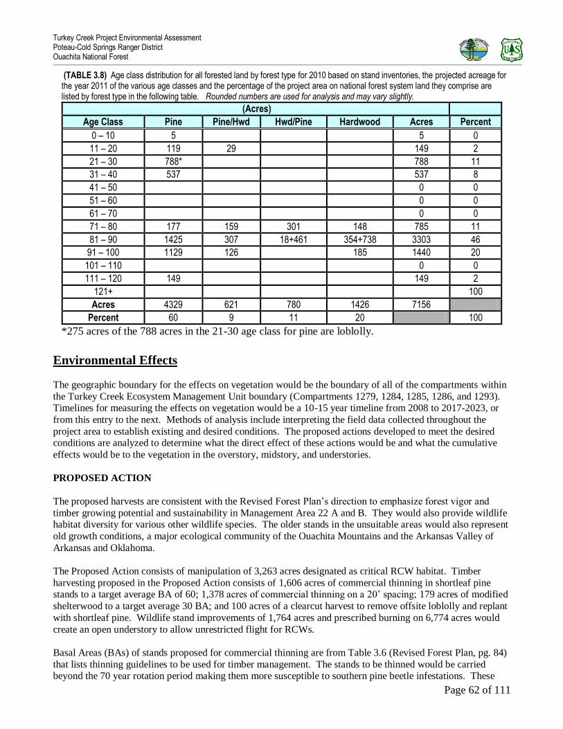
Turkey Creek Project Environmental Assessment Poteau-Cold Springs Ranger District Ouachita National Forest _______________________________________________________________________________________________________________________________________________________________________________________________________________________________________________________________________________________
Page 62 of 111
(TABLE 3.8) Age class distribution for all forested land by forest type for 2010 based on stand inventories, the projected acreage for the year 2011 of the various age classes and the percentage of the project area on national forest system land they comprise are listed by forest type in the following table. Rounded numbers are used for analysis and may vary slightly.
(Acres)
Age Class Pine Pine/Hwd Hwd/Pine Hardwood Acres Percent
0 – 10 5 5 0
11 – 20 119 29 149 2
21 – 30 788* 788 11
31 – 40 537 537 8
41 – 50 0 0
51 – 60 0 0
61 – 70 0 0
71 – 80 177 159 301 148 785 11
81 – 90 1425 307 18+461 354+738 3303 46
91 – 100 1129 126 185 1440 20
101 – 110 0 0
111 – 120 149 149 2
121+ 100
Acres 4329 621 780 1426 7156
Percent 60 9 11 20 100
*275 acres of the 788 acres in the 21-30 age class for pine are loblolly.
Environmental Effects
The geographic boundary for the effects on vegetation would be the boundary of all of the compartments within
the Turkey Creek Ecosystem Management Unit boundary (Compartments 1279, 1284, 1285, 1286, and 1293). Timelines for measuring the effects on vegetation would be a 10-15 year timeline from 2008 to 2017-2023, or
from this entry to the next. Methods of analysis include interpreting the field data collected throughout the
project area to establish existing and desired conditions. The proposed actions developed to meet the desired conditions are analyzed to determine what the direct effect of these actions would be and what the cumulative
effects would be to the vegetation in the overstory, midstory, and understories.
PROPOSED ACTION
The proposed harvests are consistent with the Revised Forest Plan‟s direction to emphasize forest vigor and
timber growing potential and sustainability in Management Area 22 A and B. They would also provide wildlife habitat diversity for various other wildlife species. The older stands in the unsuitable areas would also represent
old growth conditions, a major ecological community of the Ouachita Mountains and the Arkansas Valley of
Arkansas and Oklahoma.
The Proposed Action consists of manipulation of 3,263 acres designated as critical RCW habitat. Timber
harvesting proposed in the Proposed Action consists of 1,606 acres of commercial thinning in shortleaf pine stands to a target average BA of 60; 1,378 acres of commercial thinning on a 20‟ spacing; 179 acres of modified
shelterwood to a target average 30 BA; and 100 acres of a clearcut harvest to remove offsite loblolly and replant
with shortleaf pine. Wildlife stand improvements of 1,764 acres and prescribed burning on 6,774 acres would
create an open understory to allow unrestricted flight for RCWs.
Basal Areas (BAs) of stands proposed for commercial thinning are from Table 3.6 (Revised Forest Plan, pg. 84)
that lists thinning guidelines to be used for timber management. The stands to be thinned would be carried beyond the 70 year rotation period making them more susceptible to southern pine beetle infestations. These

Turkey Creek Project Environmental Assessment Poteau-Cold Springs Ranger District Ouachita National Forest _______________________________________________________________________________________________________________________________________________________________________________________________________________________________________________________________________________________
Page 63 of 111
BAs would reduce the chance that southern pine beetle infestations would spread to adjacent stands. Research
has shown that trees spaced at least 20 to 25 feet apart would still get southern pine beetle infestations but the
beetles would soon disperse and the spot would not spread. Average diameter of the pine sawtimber to be thinned is 12 to 13 inches. Reducing them down to a target 60 BA would leave at least approximately 25‟
between trees. These reduced BAs would eventually reduce the fuel loadings and temporarily create additional
early stage habitat needed by various wildlife species.
Where various harvests are proposed there are portions that would not be thinned or harvested because of some
type of topographic feature making them unsuitable such as rock outcrops or short steep slopes, or varying
widths in riparian zones. The exact acres deducted from these stands would be determined in the field when the timber is marked if the Proposed Action is selected.
A direct effect of the Proposed Action shelterwood harvests and the clearcut would create 279 acres of additional early seral stage habitat added to the existing 5 acres (7.2% of the suitable and 4 % of the overall
forested area). A direct effect of the commercial thinning would be a reduced number of trees in the overstory
taking the low quality trees and trees that are more susceptible to insect infestations first with the remaining
being the trees most suited to meet RCW habitat needs.
Mature growth pine and pine hardwood 80 years old or older would be reduced by 179 acres to 2,957 acres but
increase to 3,293 acres by the next entry. Mature growth hardwood and hardwood/pine would eventually increase to 185 acres in 10 years and to 1,756 acres in 20 years.
There would be reduced understory and midstory numbers (hardwood stems) throughout Turkey Creek where
prescribed burning, harvesting activities, timber stand improvement work, and wildlife stand improvement work would be conducted. The prescribed burning would reduce competing woody vegetation and make some
nutrients tied up in the duff layers available for root uptake of remaining overstory, midstory, and understory
plants. There would also be an increase of grass and forbs numbers and species composition. Scorch would be visible throughout the area burned. Some needle loss from scorch would occur but as long as the buds are not
injured the pine can survive even severe needle loss. Hardwood species most resistant to fire in the project area
and most likely to survive are white oaks, post oaks, red oaks, and black oaks. Hickories, red maple, and cedar are less resistant. Hardwood resistance increases with tree diameter due to bark thickness and fire intensity.
However some hardwood have the ability to resprout, in fact fire increases basal sprouting of hardwood species
like the oaks, cherry, red maple, dogwood, blackgum, and basswood. This ability decreases with age and size.
Season also can determine the amount of mortality from fire. Growing season burns injure or kill pine and hardwood species, depending on the type of fire and intensity.
The modified shelterwood harvests, commercial thinning, loblolly clearcut, wildlife stand improvements, prescribed burning, and scarification if needed, would create growing conditions favorable to shade intolerant
and fire tolerant plant species. The mature growth pine component would initially decrease from the proposed
modified shelterwood harvests then increase throughout, as the mature saw timber component ages into a mature growth condition. Clearcutting in the loblolly stands would begin the process of removing an offsite
species and replace it with native shortleaf pine. The mature hardwood component would develop into a mature
growth condition and respond with more hard and soft mast production providing improved habitat for plant and
animal species that require it. The 148 acres of pine in the 11-20 year age class would eventually move into pole size timber while still providing some early seral stage habitat structure when timber stand improvements
and prescribed burning is conducted. The understory throughout the project area would show an increased
growth response after removing part of the overstory and midstory with the commercial thinning. The overstory would also respond with more vigor making them more resistant to insect and disease infestations.
As an indirect effect of removing part of the overstory and midstory, the understory would be a rapid response
due to increased sunlight that would improve growing conditions for shortleaf pine, some hardwoods, and many species of non-woody plants. A combination of the proposed actions and continued prescribed burning

Turkey Creek Project Environmental Assessment Poteau-Cold Springs Ranger District Ouachita National Forest _______________________________________________________________________________________________________________________________________________________________________________________________________________________________________________________________________________________
Page 64 of 111
program would eventually result in the restoration of a missing component of RCW habitat, developing old
growth conditions in the unsuitable stands and healthy, sustainable stands of native shortleaf pine and
hardwoods where timber activities are suitable.
These actions would also result in crown closure occurring first in the stands where the pines would be thinned
to 60 BA. Crown closure would have little effect on the established pine saplings in a shelterwood condition.
The growth response of the mature pine and hardwood would not be as vigorous as in younger stands since many of the trees retained are mature sawtimber trees that have slowed in growth. However, even though the
growth response would be less when compared to younger pine and hardwood stands the reduction of the
number of trees per acre by harvesting creating more access to sunlight, water, and nutrients would still result in some improved stand vigor and would reduce the chance of disease or insect infestation in the remaining trees.
The acres of hardwood and hardwood/pine stands would be managed to maintain and enhance mast-producing
hardwoods.
CUMULATIVE EFFECTS
Cumulatively, the overall stand vigor and health of Turkey Creek would be improved with the implementation of the Proposed Action. Non-native species would be reduced and replaced with native species. Reduced
competition for water, sunlight, and nutrients would create an improved growing environment for the residual
pine, and hardwood species including the red oaks and make them more resistant to various disease and insect infestations.
Other cumulative effects of the Proposed Action would be enhanced growth of remaining shade intolerant trees
including cone production in shortleaf pine and hard and soft mast production in various shade intolerant hardwood species. The prescribed burning would resemble the natural fire events that helped develop the
overstory, midstory, and understory types that probably existed before European settlement. An overall
cumulative effect would be an increase in diversity of fire tolerant plant species.
Other than the direct, indirect, and cumulative impacts mentioned above from the proposed harvest activities,
and from past, present committed, or reasonably foreseeable future activities there should not be any adverse effects expected to the various forms of vegetation in this analysis area from these actions nor as an
accumulation of impacts from other harvest conducted in adjacent compartments or on private land within this
watershed.
Effects of Herbicide Application
Removing most of the overstory with the shelterwood harvest, or all of the overstory with the clearcut will promote a vigorous understory species response. To ensure at least 300 free-to-grow pine seedlings are
established after seed fall or planting a herbicide application could be necessary. If herbicides are used it will be
selectively applied to individual stems. Application by back-pack foliar spray, by injection, or by application to cut stems makes it possible to leave desirable species in groups or individual stems. Direct effects, as with a
manual release treatment, vegetative diversity will not be compromised. By reducing species in general, only
actual numbers of species on an area will be affected. Cumulatively, the pine and hardwood species left after
treatment would increase in diameter and height growth. Based on past experience with herbicide treatments, it is anticipated that a substantial component of hardwood species, grasses and forbs will be present in regenerated
stands after treatment. Fryar and Clerke (1988) found pine regeneration areas on the Ouachita National Forest
had large numbers of hardwood in the stands after a variety of herbicide treatments.
NO ACTION ALTERNATIVE I (Deferred Management Activities)
If this alternative is implemented, early seral stage habitat, an ecologically important part of the overall forest health would be missing as a direct effect. There would be no open stands or developed wildlife openings, or

Turkey Creek Project Environmental Assessment Poteau-Cold Springs Ranger District Ouachita National Forest _______________________________________________________________________________________________________________________________________________________________________________________________________________________________________________________________________________________
Page 65 of 111
burning program to provide some type of early seral stage structure needed by various wildlife species. There
would be no improvement in stand health because all the conditions that make the pine and red oaks vulnerable
now would continue to exist. Non-native species would continue to grow and increase reducing the native species throughout. The understory and midstory would remain dense with fire intolerant species and invader
type of species like cedar and red maple that normally do not occupy sites where fire plays a natural role in
stand development. Heavy fuel loadings from natural accumulation of fuel buildup would make Turkey Creek
susceptible to a hot crown killing wildfire.
An indirect effect could lead to the condition similar to western states where there would be old, dense, and
insect killed trees, causing unnaturally high fuel loading. This would consist of old, dense, and insect or disease killed trees that would cause unnatural fuel loading. If a wild fire should occur it would become more difficult
and dangerous to control. Dense stands of timbers that have been susceptible to southern pine beetle infestations
and red oak decline would become increasingly vulnerable due to the continued deteriorating conditions that make them vulnerable now. In 1995 and 1996, several large Southern pine beetle (SPB) spots were detected and
treated in Turkey Creek. With the No Action alternative, SPB and Ips infestations would potentially be more
frequent and more difficult to control. Critical RCW habitat would not be created or existing habitat would
decline.
CUMULATIVE EFFECTS
A cumulative effect would be that shade intolerant species such as shortleaf pine, northern and southern red
oaks, and black cherry would decline in numbers and eventually be replaced by shade tolerant species like
maple, hickory, black gum, and cedar that are already in the understory and midstory. This is currently
happening where red oak decline is present on some of the ridge tops. Some red oaks on these ridges are dying from a combination of drought, hypoxylon canker, overstocking, low site indexes, and various borers although
not as bad here as in other parts of the district at this time. Non-native species would continue to grow and
increase possibly becoming established throughout and becoming a vector to insect or disease infestations that would spread to native populations in this area and adjacent areas.
There would be some mature growth pine and hardwood scattered in pockets throughout the area growing under stressed conditions. Lack of water and nutrients caused by overcrowding in the overstory, midstory, and
understory would contribute to individual trees inability to withstand any insect or disease infestations that
develop. Native grasses and other shade intolerant species would decline and be replaced by invader type
species such as cedar and red maple. Growth in existing young pine stands would slow, eventually reducing tree vigor, quality, and stocking in favor of more shade intolerant species.
Fuel load accumulations from natural events have increased from 4 to 6 tons per acre to as much as 8-10 tons and more, with many larger branches and tree boles on the ground. This is creating a situation where any
wildfire could potentially become a hard to control, crown killing fire. A wildfire occurring in this fuel type can
cause erratic fire behavior with spotting potential. Fires of this intensity have the potential to damage forest resources and endanger the life and property of firefighters and the public.
NO HERBICIDE ALTERNATIVE II
The effects would be the same as the Proposed Action. The only difference between the Proposed Action and
Alternative II is herbicide use is not proposed in this alternative.
CUMULATIVE EFFECTS
Without the use of herbicides, several manual methods would be required to control the non-native, off-site
species. These species would continue to send up sprouts until the reserves stored in the root system could no longer sustain the plant.

Turkey Creek Project Environmental Assessment Poteau-Cold Springs Ranger District Ouachita National Forest _______________________________________________________________________________________________________________________________________________________________________________________________________________________________________________________________________________________
Page 66 of 111
Wildlife, Habitat, and Fisheries
Present Conditions Turkey Creek Ecological Management Unit totals 7,156 acres of National Forest land.
This EMU has privately owned lands within its boundary, therefore; it is influenced by private land
management practices.
There are currently 5 acres in the 0-10 year-old age class on National Forest land in this project area
making this EMU poor habitat for early seral stage species such as Prairie warblers and Northern
bobwhites.
Since little burning has occurred in this emu over the last several years, there is now limited tender
browse within reach for deer.
Many mature forest stands have a dense midstory that limits grasses and non-woody understory to
occur.
Open road density is at 1.83 mi./sq. mile for Management Area 22, exceeding the 2005 Revised Land
and Resource Management Plan criteria of 0.75 mile per square mile for Management Area 22.
This EMU is part of the RCW HMA and currently has zero active clusters.
Streams from this EMU flow into the Fourche LaFave River approximately 6 miles upriver from a
known Harperella location.
Deer are heavily hunted in this area.
Currently, 5,973 acres of MA 22 (Shortleaf pine/blue stem grass/RCW), and 1,183 acres of MA 9 are allocated
to these management areas in Turkey Creek EMU.
These existing conditions concerning wildlife, fish and T&E species and their habitats, just to name a few, were
considered when developing the Proposed Action for this project area.
Revised Forest Plan (RFP) Design Criteria WF001: On a project-by-project basis, provide grass-forb or
shrub-seedling habitats (include regeneration areas 0-10 years in age, areas of recent heavy storm or insect
damage, and woodland conditions) at a rate of:
A minimum of 4 percent of the suitable acres in MA22, Shortleaf Pine/Bluestem Grass/RCW (Ouachita
Mountains Habitat Diversity Emphasis, West Gulf Coastal Plain, Habitat Diversity Emphasis, Lands
around Lakes, Semi-primitive Areas, and Winding Stair Mountain National Recreation Area and
Associated Non-Wilderness Designations, respectively),
At least 152 acres of early seral stage habit needs to be created to meet these criteria in Turkey Creek EMU.
This is figured by the following equation:
For MA 22: 3,936 ac. suitable X 0.04 = 157 acres – 5 acres existing = 152 acres to create.
RFP Design Criteria WF002: Limit even-age regeneration cutting in each project area to no more than 8.3 percent of the suitable acres managed under even-aged prescription for Management Area 22:
4-8.3 percent in Shortleaf Pine/Bluestem Grass/RCW
In Turkey Creek, no more than 322 acres of 0-10 age-class can be created by this Proposed Action. This is
figured by the following equation:
In MA 22: 3,936 suitable acres X 0.083 = 327 acres – 5 existing = 322 acres can be created.

Turkey Creek Project Environmental Assessment Poteau-Cold Springs Ranger District Ouachita National Forest _______________________________________________________________________________________________________________________________________________________________________________________________________________________________________________________________________________________
Page 67 of 111
RFP Design Criteria WF003: Provide for and designate areas for mast production at the approximate rate of 20 percent of each project area. Hardwood and hardwood-pine forest types, age 50 and older, comprise this
component.
The hardwood component, which is over 50 years old, is currently about 31% (2,207 acres). This
project area far exceeds this Revised Forest Plan Design Criteria.
RFP Design Criteria WF006: Retain or develop mature growth pine habitats (80 years old or greater) and
mature growth hardwood habitats (100 years old or greater) at a rate of five percent of each broad cover type within each project analysis area.
For Turkey Creek EMU, this would be at least 247 acres (5 % of 4,949 acres) of mature growth pine
80 yrs.-old and older and 110 acres (5 % of 2,207 acres) of mature growth hardwood 100 yrs. old and older.
There are currently 3,398 acres (47%) of pine considered mature growth pine 80 years old or older.
There are currently 0 acres (0 %) of mature growth hardwood stands 100 years old or older within
Turkey Creek.
RFP Design Criteria WF012: Where possible, seasonally close roads during critical periods for wildlife (March–August).
Currently the open road density for Turkey Creek is 1.83 miles per square mile. These figures include
both FS roads and private roads. This project area does not currently meet the Revised Forest Plan Design Criteria of 0.75 miles per square mile for Management Area 22.
RFP Design Criteria WF010: Where there is no existing water source, provide at least one wildlife pond per160 acres where needed to accomplish wildlife objectives.
Currently, Turkey Creek contains 57 existing waterholes. Reconstruction is necessary on most of these
waterholes to make the existing waterholes reliable as year-round water sources.
No additional water sources are needed to meet RFP design criteria WF010.
Browse is limited in this project area due to the lack of prescribed burning in recent years. Cavities are also
limited in this project area. Many snags and cavities were naturally created by the ice storm in 2000 but these
trees are now falling to the ground.

Turkey Creek Project Environmental Assessment Poteau-Cold Springs Ranger District Ouachita National Forest _______________________________________________________________________________________________________________________________________________________________________________________________________________________________________________________________________________________
Page 68 of 111
Effects of Management Activities on Wildlife
PROPOSED ACTION and Alternative II
The RFP Design Criteria was used to develop the Proposed Action and Alternative II for Turkey creek. These
criteria are in place to protect and expand populations of endangered species and maintain viable populations of all native wildlife species on the forest. Actions proposed in this environmental assessment would begin with a
timber sale (and associated road work) that could not be sold until late 2011 or later. This sale(s) would
probably take 3-5 years to log all stands treated by timber harvest. Other activities would occur after the timber sale is completed.
Road work would include pre-haul maintenance of 3.54 miles, reconstruction of 12.19 miles of existing roads,
new construction of 1.85 miles, and creating temporary roads (12.0 miles) and log decks within stands to be thinned or regenerated. Reconstruction/maintenance includes brushing back right-of-ways, replacing rusted out
culverts, and adding surface gravel where necessary along the timber sale haul routes. Road reconstruction
would decrease the possibility of increased erosion and sedimentation in the local streams. Road obliteration of 1.75 miles will also be completed after the timber sale is completed. New construction of 1.85 miles of road in
this project area would improve access to a part of this area that currently does not have vehicle access. This
new construction will enable needed vegetation management treatments that will enhance wildlife habitat but
could disturb wildlife species particularly during nesting/breeding/young rearing seasons. Closing the new construction at least seasonally should reduce human disturbance in the future.
RFP Design Criteria WF012: The Proposed Action and Alternative II will lower the open road density from 1.83 to 1.65 miles per square mile. Temporary roads and log decks are seeded after they are no longer utilized.
These temporary roads and log decks along with firelines would then become temporary wildlife openings. The
objective of an opening is to provide a supplemental food source to sustain wildlife populations in areas of poor
habitat, or to supplement food shortages on a seasonal or temporary basis. These openings also provide nesting and brood habitat for game and non-game birds.
Timber Harvest, particularly even-age regeneration cuts, is often referred to by the public as deforestation. This is not the case. The forested area stays forested but becomes a different age with differing vertical
structure. These harvest cuts mimic natural occurrences such as wind storms or wild fire. Deforestation occurs
when forested land is cleared and then used for other uses such as housing developments.
Regeneration cutting (modified seed tree and clearcut of 279 (179 + 100) acres would produce enough early
seral stage habitats to have appropriate habitat capability for viable populations of many early seral stage species
and not exceed standards that protects sustainability of the forest. Both RFP Design Criteria WF001 and
WF002 are met by the Proposed Action and Alternative II.
Reforestation treatments (even-age/seed tree and clearcut harvested stands) would occur on 279 acres of new regeneration units. This would consist of utilizing hand tools and prescribed burning as a first treatment option.
If prescribed burning and hand tools does not achieve the desired results, or if prescribed burning cannot be
conducted, mechanical scarification would be used. The intent of mechanical scarification is to disturb the duff
layer and expose as minimum amount of soil as possible with 8 ft. spacing on contour throughout the seed tree stands. These treatments would create early seral stage habitat such as grasses, forbs, and woody re-sprouts for
wildlife use. The re-planting of the 100 acres of clearcuts with native shortleaf pine would lower the amount of
off-site pine species in this EMU.
In the Proposed Action ONLY, herbicide application would be used if needed to site prepare for natural
regeneration. The herbicide of choice would have glyphosate as the active ingredient. Seed tree stands would be planted with Shortleaf pine if the sites do not seed within 5 years after harvest. The objective of reforestation

Turkey Creek Project Environmental Assessment Poteau-Cold Springs Ranger District Ouachita National Forest _______________________________________________________________________________________________________________________________________________________________________________________________________________________________________________________________________________________
Page 69 of 111
treatments is to prepare the seed bed for regeneration. Early seral stage habitat would be created. The herbicide
would have no detrimental effect to wildlife (Syracuse Environmental Research Associates (SERA).
Commercial thinning would occur on 1,606 acres of pine forest to achieve basal areas of 60 square feet of pine
per acre and commercial thinning on 20 foot spacing would occur on 1,378 acres. This would develop the
crowns of existing hardwoods and remaining pines in these pine stands. Thinning would increase sunlight to the
forest floor, increase the understory species, and further develop hard and soft mast capabilities for this project area.
RFP Design Criteria WF003 (Provide for and designate areas for mast production at the approximate
rate of 20 percent of each project area. Hardwood and hardwood-pine forest types, age 50 and older,
comprise this component.) Turkey creek EMU currently exceeds this RFP Design Criteria. About 30.8%
(2207 acres) of Turkey creek can be considered suitable for mast production
RFP Design Criteria WF006 (Retain or develop mature growth…) Turkey creek currently far exceeds this criteria for pine with over 47% of the pine stands currently in a mature growth condition. However, Turkey
creek currently has 0 acres in a mature growth condition for hardwoods. The Proposed Action or Alternative II
does not negatively alter this design criterion for this EMU. In the next 10 years 185 acres of hardwood forest types will mature to an age that will exceed this criteria for this EMU.
Prescribed burning totaling 6,774 acres would first occur after timber harvest is completed in Turkey Creek. Multiple objectives would be met by prescribed burning such as wildlife habitat improvement, control
understory, and fuel reduction. These burns (every 3 - 5 years) could top-kill some hardwoods if they are less
than 2” at collar height but re-sprouting of these hardwood stems would occur. While some cover would be lost
in a prescribed burn, there would be an increase in grasses and forbs and this type of cover would replace what may be lost in a short time. This activity would increase the amount and palatability of browse utilized by
various wildlife species such as white-tailed deer.
Timber stand improvements (release of 284 ac. and pre-commercial thinning of 425 ac.) [some of these are
repeated acres] in the Proposed Action and Alternative II would open these stands for more use by early seral
stage wildlife species. The dense conditions now present that do not allow for much understory vegetation in
these stands would be reduced. The re-sprouting of hardwoods after the hand tool treatments would also produce new browse utilized by various wildlife species such as white-tailed deer.
Wildlife stand improvement of 1,764 acres of pine stands would further open these stands to allow sunlight to the forest floor and encourage grasses and forbs in the understory. Remaining hardwoods would have more
room and less competition and be able to develop healthier crowns and thus increase in mast production. The
WSI would also encourage re-sprouting of many oaks and other hardwoods. These re-sprouts would be used as browse by various wildlife species such as white-tailed deer.
Wildlife waterhole reconstruction (45) would provide year-round permanent water sources, which would be
utilized by many wildlife species. These waterholes would not be stocked and would provide locations for increased amphibian reproduction. RFP Design Criteria WF010 (water developments) will be met by the
Proposed Action and Alternative II.
Nest Box placement (90) would provide cavities for species such as wood ducks and many bat species at
waterhole locations and bluebirds in regeneration areas. Many snags and cavities were naturally created by the
ice storm in 2000 but these trees are now falling to the ground. Placing these nest structures at ponds and in regeneration areas will replace many of the snags that are now fall.

Turkey Creek Project Environmental Assessment Poteau-Cold Springs Ranger District Ouachita National Forest _______________________________________________________________________________________________________________________________________________________________________________________________________________________________________________________________________________________
Page 70 of 111
NO ACTION ALTERNATIVE I (Deferred Management Activities)
The effects of selecting the No Action alternative for Turkey creek are many. Directly, the forest stands would continue to age and mature. Leaf litter would continue to build on the forest floor in mature and maturing stands
of pine and hardwoods. Understory plant species would begin to decline in species variety and overall numbers.
Early seral stage type habitat and browse would continue to disappear. Open-road density would remain at its
current level. Some waterholes would continue to dry up during seasons of drought. Thick existing plantations would continue to be dense and inaccessible to many wildlife species. Indirectly, species of wildlife requiring
open areas such as Northern bobwhite, Bachman‟s sparrow, and Eastern bluebird and species requiring a mosaic
of forest age classes such as deer, wild turkey, and black bear would move out of the area. Timber stands currently suitable for RCW nesting and foraging would deteriorate due to increases in overstory and midstory
density. No other activities are known for this project area. There would be no cumulative effects.
Effects on Management Indicator Species (MIS)
The Forest Service Manual (FSM) defines MIS as “any species, or group of species, or species habitat element
selected to focus management attention for the purpose of resource production, population recovery, maintenance of population viability, or ecosystem diversity”
Land managers are directed to select management indicators for a Forest Plan or project that best represent the issues, concerns, and opportunities to support recovery of Federally-listed species, provide continued viability of
sensitive species, and enhance management of wildlife and fish for commercial, recreational, scientific,
subsistence, or aesthetic values or uses. “Management indicators representing overall objectives for wildlife,
fish, and plants may include species, groups of species with similar habitat relationships, or habitats that are of high concern”.

Turkey Creek Project Environmental Assessment Poteau-Cold Springs Ranger District Ouachita National Forest _______________________________________________________________________________________________________________________________________________________________________________________________________________________________________________________________________________________
Page 71 of 111
This current list of MIS (with associated purpose or habitat categories) is shown in Table 3.9.
(TABLE 3.9) Management Indicator Species (MIS) and Associated Purposes
Life form Scientific name Common name Selected for this project? (YES/NO)
DEMAND SPECIES
Bird Colinus virginianus Northern Bobwhite YES
Bird Meleagris gallopavo Eastern wild turkey YES
Fish Micropterus dolomieui Smallmouth bass – Species not in Turkey creek EMU NO
Mammal Odocoileus virginianus White-tailed deer YES
VIABILITY CONCERN SPECIES – addressed in T&E section of this EA
Bird Picoides borealis Red-cockaded woodpecker YES
ADEQUATE EARLY FOREST STAGE COVER
Bird Colinus virginianus Northern Bobwhite YES Bird Dendroica discolor Prairie warbler YES
ADEQUATE MATURE PINE FOREST COVER
Bird Dryocopus pileatus Pileated woodpecker YES
Bird Picoides borealis Red-cockaded woodpecker (MA 22) YES
Bird Piranga olivacea Scarlet tanager YES
ADEQUATE MATURE HARDWOOD FOREST COVER
Bird Dryocopus pileatus Pileated woodpecker YES
Bird Piranga olivacea Scarlet tanager YES
RECREATIONAL FISHING QUALITY (Lakes and Ponds)
Fish Lepomis macrochirus Bluegill NO Fish Lepomis microlophus Redear sunfish NO Fish Micropterus salmoides Largemouth bass NO
HABITAT QUALITY OF STREAMS: Arkansas River Valley Habitat Category
Fish Ameiurus natalis Yellow bullhead YES
Fish Campostoma anomalum Central stoneroller YES Fish Etheostoma whipplei Redfin darter YES Fish Lepomis cyanellus Green sunfish YES Fish Lepomis megalotis Longear sunfish YES
HABITAT QUALITY OF STREAMS: Gulf Coastal Plain -- Habitat Category not in Turkey creek
Fish Aphredoderus sayanus Pirate perch NO
Fish Campostoma anomalum Central stoneroller NO
Fish Erimyzon oblongus Creek chubsucker NO
Fish Lepomis cyanellus Green sunfish NO
Fish Lepomis megalotis Longear sunfish NO
HABITAT QUALITY OF STREAMS: Ouachita Mountains -- Habitat Category not in Turkey creek
Fish Campostoma anomalum Central stoneroller NO
Fish Etheostoma nigrum Johnny darter (w/in leopard darter range only) NO
Fish Etheostoma radiosum Orangebelly darter NO Fish Etheostoma whipplei Redfin darter NO Fish Fundulus catenatus Northern studfish NO Fish Hypentilium nigricans Northern hog sucker NO Fish Lepomis cyanellus Green sunfish NO Fish Lepomis megalotis Longear sunfish NO Fish Luxilus chrysocephalus Striped shiner NO Fish Micropterus dolomieui Smallmouth bass NO Fish Percina copelandi Channel darter (w/in leopard darter range only) NO
Note that several MIS appear under more than one habitat or purpose category.

Turkey Creek Project Environmental Assessment Poteau Ranger District Ouachita National Forest _________________________________________________________________________________________________________________________________________________________________________________________________________________________________________________________________________________
Page 72 of 111
MIS selected for this project - The Ouachita National Forest MIS list was reviewed and a subset of categories
and associated MIS was selected for this project. The right column in Table 3.8 indicates which MIS were
selected for this project. The following MIS categories and their associated MIS were eliminated from further
consideration because they do not occur on National Forest land in this project area: Habitat Quality of Streams (Gulf Coastal Plain and Ouachita Mountains). In the Demand Species category, smallmouth bass was not
selected because there is no suitable habitat for this species within Turkey Creek EMU. The remaining
categories are represented in the project area and summarized in Table 3.10. (TABLE 3.10) Management Indicator Species (MIS) for Turkey creek COMMON NAME PURPOSE OF SELECTION 1. Bobwhite quail Demand Species and Adequate Early Forest Stage Cover
2. Eastern wild turkey Demand Species 3. White-tailed deer Demand Species
4. Prairie warbler Adequate Early Forest Stage Cover
5. Pileated woodpecker Adequate Mature Pine Forest Cover /Adequate Mature Hardwood Forest Cover
6. Scarlet tanager Adequate Mature Pine Forest Cover /Adequate Mature Hardwood Forest Cover
7. Red-cockaded woodpecker
Adequate Mature Pine Forest Cover /Viability Concern Species– addressed in T&E section of this EA
8. Habitat Quality of Streams: Arkansas River Valley
8a. Yellow bullhead Habitat Quality of Streams: Arkansas River Valley
8b. Central stoneroller Habitat Quality of Streams: Arkansas River Valley
8c. Redfin darter Habitat Quality of Streams: Arkansas River Valley
8d. Green sunfish Habitat Quality of Streams: Arkansas River Valley
8e. Longear sunfish Habitat Quality of Streams: Arkansas River Valley
Effects on project MIS - Six terrestrial animal MIS (1-6 above) were modeled to compare habitat capabilities
within the project area for the No Action alternative and the Proposed Action/Alternative II (Table 3.10).
It should be noted that this model assumes that all treatments occur within the same year (when, in fact, treatments may occur over the course of the 10 year planning period; therefore, actual
habitat capability would differ from the projections presented here).
(TABLE 3.11) Response of Selected MIS to Alternative by Decade of Implementation (Habitat Capability Model – numbers are rounded to closest whole number)
MANAGEMENT INDICATOR SPECIES (MIS)
Quail (1) Turkey (2) Deer (3)
Prairie
Warbler (4)
Pileated
Woodpecker (5) Scarlet
Tanager (6)
INDIVIDUALS PER SQUARE MILE
NO ACTION Baseline 11.17 6.51 13.92 2.99 32.52 28.91 After 10 Years 10.83 6.54 13.95 0.09 33.76 29.67
PROPOSED ACTION & ALTERNATIVE II After Initial treatments 110.38 10.97 30.75 134.88 15.17 25.68
After 10 Years 22.81 6.44 17.03 10.65 32.95 29.49
Model coefficients are not available for the other MIS (7 & 8), which were selected for this project, but direct, indirect, and cumulative effects on their populations are discussed below.

Turkey Creek Project Environmental Assessment Poteau Ranger District Ouachita National Forest _________________________________________________________________________________________________________________________________________________________________________________________________________________________________________________________________________________
Page 73 of 111
PROPOSED ACTION & ALTERNATIVE II
The Proposed Action would produce 279 acres of early seral stage habitat through tree harvesting and site preparation activities. Under the Proposed Action and Alternative II, habitat availability for each terrestrial
vertebrate MIS would be sufficient to achieve all of the minimum population objectives and, in several cases, meet or exceed the optimum levels.
Quail: Habitat availability and population trend for quail, a Demand Species that also represents Adequate Early Forest Stage Cover, would increase over 9-fold after initial treatments of timber harvest, TSI, WSI, and
prescribed burning. Directly, some nest could be disturbed by logging equipment and by prescribed burning if
done during nesting season. Indirectly, the Proposed Action and Alternative II would produce more preferred habitat of the quail by producing enhanced nesting cover, an abundance of food, and reliable water sources.
These activities should support a positive population trend.
Deer and Turkey: Two MIS species representing Demand Species, deer and turkey, would generally both fair better under the Proposed Action or Alternative II than under No Action. There would be no direct affect to
deer but some turkey nest could be disturbed if activities occur during nesting season. Indirectly, the habitat that
both species prefer would be improved by action. Indirectly, both species would benefit from the overall affects of the Proposed Action or Alternative II by the enhancement of food, cover and water availability.
Prairie Warbler: Prairie Warbler is an MIS for Adequate Early Forest Stage Cover. Its requirements can be met
by forest stands under the age of 20 and by prescribed burning in open pine stands. Treatments in the Proposed Action and Alternative II lead to impressive population levels following treatments. There would be no
appreciable direct affect to the prairie warbler though some nest disturbance could occur. Indirectly, with the
implementation of an action alternative, more of the preferred habitat of the prairie warbler would be produced enhancing nesting cover and the abundance of food and water available, supporting a positive population trend.
Pileated Woodpecker and Scarlet Tanager: For these MIS representing mature forest types, habitat capabilities are projected to be slightly lowered by the proposed treatments. The amount of Adequate Mature Forest Cover
exceeds the optimum needs for Pileated Woodpecker and Scarlet Tanager for pine but currently falls short in
meeting hardwood needs. However, within the next 10 years 185 acres of hardwood forest types will mature to a
suitable age that will meet the needs of these two species and this EMU will then exceed this criteria for mature growth hardwood. Habitats for both species are more than adequate outside the project area. There would be no
direct, indirect or cumulative affects by the proposed activities.
This Proposed Action or Alternative II would perpetuate habitat capabilities for each of the selected terrestrial
vertebrate MIS. The Proposed Action and Alternative II meet most of the wildlife associated Revised Forest
Plan (2005) Design Criteria mentioned above in this wildlife section with the exception of WF006. In time (9 years) RFP Design criteria WF 006 will be exceeded by both the Proposed Action and Alternative II.
Habitat Quality of Streams: Arkansas River Valley MIS (MIS species 8a.–8e.): The Proposed Action or
Alternative II would have no appreciable direct, indirect, or cumulative effect on stream habitats (Habitat Quality of Streams: Arkansas River Valley) and the associated aquatic MIS. All streams would be protected
from the direct effects of logging, wildlife habitat improvement activities, and prescribed burning. Construction
of new roads and reconstruction of existing roads and replacing of several rusted out culverts that are part of the road reconstruction would have a temporary negative effect on the small streams they are installed on.
Replacing these culverts is necessary to allow proper stream flow, fish passage, and area access. Road
reconstruction would decrease existing erosion and sedimentation. Indirectly, an insignificant increase in
sedimentation may occur in some streams. When Cumulative Impacts Analysis (CIA) was run on this project, each watershed was either no net increase or indicates a low risk for sedimentation in upland Ouachita

Turkey Creek Project Environmental Assessment Poteau Ranger District Ouachita National Forest _________________________________________________________________________________________________________________________________________________________________________________________________________________________________________________________________________________
Page 74 of 111
watersheds. The Proposed Action or Alternative II would have little effect on stream habitats in Turkey creek or
the stream-associated MIS.
There are no other known activities planned at this time in and around this project area on Forest Service lands that would produce a cumulative Impact to any of the MIS species listed in Table 3.9 above.
NO ACTION ALTERNATIVE
Quail and Prairie Warbler: The No Action Alternative would have no direct effect on these species and produce no new early seral stage habitat (MIS category: Adequate Early Forest Stage Cover). It would result in not
meeting the minimum amount of early seral stage conditions in this project area. Habitat availability for prairie
warblers would become insufficient to meet the projected minimum available habitat in this area through time.
Cumulatively, this alternative would perpetuate conditions that keep quail and Prairie Warbler numbers low in the Forest.
Pileated Woodpecker, Turkey, Scarlet Tanager and White-tailed Deer: There would be no direct effect on these species. Habitat availability for the other terrestrial vertebrate MIS would change little over the first 10 years
(indirect and cumulative effect). The No Action Alternative meets Forest Plan objectives for Adequate Mature
Forest Cover for Pine and will for Hardwood forest types in 9 years (same as the Proposed Action and Alternative II). Forest plan objectives will also be met for two of the three MIS representing Demand Species
(deer and turkey but not quail.
Stream Habitats and Associated MIS: The No Action Alternative would have no appreciable direct or indirect effects on stream habitats or the associated MIS (Habitat Quality of Streams: Arkansas River Valley) due to the
lack of active management. These are species 8a.-8e., as listed in Table 3.9.
Effects on MIS in the context of Forest-wide trends (USDA Forest Service, September 2010)
The Bobwhite quail has experienced population declines across Arkansas due to decreases in early seral stage
habitat; loss of agricultural lands, and changes in agricultural practices. Bobwhite quail call counts, Breeding
Bird Census data, both indicate a slightly decreasing quail population which is in line with the slightly decreasing Habitat Capability for the Forest. Habitat capability for the Forest should improve when early seral
habitat creation reaches the 2005 Forest Plan objective. In the period between 2000 and 2009, spring call counts
have varied from a high of 1.0 bird per stop in 2005 to a low of 0.33 birds per stop in 2009. This data indicate a
slight decreasing trend. Landbird point survey data collected over the past 13 years (1997 through 2009) indicate a slight downward trend in birds detected in the Ouachita National Forest. Regional declining
population trends for the Ozark-Ouachita Plateau are also reported. The Proposed Action and Alternative II
would result in improved habitat condition and increase habitat availability for this species. The No Action alternative would not result in any additional habitat improvements.
The turkey population on the Ouachita NF has been declining as well as populations region wide. Over the past
several years (2000 – 2009), the number of turkey poults per hen has varied from a low of 1.4 poults per hen in 2009 to a high of 3.5 poults per hen in 2000. Turkey harvest and Landbird point Survey data indicate negative
trends for the turkey population. However, habitat capability modeling shows a positive trend for turkey
populations above the minimum population object for the first period in the 2005 forest plan. The sustained high levels for habitat capability would indicate that the drop in harvest and reduction in poults per hen, and
birds detected on the Landbird points are due to factors other than habitat. The Arkansas Game and Fish
Commission has shortened the spring season and eliminated the fall season to stimulate more positive population responses. Due to conflicting indicators, additional data should be monitored to determine in
additional management changes are warranted. The treatments of the Proposed Action and Alternative II would

Turkey Creek Project Environmental Assessment Poteau Ranger District Ouachita National Forest _________________________________________________________________________________________________________________________________________________________________________________________________________________________________________________________________________________
Page 75 of 111
result in improved habitat condition and increase in habitat availability for this species; the No Action
Alternative would not result in any additional habitat benefits.
Based on the annual spotlight survey data collected during 2000-2009, average deer density has varied from a low of 29 deer per square mile in 2001, to 95 deer per square mile in 2008. The average density for the Forest
for all years is 51 deer per square mile. This level exceeds Forest Plan objectives for deer per square mile. The
Proposed Action and Alternative II would contribute positively to deer by improving habitat condition and increasing habitat availability. The No Action alternative would not.
The Landbird point data for Prairie warbler indicate a downward trend for the time period of 1997-2009 for the
Ouachita NF as well as survey wide. This decline is considered directly related to the decline in the acres of early seral habitat. The Proposed Action and Alternative II would result in improved habitat condition and an
increase in habitat availability for this species; the No Action Alternative would not result in any additional
habitat benefits.
The Pileated woodpecker has a stable population trend across its overall range, and its long-term persistence on
the Forest is not in question. Habitat capability data suggest that this species‟ primary habitat, mature hardwood forest, is increasing. Population trends and habitat capability data are mixed. The Landbird point data indicated
a slight downward trend in the period of 1997-2009, for the Ouachita NF. CompPATS estimating the habitat
capability using all forest types indicate an increasing trend. These data are for pine, pine-hardwood, hardwood,
and hardwood-pine stands with the greatest value being for stands greater than or equal to 41 years old. As these stands age, the habitat capability to support the pileated woodpecker should continue to improve. The Proposed
Action and Alternative II would probably result in a temporary reduction of habitat for this species due to
continued disturbance. However, over 1/2 of Turkey creek is suitable habitat for pileated woodpecker. The No Action Alternative would probably result in no reduction in habitat for this species.
Landbird point data for Scarlet tanager indicate an overall stable trend for 1997 – 2009, for the Ouachita NF. Forest Landbird point data and habitat capability data both support a stable trend for the Scarlet tanager.
On the Forest, there are 481,226 acres of hardwood and hardwood/pine forest types greater than 41 years old
that will continue to mature. The continued long-term viability of this species is not in question. With the
maturing of nearly 500,000 acres of hardwood, hardwood/pine availability of adequate habitat is secure. The Proposed Action and Alternative II would result in a temporary reduction of habitat for this species due to
disturbance. The No Action Alternative would result in no reduction in habitat for this species.
The Proposed Action, Alternative II and the No Action alternative would have no appreciable direct, indirect, or
cumulative effects on stream habitats and the associated aquatic MIS. All streams would be protected from the
direct effects of logging, wildlife habitat improvement activities, and prescribed burning. Cumulatively, the
proposed action would have no effect on stream habitats in Turkey creek or the stream-associated MIS. This project would have no effect on Forest-wide trends of these MIS.
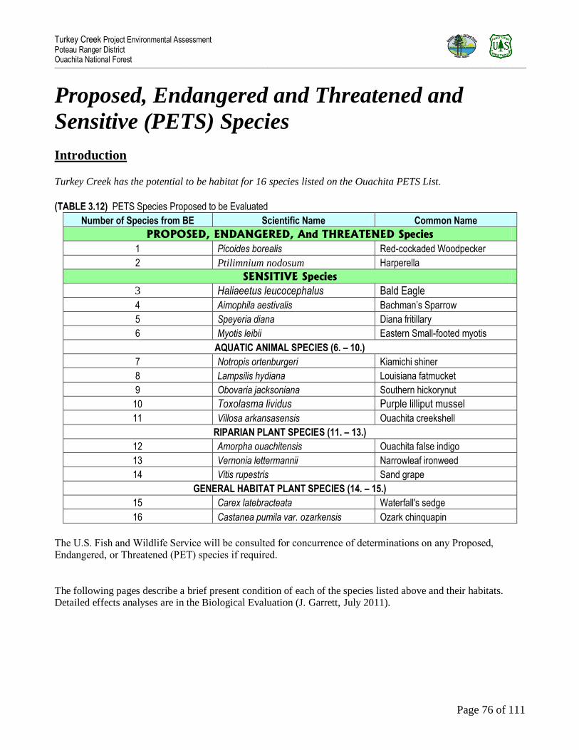
Turkey Creek Project Environmental Assessment Poteau Ranger District Ouachita National Forest _________________________________________________________________________________________________________________________________________________________________________________________________________________________________________________________________________________
Page 76 of 111
Proposed, Endangered and Threatened and
Sensitive (PETS) Species
Introduction Turkey Creek has the potential to be habitat for 16 species listed on the Ouachita PETS List.
(TABLE 3.12) PETS Species Proposed to be Evaluated
Number of Species from BE Scientific Name Common Name
PROPOSED, ENDANGERED, And THREATENED Species
1 Picoides borealis Red-cockaded Woodpecker
2 Ptilimnium nodosum Harperella
SENSITIVE Species
3 Haliaeetus leucocephalus Bald Eagle
4 Aimophila aestivalis Bachman’s Sparrow
5 Speyeria diana Diana fritillary
6 Myotis leibii Eastern Small-footed myotis
AQUATIC ANIMAL SPECIES (6. – 10.)
7 Notropis ortenburgeri Kiamichi shiner
8 Lampsilis hydiana Louisiana fatmucket
9 Obovaria jacksoniana Southern hickorynut
10 Toxolasma lividus Purple lilliput mussel
11 Villosa arkansasensis Ouachita creekshell
RIPARIAN PLANT SPECIES (11. – 13.)
12 Amorpha ouachitensis Ouachita false indigo
13 Vernonia lettermannii Narrowleaf ironweed
14 Vitis rupestris Sand grape
GENERAL HABITAT PLANT SPECIES (14. – 15.)
15 Carex latebracteata Waterfall's sedge
16 Castanea pumila var. ozarkensis Ozark chinquapin
The U.S. Fish and Wildlife Service will be consulted for concurrence of determinations on any Proposed, Endangered, or Threatened (PET) species if required.
The following pages describe a brief present condition of each of the species listed above and their habitats. Detailed effects analyses are in the Biological Evaluation (J. Garrett, July 2011).

Turkey Creek Project Environmental Assessment Poteau Ranger District Ouachita National Forest _________________________________________________________________________________________________________________________________________________________________________________________________________________________________________________________________________________
Page 77 of 111
1. RED-COCKADED WOODPECKER
Present Conditions: The entire Turkey Creek EMU is designated as MA 22. Currently, there no active RCW clusters within this project area. The present habitat condition within this project area ranges from optimal to
unsuitable. Much of the suitable habitat within Turkey creek is slowly deteriorating due to mature pine stands
becoming denser as a result of succession. Other areas in Turkey creek is currently poor habitat due to dense overstory and midstory conditions at this time.
Environmental Effects:
PROPOSED ACTION
Regeneration harvest of pine timber: Direct effects are expected to be discountable due to the unlikelihood
that an RCW or its cavity tree would be harmed during regeneration harvest of pine timber. RCW cavity trees on the Poteau/Cold Springs RD are well marked. Indirect and cumulative effects of pine regeneration cutting
would delay the suitability of these areas for RCW foraging and nesting habitat; however, the effects of pine
regeneration cutting within limits as with this Proposed Action would be positive in the long run by guaranteeing old age pine stands in the future.
Commercial thinning of pine timber: Direct effects are expected to be discountable due to the unlikelihood that an RCW or its cavity tree would be harmed during timber thinning. RCW cavity trees on the Poteau/Cold
Springs RD are well marked. Indirect and cumulative effects of pine harvest would be positive, due to the
pine-bluestem grass restoration, which is ideal habitat for RCW.
Control of non-native invasive species (NNIS): No direct effect is anticipated for RCW during the Control of
NNIS. If any RCWs are in the area during the treatment of NNIS they will most likely seek cover and return
after workers have left the area. Indirect and cumulative effects of controlling or eliminating NNIS plants would be positive, due to the restoration of native plants species and the associated influx of native insect
species that serve as the forage base for RCW.
Wildlife and timber stand improvement: WSI and TSI treatments would have no direct effect on RCWs because
only small pine trees and hardwoods would be cut. Indirect and cumulative effect would be positive, due to
improved flight paths and the increased production of seeds, fruits and other plant foods on the ground and the
production of insects associated with this herbaceous vegetation. These treatments are vital to the restoration of the pine-bluestem grass ecosystem, which is ideal habitat for the RCW.
Prescribed burning: Prescribed burning would have no direct effect on RCWs unless an active cavity tree with a nest is burned, which is a highly unlikely since all known RCW trees are prepped before burns by raking fuel
away from the base of the trees. It is possible that an unknown cavity tree may exist in the burn area but is
unlikely due to a very large amount of field work being conducted in this area and the amount of annual RCW
surveying and monitoring that is preformed. Indirectly and cumulatively, these burns would help restore and maintain open forest conditions vital to RCWs.
Wildlife improvements: Ponds and temporary openings would have habitat effects similar to other disturbances. These disturbances would not affect RCW habitat quality or quantity.

Turkey Creek Project Environmental Assessment Poteau Ranger District Ouachita National Forest _________________________________________________________________________________________________________________________________________________________________________________________________________________________________________________________________________________
Page 78 of 111
The installation of nests boxes for other species of wildlife would have no direct effect on the RCW. Indirectly
and cumulatively, the installation of these nest boxes may lower competition between other species of wildlife
and RCWs for RCW cavities.
No direct effects are expected for the implementation of (RCW) treatments/activities. Indirectly and
cumulatively, RCW habitat will be improved by maintaining and increasing cavity availability, reducing threats from competition, predation, and insects. The implementation of single-bird augmentations and multiple-bird
group-initiations would encourage RCW population growth and expansion.
Road construction, reconstruction, and maintenance: No direct effect is anticipated for RCW during road construction, reconstruction and maintenance. If any RCWs are in the area during these activities they will most
likely seek cover and return after workers have left the area. Indirectly and cumulatively, proposed roadwork
would enable needed vegetation manipulation to occur that would improve habitat for RCWs.
Reforestation site preparation: No direct effect is anticipated for RCW during reforestation site preparation
activities. If any RCWs are in the area during these activities they will most likely seek cover and return after workers have left the area. Indirect and cumulative effects will be positive due to the reestablishment of native
shortleaf pine stand that will guaranteeing old age pine stands for RCW nesting and foraging in the future.
Firewood/Rock Permits: No permits will be issued inside active RCW clusters, thus no direct effects on
RCWs are expected with these activities. Indirect effects for firewood permits are expected to be
positive due to the removal of excess wildfire fuels that pose a threat to RCW foraging habitat. No
cumulative effects are anticipated for these activities.
Determination of Effects: Considering all activities for EMU 21, effects would be discountable,
insignificant or completely beneficial; therefore the proposed project is not likely to adversely affect
Red-cockaded woodpeckers or its habitat
ALTERNATIVE II (same as Proposed Action without the use of herbicides):
The environmental effects of this alternative are the same as the Proposed Action.
NO ACTION (Deferred management activities):
Habitat within Turkey creek would continue to slowly deteriorate due to mature pine stands becoming denser,
lose of ideal insect habitat, and increased midstory densities. The likelihood of large stand replacing wildfires
and/or large Southern pine beetle outbreaks would increase.

Turkey Creek Project Environmental Assessment Poteau Ranger District Ouachita National Forest _________________________________________________________________________________________________________________________________________________________________________________________________________________________________________________________________________________
Page 79 of 111
2. HARPERELLA
Present Conditions Harperella was first discovered in Arkansas on the Ouachita NF in September 1990. In Arkansas this
species is restricted to the Fourche Mountain Ecoregion of the Ouachita Mountains. It is known from
6 counties: Garland, Montgomery, Perry, Polk, Scott, and Yell. There are 32 sites in Arkansas 19 sites
are within 300ft of the National Forest boundary and all are found on 9 streams in the Ouachita and
Fourche La Favre River drainages. Only segments of any occupied stream actually contain suitable
habitat. The nearest known location for Harperella is approximately six miles downstream from the
project area.
Environmental Effects
PROPOSED ACTION
Vegetation management: Most activities connected with timber management and WSI occur in upland pine stands, which have been designated as lands suitable for timber production. There are specific restrictions on
use of heavy equipment within SMZs that protect stream quality. Restrictions on herbicide use within the Forest Plan would protect SMZs and therefore limit impacts on this endangered plant. The removal of off-site loblolly
pine from the SMZ is discountable due to this species only occurring within the stream channel itself and the
small scale of loblolly removal from the SMZ. No direct, indirect or cumulative effect is anticipated for Harperella with these activities.
Control of non-native invasive species (NNIS): The use of herbicides to control NNIS will have no direct effect on Harperella because herbicides will only be used as per Revised Forest Plan directions and will not be used
within streamside zones. No Indirect or cumulative effects is anticipated for Harperella relating to controlling or eliminating NNIS.
Wildlife Activities: Pond reconstruction, temporary wildlife openings, RCW treatments/activities, and nest structures all occur in upland pine stands and would not directly, indirectly, or cumulatively affect this endangered plant.
Prescribe burning: Low intensity prescribed burns often go out in SMZs and should have no direct, indirect or cumulative effect on this endangered plant. Construction of firelines will mostly occur in upland habitat and
will follow forest plan restrictions for SMZs.
Road construction, reconstruction and maintenance: Road construction will not occur across SMZs at Harperella locations. Properly constructed and maintained roads reduce problems of runoff detrimental to
streams and streamside zones. Direct, indirect, or cumulative effects on Harperella associated with road work are discountable due to protective measures for streams within the Forest Plan.
Special Use Permits: There would be no direct, indirect, or cumulative effect on this endangered
plant by issuing special use permits in Turkey Creek EMU 21.
Determination of Effects: Therefore, limitations of forest management activities within SMZs
included in the Forest Plan would protect Harperella from undesirable effects. The Proposed Project
the proposed project is not likely to adversely affect Harperella or its habitat.

Turkey Creek Project Environmental Assessment Poteau Ranger District Ouachita National Forest _________________________________________________________________________________________________________________________________________________________________________________________________________________________________________________________________________________
Page 80 of 111
ALTERNATIVE II (same as Proposed Action without the use of herbicides)
The environmental effects of this alternative are the same as the Proposed Action.
NO ACTION (Deferred management activities)
The No Action alternative would have no direct, indirect or cumulative effect on this species.
3. BALD EAGLE
Present Conditions Breeding habitat is usually close to large water bodies that provided desired food sources such as fish and
waterfowl. Winter roosting sites appear to be closely related to available food sources, but may not be close in
proximity to water if abundant alternative food sources are available such as small mammals and carrion.
Environmental Effects
PROPOSED ACTION
There should be no direct, indirect, or cumulative effect on bald eagles. This is because actions will take place
on upland sites far away from large water bodies that provide optimal foraging habitat for this species. All trees
with obvious large nests are protected under all circumstances.
ALTERNATIVE II (same as Proposed Action without the use of herbicides)
The environmental effects of this alternative are the same as the Proposed Action.
NO ACTION (Deferred management activities)
The No Action alternative would have “no direct impacts” upon this bird.
4. BACHMAN’S SPARROW
Present Conditions In past years, this species was found in very young pine regeneration areas, but with the end of clearcutting in the early 1990s, most records (involving the distinctive song) come from older pine stands maintained in an
open condition with prescribed burning.
There are 5 acres of early seral stage habitat (0 – 10 years old stands) in TURKEY CREEK that could be
considered suitable habitat for this species. Older pine stands maintained in an open condition with prescribed
burning do exist within Turkey creek adding some additional habitat for this species.

Turkey Creek Project Environmental Assessment Poteau Ranger District Ouachita National Forest _________________________________________________________________________________________________________________________________________________________________________________________________________________________________________________________________________________
Page 81 of 111
Environmental Effects
PROPOSED ACTION
The Proposed Action (logging, control of NNIS, silvicultural treatments, RCW treatments/activities, WSI and
then maintaining with fire) would create much more suitable habitat for this species. Direct effects could be destroying a nest but that is unlikely because the habitat where logging will occur is too thick for this species to
consider optimal habitat. Indirectly and cumulatively, this PA would increase the amount of suitable habitat
for this sensitive species.
ALTERNATIVE II (same as Proposed Action without the use of herbicides)
The environmental effects of this alternative are the same as the Proposed Action.
NO ACTION (Deferred management activities)
The No Action alternative would have “no direct impacts” upon this bird. Indirectly, this entire project area
will soon become unsuitable habitat for this species. Suitable habitat could result from unplanned natural events
like wildfires and insect outbreaks.
5. DIANA FRITILLARY
Present Conditions
This species has been observed in various areas throughout the district. Most of the older scattered records involved sunny openings associated with roadsides. Surveys on the Poteau RD indicate this species to be
common in Management Area 22 where timber thinning, WSI, and repeated prescribe burning has produced
approximately 40,000 acres of open, park-like forest.
Environmental Effects
PROPOSED ACTION
It is extremely unlikely that the Proposed Action would have any direct impacts on adult butterflies since they are highly mobile. However, there is the possibility of harming eggs and larvae if the Proposed Action occurs
during the reproductive season. Indirect impacts would be positive. Logging, WSI, control of NNIS, and
prescribed burning would improve habitat for diana fritillary by stimulating new herbaceous plant growth that would most likely contain desired nectar producing species and violets for egg deposition. No significant
cumulative impacts are anticipated on the Diana fritillary with the proposed Project.
ALTERNATIVE II (same as PA without the use of herbicides)
The environmental effects of this alternative are the same as the Proposed Action.
NO ACTION (Deferred management activities)
The No Action alternative would have “no direct impacts” upon this butterfly but also would not indirectly
create habitat for the species.

Turkey Creek Project Environmental Assessment Poteau Ranger District Ouachita National Forest _________________________________________________________________________________________________________________________________________________________________________________________________________________________________________________________________________________
Page 82 of 111
6. Eastern Small-footed Bat
Present Conditions In Arkansas the Eastern small-footed bat is known in small numbers from only a few caves in the Ozarks and
has been documented on Mt. Magazine in Logan County. Preliminary results from acoustic surveys preformed
on the Ouachita National Forest in August and September of 2009 indicated that this species is present in low numbers in Scott and Montgomery Counties. Prior to this survey this species was not known from the caveless
region of western Arkansas.
Environmental Effects
PROPOSED ACTION
Eastern small-footed bats are highly mobile during the active season and it is unlikely that one would be directly harmed during The Proposed Action (logging, control of NNIS, pond reconstruction, road work,
silvicultural treatments, RCW treatments/activities, WSI and then maintaining with fire). Habitat suitable for
hibernation for this species is extremely poor in the Turkey Creek project area. If any habitat does exist in Turkey Creek it is most likely located within a SMZ and protected from any direct impacts from the Proposed
Action. Indirectly and cumulatively, this Proposed Action would increase the prey base and improve the
foraging habitat for this species.
ALTERNATIVE II (same as PA without the use of herbicides)
The environmental effects of this alternative are the same as the Proposed Action.
NO ACTION (Deferred management activities)
The No Action alternative would have no “direct impacts” upon this bat but also would not indirectly create or improve habitat for the species.
7. – 11. SENSITIVE AQUATIC ANIMAL SPECIES
7 Notropis ortenburgeri Kiamichi shiner Fish
8 Lampsilis hydiana Louisiana fatmucket Mollusk
9 Obovaria jacksoniana Southern hickorynut Mollusk
10 Toxolasma lividus Purple lilliput mussel Mollusk
11 Villosa arkansasensis Ouachita creekshell Mollusk
Present Conditions
None of the five sensitive aquatic species listed above have been documented from stream sites in the
EMU. Turkey, Haney, Robertson Creeks (all within EMU 21) flows into the Fourche River North of

Turkey Creek Project Environmental Assessment Poteau Ranger District Ouachita National Forest _________________________________________________________________________________________________________________________________________________________________________________________________________________________________________________________________________________
Page 83 of 111
the project area. The Fourche River does have occurrences of several of these species and the potential
to have all 5 species.
Environmental Effects
PROPOSED ACTION & ALTERNATIVE II (same as PA without the use of herbicides)
Vegetation management: All activities connected with timber management and WSI occur in upland pine
stands, which have been designated as lands suitable for timber production. There are specific restrictions on
use of heavy equipment within SMZs that protect stream quality. Restrictions on herbicide use within the Forest Plan would protect stream quality and therefore limit impacts on aquatic species. Vegetation management
would not directly, indirectly, or cumulatively affect these sensitive aquatic species.
Control of non-native invasive species (NNIS): The use of herbicides to control NNIS will have no direct,
indirect, or cumulative effect on the five sensitive aquatic species because herbicides will only be used as per
Revised Forest Plan directions and will not be used within streamside zones.
Wildlife Activities: Pond reconstruction, temporary wildlife openings, RCW treatments/activities, and nest
structures all occur in upland pine stands and would not directly, indirectly, or cumulatively impact these
sensitive aquatic species.
Prescribe burning: Low intensity burning should have little or no impact on water quality (Bidwell, et al., no
date: 2877-10). Therefore, limitations of forest management activities within SMZs included in the Forest Plan would protect these aquatic sensitive species from undesirable impacts.
Road construction, reconstruction and maintenance: Properly constructed and maintained roads reduce problems of runoff detrimental to streams. Road work in Turkey Creek would have no direct impacts on these
species due to protective measures for streams within the Forest Plan.
Special Use Permits: There would be no direct, indirect, or cumulative impact on these sensitive species by issuing special use permits in Turkey Creek EMU.
Determination of Effects: The proposed project will have “no impacts” on these five sensitive aquatic species because of the general protective measures for SMZs within the Forest Plan.
NO ACTION (Deferred management activities)
The No Action alternative would have “no impacts” upon these aquatic species.
12. - 14. SENSITIVE RIPARIAN AREA PLANT
12 Amorpha ouachitensis Ouachita false indigo
13 Vernonia lettermannii Narrowleaf ironweed
14 Vitis rupestris Sand grape

Turkey Creek Project Environmental Assessment Poteau Ranger District Ouachita National Forest _________________________________________________________________________________________________________________________________________________________________________________________________________________________________________________________________________________
Page 84 of 111
Present Conditions These three sensitive riparian plant species are endemic species to the Ouachita Mountains and is locally
abundant. Threats to these species would be similar to those for fish and mollusks. These species are protected
through the implementation of Revised Forest Plan Standards for protection of streamside zones.
Environmental Effects
PROPOSED ACTION & ALTERNATIVE II (same as PA without the use of herbicides)
Vegetation management: Most activities connected with timber management and WSI occur in upland pine
stands, which have been designated as lands suitable for timber production. There are specific restrictions on
use of heavy equipment within SMZs that protect stream quality. Restrictions on herbicide use within the Forest Plan would protect SMZs and therefore limit impacts on these plant species. However, during the removal of
off-site loblolly pine from the SMZ individual plants may be directly impacted by being run over, uprooted, or
by burying plants under displaced soils if they happen to occur in this area. These treatments will occur on a very limited number of acres and will have no significant effect on the viability of these species. Vegetation
management would not indirectly or cumulatively impact these sensitive riparian area plant species.
Control of non-native invasive species (NNIS): The use of herbicides to control NNIS will have no direct effect on the three sensitive riparian plant species because herbicides will only be used as per Revised Forest Plan
directions and will not be used within streamside zones. Indirect and cumulative effects of controlling or
eliminating NNIS would be positive, due to the restoration of native plants species.
Wildlife Activities: Pond reconstruction, temporary wildlife openings, RCW treatments/activities, and nest
structures all occur in upland pine stands and would not directly, indirectly, or cumulatively affect on these three sensitive riparian plant species.
Prescribe burning: Low intensity prescribed burns often go out in SMZs and should have discountable impacts.
However, construction of firelines will mostly occur in upland habitat and will follow forest plan restrictions for SMZs but individuals may be directly impacted. Little to no indirect or cumulative impacts are anticipated for
these three sensitive riparian plant species.
Road construction, reconstruction and maintenance: Road construction will not occur across SMZs at sensitive
plant locations. Properly constructed and maintained roads reduce problems of runoff detrimental to streams
and streamside zones. Road work in this EMU would have no direct, indirect, or cumulative impacts on these
species due to protective measures for streams within the Forest Plan.
Special Use Permits: There would be no direct, indirect, or cumulative impact on these sensitive species by
issuing special use permits since these actions will only take place in upland habitat in this EMU.
Determination of Effects: Therefore, limitations of forest management activities within SMZs included in the
Forest Plan would protect these three sensitive riparian area plant species from undesirable impacts. The Proposed Project “may impact individuals but is not likely to cause a trend to Federal listing or a loss of
viability.”
NO ACTION (Deferred management activities)
The No Action alternative would have “no impacts” on these plant species.

Turkey Creek Project Environmental Assessment Poteau Ranger District Ouachita National Forest _________________________________________________________________________________________________________________________________________________________________________________________________________________________________________________________________________________
Page 85 of 111
15. SENSITIVE PLANT: WATERFALL’S SEDGE
Present Conditions
Waterfall‟s sedge is an endemic species to the Ouachita Mountains and is locally abundant. It is found in a
variety of habitats such as shaley roadsides, dry shale woodlands, riparian areas, mesic oak hickory forest, pine
and pine hardwood forest, and mazarn shale, and novaculite glades. This species receives some natural protection from human disturbance by the diversity of its preferred habitats, as described above. Many of the
known locations for this species on the Ouachita National Forest are on sites located within areas that have
undergone timber management activities and in areas that have been burned.
Environmental Effects
PROPOSED ACTION & ALTERNATIVE II (same as PA without the use of herbicides)
Effects (Direct, Indirect, and Cumulative): The proposed Action may directly impact individual plants
through uprooting, or by burying plants under displaced soils. The use of herbicides to control NNIS
will have no direct effect on this sensitive plant because herbicides will only be used as per Revised
Forest Plan directions. Site-specific surveys for PETS plant species will be conducted prior to the
treatment of NNIS to identify, delineate, and protect any PETS plant species present at treatment sites.
Indirect impacts of controlling or eliminating NNIS would be positive, due to the restoration of native
plant species. Vegetation management should have minimal indirect impacts since waterfall‟s sedge
appears to tolerate practices that mimic natural disturbance so species viability and distribution are not
anticipated to be significantly impacted. No cumulative impacts are anticipated for Waterfall‟s sedge
from the proposed actions.
NO ACTION (Deferred management activities)
The No Action alternative would have “no impacts” on this plant species.
16. OZARK CHINQUAPIN
Present Conditions
Ozark Chinquapin is listed as sensitive because throughout its natural range it is threatened with destruction by
chestnut blight. Despite its status, it is of widespread occurrence throughout the Interior Highlands. It is found in both early successional and old growth vegetation types. It occurs in dry deciduous and mixed hardwood
pine communities on rocky dry slopes and ridge tops. It occurs largely as stump sprouts and it reaches its fastest
growth rate where abundant sunlight reaches the forest floor. This species is known to occur at one location in compartment 1285 of this EMU.

Turkey Creek Project Environmental Assessment Poteau Ranger District Ouachita National Forest _________________________________________________________________________________________________________________________________________________________________________________________________________________________________________________________________________________
Page 86 of 111
Environmental Effects
PROPOSED ACTION & ALTERNATIVE II (same as PA without the use of herbicides) Vegetation management: Individual sprout clumps may be directly impacted through uprooting, or by burying
plants under displaced soils in areas mechanically disturbed. Individuals could be top killed during prescribed
burns and sprouts could also be cut down with chainsaws during WSI, TSI, and pre-commercial thinnings but these treatments should have no significant effect on the viability of the species. No indirect or cumulative
impacts are anticipated on the Ozark chinquapin with the proposed project.
Control of non-native invasive species (NNIS): The use of herbicides to control NNIS will have no direct effect on this sensitive plant because herbicides will only be used as per Revised Forest Plan directions. Site-specific
surveys for PETS plant species will be conducted prior to the treatment of NNIS to identify, delineate, and
protect any PETS plant species present at treatment sites. Indirect impacts of controlling or eliminating NNIS would be positive, due to the restoration of native plant species. No cumulative impacts are anticipated for
Ozark chinquapin from the proposed actions.
NO ACTION (Deferred management activities)
The No Action alternative would have “no impacts” on this plant species.

Turkey Creek Project Environmental Assessment Poteau Ranger District Ouachita National Forest _________________________________________________________________________________________________________________________________________________________________________________________________________________________________________________________________________________
Page 87 of 111
(TABLE 3.13) PETS Species Summary of Determinations of the Proposed Action Species evaluated
in this BE
Scientific Name Common name Determination
1 Picoides borealis
Endangered
Red-cockaded woodpecker Not Likely to Adversely Affect
2 Nicrophorus
americanus
Endangered
Harperella Not Likely to Adversely Affect
3 Haliaeetus
leucocephalus
Bald eagle No Impacts
4 Aimophila aestivalis Bachman‟s Sparrow May impact individuals but is not likely to
cause a trend to Federal listing or a loss of viability
5 Speyeria diana Diana fritillary May impact individuals but is not likely to
cause a trend to Federal listing or a loss of
viability
6 Myotis leibii Eastern Small-footed Bat No Impacts
AQUATIC
ANIMAL
SPECIES
7. - 11.
Notropis
ortenburgeri, Lampsilis hydiana,
Obovaria
jacksoniana, Toxolasma lividus,
& Villosa
arkansasensis
Kiamichi shiner,
Louisiana fatmucket, Southern hickorynut, Purple
Lilliput mussel, &
Ouachita creekshell
No Impacts
RIPARIAN
PLANTS
12. – 14.
Amorpha ouachitensis,
Vernonia
lettermannii, & Vitis rupestris
Ouachita false indigo, Narrowleaf ironweed, &
Sand grape
May impact individuals but is not likely to cause a trend to Federal listing or a loss of
viability
15 Carex latebracteata Waterfall's sedge May impact individuals but is not likely to
cause a trend to Federal listing or a loss of viability
16 Castanea pumila
ozarkensis
Ozark chinquapin May impact individuals but is not likely to
cause a trend to Federal listing or a loss of
viability

Turkey Creek Project Environmental Assessment Poteau Ranger District Ouachita National Forest _________________________________________________________________________________________________________________________________________________________________________________________________________________________________________________________________________________
Page 88 of 111
Insects and Disease
Present Conditions
Hypoxylon canker is a disease (fungus) that has become established in the red oaks throughout the Ouachita National Forest. Hypoxylon canker is always present and can be fatal to the weakest hardwoods within a stand.
It is in the Turkey Creek ecosystem management unit as a result of stressed conditions brought on by several
years of summer drought and overstocked conditions. The ice damage each winter or storm damage adds to this
stress by causing physical damage to the majority of trees of all species district-wide. The fungus infects stressed trees through wounds and either produces a canker or quickly kills the tree by colonizing the sapwood.
Fruiting structures develop on the cankers and spores are discharged at a rapid rate into the air and spread to new hosts through wounds. Hypoxylon cankers are generally secondary to other stressing conditions, in this case
drought, ice storm damage, heavy stocking rates, and age. This disease is always present in the forest but in
normal conditions the individual trees, if healthy, are able to resist and overcome any infection. After the hypoxylon canker became established, secondary pests come in including red oak borers and two-lined chestnut
borers. Under normal conditions most healthy red oaks would be able to withstand or overcome an infestation
of these insects, but the same stress factors that caused the red oaks to become infested with hypoxylon canker
also becomes susceptible to these insects. At this time any red oaks that have died or are infected with hypoxylon canker are scattered throughout the project area primarily along the ridge tops. These areas are also
stocked with various mature white oaks, hickories, and shortleaf pines, which are surviving and occupying the
sites. Hypoxylon canker has a capability of becoming established in Turkey Creek above normal situations because of the heavy stocking rates and ages older than 70 years old.
Southern pine beetles are also present in small numbers in some individual shortleaf pine trees that are stressed
or injured. In normal years most shortleaf pine would be able to withstand or overcome an infestation of this insect if healthy and growing conditions are favorable. In 1995, due to several years of warmer than normal
winters, the populations grew to epidemic proportions and infested not only weaker trees (due to overstocked
conditions and drought) but also healthy trees.
Aerial detection flights located several infestations in nearby North Waldron Ridge watershed which has similar
timber type, stocking rates, and age conditions. These were active spots that quickly grew until management and salvage operations were able to catch up and keep them in check. One spot was approximately 2 acres when
found or when controlled. Other SPB spots were 0.25 acre or less and inactive when found and were monitored.
In 2004 Ips beetle populations increased due to several years with mild winters. Throughout the district project
area, several shortleaf pine trees were infested and killed.
Environmental Effects
The geographic boundary for the effects on vegetation would be all of the compartments within the Turkey Creek Ecosystem Management Unit boundary (compartments 1279, 1284, 1285, 1286, and 1293). Timelines
for measuring the effects on vegetation would be from 2010 to 2020-2025 or from entry period to entry period.
Methods of analysis include reviewing the past history of the project area, interpreting the field data collected
throughout the project area to establish existing and desired conditions. The proposed actions developed to meet the desired conditions are analyzed to determine what the direct effect of these actions would be and what the
cumulative effects would be to the vegetation in the overstory, midstory, and understories.

Turkey Creek Project Environmental Assessment Poteau Ranger District Ouachita National Forest _________________________________________________________________________________________________________________________________________________________________________________________________________________________________________________________________________________
Page 89 of 111
PROPOSED ACTION
Similar to the Proposed Action section in Vegetation of this chapter, the large amount of acres of mature pine
and hardwood timber types make Turkey Creek susceptible to insect and disease infestations. The proposed actions would immediately create conditions allowing all forest types to remain healthy and more resistant to
insect or disease infestations by reducing competition for limited water and nutrients.
CUMULATIVE EFFECTS
The proposed commercial thinning, timber stand improvements, and to some extent wildlife stand
improvements would improve the health of the affected stands by enabling the stands to withstand and overcome insect or disease infestations and respond to the silvicultural treatments with increased vigor until the
next entry period 10 to 15 years down the road.
NO ACTION ALTERNATIVE I (Deferred Management Activities)
A direct result of letting these infestations run their course could be large areas of dead or dying overstory and midstory and infesting adjacent watersheds over a several year period until natural events or predators stopped
them or they ran out of a suitable host or food source in Turkey Creek. Indirect results would be vigorous
response of growth from the understory and possible change in forest types. Large fuel loads would increase the
chance of a hot, crown killing wildfire that could threaten the remaining surviving mature trees in Turkey Creek and in adjacent watersheds. If the hypoxylon canker becomes established here the way it has in the past in other
parts of the district, there would be an absence or reduction of red oak acorn production for a 20 to 25 year
period in the most severely affected areas. The 20 to 25 years is the average age for red oaks to begin producing acorns. In this absence other invader species or non-native species could eventually occupy the site. Cedar and
red maple would most likely be the first ones to become established.
CUMULATIVE EFFECTS
If disease or insect infestations are allowed to run their course a cumulative effect could be large openings
created where native pine or hardwoods once occupied the site. The openings would be established with vegetative species such as forbs, grasses, and other shade intolerant species responding with rapid growth
eventually changing the native forest type. Another cumulative effect could be loss of site productivity due to
soil loss from erosion or impact on water quality due to sediment deposits in the Poteau River if a hot wildfire removes the duff layer and is followed by a heavy rain.
NO HERBICIDE ALTERNATIVE II
These effects mimic those of the Proposed Action without the effects of herbicide use.
Turkey Creek Project Environmental Assessment Poteau Ranger District Ouachita National Forest _________________________________________________________________________________________________________________________________________________________________________________________________________________________________________________________________________________
Page 90 of 111
Local or County Economy
Present Conditions
The economic base of Scott County is timber with 82% of the land area in timber, 62% of which is National Forest land (Department of Workforce Services, 2007). The local timber industry depends on National Forest
land for a source of raw material. Private earnings in Scott County from forestry, logging, fishing, hunting, and
trapping totaled $3,579,000 in 2005 (U.S. Department of Commerce, 2007). Many local residents depend on
firewood from timber and wildlife activities on the district such as regeneration harvest, site preparation, and wildlife midstory reduction. Approximately 369,618 acres of Scott County is National Forest System lands.
The local or county economy has benefited from timber harvesting and gas activities on the Cold Springs
Ranger District, which have supplied raw material to the local timber industry.
On October 3, 2008 the Secure Rural Schools and Community Self-Determination Act of 2000 (SRS Act) was
amended and reauthorized in P.L. 110-343. This law ensures that for four years (2008 –2011), counties across the country can continue to count on stable and transition payments that provide funding for schools and roads,
make additional investments in projects that enhance forest ecosystems, and improve cooperative relationships.
With notable exceptions, the SRS Act, as amended, is similar to the original program. The structure and
significant elements of Title I were amended but Titles II and III remained intact with few changes (see http://www.fs.fed.us/srs/).
The SRS Act gives counties the option between two payment methods: (1) a newly modified 25 percent seven year rolling average payment of receipts from national forest lands or (2) a share of the State payment as
calculated under the new SRS Act. The new formula uses multiple factors, including acres of federal land within
an eligible county, average of the three highest 25-percent payment, and an income adjustment based on the per
capita personal income for each county. Counties electing to receive a share of the SRS State payment are bound to this decision through 2011. Those choosing the 25 percent payment are bound to it for two years. The full
funding amount for each of the fiscal year payments is $500 million for FY 2008 and then 90% of the preceding
year‟s full funding amount for FY 2009 through FY 2011.
Environmental Effects
The geographic boundary for the effects on the local or county economy is Scott County. The timeframe used
for measuring these effects is the duration of implementation of the activities included in the project financial efficiency analysis. Quick-Silver (version 5.004.45 (2/15/2000)) was used to determine the financial efficiency
of each Alternative. This program is a project analysis tool that utilizes a MS Access database for use by forest
managers to determine the economic performance of long-term investments.
PROPOSED ACTION
Directly, harvesting sawtimber and roundwood would support the local timber industry‟s need for raw material
and the local residents need for firewood. The treatments proposed would also provide employment for forest
industry workers. The Proposed Action has a revenue cost ratio of 1.30, which means that it does pay for itself
from timber receipts. Indirectly, timber harvesting would improve wildlife habitat. Also, the money that local forest industry workers earned would be circulated within the local business communities.
CUMULATIVE EFFECTS
Cumulatively, Turkey Creek would move toward its desired future condition while providing raw material to the
timber industry, firewood to local residents, and improved hunting. The unemployment rate would be stabilized

Turkey Creek Project Environmental Assessment Poteau Ranger District Ouachita National Forest _________________________________________________________________________________________________________________________________________________________________________________________________________________________________________________________________________________
Page 91 of 111
in the forest industry; local businesses would provide demanded services; and the national forest would remain
healthy.
NO ACTION ALTERNATIVE I (Deferred Management Activities)
Directly, this alternative would not provide raw material to the timber industry, no firewood to the local
community, or improve hunting in Turkey Creek. Indirectly, Forest industry workers would have to travel further distances for employment. Businesses would suffer the loss of local forest industry workers not having
money to circulate.
CUMULATIVE EFFECTS
Cumulatively, Turkey Creek would not move toward its desired future condition to improve and maintain the
health of the forest stands of timber or provide suitable habitats for wildlife. Also by products of these activities such as timber would not be available. Unemployment rate could increase due to local forest workers not being
able to find local jobs. Local businesses could close due to less money in local economy.
NO HERBICIDE ALTERNATIVE II (same as Proposed Action without the use of herbicides)
Direct, indirect, and cumulative effects from herbicide use will be non-existent for this alternative. All other
effects are estimated to be the same as those in the Proposed Action since proposed treatments are the same, minus the effects of herbicide application.
Project Financial Efficiency Analysis
The Proposed Action and No Herbicide Alternative would both have costs and revenues associated with the sale
of timber. Costs include activities that are directly associated with timber management (site preparation, timber sale administration, road maintenance, etc.). Revenues are generated from the sale of timber. The Quick-Silver
evaluation of the financial efficiency of each alternative is displayed in Table 3.14 below. The detailed costs,
revenues, and the complete Quick-Silver analysis report are in the Project file. (TABLE 3.14) Comparison by Financial Efficiency
Cost/Income Activities No Action Alternative $
Proposed Action $
No Herbicide Action $
Present Value of Revenues1 0 1,479,835.69 1,479,835.69
Present Value of Costs2 0 1,235,944.89 1,235,944.89 Present Net Value3 0 243,890.80 243,890.80
Revenue/Cost Ratio4 N/A 1.20 1.20
1- Present Value of Revenues – The sum of all revenues discounted at some interest rate. 2- Present Value of Costs – The sum of all costs discounted at some interest rate. 3- Net Present Value – The sum of the present value of the revenues minus the sum of the present value of the costs. 4- Revenue/Cost Ratio – Present value of revenues divided by the present value of costs.
The Present Net Value and Revenue/Cost Ratio are the same for both action alternatives. The first priority even
with the Proposed Action is to use prescribed fire and hand tool treatments. Past history shows this to be
successful and explains why there is no difference in cost calculations when compared to the No Herbicide Action alternative.

Turkey Creek Project Environmental Assessment Poteau Ranger District Ouachita National Forest _________________________________________________________________________________________________________________________________________________________________________________________________________________________________________________________________________________
Page 92 of 111
Public Health and Safety
Present Conditions
Refer to the present conditions described in the Air Quality section and the Water Resources & Quality section of this Chapter.
METHODS OF ANALYSIS
Site-specific risk assessments developed by Syracuse Environmental Research Associates (SERA) have been
conducted for this analysis area as required by the Revised Forest Plan and are located in the project file
(Revised Forest Plan, Part 3, pg 87, HU002). The SERA Human Health and Ecological Risk Assessments
worksheets are a series of excel spreadsheets designed to analyze the risks associated with use of specific herbicides. These worksheets allow for the generation of project specific analysis of potential herbicide use.
Refer to the Air Quality methods of analysis in this Chapter.
Environmental Effects
Only one or the other of the two herbicides will be used, if any herbicide is used. The herbicides under
consideration, glyphosate and triclopyr, are available commercially in products called Round-up, Accord, and
Garlon. Herbicides proposed for use would be mixed and applied at the lowest rate effective in meeting project objectives and according to guidelines for protecting human and wildlife health. Application rate and work time
must not exceed levels that pose an unacceptable level of risk to human or wildlife health. Herbicides are
proposed as a last resort for release in the Proposed Action.
Glyphosate is a biodegradable herbicide classed as practically non-toxic, with an oral LD50 of >5000 mg/kg (a
single lethal dose that kills 50 percent of a test population). Using toxicological data, the EPA has established the human acceptable daily intake (ADI) value for glyphosate at 0.10 mg/kg body weight/day. This ADI value
translates into a maximum permissible intake (MPI) value of 6 mg glyphosate/day for the entire human life
span.
Triclopyr is a broad-spectrum herbicide that is also biodegradable and practically non-toxic. In forestry, it is
labeled for site preparation and release. Methods of application include cut-surface treatments, foliar spray, and
basal bark spray. Triclopyr is primarily absorbed by plant leaves and is readily moved throughout the plant. It affects plants by interfering with normal growth processes. In soil, triclopyr is not highly mobile. It is rapidly
broken down by soil microorganisms and ultraviolet light. It is present an average of 30-56 days depending on
soils and weather. Its half-life in water is about 10 hours at 72°F.
The Revised Forest Plan allows for herbicide use at the lowest effective rate. The watershed analysis calls for
the potential use of 1.3 pounds/acre of Glyphosate to be used for cut-surface treatments and 1 pound/acre for
foliar spray treatments. In the SERA Final Report for the Risk Assessment on Glyphosate they used a typical application rate of 2 pounds/acre and found the following:
“Based on the typical application rate of 2 lbs a.e./acre, none of the hazard quotients for acute or chronic scenarios reach a level of concern even at the upper ranges of exposure. This is consistent with the risk
characterization given by U.S. EPA/OPP (1993c. p.53): Based on the current data, it has been determined that
effects to birds, mammals, fish and invertebrates are minimal”. Given this, no further analysis of Glyphosate was done using the SERA worksheets.

Turkey Creek Project Environmental Assessment Poteau Ranger District Ouachita National Forest _________________________________________________________________________________________________________________________________________________________________________________________________________________________________________________________________________________
Page 93 of 111
Triclopyr-acid would be applied at a rate of up to 4 lbs/acre for cut-surface treatments and triclopyr-bee at a rate
of up to 2 lbs/acre for foliar spray.
The project-specific SERA worksheets completed for this herbicide indicated an increased hazard under certain
scenarios in the use of glyphosate. The risk characterization of a worker applying herbicides using a “directed
ground spray (backpack)” shows an increased risk for both the typical and upper level applications. This risk can be mitigated however, by requiring the worker to wear the proper attire and safety equipment; have properly
functioning equipment; apply the herbicide at the proper rate; work in an organized fashion so as to not re-enter
treated areas; by not exceeding the “typical” length of workday (7 hours) and other measures.
The risk characterization for the general public on the SERA worksheets shows several scenarios with an
increased risk of acute/accidental and chronic exposures. Public safety in and around areas of herbicide use is a
high priority concern. Measures are taken to help ensure that the general public does not come in contact with herbicides. These include posting warning signs on areas that have been treated; selectively targeting for
application only that vegetation that needs to be controlled rather than using a broadcast application;
establishing buffer zones of non-treatment around private property, streams, roads and hiking trails; carefully transporting only enough herbicide for one days use; mixing it on site away from private land, open water or
other sensitive areas; properly maintaining and operating equipment (e.g. no leaks); and having good accident
preplanning and emergency spill plans in place. These measures along with others are incorporated into
contracts and through good enforcement and administration will be effective in reducing the risk of accidental contamination of humans or the environment.
Herbicides and application methods were chosen to minimize risk to human and wildlife health and the environment (Revised Forest Plan, Part 3, pg 87, HU004). The Revised Forest Plan includes standards for
applying herbicides to reduce the possibility of adverse effects. These standards are required at all phases of the
project including being incorporated as clauses in contracts (Revised Forest Plan, Part 3, pp 77, 80, 87-89, and 106). In conclusion, application of herbicide at the stated rates would pose only an acceptably low risk to the
workers and public in the environment.
Indirect risks to the public from the use of hand tools would include the risk of falling on a remaining stump-stub. This risk would be minimized by maintaining attention to one‟s path of foot traffic. Although hand tools
pose a risk to forest workers for injury and accidents, the required proper personal protective equipment would
lessen the likelihood of injuries.
Refer to the Air Quality section of this Chapter for disclosure of effects on public health and safety from
prescribed burning.
Refer to the Water Quality section of this Chapter for additional disclosure of effects on public health and safety
from herbicide application.
CUMULATIVE EFFECTS
Refer to the Air Quality section and Water Quality section of this Chapter for cumulative effects on public health and safety from prescribed burning. There are no other known or expected activities within the
geographic bounds and timelines that would contribute to a cumulative effect on public health and safety.
ALTERNATIVE II (same as Proposed Action without the use of herbicides)
The direct, indirect, and cumulative effects of Alternative II would be the same as those disclosed above for the
Proposed Action with the exception of herbicide use. Since no herbicides would be utilized under this

Turkey Creek Project Environmental Assessment Poteau Ranger District Ouachita National Forest _________________________________________________________________________________________________________________________________________________________________________________________________________________________________________________________________________________
Page 94 of 111
alternative, there would be no direct, indirect, or cumulative effects on public health and safety resulting from
herbicide use.
NO ACTION ALTERNATIVE I (Deferred Management Activities)
No direct effects on public health and safety would occur. No Action could have a negative indirect effect to
public health and safety in the event that wildfires occur and create excessive smoke, or smoke that fails to disperse.
CUMULATIVE EFFECTS
There are no other known or expected activities within the geographic bounds and timelines that would
contribute to a cumulative effect on public health and safety.

Turkey Creek Project Environmental Assessment Poteau Ranger District Ouachita National Forest _________________________________________________________________________________________________________________________________________________________________________________________________________________________________________________________________________________
Page 95 of 111
Recreation Resources
Present Conditions
Turkey Creek Ecological Management Unit is designated as being in Management Areas 9 and 22. The majority of the land base is in MA 22, renewal of the Shortleaf Pine-bluestem Grass Ecosystem Restoration and
RCW Recovery Habitat. Management is dictated by recreational and wildlife objectives that provide for a
roaded natural experience and a range of wildlife habitats. Turkey Creek offers abundant dispersed recreation
opportunities. Hunting is the predominant use. Associated with hunting are dispersed camping, hiking, pleasure driving, and wildlife viewing. Management emphasis is to promote timber-growing potential by applying a full
range of practices to Southern yellow pine while providing a range of wildlife habitat diversity, and a spectrum
of dispersed recreational opportunities.
Environmental Effects
The geographic boundary for the effects on recreation resources encompass both analysis area and the entire
view shed as viewed from the transportation system. Timelines for measuring the effects on the recreation values are the immediate user experience and the values and memories created for a lifetime. The user
experiences created or affected by the proposed management activities would be from short term to possibly
indefinitely.
PROPOSED ACTION
A direct effect of the Proposed Action would be during harvest operations. The evidence of human activity in the area would increase due to the activity associated with logging. This activity may temporarily displace
hunters and other dispersed users. Following harvest, logging activity and equipment would leave the area and
disruption would cease.
In the future, prescribed burning could temporarily limit the activities that would occur on these areas. Initially,
prescribed burning may produce ash, which sometimes disturbs hunting dogs. However, this ash would settle after 2 or 3 rains. The slash produced in logging areas could impede foot travel in the areas for 2 or 3 years until
the slash decomposed. The habitat work proposed in this alternative would promote diversity for both game
and non-game species, increasing recreational opportunities for hunting and bird watching. Direct effects from
this alternative would include an increase in hunting and other dispersed recreational use over time as a result of management activities. The Proposed Action proposes both wildlife stand improvements and pond
rehabilitation. The direct effect of these actions would be minimal on recreation activities. Herbicide work
would temporarily display evidence of increased human activity within Turkey Creek EMU due to traffic associated with the herbicide workers. Recreational users would notice negligible impacts on wildlife and
vegetation due to the timing of the herbicide application. Indirectly, wild game for hunting would be more
abundant due to new growth and increased browse as a result of timber management and prescribed burning activities. Hunting and dispersed camping would continue to occur and most likely increase.
CUMULATIVE EFFECTS
Cumulatively, an increase in dispersed recreational use would be expected to occur. Proposed management
activities would result in improved access to the general forest, enhanced wildlife habitat, and a more open
forest appearance.

Turkey Creek Project Environmental Assessment Poteau Ranger District Ouachita National Forest _________________________________________________________________________________________________________________________________________________________________________________________________________________________________________________________________________________
Page 96 of 111
NO ACTION ALTERNATIVE I (Deferred Management Activities)
Under this alternative, there would be no additional management activity occurring within the project area. Only routine maintenance would continue. Indirect effects include a reduction in the number of dispersed
recreation users due to vegetative growth having a negative impact on access and wildlife encounters.
Indirectly, wild game would not be as abundant due to no timber harvesting or prescribed burning. The result would be a reduction in hunting activity within the project area.
CUMULATIVE EFFECTS
Cumulatively, no timber harvesting or prescribed burning would result in an unhealthy forest becoming
susceptible to insects and disease while allowing the understory and midstory to become dense where openings
or gaps occur. Dispersed recreational use would eventually decrease because of an overgrown condition and eventually become stagnant.
NO HERBICIDE ALTERNATIVE II
Direct, indirect, and cumulative effects are estimated to be similar to the effects of the Proposed Action,
without the increased human activity associated with a herbicide application.

Turkey Creek Project Environmental Assessment Poteau Ranger District Ouachita National Forest _________________________________________________________________________________________________________________________________________________________________________________________________________________________________________________________________________________
Page 97 of 111
Visual Resources
Present Conditions
Much of the vegetation in this watershed is blanketed with mature to very mature yellow pine sawtimber with
very few natural openings present. The majority of this analysis area consists of Scenic Integrity Objective
(SIO) of medium to high. This is due to the topography of the area with unique qualities. Scenic viewing from
Highway 270 offers a foreground and background viewshed that offers distant mountain tops that appear blue in
color. From within this EMU, most of the area is of a closed-in view shed, meaning that vistas are limited, and
trees and understory are normally of such density that the seen area is normally limited to the foreground.
The Western Arkansas Valley Mountains Subsection: The project area lies within the Western Arkansas
Valley Mountains (Subsection 231Gb; USDA Forest Service 2005b, pp. 24-25, 262). The characteristic
features of this subsection consist of low to moderate mountains and ridges interspersed with narrow to wide
valleys. Forested slopes covered in shortleaf pine-oak are visible from the valley bottoms. Elevations range from 590 feet to 2,450 feet. Once within the forest, vegetation density prevents most views beyond the
immediate foreground with occasional views beyond the foreground along forest roads. Existing forest types
are mainly shortleaf pine and oaks. The resulting vegetation form is evergreen needle-leaved forest with pockets of broad-leaved forest. These mixed pine-hardwood forests draw numerous tourists to the region during two

Turkey Creek Project Environmental Assessment Poteau Ranger District Ouachita National Forest _________________________________________________________________________________________________________________________________________________________________________________________________________________________________________________________________________________
Page 98 of 111
seasons of the year: the spring, when white dogwood blossoms seem to cover the hills, and the fall, when the
mountains blaze with color. The existing landscape character for the project area consists of moderate to
strongly rolling hills and lower elevation mountains with long ridges interspersed by narrow to wide valleys positioned in an east-west trending direction. Access to the project area is primarily by Forest Service roads. Visibility from nearly all roads is restricted to the foreground. The visitor/viewer within the project area
perceives a natural landscape having some evidence of human disturbance. Natural disturbances such as fire,
wind, pests, or disease have not contributed significantly to vegetative patterns. Understory species include
bushes, vines, briars, grasses, and various hardwoods (oak, hickory, dogwood, gum, maple, etc.). Generally forest roads in the project area follow the natural terrain. Users in this portion of the Forest include sightseers
engaging in pleasure driving, dispersed camping, hunting and off highway vehicles (OHV) riding. Existing
recreation use in this area is low to moderate and fits most of the experiences described as the Forest’s niche: sightseeing, equestrian use, hunting and nature-viewing.
The Forest Service utilizes the Scenery Management System (SMS) to evaluate land management activities in the context of the integration of benefits, values, desires, and preferences regarding aesthetics and scenery. The
SMS provides an overall framework for the orderly inventory, analysis, and management of scenery. The
system applies to every acre of national forest administered by the Forest Service and to all Forest Service
activities. Scenic integrity generally refers to the degree of intactness or wholeness of the landscape character. Human alteration can increase, lower, or maintain the scenic integrity of a landscape. Scenic integrity levels for
the Ouachita National Forest include Very High, High, Medium, and Low. During the recent revision process
for the Revised Forest Plan, a broad overview of Forest scenery resource was developed by establishing Forest-wide Scenic Integrity Levels using Geographic Information System (GIS) technology (USDA Forest Service
2005B, pp. 260-267). Scenic Integrity Levels establish the objective for management of the scenery resource
and is called the Scenic Integrity Objective.
Environmental Effects
The geographic boundary for the effects on the visual resources encompasses both the foreground viewshed and
areas outside the analysis area that would be viewed from forest development roads. Timelines for measuring the effects on the visual resources are immediate, during planned management
activities. Any vegetation manipulation techniques would be evident, to varying degrees, for decades. Analysis
strategies include, but are not limited to, special techniques, modeling and evaluating all planned vegetation
management and soil disturbing proposals.
PROPOSED ACTION
The scenic resource is affected by management activities that alter the appearance of what is visible in the
landscape. Short-term scenic effects are usually considered in terms of degree of visual contrast with existing or
adjacent conditions that result from management activity. The scenic landscape can be changed over the long-term or cumulatively by the alteration of the visual character. Management activities that result in visual
alterations inconsistent with the assigned SIO, even with mitigation, affect scenery. Management activities that
have the greatest potential of affecting scenery are road construction, large-scale and long-term vegetation
management, insect and disease control, utility rights-of way, and mineral extraction. Other management activities that also can impact the scenic resource at a lesser degree are threatened and endangered (T&E)
species habitat management, prescribed burning, fire suppression, land exchange, old growth forest
management, recreation, administrative site facility construction, and wildlife management (USDA Forest Service 2005b, pp. 264, 265).
Direct effects to the scenic character of the forest would occur largely in the form of changes in forest vegetation resulting from proposed timber harvest, prescribe burning, site preparation, reforestation treatments
(including possible herbicide release), pond rehabilitation, temporary wildlife openings, and wildlife stand

Turkey Creek Project Environmental Assessment Poteau Ranger District Ouachita National Forest _________________________________________________________________________________________________________________________________________________________________________________________________________________________________________________________________________________
Page 99 of 111
improvement activities (also with possible herbicide application). A direct effect would be a loss in vegetative
screening. An indirect effect of timber harvest activity will be enhanced viewing depth and contrasting tree
density. Harvest treatment will also result in a direct effect of logging or thinning residue (slash) such as
treetops and branches accumulating on the ground. Slash will eventually decay resulting in reduced long-term effect to scenery. Travel-ways within the project area are dominated by a mostly closed view of the forest.
Closely spaced trees and dense midstory and/or understory vegetation greatly limit depth of view. Providing
some diversity of visibility, with the development of more open forest conditions, was considered by the ID Team to be consistent with Scenic Integrity Objectives.
Prescribed burning will temporarily reduce the amount of understory vegetation, allowing for greater viewing
depth into the forest. Burning would create the direct effect of a charred appearance on tree trunks and the forest floor. These effects would diminish in three to six months due to re-growth of vegetation on the forest
floor, as well as natural leaf and needle shedding. This “green up” would restore a more natural appearance in
the landscape.
Proposed stand improvements through release methods (including herbicide release) would result in a short-term
direct effect on visual quality as the vegetation becomes brown and dies off. Over time the visual quality would increase as the leaves drop to the forest floor and decompose or are removed during prescribed burning as
mentioned above. By implementing the proposed management activities it is expected that there will be an
increase in the vigor or health of the forest that will reduce the direct and indirect negative effects to visual
quality that could result in an alteration of the landscape due to tree damage or mortality caused by insects and disease. Because some of the management treatments target hardwoods, an indirect effect could be a loss of
spring and fall colors. Changes in color and texture could possibly result from exposed soil in roads and skid
trails; however this indirect effect should be expected to be short-term considering expected revegetation from natural conditions and/or restoration measures. With the implementation of controlled (prescribed) burning the
potential direct and indirect detrimental effects to visual quality resulting from catastrophic fire are
diminished. Prescribed burning substantially diminishes the potential for crown fires that could result in dead overstory trees and large burn scars on remaining live trees. Low intensity prescribed fires tends to create short-
term color change.
CUMULATIVE EFFECTS
No cumulative effects are expected from implementation of this alternative because there are no other known or
expected activities within the geographic bounds and timelines that would affect visual quality. The changes in the landscape would continue to appear natural to the observer.
NO ACTION ALTERNATIVE I (Deferred Management Activities) By not implementing the proposed activities, this Alternative would not alter scenic quality. Mature and over-
mature trees would decay and die creating contrasts in form, line and texture. All changes in this landscape
would appear natural to the observer. Scenic integrity may be compromised by not implementing harvest activities in this area. Densely stocked stands result in reduced vigor or health, which cause susceptibility to
insects and disease. Infestations could result in tree death, negatively impacting visual quality. In the event of a
catastrophic wildfire, crown fires, or those that sweep through the canopy, would create a visible change to the landscape. Snags would appear as black, brown, and gray “skeletons”. Other trees would show burn scars.
Burn scars on tree trunks or “torched trees” remain visible for a long time. Understory vegetation would quickly
green up, however the standing burned vegetation would remain.

Turkey Creek Project Environmental Assessment Poteau Ranger District Ouachita National Forest _________________________________________________________________________________________________________________________________________________________________________________________________________________________________________________________________________________
Page 100 of 111
CUMULATIVE EFFECTS
No cumulative effects are expected from implementation of this alternative because there are no other known or
expected activities within the geographic bounds and timelines that would affect visual quality. The changes in the landscape would continue to appear natural to the observer.
NO HERBICIDE ALTERNATIVE II
Direct, indirect, and cumulative impacts are expected to be similar to those of the Proposed Action without the
effects of an herbicide application.

Turkey Creek Project Environmental Assessment Poteau Ranger District Ouachita National Forest _________________________________________________________________________________________________________________________________________________________________________________________________________________________________________________________________________________
Page 101 of 111
Climate Change
Present Conditions
Forests play a major role in the global carbon cycle by storing carbon in live plant biomass (approximately 50%
of dry plant biomass is carbon), in dead plant material, and in soils. Forests contain three-fourths of all plant
biomass on earth, and nearly half of all soil carbon. The amount stored represents the balance between absorbing CO2 from the atmosphere in the process of photosynthesis and releasing carbon into the atmosphere through
live plant respiration, decomposition of dead organic matter, and burning of biomass (Krankina and Harmon,
2006).
Through the process of photosynthesis, carbon is removed from the atmospheric pool. About half the carbon
absorbed through photosynthesis is later released by plants through respiration as they use their own energy to
grow. The rest is either stored in the plant, transferred to the soil where it may persist for a very long time in the form of organic matter, or transported through the food chain to support other forms of terrestrial life. When
plants die and decompose, or when biomass or its ancient remains in the form of fossil fuels are burned, the
original captured and stored carbon is released back to the atmosphere as CO2 and other carbon-based gases. In
addition, when forests or other terrestrial ecosystems are disturbed through harvesting, conversion, or natural events such as fires, some of the carbon stored in the soils and organic matter, such as stumps, snags, and slash,
is oxidized and released back to the atmospheric pool as CO2. The amount released varies, depending on
subsequent land use and probably rarely is more than 50% of the original soil store (Salwasser, 2006). As forests become older, the amount of carbon released through respiration and decay can exceed that taken up in
photosynthesis, and the total accumulated carbon levels off. This situation becomes more likely as stands grow
overly dense and lose vigor. Wildfires are the greatest cause of carbon release from forests. At the global scale, if more carbon is released than is captured and stored through photosynthesis or oceanic processes, the
concentration of carbon dioxide (CO2) builds in the atmospheric pool. However, the greatest changes in forest
sequestration and storage over time have been due to changes in land use and land use cover, particularly from
forest to agriculture and more recently changes are due to conversions from forest to urban development, dams,
highways, and other infrastructure (Malmsheimer et al., 2008).
Environmental Effects
PROPOSED ACTION
The proposed harvest operations would result in a release of carbon and reduce carbon storage in the forest both
by removing organic matter (trees) and by increasing heterotrophic soil respiration. However, much of the
carbon that is removed is offset by storage in forest products. Forest management that includes harvesting provides increased climate change mitigation benefits over time because wood-decay CO2 emissions from wood
products are delayed (Malmsheimer et al., 2008). Prescribed burning activities, although a carbon neutral
process, would release CO2, other green house gasses, and particulates into the atmosphere. However,
implementing the proposed prescribed burns on a 3 to 5 year cycle would reduce fuel loading and could be expected to reduce fire intensity and severity as well.
Indirectly, implementation of the proposed actions would increase the overall health, vitality, and growth within
the project area, reduce the susceptibility to insects and disease, as well as reduce fuel accumulations and lower the risk for a catastrophic wildfire from occurring in the project area. This would serve as a way to increase
carbon storage within the project area and mitigate carbon accumulation in the atmosphere.

Turkey Creek Project Environmental Assessment Poteau Ranger District Ouachita National Forest _________________________________________________________________________________________________________________________________________________________________________________________________________________________________________________________________________________
Page 102 of 111
CUMULATIVE EFFECTS
As GHG emissions and carbon cycling are integrated across the global atmosphere, it is not possible to determine the cumulative impact on global climate from emissions associated with this project or any number of
projects. It is not expected that the effects of this project or multiple projects can be specifically attributed the
cumulative effects on global climate change.
ALTERNATIVE II (same as Proposed Action without the use of herbicides)
The direct, indirect, and cumulative effects of Alternative II are the same as those disclosed above for the
Proposed Action.
NO ACTION ALTERNATIVE I (Deferred Management Activities)
No management activities would occur under this alternative, therefore no direct effects on GHG emissions and carbon cycling would occur.
Because no management activities would take place under this alternative, carbon would continue to be sequestered and stored in forest plants, trees, (biomass) and soil. Unmanaged, older forests can become net
carbon sources, especially if probable loss due to wildfires is included (Malmsheimer et al., 2008). In the
absence of prescribed fire, fuel loadings would continue to increase and accumulate on the forest floor. In the event of a wildfire, fuel loading would be higher, increasing the risks of catastrophic damage to natural
resources. This would result in a large release of GHG and carbon into the atmosphere. By deferring timber
harvest activities, the forests would continue to increase in density. Over time this could pose a risk to density
dependent mortality, insects, and disease. This could result both in a release of carbon from tree mortality and decomposition as well as hinder the forests ability to sequester carbon from the environment because live,
vigorous stands of trees retain a higher capacity to retain carbon.
CUMULATIVE EFFECTS
As GHG emissions and carbon cycling are integrated across the global atmosphere, it is not possible to determine the cumulative impact on global climate from emissions associated with this project or any number of
projects. It is not expected that the effects of this project or multiple projects can be specifically attributed the
cumulative effects on global climate change.
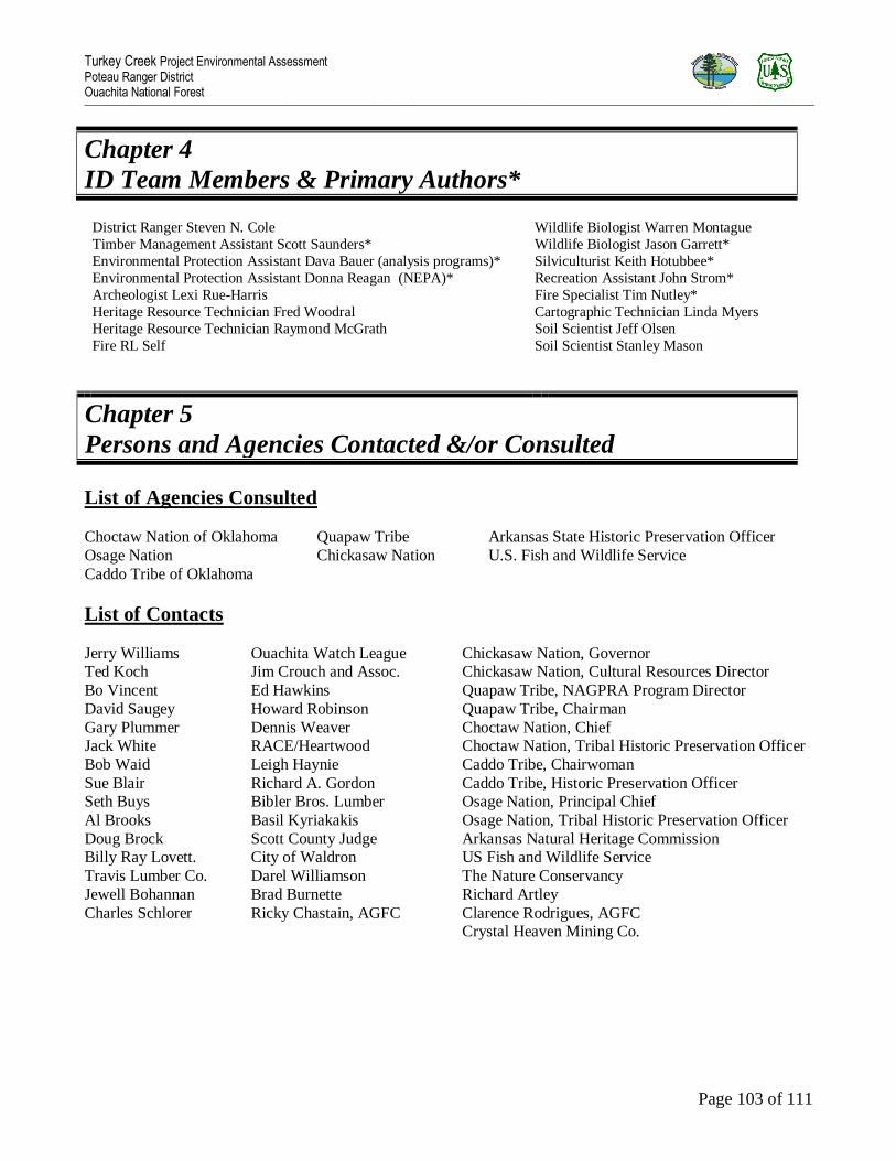
Turkey Creek Project Environmental Assessment Poteau Ranger District Ouachita National Forest _________________________________________________________________________________________________________________________________________________________________________________________________________________________________________________________________________________
Page 103 of 111
Chapter 4
ID Team Members & Primary Authors*
District Ranger Steven N. Cole Wildlife Biologist Warren Montague
Timber Management Assistant Scott Saunders* Wildlife Biologist Jason Garrett*
Environmental Protection Assistant Dava Bauer (analysis programs)* Silviculturist Keith Hotubbee*
Environmental Protection Assistant Donna Reagan (NEPA)* Recreation Assistant John Strom*
Archeologist Lexi Rue-Harris Fire Specialist Tim Nutley*
Heritage Resource Technician Fred Woodral Cartographic Technician Linda Myers
Heritage Resource Technician Raymond McGrath Soil Scientist Jeff Olsen
Fire RL Self Soil Scientist Stanley Mason
Chapter 5
Persons and Agencies Contacted &/or Consulted
List of Agencies Consulted
Choctaw Nation of Oklahoma
Osage Nation
Caddo Tribe of Oklahoma
Quapaw Tribe
Chickasaw Nation
Arkansas State Historic Preservation Officer
U.S. Fish and Wildlife Service
List of Contacts
Jerry Williams Ouachita Watch League Chickasaw Nation, Governor Ted Koch Jim Crouch and Assoc. Chickasaw Nation, Cultural Resources Director
Bo Vincent Ed Hawkins Quapaw Tribe, NAGPRA Program Director
David Saugey Howard Robinson Quapaw Tribe, Chairman
Gary Plummer Dennis Weaver Choctaw Nation, Chief Jack White RACE/Heartwood Choctaw Nation, Tribal Historic Preservation Officer
Bob Waid Leigh Haynie Caddo Tribe, Chairwoman
Sue Blair Richard A. Gordon Caddo Tribe, Historic Preservation Officer Seth Buys Bibler Bros. Lumber Osage Nation, Principal Chief
Al Brooks Basil Kyriakakis Osage Nation, Tribal Historic Preservation Officer
Doug Brock Scott County Judge Arkansas Natural Heritage Commission Billy Ray Lovett. City of Waldron US Fish and Wildlife Service
Travis Lumber Co. Darel Williamson The Nature Conservancy
Jewell Bohannan Brad Burnette Richard Artley
Charles Schlorer Ricky Chastain, AGFC Clarence Rodrigues, AGFC Crystal Heaven Mining Co.

Turkey Creek Project Environmental Assessment Poteau Ranger District Ouachita National Forest _________________________________________________________________________________________________________________________________________________________________________________________________________________________________________________________________________________
Page 104 of 111
Chapter 6
Literature Cited
Alexander, G. R.; Hansen, E. A. 1986. Sand bed load in a brook trout stream. N. Am. J. Fish. Manage. 6:9-23.
Arkansas Forestry Commission. 2002. Best Management Practices for Water Quality Protection.
Beasley, R.S., E. L. Miller and E. R. Lawson. 1987. Chemical Properties of Soils and Streams in Natural and Disturbed Forest Ecosystems in the Ouachita Mountains. Publication No. 132. Technical Completion Report
Research Project G-1212-02. Arkansas Water Resources Research Center.
Clingenpeel, J. Alan. 1989. Above and Below Storm Sampling BMP Effectiveness FY 1989 Monitoring Results. Internal report on file at the Ouachita National Forest, Supervisors Office, Hot Springs. AR. 2 pages.
Clingenpeel, J. Alan. 1990. Baseline Water Quality Stations Effectiveness Monitoring FY 1989 Monitoring
Results. Internal report on file at the Ouachita National Forest, Supervisors Office, Hot Springs. AR. 2 pages.
Coats, R. N.; Miller, T. O. 1981. Cumulative silvicultural impacts on watershed: A hydrologic and regulatory dilemma. Environ. Manage. 5:147-160.
Garrett, Jason, July 2011. Biological Evaluation of Environmental Assessment for Turkey Creek EMU.
Jorgensen, R. and C.G. Wells. 1986. Foresters‟ primer in nutrient cycling. USDA For. Serv. Gen. Tech. Rep. SE-37. 42 p.
Ku, T.T. and Lawson, E.R. Jan. 1993. Soil Nutrient Study Data Analysis and Interpretation – Ouachita National
Forest. Report submitted from Dept. of Forest Resources, U of A at Monticello. 16 p. unpublished.
Leichty, H.O., Shelton, M.G., Luckow, K.R. and Turton, D.J. 2002. “Impacts of Shortleaf Pine-Hardwood
Forest Management on Soils in the Ouachita Highlands: A Review.” Southern Journal of Applied Forestry, Vol.
26, No. 1, pages 43-51.
Lippe, M.V. and I. Kowarik. 2006. Long-distance dispersal of plants by vehicles as a driver of plant invasions. Conservation Biology 21: 986-996.
Luckow, K. 1998. “Soil compaction monitoring of 20 timber harvest unit subplots on the Ouachita National Forest. In:
Appendix D of the Environmental Assessment for Amendment No 27 to the Forest Plan for Changing Applicable Forest Plan Standards and Guidelines Related to Soil Compaction and Normal Operating Seasons.” May, 1998.
USDA-Forest Service Ouachita National Forest, Hot Springs, Arkansas.
Masters, R.E., D.M Engle and R. Robinson. 1993. Effects of timber harvest and periodic fire on soil chemical properties in the Ouachita Mountains. SJAF 17:139-145.
Miller, J.H. 1998. Exotic invasive plants in southeastern forests. In: Britton, K.O., ed.. Proceedings of the exotic
pests of eastern forests. Nashville, TN: Tennessee Exotic Pests Plant Council: 97-105.
Miller, J.H. 2003. Nonnative invasive plants of southern forests: a field guide to identification and control. Gen. Tech. Rep. SRS-62. Ashville, NC: USDA Forest Service, Southern Research Station. 93 pp.

Turkey Creek Project Environmental Assessment Poteau Ranger District Ouachita National Forest _________________________________________________________________________________________________________________________________________________________________________________________________________________________________________________________________________________
Page 105 of 111
Neihardt, Charlene L. 1994. BMP Effectiveness Monitoring Using Above and Below Storm Sampling FY
1992. Internal report on file at the Ouachita National Forest, Supervisors Office, Hot Springs. AR. 2 pages.
Ouachita NF. 2005. Forest Plan (Especially see Table E5 at pages E-94-97 which includes the Regional
Forester‟s invasive exotic plant species list for the Ouachita NF).
USDA Forest Service. 1991a. Forest Service Manual 2605.
USDA Forest Service. 1991b. Forest Service Manual 2621.1.
USDA Forest Service. 1994. A cumulative effects analysis of silvicultural best management practices using Basin Area Stream Survey Methods (BASS). Ouachita National Forest. Hot Springs AR 71902 Vols. I and II.
129 pages
USDA Forest Service. 1996. Decision Notice and Finding of No Significant Impact for Incidental Salvage due
to Natural Disturbances and Southern Pine Beetle Infestations.
USDA Forest Service. 2003. A Summary and Analysis of Data pertaining to MIS for the Ouachita National
Forest, August 2003.
USDA Forest Service. 2004. National Strategy and Implementation Plan for Invasive Species Management. FS 805, October 2004. 24 pp.
USDA Forest Service, 2005a. Revised Land and Resource Management Plan, Ouachita National Forest,
Arkansas and Oklahoma, 2005.
USDA Forest Service, 2005b. Final Environmental Impact Statement (FEIS), Revised Land and Resource
Management Plan, Ouachita National Forest, Arkansas and Oklahoma, 2005
USDA Forest Service. 2005c. A Manual for the Aquatic Cumulative Effects Model, Ouachita and Ozark
National Forests. 42 pages.
Vestal J., 2000. BMP Effectiveness Monitoring Using Above and Below Pebble Counts. Internal report on file
at Ouachita National Forest, Supervisor‟s Office, Hot Springs, AR. 2 pages.
Wheeler, G. L. and J.K. Eichman, Feb. 1991. The Effects of Forest Management Practices on Soil Nutrient -90-056 with the U of A. 56 p.
unpublished.
Whitsett K. S., 2004. Road Sediment Coefficients for Forest Planning. Internal report on file at the Ouachita National Forest, Supervisors Office, Hot Springs. AR. 6 pages.

Turkey Creek Project Environmental Assessment Poteau Ranger District Ouachita National Forest _________________________________________________________________________________________________________________________________________________________________________________________________________________________________________________________________________________
Page 106 of 111

Turkey Creek Project Environmental Assessment Poteau Ranger District Ouachita National Forest _________________________________________________________________________________________________________________________________________________________________________________________________________________________________________________________________________________
Page 107 of 111

Turkey Creek Project Environmental Assessment Poteau Ranger District Ouachita National Forest _________________________________________________________________________________________________________________________________________________________________________________________________________________________________________________________________________________
Page 108 of 111

Turkey Creek Project Environmental Assessment Poteau Ranger District Ouachita National Forest _________________________________________________________________________________________________________________________________________________________________________________________________________________________________________________________________________________
Page 109 of 111

Turkey Creek Project Environmental Assessment Poteau Ranger District Ouachita National Forest _________________________________________________________________________________________________________________________________________________________________________________________________________________________________________________________________________________
Page 110 of 111
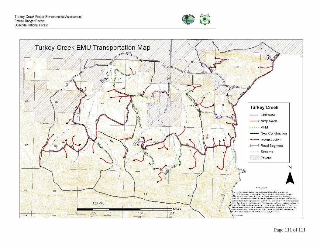
Turkey Creek Project Environmental Assessment Poteau Ranger District Ouachita National Forest _________________________________________________________________________________________________________________________________________________________________________________________________________________________________________________________________________________
Page 111 of 111