understanding changing land access issues for the …pubs.iied.org/pdfs/17597iied.pdf ·...
TRANSCRIPT

Understanding changing land access issues for the rural poor in UgandaGodber Tumushabe and Alex Tatwangire

A study of changing land access in sub-Saharan Africa
This report is part of a wider study to improve understanding of changing land access and use in sub-Saharan Africa. The study draws on case study research and literature from Ghana, Mozambique, Senegal and Uganda. A synthesis report and briefing are also available, alongside complementary reports and briefings from each of the four countries. These are listed below with hyperlinks where available. The country reports will all be available at www.iied.org/pubs once published.
Synthesis report and briefing
Knapman, C, Silici, L, Cotula, L and Mayers, J (2017) Africa’s farmland in changing hands: A review of literature and case studies from sub-Saharan Africa. Research Report. IIED, London. http://pubs.iied.org/17598IIED
Mayers, J, Knapman, C, Silici, L and Cotula, L (2017) Access to farmland gets quick and dirty in sub-Saharan Africa. Briefing. IIED, London. http://pubs.iied.org/17399IIED Also available in French and Portuguese.
Country briefings
Bugri, JT, Yeboah, E and Knapman, C (2017) Shifts in the landscape: increased pressure on rural land and livelihoods in Ghana. Briefing. IIED, London. http://pubs.iied.org/17355IIED
Filipe, E and Norfolk, S (2017) Changing landscapes in Mozambique: why pro-poor land policy matters. Briefing. IIED, London. http://pubs.iied.org/17356IIED Also available in Portuguese.
Niang, A and Knapman, C (2017) Land access for Senegal’s small producers under threat. Briefing. IIED, London. http://pubs.iied.org/17375IIED Also available in French.
Tumushabe, G, Tatwangire, A and Mayers, J (2017) Catching up with the fast pace of land access change in Uganda. Briefing. IIED, London. http://pubs.iied.org/17415IIED
Country reports
Bugri, JT and Yeboah, E (2017) Understanding changing land access and use by the rural poor in Ghana. Research Report. IIED, London. http://pubs.iied.org/17595IIED
Niang, A, Sarr, N, Hathie, I, Diouf, N, Ba, C, Ka, I and Gagné, M (2017) Understanding changing land access and use by the rural poor in Senegal. Research Report. IIED, London. http://pubs.iied.org/17596IIED
Filipe, E and Norfolk, S (2017) Understanding changing land issues for the rural poor in Mozambique. Research Report. IIED, London. http://pubs.iied.org/17594IIED

www.iied.org 1
Understanding changing land access issues for the rural poor in UgandaGodber Tumushabe and Alex Tatwangire
First published by the International Institute for Environment and Development (UK) 2017.
Copyright © International Institute for Environment and Development.
All rights reserved
ISBN: 978-1-78431-451-4
IIED order no.: 17597IIED
For copies of this publication, please contact IIED:
International Institute for Environment and Development80-86 Gray’s Inn RoadLondon WC1X 8NHUnited Kingdom
Email: [email protected]: @iied Facebook: www.facebook.com/theIIED
Download more publications at www.iied.org/pubs
A catalogue record for this book is available from the British Library.
Citation: Tumushabe, G and Tatwangire, A (2017) Understanding changing land access issues for the rural poor in Uganda. IIED, London.
Cover photo: A smallholder farmer in eastern Uganda. © Kate Holt/Africa Practice/Creative Commons CC BY 2.0 via Flickr.
Typesetting: Judith Fisher, www.regent-typesetting.co.uk

www.iied.org 3
CoNTENTS
ContentsList of boxes, figures and tables 5
Acknowledgements 6
Abbreviations and acronyms 7
About the authors 8
Executive summary 9
1 Background and introduction 15
1.1 Rationale and objective 15
1.2 Methodology and data 16
1.3 How the report is organised 19
2 Macro drivers of changes in land issues 20
2.1 Evolution of land policy and the current land tenure regimes 20
2.2 Analysis of key players 23
2.3 Land policy evolution and implications for tenure security 25
2.4 Macro policy developments and implications for land access and use 26
2.5 Economic growth and investments 29
2.6 Demographic trends 33
2.7 Urbanisation, urban growth and migration 33
2.8 Cultural drivers of land change 34
2.9 Key findings 36
3 Changes in access to land, land use and land tenure 38
3.1 Kalangala district 38
3.2 Amuru district 41
3.3 Land tenancy characteristics, fragmentation and concentration 43
3.4 Land access and distribution 45
3.5 Local drivers of change in land access and use 46
3.6 Changes in modalities of access to land 48
3.7 Changes in land use and agricultural intensification 52

Understanding changing land access issUes for the rUral poor in Uganda
4 www.iied.org
3.8 Change in land tenure and land relationships 55
3.9 Key findings 57
4 Impacts of land changes on tenure security and livelihoods 58
4.1 Impact of land changes on current and future tenure security 59
4.2 Access to land / inclusivity 60
4.3 Implications for rural livelihoods 61
4.4 Incidences of land conflicts 63
4.5 Implications for gender roles and ownership 65
4.6 Key findings 66
5 Conclusions and implications for public policy 67
References 72
Appendix 78
www.iied.org 5
List of boxes, figUres and tabLes
List of boxes, figures and tablesBox 1: How land access is changing – some local features 12
Box 2: Kalangala Infrastructure Services changing the economic landscape of Kalangala district 31
Box 3: Large-scale land acquisition drives perceptions of land grabbing in Amuru 35
Figure 1: Map of Uganda showing Amuru and Kalangala districts 18
Figure 2: Actors and institutions that interact in influencing changes in land tenure, access and use in Uganda 24
Figure 3: Map of Kalangala district 39
Figure 4: Map of Amuru district 41
Figure 5: Land parcel size categorisation and land acquisition by district 51
Table 1: Changing land use in Amuru district 53
Table 2: Changing land use in Kalangala district 54
Table A1: Right to transfer land and incidences of distress access and disposition of land, by district 78
Table A2: Incidence of concern over land disputes and their resolution, by district 79
Table A3: Incidence of land disputes and their resolution, by district 80
Table A4: Reasons for engaging in distress access and disposition of land, by district 82

Understanding changing land access issUes for the rUral poor in Uganda
6 www.iied.org
AcknowledgementsThis report synthesises findings from a research initiative steered by the Advocates Coalition for Environment and Development (ACoDE) in Uganda. It formed part of a wider initiative coordinated by the International Institute for International Development (IIED), with other partners in Ghana, Senegal and Mozambique, entitled ‘Changing land access issues for poor rural people in sub-Saharan Africa’. This was funded by the International Fund for Agricultural Development (IFAD), with some complementary funding from supporters of IIED’s strategic work: Danida (Denmark), Irish Aid and Sida (Sweden).
The authors would like to express their gratitude for the inputs made by many people in the design, fieldwork, analysis and write-up of this initiative, in particular onesmus Mugyenyi, Judith Kyarisiima, Nelson Muwereza, John okile and oscord Mark otile. We also thank those at IIED who helped shape this initiative, contributed to the analysis, and reviewed drafts of this report, in particular Laura Silici and James Mayers.
The views expressed by the authors of this report do not necessarily reflect the views of IFAD, Danida, Irish Aid, Sida, IIED or ACoDE.

www.iied.org 7
abbreviations and acronyms
Abbreviations and acronymsACoDE Advocates Coalition for Development and EnvironmentBEBA Bureau of Economic and Business AffairsCDF Cumulative Density FunctionDANIDA Danish International Development AgencyDSIP Development Strategy and Investment Plan FGD Focus group discussionFoSDA First-order Stochastic Dominance Analysis GDP Gross Domestic ProductGoU Government of Uganda (Republic of Uganda)IDP Internally displaced peopleIFAD International Fund for Agricultural Development IHS Integrated Household SurveyIIED International Institute for Environment and DevelopmentKoPD Kalangala oil Palm DevelopmentMAAIF Ministry of Agriculture, Animal, Industry and FisheriesMFPED Ministry of Finance, Planning and Economic DevelopmentMLHUD Ministry of Lands, Housing and Urban DevelopmentNDP National Development Plan NEAP National Environment Action Plan NEMA National Environment Management Authority NEMP National Environment Management Policy PEAP Poverty Eradication Action PlanPMA Plan for Modernisation of Agriculture PPP Public Private PartnershipRDC Resident District Commissioner Sida Swedish International Development Cooperation AgencyUBoS Uganda Bureau of StatisticsUGX Uganda ShillingsUNHS Uganda National Household SurveyUS$ United States DollarUWA Uganda Wildlife AuthorityVoDP Vegetable oil Development Project

Understanding changing land access issUes for the rUral poor in Uganda
8 www.iied.org
About the authorsGodber Tumushabe is associate director of the Great Lakes Institute for Strategic Studies, Kampala, Uganda. Email: [email protected]
Alex Tatwangire is a lecturer at the College of Agricultural and Environmental Sciences at Makerere University, Kampala, Uganda. Email: [email protected]
executive summary
www.iied.org 9
Executive summary Access to land is fundamental to the life of the majority of Ugandans. About 73 per cent of Uganda’s population of almost 35 million depend on farming, with some 83 per cent of Uganda’s women and some 66 per cent of employed labour engaged in agricultural activities. The way people access land – and the extent to which they face constraints and changes in doing so – is a critical issue for millions. Many sense that the scale and pace of change in land access are increasing rapidly, but solid evidence of this has been weak.
Exploring reality on the ground ACoDE and IIED, with support from IFAD, sought to improve understanding of how access to Ugandan land is changing. We reviewed literature and developed case studies based on fieldwork in two sites, in southern and in northern Uganda. A working group of key experts also helped optimise our approach.
We selected Kalangala district in southern Uganda for a case study because it offers a context in which large-scale commercial land use is developing. Kalangala hosts a major palm oil agricultural development project, which began in 1998.
In northern Uganda, Amuru district was chosen as a context where more locally-driven factors are likely to govern land access. For over 20 years, an insurgency affected northern parts of the country, including Amuru, leading to the movement of the bulk of the population into camps for internally displaced people. More recently, post-conflict resettlement has brought about changes in land access. The discovery of oil, and a proposal by a sugar company for large-scale land acquisition, may further exacerbate these changes. Reports of violence between individuals and different groups have emerged.
We developed a semi-structured questionnaire for household surveys and interview guides for focus group discussions (FGDs). We selected three sub-counties from each of the two districts and randomly chose three villages in each of the sub-counties. In Amuru district, we selected 130 households at random; in Kalangala district, 152 households. FGDs were conducted in each of the selected sub-counties, with a minimum of 12 participants to include active representation of women and youth.

Understanding changing land access issUes for the rUral poor in Uganda
10 www.iied.org
Law and policy on land access The 1995 constitution attempted to provide the core framework for land access by prescribing four distinct forms of land tenure, namely: freehold tenure, mailo tenure, leasehold tenure and customary tenure. Mailo tenure is a form of freehold tenure unique to Buganda region, introduced through the 1900 Buganda Agreement. Under this arrangement, the Kabaka of Buganda and feudal landlords received freehold rights over large tracts of land, often inhabited by poor subjects who instantly became tenants. The constitution guarantees security of occupancy of tenants who have occupied, used, or developed land unchallenged by the owner for at least 12 years.
The 1998 Land Act sets out procedures to enable holders of customary land to acquire certificates of customary ownership. It also enables tenants to acquire certificates of occupancy, and, together with land leaseholders, to convert their certificates to the freehold tenure system. A comprehensive Land Sector Strategic Plan in 2001 and a National Land Use Policy in 2013 followed the Land Act. More broadly, macro-policy frameworks including the Uganda Vision 2040 and the National Development Plan have put land at centre stage.
Yet the debate continues between, on the one hand, macro policies that embrace the growing individualisation of property rights, and, on the other, the protection of livelihoods and subsistence rights of small farmers in customary communal tenure systems.
Winners and losers at local levelProcesses taking place at the local level look set to overtake national reforms aimed at strengthening tenure security for rural households (see Box 1). Powerful individuals in a community can effectively constrain reforms on how land is governed, the capacity of customary institutional arrangements to deliver clear land rights, and resistance to unlawful evictions. Meanwhile, many poor people face severe land access challenges. These include the high cost of processing certificates of customary occupancy, the cost of processing land titles, difficulties in securing compensation for their land, and poor protection from illegal evictions.
Decentralisation policies and the creation of new districts have triggered many legal cases between communities, districts, and border counties. Poor land valuations and compensations between government and landowners also create tensions among different ethnic groups. For example, a 40 km2 tract of land in Apaa parish in the Amuru area is at the centre of a power struggle between the Uganda Wildlife Authority, Amuru district and Adjumani district. Local people claim these government agencies want to evict them from their ancestral lands.
executive summary
www.iied.org 11
Commercial agriculture and other large-scale land developments are creating opportunities for some Ugandans, including smallholders. Yet those who cannot participate in emerging land markets or production schemes may lose out, especially because implementation of government policies to support smallholder farming is weak. The land available to the less fortunate smallholders is thus on the decline. This pressure on land availability is exacerbated by demographics and rising environmental stresses. Responding to such stresses by increasing productivity may not be possible for smallholders who lack resources.
Economic growth and investment policies appear to outweigh land sector-specific policies as drivers of land access change. The development of infrastructure has the direct effect of opening up previously marginal areas, triggering fresh competition for land. As more land changes hands through the market, high prices and weak bargaining power may exclude the poorest and marginalised groups in rural as well as urban areas.
Increasing commercial interests have shifted the modes of land access from traditional means (inheritance, gifts and squatting) to market modes. This change hits some segments of the population hard, such as the youth who previously benefitted from traditional means of land access.
In conclusion, three main phenomena are driving significant transitions in land tenure in Uganda:
●● First, the changing policy narrative that has dominated the public policy discourse over the last decade. Policies on poverty eradication, investment and agricultural transformation have elevated land issues to the top of Uganda’s national policy agenda.
●● Second, the pursuit of large-scale agricultural investment projects has changed the overall economic landscape. As the two case studies indicate, changed economic landscapes have triggered actual and perceived high returns from land, hence increasing demand and driving up prices. This phenomenon is significantly altering modes of access across the country.
●● Third, local pressures on land availability are increasing fast, with traditional governance means unable to address situations typified by increasing income inequality, social tension and new conflicts over land.

Understanding changing land access issUes for the rUral poor in Uganda
12 www.iied.org
Box 1: How land access is changing – some local features
In Kalangala district, population pressure and commercial palm oil production have increased competition for land and stimulated market-based transactions. Although the traditional mailo form of tenure is still predominant, these transactions are enabling freehold and leasehold tenure systems to spread. Investments in infrastructure and agricultural services related to palm oil development have increased the impetus for commercial production. The area dedicated to perennial crops is gradually increasing compared to the area dedicated to annual crops. This shift towards commercial agriculture is evident also in the increased use of micro-irrigation, improved inputs and hired labour. Some features of changing land access include:
●● Enhanced levels of infrastructure, notably better roads and reliable electricity, creating further incentives to engage in commercial agriculture.
●● opportunity for people born in distant areas to purchase and own land in the district, stimulating increased in-migration.
●● The Kalangala oil Palm Trust (KoPT) and the Kalangala oil Palm Growers’ Association (KoPGA) are now playing important roles in allocation of land and protection of members from exploitation.
●● Nonetheless, there are conflicts between smallholders and new land owners, who gain the land under leasehold or freehold terms after lawful tenants and illegal squatters occupying mailo and public land are unable to secure certificates of occupancy. Powerful elites are more likely to evict vulnerable groups from their land, without meaningful compensation.
In Amuru district, the influx of immigrants, including people relocating from camps for internally displaced people (IDPs), conflicts over protected areas, and emerging large-scale investments in agriculture and oil exploration have also increased pressures and competition on available land. Although the vast majority of the land is under communal customary tenure, in the last five years acquisitions of parcels under leasehold and freehold tenure have increased against the desires of the traditional institutions, as have market-based transactions. Features of changing land access include:
●● Increasing economic development and progress in the area, stimulating investment in land, including in commercial agriculture and real estate businesses, and new public and administrative offices.
●● Business opportunities along the borders with Sudan and the Democratic Republic of Congo, resulting in local business profits being invested in land assets in the district.
●● Migrants to the area who can afford to buy land and displace poorer local residents.
●● Increasing incidence of land conflicts stemming from the high demand for land and perception of unfair processes. Breakdown of family values and the role of clans in regulating land rights transfers, in part due to increasing mutual suspicion created by the pressure under new land law to register all land, and in part to the opportunities to make money and increase consumption.

executive summary
www.iied.org 13
Implications for public policyUganda’s macro policy makes land access change inevitable but inconclusive. The commitment to invest in commercial agriculture to achieve faster socioeconomic transformation means that the impact of this situation goes beyond specific locations. Yet, across the country, land ownership can become threatened, and remains insecure for many. Land markets are emerging throughout the country, although considered by some to be narrow in scope, segmented, and unpredictable due to a wide range of influences.
As demand for land grows, market-based land transactions increase. Stimulated by these macro policy drivers of change, the demand for land is rising across Uganda. Where there is relative abundance of land, low population density and weak infrastructure, land transactions appear to be generally fair. In areas where development projects are mooted or underway, many people, including those from beyond the neighbouring communities, are arriving in anticipation of potential windfalls. Consequently, the amount of land that is held speculatively and unutilised is increasing. More local people are choosing to settle in nearby trading centres in anticipation of economic growth.
Impacts of investments on land access are not being anticipated and monitored. Large-scale land investments have a poor record to date of anticipating and monitoring their impacts on the social, economic and land tenure landscape. In the investments analysed in the two case study areas, we saw little evidence of effort to forecast the nature of transitions of land tenure, land use change and land governance. Future large-scale investment projects should focus on anticipating such changes, develop longitudinal data to monitor such impacts and design appropriate responses.
Land disputes reduce agricultural production. Land disputes are on the increase in both case study areas. For example, in both Kalangala and Amuru, there are court cases contending land ownership or the process of land dispute adjudication. This increase is likely to constrain land productivity. Estimates suggest that Uganda as a whole loses 5–11 per cent of agricultural production due to land conflicts. In areas where the system of mailo land tenure is predominant, losses due to land conflicts are estimated to be even higher – up to 25 per cent.
Land governance institutions struggle to cope with the scale and pace of change. Evidence from the case studies demonstrates the incapacity of existing land governance institutions to cope with the scale of change, particularly in areas with existing or proposed investments. Similar challenges are evident in other areas with large-scale land acquisitions, even when they are not agri-business related. In the Albertine Rift, for example, the rush for land, stimulated by oil development, is overstretching the capacity of local institutions to cope, and is therefore increasing tenure insecurity.

Understanding changing land access issUes for the rUral poor in Uganda
14 www.iied.org
Land policy is in transition: an opportunity for strengthening land access for poor rural people. Land policy reforms over the last 20 years have generally aimed at strengthening tenure security, with land market development in mind, including in areas dominated by customary and mailo tenure systems. Yet these reforms have not been completed. Land tenure has, meanwhile, tended to become more insecure in many areas with changes in the way land transfers are carried out, increasing investments in commercial agricultural production, real estate development in many urban areas and land accumulation for speculation. There is opportunity in this time of flux to marshal evidence about the negative consequences of insecure land access and to redirect national policy to improve access security for the poorest.

www.iied.org 15
Background and introduction
1 Background and introduction
1.1 Rationale and objectiveAs in most of sub-Saharan Africa, access to land is currently the single most important strategy for securing livelihoods and food security for the majority of rural communities. Indeed, farming households depend directly or indirectly on growing their own food for consumption, while also engaging in meaningful on-farm and off-farm land-based economic activities. For example, recent statistics show that over 73 per cent of Uganda’s estimated population of about 34.6 million people are dependent on agriculture, and over 66 per cent of the labour force (13.9 million in total) is engaged in the sector (MFPED, 2015; UBoS, 2014; 2015; 2016). The percentage of women engaged in agricultural activities is estimated to be even higher at 83 per cent (UBoS, 2005). Given the current architecture of Uganda’s economy, it is projected that the percentage of the population directly dependent on agriculture is likely to remain the same or even increase in the foreseeable future.
The agricultural sector has the potential to increase economic benefits through investments in land productivity and value addition. Consequently, research into the factors and drivers influencing changes in land access is important to guide policy and programmes that support agricultural transformation and promote rural livelihoods. There is scant literature and information on the key drivers accounting for the underlying changes in land tenure and land access regimes, on potential policy responses to these changes, and on how communities are adapting to the forces driving these changes. This study seeks to fill some of these gaps, by identifying and analysing changes in land issues that impact on the rural poor in Uganda.
Understanding changing land access issUes for the rUral poor in Uganda
16 www.iied.org
The goal of the study is to understand these forces driving changes in land tenure, land access and use and, based on this understanding, formulate policy recommendations that can help policy makers and development practitioners improve the design and the implementation of pro-poor land policies and programmes.
More specifically, this study seeks to improve an understanding of:
(i) How access to land, land use and management are changing and the drivers of these changes.
(ii) The impacts of these changes on rural livelihoods and rural class formations through particular processes of land fragmentation and concentration.
(iii) The implications of ongoing changes for public policy and practice.
The study is part of a wider comparative research project involving three other countries: Mozambique, Ghana, and Senegal. In each country, two study sites were selected with the purpose of assessing different drivers of changes in land access and use and comparing the effects that these changes have on rural livelihoods across the region. In each country, the field research was complemented by macro-level policy analysis focusing on key policy and legal developments that shape the behaviours and actions of actors regarding land and land-based transactions. The following sections further detail the methodologies, sources and data used in Uganda.
1.2 Methodology and dataPrimary data were collected through a household survey and focus group discussions (FGDs) at community level. Descriptive summary statistics and trends were computed to capture key demographic and socioeconomic characteristics and changes in land tenure, land access and use. In addition, three cross-sectional datasets – the Uganda National Household Survey (UNHS) for 1999/00, 2005/06 and 2009/10 – were utilised to further assess the status and recent changes in land tenure, land access, land distribution, and income poverty
Selection of case studiesTwo districts, namely Kalangala and Amuru, were purposively selected for the study.
Kalangala district was selected because of the ongoing large-scale acquisition of land for a major palm oil agricultural development project. The project was first introduced in 1998 and hence provides an opportunity to observe possible changes in land tenure and access, while at the same time considering issues of causation.
The second case study selected was Amuru district, located in northern Uganda. There are three important factors that make this district relevant for this study of changes in

www.iied.org 17
Background and introduction
land access and rural livelihoods. First, for over 20 years, Amuru district was affected by an insurgency leading to the movement of the bulk of the population into Internally Displaced People’s (IDPs) camps. With the end of the insurgency, the post-conflict resettlement may have shaped land tenure and access regime in many different ways. Secondly, the discovery of oil in the district has also a triggered potential land grabs. Thirdly, the proposal by Amuru Sugar Works Limited –another case of large-scale land acquisition – may have had implications on the land tenure and land access regime in the area (see Section 2.8). Land issues have thus become a general development concern in the district and a central determining factor in complex social relations within which violent conflicts between individuals and different groups have emerged.
Sampling and data analysisThe collection of primary quantitative and qualitative data relied on two household surveys and several focus group discussions (FGDs) that were held in the two study areas during March 2015. The semi-structured questionnaires for the household survey and the interview guides for the FGDs were tested in Luwero district in the Central Region, which is considered to have similar socioeconomic characteristics as the two selected study sites. Subsequently, the sampling was done using a multi-stage random sampling strategy, whereby three sub-counties were randomly selected from each of the two districts. Three villages were then randomly selected in each of the sub-counties. The raw data collected from the fieldwork was processed, coded and entered into customised template designed using EPI data software. The data was then analysed using Stata computer software.
Household surveysA total of 282 households were randomly selected from a list of households in each of the selected villages in the study area. In Amuru district, 130 households were selected in the three communities of Lamogi, Pabbo and Amuru town council. A total of 152 respondents were also randomly selected in the three communities of Mugoye, Bujumba and Kalangala town council in Kalangala district.
Focus group discussions (FGDs)Focus group discussions were conducted in each of the sub-counties. Participants were purposively selected from each of the surveyed villages, with each of the FGDs being attended by a minimum of 12 participants. The selection was carried out collaboratively with local leaders in order to have a full and active representation of women and youth within the studied community. This approach was adopted because limited time did not allow for sex-disaggregated FGDs, although these could have yielded more detailed gender-responsive information.

Understanding changing land access issUes for the rUral poor in Uganda
18 www.iied.org
Figure 1: Map of Uganda showing Amuru and Kalangala districts
Source: Based on map supplied by ACoDE
Literature reviewAn extensive literature review was carried out to establish the basis for trends analysis in changes in land issues at the macro and micro levels. Given the breadth of the subject, the literature review was approached from a broader perspective taking into account existing theories on land tenure, land change, land productivity, land markets and other related concepts. Another set of literature relevant to the study entailed the policy-related literature. This included major official government of Uganda reports, policies and programme documents in the areas of development policy, macro-economic policy, and agricultural policy. These policy documents provided important narratives and explanations
www.iied.org 19
Background and introduction
to some of the changes that may be observable at the national, community and household level.
Use of the expert task group (ETG)An expert task group was constituted at the inception of the study. The panel brought together policy experts and practitioners from a wide range of fields, including agriculture, environment, livelihoods and project management. The ETG played an oversight role in validating case study selection, reviewing the research tools and validating the findings from the fieldwork. The ETG made their contributions through formal meetings, informal consultations with the study team, and independent review of research tools and documents.
Land access and household welfareA first-order stochastic dominance analysis (FoSDA) was conducted in order to assess the distribution of land endowment across households with varying levels of welfare. In this study, household welfare is measured in terms of household level of consumption expenditure per adult-equivalent. The variable of consumption expenditure per adult-equivalent was split into four welfare quartiles, each equivalent to 25 per cent distribution to enable comparisons of differences in corresponding land access. The FoSDA uses cumulative density functions (CDFs) to test for statistical differences in the land distribution.
1.3 How the report is organisedThe report is organised into five chapters. Chapter 2, following this introduction, examines the national context and the major macro drivers of change in land tenure and land access in Uganda. The evolution of land tenure regimes, macro policy developments, macro-economic and social and cultural trends are identified and discussed. Chapter 3 presents and discusses the study findings on changes in land access modalities, land uses and land tenure regimes. The discussion relies on the analysis of qualitative and quantitative primary and secondary data. Chapter 4 discusses the implications of the changes identified in Chapter 3 on tenure security, equal access to land, livelihoods, incidence of disputes and gender roles. Finally, the concluding chapter, Chapter 5, maps out the overall study conclusion and implications for public policy and practice.
Understanding changing land access issUes for the rUral poor in Uganda
20 www.iied.org
2 Macro drivers of changes in land issues
2.1 Evolution of land policy and the current land tenure regimesThe regime of land tenure and access in Uganda has been evolving since the advent of colonialism and the signing of a series of colonial agreements at the beginning of 1900 (Brett, 1973; West, 1972 ). Major realignments in land tenure were effected through the creation of a network of protected areas including national parks, game reserves, forest reserves and wildlife hunting areas in some cases (Tumushabe et al., 2009). The process of creating these protected areas significantly altered the land tenure landscape and changed the rules of access to previously communal access areas.
Since 1900, land reforms in Uganda have typically aimed at stimulating economic growth by enhancing land use efficiency and investment, reducing poverty and promoting more sustainable land use management. However, many of these reforms have not had the intended effects, and in most cases there have been disagreements about legitimacy and real effects of these reforms (Holden et al., 2013).
In the last 115 years, there have been several pieces of legislation. The earliest are the Busulu (annual dues) and Envujo (levy per acre) Law of 1927, that were enacted in response to high land rents imposed on tenants by landlords. In 1969, the Public Land Act was enacted. Among other things, the act provided customary tenants with more protection against land evictions. Six years later, the 1975 Land Reform Decree declared all land in Uganda to become public land, administered by the Uganda Land Commission. In 1995, Uganda adopted a new constitution, which declared that all land in Uganda
www.iied.org 21
Macro drivers of changes in land issues
belongs to the citizens of Uganda and could hold it in accordance with the prescribed tenure systems. The Land Act, which was enacted in 1998, emphasises, among other things, resolving historical tenure problems by defining and entrenching land rights of all Ugandans including those on customary land to increase land use efficiency for economic growth (Bosworth, 2003; Tatwangire and Holden, 2013; 2015).
The most important point of departure in understanding current issues in land tenure and its implications on land access and use is the 1995 constitution. In an attempt to reorganise the rules that govern tenure, the framers of the 1995 constitution prescribed four distinct forms of land tenure: freehold tenure, mailo tenure, leasehold tenure and customary tenure. The 1995 constitution provides under article 237(1) that land in Uganda belongs to the citizens and shall vest in them in accordance with these four tenure systems.
Freehold tenure is an individualised form of land tenure granted in perpetuity. Mailo tenure is a form of freehold tenure unique to Buganda, introduced through the 1900 Buganda Agreement (Brett, 1973; West, 1972). Under this tenure arrangement, the Kabaka of Buganda and feudal landlords were granted freehold rights over large tracts of land, often inhabited by poor subjects, who instantly became tenants or bibanja holders. The 1995 constitution guarantees security of occupancy of tenants (referred to as bona fide occupants) who have occupied, used or developed land unchallenged by the owner for at least 12 years. Leasehold tenure is granted, providing for access to public or any other land for a fixed-term period. Currently, leasehold tenure is the only form of tenure through which non-Ugandans can own land. A tenant by occupancy on mailo, freehold or leasehold tenure holding enjoys security of occupancy. Finally, customary tenure is a form of tenure based on the customs of the community in which such custom applies.
Under the 1995 constitution, customary tenure is considered to be at par with freehold tenure, although such tenure may not be evidenced by possession of land title. Land under customary tenure was for many decades not legally recognised, while policies to nationalise land created unintended consequences such as land grabbing, unlawful evictions, resource dissipation, and poor implementation. Rural areas, as a result, experienced low investment, limited land transactions, limited access to credit, and rampant land conflicts (Deininger, 2003). The 1995 constitution has provisions to strengthen land rights on customary land, especially the rights of the underprivileged groups of women and children.
The 1998 Land Act (CAP 227) sets out procedures to enable holders of customary land to acquire certificates of customary ownership. It also enables tenants by occupancy to acquire certificates of occupancy, and together with land leaseholders to convert their certificates to a freehold tenure system. There is still debate on whether the land law reform in Uganda should embrace the growing individualisation of property rights or

Understanding changing land access issUes for the rUral poor in Uganda
22 www.iied.org
focus on protecting the livelihoods and subsistence rights of small farmers in a customary communal tenure system (Boone, 2007; Holden et al., 2013).
Under the 1998 Land Act, holders of freehold land have the freedom to use their land for any lawful purpose, including lease, sale, mortgage, and bequeathal. Holders of leasehold are free to use the land in any lawful way, such as sub-leasing, during the lease period of 49 or 99 years. In the customary land system, the rights of land ownership, usufruct, and bequest are considered to be secure, while the transfer of rights is primarily through inheritance. The holders of mailo land, on the other hand, still face the challenge of utilising their land resource effectively without evicting and compensating the lawful and bona fide occupants that have statutory protection against such evictions, as long as they continue paying rent of UGX 1,000 (US$0.28) per year (Deininger, 2003; Deininger and Ayalew, 2007).1 The act further provides for the establishment of a land fund, to be used in resettling people that become landless as a result of government actions and natural disasters, but its implementation has been slow (Rugadya et al., 2008), probably due to the lack of resources and other administrative challenges.
Following the enactment of the Land Act in 1998, a comprehensive Land Sector Strategic Plan (GoU, 2001) and a National Land Use Policy (GoU, 2013) were adopted. The goal of the National Land Policy is ‘to ensure efficient, equitable and optimal utilisation and management of Uganda’s land resources for poverty reduction, wealth creation and overall socioeconomic development’. This goal is to be achieved by improving land access through the market, improving the efficiency of the land administration, modernising the land registration infrastructure and the processing of land information and permitting system (GoU, 2003; 2006). A land amendment law was passed in 2010 (Act No.1 of 2010) in order to: resolve cultural dissent and ethnic demands, especially in Buganda region (Green, 2006); improve the implementation of the land law; and stop the evictions of tenants from the registered land, except upon the order of eviction from courts of law. Changes in land access, use and land tenure are thus happening in a state of policy and legal transition. The tenure transition processes already taking place at the household level as part of adjustment to local issues may therefore overtake the expected benefits of the reform programme that also include strengthening tenure security for rural households.
There is general lack of flexibility to adapt to new changes across communities and power traps exercised by few powerful individuals. These challenges constrain the desire to evoke necessary reforms in how land is governed, the capacity of customary institution arrangements to deliver strong and clear land rights, and the best practice of not condoning unlawful evictions of the vulnerable members of society from their land.
1 Currency rate as of April 2017.

www.iied.org 23
Macro drivers of changes in land issues
Indeed, under the current system, the majority of the rural poor face many challenges, including: high cost of processing certificates of customary occupancy, high cost of processing land titles, difficulties in securing appropriate compensation for their land, and poor protection from land evictions. on the other hand, powerful elites somehow find it easy to manipulate the system when processing land ownership under their names. The National Land Policy Implementation Action Plan seeks to avoid this abuse of land registry and administration that takes place at the expense of many tenants and poor landowners.
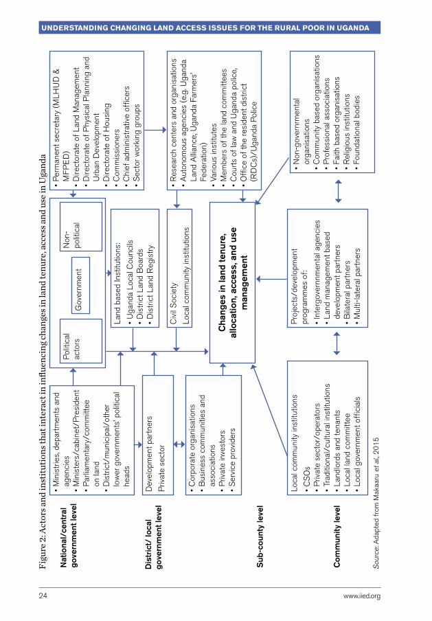
2.2 Analysis of key playersThe achievement of pro-poor changes in land tenure, land access, and use requires meaningful collaboration and combined efforts of various actors and institutions that interact and make decisions at various levels of the national, district, sub-county, and community. Key actors in land governance fall into different categories. These include the political and technical sections of central and local government, land governance institutions, civil society organisations, local communities, private sector, and development partners.
According to Makaaru et al. (2015), these actors can further be segmented into three levels of central government, local government and community. Details of different actors in land governance and allocation and their interactions are summarised in Figure 2. The actors’ landscape in the figure provides an opportunity to understand the quality of land governance institutions in Uganda in terms of how government, including the president, responds to the needs of citizens, and the capacity and extent to which these systems deliver land governance services. The ultimate aim is to satisfy the demands of citizens and to deliver accountability to them.
Land conflicts are often resolved through negotiations between conflicting factions and through holding meetings between landlords and tenants. others choose to forego their interest in land under conflict for the sake of peace. officials of local governments and area land committees play an essential role of facilitating the resolution of land conflicts. other useful agents that facilitate the resolution of land conflicts include neighbours, courts of law including commercial courts, and the office of resident district commissioners (RDCs).
Understanding changing land access issUes for the rUral poor in Uganda
24 www.iied.org
Figu
re 2
: Act
ors a
nd in
stitu
tions
that
inte
ract
in in
fluen
cing
chan
ges i
n la
nd te
nure
, acc
ess a
nd u
se in
Uga
nda
Sou
rce:
Ada
pted
fro
m M
akaa
ru e
t al.,
20
15
• P
erm
anen
t sec
reta
ry (
MLH
UD
&
MF
PE
D)
• D
irect
orat
e of
Lan
d M
anag
emen
t•
Dire
ctor
ate
of P
hysi
cal P
lann
ing
and
Urb
an D
evel
opm
ent
• D
irect
orat
e of
Hou
sing
• C
omm
issi
oner
s•
Chi
ef a
dmin
istr
ativ
e of
ficer
s•
Sec
tor
wor
king
gro
ups
• R
esea
rch
cent
ers
and
orga
nisa
tions
• A
uton
omou
s ag
enci
es (
e.g.
Uga
nda
Land
Alli
ance
, Uga
nda
Farm
ers’
Fe
dera
tion)
• Va
rious
inst
itute
s•
Mem
bers
of
the
land
com
mitt
ees
• C
ourt
s of
law
and
Uga
nda
polic
e,•
offi
ce o
f th
e re
side
nt d
istr
ict
(RD
Cs)
/Uga
nda
Pol
ice
• N
on-g
over
nrm
enta
l or
gani
satio
ns•
Com
mun
ity b
ased
org
anis
atio
ns•
Pro
fess
iona
l ass
ocia
tions
•
Faith
bas
ed o
rgan
isat
ions
• R
elig
ious
inst
itutio
ns•
Foun
datio
nal b
odie
s
Pro
ject
s/de
velo
pmen
t pr
ogra
mm
es o
f:
• In
terg
over
nnm
enta
l age
ncie
s•
Land
man
agem
ent b
ased
de
velo
pmen
t par
tner
s•
Bila
tera
l par
tner
s•
Mul
ti-la
tera
l par
tner
s
Loca
l com
mun
ity in
stitu
tions
• C
So
s•
Priv
ate
sect
or/o
pera
tors
• Tr
aditi
onal
/cul
tura
l ins
titut
ions
• La
ndlo
rds
and
tena
nts
• Lo
cal l
and
com
mitt
ee•
Loca
l gov
ernm
ent o
ffici
als
• M
inis
trie
s, d
epar
tmen
ts a
nd
agen
cies
• M
inis
ters
/cab
inet
/Pre
side
nt•
Par
liam
enta
ry/c
omm
ittee
on
land
• D
istr
ict/
mun
icip
al/o
ther
lo
wer
gov
ernm
ents
’ pol
itica
l he
ads
• C
orpo
rate
org
anis
atio
ns•
Bus
ines
s co
mm
uniti
es a
nd
asso
ciat
ions
• P
rivat
e in
vest
ors
• S
ervi
ce p
rovi
ders
Non
-po
litic
alP
oliti
cal
acto
rs
Land
bas
ed In
stitu
tions
:
• U
gand
a Lo
cal C
ounc
ils•
Dis
tric
t Lan
d B
oard
s•
Dis
tric
t Lan
d R
egis
try
Gov
ernm
ent
Dev
elop
men
t par
tner
s
Priv
ate
sect
orC
ivil
Soc
iety
Loca
l com
mun
ity in
stitu
tions
Nat
iona
l/ce
ntra
l go
vern
men
t lev
el
Dis
tric
t/ lo
cal
gove
rnm
ent l
evel
Sub
-cou
nty
leve
l
Com
mun
ity le
vel
Cha
nges
in la
nd te
nure
, al
loca
tion,
acc
ess,
and
use
m
anag
emen
t
www.iied.org 25
Macro drivers of changes in land issues
2.3 Land policy evolution and implications for tenure securityMost of the recent land reforms in Uganda are expected to enhance land tenure and the better functioning of land markets and labour supply in farm and off-farm activities. However the implementation of the new land law still faces the challenges of limited social legitimacy, opposing cultural interests, and institutional design limitations (Hunt, 2004; Rugadya et al., 2004). Plans are underway to operationalise these land reforms, and to promote land titling by inter alia a process of systematic land demarcation and computerisation of the land registry.
Land tenure security is the individual’s perception of his/her rights to a piece of land on a continual basis, free from imposition or interference from outside sources, as well as the ability to reap the benefits of labour or capital invested in land, either in use or upon alienation. This definition contains three components – breadth, duration and assurance – with legal and economic dimensions (Place et al., 1994). The meaning of land tenure security is therefore more than just having a private property, or having rights or a bundle of rights, or having a defined duration of enjoying specific rights. But it rather implies having a better perception of the likelihood of losing a specific right, including the right to lend, rent, bequeath, mortgage, give away, and sell land.
Safeguarding tenure security is vital in order to maintain and increase land use productivity as a primary source of food security and livelihoods. Strong land tenure encourages long-term land-related investments and helps to reduce the risk of land loss, increase investment incentives, stimulate growth, and reduce the need for individuals to spend resources on protecting their rights (Besley, 1995; Besley and Ghatak, 2010; Holden et al., 2013). When a symbiotic relationship between rights and investment is established in a community, landowners are encouraged to not only make these long-term land-related investments, but also to manage their land sustainably. They are sure to enjoy the fruits of their labour, without fear of losing their benefits through theft and other forms of expropriation.
Beyond land policies and their implementations, a wide range of underlying driving forces can directly or indirectly impact on land tenure. These forces influence the demand and pressure on the available land, thereby determining changes in the way land is accessed and used by different actors, as well as changes in local land relationships. In Uganda, these factors include policies and macro-economic trends that underpin the investment environment, demographic and poverty trends, sociocultural changes and environmental stresses.

Understanding changing land access issUes for the rUral poor in Uganda
26 www.iied.org
2.4 Macro policy developments and implications for land access and useThe national policy context plays a vital role in shaping the actions of government and other development partners on issues of land access and use.
Uganda’s macro policy framework can be discerned from a number of policy instruments adopted since the beginning of the 1990s. With regard to the environment, during the period between 1990 and 1994, Uganda undertook a comprehensive environment action planning process to determine the environmental and other related challenges facing the country. The process led to the adoption of two important policy instruments, namely: (i) the National Environment Action Plan (NEAP); and (ii) the National Environment Management Policy in 1994 (Republic of Uganda, 1994). The NEAP process provided the first most comprehensive attempt to better understand key problems of development in the country. It also provided the most comprehensive policy response seeking to create conditions for achieving convergence between economic development, social development, and environmental protection.
During the NEAP process (1987–1994), sectoral studies were conducted in nine broad areas that included among others: land management, population, health and human settlement, and energy and climate change. The two policy instruments no doubt played a critical role in identifying key problems in the land sector and made recommendations on how to address these specific problems. Most of the NEAP recommendations were later adopted during the formulation of Uganda’s 1995 constitution and 1998 Land Act.
In 1997, Uganda adopted the Poverty Eradication Action Plan (PEAP) as a comprehensive macro policy framework for the eradication of poverty. The Uganda PEAP set out four main goals, namely: fast and sustainable economic growth and structural transformation; good governance and security; increasing the ability of the poor to raise their incomes; and increasing the quality of life of the poor (Ellis and Bahiigwa, 2003; GoU, 2001). In 2003, the government published the revised edition of the PEAP with five pillars: (i) economic management; (ii) production, competitiveness and incomes; (iii) security, conflict resolution and disaster management; (iv) good governance; and (v) human development. Pillars (i) and (ii) provided the main policy framework for continued policy development and investment in the land and agricultural sectors. Under pillar (ii) for example, the government committed to addressing the observable increases in income inequality by focusing on agriculture and taking actions to empower women and strengthen women’s land rights (GoU, 2004).
The PEAP served as the national planning framework for a period of ten years (1997–2008). During this period, the PEAP guided the development of detailed medium-term sector plans, district plans and the national budget process. The PEAP framework was

www.iied.org 27
Macro drivers of changes in land issues
utilised as an instrument for: (i) directing spending priorities for the Poverty Action Funds (PAF), including investments in such areas as rural roads, the enactment of a new land law, improving the agricultural advisory services system, and enhancing micro-finance services delivery; (ii) directing public expenditure towards primary health care, water and sanitation, primary education and adult literacy programmes; and (iii) facilitating significant domestic spending and better targeting of international development assistance towards social sectors and other poverty reducing actions.
Consistent with the PEAP pillars, the government adopted a strategy dubbed the Plan for the Modernisation of Agriculture (PMA) in 2000. The mission of PMA was to eradicate poverty by transforming subsistence agriculture to commercial agriculture (GoU, 2000). The policy thrust of the PMA was to implement a comprehensive integrated policy package covering seven priority areas. Through the PMA, the government of Uganda pursued the goal of poverty eradication based on the theme of ‘a profitable, competitive, sustainable and dynamic agricultural and agro-industrial sector’, with the aim of achieving four specific policy objectives: (i) to increase incomes and improve the quality of life of poor subsistence farmers; (ii) to improve household food security; (iii) to provide gainful employment; and (iv) to promote sustainable use and management of natural resources. The government also identified access to land as one of the major constraints faced by subsistence farmers.
In 2010, the government adopted a new policy and planning framework in the form of a five-year National Development Plan (NDP I) (GoU, 2010). During the same year, a five-year Agricultural Sector Development Strategy and Investment Plan (DSIP) 2010/11–2014/15 (GoU, 2011) was also developed. In broad terms, the main objective of the DSIP and NDP was to achieve prosperity for all through improved agricultural productivity, improved rural household incomes, effective food and nutrition security, and reduced poverty by turning agriculture into a profitable, competitive, sustainable, and a dynamic primary and agro-industrial enterprise (MAAIF, 2010). Both the DSIP and NDP placed issues of land at the centre of the national development agenda.
The adoption of the NDP as the macro policy framework of government signalled a shift towards a more ambitious agenda of social economic change, structural change, and the need to address Uganda’s inadequate stock of physical infrastructure. The NDP I also signalled a broadening of the government’s objectives towards long-term socioeconomic transformation, with emphasis on the need to accelerate economic growth, increase average incomes, and provide the financial resources required to expand public investments and service delivery.
The contemporary policy context for analysing change in land tenure, land use, and land management for agricultural development encompasses a number of important policy frameworks. These are Uganda Vision 2040; the National Development Plan (NDP II); the National Policy on Climate Change; the National Agriculture Policy and Agriculture Sector

Understanding changing land access issUes for the rUral poor in Uganda
28 www.iied.org
Investment Plan; and the National Land Policy (GoU, 2013). All these policies recognise the role of smallholder agriculture in transforming the agricultural sector in the country. The policies also reveal government commitment in increasing investments that help to transform the largely subsistence agriculture into commercial agriculture. They also present significant drivers for change in land access and use across the country.
The Uganda Vision 2040 is a statement of the Uganda government’s aspiration to transform the country into a modern and prosperous country within 30 years by 2040. The government’s intention is to propel the country from a low-income economy with a per capita income of US$788 in the financial year of 2013/14 to a competitive upper middle-income country with a per capita income of US$9,500 in 2040 (Byamugisha, 2014; GoU, 2007). In the short term, Uganda is seeking to become a middle-income country by 2020 (NRM Manifesto, 2016).
The NDP1 ended in fiscal year 2014/15, while the second (NDPII- 2015/16) was adopted in 2015 and is scheduled to run up to the financial year 2019/20. The government under the NDP II has identified the need to harness existing development opportunities in order to increase overall competitiveness and create sustainable and additional wealth and employment. At the same time, NDP II emphasises the need to achieve inclusive and sustainable growth through interventions that (i) increase sustainable production, productivity and value addition in key growth opportunities; (ii) increase the stock and quality of strategic infrastructure to accelerate the country’s competitiveness; (iii) enhance human capital development; and (iv) strengthen mechanisms for quality, effective and efficient service delivery (GoU, 2015).
The macro policy frameworks pursued by government in the last two and half decades clearly had key elements and desired implications, which may have influenced land tenure and the way land is accessed, used, and managed. There is no doubt that the promotion of the commercialisation of agriculture, the pursuit of large-scale agricultural investments, and the increase in commoditisation of land have all created potential consequences for land tenure and land access in Uganda. The presence of supply-side constraints to agricultural production however continues to hinder the productivity of smallholders. Government policy interventions to promote the use of improved agricultural inputs, better access to land, the use of irrigation technologies, and the adoption of mechanisation in farming have all been met with several challenges, including those associated with land tenure and access.
At local level, decentralisation policies and the creation of new districts have in most cases caused legal overlaps in land-related issues and triggered disagreements between the communities, districts, and border counties. Poor land valuations and compensations between government and landowners also create tensions and conflicts among different ethnic groups, as well as inter-district, inter-sub-county, and inter-parish boundary. All these negatively influence how land is used and managed. A case in point is the conflicts
www.iied.org 29
Macro drivers of changes in land issues
over the Adjumani- Amuru border demarcation due to the Apaa land wrangles (ocungi, 2015; okello, 2015). About 40 km2 of land in Apaa parish is claimed by the Uganda Wildlife Authority, Amuru district and Adjumani district. This land is at the centre of a power struggle between local people in the Acholi sub-region and government officials, amidst claims of land grabbing in order to evict locals from their ancestral land.
2.5 Economic growth and investmentsSeveral macro-economic trends have had implications for land tenure and changes in access to land over the last decade. Uganda was one of the first sub-Saharan African countries to embark on liberalisation and pro-market policies in the late 1980s. Growth in real gross domestic product (GDP) averaged at 7 per cent per year in the 1990s and the 2000s (World Bank, 2015). The country later witnessed economic volatility and a slowdown in GDP growth, averaging 5 per cent per year after 2006. Currently, the economy is projected to grow at 7 per cent per year throughout 2020 (GoU, 2015), although similar projections in the recent past have not been met.
In the agriculture sector, the government is committed to promoting private investment in order to increase production and productivity; improve access to markets of agricultural products; expand exports; eradicate income poverty through value addition and integration, strengthening institutions in the sector, and ensuring sustainable economic growth and development (GoU, 2011). Improvements in the performance of the public sector are expected to remove constraints that prevent the private sector from investing in different agricultural value chains, thus reaching a higher path of economic growth in the country.
The country is also undertaking large investments in oil exploration and infrastructure development that are expected to significantly boost the growth of the economy. The agricultural sector, which employs the bulk of the labour force, is unlikely to achieve high rates of growth, unless the supply-side constraints are eliminated. There is need therefore to promote the use of improved agricultural inputs, better access to land, use of irrigation technologies, and adoption of mechanisation in farming.
It is widely agreed that Uganda’s relatively high economic growth in the past two decades led to a significant reduction in overall poverty. This reduction has been very impressive, and even surpassed the Millennium Development Goal target of halving the poverty rate by 2015. The head count poverty level dropped from 56 per cent in 1992/93 to 24.5 per cent in 2009/10 and to 19.7 per cent by 2012/13 (GoU, 2014; MFPED, 2010; World Bank, 2015). New economic opportunities have led to a growth in the middle class from 10.2 per cent in 1992/93 to 37 per cent in 2012/13. However, despite declining poverty rates, the absolute number of poor has decreased to a less extent, due to the fast growing population. The rate of poverty reduction also appears to vary across different
Understanding changing land access issUes for the rUral poor in Uganda
30 www.iied.org
regions of the country. For example, poverty reduced by 18 per cent in the Central Region; 19 per cent in the Northern Region; 22 per cent in the Eastern Region; and 24 per cent in the Western Region.
Despite this reduction in poverty, 6.7 million Ugandans remain poor, and an additional 43 per cent of the population are still at risk of falling back into poverty in the event of a shock. This situation is undesirable and is likely to undermine the achievements so far registered in economic growth and poverty reduction. There is need for more effort to reduce vulnerability and help build the resilience of individuals and communities, especially in northern Uganda where poverty rates remain high as a result of high youth unemployment, gender inequality, lack of access to basic services, and low economic development.
The emerging economic activities in rural areas bring in new business opportunities for development, stimulate demand for land, and also trigger new dynamics in the functioning of a land market, including land transfers for speculation purposes. This is especially the case in areas where large-scale land acquisitions for agricultural investments and oil exploitation are either taking place or are planned to take place.
Significant regional poverty and income inequalities continue to exist across regions with the Northern and Eastern Regions being the poorest. The overall income inequality, as measured by the Gini coefficient, although still high by international standards, reduced from 0.426 in 2009/10 to 0.395 in 2014/15, implying that socioeconomic interventions in the country are beginning to yield some positive results (GoU, 2014; World Bank, 2015).
More farming households across rural communities in the country are currently more capable of using land efficiently for economic reasons than was the case two decades ago. This is attributed to increasing market opportunities for farm produce, access to market information, market infrastructure development as well as security that these economic changes bring along.
The increasing level of demand for land has also stimulated the supply side of land sale and rental market in the area, a development that has increased the number of land sale/purchase transactions in all land tenure regimes. The improvement in market-based land disposition can also be attributed to the increase in agricultural commercialisation, better standards of living, rural economic development, and the socioeconomic transformation in the study area.

www.iied.org 31
Macro drivers of changes in land issues
Box 2: Kalangala Infrastructure Services changing the economic landscape of Kalangala district
Kalangala Infrastructure Services (KIS) is a public-private partnership that is changing the landscape of the social and economic infrastructure on Kalangala Islands. The project is a multi-stakeholder initiative, which aims to develop environmentally sensitive infrastructure services to serve the residents of Kalangala Islands with improved access to water, safer transportation, and more reliable renewable (solar-powered) electricity.
The initiative is a joint venture involving some six agencies. InfraCo Holdings, UK is the holding company of KIS. The Uganda Development Bank (UDB) participates on behalf of the government of Uganda. other actors include Nedbank of South Africa, Emerging Africa Infrastructure Fund, United States Agency for International Development (USAID) and the Department for International Development of the United Kingdom (DFID). The partnership involves an investment of US$50 million for the following projects:
i) Road works – rehabilitation, expansion and upgrade of the 66km main island road to first class murram and rehabilitation of two ferry landings at Luuku and Bukakata.
ii) Ferry services – construction of two new ferries to provide ferry transport services between Bukakata and Luuka.
iii) Power supply services – development of a power generation plant and construction of a distribution network throughout Bugala Island.
iv) Water supply system – rehabilitation and expansion of Kalangala town council water supply system and construction of water supply system for five major fish landing sites.
According to company registry documents, the total project investment required for all these components is estimated at US$44.5 million. This includes an estimated US$29 million for two passenger ferries, upgrades on the road network, and the water supply systems. An additional US$15.6 million is required for power generation, transmission, and distribution.
When completed, the KIS anticipates bringing a wide range of economic and social benefits to Kalangala. The development of key infrastructure is opening up the area for trade and tourism and improvements in the management of fishing landing sites, among other things. Anticipated social benefits include the creation of new jobs and skills training for local people.
During the course of this study, participants in the FGDs had little knowledge of KIS, but shared their perspective and concerns about the development taking place on the islands. While they acknowledged the tremendous infrastructure work going on, they observed that the ongoing projects could be considered a form of land grabbing from local people. They were also concerned that opening up the area by developing the road network and providing electricity was contributing to the land rush currently being experienced on the island and the fast rising prices for land.

Understanding changing land access issUes for the rUral poor in Uganda
32 www.iied.org
However, many of the poor have to a large extent failed to benefit from the sharp increase in demand for land, especially in relatively land-abundant areas. This is especially true in areas where property rights and other institutional arrangements are not adequately developed. They are in most cases too weak to handle these new demands or to protect the land rights of traditional land users against large-scale investors and speculative behaviour by more powerful actors.
Government policies designed to encourage large-scale agricultural investments also end up creating an appetite for land accumulation and speculative land acquisitions by the powerful elites. In the absence of robust institutions to ensure good land governance and transparent land transactions, speculative land transactions become widespread. They also create distortions in the land market by undermining the right of access to land for poor rural households.
As a result, there is a general and widespread perception of land grabbing in the country. Although the debate on what constitutes land grabbing is yet to be resolved, in some places this perception is significantly altering the functioning of land markets, with the effect of further increase in land prices (Stickler, 2012; ULA, 2011).
In 2011, an oxfam report stated that more than 20,000 farmers were evicted from a government-owned forest in Mubende and Kiboga districts in central Uganda to make way for a forestry initiative by a British company (Zagema, 2011).
There have been a couple of instances in Kalangala district of what some would refer to as land grabbing (see Box 2).
An article by UK newspaper, The Guardian, reports on one such case. oil Palm Uganda Limited (opul) was launched in 2002, following an agreement signed between the government and Bidco Uganda, a food producer, with the aim of increasing palm oil production in the country. In 2011, opul acquired land leases from a Ugandan businessman, with the aim of expanding its plantations. About 7,500 hectares (18,500 acres) of oil palm have been planted since 2002. opul describes the project as part of an initiative to increase vegetable oil production in the country. However, in 2011, two farmers were reportedly evicted from their land in Kalangala with no warning or compensation, despite the promise of payment, while a community of more than 100 people in Kalangala reportedly claimed that they were evicted from their land illegally (The Guardian, 2016).
To sum up, economic growth and investments increase the demand for land for commercial agriculture and other economic activities. These changes create opportunities for some, including amongst smallholders, but those who cannot participate in emerging land markets may lose out, especially because implementation of government policies to support smallholder farming and protect tenure security is weak. The land available to them is thus in decline. This pressure on land availability is exacerbated where demographic pressures and environmental stresses are also an issue.

www.iied.org 33
Macro drivers of changes in land issues
2.6 Demographic trendsUganda’s population has been increasing rapidly over the last half a century. It has grown from approximately 7 million people at the time of independence in 1962, reaching 33.4 million in 2010 (GoU, 2015). The Uganda Population Report estimates the current population to be approximately 34.6 million (UBoS, 2016), and is projected to reach 61 million by 2040. The average fertility level in the country is high at about 6.7 children per every Uganda woman. Annual population growth rate between the 2002 and 2014 censuses was 3.03 per cent (UBoS, 2014). Uganda therefore has one of the fastest annual population growth rate and the third highest in the world (GoU, 2007).
Population trends by age category have remained fairly constant. In 2014, the proportion of children below the age of 15 in 2010 was 47.9 per cent, 49.2 per cent of the population was between 15 and 65 years of age, while 2.7 per cent was 65 years or older (UBoS, 2015; 2016). Uganda’s age structure is driven by the demographic transition from high mortality and fertility to a relatively slow reduction in fertility and mortality, but the rate of reduction is still not acceptable compared to other countries (Republic of Uganda, 2014b).
These results confirm that Uganda is experiencing a steady increase in average household size, and collectively, an increase in population and population pressure on land. The recent national population and housing census 2014 reveals that Uganda’s population increased from 24.2 million to 34.9 million between 2002 and 2014 (Republic of Uganda, 2014a). The country’s population is projected to increase to 35.0 million in 2015 and further to 47.4 million in 2025. The annual population growth rate on the other hand reduced from the average of 3.2 per cent during the period 1991–2002 to 3.03 per cent in the period 2002–2014. Population density (persons per sq. km) also increased from 35.8 in 1991 to 174 in 2014. The increasing trends in the demographic characteristics are likely to trigger demand for more land and better access to land in land abundant areas, while in land scarce areas, population increase may result in increased land usage, unplanned rapid growth of urbanisation, and land degradation.
2.7 Urbanisation, urban growth and migrationThe level of urbanisation in Uganda is steadily increasing. In 2002 there were 75 urban centres with a total urban population of 2,921,981. In 2014, the number of urban centres increased to 197, with a total urban population of 7,425,864 (Republic of Uganda, 2014a). The size of the urban centres varies widely, from Kampala city with 1.5 million persons to small town councils with less than 5,000 persons.
Understanding changing land access issUes for the rUral poor in Uganda
34 www.iied.org
The distribution of the population by district is also noted to be uneven. For instance, Wakiso district in the Central Region of Uganda has a population of over two million and alone accounts for about six per cent of the total population (Republic of Uganda, 2014a). The 2002 and 2014 censuses define urban areas to include only the gazetted urban centres (city, municipalities, town councils and town boards).
Urban population in the country increased significantly from about 600,000 in 1969 to nearly three million in 2002, implying a five-fold increase in 33 years (Republic of Uganda, 2014a). The country has faced a rapid growth rate in urbanisation that is currently estimated at 5.2 per cent. Kampala city and other urban areas in the country have seen rapid population growth over the years.
Population density is a measure of the degree of population concentration in an area and is derived as a ratio of the total population of a given area to the total land area expressed in square kilometres. The population density of Uganda increased two-fold from 85 persons per square kilometre in 1991 to 173 persons per square kilometre in 2014 (UBoS, 2016).
Rural-urban migration of the unemployed youth that are less educated, less skilled and from households that are land poor, appears to be driving significant changes in how land is accessed in rural and urban areas. In areas with secure land tenure regimes, high rates of migration are stimulating better functioning of land rental and sales markets, which benefits the land rich landowners and immigrants (newcomers). In urban areas, land tenure security is breaking down due to poor land governance and corruption that in most cases give way to elite capture and unlawful evictions of poor landowners. This certainly benefits the powerful elites at the expense of genuine landowners and people demanding access to land.
The unplanned rapid horizontal development in urban areas has caused structural and socioeconomic challenges that are responsible for a poor land tenure system, low levels of spatial planning, challenges related to environmental management, development of slums and unplanned settlements, spiralling urban poverty exacerbated by high unemployment levels, poor infrastructure for markets, poor quality water and health service systems and housing, and severe challenges of overcrowding, congestion and pollution, among others.
2.8 Cultural drivers of land changeCultural attitudes, including community history, values, beliefs, and perceptions, influence the decisions of individuals and households regarding land access and land use. For example, there are strong cultural ties to land associated with the Baganda cultural and the mailo tenure system. In Amuru district and most of northern Uganda, cultural beliefs

www.iied.org 35
Macro drivers of changes in land issues
rooted in communal ownership of land are a major constraint to the efficient functioning of a land market and the protection of the land rights of individual households.
These customs, however, have started to change. In many areas, there is an increasing level of selfishness. Individuals seek to acquire land using unfair processes that are against the interests of their own clans and communities. The increasing level of individualism and breakdown of family values and customs among members of the lineage groups are weakening the role of families and clans in regulating land rights transfers in the face of increasing economic pressure to make money and increase consumption.
Box 3: Large-scale land acquisition drives perceptions of land grabbing in Amuru
In 2006, talk began of a joint venture between Amuru Sugar Works, owned by the Madhivani Group of companies, and the government of Uganda involving the acquisition of some 40,000 hectares of land in Amuru district. The investment was estimated at US$80 million and involved establishing a sugar cane plantation and construction of a series of facilities including a factory, a power generation plant, a water treatment and reservoir facility, and a host of other economic and social service facilities (International Alert, 2009).
The proposed project was presented as having immense benefits to the local people. Amuru Sugar Works projected that an estimated 7,200 people would be employed directly at the factory, while some 5,000 would benefit from the outgrowers’ scheme. The project would support the livelihoods of over 70,000 local people. In addition, the company planned to build five villages in the nucleus estate and provide a wide range of services including education, health, credit and other agricultural related services to the target population (Serwajja, 2014).
Since 2007, there have been attempts to involve local institutions in resolving the controversy over access to land for this project. This included a visit by Uganda’s president to the Acholi paramount chief. Following a series of consultations, the land requested was reduced to 20,000 hectares for the nucleus estate and 10,000 hectares for the outgrowers’ scheme. During 2008, several media reports indicated that during a meeting with the Acholi Parliamentary Group (APG), residents resolved unanimously not to relinquish their land for the project (Arinaitwe, 2013).
In 2008, a group of Acholi MPs and two Acholi elders sought court intervention against the decision of Amuru district land board to allocate the land to Amuru Sugar Works and others. However, in 2012, the court ruled in favour of the respondents and held that “in view of the clear and transparent process followed by Amuru district land board and in pursuance of its mandate under the constitution and the Land Act, this court finds and holds that the allocation not only to the respondents, but even to other persons who have not been sued in this court, did not infringe on the applicant’s rights” (Lubangakene, 2012).
This case illustrates the limits of existing institutional arrangements to resolve land access issues in a manner that provides adequate protection for communities directly dependent on land.

Understanding changing land access issUes for the rUral poor in Uganda
36 www.iied.org
In areas that are mostly dominated by overlapping land ownership (such as under mailo regime), especially in the Central Region of Uganda, landlords cannot fairly compensate tenants (or the other way round) in the process of clearing land ownership. The lack of cooperation and diminishing respect between most landlords and their tenants hinders the removal of overlapping land rights through exchange in the land market. There is an underlying total breakdown of relationship between some tenants (bona fide occupants) and their landlords. Some tenants do not know their landlords and often behave independently when transferring land to other people who may not feel secure on the acquired land.
2.9 Key findings The above analysis shows that there are important macro drivers of change in land tenure, land access and land use. While some of these drivers, such as changes in land policy and legislation, are intrinsic to the land sector, others are external drivers. For example, economic growth and investment policies provide the new context for changes in the land policy regime, hence directly impacting on land tenure, access to land, and land use. The development of infrastructure has the direct effect of opening up what has been marginal areas triggering a competition for land, pushing up land prices and increasing speculative land transactions. Consequently, it should be noted that while localised factors may directly shape the trends in land tenure, access and land use, these macro drivers have profound impacts on local factors and local response actions.
The macro-economic policies implemented since the mid-1990s have had significant impacts in stimulating investments and reducing poverty. Economic growth has created opportunities for many, but because of the weak protection of land rights, not everyone has seized the benefits. In particular, small-scale and subsistence farmers have not been able to boost their productivity due to lack of resources, but also uncertainty of their investments in land when tenure is unsecure. In addition, economic growth makes the demand for land rise for agriculture but also for commercial and residential use and infrastructure development. Beyond limiting the availability of land, the rising demand for land increases land prices, sometimes very rapidly. In a context where more land transactions happen under formal, market-based agreements, high prices and scarce bargaining power may exclude the poorest and marginalised groups in rural as well as urban areas.

www.iied.org 37
Macro drivers of changes in land issues
Results of the stochastic dominance analysis show that household welfare measured through consumption expenditure is closely correlated with different levels of land access. Land owned and land operated in 2009 is found to be statistically higher among households in the top richest 25 per cent (quartile 4), higher among households in the middle 50 per cent (quartiles 3 and 2), and is lowest in the poorest 25 per cent (quartile 1). This distinction of land access by welfare categories has been increasing since 1999. This evidence supports previous findings of Tatwangire and Holden (2013), that that there is increasing dependency on land and agriculture in rural Uganda as major sources of livelihoods in Uganda.
The rapid expansion of Uganda’s population, increasing rates of urbanisation and internal migrations, rigid land ownership, and accelerating social and welfare changes are putting further pressure on land usage, especially in urban areas. There is a sharp increase in demand for land in relatively land-abundant areas, especially where the property rights and other institutional arrangements are not adequately developed to handle these new demands or to protect the land rights of traditional land users and facilitate sustainable investments. This calls for the need to improve land administration and land management in Uganda to trigger stronger land tenure systems and more efficient use of land that boosts productivity, while at the same time allowing people with weak land rights to benefit more from economic growth.
Section 3.5 in the next chapter looks at how these macro-level trends manifest themselves at the local level in each of the study areas.

Understanding changing land access issUes for the rUral poor in Uganda
38 www.iied.org
3 Changes in access to land, land use and land tenureIn Chapter 2, we identified and discussed the macro-level drivers of change in land tenure and access. This chapter examines how these drivers manifest themselves at the local level in the two study sites – Kalangala and Amuru districts.
3.1 Kalangala districtKalangala district is situated in the southern part of Uganda (see Figure 3). It is made up of 84 islands surrounded by Lake Victoria, the world’s second largest fresh water lake. It has a total area of 9,068.3 km2 that is equivalent to 3.8 per cent of the total area of Uganda (UBoS, 2016). Land area in the district covers 432 km2 (or about 5 per cent), while open water covers 8,605 km2 (or 95 per cent). The district is bordered by Masaka and Rakai districts to the west, Mpigi and Wakiso to the north, Mukono to the east, and the Republic of Tanzania to the south. The study was conducted in the three communities of Mugoye, Bujumba, and Kalangala town council.
According to the 2014 National Housing and Population Census, Kalangala district has a population of 53,406 persons, making it the least populous district in Uganda. Population in the district increased from 16,371 in 1991 to 54,900 in 2015 (UBoS, 2016). Due to the scarce land available to live and farm, population density is relatively high, at 124 persons per km2. The vast majority of the population (48,547 people) live in rural areas, while urban population is estimated at 4,859 (Republic of Uganda, 2014a). During the period 1991–2002, the population of the district grew at a high rate of 6.46 per cent.
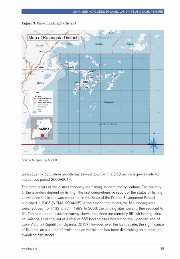
www.iied.org 39
Changes in aCCess to land, land use and land tenure
Subsequently, population growth has slowed down, with a 3.58 per cent growth rate for the census period 2002–2014.
The three pillars of the district economy are fishing, tourism and agriculture. The majority of the islanders depend on fishing. The first comprehensive report of the status of fishing activities on the island was contained in the State of the District Environment Report published in 2005 (NEMA, 2004/05). According to that report, the fish landing sites were reduced from 132 to 72 in 1999. In 2003, the landing sites were further reduced to 51. The most recent available survey shows that there are currently 65 fish landing sites on Kalangala Islands, out of a total of 555 landing sites located on the Ugandan side of Lake Victoria (Republic of Uganda, 2012). However, over the last decade, the significance of fisheries as a source of livelihoods on the islands has been diminishing on account of dwindling fish stocks.
Figure 3: Map of Kalangala district
Source: Supplied by ACoDE

Understanding changing land access issUes for the rUral poor in Uganda
40 www.iied.org
During the course of this study, participants in the FGDs reported that the fishing industry had declined considerably, and a number of landing sites had either been abandoned or the economic activities on these landings had diminished substantially. The participants attributed this phenomenon to the dwindling fish stocks and the shift in economic activity towards agriculture.
Agriculture is the second major economic activity in the district. The major crops grown in Kalangala district are cassava, potatoes, and bananas. Conversely, livestock keeping in the district has been steadily improving. This phenomenon can be attributed to increased awareness on livestock production and people’s desire to diversify from the historical dependence on fishing. A substantial proportion of farm households are embarking on other alternative enterprises like dairy, piggery, goat farming and poultry production.
In 1998, the government of Uganda launched the Vegetable oil Development Project (VoDP) in the district. The project is supported by IFAD, the World Bank, and the private company Bidco. The project involves the introduction of commercial palm oil production with the goal of increasing domestic production of vegetable oil. In 2005, the Kalangala oil Palm Growers Trust (KoPGT) introduced Kalangala oil Palm Development (KoPD) as a component of the VoDP. Since 2005, the KoPGT has successfully established palm oil production as the new and main cash crop in the district. KoPGT operates as a private agro-industrial development entity representing a commercial interface with smallholders who own 10 per cent of the shares, while Bidco Uganda Limited owns 90 per cent of the shares (Nsamba-Gayiiya and Kamusiime, 2015). Currently, the project involves 6,225 hectares of nucleus estate, 3,864 hectares of smallholder plantations and at least 1,610 hectares of smallholder farmers, out of which 35 per cent are women.
The development of the VoDP has had a tremendous impact on the way land is used in the area, with more and more farmers shifting from food crops to palm oil production. The demand for land has risen, pulled by the prospective opportunities in the sector, but also due to the increasing influx of people moving from other areas in order to produce under the VoDP. The increasing pressure on land is having also impacts on the way land is transferred and accessed by different actors as well as on the relative importance of the existing forms of land tenure. More formal, market-based transactions are replacing customary ways of accessing land. Relationships between landlords and tenants are also changing to a large extent.
The opening up of the district has also brought to the fore Kalanga’s tourism potential. Kalangala district is part of Buganda Kingdom and hence houses numerous Buganda’s cultural sites. Prominent ones include: Luggo forest which has the Ddamula, a tree cut to model a stick that prescribe full instruments of power given to an incoming prime minister of Buganda. Bukasa shrine, one of Buganda’s most important shrines, is located in the district. other important tourist attractions include the spectacular Nanziri waterfalls,
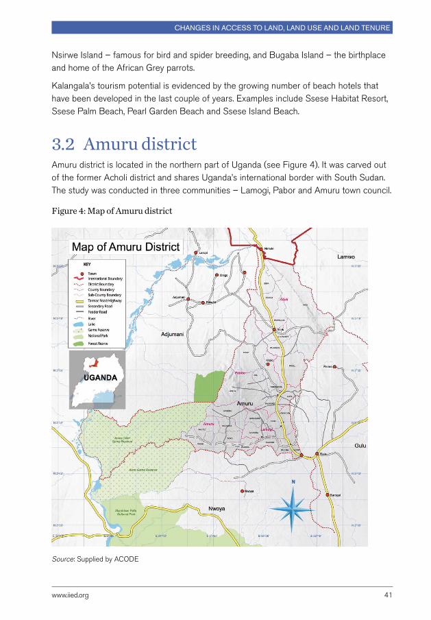
www.iied.org 41
Changes in aCCess to land, land use and land tenure
Nsirwe Island – famous for bird and spider breeding, and Bugaba Island – the birthplace and home of the African Grey parrots.
Kalangala’s tourism potential is evidenced by the growing number of beach hotels that have been developed in the last couple of years. Examples include Ssese Habitat Resort, Ssese Palm Beach, Pearl Garden Beach and Ssese Island Beach.
3.2 Amuru district Amuru district is located in the northern part of Uganda (see Figure 4). It was carved out of the former Acholi district and shares Uganda’s international border with South Sudan. The study was conducted in three communities – Lamogi, Pabor and Amuru town council.
Figure 4: Map of Amuru district
Source: Supplied by ACoDE

Understanding changing land access issUes for the rUral poor in Uganda
42 www.iied.org
Amuru district had an estimated area of 3,626 km2 and a population of 186,696 in 2014, up from 88,692 in 1991 (UBoS, 2016). over the past ten years, the population has been increasing at an annual growth rate of 2.83 per cent (Republic of Uganda, 2014a) from 88,692 in 1991 to 194,900 in 2015. Amuru district is generally sparsely populated, with a population density of 52.5 inhabitants per km2, and most of the people live in rural areas. It is estimated that only 5 per cent of the district population live in Amuru town, the main urban centre in the district, or in other peri-urban trading centres scattered across the district.
Subsistence agriculture is the backbone of the economy of Amuru district. The agricultural sector employs more than 98 per cent of the population. The dominant crops grown in the district are cotton, tobacco, maize, millet, sorghum, and simsim, among others. over 90 per cent of the land in the district is classified as fertile arable land. Hitherto, most of the land has not been previously utilised mainly because of over two decades of insurgency by the Lord’s Resistance Army. Besides agriculture, the people of Amuru district engage in petty trade and other forms of retail businesses. Since the end of the insurgency, there have been major economic developments in Amuru district that impact significantly on land access and use.
The area is part of the Albertine Graben where oil discovery and development activities have been taking place since 2006. Exploration in Amuru district falls under exploration blocks one and five licensed to Hardman resources and Energy Africa (now Tullow oil) in 2004, and Neptune Petroleum Uganda Limited (now Tower Resources) in 2005.
In 2007, Amuru district also allocated 40,000 hectares of land in Lakang village to the Madhavani Group of Companies for a large-scale sugar plantation and a sugar factory. The group has projected to invest over US$100 million through its subsidiary, Amuru Sugar Works Ltd. (ASWL). The land in issue remains a subject of litigation to date. This land dispute in Lakang has also been clouded by perceived oil discovery, and it is alleged that the vast oil deposit in Uganda is found in Lakang in Amuru. The conflict of interest centres on gains and benefits from the resource. Perceptions are that if the land, beneath which oil has been found, is given to the Madhvani Group, the locals are not likely to benefit from the proceeds of the oil revenue.
Part of Amuru district is claimed by central government to be part of the wildlife protected area under the custodianship of the Uganda Wildlife Authority (UWA). Consequently, over the years, there have been a series of forceful evictions and conflicts between the local people and the UWA (ocungi, 2015; okello, 2015). This conflict is mainly concentrated in Pabbo sub-county. Amuru has also been plagued by an array of land issues, ranging from conflicts over the Adjumani- Amuru border demarcation due to the Apaa land wrangles, to people being required to vacate land for purposes of preserving tree species in protected forest areas.
www.iied.org 43
Changes in aCCess to land, land use and land tenure
3.3 Land tenancy characteristics, fragmentation and concentration In Amuru district, the majority of the households (83 per cent) operate their owned land, compared to 25 per cent that are occupants (squatters) on their land and 18 per cent of households who are renting the land. In Kalangala district, 53 per cent of the household own their land, compared to 27 per cent who are squatters, 10 per cent who rent their parcels, and 17 per cent whose land is located in areas dominated by mailo land tenure. The proportion of households operating each of their own land and rented-in land is statistically different across the two districts, but higher in Amuru district than in Kalangala district.
Land parcel level data has not revealed significant levels of land fragmentation. on average, a household has two land parcels and they spend about 19 minutes on average walking between their homesteads and their land parcels. Households have also spent 16 years on average utilising their land parcels.
The majority of the land parcels however were found to be less than one acre in size. About 1.72 average number of land parcels accessed by farm households fall in the category of the smallest size (less than 1 acre), followed by 1.27 land parcels in the biggest category (more than 2.1 acres), and is least for 1.14 land parcels in the middle size category of 1.1–2.0 acres. The distribution of land parcels is therefore dominated by smallest size pieces of land, followed by large pieces, and is least dominated by medium pieces of land in each of the two districts. These results denote that, while access to land has not diminished over time, land is concentrated amongst few households.
As mentioned, the dominant tenure system in Kalangala district is mailo, with the majority of the surveyed households (60 per cent) declaring that they hold land under this tenure system. Households whose land is regulated under freehold tenure account for 24 per cent, followed by those under customary tenure (20 per cent) and leasehold tenure (8 per cent). The relative importance of the four tenure regimes has remained virtually the same in the last five years – between 2010 and 2015. In Amuru district, the vast majority of households – 95 per cent – declared that they held land under customary land tenure. The figure represents a slight decline – from 98 per cent since 2010. Conversely, the share of households that hold land under freehold and leasehold regimes – 5 per cent and 4 per cent respectively – have both increased to 9 per cent. While this increase may not be very significant in absolute terms, it still represents quite a significant change considering the short timeframe and considering that the northern districts are still almost entirely regulated under customary systems.

Understanding changing land access issUes for the rUral poor in Uganda
44 www.iied.org
In terms of land certification, we find that very few (8 per cent) farm households currently have a formal title of land owned. only 19 per cent of farm households have a transaction agreement that are endorsed by local council authorities, while 23 per cent of farm households reported having land transaction agreement that were not endorsed by the lowest local government council. The level of land certification is much lower in Amuru district compared to Kalangala district.
There is additional evidence from quantitative survey data analysis on the extent to which land prices and land access vary in different tenure regimes. The average size of land parcels is 4.3 acres, and although not statistically different across the two districts, the analysis shows that the size of land parcels is slightly higher in Amuru district. Fixed rental rate is higher in Kalangala district at UGX 162,300 per acre of land and for two seasons, than UGX 81,200 per acre of land in Amuru district. Land is therefore scarcer and in higher demand and a higher value in Kalangala district than in Amuru district.
There was a slight increase in the proportion of land accessed by households in areas managed under different tenure systems. Between 2010 and 2015, farm households appear to have accessed more land in areas under a freehold and leasehold tenure system. The proportion of land under freehold and leasehold tenure systems in Amuru district increased from 5 per cent and 4 per cent respectively in 2010 to 9 per cent each in 2015. The proportion of land in Kalangala district did not change from 24 per cent for freehold tenure and 8 per cent for leasehold land tenure. Land access in areas predominantly under mailo and customary tenure systems did not change much in the five-year period between 2010 and 2015. It is therefore evident that while land access has been changing in the last five years, this has been taking place at a very slow rate.
Further findings on land access and use across households reveal that households in Amuru district own 4.7 acres of land on average compared to 3.97 acres of owned land in Kalangala district. Land endowment is not statistically different in the two districts. Land rented-in ranges between 1.26–1.28 acres in Amuru district, and is higher than the average of 1.13 acres of rented-in land in Kalangala district. Household-level land owned, the proportion of land owned that is cropped in each of the two seasons, land rented-in the first cropping season, and land borrowed-in in each of the two cropping seasons are not statistically different in the two districts. Furthermore, access to a swampland is widespread in Amuru district, but very scarce in Kalangala district.
A comparative assessment of household participation in different land transfers and modes of rental rate payment in Amuru and Kalangala district were carried out. overall, 14 per cent of the total number of households surveyed in the two districts had participated in land renting-in transactions, a mode of land access that is more pronounced in Amuru district (25 per cent) compared to Kalangala district (5 per cent). only 2 per cent of households in the data rent out their land and the proportion is the same in Amuru and Kalangala district. The people who rent out land tend to be

www.iied.org 45
Changes in aCCess to land, land use and land tenure
large landowners and absent landlords, who are more likely to be missed out of the sampling frame.
Households that borrow-in land constitute 17 per cent overall. only 15 per cent of households borrow-in land in Amuru district compared to 19 per cent in Kalangala district. The proportion of households borrowing-out land is very small at 2 per cent in Amuru district and 1 per cent in Kalangala district, while households that participate in other types of land transactions in each district constitute 9.1 per cent.
The dominant rental rate mode of payment is fixed cash payment and its use is statistically different between the two districts. The proportion of households paying rental rate by fixed cash payment is 25 per cent in Amuru district and 10 per cent in Kalangala district. Household participation in short-term land rental market is increasing more in Amuru district than in Kalangala district. The level of renting-out and borrowing-out is comparably similar in two districts.
3.4 Land access and distributionThe overall average size of land parcels is 1.23 acres, while total land owned is on average 4.3 acres. The overall average size of land parcels owned does not differ significantly across the two districts (about 4.3 acres), but the average land operated is higher in Amuru district (5.6 acres) than in Kalangala (4 acres). The average land operated in the study areas is higher than average land owned, which implies that land transfers through market and non-market means are helping to allocate land to efficient farmers irrespective of the underlying constraints to smooth land transfers.
The Gini coefficient is a measure of statistical dispersion and is commonly used as a measure of inequality of income or wealth, where 0 corresponding to perfect equality. The calculated value of the Gini coefficient reveals that land is relatively concentrated in the hands of very few people. The average Gini coefficient is 0.53 for land owned and 0.52 for land operated in the study area. In Kalangala district, Gini coefficients for land owned and land operated per adult equivalent are 0.55 each. This Gini coefficient is higher than 0.50 for land owned and 0.48 for land operated in Amuru district. These results suggest that the control of productive land is highly concentrated and unequally distributed in both the study areas, although inequality in land ownership is higher in Kalangala than in Amuru district.
To the extent that the Gini coefficient for land operated and land owned is of same magnitude of 0.55 in Kalangala, this implies that inequality in land distribution is also higher in Kalangala district, compared to Amuru district. A large chunk of land in Kalangala district has been earmarked for annexation for large-scale agricultural investments. Conversely, land transfers through the market in Amuru district are to some

Understanding changing land access issUes for the rUral poor in Uganda
46 www.iied.org
extent helping to equalise the distribution of land access as demonstrated by a lower Gini coefficient (0.48) of land operated compared to 0.5 of land owned in the district.
These results reveal that market imperfections in land and labour market that are instrumental in facilitating land access and equalisation of operated land appear to be more significant in Kalangala district than in Amuru district, with inequality of land distribution higher in Kalangala than in Amuru. The functioning of the land rental market in Amuru district is helping to equalise production factor ratios, and the same land markets appear to be doing so to a limited extent in Kalangala district. This implies therefore that market-based transactions are helping to enhance efficiency in agricultural production more in Amuru district than in Kalangala district.
3.5 Local drivers of change in land access and useThis section discusses some of the underlying drivers of change in land access and use in the study areas, showing how the macro-level trends discussed in Chapter 2 manifest themselves at the local level.
From the information collected through the FGDs, at least three major driving forces emerge that operate at the local level in each of the two districts: (i) the changing nature of economic activities; (ii) population increase and influx of immigrants; and (iii) a growing demand for land for speculative purposes.
In both study areas, the changing nature of economic activities is the major underlying driving factor in determining land tenure and land access change. In Kalangala, the introduction of the VoDP is reported to have created tremendous opportunities for the community, but is also seen as having triggered a rush for land, including from non-residents. Indeed, this is seen as the single most important factor that is driving changes in land tenure, influencing modes of land access but,most importantly, impacting on the nature of land use in the area. The ongoing process of land acquisition by Amuru Sugar Works is considered to be creating similar effects in Amuru district.
The FGDs held in Amuru district identified the following as the most significant drivers of changes in land access and use:
(i) The increase in the level of security, development, and economic progress in the area encourages investment on land, including investments in commercial agriculture and real estate business that have also led to the establishment of new public and administrative offices.
(ii) The business opportunities along the borders with Sudan and the DRC also compel local business people to invest their larger savings in land assets.

www.iied.org 47
Changes in aCCess to land, land use and land tenure
(iii) A high affluence of migrants that can often afford to buy land and displace local poor members of the community.
(iv) The increasing incidence of land conflicts due to the high demand for acquiring land, including through unfair processes that overcome existing informal institutional arrangements. The high demand for land has as a result stimulated the supply side of land sale and rental market in the district, and therefore the number of land sale and purchase transactions.
In Kalangala district, the key micro-level drivers of change listed by participants in FGDs include:
(i) The sustained development and economic progresses. The establishment of large-scale palm oil production and other investments in tourism have created economic opportunities, although some development experts claim that these big land developments may have also contributed to the higher incidences of conflicts over land rights and ownership (Fallon, 2015). This is especially the case between landowners who hold the legal deeds and the generations of smallholders who occupy and derive their livelihoods from the same farmland.
(ii) The enhanced level of infrastructure, such as better roads and reliable electricity, which is creating incentives to engage in commercial agriculture.
(iii) The difficulties faced by lawful tenants and illegal squatters occupying mailo and public land when processing certificates of occupancy and later freehold land titles as required by the Land Act 1998. These vulnerable groups are more likely to be evicted from their land by the powerful elites, and their land taken over by the new owners under different land tenure with no meaningful compensation.
(iv) The increasing levels of migration that are creating opportunities for people born in distant areas to purchase and own land in the district.
A combination of these factors has triggered interest in land acquisition and, in some cases, a speculative land market in both districts, with an increase in the market opportunities for farm produce in the local area, an increase in demand for land brought about by an increase in the commercialisation of agriculture, better standards and rural economic development and transformation in the area, and the improvement in the rural road infrastructure from seasonal roads to more relatively reliable all-season dirt roads.
The projects are opening up the districts to newcomers, leading to an increase in the demand for land. Respondents in the FGDs reported that non-residents are flocking into the area, seeking to acquire large chunks of land in anticipation of a potential windfall from future land sales. However, the scope of such speculative land purchases is not well understood and may be a subject of future research to generate evidence to guide policy and decision making.
Understanding changing land access issUes for the rUral poor in Uganda
48 www.iied.org
The increasing commercial interests have also pushed a shift in the modes of land access from the traditional means (inheritance, gifts and squatting) to market modes that are now dominant and largely conducted through land sales and renting-in in response to the desire to enhance income from accumulated land assets.
In Amuru, the increasing commercialisation of land – with more households across communities now able to use land for economic reasons compared to the past and the improvement in local security and the economic environment – has led to a rise in the demand for land. This has stimulated the supply side of the sale and rental market, thereby increasing the number of sale transactions in all land tenure regimes. Use of formal, market-based transactions is also fostered by:
●● The arrival of migrants that can afford to buy or rent land.
●● The breakdown of family values and lineage groups that are weakening the role of families and clans in regulating land rights transfers in the face of increasing economic pressure to make money and increase consumption.
●● The alarming suspicion and speculation created by the new policy under the recent land law and new practice of demanding all land to be registered and formalised.
In Kalangala, the development of a commercial agricultural sector and the emergence of land markets provide opportunities to enhance the efficiency in land use. For instance, some farmers are intensifying their farming practices, as demonstrated by the spreading use of small-scale irrigation facilities. However the situation can also provoke exclusion of certain categories, for example youths, who have no access to land and are unable to buy land at the current high prices. The youth are increasingly opting to join low capital off-farm occupations such as operating boda-boda (motorcycle transport business) and other small business.
3.6 Changes in modalities of access to landLand is an important cultural and economic resource in all parts of the country. The question is whether the underlying changes in land tenure are improving access to land through market and non-market modes, and to what extent this would enhance efficiency, equity, and sustainability in the use of land. Land tenure determines the bundle of rights embedded in the use of land and the freedom to transfer such rights through different modes of access.
Land access in this study includes land endowments in acres that farm households own or operate in their production process. Land owned is defined as land accessed mainly through the modes of inheritance (or in form of gifts) and purchases. Land that farm households operate includes land that is accessed through inheritance and market modes of land access including purchases, renting-in and borrowing. This section provides
www.iied.org 49
Changes in aCCess to land, land use and land tenure
descriptive assessment of the recent changes and trends in land access. We computed land owned, land purchased, land inherited, and land operated using three different UNHS data-sets for each of the 1999/00, 2005/06, and 2009/10 fiscal years. Results show a steady increase in average land owned from 1.97 acres per household in 1999 to 2.92 acres in 2009, as well as a steady growth of land operated – from 1.15 acres in 1999 to 3.65 acres in 2009.
The analysis shows that households own and operate more land in areas where customary land tenure is dominant, implying presence of market imperfections and land abundance in these areas that to a large extent limit efficient functioning of land markets. Customary systems and freehold systems are more efficient in securing access to land, and this may also explain the highest increase in land owned in areas dominated by these land tenure systems.
Inheritance has remained the most common way of acquiring land, with land inherited having increased from an average of 0.68 acres per household in 1999 to 2.62 acres in 2009. As expected, land access through the mode of inheritance is highest in areas dominated by mailo and customary land tenure. These areas are to a large extent characterised by some restrictions on the functioning of land markets due to cultural interests. Land access through purchases reduced from 1.68 acres in 1999 to 0.93 in 2009. Even so, households purchase more land in areas dominated by freehold and leasehold land tenure when compared to the size of land purchases in other tenure systems, especially in 2009.
overall, land access appears to be increasing, implying that the recent land reforms are to a certain extent working to ensure efficient land transfers. The increase in land access is evident and more pronounced in the short-term land rental market, but it is still limited in land purchase markets. The effect of changes in land access through land renting and borrowing is evident in the higher average size of land operated when compared to land owned. Access to land through the market appears to be efficient in areas dominated by freehold and leasehold type of land tenure regimes, when compared to customary and mailo land tenure systems. Conversely, land inheritance is still on the increase and more distinct in areas dominated by mailo and customary land systems. These results are in line with findings from previous studies from Uganda that attempted to examine the extent to which land law reforms are working to strengthen land tenure security and the functioning of land markets. For example, land sales markets in the mid-2000s were found to work most efficiently in areas dominated by the freehold tenure system, while land rental and sales markets were less important as sources of land access in the mailo tenure system (Tatwangire and Holden, 2013). Land rental and sales markets are also more likely to be active in immigrant communities, where efficiency in land allocation is enhanced through land transactions (Mwesigye et al., 2014).
Understanding changing land access issUes for the rUral poor in Uganda
50 www.iied.org
Young people tend to engage in rural-to-rural and rural-to-urban migration whenever they face challenges of land scarcity as a result of population increase and limited access to non-farm employment opportunities.
Evidence from the two case study areas suggests that there are considerable changes in how land is accessed. one of the key research questions for this study was to establish the changing modes of accessing land and whether such changes have benefited poor rural households over the last ten years.
According to the respondents of the FGDs, access to land through traditional arrangements such as borrowing, squatting, inheritance and gifts have either diminished considerably or no longer convey secure rights to land. This is due to the fact that more and more actors seek to formalise a title on the land, but also because the level of trust between landowners and tenants or squatters is reported to have diminished significantly.
While access to land through inheritance remains an important mode of land access, especially in areas dominated by mailo and customary land system, there is a gradual shift from informal and more traditional modes of access to more formal, market-based modes of accessing land.
In both cases studies, land access and disposition through sale or purchase markets is now at a higher level compared to a decade ago. In Kalangala district, prior to 2005, inheritance and squatting (occupancy/just moving-in) were the main modes of land access in rural areas, while access by purchase was dominant only in areas near trading centres. Similarly, in Amuru, land used to be accessed only through non-market modes, mainly through inheritance and borrowing-in.
In more recent years, there has been an increase in land accessed through market-based modes when compared to non-market modes. Participants in the FGDs in Kalangala district indicated that land access through renting-in and purchases have increased drastically since 2005. Land access through borrowing-in has on the other hand reduced during the same period. According to the results of survey data analysis, represented in Figure 5, 26 per cent of households in Kalangala acquire land through purchases. The percentage of households acquiring land through purchases in Amuru is still much lower at 1.5 per cent – but this is not surprising in an area greatly dominated by customary tenure. on the other hand, the share of households in Amuru that are involved in renting transactions is much larger at 20 per cent than in Kalangala at 5.6 per cent, thereby indicating that market-based transactions are gaining importance in this district too. FGDs also reported that the closure of IDPs camps triggered an increase in new modes of land transfers, such as renting-out and borrowing-in.

www.iied.org 51
Changes in aCCess to land, land use and land tenure
Figure 5: Land parcel size categorisation and land acquisition by district
Like many places in the country, the price of agricultural land, commercial land, and other types of land in Kalangala district has increased considerably since 2005. Participants in the FGDs revealed that the price of one acre of land increased from UGX 55,000 to UGX 2,500,000 over the last ten years. However, respondents of the household survey declared that they may be willing to ask up to UGX 4,500,000 to sell one acre of owned land. Recent statistics also show an increase in demand for land on Bugala Island. Land prices have increased considerably, from UGX 70,000 to UGX 150,000 per acre in 2002/03 to between UGX 800,000 to UGX 2 million in 2008/9 (Nsamba-Gayiiya and Kamusiime, 2015). A significant proportion of the rural poor is less able to access land in Kalangala district; this is a new development that is changing the dynamics of land access.
Purchase 1.54%
Inherited/received as a gift 59.23%
Rented-in/leased-in 20%
Borrowing-in 15.38%
occupied/just walked-in 3.85%
Amuru (130)
Kalangala (152)
Purchase 26.06%
Inherited/received as a gift 28.87%
Rented-in/leased-in 5.63%
Borrowing-in 16.9%
Don’t know/other 4.23%Donation 5.63%
occupied/just walked-in 12.68%
Understanding changing land access issUes for the rUral poor in Uganda
52 www.iied.org
The average price of land in Amuru district is reported to have increased drastically in recent years too. Participants in the FGDs indicated that price per acre of agricultural land increased to UGX 3,300,000 up from the average price of UGX 100,000 ten years ago. Similarly, the average price of commercial land increased from UGX 350,000 in 2005 to UGX 6,000,000 in 2015, while for land that is normally utilised for other uses, the price increased from UGX 140,000 to UGX 1,650,000 in the same time period.
According to the information collected through the FGDs, these changes in prices and in the modes of accessing land have accelerated over the last five years since 2010, meaning that land markets are just starting to emerge. Further, these changes seem to be more widespread on land predominantly under freehold and leasehold tenure systems, and are less frequent on land under mailo tenure. Between 2010 and 2015, the share of land under freehold and leasehold tenure that was accessed by the survey respondents has increased a bit more compared to other tenure systems. The increase in the proportion of land accessed under freehold and leasehold tenure systems may indicate the spread of market-based transactions.
Land markets in Kalangala district are well supported by the dominance of individualised land tenure. A significant proportion of land in northern Uganda, including Amuru district, is collectively owned and a functional land market is just emerging. For example, according to the Uganda National Household Survey, approximately up to 59 per cent of cases of acquisition of agricultural land in the Central Region involved purchases through formal markets, compared to 47 per cent in the Western Region, 39 per cent in the Eastern Region and only 6 per cent in the Northern Region. Approximately 91 per cent of the land in northern Uganda is disposed of and acquired mainly through inheritance (UBoS, 2007).
3.7 Changes in land use and agricultural intensificationData analysis reveals that in both case study areas, there are clear changes in land use as a result of new dynamics in three key areas, namely: the nature of economic activities; adoption of technology; and land use intensification. Information from FGDs and field data show that there is widespread conversion of land from other forms of land use to palm oil production. Participants in the FGDs also indicated that foreigners and people from other areas are coming to the island and buying big chunks of land. Increasingly, land use is shifting from traditional crops to the growing of palm oil which is promoted through the outgrowers’ scheme. There has been a shift of land use in Kalangala district from alternative uses such as annual crop production, to vegetable oil farming, largely through nuclear estates that are rented by the local community members.

www.iied.org 53
Changes in aCCess to land, land use and land tenure
Respondents were asked to recall land allocation to different uses in the last 15 years. The analysis of fieldwork data reveals that changes in land use in Amuru district have been marginal (see Table 1) over the period of study (2005–2015). Land use under natural woodlots, man-made woodlots, and brick making appears to be disappearing very fast. The drastic changes between land use in 2015 compared to earlier years can be attributed to land that was previously more abundant.
Table 1: Changing land use in Amuru district
Primary land parcel use 2000 2005 2010 2015
% % % %
Cultivated (annual crops) 37.50 44.00 51.26 32.81
Cultivated (perennial crops) 4.55 5.00 5.04 3.91
Improved fallow 1.14 1.00 0.84 17.97
Bush fallow 11.36 9.00 4.20 3.91
Grazing land 2.27 2.00 0.84 1.56
Man-made woodlot 1.00 0.84
Natural woodlot 5.68 4.00 0.84
Construction 22.73 22.00 25.21 28.91
Residential 11.36 10.00 8.40 10.16
None or vacant 2.27 2.00 1.68
Home returned to owner 0.84 0.78
Brick making 1.14
In 2005, land use in Kalangala district was dominated by agricultural production, with annual crop production and perennial crop production each representing 35.2 per cent of land use. other uses included residential activities (7.6 per cent), grazing (5.7 per cent), bush fallow (4.7 per cent) and natural woodlot (4.7 per cent) (see Table 2). over the subsequent ten years, the most remarkable change in land use has been the increase in the parcels used for perennial crops (mainly palm oil), which now represent 40.4 per cent of the total compared to only 26 per cent of the total in 2000. All other types of uses have lost importance apart from residential area activities, up to 12 per cent. Land use in the form of growing fruit trees, fodder trees production, construction, and brick making has not changed significantly.
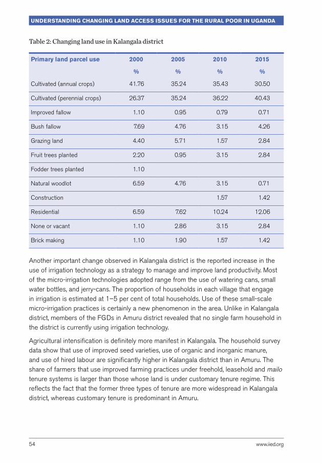
Understanding changing land access issUes for the rUral poor in Uganda
54 www.iied.org
Table 2: Changing land use in Kalangala district
Primary land parcel use 2000 2005 2010 2015
% % % %
Cultivated (annual crops) 41.76 35.24 35.43 30.50
Cultivated (perennial crops) 26.37 35.24 36.22 40.43
Improved fallow 1.10 0.95 0.79 0.71
Bush fallow 7.69 4.76 3.15 4.26
Grazing land 4.40 5.71 1.57 2.84
Fruit trees planted 2.20 0.95 3.15 2.84
Fodder trees planted 1.10
Natural woodlot 6.59 4.76 3.15 0.71
Construction 1.57 1.42
Residential 6.59 7.62 10.24 12.06
None or vacant 1.10 2.86 3.15 2.84
Brick making 1.10 1.90 1.57 1.42
Another important change observed in Kalangala district is the reported increase in the use of irrigation technology as a strategy to manage and improve land productivity. Most of the micro-irrigation technologies adopted range from the use of watering cans, small water bottles, and jerry-cans. The proportion of households in each village that engage in irrigation is estimated at 1–5 per cent of total households. Use of these small-scale micro-irrigation practices is certainly a new phenomenon in the area. Unlike in Kalangala district, members of the FGDs in Amuru district revealed that no single farm household in the district is currently using irrigation technology.
Agricultural intensification is definitely more manifest in Kalangala. The household survey data show that use of improved seed varieties, use of organic and inorganic manure, and use of hired labour are significantly higher in Kalangala district than in Amuru. The share of farmers that use improved farming practices under freehold, leasehold and mailo tenure systems is larger than those whose land is under customary tenure regime. This reflects the fact that the former three types of tenure are more widespread in Kalangala district, whereas customary tenure is predominant in Amuru.
www.iied.org 55
Changes in aCCess to land, land use and land tenure
The use of local seed varieties for major crops appears to be positively correlated with possession of secure land rights, while the use of improved seed varieties is negatively correlated with having secure land rights and being land poor. Households that are insecure with their land use rights, but also land-poor, are more likely to invest in the use of improved seed varieties than households with secure land rights and are land-rich. This explains why use of local seed varieties is dominant (94 per cent) in Amuru district compared to 79.5 per cent in Kalangala district. Conversely, a large proportion (35 per cent) of farm households in Kalangala district uses improved seed varieties compared to 8.5 per cent only in Amuru. The use of local seed varieties is more prevalent in areas dominated by customary and leasehold tenure, while the use of improved seed is dominant in leasehold and freehold land tenure systems. This again can be attributed to the wider market imperfections that also hinder access to agricultural inputs and land through local markets. It is important to note that in Uganda land tenure security is prevalent on all land tenure systems with the exception of mailo land. Land formalisation and the possession of strong land rights appear to be increasing the likelihood of household levels of sustainable land use in terms of farm level investment in the use of inorganic manure.
3.8 Change in land tenure and land relationshipsAs mentioned, there are two land tenure systems dominant in Kalangala district, namely mailo tenure and customary tenure. The most common method of acquiring land in both cases has been through inheritance. The majority of the surveyed households (60 per cent) declared to hold land under the mailo tenure system. Households whose land is regulated under freehold tenure account for 24 per cent, followed by those under customary tenure (20 per cent) and leasehold tenure (8 per cent).
The relative importance of the different tenure regimes remained virtually the same between 2010 and 2015. However, according to the FGDs, changes are more evident if a longer timeframe is considered. For example, the proportion of land under mailo dropped from an estimated 75 per cent in 2005 to 60 per cent by 2015. At the same time, land that is accessed and governed under new forms of land tenure, such as leasehold and freehold, appears to be on the increase.
These changes reflect the increasing demand for land for commercial uses that encourage different users to seek individualised forms of titling through purchases or rental and leasing agreements, as opposed to more traditional forms of acquiring land through borrowing or the use of communal land. Many landowners also seek more formal arrangements in accessing and managing land.

Understanding changing land access issUes for the rUral poor in Uganda
56 www.iied.org
Big land developments can introduce some positive changes in the local context, especially in the way local land transactions take place. The ongoing large-scale agribusiness palm oil in Kalangala district has increased the number of land transactions and appears to have improved relations between landlords and tenants in the district. Landlords appear to be less powerful than they were, and less able to cause unjust problems for the tenants.
In addition, responses from FGD participants in Kalangala revealed that smallholders who farm under the mailo system in Kalangala face two major challenges related to the way land tenure is changing. First, lawful tenants and squatters occupying mailo and public land face difficulties when processing certificates of occupancy and later freehold land titles as required by the Land Act. These vulnerable groups are more likely to be evicted from their land by the powerful elites, and their registered land taken over without meaningful compensation by the new owners under different land tenure. Secondly, absentee landlords compound the tenure situation in the district. Some tenants do not know their landlords. Participants in the FGDs reported incidences where landlords engage in transactions transferring their land without the knowledge of the bona fide occupants.
These challenges stem from the disconnections that arise between the recent developments in the local economy and local land markets and the existing land tenure system. Traditional tenure structures may not be able to address the challenges that arise from pressure and competition for land, and this is exacerbated by the weak implementation of the land law as well as gaps and overlaps that exist between the traditional institutions and the state ones.
Amuru district has mainly two types of land tenure systems, namely, customary tenure largely of a communal nature, and freehold. Participants in the FGDs observed that over the last decade, the proportion of land held under customary tenure or the communal arrangements has decreased while land held under freehold has increased. Their estimates indicate that the proportion of land held under customary tenure system reduced by about 17 per cent from an average of 93 per cent in 2005, to approximately 77 per cent on 2015. Conversely, land under freehold is estimated to have increased from about 11 per cent to 21 per cent over the same period.
Changes in land tenure systems in Amuru reflect the increased demand for land, pulled by the changes in the local economy as well as prospective investments in agriculture and other sectors that are expected to bring economic opportunities in the area. Local people have started to compete for land with newcomers; some of those relocating from IDP camps bring about new types of land transactions outside the local customary systems. A rental and sale market is emerging, based on more formal transactions. People seek to acquire land on an individual basis, as opposed to communal and household ownerships, in order to formalise the rights on the land. Individual transactions however

www.iied.org 57
Changes in aCCess to land, land use and land tenure
are also becoming more frequent as a result of the progressive weakening of community institutions and the breakdown of family values and traditional relationships.
3.9 Key findingsThe macro policy environment and other drivers of land change are reflected in many different ways at the local level. In particular, the emergence of land markets not only impacts on the local land tenure regimes, but also on the modes of access to land as well as land use. The data from the case studies show a systematic, though slow, transition from largely informal to more formal mechanisms of land access, increases in prices for land, and generally increased land speculation. In Kalangala, there is clear evidence of commercialisation of land and intensification of farming practices. With the potential for large-scale sugar cane plantation farming in Amuru, it can be argued that such commercialisation and intensification will become inevitable. Finally, large-scale investments may also come with new institutional arrangements that have implications for land governance. The Kalangala oil Palm Trust (KoPT) and the Kalangala oil Palm Growers’ Association (KoPGA) are playing important roles in mobilising members and addressing land access and livelihood issues that are emerging as a result of the changes taking place in the district. It remains to be seen whether the commencement of large-scale agriculture by the Amuru Sugar Works will engender similar forms of institutional reorganisation with regards to local land governance.

Understanding changing land access issUes for the rUral poor in Uganda
58 www.iied.org
4 Impacts of land changes on tenure security and livelihoodsAvailable data and information suggest that, over the decade, there have been some changes in land tenure and modalities of access to land. Generally, some key elements of tenure and access remain largely unchanged or the noticeable changes remain marginal. This is the case with land tenure characteristics, land fragmentation and land concentration. However, besides the macro-level drivers of change discussed in Chapter 2, there are clear local drivers that have triggered some changes in the land tenure and access regime in the two case study areas and across the country. These changes need to be constantly monitored and appropriate policy responses and interventions designed and implemented.
This chapter analyses the impact of these changes on tenure security and livelihoods in the case study districts.

www.iied.org 59
Impacts of land changes on tenure securIty and lIvelIhoods
4.1 Impact of land changes on current and future tenure securityIn both cases studies, all participants in the FGDs reported that the transitions from customary to new, more formal types of land tenure provided less tenure security compared to the situation in the past. The new forms of transferring land through purchases also had the effect of locking or rationing out the majority of poor people, especially the vulnerable women and youth, from accessing land.
In Kalangala district, tenure insecurity is attributed to at least three key factors: (i) compensation of tenants on land is difficult due the phenomenon of absentee landlords; (ii) the new land policy is not clear about the process of formalising land ownership, despite many people requesting certificates of customary occupancy five years ago; and (iii) it is very difficult and expensive to process leasehold on mailo land.
Evidence from quantitative primary data shows that the proportion of households free to exercise all land rights on every land parcel in terms of right to: sell; bequeath; preserve; or pledge land as collateral in the study area is 41 per cent on average. This proportion is noted to be slightly higher (46 per cent) in Amuru district, compared to 36 per cent in Kalangala district (see Appendix, Table A1). The majority of rural farm households are still unable to freely exercise all land rights on their land. It is however clear that access and disposition of land through short-term transfers is relatively secure. A substantial number of households in Amuru district access land through short-term rentals, since land purchases are limited to communal land to a large extent.
The ongoing large agribusiness palm oil project in Kalangala district appears to be making a positive contribution towards the strengthening of land tenure. Growing oil palm is helping to improve the position and the balance of power between bona fide tenants and landlords (landowners) on land with overlapping land ownership rights. The new engagement dynamics between landlords and tenants have as a result introduced meaningful investment on land, which is vital for poverty reduction in the long run.
Tenants seem to be in a better position to access information on issues of land law and better able to bargain effectively with their landlords for more flexibility on issues of crop choice, whether annual or perennial in nature. There also seem to be clear avenues for tenants to engage landlords as a way of negotiating for fair terms of interaction, including buying-out the stakes of landlords on the same piece of land with overlapping land rights. Participating smallholders (including women) have also benefited from formal legal recognition of their tenure rights and some have expanded their landholdings (Nsamba-Gayiiya and Kamusiime, 2015).
All palm oil project beneficiaries are required to register with the KoPGT in order to facilitate their access to IFAD loans. The loans (at 10 per cent annual interest) are

Understanding changing land access issUes for the rUral poor in Uganda
60 www.iied.org
recovered through deductions made by KoPGT from the payments made by oil Palm Uganda Limited to farmers, which reduces unscrupulous behaviour of the powerful elites from evicting and taking advantage of tenants illegally. Major challenges currently faced by the palm oil project include: the tendency of some tenants (that were previously compensated for their land) to come back asking for either the return of their land or demanding more compensation. It seems likely that these people either did not receive effective sensitisation on how to use their compensation, or they may have been cheated by their landlords who were the primary beneficiaries of the land compensation from the palm oil growing scheme.
During this phase of slow evolution of land-related institutions, from customary institutions to formalised institutions which support private-led market transactions, powers of land access are noted to be changing in ways that empower vulnerable groups, including the introduction of balanced power relations. These changes in local institutions are currently helping oil palm growers to benefit, while landowners are the ones gaining to a lesser extent. In Kalangala district, this discrepancy in benefits is attributed to the fact that the government was buying land from the landowners (landlords), who would then take the initiative to compensate the tenants on their land. Tenants who were occupying land that was acquired for palm oil growing are also sought to have lost out on the opportunity to tap into the benefits of ongoing changes in local institutions and big land developments in the area.
Elsewhere, however, property rights and other institutional arrangements are not adequately developed to handle the new demands for land or to protect the land rights of traditional land users, thus they are unable to facilitate sustainable investments on land. For example in Amuru district, the rural poor are having a hard time dealing with the sharp increase in demand for land for the upcoming large-scale sugar cane cultivation, even when land is abundant. Cultural beliefs in these areas are still rooted in communal ownership of land, a major constraint to the efficient functioning of a land market and the protection of the land rights of individual landowners. There is an increase in demand for individual land ownership, which is seen as a potential threat to the existence of traditional family values and customs among members of the lineage groups.
4.2 Access to land / inclusivityAt the national level, the average land owned and operated has increased from 2.9 in 1999 to 3.6 acres in 2009. In the study areas, land accessed (land owned and/or operated) in 2014 was 4.7 acres in Amuru and 4 acres in Kalangala. These figures are smaller compared to the land that was available to the previous generation (in Amuru parents of the head of the household had 19 acres and in Kalangala they had 9 acres).
www.iied.org 61
Impacts of land changes on tenure securIty and lIvelIhoods
Most respondents in the FGDs reported increased difficulties in accessing land currently compared to the situation 10 years ago. Access to land through non-market means such as borrowing and squatting has either diminished considerably or no longer conveys secure rights to land. The level of trust between landowners and tenants or squatters has also decreased in some areas. Consequently, landowners increasingly prefer renting-out or outright selling of their land, a development that factors out poor people from participating in land markets due to the rising prices of accessing land. The new preferred modes of land access represent a clear shift from informal to formal market transactions with some characteristics that are likely to exclude some vulnerable groups of poor households from accessing land.
Findings from FGDs in Amuru district reveal three key factors that are limiting access to land. These are: (i) increasing population amidst a breakdown in the performance of local institutions of land governance and management; (ii) a breakdown in societal morals, cultural values, and the institution of marriage within the community; and (iii) high levels of refugees and immigrants that are straining the capability and systems of cultural institutions to maintain stability, and thus exacerbating eviction of some people from their land.
In Kalangala, the following factors were also highlighted from FGDs as contributing to limited access to land by poor households: (i) the new dynamics of local development that are in some cases replacing trust between community members with individualism and a desire by some to make quick money even at the expense of others; (ii) large-scale investment in palm oil production and re-allocation of land amidst land scarcity and high population density, and (iii) increasing levels of poverty and demand for land.
4.3 Implications for rural livelihoodsAccess to land, whether through the market or non-market route, plays an important role in enhancing household welfare and livelihoods. Households with more of either owned land, operated land, or market-accessed land can gain a significant welfare-improving effect of this better land access (Tatwangire and Holden, 2011; 2015). Insufficient access to land and low productivity of land are considered to be the major causes of rural poverty and food insecurity (Holden et al., 2008a; Melmed-Sanjak and Lastarria-Cornhiel, 1998).
In a recent study, land rental and sales markets in Uganda were found to contribute to greater efficiency of land use and equity of land distribution, by helping to facilitate the transfer of land rights from land abundant to land-poor households (Holden et al., 2008b). According to Tatwangire and Holden (2011) rural households gain access to more land through the market than through non-market means. This is especially the case in areas

Understanding changing land access issUes for the rUral poor in Uganda
62 www.iied.org
where land rights are secure, and where land sales do not create land concentration in the hands of a few inefficient households.
The potential of access to land to enhance efficiency and poverty reduction can be altered, if there are many more powerful actors on the demand side. Land rights of the poor, land use efficiency, and long-term poverty reduction can also be potentially threatened when high demand for land by foreign investors in areas with weak land governance institutions combine with the challenge of elite capture in the country (Deininger et al., 2011). When land rights are insecure, new reforms become necessary to effectively protect the national interests and people’s livelihoods. Land use and management can also be enhanced when financial institutions choose to ease constraints on funding investment by accepting land as collateral among other options of local financing.
In Kalangala district, market-based land transactions have become dominant forms of accessing and disposing of land. Farmers are making a significant shift from subsistence farming to commercial production to generate income, acquiring new technologies in crop production and management practices. Tenants have, as a result, had their land surveyed and recorded, thus increasing tenure security. Participating smallholders (including women) are benefiting from formal legal recognition of land tenure rights in the area, and some have expanded their landholdings (Nsamba-Gayiiya and Kamusiime, 2015).
Under the VoDP, all public land in the area was leased out to a nucleus estate (private sector) for a 99-year period. Furthermore, oil palm growing has been commended for improving transport infrastructure in the area and for helping farmers to, among others: formalise their land tenure rights, expand their farm sizes on the margin, increase household assets, and stabilise their incomes (Nsamba-Gayiiya and Kamusiime, 2015). While the big land development in the area introduced exogenous local land transactions to household decisions at the beginning of the project, the situation appears to have changed for the better. For example, in Kalangala district there has been an increase in the proportion of farm households engaged in land transactions over the last 10 years, with an improvement in the scope of local land transactions, land tenure security for participating farmers, transport infrastructure, and the level of citizens’ empowerment.
Big land developments and large-scale agricultural investments in the country have, it seems, tended to trigger an increase in land conflicts, but their specific impact on land concentration is not well known. It is important to note that there is an increasing dependency on land for agriculture, the major source of livelihoods in the country. This is clearly depicted by the FoSDA findings that confirm a strong correlation between household welfare measured through consumption expenditure and land access.

www.iied.org 63
Impacts of land changes on tenure securIty and lIvelIhoods
4.4 Incidences of land conflictsLand disputes are widespread in Uganda and are conservatively estimated to affect 7 per cent of agricultural landholdings (BEBA, 2012; 2014). The high incidence of land disputes is attributed to the mismatch between the land policy, legal framework, and implementation process. Demand for land required for public use, private sector-led development, and by speculators is on the increase in most parts of the country, including in Amuru and Kalangala districts. The poor implementation of the 1998 Land Law is also widely considered to have triggered incidences of state and private interest-inspired land evictions that are on the rise. Consequently, the perceived fear to lose land and the increasing incidences of actual conflicts on land are affecting livelihoods and the dignity of the community members, particularly women and children, whose fundamental rights are increasingly getting abused by the interests of the powerful elites.
Land conflicts have occurred in Kalangala district between members of the local community and a private company, following the appropriation of land for palm oil production. There have been reports of people being evicted from their homes in the forest to make way for this development (NAPE, 2011). Few rural dwellers hold official land titles for the land they live on and some find it hard to seek redress when facing a dispute, a vulnerability that affects their level of agricultural productivity.
Members of the FGDs concurred that conflicts on land are many and range from occupying land illegally, sharing land in ways that are unfair to the vulnerable groups, situations of land grabbing, misunderstandings between landlords and tenants, illegal evictions of lawful tenants, break down in marriages, and the negative effects coupled with unintended consequences of domestic violence. The underlying causes of land disputes are different, and include: inappropriate land allocations; increasing land scarcity; lack of regulations on land prices that are increasing rapidly; illegal selling of land; political interference in land transfers, unclear land boundaries that put owners on collision courses; land grabbing; and lack of proper documentation of tenants as bona fide occupants.
Land conflicts are often resolved through negotiations between conflicting factions and through holding meetings between landlords and tenants. others choose to forego their interest in land under conflict for the sake of peace. officials of local governments and area land committees play an essential role in facilitating the resolution of land conflicts. other useful agents that facilitate the resolution of land conflicts include: neighbours; courts of law including commercial courts; and the office of the RDCs in the district.
In some cases, mailo land is exchanging hands from old landlords to new ones who have acquired land titles through market exchanges. The attempt of new landlords to know and have some sort of control over their tenants and land boundaries sometimes results in conflicts that undermine peaceful co-existence between landlords and tenants. This has

Understanding changing land access issUes for the rUral poor in Uganda
64 www.iied.org
resulted in occasional incidences of evicting of tenants and the killing of landlords (obbo, 2015). There are efforts to promote the buying-out of the holding(s) of a registered landowner or the two coming to an understanding of sharing land based on the mutually-agreed land sharing arrangement. This enables the tenant to receive a land title and the ultimate desired situation where the land ceases to have multiple rights
Findings from the FGDs in Amuru district also indicate a rise in land conflicts, especially between individual landowners. There is high competition for land between local people and various social groups with different interests. The causes of such land disputes vary and range from disagreements on boundary demarcation, to new economic development in the area, to misunderstandings about user rights.
Members of the community in this district attempt to resolve land conflicts by engaging elders to assist in identifying and clarifying the true boundaries of land owned. To the extent that elders are unable to resolve these conflicts on land, they stay pending until leaders of the local government councils decide to intervene.
This facilitation of land conflict resolution is often done by elders and local government officials. Furthermore, members of the FGDs in Amuru district reported an increase in the incidence of land conflicts over the last ten years (from 2005 to 2015). Incidences of land appropriation in the district are also increasing. In 2010, land in the range of 10–50 acres was appropriated from common property to construct sub-county headquarters, town boards, and a church in the area.
According to the household surveys, the likelihood of experiencing a dispute over land is still relatively low, but it is more pronounced in Kalangala district than in Amuru district. The majority (85.23 per cent) of farm households have not faced land disputes over land ownership and user rights to land. only 8.33 per cent of farm households reported having land disputes that were resolved, about 6.44 per cent experienced land disputes that were still pending. The dominant cause of land conflicts range from the misunderstandings on land boundaries (26.32 per cent), issues of trespass on land (17.11 per cent), illegal settlement (14.47 per cent), and inheritance problems (11.84 per cent) (See Appendix, Table A3).
However, the concern that someone might dispute the land owned by a household is shared by 27 per cent of households in Amuru district and 42 per cent in Kalangala district. In Amuru district, major causes of household concern on the likely land disputes are: issues of boundaries, user rights, and illegal settlement. on the other hand, key factors of concern for the likely land disputes in Kalangala district are misunderstandings on boundaries, evictions from land, and user rights (see Appendix, Table A2). Empirical evidence in Uganda shows that the loss in agricultural production as a result of conflicts on land can be as high as 6 to 37 per cent (Byamugisha, 2014). This implies that agricultural land with conflict has 6 to 37 per cent lower yields than agricultural land

www.iied.org 65
Impacts of land changes on tenure securIty and lIvelIhoods
without conflicts (Deininger and Castagnini, 2006; Mwesigye and Matsumoto, 2013). Table A4 in the Appendix lists some of the reasons farm households in Amuru and Kalangala engage in distress access or disposition of land. Boundary and ownership conflicts are included in these reasons.
4.5 Implications for gender roles and ownershipUganda’s constitution guarantees equality between women and men (Republic of Uganda, 1995). Since 1995, the government has adopted numerous affirmative actions and measures, including a gender policy. For example, the Land Act (Cap 227) provides for female inheritance rights over land and also has requirements for spousal consent in all matters relating to land from which the family derives sustenance. However, the current land tenure and land access regimes largely continue to discriminate against women with regard to property rights. In particular, customary land practices favour male inheritance to land which further limits women’s land rights to access and own land. In the majority of cases, access to land by women is only limited to user rights. Males control a large proportion of land owned by households, a situation that reflects gender bias in land access and use in Uganda.
Household level responses on gender roles and land ownership show that land owned and managed by household heads, their spouses, and both household heads and their spouses is 72.62 per cent, 2.66 per cent, and 24.71 per cent respectively. It should be noted that 73.76 per cent of these households are headed by males compared to 26.24 per cent of those headed by females. The proportion of household heads that are male is even higher (78.46 per cent) in Amuru district than the corresponding 69.74 per cent in Kalangala district. Land ownership rights were held by 76 per cent of household heads in Amuru and 69 per cent in Kalangala, totalling 72.62 per cent across both districts. ownership by household heads’ spouses alone was low at 3.17 per cent and 2.19 per cent respectively. Land owned by both was 20.63 per cent in Amuru and 28.47 per cent in Kalangala. Regarding the household member who usually worked on the land, the findings showed that almost 60 per cent of the heads of household worked alone on the land in Amuru, compared to 44 per cent in Kalangala, with 10 per cent and 14 per cent of household spouses working alone respectively, and with both working 31.75 per cent and 41.91 per cent respectively. Regarding management and control of the land, the comparison between the genders was even more pronounced. In Amuru, 69 per cent of household heads managed the land alone, compared to 48 in Kalangala, with 9.38 per cent of spouses managing the land alone in Amuru and 14 per cent in Kalangala. Land managed by both was 21.88 per cent in Amuru and 38.24 in Kalangala.
Understanding changing land access issUes for the rUral poor in Uganda
66 www.iied.org
4.6 Key findingsEvidence from the two case studies suggests that ongoing changes in land access in its different dimensions have implications for livelihoods security for households that are directly dependent on land. At one level, tenure security is reported to have declined as new institutions displace the traditional ones. More generally, the economic landscape in many areas of the country, including the two case study districts, has changed considerably hence leading to increases in the value of land. In Kalangala district, the introduction of the VoDP as a large-scale investment project has also triggered substantial changes in the institutions for land governance. The KoPT and the KoPGA have become important actors in the land governance architecture in the district. Their influence with regard to allocation of land, inclusion in the outgrowers’ scheme, or protection of members from exploitation has grown over the last couple of years.
The evidence from the FGDs also alludes to the fact that access to land has decreased over the last decade. Traditional modes of land tenure, such as inheritance and land gifts, have not been able to fully adjust to new developments in land governance. Consequently, modes of access are slowly disappearing which inevitability affects those who usually benefit from this, in particular the youth. The growing perceived and real increase in the value of land has led to increased land conflicts evidenced through ongoing litigation involving communities in both Kalangala and Amuru districts.

www.iied.org 67
ConClusions and impliCations for publiC poliCy
5 Conclusions and implications for public policy
Uganda is experiencing significant transitions in land tenure, land access and land use which challenge its land governance institutions. As discussed previously, these transitions have been driven by two important phenomena. First, the changing policy narrative that has dominated the public policy discourse over the last decade. Policies on poverty eradication, investment and agricultural transformation and the formulation of a new land policy have elevated issues of land tenure, access and land use to the top of Uganda’s national policy agenda. Key elements of this narrative include: the emphasis on the commercialisation of agriculture; the need to attract foreign direct investments; the desire to protect bona fide occupants of land; and the deliberate efforts by key agencies such as the Uganda Forestry Authority (NFA) to realise this commercial model through, in this case, the promotion of forestry plantation development.
Second, the pursuit of large-scale agricultural investment projects has had a direct effect in changing the overall economic landscape of particular areas. As evidenced by the two case studies, changed economic landscapes have triggered both actual and perceived demand for land, driving up prices and significantly altering the modes of access to land. In this concluding chapter, we draw conclusions from the study and examine the implications of the observable changes on public policy.
Understanding changing land access issUes for the rUral poor in Uganda
68 www.iied.org
Uganda’s macro policy direction makes land access change inevitableThe changes in land tenure, land access and use observable in the two case studies appear to reflect similar changes taking place across the country. At a broad level, the changes are largely driven by a combination of macro policy and specific economic policies pursued by government. Major macro-policy frameworks of government, including the Uganda Vision 2040 and the National Development Plan, have put the issue of land centre stage on the development agenda. The commitment to invest in commercialisation of agriculture as a strategy to achieve faster socioeconomic transformation means that the impact of this narrative goes beyond the confines of specific geographic locations. Yet, across the country, as reviewed recently by the World Bank, rights to land ownership remain insecure; and land markets are as yet narrow, segmented and inefficient (World Bank, 2014:50).
As demand for land increases, market-based land transactions increaseStimulated by these macro policy drivers of change, the demand for land is on the increase in all areas of Uganda, whether urban or rural, including in remote areas. Where there is relative abundance of land, low population density, and weak transport and communication infrastructure, land transactions appear to be generally fair. There are, however, increasing signs that land access is becoming a more serious local development issue in these remote areas. In areas where development projects are mooted or underway, many people, including those from beyond the neighbouring communities, are flocking to such areas in the quest to acquire chunks of land in anticipation of potential windfalls from such investments or future land sales. Consequently, land that is held speculatively and unutilised is increasing, and more local people are choosing to settle in nearby trading centres in anticipation of growth in these centres.
In Kalangala, population pressure and the commercial development of palm oil production, through a PPP, have increased competition for land and stimulated market-based transactions. Although the traditional mailo form of tenure is still predominant, these transactions are occurring where freehold and leasehold tenure systems have developed. Investments in infrastructure and agricultural services related to palm oil development have increased the impetus for commercial production, and the area dedicated to perennial crops is gradually increasing compared to the area dedicated to annual crops and other uses. This shift towards commercial agriculture is evident also in the relatively widespread use of intensification practices such as micro-irrigation, improved inputs and hired labour.
www.iied.org 69
ConClusions and impliCations for publiC poliCy
In Amuru, large-scale investments in agriculture and oil exploration, the influx of immigrants, including people relocating from camps for IDPs that are now closed, and conflicts over protected areas, have also increased pressures and competition on available land. Although the vast majority of the land is under customary tenure, in the last five years acquisitions of parcels under leasehold and freehold tenure have increased, as have market-based transactions such as sales and rental arrangements.
In both districts, prices for selling and renting land have increased dramatically in the last ten years. At present, constraints on access to land are not the foremost concern for the majority, but there is rising inequality in land distribution, and rising land prices and speculative behaviour may increasingly hinder access to land for the poorest and the youth.
Impacts of investments on land access are not being anticipated and monitored Large-scale land investments have a poor record to date of anticipating and monitoring their impacts on the social, economic and land tenure landscape in the areas they operate. In the investments analysed in the two case study areas, there was little evidence of effort to forecast the nature of transitions that have taken place in terms of land tenure, land use change and land governance and how these affect households and communities. In the case of Kalangala, for example, there is no data on what has happened with the fishing communities in the area. Future large-scale investment projects should focus on anticipating such changes and develop longitudinal data to monitor such impacts and design appropriate response options.
Land disputes reduce agricultural productionLand disputes are reported to be on the increase in both case study areas – largely attributed to real or perceived land scarcity and weak land governance institutions. For example, in both Kalangala and Amuru, there are court cases contending land ownership or the process of land dispute adjudication. This apparent increase in land disputes is likely to create a major constraint on land productivity. Estimates by others suggest that Uganda as a whole loses approximately 5–11 per cent of agricultural production due to land conflict, while in areas where the system of mailo land tenure is predominant such as Kibale district, losses due to land conflicts are estimated to be even higher – at up to 25 per cent of agricultural production (Deininger and Ali, 2008).
Understanding changing land access issUes for the rUral poor in Uganda
70 www.iied.org
Land governance institutions struggle to cope with the scale and pace of changeEvidence from the two case studies and elsewhere across the country suggests that large-scale investment activities, including those developing large-scale agribusiness, have several implications for land tenure security and general economic activity in the area concerned. In Kalangala, most of the respondents in our focus group discussions associate the rush for land and the apparent increase in land prices with the influence of the palm oil project. The project also led to a reconfiguration of local land governance institutions – making the Kalangala Palm oil Trust a new, and key, player in land decision-making in the area. In Amuru district where Amuru Sugar Works has been seeking to secure large tracts of land for its sugar plantation, the effort has already generated similar effects. These include perceived and real land tenure insecurity as well as some growth in land-based conflicts.
These processes also demonstrate the incapacity of existing national and local land governance institutions to cope with the changes induced by the scale and pace of change, particularly with proposed investments on the scene. Similar challenges are evident in other areas with large-scale land acquisitions, even when they are not agri-business related. This is the case, for example, in the Albertine rift where the rush for land is overstretching the capacity of local institutions to cope and thereby increasing tenure insecurity especially for local people.
Land policy is in transition – an opportunity for strengthening land access for poor rural people Major land policy reforms have been implemented over the last 20 years – stimulated by the constitution of 1995. These reforms gained impetus in particular with the adoption of the National Land Policy in 2013 (GoU, 2013). These reforms have generally aimed at strengthening tenure security with land market development in mind, including in areas dominated by customary and mailo tenure systems. Yet these reforms framed by policy have not been concertedly pushed through and land policy itself clearly continues to be in transition. Land tenure has, meanwhile, tended to become more insecure in many areas with changes in the way land transfers are carried out in the context of a rapid increase in demand for land, increasing investments in commercial agricultural production in some areas, real estate development in many urban areas, and land accumulation for speculation purposes. There is opportunity in this time of flux to marshal evidence about the negative consequences of insecure land access for the rural poor and to install a presumption in policy that it must improve access security for the poorest.
www.iied.org 71
ConClusions and impliCations for publiC poliCy
In conclusion, the ways in which people obtain land in Uganda are changing fast. Land that used to be secured through inheritance, gifts, or proof of long-term occupancy is now more commonly changing hands in the market. Those with wealth and powerful connections are frequently able to override local rules and gain access to land at the expense of poorer individuals. Government-backed agribusiness investors receive large areas of land with benefits for some local farmers who are able to participate in the schemes, while other smallholders see their land access and livelihoods degraded. opportunities now generated need to be seized – to modify land governance systems so that they catch up with this rapid change and ensure fair access and productive land use in Uganda.

Understanding changing land access issUes for the rUral poor in Uganda
72 www.iied.org
ReferencesArinaitwe, S (31 July 2013) The Madhvani quest for Amuru land. Daily Monitor. www.monitor.co.ug/SpecialReports/The-Madhvani-quest-for-Amuru-land/-/688342/1932108/-/11u75b9z/-/index.html
BEBA (2014) 2014 Investment Climate Statement – Uganda. Bureau of Economic and Business Affairs Report, June 2014. Kampala, Uganda.
BEBA (2012) 2012 Investment Climate Statement – Uganda. Bureau of Economic and Business Affairs Report, June 2012. Kampala, Uganda.
Besley, T (1995) Property Rights and Investment Incentives: Theory and Evidence from Ghana. Journal of Political Economy, 103, 903–937.
Besley, T and Ghatak, M (2010) Property rights and economic development. In Rosenzweig, MR and Rodrik, D (eds) Handbook of Economic Development, Vol. 5. oxford and Amsterdam: Elsevier.
Boone, C (2007) Property and constitutional order: Land tenure reform and the future of the African state. African Affairs, 106, 557–586.
Bosworth, J (2003) Integrating land issues into the broader development agenda: Uganda. Land Reform, Land Settlement, and Cooperatives- Special Edition, 11, 233–248.
Brett, EA (1973) Colonialism and underdevelopment in East Africa: The politics of economic change, 1919–1939. London: Heinemann.
Busingye, H (2002) Customary Land Tenure Reform in Uganda; Lessons for South Africa. International symposium on communal tenure reform. Land reform in Africa: lessons for South Africa, Johannesburg, 12–13 August 2002, Uganda Land Alliance.
Byamugisha, FKF ( 2014) Land Reform and Investments in Agriculture for Socio-Economic Transformation of Uganda. Paper prepared for presentation at the National Development Policy Forum, National Planning Authority (NPA), 2014 Kampala, Uganda, July 24, 2014. 1–32.
Deininger, K (2003) Land Policies for Growth and Poverty Reduction. A World Bank Policy Research Report, 26384. A copublication of the World Bank and oxford University Press.
Deininger, K and Ali, DA (2008) Do overlapping land rights reduce agricultural investments? Evidence from Uganda. American Journal of Agricultural Economics, Vol. 90, No. 4, pp. 869–882. November 2008.
www.iied.org 73
references
Deininger, K and Ayalew, AD (2007) Do overlapping Land Rights Reduce Agricultural Investment? Evidence from Uganda. The World Bank Development Research Group and the Sustainable Rural and Urban Development Team.
Deininger, K, Byerlee, D, Lindsay, J, Norton, A, Selod, H and Stickler, M (2011) Rising Global Interest in farmland: Can It Yield Sustainable and Equitable Benefits?, Washington DC.
Deininger, K and Castagnini, R (2006) Incidence and impact of land conflict in Uganda. Journal of Economic Behavior & organization, 60, 321–345.
Ellis, F and Bahiigwa, G (2003) Livelihoods and Rural Poverty Reduction in Uganda. World Development, 31, 997–1013.
Fallon, A (25 July 2015) Uganda’s farmers battle palm oil Goliaths for land. Business Insider, AFP. www.businessinsider.com/afp-ugandas-farmers-battle-palm-oil-goliaths-for-land-2015-7#ixzz3gtmXUAqI
GoU (2015) Second National Development Plan (NDPII) 2015/16 – 2019/20. Uganda Vision 2040 ‘A Transformed Ugandan Society from a Peasant to a Modern and Prosperous Country within 30 years’. NDPII Theme ‘Strengthening Uganda’s Competitiveness for Sustainable Wealth Creation, Employment and Inclusive Growth’. Kampala, Uganda.
GoU (2014) Poverty Status Report 2014: Structural Change and Poverty Reduction in Uganda. Economic Development Policy and Research Department, and; Ministry of Finance, Planning and Economic Development, With support from UNDP. Kampala, Uganda.
GoU (2013) The Uganda National Land Policy. In: Ministry of Lands, Housing and Urban Development, Kampala, Uganda. http://landportal.info/sites/default/files/the_uganda_national_land_policy-_february_2013.pdf [Accessed 27 March 2017].
GoU (2011) Policy Statement For the Ministry of Agriculture Animal Industry and Fisheries for the Financial Year 2011/12.
GoU (2010) National Development Plan (2010/11–2014/15). Government of Uganda: National Planning Authority (NPA), Kampala Uganda.
GoU (2007) Uganda Vision 2040. Kampala, Uganda.
GoU (2006) The National Land Use Policy: Modernization through Planned Land Use, Urbanization, Industrialization and Developed Service Sector. Kampala, Uganda: Ministry of Lands, Housing and Urban Development.
GoU (2004) Poverty Eradication Action Plan (2004/5–2007/8). In Development, Ministry of Finance, Planning and Economic Development. Kampala, Uganda.

Understanding changing land access issUes for the rUral poor in Uganda
74 www.iied.org
GoU (2001) Poverty Eradication Action Plan (PEAP) 2000–2003. Ministry of Finance, Planning and Economic Development (MFPED). Kampala, Uganda.
GoU (2000) Plan for modernization of agriculture (PMA): eradicating poverty in Uganda. Kampala, Uganda, Uganda Government, Ministry of Finance, Planning and Economic Development (MFPED). Kampala, Uganda.
Green, DE (2006) Ethnicity and the Politics of Land Tenure Reform in Central Uganda. Commonwealth and Comparative Politics, 44, 370–388.
Holden, S, otsuka, K and Deininger, K (2013) Land Tenure Reform in Asia and Africa: Assessing Impacts on Poverty and Natural Resource Management, Palgrave Macmillan (September 13, 2013).
Holden, S, otsuka, K and Place, MF (eds) (2008a) The Emergence of Land Markets in Africa: Impacts on Poverty, Equity and Efficiency, Washington, DC, USA: Resources for the Future.
Holden, S, otsuka, K and Place, MF (2008b) Land markets and poverty in perspective. In Holden, TS, otsuka, K and Place, MF (eds) The emergence of land markets in Africa: Assessing the Impacts on poverty, Equity and Efficiency. Washington, DC: Resources for the Future.
Hunt, D (2004) Unintended Consequences of Land Rights Reform: The Case of the 1998 Uganda Land Act. Development Policy Review, 22, 173–191.
International Alert (2009) Contributing to a Peace Economy in Northern Uganda: A Guide for Investors.
Lubangakene, C (6 February 2012) Madhvani wins Amuru land case. New Vision. www.newvision.co.ug/new_vision/news/1299427/madhvani-wins-amuru-land
MAAIF (2010) Agriculture for Food and Income Security: Agriculture Sector Development Strategy and Investment Plan: 2010/11–2014/15, Ministry of Agriculture, Animal Industry & Fisheries.
Makaaru, J, Cunningham, K, Kisaame, K, Nansozi, S and Bogere, G (2015) Assessing public expenditure governance in Uganda’s education sector: Application of an innovative assessment framework, Kampala. ACoDE Policy Research Series No.67, 2015, 1–67. www.acode-u.org/Files/Publications/PRS_67.pdf [Accessed 27 March 2017].
Melmed-Sanjak, J and Lastarria-Cornhiel, S (1998) Land access, off-farm income and capital access in relation to the reduction of rural poverty. Land reform.
MFPED (2015) Background to the Budget 2015/16 Fiscal Year. Maintaining Infrastructure Investment and Promoting Excellence in Public Service Delivery; Ministry of Finance Planning and Economic Development, Kampala, Uganda.

www.iied.org 75
references
MFPED (2010) Millennium Development Goals Report for Uganda 2010. Special theme: Accelerating progress towards improving maternal health,. Ministry of Finance Planning and Economic Development: The Republic of Uganda,. Kampala, Uganda.
Mwesigye, F and Matsumoto, T (2013) Rural-Rural Migration, overlapping Rights and Land Conflicts: Implications on Agricultural Productivity in Uganda. Mimeo, National Graduate Institute for Policy Studies, . Tokyo, Japan.
Mwesigye, F, Matsumoto, T and otsuka, K (2014) Population Pressure, Rural-to-Rural Migration and Evolution of Land Tenure Institutions: The Case of Uganda. GRIPS Discussion Paper 14-09, National Graduate Institute for Policy Studies (GRIPS). Tokyo, Japan.
NEMA (2004/05) State of Environment Report for Uganda 2004/05. National Environment Management Authority. Kampala, Uganda.
Nsamba-Gayiiya, E and Kamusiime, H (2015) Brokering Development: Enabling Factors for Public-Private-Producer Partnerships in Agricultural Value Chains. A case study of the oil Palm PPP in Kalangala, Uganda. Kampala, Uganda: Associates Research Uganda; Institute of Development Studies (IDS), and the International Fund for Agricultural Development (IFAD).
obbo, D (16 December 2015) Lands Ministry condemns tenants that kill landlords. The observer (Kampala) ( authored by the spokesperson for the Ministry of Lands, Housing and Urban Development: Kampala, Uganda). http://allafrica.com/stories/201512161293.html
ocungi, J (9 September 2015) Uganda: Five Residents Shot over Amuru Land Wrangle. Daily Monitor. www.monitor.co.ug/News/National/Five-residents-shot-over-Amuru-land-wrangle/688334-2863166-2ke50az/index.html
okello, C (2015) Angry women strip bare in ongoing north Ugandan land dispute. Africa RFI: The World and all its voices, Issued on 19 April 2015. http://en.rfi.fr/africa/20150419-women-strip-north-uganda-unresolved-land-conflict
Place, F, Roth, M and Hazell, P (1994) Land Tenure Security and Agricultural Performance in Africa: overview of Research Methodology. In: BRUCE, J. & MIGoT-ADHoLLA, S. (eds) Searching for Land Tenure Security in Africa Dubuque, IA: Kendall/Hunt.
Republic of Uganda (2014a) National population and housing census 2014: Provisional results. Revised edition, November 2014. Kampala, Uganda: UBoS and UNFPA.
Republic of Uganda (2014b) The state of Uganda population Report 2014. Harnessing Uganda’s Demographic Dividend for socio-economic transformation. Kampala, Uganda: Ministry of Finance, Planning and Economic Development (Planning), Population Secretariat, and United Nations Population Fund (UNFPA).
Understanding changing land access issUes for the rUral poor in Uganda
76 www.iied.org
Republic of Uganda (1994) The National Environment Action Plan for Uganda. Ministry of Environment/National Environment Secretariat. Kampala, Uganda.
Rugadya, MA, Nsamba-Gayiiya, E and Kamusiime, H (2008) Analysis of post conflict land policy and land administration: A survey of IDP return and resettlement issues and lesson: Acholi and lango regions. Northern Uganda land study. For the World Bank, to input into northern Uganda Peace, Recovery and Development Plan (PRDP) and the draft national land policy.
Rugadya, MA, obaikol, E and Kamusiime, H (2004) Gender and the Land Reform Process in Uganda: Assessing Gains and Losses for Women in Uganda. Associates for development: Land Research Series No. 2.
Serwajja, E (2014) An investigation of land grabbing amidst resettlement in post-conflict Amuru District, Northern Uganda http://hdl.handle.net/11394/4225
Stickler, MM (2012) Governance of Large-Scale Land Acquisitions in Uganda: The role of the Uganda Investment Authority. Biodiversity Collaborative Group (ABCG) and World Resources Institute.
Tatwangire, A and Holden, TS (2015) Modes of Land Access and Welfare Impacts in Uganda. A revised version of the contributed paper prepared for the presentation at the International Association of Agricultural Economists Conference. Beijing, China, August, 16–22, 2009.
Tatwangire, A and Holden, TS (2013) Land Market Participation and Farm Size Productivity Relationship: Implications of Land Tenure Reforms in Uganda (Chapter 8). In: Holden, S, otsuka, K and Deininger, K (eds) Land Tenure Reform in Asia and Africa: Assessing Impacts on Poverty and Natural Resource Management. Palgrave Macmillan.
Tatwangire, A and Holden, TS (2011) Modes of Land Access and Welfare Impacts in Uganda. Unpublished paper in the PhD Thesis, UMB School of Economics and Business, Norwegian University of Life Sciences, 62–89.
The Guardian (3 March 2015) Ugandan farmers take on palm oil giants over land grab claims. www.theguardian.com/global-development/2015/mar/03/ugandan-farmers-take-on-palm-oil-giants-over-land-grab-claims [Accessed on 9 June 2016].
Tumushabe, G, Mugyenyi, o and Bainomugisha, A (2009) Land Tenure, Biodiversity and Post Conflict Transformation in Acholi Sub-region: Resolving the Property Rights Dilema. ACoDE Policy Research Series No. 29, 2009. Kampala, Uganda.
UBoS (2016) The National Population and Housing Census 2014 – Main Report. Kampala, Uganda: Uganda Bureau of Statistics.
UBoS (2015) 2015 Statistical Abstract. Uganda Bureau of Statistics Kampala, Uganda: Uganda Bureau of Statistics.

www.iied.org 77
references
UBoS (2014) 2014 Statistical Abastract. Uganda Bureau of Statistics Kampala, Uganda: Uganda Bureau of Statistics, November, 2014.
UBoS (2007) Uganda National Household Survey 2005/2006. Report on the Agricultural Module. Republic of Uganda
UBoS (2005) Housing and Population Census 2005. Main Report. Kampala, Uganda: Uganda Bureau of Statistics (UBoS), March 2005.
ULA (2011) Land Grabbing and its Effects on the Communities in the oil Rich Albertine Region of Uganda: The Case of Hoima, Buliisa And Amuru. Kampala, Uganda: Uganda Land Alliance (ULA).
West, HW (1972) Land policy in Buganda, Cambridge Eng. University Press.
World Bank (2015) Economic overview of Uganda. Economic overview of Uganda: Working for a World Free of Poverty. www.worldbank.org/en/country/uganda/overview#1
Zagema, B (2011) Land and Power: The growing scandal surrounding the new wave of investments in land. oxfam Briefing Paper 151. oxfam International.

Understanding changing land access issUes for the rUral poor in Uganda
78 www.iied.org
AppendixTable A1: Right to transfer land and incidences of distress access and disposition of land, by district
Details Amuru (130) Kalangala (152) Overall (282)
Freq. % Freq. % Freq. %
Household is free to exercise all rights (to sell/lease/bequeath/preserve/pledge as collateral) on every parcel of land
No 70 53.85 97 63.82 167 59.22
Yes 60 46.15 55 36.18 115 40.78
Total 130 100.00 152 100.00 282 100.00
Household engaged in distress land borrowing-in in the last 5 years (2010–15)
No 114 88.37 122 84.72 236 86.45
Yes 15 11.63 22 15.28 37 13.55
Total 129 100.00 144 100.00 273 100.00
Household engaged in distress land borrowing-out in the last 5 years (2010–15)
No 125 96.90 137 97.86 262 97.40
Yes 4 3.10 3 2.14 7 2.60
Total 129 100.00 140 100.00 269 100.00
Household engaged in distress land renting-in in the last 5 years (2010–15)
No 110 85.94 133 94.33 243 90.33
Yes 18 14.06 8 5.67 26 9.67
Total 128 100.00 141 100.00 269 100.00
Household engaged in distress land renting-out in the last 5 years (2010–15)
No 128 99.22 139 99.29 267 99.26
Yes 1 0.78 1 0.71 2 0.74
Total 129 100.00 140 100.00 269 100.00
Household engaged in distress land sale in the last 5 years (2010–15)
No 129 100.00 139 99.29 268 99.63
Yes 1 0.71 1 0.37
Total 129 100.00 140 100.00 269 100.00
Household engaged in distress land purchases in the last 5 years (2010–15)
No 124 96.12 126 89.36 250 92.59
Yes 5 3.88 15 10.64 20 7.41
Total 129 100.00 141 100.00 270 100.00
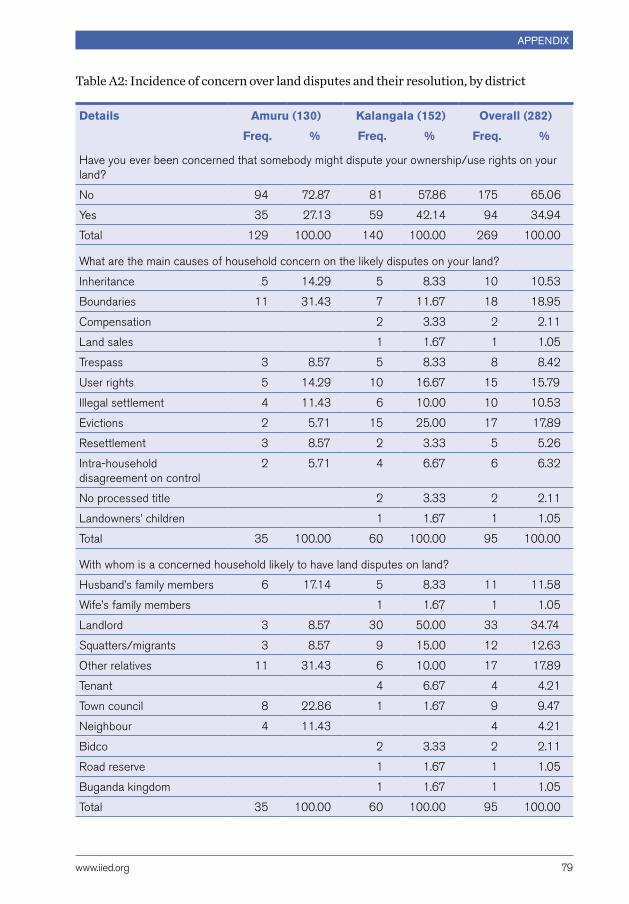
www.iied.org 79
appendix
Table A2: Incidence of concern over land disputes and their resolution, by district
Details Amuru (130) Kalangala (152) Overall (282)
Freq. % Freq. % Freq. %
Have you ever been concerned that somebody might dispute your ownership/use rights on your land?
No 94 72.87 81 57.86 175 65.06
Yes 35 27.13 59 42.14 94 34.94
Total 129 100.00 140 100.00 269 100.00
What are the main causes of household concern on the likely disputes on your land?
Inheritance 5 14.29 5 8.33 10 10.53
Boundaries 11 31.43 7 11.67 18 18.95
Compensation 2 3.33 2 2.11
Land sales 1 1.67 1 1.05
Trespass 3 8.57 5 8.33 8 8.42
User rights 5 14.29 10 16.67 15 15.79
Illegal settlement 4 11.43 6 10.00 10 10.53
Evictions 2 5.71 15 25.00 17 17.89
Resettlement 3 8.57 2 3.33 5 5.26
Intra-household disagreement on control
2 5.71 4 6.67 6 6.32
No processed title 2 3.33 2 2.11
Landowners’ children 1 1.67 1 1.05
Total 35 100.00 60 100.00 95 100.00
With whom is a concerned household likely to have land disputes on land?
Husband’s family members 6 17.14 5 8.33 11 11.58
Wife’s family members 1 1.67 1 1.05
Landlord 3 8.57 30 50.00 33 34.74
Squatters/migrants 3 8.57 9 15.00 12 12.63
other relatives 11 31.43 6 10.00 17 17.89
Tenant 4 6.67 4 4.21
Town council 8 22.86 1 1.67 9 9.47
Neighbour 4 11.43 4 4.21
Bidco 2 3.33 2 2.11
Road reserve 1 1.67 1 1.05
Buganda kingdom 1 1.67 1 1.05
Total 35 100.00 60 100.00 95 100.00

Understanding changing land access issUes for the rUral poor in Uganda
80 www.iied.org
Details Amuru (130) Kalangala (152) Overall (282)
Freq. % Freq. % Freq. %
Has your household ever had land disputes over ownership/use rights to the land?
Yes resolved 11 8.53 11 8.15 22 8.33
Yes pending 7 5.43 10 7.41 17 6.44
No 111 86.05 114 84.44 225 85.23
Total 129 100.00 135 100.00 264 100.00
Table A3: Incidence of land disputes and their resolution, by district
Details Amuru (130) Kalangala (152) Overall (282)
Freq. % Freq. % Freq. %
Causes of household having a dispute over ownership/user rights to their land
Inheritance 7 15.91 2 6.25 9 11.84
Boundaries 15 34.09 5 15.63 20 26.32
Land sales 1 2.27 1 3.13 2 2.63
Trespass 8 18.18 5 15.63 13 17.11
User rights 2 4.55 4 12.50 6 7.89
Illegal settlement 4 9.09 7 21.88 11 14.47
Evictions 1 2.27 2 6.25 3 3.95
Resettlement 4 9.09 3 9.38 7 9.21
Intra-household disagreement on control
2 4.55 1 3.13 3 3.95
No processed title 2 6.25 2 2.63
Total 44 100.00 32 100.00 76 100.00
With whom did household have land disputes over ownership/user rights to land
Husband’s family members 10 23.26 4 12.50 14 18.67
Landlord 1 2.33 11 34.38 12 16.00
Squatters/Migrants 7 16.28 7 21.88 14 18.67
other relatives 11 25.58 4 12.50 15 20.00
Tenant 3 9.38 3 4.00
Town council 13 30.23 3 9.38 16 21.33
Government 1 2.33 1 1.33
Total 43 100.00 32 100.00 75 100.00

www.iied.org 81
appendix
Details Amuru (130) Kalangala (152) Overall (282)
Freq. % Freq. % Freq. %
A place where the household referred the land dispute for redress
Court 4 9.09 8 25.00 12 15.79
LC Court1–3/offices 24 54.55 13 40.63 37 48.68
Elders 16 36.36 5 15.63 21 27.63
District councillors/government official
3 9.38 3 3.95
Landlord 1 3.13 1 1.32
None 2 6.25 2 2.63
Total 44 100.00 32 100.00 76 100.00
Reason for the choice of the place for land dispute reference
They are effective and knowledge
31 70.45 19 59.38 50 65.79
They are affordable 2 4.55 1 3.13 3 3.95
Easily accessible 11 25.00 12 37.50 23 30.26
Total 44 100.00 32 100.00 76 100.00
Is household better-off now compared to your situation 10 years ago?
No 62 47.69 52 34.21 114 40.43
Yes 68 52.31 100 65.79 168 59.57
Total 130 100.00 152 100.00 282 100.00

Understanding changing land access issUes for the rUral poor in Uganda
82 www.iied.org
Table A4: Reasons for engaging in distress access and disposition of land, by district
Details Amuru (130) Kalangala (152) Overall (282)
Freq. % Freq. % Freq. %
Reason for engaging in distress land borrowing-in in the last 5 years (2010–15)
Expand land to increase agricultural farming/production
4 25.00 14 70.00 18 50.00
Lack of/limited land owned for cultivation
5 31.25 1 5.00 6 16.67
Conflict and wrangle on unclear ownership and boundary
1 6.25 1 2.78
Lack of money to pay rent/buy land 1 6.25 1 2.78
Returned in a desperate situation from a marital home
1 6.25 1 2.78
To engage in bush fallowing 1 5.00 1 2.78
Land not fertile/reduced productivity 1 6.25 2 10.00 1 2.78
To plant palm trees 1 5.00 2 5.56
To own more land/land to cultivate 1 5.00 1 2.78
Share boundary/convenient to access 3 18.75 3 8.33
Have more access to land for crop production
1 2.78
Total 16 100.00 20 100.00 36 100.00
Reason for engaging in distress land borrowing-out in the last 5 years (2010–15)
To allow or engage in commercial or residential building
1 25.00 2 66.67 1 14.29
Expand land to increase agricultural farming/production
2 50.00 4 57.14
Lack of or limited land owned for cultivation
1 25.00 1 14.29
Conflict and wrangle on land unclear ownership
1 33.33 1 14.29
Total 4 100.00 3 100.00 7 100.00
Reason for engaging in distress land renting-in in the last 5 years (2010–15)
Costly/expensive access to land 1 5.56 1 3.85
Expand land to increase agricultural farm sizes
1 5.56 6 75.00 7 26.92
To raise school fees 1 5.56 1 3.85
To have/secure a place for business 1 12.50 1 3.85
Lack of/limited land owned for cultivation
11 61.11 11 42.31

www.iied.org 83
appendix
Details Amuru (130) Kalangala (152) Overall (282)
Freq. % Freq. % Freq. %
Lack of money to pay rent/buy land 1 5.56 1 3.85
Abandoned land/was displaced due to war
1 5.56 1 3.85
Land not fertile/reduced productivity 2 11.11 2 7.69
Long distance to land/hard to access land
1 12.50 1 3.85
Total 18 100.00 8 100.00 26 100.00
Reason for engaging in distress land renting-out in the last 5 years (2010–15)
To raise school fees 1 100.00 1 50.00
Conflict and wrangle on land unclear ownership
1 100.00 1 50.00
Total 1 100.00 1 100.00 2 100.00
Reason for engaging in distress land sale in the last 5 years (2010–15)
Displaced by road construction 1 100.00 1 100.00
Total 1 100.00 1 100.00
Reason for engaging in distress land purchases in the last 5 years (2010–15)
To allow/engage in commercial or reside
3 60.00 4 26.67 7 35.00
Costly/expensive access to land 1 20.00 1 5.00
Expand land to increase agricultural farming
5 33.33 5 25.00
Lack of/limited land owned for cultivation
1 20.00 1 5.00
Conflict and wrangle on unclear ownership and boundary
1 6.67 1 5.00
To engage in livestock farming/herding
1 6.67 1 5.00
To plant palm trees 1 6.67 1 5.00
To own more land/land to cultivate 2 13.33 2 10.00
Share boundary/convenient to access 1 6.67 1 5.00
Total 5 100.00 15 100.00 20 100.00

IIED is a policy and action research organisation. We promote sustainable development to improve livelihoods and protect the environments on which these livelihoods are built. We specialise in linking local priorities to global challenges. IIED is based in London and works in Africa, Asia, Latin America, the Middle East and the Pacific, with some of the world’s most vulnerable people. We work with them to strengthen their voice in the decision-making arenas that affect them — from village councils to international conventions.
International Institute for Environment and Development 80-86 Gray’s Inn Road, London WC1X 8NH, UK
Tel: +44 (0)20 3463 7399 Fax: +44 (0)20 3514 9055 email: [email protected] www.iied.org
The ways in which people obtain land in Uganda are changing fast. Land that used to be secured through inheritance, gifts or proof of long-term occupancy is now more commonly changing hands in the market. Those with wealth and powerful connections are frequently able to override local rules and gain access to land at the expense of poorer individuals.
Government-backed agribusiness investors receive large areas of land with benefits for some local farmers who are able to participate in the schemes, while other smallholders see their land access and livelihoods degraded. Land governance systems in Uganda should be modified to catch up with this rapid change and to ensure fair access and productive land use. This research report explores these drivers of changes in land tenure, land access and use, and sets out recommendations that can help policy makers and development practitioners improve the design and the implementation of pro-poor land policies and programmes.
Knowledge Products
Research Report 2017
Law, Land acquisitions and rights
Keywords: Livelihoods, land policy frameworks and guidelines, good governance, food and agricultural policies, land rights, Uganda