uas mapping - professional land surveyors of...
TRANSCRIPT

2/10/2017
1
UAS MappingSmall Unmanned Aerial Systems for Geospatial Data Collection
• Gary Schuller, P.S.
• Professor of Surveying and Mapping
February 17, 2017
FIXED WING
Topics
• UAS activities – who is doing what?
• UAS resources
• Surveying and other UAS applications
• Case Study
• FAA regulations/Certified Remote Pilot
• The futureInsuranceChallengesCommercial UAS Predictions
2

2/10/2017
2
UAS Defined
• Unmanned Aerial System
• Aircraft
• Command and control
• Communication!
• Payload
• Sensor/Camera
• RGB? Near Infrared? Lidar? Thermal? Multi-/Hyperspectral?
3
What’s in a name?
• UAS - Unmanned aerial system
• UAV – Unmanned aerial vehicle
• RPA – Remotely piloted aircraft
• Drone
• Radio-controlled aircraft
• Autonomous aircraft
4

2/10/2017
3
UAS are not new (Happy 100th!)
Kettering Bug
• 1917 Unmanned Aerial Torpedo
• Experimental
• Charles Kettering & Orville Wright
5
What in the World is Happening With UAS?
• From Michael Huerta, FAA Administrator, Jan. 2017
– 670,000 FAA registered UAV in 1st year
– 16,000 certified Remote Pilots (90% pass rate)
– Priority to develop rule to allow sUAS to fly over people
– FAA & NASA developing (UTM) unmanned aircraft traffic mgmt. system, and to move toward BVLOS capability)
– “Pathfinder” drone detection to cut back on sightings by pilots (1,800 in 2016 up from 1,200 in 2015)
6
2/10/2017
4
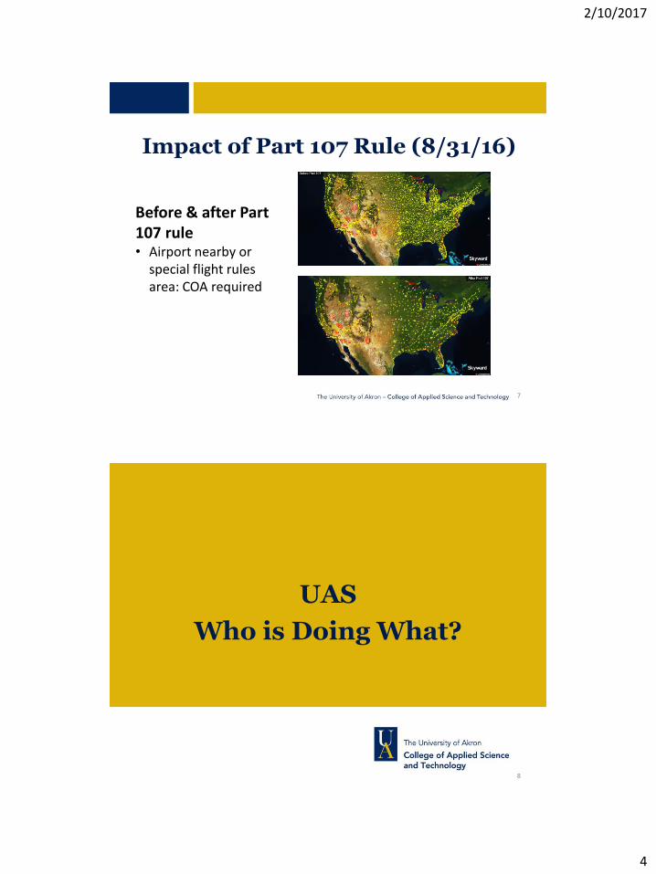
Impact of Part 107 Rule (8/31/16)
Before & after Part 107 rule• Airport nearby or
special flight rules area: COA required
7
UAS
Who is Doing What?
8

2/10/2017
5
BVLOS Testing
• Vigilant Aerospace Detect and Avoid tests (1/27/17)
• “Flight Horizon” software – 100 scripted encounters between UAVs
– Traffic alerts & collision warnings
– On-board/ground transponder +FAA feed
– Interacts w/ATC & other aircraft
– Tracks TFRs
– Helps w/part 107 waivers for BLOS & night flying
9
Ohio Set to Begin BVLOS Testing
• Beyond Visual Line of Sight restriction hinders many UAS applications
• Ohio building a ground-based sense and avoid radar system at the Springfield-Beckley Municipal Airport• Joint Ohio/U.S. Air Force project
• Could be a game-changer for Ohio & commercial drone businesses
10

2/10/2017
6
Drone Insurance
• Relates to Professionalism
• U.S. – no specific requirement
• Client may require
• Canada – requires $100K
Drone rules around the world:https://droneregulations.info/index.html
11
Verifly Drone Insurance
For low risk class G airspace:• $10/hr for $1mil @ ¼ mile radius• $25/4 hrs “ “• $15/hr for $2.5mil @ ¼ mi• $16/hr for $1mil @ ½ mi
Sample of higher risk areas:• $15/hr near a school• $25/hr near airport/heliport
12

2/10/2017
7
Unmanned Systems Legislation
auvsi.org13
Sample of proposed legislation
• Ohio: Senate Bill 251
• Gov’t oversight committee 1/20/2016
• No drone use in criminal investigation without a search warrant or unless life and death
• Warrant not needed if…
• Crime/accident scene collection of images
• Missing person
• Drone may not carry a weapon (Terminator?!)
• Michigan:
• Min. 1,500 ft. from any prison
• Anti-stalking law 7/13/2016 (In crim. Justice comm.)
14

2/10/2017
8
Association for Unmanned Vehicle Systems International (AUVSI)
• http://www.auvsi.org/home
• Advancing unmanned systems & robotics tech
• Networking & business development
• Webinars, publications
• Advocacy: prominent role in the recently enacted FAA rules for UAS
“Through 2025 we project UAS will create 100,000 jobs with economic impact of $82 billion”
15
AUVSI Webinars
16

2/10/2017
9
A New Kind of Job Description/Skill
17
Sample of Pilot Ads/Fees
Click to add text
• Click to add text
18

2/10/2017
10
The Big Picture
• Lessons from the railroad industry
Surveyors are in the Geospatial Data Business!
19
The Big Picture
• What happened with GIS?
• Non-surveyors with GPS receivers
• Inconsistent accuracy
• What will happen with UAS?
• Is this “Surveying”???
• Standards???
Surveyors are in the Geospatial Data Business! If we don’t provide this service – who will?
20

2/10/2017
11
It’s all about perspective…
21
Woolpert, LLC (Woolpert Labs)
• Quickly, safely map unstable areas
• ID dangerous slopes near highways
12
22
2/10/2017
12
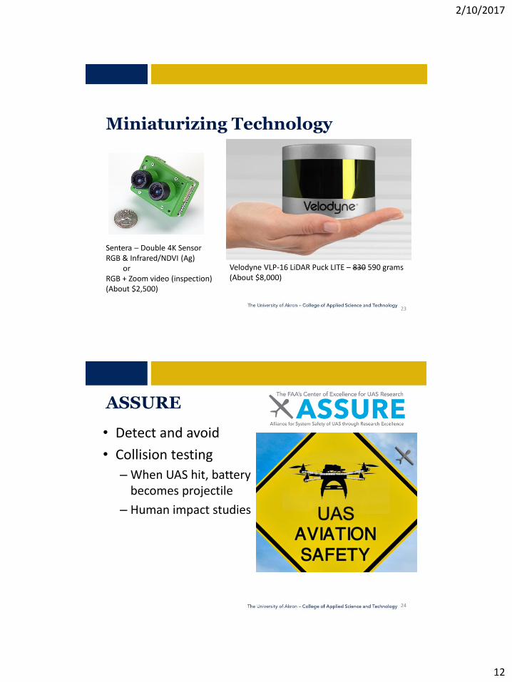
Miniaturizing Technology
Velodyne VLP-16 LiDAR Puck LITE – 830 590 grams(About $8,000)
Sentera – Double 4K SensorRGB & Infrared/NDVI (Ag)
or RGB + Zoom video (inspection)(About $2,500)
23
ASSURE
• Detect and avoid
• Collision testing
– When UAS hit, battery becomes projectile
– Human impact studies
24

2/10/2017
13
NASA and UAS
• UAS Traffic Management (low altitude)
• Systems-level integration– Reduce technical barriers associated with integrating UAS into the NAS
• Mandate to do more with small UAS community– Teaming up with Sinclair CC to study Lake Erie algae blooms with UAS
25
The University of Akron and UAS
• Surveying and Mapping– Dominion Resources grant to add aircraft systems & software
• IRIS+ aircraft
• Agisoft, Pix4D, Global Mapper w/LiDAR, Simulator
• Geosciences– Invasive species/plant studies
– FLIR (thermal) animal counts & soil moisture
• Anthropology– Archaeological sites
26

2/10/2017
14
Other Ohio Colleges/Universities
• Sinclair CC (Dayton) – Simulation, training, flight testing, maintenance
• Ohio State – Precision ag, data analytics, GPS vs Barometer for height
• Ohio Univ. – Sensors and guidance systems
27
Flying London Café Burgers…
28

2/10/2017
15
UAS Resources
29
https://www.faa.gov/uas/resources/
24
30

2/10/2017
16
• Advance commercialization of technology through research, design, testing, and evaluation and the subsequent certification of systems or system components.
• Support the UAS community in research and development, facilitating safe integration into the National Airspace System (NAS).
Ohio economy: #1 – Agriculture#2 - Aviation
http://www.dot.state.oh.us/divisions/uas/Pages/default.aspx
31
Ohio-Indiana UAS CenterOhio/Indiana Unmanned Aircraft Systems Center
4170 Allium Ct., Springfield, Ohio 45505
937-497-6739
David Gallagher, Chief of Staff
937-497-6767
Fred Judson, UAS Program Director
419-373-4497
Jim LawsonDirector, Operations937-497-6813 [email protected]
32

2/10/2017
17
Big Data
• Approx. 7 mb per image• 200 images = 1.4 Gb
• 500 images = 3.5 Gb
• Processing power/need for speed
• Graphics card
• Cloud computing?
• Outsource? • Data Privacy?
33
Flight Planning Software
E38 Mission Planner
• Create a polygon
• Take-off point
• Waypoints/Flight lines
• Flying Height
• Image overlap/spacing
34

2/10/2017
18
eMotion Flight Planner
Click to add text
Fixed-wing example
35
Crew Resource Management
• Field crew
• UAS Crew
• Established procedures• Checklists – a “pilot’s best friend”
• Safety
36

2/10/2017
19
B4UFLY
Smartphone app to determine any restrictions or requirements in effect at the flight location
• Flight status indicator (red, orange, or yellow) is driven by laws and regulations
• Display any active Temporary Flight Restriction (TFR)
• Geared toward hobby or recreation users
37
Useful Links
• Image Processing– https://pix4d.com/
– http://www.agisoft.com/
– https://event38.com/drone-data-management-system/
– https://www.datamapper.com/
• UAS:– https://event38.com/
– https://www.sensefly.com/home.html
– www.dynamicuav.com
– http://www.dji.com/
38

2/10/2017
20
Surveying and Mapping &
Other UAS Applications
39
Topographic Mapping
• High resolution imagery
• Orthomosaic
• Point Cloud
• Digital Surface Model
18 megapixel image at 150ft
40

2/10/2017
21
Volumetric/Stockpile
• Compared 3 Methods
• ~75-acre site
• Up to 60% less time w/DDMS
• UAS w/GCPs within 1.6% of RTK ground survey
• UAS w/out GCPs within 3.2%
41
Other Applications
• Precision AgricultureID pests, soil condition, disease, plant health, weeds, moisture
• Fire Fighting• sUAS to ID areas for “Slurry Bombers” (up to $70K/day) to combat
wildfires
• Police/Highway Patrol
• Missing persons
• Crash scene mapping
• Open up highway sooner
• Rescue
• https://youtu.be/4rIhhQl8ULI
42

2/10/2017
22
Other Applications
• Inspection
• Bridges
• Utilities
• Construction
• Document progress
• As-built
43
Other Applications
Multispectral mapping of land cover, vegetation type & health(Panzner Wetlands in Copley, OHcourtesy Dr. Shanon Donnelly)
44
Micasense Rededge
2/10/2017
23
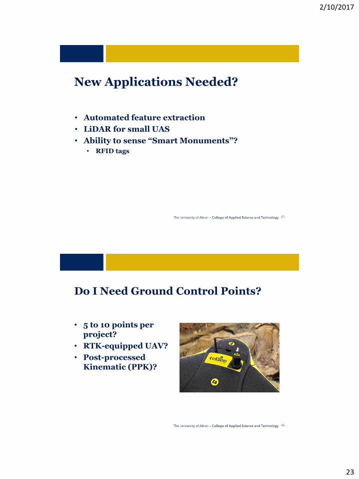
New Applications Needed?
• Automated feature extraction
• LiDAR for small UAS
• Ability to sense “Smart Monuments”?
• RFID tags
45
Do I Need Ground Control Points?
• 5 to 10 points per project?
• RTK-equipped UAV?
• Post-processed Kinematic (PPK)?
46

2/10/2017
24
There is no replacement for real ground truth, especially if your data product must be certified to a specific level of accuracy.
47
What if…
• Use multiple GNSS “antenna targets”
• Topcon Hiper SR is 6”x6”
• Rapid Static obs. w/OPUS
48

2/10/2017
25
Time of occupation Horizontal Vertical15-minute rapid static *1.6 cm (0.05’) 6.2 cm (0.20’)1-hr. rapid static 1.2 cm (0.04’) 3.8 cm (0.12’)
*2 σ values49
50

2/10/2017
26
University of Akron
Surveying and Mapping
Case Studies
51
Topographic Case Study
• Six GCPs
• 60m then 45m height
• October 6th, 2016
• 6 acre site
• 2 hour processing
• Pix4D
52

2/10/2017
27
Mission Planning
• E38 Mission Planner
• 6 Flight Lines ~ 75% overlap
• 14 Waypoints
• 4 Camera Commands
53
Flight
• IRIS+ quadcopter
• < 5 minute flight
• 71 photos (15m interval)
• Flock of birds only potential “disruption”
54

2/10/2017
28
Processing
• Pix4D Mapper Pro software
• Define coordinate system/datum
• Import images
• Link GCPs to images
Linking GCPs to images
48
55
Linking GCPs to images
White w/2” tape
Stock diamond pattern (no tape)
GCP target
56

2/10/2017
29
3-Step Processing
1. Initial processing
2. Point cloud and mesh
3. DSM, orthomosaic, and index
57
Connecting the Photos
Tie Points: unknown ground coordinates, but identifiable in overlap of two or more images
58

2/10/2017
30
Expected Accuracy
For a correctly reconstructed project:
• 1-2 GSD horizontally (X,Y coordinates)
• 1-3 GSD vertically (Z coordinate)
For this project, expected accuracy was:
Horiz. Accuracy = 2 X 1.27cm GSD = 2.54cm = 1 inch = 0.08’(0.04’ to 0.08’)Vert. Accuracy = 150% of Horiz. Acc’y. = 0.12’(0.04’ to 0.12’)
59
Absolute Accuracy
Sampled 20 points with RTK observations
• Mean y error = -0.05 ft
• Mean x error = 0.02 ft
• Mean z error = 0.11 ft
Expected: Horiz. = +- 0.04 to 0.08 ftVert. = +- 0.04 to 0.12 ft
Total Horizerror = 0.05 ft
Pt 105 - septic lid Pt 136 - cor conc walk Pt 114 – inv 6” pvc
Pt 106, 107 - fence cor
60

2/10/2017
31
Data Analysis
RTK Observations Pix4D Location (Triangle Mesh)
North (Y) East (X)Ortho. Ht
(Z) North (Y) East (X) Ortho. Ht (Z) delta Y delta x delta z
105 460356.69 2083650.35 1202.48 sq sept lid 460356.71 2083650.28 1202.46 -0.02 0.07 0.02
106 460272.55 2083681.15 1198.21 nw cor pasture fence 460272.52 2083681.1 1198.6 0.03 0.05 -0.39
107 460240.49 2083679.9 1197.34 cor pasture fence 460240.58 2083679.96 1197.55 -0.09 -0.06 -0.21
113 460149.64 2083690.6 1192.76 sw cor pasture fence 460149.69 2083690.62 1193.06 -0.05 -0.02 -0.3
114 460184.48 2083642.64 1195.32 inv s end 6" pvc 460184.44 2083642.56 1195.45 0.04 0.08 -0.13
130 460115.81 2083786.83 1193.3 inv s end 4" pvc 460115.76 2083786.73 1193.4 0.05 0.1 -0.1
131 460138.27 2083769.47 1192.82 se cor pasture fence 460138.43 2083769.52 1193.07 -0.16 -0.05 -0.25
132 460234.18 2083769.42 1197.94 ne cor pasture fence 460234.47 2083769.6 1198.1 -0.29 -0.18 -0.16
133 460236.47 2083744.62 1198 ne cor shed roof 460236.62 2083744.55 1198 -0.15 0.07 0
134 460378.26 2083721.62 1205.53 cen 18" patio stone 460378.22 2083721.63 1205.45 0.04 -0.01 0.08
135 460393.4 2083752.54 1212 cen top well cap 460393.38 2083752.46 1209.8 0.02 0.08 2.2
136 460414.02 2083743.28 1211.55 se cor conc walk 460414.04 2083743.25 1211.4 -0.02 0.03 0.15
137 460417.82 2083776.41 1211.36 angpt conc 460417.78 2083776.32 1211.42 0.04 0.09 -0.06
138 460442.47 2083747.2 1211.54 angpt conc 460442.46 2083747.17 1211.44 0.01 0.03 0.1
139 460574.97 2083748.6 1212.34 inv w end 6" pvc 460575.11 2083748.51 1212.22 -0.14 0.09 0.12
140 460575.61 2083768.11 1212.97 top e end 6" pvc 460575.77 2083768.16 1212.73 -0.16 -0.05 0.24
141 460581.94 2083767.45 1213.45 ne cor conc apron 460582.08 2083767.42 1213.12 -0.14 0.03 0.33
142 460581.62 2083750.55 1213.21 nw cor conc apron 460581.56 2083750.67 1213 0.06 -0.12 0.21
163 460428.3 2083675.98 1209.39 nw cor landscape tie 460428.24 2083675.88 1209.01 0.06 0.1 0.38
164 460386.53 2083689.29 1204.59 sw cor conc patio 460386.57 2083689.24 1204.6 -0.04 0.05 -0.01
Mean error -0.05 0.02 0.11
Std Dev 0.10 0.08 0.52
Pt 133 – ne cor shed roofPt 138 – angpt conc
delta Y delta x delta z
0.01 0.05 0.06
0.02 0.03 0.07
Std DevReduced
Dramatically!
{
Using only “clearly
identifiable” points:
61
Small Pile of Topsoil volume
262 cu ft = 9.7 cy by photogrammetric method282 cu ft = 10.4 cy using rtk ground shots
62

2/10/2017
32
Obtaining a “point” position from Densified Point Cloud
X, Y, Z position
63
Camera Locations/Ray Cloud
• Selected one of GCPs
• Shows connection to 8 images
64

2/10/2017
33
Triangle Mesh
65
Orthomosaic and DSM
Ortho: A High-Definition Map
66
2/10/2017
34
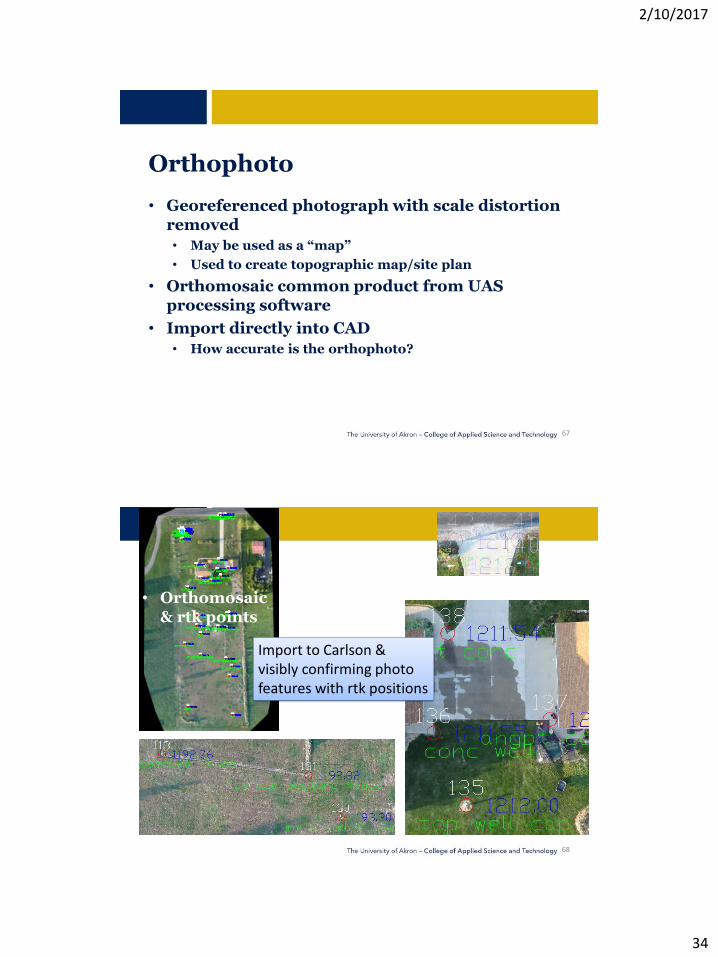
Orthophoto
• Georeferenced photograph with scale distortion removed
• May be used as a “map”
• Used to create topographic map/site plan
• Orthomosaic common product from UAS processing software
• Import directly into CAD
• How accurate is the orthophoto?
67
• Orthomosaic& rtk points
Import to Carlson & visibly confirming photo features with rtk positions
68

2/10/2017
35
• Pix4D Contours imported to CAD as dxf
Visible comparison of contour lines
• Contours derived from rtk shots
69
Communication!
60
70
2/10/2017
36
FAA Regulations
71
72
Part 107 Small Unmanned Aircraft Regulations
Effective August 29, 2016
Over 600 pages!

2/10/2017
37
73
PART 107: In Summary
Weigh less than 55 lbs.
Visual line-of-sight (VLOS)
Daylight-only operations
Must yield right of way to other aircraft
Visual observer (VO) not required
Maximum groundspeed of 100 mph (87 knots)
Minimum visibility of 3 miles from control station
Small unmanned aircraft may not operate over any persons not directly participating in the operation, not under a covered structure, and not inside a covered stationary vehicle*
Operational Limitations
74
PART 107: In Summary
Maximum altitude of 400 feet above ground level (AGL) or, if higher than 400 feet AGL, remain within 400 feet of a structure*
Operations in Class B, C, D and E airspace are allowed with ATC permission
No person may act as a remote pilot in command or VO for more than one
unmanned aircraft operation at one time
No operations from a moving vehicle unless the operation is over a sparsely populated area.
Operational Limitations Continued

2/10/2017
38
75
PART 107: In Summary
Requires preflight inspection by the remote pilot in command***
Most of the restrictions discussed are waivable if the applicant demonstrates that his or her operation can safely be conducted under the terms of a certificate of waiver
Process to receive a waiver to the restrictions?
Operational Limitations Continued
76
PART 107: In Summary
A person operating a small UAS must either hold a remote pilot airman certificate with a small UAS rating or be under the direct supervision of a person who does hold a remote pilot certificate.
Remote Pilot in Command Certification
A Look Into UAS at ODOT

2/10/2017
39
77
PART 107: In Summary
To qualify for a remote pilot certificate, a person must:
Demonstrate aeronautical knowledge by either:
Passing an initial aeronautical knowledge test at an FAA-approved knowledge testing center; or
Hold a part 61 pilot certificate other than student pilot, complete a flight review within the previous 24 months, and complete a small UAS online training course provided by the FAA.
Be vetted by the Transportation Security Administration.
Be at least 16 years old.
Remote Pilot in Command Certification
78
PART 107: In Summary
Make available to the FAA, upon request, the small UAS for inspection or testing.
Report to the FAA within 10 days of any operation that results in at least serious injury or property damage of at least $500.
Conduct a preflight inspection
Ensure that the small unmanned aircraft complies with the existing registration requirements specified in § 91.203(a)(2).
FAA airworthiness certification is not required
Not platform dependent!
Remote Pilot in Command Responsibilities

2/10/2017
40
UAS Surveying and the Law
• Get ready for “Cases of First Impression”
• California v. Ciraolo (1986), a fixed-wing aircraft flew over residential property at 1,000 feet AGL and took pictures of “plants.” – Supreme Court: 1,000 feet clearly navigational airspace, and did not
violate owner’s air rights.
• In Florida v. Riley (1989), the police utilized a helicopter to look in a residential backyard at an altitude of 400 feet AGL. – No clear majority; but a plurality of the Court agreed that 400 feet was
sufficient because FAA regulations allow helicopters at that height.
79
UAS Surveying and the Law
• The twin SCOTUS rulings indicate that the FAA’s navigational servitude of the airspace above private property is actually 400 feet, not 500 feet
What about 300’? 200’?
From Jeffery Lucas in the POB article found at:http://www.pobonline.com/articles/100512-traversing-the-law-the-faas-new-rules-on-drones
80

2/10/2017
41
Property is Four-dimensional
• Length
• Width
• Depth• Subsurface & aerial rights
• Time• Duration of a legal right
+
• Is a UAS Survey a trespass? • Are GPS observations & EDM
measurements across a parcel trespass?
81
Where is FAA’s Airspace Authority?
“The United States has the safest and most complex airspace in the world. The FAA has authority over this airspace from the ground up, and is responsible for making sure air traffic flies smoothly and efficiently.”
http://www.faa.gov/uas/
72
82

2/10/2017
42
Becoming a Remote Pilot
w/Small UAS Rating
83
How to Obtain a Remote Pilot Certification for Small UAS
• Pass an initial FAA Unmanned Aircraft General (UAG) test at a Knowledge Testing Center (KTC)• Must retest every two years
• Vetted by the TSA
84

2/10/2017
43
FAA Knowledge Testing Centers in Ohio
85
Remote Pilot Knowledge Test
Subject Areas
86

2/10/2017
44
UAG Knowledge Test Resources
• Click to add text
•Regulations and policy documents, such as 14 CFR part 107 and Advisory
Circular (AC) 107, Small UAS (as amended)
•The FAA Airman Testing Standards Branch (AFS-630) Website provides:
•Aircraft Weight and Balance Handbook
•Pilot’s Handbook of Aeronautical Knowledge (PHAK)
•Aeronautical Information Manual (AIM)
•Risk Management Handbook
•UAS Airman Certification Standards (ACS)
•General information about the FAA UAG Knowledge Test
•Sample FAA UAG Knowledge Test questions
•The FAA Unmanned Aircraft Systems Website defines types of operations
(Public, Civil, Hobby) and Section 333 exemptions
87
Example “Knowledge Check” from FAA Free Course
A Yes, this sUAS operation is subject to part 107
B No, this sUAS operation is not subject to part 107
Scenario 3: You plan to operate a 33lb sUAS to capture aerial
imagery over real estate for use in sales listings. Is this sUAS
operation subject to 14 CFR part 107?
88

2/10/2017
45
Under part 107, an operator will NOT have to apply for a waiver in order to…
a) Inspect a 500-ft tower
b) Fly beyond visual line of sight
c) Fly at night
d) Operate multiple UAVs at the same time
89
Sample Pilot Weather Knowledge Check
90

2/10/2017
46
Aviation Routine Weather Report (METAR)
Airport
Wind Dir. (110 True)Velocity 12 Gusting 18 Knots
Vis. 15 Surface Miles
METAR is reported every hour
Date & Time SKY - Sky Clear (<1/8)
SCT – Scattered (4/8)OVC – Overcast (8/8)
Alt 30.00in
Temp/Dewpoint (C)
http://www.free-online-private-pilot-ground-school.com/Aviation-weather-reporting.html
91
Which locations might expect fog?
Airport
Temp/Dewpointseparation < 3 C
92

2/10/2017
47
https://www.faa.gov/air_traffic/flight_info/aeronav/digital_products/aero_guide/
Know How to Read Aeronautical Charts
“Sectionals” are 1/500,000 scale Aeronautical Charts
93
Click to add title
Click to add text
• Click to add text
94

2/10/2017
48
95
Reading Aeronautical Charts
Contours and Obstructions
1) Contour Lines
2) Shaded Relief
3) Color Tints
4) Obstruction Symbols
5) Max. Elev. Figures
Visual Check Points
Above MSL(Height AGL)
Highest Elev. in a Quadrant
84
96

2/10/2017
49
Controlled and Uncontrolled Airspace
Ceiling MSLFloor MSL
Most small UAS flights take place in Class G airspace. Others require ATC authorization/communication.
97
FAA Free Part 107 UAS Online Course # ALC-451 for Existing Pilots (secondary audience is new sUAS pilots)
• Applicable regulations relating to sUAS rating privileges, limitations, and flight operation
• Effects of weather on small unmanned aircraft performance
• Small unmanned aircraft loading• Determining the performance of
small unmanned aircraft• Emergency procedures• Crew resource management• Maintenance and preflight
inspection procedures
You may complete this course as one part of
your independent study efforts to prepare for the
FAA UAG Knowledge Test. However, you are
also encouraged to review reference materials
that focus on the topic areas that are required in
part 107.73(a), but are not covered in this
course:
•Airspace classification, operating requirements
and flight restrictions affecting small unmanned
aircraft operation
•Aviation weather sources
•Radio communication procedures
•Physiological effects of drugs and alcohol
•Aeronautical decision-making and judgment
•Airport operations
https://www.faasafety.gov/gslac/ALC/course_content.aspx?cID=451&sID=726&crID=1436761
98

2/10/2017
50
Think Like a Pilot
(AND
Like a Surveyor)
99
Think Like a Pilot
• Professionalism
• Follow a pre-flight checklist before every flight
• Understand your sUAS failsafes – what can go wrong?
• Set up/manage different commercial sUAS flight ops
• Operating environments permitted by Part 107?
• How to communicate with Air Traffic Control (ATC) if you plan to operate outside of Class G airspace
100

2/10/2017
51
Challenges and Predictions
101
Challenges/Needs for UAS Growth
• Professionalism
• Systems Integration
• Components exist
• Spectrum Management
• Too few frequencies for # users
102

2/10/2017
52
Challenges (cont.)
• Proper insurance
• Changing public perception
• How to “scale” a drone program
• BVLOS/night flying
• Outcome of states considering legislation
The UAS is not always the best tool for the job
103
2017 Commercial UAS Predictions Jeremiah Karpowicz – Commercial UAV Expo
• New Questions re: Legality & Authority
• Make voices heard at local and state level
• Transition From “Exploring” to “Implementing”
• Derive value, solve problems, create useful products
• Insurance a Priority
• Greater awareness of risk factors
104

2/10/2017
53
2017 Commercial UAS Predictions Jeremiah Karpowicz – Commercial UAV Expo
• Public Concerns Begin to Dissipate
• Media will focus on life-saving, other benefits
• Scalability & Implementation
• Internal or outsource?
• Watch construction, aggregates, mining industries
• Industry Shakeouts
• Hardware and Software
• Complete drone solution & simplicity desired
105
Questions?
106