trip planning. plan for even the smallest trip – the safety and the success of any boating trip...
Post on 20-Dec-2015
218 views
TRANSCRIPT

Trip Planning

Trip Planning
• Plan for even the smallest trip – the safety and the success of any boating trip depends as much on what you do before you leave as on what you do once you are at sea.
• Planning starts with confidence in yourself, and in a seaworthy vessel.

Seaworthy vessel and skipper
• A seaworthy vessel is in good condition, suitable and properly equipped for the planned trip, and skippered by a person who accepts the responsibility that goes with the job.

Responsibility
Responsibility– Are you confident of your abilities as a skipper, and do you
realise your responsibilities? – If you have passengers with you, are you undertaking a
trip you have done before?– Is the trip appropriate to the ages of your passengers?– Check the weather and tides. If in doubt don’t go.– Study a chart of the waters you intend cruising. – Tell someone where you plan to go and when you intend to
return. If your plans change, let them know.– Check that all your safety gear and extras are on board, in
good shape and in reach. – Check that you have more than enough fuel.
Suitability
Suitability• Some boats should never go outside the inshore reefs – their
size, hull shape and general design do not suit them to the exposed ocean. Seek the advice of experienced people on the capabilities of your vessel.

Loading
Loading• Determine that your boat is not overloaded. Even a boat that
is not overloaded may be uncomfortably crowded, and that will make your passengers uncomfortable.

Passengers
• Check that your boat is suitable for the trip, and that the trip suitable for the passengers.
• Children may fret on a long trip, first timers may be nervous going far offshore.
• Are there any special medical problems? Do they have their medication with them?
• Are they prone to seasickness? • If there is an injury on board, do you have a first aid kit
and the skills to use it?• You should ensure that everybody has protection from
the sun: adequate clothing, and both hats and sun block – reflected sunlight gets below hat brims.

Motor check
Motor check• Before each trip, a good idea for outboard motors –
particularly older ones – is to attach a flushing device and test start the motor (before leaving home).

Fuel for the trip
Fuel for the trip• You can work out your likely fuel consumption from your
vessel’s history. • Record the hours the motor runs on each trip and the litres
needed to top up the tank; this gives you a litres per hour figure.
• Work out the length of your planned trip, divide it by your usual cruising speed, and you have a minimum litres needed for the trip.
• Fuel consumption varies with the change in the sea conditions. Aim to carry 50 per cent more fuel than you expect to use for your planned length and distance of trip. – If this means you have to carry spare fuel in a portable container,
use an approved one.

Weather

Weather
• You go boating for pleasure, and there is not much pleasure in doing it in bad weather.
• You need to be able to cope with unexpected changes in the weather, but even more importantly you need to know the range of conditions you and your vessel are happy with, and the conditions that will keep you at home.
• Learn how to read the weather map. • By following it daily you get the feel for trends in the weather
and can use it for planning ahead.
Current forecast
• Before actually starting the trip, get the most up to date forecast available.– Internet– Public broadcast radio / television– Marine radio– Recorded telephone services– Weather fax
Internet
Internet
• One of the most up-to-date sources of weather information is available from the internet.
• A full range of weather information is available on the Bureau of Meteorology’s website:www.bom.gov.au
Radio / television
Public broadcast radio/television• The Bureau of Meteorology sends coastal waters forecasts and
warnings to the ABC and commercial networks (both city and country).
• The stations usually announce the time the Bureau issued the
forecast: this is important – older forecasts are less valuable.

Marine radio
Marine radio• Volunteer sea search and rescue groups operate within normal
recreational boating hours. They provide weather information on VHF channels 16 and 67 and/or on 27.88 MHz.
• Weather and navigation warnings covering the Perth metropolitan waters (within 20 nautical miles) are broadcast on VHF Channels 16 and 67 at 0718 and 1918 hours western standard time by the WA Water Police.

Recorded services
The Bureau of Meteorology has recorded services via Weathercall for coastal waters forecasts and warnings.
Services include:• Full State Service 1900 955 366• Perth Metropolitan Service 1900 926 149• Perth Local Waters Service 1900 955 350• WA Marine Service 1900 926 150• Northern WA Coastal Waters Service 1900 969 901• Western WA Coastal Waters Service 1900 969 902• Southern WA Coastal Waters Service 1900 969 903• WA General Warnings Service 1900 955 371• WA Tropical Cyclone Information 1300 659 210• WA Coastal Marine Warnings 1300 659 223

Fax
Weather by fax• The Bureau of Meteorology Weather by Fax provides forecasts,
observations and warnings including weather charts (updated three hourly), satellite photos (updated hourly), weather radar reports, the latest warnings, routine coastal waters forecasts and the latest actual reports.
• Set your fax machine in poll receive mode and dial 1800 630 100 for a free main directory.

Synoptic charts
• You normally see the weather map (also called a synoptic chart) on television or in the newspaper.
• It will usually be older information than you can get from other forecast sources, but it gives a good picture of what is happening and is likely to happen.
Synoptic charts - WindsWinds• Wind is caused by the movement of air from high pressure to low
pressure systems, but it does not flow directly from one to the other. • It blows more nearly along the pressure contour lines (called isobars)
the solid lines on the maps – in a clockwise direction around low pressure systems and anti clockwise around highs.
• The bigger the difference in pressure of the systems, the stronger the wind.
• The number of isobars, and their closeness to each other, indicate the pressure differences.
• When estimating the progress of the pressure systems, you can reasonably assume that a low will move the width of Australia in two or three days.


Synoptic charts - Cold frontsCold fronts• The line with spikes on it is a cold front – commonly associated with
winter lows. • Ahead of the front you can expect squalls followed by rain. • The wind typically changes direction at the front (shown by the bend
in the isobars) and strengthens.

Forecast content• The forecast gives a general description of the expected weather in
the forecast period plus outlook including warnings and other specific information.
Strong wind warnings– Small craft warnings of strong winds are issued whenever mean
wind speeds exceeding 25 knots are expected. – For any mean wind speed forecast, gusts can be 40 per cent
higher, so the very smallest of strong winds will produce gusts of 35 knots.
Severe weather– The northwest of Western Australia is one of the most cyclone
prone coasts anywhere in the world. – The cyclone season extends from the months of November
through to April, but most of the coastal impacts occur between January and March.
– No vessel should be at sea within several hundred miles of a cyclone.

Wind strength and direction
• You are interested in wind speed and direction mainly because of the waves the wind will build.
• Wave height depends on wind speed, length of time the wind blows (duration) and how far over the water it blows (fetch).
• Wind off the land will produce smaller waves inshore because of the limited fetch; they will also be steep and close together – a feature of short fetch.
• If you operate in the shelter of islands you will also get smaller waves than the forecast, which assumes no shelter.

Sea and land breezes
• Local winds such as sea breezes blow for only a few hours over waters close to shore, so the waves they cause are lower than the large scale winds.
• If the sea breeze blows from a similar direction to the existing wind, it will join forces and build bigger waves.

Sea Breezes
Sea breezes• Sea breezes are a near shore event caused by the heating of
land during the day. • Their strength will be partly dependent on the existing
(synoptic) wind. • On the west coast sea breezes come from the south west, so
they will be opposed and weakened by a synoptic north easterly.
• The further towards south the synoptic wind, the more it will assist and strengthen the sea breeze.
Sea (wind waves)
• The waves caused by the wind currently blowing (the wind you can feel) are called ‘sea’.
• A 15 knot wind (not a sea breeze) will typically produce sea about 1.5 metres high.
• That is the average height, you can get the occasional wave twice that high.

Swell
• Swell are the waves caused by winds from far away. • Swell travels faster than sea and the crests are wider
spaced. • They usually look lower than they are. • They can combine with sea they overtake to make a larger
wave. • Swell are the waves that make breakers. • The bigger the swell, the deeper the water in which they
break. • As a guide, the typical swell height on the west coast in
summer is about 1.5 metres, which is classed as ‘low swell’.

Observing the weather
• Forecasts tell you the expected weather – keeping your own eye on approaching weather can confirm the forecast or can tell you that something unexpected is about to happen. Or that local conditions look like being worse than predicted.
• Keep your senses open to: – drops in temperature; – a rising swell;– solid cloud appearing;– barometer falling; or– wind changing.
• In fact almost any change can mean deteriorating weather approaching.

Coping with the weather
Coping with weather• Have an alternative trip planned for the day in case the
weather is unfriendly. – You may choose to operate inside the reefs or islands
instead of outside.• Use your radio to keep up-to-date on forecasts, the weather
can change quickly.• Trim your boat, by moving passengers or using power trim, to
suit the direction of the sea. – With a planing boat, generally you trim the bow down a
little for a head sea, and trim it up for a following sea.• A lowering of speed or a small change in course can make a
big difference to the softness of ride.• If conditions deteriorate, put on life jackets.

Visibility
• Poor visibility can have a disturbing effect on your orientation, whether you are in open ocean or on an inlet. – It also requires you to slow down and keep an even better
lookout.
• Mist and fog, although not common, occurs, and the Bureau will include predictions of it in both marine and land forecasts.
• Heavy rain can seriously reduce visibility.
• In summer, one of the commoner influences on visibility can be smoke from bush fires drifting out to sea with easterly winds.

Know the conditions
• The weather could limit where you go, the load you can carry safely, whether you should take inexperienced people with you or if you should stay home.
• Before you set off, get the latest weather forecast. • Knowing the likely conditions will help you decide where the
safest and most sheltered spots are.• Volunteer sea rescue groups are based in most coastal
population centres and operate within normal recreational boating hours. – They all provide weather information on VHF channels 16
and 67, 27MHz channel 88.
Tides

Tides• In areas of larger tides, especially the State’s north, the times and
ranges of the tides can determine whether launching and retrieval is possible.
• Metropolitan boaters often fail to consider tides because the local range is so small but in other parts of the state, tides are large enough to make ramps unusable at certain times.
• The currents created by tide – known as tidal streams – can run as fast as ten knots in the Kimberley which can seriously effect your fuel consumption.

Tide information
• Basic tidal information is often broadcast on radio and television and is included in newspapers.
• This information is also currently available on the Department’s internet website: ww.dpi.wa.gov.au/imarine
• It is simpler and safer; however, to have a current set of tide tables.

Tide predictions
• The tide predictions provide a forecast of the time and height of high and low water for a particular day at a particular place.
• The height of the tide in metres and decimals is reckoned from a theoretical datum.
• On charts, depths are shown measured from this datum. • To be able to calculate the total depth of water, you must add
the charted depth plus the height of tide.

The weather’s effect
• Prolonged winds, or barometric pressure – can cause differences between the predicted and the actual tide.
• Low-pressure systems tend to raise sea levels and high-pressure systems tend to lower them.
• In general, wind will raise the sea level in the direction towards which it is blowing.

Other equipment

Other information
• You should know exactly where you are going, how to get there and how long it will take to get back. – Carry a chart of the area. – Check on any special boating regulations for the area you
plan to visit. – This information is on charts, signs at boat ramps, or the
Department’s website:ww.dpi.wa.gov.au/imarine
Navigation charts
• Marine charts give detailed information including depths, tidal range and streams, navigation hazards and anchorages.
• They are essential when operating in unfamiliar areas, and more than useful at all other times.
• Team them with local advice on local conditions.
• With a chart and a compass you can work out your position (very important if you need to give your position to rescuers) and find a course back to shore if rain, fog, or smoke obscure the land.

Clothing
• It is always colder on the water and the sun is stronger – extra jumpers, waterproofs and sunscreen are never a waste of space.
• Even on hot summer days you should carry at least a spray jacket, and preferably a jumper as well. – These are even more important for children.
• Clothing should not restrict your movements or significantly reduce your buoyancy.
• If it’s cold and you need to bulk up, wear a buoyancy garment.
• Check your ability to swim or float in your clothes, try it out in shallow water.

Fire blanket
• Especially useful if your boat has a galley, there may be times when a fire blanket is better than an extinguisher. – Extinguishing a pan of burning oil or fat is one example.

Depth sounder
• A depth sounder is a useful aid when approaching an anchorage or confirming chart details.

Global Positioning System (GPS)
• Global Positioning Systems (GPS) give an instant latitude and longitude position.
• They are constantly useful, and invaluable if you need to send a radio call for assistance.
• You should also carry a chart and compass as back-up.

Torch
• A buoyant and waterproof torch is best, and you should also carry spare bulbs and batteries.
• This does not substitute for navigation lights. – All boats should display navigation light(s) at night in
accordance with the collision regulations.

Life buoy• Larger vessels may carry one or more life buoys, or something
similar, stowed ready for throwing if a person goes overboard. • It is easy to lose sight of someone in the water and in poor
weather can take time to get back to them. • Life buoys may have attachments including life buoy lights and
buoyant lines. • A light is a useful attachment.

Life raft
• Inflatable life rafts are expensive, but are wonderful insurance for larger vessels on longer trips or travelling well offshore.
• They are the most efficient means of evacuating passengers and crew from a sinking boat, and are standard equipment on commercial vessels.

First aid kit
• Burns, and injuries from fish hooks and gutting knives, are some of the special and not uncommon reasons for needing a first aid kit on board.
Fresh drinking water
• This is an essential on any vessel. • Carry more than you think you will need, and replace
the water frequently. • Do not completely fill the container – you want it to be
capable of floating.

Provisions
• Food is not nearly as important as water, although children may have a different view, but it would certainly be a comfort when waiting for assistance.
• Low protein food is better as it does not make you so thirsty.

Tool kit• Your motor’s handbook will detail checks and small
repairs you can make. • Carry at least enough tools to carry out all these things.

Emergency contact
Log on
Let someone know before you go.
• Giving trip details to a responsible person puts duties on two people, the person to actually do something if you do not contact them by the nominated time, and you.
• You must make that contact when you return, and you must stick with the trip plan unless you are able to make contact during the day and advise of any change.

Log on
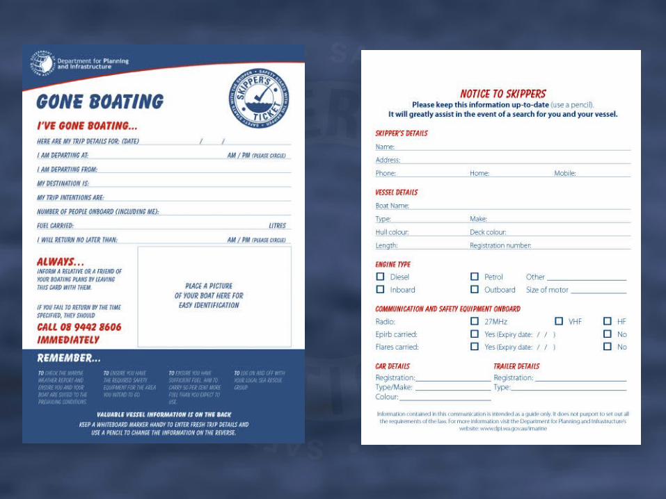
Let someone know before you go.• Some people choose to notify a neighbour or relative.
– If you do, you must accept that this person may not have much marine understanding.
– It would be best to write the plan down, and go through it with them.
– At the end of the plan make sure you write that they must ring the police if you don’t make contact at the agreed time.
• A fridge magnet is available from the Department for you to fill out your trip details on and give to a responsible person.

Log on• The most common responsible person, though, is the duty
officer at your local sea rescue group, contacted by radio.Your radio routine will be similar to this:• Select the calling frequency of the sea rescue group, wait until
you are sure you are not interrupting anyone, and then say:– “. . . Sea Rescue, this is (your boat name and call sign)
over.” – Wait for the reply.
• When Sea Rescue acknowledges your call say:– “. . . Sea Rescue, this is (your name and call sign)
departing . . . to fish at the FADs. ETA at FADs 0930. Estimated return time 1430. Two persons on board, 120 litres of fuel, over.”
• When Sea Rescue acknowledges say:• “Thank you Sea Rescue, out.”

Log off
Log off• This is as important as logging on. • If you do not log off, scarce and expensive resources may be
consumed in a futile search for you. • The radio frequency and procedure is the same as for the log
on.
Buoyancy and stability
Buoyancy
• Almost all trailer boats have flotation – sealed air chambers or foam – to give support if the boat is swamped.
• How much flotation and where it is placed determine how effective the buoyancy will be.
• There are three levels of flotation– Insufficient– Basic– Level
Insufficient flotation
• Is a flotation system that has not enough flotation to enable a vessel to stay afloat when swamped.

Basic flotation
• This is enough flotation to prevent the vessel and its maximum load from sinking when swamped.
• It does not necessarily support its passengers safely, it may float at any attitude and just give them something to cling to.

Level flotation
• When swamped, a vessel with this flotation will float upright and level (unless it has been capsized), and support its maximum load and its designed complement of occupants.
• This allows the vessel to be bailed or pumped dry, and vastly improves the prospects of survival.

Australian Builders Plate (ABP)
• Boats built from mid 2006 will carry the Australian Builders Plate, giving vital safety information to their owners – or to help prospective owners make buying decisions.
• Makers are now quoting maximum outboard weight as well as maximum power.
• The plate will be clearly visible, and includes:– maximum number of people to be carried;– maximum engine power and weight; and– the boat’s buoyancy performance.

Overloading
• If your boat does not have a plate or handbook recommending a maximum complement of people, use this table as a guide.
Length of boat Maximum number of people aboard
Less than 3.0m 2
3.0m to less than 3.5m 3
3.5m to less than 4.5m 4
4.5m to less than 5.0m 5
5.0m to less than 5.5m 6
5.5m to less than 6.0m 7

Stability• Stability is the measure of a vessel’s eagerness to return to
the upright after being heeled, and also of how far it can safely heel.
• It is affected by total load, by how the load is distributed, and by how securely stowed the load is.
• Passengers are part of the load, and their movement can affect stability, especially in smaller boats.

Stability• Ensure that total load, including the number of people on board, is
within the specifications of the boat. • Heavy items must be stowed low, and all items must be distributed
so as not to cause a change in trim of the boat (not dip the stern or the bow).
• No items may be stowed where they can shift with the vessel’s motion. – Scuba cylinders for instance, which are heavy and likely to move
if unrestrained, have caused stability problems and damage.• Any gear it is not possible to stow securely must be restrained by
straps or rope lashings.• Water in the vessel can endanger stability, both through increasing
the total load on board and through a phenomenon called free surface effect. – Water free to move around the vessel has an effect on stability
out of all proportion to its quantity.