trees on the treeless plains - permaculture principles
TRANSCRIPT

T R E E S O N T H E T R E E L E S S P L A I N SR E V EGE TATION M A N UA L FOR T H E VOLC A NI C L A N DS C A PE S OF C E N T R A L V I CTORI A
DAV I D H O L M G R E N

T R E E S O N T H E T R E E L E S S P L A I N SR E V EGE TATION M A N UA L FOR T H E VOLC A NI C L A N DS C A PE S OF C E N T R A L V I CTORI A
DAV I D H O L M G R E NeBook Version 1.0
DedicationAn important source of information and inspiration for this work has been Nature itself. Of particular value have been abandoned homestead gardens, overgrown gullies and unmanaged roadsides where natural processes of regeneration and succession have developed without curtailment by the “make work” activities of people. It may be a cliche to say that Nature is the ultimate designer but I have found this to be a simple fact, and, the inspiration for much of the design presented here. Therefore I wish to dedicate this effort to Nature in the hope that we can rediscover our respect and debt to her.
David Holmgren, Hepburn, November 1987
Book Credits 1994Copyright © David HolmgrenPublished by Holmgren Design Services 16 Fourteenth St, Hepburn, Victoria 3461Editing: Ian Lillington & Su DennettPhotographs: David HolmgrenTypesetting: GAS Graphics, Hepburn, VictoriaPrinting: FRP, Wendouree, VictoriaNational Library of Australia, cataloguing in publication Original book ISBN - 0 646 17 568 8
Cover IllustrationView of Kangaroo Hills Blampied Sept ’91.Foreground; remnant swamp gums in sheep paddock sheltered from southerly winds by multi-row shelterbelt planted in Sept ’88 (same shelterbelt as in photos 12.2 & 12.9)Midground left; old conifer plantings sheltering homestead.Background; old planted pines on hilltop (site of photo A.5) and, hidden in the haze, new shelter and tree fodder revegetation sites on the slopes.All new plantings were part of the Project Branchout Bicentennial Captain’s Creek Catchment Revegetation works with species selection and site design by the author.Drawing by Greg Holland.
eBook Credits 2006eBook design, editing and production: Richard TelfordeBook editing: Ian Lillington and Maureen Corbett
Image Scans: Christian WildCover photo: David HolmgrenProject management: Su Dennett National Library of Australia, Cataloguing in publication eBook ISBN 0-9750786-1-5This eBook and pdf & html files are copyright. Apart from any fair dealing for the purposes of private study, research, criticism or review, as permitted under the Copyright Act, no part may be reproduced by any process without written permission. Copyright © David Holmgren Published by Holmgren Design Services 16 Fourteenth St, Hepburn, Victoria 3461 Website: www.holmgren.com.au
��� �� � �� � ��� � � ��� � � ��� � � �� ��������������������������������������� �������������������������������
����� � ��������
S E A R CH HE LP CON T EN T S PR E V IOU S BACK FORWARD I I I
CONTENTS TREES ON THE TREELESS PLAINS
REVEGETATION TARGETS PA R T 3
PUBLIC LAND
CHAPTER 9 Roadsides & Reserves 32
CHAPTER 10 Streams & Reservoirs 43
REVEGETATION DESIGN SYSTEMS PA R T 4
PRIVATE LAND
CHAPTER 11 Paddock Trees 58
CHAPTER 12 Multipurpose Farm Shelterbelts 69
CHAPTER 13 Farm Forestry 92
CHAPTER 14 Tree Crops 112
APPENDICES PA R T 5
APPENDIX A Species Index 128
APPENDIX B Indigenous Species Descriptions 140
VOLCANIC LANDSCAPES MAP 156
ANNOTATED BIBLIOGRAPHY 157
CATALOGUE 160
www.holmgren.com.au
PROLOGUE
HOW TO USE THIS eBOOK IV
HELP IV
FOREWORD IV
ORIGINAL FOREWORD VI
ACKNOWLEDGEMENTS VII
INTRODUCTION VII
LANDSCAPE DESCRIPTION PA R T 1
CHAPTER 1 The Study Area 2
CHAPTER 2 Land Use & Degradation 5
CHAPTER 3 Landscape Classification 8
CHAPTER 4 Soils 14
CHAPTER 5 Native Vegetation 17
REVEGETATION PLANNING PA R T 2
CHAPTER 6 The Planning Process 21
CHAPTER 7 Revegetation Guidelines 24
CHAPTER 8 Volcanic Landscape Profiles 1, 2 & 3 27
PROLOGUE TREES ON THE TREELESS PLAINS
This eBook is based on the A4 sized book of the same name published in 1994. The following notes about how to use the book also apply to this eBook version.
The book can be read section by section, working logically from the historical and environmental features of the area, through design of the property, to implementation of the design. The contents and their sequence are intended to provide an understanding of the conscious planning and design process I use in approaching any project. This provides a structured balance to the strong impressions gained by visiting the property in a particular season or stage of development.
Alternatively, the reader may choose specific sections which are currently interesting or relevant to his or her own situation.
Explanation of technical terms and cross references to other sub-systems are given on the relevant page. Generally, common names for plants are used in the main text, with botanical and common names in the Perennial Species Index.
Because of the different nature of the media used, this eBook lacks some of the qualities of the book, most notably the A4 format with text, plans and photos laid out in thematic presentation. On the other hand the eBook provides many advantages;
• All original colour photos
• Plans, graphics and photos zoom-able to see a higher level of detail than possible in the book
Thus the eBook can be considered as both a complimentary update and an alternative to the original book. Any comments on the format and content of this eBook are welcome including bug reports: please email us (with TOTP v1.0 Feedback as the subject).
The easiest method of navigating to different parts of the eBook is by returning to the Contents page. Different coloured bars indicate chapters and the text below the bars indicate sections within the chapters. Clicking on these will link you to the relevant page.
Chapters begin with a menu page, sections are listed in capital letters and articles within the section are listed below in lower case. Click on the topic of interest to link to that page. Return to the chapter menu by clicking on chapter heading in the top right hand corner.
There are also links within the text that link you to related pages elsewhere in the document.
HOW TO USE THIS eBOOK
HELP
S E A R C H H E L P C O N T E N T S
Click on text to view at full screen width, continue clicking the mouse to move to the next section of text, alternatively you can use the scroll wheel or the up and down arrow keys.
Pictures can be enlarged. In Acrobat 5 click once to enlarge and again to reduce. Acrobat 6 is not recommended (update www.adobe.com), but you can click on the image followed by the Previous button. In Acrobat 7 hold the mouse button down to enlarge and release to reduce. ‘Preview’ (the default pdf reader on Mac OSX) is not recommended, download Acrobat Reader.
You will also notice a menu bar at the bottom of the screen.
• QUIT (rollover - bottom left) - will quit Acrobat and leave the eBook.
• FULL SCREEN (rollover - bottom left) - The eBook automatically starts in full screen mode but this button allows you to switch between Full Screen and Acrobat Window mode.
• SEARCH - find a word or series of words to match your query.
• HELP - brings you back to this page.
• CONTENTS - returns you to the contents page.
• PREVIOUS - returns you to your previous view.
• BACK - go back one page in the document.
• FORWARD - go on to the next page in the document.
This eBook edition makes available a publication which has been out of print for some years. The high resolution colour photos bring the subject landscape and trees to life replacing the lower quality black and white images in the original book. The searchable text and species index allows for quick cross referencing. The digital format makes future updates to the data and designs a possibility.
Although the fields of revegetation and farm forestry have progressed in many ways since Trees On The Treeless Plains was published in 1994, there is a continuing interest in both the design concepts and the technical detail of this revegetation manual. Some of the interest in this book is from designers around the world applying permaculture design principles to broad acre farm landscapes. In that context this eBook can provide inspiration and conceptual design ideas even if the species and the details are different.
While some of the designs remain proposals rather than proven, let alone profitable systems, they still have considerable value in the local context where good models of landscape and whole farm design of revegetation and forestry remain few and far between.
FOREWORD
P R E V I O U S B A C K F O R W A R D I V

PROLOGUE TREES ON THE TREELESS PLAINS
One of the main reasons for the slow development of revegetation and farm forestry has been the continuing low returns from traditional enterprises and the modest (at best) rise in prices for wood produced from farm forests.
In economically driven revegetation, the Blue Gum plantation phenomenon has transformed some farms in the study area, although less so than on the volcanic plains of western Victoria. The lack of a landscape approach, the short rotation monoculture, and the low value yields (pulpwood) ignore the approaches proposed here. On a smaller scale, a vibrant farm forestry network within the wider region, has developed with a focus on a range of species identified in this manual as having great potential (most notably Sugar Gum, Spotted Gum and Macrocarpa Cypress). See Agroforestry News: email [email protected]
While my permaculture design teaching and writing have mostly taken me away from the broadacre farm revegetation field, a few landholders, designers and contractors have implemented projects both on volcanic and other regional land types that reflect the broad concepts, if not the specific designs, outlined in this manual. Most notable of those has been Darren Doherty whose work in farm revegetation reflects the integrated and multifunctional designs in this book. See Australia Felix website. http://www.permaculture.biz/home.htm
The message about the shelter and habitat value of revegetation is an old one, but it is yet to be widely realised that revegetation is as important to the productive use of the volcanic plains as water supply. On some properties within the study area, higher value land uses such as horticulture especially organic production have demanded greater attention to multipurpose revegetation. Captain’s Creek Organic Farm at Blampied possibly represents one of the best overall examples of a diversified farm on the red volcanic plains. An extensive network of paddock shelterbelt and wetland revegetation areas protects high value field and tree crops as well as livestock. The habitat created supports important pest predators. The revegetation work at Captain’s Creek in the 1980’s provided essential “infrastructure” for the successful development of organic farming and was one of the influences on the ideas in this book.
Revegetation has also been an essential infrastructure for larger scale rural tourist ventures but the large budgets for many of these projects allow amenity landscaping approaches, often using advanced plant stock and drip irrigation outside the scope of this work.
If short rotation Blue Gum plantations represent the mainstream of economically focused revegetation, the mainstream of ecologically focused revegetation has shifted to a purely locally indigenous approach with substantial funding of Landcare projects through Catchment Management Authorities.
S E A R CH HE LP CON T EN T S
The recommendations and designs in this book using locally indigenous, Australian native and exotic species are much more multifunctional and flexible than designs using only locally indigenous species. The recommendations to manage rather than remove existing naturalised species, most notably willows, are in stark contrast to the large scale willow removal programs which have come to characterise publicly funded catchment management works in this and other regions of southern Australia.
Rather than being representative of an earlier phase of environmentally naïve revegetation, Trees On The Treeless Plains represents an early rejection of the “nativist” orthodoxy that has almost totally captured ecologically focused revegetation. In more recent writings I have been more forthright in arguing for recognition of the value of non-indigenous species and for management, rather than destruction, of naturalised vegetation. In particular, the further work and monitoring of the willow stream corridor forests mentioned in this work, has grown into the Spring Creek Community Forest project presenting management alternatives to willow removal. See webpage http://www.holmgren.com.au/html/SpringCk/SpringCk.html
In the design and management of tree fodder, the further documentation of our own small property of Melliodora in Hepburn Springs (see Holmgren Design Service website http://www.holmgren.com.au/html/Publications/eBook.html) has proven the highly productive and flexible nature of both evergreen and deciduous species as living haystacks to support grazing animals through normal and drought conditions. While this small scale revegetation of 2 degraded hectares on the edge of a volcanic lava flow remnant is hardly an example of the scope of the designs in Trees On The Treeless Plains, it does demonstrate the degree to which permaculture design integrates the productive and ecological imperatives in ways still largely absent from the published literature and the landscape.
Climate change has been a factor in the beliefs and policies driving the establishment of blue gum plantations, and to a lesser extent, revegetation generally. Today the imminent peaking of global oil supply and the looming energy descent future may lead to accelerated revegetation, locally and globally, to provide sustainable sources of fuel. Plantations intended for pulpwood could well become energy plantations and rapidly expand. While it may be unrealistic to expect mainstream policies and action to support anything more valuable than short rotation monocultures, a smaller scale and slower revegetation process towards multiple values will at least provide the diverse models for future generations to emulate and expand on, once our frenetic and short term economy becomes history. The “reprinting” of Trees On The Treeless Plains as an eBook is dedicated to that future.
David Holmgren Melliodora, December 2005
PR E V IOU S BACK FORWARD V
PROLOGUE TREES ON THE TREELESS PLAINS
This design manual began as a report for Project Branchout (a community revegetation organization in central Victoria) which had received funding from the Design Arts Board of the Australia Council to develop “landscape guidelines for revegetation” for one of the regional land types of central Victoria. This work was to serve as a pilot study for guidelines covering the whole region. The volcanic landscapes was selected for the study by the Project Branchout management committee and in November ’86 the author was formally commissioned.
Subdivision of the upland catchments of central Victoria on geological lines gives three broad land types which impose significant differences in landscape, land use and degradation, and hydrologic effects on the whole catchment. They are:
• Sedimentary and metamorphic hill country.• Granitic hill country.• Volcanic plains and hills.
The volcanic landscapes were selected for the pilot study for the following reasons:• Although land degradation, and particularly salinity, have not yet made a major
impact on the productivity of these areas, any effects are particularly significant since the volcanic landscapes constitute the best agricultural land in the catchments.
• Tree cover on the volcanic plains is very limited compared with other land types (with the exception of parts of the riverine plain). Adverse environmental effects, particularly exposure to cold and hot winds, and general loss of ecological diversity are severe.
• Because of the above, most landholders value existing trees and many are involved or interested in planting more. A smaller number have properties with a history of tree planting and on-going planting programs. This provides fertile social ground for the germination and growth of better designed and integrated revegetation.
Since completion, the report to Project Branchout has circulated amongst landholders, extension officers and others involved in revegetation in the study area as well as further afield. Presentations of the concepts have been made to local landcare and farm tree groups, the Bicentennial Forestry conference in Albury in 1988 and the Murray Darling Basin Commission. Designs from the report have been adapted to a number of revegetation projects including a bicentennial sub-catchment project near Smeaton and work by the Moolort Land Care Group.
However the original intention of broad promotion and follow up guidelines for other land
ORIGINAL FOREWORD
S E A R C H H E L P C O N T E N T S
types never eventuated. The shift in funding from regional groups to the newly formed local landcare groups leading to the eventual demise of Project Branchout in 1990 was the main reason.
Other possible contributing factors were;• regional land types other than volcanic remained the focus of concern in the
development of the catchment salinity plans,• the wide ranging nature of the report did not fit comfortably within an emerging
split in revegetation between "economic" perennial pastures and "environmental" indigenous trees and shrubs.
This published manual differs from the original report in some substantial ways:• The material of the report has been reorganized to make it more accessible and
useful as a manual, including the addition of an index.• A new chapter on stream and reservoir foreshores has been added.• All the chapters have been reviewed in the light of feedback, experience and
new information with editing, re-organization and new material added where necessary.
The wide ranging nature of the original report has been preserved. New information and experience in the rapidly changing field of revegetation has reinforced many of the radical concepts in the report. Therefore this manual is intended to be a conceptual as well as a practical book which should provoke more holistic ways of thinking about revegetation, landscape and agriculture.
Since the 1991 editing of this work the Loddon and Campaspe Draft Salinity Management Plans have been released. They provide much additional data on the major land degradation issue in the study area. The recommendations, especially of the Loddon plan, reflect a shift towards "integrated catchment management" and include recognition of "productive" use of trees and shrubs as one of the most cost effective ways to control salinity.
On a wider front there is a flurry of research, government programs and grass roots action in farm forestry. This activity similarly reflects a shift towards designed and productive use of trees as environmental and economic answers which promise to generate a new Australian "culture of trees".
David Holmgren Hepburn, October 1993.
Explanatory Note: Instead of Eucalyptus spp., Allocasuarina spp., Acacia spp., I have used Eucalypt, Casuarina and Acacia as collective terms as in common use, eg in caption 9.8. For specific trees, common names are generally used with common and full scientific names in the appendices.
P R E V I O U S B A C K F O R W A R D V I

PROLOGUE TREES ON THE TREELESS PLAINS
While this work is very much a statement of my perception of the issues and solutions I would like to acknowledge the support, inspiration and advice of many people.
Firstly, I would like to thank the Design Arts Board of the Australia Council for their funding of the original report, in their recognition of the importance of design to the "productive landscape".
Secondly, I would like to acknowledge the support and feedback of the Project Branchout management committee. In particular Alison Teese for her efforts in the conception, faith and strategic advice at critical points in the process and Rod May for his facilitation in the use of the Creswick Community Centre as well as his contacts, ideas and on going development and promotion of this work.
Thirdly, I would like to thank Nathan Alexander for his professional advice on format, layout and production of the original report and his dedication and meticulous workmanship in redrafting my often disorganized graphics.
I would also like to thank all the people who have given me the benefit of their contacts, local experience, ideas and feedback. In particular Ron Hately of the School of Forestry and Land Management for his encouragement and feedback, Mark Stewart of the Ballarat Water Commission for valuable ideas on mixed species plantations and Martin Westbrook of Ballarat University College for editorial assistance.
I also wish to acknowledge a debt to all the landholders and workers both past and present, whose successes and failures have provided a wealth of information.
In the preparation of this published manual I am indebted to Ian Lillington for editorial work.
Lastly I would like to thank my family for patience, support and editorial assistance, through the obsessive fieldwork, painful birthing of ideas, protracted refinement and endless production phases of the original report as well as this published manual.
David Holmgren Hepburn, October 1993.
The SubjectRevegetation is generally defined as “the planting of trees and shrubs, the encouragement of natural regeneration and the use of deep rooted and/or perennial crops and pastures."1
ACKNOWLEDGEMENTS
INTRODUCTION
S E A R C H H E L P C O N T E N T S
Revegetation is closely associated to the broadly based land care movement which has developed in response to increasing symptoms of land degradation and more general concern about misuse of natural resources. There has been a tendency on the part of agricultural and soil conservation specialists to see the diversity of land degradation as separate issues requiring remedial treatment. What is increasingly clear is that these problems are connected and require integrated solutions which address the underlying problems.
These problems are; the failure to fully use soil and water resources and, the lack of biological capital storages* to stabilize the agroecosystem.
Revegetation is one of the primary strategies which can address both problems.
This work focuses on the use of woody vegetation in revegetation because:• The multi-faceted benefits from trees and shrubs and their three dimensional
nature make design a critical factor in their optimal use.• Although much work needs to be done on permanent crops and pastures
(herbaceous vegetation), the information base on the selection, establishment and utilization of trees and shrubs (woody vegetation) is far more deficient.
For revegetation with trees and shrubs to have a substantial impact on rural land use and landscapes, many technical, economic, institutional and social impediments need to be overcome. Oates (1983) identified some of these impediments in a regional context and suggests ways they can be tackled. This work develops some of the design solutions appropriate to particular landscapes. As such it is intended as a revegetation design manual for landholders and managers within the study area.
The Wider AudienceMuch of the technical material in the manual is directly applicable to other volcanic landscapes in western and southern Victoria. For land managers with some experience in revegetation in other regions and land types, the manual should provide examples of how design can develop and expand the benefits of revegetation and stimulate adaptation of the concepts to their own regions. For educators, consultants and government officers involved in natural resource management, agriculture, land care and farm forestry, the manual should stimulate debate and provide case study material for further investigation, research and development.
1 Oates, N. (bib.)* Biological capital storages such as trees and soil humus provide a "bank" of biomass and nutrients which are
relatively stable but can be accessed to generate yields just as financial capital resources are necessary to generate economic activity.
P R E V I O U S B A C K F O R W A R D V I I

PROLOGUE TREES ON THE TREELESS PLAINS
Figure 0.1 Planning regions, shires and river catchment boundaries.
Shires with significant area within catchments of the Avoca, Loddon and Campaspe rivers.
NORTHERN MALLEE PLANNING REGION 1. Kerang
LODDON-CAMPASPE PLANNING REGION 2. Cohuna 3. Gordon 4. Rochester 5. Charlton 6. Korong 7. East Loddon 8. Huntly 9. Kara Kara 10. Bet Bet 11. Marong* 12. Strathfieldsaye* 13. McIvor* 14. Tullaroop* 15. Maldon* 16. Metcalfe* 17. Newstead* 18. Kyneton* 19. Newham & Woodend* 20. Pyalong
GOULBURN PLANNING REGION 21. Waranga* 22. Deakin
CENTRAL HIGHLANDS PLANNING REGION 23. Daylesford & Glenlyon* 24. Creswick* 25. Talbot & Clunes* 26. Avoca* 27. Lexton* 28. Ballarat* 29. Bungaree** Shires with significant volcanic country.
S E A R C H H E L P C O N T E N T S P R E V I O U S B A C K F O R W A R D V I I I
PROLOGUE TREES ON THE TREELESS PLAINS
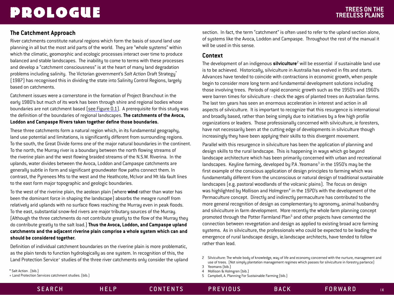
The Catchment ApproachRiver catchments constitute natural regions which form the basis of sound land use planning in all but the most arid parts of the world. They are “whole systems” within which the climatic, geomorphic and ecologic processes interact over time to produce balanced and stable landscapes. The inability to come to terms with these processes and develop a “catchment consciousness” is at the heart of many land degradation problems including salinity. The Victorian government’s Salt Action Draft Strategy* (1987) has recognised this in dividing the state into Salinity Control Regions, largely based on catchments.
Catchment issues were a cornerstone in the formation of Project Branchout in the early 1980’s but much of its work has been through shire and regional bodies whose boundaries are not catchment based (see Figure 0.1). A prerequisite for this study was the definition of the boundaries of regional landscapes. The catchments of the Avoca, Loddon and Campaspe Rivers taken together define those boundaries.
These three catchments form a natural region which, in its fundamental geography, land use potential and limitations, is significantly different from surrounding regions. To the south, the Great Divide forms one of the major natural boundaries in the continent. To the north, the Murray river is a boundary between the north flowing streams of the riverine plain and the west flowing braided streams of the N.S.W. Riverina. In the uplands, water divides between the Avoca, Loddon and Campaspe catchments are generally subtle in form and significant groundwater flow paths connect them. In contrast, the Pyrenees Mts to the west and the Heathcote, McIvor and Mt Ida fault lines to the east form major topographic and geologic boundaries.
To the west of the riverine plain, the aeolean plain (where wind rather than water has been the dominant force in shaping the landscape) absorbs the meagre runoff from relatively arid uplands with no surface flows reaching the Murray even in peak floods. To the east, substantial snow-fed rivers are major tributary sources of the Murray. (Although the three catchments do not contribute greatly to the flow of the Murray they do contribute greatly to the salt load.) Thus the Avoca, Loddon, and Campaspe upland catchments and the adjacent riverine plain comprise a whole system which can and should be considered together.
Definition of individual catchment boundaries on the riverine plain is more problematic, as the plain tends to function hydrologically as one system. In recognition of this, the Land Protection Service+ studies of the three river catchments only consider the upland
* Salt Action . (bib.)+ Land Protection Services catchment studies. (bib.)
S E A R C H H E L P C O N T E N T S
section. In fact, the term “catchment” is often used to refer to the upland section alone, of systems like the Avoca, Loddon and Campaspe. Throughout the rest of the manual it will be used in this sense.
ContextThe development of an indigenous silviculture2 will be essential if sustainable land use is to be achieved. Historically, silviculture in Australia has evolved in fits and starts. Advances have tended to coincide with contractions in economic growth, when people begin to consider more long term and fundamental development solutions including those involving trees. Periods of rapid economic growth such as the 1950’s and 1960’s were barren times for silviculture - check the ages of planted trees on Australian farms. The last ten years has seen an enormous acceleration in interest and action in all aspects of silviculture. It is important to recognize that this resurgence is international and broadly based, rather than being simply due to initiatives by a few high profile organizations or leaders. Those professionally concerned with silviculture, ie foresters, have not necessarily been at the cutting edge of developments in silviculture though increasingly they have been applying their skills to this divergent movement.
Parallel with this resurgence in silviculture has been the application of planning and design skills to the rural landscape. This is happening in ways which go beyond landscape architecture which has been primarily concerned with urban and recreational landscapes. Keyline farming, developed by P.A .Yeomans3 in the 1950’s may be the first example of the conscious application of design principles to farming which was fundamentally different from the unconscious or natural design of traditional sustainable landscapes (e.g. pastoral woodlands of the volcanic plains). The focus on design was highlighted by Mollison and Holmgren4 in the 1970’s with the development of the Permaculture concept. Directly and indirectly permaculture has contributed to the more general recognition of design as complementary to agronomy, animal husbandry and silviculture in farm development. More recently the whole farm planning concept promoted through the Potter Farmland Plan5 and other projects have cemented the connection between revegetation and design as applied to existing broad acre farming systems. As in silviculture, the professionals who could be expected to be leading the emergence of rural landscape design, ie.landscape architects, have tended to follow rather than lead.
2 Silviculture: The whole body of knowledge, way of life and economy concerned with the nurture, management and use of trees. (Not simply plantation management regimes which passes for silviculture in forestry parlance)
3 Yeomans (bib.)4 Mollison & Holmgren (bib.)5 Campbell, A. Planning For Sustainable Farming (bib.)
P R E V I O U S B A C K F O R W A R D I X
PROLOGUE TREES ON THE TREELESS PLAINS
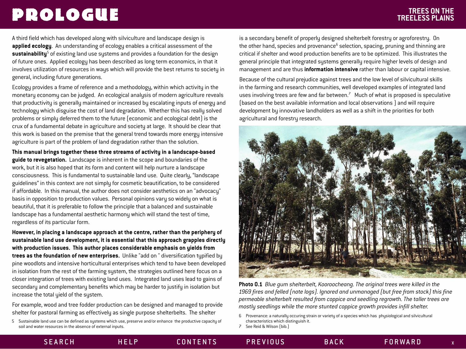
Photo 0.1 Blue gum shelterbelt, Kooroocheang. The original trees were killed in the 1969 fires and felled (note logs). Ignored and unmanaged (but free from stock) this fine permeable shelterbelt resulted from coppice and seedling regrowth. The taller trees are mostly seedlings while the more stunted coppice growth provides infill shelter.
A third field which has developed along with silviculture and landscape design is applied ecology. An understanding of ecology enables a critical assessment of the sustainability5 of existing land use systems and provides a foundation for the design of future ones. Applied ecology has been described as long term economics, in that it involves utilization of resources in ways which will provide the best returns to society in general, including future generations.
Ecology provides a frame of reference and a methodology, within which activity in the monetary economy can be judged. An ecological analysis of modern agriculture reveals that productivity is generally maintained or increased by escalating inputs of energy and technology which disguise the cost of land degradation. Whether this has really solved problems or simply deferred them to the future (economic and ecological debt) is the crux of a fundamental debate in agriculture and society at large. It should be clear that this work is based on the premise that the general trend towards more energy intensive agriculture is part of the problem of land degradation rather than the solution.
This manual brings together these three streams of activity in a landscape-based guide to revegetation. Landscape is inherent in the scope and boundaries of the work, but it is also hoped that its form and content will help nurture a landscape consciousness. This is fundamental to sustainable land use. Quite clearly, “landscape guidelines” in this context are not simply for cosmetic beautification, to be considered if affordable. In this manual, the author does not consider aesthetics on an "advocacy" basis in opposition to production values. Personal opinions vary so widely on what is beautiful, that it is preferable to follow the principle that a balanced and sustainable landscape has a fundamental aesthetic harmony which will stand the test of time, regardless of its particular form.
However, in placing a landscape approach at the centre, rather than the periphery of sustainable land use development, it is essential that this approach grapples directly with production issues. This author places considerable emphasis on yields from trees as the foundation of new enterprises. Unlike "add on " diversification typified by pine woodlots and intensive horticultural enterprises which tend to have been developed in isolation from the rest of the farming system, the strategies outlined here focus on a closer integration of trees with existing land uses. Integrated land uses lead to gains of secondary and complementary benefits which may be harder to justify in isolation but increase the total yield of the system.
For example, wood and tree fodder production can be designed and managed to provide shelter for pastoral farming as effectively as single purpose shelterbelts. The shelter 5 Sustainable land use can be defined as systems which use, preserve and/or enhance the productive capacity of
soil and water resources in the absence of external inputs.
S E A R C H H E L P C O N T E N T S
is a secondary benefit of properly designed shelterbelt forestry or agroforestry. On the other hand, species and provenance6 selection, spacing, pruning and thinning are critical if shelter and wood production benefits are to be optimized. This illustrates the general principle that integrated systems generally require higher levels of design and management and are thus information intensive rather than labour or capital intensive.
Because of the cultural prejudice against trees and the low level of silvicultural skills in the farming and research communities, well developed examples of integrated land uses involving trees are few and far between.7 Much of what is proposed is speculative (based on the best available information and local observations ) and will require development by innovative landholders as well as a shift in the priorities for both agricultural and forestry research.
6 Provenance: a naturally occuring strain or variety of a species which has physiological and silvicultural characteristics which distinguish it.
7 See Reid & Wilson (bib.)
P R E V I O U S B A C K F O R W A R D X

PROLOGUE TREES ON THE TREELESS PLAINS
This work is intended to provide stimulation and action towards an indigenous silviculture. It should not be seen as a final statement but rather as ideas in progress. The example of Tagasaste (chapter 14) which has the potential to transform pastoral farming in much of southern Australia, illustrates the productive potential of trees, their neglect, and how we are all beginners.
Inevitably, revegetation as broad and as far reaching as is proposed here requires that the economic, institutional and social impediments beyond the scope of this manual also be tackled. Revegetation will require a resettling of rural Australia, with livelihoods being created from the establishment, management, harvesting and processing of trees. This need coincides with a recent historic and sustained population drift back to regional towns and some rural areas from capital cities and the expressed desire of large numbers of urbanites to move to the country if they were able to find work.
It is also clear that neither subdivision of existing farms to allow new land uses to develop in isolation from present uses nor large estates with numerous enterprises and farm labourers are appropriate or possible solutions. Ways must be found to develop the human resources essential for revegetation, and give people a stake in the land they work. Present trends suggest that rural residential development in various forms will provide the framework and the financial resources for rural revegetation. Mainstream farmers need to be aware of the prospects for more productive and sustainable agriculture integrated with horticulture, forestry, rural residential development, recreation, tourism and conservation. Failure to grasp these opportunities is likely to result in a decline in both the economic viability and the ecological stability of farming.
Whatever the significance and impact of these wider issues, present landholders remain the key to initiating the process of revegetation. Without their efforts there will be nothing for future generations to work with.
New ideas tend to spread most effectively by example. This is particularly so amongst practically minded, conservative groups such as farmers. Only a small number of farmers have the motivation and resources to invest the considerable energy necessary to develop and maintain an on-going revegetation program which does more than repeat the well proven. Today the work of such pioneers is providing the data base for the present wave of tree plantings. It is essential to keep that pioneering work moving ahead.
This design manual is directed towards farmers who already have some experience and interest in revegetation and are looking for more specific design information. It will also be of use to educators, shire engineers, planners, farm extension workers, agricultural consultants, researchers and landscape designers as well as hobby farmers and agricultural and silvicultural contractors.
S E A R CH HE LP CON T EN T S
Photo 0.2 Rod May surveying 5 year old shelterbelt planted by Bruce Vallance to check survival, growth rate and other performance indicators. Foreground; Eucalyptus leucoxylon with moderate insect attack, middle; Eucalyptus polyanthemos with light insect attack and behind Eucalyptus baxteri; negligible insect attack and best growth rate.
PR E V IOU S BACK FORWARD X I

1PA R T
1. THE STUDY AREA2. LAND USE & DEGRADATION
An Ecological History
3. LANDSCAPE CLASSIFICATION Landform Catagories Climate Climatic Zones Mesoclimate & Microclimate
4. SOILS Summary of Soil Potential for Siviculture
5. NATIVE VEGETATION
L A N D S C A P E D E S C R I P T I O N
S E A R C H H E L P C O N T E N T S P R E V I O U S B A C K F O R W A R D 1
1PA R T

REVEGETATION PLANNING
LANDSCAPE DESCRIPTION 1
PA R T
1. THE STUDY AREA
The volcanic landscapes comprise 13.5% of the Campaspe, about 23% of the Loddon and only 1% of the Avoca catchments, and are mostly concentrated in the southern section which receives more than 500mm rainfall.Lava plains of relatively recent geologic origin8 overlaying the ancient valleys of the Campaspe and Loddon rivers make up the bulk of the area. The largest continuous area of plains spans the Great Divide north of Ballarat and extends north of the Pyrenees Highway to the east of Maryborough. Smaller lava flows occupy old creek valleys to the west and south of Maryborough. The southern section of the plain is dotted with rounded volcanic cones, Mt Kooroocheang, the largest, rising over 200m above the surrounding plain. Deep red soils are cropped intensively and in parts are irrigated from dams and bores. Further north, a variety of less well drained soils are used for grazing with some cropping. Large areas are treeless and very exposed while majestic red gum woodlands occur around swamps and in places on the plains. At the northern end rainfall is less than 500mm. Here extensive cropping paddocks predominate with remnant grey box and buloke stands.
Figure 1.1 Volcanic Landscapes of the Avoca, Loddon & Campaspe Upland Catchments.
Photo 1.1 View south near Clunes, over Birches Creek, across plain to Cattle Station Hill and other volcanoes. Foreground - gorse shelter hedge and planted trees near homestead, middleground - conifer shelterbelts.
8. See Land Protection Service catchment studies (bib.) for general description of the geology and origins of thevolcanic landscapes.
S E A R C H H E L P C O N T E N T S P R E V I O U S B A C K F O R W A R D 2

REVEGETATION PLANNING1. THE STUDY AREA
Photo 1.2 Cultivated cropping paddock south of Bridgewater in mid-winter. Deep red gradational soil. Roadside trees are grey box.
Photo 1.3 View south over Kyneton plains, from Green Hill (volcano) with remnant manna gum in foreground. Most trees on plains are exotic plantings.
LANDSCAPE DESCRIPTION 1
PA R T
West of Bendigo, where the Loddon river emerges from the uplands onto the riverine plain, is an extensive stony lava flow. Bright red fertile soils, mostly intensively cropped for wheat, form a mosaic with stony rises grazed by sheep.
Between Daylesford and Woodend, a series of undulating hills and lava flows form a mosaic with densely forested sedimentary hills. The area receives over 900mm rainfall (one location records 1260mm) and is the major source of runoff sustaining both the Loddon and Campaspe rivers. Deep red soils have been almost totally cleared for cropping. North of Daylesford, flat topped remnants of valley lava flows are scattered through predominantly forested hill country as small areas of fertile farmland. South-west of Castlemaine, a level lava plateau has soils and vegetation more like the extensive plains to the west.
Between Mt Macedon and Malmsbury, another extensive plain occupies the Campaspe valley. Largely devoid of native trees, old pine shelterbelts are the dominant woody vegetation while grazing on the heavy and mostly poorly drained soils is the main agricultural use. Hobby farming is expanding rapidly.
S E A R CH HE LP CON T EN T S
Further east, volcanic hills and lava flows occur as less erodible and more productive grazing and cropping areas within a grazed granitic landscape. Northwards along the Campaspe and tributary valleys, lava flows form tongues of flat farmland, in places characterized by majestic red gums. Lake Eppalock dissects the most northern extension of the Campaspe flow, which dips below the riverine plain north of the McIvor Highway.
To the east, the Colbinabbin Range projects northwards into the riverine plain and forms the water divide between the Campaspe and Goulburn catchments. The predominant geology is ancient Cambrian greenstone which weather to well drained red soils at least as fertile as those from the Tertiary basalts. In contrast to the volcanic landscapes, the Range has extreme erosion and salinity problems and in general is such a different landscape that it needs separate and special consideration. For these reasons it has not been included in this case study.
PR E V IOU S BACK FORWARD 3
REVEGETATION PLANNING1. THE STUDY AREA
S E A R C H H E L P C O N T E N T S P R E V I O U S B A C K F O R W A R D 4
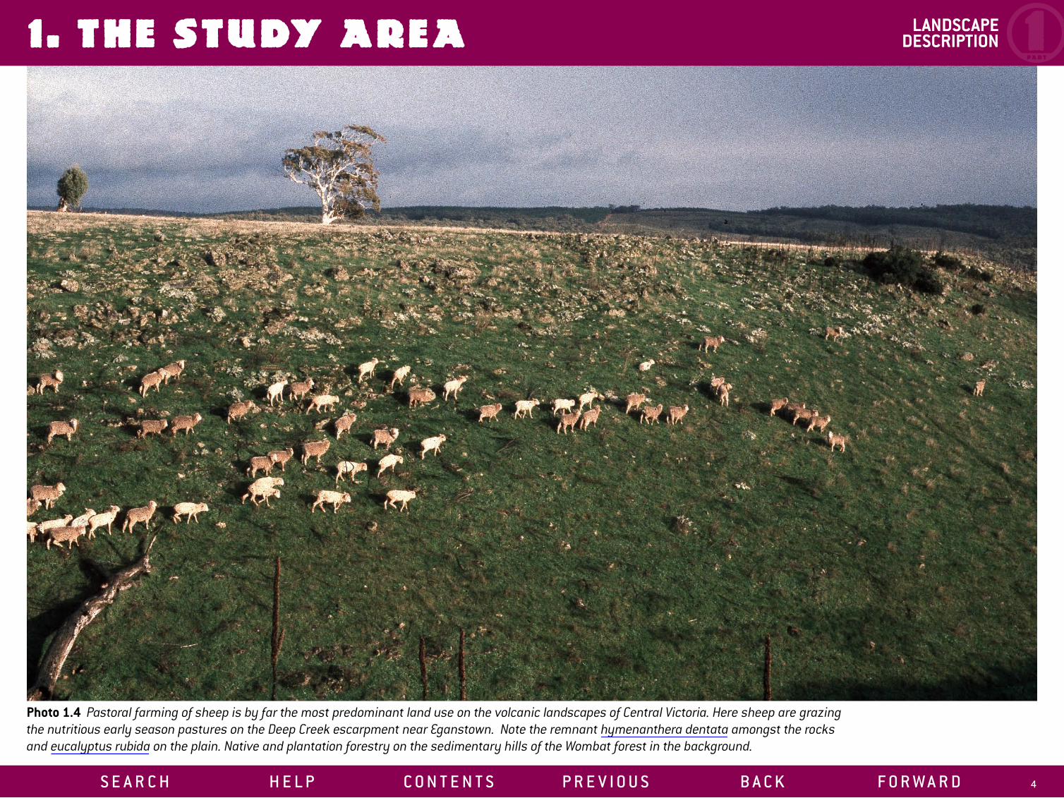
Photo 1.4 Pastoral farming of sheep is by far the most predominant land use on the volcanic landscapes of Central Victoria. Here sheep are grazing the nutritious early season pastures on the Deep Creek escarpment near Eganstown. Note the remnant hymenanthera dentata amongst the rocks and eucalyptus rubida on the plain. Native and plantation forestry on the sedimentary hills of the Wombat forest in the background.
LANDSCAPE DESCRIPTION 1
PA R T

REVEGETATION PLANNING2. LAND USE & DEGRADATION
Photo 2.1 Ruin of shepherd’s hut, Baynton - heritage of the squatting era. Remnant manna gum behind.
Photo 2.2 Mine tailings and remnant woodland, Allendale. Note tailings reworked for road gravel, gorse stabilizing silt wash from tailings, cattle attracted by salt grazing tailings. The woodland is composed of remarkably large and healthy trees which appear to be original uncut specimens (rather than coppice, seedling regrowth and gnarled old trees typical of remnant woodlands). Candlebark (white trunked) with a few messmate (now rare on the volcanic plains).
LANDSCAPE DESCRIPTION 1
PA R T
The significance of the volcanic landscapes of central Victoria in historic times has been far greater than their geographical area would suggest. They were important in the nomadic aboriginal economy, providing abundant plant and animal foods from open grassy forests, woodlands and open plains. The so-called natural ecosystems of these and other highly populated areas were managed with fire by the Aborigines to maintain a particular mosaic of vegetation types and structure.
In the first decades of European occupation the native grasslands provided a rich harvest for the squatters who concentrated their stock on the more productive country of the alluvial and volcanic plains. Evidence from elsewhere9 in Australia suggests that within a decade of the arrival of sheep and the breakdown of aboriginal husbandry, the native ecosystems went through fundamental and irreversible changes. Compaction from cloven hooves, closer grazing, overstocking and the absence of the traditional fire regime had an immediate impact on soil ecology and hydrology. Increased runoff resulted in erosion, nutrient losses and droughty conditions (lack of moisture stored in soil). Highly palatable native legumes, orchids and other herbaceous plants were grazed out and exotic grasses and forbs replaced them. Available nutrient levels would have risen despite losses as the biomass of the tall tussock grassland was replaced by a close-grazed annual pasture, creating the optimum environment for the later rabbit explosion. On the volcanic soils inherently high nutrient levels made the invasion of exotic species more rapid and complete than on less fertile country.
With the gold rush the pressure on the central Victorian environment became enormous, with land degradation unimaginable by today’s standards. The volcanic plains fared well compared with the “moonscapes” created on the sedimentary hill country diggings. However, the combined demands for increased food production, fuel and construction materials reduced tree cover dramatically.
It is doubtful whether productivity was increased in the long term by the clearing of widely spaced deep rooted eucalypts to leave open windswept plains. The fact that magnificent examples of pastoral woodlands remain, such as near Lexton, Woodstock and Kooroocheang in the Loddon, and Barfold and Mia Mia in the Campaspe indicate some landholders resisted the notion that trees reduce productivity.
Deep lead10 mining in the Loddon late last century and early this century, required massive amounts of timber for mine props and to fuel steam pumps. Timber was carted
AN ECOLOGICAL HISTORY
9 Rolls (bib.)10 Deep leads; ancient river course filled with alluvial gravels and sand which underlay the volcanic and riverine
plains and are the main aquifers transporting deep infiltration from the uplands to the riverine plain.
S E A R C H H E L P C O N T E N T S P R E V I O U S B A C K F O R W A R D 5

REVEGETATION PLANNING2. LAND USE & DEGRADATION
Photo 2.3 Isolated remnant sheoak on stony rise, Baynton. Early harvesting for fuel, high palatability to stock and rabbits, lack of coppicing and lack of seed set in isolated trees has led to the almost total demise of this species in central Victoria.
LANDSCAPE DESCRIPTION 1
PA R T
from considerable distances, indicating that local sources on the plains were largely exhausted. The remarkable ability of native trees to regenerate, combined with cyclical economic recession reducing the intensity of land management, is responsible for most of the mature trees we see today.
With the trees and deep rooted native pastures gone, recharge of local and regional aquifers increased, creating present day widespread waterlogging of low lying areas and in places, salting. As it became obvious that the other landscapes could not sustain European cropping techniques, the inherent productivity of the volcanic soils was highlighted. Closer subdivision and more intensive farming, including rock picking of stony areas, exotic shelter plantings and sown pastures, produced an almost European landscape in higher rainfall areas.
Since 1945, the dominant role of the volcanic plains declined with the widespread use of superphosphate and subterranean clover and the control of rabbits in more marginal country.
Today the low returns from farming and the increased demand for hobby farms and rural residential blocks in central Victoria has created a shift away from traditional farming. This demand has been mostly taken up on sedimentary bush country but around Woodend, Kyneton, Daylesford, Creswick, Ballarat and Clunes volcanic country is being bought by urban investors or subdivided for rural residential blocks.
This is leading to concern at the loss of prime agricultural land from production.11 Conventional subdivision is precluding broad acre agricultural uses and in some cases reducing the viability of adjacent farms. On the other hand the process has resulted in the injection of capital, labour and information, with extensive tree planting and natural regeneration being one of the most dramatic consequences. To a lesser extent, new enterprises are being developed on a small scale, many based on tree crops.
Another aspect of the shift in values which is sustaining rural resettlement is the rapid expansion of farm tourism. Agriculture continues in some form as a part of both the infrastructure and attraction of the new enterprise. The opportunities this presents for long term investment in sustainable agriculture and forestry have hardly begun to be explored.
Elsewhere there has been a shift towards larger and more capital intensive farms. Again there are advantages and disadvantages. Without the constraints of original title boundaries, planning based on land systems is easier. Small areas with the potential for intensive utilization can become the focus for capital investment allowing a more conservation orientated strategy on lower productivity areas. The higher levels of 11 See Review of Rural Land Use in Victoria (bib.)
S E A R C H H E L P C O N T E N T S
management needed in large agricultural enterprises make implementation of new land uses and better techniques more likely.
On the other hand, continuous cropping in areas where pasture rotation was previously practised is increasing risks of soil structure damage and nutrient decline. Acidification is a major threat and could be greatly increased by intensive lucerne cropping which has a much greater acidifying effect than other crops.12 Rock picking with heavy machinery to increase arable land is reducing remaining ecological diversity in northern cropping areas. Larger cultivation equipment and, in places broadacre overhead irrigation equipment are making the removal of remnant paddock trees more likely.
In many areas numbers of indigenous trees are declining to a level where increased insect and disease attack eliminate the survivors and local seed sources for revegetation are lost forever.
12 Rural Research no. 134.
P R E V I O U S B A C K F O R W A R D 6

REVEGETATION PLANNING2. LAND USE & DEGRADATION LANDSCAPE
DESCRIPTION 1PA R T
Salting, until recently not considered a problem in volcanic country, has been noticed in the last 15 years around Moolort associated with old sedimentary hilltops just below the surface of the plain. Excessive groundwater recharge from rocky rises and cones with free draining red soils is thought to be the source of the water (but not the salt) causing the problem.13 Trials by Project Branchout at Moolort suggest relatively small areas of trees can stop this excessive recharge. Elsewhere (e.g. north of Barfold, south of Leichardt and east of Smeaton) salting on sedimentary and alluvial country is probably caused by recharge on adjacent volcanic rises with shallow rooted annual pastures. Recent estimates for the Loddon catchment indicated 20% of the salt affected land is volcanic.
The importance to long term farm productivity of remnant native vegetation on the sedimentary islands and fringes of the volcanic landscapes should not be underestimated. Loss of that vegetation through salting would eliminate important seed sources, bird habitat, animal shelter and farm wood supplies.
Waterlogging (non-saline groundwater discharge and runoff) is a less dramatic but more widespread and unrecognised form of land degradation caused by lack of deep rooting vegetation. It reduces pasture and crop productivity and is a prime cause of tree decline.
It is ironic that deep infiltration of rainwater is seen as a problem rather than a resource in a region which, in world terms, is semi-arid. Deep rooted perennial pastures and fodder trees could use this water, solving the problem and making the least productive land the most productive! The fact that these potentials have not (until recent years) been properly researched and developed on their productive merits has been a major expression of the unsustainability of current pastoral farming.
Excessive recharge of the deep lead aquifers under the riverine plain is also a serious problem. The contribution of the upland landscapes to deep lead recharge has been quantified,14 but how much excess water is coming from the volcanic landscapes in particular has not. However, rocky rises, scarps, cones and undulating rises with free draining soils and shallow rooted annual pastures must be candidates for prime recharge areas.
In higher rainfall areas with deep free draining red soils, intensive cropping regimes, including potatoes, have overexploited the normally resilient soil structure with increasing erosion and the creation of hard pans. However, nutrient decline and
13 Phil Dyson, C&E hydrologist, Bendigo (pers. comm.)14 Williamson, D.R. The Application of Salt and Water Balance to Quantify Causes of Dryland Salinity Problems in
Victoria. Proceedings of Royal Soc. of Vic. Vol.95, no.3, 103-111, sept ’83.
S E A R C H H E L P C O N T E N T S
increasing acidity (with associated manganese and aluminium toxicity) are the most important warning signs of imbalance in what appears to be a harmonious rural landscape.15 Without deep rooting perennials and trees to recycle alkaline nutrients from the subsoil and halt nitrogen leaching, productivity will depend on escalating inputs of lime and fertilizers. Worsening mineral imbalances, crop and animal disease are the likely results. Accumulation of toxins from heavy use of fertilisers and pesticides has reduced future options to produce chemical free produce on some of our best farmland. In the end, land degradation under agriculture only reinforces the ability of existing tree based land uses (pine plantations) to compete for the land resource.
The connection between acidity and the regional groundwater problem makes it clear that our present land use systems are fundamentally out of balance and will require more than superficial adjustment to achieve sustainablity. Appropriately designed and managed revegetation is the only real solution to these and other interconnected problems. What is unique about the volcanic landscapes is the range of options to use revegetation to achieve major increases in long-term farm productivity. To not grasp these opportunities would be environmental irresponsibility and economic foolishness.
15 See Rural Research C.S.I.R.O. Canberra no. 122 ’84 & no.134 ’87. for an overview on acidification in southern Australia.
P R E V I O U S B A C K F O R W A R D 7
REVEGETATION PLANNING3. LANDSCAPE CLASSIFICATION LANDSCAPE
DESCRIPTION 1PA R T
The volcanic landscapes of central Victoria are geologically recent by Australian standards, and this youth is expressed in distinct forms with obvious edges and boundaries which contrast with the worn down non-volcanic uplands. This makes “reading the landscape” comparatively easy. Many people involved with the land can recognize a lava flow even if they have no knowledge of geology or geography. The phrase “the old country” referring to the sedimentary hills, indicates the distinction of landform and age. Further, most people recognize the deeply weathered, gently undulating, red soil hills of the high rainfall areas as quite different from the volcanic plains and lava flows with rocky outcrops, escarpments and variable clay soils. At a very local level farmers have an intimate but non-technical knowledge of soils. This fine-grained knowledge needs to be combined with a more general but systematic classification of landscape if revegetation is to succeed at economic revitalization as well as ecologic stabilization.
Revegetation involves decisions which have consequences for the layout and functioning of farms for decades to come. It progressively develops a third dimension (literally a vertical element) to agriculture. If revegetation decisions are to harness the many and varied benefits from trees and keep options open for future farm management, landholders will need to embrace the whole farm planning concept (see Chapter 6). The first step in whole farm planning is an analysis of the different land types which comprise the farm.
The “land systems” approach developed by geographers, planners and soil conservators in Australia and North America has been of great use in identifying the underlying potential and limitations of whole landscapes for varying uses and management. It does this by integrating three fundamental groups of landscape characteristics.
1. Climate. 2. Geology, Geomorphology and Topography (ie. land composition, process
and shape). 3. Biophysical Resources (soils, plants and animals).
A “Land System” is made up of particular “Land Components” which are considered to have more or less uniform features and are arranged in patterns which make natural landscape sense. Volcanic cone, footslope, plain, gentle drainage depression (line), stony rise, scarp and escarpment are typical components of volcanic land systems.
Based on the Land Protection Service studies16 there are twenty one volcanic land systems (not counting the Colbinabbin Range) across the three catchments. The land systems classification used by the Land Protection Service is based to a large extent on a detailed description of topography and soils and is primarily used to assess broad scale agricultural potential and associated land degradation.
S E A R C H H E L P C O N T E N T S
For the purpose of focussing on revegetation strategies, designs and species selection, the volcanic landscapes have been divided into four broad landform types and five climatic zones (detailed in this chapter), which can be considered independently if necessary.
The volcanic landscape profiles (Chapter 8) summarise information about the landform and climate zone categories in a graphic and tabular form. In most examples used here, revegetation strategies and designs are referenced to landforms and land components. Species lists are generally related to climate zones or soils. Soils correlate closely with landform, and are more readily recognised by farmers.
For a more fine-grained synthesis of topography and soils, the lands systems approach will allow consideration of all land use factors necessary in whole farm planning. Landholders and shire officers are strongly advised to refer to the land systems studies before developing revegetation programs.
1. Gently Undulating PlainsThese are extensive volcanic landscapes generally more than 2km across, and comprise much of the study area. These areas are very gently inclined (about 2% slope) and in parts level, with extremely low relief (about 5m) but including occasional volcanic cones rising 20m to 200m above the plain. Stony rises and scarps are occasional to numerous often delineating broad drainage depressions (including some closed depressions). On a larger scale, escarpments occur along some major drainage lines, especially where these form the edge of the plain. Drainage lines may also have small bordering alluvial terraces. Old sedimentary hilltops and slopes are exposed or barely covered by the soil profile in places.
A particular feature of these plains is their elevation to varying degrees in relation to surrounding landscapes. Alluvial (non-volcanic) plains of a similar scale are naturally lower than the surrounding (catchment) landscapes and tend to be slightly concave in shape while the volcanic plains are distinctly elevated and often broadly convex resulting in severe wind exposure and a much greater sense of openness.
LANDFORM CATEGORIES17
16 See bibliography17 Descriptive terms in bold type are standard landform description terms as defined in McDonald (bib.) In general
they mean the same as in common usage but with more precise definition.
P R E V I O U S B A C K F O R W A R D 8

REVEGETATION PLANNING3. LANDSCAPE CLASSIFICATION LANDSCAPE
DESCRIPTION 1PA R T
Photo 3.1 View south on the Tullaroop to Creswick Road. A gently undulating plain with broad drainage depression in foreground and isolated volcanic cones rising 80-100m above the plain.
S E A R C H H E L P C O N T E N T S P R E V I O U S B A C K F O R W A R D 9

REVEGETATION PLANNING3. LANDSCAPE CLASSIFICATION LANDSCAPE
DESCRIPTION 1PA R T
2. Gently Undulating RisesThis landform occurs as extensive landscapes between Smeaton, Creswick and Mollongghip and as elevated lava flows or hills such as around Daylesford or associated with eruption points such as around Bald Hill, Woodstock. Slopes tend to be very gentle but vary considerably and include small areas of plains. Relief is generally about 15m, apart from the numerous volcanic cones which rise to 100m above the surrounding landscape. Some have extensive gently to moderately inclined (about 10%) footslopes and rocky outcrops. Drainage depressions tend to form a more integrated and tributary network than on the plains.
A generally more weathered landscape than the plains, the original form of the lava flows is less readily recognized. Stony rises and rocky scarps within the landscape are uncommon but along the edges where streams have downcut, escarpments with cliffs, footslopes and waterfalls may occur. The most notable feature of this landform is the deep red soils which are intensively farmed.
S E A R C H H E L P C O N T E N T S
Photo 3.2 View south west along gentle scarp on Moolort Plains showing exposed basalt covering much of the surface. Excellent tree growth has been achieved following deep ripping of these sites. Mt Moolort (volcanic cone in background).
Photo 3.3 View south from Mt Kooroocheang. Gently undulating plains and rises with Kangaroo Hills (volcanic cones) in background. Relic dead blackwood with exotic plantings, mostly around homesteads on plains.
P R E V I O U S B A C K F O R W A R D 10

REVEGETATION PLANNING3. LANDSCAPE CLASSIFICATION
S E A R C H H E L P C O N T E N T S P R E V I O U S B A C K F O R W A R D 1 1
Photo 3.4 Intermittent stream cascades on escarpment slope above Upper Coliban Reservoir. Remnant patch of native tussock grassland with blackwoods.
LANDSCAPE DESCRIPTION 1
PA R T

REVEGETATION PLANNING6. THE PLANNING PROCESS
S E A R C H H E L P C O N T E N T S
Photo 3.5 View down Loddon Valley from lava flow remnant escarpment upstream of Guildford. Guildford plateau in background. Soils on escarpment brown uniform loams. Trees mostly exotic plantings and naturalized.
3. LANDSCAPE CLASSIFICATION
S E A R C H H E L P C O N T E N T S
LANDSCAPE DESCRIPTION 1
PA R T
Photo 3.6 View SW from Langdons Hill, Rocklyn. Foreground partially clear “wombat” land sMiddle and background, potato farming country on “rolling low hills” along the Great Divide sedimentary slope. Conifer shelterbelts and scattered deciduous plantings. Clarke's Hill (vo
3. Lava flows and RemnantsThese are smaller scale landforms, generally less than 1km across, occupying ancient river valleys. Where they are elevated in relation to the surrounding landscape exposure to wind can be severe. On the larger flows, slopes, relief and features are similar to those on the plains. A distinctive feature is the presence of twin lateral streams such as Kangaroo and North Drummond Creeks either side of the Drummond lava flow. Elsewhere isolated cleared flat or rounded volcanic hilltops stand out in otherwise forested hills. They often occur as chains of erosional remnants along river valleys.
4. Rolling Low HillsThese occur in small areas (Pastoria East near Kyneton and around Mollongghip). Slopes are typically 10-20% and the general relief over 60m. The landform elements are similar to those of the previous category but the steeper slopes are more restrictive of intensive farming.
P R E V I O U S B A C K F O R W A R D 12P R E V I O U S B A C K F O R W A R D 12
ystem (sedimentary) with messmate/gum/peppermint forest. near Mollongghip. Small forest block on poorly drained and low lying
lcanic cone) on skyline.

REVEGETATION PLANNING3. LANDSCAPE CLASSIFICATION
Photo 3.7 Snow on cropping country - Blampied in climate zone 4. An unusual event but one which can occur during the spring growing season.18 A wind speed of 33km/hr reduces effective temperature through evaporative cooling by 10oC (“wind chill”)
LANDSCAPE DESCRIPTION 1
PA R T
CLIMATE
CLIMATIC ZONES (see map)
In general, climate is the greatest determinant of land use. Revegetation strategies, designs and species selection are obviously related to climatic factors. Growth rates of trees are closely related to rainfall, the period moisture is available and the period temperatures are above 10oC. Ripening of fruit (including seeds, nuts and pods) is largely dependant on temperatures and sunshine hours, particularly in the growing season. Weed competition and tree planting densities are largely dependant on rainfall.
However, because of the inherent features of perennials (trees in particular) they are less critically dependant on seasonal conditions than annuals and tend to balance total biological productivity over a range of seasons. Likewise in agriculture, perennials are more reliable in any particular productive function than annuals. On the negative side, they often require better than average climatic conditions for establishment. This has important implications for the planning of revegetation programs. Without accurate long term weather forecasting a small annual planting program is preferable to a single major effort which may fail due to poor seasonal conditions
These can be described simply by three characteristics:
1. Annual average rainfall, 2. Annual average temperatures and 3. The period that rainfall is less than potential evapotranspiration
(seasonal drought).
Rainfall(mm) Temperature(oC) Drought
1. Semi-arid to Sub-humid <500 14-15 Sept-April2. Sub-humid 500-600 14 late Sept-early April3. Sub-humid to Humid 600-700 13 Oct-early April4. Humid 700-850 12 Oct-March5. Montane >850 11-12 Nov-Feb
In the Montane zone, low temperatures and sunshine levels are the primary climatic limitations.
In the Semi-arid to Humid zones rainfall and moisture availability are the primary limiting factors.
In the Humid zone itself no single factor is limiting. In fact it is the variability of weather and seasons which is the main impediment, e.g. hot northerly winds followed by severe cold.
S E A R C H H E L P C O N T E N T S
Some factors commonly thought of as climatic are actually mesoclimatic, (relating to the local environment) and microclimatic, (relating to the precise growing site). These must be considered in any revegetation project and may be more critical to establishment success than general climate.
Wind is the most important mesoclimatic factor affecting establishment, growth rate and mature size on the volcanic landscapes. It reduces effective temperature,18 increases water demand and physically damages plants. Strong winds when the soil is saturated can be fatal to rapidly growing seedlings and saplings. The roots work loose and the resulting air pockets allow dessication.
How “treed” a site already is, and the local topography determine how severe the effect of wind will be. For example the Moolort Plain is part of climate zone one but it is very exposed to cold southerly winds due to the extensive treeless plains directly south. Consequently it is effectively a colder climate than the volcanic plains to the north.
Frost is particularly damaging to young trees. Its occurrence and severity are determined by regional topography, local landform and vegetation rather than climate zones. Frost may be severe in some northern locations while sites on hilltops along the Great Divide may be almost frost free.
MESOCLIMATE AND MICROCLIMATE
P R E V I O U S B A C K F O R W A R D 13

REVEGETATION PLANNING4. SOILS LANDSCAPE
DESCRIPTION 1PA R T
Soils are the most complex variable of landscape description. Farmers have an intimate local knowledge of topsoils in relation to their land use practices. Scientific soil identification is largely based on subsoil characteristics since they tend to vary greatly between types and are less affected by land use practises. Trees are deep rooted and soil cultivation is of minor importance in silviculture.
Landholders involved in revegetation need to go back to first principles with soils rather than assuming that what is true for crops and pastures is true for trees. Familiarity with scientific soil descriptions used in the land system studies could be of more than academic interest. For the purposes of this manual it is enough to make some general observations about soils of the volcanic landscapes in relation to revegetation.
Soils, although influenced by the parent rock, can occur on a remarkable range of geologies. Volcanic soils are the exception19 simply because it is only volcanic rock
S E A R C H H E L P C O N T E N T S
Photo 4.1 Silty grey duplex cropping soils on plains with brown uniform loams on gentle scarp (showing dark on the far side of cultivated paddock with remnant red gums on swamp soils behind). Bright red gradational soil on Mt Kooroocheang noticeable through poor annual pastures and dried off thistles. The scarp and the volcano slopes represent prime tree planting sites and soils.
which weathers to produce clay minerals without coarse particles. Thus, volcanic soils, where uncontaminated by other material, are completely clay, though their structure and fabric20 may make them appear loamy or silty. The resulting high cation exchange capacity21 tends to produce fertile soils.
FertilityThe mineral rich olivine basalt which is the parent material of most of the volcanic soils in the catchments is the main reason for their fertility. High natural mineral fertility has a positive effect on growth rates and general plant vigour to a degree not commonly recognised. Thus trees on volcanic soils tend to be more resistant to other environmental stresses such as wind, drought and frost than the same species on poorer soils. Exotic species which often fail to thrive without special care on other geologies frequently do well on basalt soils. Consequently the range of species which can be considered for various uses can be extended. High fertility does have some disadvantages. Grass competition can be severe, preventing natural regeneration and resulting in high failure rates with planted seedlings. Consequently landholders can become convinced that few species are suited to their soils. Growth rates, particularly of natives adapted to poorer conditions, can be so rapid that the trees are unstable. Timber quality can also be affected by very fast growth, and may require the use of selected strains or close planting to control growth rate and form.22
Acidity/AlkalinityThe pH, (a measure of soil acidity or alkalinity) can be an important consideration. In high rainfall areas, free draining soils tend to be very acidic due to leaching of alkaline minerals, especially calcium and magnesium. The alkaline nature of olivine basalt acts as a buffer to this tendency. Where other, more acidic, volcanic parent materials do occur (Spring Hill area between Glenlyon and Kyneton) soils are much less fertile and more acid.
With increasing acidification, the free draining red soils are not as favourable for silviculture as many people think. While growth rates of natives and conifers are little affected by acidity, high fertility demanding species, especially tree crops such as walnut, almond, fig, stone fruit, etc. can be seriously retarded. Fruiting is also retarded, less prolific and more disease prone. Fertilising and liming are not always adequate solutions, but combined with soil improving rotations of perennials, such as tagasaste,
19 Paton (bib.)20 Structure and fabric are technical soil description terms not simply explained. Refer to Paton for explanation.21 Cation exchange capacity is a measure of a soil’s ability to chemically bind otherwise soluble elements which can
then be progressively released to plants.22 This has been noted in the case of Pinus radiata.
P R E V I O U S B A C K F O R W A R D 14

REVEGETATION PLANNING4. SOILS LANDSCAPE
DESCRIPTION 1PA R T
these limitations may be overcome. The same soil type, in lower rainfall areas where leaching is less of a problem (e.g. footslopes of volcanos in climate zone 1 & 2), is one of the best tree crop soils in Victoria (in the opinion of the author).
In low and moderate rainfall areas, impermeable soils, particularly gilgai cracking clays can be highly alkaline in the subsoil and this can adversely affect the growth of many tree species more than it affects surface rooting pastures.
Rooting volumeOne of the best measures of a soil’s silvicultural potential is effective rooting volume. On soils where impermeable hardpan, bedrock or permanent water tables impede root development, trees must surface root. This makes them less stable, more competitive with each other and with crops and less able to function as nutrient and water pumps. Stone content of a soil profile also reduces effective rooting volume but the ability of tree roots to penetrate rock crevices allows trees to grow well on some shallow soils. For example, so called “rotten basalt”, a highly weathered, soft rock is a common substrate on scarps, rocky rise, cones and lava flow remnants. Trees thrive, while pastures are poor to average.
DrainageSoil drainage or permeability is perhaps the most important characteristic to consider when selecting species. Water moving through the soil draws in air essential to healthy plant growth. The seasonally waterlogged nature of many Australian soils, including the majority of volcanic soils, is a greater impediment to silviculture than agronomy because shallow rooted pastures and crops often remain above the zone of saturation, in the topsoil. Increased groundwater recharge and runoff since settlement have exacerbated this problem. Luckily, many native trees are adapted to survive the dry summer/wet winter conditions, (eg. Red Gum and Grey Box).
The dense heavy cracking clay “uniform” soils (generally grey or black topsoils) and some of the “duplex” soils with silty topsoils (generally grey) and dense clay subsoils suffer from seasonal waterlogging, particularly in low lying and very flat areas. Mottled subsoil and/or “buckshot” often indicate this is a problem. The free draining nature of the loamy “gradational” and “uniform” soils (generally red or brown) makes them particularly valuable for silviculture. Most species adapted to poorly drained soils will still grow better in well drained ones so the range of species which can be considered is great.
On the very shallow and/or stony soils, water availability is low, making for droughty conditions. Ironically, water availability can be even lower on the heaviest deep soils
S E A R C H H E L P C O N T E N T S
Photo 4.2 Olive tree with heavy crop growing under mature sugar gum at abandoned homestead site, Woodstock. The high moisture holding capacity and large rooting volume of the deep red gradational soil allows the olive to thrive with only 450mm rainfall and severe competition.
P R E V I O U S B A C K F O R W A R D 15

REVEGETATION PLANNING4. SOILS LANDSCAPE
DESCRIPTION 1PA R T
(the uniform clays prone to subsoil cracking as they dry out). Once the cracks are wet by the first substantial rains they close and surface waterlogging results without the soil profile absorbing much water. These cracking clays occupy extensive areas in climate zones 2 & 3 and tend to occur on very flat or low lying ground where water does not readily drain away. On some sites they form gilgais23.
On some cracking clays, especially on well drained sites such as scarps, species which require good drainage such as sugar gum and brown mallet and others which require good moisture availability have been successful. It is possible that once established, tree growth is vigorous and healthy because rainwater is funnelled along root pathways which remain open once the rest of the soil has sealed over. Through this mechanism they may help recharge the subsoil moisture reservoir. In any case this only emphasises the point that the major problem on the cracking clays is establishment. Failure of both direct seeding and planting have been attributed to summer cracking which dries out the roots of the young plants. Precise timing of cultivation without deep ripping can create self mulching seed and planting bed with excellent results.24
S E A R C H H E L P C O N T E N T S
Photo 4.3 View northeast from stony rise across gilgai flat near Wareek with water from heavy winter rains filling the poorly drained hollows and dried off thistles on cracked soil of the mounds. Red gum corridor forest on sandy alluvial flats of Bet Bet creek in background. (see figure 10.4 for landscape cross section)
SUMMARY OF SOIL POTENTIAL FOR SILVICULTUREThe major volcanic soils can be ranked in terms of general silvicultural potential based on a summation of the following factors;
1. the range of suitable tree and shrub species which can be grown, 2. growth rates, 3. general vigour, 4. value of potential yields.
Soils rated Very High will support vigorous and healthy growth in a wide range of species including many introduced and high value tree crops with low inputs of water, fertilisers and management.
Soils rated High include those where the range of species or vigor may be lower or soil amendments, fertiliser and water inputs are necessary to achieve potential.
Soils rated Moderate will support a limited number of species (mostly Australian natives) with good growth. Substantial and costly soil amendments and/or drainage may be necessary to grow high value tree crops.
Soils rated Limited are problematic for all but a small number of species (mostly indigenous.) A limited number of high value tree crops may be grown with major soil amendments and drainage.
Very High 1. Deep red gradational, mildly acidic.
High 1. Deep red gradational, highly acidic. 2. Stony gradational or uniform loams over deeply weathered rock. 3. Dark gradational clays along drainage depressions. 4. Moderately drained deep duplex soils, usually red.
Moderate 1. Poorly drained duplex soils usually with buckshot and/or mottling. 2. Well drained shallow uniform loams over unweathered rock.
Limited 1. Poorly drained cracking clays including gilgais.
General silvicultural potential of site/soil combinations are included in the landscape profiles (Chapter 8).
23 Gilgai is a mound and hollow microrelief which forms in soils with extreme shrink-swell properties.24 Alison Teese, Moolort (pers. comm.)
P R E V I O U S B A C K F O R W A R D 16

REVEGETATION PLANNING5. NATIVE VEGETATION LANDSCAPE
DESCRIPTION 1PA R T
Information on the indigenous vegetation of Central Victorian volcanic landscapes is as sparse as the plants themselves. The systematic botanical survey work by Beauglehole25 covering the whole of the state by Land Conservation Council regions has been done for North Central Victoria and provides some information but the lack of reserves of remnant vegetation on the volcanic landscapes results in poor coverage of these areas.
The land use history (Chapter 2) explains why virtually no areas of bush remain. In fact many bush paddocks which tree-conscious people assume show what the country was like are actually small sedimentary rises or other less fertile geological formations which previous landholders have left in trees. Remnant native vegetation, where it can be found, is usually only a botanical skeleton of the original ecosystems. On the volcanic landscapes, tree and shrub species were few in number but there was a great diversity in the ground flora of grasses, bulbs, orchids, legumes and other herbaceous plants. These have largely disappeared. Regional extinction of some species and total extinction
S E A R C H H E L P C O N T E N T S
25 Beauglehole (bib.)
Photo 5.1 Sheoak (Allocasuarina verticillata) 12m tall healthy specimen bearing seed on scarp at Spring Hill above Lauriston Weir (elevation 580m asl, rainfall 850mm) close to cold limit of species.
of undescribed species are probabilities. The role and functions of the ground flora in the local ecosystems are unknown.
The processes described in Chapter 2 make it clear that reconstructing pre-European ecosystems is a fantasy. What is more appropriate is that as many species and fragmented parts of pre-European systems should be conserved to enable the evolution of new stable ecosystems as a framework within which sustainable land use is possible. This long-term strategy must be on-going at all levels. Thus, while it is necessary to protect remnant bush areas, we must learn how to productively incorporate native species in our agricultural systems. It is this pro-active aspect of a conservation strategy which is the focus here.
Despite the severity of the past losses, nearly all areas still have remnant trees which are local seed sources adapted to local conditions. The degree of local adaptation has not been studied in detail but it is possible that trees growing on volcanic soils may differ genetically from the same species nearby on other geologies and these differences could be significant in revegetation (e.g. they could be better adapted to wind exposure). As a general principle, seed sources should be local and from the volcanic landscape if possible, unless provenances with particular characteristics are required (e.g. good timber form, salt tolerance). Although remnant seed sources of nearly all indigenous trees and shrubs still exist, this resource is rapidly disappearing so that within a few decades (or years for some species) it may be lost in many areas.
Local seed sources listed in the Indigenous Species Descriptions (Appendix B) are localities where the author has observed extensive stands which allow collection of significant quantities of seed with a wide genetic base or, in some cases, remnant trees where local sources are rare. Many identified sources are on private land, and naturally landholder’s permission should be sought before collecting seed.
It is important for all those involved in revegetation to seek out, identify and collect seed from local remnant trees. This is not complex, and nurseries are often happy to propagate from seed provided. In this way, landholders can get plenty of trees for their own planting programs, possibly at reduced cost and be assisting local businesses to provide a better local service. Alternatively, professional seed collectors can be contracted to provide seed from sources in the region which closely match the local conditions.
Awareness and less haphazard action with regard to seed sources in future plantings will allow us to identify provenance characteristics such as form, growth rate, timber quality as well as insect, wind, waterlogging, salinity, frost and drought resistance. By that stage, indigenous trees will be universally recognized as a valuable and integral resource for agriculture. We still have a long way to go.
P R E V I O U S B A C K F O R W A R D 17
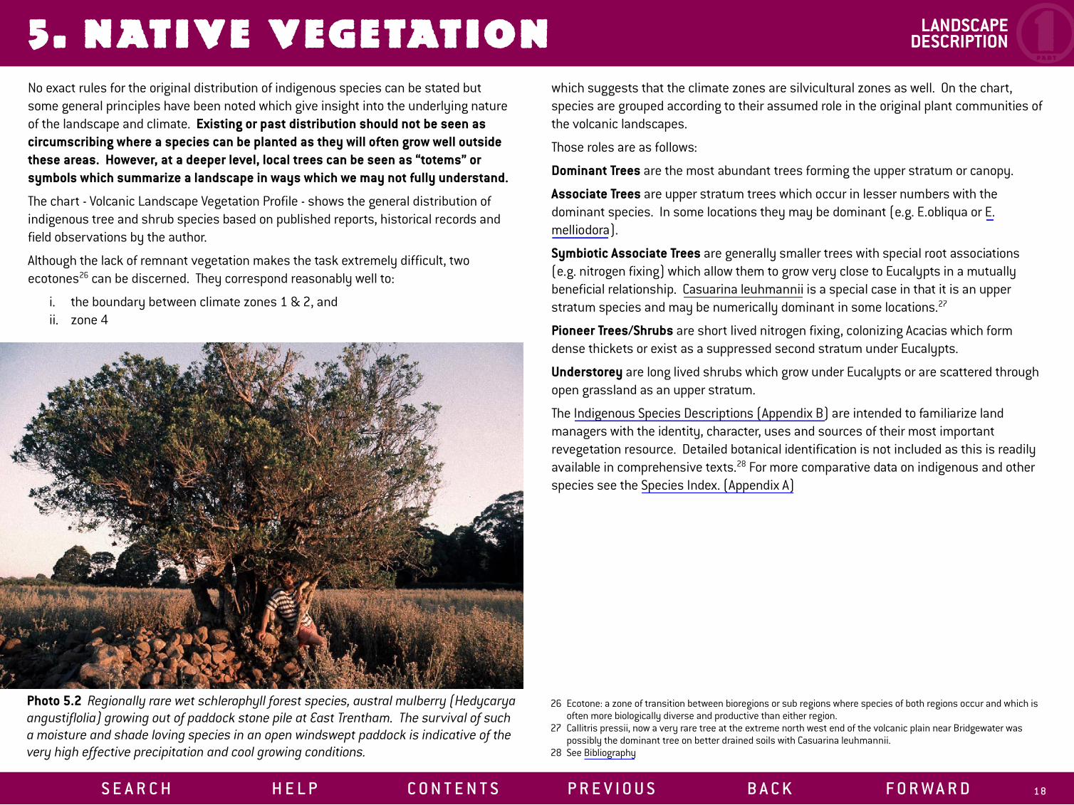
REVEGETATION PLANNING5. NATIVE VEGETATION LANDSCAPE
DESCRIPTION 1PA R T
No exact rules for the original distribution of indigenous species can be stated but some general principles have been noted which give insight into the underlying nature of the landscape and climate. Existing or past distribution should not be seen as circumscribing where a species can be planted as they will often grow well outside these areas. However, at a deeper level, local trees can be seen as “totems” or symbols which summarize a landscape in ways which we may not fully understand.
The chart - Volcanic Landscape Vegetation Profile - shows the general distribution of indigenous tree and shrub species based on published reports, historical records and field observations by the author.
Although the lack of remnant vegetation makes the task extremely difficult, two ecotones26 can be discerned. They correspond reasonably well to:
i. the boundary between climate zones 1 & 2, and ii. zone 4
S E A R C H H E L P C O N T E N T S
Photo 5.2 Regionally rare wet schlerophyll forest species, austral mulberry (Hedycarya angustiflolia) growing out of paddock stone pile at East Trentham. The survival of such a moisture and shade loving species in an open windswept paddock is indicative of the very high effective precipitation and cool growing conditions.
which suggests that the climate zones are silvicultural zones as well. On the chart, species are grouped according to their assumed role in the original plant communities of the volcanic landscapes.
Those roles are as follows:
Dominant Trees are the most abundant trees forming the upper stratum or canopy.
Associate Trees are upper stratum trees which occur in lesser numbers with the dominant species. In some locations they may be dominant (e.g. E.obliqua or E. melliodora).
Symbiotic Associate Trees are generally smaller trees with special root associations (e.g. nitrogen fixing) which allow them to grow very close to Eucalypts in a mutually beneficial relationship. Casuarina leuhmannii is a special case in that it is an upper stratum species and may be numerically dominant in some locations.27
Pioneer Trees/Shrubs are short lived nitrogen fixing, colonizing Acacias which form dense thickets or exist as a suppressed second stratum under Eucalypts.
Understorey are long lived shrubs which grow under Eucalypts or are scattered through open grassland as an upper stratum.
The Indigenous Species Descriptions (Appendix B) are intended to familiarize land managers with the identity, character, uses and sources of their most important revegetation resource. Detailed botanical identification is not included as this is readily available in comprehensive texts.28 For more comparative data on indigenous and other species see the Species Index. (Appendix A)
P R E V I O U S B A C K F O R W A R D 1 8
26 Ecotone: a zone of transition between bioregions or sub regions where species of both regions occur and which is often more biologically diverse and productive than either region.
27 Callitris pressii, now a very rare tree at the extreme north west end of the volcanic plain near Bridgewater was possibly the dominant tree on better drained soils with Casuarina leuhmannii.
28 See Bibliography

REVEGETATION PLANNING5. NATIVE VEGETATION
S E A R C H H E L P C O N T E N T S P R E V I O U S B A C K F O R W A R D 19
VOLCANIC LANDSCAPES VEGETATION PROFILE
LANDSCAPE DESCRIPTION 1
PA R T

1PA R T
6. THE PLANNING PROCESS7. REVEGETATION GUIDELINES8. VOLCANIC LANDSCAPE PROFILES 1, 2 & 3
R E V E G E TAT I O N P L A N N I N G
S E A R C H H E L P C O N T E N T S P R E V I O U S B A C K F O R W A R D 2 0
2PA R T

9. ROADSIDES & RESERVES Volcanic Landscapes Aesthetics Fire Hazard Weeds Direct Seeding of Roadsides Summary of Issues Strategy Roadside Design Direct Seeding Techniques Cape Broom Study
10. STREAMS & RESERVOIRS Landscape Interpretation Stream Classification Reservoir Classification Significance of Streams and Foreshores Revegetation Strategies Design Guidelines for Permanent Streams Design Example for Deeply Incised Stream on Plains Strategy for Reservoir Foreshores Design Guidelines for Reservoirs
R E V E G E TAT I O N TA R G E T S - P U B L I C L A N D
S E A R C H H E L P C O N T E N T S
Chapter 9 and 10 focus on revegetation which will have the maximum public benefit and in most situations involves publicly owned land. Strategies to conserve and extend the indigenous vegetation on the volcanic landscapes are a major theme of these proposals. Farmers manage much of this land, and the benefits to these landholders from the proposed systems are substantial. In general, revegetation on these areas require some degree of co-ordination and co-operation between local government, landholders and government departments and should be the primary focus for public funding.
In particular public funding should be used to support development on public land; eg. catchment planning, roadside and streamside revegetation.
3PA R T
P R E V I O U S B A C K F O R W A R D 31
R E V E G E TAT I O N D E S I G N S YS T E M S - P R I VAT E L A N D
S E A R C H H E L P C O N T E N T S
11. PADDOCK TREES Pastoral Woodlands Copses & Woodlots Design of Woodlots Management of Copses & Woodlots Fodder & Copse Systems Shade Trees
12. MULTIPURPOSE FARM SHELTERBELTS Overview General Strategy Species Selection Siting Criteria Strategies Design Principles Examples of Multipurpose Shelterbelt Designs
13. FARM FORESTRY Plantation Siting & Design Plantation Regimes
14. TREE CROPS Tagasaste Willows Salt Tolerant Fodder Systems
4The final four chapters are devoted to a closer integration of trees and shrubs with existing agricultural land use on the volcanic landscapes. They complement the proposals in the previous chapters but all have a stronger emphasis on farm productivity.
The systems proposed in Part IV range from indigenous pastoral woodlands to intensively managed shrub fodder blocks of exotic species. These systems have the potential to increase and diversify farm productivity when used in combination with deep rooted and/or perennial crops and pastures. They also provide a sustainable framework for further agricultural and silvicultural intensification on our most productive farmland.
Public resources should be used to support these sustainable land use alternatives through practical on-farm research and favourable financing to allow landholders to make the long term investments necessary to achieve diversification and intensification.
P R E V I O U S B A C K F O R W A R D 57
PA R T

5PART
A SPECIES INDEX Characteristics & Uses Sources Index Interpretation Species Index Sheets 1-6
B INDIGENOUS SPECIES DESCRIPTIONS Eucalyptus camaldulensis - River Red Gum Eucalyptus ovata - Swamp Gum Eucalyptus microcarpa - Grey Box Eucalyptus melliodora - Yellow Box Eucalyptus viminalis - Manna Gum Eucalyptus rubida - Candlebark Eucalyptus pauciflora - Snow Gum Allocasurina verticillata - Drooping Sheoak Casurina leuhmannii - Buloke Acacia melanoxylon - Blackwood Acacia dealbata - Silver Wattle Banksia marginata - Silver Banksia Acacia implexa - Lightwood Hymenanthera dentata - Tree Violet
VOLCANIC LANDSCAPES MAPANNOTATED BIBLIOGRAPHYCATALOGUE
APPEND ICES
S E A R C H H E L P C O N T E N T S P R E V I O U S B A C K F O R W A R D 12 7
APPENDICES 5PA R T
CATALOGUE
We publish a limited number of permaculture books authored by David Holmgren, the co-originator of the internationally acclaimed Permaculture concept of sustainability, first presented in Permaculture One (published 1978).PERMACULTURE: PRINCIPLES & PATHWAYS BEYOND SUSTAINABILITYThis book uses permaculture principles as a framework for an empowering but challenging vision of creative adaptation to a world of energy descent. David Holmgren builds on the extraordinary success of the permaculture concept (which he co-originated with Bill Mollison 25 years ago) and the global permaculture movement, to provide a more cerebral and controversial contribution to the sustainability debate.
• 320 pages, graphics and design principle icons
• Available from the publisher and selected bookshops
“If the ‘Permaculture Principles that David Holmgren discusses in this extremely important book were applied to all that we do, we would well be on the road to sustainability, and beyond.” Professor Stuart B. Hill
CONTENTS: Introduction • What Is Permaculture? • Popular and academic reactions • Ethical and Design Principles
Ethical Principles • Care of the Earth • Care of People • Distribute Surplus and Set Limits to Consumption and Reproduction
Design Principles • Observe and Interact • Catch and Store Energy • Obtain a Yield
• Apply Self Regulation and Accept Feedback • Use and Value Renewable Resources and Services • Produce No Waste • Design From Patterns To Details • Integrate Rather Than Segregate • Use Small and Slow Solutions • Use and Value Diversity • Use Edges and Value The Marginal • Creatively Use and Respond To Change
S E A R C H H E L P C O N T E N T S
'MELLIODORA' HEPBURN PERMACULTURE GARDENS A Case Study in Cool Climate Permaculture 1985 - 2005This PC/ Mac compatible CD ROM format publication contains the original 1995 A3 format book “Melliodora: Ten Years of Sustainable Living” in digital form as well as new and updated material about this leading cool climate permaculture demonstration site.
The eBook is a pdf (viewable with Adobe Acrobat Reader) It includes all the book text, high resolution zoomable graphics and full colour high resolution versions of the photos as well as linkable new photos of key views showing the changes and growth over the last decade.
New sections include: • House thermal performance upgrade and review • Grid feedback photovoltaic installation and performance • Cool cupboard review and design • Animals update including goats and soil management • Seasonal cycle photos
Built in navigation bar, jump buttons and text links allow you to cross reference, move around the eBook and get back to where you were.
Also on the CD: Virtual Tour A virtual tour of the property (html file viewable with any web browser) starts from an interactive high resolution aerial view, zooming into each of the planting zones described in detail in the eBook. Selection of photo icons opens high quality photos and panoramas in separate windows. Clicking on the caption button gives you orientation and id info for each photo and panorama The virtual tour provides a snapshot of the property during a drought growing season (late 2003- early 2004).
Melliodora Promotional Download A free low resolution downloadable copy of the introductory chapters plus some of the update photography gives you the feel of the eBook to view and share around.
P R E V I O U S B A C K F O R W A R D 16 0

APPENDICES 5PA R T
CATALOGUE
PERMACULTURE PRINCIPLES TEACHING KITThis kit is designed as an aid to teaching ethics and principles on Permaculture Design Courses but will also be useful in introducing permaculture to a wide range of audiences from school children to design professionals. It can be used as a static display, a group revision game, or to present ethics and principles especially where audio visual equipment is not available.The teaching kit consists of 52 cards and an explanatory booklet printed on recycled card stock and packed as a boxed set. Designed by graphic artist, Richard Telford, using striking icons, the principle card concept is based on a card set developed by Robin Clayfield and Skye, innovators in creative and participatory learning methods in permaculture.
These teaching cards do not explain the principles in any depth. For an introduction to the scope of permaculture, and each principle read the Essence of Permaculture. For a full understanding of this format and explanation of permaculture principles, read Permaculture: Principles & Pathways Beyond Sustainability.
For each of the twelve design principles there are four cards; principle, icon, proverb (black on white) and photo (full colour). For each of the ethics, there is a single card with the ethic, icon and action statement.
A set of fridge magnets of the ethics and principles is included in the kit.
This teaching kit will be useful for anyone involved in permaculture and environmental education wanting a condensed way to communicate and remember the essence of the powerful concepts explained in Permaculture: Principles & Pathways Beyond Sustainability
The Kit: A5 box with 20 page A5 booklet, 52xA6 sized cards , 40 b&w on 300gsm - booklet and b&w cards printed on 100% recycled stock, 12 colour cards - on 250gsm, 15 fridge magnets 5cm x 7cm. The first 200 copies have been numbered and signed by the author.
S E A R C H H E L P C O N T E N T S
PERMACULTURE ETHICS & PRINCIPLES FRIDGE MAGNETSShow how permaculture is more than gardening!
Bring permaculture ethics and principles into everyday life with this set of fifteen magnets each with a simple graphic representing a core permaculture concept. Turn the magnet over to read the principle and proverb. Great memory tool for permaculture teaching, daily living and spreading the permaculture message to friends and family including children.
15 double sided black and white fridge magnets 5cm x 7cm
DAVID HOLMGREN: COLLECTED WRITINGS 1978-2000 This collection of magazine articles, conference papers, public lectures, book reviews and other work by David Holmgren provide a deeper insight into the thinking behind the Permaculture concept and its many applications. The publication of the Collected Writings on CD provides source material from the co-originator of the Permaculture concept. Together they trace the ongoing evolution and explanation of the permaculture concept to a wide range of audiences by its lesser known author.
They will be of particular interest to permaculture teachers and practitioners and provide a glimpse of some of the ideas which have contributed to the long-awaited major new book, Permaculture: Principles and Pathways Beyond Sustainability.
The CD also contains some biographical photos which relate to the articles and some further references to the Holmgren Design Services and other websites.
This CD is Windows and Mac compatible and requires a web browser and a pdf reader such as Acrobat Reader (already installed on most computers and available free over the internet from www.adobe.com).
P R E V I O U S B A C K F O R W A R D 161

5PART
CATALOGUE APPENDICES 5PART
‘MELLIODORA’ HEPBURN PERMACULTURE GARDENS Melliodora: Ten Years of Sustainable Living Book Review by Ian Lillington, Permaculture International Journal
When I first heard about Permaculture I thought it was for large acreages in the sub tropics. My first visit to David Holmgren’s and Su Dennett’s place in 1989 entirely changed my thinking. Here was a passive solar house and a food production system on one hectare, in a cool climate, in a town. It worked: the house was warm in winter, cool in summer and the land provided all the vegetables and most of the fruit for the family!
Throughout the 10 year history of the project, David has kept detailed records and photos, which have been collated into a very unusual book. It has A3 size landscape pages, so at a single opening it covers your desk! Each spread has a theme - such as house design, orchard, or animals with maps, plans photos and text.
The book was written inside the property it is describing - it’s a kind of autobiography. It was written over a five year period, and with property now “established”, the text has been revised with the benefits of hindsight. It is ideal for anyone seriously interested in sustainable living - both at a practical level and with a good dose of Holmgren holistic thinking.
The meticulous detail allows the reader to trace the development of the property from the purchase of a steep weed-infested site, through the early stages of blackberry slashing, dam construction and tree planting to the “finished” product of family home, office, workshop, greenhouse, and integrated living systems with perennial plants and a range of animals fulfilling many functions.
Hepburn is in central Victoria, 470 metres above sea level, in the Great Dividing Range, north of Melbourne. It is an arboretum for cool climate Permaculture and the book has an extensive species list (over 170 listings)
Twenty years on from the first draft of “Permaculture One”, this book shows that Permaculture works....”
S E A R C H H E L P C O N T E N T S
PERMACULTURE ONE: A Perennial Agriculture for Human Settlements. By Bill Mollison & David HolmgrenThis seminal work first published in 1978 and translated in 7 languages, was the book that launched the Permaculture concept and movement. It is both the original statements of the theory by the co-authors and a useful text on cool climate self reliant land use and living. Includes an extensive species index of plants for cool temperate regions.
WEEDS OR WILD NATURE: Migrant Plants and Animals in Australia NEW BOOK IN THE PIPELINE PROMISES TO BE CONTROVERSIAL
For over twenty years David Holmgren has observed, researched, discussed and debated the controversial issue of what is an environmentally progressive response to weeds and pests. Over the last five years he has been working on a book (WEEDS OR WILD NATURE: Migrant Plants and Animals in Australia) which gives a positive and empowering portrait of our relationship to nature and lays out a clear challenge to the emerging environmental orthodoxy about the evils of plant and animal naturalisations.
For an introduction to David’s perspective on this subject, the article Weeds or Wild Nature is a good start (published in the Permaculture International Journal issue 61 in 1997). Articles 1, 18 and 20 in the Collected Writing CD also explore this subject while the theoretical foundations for these perspectives are explained in Permaculture: Principles & Pathways Beyond Sustainability
For an example of the application of these ideas to practical management of mixed urban fringe streamside vegetation see report by David Holmgren Upper Spring Creek Restoration Project Management Report on Daylesford Regional Landcare Group web site.
FORTHCOMING TITLE
P R E V I O U S B A C K F O R W A R D 16 2

APPENDICES 5PA R T
CATALOGUE
Check our website for pricing and payment options www.holmgren.com.au
Cheque or money orders can be made out to: Holmgren Design Services 16 Fourteenth Street, Hepburn, Victoria 3461, Australia
Email us for inquiries about discounts on bulk orders: [email protected]
N.Z. distribution• Living Lightly: Principles & Pathways, Melliodora, Collected Writings CD
U.S.A. distribution• Chelsea Green: Principles & Pathways, Melliodora • Permaculture Activist: Collected Writings CD, Principles & Pathways
U.K. distribution• Permanent Publications: Principles & Pathways, Melliodora, Collected Writings CD
TREES ON THE TREELESS PLAINS: Revegetation Manual for the Volcanic Landscapes of Central Victoria This design manual is a result of years of research and observation into the role and potential of trees and shrubs on farms. It addresses the transformation of broader farm landscapes through the application of permaculture principles to revegetation. The manual includes revegetation strategies and design solutions relevant to increasing and diversifying farm productivity while stabilising the landscape. It also address the public land on roadsides, stream sides and reserves.
The case study approach of the manual uses the volcanic landscapes as a focus to describe land types, local native species and to provide strategies, design solutions and species lists. It is directly relevant to some of the most valuable agricultural land in Victoria including the extensive Western Districts. A comprehensive species index of native and introduced trees and shrubs with proven performance provides a ready guide
HOW TO ORDER
OUT OF PRINT TITLES
S E A R C H H E L P C O N T E N T S
to species selection for different situations and purposes. For private and public land managers of the volcanic landscapes this manual is an essential reference.
For a wider audience concerned with revegetation, this book provides a design system approach and principles applicable everywhere to assist in the development of local strategies and design solutions.
PERMACULTURE IN THE BUSH: The Design and Development of a Homestead on the Far South Coast of NSW For those familiar with the basic concepts of permaculture, this case study design shows how the principles have been applied to the inevitably unique conditions of a particular site and locality by permaculture’s foremost practitioner. It provides information about a permaculture site, otherwise only accessible through local residential permaculture design courses. This small book is packed with technical information on land assessment, earthworks, water supply, soil improvement, passive solar and fire resistant design adaptable to a range of situations but especially for people developing bush properties.
THE FLYWIRE HOUSE: A Case Study in Design Against BushfireThis small book is packed with information about the principles and practice of fire resistant, landscape and house design in ways which are energy efficient, sustainable and productive: the essence of permaculture. It takes the form of a case study design for a property burnt out in the catastrophic Ash Wednesday fires of 1983 in the Dandenong Ranges of Victoria. This work has been applied in many designs by Holmgren Design Services including Melliodora. The ideas are applicable to all fire prone regions.
Please let us know if you are interested in out-of-print titles by emailing us at [email protected] as this will help us plan re-prints.
P R E V I O U S B A C K F O R W A R D 163