transportation in mandalay · using sydney coordinated adaptive traffic system(scats) traffic...
TRANSCRIPT

Transportation in
Mandalay
1
U Kyaw Zay Ya
Committee Member
Mandalay City Development Committee

2
Introduction
Institution of MCDC
Transport Sector
Smart City Initiatives
Future Plan
Overview

The Republic of the Union of Myanmar
❖ Agricultural country
❖ Capital - Naypyidaw city since November, 2005
❖ Official language – Myanmar
❖ Rich in terms of natural resources
❖ the second highest exporter of natural gas in the
South East Asia region
3
Introduction
❖Population - about 51 million (2014)
❖Area - 676,577.2 sq.km
❖Coastline - 2832km
❖Population density – 76 pop./sq. km
❖Urban population – 30%

Mandalay
4
❖Second largest city
❖Last Ancient Royal Capital of Myanmar
❖Commercial Hub
❖Member city in 100 Resilient Cities (2013)
❖Smart city (2018)
❖A.D 1857
❖Royal Palace, Battlemented walls
and moat surrounding it
Townships = 6 nos.
Wards = 96 nos.
Population = about 1.5 million (2014)
Area = about 315 km2
Total road length = 1420 km (Grid Patterns)
Annual rainfall = 810 mm/year
Location : N Lat. 21°51´47˝ & 22°01´27˝
E Long. 96°03´17˝ & 96°03´47 ˝
Mandalay
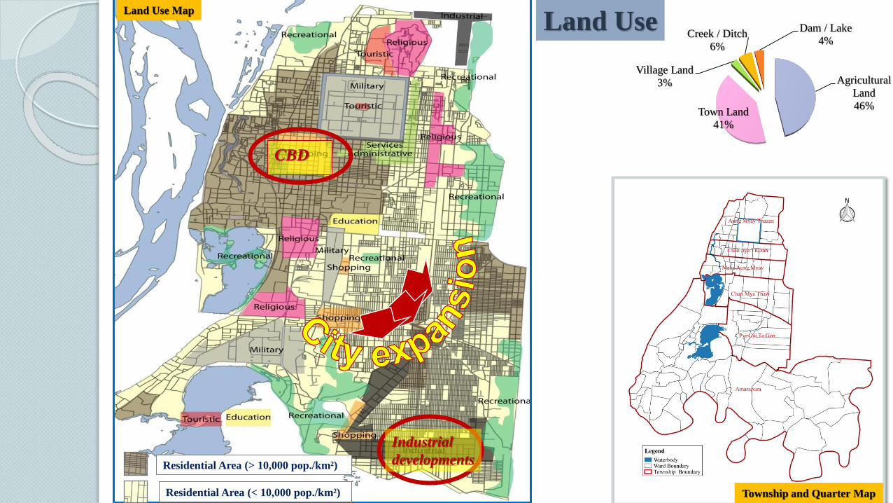
Residential Area (> 10,000 pop./km²)
Residential Area (< 10,000 pop./km²)
Industrial
developments
Land Use Map
CBD
Township and Quarter Map
Agricultural
Land
46%Town Land
41%
Village Land
3%
Creek / Ditch
6%
Dam / Lake
4%
Land Use
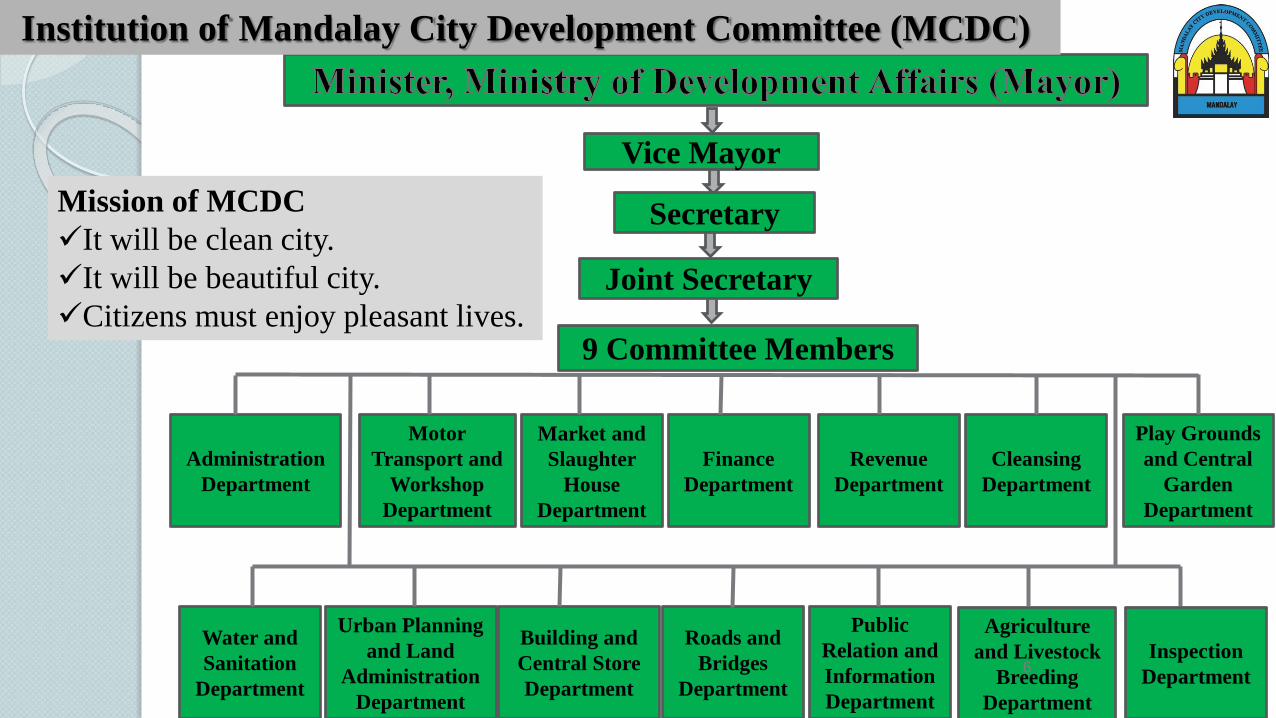
Vice Mayor
9 Committee Members
Joint Secretary
Administration
Department
Market and
Slaughter
House
Department
Motor
Transport and
Workshop
Department
Finance
Department
Revenue
Department
Cleansing
Department
Water and
Sanitation
Department
Play Grounds
and Central
Garden
Department
Building and
Central Store
Department
Roads and
Bridges
Department
Urban Planning
and Land
Administration
Department
Agriculture
and Livestock
Breeding
Department
Public
Relation and
Information
Department
Inspection
Department
Secretary
6
Institution of Mandalay City Development Committee (MCDC)
Mission of MCDC
✓It will be clean city.
✓It will be beautiful city.
✓Citizens must enjoy pleasant lives.

7
Situation
Private car/
public transportMotorcycleBicycle
Bicycle City Motorcycle City
➢City having maximum
number of motorcycles
➢Motorcycles : common
mode for commuting
Modal share in 2016
private
5%
freight truck
6%
Passenger
0%
(2567)
others
5%
Motorcycle
84%
(988316)
(Source: Traffic Police)
No. of motorcycle1999 – Imported from China
2004 – Starting to increase
2002 ~ 2018 – increasing 21.5 times
No. of Private car2002 ~ 2018 – increasing 3.5 times
Policy change
from 2011➢Keep and destroy
old cars
➢Import of private
cars
➢Allow residents to
register illegally
imported
motorcycles
Transport Sector
300000 (2014)

8
urban
77%
rural
23%
1. Vehicle ownerships and population
Population density = 34000/sq.mile
Populated township = Ma Ha Aung Myay
360
1,461
0
200
400
600
800
1000
1200
1400
1600
0
200
400
600
800
1000
1200
1400
1600
1800
2000
2010 2011 2012 2013 2014 2015 2016 2017 2018
No. of
Veh
icle
Ow
ner
ship
No.
of
Pop
ula
tion
Year
population in 1000 No. of vehicle in 1000

9
2. Vehicle ownerships and traffic problems
191
358
0
200
400
600
No
. o
f A
ccid
ents
Year
Traffic accidents
1223009
92994
0
20000
40000
60000
80000
100000
0
200000
400000
600000
800000
1000000
1200000
1400000
No. of
Cars
No
. o
f M
oto
rcycl
es
Year
Vehicle ownerships
Motorcycles Private car
Usage• Private
• Public - taxi
Reason
• Convenience
• Time save
• Cheap price
Motorcycles

10
61,760
46,115
68,723
46,040 43,532
-
20,000
40,000
60,000
80,000
42x78 TPxYM 26x78 30x78 32x78
No
. o
f V
ehic
les
Location of Road Intersection
Traffic volume at congested junctions
1.2.2019
2.2.2019
27,108
28,628
2,904
3,301
2800
2900
3000
3100
3200
3300
3400
26000
26500
27000
27500
28000
28500
29000
May June
No
. o
f V
iola
tion
s
No
. o
f V
ehic
le
Period
Road Regualtion Violation at Intersection
Passing Vehicles Violations
3. Traffic Flow ( Sensor Data)

4. Road Condition
11
Traffic control measures (2018)
✓ Traffic signals = 95 nos.
✓ Real Time Traffic Signal = 32 nos.
✓ One-way = 9 locations
✓ Motorcycle separated roads = 1
✓ Motorcycle forbidden zones = 2 overpasses
Road Types1.Trunk Road
2.Arterial Road
3.Collector Road
4.Local Street

12
30th and 62th Street
Junction
Road Cross-Section
Intersection Plan
Current Road Designs

13
5. Bus Services
53970
43790
42000
47000
52000
57000
2014 2015 2016 2017
No.
of
Pa
ssen
ger
s
Years
Passengers/day
44
824
448
57
859
362
0
100
200
300
400
500
600
700
800
900
1000
Bus Fleets Owned Buses Running Buses
No
. o
f F
leet
es a
nd
Bu
ses
2014 2015 2016 2017
✓population = nearly 1.5 Million
for daily commuting
✓bus users = about 44,000 people (About 3% of total population)
✓registered motorcycles are nearly 1.3 Million (over 1Million people )
✓Total route length = 1012km
Bus Users
Conditions of Buses
(Source: Ya.Ka.Ka)

▪ Buses for inner city and surrounding areas
▪ Trains and Express Buses to other far cities
14
City Bus
Light Truck
Dyna
Hilux
Types of inner city buses
Taking a busBus Shelter Location within City Area

Using Sydney Coordinated Adaptive Traffic System(SCATS) Traffic Control System
Monitor traffic route and adapt the timing of traffic signal
Use intelligence sensor and devices integrating(32)number of traffic light and (266)
number of (ANPR)CCTV cameras
Monitor and records the vehicles and traffic condition between the city areas in
24hr
15
6. Intelligent Traffic Control System

16
Purpose
❖ To control traffic congestion within city area
❖ To monitor traffic flow
Sydney Coordinated Adaptive Traffic System (SCATS) Traffic Control System
❖ Sydney Coordinated Adaptive Traffic System (SCATS)
❖ AI based Intelligent Traffic Monitoring System ( HIK iVMS-8600 platform software)
❖ Automatic Number Plate Recognition (ANPR) CCTV
❖ (3x3) video wall
❖ Central control room (24 hrs recording)
❖ Alert system for violation of traffic rules and regulations in line with time
Technology
❖ Photos and Video
❖ Chart ၊ Graph ၊ Report
Data

SCATS System

18
❖ Monitoring location, time, number plate and route of vehicle which violates traffic rule , and traffic
accident location
❖ Automatically monitoring and recording the feature of accident contributors
❖ Traffic violation records
❖ Tracing the route of a vehicle on eMap
❖ Recording the number of vehicles entering and exiting the main location of downtown areas, time by
time and location by location
❖ Monitoring the traffic flow using video wall
❖ Recording the time and location of possible traffic congestion
❖ Managing security, road construction and maintenance, and traffic route
Advantages
Location
❖ (SCATS) Intelligent sensors and devices at 32 traffic signal
❖ ANPR CCTV camera (266) Nos.

Traffic Violation Records
Dashboard of HIK iVMS-8600
Intelligent Traffic Monitoring System (HIK iVMS-8600 )
Traffic Violation Records
Monitoring the track of a vehicle on eMap

Monitoring traffic records

Real Time Traffic Control and Monitoring Room

✓ Weak in Accessibility, Facility, Service and
Insufficiency of Public transport
✓ Discontinuity of Road Network
✓ Weak in Law enforcement & Low penalty
22
✓ Traffic accidents
✓ congestion
✓ Parking Spaces
✓ Environmental
problems
✓ Being difficult to
walk for pedestrians
• Usage of
Motorcycles
• Behavioral
problem
Public transport
✓Loading/Unloading
at random place
✓Frequency is low
✓No time schedule
❖ Motor Vehicle Laws (1964)
❖ Motor Vehicle By-Laws (1989)
❖Motor Vehicle Laws (2015)
7. Facing Problems

23
Mix traffic and Share lane
Congestion
Parking
Walk on roadway
Behavioral Problem

24
Mandalay
ASEAN Smart Cities FrameworkSmart City Initiatives

25
Projects in Mandalay
Civil and Social
• Public and
Municipal
Services
• Governance
1. One stop Service System
2. Integratable Land Management and
Information System
3. Virtual Office System
4. Electronic Document Management
System
5. Billing System
6. Online Business Registration
System
Safety and Security• Public Safety, City
Surveillance and Crime
Prevention
1. Toll gate Check Point
System
2. CCTV and Terminal
Server for Real Time
Traffic Control
3. Street Light System
Quality Environment
• Clean Environment
• Resource Access and
Management
1. Solid waste Management
System
2. Water Supply System
3. Fuel Management System

26
Built Infrastructure• Utilities
• Mobility and
Transportation
1. Urban Mobility
2. Metropolitan Fiber
Network
3. e-Toll Collection
System
4. Weight in Motion
System
5. Upgrading Server
• Technology Incubation
• Research Industry and Innovation
1. Business Process
Analysis For Digital
Transformation
2. Visitor Control
System
Soft Infrastructure• Zip Code (post code)
• Standardization
1. City new address
system
2. City new Road
structure
standardizing
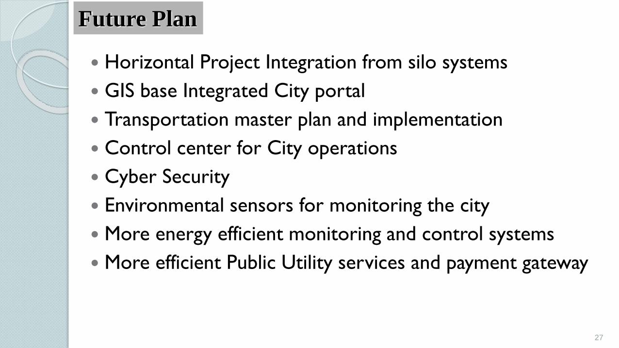
Horizontal Project Integration from silo systems
GIS base Integrated City portal
Transportation master plan and implementation
Control center for City operations
Cyber Security
Environmental sensors for monitoring the city
More energy efficient monitoring and control systems
More efficient Public Utility services and payment gateway
27
Future Plan

Thank you for your attention