town of sewall’s pointsewallspoint.org/wp-content/uploads/2016/01/agenda... · 521.52 · pd...
TRANSCRIPT
TOWN OF SEWALL’S POINT
PAMELA MAC’KIE WALKER Town Manager
TO: Town of Sewall’s Point Commission
FROM: Pamela Mac’kie Walker, Town Manager
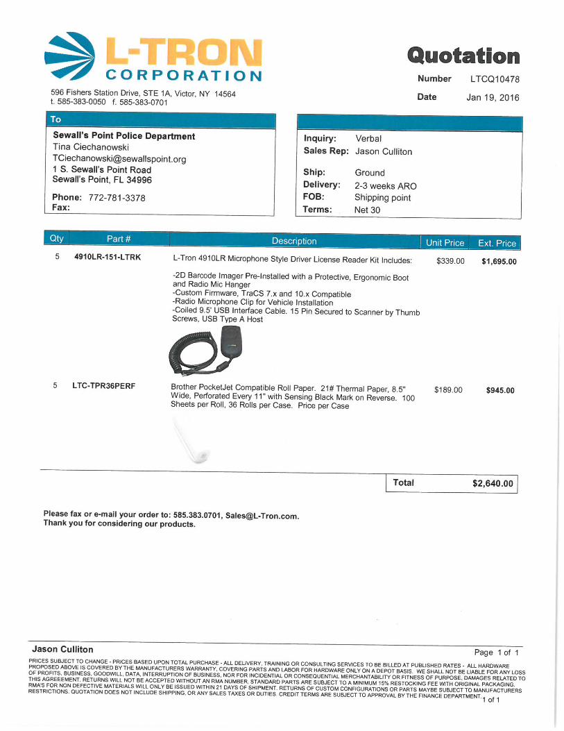
SUBJECT: Agenda Item 1 Financial Reports Town Commission Meeting, January 26, 2016 Staff recommends acceptance of the attached financial reports.

Town of Sewall's Point
Financial Report
Revenues and Expenses Budget-to-Actual
1 of 2
Actual Oct.-Dec
2015
Annual Budget
FY 2016
% of
Budget
unaudited unaudited
Revenues
Intergovernmental
334.100 · Police Dept Grant Funds 1,168 - #DIV/0!
332.000 · Grant Mgmt. Fees FEMA 3% 1,549 20,000 7.7%
312.400 · Gas Tax 15,508 63,000 24.6%
315.000 · Communications Services Taxes 15,726 63,000 25.0%
335.120 · State Revenue Sharing 15,293 63,000 24.3%
335.150 · Alcoholic Beverage Tax - 2,000 0.0%
335.180 · Sales Tax 47,485 212,000 22.4%
Total Intergovernmental 96,728 423,000 22.9%
Local Taxes, Fees, Fines
311.100 · Ad Valorem Taxes 1,233,311 1,633,000 75.5%
316.000 · Local Business Tax 1,436 4,000 35.9%
322.000 · Building Permit Fees 32,904 210,000 15.7%
323.100 · Electric Francise 43,880 129,000 34.0%
325.200 · Road Impact Assessments 6,361 34,000 18.7%
351.300 · Civil Fines 5,100 6,000 85.0%
351.500 · Traffic Fines 3,120 17,000 18.4%
351.501 · Police Education 178 2,000 8.9%
361.100 · Interest 1,662 5,000 33.2%
366.900 · Miscellaneous Revenue 380 7,000 5.4%
367.000 · Town Licenses & Fees 675 5,000 13.5%
Total Local Taxes, Fees, Fines 1,329,008 2,052,000 64.8%
Total Revenues 1,425,736 2,475,000 57.6%
Expenses
Human Resources
Public Safety 185,373 827,845 22.4%
Town Manager 27,108 121,200 22.4%
Town Assistant 10,289 45,600 22.6%
Town Clerk 13,980 63,375 22.1%
Building Dept. 26,247 80,100 32.8%
Maintenance Dept. 9,235 40,700 22.7%
519.230 · Insurance Benefits 41,445 179,000 23.2%
519.24 · Worker's Comp - Other 5,820 25,000
Total Human Resources 319,497 1,382,820 23.1%
Operating Expenses
519.40 · Travel 1,063 3,000 35.4%
519.41 · Communication Network 12,129 34,600 35.1%
519.43a - Electricity 5,170 29,000 17.8%
519.43b - Water 4,688 24,000 19.5%
519.45 · General and Liability Insurance 12,804 44,000 29.1%
519.48 · Town Events 5,020 10,000 50.2%
511.49 - Contingency - 1,000 0.0%
519.49D - Disaster Aid - 1,000 0.0%
519.49F - Bank Fees 339 3,000 11.3%
519.51 · Office Supplies & Services 4,505 31,000 14.5%
519.52 · Fuel, Oil, Operating Supplies 3,938 29,000 13.6%
519.54 · Dues, Ed., Tuition Reimb 1,250 8,000 15.6%
521.52 · PD Enforcement Supplies 1,148 17,700 6.5%
Total Operating Expenses 52,054 235,300 22.1%
Outside Services
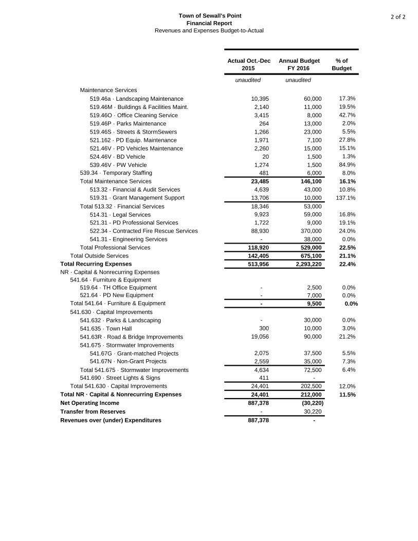
Town of Sewall's Point
Financial Report
Revenues and Expenses Budget-to-Actual
2 of 2
Actual Oct.-Dec
2015
Annual Budget
FY 2016
% of
Budget
unaudited unaudited
Maintenance Services
519.46a · Landscaping Maintenance 10,395 60,000 17.3%
519.46M · Buildings & Facilities Maint. 2,140 11,000 19.5%
519.46O · Office Cleaning Service 3,415 8,000 42.7%
519.46P · Parks Maintenance 264 13,000 2.0%
519.46S · Streets & StormSewers 1,266 23,000 5.5%
521.162 · PD Equip. Maintenance 1,971 7,100 27.8%
521.46V · PD Vehicles Maintenance 2,260 15,000 15.1%
524.46V · BD Vehicle 20 1,500 1.3%
539.46V · PW Vehicle 1,274 1,500 84.9%
539.34 · Temporary Staffing 481 6,000 8.0%
Total Maintenance Services 23,485 146,100 16.1%
513.32 - Financial & Audit Services 4,639 43,000 10.8%
519.31 · Grant Management Support 13,706 10,000 137.1%
Total 513.32 · Financial Services 18,346 53,000
514.31 · Legal Services 9,923 59,000 16.8%
521.31 - PD Professional Services 1,722 9,000 19.1%
522.34 - Contracted Fire Rescue Services 88,930 370,000 24.0%
541.31 - Engineering Services - 38,000 0.0%
Total Professional Services 118,920 529,000 22.5%
Total Outside Services 142,405 675,100 21.1%
Total Recurring Expenses 513,956 2,293,220 22.4%
NR · Capital & Nonrecurring Expenses
541.64 · Furniture & Equipment
519.64 · TH Office Equipment - 2,500 0.0%
521.64 · PD New Equipment - 7,000 0.0%
Total 541.64 · Furniture & Equipment - 9,500 0.0%
541.630 · Capital Improvements
541.632 · Parks & Landscaping - 30,000 0.0%
541.635 · Town Hall 300 10,000 3.0%
541.63R · Road & Bridge Improvements 19,056 90,000 21.2%
541.675 · Stormwater Improvements
541.67G · Grant-matched Projects 2,075 37,500 5.5%
541.67N · Non-Grant Projects 2,559 35,000 7.3%
Total 541.675 · Stormwater Improvements 4,634 72,500 6.4%
541.690 · Street Lights & Signs 411 -
Total 541.630 · Capital Improvements 24,401 202,500 12.0%
Total NR · Capital & Nonrecurring Expenses 24,401 212,000 11.5%
Net Operating Income 887,378 (30,220)
Transfer from Reserves - 30,220
Revenues over (under) Expenditures 887,378 -
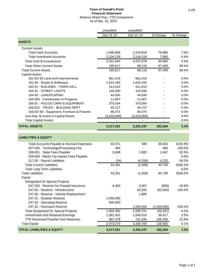
Town of Sewall's Point
Financial Statement
Balance Sheet Prev. YTD Comparison
1 of1
unaudited unaudited
Dec 31 15 Dec 31 14 $ Change % Change
ASSETS
Current Assets
Total Cash Accounts 1,095,805 1,018,919 76,886 7.5%
Total Investment Accounts 2,226,139 2,218,159 7,980 0.4%
Total Cash & Investments 3,321,944 3,237,078 84,865 2.6%
Total Other Current Assets 195,617 98,118 97,499 99.4%
Total Current Assets 195,617 98,118 97,499 99.4%
Capital Assets161.91/.92 Land and Improvements 681,019 681,019 - 0.0%
161.94 · Roads & Walkways 1,624,183 1,624,183 - 0.0%
162.91 · BUILDING - TOWN HALL 411,010 411,010 - 0.0%
164.91 · STREET LIGHTS 140,590 140,590 - 0.0%
164.92 · LANDSCAPING 44,930 44,930 - 0.0%
165.000 · Construction In Progress 11,907 11,907 - 0.0%
166.91 · POLICE CARS & EQUIPMENT 370,554 370,554 - 0.0%
166.912 · TRUCK - BUILDING DEPT 40,727 40,727 - 0.0%
166.92/.93 · Equipment, Furniture & Fixtures 86,074 86,074 - 0.0%
Less Dep. & Invest.in Capital Assets (3,410,994) (3,410,994) - 0.0%
Total Capital Assets - - - 0.0%
TOTAL ASSETS 3,517,561 3,335,197 182,364 5.5%
LIABILITIES & EQUITY
Total Accounts Payable & Accrued Expenses 40,371 949 39,423 4155.9%
207.000 · Technology/Processing Fee 484 - 484 100.0%
208.001 · State Fees Payable 3,468 1,802 1,667 92.5%
209.000 · Martin Cty Impact Fees Payable - - - 0.0%
217.00 · Payroll Liabilities (34) (4,259) 4,225 99.2%
Total Current Liabilities 44,291 (1,508) 45,799 3036.2%
Total Long Term Liabilities - - - 0.0%
Total Liabilities 44,291 (1,508) 45,799 3036.2%
Equity
Designated for Special Projects
247.030 · Reserve for Prepaid Insurance 4,460 5,367 (906) -16.9%
247.05 · Reserve - Infrastructure - 62,500 (62,500) -100.0%
247.06 · Reserve - Vehicle Replacement 1,885
247.32 · Disaster Reserve 1,000,000 -
247.33 · Operating Reserve 500,000
247.32 · Hurricane Reserve - 1,500,000 (1,500,000) -100.0%
Total Designated for Special Projects 1,504,460 1,569,751 (65,291) -4.2%
Unrestricted and Retained Earnings 1,081,431 1,045,014 36,417 3.5%
YTD Revenues/Transfer from Reserves 887,378 721,940 165,439 22.9%
Total Equity 3,473,270 3,336,705 136,565 4.1%
TOTAL LIABILITIES & EQUITY 3,517,561 3,335,197 182,364 5.5%
As of Dec. 31, 2015
Page 1 of 1

TOWN OF SEWALL’S POINT
PAMELA MAC’KIE WALKER Town Manager
TO: Town of Sewall’s Point Commission
FROM: Pamela Mac’kie Walker, Town Manager
SUBJECT: Agenda Item 2 Meeting Minutes Town Commission Meeting, January 26, 2016 ____________________________________________________________________________ Staff recommends approval of the attached meeting minutes.

TOWN OF SEWALL’S POINT
TOWN COMMISSION MINUTES OF REGULAR MEETING DECEMBER 15, 2015
[Verbatim details available at www.sewallspoint.org by clicking the “audio” link for the meeting] The Town Commission of the Town of Sewall’s Point met on Tuesday, December 15, 2015 at 7:00 p.m. at Town Hall. CALL TO ORDER Mayor Morris called the meeting to order at 7:00 p.m. PLEDGE OF ALLEGIANCE Mayor Morris led the Pledge of Allegiance. ROLL CALL Mayor Dan Morris, Vice-Mayor James Campo, Commissioner Vincent N. Barile, Commissioner Paul Luger, Commissioner Jacqui Thurlow-Lippisch, Town Manager Pamela M. Walker, Town Attorney Glen Torcivia and Town Clerk Lakisha Burch were present. ADDITIONS, DELETIONS OR CHANGES TO THE AGENDA Commissioner Barile asked if the committee appointments could be added to the agenda. Mayor Morris stated that he has not had a chance to review them as of yet. Town Manager Walker also responded that the most pressing one is the Regional Planning Council and she has spoken with them and advised it would be on our January agenda. Commissioner Thurlow-Lippisch stated that she was voted to be the Vice-Chair for the Regional Planning Council at their last meeting, which was held last week. However, if the Commission would like to have a different Commissioner serve as a courtesy we should inform them sooner rather than later. The Commission reached a consensus to have committee appointments done at the January 26, 2016 Commission meeting. CONSENT AGENDA
1. Financial Reports

Town of Sewall’s Point December 15, 2015 Town Commission Meeting Page No.2
2. Meeting Minutes
Commissioner Campo commented that he requested that the Commission receive year to date financials rather than monthly financial statements that stands on their own. Town Manager Walker stated that she would be happy and that she could produce a report that shows this month, the year to date against the entire budget and the percentage of the entire budget. Motion was made by Vice-Mayor Campo, seconded by Commissioner Luger, to approve the Consent Agenda; it was voted as follows: Ayes: Mayor Morris, Vice-Mayor Campo, Commissioners Barile, Luger and Thurlow-Lippisch. Motion was passed unanimously. PROCLAMATIONS
3. Volunteer Appreciation Mayor Morris read the Certificate of Appreciation for the volunteers into the record. Town Manager Walker presented the item and presented the certificates to the following volunteers: Bill Escue, Elizabeth Demorest, Ella Ford, Ellen Demorest, Lucy Escue, Paul Heise and Susan Licari was recognized for the volunteer services that they freely give to the Town of Sewall’s Point. The volunteers were presented a Certificate of Appreciation by the Town of Sewall’s Point and a gift certificate donated by Harbour Bay Plaza. COMMENTS FROM THE PUBLIC ON NON-AGENDA ITEMS There were public comments made by Jody Hart and Shelly Walser. DISCUSSION
4. Sign Code Update
Town Manager Walker presented the item. Steve Garrett, from Lucido & Associates, presented a PowerPoint presentation giving an overview of the sign code. There was discussion among the Commission and Mr. Garrett. There were public comments made by Frank Ferraro, Steve Dutcher and Debbie Duval. Town Manager Walker gave a review of the changes and updates regarding the sign code ordinance. Commissioner Thurlow-Lippisch asked that the Supreme Court ruling on signs be explained to the citizens of Sewall’s Point in the newsletter.
Town of Sewall’s Point December 15, 2015 Town Commission Meeting Page No.3
The Commission reached a consensus to place the Supreme Court ruling in a newsletter for the citizens to be aware of the sign code changes that will be made and to have ready for first reading in January.
5. Lantana Park Plan/Budget Modification
Town Manager Walker presented the item. Commissioner Campo stated that he has an issue with spending that kind of money and not having any functionality. He also stated that we are trying to build community, for people to come and share and in order to create communities we have to provide opportunity for that and a place where people can meet and sit at picnic table. A gazebo would be a better use of money. Commissioner Luger stated that this was his idea and that Commissioner Campo’s comments were part of the original plan. He agrees with Commissioner Campo about it being He also stated that he has been in touch with some local community leaders and is trying to get some participation in helping to do this new plan. Commissioner Barile stated that he does not agree with taking the money from the A1A beautification project, we need to find another place to get the money. He also stated that we have to remember that this is a retention area. Also, we have to be very careful about having ball playing there because of the liability. Commissioner Thurlow-Lippisch stated that it is a beautiful plan and hopes that we keep it and utilize it more in the future as realty sales improves. She stated that she does not support it at this time because she feels beautification should be spent on A1A. She also thanked Lucido & Associates and stated that she doesn’t want to seem ungrateful but doesn’t think this is the time for it. Tom Lucido, Lucido & Associates, addressed the Commission in regards to the design of the park and additional costs. The Commission reached a consensus and advised the Town Manager to meet with Lucido & Associates for a revised plan. COMMISSIONERS OR STAFF COMMENTS Commissioner Luger stated that he wanted to express publicly that this Commission is a good group of people and he believes they work well together and regardless of their battles and differences, he believes that we are doing a great service for this Town and he appreciates all the Commissioners individually. Vice-Mayor Campo thanked Police Chief Ciechanowski, Town Manager Walker and all of the staff for a magnificent Christmas party.

Town of Sewall’s Point December 15, 2015 Town Commission Meeting Page No.4
Mayor Morris stated that it was a terrific event and he also thanked the Elliot Museum for their donation and time, Renato and Josephine for the great food, and he stated that the kids had a great time at the park with the pony and it was a wonderful event for all. Commissioner Thurlow-Lippisch also stated that it was a great party and this was the first time she has sat through the whole magic show and that the magician was great with the kids. She also stated that she noticed that the Town did something a little different by involving Seacoast Bank. She thinks that the involvement was positive. ADJOURN There being no further business to come before the Commission, the meeting was adjourned at 9:52 p.m.
APPROVED:
_____________________________________ Mayor Dan Morris, Presiding Officer
ATTEST:
_____________________________________ Lakisha Q. Burch, Town Clerk

TOWN OF SEWALL’S POINT
PAMELA MAC’KIE WALKER Town Manager
TO: Town of Sewall’s Point Commission FROM: Pamela Mac’Kie Walker, Town Manager SUBJECT: Agenda Item 3
Request to Proceed with Purchases Related to the DOT E-Crash Grant Town Commission Meeting, January 26, 2016
Background: The Town was awarded a grant for equipment to electronically submit crash reports from the Department of Transportation on December 18, 2015. Attached is a memo from Police Chief Ciechanowski explaining the grant and the expenditures. Recommendation: That the Commission approve the purchases related to the DOT E-Crash Grant.


TOWN OF SEWALL’S POINT
PAMELA MAC’KIE WALKER Town Manager
TO: Town of Sewall’s Point Commission FROM: Pamela Mac’Kie Walker, Town Manager SUBJECT: Agenda Item 4 Sign Ordinance Town Commission Meeting, January 26, 2016 Background: At the January 12, 2016 Commission Workshop the Commission discussed changes to the Sign Code Ordinance. The Ordinance is attached. It reflects the direction provided by the Commission at previous workshops. Subsequent to the last meeting, additional issues have arisen that will require direction by the Commission. In the event that changes are required, the ordinance can be re-advertised to reflect the Commission's direction. Recommendation: That the Commission approve on first reading the Sign Code Ordinance.
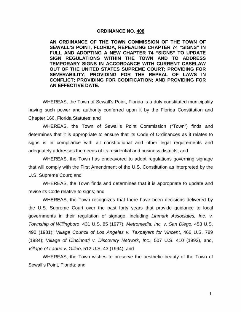
ORDINANCE NO. 408
AN ORDINANCE OF THE TOWN COMMISSION OF THE TOWN OF SEWALL’S POINT, FLORIDA, REPEALING CHAPTER 74 “SIGNS” IN FULL AND ADOPTING A NEW CHAPTER 74 “SIGNS” TO UPDATE SIGN REGULATIONS WITHIN THE TOWN AND TO ADDRESS TEMPORARY SIGNS IN ACCORDANCE WITH CURRENT CASELAW OUT OF THE UNITED STATES SUPREME COURT; PROVIDING FOR SEVERABILITY; PROVIDING FOR THE REPEAL OF LAWS IN CONFLICT; PROVIDING FOR CODIFICATION; AND PROVIDING FOR AN EFFECTIVE DATE.
WHEREAS, the Town of Sewall’s Point, Florida is a duly constituted municipality
having such power and authority conferred upon it by the Florida Constitution and
Chapter 166, Florida Statutes; and
WHEREAS, the Town of Sewall’s Point Commission (“Town”) finds and
determines that it is appropriate to ensure that its Code of Ordinances as it relates to
signs is in compliance with all constitutional and other legal requirements and
adequately addresses the needs of its residential and business districts; and
WHEREAS, the Town has endeavored to adopt regulations governing signage
that will comply with the First Amendment of the U.S. Constitution as interpreted by the
U.S. Supreme Court; and
WHEREAS, the Town finds and determines that it is appropriate to update and
revise its Code relative to signs; and
WHEREAS, the Town recognizes that there have been decisions delivered by
the U.S. Supreme Court over the past forty years that provide guidance to local
governments in their regulation of signage, including Linmark Associates, Inc. v.
Township of Willingboro, 431 U.S. 85 (1977); Metromedia, Inc. v. San Diego, 453 U.S.
490 (1981); Village Council of Los Angeles v. Taxpayers for Vincent, 466 U.S. 789
(1984); Village of Cincinnati v. Discovery Network, Inc., 507 U.S. 410 (1993), and,
Village of Ladue v. Gilleo, 512 U.S. 43 (1994); and
WHEREAS, the Town wishes to preserve the aesthetic beauty of the Town of
Sewall’s Point, Florida; and
1

WHEREAS, the Town finds and determines that Article II, Section 7, of the
Florida Constitution, as adopted in 1968, provides that it shall be the policy of the state
to conserve and protect its scenic beauty; and
WHEREAS, the Town finds and determines that the regulation of signage for
purposes of aesthetics directly serves the policy articulated in Article II, Section 7, of the
Florida Constitution, by conserving and protecting its scenic beauty; and
WHEREAS, under established Supreme Court precedent, a law that is content-
based is subject to strict scrutiny under the First Amendment of the U.S. Constitution,
and such law must therefore satisfy a compelling governmental interest; and
WHEREAS, under established Supreme Court precedent, a compelling
government interest is a higher burden than a substantial or significant governmental
interest; and
WHEREAS, under established Supreme Court precedent, aesthetics is not a
compelling governmental interest; and
WHEREAS, until a recent Supreme Court decision released in June 2015, there
had not been clarity as to what constitutes a content-based law as distinguished from a
content-neutral law; and
WHEREAS, in Reed v. Town of Gilbert, 575 U.S. TBD (2015), the United States
Supreme Court, in an opinion authored by Justice Thomas, and joined in by Chief
Justices Roberts, Scalia, Alito, Kennedy and Sotomayer, addressed the constitutionality
of a local sign ordinance that had different criteria for different types of temporary
noncommercial signs; and
WHEREAS, in Reed, the Supreme Court held that content-based regulation is
presumptively unconstitutional and requires a compelling governmental interest; and
WHEREAS, in Reed, the Supreme Court held that government regulation of
speech is content based if a law applies to particular speech because of the topic
discussed or the idea or message expressed; and
WHEREAS, in Reed, the Supreme Court held that even a purely directional
message, which merely gives the time and location of a specific event, is one that
conveys an idea about a specific event, so that a category for directional signs is
therefore content-based, and event-based regulations are not content neutral; and
2

WHEREAS, in Reed, the Supreme Court held that if a sign regulation on its face
is content-based, neither its purpose, nor function, nor justification matter, and the sign
regulation is therefore subject to strict scrutiny and must serve a compelling
governmental interest; and
WHEREAS, in Reed, Justice Alito in a concurring opinion joined in by Justices
Kennedy and Sotomayer pointed out that municipalities still have the power to enact
and enforce reasonable sign regulations; and
WHEREAS, Justice Alito in the concurring opinion joined in by Justices Kennedy
and Sotomayer provided a list of rules that would not be content-based; and
WHEREAS, Justice Alito noted that these rules, listed below, were not anything
like a comprehensive list of such rules; and
WHEREAS, Justice Alito included the following rules among those that would not
be content-based (1) rules regulating the size of signs, which rules may distinguish
among signs based upon any content-neutral criteria such as those listed below; (2)
rules regulating the locations in which signs may be placed, which rules may distinguish
between freestanding signs and those attached to buildings; (3) rules distinguishing
between lighted and unlighted signs; (4) rules distinguishing between signs with fixed
messages and electronic signs with messages that change; (5) rules that distinguish
between the placement of signs on private and public property; (6) rules distinguishing
between the placement of signs on commercial and residential property; (7) rules
distinguishing between on-premises and off-premises signs; (8) rules restricting the total
number of signs allowed per mile of roadway; and (9) rules imposing time restrictions on
signs advertising a one-time event, where rules of this nature do not discriminate based
on topic or subject and are akin to rules restricting the times within which oral speech or
music is allowed; and
WHEREAS, Justice Alito further noted that in addition to regulating signs put up
by private actors, government entities may also erect their own signs consistent with the
principles that allow governmental speech [see Pleasant Grove Village v. Summum,
555 U.S. 460, 467-469 (2009)], and that government entities may put up all manner of
signs to promote safety, as well as directional signs and signs pointing out historic sites
and scenic spots; and
3
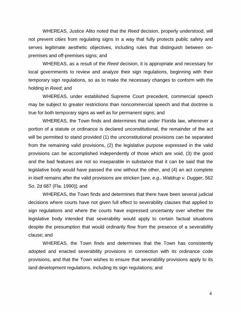
WHEREAS, Justice Alito noted that the Reed decision, properly understood, will
not prevent cities from regulating signs in a way that fully protects public safety and
serves legitimate aesthetic objectives, including rules that distinguish between on-
premises and off-premises signs; and
WHEREAS, as a result of the Reed decision, it is appropriate and necessary for
local governments to review and analyze their sign regulations, beginning with their
temporary sign regulations, so as to make the necessary changes to conform with the
holding in Reed; and
WHEREAS, under established Supreme Court precedent, commercial speech
may be subject to greater restrictions than noncommercial speech and that doctrine is
true for both temporary signs as well as for permanent signs; and
WHEREAS, the Town finds and determines that under Florida law, whenever a
portion of a statute or ordinance is declared unconstitutional, the remainder of the act
will be permitted to stand provided (1) the unconstitutional provisions can be separated
from the remaining valid provisions, (2) the legislative purpose expressed in the valid
provisions can be accomplished independently of those which are void, (3) the good
and the bad features are not so inseparable in substance that it can be said that the
legislative body would have passed the one without the other, and (4) an act complete
in itself remains after the valid provisions are stricken [see, e.g., Waldrup v. Dugger, 562
So. 2d 687 (Fla. 1990)]; and
WHEREAS, the Town finds and determines that there have been several judicial
decisions where courts have not given full effect to severability clauses that applied to
sign regulations and where the courts have expressed uncertainty over whether the
legislative body intended that severability would apply to certain factual situations
despite the presumption that would ordinarily flow from the presence of a severability
clause; and
WHEREAS, the Town finds and determines that the Town has consistently
adopted and enacted severability provisions in connection with its ordinance code
provisions, and that the Town wishes to ensure that severability provisions apply to its
land development regulations, including its sign regulations; and
4
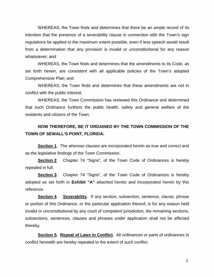
WHEREAS, the Town finds and determines that there be an ample record of its
intention that the presence of a severability clause in connection with the Town’s sign
regulations be applied to the maximum extent possible, even if less speech would result
from a determination that any provision is invalid or unconstitutional for any reason
whatsoever; and
WHEREAS, the Town finds and determines that the amendments to its Code, as
set forth herein, are consistent with all applicable policies of the Town’s adopted
Comprehensive Plan; and
WHEREAS, the Town finds and determines that these amendments are not in
conflict with the public interest.
WHEREAS, the Town Commission has reviewed this Ordinance and determined
that such Ordinance furthers the public health, safety and general welfare of the
residents and citizens of the Town.
NOW THEREFORE, BE IT ORDAINED BY THE TOWN COMMISSION OF THE TOWN OF SEWALL’S POINT, FLORIDA: Section 1. The whereas clauses are incorporated herein as true and correct and
as the legislative findings of the Town Commission.
Section 2. Chapter 74 “Signs”, of the Town Code of Ordinances is hereby
repealed in full.
Section 3. Chapter 74 “Signs”, of the Town Code of Ordinances is hereby
adopted as set forth in Exhibit “A” attached hereto and incorporated herein by this
reference.
Section 4. Severability. If any section, subsection, sentence, clause, phrase
or portion of this Ordinance, or the particular application thereof, is for any reason held
invalid or unconstitutional by any court of competent jurisdiction, the remaining sections,
subsections, sentences, clauses and phrases under application shall not be affected
thereby.
Section 5. Repeal of Laws in Conflict. All ordinances or parts of ordinances in
conflict herewith are hereby repealed to the extent of such conflict.
5

Section 6. Codification. The sections of the ordinance may be made a part of
the Town Code of Laws and ordinances and may be re-numbered or re-lettered to
accomplish such, and the word “ordinance” may be changed to “section,” “division,” or
any other appropriate word.
Section 7. Effective Date. This ordinance shall take effect immediately upon
adoption.
_______________________ offered the Ordinance for its first, reading and moved its
adoption. The motion was seconded by _______________________, and upon being put
to a vote, the vote was:
AYE NAY
DAN MORRIS, MAYOR ____ ____ JAMES W. CAMPO, VICE MAYOR ____ ____ VINCENT N. BARILE, COMMISSIONER ____ ____ PAUL LUGER, COMMISSIONER ____ ____ JACQUI THURLOW-LIPPISCH, COMMISSIONER ____ ____
Passed second reading at the Regular Meeting of the Town Commission held on the _____ day of ___________________, 2016. The ___________________ thereupon declared this Ordinance approved and adopted by the Town Commission on this _____ day of _________________, 2016. TOWN OF SEWALL’S POINT, FLORIDA __________________________________ DAN MORRIS, MAYOR ATTEST: Approved as to form and legal sufficiency: ___________________________ Lakisha Q. Burch, Town Clerk ________________________________ (TOWN SEAL) Glen J. Torcivia, Town Attorney Florida Bar No. 343374
6
EXHIBIT “A”
Chapter 74 - SIGNS
ARTICLE I. - IN GENERAL Sec. 74-1. – Purpose. The regulations and requirements set forth in this chapter are intended to preserve the character of the Town by controlling the size, location and use of signs in all zoning districts within the Town. It is further intended to protect property values and to create a more attractive, economic and business climate through the reinforcement and encouragement of graphic excellence and to reduce conflicts between signs. It is the goal of the Town to promote the Town's interest in aesthetics, to reduce urban clutter, to eliminate nuisance forms of advertising and to promote traffic safety by the avoidance of distractions to motorists caused by objectionable signage. It is not the intent or purpose of this article to impermissibly regulate signage by giving commercial speech greater protection than noncommercial speech, nor to discriminate among various noncommercial messages exhibited or conveyed by signs. Notwithstanding anything contained in the Town of Sewall Point’s Sign Code to the contrary, any sign erected pursuant to the provisions of this Code may, at the option of the applicant, contain either a noncommercial message unrelated to the business located on the premises where the sign is erected or a commercial message related to the business and located on the business premises. The noncommercial message may occupy the entire sign face or portion thereof. The sign may be changed from commercial to noncommercial messages as frequently as desired by the owner of the sign, provided that the size and design criteria conform to the applicable portions of this Code, the sign is allowed by this Code, the sign conforms to the requirements of the applicable zoning district, and the appropriate permits are obtained. For the purposes of this sign code, noncommercial messages, by their very nature, shall never be deemed an off premise sign. Sec. 74-2. - Penalty for violation of chapter.
Violations of this chapter shall be a Class A violation, punishable as set forth in chapter 18.
Sec. 74-3. - Right-of-way violations. If a prohibited sign is unlawfully located in a public right-of-way, the town may immediately remove
said sign. Information contained in the sign, including names, addresses or phone numbers of persons or entities advertising on the sign shall establish a rebuttable presumption of ownership for purposes of enforcement of this violation. Such signs shall be handled in the following manner:
(1) Illegal signs of negligible or no value. Any sign placed or erected in a public right-of-way in violation of this chapter which has negligible or no value due to its perishable or nondurable composition, including, but not limited to, those made out of paper, cardboard, posterboard, or similar material, including such signs mounted on wire, aluminum, other metal or wood, shall be deemed abandoned and may be destroyed by the town after removal. No opportunity to reclaim such a sign shall be given by the town. In addition to the town’s rights to remove and destroy the prohibited sign, the town may issue the owner, if the owner’s identity and whereabouts are known to the town, a citation as set forth in chapter 18 of this Code.
(2) Recovery of impounded signs; abandonment and destruction. Except for those signs described in subsection (a) above, any sign removed from a public right-of-way and impounded by the town shall be held in storage and the owner, if the owner’s identity and whereabouts are known to the town, shall be provided with a citation for such violation and shall be given 3 business days from the date the citation is received to reclaim any such sign. Any impounded sign stored by the town may be destroyed if not reclaimed within 3 business days of the receipt of the citation by the owner or within 7 business days of mailing of the citation if no signed return receipt is received or within 3 business days of the date of removal if the identity and whereabouts of the owner are not known to the town.
Page 1

Secs. 74-4—74-25. - Reserved.
ARTICLE II. - SIGN REGULATIONS
DIVISION 1. - DEFINITIONS
Sec. 74-26. – Definitions. The following words, terms and phrases, shall have the meaning ascribed to them in this section:
Abandoned sign means a sign is abandoned if the land use or business advertised in that sign is no longer licensed, no longer has a certificate of occupancy, or is no longer doing business at the location of the sign or the location noted on the sign.
Adjacent property means property immediately adjacent to the property.
Animated sign means a sign of which all or any part visibly moves in any fashion; and any sign which contains or uses for illumination any light, lights, or lighting device or devices which change color, flash, alternate, show movement, or motion, or change the appearance of the sign or any part thereof.
Area (See copy area; overall area.)
Attachment means brochure holder, balloons, flags or any other attention-getting device attached to a sign.
Awning means a cover or screen, usually consisting of canvas fabric, supported and stiffened by a rigid frame, extending over or before windows, doors, outside walks, or the like, and providing shelter or protection against the elements.
Banner means a sign produced on cloth, paper or fabric of any kind, either with or without frame.
Business Occupant means any person, firm, entity, partnership, trust, corporation, association, or other organization that is doing business in a commercial building, or a portion or portions thereof, for a period exceeding thirty (30) days, whether said building or portion of a building is rented, leased, or owned.
Changeable copy means a sign with characters, letters, or illustrations that can be changed, rearranged, or altered without changing the face of the sign or surface or wall.
Commercial sign means a sign that advertises a trade, business, industry or other activity for profit, or a product, commodity or service, whether or not for profit, including, but not limited to, vehicle signs, construction signs and real estate signs.
Construction sign means a temporary sign giving the name or names of principal contractors, architects, lending institutions, or sponsor responsible for construction or development on the premises where the sign is erected, and/or identifying the structure or project being constructed on the premises where the sign is placed.
Copy area means the actual area of the sign copy applied to any background as computed by drawing precisely four straight lines, in the shape of a square or rectangle, drawn closest to copy extremities encompassing all individual letters, words and graphics including logos.
Courtyard means an open space surrounded by walls or buildings on the same lot.
Directional sign means a sign which only provides directional instructions or information, no commercial information, for pedestrian or vehicular traffic, such as the terms: parking, one-way, exit, or entrance, and/or arrows.
Double-faced sign means a sign which has two sides, parallel to each other, facing in exact opposite directions.
Election sign means a temporary sign erected to support or oppose a candidate, political party, or ballot measure in an upcoming election, or to encourage citizens to vote in an upcoming election.
Page 2

Finished grade means the completed or settled level of the ground, asphalt, or pavement on which a sign is erected; except that if the sign is erected on an artificial mound or similar artificial rise, the term shall mean the completed or settled level of the ground, asphalt, or pavement which surrounds all or a majority of the building on the premises or site on which the sign is erected.
Flag means a piece of fabric (most often rectangular or quadrilateral) with a distinctive design that is used as a symbol, a signaling device, or a decoration, but for purposes of this sign code, does not include flags used for a commercial promotion or as an advertising device.
Font means an assortment or set of type all of one size and style.
Freestanding Directory sign means a permanent sign which is supported by structures or supports in or upon the ground and independent of support from any building used only for the purpose of identifying occupants of the premises.
Government sign means a sign erected, owned, leased, or maintained by any city or county, the state, or federal government for the purpose of discharging any government function.
Gross glass area means and shall include all glass on the side of a structure facing the same or generally same direction.
Ground floor means the floor of the building constructed at or slightly above the same level as the parking lot at the main entrance to the building.
Ground sign means a permanent sign which is supported by structures or supports in or upon the ground and independent of support from any building.
Height. (See overall height.)
Illuminated means receiving light from an artificial internal or external source.
Non-conforming sign means a sign legal at the time of its erection, which does not conform to the requirements of this sign code.
Normal Business Hours means 8:00 a.m. through 5:00 p.m. Monday through Saturday.
Obscene sign means that quality of any description or representation, in whatever form, of nudity, sexual conduct, or sexual excitement, when it (1) Predominately appeals to the prurient, shameful, or morbid interests of minors in sex, and (2) Is patently offensive to contemporary standards in the adult community as a whole with respect to what is suitable sexual material for minors, and (3) Taken as a whole, lacks serious literary, artistic, political, or scientific value.
Off-premises sign means a sign relating its subject matter to premises other than the premises on which it is located or to products, accommodations, services or activities available on premises other than the premises on which the sign is located.
Overall area means the total area of the sign face, not including any supporting structure provided that such supporting structure is used exclusively for and is necessary for support and does not carry any lettering or identifying markings.
Overall height means total height of sign including any frame, background, supporting member or other component part measured from finished grade level.
Overall width means total width of sign including any frame, background, supporting member or other component part.
Pedestal means the lower portion or base of a ground sign; said pedestal shall be solid, and made of stucco, cement, stone or similarly appearing material.
Perimeter Wall or Entry Feature Identification sign means a permanent sign which by symbol or name identifies a multi-lot residential neighborhood.
Page 3
Permanent sign means sign permanently affixed to a building or structure or to the ground.
Permanently attached means using bolts and screws.
Premises means all contiguous lands, structures, places, used in connection with any business conducted on such site, including the interior of the establishment and the contiguous exterior walls under common ownership, control or possession.
Professional office means the office of an establishment in which a person or persons are engaged in any occupation, vocation, or calling, not purely commercial, mechanical, or agricultural, in which a professed knowledge or skill in some department of science or learning is used by its practical application to the affairs of others, either advising or guiding them in serving their interest or welfare through the practice of an art founded thereon.
Property means an area of vacant land or land containing one or more buildings which, because of its unity of use, shall be regarded as one unit for the purpose of this sign code.
Property Identification Name means text and/or graphics used to distinguish one commercial property from another. A Property Identification name may be the name of a single occupant of the property, or any name that is unique within the Town’s jurisdiction and not specifically prohibited in Sec. 74-150.
Real-estate sign means a temporary sign, which advertises the sale, rent, lease or open house of the premises upon which it is located.
Residential Identification sign means a sign which by symbol or name identifies a residential property.
Setback means the distance between a property line or right-of-way line and the edge of a sign, which is nearest to the property line or right-of-way.
Sign means any display of characters, ornamentation, letters, or other display such as, but not limited to , a symbol, logo, picture, sculpture or other device used to attract attention, or to identify, advertise, announce, or to indicate directions or to otherwise convey a message, including the structure or frame used in the display.
Snipe sign means any sign placed on any tree, shrub, plant, utility pole, or similar object. Also, any sign installed without permission of the owner(s) or agent of the property where the sign is placed.
Strip lighting means long narrow lights.
Temporary sign means a sign of a non-permanent nature not requiring a permit and as regulated in this sign code, including real-estate signs, construction signs, election signs, or any other temporary sign. Temporary signs are those signs that are not intended or not constructed for permanent placement pursuant to the technical requirements of this article, as well as the town's building and other technical codes, including electrical codes. Temporary signs shall not include holiday or seasonal decorations.
Traffic sign means a sign or signal for the control of pedestrian or vehicular traffic, such as, but not limited to: stop, merge, and yield.
Uniform Sign Program means a document which specifies, and provides for, consistent color, font, style and materials for all wall signs within a development. Said Uniform Sign Program shall be subject to the approval of the Town Commission.
Vehicle sign means any lettering or graphic depiction painted on, magnetically attached to, or otherwise visible on or in a vehicle of any nature. Separate sign structures mounted on any vehicle(s) are expressly prohibited.
Wall sign means sign mounted parallel to and affixed to the face of a structure or wall.
Page 4
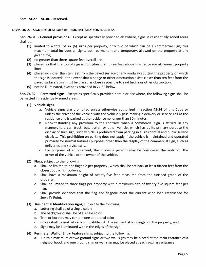
Secs. 74-27—74-30. - Reserved.
DIVISION 2. - SIGN REGULATIONS IN RESIDENTIALLY ZONED AREAS
Sec. 74-31. - General provisions. Except as specifically provided elsewhere, signs in residentially zoned areas shall be:
(1) limited to a total of six (6) signs per property, only two of which can be a commercial sign; this maximum total includes all signs, both permanent and temporary, allowed on the property at any given time;
(2) no greater than three square feet overall area; (3) placed so that the top of sign is no higher than three feet above finished grade at nearest property
line; (4) placed no closer than ten feet from the paved surface of any roadway abutting the property on which
the sign is located; in the event that a hedge or other obstruction exists closer than ten feet from the paved surface, signs must be placed as close as possible to said hedge or other obstruction;
(5) not be illuminated, except as provided in 74-32 below.
Sec. 74-32. – Permitted signs. Except as specifically provided herein or elsewhere, the following signs shall be permitted in residentially zoned areas:
(1) Vehicle signs. a. Vehicle signs are prohibited unless otherwise authorized in section 42-24 of this Code or
unless the driver of the vehicle with the Vehicle sign is making a delivery or service call at the residence and is parked at the residence no longer than 30 minutes.
b. Notwithstanding any provision to the contrary, when a commercial sign is affixed, in any manner, to a car, truck, bus, trailer, or other vehicle, which has as its primary purpose the display of such sign, such vehicle is prohibited from parking in all residential and public service districts. This prohibition on parking does not apply if the vehicle is maintained and operated primarily for normal business purposes other than the display of the commercial sign, such as deliveries and service calls.
c. For purposes of enforcement, the following persons may be considered the violator: the driver of the vehicle or the owner of the vehicle.
(2) Flags, subject to the following: a. Shall be limited to one flagpole per property , which shall be set back at least fifteen feet from the
closest public right-of-way; b. Shall have a maximum height of twenty-five feet measured from the finished grade of the
property; c. Shall be limited to three flags per property with a maximum size of twenty-five square feet per
flag; d. Shall provide evidence that the flag and flagpole meet the current wind load established for
Sewall's Point.
(3) Residential Identification signs, subject to the following: a. Lettering shall be of a single color; b. The background shall be of a single color; c. Trim or borders may contain one additional color; d. Colors shall be aesthetically compatible with the residential building(s) on the property; and e. Signs may be illuminated within the edges of the sign.
(4) Perimeter Wall or Entry Feature signs, subject to the following: a. Up to a maximum of two ground signs or two wall signs may be placed at the main entrance of a
neighborhood, and one ground sign or wall sign may be placed at each auxiliary entrance;
Page 5

b. Signs may only contain the name and/or street address of the neighborhood at which it is located;
c. Maximum overall area of each sign shall be ten square feet; d. Maximum overall height shall be five feet; e. Maximum width shall be five feet; and f. Ground signs shall be made of stucco, cement, stone, or similarly appearing material in all areas
except for the text and logo.
(5) Temporary signs, subject to the regulations and criteria set forth in Division 5 below. Secs. 74-33—74-70. - Reserved. DIVISION 3. - SIGN REGULATIONS FOR COMMERCIALLY ZONED AREAS
Sec. 74-71. – Purpose. The purpose of Division 3 of this code is to set out the design regulations, size limitations, and other regulations controlling the different types of signs allowed in commercially zoned areas (B-1 and B-2). Division 4 of this code will prescribe the number, location, and other rules relative to each type of sign as they apply to the respective uses within the B-1 and B-2 Zoning Districts.
Sec. 74-72. – Ground signs. Where Ground signs are allowed in Division 4 of this code, they shall conform to the following regulations:
(1) All Ground signs shall conform to the following design in order to provide for a consistent aesthetic in the Town’s commercial corridor:
a. Multi-Occupant Ground Sign
Page 6

b. Single-Occupant Ground Sign
(2) In addition, all Ground signs:
a. Shall comply with the construction detailed plan provided by the Town in conformance with the relevant illustration above;
b. Shall be consistent with the aesthetics, architecture, materials, and color of the main structure(s) and/or character of the premises;
c. May be only single, or double-faced; d. May include graphics and/or stylized and colored font in the copy area; e. Shall require that letters be attached directly to the monument sign structure (“pin-
mounted”); panels, raceways, and cabinet signs are expressly prohibited; f. Shall require that letters be of a minimum size of nine (9) inches; however, if such minimum
size does not allow for the continuance of existing advertising rights established in a legal document (e.g., written lease, condominium ownership documents, etc.) in effect on or before the effective date of this sign code, ___________________, 2016, then the effected Ground sign shall allow letters to be of a minimum size of four (4) inches;
g. Shall be setback at least twelve feet from the paved surface of the abutting roadway; h. Shall be limited in overall height to a maximum of nine (9’) feet from finished grade of the
property where the sign is located; provided however, that overall height can be measured from the finished grade of the crown of adjacent roadway where measurement from the sign’s location would make the ground sign not visible from the adjacent roadway;
i. Shall not exceed 12 feet in overall width; j. May be placed at an angle when located at the intersection of two streets; k. Shall be limited to one sign per 195 linear feet of frontage on State Road A1A up to a
maximum of three signs per property; l. If illuminated, shall have only permanently fixed and encased face lighting on the ground from
in front of and generally below the level of the sign surface; and m. Shall comply with the following landscaping and irrigation requirements:
i. All trees and vegetation planted in conformance with this chapter shall be installed in
accordance with good planting procedures as prescribed by the American Society of Landscape Architects. All existing trees, trees being planted on the site, and other
Page 7
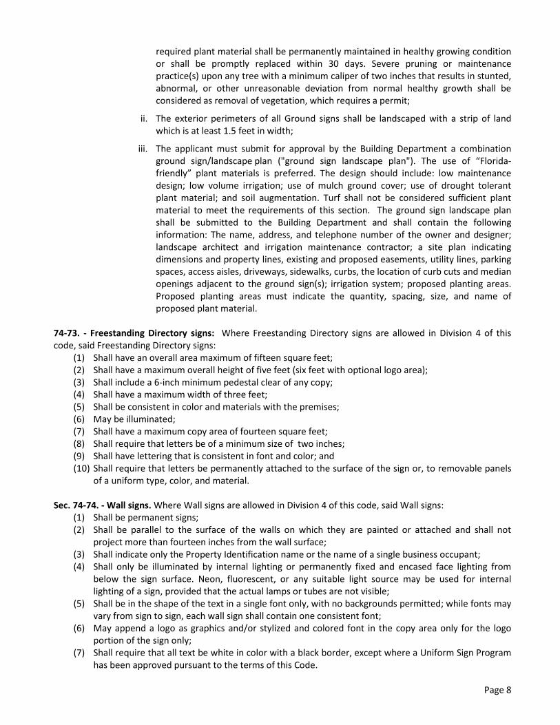
required plant material shall be permanently maintained in healthy growing condition or shall be promptly replaced within 30 days. Severe pruning or maintenance practice(s) upon any tree with a minimum caliper of two inches that results in stunted, abnormal, or other unreasonable deviation from normal healthy growth shall be considered as removal of vegetation, which requires a permit;
ii. The exterior perimeters of all Ground signs shall be landscaped with a strip of land which is at least 1.5 feet in width;
iii. The applicant must submit for approval by the Building Department a combination ground sign/landscape plan ("ground sign landscape plan"). The use of “Florida-friendly” plant materials is preferred. The design should include: low maintenance design; low volume irrigation; use of mulch ground cover; use of drought tolerant plant material; and soil augmentation. Turf shall not be considered sufficient plant material to meet the requirements of this section. The ground sign landscape plan shall be submitted to the Building Department and shall contain the following information: The name, address, and telephone number of the owner and designer; landscape architect and irrigation maintenance contractor; a site plan indicating dimensions and property lines, existing and proposed easements, utility lines, parking spaces, access aisles, driveways, sidewalks, curbs, the location of curb cuts and median openings adjacent to the ground sign(s); irrigation system; proposed planting areas. Proposed planting areas must indicate the quantity, spacing, size, and name of proposed plant material.
74-73. - Freestanding Directory signs: Where Freestanding Directory signs are allowed in Division 4 of this code, said Freestanding Directory signs:
(1) Shall have an overall area maximum of fifteen square feet; (2) Shall have a maximum overall height of five feet (six feet with optional logo area); (3) Shall include a 6-inch minimum pedestal clear of any copy; (4) Shall have a maximum width of three feet; (5) Shall be consistent in color and materials with the premises; (6) May be illuminated; (7) Shall have a maximum copy area of fourteen square feet; (8) Shall require that letters be of a minimum size of two inches; (9) Shall have lettering that is consistent in font and color; and (10) Shall require that letters be permanently attached to the surface of the sign or, to removable panels
of a uniform type, color, and material.
Sec. 74-74. - Wall signs. Where Wall signs are allowed in Division 4 of this code, said Wall signs: (1) Shall be permanent signs; (2) Shall be parallel to the surface of the walls on which they are painted or attached and shall not
project more than fourteen inches from the wall surface; (3) Shall indicate only the Property Identification name or the name of a single business occupant; (4) Shall only be illuminated by internal lighting or permanently fixed and encased face lighting from
below the sign surface. Neon, fluorescent, or any suitable light source may be used for internal lighting of a sign, provided that the actual lamps or tubes are not visible;
(5) Shall be in the shape of the text in a single font only, with no backgrounds permitted; while fonts may vary from sign to sign, each wall sign shall contain one consistent font;
(6) May append a logo as graphics and/or stylized and colored font in the copy area only for the logo portion of the sign only;
(7) Shall require that all text be white in color with a black border, except where a Uniform Sign Program has been approved pursuant to the terms of this Code.
Page 8

Sec. 74-75. – Directional and Traffic signs. Where Directional and Traffic signs are allowed in Division 4 of this code, said Directional and Traffic signs:
(1) Directional signs shall be: a. No greater than two square feet in overall area; b. No higher than five feet in overall height above the adjacent paved surface; c. Either single-or-double-faced; d. Setback at least two feet from the property line.
(2) Traffic control signs required for public safety shall be: a. No greater than six square feet overall area; b. No higher than seven feet above the adjacent paved surface; c. Either single- or double-faced; d. Setback at least two feet from the property line.
(3) Should a conflict arise between this chapter and the FHWA Manual, the FHWA Manual shall prevail. Sec. 74-76. – Window signs. Where Window signs are allowed in Division 4 of this code, said Window signs:
(1) May contain the name of the occupant, hours of business operation, open/closed designations, credit card designation and telephone numbers in an area not to exceed five percent of the gross glass area;
(2) May contain advertising of goods and services in an additional area not to exceed fifteen percent of the gross glass area;
(3) Shall require all window sign lettering to be of a permanent nature, with cardboard or paper materials expressly prohibited (except for restaurant menus); and
(4) Shall in no event exceed a total coverage in excess of twenty square feet of the gross glass area. Sec. 74-77. – Restaurant Menu signs. Where Restaurant Menu signs are allowed in Division 4 of this code, said Restaurant Menu signs:
(1) Shall be attached to a wall on a portion of a building occupied by said restaurant; (2) Shall be enclosed in a casing that is architecturally compatible with the building design and color; and (3) Shall extend no more than three inches in depth away from the wall to which it is attached.
Sec. 74-78 - Automated teller machines. Where Automated Teller Machine (ATM) signs are allowed in Division 4 of this code, said ATM signs:
(1) Shall be limited to ATMs that are attached to a bank; (2) Shall be an integral part of the ATM; (3) May not exceed two and one-half square feet in total size, including any border or background color;
and (4) May also include informational and instructional signs up to a maximum of 60 square inches.
Sec. 74-79 – Flags. Where Flags are allowed in Division 4 of this code, said Flags:
(1) Shall be limited to one flagpole per property , which shall be set back at least fifteen feet from the closest public right-of-way;
(2) Shall have a maximum height of twenty-five feet measured from the finished grade of the property; (3) Shall be limited to three flags per property with a maximum size of twenty-five square feet per flag; (4) As a part of the building permit application for installation of the Flag, shall provide evidence that the
Flag and flagpole meet the current wind load established for Sewall's Point.
Secs. 74-80—74-100. - Reserved. DIVISION 4. – SIGNS PERMITTED IN COMMERCIALLY ZONED AREAS
Sec. 74-101. – Purpose. The purpose of Division 4 of this code is to prescribe the number, location, and other rules relative to each type of sign allowed for each permitted use within the B-1 and B-2 Zoning Districts. The signs allowed in this Division 4 are subject to the regulatory controls laid out in Division 3 of this code.
Page 9
Sec. 74-102 - Shopping centers. The following signs may be erected, placed or maintained for shopping centers in the B-1 District:
(1) Ground signs: One Multi-Occupant Ground sign subject to the criteria set forth in Sec. 74-72(1) (a) shall be permitted for every 195 linear feet of frontage on State Road A1A up to a maximum of three signs per property.
(2) Freestanding Directory signs: One Freestanding Directory sign subject to the criteria set forth in Section 74-73 shall be permitted for each detached building on the property or one for each point of access to a courtyard. The location of such sign shall comply with the American with Disability Act (ADA) requirements not to obstruct accessibility to the building, sidewalks and pedestrian flow throughout the property.
(3) Wall signs subject to the criteria set forth in Section 74-74 shall be permitted in accordance with the following:
a. Individual Wall signs shall not exceed sixty (60) square feet in overall area; b. Wall signs shall be permitted limited to one wall sign per occupant of an individual business
space, assigned at the discretion of the property owner, with the maximum wall sign coverage limited to one square foot of wall signage per one linear foot of frontage on State Road A1A;
c. In lieu of a Wall sign, one removable hanging sign may be permitted; provided that such removable hanging sign shall not exceed two square feet; shall be one- or two-sided; shall be hung from a walkway soffit or structure in front of a business occupant’s space at the main entrance door of a directly accessible business occupant’s space; shall not project lower than eight feet from the walkway below; shall be uniformly hung perpendicular with respect to the building face; and shall be removed in the event of a hurricane or other such event; or
d. In lieu of a Wall sign, an awning with name of a business occupant may be permitted; provided that the overall area of the sign does not exceed one foot in height and ten feet in length; the sign is placed on the vertical edge of awning only; no additional identification signs larger than two square feet exist on the premises; and the awning sign contains one message only.
(4) Directional and Traffic control signs are permitted subject to the criteria set forth in Sec. 74-75;
(5) Window signs: individual business occupants within a shopping center shall be permitted one Window sign subject to the criteria set forth in Section 74 - 76;
(6) Restaurant Menu signs: a restaurant within a shopping center shall be permitted one restaurant menu sign subject to the criteria set forth in Section 74 - 77;
(7) Automated Teller Machine signs (ATM) are permitted subject to the criteria set forth in Section 74-78;
(8) Flags are permitted subject to the criteria set forth in Sec. 74 – 79;
(9) Vehicle signs are permitted during Normal Business Hours. During other hours, Vehicle signs are permitted for a reasonable time, not to exceed four hours, if one of the following applies:
a. The driver of the vehicle with the Vehicle sign is patronizing the location at which they are parked; or
b. The vehicle with the Vehicle sign is parked at the location of the business advertised on such Vehicle sign and it is during the business’ regular hours of operation;
(10) Temporary signs, subject to the regulations and criteria set forth in Division 5 below. Sec. 74-103 - Stand-alone restaurants. The following signs may be erected, placed or maintained for Stand-Alone Restaurants in the B-1 District:
Page 10

(1) Ground signs: One Single-Occupant Ground sign subject to the criteria set forth in Sec. 74-72(1)(b) shall be permitted for every 195 linear feet of frontage on State Road A1A up to a maximum of three signs per property.
(2) Freestanding Directory signs: One Freestanding Directory sign subject to the criteria set forth in Section 74-73 shall be permitted for each detached building on the property, or one for each point of access to a courtyard. The location of such sign shall comply with the American with Disability Act (ADA) requirements not to obstruct accessibility to the building, sidewalks and pedestrian flow throughout the property.
(3) Wall signs: Wall signs subject to the criteria set forth in Section 74-74 shall be permitted in accordance with the following:
a. The maximum Wall sign coverage is limited to one square foot of wall signage per three linear feet of frontage on State Road A1A;
b. The maximum size of an individual Wall sign shall not exceed sixty (40) square feet in overall area;
c. One Wall sign may be water-facing.
(4) Directional and Traffic control signs are permitted subject to the criteria set forth in Sec. 74-75;
(5) Window signs: subject to the criteria set forth in Section 74 – 76, one window sign and one matted or framed window menu sign shall be permitted;
(6) Restaurant Menu signs: One restaurant menu sign shall be permitted subject to the criteria set forth in Section 74 - 77;
(7) Flags shall be permitted subject to the criteria set forth in Sec. 74 – 79;
(8) Vehicle signs shall be permitted during Normal Business Hours. During other hours, Vehicle signs are permitted for a reasonable time, not to exceed four hours, if one of the following applies:
a. The driver of the vehicle with the Vehicle sign is patronizing the location at which they are parked; or
b. The vehicle with the Vehicle sign is parked at the location of the business advertised on such Vehicle sign and it is during the business’ regular hours of operation;
(9) Temporary signs, subject to the regulations and criteria set forth in Division 5 below.
Sec. 74-104 – Professional and business office buildings. The following signs may be erected, placed or maintained for Professional and Business Office Buildings in the B-1 and B-2 Districts:
(1) Ground signs: One Ground sign subject to the criteria set forth in Sec. 74-72(1) (a) or (b) (determined by the use of the building by single or multiple occupants) shall be permitted for every 195 linear feet of frontage on State Road A1A up to a maximum of three signs per property.
(2) Freestanding Directory signs: One Freestanding Directory sign subject to the criteria set forth in Section 74-73 shall be permitted for each detached building on the property, or one for each point of access to a courtyard. The location of such sign shall comply with the American with Disability Act (ADA) requirements not to obstruct accessibility to the building, sidewalks and pedestrian flow throughout the commercial property.
(3) Wall signs subject to the criteria set forth in Section 74-74 shall be permitted in accordance with the following:
a. The maximum Wall sign coverage is limited to one square foot of wall signage per three linear feet of frontage on State Road A1A;
b. The maximum size of an individual Wall sign shall not exceed sixty (40) square feet in overall area;
c. One Wall sign may be water-facing;
Page 11
d. One additional Wall sign in the form of a directory for the purpose of listing occupants of the building, which shall be located on the face of the building at the main ground floor entrance, affixed immediately outside and directly adjacent to the entrance at a height not exceeding the entrance door to the building, which may contain changeable copy but shall not exceed six square feet of total area.
(4) Directional and Traffic control signs are permitted subject to the criteria set forth in Sec. 74-75;
(5) Flags are permitted subject to the criteria set forth in Sec. 74 – 79;
(6) Vehicle signs are permitted during Normal Business Hours. During other hours, Vehicle signs are permitted for a reasonable time, not to exceed four hours, if one of the following applies:
a. The driver of the vehicle with the Vehicle sign is patronizing the location at which they are parked; or
b. The vehicle with the Vehicle sign is parked at the location of the business advertised on such Vehicle sign and it is during the business’ regular hours of operation;
(7) Temporary signs, subject to the regulations and criteria set forth in Division 5 below. Secs. 74-105—74-129. - Reserved.
DIVISION 5. - TEMPORARY SIGNS
Sec. 74-130. Findings of fact; purpose and intent. (a) Findings of fact. The Town Commission finds that the location and maintenance of Temporary signs
affects the public health, safety, and general welfare of the people of this community, and that in order to preserve and enhance the town as a desirable community in which to live and do business, a pleasing, visually attractive environment is of foremost importance. The town commission further finds that the regulation of Temporary signs within the town is a highly contributive means by which to achieve this desired end, and that uncontrolled and unlimited Temporary signs would degrade the aesthetic attractiveness of the natural and manmade attributes of the community and thereby undermine property values and the quaint character of the town.
(b) Purpose and intent. It is the purpose of this division to promote the public health, safety and general welfare through reasonable, consistent, and non-discriminatory standards for temporary signs. The Temporary sign regulations in this division are not intended to censor speech or to regulate viewpoints, but instead are intended to regulate the secondary effects of speech, and especially insofar as those secondary effects may adversely affect aesthetics and traffic and pedestrian safety. It is the intent of the town commission that the temporary sign regulations shall provide uniform sign criteria which regulate the size, height, number and placement of signs in a manner that is compatible to the scale and character of the town, and which place the fewest possible restrictions on personal liberties, property rights, commerce, and the free exercise of Constitutional rights while achieving the town’s goal of creating a healthy, safe and attractive environment that does not contain excessive clutter and visual distraction in rights-of-way and adjacent properties, the surrounding natural environment, and residential neighborhoods. These sign regulations have been prepared with the intent of enhancing the visual environment of the town and promoting its continued well-being, consistent with the most recent pronouncements of the United States Supreme Court regarding the regulation of temporary signage, and are further intended to:
1. Encourage the effective use of signs as a means of communication in the town; 2. Maintain and enhance the aesthetic environment and quaint character of the town; 3. Improve pedestrian and traffic safety; 4. Minimize the possible adverse impact of Temporary signs on nearby public and private
property;
Page 12
5. Lessen the visual clutter that may otherwise be caused by the proliferation, improper placement, illumination, animation, excessive height, and excessive size (area) of Temporary signs which compete for the attention of pedestrian and vehicular traffic.
6. Allow Temporary signs that are compatible with their surroundings, while precluding the placement of temporary signs that contribute to sign clutter or that conceal or obstruct adjacent land uses or signs;
7. Encourage and allow Temporary signs that are appropriate to the zoning district in which they are located;
8. Regulate Temporary signs in a manner so as to not interfere with, obstruct the vision of or distract motorists, bicyclists or pedestrians;
9. Preserve, conserve, protect, and enhance the aesthetic quality and scenic beauty of all zoning districts of the town;
10. Protect property values by precluding to the maximum extent possible Temporary signs that create a nuisance to the occupancy or use of other properties as result of their number, size, height, illumination, brightness, or movement; and
11. Enable the fair and consistent enforcement of these Temporary sign regulations.
74-131. Temporary signs. Temporary signs shall be subject to the following: (1) Temporary signs are exempt from the permitting process required of permanent signs pursuant to
this article; however, Temporary signs shall comply with the requirements of this division and those other sections referenced herein.
(2) No Temporary sign shall be placed in any public right-of-way or on any public property. (3) Notwithstanding the foregoing, the town manager may authorize the placement within a right-of-
way of Temporary signs identifying by name open businesses adjacent to ongoing road construction. Any such sign shall comply with FDOT or other applicable standards regarding lettering, size, material and placement.
(4) No Temporary sign shall be placed in a location in such a manner as to constitute a safety hazard, or hindrance to pedestrian or vehicular traffic.
(5) No Temporary sign shall be attached to a temporary structure. (6) The failure to remove a Temporary sign pursuant to the provisions of this section shall subject the
property owner upon whose property the sign is located to code enforcement. Each day that a Temporary sign remains in violation of this section shall be deemed to be a separate offense.
(7) Government signs may be located at the discretion of the town manager to serve a governmental purpose.
(8) If a Temporary sign pertains to an event, the Temporary sign shall be removed within and by no later than three days after the event is concluded. Types of events include, but are not limited to, the sale or lease of property, the holding of an election, the issuance of a certificate of occupancy, the conclusion of a garage sale or special event, etc.
(9) A Temporary sign may not be placed on property without the permission of the owner of the real property.
(10) A Temporary sign may not display any lighting or illuminations and must remain static. (11) A Temporary sign may not obstruct the view of a permanent sign as viewed from any road, street
or highway or any sidewalk.
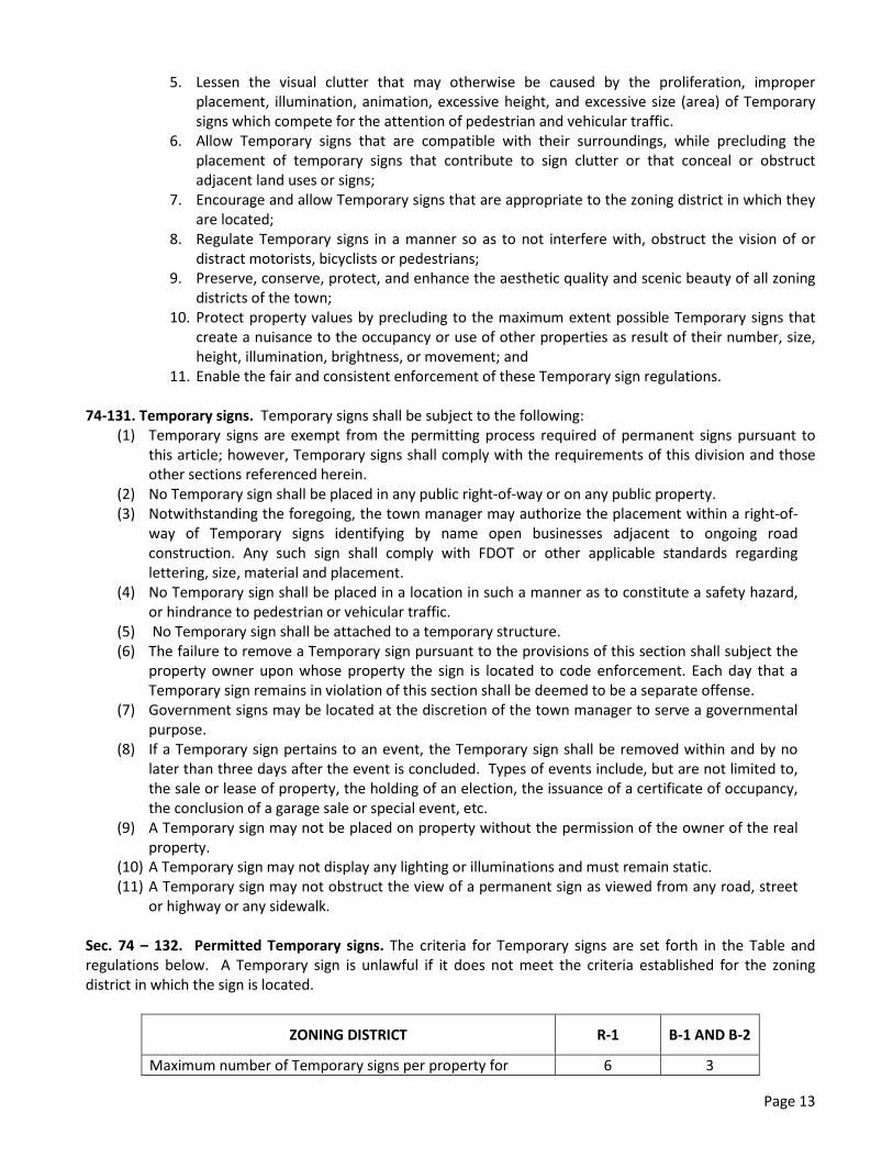
Sec. 74 – 132. Permitted Temporary signs. The criteria for Temporary signs are set forth in the Table and regulations below. A Temporary sign is unlawful if it does not meet the criteria established for the zoning district in which the sign is located.
ZONING DISTRICT R-1 B-1 AND B-2
Maximum number of Temporary signs per property for 6 3
Page 13

residential district and per premises for business districts Maximum per sign area 3 sf. 8 sf. Maximum sign height for freestanding signs 3 ft. 3 ft. Minimum sign setback 10 ft. 10 ft.
(1) Maximum number for residential districts. The maximum number of six signs per property for R-1 districts includes Temporary and Permanent signs. The number of Temporary commercial signs per parcel in residential districts shall be no more than two.
(2) Maximum number for commercial districts. A maximum of three Temporary signs per premises shall be permitted in commercial zoning districts. The total number of Permanent signs in commercial districts is as set forth in Division 4 of this Article.
(3) Size of Temporary signs. Temmporary signs in residential zoning districts are limited to three square feet. Temporary signs in commercial zoning districts are limited to eight square feet. The square footage limitation is per side for a back-to-back sign. For example, a 3 square foot limitation means that there is a limit of 3 square feet of surface area per side of a back-to-back sign, and an aggregate limit of 9 square feet is allowed if the sign is a back-to-back temporary sign.
(4) Height of Temporary signs. Freestanding Temporary signs in both residential and commercial zoning districts shall be a maximum overall height of three feet in height measured the finished grade of the property on which the sign is located.
(5) Setbacks for Temporary signs. Minimum sign setbacks are measured from the edge of the property line. In the event that a hedge or other obstruction exists closer than ten feet from the property line, signs must be placed as close as possible to said hedge or other obstruction.
(6) Signs required by law. Temporary government signs and Temporary signs that are required by law, rule or regulation shall be exempt from the criteria set forth in this section.
Secs. 74-133—74-149. - Reserved.
DIVISION 6. - PROHIBITED SIGNS
Sec. 74- 150. Prohibited signs. The following signs shall not be erected, placed or maintained in any zoning district and are prohibited, unless specifically permitted elsewhere in this sign code:
(1) Any sign which obstructs the view of bicyclists or motorists using any street, approach to any street intersection, or which interferes with the effectiveness of or obscures any traffic sign, device, or signal.
(2) Signs that by reason of position, shape, or color, would conflict with the proper function of any traffic sign or signal, or be of a size, location, movement, content, color, or illumination that may be reasonably confused with or construed as, or conceal, a traffic control device.
(3) Snipe signs. (4) Off-premises signs. Vehicle signs are prohibited in residential districts unless otherwise authorized in
section 42-24 of this Code or unless the driver of the vehicle with the Vehicle sign is making a delivery at the residence and is parked at the residence no longer than 30 minutes. Vehicle signs are prohibited in non-residential districts except during normal business hours; provided, however, that during other hours, Vehicle signs are permitted for a reasonable time in non-residential districts, not to exceed four hours, if one of the following applies:
a. The driver of the vehicle with the Vehicle sign is patronizing the location at which they are parked; or
Page 14

b. The vehicle with the Vehicle sign is parked at the location of the business advertised on such Vehicle sign and it is during the business’ regular hours of operation;
(5) Signs erected, constructed, or maintained so as to obstruct any fire escape or any window or door or opening used as a means of ingress or egress.
(6) Any sign (other than a government sign), banner, or display placed on any curb, street, sidewalk, post, pole, hydrant, bridge, tree, or other surface located on, over, or across any public street or right-of-way, or other public property, or located on town owned property. Such signs shall immediately be removed by the town's police department or other designee of the town commission.
(7) Animated signs of any kind. (8) Signs containing any type of reflective, fluorescent, or fluorescent-like paint or materials of any kind. (9) Sign spot lights or flood lamps and any exposed incandescent lamps larger than fifteen watts unless
shielded to prevent glare upon a public right-of-way or adjacent property. Any sign lights that hamper the vision of motorists or bicyclists.
(10) Neon lighting or strip lighting in any fashion when the actual lights or tubes can be seen from any street or right-of-way or adjacent property.
(11) Signs with the optical illusion of movement by means of a design that presents a pattern capable of giving the illusion of motion or changing copy.
(12) Signs containing extruding figures, waving or fluttering, or any device to attract attention; flags, or banners.
(13) Signs that emit odor, or visible matter such as smoke or steam. (14) Signs in non-residentially zoned areas which face residential property other than traffic signs. (15) In residentially zoned areas, signs closer than 100 feet from the property line of an adjacent
residential property. (16) Signs that contain any obscene copy. (17) Abandoned signs. (18) Signs which emit or utilize in any manner any sound capable of being detected by a person with
normal hearing. (19) Balloons or inflatable signs of any kind, except for private parties held in individual residences.
Sec. 74-151 - Nonconforming signs. Any nonconforming sign pursuant to the regulations of this chapter, which was lawfully in existence prior to the adoption of this chapter, shall be allowed to remain as a legal nonconforming structure, pursuant to the requirements of Chapter 82, Zoning, Article III, Nonconformities, and subject to the following limitations:
(1) The sign may not be altered, expanded or extended in any way unless to bring it into conformity except that business occupant name changes on existing menu type signs may be changed to reflect a new business occupant or a business name change. Except as otherwise set forth in this code, normal repair and maintenance, including necessary nonstructural repairs and incidental work which does not extend or intensify the noncomplying features of the sign, may be performed.
(2) No nonconforming sign shall be moved, in whole or in part, to any other location where it would remain noncomplying.
(3) If a nonconforming sign is destroyed or damaged by any means to an extent of 50 percent or more of its replacement costs at the time of destruction or damage, it shall not be reconstructed or repaired except in conformance with this sign code.
(4) Perimeter Wall or Entry Feature Identification signs in residential zones, existing, and in place, as of the date of this chapter shall be exempt from compliance with this code. Replacements for existing neighborhood Perimeter Wall or Entry Feature Identification signs must comply with this code.
(5) Signs which are not in compliance with this chapter on the effective date of this sign code, ______________________, 2016, shall be brought into compliance within four (4) years of such effective date. If a property owner or its representative applies for a permit for a new sign on the property and that sign will increase the overall square footage of existing signage on the property, then the owner shall be required to bring all nonconforming signs on the property into compliance
Page 15

with this code within one year from the date of the installation of any such new sign or within four (4) years of the effective date of this sign code, whichever is sooner.
Sec. 74-151 - Permits.
(a) It shall be unlawful for any entity or person to erect, construct, alter, enlarge, move, or replace any permanent sign or cause the same to be done, without first having obtained a building permit for the sign. The building official, in his or her sole discretion, may exempt a permanent sign from the permit requirement if the work to be done is of such a minor nature that the protections of the building permit are not necessary, and such permit is not otherwise required under the Florida Building Code or other statute, ordinance, rule or regulation.
(b) Government signs are exempt from the requirements of this section. (c) A fee in accordance with a fee schedule adopted by resolution of the town commission, as noted in
section 50-102, shall be charged for each building permit issued excepted as provided elsewhere in this chapter.
(d) The permit fee shall be waived for a one time replacement of permitted signs in existence on the date of this chapter, which were made non-conforming by virtue of this chapter.
(e) All permanent signs shall conform to all applicable building codes. (f) A building permit for a permanent sign shall become null and void unless the construction is complete
and a certificate of completion from the Building Department is issued within three months after the effective date of the issuance of the permit.
Sec. 74-152. - Variance. There shall be no process by which an applicant may seek a legal variance from the terms of this sign code.
Page 16

EXHIBIT “A”
Chapter 74 - SIGNS
ARTICLE I. - IN GENERAL Sec. 74-1. – Purpose. The regulations and requirements set forth in this chapter are intended to preserve the character of the Town by controlling the size, location and use of signs in all zoning districts within the Town. It is further intended to protect property values and to create a more attractive, economic and business climate through the reinforcement and encouragement of graphic excellence and to reduce conflicts between signs. It is the goal of the Town to promote the Town's interest in aesthetics, to reduce urban clutter, to eliminate nuisance forms of advertising and to promote traffic safety by the avoidance of distractions to motorists caused by objectionable signage. It is not the intent or purpose of this article to impermissibly regulate signage by giving commercial speech greater protection than noncommercial speech, nor to discriminate among various noncommercial messages exhibited or conveyed by signs. Notwithstanding anything contained in the Town of Sewall Point’s Sign Code to the contrary, any sign erected pursuant to the provisions of this Code may, at the option of the applicant, contain either a noncommercial message unrelated to the business located on the premises where the sign is erected or a commercial message related to the business and located on the business premises. The noncommercial message may occupy the entire sign face or portion thereof. The sign may be changed from commercial to noncommercial messages as frequently as desired by the owner of the sign, provided that the size and design criteria conform to the applicable portions of this Code, the sign is allowed by this Code, the sign conforms to the requirements of the applicable zoning district, and the appropriate permits are obtained. For the purposes of this sign code, noncommercial messages, by their very nature, shall never be deemed an off premise sign. Sec. 74-2. - Penalty for violation of chapter.
Violations of this chapter shall be a Class A violation, punishable as set forth in chapter 18.
Sec. 74-3. - Right-of-way violations. If a prohibited sign is unlawfully located in a public right-of-way, the town may immediately remove
said sign. Information contained in the sign, including names, addresses or phone numbers of persons or entities advertising on the sign shall establish a rebuttable presumption of ownership for purposes of enforcement of this violation. Such signs shall be handled in the following manner:
(1) Illegal signs of negligible or no value. Any sign placed or erected in a public right-of-way in violation of this chapter which has negligible or no value due to its perishable or nondurable composition, including, but not limited to, those made out of paper, cardboard, posterboard, or similar material, including such signs mounted on wire, aluminum, other metal or wood, shall be deemed abandoned and may be destroyed by the town after removal. No opportunity to reclaim such a sign shall be given by the town. In addition to the town’s rights to remove and destroy the prohibited sign, the town may issue the owner, if the owner’s identity and whereabouts are known to the town, a citation as set forth in chapter 18 of this Code.
(2) Recovery of impounded signs; abandonment and destruction. Except for those signs described in subsection (a) above, any sign removed from a public right-of-way and impounded by the town shall be held in storage and the owner, if the owner’s identity and whereabouts are known to the town, shall be provided with a citation for such violation and shall be given 3 business days from the date the citation is received to reclaim any such sign. Any impounded sign stored by the town may be destroyed if not reclaimed within 3 business days of the receipt of the citation by the owner or within 7 business days of mailing of the citation if no signed return receipt is received or within 3 business days of the date of removal if the identity and whereabouts of the owner are not known to the town.
Page 1

Secs. 74-34—74-25. - Reserved.
ARTICLE II. - SIGN REGULATIONS The regulations and requirements set forth in this article are intended to preserve the character of the Town by controlling the size, location and use of signs in all zoning districts within the Town. It is further intended to protect property values and to create a more attractive, economic and business climate through the reinforcement and encouragement of graphic excellence and to reduce conflicts between signs. It is the goal of the Town to promote the Town's interest in aesthetics, to reduce urban clutter, to eliminate nuisance forms of advertising and to promote traffic safety by the avoidance of distractions to motorists caused by objectionable signage. It is not the intent or purpose of this article to impermissibly regulate signage by giving commercial speech greater protection than noncommercial speech, nor to discriminate among various noncommercial messages exhibited or conveyed by signs. Notwithstanding anything contained in the Town of Sewall Point’s Sign Code to the contrary, any sign erected pursuant to the provisions of this Code may, at the option of the applicant, contain either a noncommercial message unrelated to the business located on the premises where the sign is erected or a commercial message related to the business and located on the business premises. The noncommercial message may occupy the entire sign face or portion thereof. The sign may be changed from commercial to noncommercial messages as frequently as desired by the owner of the sign, provided that the size and design criteria conform to the applicable portions of this Code, the sign is allowed by this Code, the sign conforms to the requirements of the applicable zoning district, and the appropriate permits are obtained. For the purposes of this sign code, noncommercial messages, by their very nature, shall never be deemed an off premise sign.
DIVISION 1. - DEFINITIONS
Sec. 74-26. – Definitions. The following words, terms and phrases, shall have the meaning ascribed to them in this section:
Abandoned sign means a sign is abandoned if the land use or business advertised in that sign is no longer licensed, no longer has a certificate of occupancy, or is no longer doing business at the location of the sign or the location noted on the sign.
Adjacent property means property immediately adjacent to the property.
Animated sign means a sign of which all or any part visibly moves in any fashion; and any sign which contains or uses for illumination any light, lights, or lighting device or devices which change color, flash, alternate, show movement, or motion, or change the appearance of the sign or any part thereof.
Area (See copy area; overall area.)
Attachment means brochure holder, balloons, flags or any other attention-getting device attached to a sign.
Awning means a cover or screen, usually consisting of canvas fabric, supported and stiffened by a rigid frame, extending over or before windows, doors, outside walks, or the like, and providing shelter or protection against the elements.
Banner means a sign produced on cloth, paper or fabric of any kind, either with or without frame.
Business Occupant means any person, firm, entity, partnership, trust, corporation, association, or other organization that is doing business in a commercial building, or a portion or portions thereof, for a period exceeding thirty (30) days, whether said building or portion of a building is rented, leased, or owned.
Changeable copy means a sign with characters, letters, or illustrations that can be changed, rearranged, or altered without changing the face of the sign or surface or wall.
Commercial sign means a sign that advertises a trade, business, industry or other activity for profit, or a product, commodity or service, whether or not for profit, including, but not limited to, vehicle signs, construction signs and real estate signs.
Page 2

Construction sign means a temporary sign giving the name or names of principal contractors, architects, lending institutions, or sponsor responsible for construction or development on the premises where the sign is erected, and/or identifying the structure or project being constructed on the premises where the sign is placed.
Copy area means the actual area of the sign copy applied to any background as computed by drawing precisely four straight lines, in the shape of a square or rectangle, drawn closest to copy extremities encompassing all individual letters, words and graphics including logos.
Courtyard means an open space surrounded by walls or buildings on the same lot.
Directional sign means a sign which only provides directional instructions or information, no commercial information, for pedestrian or vehicular traffic, such as the terms: parking, one-way, exit, or entrance, and/or arrows.
Double-faced sign means a sign which has two sides, parallel to each other, facing in exact opposite directions.
Election sign means a temporary sign erected to support or oppose a candidate, political party, or ballot measure in an upcoming election, or to encourage citizens to vote in an upcoming election.
Finished grade means the completed or settled level of the ground, asphalt, or pavement on which a sign is erected; except that if the sign is erected on an artificial mound or similar artificial rise, the term shall mean the completed or settled level of the ground, asphalt, or pavement which surrounds all or a majority of the building on the premises or site on which the sign is erected.
Flag means a piece of fabric (most often rectangular or quadrilateral) with a distinctive design that is used as a symbol, a signaling device, or a decoration, but for purposes of this sign code, does not include flags used for a commercial promotion or as an advertising device.
Font means an assortment or set of type all of one size and style.
Freestanding Directory sign means a permanent sign which is supported by structures or supports in or upon the ground and independent of support from any building used only for the purpose of identifying occupants of the premises.
Government sign means a sign erected, owned, leased, or maintained by any city or county, the state, or federal government for the purpose of discharging any government function.
Gross glass area means and shall include all glass on the side of a structure facing the same or generally same direction.
Ground floor means the floor of the building constructed at or slightly above the same level as the parking lot at the main entrance to the building.
Ground sign means a permanent sign which is supported by structures or supports in or upon the ground and independent of support from any building.
Height. (See overall height.)
Illuminated means receiving light from an artificial internal or external source.
Non-conforming sign means a sign legal at the time of its erection, which does not conform to the requirements of this sign code.
Normal Business Hours means 8:00 a.m. through 5:00 p.m. Monday through Saturday.
Obscene sign means that quality of any description or representation, in whatever form, of nudity, sexual conduct, or sexual excitement, when it (1) Predominately appeals to the prurient, shameful, or morbid interests of minors in sex, and (2) Is patently offensive to contemporary standards in the adult community as a whole with respect to what is suitable sexual material for minors, and (3) Taken as a whole, lacks serious literary, artistic, political, or scientific value.
Page 3

Off-premises sign means a sign relating its subject matter to premises other than the premises on which it is located or to products, accommodations, services or activities available on premises other than the premises on which the sign is located.
Overall area means the total area of the sign face, not including any supporting structure provided that such supporting structure is used exclusively for and is necessary for support and does not carry any lettering or identifying markings.
Overall height means total height of sign including any frame, background, supporting member or other component part measured from finished grade level.
Overall width means total width of sign including any frame, background, supporting member or other component part.
Pedestal means the lower portion or base of a ground sign; said pedestal shall be solid, and made of stucco, cement, stone or similarly appearing material.
Perimeter Wall or Entry Feature Identification sign means a permanent sign which by symbol or name identifies a multi-lot residential neighborhood.
Permanent sign means sign permanently affixed to a building or structure or to the ground.
Permanently attached means using bolts and screws.
Premises means all contiguous lands, structures, places, used in connection with any business conducted on such site, including the interior of the establishment and the contiguous exterior walls under common ownership, control or possession.
Professional office means the office of an establishment in which a person or persons are engaged in any occupation, vocation, or calling, not purely commercial, mechanical, or agricultural, in which a professed knowledge or skill in some department of science or learning is used by its practical application to the affairs of others, either advising or guiding them in serving their interest or welfare through the practice of an art founded thereon.
Property means an area of vacant land or land containing one or more buildings which, because of its unity of use, shall be regarded as one unit for the purpose of this sign code.
Property Identification Name means text and/or graphics used to distinguish one commercial property from another. A Property Identification name may be the name of a single occupant of the property, or any name that is unique within the Town’s jurisdiction and not specifically prohibited in Sec. 74-150.
Real-estate sign means a temporary sign, which advertises the sale, rent, lease or open house of the premises upon which it is located.
Residential Identification sign means a sign which by symbol or name identifies a residential property.
Rider means a small sign attached to a larger one; commonly seen on real estate signs which may contain the name and phone number of the real estate broker or agent, or which may contain remarks specific to the property, such as "Sold," "For Sale," "For Rent," or "Sale Pending." The rider is included within the overall two square feet limitation set forth in subsection 74-31(1).
Setback means the distance between a property line or right-of-way line and the edge of a sign, which is nearest to the property line or right-of-way.
Sign means any display of characters, ornamentation, letters, or other display such as, but not limited to , a symbol, logo, picture, sculpture or other device used to attract attention, or to identify, advertise, announce, or to indicate directions or to otherwise convey a message, including the structure or frame used in the display.
Snipe sign means any sign placed on any tree, shrub, plant, utility pole, or similar object. Also, any sign installed without permission of the owner(s) or agent of the property where the sign is placed.
Page 4
Strip lighting means long narrow lights.
Temporary sign means a sign of a non-permanent nature not requiring a permit and as regulated in this sign code, including real-estate signs, construction signs, election signs, or any other temporary sign. Temporary signs are those signs that are not intended or not constructed for permanent placement pursuant to the technical requirements of this article, as well as the town's building and other technical codes, including electrical codes. Temporary signs shall not include holiday or seasonal decorations.
Traffic sign means a sign or signal for the control of pedestrian or vehicular traffic, such as, but not limited to: stop, merge, and yield.
Uniform Sign Program means a document which specifies, and provides for, consistent color, font, style and materials for all wall signs within a development. Said Uniform Sign Program shall be subject to the approval of the Town Commission.
Vehicle sign means any lettering or graphic depiction painted on, magnetically attached to, or otherwise visible on or in a vehicle of any nature. Separate sign structures mounted on any vehicle(s) are expressly prohibited.
Wall sign means sign mounted parallel to and affixed to the face of a structure or wall.
Secs. 74-27—74-30. - Reserved.
DIVISION 2. - SIGN REGULATIONS IN RESIDENTIALLY ZONED AREAS
Sec. 74-31. - General provisions. Except as specifically provided elsewhere, signs in residentially zoned areas shall be:
(1) limited to a total of six (6) signs per property, only one two of which can be a commercial sign; this maximum total includes all signs, both permanent and temporary, allowed on the property at any given time;
(2) no greater than twothree square feet overall area; (3) placed so that the top of sign is no higher than three feet above finished grade at nearest property
line; (4) placed no closer than ten feet from the paved surface of any roadway abutting the property on which
the sign is located; in the event that a hedge or other obstruction exists closer than ten feet from the paved surface, signs must be placed as close as possible to said hedge or other obstruction;
(5) not be illuminated, except as provided in 74-32 below.
Sec. 74-32. – Permitted signs. Except as specifically provided herein or elsewhere, the following signs shall be permitted in residentially zoned areas:
(1) Vehicle signs during Normal Business Hours. . a. Vehicle signs as regulated by this Chapter shall at all times be contingent upon compliance
with the parking restrictions set forthare prohibited unless otherwise authorized in chaptersection 42, article II-24 of this Code, including or unless the driver of the following: vehicle with the Vehicle sign is making a delivery or service call at the residence and is parked at the residence no longer than 30 minutes.
a.b. Notwithstanding any provision to the contrary, when a commercial sign is affixed, in any manner, to a car, truck, bus, trailer, or other vehicle, which has as its primary purpose the display of such sign, such vehicle is prohibited from parking in all residential and public service districts. This prohibition on parking does not apply if the vehicle is maintained and operated primarily for normal business purposes other than the display of the commercial sign, such as deliveries and service calls.
Page 5

b.c. For purposes of enforcement, the following persons may be considered the violator: the driver of the vehicle, or the owner of the vehicle and any person or entity that is advertised on the subject vehicle sign.
(2) Flags, subject to the following: a. Shall be limited to one flagpole per property , which shall be set back at least fifteen feet from the
closest public right-of-way; b. Shall have a maximum height of twenty-five feet measured from the finished grade of the
property; c. Shall be limited to three flags per property with a maximum size of twenty-five square feet per
flag; d. Shall provide evidence that the flag and flagpole meet the current wind load established for
Sewall's Point.
(3) Residential Identification signs, subject to the following: a. Lettering shall be of a single color; b. The background shall be of a single color; c. Trim or borders may contain one additional color; d. Colors shall be aesthetically compatible with the residential building(s) on the property; and e. Signs may be illuminated within the edges of the sign.
(4) Perimeter Wall or Entry Feature signs, subject to the following: a. Up to a maximum of two ground signs or two wall signs may be placed at the main entrance of a
neighborhood, and one ground sign or wall sign may be placed at each auxiliary entrance; b. Signs may only contain the name and/or street address of the neighborhood at which it is
located; c. Maximum overall area of each sign shall be ten square feet; d. Maximum overall height shall be five feet; e. Maximum width shall be five feet; and f. Ground signs shall be made of stucco, cement, stone, or similarly appearing material in all areas
except for the text and logo.
(5) Temporary signs, subject to the regulations and criteria set forth in Section 74-131Division 5 below. Secs. 74-33—74-70. - Reserved. DIVISION 3. - SIGN REGULATIONS FOR COMMERCIALLY ZONED AREAS
Sec. 74-71. – Purpose. The purpose of Division 3 of this code is to set out the design regulations, size limitations, and other regulations controlling the different types of signs allowed in commercially zoned areas (B-1 and B-2). Division 4 of this code will prescribe the number, location, and other rules relative to each type of sign as they apply to the respective uses within the B-1 and B-2 Zoning Districts.
Sec. 74-72. – Ground signs. Where Ground signs are allowed in Division 4 of this code, they shall conform to the following regulations:
(1) All Ground signs shall conform to the following design in order to provide for a consistent aesthetic in the Town’s commercial corridor:
a. Multi-Occupant Ground Sign
Page 6

[Insert graphic with measurements for multi-occupant buildings]
b. Single-Occupant Ground Sign [Insert graphic with measurements for single-occupant buildings]
Formatted: Indent: Left: 1.05", First line: 0"
Page 7

(2) In addition, all Ground signs:
a. Shall comply with the construction detailed plan provided by the Town in conformance with the relevant illustration above;
b. Shall be consistent with the aesthetics, architecture, materials, and color of the main structure(s) and/or character of the premises;
c. May be only single, or double-faced; d. May include graphics and/or stylized and colored font in the copy area; e. Shall require that letters be attached directly to the monument sign structure (“pin-
mounted”); panels, raceways, and cabinet signs are expressly prohibited; f. Shall require that letters be of a minimum size of nine (9) inches; however, if such minimum
size does not allow for the continuance of existing advertising rights established in a legal document (e.g., written lease, condominium ownership documents, etc.) in effect on or before the effective date of this sign code, ___________________, 2016, then the effected Ground sign shall allow letters to be of a minimum size of four (4) inches;
g. Shall be setback at least twelve feet from the paved surface of the abutting roadway; h. Shall be limited in overall height to a maximum of six nine (9’) feet from finished grade of the
property where the sign is located; provided however, that overall height can be measured from the finished grade of the crown of adjacent roadway where measurement from the sign’s location would make the ground sign not visible from the adjacent roadway;
i. Shall not exceed 12 feet in overall width; j. May be placed at an angle when located at the intersection of two streets; k. Shall be limited to one sign per 195 linear feet of frontage on State Road A1A up to a
maximum of three signs per property; l. If illuminated, shall have only permanently fixed and encased face lighting on the ground from
in front of and generally below the level of the sign surface; and m. Shall comply with the following landscaping and irrigation requirements:
i. All trees and vegetation planted in conformance with this chapter shall be installed in
accordance with good planting procedures as prescribed by the American Society of Landscape Architects. All existing trees, trees being planted on the site, and other required plant material shall be permanently maintained in healthy growing condition or shall be promptly replaced within 30 days. Severe pruning or maintenance
Page 8

practice(s) upon any tree with a minimum caliper of two inches that results in stunted, abnormal, or other unreasonable deviation from normal healthy growth shall be considered as removal of vegetation, which requires a permit;
ii. The exterior perimeters of all Ground signs shall be landscaped with a strip of land which is at least 1.5 feet in width;
iii. The applicant must submit for approval by the Building Department a combination ground sign/landscape plan ("ground sign landscape plan"). The use of “Florida-friendly” plant materials is preferred. The design should include: low maintenance design; low volume irrigation; use of mulch ground cover; use of drought tolerant plant material; and soil augmentation. Turf shall not be considered sufficient plant material to meet the requirements of this section. The ground sign landscape plan shall be submitted to the Building Department and shall contain the following information: The name, address, and telephone number of the owner and designer; landscape architect and irrigation maintenance contractor; a site plan indicating dimensions and property lines, existing and proposed easements, utility lines, parking spaces, access aisles, driveways, sidewalks, curbs, the location of curb cuts and median openings adjacent to the ground sign(s); irrigation system; proposed planting areas. Proposed planting areas must indicate the quantity, spacing, size, and name of proposed plant material.
74-73. - Freestanding Directory signs: Where Freestanding Directory signs are allowed in Division 4 of this code, said Freestanding Directory signs:
(1) Shall have an overall area maximum of fifteen square feet; (2) Shall have a maximum overall height of five feet (six feet with optional logo area); (3) Shall include a 6-inch minimum pedestal clear of any copy; (4) Shall have a maximum width of three feet; (5) Shall be consistent in color and materials with the premises; (6) May be illuminated; (7) Shall have a maximum copy area of fourteen square feet; (8) Shall require that letters be of a minimum size of two inches; (9) Shall have lettering that is consistent in font and color; and (10) Shall require that letters be permanently attached to the surface of the sign or, to removable panels
of a uniform type, color, and material.
Sec. 74-74. - Wall signs. Where Wall signs are allowed in Division 4 of this code, said Wall signs: (1) Shall be permanent signs; (2) Shall be parallel to the surface of the walls on which they are painted or attached and shall not
project more than fourteen inches from the wall surface; (3) Shall indicate only the Property Identification name or the name of a single business occupant; (4) Shall only be illuminated by internal lighting or permanently fixed and encased face lighting from
below the sign surface. Neon, fluorescent, or any suitable light source may be used for internal lighting of a sign, provided that the actual lamps or tubes are not visible;
(5) Shall be in the shape of the text in a single font only, with no backgrounds permitted; while fonts may vary from sign to sign, each wall sign shall contain one consistent font;
(6) May append a logo as graphics and/or stylized and colored font in the copy area only for the logo portion of the sign only;
(7) Shall require that all text be white in color with a black border, except where a Uniform Sign Program has been approved pursuant to the terms of this Code.
Sec. 74-75. – Directional and Traffic signs. Where Directional and Traffic signs are allowed in Division 4 of this code, said Directional and Traffic signs:
Page 9

(1) Directional signs shall be: a. No greater than two square feet in overall area; b. No higher than five feet in overall height above the adjacent paved surface; c. Either single-or-double-faced; d. Setback at least two feet from the property line.
(2) Traffic control signs required for public safety shall be: a. No greater than six square feet overall area; b. No higher than seven feet above the adjacent paved surface; c. Either single- or double-faced; d. Setback at least two feet from the property line.
(3) Should a conflict arise between this chapter and the FHWA Manual, the FHWA Manual shall prevail. Sec. 74-76. – Window signs. Where Window signs are allowed in Division 4 of this code, said Window signs:
(1) May contain the name of the occupant, hours of business operation, open/closed designations, credit card designation and telephone numbers in an area not to exceed five percent of the gross glass area;
(2) May contain advertising of goods and services in an additional area not to exceed fifteen percent of the gross glass area;
(3) Shall require all window sign lettering to be of a permanent nature, with cardboard or paper materials expressly prohibited (except for restaurant menus); and
(4) Shall in no event exceed a total coverage in excess of twenty square feet of the gross glass area.
Sec. 74-77. – Restaurant Menu signs. Where Restaurant Menu signs are allowed in Division 4 of this code, said Restaurant Menu signs:
(1) Shall be attached to a wall on a portion of a building occupied by said restaurant; (2) Shall be enclosed in a casing that is architecturally compatible with the building design and color; and (3) Shall extend no more than three inches in depth away from the wall to which it is attached.
Sec. 74-78 - Automated teller machines. Where Automated Teller Machine (ATM) signs are allowed in Division 4 of this code, said ATM signs:
(1) Shall be limited to ATMs that are attached to a bank; (2) Shall be an integral part of the ATM; (3) May not exceed two and one-half square feet in total size, including any border or background color;
and (4) May also include informational and instructional signs up to a maximum of 60 square inches.
Sec. 74-79 – Flags. Where Flags are allowed in Division 4 of this code, said Flags:
(1) Shall be limited to one flagpole per property , which shall be set back at least fifteen feet from the closest public right-of-way;
(2) Shall have a maximum height of twenty-five feet measured from the finished grade of the property; (3) Shall be limited to three flags per property with a maximum size of twenty-five square feet per flag; (4) As a part of the building permit application for installation of the Flag, shall provide evidence that the
Flag and flagpole meet the current wind load established for Sewall's Point.
Secs. 74-80—74-100. - Reserved. DIVISION 4. – SIGNS PERMITTED IN COMMERCIALLY ZONED AREAS
Sec. 74-101. – Purpose. The purpose of Division 4 of this code is to prescribe the number, location, and other rules relative to each type of sign allowed for each permitted use within the B-1 and B-2 Zoning Districts. The signs allowed in this Division 4 are subject to the regulatory controls laid out in Division 3 of this code.
Page 10
Sec. 74-102 - Shopping centers. The following signs may be erected, placed or maintained for shopping centers in the B-1 District:
(1) Ground signs: One Multi-Occupant Ground sign subject to the criteria set forth in Sec. 74-72(1) (a) shall be permitted for every 195 linear feet of frontage on State Road A1A up to a maximum of three signs per property.
(2) Freestanding Directory signs: One Freestanding Directory sign subject to the criteria set forth in Section 74-73 shall be permitted for each detached building on the property or one for each point of access to a courtyard. The location of such sign shall comply with the American with Disability Act (ADA) requirements not to obstruct accessibility to the building, sidewalks and pedestrian flow throughout the property.
(3) Wall signs subject to the criteria set forth in Section 74-74 shall be permitted in accordance with the following:
a. Individual Wall signs shall not exceed sixty (60) square feet in overall area; b. Wall signs shall be permitted limited to one wall sign per occupant of an individual business
space, assigned at the discretion of the property owner, with the maximum wall sign coverage limited to one square foot of wall signage per one linear foot of frontage on State Road A1A;
c. In lieu of a Wall sign, one removable hanging sign may be permitted; provided that such removable hanging sign shall not exceed two square feet; shall be one- or two-sided; shall be hung from a walkway soffit or structure in front of a business occupant’s space at the main entrance door of a directly accessible business occupant’s space; shall not project lower than eight feet from the walkway below; shall be uniformly hung perpendicular with respect to the building face; and shall be removed in the event of a hurricane or other such event; or
d. In lieu of a Wall sign, an awning with name of a business occupant may be permitted; provided that the overall area of the sign does not exceed one foot in height and ten feet in length; the sign is placed on the vertical edge of awning only; no additional identification signs larger than two square feet exist on the premises; and the awning sign contains one message only.
(4) Directional and Traffic control signs are permitted subject to the criteria set forth in Sec. 74-75;
(5) Window signs: individual business occupants within a shopping center shall be permitted one Window sign subject to the criteria set forth in Section 74 - 76;
(6) Restaurant Menu signs: a restaurant within a shopping center shall be permitted one restaurant menu sign subject to the criteria set forth in Section 74 - 77;
(7) Automated Teller Machine signs (ATM) are permitted subject to the criteria set forth in Section 74-78;
(8) Flags are permitted subject to the criteria set forth in Sec. 74 – 79;
(9) Vehicle signs are permitted during Normal Business Hours. During other hours, Vehicle signs are permitted for a reasonable time, not to exceed four hours, forif one of the purpose offollowing applies:
a. The driver of the vehicle with the Vehicle sign is patronizing the location at which they are parked; or
b. The vehicle with the Vehicle sign is parked at the location of the business advertised on such Vehicle sign and it is during the business’ regular hours of operation;
(9)(10) Temporary signs, subject to the regulations and criteria set forth in Division 5 below. Sec. 74-103 - Stand-alone restaurants. The following signs may be erected, placed or maintained for Stand-Alone Restaurants in the B-1 District:
Page 11

(1) Ground signs: One Single-Occupant Ground sign subject to the criteria set forth in Sec. 74-72(1)(b) shall be permitted for every 195 linear feet of frontage on State Road A1A up to a maximum of three signs per property.
(2) Freestanding Directory signs: One Freestanding Directory sign subject to the criteria set forth in Section 74-73 shall be permitted for each detached building on the property, or one for each point of access to a courtyard. The location of such sign shall comply with the American with Disability Act (ADA) requirements not to obstruct accessibility to the building, sidewalks and pedestrian flow throughout the property.
(3) Wall signs: Wall signs subject to the criteria set forth in Section 74-74 shall be permitted in accordance with the following:
a. The maximum Wall sign coverage is limited to one square foot of wall signage per three linear feet of frontage on State Road A1A;
b. The maximum size of an individual Wall sign shall not exceed sixty (40) square feet in overall area;
c. One Wall sign may be water-facing.
(4) Directional and Traffic control signs are permitted subject to the criteria set forth in Sec. 74-75;
(5) Window signs: subject to the criteria set forth in Section 74 – 76, one window sign and one matted or framed window menu sign shall be permitted;
(6) Restaurant Menu signs: One restaurant menu sign shall be permitted subject to the criteria set forth in Section 74 - 77;
(7) Flags shall be permitted subject to the criteria set forth in Sec. 74 – 79;
(8) Vehicle signs shall be permitted during Normal Business Hours. During other hours, Vehicle signs are permitted for a reasonable time, not to exceed four hours, forif one of the purpose offollowing applies:
a. The driver of the vehicle with the Vehicle sign is patronizing the location at which they are parked; or
b. The vehicle with the Vehicle sign is parked at the location of the business advertised on such Vehicle sign and it is during the business’ regular hours of operation;
(8)(9) Temporary signs, subject to the regulations and criteria set forth in Division 5 below.
Sec. 74-104 – Professional and business office buildings. The following signs may be erected, placed or maintained for Professional and Business Office Buildings in the B-1 and B-2 Districts:
(1) Ground signs: One Ground sign subject to the criteria set forth in Sec. 74-72(1) (a) or (b) (determined by the use of the building by single or multiple occupants) shall be permitted for every 195 linear feet of frontage on State Road A1A up to a maximum of three signs per property.
(2) Freestanding Directory signs: One Freestanding Directory sign subject to the criteria set forth in Section 74-73 shall be permitted for each detached building on the property, or one for each point of access to a courtyard. The location of such sign shall comply with the American with Disability Act (ADA) requirements not to obstruct accessibility to the building, sidewalks and pedestrian flow throughout the commercial property.
(3) Wall signs subject to the criteria set forth in Section 74-74 shall be permitted in accordance with the following:
a. The maximum Wall sign coverage is limited to one square foot of wall signage per three linear feet of frontage on State Road A1A;
b. The maximum size of an individual Wall sign shall not exceed sixty (40) square feet in overall area;
Page 12

c. One Wall sign may be water-facing; d. One additional Wall sign in the form of a directory for the purpose of listing occupants of the
building, which shall be located on the face of the building at the main ground floor entrance, affixed immediately outside and directly adjacent to the entrance at a height not exceeding the entrance door to the building, which may contain changeable copy but shall not exceed six square feet of total area.
(4) Directional and Traffic control signs are permitted subject to the criteria set forth in Sec. 74-75;
(5) Flags are permitted subject to the criteria set forth in Sec. 74 – 79;
(6) Vehicle signs are permitted during Normal Business Hours. During other hours, Vehicle signs are permitted for a reasonable time, not to exceed four hours, forif one of the purpose offollowing applies:
a. The driver of the vehicle with the Vehicle sign is patronizing the location at which they are parked; or
b. The vehicle with the Vehicle sign is parked at the location of the business advertised on such Vehicle sign and it is during the business’ regular hours of operation;
(7) Temporary signs, subject to the regulations and criteria set forth in Division 5 below. Secs. 74-105—74-129. - Reserved.
DIVISION 5. - TEMPORARY SIGNS
Sec. 74-130. Findings of fact; purpose and intent. (a) Findings of fact. The Town Commission finds that the location and maintenance of Temporary signs
affects the public health, safety, and general welfare of the people of this community, and that in order to preserve and enhance the town as a desirable community in which to live and do business, a pleasing, visually attractive environment is of foremost importance. The town commission further finds that the regulation of Temporary signs within the town is a highly contributive means by which to achieve this desired end, and that uncontrolled and unlimited Temporary signs would degrade the aesthetic attractiveness of the natural and manmade attributes of the community and thereby undermine property values and the quaint character of the town.
(b) Purpose and intent. It is the purpose of this division to promote the public health, safety and general welfare through reasonable, consistent, and non-discriminatory standards for temporary signs. The Temporary sign regulations in this division are not intended to censor speech or to regulate viewpoints, but instead are intended to regulate the secondary effects of speech, and especially insofar as those secondary effects may adversely affect aesthetics and traffic and pedestrian safety. It is the intent of the town commission that the temporary sign regulations shall provide uniform sign criteria which regulate the size, height, number and placement of signs in a manner that is compatible to the scale and character of the town, and which place the fewest possible restrictions on personal liberties, property rights, commerce, and the free exercise of Constitutional rights while achieving the town’s goal of creating a healthy, safe and attractive environment that does not contain excessive clutter and visual distraction in rights-of-way and adjacent properties, the surrounding natural environment, and residential neighborhoods. These sign regulations have been prepared with the intent of enhancing the visual environment of the town and promoting its continued well-being, consistent with the most recent pronouncements of the United States Supreme Court regarding the regulation of temporary signage, and are further intended to:
1. Encourage the effective use of signs as a means of communication in the town; 2. Maintain and enhance the aesthetic environment and quaint character of the town; 3. Improve pedestrian and traffic safety;
Page 13

4. Minimize the possible adverse impact of Temporary signs on nearby public and private property;
5. Lessen the visual clutter that may otherwise be caused by the proliferation, improper placement, illumination, animation, excessive height, and excessive size (area) of Temporary signs which compete for the attention of pedestrian and vehicular traffic.
6. Allow Temporary signs that are compatible with their surroundings, while precluding the placement of temporary signs that contribute to sign clutter or that conceal or obstruct adjacent land uses or signs;
7. Encourage and allow Temporary signs that are appropriate to the zoning district in which they are located;
8. Regulate Temporary signs in a manner so as to not interfere with, obstruct the vision of or distract motorists, bicyclists or pedestrians;
9. Preserve, conserve, protect, and enhance the aesthetic quality and scenic beauty of all zoning districts of the town;
10. Protect property values by precluding to the maximum extent possible Temporary signs that create a nuisance to the occupancy or use of other properties as result of their number, size, height, illumination, brightness, or movement; and
11. Enable the fair and consistent enforcement of these Temporary sign regulations.
74-131. Temporary signs. Temporary signs shall be subject to the following: (1) Temporary signs are exempt from the permitting process required of permanent signs pursuant to
this article; however, Temporary signs shall comply with the requirements of this division and those other sections referenced herein.
(2) No Temporary sign shall be placed in any public right-of-way or on any public property. (3) Notwithstanding the foregoing, the town manager may authorize the placement within a right-of-
way of Temporary signs identifying by name open businesses adjacent to ongoing road construction. Any such sign shall comply with FDOT or other applicable standards regarding lettering, size, material and placement.
(4) No Temporary sign shall be placed in a location in such a manner as to constitute a safety hazard, or hindrance to pedestrian or vehicular traffic.
(5) No Temporary sign shall be attached to a temporary structure. (6) The failure to remove a Temporary sign pursuant to the provisions of this section shall subject the
property owner upon whose property the sign is located to code enforcement. Each day that a Temporary sign remains in violation of this section shall be deemed to be a separate offense.
(7) Government signs may be located at the discretion of the town manager to serve a governmental purpose.
(8) If a Temporary sign pertains to an event, the Temporary sign shall be removed within and by no later than three days after the event is concluded. Types of events include, but are not limited to, the sale or lease of property, the holding of an election, the issuance of a certificate of occupancy, the conclusion of a garage sale or special event, etc. If a temporary sign does not pertain to an event, the temporary sign shall be removed within and by no later than thirty days after being erected.
(9) A Temporary sign may not be placed on property without the permission of the owner of the real property.
(10) A Temporary sign may not display any lighting or illuminations and must remain static. (11) A Temporary sign may not obstruct the view of a permanent sign as viewed from any road, street
or highway or any sidewalk.
Sec. 74 – 132. Permitted Temporary signs. The criteria for Temporary signs are set forth in the Table and regulations below. A Temporary sign is unlawful if it does not meet the criteria established for the zoning district in which the sign is located.
Page 14
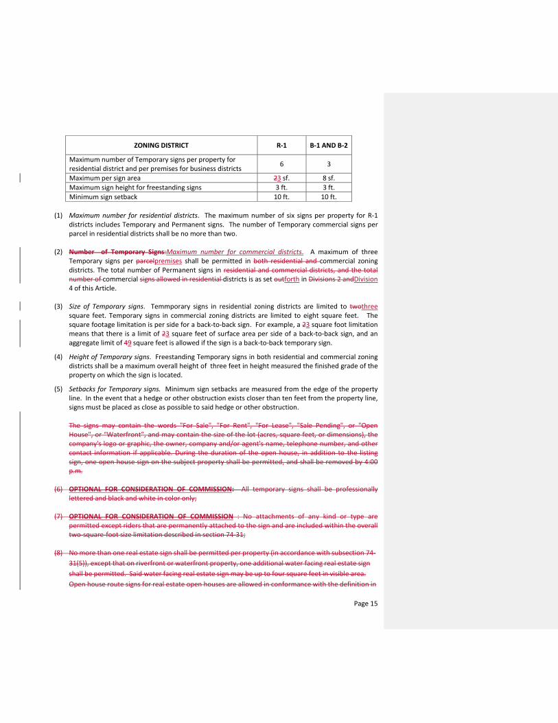
ZONING DISTRICT R-1 B-1 AND B-2
Maximum number of Temporary signs per property for residential district and per premises for business districts 6 3
Maximum per sign area 23 sf. 8 sf. Maximum sign height for freestanding signs 3 ft. 3 ft. Minimum sign setback 10 ft. 10 ft.
(1) Maximum number for residential districts. The maximum number of six signs per property for R-1 districts includes Temporary and Permanent signs. The number of Temporary commercial signs per parcel in residential districts shall be no more than two.
(2) Number of Temporary Signs:Maximum number for commercial districts. A maximum of three Temporary signs per parcelpremises shall be permitted in both residential and commercial zoning districts. The total number of Permanent signs in residential and commercial districts, and the total number of commercial signs allowed in residential districts is as set outforth in Divisions 2 andDivision 4 of this Article.
(3) Size of Temporary signs. Temmporary signs in residential zoning districts are limited to twothree square feet. Temporary signs in commercial zoning districts are limited to eight square feet. The square footage limitation is per side for a back-to-back sign. For example, a 23 square foot limitation means that there is a limit of 23 square feet of surface area per side of a back-to-back sign, and an aggregate limit of 49 square feet is allowed if the sign is a back-to-back temporary sign.
(4) Height of Temporary signs. Freestanding Temporary signs in both residential and commercial zoning districts shall be a maximum overall height of three feet in height measured the finished grade of the property on which the sign is located.
(5) Setbacks for Temporary signs. Minimum sign setbacks are measured from the edge of the property line. In the event that a hedge or other obstruction exists closer than ten feet from the property line, signs must be placed as close as possible to said hedge or other obstruction.
The signs may contain the words "For Sale", "For Rent", "For Lease", "Sale Pending", or "Open House", or “Waterfront”, and may contain the size of the lot (acres, square feet, or dimensions), the company's logo or graphic, the owner, company and/or agent's name, telephone number, and other contact information if applicable. During the duration of the open house, in addition to the listing sign, one open house sign on the subject property shall be permitted, and shall be removed by 4:00 p.m.
(6) OPTIONAL FOR CONSIDERATION OF COMMISSION: All temporary signs shall be professionally
lettered and black and white in color only;
(7) OPTIONAL FOR CONSIDERATION OF COMMISSION : No attachments of any kind or type are permitted except riders that are permanently attached to the sign and are included within the overall two-square-foot size limitation described in section 74-31;
(8) No more than one real estate sign shall be permitted per property (in accordance with subsection 74-31(5)), except that on riverfront or waterfront property, one additional water facing real estate sign shall be permitted. Said water facing real estate sign may be up to four square feet in visible area. Open house route signs for real estate open houses are allowed in conformance with the definition in
Page 15

74-26. Signs may be posted on the day of the open house no earlier than 10:00 a.m. and must be removed by 4:00 p.m. No more than one open house route sign is permitted.
The use of open house route signs for open houses is limited to Saturdays and Sundays only, except for the quarterly open houses held by the Realtor's Association.
(6) Open house route signs are not permitted within 100 feet of the intersection of Sewall's Point Road and East Ocean Boulevard. Said distance shall be measured from each corner of the intersection.Signs required by law. Temporary government signs and Temporary signs that are required by law, rule or regulation shall be exempt from the criteria set forth in this section.
Secs. 74-133—74-149. - Reserved.
DIVISION 6. - PROHIBITED SIGNS
Sec. 74- 150. Prohibited signs. The following signs shall not be erected, placed or maintained in any zoning district and are prohibited, unless specifically permitted elsewhere in this sign code:
(1) Any sign which obstructs the view of bicyclists or motorists using any street, approach to any street intersection, or which interferes with the effectiveness of or obscures any traffic sign, device, or signal.
(2) Signs that by reason of position, shape, or color, would conflict with the proper function of any traffic sign or signal, or be of a size, location, movement, content, color, or illumination that may be reasonably confused with or construed as, or conceal, a traffic control device.
(3) Snipe signs. (4) Off-premises signs. This provision expressly prohibits any business from maintaining Vehicle signs are
prohibited in residential districts unless otherwise authorized in section 42-24 of this Code or unless the driver of the vehicle signs anywhere within the Townwith the Vehicle sign is making a delivery at the residence and is parked at the residence no longer than 30 minutes. Vehicle signs are prohibited in non-residential districts except during regularnormal business hours; provided, however, that vehiclesduring other hours, Vehicle signs are permitted for a reasonable time in non-residential districts, not to exceed four hours, forif one of the purpose offollowing applies:
a. The driver of the vehicle with the Vehicle sign is patronizing the location at which they are parked; or
b. The vehicle with the Vehicle sign is parked at the location of the business advertised on such Vehicle sign and it is during the business’ regular hours of operation;
(5) Signs erected, constructed, or maintained so as to obstruct any fire escape or any window or door or opening used as a means of ingress or egress.
(6) Any sign (other than a government sign), banner, or display placed on any curb, street, sidewalk, post, pole, hydrant, bridge, tree, or other surface located on, over, or across any public street or right-of-way, or other public property, or located on town owned property. Such signs shall immediately be removed by the town's police department or other designee of the town commission.
(7) Animated signs of any kind. (8) Signs containing any type of reflective, fluorescent, or fluorescent-like paint or materials of any kind. (9) Sign spot lights or flood lamps and any exposed incandescent lamps larger than fifteen watts unless
shielded to prevent glare upon a public right-of-way or adjacent property. Any sign lights that hamper the vision of motorists or bicyclists.
(10) Neon lighting or strip lighting in any fashion when the actual lights or tubes can be seen from any street or right-of-way or adjacent property.
(11) Signs with the optical illusion of movement by means of a design that presents a pattern capable of giving the illusion of motion or changing copy.
Page 16

(12) Signs containing extruding figures, waving or fluttering, or any device to attract attention; flags, or banners.
(13) Signs that emit odor, or visible matter such as smoke or steam. (14) Signs in non-residentially zoned areas which face residential property other than traffic signs. (15) In residentially zoned areas, signs closer than 100 feet from the property line of an adjacent
residential property. (16) Signs that contain any obscene copy. (17) Abandoned signs. (18) Signs which emit or utilize in any manner any sound capable of being detected by a person with
normal hearing. (19) Balloons or inflatable signs of any kind, except for private parties held in individual residences.
Sec. 74-151 - Nonconforming signs. Any nonconforming sign pursuant to the regulations of this chapter, which was lawfully in existence prior to the adoption of this chapter, shall be allowed to remain as a legal nonconforming structure, pursuant to the requirements of Chapter 82, Zoning, Article III, Nonconformities, except as followsand subject to the following limitations:
(1) The sign may not be altered, expanded or extended in any way unless to bring it into conformity except that business occupant name changes on existing menu type signs may be changed to reflect a new business occupant or a business name change. Except as otherwise set forth in this code, normal repair and maintenance, including necessary nonstructural repairs and incidental work which does not extend or intensify the noncomplying features of the sign, may be performed.
(2) No nonconforming sign shall be moved, in whole or in part, to any other location where it would remain noncomplying.
(2)(3) If a nonconforming sign is destroyed or damaged by any means to an extent of 50 percent or more of its replacement costs at the time of destruction or damage, it shall not be reconstructed or repaired except in conformance with this sign code.
(3)(4) Perimeter Wall or Entry Feature Identification signs in residential zones, existing, and in place, as of the date of this chapter shall be exempt from compliance with this code. Replacements for existing neighborhood Perimeter Wall or Entry Feature Identification signs must comply with this code.
(4)(5) Signs which are not in compliance with this chapter on the effective date of this sign code, ______________________, 2016, shall be brought into compliance within four (4) years of such effective date. If a property owner or its representative applies for a permit for a new sign on the property and that sign will increase the overall square footage of existing signage on the property, then the owner shall be required to bring all nonconforming signs on the property into compliance with this code within one calendar year from the date of the installation of any such new sign onor within four (4) years of the propertyeffective date of this sign code, whichever is sooner.
Sec. 74-151 - Permits.
(a) It shall be unlawful for any entity or person to erect, construct, alter, enlarge, move, or replace any permanent sign or cause the same to be done, without first having obtained a building permit for the sign. The building official, in his or her sole discretion, may exempt a permanent sign from the permit requirement if the work to be done is of such a minor nature that the protections of the building permit are not necessary, and such permit is not otherwise required under the Florida Building Code or other statute, ordinance, rule or regulation.
(b) Government signs are exempt from the requirements of this section. (b)(c) A fee in accordance with a fee schedule adopted by resolution of the town commission, as
noted in section 4-18(b) supplemental fees50-102, shall be charged for each building permit issued excepted as provided elsewhere in this chapter.
(c)(d) The permit fee shall be waived for a one time replacement of permitted signs in existence on the date of this chapter, which were made non-conforming by virtue of this chapter.
Page 17

(d)(e) All permanent signs shall conform to all applicable building codes. (e)(f) A building permit for a permanent sign shall become null and void unless the construction is
complete and a certificate of completion from the Building Department is issued within three months after the effective date of the issuance of the permit.
Sec. 74-152. - Variance. There shall be no process by which an applicant may seek a legal variance from the terms of this sign code.
Page 18

TOWN OF SEWALL’S POINT
PAMELA MAC’KIE WALKER Town Manager
TO: Town of Sewall’s Point Commission FROM: Pamela Mac’Kie Walker, Town Manager SUBJECT: Agenda Item 5 Award Bid #2015-001 and #2015-002
Town Commission Meeting, January 26, 2016
BACKGROUND: On January 1, 2016, the Town posted a Request for Bids for a replacement pond fountain, and various carpentry repair/remodel projects for the park playground equipment, minor Town Hall remodeling, and repair work on two storage sheds in compliance with the Town’s purchasing ordinance. At noon on August 10, 2014, the following bids were opened: Town Commons Park Fountain:
1. Tin Shark Fountainworks, LLC - $5,350.00. This bid is for the fountain and controls only. Installation of the fountain, electrical hook up, and accessory work to be provided by the town. We recommend and additional maximum of $2,500.00 be budgeted for installation. This is the only bid received for this item.
Town Hall Construction:
1. Paul Ghiotto, Inc. - $12,709.20 2. Masterpiece Builders, Inc. $8,431.50
Attached is the descriptions and specifications for the for the carpentry projects. Item “F” Entry Desk is not included at this time in the bid. We will present it at a later date and provide a sketch. Copies of the bid document and responses are available in the Town Clerk’s office. RECOMMENDATION: Staff respectfully recommends that Bid #2015-1 for Town Commons Fountain be awarded to Tin Shark Fountainworks, LLC., and Bid #2015-2 Town Hall Town Common Modification be awarded to Masterpiece Builders, Inc.
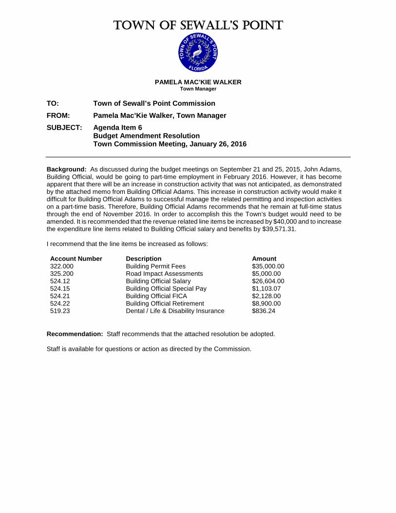
TOWN OF SEWALL’S POINT
PAMELA MAC’KIE WALKER Town Manager
TO: Town of Sewall’s Point Commission FROM: Pamela Mac’Kie Walker, Town Manager SUBJECT: Agenda Item 6 Budget Amendment Resolution Town Commission Meeting, January 26, 2016 Background: As discussed during the budget meetings on September 21 and 25, 2015, John Adams, Building Official, would be going to part-time employment in February 2016. However, it has become apparent that there will be an increase in construction activity that was not anticipated, as demonstrated by the attached memo from Building Official Adams. This increase in construction activity would make it difficult for Building Official Adams to successful manage the related permitting and inspection activities on a part-time basis. Therefore, Building Official Adams recommends that he remain at full-time status through the end of November 2016. In order to accomplish this the Town’s budget would need to be amended. It is recommended that the revenue related line items be increased by $40,000 and to increase the expenditure line items related to Building Official salary and benefits by $39,571.31. I recommend that the line items be increased as follows: Account Number Description Amount 322.000 Building Permit Fees $35,000.00 325.200 Road Impact Assessments $5,000.00 524.12 Building Official Salary $26,604.00 524.15 Building Official Special Pay $1,103.07 524.21 Building Official FICA $2,128.00 524.22 Building Official Retirement $8,900.00 519.23 Dental / Life & Disability Insurance $836.24
Recommendation: Staff recommends that the attached resolution be adopted. Staff is available for questions or action as directed by the Commission.

DAN MORRIS Mayor TOWN OF SEWALL’S POINT
PAMELA MAC’KIE WALKER
Town Manager JAMES W. CAMPO, C.F.P. Vice Mayor
LAKISHA Q. BURCH, CMC
Town Clerk VINCENT N. BARILE Commissioner
TINA CIECHANOWSKI
Chief of Police PAUL LUGER Commissioner
JOHN ADAMS
Building & Facilities Director JACQUI THURLOW-LIPPISCH Commissioner
INTER-OFFICE MEMORANDUM DATE: January 14, 2016 TO: Pamela Mac’Kie Walker, Town Manager FROM: John Adams, CBO, Building Official SUBJECT: Extension of full time employment and budget adjustment. Due to a major uptick in building activity that I am aware of in the 2016 calendar year, I would like to propose extending my full time employment until November 2016. As you know I am scheduled to start part time employment February 1, 2016 and work 3 days a week, but over the past two months it has become apparent that there is a large amount of activity in the pipeline. The following is a list of properties that have had serious inquiries regarding new Single Family development activities.
1. Lot 38 Castle Hill 2. 6 River Oak Place 3. Lot 70 Plumeria Place 4. Lot 35 Lantana Lane 5. 8 Cranes Nest 6. 19 Simara Street 7. 141 S. River Road 8. Lot 40 High Point (Middle Road) 9. 36 E. High Point Rd. 10. 19 E. High Point Road. 11. 14 Island Road (Guest House.
For example if a permit is submitted with a $500,000 value the building permit fees, which the Town would earn are: Plan Submittal Fee $350.00 Building Fee (2% of construction value) $10,000.00 Technology Fee (0.04% of construction value) $200.00 Road Impact Assessment (0.4% of construction value) $2,000.00 TOTAL $12,550.00 If all the property were to be permitted during this fiscal year it would equal an additional $113,850 in building (2% of construction value) and plan submittal fees to the town that were not accounted for in the current budget. However, I am also proposing a conservative $40,000.00 increase to the Building Department Revenue.
One South Sewall 's Point Road, Sewall 's Point, Flor ida 34996 Town Hal l (772 ) 287-2455 • Fax (772 ) 220-4765 • E-Mai l : pwalker@sewa l lspo in t .o rg Po l i ce Depar tment (772) 781-3378 • Fax (772 ) 286-7669 • E-Mai l : sppd@sewal l spo in t .o rg
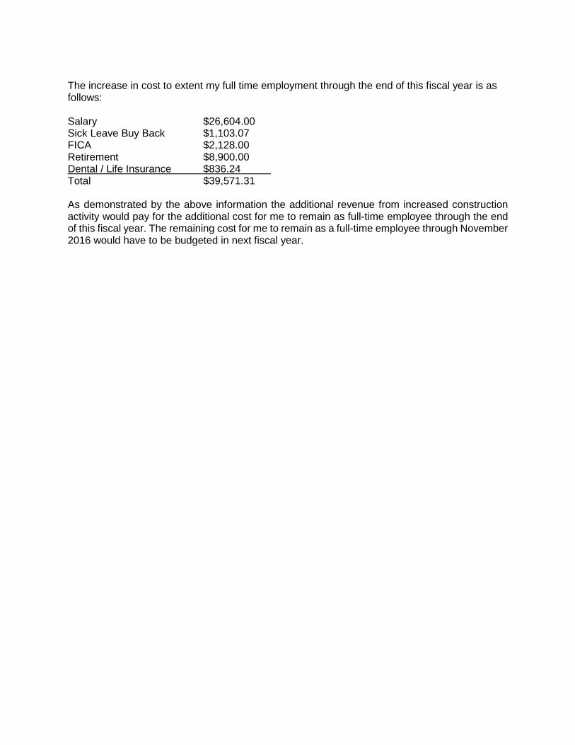
The increase in cost to extent my full time employment through the end of this fiscal year is as follows: Salary $26,604.00 Sick Leave Buy Back $1,103.07 FICA $2,128.00 Retirement $8,900.00 Dental / Life Insurance $836.24 Total $39,571.31 As demonstrated by the above information the additional revenue from increased construction activity would pay for the additional cost for me to remain as full-time employee through the end of this fiscal year. The remaining cost for me to remain as a full-time employee through November 2016 would have to be budgeted in next fiscal year.
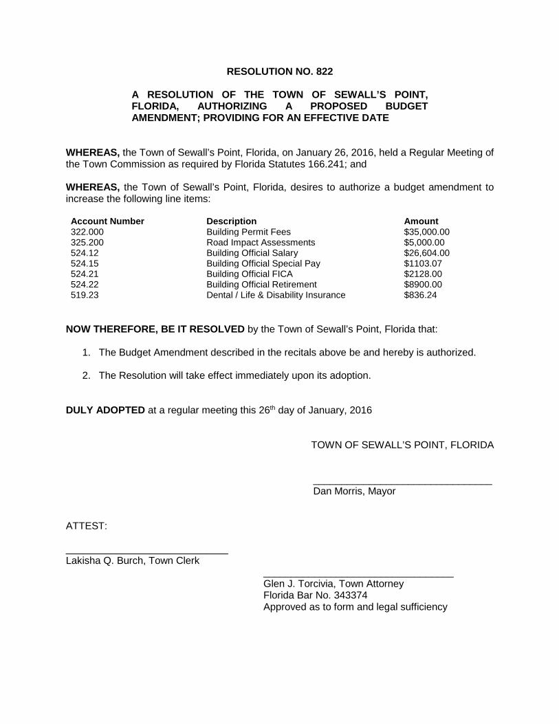
RESOLUTION NO. 822
A RESOLUTION OF THE TOWN OF SEWALL’S POINT, FLORIDA, AUTHORIZING A PROPOSED BUDGET AMENDMENT; PROVIDING FOR AN EFFECTIVE DATE
WHEREAS, the Town of Sewall’s Point, Florida, on January 26, 2016, held a Regular Meeting of the Town Commission as required by Florida Statutes 166.241; and WHEREAS, the Town of Sewall’s Point, Florida, desires to authorize a budget amendment to increase the following line items: Account Number Description Amount 322.000 Building Permit Fees $35,000.00 325.200 Road Impact Assessments $5,000.00 524.12 Building Official Salary $26,604.00 524.15 Building Official Special Pay $1103.07 524.21 Building Official FICA $2128.00 524.22 Building Official Retirement $8900.00 519.23 Dental / Life & Disability Insurance $836.24
NOW THEREFORE, BE IT RESOLVED by the Town of Sewall’s Point, Florida that:
1. The Budget Amendment described in the recitals above be and hereby is authorized.
2. The Resolution will take effect immediately upon its adoption.
DULY ADOPTED at a regular meeting this 26th day of January, 2016
TOWN OF SEWALL’S POINT, FLORIDA ________________________________ Dan Morris, Mayor ATTEST: _____________________________ Lakisha Q. Burch, Town Clerk __________________________________ Glen J. Torcivia, Town Attorney Florida Bar No. 343374 Approved as to form and legal sufficiency

TOWN OF SEWALL’S POINT
PAMELA MAC’KIE WALKER Town Manager
TO: Town of Sewall’s Point Commission FROM: Pamela Mac’Kie Walker, Town Manager SUBJECT: Agenda Item 7 Resolution to Adopt the 2015 Martin County Unified Local Mitigation Strategy Town Commission Meeting, January 26, 2016 Background: Every five (5) years Martin County updates the Unified Local Mitigation Strategy and the latest update was adopted by Martin County on December 1, 2015. Attached is a memorandum from Joe Capra, Captec Engineering, explaining the process and its impacts on the Town of Sewall’s Point. Attached is the resolution and the 2015 Martin County Unified Local Mitigation Strategy for your review. Recommendation: That the Commission approve on the resolution adopting the 2015 Unified Local Mitigation Strategy.
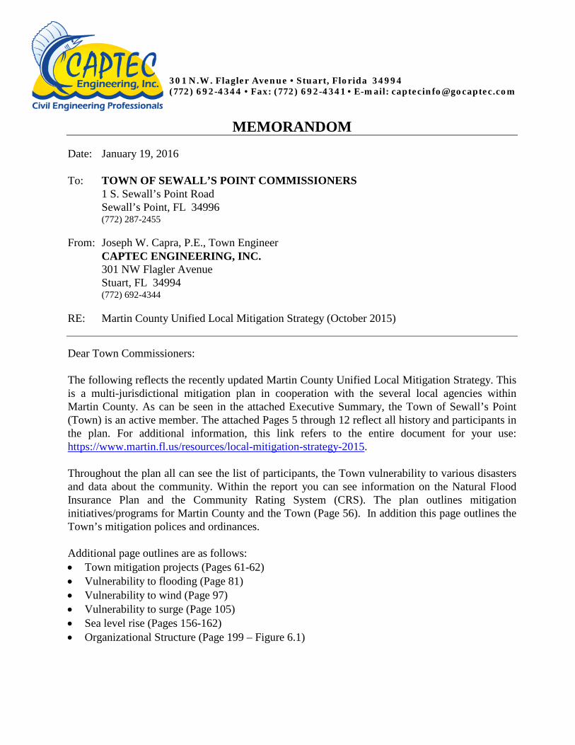
301 N.W. Flagler Avenue • Stuart, Florida 34994 (772) 692-4344 • Fax: (772) 692-4341 • E-mail: [email protected]
MEMORANDOM Date: January 19, 2016 To: TOWN OF SEWALL’S POINT COMMISSIONERS
1 S. Sewall’s Point Road Sewall’s Point, FL 34996 (772) 287-2455
From: Joseph W. Capra, P.E., Town Engineer CAPTEC ENGINEERING, INC. 301 NW Flagler Avenue Stuart, FL 34994 (772) 692-4344
RE: Martin County Unified Local Mitigation Strategy (October 2015)
Dear Town Commissioners: The following reflects the recently updated Martin County Unified Local Mitigation Strategy. This is a multi-jurisdictional mitigation plan in cooperation with the several local agencies within Martin County. As can be seen in the attached Executive Summary, the Town of Sewall’s Point (Town) is an active member. The attached Pages 5 through 12 reflect all history and participants in the plan. For additional information, this link refers to the entire document for your use: https://www.martin.fl.us/resources/local-mitigation-strategy-2015. Throughout the plan all can see the list of participants, the Town vulnerability to various disasters and data about the community. Within the report you can see information on the Natural Flood Insurance Plan and the Community Rating System (CRS). The plan outlines mitigation initiatives/programs for Martin County and the Town (Page 56). In addition this page outlines the Town’s mitigation polices and ordinances. Additional page outlines are as follows: • Town mitigation projects (Pages 61-62) • Vulnerability to flooding (Page 81) • Vulnerability to wind (Page 97) • Vulnerability to surge (Page 105) • Sea level rise (Pages 156-162) • Organizational Structure (Page 199 – Figure 6.1)

Page 2 of 2
JWC/gc P:\000\023\023.108 - LMS\Commissioner Mtg memo-011916.doc
The plan outlines projects that the Town may want to proceed with in the future to help mitigate any disasters that could strike the Town. The projects previously listed, but reviewed are depicted on Page 209. The proposed Town projects are listed on Page 213. The projects are listed County-wide and ranked for prioritization. The Town Hall is noted on Page 244. The Town list is depicted on Page 213. These projects have been briefly discussed by the Town Commission in past years. The purpose program will give the County access to emergency hazardous grant funding which in turn gives the Town access to the same funding. The LMS plan is updated in a 5-year cycle. Please contact me if you should have any questions.

Martin County
Unified Local Mitigation
Strategy
Martin County, Florida October 2015

2

3
Contents ACKNOWLEDGEMENTS ........................................................................................................................ 5
EXECUTIVE SUMMARY ......................................................................................................................... 5
INTRODUCTION .................................................................................................................................... 6
EXECUTIVE SUMMARY ......................................................................................................................... 6
OVERVIEW ....................................................................................................................................... 6
INITIAL HAZARDS IDENTIFICATION .................................................................................................. 8
INITIATING ACTION ........................................................................................................................ 11
THE PROCESS ................................................................................................................................. 11
FINDINGS ....................................................................................................................................... 11
PROJECT PRIORITIZATION LIST (PPL) ............................................................................................. 12
UPDATING PROCESS ...................................................................................................................... 12
PURPOSE AND OVERVIEW ................................................................................................................. 13
1.1 PURPOSE ............................................................................................................................ 13
1.2 PLANNING PROCESS........................................................................................................... 15
1.3 PUBLIC PARTICIPATION PROCESS ...................................................................................... 17
COMMUNITY PROFILE ....................................................................................................................... 21
2.1 GEOGRAPHY ....................................................................................................................... 21
2.2 POPULATION ...................................................................................................................... 22
2.3 INFRASTRUCTURE .............................................................................................................. 24
2.4 PROPERTY AND DEVELOPMENT ........................................................................................ 25
2.5 ECONOMIC RESOURCES ..................................................................................................... 32
2.6 ENVIRONMENTAL RESOURCES .......................................................................................... 33
2.7 HISTORIC AND CULTURAL RESOURCES .............................................................................. 33
2.8 CRITICAL FACILITIES ........................................................................................................... 33
INSTITUTIONAL ANALYSIS .................................................................................................................. 35
3.1 FEDERAL GOVERNMENT .................................................................................................... 35
3.2 NON-GOVERNMENT .......................................................................................................... 40
3.3 STATE GOVERNMENT ........................................................................................................ 41
3.4 REGIONAL GOVERNMENT .................................................................................................. 43
3.5 COUNTY GOVERNMENT ..................................................................................................... 46
3.6 MUNICIPALITIES ................................................................................................................. 56
3.7 COMMUNITY ORGANIZATIONS ......................................................................................... 64

4
3.8 INTERGOVERNMENTAL COORDINATION ........................................................................... 64
3.9 STRENGTHENING THE ROLE OF LOCAL GOVERNMENT ..................................................... 65
3.10 PRIVATE SECTOR BACKGROUND AND ANALYSIS ............................................................... 67
HAZARD IDENTIFICATION, VULNERABILITY, AND RISK ...................................................................... 69
4.1 NATURAL HAZARDS ........................................................................................................... 72
4.2 OTHER NATURAL HAZARDS ............................................................................................. 140
4.3 TECHNOLOGICAL HAZARDS ............................................................................................. 168
4.4 SOCIETAL HAZARDS.......................................................................................................... 183
4.5 SUMMARY ........................................................................................................................ 187
MITIGATION OPTIONS ..................................................................................................................... 188
5.1 MITIGATION DEFINITION AND INTRODUCTION .............................................................. 188
5.2 MITIGATION CATEGORIES ................................................................................................ 188
5.3 MITIGATION OPTIONS BY CATEGORY .............................................................................. 188
5.4 MITIGATION OPTIONS BY HAZARD .................................................................................. 190
5.5 MITIGATION OPTIONS ADDRESSING SPECIAL ISSUES ...................................................... 191
5.6 MITIGATION IN DEPTH ..................................................................................................... 193
IMPLEMENTATION PROGRAM ......................................................................................................... 197
6.1 INTRODUCTION ................................................................................................................ 197
6.2 INSTITUTIONAL ARRANGEMENT ...................................................................................... 197
6.3 IMPLEMENTATION STRATEGY ......................................................................................... 200
6.4 INTEGRATION INTO LOCAL PLANS ................................................................................... 203
6.5 PLAN MONITORING ......................................................................................................... 205
6.6 UPDATING THE PLAN ....................................................................................................... 206
6.7 CONTINUING PUBLIC INVOLVEMENT .............................................................................. 224
6.8 CONFLICT RESOLUTION.................................................................................................... 225
6.9 FUNDING .......................................................................................................................... 227
Appendix A – Acronyms ...................................................................................................................... 228
Appendix B – Facilities List and Hazards ............................................................................................. 232
Appendix C – Forms ............................................................................................................................ 246
Appendix D – Stakeholder Participation ............................................................................................. 252
Appendix E – References .................................................................................................................... 291
Appendix F – Adoption Resolutions .................................................................................................... 296

5
ACKNOWLEDGEMENTS
Martin County Fire Rescue’s Emergency Management Agency engaged a number of community
stakeholders and utilized a variety of data sources to complete this update to the Martin County Local
Mitigation Strategy (LMS).
The LMS Committee is comprised of agency representatives from five jurisdictions in Martin County, as
well as the Martin County School District, Martin Health Systems, and Florida Forest Service, private
firms and the public to develop strategies to prepare for disasters, was crucial to the development of
this plan.
In addition, students at Indian River State College utilized historical data and information from the
National Climatic Data Center; the National Oceanic and Atmospheric Administration; Hazus-MH; Martin
County’s Information Technology Department, Building Department, and Engineering Department;
Treasure Coast Regional Planning Council, and the Florida Forest Service to update this document with
the “best available” climate and hazard vulnerability data.
EXECUTIVE SUMMARY
This is a multi-jurisdictional hazard mitigation plan, and the planning effort has been conducted through
the coordinated, cooperative effort of several local governments within Martin County. In August and
November 2014. These local governments include Martin County, the City of Stuart, the Town of Jupiter
Island, the Town of Sewall’s Point, and the Town of Ocean Breeze. All agencies have provided
vulnerability and mitigation strategies to culminate the publication of this 2015 update of the “Martin
County Unified Local Hazard Mitigation Strategy.”
For this 2015 update, a new project prioritization methodology was introduced for consideration. With
the updated analysis, student worked to identify, justify and coordinate the prioritization of projects for
each participating agency. These projects are aimed to avoid or minimize vulnerabilities in the future.
These proposed projects and programs are also referred to as “Mitigation Measure Projects or
Initiatives” in this document.
A final draft has been presented to the Local Mitigation Strategy Committee for review and comment.
Once all concerns have been address, a public comment and public presentation will be held. After two
weeks of public comment, all concerns will be returned to the LMS Committee to be addressed.
This update has been submitted to the Florida Division of Emergency Management (FDEM), who also
has the authority to review the document on behalf of the Federal Emergency Management Agency
(FEMA), for review in comparison to the requirements from the Local Mitigation Plan Review Guide,
revised by FEMA in March 2013. Once notified that this draft adequately addresses all requirements of
the 44 CFR §201.6 (Local Mitigation Plans, the plan will be submitted to the participating jurisdictions’
governing bodies for formal adoption and approval. Adoption resolutions can be found in Appendix F.
The final draft plan will be submitted to the governing bodies of the participating jurisdictions for final
approval and adoption. Consistent with the normal practices of the participating jurisdictions, which
conduct meetings in accordance with Florida’s open meetings statutes, the public will have an
opportunity to comment upon each jurisdiction’s adoption of the plan during public meetings. In

6
accordance with Federal practice, the participating local jurisdictions have one year from the date of
State approval of the plan to complete the formal adoption.
This plan will continue to be updated in the future to ensure it addresses changing conditions in the
participating jurisdictions, experiences with disasters that occur and any changes in the characteristics of
the hazards that threaten the involved communities. This updating process and future editions of the
local mitigation strategy will also be used to inform and involve the public, and other interested groups,
in an effort to elicit their participation in making the community more resilient to the impacts of future
disasters.
INTRODUCTION
Martin County, the municipalities within it, districts, public and private entities have engaged in
mitigation planning since 1998 to make the population, neighborhoods, businesses and institutions of
the community more resistant to the impacts of future disasters. The group has been undertaking a
comprehensive, detailed evaluation of the vulnerabilities of the community to all types of natural,
technological and societal hazards in order to identify ways to make the communities of the planning
area more resilient to their impacts. This document reports the results of that planning process for the
current planning period as indicated in the below table:
Table 1.0 – Planning Schedule
Start of Planning Anticipated Completion Date Plan Released
10/1/2008 6/1/2010 12/9/2010
9/5/2014 11/1/2015 TBA
EXECUTIVE SUMMARY
OVERVIEW
Martin County is one of Florida’s 67 counties. It is located on Florida’s east coast in south central Florida
and is bordered by 21 miles of coastline with two inhabited barrier islands. Martin County’s population
in 2010 was 147, 492 according to the United States Census Bureau. Martin County has one ocean
access inlet, St. Lucie Inlet. The St. Lucie Inlet is a manmade federal inlet that is Martin County’s only
point of access to the Atlantic Ocean—it separates the barrier islands of Hutchinson Island to the north
and Jupiter Island to the south. The inlet connects the Atlantic Ocean to several waterways, including
the Indian River Lagoon, the St. Lucie River, the Hobe Sound Narrows and the Intracoastal Waterway.
There are several stakeholders in mitigating risks within Martin County; one unincorporated county, four
incorporated cities, a school district, one state entity, not-for-profit community advocate group for
challenged citizens and one not-for-profit community-based health care organization. Those entities
are:
Martin County;
City of Stuart;
Town of Jupiter Island;
Town of Sewall’s Point;
Town of Ocean Breeze;
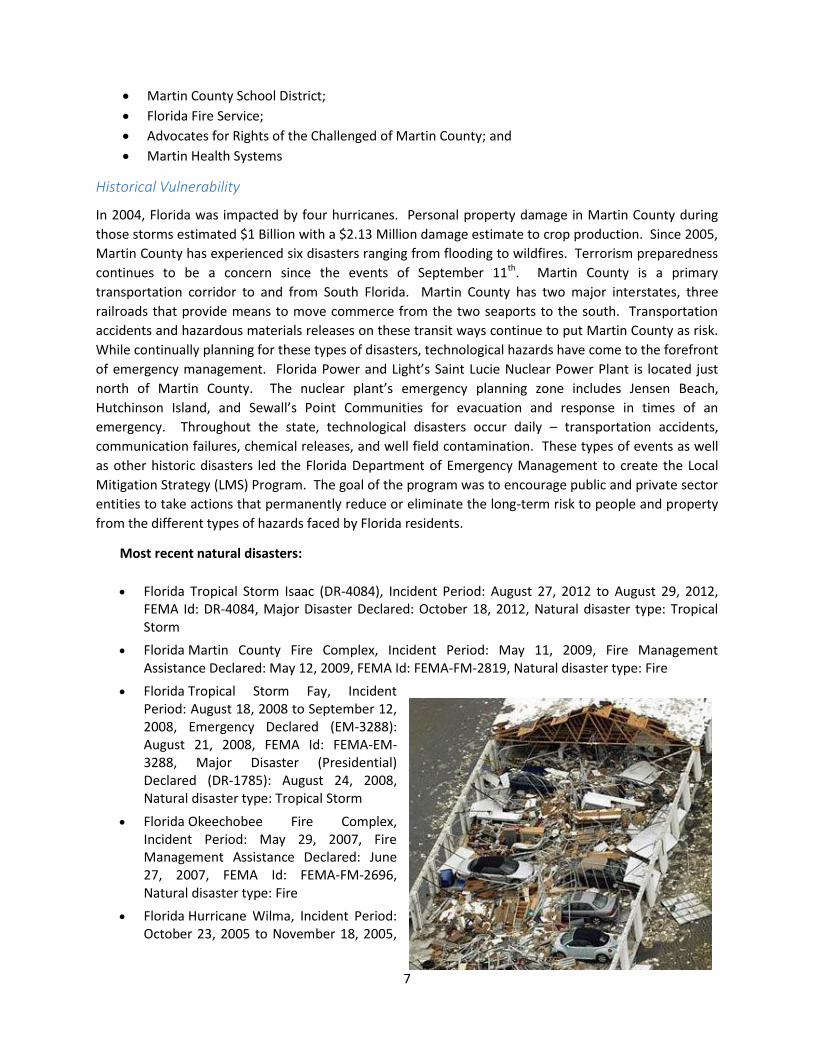
7
Martin County School District;
Florida Fire Service;
Advocates for Rights of the Challenged of Martin County; and
Martin Health Systems
Historical Vulnerability
In 2004, Florida was impacted by four hurricanes. Personal property damage in Martin County during
those storms estimated $1 Billion with a $2.13 Million damage estimate to crop production. Since 2005,
Martin County has experienced six disasters ranging from flooding to wildfires. Terrorism preparedness
continues to be a concern since the events of September 11th. Martin County is a primary
transportation corridor to and from South Florida. Martin County has two major interstates, three
railroads that provide means to move commerce from the two seaports to the south. Transportation
accidents and hazardous materials releases on these transit ways continue to put Martin County as risk.
While continually planning for these types of disasters, technological hazards have come to the forefront
of emergency management. Florida Power and Light’s Saint Lucie Nuclear Power Plant is located just
north of Martin County. The nuclear plant’s emergency planning zone includes Jensen Beach,
Hutchinson Island, and Sewall’s Point Communities for evacuation and response in times of an
emergency. Throughout the state, technological disasters occur daily – transportation accidents,
communication failures, chemical releases, and well field contamination. These types of events as well
as other historic disasters led the Florida Department of Emergency Management to create the Local
Mitigation Strategy (LMS) Program. The goal of the program was to encourage public and private sector
entities to take actions that permanently reduce or eliminate the long-term risk to people and property
from the different types of hazards faced by Florida residents.
Most recent natural disasters:
Florida Tropical Storm Isaac (DR-4084), Incident Period: August 27, 2012 to August 29, 2012, FEMA Id: DR-4084, Major Disaster Declared: October 18, 2012, Natural disaster type: Tropical Storm
Florida Martin County Fire Complex, Incident Period: May 11, 2009, Fire Management Assistance Declared: May 12, 2009, FEMA Id: FEMA-FM-2819, Natural disaster type: Fire
Florida Tropical Storm Fay, Incident Period: August 18, 2008 to September 12, 2008, Emergency Declared (EM-3288): August 21, 2008, FEMA Id: FEMA-EM-3288, Major Disaster (Presidential) Declared (DR-1785): August 24, 2008, Natural disaster type: Tropical Storm
Florida Okeechobee Fire Complex, Incident Period: May 29, 2007, Fire Management Assistance Declared: June 27, 2007, FEMA Id: FEMA-FM-2696, Natural disaster type: Fire
Florida Hurricane Wilma, Incident Period: October 23, 2005 to November 18, 2005,

8
Major Disaster (Presidential) Declared (DR-1609): October 24, 2005, FEMA Id: FEMA-DR-1609, Natural disaster type: Hurricane
Florida Hurricane Katrina Evacuation, Incident Period: August 29, 2005 to October 1, 2005, Emergency Declared (EM-3220): September 5, 2005, FEMA Id: FEMA-EM-3220, Natural disaster type: Hurricane
Florida Hurricane Jeanne, Incident Period: September 24, 2004 to November 17, 2004, Major Disaster (Presidential) Declared (DR-1561): September 26, 2004, FEMA Id: FEMA-DR-1561, Natural disaster type:
Hurricane Florida Hurricane Ivan, Incident Period: September 13, 2004 to November 17, 2004, Major Disaster (Presidential) Declared (DR-1551): September 16, 2004, FEMA Id: FEMA-DR-1551, Natural disaster type: Hurricane
Florida Hurricane Frances, Incident Period: September 3, 2004 to October 8, 2004, Major Disaster (Presidential) Declared (DR-1545): September 4, 2004, FEMA Id: FEMA-DR-1545, Natural disaster type: Hurricane
Florida Hurricane Charley and Tropical Storm Bonnie, Incident Period: August 11, 2004 to August 30, 2004, Major Disaster (Presidential) Declared (DR-1539): August 13, 2004, FEMA Id: FEMA-DR-1539, Natural disaster type: Tropical Storm, Hurricane
12 other natural disasters have been reported since 1953 (City-Data.com, 2015).
Both public and private sectors win by developing an LMS. It leads to
reducing future vulnerability to disasters;
reducing the time (and cost) of recovery from such events when they do happen;
minimizing disruption to the local economy;
facilitating recovery and the receipt of post-disaster funding; and
educating and informing the public about hazards and steps they can take to mitigate the effects.
INITIAL HAZARDS IDENTIFICATION
Martin County is vulnerable to a wide range of natural and human-caused hazards that threaten life and
property. FEMA’s current regulations and guidance under the Disaster Mitigation Act of 2000 (DMA
2000) require, at a minimum, an evaluation of a full range of natural hazards. An evaluation of human-
caused hazards (i.e. technological hazards, terrorism) is encouraged, though not required for a plan
approval. The initial identification of hazards for inclusion in the risk assessment was based on earlier
versions of the Martin County LMS, as well as a review of the State of Florida Hazard Mitigation Plan and
FEMA mitigation planning guidelines.
Each of the initially identified hazards was studied for their potential impact on Martin County as well as
in terms of the availability of hazard mitigation strategies to reduce that impact. Best available data on
historical occurrences, the geographical location and extent as well as the probability of future
occurrences have been collected and reviewed as part of the hazard identification process. Using this
data, the hazards included in Table 1.1a were selected as the main hazards of concern and they will be
described and analyzed fully in the following section.

9
Table 1.1a Hazards Vulnerability and Probability by Community
Hazard category
Vulnerability
Pro
bab
ility
Mar
tin
Co
un
ty
Stu
art
Sew
all’s
Po
int
Jup
iter
Isla
nd
Oce
an B
ree
ze
Jen
sen
Bea
ch
No
rth
Riv
er S
ho
res
Po
rt S
aler
no
Ho
be
Sou
nd
Ind
ian
tow
n
Natural Hazards
Flooding 3 3 3 3 2 3 3 3 3 3 H
Hurricanes/Tropical Storms 3 3 3 3 3 3 3 3 3 3 M
Tornadoes 2 2 2 2 2 2 2 2 2 2 M
Severe Thunderstorms 3 2 2 2 3 2 2 2 2 2 H
Wildland Fire 2 1 1 1 1 1 1 1 2 2 M
Erosion 2 1 1 2 1 1 1 1 1 1 M
Legend – see information following Table 1.1c
In addition, the remaining natural hazards are not main hazards of concern. Therefore, even though
these hazards were described, they were not selected for full analysis in this plan. Most of these hazards
have a low potential impact on Martin County and therefore, hazard mitigation strategies are not
provided. The remaining hazards are as follows:
Table 1.1b Other Natural Hazards Vulnerability and Probability by Community
Hazard category
Vulnerability
Pro
bab
ility
Mar
tin
Co
un
ty
Stu
art
Sew
all’s
Po
int
Jup
iter
Isla
nd
Oce
an B
ree
ze
Jen
sen
Bea
ch
No
rth
Riv
er S
ho
res
Po
rt S
aler
no
Ho
be
Sou
nd
Ind
ian
tow
n
Other Natural Hazards
Extreme Temperatures 1 1 1 1 1 1 1 1 1 1 L
Drought 2 1 1 1 1 2 1 2 2 3 L
Geologic Hazards 1 1 1 1 1 1 1 1 1 1 L
Tsunami 1 1 1 1 L
Sea Level Rise
Dam/Levee Failure 2 1 1 1 1 1 1 1 1 2 L
Legend – see information following Table 1.1c
Finally, the remaining are not natural hazards were studied for their potential impact on Martin County
as well as in terms of the availability of hazard mitigation strategies to reduce that impact. Best

10
available data on historical occurrences, the geographical location and extent as well as the probability
of future occurrences have been collected and reviewed as part of the hazard identification process.
Using this data, the hazards included in Table 1.1b will also be described and analyzed in the following
section.
Table 1.1c Technological and Societal Hazards Vulnerability and Probability by Community
Hazard category
Vulnerability
Pro
bab
ility
Mar
tin
Co
un
ty
Stu
art
Sew
all’s
Po
int
Jup
iter
Isla
nd
Oce
an B
ree
ze
Jen
sen
Bea
ch
No
rth
Riv
er S
ho
res
Po
rt S
aler
no
Ho
be
Sou
nd
Ind
ian
tow
n
Technological Hazards
Agricultural Pests and Diseases 2 1 1 1 1 1 1 1 1 2 L
Epidemics 2 1 1 1 1 1 1 1 1 2 L
Radiological Accidents 1 1 1 1 1 1 1 1 1 1 L
Power Failures 2 2 2 2 2 2 2 2 2 2 M
Hazardous Materials Accidents 3 3 1 1 1 3 1 3 3 3 M
Transportation System Accidents 2 3 1 1 2 2 2 3 3 3 M
Wellfield Contaminations 1 1 1 1 1 2 1 1 2 2 L
Communications Failures 2 2 2 2 1 2 2 2 2 2 L
Societal Hazards
Terrorism and Sabotage 1 1 1 1 1 1 1 1 1 1 L
Civil Disturbances 1 2 1 1 1 1 1 1 1 1 L
Immigration Crises 1 1 1 1 1 1 1 2 1 2 L
Legend (Tables 1.1) – Each hazard described in this section was rated by level of relative risk based on vulnerability and probability as follows:
Vulnerability – Based on the vulnerability of the hazard and on-going mitigation measures.
None – Either No possibility of damage, injury or death, or insufficient data 1 Low – Slight potential for damage, injury or death 2 Moderate – Potential for damage, injury or death 3 High – Strong potential for damage, injury or death
Probability – Based on historical data this scale takes into effect the likelihood that Martin County will be impacted by the hazard within a given period.
L Low – Although the hazard is noted, either no previous occurrence is recorded or the potential for the hazard to exist is only once every 10 years or more.
M Moderate – The potential is for the hazard to exist once every 5-10 years. H High – The potential is for the hazard to exist once every 1-5 years.
The Martin County Unified Local Mitigation Strategy (LMS) has incorporated hazard history that was
available. In the future, the LMS will incorporate continued hazard history.

11
INITIATING ACTION
In 1998, Martin County along with all the municipalities joined to develop a countywide LMS. The
committee focused on achieving two key results:
the creation of a long-term LMS planning process; and
the development of the LMS document itself along with a list of prioritized mitigation projects.
In the year 2000, the Federal Emergency Management Agency's (FEMA's) recognition of the growing
costs of responding to and recovering from disasters materialized in the Disaster Mitigation Act of 2000
(DMA 2000). DMA 2000 created a new Pre-Disaster Mitigation (PDM) Program aimed at reducing the
cost of disasters as well as risk through comprehensive planning before disasters occur. DMA 2000
requires that all communities, tribes, and states have a FEMA-approved hazard mitigation plan
consistent with the DMA 2000 requirements in place to retain eligibility for PDM project funds and post-
disaster Hazard Mitigation Grant Program funds. This plan was developed following the guidelines of
the DMA 2000.
THE PROCESS
The process by which the LMS was completed involved:
describing current community conditions;
identifying the potential hazards;
assessing each community's vulnerabilities to those specific hazards;
proposing initiatives to reduce these vulnerabilities;
developing evaluation criteria to rank mitigation projects regardless of jurisdiction; and
establish procedures that will be needed if the LMS Program is to retain long-term viability.
All of these aspects are integrated into this unified LMS document, which has been provided to Martin
County Fire Rescue’s Emergency Management Agency.
FINDINGS
Some of the key findings pertinent to Martin County include the following:
Flooding and hurricanes occur the most frequently; place the most people at risk, and produce
the greatest amount of damage of all the natural hazards faced by the County.
While wildland fires occur more frequently than flooding and hurricanes, but have a lower
impact on the community. Exposure to the impacts of wildland fire continues to increase as
urban interface areas are developed next to wildland areas.
Agriculture is an important component of the local economy; therefore, drought and
agricultural pests and disease are as important to the agricultural community as beach erosion
and flooding are to the coastal and intra-coastal communities.
While a major focus of mitigation is on retrofitting, the most effective time to mitigate is before
development orders are approved. Adding hazard mitigation requirements may add to the cost
of development, but this cost is relatively small. Following a disaster, the cost of recovery and
redevelopment can be enormous. Recovery cost tends to become public cost that local
governments must assume.
12
While all jurisdictions in Martin County are in the National Flood Insurance Program, not all
eligible local governments have participated in the Community Rating System Program (CRS) or
the Flood Mitigation Assistance (FMA) Program to the maximum extent possible. Having a
strong CRS Program reduces the cost of flood insurance premiums to Martin County residents,
and the FMA Program is a major source of funding to assist in retrofitting flooding problems.
Properties on the barrier islands are susceptible to both flooding and wind-related storm
damage. There are a number of important public facilities in those areas. By hardening these
facilities, the chance of their being impacted by storm events can be significantly reduced.
As the amount of transportation on Interstate 95 and the Florida Turnpike increases in the
future, the probability of truck rollovers and spilling of toxic contaminants will continue to
increase, and hazard management teams need to plan now for this eventuality.
The Florida East Coast and CSX Railroad passes through several densely populated areas of
coastal urban population and development, putting an ever-increasing number of people at risk
from train derailment and potentially significant toxic materials spills.
PROJECT PRIORITIZATION LIST (PPL)
The county, municipalities, and districts have already implemented numerous mitigation projects, such
as:
installing storm shutters on public buildings;
retrofitting stormwater drainage systems;
raising finished floor elevation to 18 inches above base flood elevation;
distributing informative publications on hurricanes to local residents; and
installing emergency generators at key critical facilities.
The objective of developing a unified, countywide PPL for mitigation projects is to allow the City and
County governments to better focus their mitigation efforts and dollars. The existence of this list will
speed local receipt of federal disaster mitigation funds after a disaster, and will place Martin County in a
more competitive position when competing for other, non-disaster-related mitigation grant funds.
To develop the PPL, each local government was invited to submit a list of mitigation projects for
inclusion in the unified, countywide list. A project prioritization methodology was developed by the
Steering Committee as a means of scoring each project, and developing a ranked list of projects.
Projects are ranked according to the stakeholders’ priority. Should funding become available during the
year, the Committee will review top projects to determine what projects should be submitted for
funding. The Martin County LMS Steering Committee last updated the PPL in January 2015.
The development of this PPL is not a one-time process. To be effective, this list must be dynamic. It will
need to be revised as old projects are accomplished and new hazards or increased vulnerabilities are
identified. The PPL process will be implemented on an ongoing basis.
UPDATING PROCESS
Like all local comprehensive planning efforts, the LMS itself will need to be reviewed and updated from
time to time to ensure that it adequately addresses the various types of hazards currently facing the
community. An LMS updating process was prepared and adopted by the Steering Committee. The
Martin County LMS will be updated every 5 years.

56
Table 3.5 Summary of Mitigation Initiatives/Programs for Martin County
Projects/Initiatives/Programs/Ordinances
Mar
tin C
ount
y
Em
erge
ncy
Man
agem
ent
Eng
inee
ring
Dep
artm
ent
Gen
eral
Ser
vice
s
Gro
wth
Man
agem
ent
Municipalities/Organizations
City
of
Stu
art
Tow
n of
Sew
all’s
Poi
nt
Tow
n of
Jupi
ter
Isla
nd
Tow
n of
Oce
an
Bre
eze
M
artin
Cou
nty
Sch
ools
Acquisition of Property X X
Retrofitting of Public Facilities X X X X X X X X
Structural Hazard Control X X X X X X X
Stormwater Drainage X X X X X
Beach Preservation X X X X
Warning Systems X X
Hazard Specific Building Codes/Development Regulations
X X X X X
Public Information Campaigns X X X X X X X X
Preparedness Training X X X X X X X X X
Maintenance Programs X X X X X X X X
Hazardous Materials Management X X
Emergency Operations Plans X X X X X X X X
Continuity of Operations Plans X X X X X X X X
Post Disaster Redevelopment Plan X X X X X X X X X
3.6 MUNICIPALITIES
There are four incorporated municipalities within Martin County. These are the Town of Jupiter Island,
the Town of Ocean Breeze, the Town of Sewall's Point, and the City of Stuart. Stuart is the County Seat.
All municipalities are chartered by the State of Florida and their forms of municipal government include
Council-Manager, Council-Mayor, and Mayor-Commission. Each municipality is internally organized in
the form of departments, divisions, and bureaus for the delivery of normal municipal services as
determined by the local representative government.
3.6.1 Listing of Agencies
Emergency Management
Emergency management responsibilities generally fall within the public safety, fire, and/or police
departments. In many municipality governments that emergency management is an individual's
secondary responsibility. During emergency events, such as hurricanes, municipalities have an
"executive group" (e.g., Mayor, City Manager, Police Chief, Fire Chief) that coordinates the
municipality's efforts with the Martin County EMA. The City of Stuart emergency management
functions are directed through the City Manager's office. The City of Stuart has an Emergency
Management Coordinator who works closely with the Police and Fire-Rescue Departments and
coordinates all emergency management planning for the entire City, under the direct supervision of the
City Manager. The Emergency Management Coordinator is the City's liaison with Martin County
Emergency Management and Florida DEM. Jupiter Island and Stuart are the only municipalities in Martin

59
Town of Sewall's Point
The Town of Sewall's Point lies on a peninsula of land between the Indian River Lagoon and the St. Lucie
River estuary. Floodplains on the eastern side and southern end within the Town of Sewall's Point are
identified on the FIRMs consist of V zones located along the east and west shorelines around the
peninsula. Zone “AE” extends 500 feet west of Sewall's Point Road. The Town is in the CRS Program.
Floodplain areas are regulated under the Town Flood Damage Prevention Ordinance, which was
developed by the Town in conjunction with the NFIP. This ordinance promotes public safety and general
welfare and attempts to minimize public and private losses due to flooding. Sewall's Point also has
designated CHHAs, which are subject to high velocity waves including storm associated surges. Primary
areas subject to flooding are Sewall's Point Road and the adjacent dwellings areas to the east and west
of the road right-of-way. The Town has enacted measures for structural modification to both
infrastructure and private construction in the CHHA to reduce exposure to damage from flooding. The
rebuilding of any structures 50% or more destroyed shall be prohibited, unless the reconstruction
complies with existing building codes and set back requirements. While Sewall's Point Road lies in an
area vulnerable to flooding, there is no viable potential for relocating this road. Relocation is not
feasible due to the high cost of land and the disruption of established residential neighborhoods. Martin
County EMA acts as the coordinator for the evacuation of all special needs residents during a natural
disaster event.
City of Stuart
Floodplains within the City of Stuart correspond to Zones "AE" and “VE” on the FIRM maps, and building
plans in undeveloped flood prone parcels are monitored accordingly. Any development adjacent to
water bodies within the City's boundary is carefully reviewed to make certain it does not interfere with
existing drainage or increase the potential for flooding. The City monitors its storm water management
and flood prevention ordinances for effectiveness and reviews all ordinances every 5 years. Such
ordinances must be consistent with FEMA flood insurance guidelines and the SFWMD's stormwater
ordinance criteria. The City is in the NFIP; however, it has not become eligible to participate in the
NFIP's CRS Program. Until the City files an application to become a CRS community, it will not be eligible
to receive grant funds from the FEMA Program to correct drainage projects.
The City coordinates its flood mitigation planning with the Martin County Engineering Department,
through a formal agreement of cooperation, joint planning efforts, and mutual review of storm water
management and flood prevention plans. The City also cooperates with the County in identifying flood
prone evacuation routes and maintaining tree trimming or removal programs to keep these routes free
of debris in the event of storms. The City seeks the advice of both Martin County and the TCRPC when
reviewing development or redevelopment proposals for projects situated wholly or partially within a
floodplain. LDRs enforce local, State, and Federal building and sanitation codes for floodplains and
velocity zones, and storm water and flood prevention ordinances in accordance with FEMA guidelines.
The City specifies that any mobile home development be located away from areas prone to flooding or
excessive danger from tropical storms. Post-disaster recovery plans will include recommendations for
hazard mitigation options including, but not limited to, abandonment, reconstruction, or relocation of
damaged public facilities.

61
1st Strategy- Beach Re-nourishment – The beaches of Jupiter Island are critical to the protection
of health, safety and property on Jupiter Island. The Town spent $14m in 2012 on beach and
dune re-nourishment and now due to Hurricanes Isaac and Sandy is prepared to re-nourishment
the beaches again in November, 2015 at an estimated cost of $15m.
2nd Strategy- To address the issue of road flooding the Town has installed additional drainage
along Gomez Road. Over the next 5 years the Town will continue to seek opportunities to
improve storm water drainage throughout the Town.
3rd Strategy- Improve the hardening of structures and internal operational improvements for
emergency management.
Continued participation in planning and exercises for tsunamis, planning for emergency
notifications and evacuations of the identified hazard zone.
Continued participation in public outreach in disaster preparedness.
Town of Ocean Breeze
The Town has coordinated with Martin County on roadway and drainage improvements to Indian River
Drive, a key north-south, County-maintained roadway, situated within the Town along its eastern
border. Also, the Town has a scheduled maintenance program for its storm water drainage system.
While the Town is very small in size and population, 102 acres in size, 0.2 square miles with a current
population of 100 residents, however with redevelopment population may potentially go to 550. The
predominant structural building type is mobile home. Since the Town fronts directly on the Indian River
Lagoon, potential damage and destruction during a major flood event or a hurricane could be significant.
However, at present, the Town has no post-disaster redevelopment plan in place. A vision of what the
Town should be, should a catastrophic event such as a major hurricane were to occur, needs to be given
careful thought now before the event actually occurs. Whatever the concept, it should be embrace the
idea of sustainability. The Town is currently under significant redevelopment by a private
owner/developer, with replacement of the mobile homes with manufactured homes, meeting current
building and FEMA regulations. The Town does not own or maintain any utilities or public facilities. All
public services are provided by Martin County. The Town is active with Martin County in providing
disaster preparedness and recovery education to its residents. Since the Town of Ocean Breeze does
not own public buildings, or provide infrastructure services, even the roads within the Town are private,
there is limited projects to consider for mitigation. No buildings to harden, no critical facilities within
the Town.
Town of Sewall's Point
Historically, South Sewall's Point Road has experienced frequent flooding; however, the Town has
developed an improvement program to correct the problem. The Town has completed Phase I
improvements, which included deepening the swale and installation of catch basins. The Town partially
funded the program with SFWMD funds. Similar improvements were made to North Sewall's Point Road
right-of-way. As a result of both efforts, the occurrence of flooding has been significantly reduced.
Finally, in terms of drainage projects, the Town has completed drainage improvements to India-Lucie
Parkway, an area that has experienced problems of flooding during heavy rains.
For years, the Town has been working to achieve an emergency access point via River Road for the
residents living in the south Sewall's Point area. Even though drainage improvements have reduced the

62
frequency of the roadway flooding, during a hurricane, the road most likely will become impassable due
to flooding. Therefore, an alternative emergency access point was needed. The Town completed
negotiations with a local property owner to purchase or obtain an emergency access agreement.
Besides the completion of capital projects as described above, the Town participates on an ad hoc storm
water managers committee that includes local governments in Martin and St. Lucie counties. This
serves as a forum for information exchange and as an opportunity for local governments to coordinate
the planning and execution of storm water projects.
The Town's Building Code includes key hazard-specific provisions. They include brace gable end roof
framing, corrosion-resistant hurricane clips, and pressure positively treated lumber. In addition, the
Town has modified its Flood Damage Prevention Ordinance by raising the base floor elevation.
In addition, the Town has an Emergency Operations Plan and conducts two hurricane evacuation drills
each year. Building officials frequently attend seminars and conferences to advance skills and increase
their knowledge of building construction techniques as it relates to hurricanes and flooding.
The Town distributes leaflets and pamphlets to promote and inform its residents about steps that they
can take to reduce the potential damage resulting from hurricanes and flooding. The Town has built
over 34 stormwater retrofits within the community to address stormwater problems. They are currently
raising 8 to10 houses with the Town’s and FEMA funding. They have been and are currently creating a
stormwater maintenance program to clean out facilities on a yearly basis.
Mitigation Strategies for the Town are:
1st Strategy- Town Hall / House Raising
2nd Strategy- Stormwater retrofits to Provide additional storage for flood waters and discharges
3rd Strategy- regular replacement of aging stormwater infrastructure and maintenance of the same facilities
4th Strategy- Provide Higher Elevation Evacuation Route
Continued public outreach in disaster preparedness covering all hazards the Town is vulnerable to.
Participation in the planning and exercises with Martin County.
City of Stuart
The City has undertaken a number of flood mitigation projects. Many have been constructed to
eliminate home, yard, and street flooding. 95% of the projects identified in the stormwater master plan
have been completed.
Other mitigation efforts involve the City participating in mock drills with the County emergency
management staff. Internally, City staff have developed a Disaster Recovery Plan based on the ESF
structure, which focuses primarily on flooding and hurricane evacuation matters. The City has an
Emergency Management Plan, which is all-hazard. This plan will include procedures for response to all
hazardous conditions, and including flooding, hurricanes, tornadoes, radiological incidents, terrorism
incidents, and wild land fire incidents, and will include a Recovery Annex. In addition, the City actively
participates on the ad hoc storm water managers committee for Martin and St. Lucie County. The City
annually participates in the hurricane exercise. The City also has posted the EOC Standard Operating
Procedures and the Emergency Action Plan on the City's Intranet site. In 2003, FEMA FIRMs were
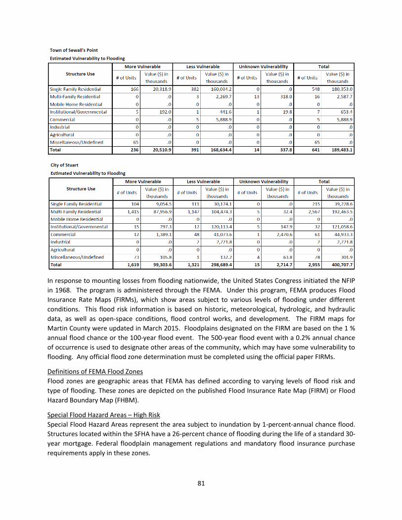
81
In response to mounting losses from flooding nationwide, the United States Congress initiated the NFIP
in 1968. The program is administered through the FEMA. Under this program, FEMA produces Flood
Insurance Rate Maps (FIRMs), which show areas subject to various levels of flooding under different
conditions. This flood risk information is based on historic, meteorological, hydrologic, and hydraulic
data, as well as open-space conditions, flood control works, and development. The FIRM maps for
Martin County were updated in March 2015. Floodplains designated on the FIRM are based on the 1 %
annual flood chance or the 100-year flood event. The 500-year flood event with a 0.2% annual chance
of occurrence is used to designate other areas of the community, which may have some vulnerability to
flooding. Any official flood zone determination must be completed using the official paper FIRMs.
Definitions of FEMA Flood Zones
Flood zones are geographic areas that FEMA has defined according to varying levels of flood risk and
type of flooding. These zones are depicted on the published Flood Insurance Rate Map (FIRM) or Flood
Hazard Boundary Map (FHBM).
Special Flood Hazard Areas – High Risk
Special Flood Hazard Areas represent the area subject to inundation by 1-percent-annual chance flood.
Structures located within the SFHA have a 26-percent chance of flooding during the life of a standard 30-
year mortgage. Federal floodplain management regulations and mandatory flood insurance purchase
requirements apply in these zones.

97
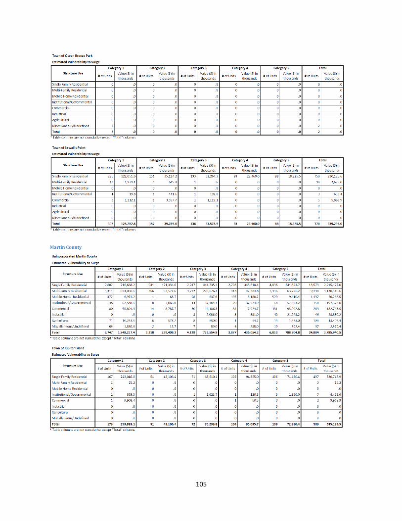
105
157
4.2.5 Sea Level Rise
Southeast Florida is vulnerable to sea level rise (SLR) due to its peninsular geomorphology and low
topography. Mapping different sea level rise inundation scenarios helps to identify areas at potential
risk and aids in planning for a sustainable community. Inundation maps, identifying land at elevations
below sea level, highlight areas located near Martin County’s coastline and tidal waterways. Inland
areas identified as vulnerable are low-lying areas, which may be of future concern for storm water
management but are not directly hydrologically connected to tidal waters.
The sea level has risen in Florida about 9 inches over the past century according to the South Florida
Water Management District. The US National Research Council reported in 2008 that the global
consensus is that the Earth’s climate is warming and the impact of that climate change is accelerated sea
level rise. There is no general consensus on the rate at which sea level will rise however and therefore
with scientific literature offering various acceleration rate theories we are only able to be certain that
sea level will continue to rise.
The barrier islands of Martin County are Hutchinson Island north of the St. Lucie Inlet and Jupiter Island
south of the inlet. State Road A1A extends south on Hutchinson Island into Martin County from St. Lucie
County. Developed areas are predominately residential. The Indian River Lagoon lies west of the barrier
island in Martin County and extends to Jupiter Inlet. This estuary is designated as an Estuary of National
Significance. The Lagoon contains highly productive natural communities and ecosystem, including sea
grass beds, algal beds, and oyster beds, mud flats, tidal marshes and mangrove swamps. The Lagoon is
heavily used by recreational boaters and is important to the marine business communities as prime
locations for boat facilities and waterfront development. Impacts include storm-water drainage
systems, saltwater intrusion into public water supplies and sources, and ecological impacts of
inundation and saltwater intrusion into estuaries and freshwater systems.
Sea level changes can have a compounded impact when a flooding or storm surge event impacts coastal
and inland areas. Adaptation of current structures, mitigation and/or managed withdrawal of structures
in redevelopment activities can lessen economic and social impacts to County businesses, government
and residents (Martin County CEMP, 2014).
In June 2012 a regional vulnerability study was completed for the Treasure Coast (Martin, St. Lucie,
Indian River and Palm Beach counties) by the Treasure Coast Regional Planning Council. The study
included sea level rise.

158
Source: Seven/ 50 Plan (2013)
Figure 4.17 – Analysis of Vulnerability to Sea Level Rise 1 foot
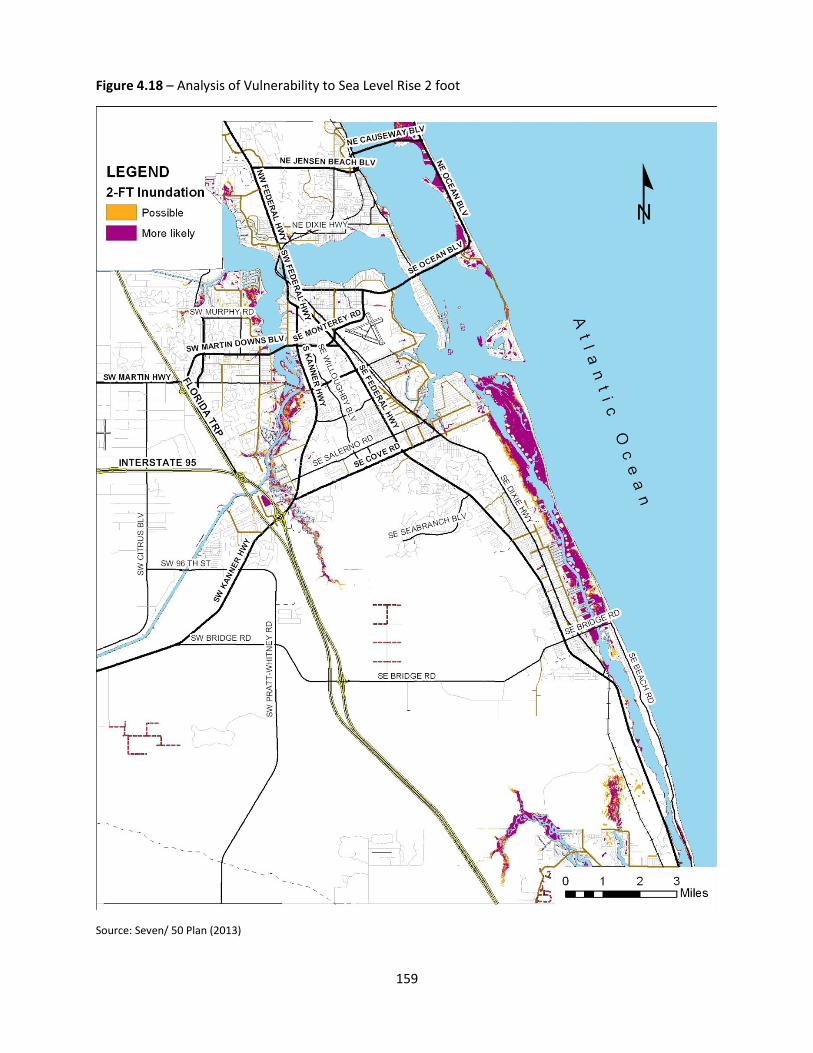
159
Figure 4.18 – Analysis of Vulnerability to Sea Level Rise 2 foot
Source: Seven/ 50 Plan (2013)
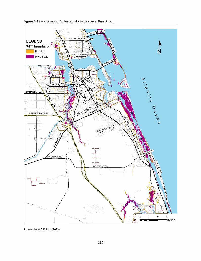
160
Figure 4.19 – Analysis of Vulnerability to Sea Level Rise 3 foot
Source: Seven/ 50 Plan (2013)
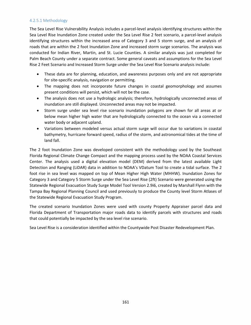
161
4.2.5.1 Methodology
The Sea Level Rise Vulnerability Analysis includes a parcel‐level analysis identifying structures within the
Sea Level Rise Inundation Zone created under the Sea Level Rise 2 feet scenario, a parcel‐level analysis
identifying structures within the increased area of Category 3 and 5 storm surge, and an analysis of
roads that are within the 2 foot Inundation Zone and increased storm surge scenarios. The analysis was
conducted for Indian River, Martin, and St. Lucie Counties. A similar analysis was just completed for
Palm Beach County under a separate contract. Some general caveats and assumptions for the Sea Level
Rise 2 Feet Scenario and Increased Storm Surge under the Sea Level Rise Scenario analysis include:
These data are for planning, education, and awareness purposes only and are not appropriate
for site‐specific analysis, navigation or permitting.
The mapping does not incorporate future changes in coastal geomorphology and assumes
present conditions will persist, which will not be the case.
The analysis does not use a hydrologic analysis; therefore, hydrologically unconnected areas of
inundation are still displayed. Unconnected areas may not be impacted.
Storm surge under sea level rise scenario inundation polygons are shown for all areas at or
below mean higher high water that are hydrologically connected to the ocean via a connected
water body or adjacent upland.
Variations between modeled versus actual storm surge will occur due to variations in coastal
bathymetry, hurricane forward speed, radius of the storm, and astronomical tides at the time of
land fall.
The 2 foot Inundation Zone was developed consistent with the methodology used by the Southeast
Florida Regional Climate Change Compact and the mapping process used by the NOAA Coastal Services
Center. The analysis used a digital elevation model (DEM) derived from the latest available Light
Detection and Ranging (LiDAR) data in addition to NOAA’s VDatum Tool to create a tidal surface. The 2
foot rise in sea level was mapped on top of Mean Higher High Water (MHHW). Inundation Zones for
Category 3 and Category 5 Storm Surge under the Sea Level Rise (2ft) Scenario were generated using the
Statewide Regional Evacuation Study Surge Model Tool Version 2.9i6, created by Marshall Flynn with the
Tampa Bay Regional Planning Council and used previously to produce the County level Storm Atlases of
the Statewide Regional Evacuation Study Program.
The created scenario Inundation Zones were used with county Property Appraiser parcel data and
Florida Department of Transportation major roads data to identify parcels with structures and roads
that could potentially be impacted by the sea level rise scenario.
Sea Level Rise is a consideration identified within the Countywide Post Disaster Redevelopment Plan.

162
Table 4.27 Vulnerability to Sea Level Rise and Storm Surge as Increased by Sea Level Rise
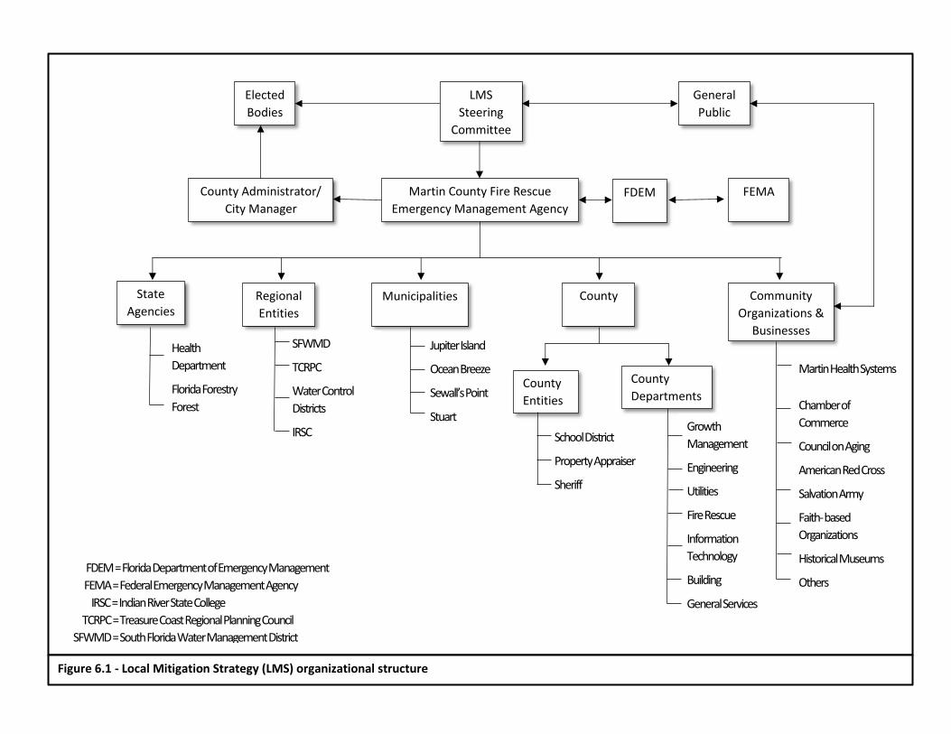
199
Municipalities Regional
Entities
State
Agencies
FEMA FDEM
County
Entities
Community
Organizations &
Businesses
County
County
Departments
Health
Department
Florida Forestry
Forest
SFWMD
TCRPC
Water Control
Districts
IRSC
Jupiter Island
Ocean Breeze
Sewall’s Point
Stuart Growth
Management
Engineering
Utilities
Fire Rescue
Information
Technology
Building
General Services
Martin Health Systems
Chamber of
Commerce
Council on Aging
American Red Cross
Salvation Army
Faith- based
Organizations
Historical Museums
Others
School District
Property Appraiser
Sheriff
Elected
Bodies
County Administrator/
City Manager
Martin County Fire Rescue
Emergency Management Agency
General
Public
LMS
Steering
Committee
FDEM = Florida Department of Emergency Management
FEMA = Federal Emergency Management Agency
IRSC = Indian River State College
TCRPC = Treasure Coast Regional Planning Council
SFWMD = South Florida Water Management District
Figure 6.1 - Local Mitigation Strategy (LMS) organizational structure
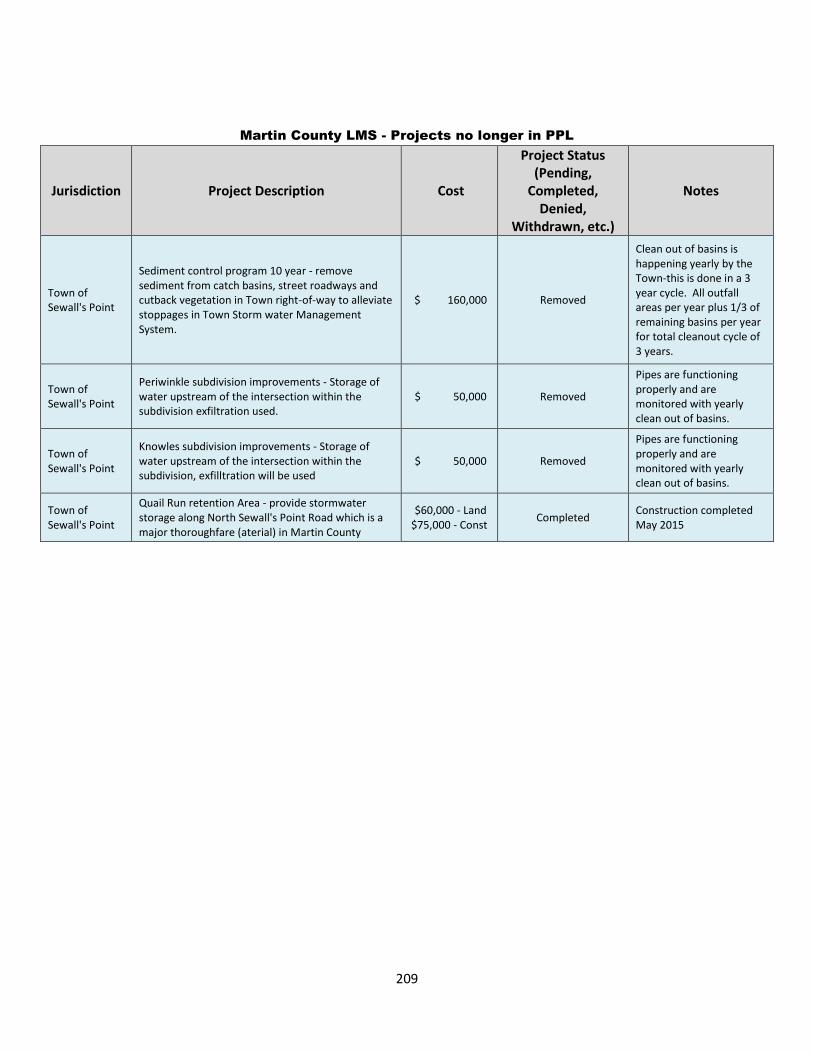
209
Martin County LMS - Projects no longer in PPL
Jurisdiction Project Description Cost
Project Status (Pending,
Completed, Denied,
Withdrawn, etc.)
Notes
Town of Sewall's Point
Sediment control program 10 year - remove sediment from catch basins, street roadways and cutback vegetation in Town right-of-way to alleviate stoppages in Town Storm water Management System.
$ 160,000 Removed
Clean out of basins is happening yearly by the Town-this is done in a 3 year cycle. All outfall areas per year plus 1/3 of remaining basins per year for total cleanout cycle of 3 years.
Town of Sewall's Point
Periwinkle subdivision improvements - Storage of water upstream of the intersection within the subdivision exfiltration used.
$ 50,000 Removed
Pipes are functioning properly and are monitored with yearly clean out of basins.
Town of Sewall's Point
Knowles subdivision improvements - Storage of water upstream of the intersection within the subdivision, exfilltration will be used
$ 50,000 Removed
Pipes are functioning properly and are monitored with yearly clean out of basins.
Town of Sewall's Point
Quail Run retention Area - provide stormwater storage along North Sewall's Point Road which is a major thoroughfare (aterial) in Martin County
$60,000 - Land $75,000 - Const
Completed Construction completed May 2015

244
Utilities - Vista Salerno 6510 SE Parkwood Dr Martin County
Zone X Zone 4>160 n/a high risk utility
Town Hall 2 Bridge Rd Jupiter Island
Zone X Zone 4>160 Cat 1
medium risk
other
Public Safety 103 Bunker Hill Rd Jupiter Island
Zone X Zone 4>160 Cat 1
medium risk
public safety
Public Works 12921 SE Suzanne Ave Martin County
Zone X Zone 4>160 Cat 1
medium risk
other
South Martin Regional Utilities 9000 SE Athena Dr Martin County
Zone X Zone 4>160 Cat 1
medium risk
utility
Town Of Sewall's Point Town Hall
1 South Sewall's Point Rd
Sewall's Point
Zone AE Zone 3 <160 Cat 3 medium
risk other
Water Treatment 1002 Palm Beach Rd Stuart Zone X Zone 3 <160 n/a low risk WTP/ WWTP
WW Treatment 301 Stypmann Blvd Stuart other flood area Zone 3 <160 n/a low risk WTP/ WWTP
City Hall 121 Flagler Ave Stuart Zone X Zone 3 <160 Cat 5 low risk other
Police/Fire 800/830 MLK Blvd Stuart Zone X Zone 3 <160 n/a low risk public safety
Community Center 724 10th St Stuart Zone X
Zone 3 <160 n/a medium
risk Other
Anderson Middle 7000 SE Atlantic Ridge
Drive MCSD
Zone X Zone 4>160 n/a
medium risk
school
Bessey Creek Elementary 2201 SW Matheson
Ave MCSD
Zone X Zone 4>160 Cat 5
medium risk
school
Challenger 5150 SE Willoughby
Blvd MCSD
Zone X Zone 4>160 n/a
medium risk
school
Citrus Grove Elementary 2527 SW Citrus Blvd MCSD Zone AE
Zone 4>160 n/a medium
risk school
Crystal Lake Elementary 2095 SW 96th Street MCSD Zone AE
Zone 4>160 n/a medium
risk school
Environmental Studies Center 2900 NE Indian River
Drive MCSD
Zone AE Zone 4>160 Cat 1
medium risk
school
Felix A. Williams Elementary 401 Baker Road MCSD Zone X
Zone 4>160 Cat 5 medium
risk school
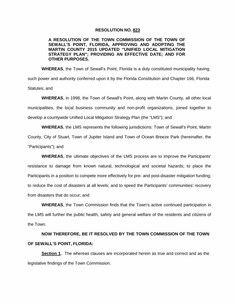
RESOLUTION NO. 823
A RESOLUTION OF THE TOWN COMMISSION OF THE TOWN OF SEWALL’S POINT, FLORIDA, APPROVING AND ADOPTING THE MARTIN COUNTY 2015 UPDATED “UNIFIED LOCAL MITIGATION STRATEGY PLAN”; PROVIDING AN EFFECTIVE DATE; AND FOR OTHER PURPOSES.
WHEREAS, the Town of Sewall’s Point, Florida is a duly constituted municipality having
such power and authority conferred upon it by the Florida Constitution and Chapter 166, Florida
Statutes; and
WHEREAS, in 1998, the Town of Sewall’s Point, along with Martin County, all other local
municipalities, the local business community and non-profit organizations, joined together to
develop a countywide Unified Local Mitigation Strategy Plan (the “LMS”); and
WHEREAS, the LMS represents the following jurisdictions: Town of Sewall’s Point, Martin
County, City of Stuart, Town of Jupiter Island and Town of Ocean Breeze Park (hereinafter, the
“Participants”); and
WHEREAS, the ultimate objectives of the LMS process are to improve the Participants’
resistance to damage from known natural, technological and societal hazards; to place the
Participants in a position to compete more effectively for pre- and post-disaster mitigation funding;
to reduce the cost of disasters at all levels; and to speed the Participants’ communities’ recovery
from disasters that do occur; and
WHEREAS, the Town Commission finds that the Town’s active continued participation in
the LMS will further the public health, safety and general welfare of the residents and citizens of
the Town.
NOW THEREFORE, BE IT RESOLVED BY THE TOWN COMMISSION OF THE TOWN
OF SEWALL’S POINT, FLORIDA:
Section 1. The whereas clauses are incorporated herein as true and correct and as the
legislative findings of the Town Commission.
Section 2. The Town Commission hereby approves and adopts the Martin County
2015 updated “UNIFIED LOCAL MITIGATION STRATEGY PLAN” (the “LMS”). A digital copy of
the LMS is attached hereto as Exhibit “A”. A printed copy of the LMS plan is on file in the office
of the Town Clerk.
Section 3. Severability. If any section or portion of a section of this Resolution
proves to be invalid, unlawful, or unconstitutional, it shall not be held to invalidate or impair the
validity, force, or effect of any other section or part of this Resolution.
Section 4. Conflicts. All resolutions or parts of resolutions in conflict with any of the
provisions of this Resolution are hereby repealed.
Section 5. Implementing Actions. The Town Manager is hereby authorized to take
any actions necessary to implement the action taken in this Resolution.
Section 6. Effective Date. This Resolution shall take effect in accordance with law.
The Town Manager thereupon declared this Resolution No.823 approved and adopted by the
Town Commission of the Town of Sewall’s Point on this 26th day of January, 2016.
TOWN OF SEWALL’S POINT, FLORIDA
______________________________ E. Dan Morris, Mayor
ATTEST: _________________________________ Lakisha Burch, Town Clerk (TOWN SEAL)
________________________________________
Glen J. Torcivia, Town Attorney Florida Bar No. 343374 Approved as to form and legal sufficiency
2

TOWN OF SEWALL’S POINT
PAMELA MAC’KIE WALKER Town Manager
TO: Town of Sewall’s Point Commission
FROM: Pamela Mac’Kie Walker, Town Manager
SUBJECT: Agenda Item 8 Commission Appointments to Regional/State Boards Town Commission Meeting, January 26, 2016 ____________________________________________________________________________ Background: Current committee appointments are as follows: Committee: Commissioner: Expires: Meeting Dates: Airport Noise Advisory Committee
Commissioner Luger None Quarterly, 4th Thursday
Florida League of Cities Commissioner Barile Alt. Commissioner Campo
1 yr. Annual Meeting
Metropolitan Planning Organization
Commissioner Barile Alt. Mayor Morris
1 yr. Feb. 22nd, Apr 18th, May 9th, Jun 20th , Sep 9th , Dec 12th
Regional Planning Council
Commissioner Thurlow-Lippisch Alt. Mayor Morris
1 yr. Monthly
Tourist Development Council
Commissioner Barile (term ends 11/16)
4 yr. term
Quarterly
Treasure Coast Council of Local Governments
Commissioner Luger Alt. Commissioner Barile
1yr. First Wednesday of every month
Treasure Coast Regional League of Cities
Commissioner Barile Alt. Commissioner Campo
1 yr. Third Wednesday of every other month
Recommendation: Staff requests that the Commission advise of its appointments.