town of clayton - clayton local development … · web viewtown and village of clayton local...
TRANSCRIPT

TOWN and VILLAGE OF CLAYTON
LOCAL WATERFRONT REVITALIZATION PROGRAM (LWRP)
Prepared By: Environmental Design & Research, Landscape Architecture, Planning, Environmental Services, Engineering and Surveying, P.C. (EDR)217 Montgomery StreetSuite 1000Syracuse, New York 13202
August 2011
This report was prepared for the New York State Department of State with funds provided under Title 11 of the Environmental Protection Fund.

Town and Village of Clayton LWRP Acknowledgements
ACKNOWLEDGEMENTS
Town BoardJustin Taylor, SupervisorRobert Cantwell, IIIGeorge KittleLance PetersonDonald Turcotte
Village BoardNorma Zimmer, MayorMary BurkeJoseph W. Orobona, Jr.Doug RogersShauna Sherboneau
Planning Board Roland (Bud) Baril, ChairpersonLarry Aubertine, Vice ChairpersonRonald N. Duford, Sr.Paul E. HeckmannJohn W. Kehoe Preston LoweTwyla Webb
Advisory CommitteeBobby Cantwell III, Co-ChairpersonWilliam Grater, Co-ChairpersonPati BazinetPete BeattieJohn BukerKelly CantwellAngela CipulloTwyla CushmanKathy DanielsonJay S. DydykNancy GarnseyAmy GetmanNancy HydeDeborah JepmaJeremy KelloggKen KnappAl O’NeillLance PetersonChris PhinneyChris RhinebeckCarol SimpsonAugusta WithingtonKristin Youngs
August 2011 DRAFT i

Town and Village of Clayton LWRP Table of Contents
TABLE OF CONTENTS
Introduction and Overview............................................................................................................1
What is a Local Waterfront Revitalization Program (LWRP)?.......................1Town and Village of Clayton LWRP Summary..............................................1Planning Process.........................................................................................3Previous Planning Efforts............................................................................4Important Concurrent Planning Effort.........................................................5Smart Growth Approaches..........................................................................6
Vision Statement.............................................................................................................................9
1.0 Waterfront Revitalization Area (WRA)..........................................................................11
1.1 Existing New York State Coastal Management Program Boundary....112.0 Inventory and Analysis.....................................................................................................15
2.1 Regional Setting and Overview..........................................................152.2 History...............................................................................................152.3 Community Characteristics................................................................182.4 Land Use............................................................................................242.5 Water Use..........................................................................................272.6 Agricultural Lands and Farming Activity............................................322.7 Existing Zoning..................................................................................342.8 Public Access and Recreation.............................................................352.9 Historic Resources.............................................................................402.10 Scenic Resources...............................................................................472.11 Topography and Geology...................................................................502.12 Water Quality.....................................................................................502.13 Natural Resources & Environmentally Sensitive Features..................552.14 Fish and Wildlife Resources................................................................602.15 Infrastructure.....................................................................................702.16 Transportation...................................................................................71
3.0 Waterfront Revitalization Policies...................................................................................75
DEVELOPED WATERFRONT POLICIES........................................................77NATURAL WATERFRONT POLICIES.............................................................96PUBLIC WATERFRONT POLICIES..............................................................121
August 2011 DRAFT iii

Table of Contents Town and Village of Clayton LWRP
WORKING WATERFRONT POLICIES..........................................................1324.0 Proposed Land and Water Uses and Projects..............................................................145
4.1 Proposed Land Use...........................................................................1454.2 Proposed Water Use.........................................................................1464.3 Public Waterfront Access and Recreational Enhancement Projects and Programs.................................................................................................1464.4 Infrastructure and Redevelopment Projects and Programs..............1514.5 Heritage Protection Projects and Programs......................................1614.6 Economic Opportunities...................................................................164
5.0 Techniques For Local Implementation.........................................................................173
5.1 Existing Local Laws and Regulations................................................1735.2 Proposed New or Revised Local Laws and Regulations....................1755.3 Management Structure to Implement the LWRP..............................1775.4 Procedural Guidelines For Coordinating NYS DOS & LWRP Consistency Review Of Federal Agency Actions..........................................................1805.5 Guidelines for Notification and Review of State Agency Actions Where Local Waterfront Revitalization Programs are in Effect....................................1835.6 Financial Resources Necessary to Implement the LWRP..................188
6.0 State And Federal Actions And Programs Likely To Affect Implementation..........195
6.1 State Agencies.................................................................................1966.2 Federal Agencies..............................................................................2096.3 State And Federal Actions And Programs Necessary To Further The LWRP
2167.0 Consultation With Other Affected Agencies................................................................219
7.1 Local Consultation............................................................................2197.2 Regional Consultation......................................................................2197.3 State Agency Consultation...............................................................219
8.0 Local Commitment & Consultation..................................................................................221
iv August 2011 DRAFT

Town and Village of Clayton LWRP Table of Contents
APPENDICESAppendix A- Harbor Management PlanAppendix B- Town and Village of Clayton Local Consistency Review LawsAppendix C- Proposed New or Revised Local Laws and RegulationsAppendix D- DefinitionsAppendix E- Significant Coastal Fish and Wildlife HabitatsAppendix F- SEQR Full Environmental Assessment Form
LIST OF TABLESTable 2.1. Population by Age Cohort, 2000...............................................................................................18
Table 2.2. Employment Statistics................................................................................................................20
Table 2.3. Workforce Statistics....................................................................................................................20
Table 2.4. Year Housing Units Built...........................................................................................................23
Table 2.5. Comparison of Land Use...........................................................................................................24
Table 2.7. Existing Zoning..........................................................................................................................34
Table 2.8. Historical and Cultural Recreational Facilities..........................................................................37
Table 2.9. Public and Semi-Public Boating Facilities................................................................................37
Table 2.10. Private Boating Facilities:........................................................................................................38
Table 2.11. Town of Clayton Notable Historic Resources.........................................................................40
Table 2.12. Village of Clayton Notable Historic Resources.......................................................................42
Table 3.1. Waterfront Revitalization Policies for the Town and Village of Clayton..................................76
Table 5.1 LWRP Implementation Recommendations...............................................................................185
LIST OF MAPSLWRP Map 1: Waterfront Revitalization Area LWRP Map 2: Existing Land UsesLWRP Map 3: Important Agricultural LandsLWRP Map 4: Town of Clayton Existing ZoningLWRP Map 5: Village of Clayton Existing ZoningLWRP Map 6: Public Access and RecreationLWRP Map 7: Historic and Scenic ResourcesLWRP Map 8: TopographyLWRP Map 9: WetlandsLWRP Map 10: Significant Fish and Wildlife HabitatsLWRP Map 11: Proposed Recreational Trails and Priority ProjectsAugust 2011 DRAFT v

Table of Contents Town and Village of Clayton LWRP
LWRP Map 12: Town of Clayton Proposed Zoning Map
vi August 2011 DRAFT

Town and Village of Clayton LWRP Introduction and Overview
Introduction and Overview
What is a Local Waterfront Revitalization Program (LWRP)?A Local Waterfront Revitalization Program (LWRP) is a locally prepared comprehensive land and water use plan for a municipality’s natural, public, and developed waterfront resources. A LWRP is prepared with assistance from the New York State Department of State (NYS DOS) Division of Coastal Resources in accordance with the New York State Waterfront Revitalization of Waterfront Areas and Inland Waterways Act. A LWRP formulates waterfront development objectives by adapting statewide legislation and policies to the unique and individual requirements of a waterfront municipality. A LWRP also outlines specific projects to encourage environmental protection, foster economic development, protect valuable water resources, and improve public waterfront accessibility. More importantly, the LWRP is designed to establish a process to ensure that all actions proposed for a municipality’s local waterfront area occur in a fashion prescribed by the LWRP. This “consistency” provision is a tool that is intended to create dialog and encourage cooperation between state, federal and local governments, as well as private sector interests, to build a strong economy and a healthier waterfront environment. More information on LWRPs is found at the following website: http://www.nyswaterfronts.org.
Town and Village of Clayton LWRP SummaryWith this LWRP, the Town and Village of Clayton are prepared to cooperatively take on the challenges of the 21st century – to embrace economic change and further enhance the Thousand Islands region as a highly desirable place to not only visit, but to live, work and play. To achieve its goals, the Town and Village of Clayton have turned their energy and resources to one of the region’s most unique and valuable assets – its broad and diverse waterfront. From world-class recreational opportunities to island-supporting industries, from village commercial areas to beautiful rural town open space areas, from unique cultural institutions to distinctive waterfront character, the Clayton community can cater to the needs of visitors as well as enhance the quality of life for its residents. For many in the community, the waterfront represents the past as well as the future, and an opportunity to capitalize on existing strengths while charting a new course. The key will be to balance Clayton’ authenticity with new ideas as new residents continue to move into the community. The LWRP will facilitate this dialogue.
August 2011 DRAFT 1

Introduction and Overview Town and Village of Clayton LWRP
Below is a summary of the eight sections of the Town and Village of Clayton LWRP.
Section 1.0 - Waterfront Revitalization Area (WRA) Boundary - This section provides a detailed narrative and graphic description of the WRA and boundary.
Section 2.0 - Inventory and Analysis - This section describes the existing natural and man-made environments and conditions within the community, as well as an analysis of opportunities and constraints to development.
Section 3.0 - Waterfront Revitalization Policies - This section presents the waterfront revitalization policies that apply to the Town and Village of Clayton. The policy explanations of the New York State Coastal Management Program have in some cases been modified and expanded to reflect the unique conditions within the Town and Village of Clayton. These policies are based on the economic, environmental, and cultural characteristics of the Town and Village of Clayton, and represent a balance between economic development and preservation, which will permit beneficial use of, and prevent adverse effects on, Town and Village of Clayton waterfront resources. The policies serve as the basis for local, state, and federal consistency determinations for activities affecting the Town and Village of Clayton. No policy is more significant than another. These policies should be read in conjunction with the specific standards of the relevant Town and Village of Clayton local laws.
Section 4.0 - Proposed Land and Water Uses and Proposed Projects - This section describes proposed long-term land and water uses for the community. This section also includes proposed short- and long-term projects the Town and Village of Clayton would like to pursue to implement their LWRP. The proposed uses and initiatives outlined in this section have the potential to enrich the Clayton community by building on the authentic character still visible in many of the trades practiced today, such as boat building and guide services. The proposed projects also build on the Town and Village’s resources and amenities that make it a cultural destination. Reinvestment in the waterfront is intended to enhance the character and functions of existing waterfront activities as well as safeguard and enrich the right of the public to access the waterfront. Clayton’s waterfront will strike a balance, ensuring above all that the waterfront is an inviting place for people to unwind and enjoy civic activities, while also providing important new
2 August 2011 DRAFT

Town and Village of Clayton LWRP Introduction and Overview
places and opportunities for innovative residential, commercial and professional activities.
Section 5.0 - Techniques for Local Implementation - This section describes the local laws, management structure, and financial resources necessary to implement the policies and proposed uses set forth in Sections 3.0 and 4.0.
Section 6.0 - State and Federal Actions and Programs Likely to Affect Implementation of the LWRP - This section consists of a list of State and Federal actions and programs which must be undertaken in a manner consistent with the Town and Village of Clayton LWRP, as well as a description of specific state and federal actions necessary to further implementation of the LWRP.
Section 7.0 - Consultation with Other Affected Agencies- The Town and Village of Clayton LWRP will affect and be affected by the actions of adjacent municipalities and federal, state, regional, and county agencies. This section summarizes the efforts made by the Town and Village of Clayton to involve and/or inform other agencies regarding the development of their LWRP.
Section 8.0 - Techniques for Local Implementation - This section summarizes the actions taken by the Town and Village of Clayton to obtain local input and support for their LWRP.
Planning ProcessThe LWRP process involved cooperation with state, county, local, and private agencies as well as an appointed LWRP Advisory Committee that included local business owners, municipal officials and residents from the Town and Village of Clayton. A key role of the LWRP Advisory Committee was to review and provide feedback on draft documents developed by the planning consultants hired by the Town of Clayton.
As part of the planning effort, an inclusive public outreach effort was conducted to gain feedback from the community on existing land and water use issues and to build consensus on a vision of Clayton’s Waterfront. Public meetings were also held to share and explain progress drafts of the LWRP. The table below summarizes the schedule of significant tasks and events.
August 2011 DRAFT 3

Introduction and Overview Town and Village of Clayton LWRP
4 August 2011 DRAFT

Town and Village of Clayton LWRP Introduction and Overview
Project Schedule SummaryTASKS/EVENTS SCHEDULE
Public Information Meeting #1 February 7, 2008Public Workshop June 5, 2008Inventory/Analysis/Mapping February-November 2008Draft LWRP December 2008-March 2009Public Information Meeting #2 April 29, 2009Plan Finalization May 2009-March 2010Public Information Meeting #3 2011 TBDPlan Finalization 2011 TBD
Previous Planning EffortsThe Town and Village of Clayton and Jefferson County have been the subjects of a number of studies over the decades. The following plans and documents were reviewed in preparation of this LWRP:
1965
- Background Studies and Comprehensive Plan Report for the Saint Lawrence Sub-Region. Contains recommendations for land use, transportation and community facilities/infrastructure.
1966
- Background Studies and Comprehensive Plan Report (a.k.a. Master Plan Report) for the Town and Village of Clayton, New York. Contains recommendations for land use, transportation and community facilities/infrastructure.
1986
- Village of Clayton Local Waterfront Revitalization Program. Adopted by Village of Clayton April 1, 1986, Approved by NYS Secretary of State May 28, 1986, and received by the US Office of Ocean and Coastal Resource Management concurrence July 7, 1986.
1988
- Village of Clayton Harbor Management Plan. Outlined a series of goals and objectives relating to water use and navigation, public access, land use and development, natural resources, and harbor management.
1991
- Town of Clayton Draft Local Waterfront Revitalization Plan. The town did not formally adopt this draft document, but its content was useful in compiling this LWRP.
1994
- Waterfront Economic Feasibility Study, Village of Clayton, New York. Recommended the development of an 85-room hotel, a 2,500 square foot meeting facility, a 231-slip marina and 267 surface parking spaces on the 8-acre Frink America site.
1999
- Shopping Pattern Study
August 2011 DRAFT 5

Introduction and Overview Town and Village of Clayton LWRP
2000
- Joint Town and Village of Clayton Comprehensive Plan
2001
- Black River Corridor Economic Adjustment Strategy. Surveyed 322 Jefferson County residents on their employment status, work history and skills.
2003
- An Overview of Tourism – 1000 Islands/St. Lawrence Seaway. Analyzed 1000 Island tourism in Canada.
2003
- Fort Drum Economic Impact Statement. Tallies the impact that the military base has on the local economy.
2003
- North Country west, New York Area Workforce Report. Describes the employment and salary situation faced by new employers in the region.
2003
- 2001 National Survey of Fishing, Hunting, and Wildlife-Associated Recreation, New York. Compiles demographic information on these recreational uses.
2004
- 2003 Economic Impact of Expenditures by Tourists on Northern New York State. Measures the economic benefits derived by tourism dollars in Jefferson County.
2004
- Wage & Benefits Survey Results for Jefferson County. Provides a snapshot of the county’s workforce based on a survey sent to employers.
2004
- Jefferson County Tourism Profile. Offers an annual accounting of this economic sector.
2004
- Summer Tourism Season Business Confidence Survey Executive Report. Surveyed business owners about their observations of the latest season.
2006
- Village of Clayton Downtown Plan of Action & Local Waterfront Revitalization Program. Prepared by Saratoga Associates for select Village of Clayton areas, this document provides important visitor and tourism data and identifies existing parking resources. The village did not formally adopt this document, but its content was relevant and useful in compiling this LWRP.
2007
- Design Strategies for Waterfront Revitalization in Clayton, New York
2008
- Village of Clayton Prioritized Project Plan (Sewer Related Issues)
Important Concurrent Planning EffortDuring the planning process for the Town and Village of Clayton LWRP the International Joint Commission (IJC) was reviewing its Orders of Approval for regulation of Lake Ontario and the St. Lawrence River levels and flows through the Moses-Saunders Dam at Cornwall-Massena. Following public debate and 6 August 2011 DRAFT

Town and Village of Clayton LWRP Introduction and Overview
considering public comments on the proposed Plan 2007, the commission proposed a one-year process to revise the water level and flow regulation plan to achieve more natural flows while respecting other public interests. This process is currently underway.
The Town and Village of Clayton LWRP advisory committee, as well as the State of New York, the Ontario Ministry of Natural Resources, and many other federal and state/provincial agencies, private organizations, and stakeholders in the U.S. and Canada, support an alternative to Plan 2007. Plan B+ is the widely supported management proposal developed by the IJC that would provide significant environmental and economic improvements to the region. The approach to water management outlined in Plan B+ is to mimic natural water patterns while taming the extremes of high and low water levels that can lead to economic damage. More information on this issue can be found at the following websites: http://www.savetheriver.org and http://www.ijc.org.
Smart Growth ApproachesThroughout the planning process the term “smart growth” was discussed as a strategy to help the community manage growth and development while balancing environmental, economic, and quality of life issues. Smart growth is defined by ten principles. These principles provide a framework for making growth and development decisions that yield better economic, environmental, community, and public health results. Developed in 1996 by the Smart Growth Network, a coalition of national and regional organizations that believe where and how we grow matters, the principles are based on the characteristics and experiences of thriving, diverse, and successful communities. These principles help guide growth and development in communities that have a clear vision for their future and understand the values they want to sustain.
In 2009, coastal and waterfront elements were developed by the National Oceanic and Atmospheric Administration (NOAA) to augment the existing smart growth principles to reflect the specific challenges and opportunities characterizing the waterfront, be it on a coast, a river, or a lake. These elements provide guidance for communities to grow in ways that are compatible with their natural assets, creating great places for residents, visitors, and businesses. More information on waterfront smart growth strategies can be found at http://coastalsmartgrowth.noaa.gov/.
The following table includes the Smart Growth Principles and the corresponding Smart Growth Coastal and Waterfront Elements:August 2011 DRAFT 7

Introduction and Overview Town and Village of Clayton LWRP
Smart Growth Principles Smart Growth Coastal and Waterfront Elements
1. Mix land uses 1. Mix land uses, including water-dependent uses
2. Take advantage of compact building design
2. Take advantage of compact community design that enhances, preserves, and provides access to waterfront resources
3. Create a range of housing opportunities and choices
3. Provide a range of housing opportunities and choices to meet the needs of both seasonal and permanent residents
4. Create walkable communities
4. Create walkable communities with physical and visual access to and along the waterfront for public use
5. Foster distinctive, attractive communities with a strong sense of place
5. Foster distinctive, attractive communities with a strong sense of place that capitalizes on the waterfront's heritage
6. Preserve open space, farmland, natural beauty, and critical environmental areas
6. Preserve open space, farmland, natural beauty, and the critical environmental areas that characterize and support coastal and waterfront communities
7. Strengthen and direct development toward existing communities
7. Strengthen and direct development toward existing communities, and encourage waterfront revitalization
8. Provide a variety of transportation options
8. Provide a variety of land- and water-based transportation options
9. Make development decisions predictable, fair, and cost effective
9. Make development decisions predictable, fair, and cost effective through consistent policies and coordinated permitting processes
10. Encourage community and stakeholder collaboration in development decisions
10.Encourage community and stakeholder collaboration in development decisions, ensuring that public interests in and rights of access to the waterfront and coastal waters are upheld
8 August 2011 DRAFT

Town and Village of Clayton LWRP Vision Statement
Vision StatementIn order to position themselves as a premier waterfront community on the Saint Lawrence River, the Clayton community will strive to:
Preserve the picturesque nature of the community that is visible in both the quaint, small-town atmosphere of the Village center as well as the rural character and natural beauty of the Town;
Develop amenities for residents and visitors that will allow Clayton to be an interesting year-round place to live, visit, work, and play;
Increase access to the water and to recreational opportunities while preserving sensitive natural places;
Preserve and promote the artistic and cultural resources of the local community, found in historic architecture, exceptional museums, and an opera house;
Enhance the characteristics of the community that make Clayton a pedestrian-friendly, livable, sustainable place;
Provide opportunities for development that is in scale with the existing community fabric and balances with existing uses;
Promote economic growth and stability by supporting locally-owned businesses and encouraging vibrant, successful shops, hotels, and restaurants;
Ensure the Clayton waterfront is a friendly, welcoming place where twenty years from now, children can still play in the streets and people can feel safe and happy about raising their families here.
August 2011 DRAFT 9

10 August 2011 DRAFT

Town and Village of Clayton LWRP 1.0 Waterfront Revitalization Area (WRA)
1.0 Waterfront Revitalization Area (WRA)
The State’s Coastal Management Program has established Statewide waterfront boundaries in accordance with the requirements of the Coastal Zone Management Act of 1972, as amended, and its subsequently issued rules and regulations.
1.1 Existing New York State Coastal Management Program BoundaryThe existing New York State Coastal Management Program boundary intersects multiple jurisdictions as it follows New York State’s coastlines. Therefore, for this joint LWRP, the landward Coastal Area Boundary delineates the upland extent of the Town of Clayton and Village of Clayton waterfront areas and the waterside extent of the Town of Clayton –henceforth referred to jointly as the Waterfront Revitalization Area (WRA). It is important to note that the Town and Village authority to implement a Local Waterfront Revitalization Program is confined to the area within their respective corporate limits.
The existing WRA boundary for the Town and Village of Clayton is described below and identified on LWRP Maps 1 and 1A.
Town of Clayton and Village of Clayton WRA Upland Boundary
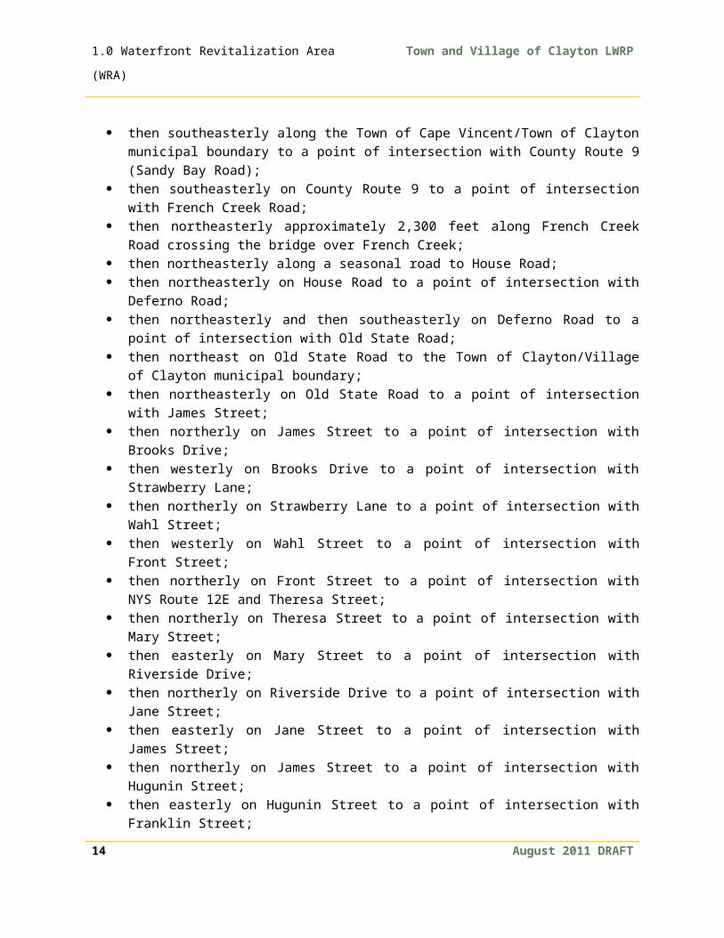
The coastal area boundary for the Town of Clayton and Village of Clayton, as established under the New York State Coastal Management Program, begins at the intersection of the Town of Cape Vincent/Town of Clayton municipal boundary and the mean high water line of the St. Lawrence River;
the boundary then proceeds southeasterly along the Town of Cape Vincent/Town of Clayton municipal boundary to a point 1,000 feet inland of NYS Route 12E;
then northeasterly and parallel to NYS Route 12E to a point of intersection with County Route 4 (Crystal Springs Road);
then southwesterly on County Route 4 to the Town of Cape Vincent/Town of Clayton municipal boundary;
then southeasterly along the Town of Cape Vincent/Town of Clayton municipal boundary to a point of intersection with County Route 9 (Sandy Bay Road);
then southeasterly on County Route 9 to a point of intersection with French Creek Road;
then northeasterly approximately 2,300 feet along French Creek Road crossing the bridge over French Creek;
then northeasterly along a seasonal road to House Road;
August 2011 DRAFT 11

1.0 Waterfront Revitalization Area (WRA)
Town and Village of Clayton LWRP
then northeasterly on House Road to a point of intersection with Deferno Road;
then northeasterly and then southeasterly on Deferno Road to a point of intersection with Old State Road;
then northeast on Old State Road to the Town of Clayton/Village of Clayton municipal boundary;
then northeasterly on Old State Road to a point of intersection with James Street;
then northerly on James Street to a point of intersection with Brooks Drive; then westerly on Brooks Drive to a point of intersection with Strawberry Lane; then northerly on Strawberry Lane to a point of intersection with Wahl Street; then westerly on Wahl Street to a point of intersection with Front Street; then northerly on Front Street to a point of intersection with NYS Route 12E
and Theresa Street; then northerly on Theresa Street to a point of intersection with Mary Street; then easterly on Mary Street to a point of intersection with Riverside Drive; then northerly on Riverside Drive to a point of intersection with Jane Street; then easterly on Jane Street to a point of intersection with James Street; then northerly on James Street to a point of intersection with Hugunin Street; then easterly on Hugunin Street to a point of intersection with Franklin Street; then southerly on Franklin Street to a point of intersection with Union Street; then westerly on Union Street to a point of intersection with Webb Street; then southerly on Webb Street to a point of intersection with NYS Route 12; then easterly on NYS Route 12 to the intersection of the Village of
Clayton/Town of Clayton municipal boundary; then southeasterly along the Village of Clayton/Town of Clayton municipal
boundary to a point 1,000 feet inland of NYS Route 12; then northeasterly and parallel to NYS Route 12 to a point of intersection with
the Town of Clayton/Town of Orleans municipal boundary; then north along the Town of Clayton/Town of Orleans municipal boundary to
the mean high water line of the St. Lawrence River.
Town and Village of Clayton Waterside Boundary
The waterside boundary for the Town of Clayton begins at the intersection of the Town of Clayton/Town of Orleans municipal boundary and the mean high water line of the St. Lawrence River;
12 August 2011 DRAFT

Town and Village of Clayton LWRP 1.0 Waterfront Revitalization Area (WRA)
then northerly on the Town of Clayton/Town of Orleans municipal boundary to the point of intersection with the United States/Canada International boundary;
then southwesterly and following coterminous to the United States/Canada boundary to a point of intersection with the Town of Clayton/Town of Cape Vincent municipal boundary;
then southeasterly along the Town of Clayton/Town of Cape Vincent municipal boundary to a point of intersection of the Town of Clayton/Town of Cape Vincent municipal boundary and the mean high water of the St. Lawrence River.
Village of Clayton Waterside Boundary Beginning at the eastern intersection of the landward boundary, on State Street, and the Village of Clayton/Town of Clayton line, the boundary follows the village municipal line north over the St. Lawrence River to the northeastern most point of the village limits. Thence upriver (westerly) to the northwestern most point of the village limits north of Bartlett Point, thence southerly following the municipal line crossing NY 12E and French Creek to the intersection of the municipal line and the landward boundary at the southwestern limit of the village at Old State Road
August 2011 DRAFT 13

Town and Village of Clayton LWRP 2.0 Inventory and Analysis
2.0 Inventory and Analysis 2.1 Regional Setting and Overview The 700-mile long Saint Lawrence River has defined and molded the Clayton community from the first native habitation continuing until modern times. Clayton sits less than 20 miles from the start of the Saint Lawrence River at Lake Ontario. Along this stretch, the river is the boundary between the United States and Canada. Between Clayton and the community of Gananoque on the Canadian side of the river sits Grindstone Island –the fourth largest of the Thousand Islands. The driving connection to Canada is less than ten miles to the north where NYS Route 12 connects with Interstate 81. Today, Clayton is touted as the “Gateway to the Thousand Islands” and with its approximately 15 miles of shoreline is a major destination for fishing, boating and sightseers.
Outside of the scattered urban areas, the region is rural with many scenic qualities. The largest U.S. city in the area is Watertown, New York, approximately 20 miles to the southeast, and home to approximately 26,705 people. A major economic generator in the region is Fort Drum, which is located just a few miles outside of Watertown. A recent expansion at the army post increased population counts to 16,000 military and 14,000 dependents, and over 3,000 civilian workers. The boundary of the Adirondack State Park is less than 50 miles to the east. State Route 12E, which transects the WRA, is part of the Seaway Trail Scenic Byways system.
2.2 HistoryLife and the economy in Clayton has always centered on the Saint Lawrence River. Even the very first people to see the Clayton area were attracted by the same natural qualities that attract people to Clayton today.
The first humans to call Clayton home arrived around 6 to 8 thousand years B.C. (before present). As the glacial floodwaters retreated, the familiar landscape of the region appeared and so did people. In the surrounding area, Paleo-Indian artifacts from at least 8000 B.C. have been identified from higher elevations (approximately 600’) at nearby Ft. Drum, and many sites and artifacts found in Clayton date from the Archaic period (8000 B.C. - 3400 B.C.). The northwest corner of Jefferson County, where the Town and Village of Clayton are located, is known for having the heaviest concentration of prehistoric sites in the State of New York, and Clayton is one of the focal points of this prehistoric activity.
There are over a dozen registered sites and dozens more known areas of prehistoric activity within the Town of Clayton. These sites include campsites, thousands of August 2011 DRAFT 15
2.0 Inventory and Analysis Town and Village of Clayton LWRP
years old, still littered with chert (flint) points and debris, from the last prehistoric residents, the Saint Lawrence Iroquois. The Saint Lawrence Iroquois were distinct from, but related to, the Five Nations Iroquois and vanished as a separate people about 500 years ago, around the same time as the first European contact in the St. Lawrence Valley. The first and the last historic description of the Saint Lawrence Iroquois was made by the explorer Cartier in 1535. Some 50 years later, Champlain found the distinct culture of the Saint Lawrence Iroquois gone and the Oneida Nation holding claim to the area. The disappearance of the Saint Lawrence Iroquois remains a prehistoric mystery. A local tradition tells that the Oneida won a great battle near the present-day Village of Clayton and the name “Weteringhera Guentere” (meaning “fallen fort”) was given for the area.
To date, no European contact sites have been identified in Clayton, nor is there evidence of much historic activity on the U.S. side of the River until after the Revolutionary War. Some of the earliest settlers left their names on places such as Bartlett’s Point and Barrett’s Creek. After the war of 1812, true settlement started to take shape. As the French settled in the area in the 1820s, the Village was called French Creek. Soon after its name was changed to Clayton in honor of John M. Clayton, a U.S. Senator from Delaware. In 1872, the Village of Clayton was incorporated. In 1883, the Town of Clayton was officially carved from the Towns of Orleans and Lyme.
Agriculture and timber were the first major industries in Clayton. Workers lashed trees together into rafts and floated them downstream to Montreal and other areas to be milled into lumber. Clayton’s location on the river and supply of lumber also became a natural fit for the shipbuilding industry. In 1832, shipbuilding began with the construction of two “ways,” structures on which ships were built and launched, in the area of Hugunin Street. For almost six decades the construction or repair of ships employed as many as two to three hundred workers.
Mining in quarries on Picton and Grindstone Islands was also an active industry in the mid 1800's. High quality granite from Grindstone and Picton Islands was widely used for paving blocks and prominent buildings such as the New York State Capitol Building. There are a number of active sand and gravel operations located on County Route 4, (Crystal Springs Road).
Steamers plied the waters of the St. Lawrence from 1840 until 1912. The Village of Clayton served as a refueling stop as well as a departure point for wealthy families to reach their estates or the luxurious hotels on the islands. In 1873, the railroad bolstered the tourism trade by providing a direct connection between the cities of 16 August 2011 DRAFT

Town and Village of Clayton LWRP 2.0 Inventory and Analysis
the Northeast and the steamboat terminal in Clayton. Grindstone, Picton, Bluff, Murray and other smaller islands began to become settled by local residents and tourists. Elaborate hotels, shops and other businesses catered to the growing tourist influx. U.S. Presidents Ulysses S. Grant and Chester Arthur visited Clayton during this time. Grant’s visit started a major influx of wealthy tourists and started the construction boom of many large estates.
By the early 20th century, the economic boom brought by tourism started to wane. The advent of the automobile and the increase in small privately owned boats diminished the important role that the Clayton waterfront played in connecting rail passengers to the ferry service. The small boat sales and repair business quickly became lucrative, but few of the fabulously wealthy continued to visit the area. The hotel trade dropped off as more private camps and cottages grew along the shores of the Saint Lawrence River. Few local people could afford wood boats, with the initial cost and the subsequent maintenance. The introduction of fiberglass boats in the 1950’s and 1960’s made boats more affordable for the general public and helped the area prosper.
For a few decades, freight service picked up some of the slack left by the drop-off in rail passengers with Clayton remaining an important refueling station for the coal burning freighters. However, the opening of the Saint Lawrence Seaway in 1959 allowed larger, diesel-fueled vessels to ply the river’s waters and Clayton’s refueling role ceased.
Like most communities, Clayton has undergone many social and economic changes. Today, Clayton community is a vibrant waterfront with shops and restaurants, and numerous recreational opportunities.
August 2011 DRAFT 17

2.0 Inventory and Analysis Town and Village of Clayton LWRP
2.3 Community Characteristics2.3.1 Population
In the 2000 Census, the Village had a total population of 1,821 and the Town had a total population of 4,817. This count does not include summer residents. In 1990, the U.S. Census tallied 2,160 people residing in the Village, and 4,629 people residing in the Town. Between 1990 and 2000, the number of Village residents dropped by 15.7 percent, while the Town grew by 4.1 percent. As can be seen in the following chart, the Village trend over the last decade contrasts sharply with regional trends, while the Town shows growth that is more comparable to overall State trends. In other areas, the move away from developed areas reflects the growing trend of suburbanization and sprawl. This trend may also be occurring in
Clayton.
Figure 2.1. Population Growth, 1990 to 2000
Table 2.1 provides a breakdown of population number in each age cohort for the Village and the Town.
Table 2.1. Population by Age Cohort, 2000
Population by Age Cohort, 2000(Source: U.S. Census)
Age Cohort Village Town
Preschool (<5) 104 303School Age (5-17) 307 982College Age (18-24) 127 315Y. Working Adult (25-34) 202 578Mid-Life (35-54) 520 1,454Emp. Nest. (55-64) 181 456
18 August 2011 DRAFT
Source: U.S. Census Bureau: 2000 Census and 1990 Census

Town and Village of Clayton LWRP 2.0 Inventory and Analysis
Population by Age Cohort, 2000(Source: U.S. Census)
Age Cohort Village Town
Seniors (65+) 380 729Total 1,821 4,817
A comparison of each age cohort indicates residents of the Town and Village are slightly older (mid-life; empty nesters; and seniors) than those in the surrounding region.
Figure 2.2. Age Cohort Comparison, 2000
2.3.2 Labor Force and Employment
Since workers travel across political boundaries, it is best to examine the labor across areas much larger than the WRA, the Village, or the Town. The North Country West region comprises Jefferson, St. Lawrence and Lewis Counties. The New York State Department of Labor reported the average statistics for 2004 as shown in the table below. The region had higher rates of unemployment than the state as a whole.
August 2011 DRAFT 19
2.0 Inventory and Analysis Town and Village of Clayton LWRP
Table 2.2. Employment StatisticsUnfortunately, this data tells only part of the story. The government’s definition of employed is fairly lax for one must be paid for only one hour per week to be considered working. Also, if someone stops looking for work, as often happens during prolonged economic downturns, they are dropped from the labor force, lowering the
unemployment rate. Finally, government statisticians do not consider the many workers who are ‘underemployed’ – working fewer hours or at lower wages than their desires and skill levels would dictate.
Table 2.3. Workforce StatisticsIn 2003, the Pathfinders, a Dallas-based economic development-consulting firm, conducted a regional workforce survey for the three county regions: Jefferson; Lewis; and St. Lawrence. The goal of the study was to tally the number of workers available to work should
a new employer enter the area. Pathfinders found that 16.1 percent of the labor force was underemployed given their skills, education and current salaries. Within the group of underemployed, 10 percent of the workers would change jobs for $8.39 per hour or less; one-third would switch for $10.71 or less; and half would take new work for $13.42 per hour or less.
20 August 2011 DRAFT
Employment Statistics, 2007(Source: NYS Dept. of Labor)
County Unemployment Rate
Labor Force
Jefferson 5.3% 48,300Lewis 5.3% 12,600St. Lawrence 5.8% 49,400New York State
4.5% Not applicable
Workforce Statistics, 2003(Source: The Pathfinders)
Workers
Portion of Labor Force
Total Labor Force 104,900 100%Underemployed 16,900 16.1%Unemployed 8,300 7.9%

Town and Village of Clayton LWRP 2.0 Inventory and Analysis
2.3.3 Income Characteristics
The distribution of household incomes in the Town and Village of Clayton tends to skew to the lower side. This can be seen in the following chart, which compares the income distribution of the Town and Village with Jefferson County and New York State. The distribution of household incomes in the Village is slightly lower than in the County, but significantly lower when compared to the State as a whole.
Figure 2.3. Household Income Distribution Comparison, 2000
August 2011 DRAFT 21
Household Income Distribution Comparison, 2000
0%
5%
10%
15%
20%
25%
30%
35%
40%
45%
Less than$10,000
$10,000 to$24,999
$25,000 to$49,999
$50,000 to$74,999
$75,000 to$99,999
$100,000to
$149,999
$150,000or more
Port
ion
of P
opul
atio
n
Village
Tow n
County
NY State
Source: U.S. Census Bureau, 2000 Census

2.0 Inventory and Analysis Town and Village of Clayton LWRP
2.3.4 Housing Characteristics
In 2000, the census found that the owner-occupancy rate of the Village is comparable with regional and state rates. However, the Town of Clayton, with more single-family homes, has a significantly higher rate of owner-occupancy than the Village or the WRA.
Figure 2.4. Owner-Occupancy Rate, 2000
The census does not release the detailed data on housing types or age at the census block level, so calculating it for the WRA is impossible. However, it is still interesting to look at the data from the Town and Village and, as done previously, compare it to other regional geographical units.
Figure 2.5. Housing Type Comparison, 2000
22 August 2011 DRAFT
Source: U.S. Census Bureau, 2000 Census

Town and Village of Clayton LWRP 2.0 Inventory and Analysis
Table 2.4. Year Housing Units Built
Year Housing Units Built, 2000
Year Structure Built
Village TownNumbe
r of Units
Portion of Total
Number of
Units
Portion of Total
1999 to March 2000 0 0.0% 53 1.6%1995 to 1998 23 2.1% 157 4.6%1990 to 1994 30 2.7% 304 9.0%1980 to 1989 105 9.5% 536 15.8%1970 to 1979 130 11.7% 420 12.4%1960 to 1969 82 7.4% 428 12.6%1940 to 1959 197 17.8% 508 15.0%1939 or earlier 540 48.8% 985 29.0%Total: 1,107 100.0% 3,391 100.0%
The U.S. Census tracks the age of housing units. As is typical in historic, urbanized areas, the age of buildings in the Village of Clayton is greater than in the surrounding areas. The average age of housing units in the Town of Clayton is less than the Village, County, or the rest of New York State. The median year that housing units were built compared to other places is:
Village of Clayton: 1942 Town of Clayton: 1965 Jefferson County: 1960 New York State: 1954
August 2011 DRAFT 23
Source: U.S. Census Bureau, 2000 Census

2.0 Inventory and Analysis Town and Village of Clayton LWRP
2.4 Land UseLWRP Map 2 illustrates the distribution of land use types within the Town and Village. Table 2.6 identifies the proportion of the different land uses in the community.
Table 2.5. Comparison of Land Use
Comparison of Land Use in the Town and Village of Clayton, 2008
Land UseTown of Clayton Village of Clayton
Parcel Count
Size (acres)
Portion of total
sizeParcel Count
Size (acres
)
Portion of total
sizeAgricultural 254 25,196.4 48.3% 0 0 0%Commercial 171 912.65 1.8% 99 47.83 5.0%Community Services 47 182.95 0.4% 20 48.68 5.1%Forested 34 1,810.86 3.5% 4 46.64 4.9%Industrial 16 192.35 0.4% 3 6 0.6%Public Services 15 182.81 0.4% 3 8.35 0.9%Recreation & Entertainment 35 404.43 0.8% 23 117.47 12.2%
Residential 2487 14,261.35 27.4% 695 250.19 26.0%
Vacant 1018 8,930.34 17.1% 143 435.8 45.4%Unknown 4 42.14 0.1% 0 0 0%TOTALS 4081 52,116.2
8 100% 990 960.96 100%
2.4.1 Land Uses in the WRA
Agriculture Agricultural lands occur on the south side of NYS Route 12 and 12E outside of the Village and, to a lesser extent, on Grindstone Island. Farming activities on the mainland are comprised of dairy and beef farming, hay and corn crops and an occasional horse farm. Farming activity on Grindstone Island is comprised of beef farming, hay crops, and pastureland for grazing.
Residential In the Town, residential land use consists primarily of shoreline development with some rural residential activity on the mainland and on Grindstone Island. Shoreline development ranges from small lots with less than 50 feet of frontage, to large lots of over 200 acres. It is anticipated that interest in shoreline property for residential purposes will continue to increase in the future, thus limiting potential for 24 August 2011 DRAFT

Town and Village of Clayton LWRP 2.0 Inventory and Analysis
development of water dependent uses. In the Village, residential land use takes three forms: detached single-family homes, apartments, and multiple dwelling units. Apartments can be found as accessory units or over first-floor commercial businesses in the downtown area. Multiple dwelling units include townhouses, condominiums, converted older single-family structures, and multi-story buildings.
Commercial In the Town, the vast majority of commercial development occurs on the northerly side of NYS Route 12 and 12E and consists of motels, rental camps, cottages, and restaurants. Also present are marine related commercial uses, such as boat storage, marine construction and repair services, boating equipment sales and marinas. The eastern and northeastern shores of the Village peninsula have opportunities for enhancing public access and mixed-use development, siting new commercial uses and improving visual quality.
Public and Semi-Public Institutions and FacilitiesIn the Town, these consist of a couple of seasonal island post offices, a community center, and a dormant K-6 elementary school on Grindstone Island.
ForestedAreas include a 229-acre parcel located on the northeastern end of Grindstone Island, just inland from Canoe and Picnic Point State Park. Other notable forest lands occur near the southwest end of Cross Island on Grindstone Island and on Crystal Springs Road (County Route 4) near the intersection of NYS Route 12E on the northwest side. Other smaller forest tracts occur throughout Grindstone, Picton, Murray and Bluff Islands and, to some extent, on the mainland throughout the southwest side of the Town’s waterfront area.
Recreation and EntertainmentPrivate camping facilities are located on the waterside of NYS Route 12E west of the Village of Clayton. Other private boating facilities occur throughout the shoreline in areas of concentrated development on the mainland and islands. Public boating access facilities include the Town-owned Upper Landing on Grindstone Island, which provides access to the island for summer residents. In addition, NYS OPRHP operates camping and recreational facilities at Canoe and Picnic Points on Grindstone Island, while NYS DEC manages 2,262 acres of adjacent French Creek for public hunting, fishing and trapping purposes.
Vacant/Undeveloped
August 2011 DRAFT 25

2.0 Inventory and Analysis Town and Village of Clayton LWRP
In the Town, most vacant land occurs at large isolated parcels among agricultural and residential development. Vacant land also exists on nearly all the larger islands and along the steep slope areas of the shoreline.
Utilities/ServicesUtilities consist of the National Grid electrical transmission and distribution facility on NYS Route 12 near Blanchard Road. The Municipal Wastewater Treatment Plant is located on the east side of the Village peninsula. The Plant, while performing important functions, also occupies an attractive piece of waterfront property and is less than desirable to nearby residents.
ExtractiveIn the Town, quarries are located on the Crystal Springs Road (County Route 4). One quarry is a private operation that sells gravel to the general public, while the others provide gravel for the municipal purposes of the Towns of Clayton, Cape Vincent and Lyme. In addition to quarries, Frontenac Crystal Springs water-bottling plant is located on the Crystal Springs Road (County Route 4) and provides bottled spring water to the public and private organizations. These extractive operations are within the WRA, but far enough away from the water’s edge to have minimal impact on water quality and scenic views.
Underutilized, Abandoned or Deteriorated Sites Within the Town portions of the WRA, there are no sites considered underutilized, abandoned, or deteriorated. Several locations in the Village are underutilized and have the potential for revitalization.
Redevelopment of the 8.4 acre Frink America property, located in the northeastern portion of the peninsula, is considered the most important opportunity to attract investment in the Village of Clayton. The Clayton Local Development Corporation (CLDC) is currently seeking qualified firms to transform this waterfront property into a vibrant mixed-use development. A concept master plan and design guidelines were completed to illustrate the community’s vision for the redevelopment (see section 4.4.1).
Appropriate infill development should be encouraged in the village area north of NY Route 12E, with a particular focus on the commercial core along Riverside Drive between Centennial Park to the northeastern corner of the peninsula. Opportunities to increase residential housing in this area could occur by converting vacant upper floors of commercial buildings into residential housing.
26 August 2011 DRAFT

Town and Village of Clayton LWRP 2.0 Inventory and Analysis
The Municipal Wastewater Treatment Plant currently occupies an attractive piece of waterfront property on the east side of the village peninsula. The services provided by the plant could be provided by another facility, and the site redeveloped to include water-dependent or water-enhanced uses (see section 4.4.3). Redevelopment of this property should positively impact the waterfront and adjacent significant habitat.
Public parkingThere is no rule of thumb to dictate how many parking spaces are required for specific uses in downtown areas, including boat trailer parking. While such standards can be applied to shopping centers, traditional village downtowns are more complex in terms of land and space uses, the nature of parkers (shoppers vs. workers), seasonality, density, walk-in traffic, mixed uses, and mixed hours of operation among other factors. Typically, the traditional village downtown retail segment needs a lower ratio of parking spaces per square feet of leaseable area than shopping centers. A balance must be achieved to prevent direct business losses where too few parking spaces are available.
An inventory of the parking facilities available in Clayton suggests that sufficient parking exists for today’s visitors. There is, however, a perception that there is not adequate parking. A culprit of this perception is the difficulties visitors are known to have in locating public parking. Consequently, improved parking identification signage should be developed improve visitor access to points of interest within Clayton. Creative solutions, including parking configurations, better signage, and off-site lots should be part of a public parking improvement strategy.
2.5 Water UseWater dependent uses (those uses that rely on water), such as marinas, commercial docking and boat launching facilities are located in French Creek Bay, Goose Bay, Spicer’s Bay, Blind Bay, and Carrier Bay. These types of water dependent uses provide access to the St. Lawrence River and are a vital part of the region’s economy.
Water enhanced uses (those uses which are enhanced as a result of their proximity to water) such as boathouses, summer rental cottages, motels, restaurants and public camping facilities are located along the water side of the NYS Routes 12 and 12E. In some cases, these water enhanced uses enjoy direct access to the waters edge and are aesthetically enhanced as a result of their proximity to the St. Lawrence River. In general, the shorelines of the islands located in the WRA are August 2011 DRAFT 27

2.0 Inventory and Analysis Town and Village of Clayton LWRP
developed with permanent and seasonal homes, camps, rental cottages and boathouses.
The discussion of the uses of the waters in the WRA is divided into the Central Harbor Area and Open Water Area. These two areas also provide the organizational framework for the Harbor Management Plan.
2.5.1 Central Harbor Area
Clayton’s central harbor area primarily consists of three bays: French Creek Bay, Goose Bay, and Carrier Bay (see HMP Map 2). The character and water use related issues of these bays is discussed below.
French Creek BayFrench Creek Bay is bound by the Village peninsula to the east, Bartlett Point to the west, French Creek and the Route 12E Bridge at French Creek to the south and the open waters of the St. Lawrence River to the north.
Most of French Creek Bay provides adequate navigability in most areas. However, the southern portion of the bay and along the shoreline lacks sufficient depth for the adequate movement of vessels as water depths range under three feet. Disturbance to natural sedimentation patterns has created problems with shallow areas in the bay. Several sources are contributing to this phenomenon, including restriction of the flows of French Creek and its tributaries by the Route 12E Bridge, disturbance of wetlands and other upland areas that drain into French Creek, transport of bottom sediments by littoral drift, and storm water outfalls. In addition, boats churn up mud as they transit the French Creek Fairway and weeds are a serious problem in the summer as they clog water intakes on powerboats. The build-up of sedimentation under Route 12E Bridge also makes paddling in the French Creek difficult.
Although French Creek Bay is protected by land on three sides, it is exposed to unobstructed northerly winds, waves, and ice flows from the St. Lawrence River. This exposure can create damaging conditions for boats and docks during storms and in the winter months. Despite these potentially hazardous conditions, Clayton's largest concentration of marina facilities is located in this bay, mostly along the bay’s eastern shore. The adjacent land use on the western side of the bay is predominantly residential. Exceptions to this are the Clayton Yacht Club near Bartlett Point and marinas in the southwestern corner of the bay. South of the Route 12E Bridge the waters of French Creek support the aforementioned marina facility along with a significant natural habitat area. 28 August 2011 DRAFT

Town and Village of Clayton LWRP 2.0 Inventory and Analysis
While most of Clayton's recreational boating activity takes place in French Creek Bay, further development of the bay for boating facilities is constrained by a number of factors, including:
Persistent sedimentation problems reducing water depths Northerly and Westerly exposure to the St Lawrence River with its winds,
waves and ice floes Limited access to French Creek Significant wildlife habitat and wetlands in French Creek Lack of land area for sufficient parking adjacent to the waterfront
Goose BayGoose Bay, situated on the eastern shore of the Village peninsula, is smaller than French Creek Bay and is divided by a causeway that leads to Washington Island. For discussion purposes, the waters west of the causeway will be referred to as upper Goose Bay and those to the east, lower Goose Bay.
The waterfront along both the upper and lower portions of the bay is dominated by non water-related uses. Although one marina facility is located in upper Goose Bay, its waterfront is occupied by the currently vacant Frink America property, the Municipal Wastewater Treatment Plant and residential development (on Washington Island). Land use along lower Goose Bay is composed of a former retail lumber company, and abandoned railroad right-of-way and vacant land along the southwestern portion and residential along the southeastern portion. The water surface area of the upper Goose Bay is sufficient to support additional harbor facilities. The redevelopment of the Frink America property provides significant possibilities for expansion of water dependent uses in this area. Additional harbor facilities in the lower Goose Bay are limited by the Municipal Wastewater Treatment Plant outfall pipe and because it is designated a Significant Coastal Fish and Wildlife Habitat by New York State. The Washington Island causeway prohibits the natural flow of water between Washington Island and mainland. The causeway is also susceptible to storm damage.
Carrier BayCarrier Bay is a fairly large and open embayment east of Goose Bay and outside of Village limits. The relatively small segment of the bay which is located within the Village is characterized by two narrow arms of water surrounding a small peninsula and bordered by Steeles Point to the west, Route 12 to the south, the Town of Clayton to the east, and the open waters of the remainder of Carrier Bay and the St Lawrence River to the north.August 2011 DRAFT 29

2.0 Inventory and Analysis Town and Village of Clayton LWRP
Land uses around this embayment include single-family residential development, a large marina, and a restaurant with water access. Although not very large, Carrier Bay provides excellent natural protection from wind and wave action for the docking of boats.
A shoal threatens access into Carrier Bay. This shallow area is located near the entrance between Steeles Point and Pier 65; any drop in lake levels could prevent vessels from entering or leaving the bay. Carrier Bay has been designated a Significant Coastal Fish and Wildlife Habitat by New York State.
2.5.2 Open Waters
There are multitudes of “traveling corridors” among the open waters in the WRA. The islands, which make this area so dramatically unique, contribute to the complexity of boating patterns. In the open waters area there are no designated unsafe or unsanctioned mooring or anchoring areas. However, boat anchorage between Canoe State Park and Picnic Point Park occurs within a Significant Coastal Fish and Wildlife Habitat and should be monitored and discouraged for potential habitat interference.
2.5.3 Surface-water activities
Recreational BoatingRecreational boating is the principal surface-water activity within the WRA (see HMP Map 1). There are docks and launching facilities available within the WRA, but additional facilities would help meet a growing demand. The recreational boats range in size. During the months of July and August, recreational boating is continuous. Warm season recreational boating activities include: boating (motor craft, personal watercraft, and sailboats), mooring and anchorage, fishing, touring, paddling, scuba diving; and various special events such as the annual Poker Run.
In general, four types of boaters utilize the WRA:1) Resident Boaters. Boaters who typically keep their boat in a Clayton marina
the majority of the time and approach the WRA area from the landside.2) Short-term Boaters. Day-trip boaters (including islanders) who approach the
WRA from the waterside, patronize retail establishments, and tend to stay for a few hours.
3) Transient Boaters (water). Boaters who arrive in the WRA from the waterside, patronize the shops, restaurants, motels, etc. in the commercial district, and tend to stay overnight.
30 August 2011 DRAFT

Town and Village of Clayton LWRP 2.0 Inventory and Analysis
4) Transient Boater (land): Boaters who wish to launch boats from land.
An increase in the volume and diversity in boating activities may pose a concern for safety and overall health of the St. Lawrence River, however, the current New York State Navigation Law and United States Coast Guard regulations regarding vessel speed limits and noise levels effectively address these concerns.
Commercial BoatingMost of the commercial boating activity occurs on the west side of the Village peninsula and east of the Village in the Town of Clayton. These commercial operations are primarily focused on tourism and recreational boat usage, with boating repair services, marinas, tour boats, charter fishing boats, and boat rentals. Minimal private dredging activity has taken place in these areas to accommodate commercial boating.
Non-boating activitiesThe principal non-boating activities are swimming, fishing, and scuba diving. Potter’s Beach on Grindstone Island is a 600-foot long naturally sandy beach and the only public swimming area on the St. Lawrence River within the jurisdiction of the Town of Clayton. Access to Potter’s Beach is mostly limited to boats. Unauthorized swimming occurs at the Regional Dock and other areas of the Village. Fishing on public docks often conflicts with boat usage. Fishing off the Route 12E Bridge at French Creek is desired, however currently the bridge is too narrow to accommodate safe fishing access. Scuba diving, the only underwater use in the WRA occurs at various underwater shipwrecks. Preservation and awareness of the shipwrecks and diving opportunities is needed. Over the last decade, the Thousand Island region has experienced an increase in recreational tourists interested in diving the many historic shipwreck sites.
Some winter recreational activities occur in the HMP area. When there is sufficient ice coverage, winter activities include: ice fishing; cross-country skiing; snow hiking; and horse racing. Programmed use of the River for winter activities has been precluded over the past decade due to a lack of ice.
St. Lawrence Seaway Navigation ChannelThe St. Lawrence Seaway international navigation channel is a critical component to the movement of commerce from the Atlantic Ocean to the interior Great Lakes and major harbors located in Rochester, Buffalo, and ports further west such as Chicago and Milwaukee. The Channel is also an important component of the Clayton’s cultural fabric. Although local recreational and commercial boating traffic routinely August 2011 DRAFT 31

2.0 Inventory and Analysis Town and Village of Clayton LWRP
crosses the shipping channel to access many of the islands, conflicts with commercial ships using the channel have been avoided through strong and effective communication between all boating agencies.
The possibility of winter navigation on the St. Lawrence Seaway raises many issues that are related to potential environmental impacts to the shoreline and wetland areas within the WRA and the entire St. Lawrence Seaway. Studies conducted by the U.S. Army Corps of Engineers regarding the extension of the navigational season on the St. Lawrence Seaway identified the following possible environmental impacts:
Potential increase in shoreline erosion and shore structure damage due to pressure waves induced by ship passage;
Damage to wetlands, benthic communities and aquatic vegetation beds from high velocity water currents and ice scouring;
Resuspension and redeposition of sediments in or near spawning areas resulting in possibly increased mortality rates in egg and larvae of fish species;
Degradation of water quality where polluted sediments are resuspended within the water column;
Potential increase in toxic, hazardous substances and oil spills as a result of increased navigation;
Restriction to normal range movements of mammals between the mainland and islands, as a result of maintaining an open vessel track for ship passage, thus creating imbalances of predator-prey relationships on island areas; and
Potential loss of winter recreation activities, such as ice fishing, skiing and snowmobiling, in small harbor areas due to unstable ice conditions created by ship passage.
Given the requirement of safeguarding Significant Coastal Fish and Wildlife Habitats and protecting valuable waterfront resources, winter navigation proposals should not be encouraged unless specific measures that mitigate potential environmental impacts associated with winter navigation can be implemented.
2.6 Agricultural Lands and Farming Activity A large portion of land within the Town's waterfront revitalization area contains prime farmland soils or soils of statewide significance (see LWRP Map 3). Prime farmland soils produce the highest yields of food, feed, forage, fiber, and oilseed crops while soils of statewide significance are important to agriculture in the state, but exhibit some properties that do not meet prime farmland criteria, such as
32 August 2011 DRAFT
Town and Village of Clayton LWRP 2.0 Inventory and Analysis
seasonal wetness or erodibility. Prime farmland soils are primarily located adjacent to French Creek, with small pockets located on the northern portion of Grindstone Island and at various points along the Town’s mainland shoreline. Soils of statewide significance are located on Grindstone Island, adjacent to the Lower Town Landing Road, west of School House Road, northeast of Flynn Bay, on Mason Point, northeast of Carrier Bay, inland from Bartlett Point, northeast of Sawmill Bay, and generally scattered adjacent to French Creek. Although these areas comprise a vast amount of the waterfront revitalization area, relatively little of this land is utilized for actual agricultural purposes.
Active farming occurs near the municipal boundary of the Town of Cape Vincent and Town of Clayton, where lands have been committed to Agricultural District #2. Agricultural districting encourages the continued use of farmland for agricultural production through a combination of landowner incentives and protections, such as preferential real property tax treatment (agricultural assessment and special benefit assessment). Other areas that support farming activity and crop production include portions of the north and south sides of NYS Routes 12 and 12E inland from Bartlett Point, and a small area on Grindstone Island which is used to produce beef cattle, hay crops and pasture grasses.
Farming activity within Jefferson County and the Town has decreased in recent years as a result of:
The decline of dairy production due to concerns over this market’s cyclical nature,
Significant changes in federal agricultural policy and assistance, and Loss of land to competing uses.
Agriculture is an important part of the character and culture of the area, and the community needs to explore opportunities to preserve agricultural land and farming activity. Viable agricultural land needs to be retained in order to provide suitable crops and pastureland for dairy and beef farming, to serve as important natural buffer areas, and for economic and aesthetic reasons. The Town of Clayton should continue to support education regarding Purchase of Development Rights (PDR) programs. A PDR is a voluntary tool that pays landowners for their development rights to protect their land for agriculture. An easement that runs with the deed to the land in perpetuity is placed on the property ensuring it cannot be developed for non-agricultural uses. The landowner still maintains ownership of the property and all other rights to it. PDR can be applied to agricultural properties as well as lands with scenic, natural, or other open space values. The Town of Clayton should consider advancing purchase of development right projects by supporting those August 2011 DRAFT 33

2.0 Inventory and Analysis Town and Village of Clayton LWRP
that provide multiple benefits and receive various funding sources, such as farmland protection and watershed protection. The Town does not need to have a PDR program in place to submit projects or state grant funding. In addition, other programs exist through the NYS Department of Agricultural & Markets, Natural Resource Conservation Service and TILT and their farmland preservation initiatives. The Town should assist farmers in learning more about these programs and connecting them with the right project partners.
Nationwide, the general public has become more interested in purchasing and consuming locally grown products, and subsequently, has begun to show increasing support for local farmer’s markets. Expanding the Farmer’s Market at Frink Memorial Park provides a location and an opportunity to enhance local offerings of locally grown and created products. The market should continue to be located in the downtown to ensure spin-off business opportunities for other merchants.
34 August 2011 DRAFT

Town and Village of Clayton LWRP 2.0 Inventory and Analysis
2.7 Existing ZoningLWRP Maps 4 and 5 show the location of the existing zoning districts in the Town and Village of Clayton. The following table identifies the zoning districts in the Village of Clayton.
Table 2.7. Existing ZoningVillage Zoning District
Resort – Single-Family Residential Neighborhood ResidentialNeighborhood Residential – Special UseGeneral Residential Marine Development Business Industrial Industrial – A RiverWalk District – A RiverWalk District – B RiverWalk District – C
Town Zoning District (in WRA)ResidentialMarine ResidentialMarine DevelopmentAgricultural and Rural ResidentialHamletBusinessIndustrialConservationTOTAL
To address the concerns about appropriate development, the Town of Clayton should consider ways to encourage appropriate use and scale of buildings, and additional site plan review standards, particularly along the rural Route 12 and 12E corridor areas. Tools that provide permanent protection of agricultural land from development and ways for more efficient and affordable development compared to large lot development also deserve consideration.
August 2011 DRAFT 35

2.0 Inventory and Analysis Town and Village of Clayton LWRP
2.8 Public Access and RecreationThere are numerous opportunities within the WRA to enjoy water-related recreational activities, including boating, water skiing, scuba diving, swimming, hunting, fishing, trapping, and nature observation (see LWRP Map 6). Demand for water-related recreational activities is particularly high during late spring and summer months as tourists and seasonal residents begin to return to the Thousand Islands region. As in many other Thousand Island communities, the demand for water-related recreational resources exceeds the supply. This has been confirmed by past and present State Park attendance records, which indicate that user demand for public facilities that provide access to water-related recreational resources exceeds the availability and capacity of State-owned facilities.
The majority of shoreline in the WRA is privately owned with private access privileges. The privately owned sites that provide surface-water access include, residential properties with docks, recreational clubs, marinas, resorts, restaurants, and motels with private docks, and boating supplies and service facilities. The public has expressed the need for additional public swimming and boating facilities in the Village and along the Town’s mainland shoreline. One location that could be redeveloped to provide additional access to the water is the Municipal Wastewater Treatment Plant property located at the east end of Mary Street. A potential designated location for public swimming is Centennial Park. Potential locations for additional waterfront access include Bain Street, the expansion of the Clayton RiverWalk, and docks at the Frink America property.
2.8.1 Town Access and Recreation
Public access to the waterfront in the Town is available at the following locations: French Creek Wildlife Management Area. This location offers access and
utilization of the French Creek Marsh and provides excellent hunting opportunities. Parking facilities are available for 5 vehicles. Canoes and small boats can be launched from the bank adjacent to the Marsh and French Creek.
Canoe Point and Picnic Point State Parks. These State facilities offer docks for transient boaters, 35 campsites, 6 rental cabins, 24 boat slips, and a children’s playground.
Potter’s Beach. The Thousand Islands Land Trust (TILT) owns this recreational preserve located at the west end of Grindstone Island. Typically accessed by boat, the property provides a natural sand beach and a 230-acre nature preserve adjacent to the river.
36 August 2011 DRAFT

Town and Village of Clayton LWRP 2.0 Inventory and Analysis
Upper Landing (Aunt Jane’s Bay) on Grindstone Island. The town owns two docks available for transient boats.
Limited public access is available through such uses as motels, rental cottages, or restaurants, which provide docking or boat launching facilities for fee.
2.8.2 Village Access and Recreation
Village access to the waterfront is available at the following locations: The Regional Dock in Frink Memorial Park, which is a public deep-water dock. The Clayton Municipal Dock located on French Creek Bay at the end of Mary
Street, which provides public dock space for transient vessels with some overnight slips, a boat launch, and restrooms with showers.
The Clayton Village Dock, which provides short-term public docking for less than two hours, public restrooms, and a videophone for US Customs. A 200-foot long floating breakwater protects the floating docks.
A private boat launch (with no dock) at the foot of Rees Street, which provides access to French Creek Bay and is used by island supply barges.
A public non-motorized watercraft launch at Centennial Park and along the causeway to Washington Island.
Designated mooring areas at French Creek Bay (29 buoys) and Upper Goose Bay/Washington Island (8 buoys). See Mooring Area maps, prepared by Jefferson County in January 2010, located in Appendix A.
Public parks in the Village are generally in good condition and include: Centennial Park, Memorial Park, and Frink Memorial Park, which are primarily
used for passive recreation such as fishing and viewing the river. Lion’s Field is an open playing field on the east side of Webb Street, mid-
block between Union Street and Route 12 (State Street). It provides for active recreation, but not waterfront access. The field is a popular amenity that is used for football, soccer, skating, sledding, and frisbee.
Clayton Recreation Park, located on East Line Road in the southern part of the Village, has a number of athletic facilities that are open to the public. These facilities include: an outdoor swimming pool, tennis courts, basketball courts, baseball fields, soccer fields, a pavilion, playground, walking trail, and an indoor ice rink used for figure skating, hockey, and public shows in the summer months.
Historical and cultural institutions open to the public in the WRA are listed in Table 2.8. Table 2.9 lists public and semi-public boating facilities in the WRA. Private
August 2011 DRAFT 37

2.0 Inventory and Analysis Town and Village of Clayton LWRP
boating facilities are listed in Table 2.10. This table indicates a majority of available tie-ups in the WRA are provided by private marinas.
38 August 2011 DRAFT

Town and Village of Clayton LWRP 2.0 Inventory and Analysis
Table 2.8. Historical and Cultural Recreational Facilities Facility Season Notes
Antique Boat Museum750 Mary Street
Mid-May to Mid-October
National premier boat museum with over 200 watercraft
Clayton Opera House405 Riverside Drive Year round Community performance space
Thousand Islands Art Center, Home of the Handweaving Museum314 John Street
Year roundAn organization dedicated to reserving and promoting of handcrafts
Thousand Islands Museum312 James Street Year round Historic and artistic displays of
life along the Saint Lawrence.Winged Bull Studios226 James Street Year round
A gallery and public studio featuring artist Greg Lago’s prints and engravings
St. Lawrence Gallery203 James Street Year round Art gallery and studio that
features Michael Ringer’s art.
Table 2.9. Public and Semi-Public Boating Facilities
Facility Season Notes
Antique Boat Museum May-September
22 transient slips not open to the general public, not open to overnight visitors only daily museum visitors
Canoe Point State ParkGrindstone Island
May-September
24 transient slips located on an island 4 miles from the Village
Centennial ParkRiverside Drive
Spring to Fall Non-motorized watercraft launch
Clayton Yacht Club Spring to Fall
2 transient slips for Yacht Club members only, located over 1 mile drive from the Village
Town DockAunt Jane’s Bay Grindstone Island
Spring to Fall
5 transient slips for island residents & their guests (not located near the Village)
Village DockRiverside Drive
Spring to Fall
26 transient slips for hourly docking only; No overnight facilities
Village DockFrink Memorial Park
Spring to Fall
Deep-water transient dock approximately 200’ long.
Village DockMary Street
Spring to Fall
30 transient slips, however only 12 to 15 spaces on the South side of the dock are available for overnight docking. The North side of the dock is not safe for
August 2011 DRAFT 39
2.0 Inventory and Analysis Town and Village of Clayton LWRP
Facility Season Notesovernight docking due to exposure to wave action.
Village Boat LaunchRees Street
Spring to Fall Gravel boat launch
Table 2.10. Private Boating Facilities:
Facility Season Notes
Bayside Marina1044 State Street Year-round
50 slips, transient slips if available, showers, restrooms, shore power, mechanic, prop & hull, launch ramp, winter storage, boat rentals
Cantwell Pier 6539645 NYS Route 12 Year-round For sale, winter storage, docks, three
year-round boathouses
Clayton Marina50 State Street Year-round
100 slip, 5 transient slips, boat lift, mechanic, prop & hull, launch ramp, restrooms, shore power, showers, marine store, winter storage, boat sales and rental
Don’s Prop Shop38648 NYS Route 12E
Year-roundSeasonal
hours
Repairs to boats propellers and skegs, trailer repairs, complete welding service and machine shop, marine supply store, and nautical gifts
French Bay Marina530 Theresa St.
Summer dockage,
winter storage
125 slips (64 enclosed), 15 moorings, transient slips if available, boat lift, boat repair, launch ramp, restrooms, pump out facilities, shore power, showers, winter storage, boat sales and rental
French Creek Marina250 Wahl Drive Year-round
50 transient slips, However, access to this marina is severely restricted as all boats must pass under a bridge with 8 ft. clearance. Very few transient boats, if any, with overnight accommodations are able to use this marina.
Islander Marina500 Theresa Street
Year-round, Seasonal
docks April-November
50 slips, transient slips if available, 9 moorings, fuel (gas), boat lift, mechanic, Laundromat, pump out, restrooms, shore power, showers, marine store, winter storage, boat sales and rental
Meyers Marine40729 NYS Route 12 & 328 Rivershore Drive
Summer dockage,
winter storage
Boat lift, mechanic, prop & hull, launch ramp, marine store, winter storage, boat sales
Northern Marine Summer Fuel (gas), boat lift, mechanic, prop & 40 August 2011 DRAFT

Town and Village of Clayton LWRP 2.0 Inventory and Analysis
Facility Season Notes
16872 Stern Drive dockage, winter storage
hull, launch ramp, pump out, restrooms, showers, winter storage, boat sales
Pier 225 Marina835 Rees Street
April 15 to October 15
26 slips, 7 transient slips, 2 moorings, launch ramp, fuel (gas), pump out, showers, restrooms, winter storage, boat repairs, parking for customers only
R.J. Marine Associates690 Riverside Drive
April to October
10 slips, transient slips if available, fuel (gas and diesel), mechanic, pump out, winter storage, boat sales
Seaway Slips & Cottages1100 State Street
Spring to Fall45 slips, 2 transient slips, mechanic, launch ramp, restrooms, shore power, showers, winter storage, boat rental, fishing pier
Spicer Marine BasinSpicer Bay40467 NYS Route 12
Summer dockage,
winter storage
Fuel (gas), boat lift, mechanic, prop & hull, launch ramp, pump out, restrooms, shore power, showers, marine store, winter storage, boat sales
St. Lawrence Restoration411 Franklin St. #2
Summer dockage,
winter storage
50 slips (24 covered), transient slips if available, 8 moorings, boat lift, mechanic, prop & hull, restrooms, shore power, showers, marine store, winter storage, boat sales
Steele’s Point Marina334 Rivershore Drive May-Sept Boat and yacht rentals: pontoon, fishing,
power, and personal water craftT.I. Adventures1101 State St. Summer Kayak lessons, rentals and sales
The number of vessels in the Clayton market region has remained relatively stable with changes in population. Dockmasters are reporting full occupancy levels all season with requests for transient dockage as vessels transit the market region. Currently transient vessels are drawn to Clayton for the Antique Boat Museum, Antique Race Boat Regatta, the Opera House and other events. Although there are many marina facilities in the area, transient dockage is scarce due to high seasonal occupancy rates. Providing additional transient dockage will attract boaters that homeport in the region and wish to visit Clayton as well as those that are seeking a short-term slip while traversing the seaway. Based on population growth, slip wait lists and increased tourism the market is expected to support an additional 225 to 350 transient slip nights over the next 5 years. New boating facilities should offer basic amenities such as potable water, electric, dock lighting, pump-out facilities, parking, solid waste collection, fire protection, service distribution, dock boxes, and security. Additional ancillary amenities, such as internet access, fuel, shower and restrooms, laundry, fish cleaning station, may also help attract boaters (see Frink Waterside Development Marina Market Evaluation, August 2011).
August 2011 DRAFT 41

2.0 Inventory and Analysis Town and Village of Clayton LWRP
The Village and Town of Clayton need additional coordinated way-finding signage to improve the visitor experience. Improved signage is needed to assist transient boaters who are unfamiliar with Clayton and want to know more about the services and amenities in the area, both prior to landing and once they are ashore. For visitors arriving from the landside and using the public boat launches improved signage is needed to identify public parking facilities. Thus, there is a need for informational and directional signage to provide convenience to boaters, to promote commercial interests, and to protect the privacy and other interests of the residents.
2.9 Historic Resources Within the Thousand Islands region, there are numerous significant historic, archaeological and scenic resources. The locations of these significant resources in the WRA are identified on LWRP Map 7.
2.9.1 Town Historic Resources
The mainland shoreline and many of the picturesque islands of the Town of Clayton are dotted with historic homes and cottages that display Italianate, Greek Revival, Federalist, Queen Anne, and Gothic forms of architecture. Architectural styles from past eras provide a sense of the spatial and building standards that were used during a prominent time of development in the Thousand Islands region. These architectural features and styles are vital aspects to the regional and local tourist economy and deserve to be preserved and protected. Important historic structures in the Town of Clayton are located on Grindstone Island, on the mainland adjacent to the Village of Clayton, and at one location near the Town of Cape Vincent/Town of Clayton municipal boundary. Notable historic resources in the Town are listed in Table 2.10.
Table 2.11. Town of Clayton Notable Historic Resources
Name* LocationNational Registry
Ref. No. & (Determination)**
1. Tomaivoli Cottage Bluff Island (No Determination)
2. Boyer Summer Home Whiskey Island, West Side (No Determination)
3. Marina and Summer Homes Calumet Island (No Determination)
4. Hummel Castle Grennell Island, West Side (No Determination)
42 August 2011 DRAFT

Town and Village of Clayton LWRP 2.0 Inventory and Analysis
Name* LocationNational Registry
Ref. No. & (Determination)**
5. Frontenac Post Office Round Island, West Side (No Determination)6. Gray Summer Home Round Island, West Side (No Determination)7. Churchill Cottage Watch Island, West Side (No Determination)8. McHenry Summer Home Watch Island, West Side (No Determination)
9. Dr. Douryea Summer House Long Rock Island, West Side (No Determination)
10.Scott Summer Home Grennell Island, West Side (No Determination)
11.Holden Summer Home Grennell Island, West Side (No Determination)
12.Neary Cottage Murray Island, West Side (No Determination)13.“Carpe Diem” Round Island, West Side (No Determination)14.The Yacht Club Round Island (No Determination)
15.Russell Summer Home Wintergreen Island, West Side (No Determination)
16.Summer Home Round Island, West Side (No Determination)17.Summer Home with
Screened Porch Round Island, West Side (No Determination)
18.Hart Summer Home Round Island, West Side (No Determination)19.Parker Summer Home Round Island, West Side (No Determination)20.Marean Summer Home Round Island, West Side (No Determination)21.Dixie Cottage Round Island, West Side (No Determination)22.“Brun Arche” Round Island, West Side (No Determination)23.Kettell Summer Home Round Island, West Side (No Determination)24.Grindstone Island Methodist
Church Grindstone Island (No Determination)
25.White Italianate Home Bartlett Pt. Rd., West Side (No Determination)
26.Fairview Manor (Long Vue Manor) 38289 NY 12-E 05NR05454, (I)
27.Calhoun Residence Bog Rd., East Side, South of Bevins Rd. (No Determination)
28.Crystal Springs Hotel CR 4, North of Bog Rd., East Side (No Determination)
29.Lyman Residence NY 12, North Side (No Determination)30.Willoughby Residence 38876 NY 12-E (No Determination)August 2011 DRAFT 43

2.0 Inventory and Analysis Town and Village of Clayton LWRP
*Names based on the New York State Preservation Historic Preservation Network Exchange listing.** Determinations: I = Individually eligible properties
2.9.2 Village Historic Resources
Two historic districts sit in the Village core, and both are listed on the State and National Registers of Historic Places (see LWRP Map 7). Properties in both of these districts are subject to zoning implications for work undertaken in these zones. The 1985 Historic District encompasses buildings on the north and south sides of Riverside Drive between James and John Street as well as parcels along the west side of James Street past Hugunin Street, midway to Jane Street. The two and three-story attached and semi-detached structures represent the waterfront’s historic mix of commercial uses on ground floors and residences on upper stories. Built between 1854 and 1920s, the structures include a concentration of Italianate style buildings in brick and wood, three Richardsonian Romanesque structures with stone facades, and other early 20th century commercial buildings.
In 1997, the Village designated another historic district consisting of buildings along the south side of Riverside Drive running from John Street to Merrick. The district includes the Thousand Islands Inn on the southeast corner of Riverside and Merrick, which was built in 1897.
Table 2.12. Village of Clayton Notable Historic Resources
Name* LocationNational Registry Ref.
No. (Determination)** & (Year)***
1. Wetterhahn Wetterhahn Site 00NR01592 (L) (2001)
2. St. Lawrence Gallery 203 James St. 90NR01184 (L) (1985) & 97NR01187 (L) (1997)
3. Pool Hall 209 James Street 90NR01184 (L) (1985) & 97NR01187 (L) (1997)
4. The Lost Navigator 215 James Street 90NR01184 (L) (1985) & 97NR01187 (L) (1997)
5. Koffee Kove Restaurant 220 James Street 90NR01184 (L) (1985) & 97NR01187 (L) (1997)
6. Winged Bull Studio 228 James Street 90NR01184 (L) (1985) & 97NR01187 (L) (1997)
7. “McKinley Building”; Gray’s Flower Shop; Porch and
232-238 James Street
90NR01184 (L) (1985) & 97NR01187 (L) (1997)
44 August 2011 DRAFT

Town and Village of Clayton LWRP 2.0 Inventory and Analysis
Name* LocationNational Registry Ref.
No. (Determination)** & (Year)***
Paddle;8. “Montgomery Ward”; Gold
Cup Farms; River Rat Cheese Store
242 James Street 90NR01184 (L) (1985) & 97NR01187 (L) (1997)
9. “Lyric Theatre”; Lyric Coffee House 246 James Street 90NR01184 (L) (1985) &
97NR01187 (L) (1997)
10.Island Treasures 300 James Street 90NR01184 (L) (1985) & 97NR01187 (L) (1997)
11.N/A; Village Video; Thousand Islands Realty, LLC
304-308 James Street 90NR01184 (L) (1985)
12.N/A 306 James Street 90NR01184 (L) (1985) & 97NR01187 (L) (1997)
13.N/A 308 James Street 90NR01184 (L) (1985) & 97NR01187 (L) (1997)
14.“Antique Store”; Thousand Islands Museum 312 James Street 90NR01184 (L) (1985) &
97NR01187 (L) (1997)
15.Clayton Trading Company 320 James Street 90NR01184 (L) (1985) & 97NR01187 (L) (1997)
16.NAPA Auto Parts & Skinners Trolling Spoons Factory
322-326 James Street 97NR01187 (L) (1997)
17.St. Mary’s Church Rectory & Parish 521 James Street 96NR01048 (L)
18.Thousand Islands Inn 335 Riverside Drive 97NR01187 (L) (1997)
19.Town Hall/Opera House Museum
403 Riverside Drive 97NR01187 (L) (1997)
20.Save The River 409 Riverside Drive 97NR01187 (L) (1997)
21.Thousand Islands Land Trust 413 Riverside Drive 97NR01187 (L) (1997)
22.Islanders Boutique 419-421 Riverside Drive 97NR01187 (L) (1997)
23.Reinman’s Department Store
435 Riverside Drive 97NR01187 (L) (1997)
24.“Hungerford Building”; Karla’s Christmas Shoppe
500 Riverside Drive
90NR01184 (L) (1985) & 97NR01187 (L) (1997)
August 2011 DRAFT 45

2.0 Inventory and Analysis Town and Village of Clayton LWRP
Name* LocationNational Registry Ref.
No. (Determination)** & (Year)***
25.“Willams Building”; Riverside Café; Tiny Tots Trading Post
504-510 Riverside Drive, North Side;
East of John St.
90NR01184 (L) (1985) & 97NR01187 (L) (1997)
26.“Kemp Residence”; Ford English & Assoc., LLC; Riverside Media Group
507 Riverside Drive
90NR01184 (L) (1985) & 97NR01187 (L) (1997)
27.“Cerow Building”; Jreck Subs 514-516 Riverside Drive
90NR01184 (L) (1985) & 97NR01187 (L) (1997)
28.Chamber of Commerce; Undersea Images, Inc.; Grater Architects, PC
517-519 Riverside Drive
90NR01184 (L) (1985) & 97NR01187 (L) (1997)
29.American Legion; Apex Dental Laboratory, LLC
518 Riverside Drive
90NR01184 (L) (1985) & 97NR01187 (L) (1997)
30.Hilda’s Place 522 Riverside Drive
90NR01184 (L) (1985) & 97NR01187 (L) (1997)
31.N/A 525 Riverside Drive
90NR01184 (L) (1985) & 97NR01187 (L) (1997)
32.Streets Realty Co.; Courage My Love; The Eagle Shoppe
525-527 Riverside Drive
90NR01184 (L) (1985) & 97NR01187 (L) (1997)
33.N/A 526 Riverside Drive
90NR01184 (L) (1985) & 97NR01187 (L) (1997)
34.N/A 527 Riverside Drive
90NR01184 (L) (1985) & 97NR01187 (L) (1997)
35.Reinman’s Decorating Center
528 Riverside Drive
90NR01184 (L) (1985) & 97NR01187 (L) (1997)
36.“Barker Building”; Solar’s Barber Shop
530-532 Riverside Drive
90NR01184 (L) (1985) & 97NR01187 (L) (1997)
37.N/A 537 Riverside Drive
90NR01184 (L) (1985) & 97NR01187 (L) (1997)
38.Keybank 538 Riverside Drive
90NR01184 (L) (1985) & 97NR01187 (L) (1997)
39.N/A 544 Riverside Drive
90NR01184 (L) (1985) & 97NR01187 (L) (1997)
40.Heyman House 731 Beecher Street (No Determination)
41.N/A 740 High Street (No Determination)
46 August 2011 DRAFT

Town and Village of Clayton LWRP 2.0 Inventory and Analysis
Name* LocationNational Registry Ref.
No. (Determination)** & (Year)***
42.Residence 402 Hugunin Street (No Determination)
43.Hugunin Residence 403 Hugunin Street (No Determination)
44.Residence 405 Hugunin Street (No Determination)
45.Residence 505 Hugunin Street (No Determination)
46.Dier Insurance & Club Rene 351 James Street (No Determination)
47.Kennedy PharmacyJames Street, east
side; south of Riverside Dr.
(No Determination)
48.N/A 352 James Street (No Determination)49.Angel House 410 James Street (No Determination)50.Baptist Church of the 1000
Islands 511 John Street (No Determination)
51.Clayton United Methodist Church 324 John Street (No Determination)
52.Christ Episcopal Church 412 Hugunin Street (No Determination)
53.Hawley Memorial Library 220 John Street (U)54.1000 Islands Craft School 314 John Street (U)55.Residence 325 John Street (No Determination)56.Residence 220 Merrick Street (No Determination)57.Residence 223 Merrick Street (No Determination)
58.N/A 600 Riverside Drive (No Determination)
59.Golf Club House State Street (No Determination)* Names based on the New York State Preservation Historic Preservation Network Exchange listing or current commercial name.** Determination: L = Listed; U = Underdetermined (evaluated, but no determination made)*** 1985 and 1997 listed properties are in a Historic District.
The historic resources of the town and village provide a significant cultural heritage that is a unique part of the waterfront’s historic character. Many of these resources, which are privately owned, face the threat of deterioration or alteration. If the town and village are successful in their efforts to encourage revitalization and tourism
August 2011 DRAFT 47

2.0 Inventory and Analysis Town and Village of Clayton LWRP
development, the historic structures may face additional threats such as demolition (partial or complete), wholesale alteration, or impacts from incompatible development on adjacent properties. During the preparation of the LWRP, the public identified Fairview Manor, located along the Town’s mainland shoreline, and the cheese factory on Grindstone Island as at-risk historic properties worthy of preservation.
Historic structures that are not identified and protected by local historic preservation laws are subject to the desires of private owners. Local public education efforts should be fostered to increase citizen awareness of the value of historic resources and to encourage private preservation initiatives. Additionally, a historic resource guide, that identifies important historic resources and structures in the Town and Village of Clayton, could be developed for use in the tourism trade.
2.9.3 Archaeological Resources in the Town and Village
The history of human habitation in Clayton began between 6,000 to 8,000 years ago. This long history was spurred by Clayton’s location near the St. Lawrence River. Although preliminary research suggests that there appear to be significant prehistoric and historic archaeological resources in the Village and Town, to date the Village or Town has not been actively engaged in activities aimed in identifying and preserving these archaeological resources.
The Town and Village require consideration of potential archaeological resources through the land development and State Environmental Quality Review (SEQR) assessment process. Development petitioners must consult with the OPRHP inventory of potential archaeologically sensitive sites before proceeding and must comply with any requirements set forth by the State. This may include various levels of investigation. If any resources are found, documentation of the findings, or in rare cases, protection of resources is required.
New York State identifies known archaeologically sensitive areas and protected buffer zones. These sites are based on current records, databases, and file information retained at the New York State Historic Preservation Office (SHPO). The buffer zones are used by SHPO to provide recommendations to state and federal agencies regarding the need for archaeological surveys. The exact locations of known or predicted archaeological sites are not specifically located since the State Historic Preservation Act of 1980 protects them from disclosure. This information can only be accessed at SHPO in accordance with SHPO’s Policy on Access to Files, Data and Information. Clayton is fortunate, however, to have local professorial and 48 August 2011 DRAFT

Town and Village of Clayton LWRP 2.0 Inventory and Analysis
vocational archaeologists and resources that may have more up-to-date and specific local information on sites and potential sites than current SHPO maps and data. These resources are available as a resource to the Town and Village.
In addition, archaeological areas include underwater resources such as shipwrecks. Many shipwrecks have become popular scuba diving destinations. The NYS DOS has initiated development of the Underwater Blueway Trail for enhancing recreational use of specific underwater locations in the state, including the Saint Lawrence River. The Clayton community should coordinate with this program to protect and promote the proper use of these dive sites, and to ensure correct marking of shipwrecks and rock formations.
2.10 Scenic ResourcesThe Thousand Islands region is recognized as one of the greatest landscapes and impressive scenic vistas in the United States. Protruding island and mainland outcroppings, abundant natural vegetation and wildlife habitats, and historically and culturally significant boathouses and other structures are all a part of the characteristics associated with the scenic quality of the Clayton Community and Thousand Island region.
Scenic ViewsImpressive scenic views within the Town include views to the Saint Lawrence River from roadways and upland areas, views from shoreline locations and from the water, and views from various locations of open space and agricultural resources (see LWRP Map 7). The highway gateways and corridors along NYS Routes 12 and 12E are very important to the visual quality and image of the Town’s traditional rural waterfront character. Additionally, Routes 12 and 12E through Clayton are part of the Seaway Trail, a national scenic byway along the St. Lawrence River, Lake Ontario, the Niagara River, and Lake Erie. Important scenic views from the river to a mostly natural shoreline are present along the western, northern and eastern shores of Grindstone Island and from the channel looking towards the Village. The smaller islands, such as Picton and Bluff, contribute equally significant vistas and add to the overall aesthetic quality of the Thousand Islands region.
Efforts to protect and maintain some of the most important scenic views on Grindstone and Murray islands are presently being undertaken by organizations such as the TILT, the Trust for Public Lands, and private individuals. These organizations and individuals have taken positive steps to limit development, protect scenic vistas and wetlands, and create a forest preserve through fee acquisition and conservation easements. August 2011 DRAFT 49

2.0 Inventory and Analysis Town and Village of Clayton LWRP
In the Village, shoreline properties along Riverside Drive afford exciting views of an expanse of the St. Lawrence River with islands, seaway traffic, fishing and boating activities characteristic of the Thousand Islands region. Views of the St. Lawrence River on axis with other village streets, such as James Street are also significant. Additionally, the views from the Mary Street docks and those from and in the vicinity of the Route 12E Bridge at French Creek warrant protection and enhancement.
Boathouses Boathouses are another scenic resource that significantly contributes to the Thousand Island regional character and the character of the Clayton community (see Figure 2.5). Many cottages, camps, and homes along the shoreline commonly have some type of accessory boathouse. Each boathouse has unique architectural features that are typically residential in character and scale. Clayton community boathouses are typically one to two stories with pitched roofs and clapboard and/or masonry facades. Some boathouses have multiple slips while others are designed for one boat. These existing boathouses serve multiple functions and have been a traditional use in the area.
An inventory of existing boathouses that identifies location, architectural features, and use would benefit the Clayton community. This inventory could be used to identify and designate appropriate areas for the construction of new boathouses and serve as a basis for the development of local design guidelines that would ensure new boathouse construction is compatible with community character and scenic resources.
Increased proliferation of boathouses and their potential cumulative impacts can present a concern to waterfront management. There is considerable evidence that over water structures such as boathouses can adversely affect aquatic habitat through shading of aquatic submerged vegetation and fragmentation of habitats, alter patterns of water flow, introduce chemicals into the marine environment, impact navigation, and restrict access to public trust resources. Therefore, building permit applications for new boathouse construction should be reviewed individually in order to carefully consider the cumulative environmental impacts of proposed construction and the potential benefits to the applicant. The construction of boathouses above the Ordinary High Water (OHW) mark is strongly encouraged in order to minimize adverse impacts.
50 August 2011 DRAFT

Town and Village of Clayton LWRP 2.0 Inventory and Analysis
Figure 2.6: Example of boathouses in the Clayton WRA.
In order to build a new boathouse structure along the St. Lawrence River, an applicant must not only meet Town or Village regulations but must also apply for a Joint Protection of Waters Permit from the NYS Department of Environmental Conservation and the U.S. Army Corps of Engineers, submit a completed Federal Consistency Assessment Form to NYS DOS with a copy of the Army Corps permit application, and contact the NYS Office of General Services (OGS) to ascertain if the project will require a application for an easement, lease, or license of NYS underwater lands. Dependent upon the specific project, other permits may also be required.
In efforts to streamline the permitting process, the Buffalo District of the U.S. Army Corps of Engineer (ACE) issued regional permit 79-000-3. This regional permit allows for the construction and maintenance of boathouses in waters located within the State of New York and subject to regulation by the U.S. Army Engineer Buffalo District, provided there is compliance with its general and special conditions. The regional permit stipulates that the maximum height of the boathouse does not exceed 16 feet as measured from the ordinary high water (OHW) mark to the top of the structure, the surface area of the boathouse must not exceed 1,000 square feet, the boathouse must not contain more than two bays for docking, and access docks from the OHW to the boathouse must be less than 20 feet long by four feet wide. Proposed boathouses applications, which do not meet all the regional permit criteria, need separate authorization by the Army Corps of Engineers.
Overall Visual QualityInappropriate signage along NYS Route 12 and 12E, outdoor storage of junk, and conflicting land uses have the potential to degrade the overall quality of the waterfront area. Opportunities to restore, enhance and protect the overall aesthetic resources of the waterfront should be encouraged where possible. Several means to accomplish this include:
1. Concerted public and private revitalization efforts;
August 2011 DRAFT 51
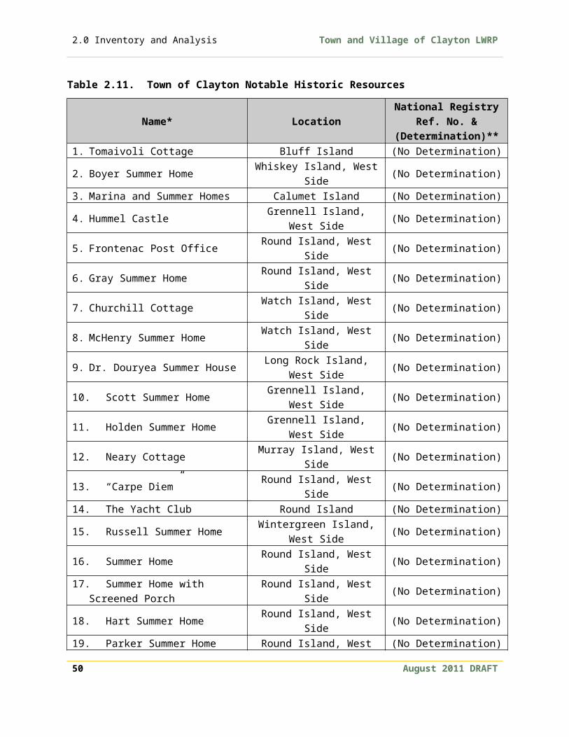
2.0 Inventory and Analysis Town and Village of Clayton LWRP
2. Revisions to the Town signage law;3. Purchase of conservation easements that provide for the retention of the
existing natural landscape and waterfront area; and4. Encouragement of clustering and other rural site design principles.
Effective land use planning, selective management of vegetative growth, and removal of distracting impairments can upgrade and enhance the aesthetic quality of the area and benefit the natural ecosystem. Additionally, joint municipal cooperation between the Town and Village in conjunction with private developers is needed to promote, enhance and protect the aesthetic beauty and scenic resources within the waterfront area.
Wind energy development has been proposed in southern sections of the Town of Clayton, as well as in adjacent communities. The scenic qualities of Clayton may be impacted by such development, and the wind facilities will need to be properly sited in order to preserve the scenic qualities of the WRA and Thousand Islands region. Identifying and protecting scenic resources is an important component of smart growth and scenic stewardship.
2.11 Topography and Geology In general, the topography of the WRA is generally level with some undulation (see LWRP Maps 1 and 8). There are some significant ridges that help define the WRA, including ridgelines on the north and south sides of French Creek, along the mainland shoreline west of the Village of Clayton, and along the north edge of McCarn Hill.
The geological character of the WRA consists mostly of sandstone bedrock known as Potsdam Sandstone, which dates to the Cambrian Period. The absence of sedimentary rock over it reflects a broad transition from more recently deposited limestone in the south and southwestern portions of the Village to the older gneisses and granites located in the north and northeast.
Four general types of soil are distributed throughout the Village waterfront. Silt loams are deep, fine textured, well-drained soil and are found on the eastern end of the peninsula. Silty clay loams are moderately deep and poorly draining, and are located on the western and northern portions of the Village peninsula. Under the drainage ways of French Creek and Bartlett Creek sit saprists and aquents
52 August 2011 DRAFT

Town and Village of Clayton LWRP 2.0 Inventory and Analysis
consisting of mixed organic and mineral materials. Highly altered soils from filling operations can be found at the western end of Mary Street.
The thin soils of the Town’s waterfront are represented by five general categories. These categories include: Benson-Newstead-Galloo Outcrop, Chaumond-Galloo-Wilpoint-Guffin clayey loams, Rhinebeck Hudson Rock Outcrop, Vergennes-Kingsbury-Elmridge loams and clays, and Groton-Windsor-Alton sands. Although loams are identified within these soil categories, they represent only a small portion in physical land area. The soil categories are predominantly composed of silty clays that drain poorly and are susceptible to ponding.
2.12 Water QualityWater Quality Classifications and StandardsThe New York State Department of Environmental Conservation (NYS DEC) has established water quality standards pursuant to ECL Title 6, Chapter X, Part 701.19 for surface and groundwater supplies in New York State. Determinations regarding water quality are based upon measurements of coliform, P.H., total dissolved solids, dissolved oxygen and other criteria. The Water Division of the NYS DEC does not do testing specifically around Clayton. The water quality in the Saint Lawrence River is very high in general and the state considers it a Class A drinking water source meaning it is drinking water quality with treatment. This is the state’s highest classification. The river is the source of drinking water for the Village and the Town.
Waters of French Creek are Class C waters and “are suitable for fishing, fish propagation and primary and secondary contact recreation even through other factors may limit the use for that purpose”. Consultation with NYS DEC indicated that the water quality of French Creek is designated as Class C since its waters “are primarily used for fishing and not utilized as a drinking water source”. Some areas of this watershed may be experiencing eutrophication as a result of upland erosion and fertilizer applications.
The local environmental group, Save the River, conducts periodic water quality tests for the bacteria, Enterococci (Entero) in the Clayton area. In 2008, water quality tests were conducted at Frink Dock; Potter’s Beach on Grindstone Island; and near Round Island. Water quality for all locations was within the state and federal standards for swimming water quality.
Given the fact that the St. Lawrence River serves as a primary water supply for shoreline residences, and that the French Creek is important as a fishery resource, August 2011 DRAFT 53

2.0 Inventory and Analysis Town and Village of Clayton LWRP
it is necessary to insure that these water sources are not impaired or impacted with regard to their water quality. The existing water use classification for the St. Lawrence River and French Creek are deemed appropriate given their respective uses.
End of Pipe DischargeThe discharge of pollutants, other than residential septic discharges are primarily associated with several small commercial uses located along the waterfront which have received discharge permits from NYS DEC. Treated effluent from the Village of Clayton Municipal Wastewater Treatment Plant also enters the St. Lawrence River on the north side of Washington Island. No problems have been identified at this time regarding the discharge of pollutants within the Town’s waterfront.
The Village of Clayton is dealing with two combined sewer overflows (CSOs) as required by the re-permitting of its wastewater treatment system. CSOs carry both storm and sanitary sewage directly into bodies of water when treatment facilities cannot handle flow rates, as during heavy rains. The EPA has a goal of releasing no sewage into the Saint Lawrence River and the community is taking steps to make that happen. The Village has long term Prioritized Project Plan and has already implemented a series of interim controls outlined by the state and federal government. Some of the prioritized projects include improved drainage system projects and NYSERDA energy saving projects.
Stormwater RunoffAs previously noted, Blind Bay, Carrier Bay, Sawmill Bay, Irwin Point, Bartlett Point, Mason Point and Grenell Island have been intensely developed with seasonal cottages, rental trailers and permanent homes. These areas have had problems associated with stormwater runoff. Additionally, draft studies released by the NYS DEC indicate that stormwater runoff in the St. Lawrence River basin is contaminated by nutrients, petroleum residuals, pathogens and sediments. Because of the health risks and environmental problems associated with these contaminants, measures are needed to control stormwater runoff. The NYS DEC Management Practices Catalogue for Nonpoint Source Pollution Prevention and Water Quality Protection in New York State may be used for technical guidance.
There are also some Best Management Practices (BMPs) which could be implemented at no or low costs such as Integrated Management Practices (IMPs), reduced use of fertilizers, pesticides, herbicides, and fungicides, road ditch maintenance, proper use and disposal of hazardous substances, buffer establishment and enhancements. Preventing pollutants from entering the storm 54 August 2011 DRAFT
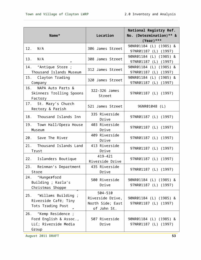
Town and Village of Clayton LWRP 2.0 Inventory and Analysis
water system is usually more efficient and cost-effective than treating stormwater runoff.
Discharges from VesselsThere are eight pumpout facilities located in the WRA. According to the NYS Clean Vessel Act Plan, published by the NYS DOS and NYS DEC in 1996, there was sufficient amount of pumpout facilities to meet the demand of recreational vessels at the time of the report. The development of additional pumpout facilities is contingent upon user demand. An updated plan, which is proposed by the NYS DOS and NYS DEC, will help identify the current demand. To promote appropriate removal and disposal of recreational boater septic waste, new or expanding marinas should provide adequate sewage pumpout facilities. The development of additional pumpout facilities could help the WRA become more accessible to visitors.
Other concerns related to discharges into waterfront waters involve the potential introduction of Zebra mussels and other non-native species into the St. Lawrence River and Great Lakes system as a result of ballast discharges from oceangoing vessels. Potential impacts as a result of the introduction of the mussels could be:
1. Imbalances in the aquatic food chain;2. Disruption of native fisheries habitats; and 3. Maintenance problems at dams, municipal water intakes and other related
structures.
DredgingThe bedrock geology of the Clayton shoreline limits the potential for dredging. Minimal dredging activity has taken place near Sawmill Bay, Carrier Bay and at Steeles Point in order to provide additional boat slips at existing marinas that are expanding.
The need for dredging is directly linked to the flow and regulation of water levels in the St. Lawrence River. Requests for dredging permits could increase as a result of drought conditions, unfavorable management of flow and river levels creating low water conditions, and increased development. These problems could severely limit boat access and dockage. Other concerns relevant to the potential increase in dredging activities include:
1. Disruption of bottom sediments;2. Reduced water quality in areas where contaminated bottom sediments are
suspended in the water strata;3. Increased turbidity resulting in stress on aquatic and benthic organisms; and
August 2011 DRAFT 55

2.0 Inventory and Analysis Town and Village of Clayton LWRP
4. Disturbance to wetland environments as a result of silt wash.
Currently, there is no scheduled dredging program maintained by the Village, state, or federal government for public and/or private dredging projects within the WRA. Uncoordinated dredging results in greater potential for irregular depth patterns, greater negative environmental impacts, and greater monetary costs than a coordinated program could provide.
Spills Into Waterfront WatersThe St. Lawrence River channel, which serves as an international shipping corridor for freight and materials from throughout the world, runs parallel to a vast amount of the Clayton mainland and island shoreline. Substances that are transported within this corridor include explosives, petroleum products and hazardous wastes. Vessels occasionally become grounded on shoals as a result of navigational error and unfavorable weather conditions.
Resultant spills of oil or other hazardous substances pose various threats to fish and wildlife, adverse impacts on drinking water supplies, and result in significant degradation to wetland, aquatic and benthic environments. Other factors that influence the impact of spills include the quantity of substances released, existing and prevailing weather conditions, and water level and flow.
Nonpoint DischargesA January 1990 Nonpoint Source Water Pollution Study, completed by the NYS DEC, identified that nonpoint nutrient contaminants from on-site waste water systems affect bay areas along the St. Lawrence River. Problems associated with nonpoint pollution include: excessive algae and plant growth, nitrogen contamination of water supplies, and reduced recreational values.
Another factor that contributes to the degradation of water quality is soil erosion. Although no immediate concerns have been identified in areas of highly erodible soils, land use and site development practices are constrained in such locations. Any uncontrolled activity that would aggravate the erodibility of these soils enhances the potential for water quality problems, or increases sedimentation rates, which may adversely affect fish and wildlife habitats.
Surface and Groundwater SuppliesThe surface waters of the St. Lawrence River serve as a primary source of drinking water for the entire Village of Clayton and the shoreline residents of the Town. Water studies conducted in 1968 for Jefferson County by the engineering firm of 56 August 2011 DRAFT

Town and Village of Clayton LWRP 2.0 Inventory and Analysis
O’Brien and Gere indicate that no aquifers exist within the waterfront area. However, the presence of drilled wells in bedrock, inland from the waterfront, indicates that groundwater is available. The source of this groundwater is believed to originate by direct recharge from the St. Lawrence River and French Creek drainage basin. No current information is available regarding well yields or locations of bedrock aquifers along the Town’s waterfront area.
The New York State DEC cites failing sewage disposal systems as the primary contributing factor to nutrient loading in small bays of the St. Lawrence River. It is unknown to what degree these small bays serve as a drinking water source. Left unchecked, this problem could lead to constraints on the use of existing ground and surface water supplies. The potential for increased summer home and residential development along the shoreline is another factor that could affect the quality and quantity of local ground and surface water supplies.
Saint Lawrence River Water LevelsThe Town and Village of Clayton strongly believe the regulation of Saint Lawrence River water levels and flows should be based on criteria that mimics natural water patterns and tames the extremes of high and low water levels. The Town and Village of Clayton would support an International Joint Commission (IJC) proposal for regulation of Lake Ontario and the St. Lawrence River levels and flows through the Moses-Saunders Dam at Cornwall-Massena that would provide the following significant environmental, recreational, and economic benefits:
Restores natural variability in water levels, which creates diversified zones of wetlands that shelter a greater variety of plants, fish, birds, mammals, and other animals.
Protects the recreational fishing industry of Lake Ontario/St. Lawrence/Lake Erie – valued at $330 million annually – by restoring the wetlands vital to fish life cycles.
Increases the number of recreational use days on the water, which will in turn provide increased revenue generation for small business owners, increased tax revenues for municipalities, and expansion of tourism opportunities.
Increase hydropower generation by over $6 million per year. Hydropower offers a cheaper, renewable energy alternative to fossil fuel power plants.
See also Harbor Management Plan, Section D.
2.13 Natural Resources & Environmentally Sensitive Features This section highlights portions of the WRA that contain wetlands, steep slopes and floodplains. These natural resources can be important natural amenities. In many August 2011 DRAFT 57

2.0 Inventory and Analysis Town and Village of Clayton LWRP
cases, development in or around these areas can prove to be more expensive and limited by regulation.
2.13.1 Floodplains
Most floodplains are found in low areas adjacent to streams, rivers, lakes and oceans and are prone to periodic flooding. In undeveloped areas this natural interaction restores soil fertility, recharges groundwater supplies and creates unique and diverse habitats.
The Federal Emergency Management Agency (FEMA) has designated 100-year flood zones. This designation does not mean that flooding will occur only once a century. Instead it means that, in any given year, there is a one-in-one hundred chance of flooding. Frequency of flooding is dependent on many factors including weather conditions and upstream development changes to the watershed.
Flooding is not considered a significant problem within Clayton’s waterfront area. In the Village, the 100-year floodplain generally consists of a narrow band 10-100 feet wide around the edge of the village peninsula (see LWRP Map 8). In the Town, the 100-year floodplain mostly surrounds streams and bays. Specifically, areas within the 100-year floodplain on mainland include low areas at French Creek, Wheeler Creek, Blind Bay, and Goose Bay. On Grindstone Island, areas within the 100-year floodplain include low areas adjacent to Delaney Bay, Rusho Bay, Aunt Jane’s Bay, and Flynn Bay.
The Town of Clayton and the Village of Clayton are in compliance with the terms of the National Flood Insurance program as administered by FEMA. Both the Town and Village of Clayton have adopted floodplain regulations to control the location and siting of new construction activities within flood zone areas in an effort to minimize damage to property, life, and natural resources.
2.13.2 Wetlands
Wetlands are among the most biologically productive ecosystems in the world. LWRP Map 9 identifies the location of National Wetland Inventory (NWI) and NYS DEC wetlands within the WRA. These wetlands provide environmental, recreational, educational, and aesthetic benefits by:
1. Protecting surface and groundwater supplies;2. Acting as permanent retention/detention areas which aid in minimizing
flooding and erosion;
58 August 2011 DRAFT

Town and Village of Clayton LWRP 2.0 Inventory and Analysis
3. Filtering and improving water quality;4. Serving as open space and natural buffer areas;5. Supporting numerous fish and wildlife habitat, as well as providing spawning
and nursery areas;6. Supplying food and organics within the food chain;7. Providing important recreational opportunities for boating, hunting, fishing
and trapping; and8. Providing areas for biological and ecological study.
Threats to wetlands include encroachment by residential land use, over utilization and disruption of nursery and fish spawning areas by powerboats, and possible eutrophication and siltation. The area surrounding the French Creek causeway, where French Creek flows into French Creek Bay, is an important aquatic ecosystem that was significantly disturbed by the construction of the causeway which restricted natural water flow significantly altered the ecology of French Creek. The removal of the natural marsh grasses and the loss of their associated ecosystem services has caused an increase in siltation that has rendered the creek barely navigable by personal watercraft, among other environmental problems. Replacing the causeway with a bridge would help to restore this important ecosystem by restoring natural flows and sediment movement.
Proposals that encourage the protection and preservation of wetlands, such as the 1974 McCrae and Delaney Wetlands Estuarine Sanctuary, by the State University of New York College of Environmental Science and Forestry at Syracuse, have merit for the purposes of natural wetland study. The ability to preserve wetlands for study, however, may be dependent upon other factors, such as private land ownership and acquisition costs.
2.13.3 Steep Slopes and Erosion
The high costs associated with building on steep slopes make them undesirable for development. The areas are prone to erosion and instability, and are unsuitable for both traditional and alternative septic systems. The definition of a steep slope varies, but typically it includes slopes greater that 12 to 15%. LWRP Map 8 identifies the location of slopes in the WRA greater that 12%. Areas of significant slopes on the mainland include the shoreline areas west of the Village, slopes on the north side of County Road 4 (north of the French Creek Wildlife Management Area), and a ridge north of House Road. Areas of significant slopes on Grindstone Island include the shorelines surrounding Buck Bay, Aunt Jane’s Bay and Rusho Bay. Islands with significant steep slopes include Bluff Island, Picton Island and Murray Island. August 2011 DRAFT 59

2.0 Inventory and Analysis Town and Village of Clayton LWRP
Erosion Hazard Areas and Natural Protective FeaturesThere are no NYS DEC designated Waterfront Erosion Hazard Areas within the Village’s or Town’s waterfront. A good portion of Grindstone Island contains highly erodible soils particularly near Flynn Bay, adjacent to the Upper Town landing, at Rusho Bay, and near the intersection of Cross Island Road and Middle Road. Inland areas of highly erodible soils are evident at Sawmill Bay, Carrier Bay and, to a lesser extent, adjacent to French Creek. The areas of highly erodible soils, as noted above, generally coincide with areas of steep slopes. These steep slopes and low erodible bluffs serve as natural protective features and buffer the mainland from the erosive forces of wave and ice action. Although no immediate concerns have been identified with regard to these erosion areas, management practices that minimize the potential for erosion should be implemented.
Erosion Protective StructuresExisting protective structures used to minimize erosion and wave impacts throughout the Clayton shoreline area include: seawalls and bulkheads, groins and jetties, and in a few locations, revetments and riprap. These protective structures provide a necessary means to control wave impacts and soil erosion along the Town and Village’s shoreline. While hard controls may provide temporary relief from erosion, they are expensive to install, degrade habitat, require ongoing maintenance, and may transfer erosion problems to adjacent areas. Alternatives to structural, engineered solutions exist, and these alternatives should be considered for use in the future whenever possible as the community continues to deal with erosion protection. Possible alternatives to help protect the shoreline and the ecosystem include bioengineering techniques and planting buffers using deep-rooted vegetation such as tall grasses, shrubs and trees, and aquatic vegetation such as reeds or cattails. These alternative solutions would result in a more natural shoreline, which has aesthetic and scenic benefits. Hard structural erosion protection measures should only be used as a last alternative, where there is a documented erosion problem and where alternative measures have been proven to be inadequate to protect the principal use.
Nonstructural Measures for Damage PreventionMinimizing flooding and erosion through nonstructural means within the WRA has been primarily accomplished through regulatory provisions in the Village and Town’s zoning ordinance and floodplain regulations. Additionally, the Village and Town’s floodplain regulations incorporate specific requirements for residential and commercial structures and provide the means to safeguard against potential flood damage. The Town and Village must utilize the provisions of their floodplain 60 August 2011 DRAFT

Town and Village of Clayton LWRP 2.0 Inventory and Analysis
regulations and require new uses to locate outside of the floodplain, or provide adequate flood proofing measures, as appropriate. Regulatory provisions, as established within the Village and Town’s zoning ordinance and floodplain regulations, are considered adequate at this time.
Ice ManagementTo date, no significant ice management problems have been experienced along the shoreline areas of the Town or the Village. Potential ice related impacts from natural climatic cycles and human manipulation of flow and water levels during winter months include the following:
1. Potential damage to shoreline structures;2. Increased bank erosion as a result of ice movement in areas that contain soils
of high erodibility;3. Loss of feeding habitat for wintering birds due to closure of normally open
water areas by broken and brash ice;4. Ice scouring of shoreline wetlands as a result of fluctuating water and ice
levels thereby stressing and, in some cases, altering viable fish and wildlife habitat in shoreline and bay areas; and
5. Instability of ice cover resulting in limited or loss of recreational use of river and bay areas for such uses as snowmobiling, skiing, and ice fishing.
The necessity of establishing a stable ice cover on the St. Lawrence River is important for environmental, economic and safety reasons. Therefore, establishing and maintaining consistent water levels that promote stable ice cover should be encouraged with regard to the shoreline areas of Clayton.
August 2011 DRAFT 61

2.0 Inventory and Analysis Town and Village of Clayton LWRP
2.14 Fish and Wildlife ResourcesThe 700-mile long Saint Lawrence River is home to many fish species and can be divided into four hydrographic zones. The WRA is part of the Fluvial Section, which runs from Lake Ontario past Montreal to Trois Rivieres. The river life can be divided into seven categories: plants, plankton, benthic organisms, fish, amphibians, birds and mammals.
2.14.1 River Life
Plants Thousands of species of plants inhabit the water and shorelines of the Saint Lawrence River system. In the Fluvial Section many are found in wetlands, such as marshes, wet meadows and swamps. Plants provide an important food source for other species and create habitats for many organisms.
Plankton Plankton are tiny creatures that drift in the water with limited ability to propel themselves. They form the base of the food chain in the St. Lawrence River and include bacteria, yeast, phytoplankton and zooplankton. Like plants, phytoplankton have a role of fixing carbon dioxide via photosynthesis. Zooplankton, on the other hand, are single and multicellular microanimals, which are often the larvae of fish and migrate the length of the river.
Benthic OrganismsBenthic Organisms dwell on the river bottom and are important for recycling organic matter, particularly in deep areas where sunlight does not penetrate. They are also a food source for other species, including people. Some bottom dwellers found in the Fluvial Section include mollusks (e.g., clams), crustaceans (e.g., crabs), oligocheate worms, diptera larve, amphipods, gastropods (e.g., snails) and tubificids.
FishFreshwater fish species found in the Fluvial Section include bullhead, carp, bass, pumpkinseed, walleye, stickleback, sturgeon, pike, burbot, sucker, perch, shiner, trout, mudminnow, char, muskellunge, and redhorse.
Amphibians and reptilesAmphibians and reptiles are important secondary consumers in the food chain eating, for example, insects or plankton. A range of amphibians can be found in and along the river including salamanders, newts, mudpuppies, turtles and frogs.
62 August 2011 DRAFT

Town and Village of Clayton LWRP 2.0 Inventory and Analysis
Birds Most birds along the Saint Lawrence inhabit the wetlands in the Fluvial Section as well as the Estuaries closer to the Gulf. Many migrate to the river ecosystem during the spring in search of food and breeding grounds. The main birds in the Fluvial Section include blue heron, Canada geese, mergansers, goldeneye, snow geese, moorhen, wood duck, green heron, pied billed geese and Peregrine falcons. Less common species include eagles, redheads and yellowtails.
Mammals Most of the area’s mammal population can be found in the marshes and wetlands. Examples include mink, muskrats, otters, beavers and raccoons.
2.14.2 Significant Fish and Wildlife Habitats
The Clayton WRA encompasses a number of significant waterfront fish and wildlife habitats within the St. Lawrence River ecosystem (see LWRP Map 10). Significant fish and wildlife habitat are evaluated by the NYS DEC based on the area’s wildlife population levels, species vulnerability, ecosystem rarity, human use and replaceability and based on this evaluation the NYS DOS designates significant habitats for protection, preservation, and where practical restoration so as to maintain their viability as habitats.
Significant habitats in the WRA are described below. A more detailed habitat narrative, the coastal fish and wildlife habitat rating form, fish and wildlife values, impact assessment, listing of knowledgeable contacts, and a location map is included for each designated habitat in Appendix E.
French Creek Marsh (including the French Creek Wildlife Management Area) This fish and wildlife habitat extends inland approximately five miles from the Village of Clayton, encompassing an approximately 700-acre streamside wetland and adjacent uplands in the NYS DEC’s French Creek Wildlife Management Area (WMA). French Creek is a sizeable warm water stream, with a broad floodplain occupied by extensive emergent marsh communities. The drainage area of French Creek is small, and little flow is discernible during the summer. Maximum channel depths of about 10 feet occur downstream of French Creek and Bevins Roads, but are less than 5 feet deep in the two major branches of the Creek. Water levels throughout this WMA are generally continuous with those of the St. Lawrence River, but fluctuations may be affected by the narrow channel opening under NYS Route August 2011 DRAFT 63

2.0 Inventory and Analysis Town and Village of Clayton LWRP
12E. The mouth of French Creek, at French Creek Bay, is outside of the Wildlife Management Area, and has been subject to considerable residential and commercial waterfront development, including diking and dredging of wetlands. Upland areas bordering the north, west and south sides of French Creek Marsh are largely rural in nature, including woodlots, abandoned fields, active agricultural lands, and low density residential development. Agricultural activities, including livestock grazing, extend up to the wetland at some locations, but other habitat disturbances are minimal.
The French Creek Marsh or at least that portion of the marsh located within the French Creek Wildlife Management Area represents a fish and wildlife habitat of potential statewide significance. Any significant disturbance of French Creek would be especially detrimental during fish spawning and nursery periods (March-July for most warmwater species) and wildlife breeding seasons (April-July for most species). Barriers to fish migration in the creek, whether physical or chemical, could have significant impacts on fish populations within the marsh and in French Creek Bay. Existing areas of natural vegetation bordering French Creek Marsh should be maintained for their value as cover for wildlife, perching sites, and buffer zones. Efforts should be made to reduce habitat disturbance by agricultural activities, especially grazing, through fencing and restoration of riparian vegetation. Potentially incompatible human use of the area, such as use of motorboats, waste disposal or camping should be restricted through enforcement of existing Wildlife Management Area regulations. Proposed public or private development actions must be cognizant of and compatible with the sensitivity of this habitat area. Upland and shoreline development west and east or southeast of the mouth, if not carefully guided and appropriately limited could jeopardize the habitat's viability.
Grindstone Island WetlandsGrindstone Island is the second largest island in New York’s portion of the upper St. Lawrence River and the largest island amongst the Thousand Islands, located approximately three miles northwest of the Village of Clayton. The fish and wildlife habitat consists of four large waterfront wetland and bay areas on the island. These are: Flynn Bay (approximately 270 acres), which includes adjacent Lindley Bay, located at the southern end of Grindstone Island; McCrae Bay (325 acres), which includes adjacent New Bay, located in the northwestern part of the island; Delaney Bay (200 acres), located in the northeastern part of the island; and the littoral shoreline which extends from Canoe Point south to Point Angiers (200 acres), located along the eastern part of the island. Flynn Bay is a wide-mouth bay facing the main channel of the St. Lawrence River. It has the smallest emergent wetland of the four bays, but features an extensive littoral zone. Flynn Bay is exposed to 64 August 2011 DRAFT
Town and Village of Clayton LWRP 2.0 Inventory and Analysis
considerable current and wave action so submergent vegetation is sparse. McCrae Bay and Delaney Bay are dominated by extensive emergent marshes that extend inland up to two miles. Both of these bays are bisected into upper and lower wetland portions, by a small road crossing over McCrae Bay, and by a natural island in Delaney Bay Marsh. The marshes extending from Canoe Point south to Point Angiers consist of extensive littoral zones and shoreline marshes and coves, including Whitehouse Marsh and Plumtree Marsh.
Despite differences in vegetative cover, the Grindstone Island Wetlands share a number of ecological characteristics. Water depths in all four areas generally do not exceed six feet, and are continuous with those of the St. Lawrence River. Drainage areas of the wetlands are small, and little flow is discernible during the summer. Surrounding upland areas are essentially undeveloped, including active agricultural lands, abandoned fields, and woodlots. Habitat disturbances in Grindstone Island Bays are generally limited to occasional livestock grazing, use of motorboats in the bays, and presence of rural road crossings. All of Grindstone Island Bays are privately owned, except for the marshes adjacent to Canoe Point and Picnic Point State Park.
Elimination of wetland habitats (including submergent vegetation), or significant human disturbance of the area, through dredging, filling, construction of roads, waste disposal, or motorboat access development, could severely reduce the value of Grindstone Island Wetlands to fish and wildlife. Activities that would subdivide these large, undisturbed areas into smaller fragments should be restricted. Channelization would reduce stream channel diversity, and result in a direct loss of valuable habitat area. However, habitat management activities, including water level management or expansion of productive littoral areas, may be designed to maintain or enhance populations of certain fish or wildlife species. Any significant disturbance of Grindstone Island Wetlands would be especially detrimental during fish spawning and nursery periods (March-July for most warmwater species) and wildlife breeding season (April-July for most species). Barriers to fish migration in major stream channels, whether physical or chemical, could have significant impacts on fish populations within the marshes, bays, and the upper St. Lawrence River. Adequate drainage of wetland areas located above road crossings should be provided through the installation and maintenance of bridges or culverts, if necessary. Existing areas of natural vegetation bordering these wetlands should be maintained for their value as cover for wildlife, perching sites, and buffer zones. Efforts should be made to reduce stream disturbance by agricultural activities, especially grazing, through fencing and restoration of riparian vegetation. Development of additional public access may be desirable to increase compatible August 2011 DRAFT 65
2.0 Inventory and Analysis Town and Village of Clayton LWRP
human uses of wetlands, but must be designed to minimize disturbance of sensitive fish and wildlife species that occur in this area.
Thousand Island Tern ColoniesThe Thousand Island Tern Colonies are located along the St. Lawrence Seaway navigation channel, extending from the Town of Clayton to the Town of Alexandria in Jefferson County. The fish and wildlife habitat consists of one man-made structure supporting navigation lights, located where shoals occur in close proximity to the Seaway channel, and three small rocky islands along with one small group of islands. The artificial structure is a roughly 25 foot square platform, constructed of concrete, rock, steel piping, with varying amount of soil, gravel, and vegetation on the surface. The height of the platform is approximately 8-10 feet above the water. All of the St. Lawrence River navigation lights are owned and maintained by the St. Lawrence Development Corporation, along with many other river structures not included in the habitat. The other specific sites include a small group of islands known as Eagle Wing Group, located approximately one-half mile northeast of the Village of Clayton; Gull Island, located about one mile north of Carrier Bay; Tidd Island, located one mile north of Mason Point; Light Northeast 216, located approximately one-half mile south of Thousand Islands Park; and an island known as Southeast Isle of Pines, located just north of Fishers Landing in the Town of Alexandria.
Bird species nesting in colonies on man-made structures and islands in the St. Lawrence River are highly vulnerable to disturbance from mid-April through July. Significant human activity (e.g. boat-landing, fishing or maintenance) on or around occupied sites, including Eagle Wing Group, Gull Island, and Tidd Island, could eliminate tern colonies, and should be minimized during this period. Artificially high water during nesting season would limit use of the islands. Annual or permanent posting of the structure and the islands should be provided to help protect the nesting bird species. Habitat management activities, such as manipulation of surface substrates, control of avian predation or competition, and establishment of additional nesting colonies in the vicinity, may be desirable or necessary in the near future to ensure the survival of common tern populations in the St. Lawrence River. Other navigation structures in the river should be monitored or enhanced for use by common terns, as part of an overall management program for these bird populations. Introduction or attraction of mammalian predators, including pet animals, would also be detrimental to the colonial bird populations at Eagle Wing Group, Gull Island, and Tidd Island.
Eel Bay66 August 2011 DRAFT

Town and Village of Clayton LWRP 2.0 Inventory and Analysis
Eel Bay is located in the upper St. Lawrence River, on the west side of Wellesley Island, in the Towns of Orleans and Clayton, Jefferson County. The fish and wildlife habitat is an approximate 2,100-acre shallow bay, containing extensive beds of submergent aquatic vegetation (e.g., wild celery, pondweeds, and muskgrass), a fringe of emergent marsh vegetation, and several small islands including Big Gull and Little Gull Islands. The habitat extends southwest to the shores of Murray Isle and Picton Island. There are two sizeable emergent wetland areas, totaling about 75 acres, around the bay shoreline. The larger wetland lies between Flat Iron Island and the north shore, and the smaller one occupies the northeast corner of the bay. Average water depths in Eel Bay range from 6-10 feet, depending of water levels in the St. Lawrence River. The bay bottom is covered variously with soft silt, peat, or clay, except near the south shore, which is rocky. Eel Bay is somewhat sheltered from prevailing winds and wave action, by being situated in the lee of Grindstone Island. Water circulation is substantial with a large channel cutting from the southwest corner and along the shore of Grindstone Island.
The mainland surrounding Eel Bay is almost entirely within Wellesley Island State Park, and remains in a relatively undisturbed natural condition. Private lands with seasonal camps and residences occur only at the hamlet of Grandview Park, on several small islands in the bay, and just east of the larger wetland area. Public access to the area is available from a State boat launching site on the east side of the bay, and from the Minna Anthony Nature Center located near the south shore of Eel Bay, in Wellesley Island State Park.
Any activity that would substantially degrade water quality in Eel Bay could affect the biological productivity of this area. All species of fish and wildlife may be adversely affected by water pollution, such as oil spills, excessive turbidity or sedimentation, waste disposal, and discharges of sewage or stormwater runoff containing chemical pollutants (including fertilizers, herbicides, or insecticides). Spills of oil or other hazardous substances are an especially significant threat to waterfowl concentrations in this area. Disturbance of littoral areas or wetland vegetation, through dredging, filling, bulkheading, or other shoreline construction activities (including development of motorboat access facilities) would adversely affect fish and wildlife through direct loss of habitat, and through increased human disturbance during fish spawning and nursery periods (April-July for most warmwater species). Development of additional public access opportunities to the Eel Bay area may be desirable, but should be located at existing access points to minimize potential disturbance of productive shallow areas. Significant human activity (e.g. motorboat traffic, fishing) on or around small islands used for nesting by common loons (from April through July) should be minimized during this period. August 2011 DRAFT 67

2.0 Inventory and Analysis Town and Village of Clayton LWRP
Annual or permanent posting of active nesting areas may be desirable to help protect breeding loons from human disturbance. Substantial alteration of fluctuation of water levels in the St. Lawrence River could also affect fish and wildlife use of the area. Existing areas of natural vegetation bordering Eel Bay and on the islands in the bay should be maintained to provide cover for wildlife, perching sites, soil stabilization, and buffer zones from human disturbance.
St. Lawrence River Shoreline BaysThe St. Lawrence River Shoreline Bays are located on the upper St. Lawrence River, between the Village of Clayton and Alexandria Bay, and in the Towns of Cape Vincent, Clayton, Orleans, and Alexandria. The fish and wildlife habitat consist of eight shallow bays along the River’s mainland shoreline. Within the WRA, from southwest (upriver) to northeast (downriver), these bays are: Peos Bay, (20 acres); Millen Bay (35 acres); Rose Bay (30 acres); Carrier Bay (approximately 160 acres); and Blind Bay (50 acres). All of the bays are generally less than six feet deep (depending on River levels) and are somewhat sheltered from prevailing winds and wave action. Much of the land area surrounding the St. Lawrence River Shoreline Bays is privately owned, and has been developed into seasonal camps, permanent residences, and small craft harbor facilities (resulting in some habitat disturbance).
The Shoreline Bays also merit consideration as habitats with potential statewide significance, especially the shallow areas in the southeast corner of Carrier Bay, due to the spawning and rearing of Muskellunge there. Any activity that would substantially degrade water quality, increase turbidity or sedimentation, reduce water levels, or increase water level fluctuations in Carrier Bay could adversely affect fish and wildlife use of these areas. Discharges of sewage or stormwater runoff containing sediments or chemical pollutants (including fertilizers, herbicides, or insecticides) into any of the bays may result in adverse impacts on fish and wildlife resources. Spills of oil or other hazardous substances are a potentially serious threat to fish populations on the Shoreline Bays area and every effort should be made to prevent such contamination. Significant human disturbances of the area, through dredging, filling, construction of roads, waste disposal, or unlimited motorboat access development, could severely reduce the habitat’s value as a spawning and nursery habitat Such disturbances would be especially detrimental during fish spawning and nursery periods (March through July for most species). Carrier Bay and all St. Lawrence River Shoreline Bays should be maintained for their value for wildlife, perching sites, and buffer zones. Proposed public or private development actions near the bay on Steeles Point or along NY Route 12 must be undertaken in a manner that will not jeopardize such spawning and rearing activity. While these areas are not targeted for special emphasis by the Town and Village for 68 August 2011 DRAFT

Town and Village of Clayton LWRP 2.0 Inventory and Analysis
revitalization or facilitation of water-dependent uses, review of private development or expansion efforts will still be important to ensure that physical disturbances (such as dredging or filling) and contamination (from septic system leachate) are not increased.
2.14.3 Species at Risk
Species at risk currently occupying waterfront area habitats outside the bounds of designated Significant Waterfront Fish and Wildlife Habitats include, but are not limited to: the Bald Eagle (Federal and New York State Endangered); Northern Harrier and Common Tern (New York State Threatened); Common Loon (New York State Species of Special Concern); Small Skullcap (a flowering plant rated as especially vulnerable, with 5 or fewer recorded occurrences in New York State); Lake Sturgeon (New York State Threatened); and Muskellunge (status unrated, but of significant concern at local and state levels). The location and presence of these species are described below.
August 2011 DRAFT 69

2.0 Inventory and Analysis Town and Village of Clayton LWRP
Bald EaglesBald Eagles are present in the waterfront area as spring and fall migrants and winter residents. As winter residents, they occupy open water pools in the ice cover and forested shoreline areas. Seasonally persistent open water pool habitat occurs in the vicinity of Woronoco and Basswood Islands.
Northern HarriersNorthern Harriers are present in migration, as nesting residents and as winter residents. They occupy wetlands, shorelands, shrublands and fields.
Common Terns Common Terns are present as migrants and as colonially nesting residents. They occupy open water, shoreline and wetlands.
Common LoonsCommon Loons may be present in breeding season, as well as in migration. They occupy open water, shoreline, and wetland edge habitats.
Small SkullcapSmall Skullcap has been identified as present on three small islands and one mainland site within the waterfront area.
Lake Sturgeon Lake Sturgeon are known to inhabit waters of the waterfront area. Critical habitat locations have not been identified – perhaps due to a lack of data.
Muskellunge Muskellunge spawning/nursery habitat (occupied) has been identified in several waterfront area embayments (Ste LaPan to SLECO: 9/28/89), including Blind Bay and two unnamed bays between McRae and Delaney Bays on Grindstone Island.
70 August 2011 DRAFT

Town and Village of Clayton LWRP 2.0 Inventory and Analysis
2.14.4 Other Issues Affecting Fish and Wildlife
Bioaccumulation of PollutantsPoint-specific information concerning the bioaccumulation of pollutants in the St. Lawrence River is not available for the WRA. However, the entire river has problems with heavy metal contamination in the sediments. Health advisories issued by the New York State Department of Health recommend limited consumption of sport fish and wildlife taken from the St. Lawrence River, because of a potentially harmful level of chemical contaminants in the River. The Department of Health recommends eating no American eels, channel catfish, lake trout over 25 inches, brown trout over 20 inches and Chinook salmon caught in the river. The agency recommends eating no more than one meal per month of river-caught white perch, white sucker, rainbow trout, smaller lake trout, smaller brown trout and Coho salmon over 25 inches. The chemicals of concern are PCBs, Mirex and Dioxin. As such, any effort that eliminates the actual or potential introduction of pollutants within the WRA should be encouraged.
Recreational Use of Fish and Wildlife Resources Recreational use of Clayton’s fish and wildlife resources occurs at the NYS DEC’s 2,262-acre French Creek Wildlife Management Area. Hunting, fishing and trapping opportunities are available on the marsh and adjacent uplands. “Pheasants are stocked occasionally to augment a small population of Ringnecks, while waterfowl and furbearers find suitable homes in the cattail marsh which borders the open water.” Access to this marsh is provided via unpaved roads within this area, although travel by foot is the primary means of passage through the uplands. Additionally, recreational use of fish and wildlife resources is notable throughout the shoreline and island areas, where sport fishing and small game opportunities can be enjoyed.
Commercial Fishing ActivitiesAt this time, there are no commercial fishing activities or uses within the waterfront area. The potential for the location of such uses in the future is a possibility, since the St. Lawrence River contains a number of game and bait fish species. Other commercial fishing activities such as netting, rigging or on-shore processing may prove to be counterproductive with regard to leisure and guide fishing opportunities presently in existence.
August 2011 DRAFT 71

2.0 Inventory and Analysis Town and Village of Clayton LWRP
2.15 InfrastructureSanitary Waste SystemsLocal concerns regarding the discharge of sewage effluent into the St. Lawrence River have been raised as a result of failing or inadequate residential septic systems along the Clayton shoreline. Accordingly, the Town has adopted NYS Department of Health regulations and inspection practices, which establish septic system requirements for all new uses to minimize the potential of ground or surface water contamination. The criteria, as contained in Jefferson County’s sanitary regulations, establish standards for septic systems based upon individual site conditions, and are considered adequate at present. In addition, the use of alternative septic systems is strongly encouraged to protect water quality and lessen the potential health risks associated with contaminated ground and surface water from failed septic systems within the waterfront area.
A significant impediment to adequate disposal of sewage effluent throughout the Town’s waterfront area is the presence of thin soils and steep slopes. Thin soils place severe limitations on the use of traditional septic systems. This factor is especially relevant to the islands and immediate shoreline areas where soils are sparse and bedrock is exposed to the ground surface. The soils are predominantly composed of silty clays that drain poorly, are susceptible to ponding, and are inadequate to effectively treat and dispose of effluent from traditional septic systems. Traditional or alternative septic systems also should not be located in areas where slopes exceed 12 to 15 percent.
A local organization known as Save the River is currently promoting the use of alternative septic systems in the Clayton and Thousand Islands region. Through its Kingfisher Program, this organization offers free septic system inspection and advisement on alternative septic systems. The Program has encouraged numerous shoreline property owners to upgrade their individual wastewater treatment systems. Public funding for this Program should be continued.
Additionally, information on alternative septic systems for residential use is available from the NYS Department of Health, Jefferson County Planning Department, and the Tug Hill Commission. These agencies can provide excellent source material regarding replacement of inadequate sewage disposal systems.
Solid Waste ManagementThe Town’s transfer station, located on the waterside of County Route 4, approximately 1.5 miles northeast of the Town of Clayton/Town of Cape Vincent
72 August 2011 DRAFT

Town and Village of Clayton LWRP 2.0 Inventory and Analysis
municipal boundary, is used for the disposal of the Town’s solid waste. Disposal of solid or hazardous wastes from the Town’s transfer station is not known to pose any threats to the water quality within the local waterfront area.
The lack of effective transportation and disposal of solid waste from the island areas has the greatest potential to impact the surface waters of the St. Lawrence River. To date, this has not been identified as a serious problem within the waterfront area.
Major Electric and Industrial FacilitiesAt this time, no major electric or industrial facilities exist along the waterfront area. The Town and Village of Clayton Zoning Ordinances adequately address the potential for the location of these types of uses. The Town has established an industrial district approximately one mile south of the WRA. The Village’s Industrial District is less then one mile from the waterfront edge and falls within the WRA. It is unlikely that discharges from any potential electrical or industrial use in this district would affect the natural resources of the St. Lawrence River or French Creek, since the district is located substantially inland from these bodies of water.
2.16 TransportationThe transportation network in a community determines how easily people and goods can move into, out of, and within a community and the WRA. The access and circulation systems inventory includes an investigation of the existing transportation systems including roads, air, and pedestrian/bicycle access. Clayton does not have public transit, such as rail or bus service. 2.16.1 Roads
The road system within the Clayton WRA includes NY State Routes, arterial roads, and town roads.
Major RoadwaysThe major arterial road providing regional access to the Town and Village of Clayton is Interstate 81. Interstate 81 runs through the adjacent towns of Pamelia and Orleans in a north/south direction. Interstate Route 81, a four lane limited access highway, directly connects Jefferson County to Ontario, Canada and the US Interstate system. No portion of Interstate 81 is located in the WRA, but it serves as a key access route to Clayton via State Routes 12 and 12E.
NYS Routes
August 2011 DRAFT 73

2.0 Inventory and Analysis Town and Village of Clayton LWRP
Two New York State Roadways are located within the Town and Village of Clayton, providing a means of vehicle access around the community and into neighboring areas. NYS Route 12 enters from the southeast corner of the Town, travels generally in a north-south direction into the Village of Clayton, where it makes a 90-degree turn and continues in a northeasterly direction along the waterfront to the Town of Orleans. In the Town of Orleans, Route 12 intersects with Interstate 81 near the Thousand Islands Bridge, and continues on through several shoreline communities, to the vicinity of Morristown.
At the intersection where Route 12 makes a 90-degree turn, NYS Route 12E begins and runs in a southwesterly direction from the Village of Clayton through the Town of Clayton and into the Town of Cape Vincent. Route 12E continues on along the waterfront of Lake Ontario through Chaumont, before ending in Limerick. Significant portions of Route 12 and 12E are located within the WRA, and act as key gateways into the Clayton WRA. Both routes provide adequate vehicular access and safety, but lack safe access for bicycling and/or walking. Also of particular note, are pedestrian and vehicular safety concerns related to the NYS Route 12E Bridge at French Creek. The bridge’s narrow shoulders limit pedestrian access and safety. Due to its location on a curve, driver line of sight conditions are limited.
Local RoadsThe remaining roads in the WRA, excluding those discussed above, are considered local roads. The roads located on the Village peninsula are organized in a grid pattern and provide adequate circulation. There is an opportunity to extend the grid pattern as part of the Frink America property redevelopment to make a seamless connection to the commercial core and adjacent neighborhoods. Riverside Drive could benefit from traffic calming techniques and pedestrian improvements. In the Town of Clayton and in the outskirts of the Village, local roads generally run perpendicular to Route 12 and Route 12E and are in good condition.
2.16.2 Air Service
The Watertown International Airport, located approximately 6 miles west of the City of Watertown, provides the nearest air service to the Clayton community. Jefferson County owns and operates the airport. The airport provides both general aviation and commercial air services. Cape Air Airways provides daily commercial passenger flights. Tom Brouty Aircraft Service, Inc. provides general aviation services, including fuel sales, aircraft engine repair, handicap accessible restrooms, and charter flights. The airport provides free parking and quick boarding, as well as free wireless Internet.
74 August 2011 DRAFT
Town and Village of Clayton LWRP 2.0 Inventory and Analysis
2.16.3 Pedestrian and Bicycle Circulation
The Village core and the neighborhoods immediately surrounding this area have adequate sidewalk systems that allow for safe travel over short distances within the immediate vicinity. The Village should repair and maintain sidewalks that link residential areas to downtown, and strive to improve crosswalk conditions. Constructing a median on Riverside Drive is a potential opportunity to improved pedestrian safety in the Village’s commercial core. Although traffic in the Village is not as intimidating as on major roadways, bicycle lanes have been suggested for local roads in the Village core to provide safer access throughout this area.
Pedestrian and bicycle circulation systems are limited or non-existent along NYS Routes 12 and 12E. In these areas, walking is dangerous, as road shoulders are not wide enough to ensure an adequate comfort level alongside the high speed and frequency of vehicles. Experienced cyclists may be more comfortable traveling on roadways in the WRA, as they tend to be more at ease sharing the road and interacting with motorists. However, inexperienced or recreational cyclists would likely find the same roadways to be dangerous and unnerving. Walking and biking trails/lanes along Routes 12 and 12E would greatly improve pedestrian and bicyle access and safety.
Existing trails in the WRA include the Grindstone Island Nature Trail, Sissy Danforth Rivergate Trail, and Zenda Farm Preserve Trail. The Grindstone Island Nature Trail is three miles long and links Canoe Point and Picnic Point State Parks. Hikers, mountain bikers, skiers, ATV riders and snowmobilers use the 24-mile Sissy Danforth Rivergate Trail. This trail links sections of abandoned New York Central Railroad beds in the Towns of Philadelphia, LaFargeville, Theresa, and Redwood. The Zenda Farm Preserve Trail was completed in 2009 and is used by hikers and cross-country skiers.
The Town and Village of Clayton have opportunities to develop additional trails in the French Creek Wildlife Management Area, on Grindstone Island, along Routes 12 and 12E, and along additional sections of abandoned railroad right-of-ways. Improving trail linkages to the Clayton RiverWalk would improve regional pedestrian and bicycle access to the waterfront and Village commercial district. The reconstruction of the Route 12E Bridge at French Creek also could provide an excellent opportunity to improve pedestrian and bicycle circulation and safety.
August 2011 DRAFT 75
2.0 Inventory and Analysis Town and Village of Clayton LWRP
2.16.4 Alternative Transportation
The Town and Village of Clayton currently have few transportation options for residents and visitors. The community is not served by local or regional bus service, or by railway. The closest ferry service is in Cape Vincent, with trips to Wolfe Island. Boat tours are available, but have limited access when compared with a ferry or water taxi. The community would benefit from alternative transportation options, such as a local trolley, or small ferries and/or water taxis that provide access to a variety of islands, parks and historic sites. Visitors in particular might benefit from the opportunity to rent a golf cart, scooter, bicycle or Segway as a means to get around the community. A small bus/trolley system that could carry visitors from satellite parking areas to Town and Village waterfront destinations would also improve transportation challenges.
76 August 2011 DRAFT

Town and Village of Clayton LWRP 3.0 Waterfront Management Policies
3.0 Waterfront Revitalization Policies
The Local Waterfront Revitalization Program (LWRP) policies presented in this section consider the economic, environmental, and cultural characteristics of the community’s waterfront. The NYS Waterfront Revitalization of Waterfront Areas and Inland Waterways Act establishes public policies for appropriate use and protection of the State’s waterfront areas and inland waterways. One of the most important roles of the Local Waterfront Revitalization Program is the adaptation of the State’s waterfront policies by the community to reflect local waterfront issues and utilize local approaches to address them along with the addition of specific local policies.
Once the LWRP is adopted by the Town and Village of Clayton and accepted by the NYS Secretary of State, public agencies will use these policies when considering the appropriateness of a proposed action, such as land use decisions and review of private development plans, within the WRA. Federal, State and local laws and regulations (the Federal Waterfront Zone Management Act, Article 42 of the NYS Executive Law and Town and Village Waterfront Consistency Review Laws) require agencies to conduct their activities in a manner consistent with these policies. If a proposed action is contrary to one or more of the policies, the action should be considered inconsistent with the LWRP unless an appropriate modification can be made or it can be shown that the action has an overriding public benefit.
The Town and Village of Clayton’s Waterfront Revitalization Policies are consistent with the LWRP vision statement and objectives. The policies are comprehensive and reflect existing laws and authority regarding development and environmental protection. Together, these policies are to be used to determine the appropriate balance between economic development and resource preservation that will permit beneficial use of, and prevent adverse effects on, Town and Village resources in the WRA.
The policies are organized under four headings: developed waterfront, natural waterfront, public waterfront, and working waterfront. The policies are summarized in the table below.
August 2011 DRAFT 77

3.0 Waterfront Management Policies
Town and Village of Clayton LWRP
Table 3.1. Waterfront Revitalization Policies for the Town and Village of Clayton
DEVELOPED WATERFRONT POLICIESPolicy 1 Foster a pattern of development in the waterfront area that enhances
community character, preserves open space, makes efficient use of infrastructure, makes beneficial use of a waterfront location, and minimizes adverse effects of development.
Policy 2 Preserve historic resources of the waterfront area.Policy 3 Enhance visual quality and protect scenic resources throughout the
waterfront area.NATURAL WATERFRONT POLICIESPolicy 4 Minimize loss of life, structures, and natural resources from flooding
and erosion.Policy 5 Protect and improve water quality and supply.Policy 6 Protect and restore the quality and function of the ecosystem.Policy 7 Protect and improve air quality in the waterfront area.Policy 8 Minimize environmental degradation in the waterfront area from solid
waste and hazardous substances and wastes.PUBLIC WATERFRONT POLICYPolicy 9 Provide for public access to, and recreational use of, the waterway,
public lands, and public resources of the waterfront area.WORKING WATERFRONT POLICIESPolicy 10 Protect water-dependent uses and promote siting of new water-
dependent uses in suitable locations.Policy 11 Promote sustainable use of fish and wildlife resources.Policy 12 Protect the agricultural lands.Policy 13 Promote appropriate use and development of energy and mineral
resources.
The following paragraphs examine the applicable State policies with regard to conditions, problems, and opportunities associated with the Town and Village of Clayton WRA.
78 August 2011 DRAFT

Town and Village of Clayton LWRP 3.0 Waterfront Management Policies
DEVELOPED WATERFRONT POLICIESPOLICY 1: FOSTER A PATTERN OF DEVELOPMENT IN THE WATERFRONT
AREA THAT ENHANCES COMMUNITY CHARACTER, PRESERVES OPEN SPACE, MAKES EFFICIENT USE OF INFRASTRUCTURE, MAKES BENEFICIAL USE OF A WATERFRONT LOCATION, AND MINIMIZES ADVERSE EFFECTS OF DEVELOPMENT.
Policy 1 ExplanationThis policy is intended to foster a development pattern that provides for beneficial use of waterfront resources. The primary components of the desired development pattern are: strengthening traditional waterfront communities as centers of activity, encouraging water-dependent uses to expand in these centers of activity, enhancing stable residential areas, and preserving open space.
The Town and Village of Clayton’s waterfront areas include a wide variety of land uses, natural resources, cultural and historic resources and recreational facilities and opportunities.
The reuse of existing, architecturally significant building stock and historic sites as centers of residential, commercial and recreational activity is the key component of the desired development pattern for the Village of Clayton’s downtown and WRA. Where new construction is necessary, the construction should be consistent in scale and character with the existing Village character. Land uses that attract residents and visitors to the downtown and offer recreational activities or community-oriented social activities and facilities should be encouraged.
The Town of Clayton’s waterfront is characterized by rural landscape with small enclaves of residential development along the shoreline of the Saint Lawrence River. The residential development comes in all shapes and sizes, from mobile homes to multi-million dollar waterfront estates. The Town also has significant agricultural and open space land uses on Grindstone Island. The vitality of the waterfront, and the preservation of the rural character of the area, is a critical component of the land use strategy for this area. Future investments should focus on sustaining the community and protecting the remaining open landscape that provides agricultural, ecological and scenic value. The principles of Smart Growth are applicable to the WRA.
August 2011 DRAFT 79

3.0 Waterfront Management Policies
Town and Village of Clayton LWRP
Policy 1 StandardsPolicy 1.1: Concentrate development and redevelopment in order to
revitalize and enhance the waterfronts, strengthen the traditional village core and rural edge, and prevent sprawl.
Development in the Town and Village of Clayton should perform several functions, including enhancing the visual character of the community, promoting the historic or nautical theme of the community, and providing economic activity beneficial to the community. At the same time, development should protect and enhance the environmental resources that support the area’s economy and improve its quality of life.
The following planning principles should be used to guide investment and preparation of development strategies and plans:
a. Ensure that new development within the Town and Village supports and is compatible with the existing desirable character of the community.
b. Match land uses to local and regional community needs to avoid unnecessary duplication and to preserve community character.
c. Focus public investment, actions, and assistance in waterfront redevelopment areas to reclaim unused waterfront land and brownfields for new purposes.
d. Locate new development where infrastructure is adequate or can be appropriately upgraded to accommodate new development.
e. Limit development to areas with no environmental constraints and minimize consumption of rural Town lands with clustering techniques and other rural land planning and design strategies.
f. Develop related recreational and commercial opportunities in the waterfront and downtown areas to encourage movement between the two areas.
g. Accommodate new waterfront uses in an orderly manner and foster safe, convenient waterfront access at strategic locations, linked by streets, sidewalks, a RiverWalk system, and other modes of access.
h. Increase educational and interpretative uses of the area around the St. Lawrence River.
i. Provide physical linkages between the waterfront, downtown, and other areas of Clayton, as well as other communities.
Revitalizing deteriorated, abandoned, vacant or underutilized sites within the waterfront area will help improve the economic vitality, provide recreational 80 August 2011 DRAFT

Town and Village of Clayton LWRP 3.0 Waterfront Management Policies
opportunities, and enhance the appearance of these areas. In particular, revitalization, stabilization or redevelopment of the following areas is recommended:
a. Revitalize the area north of NY Route 12E, with a particular focus on the commercial core from Riverside Drive between Centennial Park through to the northeastern portion of the peninsula. This includes providing clear pedestrian connections between the Antique Boat Museum and the east end of Riverside Drive. Infill development should be encouraged in this area in a manner compatible with the existing historical context.
b. Revitalize, stabilize and redevelop the areas along the eastern and northeastern shores of the Village peninsula with emphasis on enhancing public access and mixed-use development, siting new commercial uses and improving visual quality.
c. Redevelop the Municipal Wastewater Treatment Plant site. The Municipal Wastewater Treatment Plant occupies an attractive piece of waterfront property. The services provided by the Municipal Wastewater Treatment Plant should be provided by another facility, and the site redeveloped into a water-enhanced use.
Policy 1.2: Ensure that development or uses take appropriate advantage of their waterfront location.
The amount of waterfront and its associated resources are limited. All uses should relate to the unique qualities associated with a waterfront location. Consideration should be given to whether a use is appropriate for a waterfront location. When planning waterfront development or redevelopment, the waterfront location should be reflected in the siting, design, and orientation of the development. This policy seeks to provide a measure of control for future waterfront land uses in Clayton by devoting these lands to uses that are water-dependent or water-enhanced.
Water-dependent uses'Water-dependent uses' are defined by the State of New York as "activities that require a location in, on, over, or adjacent to the water because the activities require direct access, and the use of water is an integral part of the activity." The following uses and facilities are considered to be water dependent:
a. Uses that depend on the utilization of resources found in coastal water (for. example: fishing, mining of sand and gravel, mariculture activities);
b. Recreational activities that depend on access to coastal waters (for example: swimming, snorkeling, scuba diving, free diving, fishing (including charter fishing businesses), boating, and wildlife viewing);
August 2011 DRAFT 81

3.0 Waterfront Management Policies
Town and Village of Clayton LWRP
c. Uses involved in the sea/land transfer of goods (for example: commercial or public docks, loading areas, pipelines, short-term storage facilities);
d. Structures needed for navigational purposes (for example: locks, dams, lighthouses);
a. Flood and erosion protection structures (for example: breakwaters, bulkheads);
b. Facilities needed for in-water storage and service of boats and ships (for example: marinas, boat hoists/lifts, boat rail/track systems);
c. Uses requiring large quantities of water for processing and cooling purposes (for example: hydroelectric power plants, fish processing plants, pumped storage power plants);
d. Uses that rely heavily on the waterborne transportation of raw materials or products which are difficult to transport on land, thereby making it critical that a site near to shipping facilities be obtained (for example: coal export facilities, cement plants, quarries);
e. Uses which operate under such severe time constraints that proximity to shipping facilities become critical (for example: firms processing perishable foods);
f. Scientific/educational activities which, by their nature, require access to coastal waters (for example: certain meteorological and oceanographic activities); and
g. Support facilities which are necessary for the successful functioning of permitted water-dependent uses (for example: parking lots, snack bars, first aid stations, short-term storage facilities). Though these uses must be near the given water-dependent use, they should, as much as possible, be sited inland from the water-dependent use rather than on the shore.
Water-dependent uses should be promoted where appropriate and given precedent over other types of development at suitable waterfront sites. Existing water dependent uses, including commercial barge traffic servicing the islands, recreational boating, water-based entertainment (e.g., water-ski shows and visiting tour boats and naval vessels), fishing, and recreational diving should be protected. Enhanced docking access, particularly in the village, is a type of water-dependent use that is appropriate and useful in capturing recreational boaters from the St. Lawrence River. Development which is not dependent on a waterfront location or which cannot make beneficial use of a waterfront location should be avoided in the currently vacant areas along the waterfront. Floating domiciles are not considered a water-dependent use. Floating domiciles may not be attached to the shore by dock, pier, causeway or grounding within the village’s harbor management area 82 August 2011 DRAFT

Town and Village of Clayton LWRP 3.0 Waterfront Management Policies
except by permit when associated with a vacant lot with a minimum of 200ft of shoreline that is owned by the occupant of the floating domicile or docked at a commercial marina facility.
Water-enhanced uses'Water-enhanced uses' are defined as "activities that do not require a location on or adjacent to the water to function, but whose location on the waterfront upland, not on or over the water surface, could add to public enjoyment and use of the water's edge, if properly designed and sited. Water-enhanced uses are generally of a recreational, cultural, commercial, or retail nature."
Water-enhanced uses may be encouraged upland adjacent to the waterfront where they are compatible with surrounding development and are designed to make beneficial use of their waterfront location. A restaurant, which uses good site design to take advantage of a waterfront view, is an example of a water-enhanced use.
To ensure that water-enhanced uses make beneficial use of their waterfront location, they should be sited and designed to:
a. Attract people to or near the waterfront and provide opportunities for access that is oriented to the waterfront
b. Provide public views to or from the waterc. Minimize consumption of waterfront landd. Not interfere with the operation of water-dependent usese. Not cause significant adverse impacts to community character and
surrounding land and water resourcesf. Where appropriate, improve public access to waterfront
Uses should be avoided that would:a. Result in unnecessary and avoidable loss of waterfront resourcesb. Ignore their waterfront setting as indicated by design or orientationc. By their nature, not derive an economic benefit from a waterfront location
There is a finite amount of waterfront space in Clayton, especially in the Village, suitable for development purposes. Therefore, it is reasonable to expect that demand for waterfront land in Clayton will continue to intensify over time. In the Town, priority should be given to water-dependent and water-enhanced uses over non-water dependent residential, commercial or industrial uses. In the Village, priority should be given to completing the proposed RiverWalk which will integrate public access with its marine-related commercial operations and its other downtown businesses; providing for the expansion of harbor facilities where conditions allow; August 2011 DRAFT 83

3.0 Waterfront Management Policies
Town and Village of Clayton LWRP
and redeveloping underutilized properties that can capitalize on their waterfront location.
Policy 1.3: Protect stable residential areas. New development located in or adjacent to existing residential areas should be compatible with neighborhood character. New development can result in a reduction of access to publicly accessible places (i.e., any land, waterbody, or structure that is open to the general public, such as a public road, park, public school, recreation area, conservation area, or place of public accommodation such as a restaurant or hotel), which may be of significance to a residential area. The potential loss of access to publicly accessible places emphasizes the need to foster opportunities to provide new publicly accessible places for the community.
New non-residential uses in a stable residential area should be avoided when the use, its size, and scale will significantly impair neighborhood character. New construction, redevelopment, and screening, such as fences and landscaping, should not reduce or eliminate vistas that connect people to the water.
Policy 1.4: Maintain and enhance natural areas, recreation, open space, and agricultural lands.
Natural areas, recreation, open space, waterbodies, and agricultural lands produce public benefits that may not be immediately tangible. In addition to scenic and recreational benefits, these lands may also support habitat for commercially or ecologically important fish and wildlife, provide watershed management or flood control benefits, serve to recharge ground water, and maintain links to a region’s agricultural heritage.
Clayton's natural areas, recreation, open space, and agricultural lands on the waterfront and throughout the Town and Village, benefit the physical environment as well as the physical and psychological health of the community. To enhance community character and maintain the quality of the natural and man-made environments, especially on lands abutting NYS Route 12 E, potential adverse impacts on existing development, physical environments, and economic factors should be addressed and mitigated.
84 August 2011 DRAFT

Town and Village of Clayton LWRP 3.0 Waterfront Management Policies
The following planning principles apply to Clayton's natural areas, recreation, open space, and agricultural lands:
a. Development requirements should reflect site characteristics, limit the disturbance of land and water, and foster visual compatibility of the development with surrounding areas.
b. Avoid loss of economic, environmental, and aesthetic values associated with these areas.
c. Avoid the deterioration of water quality.d. Avoid expansion of infrastructure and services that would promote growth
and development detrimental to these resources. e. Maintain natural, recreational, and open space values including those
associated with large estates, golf courses, and beach clubs.f. Avoid, or minimize the loss of open space, natural areas, wetlands and
wildlife habitat while attempting to accommodate the recreational needs of the community.
g. Encourage appropriate, low impact uses that take into consideration the local natural features such as geology, topography, and wildlife habitat.
h. Implement protective measures to prevent erosion and stormwater runoff into the St. Lawrence River and its tributaries.
i. When evaluating proposed new development, ensure that natural areas are preserved to the maximum extent possible. For example, avoid the loss, fragmentation, and impairment of habitats and wetlands, and preserve steep slopes, native species, large individual trees, stands of trees, and unique forest cover types whenever possible.
j. Protect existing parklands and provide additional public recreational opportunities and carefully consider the implications of expanding infrastructure that might accelerate conversion of open spaces or natural areas to other uses.
k. Protect the open space value of agricultural land, preferably through retention of agricultural production.
Policy 1.5: Minimize adverse impacts of new development and redevelopment.
To enhance community character and maintain the quality of the natural and manmade environments of the WRA, potential adverse land use and accessory uses, environmental, and economic impacts from proposed development should be addressed and mitigated. Cumulative and secondary adverse impacts from development and redevelopment should also be minimized. Cumulative impacts August 2011 DRAFT 85

3.0 Waterfront Management Policies
Town and Village of Clayton LWRP
result from the incremental or increased impact of repetitive actions or activities when added to other past, present, or future actions or activities. Secondary impacts are those that are foreseeable, but occur at a later time or at a greater distance from the action, and are caused or facilitated by an action or activity, whether directly or indirectly.
Although recognized as a scenic resources, increased proliferation of boathouses and their potential cumulative impacts can present a concern to waterfront management (See Section 2.10). While maintenance of existing boathouses should be allowed, construction of new boathouses in appropriately designated areas, such as a historic boathouse district, should be carefully considered prior to permitting. New boathouse construction will not encroach upon navigation channels, significantly limit public access to the shoreline, degrade natural resources or significant scenic views, diminish the reasonable exercise of riparian rights by adjacent waterfront landowners, and must be designed with architectural features compatible with the community character. The construction of boathouses above the Ordinary High Water (OHW) mark is strongly encouraged in order to minimize adverse impacts.
Potential adverse environmental impacts on existing development should be minimized as follows:
a. Avoid the introduction of discordant features, which would detract from the community. Compare the proposed development or activity with existing distribution of structures, scale, intensity of use, architectural style, land use pattern, or other indicators of community character.
b. Mitigate adverse impacts among existing incompatible uses by avoiding expansion of conflicting uses, promoting mixed-use development approaches which would reduce potential for conflict, mitigating potential conflicts by segregating incompatible uses, and providing buffers, or using other design measures to reduce conflict between incompatible uses.
c. Protect the surrounding community from adverse impacts due to substantial introductions of or increases in odors, noise, or traffic.
d. Integrate waterfront areas with upland communities by: providing physical linkages between the upland community and the waterfront, matching uses to community needs, particularly as related to demographic characteristics, and limiting exclusion of the waterfront from the surrounding community.
e. Prevent displacement or impairment of the operation of water-dependent and water-enhanced uses.
86 August 2011 DRAFT

Town and Village of Clayton LWRP 3.0 Waterfront Management Policies
f. Encourage density averaging (clustering), cluster development or conservation subdivisions for rural Route 12 and 12E areas. Density averaging or clustering, also referred to as conservation subdivision, allows residences to be built on smaller lot sizes than typically permitted by zoning, provided that the average density of the original parcel is not increased.
g. Utilize all planning review, analysis, and mitigation tools, Best Management Practices (BMPs) for stormwater management, non-point source pollution, etc. and others.
h. Preserve scenic viewsheds and resources to the maximum extent possible.
Potential adverse economic impacts should be minimized, as follows: a. Prevent derelict or dilapidated conditions of existing buildings and sites to
avoid detraction from community character. b. Protect and enhance the community’s economic base. c. Promote a diverse economic base in the downtown and waterfront areas
to serve the needs of residents and non-residents. d. Avoid the expansion of infrastructure or services into previously
undeveloped areas, particularly areas abutting the French Creek marsh, undeveloped island lands, and steep slope areas.
e. Increase existing capacity of services and infrastructure to foster the concentration of development in preferred areas, such as the downtown area.
August 2011 DRAFT 87

3.0 Waterfront Management Policies
Town and Village of Clayton LWRP
POLICY 2: PRESERVE HISTORIC RESOURCES OF THE WATERFRONT AREA.
Policy 2 ExplanationArchaeological sites and historic structures are tangible links to the past development of a community—both its cultural and economic life—providing a connection to past generations and events. The Native American sites, Colonial era farmsteads and outbuildings, 19th century commercial districts, fishing villages, lighthouses, shipwrecks, and Gilded Age mansions are important components in defining the distinctive identity and heritage of New York State’s waterfront. Clayton’s historic and cultural legacy is rich in architectural, marine, waterway, and scenic resources that contribute to the enrichment of Clayton's identity and provide a multitude of opportunities to restore or revitalize points of interest for the enjoyment of residents and visitors alike. Therefore, the effective preservation of historic resources must include efforts to identify, document, restore, and revitalize important resources.
The intent of this policy is to preserve the historic and archaeological resources of the WRA (see LWRP Section 2.8 and Map 7). The community has identified Fairview Manor, located along the Town’s mainland shoreline, and the cheese factory on Grindstone Island as at-risk historic properties worthy of preservation. Concern extends not only to these specific sites or resources, but also with the area adjacent to and around specific sites or resources. The quality of adjacent areas is often critical to maintaining the quality and value of the resource. Effective preservation of historic resources must include more than local historic district zoning regulations (which the Village of Clayton has) but also, active efforts, when appropriate, to restore or revitalize. While this LWRP addresses all such resources within the WRA, it actively promotes preservation of historic, archaeological, and cultural resources that have a waterfront or maritime relationship.
The U.S. Secretary of the Interior provides standards for the identification and treatment of historic properties. Based on these standards, historic resources that would be covered under this policy include those structures, landscapes, districts, areas or sites, or underwater structures or artifacts, which are listed or designated as follows:
a. Any historic resource in a federal or state park established, solely or in part, in order to protect and preserve the resource.
b. Any resource on, nominated to be on, or determined eligible to be on the National or State Register of Historic Places.
88 August 2011 DRAFT

Town and Village of Clayton LWRP 3.0 Waterfront Management Policies
c. Any cultural resource managed by the New York State Nature and Historic Preserve Trust or the New York State Natural Heritage Trust.
d. Any archaeological resource which is on the inventories of archaeological sites maintained by the New York State Department of Education or the Office of Parks, Recreation, and Historic Preservation.
e. Any locally designated historic or archaeological resources protected by a local law or ordinance.
In identifying those elements that are important in defining the character and value of a historic resource, designation information, available documentation, and original research should be used. Important character-defining elements of the historic resource should be identified in terms of its:
a. Time, place, and use;b. Materials, features, spaces, and spatial relationships;c. Setting within its physical surroundings and the community; andd. Association with historic events, people, or groups.
The value of the historic resource is indicated by:a. Its membership within a group of related resources which would be
adversely impacted by the loss of any one of the group of resources;b. The rarity of the resource in terms of the quality of its historic elements or
in the significance of it as an example; orc. The significance of events, people, or groups associated with the resource.
Policy 2 Standards
Policy 2.1: Maximize preservation and retention of historic resources.
Preserve and retain the historic character-defining elements of the resource. Use the following standards to achieve the least degree of intervention:
a. Protect and maintain historic materials and features according to the following approach:1) Evaluate the physical condition of important materials and features:2) Stabilize materials and features to prevent further deterioration;3) Protect important materials and features from inadvertent or
deliberate removal or damage; and4) Ensure the protection of historic elements through a program of
nonintrusive maintenance of important materials and features.b. Repair historic materials and features according to recognized
preservation methods when their physical condition warrants.August 2011 DRAFT 89

3.0 Waterfront Management Policies
Town and Village of Clayton LWRP
c. When a historic feature is missing or the level of deterioration or damage precludes maintenance or repair:1) Limit the replacement of extensively deteriorated features or missing
parts to the minimum degree necessary to maintain the historic character of the resource.
2) Maintain historic character where a deteriorated or damaged feature is replaced in its entirety. In replacing features, the historic character of the resource can be best maintained by replacing parts with the same kind of material. Substitute materials may be suitable if replacement in kind is not technically or economically feasible and the form, design, and material convey the visual appearance of the remaining parts of the feature.
3) When re-establishing a missing feature, ensure that the new feature is consistent with the historic elements of the resource. If adequate historical, pictorial, and physical documentation exists so that the feature may be accurately reproduced, use available documentation to design and construct a new feature. If adequate documentation does not exist, design and construct a new feature that is compatible with the remaining features of the resource. The new design should be based on research, pictorial, and other evidence so that a true historical appearance is created.
d. Provide for efficient, compatible use of the historic resource.e. Foster uses that maximize retention of the historic character of
the resource:1) Maximum retention of historic character is best achieved by using the
resource as it was historically used; and2) If the resource cannot be used as it was historically used, adapt a use
to the historic resource that maximizes retention of character-defining materials and features.
f. Minimize alterations to the resource to preserve and retain its historic character.1) Minimize potential negative impacts on the resource's historic
character due to necessary updates in systems to meet health and safety code requirements or to conserve energy.
2) Make alterations to the resource only as needed to ensure its continued use and provided that adverse impact on the resource is minimized. Alterations should not obscure, destroy, or radically change character defining spaces, materials, features, or finishes in order to minimize adverse impact on the resource. Alterations may include
90 August 2011 DRAFT
Town and Village of Clayton LWRP 3.0 Waterfront Management Policies
selective removal of features that are not historic elements of the resource and its setting and that detract from the overall historic character of the resource.
3) Construct new additions only after it is determined that an exterior addition is the only viable means of assuring continued use of the resource.
4) In constructing new additions, use appropriate design and construction to minimize adverse impact on the resource's historic character. Adverse impact can minimized in new additions by: clearly differentiating from historic materials and features; using design compatible with the historic materials, forms and details, size, scale and proportion, and massing of the resource to protect the integrity of the resource and its setting. In addition, new additions should be designed such that, if removed in the future, the essential form and integrity of the historic resource and its setting would not be impaired.
g. Minimize loss of historic resources or the historic character of the resources of the waterfront when it is not possible to completely preserve and retain the resource.
h. Relocate an historic resource when it cannot be preserved in place and the resource is imperiled:1) directly by a proposed activity which has no viable alternative which
would not result in adverse effects on the resource, or indirectly by surrounding conditions which are likely to result in degradation or inadequate maintenance of the resource the resource cannot be adapted for use on the existing site which would result in preservation of the resource,
2) a suitable site for relocation is available, and3) it is technically and economically feasible to move the resource.
i. Allow for demolition of the resource only when:1) it is not feasible to protect the resource through relocation, and2) the resource has been officially certified as being imminently
dangerous to life or public health, or3) the resource cannot be adapted for any use on the existing site or on
any new sitej. Document in detail the character-defining elements of the historic
resource in its original context prior to relocation or demolition of the resource.
k. Avoid potential adverse impacts of development on adjacent or nearby historic resources.
August 2011 DRAFT 91

3.0 Waterfront Management Policies
Town and Village of Clayton LWRP
l. Protect historic resources by ensuring that development is compatible with the historic character of the affected resource.
m. Design development to a size, scale, proportion, mass, and with a spatial relationship compatible with the historic resource.
n. Design development using materials, features, forms, details, textures, and colors compatible with similar features of the historic resource.
o. Limit adverse cumulative impacts on historic resources.
1) Minimize the potential adverse cumulative impact on a historic resource, which is a member of a group of related resources that may be adversely impacted by the loss or diminution of any one of the members of the group.
2) Minimize the potential cumulative impacts of a series of otherwise minor interventions on a historic resource.
3) Minimize potential cumulative impacts from development adjacent to the historic resource.
Policy 2.2: Protect and preserve archaeological resources.
Conduct a cultural resource investigation when an action is proposed on an archaeological site, fossil bed, or in an area identified for potential archaeological sensitivity on the archaeological resources inventory maps prepared by the New York State Department of Education.
a. Conduct a site survey to determine the presence or absence of cultural resources in the project's potential impact area.
b. If cultural resources are discovered as a result of the initial survey, conduct a detailed evaluation of the cultural resource to provide adequate data to allow a determination of the resource's archaeological significance.
If impacts are anticipated on a significant archaeological resource, minimize potential adverse impacts by:
a. Redesigning projectsb. Reducing direct impacts on the resourcec. Recovering artifacts prior to construction, and documenting the site.
92 August 2011 DRAFT

Town and Village of Clayton LWRP 3.0 Waterfront Management Policies
Archaeological resources are protected under § 233 of New York State Education Law. These resources may not be appropriated for private use.
Policy 2.3: Protect and enhance resources that are significant to the waterfront culture.
The Town and Village desire to protect historic shipwrecks and shipwrecks to which the state holds title. Colonial era to modern-day shipwrecks lie in the Saint Lawrence River. While the location of many of these ships is well documented, more research remains to be done to identify and protect these historic and recreational resources as significant components of the waterfront culture of the state. Historic shipwrecks are those wrecks which, by reason of their antiquity or their historic, architectural, archaeological, or cultural value, have state or national importance and are eligible for inclusion on the State or National Register of Historic Places. The state holds title to all shipwrecks determined abandoned under the Abandoned Shipwrecks Act of 1987, and are protected under § 233 of New York State Education Law, Section 233.
The following standards apply to shipwrecks:a. Provide for the long-term protection of historic shipwrecks through the
least degree of intervention. The least degree of intervention can be achieved by preserving historic shipwrecks in place. When preservation is not feasible, record and recover shipwrecks or their artifacts.
b. Manage shipwrecks to provide for public appreciation, use, and benefit. The nature of public use and benefits associated with shipwrecks is very diverse. Sport divers should have reasonable access to explore shipwrecks. Additional public appreciation and enjoyment of shipwrecks can be achieved through interpretive access, which describes the history and value of the resource. Archaeological research on historic shipwrecks is particularly important where research can be reasonably expected to yield information important to understanding the past.
c. Avoid disturbance to shipwrecks unless the shipwreck: poses a navigation hazard; or, would impede efforts to restore natural resource values.
d. Prevent unauthorized collection of shipwreck artifacts and associated direct or cumulative impacts.
e. Maintain the natural resource values that are associated with shipwreck sites, which may be sensitive to disturbance.
August 2011 DRAFT 93

3.0 Waterfront Management Policies
Town and Village of Clayton LWRP
POLICY 3: ENHANCE VISUAL QUALITY AND PROTECT SCENIC RESOURCES THROUGHOUT THE WATERFRONT AREA.
Policy 3 ExplanationWaterfront landscapes possess inherent scenic qualities. The presence of water and ever-changing expansive views, the ephemeral effects of wildlife and atmospheric changes, and the visually interesting working landscape draw people to the water's edge. Due to their importance, scenic resources should be considered in balancing wise use and conservation of waterfront resources. In the Town and Village of Clayton, scenic views are extensive and varied (see LWRP Section 2.9 and Map 7). They include, but are not limited to, views to the Saint Lawrence River from roadways and upland areas, views from shoreline locations and from the water, and views from various locations of open space and agricultural resources. In the Village, shoreline properties along Riverside Drive afford exciting views of an expanse of the St. Lawrence River with islands, Seaway traffic, fishing and boating activities characteristic of the Thousand Islands region.
The highway gateways into the Town of Clayton and its waterfront area deserve special protection to preserve the attractive rural and historic quality of the Town. A scenic protection overlay district is a useful tool to regulate land uses within these scenic corridors to ensure areas visible to the public substantially retain their scenic character. Related to the significance of the gateways is the importance of the New York Seaway Trail that follows Route 12E through the Town and Village of Clayton. The Seaway Trail is the only National Scenic By-way in New York State. National Scenic By-ways are areas that possess outstanding qualities that exemplify the regional characteristics of our nation. This designation for the corridor through Clayton is important and should be recognized as such.
Vistas in the WRA that warrant protection or enhancement include the view from the Mary Street docks and those from and in the vicinity of the Route 12E Bridge at French Creek. Revitalization projects in the WRA will take advantage of these locally significant scenic resources with an aim to protect, enhance and preserve overall scenic character.
Boathouses located along the Town and Village shoreline that have architectural features compatible with the community character are another significant scenic resource that distinguishes the Thousand Island community from other New York State waterfront communities. Although recognized as a scenic resource, increased proliferation of boathouses and their potential cumulative impacts can present a 94 August 2011 DRAFT

Town and Village of Clayton LWRP 3.0 Waterfront Management Policies
concern to waterfront management (See Section 2.10). While maintenance of existing boathouses should be allowed, construction of new boathouses in appropriately designated areas, such as a historic boathouse district, should be carefully considered prior to permitting. New boathouse construction will not encroach upon navigation channels, significantly limit public access to the shoreline, degrade natural resources or significant scenic views, or diminish the reasonable exercise of riparian rights by adjacent waterfront landowners. The construction of boathouses above the Ordinary High Water (OHW) mark is strongly encouraged in order to minimize adverse impacts. New boathouses should be designed with architectural features compatible with the community character. Modest variations in architectural features are welcome as they add uniqueness and character to the area. Placement, footprint, roof pitch, and exterior materials should be considered during site plan review. Accessory decks should be placed on the upland area not over the water surface.
Policy 3 Standards
Policy 3.1: Protect and improve visual quality throughout the waterfront area.
The visual quality of WRA is an important component in the character of this area. Waterfront uses often include residential and recreational activities, infrastructure, and changes to the landscape that add visual interest. The Town and Village of Clayton will protect and improve visual quality and scenic vistas by:
a. Preventing impairment of scenic components that contribute to high scenic quality, as described in LWRP Section 2.9 and Map 7.
b. Improve the visual quality associated with urban areas and historic maritime areas.
c. Anticipate and prevent impairment of dynamic landscape elements that contribute to ephemeral scenic qualities.
d. Recognize water-dependent uses as important additions to the visual interest of the waterfront.
e. Protect scenic values associated with public lands, including public trust lands and waters, and natural resources.
f. Maintaining existing open views on axis with Village streets (ex., the open lot at the north end of James Street).
Policy 3.2: Protect aesthetic values associated with recognized areas of high scenic quality.
August 2011 DRAFT 95

3.0 Waterfront Management Policies
Town and Village of Clayton LWRP
There are no designated Scenic Areas of Statewide Significance; designated areas under Protection of Natural and Man-made, designated scenic rivers, or other governmentally recognized scenic resource areas in the WRA. Nonetheless, special attention should be given to zoning and architectural review regulations where there is a potential for river views that connect the historic commercial strip with the river that brought Clayton into existence. These views deserve strong protective measures because of their scenic qualities and their centrality to life in Clayton through location and frequency of use. Overhead utility lines, inappropriate lighting, and inconsistent architectural character are just a few examples of negative impacts on the character of the downtown area. For the Town of Clayton, views of the St. Lawrence River and rural lands are very important along the NYS Route 12 corridor. The application of a scenic protection overlay zoning district provides the tool to regulate land uses within this scenic corridor and protect its scenic beauty and rural character.
The following siting and facility-related guidelines are to be used to achieve this policy, recognizing that each development situation is unique and that the guidelines will have to be applied accordingly:
a. Site structures and other development back from shorelines and the crest of hills, or in other inconspicuous locations to maintain the attractive quality of the shoreline and to retain views to and from the shore;
b. Cluster or orient structures to retain views, retain qualities of open space, and provide visual organization to a development;
c. Incorporate existing structures (especially historic buildings) into the overall development scheme of a project;
d. Remove deteriorated and/or degrading elements;e. Maintain or restore the original land form, except when changes screen
unattractive elements and/or add appropriate interest;f. Maintain or add vegetation to provide interest, encourage the presence of
wildlife, blend structures into the site, and obscure unattractive elements, (such as parking lots and boat storage areas), except when selective clearing removes unsightly, diseased or hazardous vegetation and when selective clearing within public parks, at street ends and along rights-of-way creates views of the Saint Lawrence River and other bodies of water;
g. Use appropriate materials (wood, stone, wrought iron fencing, earth berms) in addition to vegetation to screen unattractive elements;
h. Use appropriate scales (i.e., building height and massing), forms, and materials to ensure that buildings and other structures are compatible with and add interest to the Clayton’s visual environment;
96 August 2011 DRAFT

Town and Village of Clayton LWRP 3.0 Waterfront Management Policies
i. Minimize the effects, as much as possible, of facility operation (e.g. lighting, noise, and odor); and
j. Provide for burying overhead wires whenever practicable especially in the Business District on Riverside Drive.
August 2011 DRAFT 97

3.0 Waterfront Management Policies
Town and Village of Clayton LWRP
NATURAL WATERFRONT POLICIES
POLICY 4: MINIMIZE LOSS OF LIFE, STRUCTURES, AND NATURAL RESOURCES FROM FLOODING AND EROSION.
Policy 4 Explanation This policy seeks to protect life, structures, and natural resources from flooding and erosion hazards throughout the waterfront area. The policy reflects state flooding and erosion regulations and provides measures for reduction of hazards and protection of resources. This policy will also assist in slowing the rate of deterioration of shoreline structures and in avoiding disruptions or losses of public access to the St. Lawrence River by increasing the durability of such structures.
Portions of Clayton's St. Lawrence River shoreline are located within the 100-year floodplain. Shoreline stabilization, especially in the waterfront/shoreline area, is vulnerable to seasonal water-level fluctuations, wind driven wave action, and ice movement, causing both long- and short-term damage to shoreline structures. Shoreline erosion, on the other hand, is minimal due to the durability of the Potsdam sandstone bedrock typically exposed along the shore and proper design, construction and maintenance of shoreline structures will prolong their utility and benefits when resistance to wave and ice action is included as a design parameter.
The Town and Village of Clayton participate in the National Flood Insurance Program (NFIP) and have local laws covering flood damage prevention. These laws are designed to prevent future property damage within the flood hazard area. In areas subject to flood control regulations, no structure will be permitted that is in violation of local flood control regulations.
The Town and Village waterfront areas have no Waterfront Erosion Hazard Areas. However, soils with high potential erodibility have been identified on Grindstone Island at Flynn Bay, Upper Town Landing and between North Shore Road and Cross Island Road. Other islands, which possess highly erodible soils, are Picton, Murray, Bluff and Maple. Mainland areas that contain highly erodible soils include small locations at Sawmill Bay, Carrier Bay and, to a lesser extent, adjacent French Creek. These areas of highly erodible soil types are usually associated with steep slopes having modest vegetative cover. A few of these areas are likely to experience erosion at a rate of one foot or more per year.
98 August 2011 DRAFT

Town and Village of Clayton LWRP 3.0 Waterfront Management Policies
Extensive disturbance of vegetative cover in the process of development would likely result in increased soil erosion. Erodible upland soils could also be carried into the waterfront waters of the Town and Village if development is permitted on steep slopes without erosion and sedimentation control measures. Therefore, public and private actions involving development should be guided to avoid or minimize substantial disturbance of existing vegetative cover to prevent erosion or, at a minimum, be required to employ suitable erosion and sedimentation control techniques after disturbance has occurred. Upland erosion and sedimentation control will be particularly important for protection of the St. Lawrence River and French Creek. In particular, the area east of the French Creek Marsh is more extensive and closer to sensitive wetlands and fish and wildlife habitats.
Policy 4 Standards
Policy 4.1 Minimize flooding damage in the Town and Village of Clayton through the use of appropriate management measures.
Standards which use various management measures design to prevent flood damage prevention and protect life and property, are presented below in order of priority:
a. Avoid development other than water-dependent uses in waterfront hazard areas.
b. Locate or move development and structures as far away from hazards as practical.
c. Use vegetative non-structural measures which have a reasonable probability of managing flooding and erosion, based on shoreline characteristics including exposure, geometry, and sediment composition.
d. Enhance existing natural protective features and processes, and use non-structural measures that have a reasonable probability of managing erosion.
e. Use hard structural erosion protection measures as a last alternative, only where there is a documented erosion problem, where the above measures have be proven to be inadequate to protect the principal use, or the use is water-dependent or reinforces the role of the Village’s waterfront activity or a waterfront redevelopment area.
f. Manage development in floodplains outside of waterfront hazard areas, so as to avoid adverse environmental effects, minimize the need for structural flood protection measures, and meet Federal flood insurance program standards. In addition, mitigate the impacts of erosion control structures.
August 2011 DRAFT 99

3.0 Waterfront Management Policies
Town and Village of Clayton LWRP
Policy 4.2: Preserve and restore natural protective features.
The natural protective features within the WRA are bluffs, wetlands, and associated vegetation. For example, the low erodible bluffs along portions of the Town and Village’s mainland waterfront and on Grindstone Island are natural protective features that help safeguard waterfront lands and property from damage, as well as reduce the danger to human life, resulting from flooding and erosion. As flooding and erosion protection features, these natural protective features are considered superior to manmade features and will be preserved where feasible in the Town and Village of Clayton. Excavation of waterfront features, improperly designed structures, inadequate site planning, or other similar actions that fail to recognize their fragile nature and protective value may lead to weakening or destruction of these landforms. Activities and development in, or in proximity to, natural protective features must ensure that all such adverse effects are minimized. Nonstructural measures to minimize damage from wave action and ice movement will primarily involve facilitating the location of water-dependent uses that rely on shoreline structures in areas of the waterfront less exposed to such forces.
Standards applicable to preserving and restoring natural protective features include:
a. Avoiding alteration or interference with shorelines currently in a natural condition;
b. Avoiding development other than water-dependent uses in, or in close proximity to natural protective features;
c. Enhancing existing natural protective features;d. Restoring the condition of impaired natural protective features, wherever
practical; e. Using practical vegetative approaches to stabilize natural shoreline
features; andf. Providing signage or other interpretive materials to increase public
awareness of natural features.
100 August 2011 DRAFT

Town and Village of Clayton LWRP 3.0 Waterfront Management Policies
Policy 4.3: Protect public lands and public trust lands and use of these lands when undertaking all erosion or flood control projects.
Every effort should be made to protect the loss of public lands threatened by flooding and erosion using the techniques and standards described above and the following:
a. Retain ownership of public trust lands that have become upland areas due to fill or accretion resulting from erosion control projects.
b. Avoid impairments, losses or likely losses of public trust lands or use of these lands, including public access along the shore, which can be reasonably attributed to or anticipated to result from erosion protection structures. Impairments of lands can include, but is not limited to, impacts on habitat, degradation of water quality, reduction of public access, or interference with navigation.
c. Mitigate unavoidable impacts on adjacent property, natural waterfront processes and natural resources, and on public trust lands and their use.
Policy 4.4: Manage navigation infrastructure to limit adverse impacts on waterfront processes.
The intent of this policy is to manage navigation channels to limit adverse impacts on natural waterfront processes that shape the shoreline, such as sediment transport and deposition. Techniques for designing channel construction and maintenance practices to protect and enhance natural protective features and prevent destabilization of adjacent areas; and make beneficial use of suitable dredged material include:
a. Using dredging setbacks from established channel edges and designing finished slopes to ensure their stability.
b. Locating channels away from erodible features, where feasible. c. Preventing adverse alteration of basin hydrology. d. Managing stabilized inlets to limit adverse impacts on waterfront
processes.
Policy 4.5: Ensure that expenditure of public funds for flooding and erosion control projects results in a public benefit.
Town and Village investment in shoreline structures exposed to flood, erosion, wind driven wave action and ice movement is generally unwise unless the expenditures August 2011 DRAFT 101

3.0 Waterfront Management Policies
Town and Village of Clayton LWRP
of public funds is necessary to diminish the severity of these forces to protect life, limb, or public property. Town or Village investment in measures to protect properties, as in the construction of shoreline structures in the more exposed areas, must weigh the economic benefits to Clayton and its waterfront in view of public costs.
Factors to be used in determining public benefit attributable to the proposed flood control measure include:
a. Economic benefits derived from protection of public infrastructure and investment and protection of water-dependent commerce;
b. Protection of significant natural resources and maintenance or restoration of waterfront processes;
c. Integrity of natural protective features; d. Extent of public infrastructure investment; ande. Extent of existing or potential public use.
Evaluation of these factors may indicate that public expenditure for flood control projects is warranted in developed centers. Give priority in expenditure of public funds to actions that protect public health and safety, mitigate flooding and erosion problems caused by previous human intervention, protect areas of intensive development, and protect substantial public investment in land, infrastructure, and facilities.
Whenever possible, use nonstructural measures to minimize damage to natural resources and property from flooding and erosion. Such measures shall include:
a. The setback of buildings and structures;b. The planting of vegetation and the installation of sand fencing and
draining;c. The reshaping of bluffs; andd. The floodproofing of buildings or their elevation above the base flood
level.
Expenditure of public funds for flooding or erosion control projects:a. Should be limited to those circumstances where public benefits exceed
public cost; b. Is prohibited for the exclusive purpose of protecting private development;
andc. May be apportioned among each level of participating governmental
authority according to the relative public benefit accrued.102 August 2011 DRAFT
Town and Village of Clayton LWRP 3.0 Waterfront Management Policies
Policy 4.6: The construction or reconstruction of docks, boathouses, boat hoists, public access facilities and other shoreline structures shall be undertaken in a manner which will, to the maximum extent practicable, protect against or withstand the destructive forces of wave action and ice movement.
The western and northern portions of the village peninsula are variably subject to wind driven wave action and ice movement, causing both long- and short-term damage to shoreline structures. Shoreline erosion, on the other hand, is minimal due to the durability of the Potsdam sandstone bedrock typically exposed along the shore and proper design, construction and maintenance of shoreline structures will prolong their utility and benefits when resistance to wave and ice action is included as a design parameter. Construction must conform to existing design, construction, and maintenance standards. Improper design, construction and maintenance standards, may result in loss of structures and potentially create water hazards from debris. This policy will thus assist in slowing the rate of deterioration of shoreline structures and in avoiding disruptions or losses of public access to the St. Lawrence River by increasing the durability of such structures.
Policy 4.7: Water level management practices shall not damage significant fish and wildlife and their habitats, increase shoreline erosion or flooding, or interfere with the local economy.
Water levels have a significant impact on fish and wildlife and their habitats, shoreline erosion and flooding, as well as, the local economy. Changes in water levels impacts the ability of people to access the Clayton central harbor area, and therefore, any businesses that contribute to the economic base of the community. The Clayton community will support a regional water level management strategy that tames the extremes of high and low water levels and offers significant environmental and economic improvements to the region.
Specifically, the Clayton community would support a regional water level management strategy that would provide the following significant environmental and economic benefits:
a. Restores natural variability in water levels, which creates diversified zones of wetlands that shelter a greater variety of plants, fish, birds, mammals,
August 2011 DRAFT 103

3.0 Waterfront Management Policies
Town and Village of Clayton LWRP
and other animals and helps protect the recreational fishing industry of the Saint Lawrence River.
b. Provides – on average – higher water levels in the spring and fall, which increases the number of recreational use days on the water, which will in turn provide increased revenue generation for small business owners, increased tax revenues for municipalities, and expansion of tourism opportunities.
c. Increases hydropower generation, which offers a cheaper, renewable energy alternative to fossil fuel power plants. New hydropower generation shall not adversely impact fisheries and wildlife and their habitats, natural resources, navigation, water-dependent uses, or public access.
Policy 4.8: Ice management practices shall not damage significant fish and wildlife and their habitats, increase shoreline erosion or flooding.
Prior to undertaking actions required for ice management, an assessment must be made of the potential effects of such actions upon fish and wildlife and their habitats as identified in Section 2.14 and Policy 6, flood levels and damage, rates of shoreline erosion damage, and upon natural protective features. Following such an examination, adequate methods of avoidance or mitigation of such potential effects must be utilized if the proposed action is to be implemented.
Winter navigation along the St. Lawrence Seaway, which has been proposed in the past, would require ice management practices along the Village and Town’s river shoreline. Such practices would involve detrimental impacts on waterfront resources in the local waterfront area. The Town and Village oppose winter navigation in every conceivable way.
Policy 4.9: Use environmentally sound, cost-effective measures, when proven necessary, to minimize the wave action and ice movement itself, such measures shall be pursued in consultation with appropriate State and federal agencies, local interests, and experts in the fields of marine engineering and construction.
104 August 2011 DRAFT

Town and Village of Clayton LWRP 3.0 Waterfront Management Policies
Erosion protection structures often contribute to erosion both on and off the site due to poor design and siting and lack of down drift remediation. Increased erosion, aesthetic impairments, loss of public recreational resources, loss of habitats, and water quality degradation can result from erosion protection structures. The cumulative impact of these structures can be large. Before a permit is granted to allow construction of erosion protection structures, the purpose, function, impact, and alternatives to a structure need to be carefully evaluated to determine if the structures are necessary, and to avoid adverse impacts.
The western and northern portions of the village peninsula are variably subject to wind driven wave action and ice movement, causing both long- and short-term damage to shoreline structures. Shoreline erosion, on the other hand, is minimal due to the durability of the Potsdam sandstone bedrock typically exposed along the shore. Proper design, construction, and maintenance of shoreline structures will prolong their utility and benefits when resistance to wave and ice action is included as a necessary design parameter. This policy will thus assist in slowing the rate of deterioration of shoreline structures and in avoiding disruptions or losses of public access to the St. Lawrence River by increasing the durability of such structures.
August 2011 DRAFT 105

3.0 Waterfront Management Policies
Town and Village of Clayton LWRP
POLICY 5: PROTECT AND IMPROVE WATER QUALITY AND SUPPLY.
Policy 5 ExplanationThe purpose of this policy is to protect the quality and quantity of water in the waterfront area. Quality considerations include both point source and nonpoint source pollution management. The primary quantity consideration is the maintenance of an adequate supply of potable water in the region. The primary water resources in the Town and Village of Clayton are the St. Lawrence River and French Creek.
Water quality protection and improvement in the region must be accomplished by the combination of managing new and remediating existing sources of pollution. In some areas with existing water quality impairments, more aggressive remediation measures will be needed.
Policy 5 Standards
Policy 5.1: Prohibit direct or indirect discharges, which would cause or contribute to contravention of water quality standards.
This policy focuses on those discharges into the water resources of Clayton’s WRA that have an identifiable source, such as a development site, industrial operation, or wastewater treatment plant. These are called "point-source" discharges. Point-source discharges into water resources are regulated by New York State Pollutant Discharge Elimination System (SPDES) permits that serve to prevent discharges that:
a. Exceed applicable effluent limits for the discharge source;b. Cause or contribute to contravention of water quality classification and
use standards;c. Adversely affect the water quality of receiving waters; ord. Violate a vessel waste no-discharge zone.
The effective treatment of sanitary sewage and industrial discharges will be ensured by:
a. Maintaining efficient operation of sewage and industrial treatment facilities pursuant to the applicable NYS DEC regulations;
b. Providing, at minimum, secondary treatment of sanitary sewage;c. Making improvements to wastewater treatment facilities to improve
nitrogen removal capacity;106 August 2011 DRAFT

Town and Village of Clayton LWRP 3.0 Waterfront Management Policies
d. Reducing the loading of toxic materials into waters by including limits on toxic metals as part of wastewater treatment plant effluent permits;
e. Reducing or eliminating combined sewer outflows; andf. Providing and managing on-site disposal systems where applicable in
accordance with NYS Codes, Rules and Regulations.g. New or expanding marinas shall provide adequate sewage pumpout
facilities. The Village of Clayton's municipal sewer system adequately serves most of its waterfront area. On site waste disposal systems will be required in areas not served by sewers in accordance with NYS Department of Health standards. Alternative and innovative disposal systems will be encouraged in areas identified as poorly suited to conventional systems.
Policy 5.2: Manage land use activities and use best management practices to minimize nonpoint source pollution of waterfront areas.
Non-point source pollution is pollution that originates from sources that are not localized or easily identifiable. Non-point source pollution includes contaminated surface water runoff of urban areas and agricultural operations. Limiting non-point sources of pollution is the best way to avoid non-point source pollution, which can be accomplished by:
a. Reducing or eliminating the introduction of materials that may contribute to non-point source pollution.
b. Avoiding activities that would increase stormwater runoff.c. Controlling and managing stormwater runoff.d. Retaining or establishing vegetation or providing soil stabilization.e. Preserving natural hydrologic conditions through maintenance of natural
water surface flows, thereby retaining natural watercourses, wetlands, and drainage systems.
This policy is particularly applicable to Clayton in that the Village comprises the drainage basins of the St. Lawrence River and a tributary, the French Creek Marsh. Non-point source pollution from roadways, marinas, fertilized lawns and golf courses, eroded stream banks and steep slopes should be prevented through the implementation of the following standards:
a. Develop both watershed planning and protection approaches and efforts targeting specific pollution sources to reverse the degradation of the St. Lawrence River and its tributaries.
August 2011 DRAFT 107

3.0 Waterfront Management Policies
Town and Village of Clayton LWRP
b. Develop a Village and Town-wide stormwater management plan, in accordance with current EPA Phase 2 Stormwater Management standards, to address any non-point sources of pollution and to establish physical and regulatory mechanisms to prevent further non-point source pollution.
c. Incorporate integrated pest management (IPM) practices that encourage use of native or other well-adapted, non-invasive species in landscaping and that require minimal-to-no use of fertilizers, pesticides, herbicides, and fungicides.
d. Incorporate the use of oil-separating catch basins at gas stations and parking lots and all other locations where catch basins are proposed as part of development plans.
e. Where marina expansion or development is proposed, incorporate the use of Best Management Practices to prevent pollutants generated from typical marina activities, such as boat cleaning, fueling operations, waste discharge, and storm water runoff from parking lots and maintenance/repair areas, from entering waterbodies. The EPA National Management Measures to Control Nonpoint Source Pollution from Marinas and Recreational Boating and NYS DEC Management Practices Catalogue for Nonpoint Source Pollution Prevention and Water Quality Protection in New York State may be used for technical guidance.
Policy 5.3: Protect and enhance the quality of waterfront area waters.
Water quality shall be protected based on an evaluation of physical, health, and aesthetic factors. Physical factors include pH, dissolved oxygen, dissolved solids, nutrients, odor, color and turbidity. Health factors include pathogens, chemical contaminants, and toxicity. Aesthetic factors include oils, floatables, refuse, and suspended solids.
To preserve and improve water quality, the Town and Village of Clayton will minimize non-point source pollution, including rainfall and snowmelt, by the following actions:
a. Retaining as much of the natural vegetation as possible near the waterfront and avoiding the mass clearing of sites.
b. Utilizing large graded areas on the most level portions of development sites, and avoiding the development of steep vegetated slopes.
c. Conducting grading and clearing activities outside of the floodplain to the maximum extent feasible.
108 August 2011 DRAFT
Town and Village of Clayton LWRP 3.0 Waterfront Management Policies
d. Continually evaluating the effectiveness of storm collection systems, and making improvements, where possible, aimed at collecting and detaining sediments in filtering catch basins and retention areas.
Also, water quality protection involves minimizing disturbance of streams, including their beds and banks, in order to prevent erosion of soil, increased turbidity, and irregular variation in velocity, temperature, and level of water; and protecting water quality of the waterway from adverse impacts associated with excavation, fill, dredging, and disposal of dredged material.
New or expanding marinas shall provide adequate sewage pumpout facilities to promote appropriate removal and disposal of recreational boater septic waste. State law regulates the discharge of sewage, garbage, rubbish, and other solid and liquid materials into New York State waterways. Also, specific effluent standards for marine toilets have been publicized by the U.S. Department of Transportation. Priority will be given to the enforcement of this law in significant habitats and public water supply intakes, which need protection from contamination by vessel waste.
Clayton's system of stormwater sewers and catch basins, which capture rain water contaminated with eroded soil, automotive residue, road salts, petroleum, and other pollutants, runs directly into the St. Lawrence River. Local measures to control and manage erosion and excessive runoff are essential in preventing degradation of the St. Lawrence River’s water quality.
Leaking underground storage tanks (LUSTs) are also a common cause of water resource degradation. The siting and subsequent installation of petroleum storage facilities in Clayton should be subject to vigorous review and inspection standards.
Policy 5.4: Limit the potential for adverse impacts of watershed development on water quality and quantity.
Protect water quality by ensuring that watershed development results in:a. Protection of areas that provide important water quality benefits;b. Maintenance of natural characteristics of drainage systems; and c. Protection of areas that are particularly susceptible to erosion and
sediment loss.
In addition, it is important to limit the impacts of individual development projects to prevent cumulative water quality impacts upon the watershed, which would result in a failure to meet water quality standards. It is particularly important that August 2011 DRAFT 109

3.0 Waterfront Management Policies
Town and Village of Clayton LWRP
sensitive areas be protected during construction of approved projects in the watershed areas. Measures to control the loss of soil and ensure bank stability in the St. Lawrence River and along French Creek are crucial to the continued health and viability of these waters.
Policy 5.5: Protect and conserve the quality and quantity of potable water.
The St. Lawrence River is the principal source of water supply for both the Town and Village of Clayton. Groundwater sources also are used in the WRA not served by the Village's water system. Both sources must be protected. Prevent contamination of potable waters by limiting discharges of pollutants and limiting land uses which are likely to contribute to contravention of surface and groundwater quality classifications for potable water supplies. Limit cumulative impacts of development on groundwater recharge areas to ensure replenishment of potable groundwater supplies.
110 August 2011 DRAFT

Town and Village of Clayton LWRP 3.0 Waterfront Management Policies
POLICY 6: PROTECT AND RESTORE THE QUALITY AND FUNCTION OF THE ECOSYSTEM.
Policy 6 ExplanationThe ecosystem consists of physical (non-living) components, biological (living) components, and their interactions. The physical components include environmental factors such as water, soils, geology, energy, and contaminants. The biological components include the plants, animals, and other living things in and around the shore. Habitat protection is fundamental to assuring the survival of fish and wildlife populations, which are critical elements of the ecosystem. Certain natural resources that are important for their contribution to the quality and biological diversity of the ecosystem have been specifically identified by the State for protection. These natural resources include regulated freshwater wetlands; designated Significant Waterfront Fish and Wildlife Habitats; and rare, threatened, and endangered species. In addition to specifically identified discrete natural resources, the quality of the ecosystem also depends on more common, broadly distributed natural resources, such as the extent of forest cover, the population of overwintering songbirds, or benthic communities. These more common natural resources collectively affect the quality and biological diversity of the ecosystem.
Policy 6 Standards
Policy 6.1: Protect and restore ecological quality.
The overall intent of this policy is to improve or restore ecological quality through protection of natural resources. The principles of the policy follow:
a. Avoid significant adverse changes to the quality of the ecosystem as indicated by physical loss, degradation, or functional loss of ecological components.
b. Maintain values associated with natural ecological communities.c. Retain and add indigenous plants.d. Avoid use of non-indigenous plants that are invasive species likely to alter
existing natural community composition. e. Avoid fragmentation of natural ecological communities and maintain
corridors between ecological communities. Maintain structural and functional relationships between natural ecological communities to provide for self-sustaining systems.
f. Avoid permanent adverse change to ecological processes. August 2011 DRAFT 111

3.0 Waterfront Management Policies
Town and Village of Clayton LWRP
g. Reduce adverse impacts of existing and new development to the maximum extent practical.
h. Protect and enhance activities associated with sustainable human use or appreciation of natural resources.
i. Avoid new development activities that may cause or cumulatively contribute to permanent adverse changes to the ecological complexes and their natural processes. When avoidance is proven to be impossible, minimize the impacts of the project to the maximum extent feasible and mitigate any physical loss or degradation of ecological elements. Use mitigation measures that are likely to result in the least environmentally damaging feasible alternative.
j. Focus State actions on protection, restoration, and management of natural resources.
k. Adhere to management plans prepared for regionally important natural areas.
The Clayton area of the St. Lawrence River is endowed with exceptional fishing resources. Demand continues to increase for access to these resources. The Town and Village of Clayton will continue to cooperate with government agencies to expand recreational uses of these resources while ensuring their protection.
Policy 6.2: Protect, preserve, and where practical restore Significant Waterfront Fish and Wildlife Habitats.
Significant fish and wildlife habitats are those areas that are difficult or impossible to replace or ones that exhibit one or more of the following characteristics:
a. Essential to the survival of a viable population of a particular fish or wildlife species.
b. Support a species, which is either endangered, threatened or of special concern (as defined in 6 NYCRR Part 182).
c. Support fish or wildlife population having significant commercial, recreational, or educational value to human beings, or of a type that is not commonly found in this region of the state.
The range of activities most likely to affect significant waterfront fish and wildlife habitats includes, but is not limited to, the following:
112 August 2011 DRAFT

Town and Village of Clayton LWRP 3.0 Waterfront Management Policies
a. Draining wetlands, ponds: Cause changes in vegetation, or changes in groundwater and surface water hydrology.
b. Filling wetlands, shallow areas of streams, lakes, bays, estuaries: May change physical character of substrate (e.g., sandy to muddy, or smother vegetation, alter surface water hydrology).
c. Grading land: Results in vegetation removal, increased surface runoff, or increased soil erosion and downstream sedimentation.
d. Clear cutting: May cause loss of vegetative cover, increase fluctuations in amount of surface runoff, or increase streambed scouring, soil erosion, sediment deposition.
e. Dredging or excavation: May cause change in substrate composition, possible release of contaminants otherwise stored in sediments, removal of aquatic vegetation, or change circulation patterns and sediment transport mechanisms.
f. Dredge spoil disposal: May induce shoaling of littoral areas, or change circulation patterns.
g. Physical alteration of shore areas through channelization or construction of shore structures: May change in volume and rate of flow or increased scouring, sedimentation.
h. Introduction, storage or disposal of pollutants such as chemical, petrochemical, solid wastes, nuclear wastes, toxic material pesticide, sewage effluent, urban and rural runoff, 1echate of hazardous and toxic substances stored in landfills: May cause increased mortality of sublethal effects on organisms, alter their reproductive capabilities, or reduce their value as food organisms.
i. The range of physical, biological and chemical parameters that should be considered include but are not limited to the following:1. Physical parameters such as: Living space, circulation, flushing rates,
tidal amplitude, turbidity, water temperature, depth (loss of littoral zone), morphology, substrate type, vegetation, structure, erosion and sedimentation rates.
2. Biological parameters such as: Community structure, food chain relationship, species diversity, predator/prey relationships, population size, mortality rates, reproductive rates, behavioral patterns, and migratory patterns.
3. Chemical parameters such as: Dissolved oxygen, carbon dioxide, ph, dissolved solids, nutrients, organics, salinity, and pollutants (heavy metals, toxic and hazardous materials).
August 2011 DRAFT 113

3.0 Waterfront Management Policies
Town and Village of Clayton LWRP
When a proposed action is likely to alter any of the biological, physical or chemical parameters as described in the narrative beyond the tolerance range of the organisms occupying the habitat, the viability of that habitat has been significantly impaired or destroyed. Such action, therefore, would be inconsistent with the above policy.
All projects along the waterfront, and especially projects involving waterfront access, shall be developed in a manner that ensures the protection of fish and wildlife resources. Project reviewers must consider potential impacts on fish and wildlife habitats, avoid project development and other activities that would destroy or impair habitats, and encourage project design that will restore previously impacted habitats for desirable species.
Where destruction or significant impairment of habitat values has already occurred or has been proven to be unavoidable, mitigation may be considered to minimize potential impacts of a proposed action which significantly advances one or more LWRP policies or goals. Mitigation includes:
a. Avoiding ecologically sensitive areas.b. Scheduling activities to avoid vulnerable periods in life cycles or the
creation of unfavorable environmental conditions.c. Preventing fragmentation of intact habitat areas.d. Reducing the scale or intensity of use or development.e. Designing projects to result in the least amount of potential adverse
impact.f. Choosing alternative actions or methods that would lesson potential
impact.
French Creek Marsh (including the French Creek Wildlife Management Area); Grindstone Island Wetlands; Thousand Island Tern Colonies; Eel Bay; and St. Lawrence River Shoreline Bays (specifically Carrier Bay) are locally significant fish and wildlife habitats located within or near Clayton’s waterfront (see LWRP Section 2.14.2 and Map 10). They should be protected and preserved to maintain their viability and value to the Town and Village and the region.
Policy 6.3: Protect and restore freshwater wetlands.
Compliance with the statutory and regulatory requirements of state wetland laws is critical for protecting and restoring freshwater wetlands. In addition, this policy
114 August 2011 DRAFT

Town and Village of Clayton LWRP 3.0 Waterfront Management Policies
recommends using the following management measures, which are presented in order of priority:
a. Prevent the net loss of vegetated wetlands by avoiding fill, draining, or excavation.
b. Minimize adverse impacts resulting from unavoidable fill, excavation, or other activities.
c. Provide for compensatory mitigation for unavoidable adverse impacts that may remain after all appropriate and practicable minimization measures have been taken.
d. Provide and maintain adequate buffers between wetlands and adjacent or nearby uses and activities to protect wetland values.
In addition, restore freshwater wetlands wherever practical to foster their continued existence as natural systems.
This policy relates to, but is not limited to, extensive freshwater environments associated with French Creek, French Creek Wildlife Management Area, two areas on the mainland at Blind Bay, Carrier Bay, an area adjacent to Murray Island, and eleven areas within and coterminous to Grindstone Island (see LWRP Section 2.13.2 and Map 9). It also relates to NWI wetlands and wetlands which may not be mapped.
The Town and Village recognize the recreational, aesthetic, and ecological benefits attributable to such natural areas and will comply with the NYS Department of Environmental Conservation's implementation of the NYS Freshwater Wetlands Act, and the NYS Use and Protection of Waters Act. Recognizing that the possibility exists where wetland impacts may be unavoidable to accommodate beneficial development, mitigation of such wetland loss shall only be considered where first, it has be demonstrated that impacts to the wetland cannot be avoided entirely, and then demonstrated that unavoidable losses or impacts on the functions or benefits of the wetland have been minimized. The preferred order of compensatory mitigation is wetland restoration, then creation, and finally enhancement. Mitigation ratios shall result in a net gain of wetland acreage and value, and shall be evaluated and set on a project-by-project basis, considering the functions and benefits lost or gained, the acreage involved, and the mitigation being proposed.
Policy 6.4: Protect vulnerable fish, wildlife, and plant species, and rare ecological communities.
August 2011 DRAFT 115

3.0 Waterfront Management Policies
Town and Village of Clayton LWRP
It is the intent of this policy to afford reasonable protection to plant, fish and wildlife species and communities with standing in New York State’s Natural Heritage, Significant Habitats, Endangered Species or other authoritative programs, even though they may occupy habitat outside the bounds of a designated Significant Waterfront Fish and Wildlife Habitat. Such species are commonly at risk due to loss or degradation of their habitat. “Most endangered species have declined because changes in the environment have reduced their habitats. This loss of habitat results in the greater pressure on creatures which need special or unusual conditions to survive.” (New York State Department of Environmental Conservation, Endangered Species in New York).
Any proposed activity that may substantially degrade occupied habitat for such species or communities shall be considered on the Environmental Assessment Form as an action that may: remove a portion of a critical or significant wildlife habitat; occupy a site containing a species of plant or animal life that is identified as threatened or endangered; and/or may substantially interfere with any resident or migratory fish and wildlife species.
Species at risk currently occupying waterfront area habitats outside the bounds of designated Significant Waterfront Fish and Wildlife Habitats include, but are not limited to: the Bald Eagle (Federal and New York State Endangered); Northern Harrier and Common Tern (New York State Threatened); Common Loon (New York State Species of Special Concern); Small Skullcap (a flowering plant rated as especially vulnerable, with 5 or fewer recorded occurrences in New York State); Lake Sturgeon (New York State Threatened); and Muskellunge (status unrated, but of significant concern at local and state levels).
Although fish, wildlife and plant species at risk might occupy the full range of habitats present in the waterfront area, some habitat types warrant special attention:
Open water pools in the winter ice cover. The leading edge of ice cover, where it meets the water. Mature forest stands, and isolated tall trees near open pools of water in the
ice cover. Upland wetlands. Wetlands along the St. Lawrence River Shoreline. Uninhabited islands and shoals, of 2 acres or less in size, especially if they
lack tall (approximately 20 ft. or greater) tree cover.116 August 2011 DRAFT

Town and Village of Clayton LWRP 3.0 Waterfront Management Policies
Shallow water areas to depth of approximately 18 feet, especially if supporting submerged, floating or emergent aquatic vegetation.
Hay fields, pastures and open fields in succession (such as abandoned farm fields).
Significant Habitats and Natural Heritage Element Sites as plotted on maps held by the NYS Department of Environmental Conservation located at 317 Washington Street, Watertown, NY.
August 2011 DRAFT 117

3.0 Waterfront Management Policies
Town and Village of Clayton LWRP
POLICY 7: PROTECT AND IMPROVE AIR QUALITY IN THE WATERFRONT AREA.
Policy 7 ExplanationThis policy provides for protection from air pollution generated within the waterfront area or from outside the waterfront area which adversely affects air quality.
Policy 7 Standards
Policy 7.1: Control or abate existing and prevent new air pollution.
New land uses or developments in Clayton are to be reviewed according to the following standards to ensure they do not exacerbate air pollution:
a. Ensure that proposed development in Clayton does not exceed thresholds established by the Federal Clean Air Act and state air quality laws.
b. Limit pollution resulting from vehicle or vessel movement or operation.c. Limit actions, which directly or indirectly change transportation uses or
operations and result in increased pollution. d. Consider measures to reduce car dependency including providing safe
pedestrian access throughout the Village and encourage the use of public transportation throughout the Town and Village.
e. Recycle or salvage air contaminants using best available air cleaning technologies.
f. Restrict emissions or air contaminants to the outdoor atmosphere that are potentially injurious to human, plant, or animal life or property, or may unreasonably interfere with the comfortable enjoyment of life or property.
g. Limit new facility or stationary source emissions of acid deposition precursors consistent with achieving final control target levels for wet sulfur deposition in sensitive receptor areas, and meeting New Source Performance Standards for the emissions of oxides of nitrogen.
h. Encourage the development of clean, renewable energy sources as a replacement for burning fossil fuels.
Policy 7.2: Limit discharges of atmospheric radioactive material to a level
that is as low as practicable.
Explanation of Policy:
118 August 2011 DRAFT

Town and Village of Clayton LWRP 3.0 Waterfront Management Policies
State air quality statutes regulate radioactive materials, chlorofluorocarbon compounds, and nitrogen pollutants. The following standards provide that, for actions with a potential impact on air quality, Clayton shall provide information to the state, as appropriate, to enable the state to effectively administer its regulations by:
a. Providing necessary information on local actions to enable the state to effectively administer its air quality statutes pertaining to atmospheric radioactive material.
b. Assisting the state whenever possible in the administration of its air quality statutes pertaining to the atmospheric deposition of pollutants in the region, particularly from nitrogen sources.
Policy 7.3: Limit sources of atmospheric deposition of pollutants to the St. Lawrence River and its tributaries, particularly from nitrogen sources.
State air quality standards regulate sources of nitrogen pollution. For actions with a potential impact on air quality, the Town and Village shall assist the State, whenever possible, in the administration of its air quality statutes pertaining to the atmospheric deposition of pollutants in the region, particularly nitrogen sources.
August 2011 DRAFT 119

3.0 Waterfront Management Policies
Town and Village of Clayton LWRP
POLICY 8: MINIMIZE ENVIRONMENTAL DEGRADATION IN THE WATERFRONT AREA FROM SOLID WASTE AND HAZARDOUS SUBSTANCES AND WASTES.
Policy 8 ExplanationThe intent of this policy is to protect people from sources of contamination and to protect waterfront resources from degradation through proper control and management of commercial and industrial wastes and hazardous materials. In addition, this policy is intended to promote the expeditious remediation and reclamation of hazardous waste sites to permit redevelopment. Attention is also required to identify and address sources of soil and water contamination resulting from landfill and hazardous waste sites and in-place sediment contamination.
Policy 8 Standards
Policy 8.1: Manage solid waste to protect public health and control pollution.
Solid waste should be managed by:a. Reducing the amount of solid waste generated.b. Reusing or recycling materials.c. Using land burial or other approved methods to dispose of solid waste that
is not reused or recycled.
Using proper handling, management, and transportation practices should prevent the discharge of solid wastes into the environment. Solid waste management facilities should operate with methods that prevent or reduce water, air, and noise pollution and other conditions harmful to the public health.
Solid waste disposal should be adequately addressed when evaluating any development proposal or activities generating solid wastes in Clayton.
Policy 8.2: Manage hazardous wastes to protect public health and control pollution.
Hazardous wastes should be managed in accordance with the following priorities:
120 August 2011 DRAFT

Town and Village of Clayton LWRP 3.0 Waterfront Management Policies
a. Eliminate or reduce the generation of hazardous wastes to the extent feasible;
b. Recover, reuse, or recycle remaining hazardous wastes to the extent feasible;
c. Use detoxification, treatment, or destruction technologies to dispose of hazardous wastes that cannot be reduced, recovered, reused, or recycled; and
d. Use land disposal as a last resort.
In addition, these guidelines should be followed regarding hazardous waste:a. Phase out land disposal of industrial hazardous wastes. b. Ensure maximum public safety through proper management of industrial
hazardous waste treatment, storage, and disposal. c. Remediate inactive hazardous waste disposal sites. While there are no
known inactive hazardous waste disposal sites within the WRA, should any be identified in the future they should be investigated and remediated in the appropriate manner to minimize impact on the environment.
Policy 8.3: Protect the environment from degradation due to toxic pollutants and substances hazardous to the environment and public health.
This policy addresses preventing the release of toxic pollutants or substances hazardous to the environment that would have a deleterious effect on fish and wildlife resources. Prevent environmental degradation due to persistent toxic pollutants by: limiting discharge of bioaccumulative substances, avoiding resuspension of toxic pollutants and hazardous substances and wastes, and avoiding reentry of bioaccumulative substances into the food chain from existing sources. Prevent and control environmental pollution due to radioactive materials.
Public health, private property, and fish and wildlife need to be protected from the inappropriate use of pesticides and petroleum products by:
a. Limiting the use of pesticides by effective targeting of actual pest populations.
b. Preventing direct or indirect entry of pesticides into waterways except when waterway application is essential for controlling the target species as in pond reclamation projects, black fly control operations, or nuisance aquatic vegetation control projects.
August 2011 DRAFT 121

3.0 Waterfront Management Policies
Town and Village of Clayton LWRP
c. Minimizing the exposure of people, fish, and wildlife to pesticides.d. Minimizing adverse impacts from potential oil spills through the
appropriate siting of petroleum facilities.e. Preventing discharge of petroleum products by following approved
handling, storage, and facility design and maintenance principles.
Appropriate action should be taken to correct all unregulated releases of substances hazardous to the environment.
Policy 8.4: Prevent and remediate discharge of petroleum products.
Because of its location along the St. Lawrence Seaway, the Town and Village of Clayton is subject to the dangers surrounding the shipment of petroleum and other hazardous materials. The Town and Village encourage the maximum practicable measures that will prevent or at least minimize spills and discharges of such materials into its waterfront waters.
The handling of petroleum products near water bodies must be undertaken with utmost care. The following guidelines should be applied to the Town and Village of Clayton:
a. Minimize adverse impacts from potential oil spills by appropriate siting of petroleum offshore loading facilities.
b. Have adequate plans for prevention and control of petroleum discharges in place at any major petroleum-related facility.
c. Prevent discharges of petroleum products by following approved handling and storage, and facility design and maintenance principles.
d. Undertake clean-up and removal activities of petroleum discharge in accordance with guidelines contained in the New York State Water Accident Contingency Plan and Handbook, and give first priority to minimizing environmental damage by:
1) Responding quickly to contain petroleum spills.2) Containing discharges immediately after discovery.3) Recovering petroleum discharges using the best available practices.4) Encouraging careful self-monitoring of auto-related businesses.
The U.S. EPA is the lead federal response agency for oil spills occurring in inland waters, while the U.S Coast Guard is the lead response agency for spills in coastal waters and deepwater ports. The Oil Pollution Act of 1990 (OPA 90) amended
122 August 2011 DRAFT

Town and Village of Clayton LWRP 3.0 Waterfront Management Policies
section 311(j) of the Federal Water Pollution Control Act (FWPCA) to require the preparation and submission of oil spill response plans by the owners or operators of certain facilities and vessels, and also requires that the vessel or facility be operated in compliance with its submitted response plan. These plans must document agreements with oil spill cleanup organizations to respond in the event of an oil spill, be approved by the USCG or EPA, and be tested regularly.
Policy 8.5: Transport solid waste, hazardous substances, and hazardous waste in a manner which protects the safety, well-being, and general welfare of the public; the environmental resources of the State; and the continued use of transportation facilities.
As part of its solid waste management plan, the Town and Village will incorporate guidelines to carry out the intent of this policy in its collection and transport of solid waste.
Policy 8.6: Seek alternatives to locations within the Clayton WRA for solid and hazardous facilities.
The purpose of the Clayton WRA is to create a waterfront that is attractive to tourists and residents, as well as to preserve waterfront lands or water-dependent and water-enhanced uses. For these reasons, the siting of solid and hazardous waste facilities in the WRA is considered an inappropriate use of land and shall be prohibited.
August 2011 DRAFT 123

3.0 Waterfront Management Policies
Town and Village of Clayton LWRP
PUBLIC WATERFRONT POLICIES
POLICY 9: PROVIDE FOR PUBLIC ACCESS TO, AND RECREATIONAL USE OF, THE WATERWAY, PUBLIC LANDS, AND PUBLIC RESOURCES OF THE WATERFRONT AREA.
Policy 9 ExplanationThis policy incorporates measures needed to provide and increase public access throughout the waterfront area. The need to maintain and improve existing public access and facilities is among these measures, and is necessary to ensure that use of existing access sites and facilities is optimized in order to accommodate existing demand. Another measure is to capitalize on all available opportunities to provide additional visual and physical public access along with appropriate opportunities for recreation.
The particular water-related recreation resources and facilities, which will receive priority for improved access in Clayton's waterfront, are fishing areas, swimming areas, boating facilities and passive/active recreational parks. To optimize the use of these resources, the Town and Village must facilitate alternative modes of access, including pedestrian, vehicular and waterborne.
Clayton's waterfront has historically provided opportunities for access to the St. Lawrence River and its associated recreational resources. However, the extent of public access, both physical and visual, is surprisingly limited in view of the Town and Village's unique waterfront setting in the Thousand Islands area. Past ownership and development patterns have eliminated many access opportunities.
Specifically in the Village, present conflicts between pedestrian and vehicular modes of access to or within the waterfront compound the access limitations along Riverside Drive. Resolution of these conflicts through streetscape improvements and a comprehensive pedestrian access system, such as the RiverWalk, will ensure optimum use of the waterfront and Clayton's water-related recreational resources, while also connecting cultural institutions and neighborhoods.
Measures taken to increase the supply and effective use of parking in this part of the Village waterfront will support both revitalization efforts and improved vehicular access to the Village's waterfront recreational facilities. A coordinated signage program should provide improved recognition of available parking.
124 August 2011 DRAFT

Town and Village of Clayton LWRP 3.0 Waterfront Management Policies
Both public and private commercial measures can be taken to expand docking and support facilities to improve the accessibility of Clayton's water-related recreational resources to boaters from within the community and from outlying areas along the St. Lawrence River. Development or expansion of marinas and community docks is preferable to the proliferation of new private single-family docks. Expansion of the municipal docks at the west end of Mary Street and construction of a transient dock facility on the Frink America property will increase overnight docking capability and, thus, will increase the opportunity for boaters to visit the Village’s shoreline parks, cultural and commercial establishments along Riverside Drive.
Development and expansion of private marinas, to the extent possible, will similarly improve waterborne access from the western and eastern sides of the Village peninsula. Maintenance of existing and newly developed dockage and marina facilities will be necessary to ensure their continued service. Joint public-private efforts will be appropriate in diminishing actual or potential damages to these facilities from wave and ice action.
Most of the Town’s waterfront is in private ownership. Exceptions include Canoe and Picnic Point State Parks, Potter’s Beach, and the Town-owned Upper Landing on Grindstone Island, and the French Creek Wildlife Management Area on the Town mainland. These publicly owned lands should be retained in public ownership. The Town should work with TILT to develop further public access opportunities on TILT property.
In order to improve access to the waterfront, and along the waterfront, the village and town may also consider negotiating with private property owners for the purchase of desirable parcels or easements along waterfront properties. In particular, the village may consider acquiring easements, which could enhance or expand the proposed Riverwalk.
Any action taken to increase public access should enhance or, at a minimum, be consistent with local efforts to revitalize deteriorated and/or underutilized areas, facilitate water-dependent uses, protect historic resources and increase the recreational use of the St. Lawrence River, French Creek and their fish and wildlife resources.
All government agencies must give consideration to the Town and Village's existing and potential public access when considering proposed development actions. They should, to the extent permitted by other waterfront policies, encourage new or August 2011 DRAFT 125

3.0 Waterfront Management Policies
Town and Village of Clayton LWRP
improved pedestrian, vehicular and/or waterborne access to Clayton's recreational facilities while ensuring that their actions do not jeopardize present levels of access or safety.
Policy 9 Standards
Policy 9.1: Promote appropriate and adequate physical public access and recreation throughout the waterfront area.
Public access and recreation facilities improve the quality of life for residents and generate revenues for the businesses throughout Clayton. The following standards will be used as a guide in making future decisions regarding public access and expanding recreation opportunities:
a. Provide a level and type of public access and recreational use that takes into account proximity to population centers, public demand, natural resource sensitivity, accessibility, compatibility with on-site and adjacent land uses, and needs of special groups.
b. Provide convenient, well-defined, physical public access to and along the shoreline for water-related recreation.
c. Protect and maintain existing public access and water-related recreation. d. Provide additional physical public access and recreation facilities at public
sites. e. Provide physical access linkages throughout the waterfront area. f. Include physical public access and/or water-related recreation facilities as
part of development whenever development or activities are likely to limit the public's use and enjoyment of public waterfront lands and waters.
g. Provide incentives to private development which provides public access and/or water-related recreation facilities.
h. Restrict public access and water-related recreation on public lands only where incompatible with public safety and protection of natural resources.
i. Ensure access for the general public at locations where State or Federal funds are used to acquire, develop, or improve parkland.
Policy 9.2: Access to the publicly owned foreshore and to lands immediately adjacent to the foreshore or the water’s edge that are publicly owned shall be provided. Obtain public access to the foreshore through the use of easements, land purchase or other measures where necessary and feasible.
126 August 2011 DRAFT
Town and Village of Clayton LWRP 3.0 Waterfront Management Policies
In Clayton, few recreational facilities provide water-related recreational activities. In addition, there is limited access to the waterfront for pursuits that require only minimal facilities for their enjoyment. Increased access would allow for walking along the Village waterfront or to a vantage point in the Town from which to view the St. Lawrence River. Similar activities requiring access would include bicycling, bird watching, photography, nature study, and fishing. To increase public access and recreation opportunities, the Town and Village should develop or expand both water-dependent and water-enhanced public access and recreation facilities along the entire shoreline.
Most of the Town’s waterfront is in private ownership. Exceptions include Canoe and Picnic Point State Parks, Potter’s Beach, and the Town-owned Upper Landing on Grindstone Island, and the French Creek Wildlife Management Area on the Town mainland. These publicly owned lands should be retained in public ownership.
Given that access to Canoe and Picnic Point State Park and Upper Landing on Grindstone Island is by boat only, and existing Town boat launching facilities do not adequately meet current demand, there is a need for additional boat launching capabilities for Town residents and visitors. Additional public access for Town and Village residents and tourists could be facilitated in the Village of Clayton, where several opportunities exist to develop water-related recreational facilities. Any arrangement that the Town may enter into with the Village of Clayton, which may require an intermunicipal agreement, would have to address the Town’s need for increased boat launching facilities.
In waterfront areas where there are little or no recreation facilities providing specific water-related recreational activities, access to the publicly owned lands of the waterfront at large should be provided for numerous activities and pursuits which require only minimal facilities for their enjoyment. Such access would provide for bicycling, bird watching, photography, nature study, swimming, fishing, hunting and trapping.
For those activities, there are several methods of providing access, which will receive priority attention of the Local Waterfront Revitalization Program. These include: the development of a waterfront trails system; the provision of access across transportation facilities to the shoreline; the improvement of access to waterfronts throughout the Town; and the promotion of mixed and multi-use development.
August 2011 DRAFT 127

3.0 Waterfront Management Policies
Town and Village of Clayton LWRP
While publicly-owned lands referenced in the policy shall be retained in public ownership, traditional sales of easements on lands underwater to adjacent onshore property owners are consistent with this policy, provided such easements do not substantially interfere with continued public use of the public lands on which the easement is granted. Also, public use of such publicly-owned underwater lands and lands immediately adjacent to the shore shall be discouraged where such use would be inappropriate for reasons of public safety, military security, or the protection of fragile waterfront resources.
The following guidelines will be used in determining the consistency of a proposed action with this policy:
a. Existing access from adjacent or proximate public lands or facilities to existing public waterfront land and/or waters shall not be reduced or eliminated, nor shall the possibility of increasing access in the future from adjacent or nearby public lands or facilities to public waterfront lands and/or waters be eliminated, unless such actions are demonstrated to be of overriding local, regional or Statewide public benefit, or in the latter case, estimates of future use of these lands and waters are too low to justify maintaining or providing increased access.
The following is an explanation of the terms used in the above guideline:1. A reduction in the existing level of public access includes, but is not
limited to, the following: Pedestrian access is diminished or eliminated because of
hazardous crossings required at new or altered transportation facilities, electric power transmission lines, or similar linear facilities.
Pedestrian access is diminished or blocked completely by public or private development.
2. An elimination of the possibility of increasing public access in the future includes, but is not limited to, the following:
Construction of public facilities, which physically prevent the provision, except at great expense, of convenient public access to public water-related recreation resources and facilities.
128 August 2011 DRAFT

Town and Village of Clayton LWRP 3.0 Waterfront Management Policies
Sale, lease, or other transfer of public lands that could provide public access to a public water-related recreation resource or facility.
Construction of private facilities that physically prevent the provision of convenient public access to public water-related recreation resources or facilities from public lands and facilities.
b. The existing level of public access within public waterfront lands or waters shall not be reduced or eliminated. A reduction in the existing level of public access includes, but is not limited to, the following:1. Access is reduced or eliminated because of hazardous crossings
required at new or altered transportation facilities, electric power transmission lines, or similar linear facilities.
2. Access is reduced or blocked completely by any public developments.
c. Proposals for increased public access to waterfront lands and waters shall be analyzed according to the following factors:1. The level of access to be provided should be in accord with estimated
public use. If not, the proposed level of access to be provided shall be deemed inconsistent with the policy.
2. The level of access to be provided shall not cause a degree of use that would exceed the physical capability of the resource waterfront lands. If this were determined to be the case, the proposed level of access to be provided shall be deemed inconsistent with the policy.
The following are recommendations to respond to this policy:1. Develop and maintain public access from the Antique Boat Museum to
the southwestern shoreline of Goose Bay via the RiverWalk, understanding that some portions of the RiverWalk will weave in and out from the water’s edge back to the street side, incrementally building a fully integrated pedestrian network.
2. Develop, protect and maintain pedestrian access to and linkages between public water-related recreational uses and facilities throughout the peninsula through integration of the RiverWalk.
3. Increase, maintain and protect waterborne access to the Town and Village's shoreline recreation resources for Town and Village residents and visitors. Additional public access could be facilitated for both the Town and Village through public dockage at the Village docks on Riverside Drive, the Mary Street docks, expansion of the Town dock on
August 2011 DRAFT 129

3.0 Waterfront Management Policies
Town and Village of Clayton LWRP
Grindstone Island, and new transient, overnight docking at the Frink America property. The Village will encourage expansion and upgrading of private marina facilities along the western and eastern side of the peninsula. The community will develop, protect and maintain vehicular access to public water-related recreational uses throughout the western and eastern portions of the peninsula.
4. Maintain and repair, as needed, those facilities under local government control, which affect public use of the waterfront and provide necessary safety and sanitation services for areas under local jurisdiction.
5. Develop and expand water-dependent and water-enhanced public access and recreation facilities along the northern and western sides of the Village peninsula and, if feasible, in the southwest corner of Goose Bay.
6. Encourage the development and expansion of water-dependent and water-enhanced semi-public cultural facilities along the northern and western sides of the Village peninsula, particularly in Frink Memorial Park and the property east.
7. Increase fitness opportunities for visitors and residents by providing trails, swimming areas, and access to kayak, canoe, and paddleboat rentals.
8. Relocate the Municipal Wastewater Treatment Plant and redevelop the property in a way that provides open space and public access to the water.
9. Provide increased access to French Creek and the associated wildlife management area for recreational activities, such as skating, fishing, bicycling, paddling, and bird watching.
Policy 9.3: Provide public visual access to waterfront lands and waters or open space at all sites where physically practical.
The Saint Lawrence River and inland scenic resources define the character of Clayton’s waterfront area. These resources have significant impact on private property values and the resultant tax base. The Town and Village should take actions on municipal property to improve and enhance visual access to the River from both public and private space. In addition, the community has interest in developing public viewing areas specifically for viewing freighters and other ships in the international shipping channel, with schedules and other information communicated on a viewing board. To the extent feasible, views of the waterfront 130 August 2011 DRAFT
Town and Village of Clayton LWRP 3.0 Waterfront Management Policies
from roads and public access locations should also be expanded to allow full appreciation of the beauty of these resources, and to increase the attractiveness of the waterfront and the community’s open space for residents and visitors.
The following standards should be applied with respect to increasing visual access to waterfront lands and waters or open space:
a. Limit physical blockage of existing visual access by constructing improvements and buildings at an appropriate scale and location.
b. Protect view corridors provided by streets and other public areas leading to the shoreline areas.
c. Use structural design and building siting techniques to preserve or retain visual access and minimize obstruction of views.
d. Provide public visual access from vantage points on the site where development of the site blocks visual access from inland public vantage points.
e. Provide visual access to areas of high visual quality including community waterfronts, water-dependent uses, agriculture, natural resources, and panoramas of the Saint Lawrence River.
f. Provide interpretive signs/kiosks/exhibits at appropriate locations to enhance the understanding and enjoyment of views.
g. Allow and encourage vegetative or other screening of uses that detract from the visual quality of the waterfront.
h. Adopt and enforce regulatory and land use mechanisms that preserve and enhance visual resources.
Policy 9.4: Preserve the public interest in and use of lands and waters
held in public trust by the state and other public entities.
The following practices should be used with respect to preserving the public interest in and use of lands and waters held in public trust by the state, and other public entities:
a. Limit grants, easements, permits, or lesser interests in lands underwater to those instances where they are consistent with the public interest in the use of public trust lands.
b. Determine ownership, riparian interest, or other legal right prior to approving private use of public trust lands under water.
c. Limit grants, including conversion grants, in fee of underwater lands to exceptional circumstances.
August 2011 DRAFT 131

3.0 Waterfront Management Policies
Town and Village of Clayton LWRP
d. Reserve such interests or attach such conditions to preserve the public interest in use of underwater lands and waterways, which will be adequate to preserve public access, recreation opportunities, and other public trust purposes.
e. Evaluate opportunities to re-establish public trust interests in existing grants which are not used in accordance with the terms of the grant, or are in violation of the terms of the lease, or where there are significant limitations on public benefits resulting from the Public Trust Doctrine.
f. Partner with the TILT to develop public uses of Zenda Farm Preserve, a 400-acre historic farm landscape with views of the Saint Lawrence River and French Creek. Zenda Farm Preserve is adjacent to the 2,600-acre French Creek Wildlife Management Area owned by the NYS Department of Environmental Conservation.
Policy 9.5: Assure public access to public trust lands and navigable waters.
Guidelines for achieving this policy include the following:a. Ensure that the public interest in access below mean high water and to
navigable waters is maintained. b. Allow obstructions to public access when necessary for the operation of
water-dependent uses and their facilities. c. Permit interference with public access for riparian non-water-dependent
uses in order to gain the minimum necessary reasonable access to navigable waters.
d. Use the following factors in determining the minimum access necessary: the range of water level fluctuation, the size and nature of the water body, the uses of the adjacent waters by the public, proximity to public marinas, and whether alternative means to gain access are available.
e. Mitigate substantial interference or obstruction of public use of public trust lands and navigable waters.
Policy 9.6: Provide access and recreation that is compatible with natural resource values.
In designing access facilities to and along the waterfront, provisions should be made for the protection and enhancement of natural habitat and wetlands, including, but
132 August 2011 DRAFT

Town and Village of Clayton LWRP 3.0 Waterfront Management Policies
not limited to, French Creek. Access facilities at the water's surface, i.e. water trails, boat launches, and docks, should be sited and designed with minimum impact to shoreline habitats and the river bottom, or to land-based natural resources used for access to the waterfront. Where possible, existing access facilities should be used and enhanced rather than building new facilities.
Access and recreational activities must avoid adverse impacts on natural resources. The following factors will be utilized in determining the potential for adverse environmental effects:
a. The intensity of the anticipated recreational activity. b. The level of disturbance associated with the activity. c. The sensitivity of the natural resources involved. d. The impacts of required operations and maintenance activity.
Access should be limited where the uncontrolled public use of a recreational facility or public access site would impair the natural resources. The following additional standards and guidelines will be applied in analyzing recreation and public access projects along waterfront areas:
a. Provide access for fish and wildlife related activities, so long as the level of access would not result in the unacceptable adverse impacts to, or loss of, the resources themselves.
b. Use methods and structures of access that maintain and protect open space areas associated with natural resources.
c. Impose seasonal limitations on public access where necessary to avoid adverse environmental impacts. This is especially true during the winter season when snowmobiles can cause damage to the banks of rivers and streams and cause excessive noise, and during drought periods when soil and vegetation are easily eroded.
Policy 9.7: Development, when located adjacent to the shore, shall provide for water-related recreation, as a multiple use, whenever such recreational use is appropriate in light of reasonably anticipated demand for such activities and the primary purpose of the development.
Many developments present practical opportunities for providing recreation facilities as an additional use of the site or facility. Therefore, whenever developments are located adjacent to the shore, they should, to the fullest extent permitted by existing law, provide for some form of water-related recreation use unless there are compelling reasons why any form of such recreation would not be compatible with August 2011 DRAFT 133

3.0 Waterfront Management Policies
Town and Village of Clayton LWRP
the development, or a reasonable demand for public use cannot be foreseen. In determining whether compelling reasons exist which would make inadvisable recreation as a multiple use, safety considerations should reflect recognition that some risk is acceptable in the use of recreational facilities. Prior to taking action relative to any development, government agencies should consult with the Town or Village to determine appropriate recreation uses. The agency should provide the village with the opportunity to participate in project planning.
Appropriate recreation uses, which do not require any substantial additional construction shall be provided at the expense of the project sponsor provided the cost does not exceed 2% of the total project costs. Current and future development activities in Clayton to redevelop the west end of Riverside Drive and strengthen commercial establishments in the Village core should be integrated with the improvement of public access and recreational facilities as multiple uses. Municipal approvals of private development projects will assure that recreation, as a multiple use, will be required when appropriate in any development activities within this part of the waterfront.
134 August 2011 DRAFT

Town and Village of Clayton LWRP 3.0 Waterfront Management Policies
WORKING WATERFRONT POLICIES
POLICY 10: PROTECT WATER-DEPENDENT USES, PROMOTE SITING OF NEW WATER-DEPENDENT USES IN SUITABLE LOCATIONS, AND SUPPORT EFFICIENT MARINA OPERATIONS.
Policy 10 ExplanationThe intent of this policy is to protect existing water-dependent commercial, and recreational uses and to promote future siting of water-dependent uses at suitable locations. It is also the intent of this policy to enhance the economic viability of water-dependent uses by ensuring adequate infrastructure for water-dependent uses and their efficient operation. Water-dependent uses are vital to the economic health of the region and therefore the town and village will facilitate the location and expansion of water-dependent uses with particular emphasis on those that will contribute to local revitalization efforts and tourism development.
Water-related recreation in Clayton includes water-dependent activities, such as boating and fishing, as well as certain activities that are enhanced by a waterfront location and increase the general public's access to the waterfront. These include shoreline parks, picnic areas, and scenic viewpoints that take advantage of waterfront scenery.
The development of water-related recreation must be consistent with the preservation and enhancement of such important waterfront resources as fish and wildlife habitats, aesthetically significant areas, and historic and cultural resources. If the demand exists, water-related recreation development should be increased.
Water-dependent uses shall have a higher priority than any non-waterfront dependent uses, including non-water-related recreation uses. In addition, water-dependent recreation uses shall have a higher priority over water-enhanced recreation uses. Determining a priority among waterfront dependent uses will require a case-by-case analysis. The siting or design of new public development in a manner that would result in a barrier to the recreational use of a major portion of a community's shore shall be avoided.
August 2011 DRAFT 135

3.0 Waterfront Management Policies
Town and Village of Clayton LWRP
Policy 10 Standards
Policy 10.1: Protect existing public and commercial water-dependent uses.
Actions that would displace, adversely impact, or interfere with existing public and commercial water-dependent uses should be avoided. Conversely, actions that enhance and protect marine and public access facilities should be encouraged.
Uses such as marinas, boat repair facilities, tour boat operations and bait and tackle shops will be encouraged along the western side of the Village peninsula. The suitability of these areas for water-dependent uses has already been established by the presence and continued operation of such uses. Portions of these areas are deteriorated and/or underutilized and, therefore provide important target areas for new investment. Local residents are committed to supporting small businesses in Clayton so that they thrive, not merely survive.
Projects along the water’s edge in the Village peninsula shall incorporate the Clayton RiverWalk, a key component of the revitalization of the Village’s commercial core. The RiverWalk is intended to foster this revitalization by redefining how the water’s edge and commercial core are integrated, and connecting important cultural and entertainment destinations within the community. The development of the entire RiverWalk is recommended in this document.
Particular attention should be given to the attraction of marine activities to French Creek Bay in relation to the visual appeal of the St. Lawrence River. The community is encouraged to facilitate new locations, redevelopment and expansion of water-based commercial recreation facilities, marine support services and other water-dependent commercial uses along the western and eastern sides of the Village peninsula and, to a limited extent, along the eastern side of French Creek. Marine-related commercial operations should also be encouraged to keep areas visible to passers-by as a testament to the heritage of the community.
Policy 10.2: Promote the siting of new public and commercial water-dependent uses at suitable locations and provide for their safe operation.
136 August 2011 DRAFT

Town and Village of Clayton LWRP 3.0 Waterfront Management Policies
Adverse impacts of new and expanding public and commercial water-dependent uses should be minimized. Water-dependent uses should be sited in locations where:
a. The need for dredging is minimized;b. Waterside and landside access, as well as upland space for parking and
other facilities, is adequate;c. The necessary infrastructure exists or is easily accessible, including
adequate shoreline stabilization structures, roads, water supply and sewage disposal facilities, and vessel waste pump-out and waste disposal facilities; and
d. Water quality classifications are compatible.e. Adjacent residential land use is not significantly impacted by noise, order,
and visual impacts.
Policy 10.3: Improve the economic viability of water-dependent uses.
Many water-dependent uses are often supported by or contain non-water dependent uses, which complement and support the water-dependent uses. Non-water-dependent accessory or mixed-use development will be encouraged if the use meets the following criteria:
a. Accessory uses are subordinate and functionally related to the principal water-dependent use and contribute to sustaining the water-dependent use;
b. Mixed uses support the water-dependent use and are accompanied by a demonstrable commitment to continue operation of the water-dependent use;
c. Uses are sited and operated so as not to interfere with the principal operation of the site for a water-dependent use; and
d. Users do not preclude future expansion of a water-dependent use.e. Locations with important natural resource values, such as wetlands and
fish and wildlife habitats, should be avoided.
Other uses may be included in the waterfront, especially water-enhanced and marine support services, as long as these uses:
a. Improve the working waterfront and its character;b. Do not hinder efficient operation of another water-dependent use; andc. Make beneficial use of a waterfront location through siting and design to
increase public enjoyment of the waterfront.
August 2011 DRAFT 137

3.0 Waterfront Management Policies
Town and Village of Clayton LWRP
The Town and Village will encourage the location and expansion of resorts, motels, restaurants, residential and other water-enhanced commercial facilities along the northern tip and eastern portions of the Village peninsula as well as along the north side of Route 12 and the south side of Route 12E, west of the Route 12E Bridge at French Creek. Each of these areas already has, to a certain extent, an orientation to the development of water-enhanced accommodations or commercial facilities for the tourist.
The Village will also encourage local museums, arts and craft shows, and other semi-public cultural facilities, which depend on or are enhanced by a location near the water. The principal areas for expanding or attracting and siting such facilities will be along Riverside Drive, at the west end of Mary Street where certain semi-public uses have already located and within Frink Memorial Park and adjoining lands.
Policy 10.4: Promote efficient management of surface waters and underwater lands.
Lack of effective water use management contributes to congestion and competition for space within harbors, surface waters, and underwater lands. As a result, natural resources can be degraded and communities are not able to take advantage of tourism and economic growth opportunities. Guidelines for achieving this policy include the following:
a. Limit congestion of harbor waters, conflict among uses, foster navigational safety, and minimize obstructions in the waterway to reduce potential hazards to navigation.
b. Prohibit any increase or additional use of the waterway if such an increase or addition poses a public safety hazard, which cannot be mitigated.
c. Prohibit intrusions or encroachments upon navigation channels and other identified vessel use areas.
138 August 2011 DRAFT

Town and Village of Clayton LWRP 3.0 Waterfront Management Policies
POLICY 11: PROMOTE SUSTAINABLE USE OF FISH AND WILDLIFE RESOURCES.
Policy 11 ExplanationRecreation uses of fish and wildlife resources include consumptive uses such as fishing and hunting, and non-consumptive uses such as wildlife photography, bird watching, and nature studies.
The following guidelines should be considered relative to State and Federal regulations as they relate to their consistency with the above policy:
a. Consideration should be made as to whether an action will impede existing or future utilization of the State’s recreational fish and wildlife resources.
b. Efforts should be made to increase access to recreational fish and wildlife resources while not leading to over utilization of any such resource or cause impairment of the habitat. Sometimes such impairment can be more subtle than actual physical damage to the habitat. For example, increased human presence can deter animals from using a habitat area.
c. Any public or private sector initiatives to supplement existing stocks (e.g., stocking fisheries) or develop new resources (e.g., creating private fee-hunting or fee-fishing facilities) must be done in accord with existing State law.
Policy 11 Standards
Policy 11.1: Provide for and promote the health and recreational use of fishing resources.
Projects that permanently and/or significantly create increased sedimentation, erosion or toxic discharge in the Saint Lawrence River or French Creek will not be undertaken. Activities that introduce hazardous wastes or other pollutants in the waterfront area will be prohibited. Additionally, actions that could harm fish or wildlife populations will not be undertaken.
To provide for and promote opportunities for recreational use of Clayton’s fisheries, Clayton will strive to provide adequate infrastructure to meet recreational needs, including appropriate fishing access, dockage, and parking.
August 2011 DRAFT 139
3.0 Waterfront Management Policies
Town and Village of Clayton LWRP
140 August 2011 DRAFT

Town and Village of Clayton LWRP 3.0 Waterfront Management Policies
POLICY 12: PROTECT AGRICULTURAL LANDS.
Policy 12 Explanation The intent of this policy is to conserve and protect agricultural land by preventing the conversion of farmland to other uses and protecting existing and potential agricultural production. Existing agricultural lands significantly add to the community character within the Clayton WRA. Agricultural lands occur on the south side of NYS Route 12 and 12E outside of the Village and, to a lesser extent, on Grindstone Island. Farming activities on the mainland are comprised of dairy and beef farming, hay and corn crops and an occasional horse farm. Farming activity on Grindstone Island is comprised of beef farming, hay crops, and pastureland for grazing. Protecting the remaining agricultural land is necessary to ensure preservation of the agricultural economy, farming heritage, open space, and scenic quality.
Policy 12 Standards
Policy 12.1: Protect existing agriculture and agricultural lands from conversion to other land uses.
The Town and Village of Clayton will avoid conversion of agricultural lands used or with the potential to be used in agricultural production to non-agricultural uses. The following order of priority presents the importance of existing or potential use of agricultural lands:
a. Shorelands with related agriculture, particularly vineyard, vegetables, fruits, sod farms, and nursery and greenhouse products;
b. Other lands actively used in agricultural production; andc. Agricultural lands not actively used in agricultural production.
Additional applicable guidelines include:a. Prevent encroachment of commercial, industrial, institutional, or
residential development on existing agricultural lands.b. Protect existing agricultural use and production from adverse impacts due
to:1. Public infrastructure and facility development including:2. Unnecessary encroachment of public projects into agricultural lands;3. Introduction of infrastructure or facilities, such as public roads or water
or sewer facilities into agricultural lands;
August 2011 DRAFT 141
3.0 Waterfront Management Policies
Town and Village of Clayton LWRP
4. Dividing active farms with obstacles, such as highway construction and maintenance right-of-ways;
5. Creation of other conditions which are likely to lead to conversion of agricultural lands, such as loss of necessary support services; and
6. Environmental changes which are likely to reduce agricultural productivity or quality, including, but not limited to, changes in groundwater quantity and quality.
c. New development located adjacent or in proximity to agricultural land or uses should provide sufficient buffer between agricultural and non-agricultural lands to protect agricultural uses from interference from non-agricultural uses, and protect non-agricultural lands from potentially offensive agricultural practices.
d. Conversion of agricultural lands for public uses may be allowed provided that no other site is available or suitable for the intended public purpose and loss of agricultural lands and production is minimized.
Policy 12.2: Establish and maintain favorable conditions that support existing or promote new agricultural production.
Guidelines for achieving this policy include the following:a. Promote new and maintain existing local services and commercial
enterprises necessary to support agricultural operations. b. Provide economic support of existing agriculture by allowing mixed uses,
which would assist in retention of the agricultural use. c. Promote activities and market conditions that would likely prevent
conversion of farmlands to other land uses.
Policy 12.3: Minimize adverse impacts on agriculture from unavoidable conversion of agricultural land.
Guidelines for achieving this policy include the following:a. Minimize encroachment of commercial, industrial, institutional, or
residential development on agricultural lands. b. Retain or incorporate opportunities for continuing agricultural use. c. Locate and arrange development to maximize protection of the highest
quality agricultural land in large contiguous tracts for efficient farming.
142 August 2011 DRAFT

Town and Village of Clayton LWRP 3.0 Waterfront Management Policies
Policy 12.4: Preserve scenic and open space values associated with agricultural lands.
Guidelines for achieving this policy include the following:
a. Locate and arrange development to maximize protection of agricultural land in large contiguous tracts to protect associated scenic and open space values.
b. Allow farms to operate using appropriate modern techniques and structures with consideration of scenic values.
August 2011 DRAFT 143

3.0 Waterfront Management Policies
Town and Village of Clayton LWRP
POLICY 13: PROMOTE APPROPRIATE USE AND DEVELOPMENT OF ENERGY AND MINERAL RESOURCES.
Policy 13 ExplanationThis policy calls for conservation of energy resources in the WRA. It addresses alternative energy sources, provides standards to ensure maximum efficiency and minimum environmental impacts when siting energy facilities, standards to minimize the impact of large fuel storage facilities, and addresses land extraction and dredging.
Policy 13 Standards
Policy 13.1: Conserve energy resources.
In dealing with energy problems, the first order of preference is the conservation of energy. Energy efficiency in transportation and site design, and efficiency in energy generation are the best means for reducing energy demands. Reduced demand for energy reduces the need for construction of new facilities that may have adverse impacts on waterfront resources. Guidelines for achieving this policy include the following:
a. Promote and maintain energy efficient modes of transportation, including pedestrian and bicycle transportation, electric cars, and other alternative forms of transportation.
b. Promote energy efficient design in new developments, including the use of solar and wind energy, and landscaping for thermal control.
c. Improve energy generating efficiency through design upgrades of existing public facilities.
d. Monitor electricity, natural gas, and gasoline consumption by all Village and Town-owned structures and vehicles, and encourage all Town and Village residents to do the same.
e. Retrofit existing equipment (e.g. street and parking lot lighting) that is inefficient and wastes energy.
The Clayton community is committed to work toward achieving the utmost energy efficiency and sustainability practices.
144 August 2011 DRAFT

Town and Village of Clayton LWRP 3.0 Waterfront Management Policies
Policy 13.2: Promote alternative energy sources that are self-sustaining, including solar and wind powered energy generation.
The siting of wind energy facilities has the potential to conflict with Clayton’s waterfront vision. In reviewing proposed wind energy projects, adverse impacts on adjacent land use, natural resources, avian and bat populations, community character, historic districts, important scenic views, and gateway views should be considered. Wind energy facilities should not substantially detract from or block important scenic views, including, but not limited to, those identified in LWRP Section 2.10 and Map 7. Appropriate setbacks from buildings, property lines and roads should also be considered.
The Town and Village of Clayton should promote the use of alternative energy sources by:
a. Encouraging renewable and non-polluting energy sources, e.g., passive solar, solar storage units, wind power, and fuel cells for municipal buildings, private homes, commercial buildings, public spaces, and industry.
b. Researching alternative energy saving devices for use in a Town and Village pilot program.
c. Educating residents about state and federal subsidy programs for alternative energy sources for homes and cars.
Policy 13.3: Ensure maximum efficiency and minimum adverse environmental impact when siting major energy generating facilities.
The Town and Village Waterfront Areas are not identified currently in the State Energy Master Plan. However, regarding the siting of major energy transport and generating facilities, the Town and Village of Clayton, assisted by the NYS DOS Division of Coastal Resources, will work to enforce the public safety and environmental protection policies of the Federal Waterfront Zone Management Act, the State Waterfront Management Program, and the Town and Village of Clayton LWRP.
August 2011 DRAFT 145
3.0 Waterfront Management Policies
Town and Village of Clayton LWRP
Policy 13.4: Minimize adverse impacts from fuel storage facilities.
Regional petroleum reserve facilities are inappropriate in the waterfront area. The production, storage, or retention of petroleum products in earthen reservoirs is prohibited. In accordance with the standards of Title 17, Article 23 of the Environmental Conservation Law and the Federal Safety Standards (40 CFR Part 193), the Town and Village of Clayton will ensure that the existing storage and retention of petroleum products in the waterfront area is performed in accordance with NYS Department of Conservation standards and that natural resources are protected by an oil spill contingency plan.
Policy 13.5: Ensure that mining, blasting, excavation and dredging do not cause an increase in erosion, any adverse effects on natural resources or degradation of visual resources.
All excavation activities shall be designed, permitted and conducted in conformance with the standards and procedures set forth in the Town and Village Codes as well as NYS permit standards set forth in regulations developed pursuant to Environemntal Conservation Law (Articles 15, 24, 25 and 34). Due to the disruptive nature of these activities, caution must be exercised to ensure that such activities do not adversely affect natural resources or disturb the human environment. The impact on visual resources is also important to preserve the scenic character of the traditional rural and village sections of the waterfront.
Additional factors to be used in determining the appropriateness of a commercial excavation operation within the waterfront area include:
a. Compatibility with adjacent uses;b. Loss of use of the site for other potential uses;c. Alteration of waterfront geological landforms;d. Adverse impact on natural resources; e. Potential loss of topsoil; andf. Degradation of visual quality.
Removal of soils and overburden requires appropriate site preparation and subsequent site reclamation in accordance with an approved plan for the suitable use of affected lands, including:
a. Drainage and water control to reduce soil erosion;b. Proposed future use of the affected lands; and
146 August 2011 DRAFT

Town and Village of Clayton LWRP 3.0 Waterfront Management Policies
c. Specific activities, including:1. Revegetation;2. Disposal of refuse or spoil;3. Drainage and water control features;4. Grading and slope treatment; and5. Proposals for the prevention of pollution and the protection of the
environment.
August 2011 DRAFT 147

Town and Village of Clayton LWRP 4.0 Proposed Land and Water Uses and Projects
4.0 Proposed Land and Water Uses and Projects
The land and water use plan outlined in the following section is designed to translate the policies of the local waterfront revitalization program into actions and projects that will effectively draw upon or positively modify existing waterfront and land side resources to stimulate revitalization as well as facilitate local and regional tourism and environmental preservation and enhancement goals. The land and water use projects outlined below are based on an analysis of opportunities and constraints, public input, and the wide range of existing and ongoing projects articulated in other recently completed plans and grant applications. The proposed projects and programs are grouped in the following categories:
Public Access and Recreational Enhancement Infrastructure and Redevelopment Projects and Programs Heritage Protection Projects and Programs Economic Opportunities
4.1 Proposed Land UseThe Town and Village of Clayton will build on their already established position as the cultural center of the Thousand Islands. With museums, performing arts, and visual arts, Clayton is located in a spectacular naturally beautiful setting with easily accessed recreational activities. This small community has a distinct village commercial core surrounded by a traditional village residential structure, and rural open space and residential waterfront development outside of the village. Clayton’s diverse waterfront areas offer space for picnics and open-air summer concerts, areas for informal fishing, small-scale boat building and island-shipping operations, recreational boat docking, and outdoor commercial and dining opportunities. The land uses found along the river are varied, particularly in the peninsula area of the Village. For the future, the most important aspect of these diverse uses is to achieve a balance that continues to add character and vitality to the community and enhances the Thousand Island region as a highly desirable place to not only visit, but to live and work. To achieve that balance, the Clayton community needs to ensure its waterfront is an inviting place for people to unwind and enjoy civic activities, while also providing important new places and opportunities for innovative residential, commercial, and professional activities.
A number of proposed projects have been identified that represent a cohesive physical plan for the community (see LWRP Map 11). The proposed projects include redevelopment of the Frink America property, infill development with the Village’s August 2011 DRAFT 149

4.0 Proposed Land and Water Uses and Projects Town and Village of Clayton LWRP
commercial core, enhancements to public waterfront access and recreation, infrastructure improvements, heritage protection initiatives, economic programs, and zoning updates.
4.2 Proposed Water UseWithin the Town and Village of Clayton, various existing water-dependent uses and their associated infrastructure are proposed to continue within the jurisdictional waters of the Village and Town (see Appendix A-Harbor Management Plan). These uses include recreational boating, intra-island barge traffic and workboats, water-based entertainment (such as visiting cruise ships, and visiting naval vessels), local tour boat operations, boathouses, and boatyards. Water-dependent activities that will continue to occur in the waters of Clayton are water skiing, recreational boating, operating personal watercraft, sailing, paddling, fishing, swimming, and scuba diving. Floating domiciles are not considered a water-dependent use and may not be attached to the shore by dock, pier, causeway or grounding within the village’s harbor management area except by permit when associated with a vacant lot with a minimum of 200ft of shoreline that is owned by the occupant of the floating domicile or docked at a commercial marina facility. Winter activities that occur on the ice include ice fishing, cross-country skiing, hiking, kite skiing, snowmobiling, and previously horse racing. An international shipping corridor runs between Clayton’s islands and the mainland. Shipwreck diving sites, as well as locations for anchoring and mooring, are also found throughout the St. Lawrence River. Projects listed in the following section that addresses water use consider the need for transportation improvements, recreational amenities, and increased access to water-based facilities, such as boat launches and docks for transient boaters.
4.3 Public Waterfront Access and Recreational Enhancement Projects and Programs
4.3.1 The RiverWalk (PRIORITY PROJECT)
The Clayton RiverWalk is a comprehensive pedestrian access system that will ensure optimum use of the waterfront and Clayton’s water related recreational resources, while also connecting cultural institutions and neighborhoods. The RiverWalk will ultimately provide pedestrian’s access from the Frink America Property to the Antique Boat Museum. It is intended to be the unifying element along the Village’s waterfront. It will be the centerpiece of Clayton and a catalyst for Clayton’s business development goals. In order to be effective, the Clayton community must develop a long-term incremental approach to implementing the RiverWalk that capitalizes on existing assets and builds momentum for successive 150 August 2011 DRAFT

Town and Village of Clayton LWRP 4.0 Proposed Land and Water Uses and Projects
projects—the Frink-segment of the RiverWalk being an excellent first step. Likewise, building strong relationships between the public and private sectors will be crucial to success. As new initiatives are planned, it will be important to make the quality of the experience a defining component of the initiative. It will also be important that the Clayton community celebrate these initiatives, no matter how big or small. Frequent reminders of RiverWalk development efforts will bring the RiverWalk to the front of peoples minds and help to gradually change negative perceptions and build a unified front.
The RiverWalk will also evolve as an important waterside gateway for the community. In order for Clayton to effectively draw boaters from the St. Lawrence River it will be important to effectively display to boaters that Clayton is an energetic community that offers unique dining and entertainment opportunities. Treatment of the waterfront as a gateway is important because it forms not only first impressions for visitors already determined to come to Clayton, but also to boaters on their way to other destinations. Unique treatments like banners, lighting, and trees along the St. Lawrence River side for the RiverWalk may inspire those “passing through” to stop in Clayton. Additionally, the treatment of the buildings and landscape within the view of the water should be given special care and attention. Nodes of activity should be encouraged in an effort to stimulate interest and draw visitors in. Developing the River Walk is an important way for Clayton to not only improve the outside world’s perception of Clayton, but also a way to encourage building owners to improve the “backside” of their buildings and create improved connections along the waterfront.
August 2011 DRAFT 151

4.0 Proposed Land and Water Uses and Projects Town and Village of Clayton LWRP
Figure 4.1: Proposed plan of RiverWalk improvements from Frink Memorial Park to the Village Dock area.
152 August 2011 DRAFT

Town and Village of Clayton LWRP 4.0 Proposed Land and Water Uses and Projects
4.3.2 Recreational trail opportunities
Clayton has many beautiful opportunities for walking, hiking, jogging, biking, paddling, cross-country skiing, and fishing, as well as viewing nature, particularly birds, native flora and fauna, and historic features. Recreational trails promote a healthy lifestyle and provide opportunities for small businesses: bicycle repair, outdoor equipment, ice cream or other food-related shops. Where appropriate, small businesses such as these can be associated with rest areas and trailheads. Specific recreational trail opportunities include:
Routes 12 and 12E trail (PRIORITY PROJECT). Both roads are scenic, but traffic moves quickly. Improving bicycle and pedestrian access along these main corridors would improve the opportunities for transportation and safe recreation throughout the community and the local region.
Reuse of the existing railroad bed for a multi-use trail. The railroad played an important part of Clayton emerging as a vacation destination. Today, the railroad that once contributed so greatly to the emergence of Clayton has been abandoned, but has created an opportunity to develop a trail connection to a broader trail network. Connecting this linear corridor to a broader trail network not only creates an opportunity to attract touring cyclists, but also creates an additional amenity (including interesting views of the St. Lawrence River) that can be offered to visitors and residents. Those who want to snowmobile, bicycle, take a walk through the countryside, or birdwatch, could all use the trail. The Town and Villageshould create a committee to develop the rail line into a trail. The committee should organize themselves around the principles and structure outlined by the Rails-to-Trails Conservancy. Land ownership issues would likely need to be addressed during the planning efforts.
French Creek trail. A hiking trail along French Creek, possibly with access for biking, and educational elements related to current SUNY-ESF and NYS DEC wetlands restoration efforts would enhance access to this significant natural resource, and would help local families and students better understand their environment. A link to the proposed Route 12E trail is also proposed.
Grindstone Island trail. A designated trail on or adjacent town roads would allow further enjoyment of the island’s scenic resources.
Paddling trail. A designated paddling trail along French Creek and out to an island, such as Round Island would encourage additional visitor interest in the area and promote increased access to the community’s water resources.
August 2011 DRAFT 153

4.0 Proposed Land and Water Uses and Projects Town and Village of Clayton LWRP
Dedicated bike lanes in the Village. Bike lanes provide enhanced transportation options and safety for visitors and residents. Appropriate roads for bike landes include James Street and Riverside Drive.
4.3.3 Mainland Public Swimming Access
A pool is located at the Recreation Park, but few opportunities exist for the public to swim in the river from the mainland. The Clayton community should continue to investigate opportunities for a public swimming facility, including the option of developing a swim platform and deck at Centennial Park. 4.3.4 Coordinate with the NYS DOS Underwater Blueway Trail
The NYS DOS has initiated development of the Underwater Blueway Trail to enhance recreational use at specific underwater locations throughout the state. Trail development includes marking shipwrecks and rock formations with buoys, guiding lines and signage. Association with the trail will make Clayton more attractive to divers, and provide additional publicity for the existing dive sites in Clayton.
4.3.5 Enlarge Grindstone Island public dock
Facilitate greater public access to this beautiful island and the public roadways and lands on it.
4.3.6 Develop a skateboard park
A skateboard park has been identified as a viable recreational amenity that would serve the need for recreational opportunities for young adults, both visitors and residents. This type of park feature can be developed in one of the existing parks within the Village of Clayton.
4.3.7 Develop a shuffleboard or court game area
The community indicated there is a desire for additional recreational opportunities. These type of court game recreational features can be developed in some of the existing parks within the Village of Clayton.
4.3.8 Provide places for dogs to swim
Dog owners would like to find locations for dogs to swim. Possible locations include streets that extend to the river, such as Bain Street and Union Street. In addition, Canoe Point and Picnic Point State Park on Grindstone Island both provide opportunities for dog owners to allow their pets to swim.
154 August 2011 DRAFT

Town and Village of Clayton LWRP 4.0 Proposed Land and Water Uses and Projects
August 2011 DRAFT 155

4.0 Proposed Land and Water Uses and Projects Town and Village of Clayton LWRP
4.4 Infrastructure and Redevelopment Projects and Programs
4.4.1 Frink America property redevelopment (PRIORITY PROJECT)
Redevelopment of the Frink America property is the single-most important opportunity that will influence reinvestment in the Village of Clayton for the foreseeable future. This site will attract new business and residential development ventures in Clayton as well as attract new residents and retain existing residents. Redevelopment of the Frink America property will facilitate an economically integrated commercial core and waterfront. Key components to redevelopment:
Proactively attract developers committed to the Clayton community’s vision. Do not release the property to a developer that may be interested in the property but does not embrace the principles illustrated on the Concept Master Plan (see Figure 4.2).
Leverage public investment to attract private development complementary to the Village’s commercial core (i.e. grant-funded projects such as the RiverWalk, partnerships with the NYS DOS, or other matching grant opportunities).
Continue to stabilize the shoreline area and expand RiverWalk amenities such as benches, picnic tables, and interpretive signage (with references to the railroad, snow plow, and lumber industries and St. Lawrence Seaway history).
Provide public waterfront access for multiple users: residents, tourists, boaters, and pedestrians.
Provide connections to the broader trail network along the abandoned railroad right-of-way.
Provide a Welcome Center for boaters coming off the St. Lawrence Seaway with restrooms and shower facilities. The facility could also provide an office for a harbormaster.
Make clear connections to the commercial core via a Riverside Drive extension and provide seamless connections to the adjoining neighborhoods.
4.4.2 Boat docking and services at the Frink America property (PRIORITY PROJECT) and other areas
In recent years there has been increasing competition for both short-term and extended stay dockage. In addition, as Clayton continues to attract new residents, many of which are coming to the community with both cars and boats, the increased competition for boat dockage will continue to rise. As a result, residents and waterfront personnel have noted the need to enhance boating services and facilities in Clayton. Boaters that regularly transit Alexandria Bay, Gananoque and Kingston are unable to find dock space in Clayton. The municipal dock at Mary 156 August 2011 DRAFT

Town and Village of Clayton LWRP 4.0 Proposed Land and Water Uses and Projects
Street has good facilities, but it can accommodate only fifteen boats for overnight docking and parking for vehicles with boat trailers is limited. Commercial marinas also have a limited number of overnight spaces.
The Frink America property redevelopment project provides a very practical opportunity to address the docking shortage. A breakwater extending easterly from the Frink America property into Goose Bay toward Washington Island would provide excellent protection in a water area that is currently underutilized and is already fairly well protected. When considering the appropriateness of constructing a breakwater, the Village and Town should seek a breakwater that provides: the greatest marine protection benefits, the least monetary cost, the least impacts upon current uses and users, the least environmental impacts upon the WRA, and consistency with state, regional and local plans and policies. In addition, the breakwater system could protect a floating dock system to serve additional transient boaters and individual owners of adjacent housing. The transient boater dock facility would have electricity and water hook-ups and an adjacent toilet/shower facility. This would give the Village a first class transient boat docking system in the heart of the commercial core within walking distance of almost all the major attractions in the Village. There would be no seasonal docking. All services, fuel, repairs, etc., would be provided by local marinas.
Provision of improved docking facilities, such as additional docks and electrical service, especially for large boats, will allow more people to visit Clayton. Possible locations for improvements include the RiverWalk docks, the Mary Street dock, and the enlargement of the Town-owned dock at Upper Landing on Grindstone Island. The proposed permanent tie-up pylons extending the Regional Dock at Frink Memorial Park is also another opportunity to accommodate larger transient boats (see Figure 4.2).
August 2011 DRAFT 157
4.0 Proposed Land and Water Uses and Projects Town and Village of Clayton LWRP
Figure 4.2: Concept Master Plan for the Frink America property.
158 August 2011 DRAFT

Town and Village of Clayton LWRP 4.0 Proposed Land and Water Uses and Projects
4.4.3 Municipal Wastewater Treatment Plant Redevelopment (PRIORITY PROJECT)
The Municipal Wastewater Treatment Plant occupies an attractive piece of waterfront property. The services provided by the Municipal Wastewater Treatment Plant should be provided by another facility, and the site redeveloped with water-enhanced uses (see also LWRP Section 4.4.5). Based on community input, a mix of public and private improvements related to improved access to the water is preferred (see Figure 4.3). The concept plan below proposes new public facilities such as a boat launch and floating dock, harbor master/bait shop building, park/green space, parking areas, public street, and pedestrian linkages to the RiverWalk. Proposed new private amenities include housing and a water-related commercial facility.
Figure 4.3: Proposed concept redevelopment plan for the Municipal Wastewater Treatment Plant property and surrounding area, including the Washington Island causeway.
August 2011 DRAFT 159
4.0 Proposed Land and Water Uses and Projects Town and Village of Clayton LWRP
4.4.4 Route 12E Bridge at French Creek Reconstruction (PRIORITY PROJECT)
A causeway currently blocks most of the channel connecting French Creek to French Creek Bay. A reconstructed bridge would improve navigability, address ecological issues, and serve as an aesthetically pleasing landmark structure. Plus, the view from this location is one of the most spectacular scenic vistas in the Village of Clayton. A new bridge is envisioned to have pedestrian walkways, a public fishing/observation platform with seating, and a designated bike lane (see Figure 4.4). Lighting for the bridge should be carefully designed to illuminate the vehicular, pedestrian, and bicycle routes. When the causeway is removed, the silt and solid fill should be removed from the creek and the natural creek edge vegetation restored. The historic trestle bridge that was removed in the 1930’s would be an appropriate design inspiration for the new structure. This concept will require additional study to determine the current impacts of the existing causeway, the predicted impacts of its removal, and the feasibility of its removal.
160 August 2011 DRAFT
Town and Village of Clayton LWRP 4.0 Proposed Land and Water Uses and Projects
4.4.5 Water, sewer and stormwater management (PRIORITY PROJECT)
The Town and Village of Clayton have a variety of issues related to the water system, sewage system, and stormwater management. Combined sewer overflows (CSO) during wet weather conditions are a high priority concern. The Village worked with a consultant in 2007 and 2008 to prepare a Prioritized Project Plan to deal with multiple ongoing sewer related issues. These include collection system expansions, potential and existing new developments, combined sewer overflow/wet weather issues, and operational issues with respect to the Cape Vincent Correctional Facility force main and pumping system. Recommendations include the creation of a CSO Long Term Control Plan, and the relocation of the Municipal Wastewater Treatment Plant.
Rather than revisit these issues, the LWRP supports the recommendations of the Prioritized Project Plan. The Town of Clayton should work collaboratively with the Village of Clayton on these prioritized projects, including a feasibility study on the relocation options for of the Wastewater Treatment Plant. Additionally, both the Town and Village of Clayton should consider green infrastructure options for implementation of the priorities.
Additionally, in order to improve ground water and river water quality, properties within the WRA, especially areas with moderate housing density (i.e. under one dwelling per acre) should be connected to a municipal sewer system. For instance, a sewer hookup should be required if a sewer main is installed between Clayton and Collins Landing.
4.4.6 Frink Memorial Park improvements (PRIORITY PROJECT)
Frink Memorial Park is an important open space area located within the commercial Village core providing wide-open views and access the waterfront. Improvements should include the RiverWalk and the following other elements (see also Section 4.3.1):
A site layout that accommodates public waterfront events that promote the arts, environment and education
August 2011 DRAFT 161
Figure 4.4: Proposed concept plan of reconstructed NYS Route 12E Bridge at French Creek.

4.0 Proposed Land and Water Uses and Projects Town and Village of Clayton LWRP
A design that celebrates the environmental features of the region and the exposed glacial stone at the park
Space for the farmers’ market
4.4.7 Washington Island causeway rehabilitation
Significant silting has occurred in the bays adjacent to the causeway and the causeway itself has been damaged significantly from the wave action caused by severe storms. The causeway also restricts the natural flow of water to Goose Bay and limits fishing opportunities. If the causeway was removed and a low bridge system built, this would improve the silting problem and storm damage potential (See Figure 4.3). This concept requires additional study to determine the current impacts of the existing causeway, the predicted impacts of its removal, and the feasibility of the most appropriate solution.
4.4.8 Village streetscapes improvements
It is important for the Clayton community to develop a long-term coordinated streetscape enhancement plan to establish standards and direction for improvements that create a pedestrian-friendly environment and enhance the identity of the area, as well as connections to the waterfront. The principle objective of the streetscape plan should be to promote a public and private investment in the pedestrian environment. The Clayton community has discussed the following improvements:
Repair and maintain sidewalks linking residential areas to the downtown. In a pedestrian-oriented community like Clayton, it is important that sidewalks are maintained in areas that link to the downtown. The Village should establish a priority schedule for maintaining sidewalks in higher traffic areas such as James, Webb, and Mary Streets.
Improve crosswalks. The easier a street is to cross, the more inviting and safe it will be for pedestrians. While stop signs and traffic signals are helpful, their goal is usually to stop automobiles rather than to guide the pedestrian safely across the road. In response, a highly visible crosswalk standard should be designed which can be applied throughout the Village. It is recommended that the Village investigate the possibility of using unit pavers at key (i.e., heavily traveled) intersections to differentiate crosswalks from road asphalt pavement. Bulb-outs should also be considered, particularly for the western end of Riverside Drive at James Street.
162 August 2011 DRAFT

Town and Village of Clayton LWRP 4.0 Proposed Land and Water Uses and Projects
Provide pedestrian amenities In addition to safe crosswalks and continuous sidewalks, it is important that the Village continue to invest in amenities that make walking more interesting and enjoyable. Benches offer pedestrians a place to rest, talk, and people watch, and should be distributed widely. Attractive human-scale lighting enhances the aesthetic, and engenders a sense of personal security. Lights should be lower to light walkways, not wash buildings. Trees, planters, hanging flower baskets, banners, way finding signage, and attractive pavement also help enhance the pedestrian environment. Street amenities such as wide sidewalks, benches, pedestrian scaled decorative light fixtures and posts, street trees, clocks, planters, and trash receptacles should be located in the areas generally with high pedestrian activity. These amenities should also draw visitors to the water’s edge at places like Centennial Park and Frink Memorial Park.
Landscape edges and nodes. Where parking lots abut the sidewalk, a distinct border should exist between the two. Ideally, this border would be landscaped, creating a continuous edge to the sidewalk and enhancing the aesthetic value. Such a border could take the form of a low hedgerow, a wooden or wrought iron fence, or a planting strip of shrubbery. This border would serve not only to improve the aesthetics, but also to create a physical barrier to separate pedestrians from parked vehicles. Places where these treatments should be considered a priority include the parking lots along James Street, a primary gateway into the Village’s commercial core for both pedestrians and vehicles. Other specific locations should be identified in the Village core, and interested parties should spearhead the design, installation and maintenance of edges and nodes, in coordination with the Village.
Eliminate visual clutter. Many community residents identified overhead utilities as a concern. As the Village continues to negotiate ownership of Riverside Drive with the NYS Department of Transportation, it is strongly recommended that every effort be made to bury existing power lines to help soften the visual character of the commercial core. When a related project is scheduled, such as road re-surfacing or utility maintenance, the Town and Village of Clayton should consider burying the utility lines in key locations, such as Riverside Drive. The Village should also consider removing the dated parking meters, and replacing them with consolidated solar operated parking meter stations.
August 2011 DRAFT 163
4.0 Proposed Land and Water Uses and Projects Town and Village of Clayton LWRP
Develop a Riverside Drive median. One of the ideas from the community includes the construction of a curbed median large enough to accommodate the tree and shrub plantings. This idea is reminiscent of the median that existed in the early to mid 20th century on Riverside Drive. A median, whether permanent or seasonal (i.e., moveable large pots filled with small trees or flowers along the centerline of the street) would improve pedestrian crossing safety and reduce the large expanse of asphalt that exists today on Riverside Drive.
4.4.9 Village parking improvement strategy
As the Village continues to grow in terms of residential population as well as new retail and professional establishments, parking should be addressed with a comprehensive parking strategy. In addition, existing parking lots should be made more inviting and visually appealing with plantings that flower in the summer months. Permeable paving that reduces stormwater runoff should also be considered when public parking improvements are proposed. Potential parking improvements include:
Expanded summertime visitor parking at the elementary school with a shuttle service to the Village downtown, and
A parking garage strategically located (preferably sited behind buildings and/or in a rear yard area) with adequate buffers/screening between single-family residential properties
4.4.10 Gateway enhancements
Gateways play an important role in forming first impressions and welcoming visitors and residents alike. Both the form and the character of a gateway can influence the overall experience of a particular area. Enhancements at key intersections can also help to lead visitors to the waterfront and important community destinations. Generally, the goal should be to create signature gateways that give an enlivened feeling and a sense of arrival into Clayton and clear direction to main destinations like the Antique Boat Museum and the Village’s commercial core. Existing signage should be enhanced with additional landscaping to make a more pronounced statement about the pride that Clayton residents have in their community. Special consideration should be taken at the following intersections:
Route 12 and James Street Route 12 and Webb Street Mary Street and James Street Route 12 at McCarn Hill Route 12E at the Town boundaries
164 August 2011 DRAFT

Town and Village of Clayton LWRP 4.0 Proposed Land and Water Uses and Projects
4.4.11 Coordinated way finding signage
The object of an effectively communicated way finding system is to get visitors out of their initial mode of transportation (i.e. cars, buses, motorcycles, boats. bicycles, etc.) and become pedestrians who immerse themselves into the communities that they are passing through. To do this, however, it is important to develop a coordinated communication network that starts with the automobile or boat traveler and gradually, and conveniently, moves the visitor into and around the community. For example, the community noted a need to draw visitors from the Antique Boat Museum to James Street. Consequently, it is recommended that a hierarchical communication network be developed. The strength of this hierarchy of signs is that it clearly connects the traveler’s transition from an automobile or boat, to a walking environment, and a visitor experience.
Part of this coordinated signage system should be placement of informational signage at all public and semi-public boating facilities. The signage should include, but not be limited to, the following considerations:
Listing of service offered by the facility and required fees Posting of all rules and regulations for use of the public boating docks, ramps,
and mooring and anchorage areas Location of both short term and overnight parking facilities Location of marinas and boat repair, service and supply facilities, including
laundry, pump out, showers, ice and fuel Location of various commercial facilities such as grocery stores, retail shops,
lodging, restaurants, and Laundromats Telephone numbers of taxi services, coast guard, police, and fire department Locations of other points of interest such as historic structures, scenic vistas,
parks, theaters, and other cultural attractions Notices regarding special community events and activities
4.4.12 Encourage alternative transportation opportunities
When people visit Clayton, they can enjoy the community in a variety of different ways. Enhanced access to businesses and sightseeing destinations can be encouraged through the following modes of transportation:
Local bus/trolley Small ferries or water taxis to islands and historic sites Kayak/canoe, golf cart, scooter, bike, or Segway rentals
August 2011 DRAFT 165

4.0 Proposed Land and Water Uses and Projects Town and Village of Clayton LWRP
4.5 Heritage Protection Projects and Programs
4.5.1 Town Strategy
The Town should preserve properties and places that provide historic or cultural character, open space or important views. The following should be considered:
Open Space Network Plan. An open space network plan or green infrastructure plan would be a useful tool to strengthen the protection of the Town’s rural character and natural resources. A interconnected open space network that integrates public open spaces and parks, private open spaces (e.g., golf clubs and protected farmlands), and significant environmental features will help maintain the Town’s visual character, preserve natural and cultural resources, and provide new recreational opportunities. A comprehensive inventory of priority natural and cultural resources is the necessary first step to identify and confirm the location of these resources. The results of this inventory should be integrated into the county’s Geographic Information Systems (GIS) and become a key resource in site plan review.
Protect agricultural and natural landscapes, open space, and important views and provide public access where appropriate. Purchasing the development rights or coordinating conservation easements are ways to protect the character of local agricultural and natural lands. The Bechaz Farm is an important agricultural landscape where these types of tools could be applied. Incentives to reward landowners who keep their shorelines natural in appearance is a way to help protect the character of the WRA. Open space resources that deserve protection include natural areas, such as French Creek, as well as developed open space areas, such as golf courses. The community identified the Palisades as an area with important views to the water that are inaccessible to the public. TILT is a possible partner in seeking protection and possible public access to sections of this area and other areas in the WRA. NYS Department of Agriculture and Markets would be good partner and possible grant funding source in seeking protection of farmland.
Protect historic properties. Historic properties impart a sense of place, and remind residents, as well as visitors, of the story associated with the community. These properties can be restored and reused for any number of uses. Properties with historic significance and worthy of protection in the
166 August 2011 DRAFT

Town and Village of Clayton LWRP 4.0 Proposed Land and Water Uses and Projects
Town of Clayton include Fairview Manor and the Grindstone Island cheese factory.
4.5.2 Village Strategy
Preserving historic buildings, traditional urban development patterns, and park space like Lion's Field helps connect a community to its origins. This can, in turn, establish the community’s contemporary identity and help set a direction for future revitalization efforts. Like many small urban communities of the 1960s, the Village of Clayton knew that it had a number of special buildings that where being destroyed by Urban Renewal projects. In response, the Village designated two historic districts, one in 1985 and another in 1997, which still continue to provide important protections for these buildings.
Both the Federal and State governments encourage historic preservation through various means. A number of not-for-profit organizations have also established programs that support local historic preservation efforts. Many progressive economic development practitioners are using historic preservation as a central component to long-term economic development.
The Village should develop a strategy that clearly defines design review and incentive programs for historic preservation efforts. Further, a comprehensive single volume Historic Preservation Plan should be developed in coordination with design guidelines and standards. This plan can comprehensively revise existing policies and accurately reflect current goals. This plan should include the definition (or redefinition) of the Historic District boundaries, standards for building renovation and reconstruction within the district, protection of important views (such as those to the river on axis with village streets), and financial and technical assistance programs (including local, state and federal programs). National and State Historic districts have the potential to gain tax credits for various projects. Consequently, a Historic District Grant and Low Interest Loan Program should be developed that includes grants and low-interest loans for storefront renovation, adding residential spaces above businesses, signage, elevator installations, painting, and roofing which directly benefits the Historic District.
Taking advantage of the National Trust’s Main Street Program can be one approach used to market and manage an expanded Clayton Historic Preservation program. Clearly, other partners and funding sources will need to be identified. Some of these
August 2011 DRAFT 167

4.0 Proposed Land and Water Uses and Projects Town and Village of Clayton LWRP
partners may include the National Park Service, National Trust for Historic Preservation, Preservation League of New York State, New York State Office of Parks, Recreation and Historic Preservation, New York State Department of Transportation, New York State Council on the Arts, and New York Landmarks Conservancy.
168 August 2011 DRAFT

Town and Village of Clayton LWRP 4.0 Proposed Land and Water Uses and Projects
4.6 Economic OpportunitiesThe Town and Village of Clayton should work to develop a viable year-round economy that provides opportunities for residents to live, work and play, as well as reasons for tourists to visit.
4.6.1 Diversify retail and service offerings
Understanding who is coming to Clayton and what type of amenities and services they expect is the foundation for continued success. By fostering the development of and by nurturing more specific goods and a service-based niche, Clayton has enormous potential to draw a resident and visitor base that can extend the season on both ends. For Clayton, this should include niches that build around restaurants and culture. Clayton’s village commercial area also provides unique cultural experiences including the Antique Boat Museum, Opera House, Thousand Islands Museum and Thousand Islands Art Center, Home of the Handweaving Museum. Cultural attractions, in particular, have become an increasingly powerful tool for attracting tourists. Studies have found that large numbers of travelers are more interested in a museum or music festival than in a theme park. Clayton can couple its unique, walkable environment with its cultural opportunities and waterfront to attract a broad group of visitors to the community. Nearby populations, such as military families at Fort Drum, should be considered as possible visitors.
The following niches should be considered for Clayton:
Retirees. Communities with an attractive range of resources and interesting commercial cores have become increasingly important to those who are considering where to retire or have a second home. Additionally, communities that can offer opportunities for residents to live within a community and walk to their boats are also very attractive. Clayton has a unique opportunity to provide housing within walking distance to a viable commercial district as well as boat docking areas. In addition, more and more retirees and second homeowners are moving to Clayton. With 20 million Americans projected to retire in the coming decade, the attractiveness of this niche for Clayton can only be expected to grow. What’s more, this same demographic has the ability to contribute significantly to downtown merchant revenues. Many of these retirees spend their money locally on services and many like to eat out often.
August 2011 DRAFT 169

4.0 Proposed Land and Water Uses and Projects Town and Village of Clayton LWRP
Tourists. In addition to a growing retiree niche for Clayton, it cannot be ignored that the community has a history of being a visitor destination. Like the retirees living in the community, tourists eat out at local restaurants. In addition, heritage, cultural and eco-tourism are becoming increasingly important travel industry niches. The National Trust for Historic Preservation defines heritage tourism as “traveling to experience the places, artifacts and activities that authentically represent the stories and people of the past and present.” According to a recent study by the Travel Industry Association of America, people who engage in historic and cultural activities spend more, do more, and stay longer than other types of U.S. travelers. Baby boomers in particular wish to experience history through travel, visiting the authentic places where significant events occurred or made relevant contributions to the development of America. Likewise, international visitors to the U.S. desire a deeper understanding of America’s heritage. Heritage tourism’s popularity, though, also stems from the opportunity to educate. The American heritage traveler is older, better educated, and more affluent than other tourists, much like the retiree population moving into Clayton. Clayton, with its historic intact commercial core and surrounding environmental features has great potential to be successful focusing on these heritage and eco-tourism niches. Clayton already has establishments such as the St. Lawrence Gallery and Winged Bull Studio in addition to boat builders and photographers. Clayton is also known as the home of the St. Lawrence Skiff. Clayton should take advantage of these resources and seek to build a marketing strategy that targets these types of establishments. Clayton also has the potential to promote craftsmen-produced items that should not be underestimated.
An informal survey completed by the committee responsible for developing 2007 draft Village LWRP found that the top three businesses that are needed in downtown are, in order of priority, restaurants, a bakery, and a hotel open year round. The Committee responsible for developing this LWRP was very interested in supporting year-round employment opportunities that are not necessarily dependent on tourism.
4.6.2 Encourage waterfront and housing opportunities in the Village core
A strong residential component is recognized as being essential for a thriving village core. Downtown residents create and expand the market for downtown businesses by demanding a diverse mix of products and services including retail, restaurants, and entertainment facilities. Downtown residents also ensure that the vitality of the downtown is maintained, especially after business hours. Other benefits of downtown housing include more efficient use of existing infrastructure, more 170 August 2011 DRAFT

Town and Village of Clayton LWRP 4.0 Proposed Land and Water Uses and Projects
sustainable lifestyle choices for Clayton residents, and an enhanced image of the village for residents and visitors.
Although the downtown has experienced a good deal positive redevelopment in recent years, residential development has been limited. In order to ensure the continued revitalization of the downtown to the benefit of the village as a whole, further action to stimulate more housing downtown is needed. Recent studies and trends across the United States indicated a strong interest among young professionals and the retirement community for downtown housing. With Fort Drum nearby, Clayton might be attractive for military personnel looking for waterfront urban living.
For many, the major appeal of living downtown is being close to the shopping and services offered downtown. In Clayton, many of the buildings offer not only this accessibility but also the ability to walk to private boat slips and some very unique views along the St. Lawrence River. However, among the key issues affecting the development of housing in the downtown are the cost of converting existing buildings, obstacles to new construction, parking, financing, and incentives. Opportunities exist to convert the upper floors of commercial buildings to residential use while retaining commercial uses on the main floor. These opportunities should be sought and strategies, such as local incentives, should be developed to provide increased residential development above commercial establishments.
Other than converting existing buildings, another way to gain more residential units downtown is to build new multi-unit mixed-use buildings. Building new avoids many of the costs associated with conversions but has its own set of challenges. Among these are the high cost of downtown property and the high costs of construction. Finding suitable locations for new development in the downtown can also be an impediment. Assembling property for a new housing development by focusing on land with derelict buildings is an option but the costs of demolition can be a significant factor in the financial viability of this type of project. Most importantly, if new construction is proposed within the downtown commercial core, then mixed-use buildings ought to be required with commercial space on the ground floor and architectural detailing must be reflective of downtown’s historic character. This mixed-use concept has been promoted in the Frink America property concept master plan.
Residential developments in the downtown can be eligible for incentives and funding assistance under programs available through the New York State Housing August 2011 DRAFT 171
4.0 Proposed Land and Water Uses and Projects Town and Village of Clayton LWRP
Finance Agency and the New York State Division of Housing and Community Renewal. The CLDC should facilitate the conversion and rehabilitation of downtown buildings for residential uses on upper floors. The CLDC should identify the buildings in the downtown that are the best candidates for full conversion or partial conversion (upper floors only) to residential and examine costs associated with building conversion.
4.6.3 Encourage and organize winter activities
The Clayton community should take advantage of opportunities for winter activities such as cross country skiing, snowmobiling, ice-skating, and shopping. Cross-country skiing could occur on existing trails and municipal golf courses. Ice-skating could occur at the rink at Lion's Field and on French Creek.
4.6.4 Expand and promote the Farmer’s Market
The Clayton community should promote a vibrant farmer’s market as a way to bring community residents together, attract other regional residents, and help support the agricultural industry that is integral to Clayton’s history. The Clayton Farmer’s Market should continue to be located at Frink Memorial Park or at some other location in the heart of the Village to ensure spinoff business opportunities for other village merchants. Establishing a market with a critical mass of vendors and consumers is a higher priority than constructing a market building that might not be financially viable. The market should be open on weekends to attract boaters as part of the critical mass. In response to the burgeoning interest in farmers’ markets, more and more federal and state government agencies and private foundations are providing grants and technical assistance to assist with the promotion of farmers’ markets. For instance, the NYS Department of Agriculture and Markets, through its Farmers' Market Grant Program, funds proposals for the construction, reconstruction, improvement, expansion, or rehabilitation of farmers’ markets in New York State.
4.6.5 Expand entertainment venues
The Clayton community already has a tremendous resource in the Clayton Opera House. However, community residents suggested that a different type of venue is needed to bring in events and shows. Events and shows would be a welcome amenity for residents, and a tourist attraction for overnight, year-round visitors. Possible venues include an improved bandstand in Frink Memorial Park, more athletic playing fields, and a hotel with an indoor water slide or spa.
172 August 2011 DRAFT

Town and Village of Clayton LWRP 4.0 Proposed Land and Water Uses and Projects
4.6.6 Continue to market Clayton’s assets
The Clayton community should to continue to promote Clayton as year-round destination in the following ways:
Develop and support eco-tourism and recreational opportunities. The natural and scenic qualities of Clayton lend themselves to ecological tourism, which generally involves travel to places where flora, fauna, and cultural heritage are the primary attractions. Possible eco-tourism opportunities in Clayton include birding along the waterfront, paddling French Creek, and enjoying open space on Grindstone Island. In addition, Clayton has a number of recreational amenities for biking, hiking and paddling, among other things, that need to be better promoted.
Promote local history. The Town and Village of Clayton should also encourage heritage tourism. Heritage tourism promotion might include installing historic signage or markers at locations such as French Creek and McCarn Hill, walking tours, or interpretive signage at diving sites. Local history could be promoted through the establishment of a Clayton Historical Society or the Thousand Islands Museum and a historic resource guide that identifies important historic resources and structures in the Town and Village of Clayton.
Highlight distinctive features. The Clayton community has a number of distinctive features that could be emphasized in order for visitors to find and enjoy them. An example is lighting unique features along the riverfront, or developing signage or a scenic overlook at McCarn Hill.
Encourage walking. The Town and Village of Clayton need to provide reasons for people to get out of their cars and walk around. Ways to do this would be to improve wayfinding signage, provide interesting scenic overlooks with historic photos, develop attractive storefronts for window-shopping, light the storefronts at night, and promote walking tours and hiking routes. Walking tours can be led by a tour guide or docent, as well as self-guided, using a brochure or audio recording.
Develop a map of all public trails and fishing access points. A map of public trails and fishing access locations would be useful to residents, as well as visitors, as they try to enjoy all that Clayton has to offer. When new trails
August 2011 DRAFT 173

4.0 Proposed Land and Water Uses and Projects Town and Village of Clayton LWRP
are developed, a trail map will be a logical extension. Other highlights, such as the pool and walking trail at Recreation Park should also be listed. Maps could be distributed at local businesses and at the Chamber of Commerce.
Communicate the shipping schedule for public enjoyment. Provide information regarding vessels traveling along the International Shipping Channel. Other river communities have seaway shipping monitoring stations that are interactive. These could be located anywhere along the waterfront, such as Frink Memorial Park. The Chamber of Commerce could maintain interpretive signage.
4.6.7 Maintain and enhance the relationship with the Seaway Trail and the Thousand Island Council
The New York State Seaway Trail, a 454-mile scenic route paralleling Lake Erie, the Niagara River, Lake Ontario and the St. Lawrence River, is an important partner in promoting Clayton and bringing international attention to the communities that it passes through. The mission of the Seaway Trail Discovery Center is to educate and entice visitors to learn more about the historic, cultural, recreational, natural, architectural and agricultural resources by traveling to sites along one of “America’s Byways.” This mission is an appropriate fit with Clayton’s heritage tourism objectives. A good example of the advantages that an organization like the Seaway Trail can bring to Clayton is the Seaway Trail Walk currently in place. This is a guided walking tour of Clayton that is advertised as part of the Seaway Trail’s general marketing materials and brings outside visitors not only into Clayton, but gets them out of their vehicles to walk and “experience” the community, thereby making them potential patrons of local establishments. As new projects and programs are developed, the Village should be sure to keep the Seaway Trail informed and whenever possible get publicity assistance.
4.6.8 Make efforts to reclaim cruise ship visitations
Building a strong tourism infrastructure that includes unique destinations like the Thousand Islands Art Center, the Thousand Island Museum, the Antique Boat Museum and the Clayton Opera House while fostering a walkable environment with points of interest will continue to make Clayton a more attractive stop for the various cruise ship companies that were once such an important part to Clayton’s economic base. To do so, it will be necessary to build the infrastructure required for the cruise ship companies to stop in Clayton, as well as get the word out that Clayton is a worthwhile stop. Redevelopment of the Frink America property, or adjacent Frink Memorial Park, should include amenities to provide the necessary 174 August 2011 DRAFT
Town and Village of Clayton LWRP 4.0 Proposed Land and Water Uses and Projects
dock space for the cruise ships. The advantage of locating here is that visitors will then be drawn along Riverside Drive as they make their way to the visitor destinations named above and the available commercial activities.
4.6.9 Continue to monitor the business environment
The following suggestions should be considered to further the understanding of the business environment in the WRA:
Continue to update the space inventory. This should include adding not only business addresses, names and owners, but should also include commercial space by the Census Bureau’s Standard Industrial Classification. Doing so will allow continued analysis of emerging niches that might need to be fostered. The inventory should also include identification of commercial and retail properties that are underutilized and efforts should be made to work with these property owners to maximize the use of the space.
Obtain and analyze sales data. Working with local business owners, sales data should be collected and recorded by SIC (not by business name, so as to maintain privacy).
Conduct a shopper intercept survey. A survey of shoppers to the area is one of the best ways to understand why people are coming to downtown as well as the types of services and establishments that would bring them back more often. However, these surveys can be difficult and should be well thought out before actually performing. Additionally, the surveys should be short (no more than ten questions) and finding the appropriate location will be critical.
Conduct a trade area survey. Coupled with the findings of a shopper intercept survey, a very holistic understanding of needs and expectations for the commercial core can be developed. Additionally, identification of emerging niches can become very evident. However, like a shopper intercept survey, a trade area survey can be improperly performed and not reveal accurate or useful findings. If properly developed, these surveys can be very useful in helping to identify the goods and services for which residents and visitors alike feel are under-served.
August 2011 DRAFT 175

4.0 Proposed Land and Water Uses and Projects Town and Village of Clayton LWRP
Collect zip code data. This type of information can be very useful in helping to define the trade area for downtown Clayton as well as the types of goods and services they are purchasing when in Clayton. This information can be collected from business owners at the point of purchase and shared with the Clayton Area Chamber of Commerce (or another organizing body for downtown merchants).
Study other communities. The Town and Village of Clayton need to stay up-to-date and informed about what other communities are doing, and should consider visiting local and national destination communities for inspiration on how to attract visitors, attract businesses, and revitalize the waterfront. Community leaders should look to precedents in the following communities:
o Sackets Harbor, NY (planting, lighting) o Skaneateles, NY (shops, walkable, compact scale) o Merrickville, ON (restaurants, arts - glass blowing) o San Antonio, TX (public-private partnerships, River Walk) o Lake George, NY (planting, alleys, walk along water)o Gananoque, ON (excellent transient boater facilities, artisan
businesses)o Kingston, ON (excellent marina for transient boaters, farmer’s market)
176 August 2011 DRAFT

Town and Village of Clayton LWRP 5.0 Techniques For Local Implementation
5.0 Techniques For Local Implementation
This section of the LWRP sets out implementation strategies for the Town and Village of Clayton LWRP. This section considers existing laws and sections of Clayton Town and Village Codes that relate to the LWRP policies, as well as identifying proposed laws, amendments and other Town or Village actions necessary to support the LWRP policies. A management structure for implementation and consistency review is presented, along with an outline of the financial resources that may be necessary to implement the LWRP.
5.1 Existing Local Laws and Regulations
5.1.1 Town of Clayton Zoning Ordinance
The Town of Clayton Zoning Ordinance regulates and restricts, by district, the use of land and the use of buildings. This ordinance also provides dimensional requirements and procedures for site plan review. The following zoning districts are located within the WRA (see LWRP Map 4):
R-1 ResidentialMR Marine ResidentialMD Marine DevelopmentAR Agricultural and Rural ResidentialCON Conservation
5.1.2 Town of Clayton Flood Damage Prevention Local Law
The Town of Clayton’s Flood Damage Prevention Local Law provides the means to implement and support the policies that pertain to flooding as discussed in Section 3.0. The law regulates development within the flood hazard areas of the Town, as defined on the Flood Insurance Rate Maps (FIRM) prepared by the Federal Emergency Management Agency (FEMA). The purpose of this local law is to promote the public health, safety, and general welfare, and to minimize public and private losses due to flood conditions in specific areas. In conformance with the requirements of the National Flood Insurance Program, and to qualify for participation in this program, this law outlines the standards for construction in areas of special flood hazard and restrictions on encroachments and other activities in designated floodways. The law also sets forth a process for obtaining a permit for development in the floodplain.
5.1.3 Town of Clayton Subdivision Regulations
The Town’s subdivision regulations authorize the Planning Board to review and approve plats for the subdivision of land in conformance with the Town of Clayton August 2011 DRAFT 177

5.0 Techniques For Local Implementation
Town and Village of Clayton LWRP
Zoning Code and Comprehensive Plan. The subdivision regulations set forth application/review procedures, plan specifications, design standards and required land improvements (road, drainage and utilities).
The Town’s land division regulations provide a measure of support for the LWRP and zoning ordinance by allowing the Town Planning Board to review cluster development plans.
5.1.4 Village of Clayton Zoning Ordinance - Chapter 132
The Village of Clayton Zoning Ordinance regulates and restricts, by district, the use of land and the use of buildings. This ordinance also provides dimensional requirements, procedures for site plan review, and SEQR compliance. The following zoning districts are located within the WRA (see LWRP Map 5):
Resort – Single-Family ResidentialNeighborhood ResidentialNeighborhood Residential – Special UseGeneral ResidentialMarine DevelopmentBusinessIndustrialIndustrial – ARiverWalk District – ARiverWalk District – BRiverWalk District – C
5.1.5 Village of Clayton Docking - Chapter 58
Chapter 58 of the Village of Clayton Code provides the means to regulate the use of the various Village docks in order to determine a fair and equitable use by all persons involved. The availability (dates) and fees related to use of Riverside Drive docks, the Mary Street Dock, and the launching ramp are detailed.
5.1.6 Village of Clayton State Environmental Quality Review - Chapter 64
Chapter 64 of the Village of Clayton Code address SEQR compliance, including the requirement of environmental impact statements per NYS DEC regulations.
5.1.7 Village of Clayton Flood Damage Prevention - Chapter 74
Chapter 74 of the Village of Clayton Code provides the means to implement and support the policies that pertain to flooding as discussed in Section 3.0. The 178 August 2011 DRAFT

Town and Village of Clayton LWRP 5.0 Techniques For Local Implementation
ordinance regulates development within the flood hazard areas of the Village, as defined on the Flood Insurance Rate Maps (FIRM) prepared by the Federal Emergency Management Agency (FEMA). The purpose of this chapter of the Village Code is to promote the public health, safety, and general welfare, and to minimize public and private losses due to flood conditions in specific areas. In conformance with the requirements of the National Flood Insurance Program, and to qualify for participation in this program, this law outlines the standards for construction in areas of special flood hazard and restrictions on encroachments and other activities in designated floodways. The law also sets forth a process for obtaining a permit for development in the floodplain.
5.1.8 Village of Clayton Harbor Management - Chapter 85
Chapter 85 of the Village of Clayton Code provides the means to regulate the use and operation of vessels and the conduct of water-based activities within the jurisdiction of the Village of Clayton in a manner to protect and promote the public health, safety and general welfare. This chapter applies to all navigable waters within the jurisdiction of the Village of Clayton, which was adopted February 26, 1996. The Village’s Code Enforcement Officer is vested with authority over and control of all floats, wharves, docks and other facilities owned, leased, controlled, constructed or maintained by the Village of Clayton, or constructed or maintained by a lessee in any waters under the jurisdiction of the Village of Clayton.
5.2 Proposed New or Revised Local Laws and Regulations This section describes specific local legislative and quasi-legislative actions necessary to implement the Town and Village of Clayton LWRP policies and recommendations. Included in this section is the LWRP Local Consistency Law (see Appendix B) and proposed amended zoning laws (see Appendix C). Both laws, when applied along with the existing laws described earlier in this section, provide a realistic strategy to carry out proposed waterfront projects and develop programs that will further the policies and purposes of the LWRP.
5.2.1 Local LWRP Consistency Law
To implement the LWRP, the Town of Clayton and the Village of Clayton will adopt a Local Consistency Review Law, which requires all proposed Actions, as defined in the Town and Village of Clayton Waterfront Consistency Review Law, directly undertaken, approved, or funded by the town or village within the WRA are consistent to the maximum extent practicable with the policies of this LWRP. No action within the Clayton waterfront area which is subject to review under this law shall proceed until a written determination has been issued from the appropriate August 2011 DRAFT 179

5.0 Techniques For Local Implementation
Town and Village of Clayton LWRP
town or village agency that the action is consistent with the policies and purposes of the Clayton LWRP. The village or town planning board shall advise, assist and make consistency recommendations to town and village agencies during this consistency review. Appendix B contains a copy of the Town and Village of Clayton Waterfront Consistency Review Law, which more fully sets forth the local review process.
This law is adopted under the authority of the Municipal Home Rule Law and the Waterfront Revitalization of Coastal Areas and Inland Waterways Act of the State of New York. By adopting this local law, the town and village have established a legal framework for reviewing actions within the WRA, and have committed themselves and their agents to comply with the provisions of the LWRP. Accordingly, this law is intended to allow for the permitting the beneficial use of waterfront resources while preventing loss or impairment of ecosystem resources and wildlife; loss or reduction of open space; diminution of public access to the waterfront; erosion of shoreline; loss or impairment of scenic and historical resources; losses due to flooding, erosion and sedimentation; impairment of water quality; and long term adverse changes to the natural and human environment of the WRA.
To facilitate the consistency review, a Waterfront Assessment Form (WAF), will be adopted as part of the Local Consistency Review Law. Applicants or, in the case of direct actions, village or town agencies, shall complete this WAF to supplement other information used in making a determination of consistency.
5.2.2 RiverWalk C District Design Guidelines (Village)
The Village of Clayton will amend their zoning regulations to include design guidelines for the RiverWalk C District, which includes the Frink America property. The purpose of this amendment is to provide a set of clear and usable design guidelines and criteria for creating an energetic waterfront Village experience in the RiverWalk C District. These guidelines should assist designers in developing acceptable site and building design based on the existing scale and pedestrian character of the Village. These guidelines are intended to be flexible and allow creativity and variation in the design of buildings and to encourage an overall pedestrian oriented streetscape.
The provisions of the guidelines will apply to all development within the RiverWalk C District. Any addition, remodeling, relocation, or construction requiring a building permit within the RiverWalk C District will adhere to these guidelines. The design elements of each project, such as site layout, architecture, landscaping, and parking
180 August 2011 DRAFT

Town and Village of Clayton LWRP 5.0 Techniques For Local Implementation
design, will be reviewed on a comprehensive basis. The Village of Clayton may interpret these design guidelines with some flexibility in their application to specific projects. The guidelines will be utilized during the Village’s site plan review process to encourage the highest level of design quality, while at the same time providing the flexibility necessary to encourage creativity on the part of the project designers. The overall objective is to ensure that the intent and spirit of the guidelines are followed. Generally, the Village will not waive a guideline unless the project designer can demonstrate that such a waiver will facilitate an innovative or otherwise preferable design concept.
5.2.3 Rural Design Guidelines and Scenic Protection Overlay District (Town)
The Town of Clayton will amend their zoning regulations to include siting and design guidelines that address hamlet design, rural building form, and rural development to encourage development that is compatible with the existing rural character of the Town. The Town of Clayton also will amend their zoning regulations to include a new Scenic Protection Overlay District. This overlay district will help protect the scenic road corridors in the WRA necessary to preserve the attractive rural and historic quality of the Town.
5.2.4 Agricultural-Island Residential District (Town)
The Town of Clayton will amend their zoning regulations to include a new Agricultural-Island Residential District. The purpose of this new district is to provide a low-density mix of agricultural and residential uses consistent with rural open space characteristics that are both appropriate to and compatible with the maximum protection of the aesthetic and environmental quality of the St. Lawrence River and its tributary waters.
The boundary of the Agricultural-Island Residential district is designated as follows: The district boundary is all that land that is 400’ inland of the high water mark surrounding Grindstone Island, and the district shall encompass all of the land to the interior of the district boundary.
5.2.5 Zoning Map Amendment (Town)
The Zoning Map, as filed in the Town Clerk’s Office, shall be amended and re-dated to reflect the boundaries of the Agricultural and Island district and the Scenic Protection Overlay District.
August 2011 DRAFT 181

5.0 Techniques For Local Implementation
Town and Village of Clayton LWRP
5.3 Management Structure to Implement the LWRP1. Management Structure
A number of town and village agencies or local officials are responsible for management and coordination of the LWRP and are directly involved in ensuring that consistency reviews are completed for projects within the WRA. These agencies or officials, with their responsibilities are:
VILLAGE OF CLAYTON
Mayor: The Village Mayor will provide overall management of the Local Waterfront Revitalization Program. The Mayor will apply for funding to implement project and programs identified in the LWRP/HMP.
Village Clerk-Treasurer: Correspondence, communications, and record keeping for Village government actions pertaining to the implementation of the LWRP/HMP will be the responsibility of the Village Clerk-Treasurer. Applicants can obtain waterfront assessment forms from the Village Clerk’s office.
Village Board of Trustees: The Village Board will prepare applications for funding from State, Federal, or other sources to finance projects under the LWRP/HMP.
Village Planning Board: The Planning Board will be responsible for undertaking site plan review for new development within the WRA. The Planning Board will coordinate review of actions in the village's waterfront area for consistency with the LWRP, and will advise, assist and make consistency recommendations to other village agencies in the implementation of the LWRP, its policies and projects, as well as, coordinate with the New York State Department of State regarding consistency review of actions by Federal agencies and with State agencies regarding consistency review of their actions. The Planning Board will be responsible for undertaking site plan review for new development within the waterfront area. The Planning Board shall also assist the Village Board of Trustees in making applications for funding from State, Federal, or other sources to finance projects under the LWRP/HMP.
Zoning Board of Appeals: The Zoning Board of Appeals is the designated agency for the determination of consistency for variance applications subject to Village of Clayton Waterfront Consistency Review Law. The Zoning Board of Appeals will hear
182 August 2011 DRAFT

Town and Village of Clayton LWRP 5.0 Techniques For Local Implementation
and render decision on variance applications and appeals involving property or activities within the waterfront area.
Village Zoning Enforcement Officer: The Zoning Enforcement Officer will be responsible for enforcing the zoning regulations; and will issue summonses for violations of the Village of Clayton Waterfront Consistency Review Law.
TOWN OF CLAYTON
Town Supervisor: The Town Supervisor will provide overall management of the Local Waterfront Revitalization Program. The Supervisor will apply for funding to implement project and programs identified in the LWRP/HMP.
Town Clerk: Correspondence, communications, and record keeping for Town government actions pertaining to the implementation of the LWRP/HMP will be the responsibility of the Town Clerk. Applicants can obtain waterfront assessment forms from the Town Clerk’s office.
Town Board: The Town Board will prepare applications for funding from State, Federal, or other sources to finance projects under the LWRP/HMP.
Planning Board: The Planning Board will be responsible for undertaking site plan review for new development within the WRA. The Planning Board will coordinate review of actions in the village's waterfront area for consistency with the LWRP, and will advise, assist and make consistency recommendations to other village agencies in the implementation of the LWRP, its policies and projects, as well as, coordinate with the New York State Department of State regarding consistency review of actions by Federal agencies and with State agencies regarding consistency review of their actions. The Planning Board will be responsible for undertaking site plan review for new development within the waterfront area. The Planning Board shall also assist the Village Board of Trustees in making applications for funding from State, Federal, or other sources to finance projects under the LWRP/HMP.
Zoning Board of Appeals: The Zoning Board of Appeals is the designated agency for the determination of consistency for variance applications subject to Village of Clayton Waterfront Consistency Review Law. The Zoning Board of Appeals will hear and render decision on variance applications and appeals involving property or activities within the waterfront area.
August 2011 DRAFT 183

5.0 Techniques For Local Implementation
Town and Village of Clayton LWRP
Town Zoning Enforcement Officer: The Zoning Enforcement Officer will be responsible for enforcing the zoning regulations; and will issue summonses for violations of the Town of Clayton Waterfront Consistency Review Law.
2. Regulatory Reviews
Local Consistency ReviewTo implement this LWRP the Town of Clayton and the Village of Clayton will adopt a Local Consistency Review Law, which requires review of actions or agency decisions in the waterfront area for consistency with this LWRP (see Appendix B).
The Local Consistency Review Law requires all proposed Actions, as defined in the Town and Village of Clayton Waterfront Consistency Review Law, directly undertaken, approved or funded by the town or village within the WRA are consistent with the policies of this LWRP. Consistency review and certification procedures are set forth in the Village's and Town's Local Consistency Review Law.
When an application for approval or funding comes before any agency, department, office of other body of the town or village, the applicant shall fill out a Waterfront Assessment Form (WAF). In the case of direct actions, the appropriate town or village agency shall complete the WAF. The agency receiving or completing the WAF shall provide it, with all relevant supporting documentation (maps, EAFs, plans, etc.), to the Town or Village Planning Board within ten days of its submission. The Town or Village Planning Board has thirty days to review the application and make a consistency recommendation to the agency, unless an EIS is being prepared, in which case the SEQRA requirements supercede this timeline. The agency shall consider the Planning Board’s recommendations and make a written determination of consistency. In issuing a determination, the agency may impose practicable and reasonable conditions on any proposed action to ensure its consistency with the LWRP.
184 August 2011 DRAFT

Town and Village of Clayton LWRP 5.0 Techniques For Local Implementation
5.4 Procedural Guidelines For Coordinating NYS DOS & LWRP Consistency Review Of Federal Agency Actions
5.4.1 Direct Actions
A. After acknowledging the receipt of a consistency determination and supporting documentation from a federal agency, NYS DOS will forward copies of the determination and other descriptive information on the proposed direct action to the Town and Village of Clayton LWRP Coordinator and other interested parties.
B. This notification will indicate the date by which all comments and recommendations must be submitted to NYS DOS and will identify the Department's principal reviewer for the proposed action.
C. The review period will be about twenty-five (25) days. If comments and recommendations are not received by the date indicated in the notification, NYS DOS will presume that the Town or Village of Clayton has "no opinion" on the consistency of the proposed direct federal agency action with local waterfront policies.
D. If NYS DOS does not fully concur with and/or has any questions on the comments and recommendations submitted by the Town or Village of Clayton, NYS DOS will contact the Town or Village of Clayton to discuss any differences of opinion or questions prior to agreeing or disagreeing with the federal agency's consistency determination on the proposed direct action.
E. A copy of NYS DOS' "agreement" or "disagreement" letter to the federal agency will be forwarded to the Town and Village of Clayton LWRP Coordinator.
5.4.2 Permit And License Actions
A. NYS DOS will acknowledge the receipt of an applicant's consistency certification and application materials. At that time, NYS DOS will forward a copy of the submitted documentation to the Town and Village of Clayton LWRP Coordinator and will identify the Department's principal reviewer for the proposed action.
August 2011 DRAFT 185

5.0 Techniques For Local Implementation
Town and Village of Clayton LWRP
B. Within thirty (30) days of receiving such information, the Town and Village of Clayton LWRP Coordinator will contact the principal reviewer for NYS DOS to discuss: (a) the need to request additional information for review purposes; and (b) any possible problems pertaining to the consistency of a proposed action with local waterfront policies.
C. When NYS DOS and the Town and Village of Clayton LWRP Coordinator agree that additional information is necessary, NYS DOS will request the applicant to provide the information. A copy of this information will be provided to the program coordinator upon receipt.
D. Within thirty (30) days of receiving the requested additional information or discussing possible problems of a proposed action with the principal reviewer for NYS DOS, whichever is later, the Town and Village of Clayton LWRP Coordinator will notify NYS DOS of the reasons why a proposed action may be inconsistent or consistent with local waterfront policies.
E. After the notification, the Town and Village of Clayton LWRP Coordinator will submit the Town or Village’s written comments and recommendations on a proposed permit action to NYS DOS before or at the conclusion of the official public comment period. If such comments and recommendations are not forwarded to NYS DOS by the end of the public comment period, NYS DOS will presume that the Town or Village has "no opinion" on the consistency of the proposed action with local waterfront policies.
F. If NYS DOS does not fully concur with and/or has any questions on the comments and recommendations submitted by the Town or Village on a proposed permit action, NYS DOS will contact the program coordinator to discuss any differences of opinion prior to issuing a letter of "concurrence" or "objection" letter to the applicant.
G. A copy of NYS DOS' "concurrence" or "objective" letter to the applicant will be forwarded to the Town and Village of Clayton LWRP Coordinator.
5.4.3 Financial Assistance Actions
A. Upon receiving notification of a proposed federal financial assistance action, NYS DOS will request information on the action from the applicant for
186 August 2011 DRAFT

Town and Village of Clayton LWRP 5.0 Techniques For Local Implementation
consistency review purposes. As appropriate, NYS DOS will also request the applicant to provide a copy of the application documentation to the Town and Village of Clayton LWRP Coordinator. A copy of this letter will be forwarded to the Coordinator and will serve as notification that the proposed action may be subject to consistency review.
B. NYS DOS will acknowledge the receipt of the requested information and provide a copy of this acknowledgement to the Town and Village of Clayton LWRP Coordinator. NYS DOS may, at this time, request the applicant to submit additional information for review purposes.
C. The review period will conclude thirty (30) days after the date on NYS DOS' letter of acknowledgement or the receipt of requested additional information, whichever is later. The review period may be extended for major financial assistance actions.
D. The Town and Village of Clayton LWRP Coordinator must submit the Town or Village’s comments and recommendations on the proposed action to NYS DOS within twenty (20) days (or other time agreed to by NYS DOS and the Town and Village of Clayton LWRP Coordinator) from the start of the review period. If comments and recommendations are not received within this period, NYS DOS will presume that the Town or Village has "no opinion" on the consistency of the proposed financial assistance action with local waterfront policies.
E. If NYS DOS does not fully concur with and/or has any questions on the comments and recommendations submitted by the municipality, NYS DOS will contact the Town and Village of Clayton LWRP Coordinator to discuss any differences of opinion or questions prior to notifying the applicant of NYS DOS' consistency determination.
F. A copy of NYS DOS' consistency decision letter to the applicant will be forwarded to the Town and Village of Clayton LWRP Coordinator.
5.5 Guidelines for Notification and Review of State Agency Actions Where Local Waterfront Revitalization Programs are in Effect
5.5.1 Purposes Of Guidelines
August 2011 DRAFT 187

5.0 Techniques For Local Implementation
Town and Village of Clayton LWRP
A. The Waterfront Revitalization of Waterfront Areas and Inland Waterways Act (Article 42 of the Executive Law) and the Department of State's regulations (19 NYCRR Part 600) require certain state agency actions identified by the Secretary of State to be consistent to the maximum extent practicable with the policies and purposes of approved Local Waterfront Revitalization Programs (LWRPs). These guidelines are intended to assist state agencies in meeting that statutory consistency obligation.
B. The Act also requires that state agencies provide timely notice to the Town or Village of Clayton whenever an identified action will occur within an area covered by the Town and Village of Clayton LWRP. These guidelines describe a process for complying with this notification requirement. They also provide procedures to assist local governments in carrying out their review responsibilities in a timely manner.
C. The Secretary of State is required by the Act to confer with state agencies and the Town or Village of Clayton when notified by the Town or Village of Clayton that a proposed state agency action may conflict with the policies and purposes of its approved LWRP. These guidelines establish a procedure for resolving such conflicts.
5.5.2 Definitions
A. Action means:
1. A "Type 1" or "Unlisted" action as defined by the State Environmental Quality Review Act (SEQRA);
2. Occurring within the boundaries of the Clayton WRA; and3. Being taken pursuant to a state agency program or activity that has
been identified by the Secretary of State as likely to affect the policies and purposes of the Town and Village of Clayton LWRP.
B. Consistent to the maximum extent practicable means that an action will not substantially hinder the achievement of any of the policies and purposes of the Town and Village of Clayton LWRP and, whenever practicable, will advance one or more of such policies. If an action will substantially hinder any of the policies or purposes of the Town and Village of Clayton LWRP, then the action must be one:
188 August 2011 DRAFT

Town and Village of Clayton LWRP 5.0 Techniques For Local Implementation
1. For which no reasonable alternatives exist that would avoid or overcome any substantial hindrance;
2. That will minimize all adverse effects on the policies or purposes of the Town and Village of Clayton LWRP to the maximum extent practicable; and
3. That will result in an overriding regional or statewide public benefit.
C. Local Waterfront Revitalization Program or LWRP means a program prepared and adopted by the Town and Village of Clayton and approved by the Secretary of State pursuant to Executive Law, Article 42; which program contains policies on the management of land, water and man-made resources, proposed land uses and specific projects that are essential to the implementation of the LWRP.
5.5.3 Notification Procedure
A. When a state agency is considering an action as described above in 5.6.2A, the state agency shall notify the affected local government (Town or Village of Clayton).
B. Notification of a proposed action by a state agency:
1. Shall fully describe the nature and location of the action;2. Shall be accomplished by use of either the State Clearinghouse, other
existing state agency notification procedures, or through an alternative procedure agreed upon by the state agency and local government (Town or Village of Clayton);
3. Should be provided to the LWRP Coordinator as early in the planning stages of the action as possible, but in any event at least thirty (30) days prior to the agency's decision on the action. The timely filing of a copy of a completed Waterfront Assessment Form (WAF) with the Town and Village of Clayton LWRP Coordinator should be considered adequate notification of a proposed action.
C. If the proposed action will require the preparation of a draft environmental impact statement (EIS), the filing of this draft EIS with the Town or Village
August 2011 DRAFT 189

5.0 Techniques For Local Implementation
Town and Village of Clayton LWRP
Clerk can serve as the state agency's notification to the Town or Village of Clayton.
190 August 2011 DRAFT

Town and Village of Clayton LWRP 5.0 Techniques For Local Implementation
5.5.4 Local Government Review Procedure
A. Upon receipt of notification from a state agency, the Town or Village of Clayton will be responsible for evaluating a proposed action against the policies and purposes of its approved LWRP. Upon request of the Town and Village of Clayton LWRP Coordinator, the state agency should promptly provide the Town or Village of Clayton with whatever additional information is available that will assist the Town or Village of Clayton in evaluating the proposed action.
B. If the Town or Village of Clayton cannot identify any conflicts between the proposed action and the applicable policies and purposes of its approved LWRP, it should inform the state agency in writing of its finding. Upon receipt of the Town or Village of Clayton’s finding, the state agency may proceed with its consideration of the proposed action in accordance with 19 NYCRR Part 600.
C. If the Town or Village of Clayton does not notify the state agency in writing of its finding within the established review period, the state agency may then presume that the proposed action does not conflict with the policies and purposes of the Town and Village of Clayton LWRP.
D. If the Town or Village of Clayton notifies the state agency in writing that the proposed action does conflict with the policies and/or purposes of its approved LWRP, the state agency shall not proceed with its consideration of, or decision on, the proposed action as long as the Resolution of Conflicts procedure established in item 5.6.5 below shall apply. The Town or Village of Clayton shall forward a copy of the identified conflicts to the Secretary of State at the time when the state agency is notified. In notifying the state agency, the Town or Village of Clayton shall identify the specific policies and purposes of the LWRP with which the proposed action conflicts.
5.5.5 Resolution Of Conflicts
A. The following procedure applies whenever the Town or Village of Clayton has notified the Secretary of State and state agency that a proposed action conflicts with the policies and purposes of its approved LWRP:
August 2011 DRAFT 191

5.0 Techniques For Local Implementation
Town and Village of Clayton LWRP
1. Upon receipt of notification from a local government that a proposed action conflicts with its approved LWRP, the state agency should contact the Town and Village of Clayton LWRP official to discuss the content of the identified conflicts and the means for resolving them. A meeting of state agency and Town or Village of Clayton representatives may be necessary to discuss and resolve the identified conflicts. This discussion should take place within 30 days of the receipt of a conflict notification from the local government.
2. If the discussion between the Town or Village of Clayton and the state agency results in the resolution of the identified conflicts, then, within seven (7) days of the discussion, the Town or Village of Clayton shall notify the state agency in writing, with a copy forwarded to the Secretary of State, that all of the identified conflicts have been resolved. The state agency can then proceed with its consideration of the proposed action in accordance with 19 NYCRR Part 600.
3. If the consultation between the Town or Village of Clayton and the state agency does not lead to the resolution of the identified conflicts, either party may request, in writing, the assistance of the Secretary of State to resolve any or all of the identified conflicts. This request must be received by the Secretary within fifteen (15) days following the discussion between the Town or Village of Clayton and the state agency. The party requesting the assistance of the Secretary of State shall forward a copy of their request to the other party.
4. Within thirty (30) days following the receipt of a request for assistance, the Secretary or a Department of State official or employee designated by the Secretary, will discuss the identified conflicts and circumstances preventing their resolution with appropriate representatives from the Town or Village of Clayton.
5. If agreement among all parties cannot be reached during this discussion, the Secretary shall, within fifteen (15) days, notify both parties of his/her findings and recommendations.
6. The state agency shall not proceed with its consideration of, or decision on, the proposed action as long as the foregoing Resolution of Conflicts procedures shall apply.
192 August 2011 DRAFT

Town and Village of Clayton LWRP 5.0 Techniques For Local Implementation
5.6 Financial Resources Necessary to Implement the LWRPThe implementation of the projects set forth in this Local Waterfront Revitalization Program will require an undetermined amount of public funds. Table 5.1 identifies a general timeline for the projects to be completed and approximate budgets. The approximate budgets are categorized into three levels: Low ($30,000 or less), Medium ($30,000 - $200,000), and High ($200,000 or greater). Public funding resources are broken into the following four entities:
1. TownAn obligation of Town funds may be necessary for completion of proposed improvements including the development and enhancement of parks and trails, gateway and streetscape improvements, boating facilities, and other types of infrastructure.
2. VillageAn obligation of Village funds may be necessary for completion of proposed improvements including development and enhancement of parks and trails, gateway and streetscape improvements, downtown revitalization, boating facilities, and other types of infrastructure.
3. StateContinued funding is needed for a variety of projects designed to improve public access to waterfront areas, enhance existing waterfront amenities, and construct new facilities in key waterfront areas. Most of these improvements and enhancements have been consistently identified and recommended in local and regional planning documents for many years. They include: trail extensions, gateway and streetscape improvements; park improvements; and other projects found in the table below.
4. FederalContinued funding is needed from the Federal government to assist in improvements related to dock facilities, trails, parks, vehicular traffic, and pedestrian improvements.
August 2011 DRAFT 193

5.0 Techniques For Local Implementation
Town and Village of Clayton LWRP
Table 5.1 LWRP Implementation Recommendations
LWRP Section Recommendations Budget
NeedsTimeline
4.4.64.6.34.6.7
Frink Memorial Park ImprovementsEncourage and organize winter activitiesCoordinate with the Seaway Trail & the TI Council
Low Ongoing
4.6.6-9 Continue to market Clayton’s assets and monitor businesses and housing Medium
4.3.34.3.74.3.84.4.94.6.4
Develop mainland public swimming access Develop new recreational features in existing parksProvide places for dogs to swimDevelop a Village parking strategy Expand and promote the Farmer’s Market
Low
1-2 years4.4.34.4.44.4.74.4.124.6.5
Assess Wastewater Treatment Plant redevelopment (PRIORITY PROJECT)French Creek Bridge feasibility study (PRIORITY PROJECT)Washington Island causeway rehabilitation feasibility study Encourage alternative transportation solutions for visitorsAssess the feasibility of providing new entertainment venues
Medium
4.4.54.4.11
Prioritized Project Plan (CSO) recommendations (PRIORITY PROJECT)Develop coordinated wayfinding signage
High
4.3.2 Zenda Farm trail Low
2-5 years
4.3.24.3.24.3.24.3.24.3.24.3.24.3.6 4.4.104.5.1-2
Create dedicated bicycle lanes in the VillageReuse of the existing railroad bed for a multi-use trailEnlarge Grindstone Island public dock to improve public accessFrench Creek trailGrindstone Island trailPaddling trailDevelop a skateboard parkGateway enhancementsTown and Village Comprehensive Historic Preservation Strategy
Medium
4.3.14.3.24.4.14.4.24.4.6
The RiverWalk (PRIORITY PROJECT)Routes 12 and 12E trail (PRIORITY PROJECT)Frink America property redevelopment (PRIORITY PROJECT)Boat docking and services, including Grindstone dock (PRIORITY PROJECT)Frink Memorial Park improvements
High
4.4.8 Improve Village streetscapes High5-10 years
194 August 2011 DRAFT
Town and Village of Clayton LWRP 5.0 Techniques For Local Implementation
August 2011 DRAFT 195
5.0 Techniques For Local Implementation
Town and Village of Clayton LWRP
The following is a summary of applicable funding programs and contact information:
1. Environmental Protection Fund (EPF)The Environmental Protection Act of 1993 funds a number of programs relevant to LWRP implementation. The NYS Office of Parks, Recreation, and Historic Preservation (NYS OPRHP) administer the Parks, Acquisition and Historic Preservation grant programs. NYS Department of State administers the Local Waterfront Revitalization Program Grants. These EPF programs can fund design, planning, and capital improvement components. In addition, NYS OPRHP can fund land acquisitions. All programs are matching grant programs for a maximum of 50 percent reimbursement of eligible costs. Demand for funds is high and availability and rating criteria vary from year to year.
Contacts NYS DOS Division of Coastal Resources, 518-474-6000NYS Office of Parks, Recreation, and Historic Preservation, 518-474-0456
2. Clean Water/Clean Air Bond Act of 1996Monies remain available to reimburse municipalities up to 75 percent of eligible costs for municipally owned brownfield site investigation and remediation activities.
Contact NYS DEC Environmental Remediation, Albany, 518-402-9764NYS DEC Region 6, Watertown 315-785-2252
3. Environmental Facilities CorporationThe Clean Water State Revolving Fund (CWSRF) helps municipalities finance facilities that reduce or prevent water pollution. The Drinking Water State Revolving Fund (DWSRF) helps finance public and private water system improvements. The CWSRF can also fund habitat restoration projects, municipal brownfield projects, and remediation of leaking underground tanks that protect water quality. These programs are frequently used to finance design and construction activities associated with reimbursement programs and to finance required local share.
Contact NYS EFC, Albany 1-800-882-9721
4. Empire State Development Corporation (ESDC)This New York State Agency operates numerous economic development programs. Most financial assistance is tied to the creation or retention of jobs. There may be 196 August 2011 DRAFT

Town and Village of Clayton LWRP 5.0 Techniques For Local Implementation
competitive funding for activities such as feasibility studies, demolition, streetscape improvements and façade programs.
Contact Empire State Development Corp. Watertown 315-785-7940
5. Local Government Efficiency Program (LGE)This Department of State program provides technical assistance and competitive grants to local governments for the development of projects that will achieve savings and improve municipal efficiency through shared services, cooperative agreements, mergers, consolidations and dissolutions. The Division of Local Government administers the LGE program.
Contact Division of Local Government, 518-473-3355
6. Community Development Block Grant Program (CDBG)This federal grant program funds design, acquisition, and/or construction funding for housing, infrastructure, and economic development activities principally benefiting low and moderate-income households. The NYS Governors Office for Small Cities administers the program.
Contact Governors Office for Community Renewal, Albany 518-474-2057
7. NYS Legislative Grant Program Local state legislative representatives may request state appropriations for community projects of local interest. Modestly sized, highly visible and unique facilities or those involving creative partnerships may be most attractive to this funding mechanism.
Contacts State Senate District # 48, 315-786-0284State Assembly District #118, 315-386-2037
8. United States Department of Agriculture (USDA) and NYS Department of Agriculture and MarketsUSDA Rural Utilities Service programs provide loans, grants, and loan guarantees to public entities and nonprofit corporations to build, repair, and improvement public water and waste water collection and treatment systems. The NYS Department of Agriculture and Markets, through its Farmers' Market Grant Program, funds proposals for the construction, reconstruction, improvement, expansion, or rehabilitation of farmers’ markets.
August 2011 DRAFT 197

5.0 Techniques For Local Implementation
Town and Village of Clayton LWRP
Contacts USDA Rural Development Services, Syracuse 315-477-6427USDA, Watertown, 315-782-7289 x202NYS Department of Agriculture and Markets, www.agmkt.state.ny.us
9. Land and Water Conservation Fund (LWCF)
This federal program funds outdoor recreation programs and is administered in conjunction with the EPF by the NYS Office of Parks, Recreation, and Historic Preservation.
Contact Thousands Islands Region, NYSOPRHP 315-482-2593
10. Federal Transportation Act (FTA)In the past several years, legislation authorizing the Federal Transportation Program (ISTEA and TEA-21) has included funding for transportation enhancements including provision of facilities for bicycles and pedestrians, provision of safety and educational activities for bicyclists and pedestrians, acquisition of scenic easements and scenic or historic sites, landscaping and other scenic beautification, historic preservation, rehabilitation and operation of historic transportation buildings or facilities, preservation of abandoned railway corridors, control and removal of outdoor advertising, archaeological planning and research, environmental mitigation to address water pollution due to highway runoff, and establishment of transportation museums. The Transportation Enhancement Program is administered by the NYSDOT. The program requires a minimum 20% local match of cash or in-kind services.
Contact NYSDOT, Watertown 315-785-2480
11. Partners for Wildlife This funding program is appropriate mostly for habitat enhancement activities such as native species buffers and storm water management activities. Partners for Wildlife is a program of the U.S. Fish and Wildlife Services and is administered by the office in Cortland, New York.
Contact U.S. Fish and Wildlife Services, Cortland, 607-753-9334
12. Town, Village, and County Capital and Operating BudgetsCapital budgets are most appropriate for budgeting, in whole or in part, for priority public infrastructure projects including improvements to public utilities, roads, 198 August 2011 DRAFT

Town and Village of Clayton LWRP 5.0 Techniques For Local Implementation
sidewalks, and parks. LWRP implementation also requires operating budget commitments for consistency reviews, maintenance of public facilities, and additional planning activities.
13. Other Agency Capital and Operating BudgetsIn addition to state and federal assistance programs, some LWRP activities can be funded through annual capital and operating budgets of State and Federal agencies such as NYS Department of Transportation, NYS Department of Environmental Conservation, and NYS Department of Parks, Recreation, and Historic Preservation, US Coast Guard, and US Army Corps of Engineers, and the Thousand Island Bridge Authority. Examples of such activities include improved accommodations for bicycle and pedestrian traffic along NYS 12 and 12E, trails and interpretative displays at state wildlife management areas. There are also not-for-profit entities such as the Seaway Trail, Inc. and the Thousand Island Land Trust that have a role in implementing some LWRP activities.
14. Public/Private PartnershipsMany of the projects proposed to implement waterfront revitalization present opportunities for public/private partnerships. The private sector may contribute to municipal improvement projects by donating labor or materials, guiding volunteer labor or sponsoring project elements such as benches or plantings. Similarly, municipal improvement projects, advocacy, regulatory changes or other types of partnerships are often necessary to spur private sector revitalization efforts.
15. Restore NY communities’ initiativeRestore NY is a program designed to encourage economic development and neighborhood growth by providing municipalities with financial assistance for revitalization of commercial and residential properties. Restore New York funding is available for projects involving the demolition, deconstruction, rehabilitation and/or reconstruction of vacant, abandoned, condemned and surplus properties. Future grant rounds are contingent upon the availability of future appropriations.
August 2011 DRAFT 199

Town and Village of Clayton LWRP
6.0 State and Federal Actions and Programs Likely To Affect Implementation
6.0 State And Federal Actions And Programs Likely To Affect Implementation
State and Federal actions will affect and be affected by implementation of the LWRP for the Clayton. Under State law and the U.S. Waterfront Zone Management Act, certain State and Federal actions within or affecting the local waterfront area must be "consistent" or "consistent to the maximum extent practicable" with the enforceable policies and purposes of the LWRP. This consistency requirement makes the LWRP a unique, intergovernmental mechanism for setting policy and making decisions and helps to prevent detrimental actions from occurring and future options from being needlessly foreclosed. At the same time, the active participation of State and Federal agencies is also likely to be necessary to implement specific provisions of the LWRP.
The first part of this section identifies the actions and programs of State and Federal agencies that should be undertaken in a manner consistent with the LWRP. This is a generic list of actions and programs, as identified by the NYS DOS; therefore, some of the actions and programs listed may not be relevant to this LWRP. Pursuant to the State Waterfront Revitalization of Waterfront Areas and Inland Waterways Act (Executive Law, Article 42), the Secretary of State individually and separately notifies affected State agencies of those agency actions and programs that are to be undertaken in a manner consistent with approved LWRP. Similarly, federal agency actions and programs subject to consistency requirements are identified in the manner prescribed by the U.S. Waterfront Zone Management Act and its Implementing regulations. The lists of State and Federal actions and programs included herein are informational only and do not represent or substitute for the required identification and notification procedures. The current official lists of actions subject to State and Federal consistency requirements may be obtained from the NYS DOS.
The second part of this section is a more focused and descriptive list of State and Federal agency actions that are necessary to further implementation of the LWRP. It is recognized that a State and Federal agency's ability to undertake such actions is subject to a variety of factors and considerations; that the consistency provisions referred to above, may not apply; and that the consistency requirements can not be used to require a State and Federal agency to undertake an action it could not undertake pursuant to other provisions of law. Reference should be made to sections 4.0 and 5.0, which also discuss State and federal assistance needed to implement the LWRP.
August 2011 DRAFT 201

6.0 State and Federal Actions and Programs Likely to Affect Implementation Town and Village of Clayton LWRP
6.1 State Agencies
OFFICE FOR THE AGING
1.00 Funding and/or approval programs for the establishment of new or expanded facilities providing various services for the elderly.
DEPARTMENT OF AGRICULTURE AND MARKETS
1.00 Agricultural Districts Program2.00 Rural Development Program3.00 Farm Worker Services Programs4.00 Permit and approval programs:
4.01 Custom Slaughters/Processor Permit4.02 Processing Plant License4.03 Refrigerated Warehouse and/or Locker Plant License
DIVISION OF ALCOHOLIC BEVERAGE CONTROL/STATE LIQUOR AUTHORITY
1.00 Permit and Approval Programs:1.01 Ball Park - Stadium License1.02 Bottle Club License1.03 Bottling Permits1.04 Brewer's Licenses and Permits1.05 Brewer's Retail Beer License1.06 Catering Establishment Liquor License1.07 Cider Producer's and Wholesaler's Licenses1.08 Club Beer, Liquor, and Wine Licenses1.09 Distiller's Licenses1.10 Drug Store, Eating Place, and Grocery Store Beer Licenses1.11 Farm Winery and Winery Licenses1.12 Hotel Beer, Wine, and Liquor Licenses1.13 Industrial Alcohol Manufacturer's Permits1.14 Liquor Store License1.15 On-Premises Liquor Licenses1.16 Plenary Permit (Miscellaneous-Annual)1.17 Summer Beer and Liquor Licenses1.18 Tavern/Restaurant and Restaurant Wine Licenses1.19 Vessel Beer and Liquor Licenses1.20 Warehouse Permit1.21 Wine Store License1.22 Winter Beer and Liquor Licenses1.23 Wholesale Beer, Wine, and Liquor Licenses
DIVISION OF ALCOHOLISM AND ALCOHOL ABUSE202 August 2011 DRAFT

Town and Village of Clayton LWRP
6.0 State and Federal Actions and Programs Likely To Affect Implementation
1.00 Facilities, construction, rehabilitation, expansion, or demolition or the funding of such activities.
2.00 Permit and approval programs:2.01 Letter Approval for Certificate of Need2.02 Operating Certificate (Alcoholism Facility)2.03 Operating Certificate (Community Residence)2.04 Operating Certificate (Outpatient Facility)2.05 Operating Certificate (Sobering-Up Station)
COUNCIL ON THE ARTS
1.00 Facilities construction, rehabilitation, expansion, or demolition or the funding of such activities.
2.00 Architecture and environmental arts program.
DEPARTMENT OF BANKING
1.00 Permit and approval programs:1.01 Authorization Certificate (Bank Branch)1.02 Authorization Certificate (Bank Change of Location)1.03 Authorization Certificate (Bank Charter)1.04 Authorization Certificate (Credit Union Change of Location)1.05 Authorization Certificate (Credit Union Charter)1.06 Authorization Certificate (Credit Union Station)1.07 Authorization Certificate (Foreign Banking Corporation Change of
Location)1.08 Authorization Certificate (Foreign Banking Corporation Public
Accommodations Office)1.09 Authorization Certificate (Investment Company Branch)1.10 Authorization Certificate (Investment Company Change of Location)1.11 Authorization Certificate (Investment Company Charter)1.12 Authorization Certificate (Licensed Lender Change of Location)1.13 Authorization Certificate (Mutual Trust Company Charter)1.14 Authorization Certificate (Private Banker Charter)1.15 Authorization Certificate (Public accommodation Office - Banks) 1.16 Authorization Certificate (Safe Deposit Company Branch)1.17 Authorization Certificate (Safe Deposit Company Change of Location)1.18 Authorization Certificate (Safe Deposit Company Charter)1.19 Authorization Certificate (Savings Bank Charter)1.20 Authorization Certificate (Savings Bank De Novo Branch Office)1.21 Authorization Certificate (Savings Bank Public Accommodations
Office)1.22 Authorization Certificate (Savings and Loan Association Branch)
August 2011 DRAFT 203

6.0 State and Federal Actions and Programs Likely to Affect Implementation Town and Village of Clayton LWRP
1.23 Authorization Certificate (Savings and Loan Association Change of Location)
1.24 Authorization Certificate (Savings and Loan Association Charter)1.25 Authorization Certificate (Subsidiary Trust Company Charter)1.26 Authorization Certificate (Trust Company Branch)1.27 Authorization Certificate (Trust Company-Change of Location)1.28 Authorization Certificate (Trust Company Charter)1.29 Authorization Certificate (Trust Company Public
Accommodations Office)1.30 Authorization to Establish a Life Insurance Agency1.31 License as a Licensed Lender1.32 License for a Foreign Banking Corporation Branch
DEPARTMENT OF COMMERCE
1.00 Preparation or revision of statewide or specific plans to address State economic development needs.
2.00 Allocation of state tax-free bonding reserve.
DEPARTMENT OF CORRECTIONAL SERVICES
1.00 Facilities construction, rehabilitation, expansion, or demolition or the funding of such activities.
DORMITORY AUTHORITY OF THE STATE OF NEW YORK
1.00 Financing of higher education and health care facilities.
2.00 Planning and design services assistance program.
EDUCATION DEPARTMENT
1.00 Facilities construction, rehabilitation, expansion, demolition or funding of such activities.
2.00 Permit and approval programs:2.01 Certification of Incorporation (Regents Charter)2.02 Private Business School Registration2.03 Private School License2.04 Registered Manufacturer of Drugs and/or Devices2.05 Registered Pharmacy Certificate2.06 Registered Wholesale of Drugs and/or Devices 2.07 Registered Wholesaler-Repacker of Drugs and/or Devices2.08 Storekeeper's Certificate
ENERGY PLANNING BOARD AND ENERGY OFFICE
1.00 Preparation and revision of the State Energy Master Plan.
204 August 2011 DRAFT
Town and Village of Clayton LWRP
6.0 State and Federal Actions and Programs Likely To Affect Implementation
NEW YORK STATE ENERGY RESEARCH AND DEVELOPMENT AUTHORITY
1.00 Issuance of revenue bonds to finance pollution abatement modifications in power-generation facilities and various energy projects.
DEPARTMENT OF ENVIRONMENTAL CONSERVATION
1.00 Acquisition, disposition, lease, grant of easement and other activities related to the management of lands under the jurisdiction of the Department.
2.00 Classification of Waters Program; classification of land areas under the Clean Air Act.
3.00 Facilities construction, rehabilitation, expansion, or demolition or the funding of such activities.
4.00 Financial assistance/grant programs:4.01 Capital projects for limiting air pollution4.02 Cleanup of toxic waste dumps 4.03 Flood control, beach erosion and other water resource projects 4.04 Operating aid to municipal wastewater treatment facilities4.05 Resource recovery and solid waste management capital projects4.06 Wastewater treatment facilities
5.00 Funding assistance for issuance of permits and other regulatory activities (New York City only).
6.00 Implementation of the Environmental Quality Bond Act of 1972, including:
(a) Water Quality Improvement Projects(b) Land Preservation and Improvement Projects including Wetland
Preservation and Restoration Projects, Unique Area Preservation Projects, Metropolitan Parks Projects, Open Space Preservation Projects and Waterways Projects.
7.00 New York Harbor Drift Removal Project
8.00 Permit and approval program:
Air Resources
9.01 Certificate of Approval for Air Pollution Episode Action Plan9.02 Certificate of Compliance for Tax Relief - Air Pollution Control Facility
August 2011 DRAFT 205

6.0 State and Federal Actions and Programs Likely to Affect Implementation Town and Village of Clayton LWRP
9.03 Certificate to Operate: Stationary Combustion Installation; Incinerator; Process, Exhaust or Ventilation System
9.04 Permit for Burial of Radioactive Material9.05 Permit for Discharge of Radioactive Material to Sanitary Sewer9.06 Permit for Restricted Burning9.07 Permit to Construct: a Stationary Combustion Installation;
Incinerator; Indirect Source of Air Contamination; Process, Exhaust or Ventilation System
Construction Management
9.08 Approval of Plans and Specifications for Wastewater Treatment Facilities
Fish and Wildlife
9.09 Certificate to Possess and Sell Hatchery Trout in New York State9.10 Commercial Inland Fisheries Licenses9.11 Fishing Preserve License9.12 Fur Breeder's License9.13 Game Dealer's License9.14 Licenses to Breed Domestic Game Animals9.15 License to Process and Sell Live Game9.16 Permit to Import, Transport and/or Export under Section 184.1
(11-0511)9.17 Permit to Raise and Sell Trout9.18 Private Bass Hatchery Permit9.19 Shooting Preserve Licenses9.20 Taxidermy License9.21 Permit – Article 15, (Protection of Water) – Drudge or Deposit
Material in a Waterway9.22 Permit – Article 15, (Protection of Water) – Stream Bed or Bank
Disturbance9.23 Permit – Article 24, (Freshwater Wetlands)
Hazardous Substances
9.24 Permit to Use Chemicals for the Control or Elimination of Aquatic Insects
9.25 Permit to Use Chemicals for the Control or Elimination of Aquatic Vegetation
9.26 Permit to Use Chemicals for the Control or Extermination of Undesirable Fish
Lands and Forest
9.27 Certificate of Environmental Safety (Liquid Natural Gas and Liquid Petroleum Gas)
9.28 Floating Object Permit
206 August 2011 DRAFT
Town and Village of Clayton LWRP
6.0 State and Federal Actions and Programs Likely To Affect Implementation
9.29 Marine Regatta Permit9.30 Mining Permit9.31 Navigation Aid Permit9.32 Permit to Plug and Abandon (a non-commercial, oil, gas or
solution mining well)9.33 Permit to Use Chemicals for the Control or Elimination of Aquatic
Insects9.34 Permit to Use Chemicals for the Control or Elimination of Aquatic
Vegetation9.35 Permit to use Chemicals for the Control or Extermination of
Undesirable Fish9.36 Underground Storage Permit (Gas)9.37 Well Drilling Permit (Oil, Gas, and Solution Salt Mining)
Marine Resources
9.40 License for Non-Resident Food Fishing Vessel9.44 Permit to Use Pond or Trap Net
Regulatory Affairs
9.48 Approval - Drainage Improvement District9.49 Approval - Water (Diversions for) Power9.50 Approval of Well System and Permit to Operate9.51 Permit - Article 15, (Protection of Water) - Dam9.52 Permit - Article 15, (Protection of Water) - Dock, Pier or Wharf9.53 Permit - Article 15, (Protection of Water) - Dredge or Deposit
Material in a Waterway9.54 Permit - Article 15, (Protection of Water) - Stream Bed or Bank
Disturbances9.55 Permit - Article 15, Title 15 (Water Supply)9.56 Permit - Article 24, (Freshwater Wetlands) 9.57 River Improvement District Approvals9.58 River Regulatory District Approvals9.59 Well Drilling Certificate of Registration
Solid Wastes
9.61 Permit to Construct and/or Operate a Solid Waste Management Facility
9.62 Septic Tank Cleaner and Industrial Waste Collector Permit
Water Resources
9.63 Approval of Plans for Wastewater Disposal Systems9.64 Certificate of Approval of Realty Subdivision Plans9.65 Certificate of Compliance (Industrial Wastewater Treatment Facility)
August 2011 DRAFT 207
6.0 State and Federal Actions and Programs Likely to Affect Implementation Town and Village of Clayton LWRP
9.66 Letters of Certification for Major Onshore Petroleum Facility Oil Spill Prevention and Control Plan
9.67 Permit - Article 36, (Construction in Flood Hazard Areas)9.68 Permit for State Agency Activities for Development in Waterfront
Erosion Hazards Areas9.69 Permit for State Agency Activities for Development in Waterfront
Erosion Hazards Areas 9.70 State Pollutant Discharge Elimination System (SPDES) Permit9.71 401 Water Quality Certification
10.00 Preparation and revision of Air Pollution State Implementation Plan.
11.00 Preparation and revision of Continuous Executive Program Plan.
12.00 Preparation and revision of Statewide Environmental Plan.
13.00 Protection of Natural and Man-made Beauty Program.
14.00 Urban Fisheries Program.
15.00 Urban Forestry Program.
16.00 Urban Wildlife Program.
ENVIRONMENTAL FACILITIES CORPORATION
1.00 Financing program for pollution control facilities for industrial firms and small businesses.
FACILITIES DEVELOPMENT CORPORATION
1.00 Facilities construction, rehabilitation, expansion, or demolition or the funding of such activities.
OFFICE OF GENERAL SERVICES
1.00 Administration of the Public Lands Law for acquisition and disposition of lands, grants of land and grants of easement of land under water, issuance of licenses for removal of materials from lands under water, and oil and gas leases for exploration and development.
2.00 Administration of Article 4-B, Public Buildings Law, in regard to the protection and management of State historic and cultural properties and State uses of buildings of historic, architectural or cultural significance.
3.00 Facilities construction, rehabilitation, expansion, or demolition.
208 August 2011 DRAFT

Town and Village of Clayton LWRP
6.0 State and Federal Actions and Programs Likely To Affect Implementation
DEPARTMENT OF HEALTH
1.00 Facilities construction, rehabilitation, expansion, demolition, or the funding of such activities.
2.00 Permit and approval programs:
2.01 Approval of Completed Works for Public Water Supply Improvements2.02 Approval of Plans for Public Water Supply Improvements.2.03 Certificate of Need (Health Related Facility - except Hospitals)3.04 Certificate of need (Hospitals)2.05 Operating Certificate (Diagnostic and Treatment Center)2.06 Operating Certificate (Health Related Facility)2.07 Operating Certificate (Hospice)2.08 Operating Certificate (Hospital)2.09 Operating Certificate (Nursing Home)2.10 Permit to Operate a Children's Overnight or Day Camp2.11 Permit to Operate a Migrant Labor Camp2.12 Permit to Operate as a Retail Frozen Dessert Manufacturer2.13 Permit to Operate a Service Food Establishment2.14 Permit to Operate a Temporary Residence/Mass Gathering2.15 Permit to Operate or maintain a Swimming Pool or Public
Bathing Beach2.16 Permit to Operate Sanitary Facilities for Realty Subdivisions2.17 Shared Health Facility Registration Certificate
DIVISION OF HOUSING AND COMMUNITY RENEWAL AND ITS SUBSIDIARIES AND AFFILIATES
1.00 Facilities construction, rehabilitation, expansion, or demolition.
2.00 Financial assistant/grant programs:
2.01 Federal Housing Assistance Payments Program (Section 8 Programs)
2.02 Housing Development Fund Programs2.03 Neighborhood Preservation Companies Program2.04 Public Housing Programs2.05 Rural Incentives Grant Program2.06 Rural Preservation Companies Program2.07 Rural Rental Assistance Program2.08 Special Needs Demonstration Projects2.09 Urban Initiatives Grant Program 2.10 Urban Renewal Programs
3.00 Preparation and implementation of plans to address housing and community renewal needs.
August 2011 DRAFT 209

6.0 State and Federal Actions and Programs Likely to Affect Implementation Town and Village of Clayton LWRP
HOUSING FINANCE AGENCY
1.00 Funding programs for the construction, rehabilitation, or expansion of facilities.
2.00 Affordable Housing Corporation.
JOB DEVELOPMENT AUTHORITY
1.00 Financing assistance programs for commercial and industrial facilities.
MEDICAL CARE FACILITIES FINANCING AGENCY
1.00 Financing of medical care facilities.
OFFICE OF MENTAL HEALTH
1.00 Facilities construction, rehabilitation, expansion, demolition, or the funding of such activities.
2.00 Permit and approval programs:
2.01 Operating Certificate (Community Residence)2.02 Operating Certificate (Family Care Homes)2.03 Operating Certificate (Inpatient Facility)2.04 Operating Certificate (Outpatient Facility)
OFFICE OF MENTAL RETARDATION AND DEVELOPMENT DISABILITIES
1.00 Facilities construction, rehabilitation, expansion, or demolition or the funding of such activities.
2.00 Permit and approval programs:
2.01 Establishment and Construction Prior Approval2.02 Operating Certificate Community Residence2.03 Outpatient Facility Operating Certificate
DIVISION OF MILITARY AND NAVAL AFFAIRS
1.00 Preparation and implementation of the State Disaster Preparedness Plan.
NATURAL HERITAGE TRUST
1.00 Funding program for natural heritage institutions.
210 August 2011 DRAFT

Town and Village of Clayton LWRP
6.0 State and Federal Actions and Programs Likely To Affect Implementation
OFFICE OF PARKS, RECREATION AND HISTORIC PRESERVATION (including Regional State Park Commission)
1.00 Acquisition, disposition, lease, grant of easement or other activities related to the management of land under the jurisdiction of the Office.
2.00 Facility construction, rehabilitation, expansion, or demolition or the funding of such activities.
3.00 Funding program for recreational boating, safety and enforcement.
4.00 Funding program for State and local historic preservation projects.
5.00 Land and Water Conservation Fund programs.
6.00 Nomination of properties to the Federal and/or State Register of Historic Places.
7.00 Permit and approval programs:
7.01 Floating Objects Permit7.02 Marine Regatta Permit7.03 Navigation Aide Permit7.04 Posting of Signs Outside State Parks
8.00 Preparation and revision of the Statewide Comprehensive Outdoor Recreation Plan and the Statewide Comprehensive Historic Preservation Plan and other plans for public access, recreation, historic preservation or related purposes.
9.00 Recreation services program
10.00 Heritage Areas Program
POWER AUTHORITY OF THE STATE OF NEW YORK
1.00 Acquisition, disposition, lease, grant of easement and other activities related to the management of land under the jurisdiction of the Authority.
2.00 Facilities construction, rehabilitation, expansion, or demolition.
NEW YORK STATE SCIENCE AND TECHNOLOGY FOUNDATION
1.00 Corporation for Innovation Development Program.
2.00 Center for Advanced Technology Program.
August 2011 DRAFT 211

6.0 State and Federal Actions and Programs Likely to Affect Implementation Town and Village of Clayton LWRP
DEPARTMENT OF SOCIAL SERVICES
1.00 Facilities construction, rehabilitation, expansion, or demolition or the funding of such activities.
2.00 Homeless Housing and Assistance Program.
3.00 Permit and approval programs:
3.01 Certificate of Incorporation (Adult Residential Care Facilities)3.02 Operating Certificate (Children's Services)3.03 Operating Certificate (Enriched Housing Program)3.04 Operating Certificate (Home for Adults)3.05 Operating Certificate (Proprietary Home)3.06 Operating Certificate (Public Home)3.07 Operating Certificate (Special Care Home)3.08 Permit to Operate a Day Care Center
DEPARTMENT OF STATE
2.00 Waterfront Management Program
3.00 Community Services Block Grant Program.
4.00 Permit and approval programs:
4.01 Billiard Room License4.02 Cemetery Operator4.03 Uniform Fire Prevention and Building Code
STATE UNIVERSITY CONSTRUCTION FUND
1.00 Facilities construction, rehabilitation, expansion, or demolition or the funding of such activities.
STATE UNIVERSITY OF NEW YORK
1.00 Acquisition, disposition, lease, grant of easement and other activities related to the management of land under the jurisdiction of the University.
2.00 Facilities construction, rehabilitation, expansion, or demolition or the funding of such activities.
DIVISION OF SUBSTANCE ABUSE SERVICES
1.00 Facilities construction, rehabilitation, expansion, or demolition or the funding of such activities.
212 August 2011 DRAFT

Town and Village of Clayton LWRP
6.0 State and Federal Actions and Programs Likely To Affect Implementation
2.00 Permit and approval programs:
2.01 Certificate of Approval (Substance Abuse Services Program)
August 2011 DRAFT 213
6.0 State and Federal Actions and Programs Likely to Affect Implementation Town and Village of Clayton LWRP
THRUWAY AUTHORITY/CANAL CORPORATION/CANAL RECREATION WAY COMMISSION
1.00 Acquisition, disposition, lease, grant of easement and other activities related to the management of land and other resources under the jurisdiction of the Authority, Canal Corporation, and Canal Recreationway Commission.
2.00 Facilities construction, rehabilitation, expansion, or demolition.
3.00 Permit and approval programs:
3.01 Advertising Device permit3.02 Approval to Transport Radioactive Waste3.03 Occupancy Permit3.04 Permits for use of Canal System lands and waters
4.00 Statewide Canal Recreationway Plan.
DEPARTMENT OF TRANSPORTATION
1.00 Acquisition, disposition, lease, grant of easement and other activities related to the management of land under the jurisdiction of the Department.
2.00 Construction, rehabilitation, expansion, or demolition of facilities, including but not limited to:
(a) Highways and parkways(b) Bridges on the State highways system(c) Highway and parkway maintenance facilities(d) Rail facilities
3.00 Financial assistance/grant programs:
3.01 Funding programs for construction/reconstruction and reconditioning/preservation of municipal streets and highways (excluding routine maintenance and minor rehabilitation)
3.02 Funding programs for development of the ports of Albany, Buffalo, Oswego, Ogdensburg and New York
3.03 Funding programs for rehabilitation and replacement of municipal bridges
3.04 Subsidies program for marginal branchlines abandoned by Conrail
3.05 Subsidies program for passenger rail service
214 August 2011 DRAFT
Town and Village of Clayton LWRP
6.0 State and Federal Actions and Programs Likely To Affect Implementation
4.00 Permits and approval programs:
4.01 Approval of applications for airport improvements (construction projects)
4.02 Approval of municipal applications for Section 18 Rural and Small Urban Transit Assistance Grants (construction projects)
4.03 Approval of municipal or regional transportation authority applications for design, construction and rehabilitation of omnibus maintenance and storage facilities
4.04 Approval of municipal or regional transportation authority applications for fund for design and construction of rapid transit facilities
4.05 Certificate of Convenience and Necessity to Operate a Railroad
4.06 Highway Work Permits
4.07 License to Operate Major Petroleum Facilities
4.08 Outdoor Advertising Permit (for off-premises advertising signs adjacent to interstate and primary highway)
4.09 Real Property Division Permit for Use of State-Owned Property
5.00 Preparation or revision of the Statewide Master Plan for Transportation and sub-area or special plans and studies related to the transportation needs of the State.
6.00 Water Operation and Maintenance Program - Activities related to the containment of petroleum spills and development of an emergency oil-spill control network.
EMPIRE STATE DEVELOPMENT CORPORATION and its subsidiaries and affiliates
1.00 Acquisition, disposition, lease, grant of easement or other activities related to the management of land under the jurisdiction of the Corporation.
2.00 Planning, development, financing, construction, major renovation or expansion of commercial, industrial, and civic facilities and the provision of technical assistance or financing for such activities, including, but not limited to, actions under its discretionary economic development programs such as the following:
August 2011 DRAFT 215

6.0 State and Federal Actions and Programs Likely to Affect Implementation Town and Village of Clayton LWRP
(a) Tax-Exempt Financing Program(b) Lease Collateral Program(c) Lease Financial Program(d) Targeted Investment Program(e) Industrial Buildings Recycling Program
3.00 Administration of special projects.
4.00 Administration of State-funded capital grant programs.
DIVISION OF YOUTH
1.00 Construction, rehabilitation, expansion, demolition, or the funding or approval of youth related facilities.
6.2 Federal Agencies
DEPARTMENT OF COMMERCE
National Marine Fisheries Services
1.00 Fisheries Management Plans
DEPARTMENT OF DEFENSE
Army Corps of Engineers
1.00 Proposed authorizations for dredging, channel improvements, break-waters, other navigational works, or erosion control structures, beach replenishment, dams or flood control works, ice management practices and activities, and other projects with potential to impact waterfront lands and waters.
2.00 Land acquisition for spoil disposal or other purposes.
3.00 Selection of open water disposal sites.
DEPARTMENT OF ENERGY
1.00 Prohibition orders.
GENERAL SERVICES ADMINISTRATION
1.00 Acquisition, location and design of proposed Federal Government property or buildings, whether leased or owned by the Federal Government.
2.00 Disposition of Federal surplus lands and structures.
216 August 2011 DRAFT
Town and Village of Clayton LWRP
6.0 State and Federal Actions and Programs Likely To Affect Implementation
DEPARTMENT OF INTERIOR
Fish and Wildlife Service
1.00 Management of National Wildlife refuges and proposed acquisitions.
Mineral Management Service
2.00 OCS lease sale activities including tract selection, lease sale stipulations, etc.
National Park Service
3.00 National Park and Seashore management and proposed acquisitions.
DEPARTMENT OF TRANSPORTATION
Amtrak, Council
1.00 Expansions, curtailments, new construction, upgrading or abandonments or railroad facilities or services, in or affecting the State's waterfront area.
Waterfront Guard
2.00 Location and design, construction or enlargement of Waterfront Guard stations, bases, and lighthouses.
3.00 Location, placement or removal of navigation devices which are not part of the routine operations under the Aids to Navigation Program (ATON).
4.00 Expansion, abandonment, designation or anchorages, lightening areas or shipping lanes and ice management practices and activities.
Federal Aviation Administration
5.00 Location and design, construction, maintenance, and demolition of Federal aids to air navigation.
Federal Highway Administration
6.00 Highway construction.
FEDERAL LICENSES AND PERMITS
August 2011 DRAFT 217

6.0 State and Federal Actions and Programs Likely to Affect Implementation Town and Village of Clayton LWRP
DEPARTMENT OF DEFENSE
Army Corps of Engineers
1.00 Construction of dams, dikes or ditches across navigable waters, or obstruction or alteration of navigable waters required under Section 9 and 10 of the Rivers and Harbors Act of 1899 (33 U.S.C. 401, 403).
2.00 Establishment of harbor lines pursuant to Section 11 of the Rivers and Harbors Act of 1899 (33 U.S.C. 404, 405).
3.00 Occupation of seawall, bulkhead, jetty, dike, levee, wharf, pier, or other work built by the U.S. pursuant to Section 14 of the Rivers and Harbors Act of 1899 (U.S.C. 408).
4.00 Approval of plans for improvements made at private expense under USACOE supervision pursuant to the Rivers and Harbors Act of 1902 (33 U.S.C. 565).
5.00 Disposal of dredged spoils into the waters of the U.S., pursuant to the Clean Water Act, Section 404, (33 U.S.C. 1344).
6.00 All actions for which permits are required pursuant to Section 103 of the Marine Protection, Research, and Sanctuaries Act of 1972 (33 U.S.C. 1413).
7.00 Construction of artificial islands and fixed structures in Long Island Sound pursuant to Section 4(f) of the River and Harbors Act of 1912 (33 U.S.C.).
DEPARTMENT OF ENERGY
Economic Regulatory Commission
1.00 Regulation of gas pipelines, and licensing of import or export of natural gas pursuant to the Natural Gas Act (15 U.S.C. 717) and the Energy Reorganization Act of 1974.
2.00 Exemptions from prohibition orders.
Federal Energy Regulatory Commission
3.00 Licenses for non-Federal hydroelectric projects and primary transmission lines under Section 3(11), 4(e) and 15 of the Federal Power Act (16 U.S.C. 796(11), 797(11) and 808).
4.00 Orders for interconnection of electric transmission facilities under Section 202(b) of the Federal Power Act (15 U.S.C. 824a(b)).
218 August 2011 DRAFT

Town and Village of Clayton LWRP
6.0 State and Federal Actions and Programs Likely To Affect Implementation
5.00 Certificates for the construction and operation of interstate natural gas pipeline facilities, including both pipelines and terminal facilities under Section 7(c) of the Natural Gas Act (15 U.S.C. 717f(c)).
6.00 Permission and approval for the abandonment of natural gas pipeline facilities under Section 7(b) of the Natural Gas Act (15 U.S.C. 717f(b)).
ENVIRONMENTAL PROTECTION AGENCY
1.00 NPDES permits and other permits for Federal installation, discharges in contiguous zones and sludge runoff.
2.00 Permits pursuant to the Resources Recovery and Conservation Act of 1976.
3.00 Permits pursuant to the underground injection control program under Section 1424 of the Safe Water Drinking Water Act (42 U.S.C. 300h-c).
4.00 Permits pursuant to the Clean Air Act of 1976 (42 U.S.C. 1857).
DEPARTMENT OF INTERIOR
Fish and Wildlife Services
1.00 Endangered species permits pursuant to the Endangered Species Act (16 U.S.C. 153 (a)).
Mineral Management Service
2.00 Permits to drill, rights of use and easements for construction and maintenance of pipelines, gathering and flow lines and associated structures pursuant to 43 U.S.C. 1334, exploration and development plans, and any other permits or authorizations granted for activities described in detail in OCS exploration, development, and production plans.
3.00 Permits required for pipelines crossing federal lands, including OCS lands, and associated activities pursuant to the OCS Lands Act (43 U.S.C. 1334) and 43 U.S.C. 931(c) and 20 U.S.C. 185.
INTERSTATE COMMERCE COMMISSION
1.00 Authority to abandon railway lines (to the extent that the abandonment involves removal of trackage and disposition of right-of-way); authority to construct railroads; authority to construction coal slurry pipelines.
August 2011 DRAFT 219
6.0 State and Federal Actions and Programs Likely to Affect Implementation Town and Village of Clayton LWRP
NUCLEAR REGULATORY COMMISSION
1.00 Licensing and certification of the siting, construction and operation of nuclear power plans pursuant to Atomic Energy Act of 1954, Title II of the Energy Reorganization Act of 1974 and the National Environmental Policy Act of 1969.
DEPARTMENT OF TRANSPORTATION
Waterfront Guard
1.00 Construction or modification of bridges, causeways or pipelines over navigable waters pursuant to 49 U.S.C. 1455.
2.00 Permits for Deepwater Ports pursuant to the Deepwater Ports Act of 1974 (33 U.S.C. 1501).
Federal Aviation Administration
3.00 Permits and licenses for construction, operation or alteration of airports.
FEDERAL ASSISTANCE
DEPARTMENT OF AGRICULTURE
10.068 Rural Clean Water Program10.409 Irrigation, Drainage, and Other Soil and Water Conservation Loans10.410 Low to Moderate Income Housing Loans10.411 Rural Housing Site Loans10.413 Recreation Facility Loans10.414 Resource Conservation and Development Loans10.415 Rural Renting Housing Loans10.416 Soil and Water Loans10.418 Water and Waste Disposal Systems for Rural Communities10.422 Business and Industrial Loans10.424 Industrial Development Grants10.426 Area Development Assistance Planning Grants10.429 Above Moderate Income Housing Loans10.430 Energy Impacted Area Development Assistance Program10.901 Resource Conservation and Development10.902 Soil and Water Conservation10.904 Watershed Protection and Flood Prevention10.906 River Basin Surveys and Investigations
DEPARTMENT OF COMMERCE
11.300 Economic Development – Grants and Loans for Public Works and Development Facilities
220 August 2011 DRAFT
Town and Village of Clayton LWRP
6.0 State and Federal Actions and Programs Likely To Affect Implementation
11.301 Economic Development – Business Development Assistance11.302 Economic Development – Support for Planning Organizations11.304 Economic Development – State and Local Economic Developing Planning11.305 Economic Development – State and Local Economic Developing Planning11.307 Special Economic Development and Adjustment Assistance Program –
Long Term Economic Deterioration11.308 Grants to States for Supplemental and Basic Funding of Titles I, II, III,
IV, and V Activities11.405 Anadromous and Great Lakes Fisheries Conservation11.407 Commercial Fisheries Research and Development11.417 Sea Grant Support11.427 Fisheries Development and Utilization – Research and Demonstration Grants and Cooperative Agreements Program11.501 Development and Promotion of Ports and Intermodel Transportation11.509 Development and Promotion of Domestic Waterborne Transport Systems
DEPARTMENT OF HOUSING AND URBAN DEVELOPMENT
14.112 Mortgage Insurance – Construction of Substantial Rehabilitation of Condominium Projects
14.115 Mortgage Insurance – Development of Sales Type Cooperative Projects14.117 Mortgage Insurance – Homes14.124 Mortgage Insurance – Investor Sponsored Cooperative Housing14.125 Mortgage Insurance – Land Development and New Communities14.126 Mortgage Insurance – Management Type Cooperative Projects14.127 Mortgage Insurance – Mobile Home Park14.218 Community Development Block Grants/Entitlement Grants14.219 Community Development Block Grants/Small Cities Program14.221 Urban Development Action Grants14.223 Indian Community Development Block Grant Program.
DEPARTMENT OF INTERIOR
15.400 Outdoor Recreation – Acquisition, Development and Planning15.402 Outdoor Recreation – Technical Assistance15.403 Disposal of Federal Surplus Real Property for Parks, Recreation, and
Historic Monuments15.411 Historic Preservation Grants-in-Aid15.417 Urban Park and Recreation Recovery Program15.600 Anadromous Fish Conservation15.605 Fish Restoration15.611 Wildlife Restoration15.613 Marine Mammal Grant Program15.802 Minerals Discovery Loan Program15.950 National Water Research and Development Program
August 2011 DRAFT 221
6.0 State and Federal Actions and Programs Likely to Affect Implementation Town and Village of Clayton LWRP
15.951 Water Resources Research and Technology – Assistance to State Institutes
15.952 Water Research and Technology – Matching Funds to State Institutes
DEPARTMENT OF TRANSPORTATION
20.102 Airport Development Aid Program20.103 Airport Planning Grant Program20.205 Highway Research, Planning, and Construction20.309 Railroad Rehabilitation and Improvement – Guarantee of Obligations20.310 Railroad Rehabilitation and Improvement – Redeemable Preference
Shares20.506 Urban Mass Transportation Demonstration Grants20.509 Public Transportation for Rural and Small Urban Areas
GENERAL SERVICES ADMINISTRATION
39.002 Disposal of Federal Surplus Real Property
COMMUNITY SERVICES ADMINISTRATION
49.002 Community Action49.011 Community Economic Development49.013 State Economic Opportunity Offices49.017 Rural Development Loan Fund49.018 Housing and Community Development (Rural Housing)
SMALL BUSINESS ADMINISTRATION
59.012 Small Business Loans59.013 State and Local Development Company Loans59.024 Water Pollution Control Loans59.025 Air Pollution Control Loans59.031 Small Business Pollution Control Financing Guarantee
ENVIRONMENTAL PROTECTION AGENCY
66.001 Air Pollution Control Program Grants66.418 Construction Grants for Wastewater Treatment Works66.426 Water Pollution Control – State and Area-wide Water Quality
Management Planning Agency66.451 Solid and Hazardous Waste Management Program Support Grants66.452 Solid Waste Management Demonstration Grants66.600 Environmental Protection Consolidated Grants Program Support
ComprehensiveEnvironmental Response, Compensation and Liability (Super Fund)
222 August 2011 DRAFT
Town and Village of Clayton LWRP
6.0 State and Federal Actions and Programs Likely To Affect Implementation
6.3 State And Federal Actions And Programs Necessary To Further The LWRP
6.3.1 State Agencies
DEPARTMENT OF ECONOMIC DEVELOPMENT
1) Any action or provision of funds for the development or promotion of tourism related activities or development.
DEPARTMENT OF ENVIRONMENTAL CONSERVATION
1) Planning, development, construction, major renovation, or expansion of facilities in waterfront, including recreational improvement projects.
2) Advance assistance under the Small Communities and Rural Wastewater Treatment Grant Program and a subsequent construction grant subsidy.
3) Review of actions within National Register Districts pursuant to SEQR.
OFFICE OF PARKS, RECREATION AND HISTORIC PRESERVATION
1) Planning, development, construction, major renovation or expansion of recreational facilities or the provision of funding for such facilities.
2) Provision of funding for State and local activities from the Land and Water Conservation Fund.
3) Planning, development, implementation or the provision of funding for recreational services programs.
4) Certification of properties within the National Register Districts.5) Provision of funding for State and local historic preservation activities.6) Review of Type I actions within the National Historic Districts.
DEPARTMENT OF STATE
1) Provision of funding for the implementation of an approved LWRP.2) Provision of funding under the Community Services Block Grant
program.
COUNCIL ON THE ARTS
Assistance from the Architecture and Environmental Arts program for a harbor-front plan.
DEPARTMENT OF TRANSPORTATION
Assistance for street repairs through the Consolidated Highway Improvements Program.
August 2011 DRAFT 223

6.0 State and Federal Actions and Programs Likely to Affect Implementation Town and Village of Clayton LWRP
6.3.2 Federal Agencies
DEPARTMENT OF HOUSING AND URBAN DEVELOPMENT
Office of the Assistant Secretary for Community Planning and Development
1) Funding under the Urban Development Action Grant Program for Core area and Madison Barracks projects.
2) Funding under the Community Development Block Grant Program for improvements in the waterfront.
DEPARTMENT OF DEFENSE
Army Corps of Engineers
1) Review of any proposed action within a National Register District pursuant to NEPA.
2) Authorization of dredging and erosion control structures to maintain navigation and repair deteriorated bulkheads.
DEPARTMENT OF THE INTERIOR
National Park Service
1) Provision of funding under the Land and Water Conservation Fund Program.
2) Review of federal actions within the National Register Districts pursuant to NEPA.
DEPARTMENT OF THE TREASURY
1) Continuation of Incentives for Qualified Building Rehabilitation.2) Provision of appropriate tax-exempt status for non-profit agencies
active in the waterfront area.
ECONOMIC DEVELOPMENT ADMINISTRATION
Assistance under the Public Works and Economic Development Act for street improvements.
DEPARTMENT OF TRANSPORTATION
United States Waterfront Guard
Maintenance/rehabilitation of facilities.
224 August 2011 DRAFT

Town and Village of Clayton LWRP 7.0 Consultation With Other Affected Agencies
7.0 Consultation With Other Affected Agencies
7.1 Local ConsultationLocal consultation has involved the cooperation with other Town and Village groups whose actions or functions may be affected by the LWRP. Many of the members of the LWRP Advisory Committee also belong to other community organizations and local boards bringing a unique and complete knowledge and perspective of life in Clayton. Committee members throughout the development of the LWRP have made open communication with these local groups. The Town/Village intends to hold a final public hearing prior to the approval of the LWRP.
7.2 Regional ConsultationThe Jefferson County Planning Department has been consulted and will participate in the review of the draft LWRP.
7.3 State Agency Consultation
7.3.1 Department of Environmental Conservation
Several contacts were made to gather data concerning wetlands and biological resources.
7.3.2 Department of State
Consultation with the NYS DOS took place drafting the preparation of the LWRP. The NYS DOS also provided assistance regarding methods of implementation and legal and programmatic concerns.
The LWRP is to be reviewed and declared complete by the Town and Village Boards and forwarded to the NYS DOS. The NYS DOS will initiate a 60-day review of the Draft LWRP pursuant to the Waterfront Revitalization of Waterfront Areas and Inland Waterways Act and the State Environmental Review Act. Copies of the Draft LWRP will be distributed to all potentially affected state agencies and Jefferson County. The Town, Village and NYS DOS will review comments received on the document, and update the LWRP accordingly.
August 2011 DRAFT 225

Town and Village of Clayton LWRP 8.0 Local Commitment and Consultation
8.0 Local Commitment & Consultation
The Town and Village of Clayton LWRP has been prepared with assistance from a LWRP Advisory Committee established in 2007 to initiate and oversee preparation of a Local Waterfront Revitalization Program. Committee membership includes representation from the Town and Village Boards, various waterfront area residents, and business owners.
The direction for Clayton’s LWRP planning effort came from resident input received at a community visioning workshop conducted in June 2008 as well as three public meetings held during the planning process. The workshop showed that while people are generally satisfied with the Town and Village overall, residents desire improvements to their quality of life and to truly make the Clayton community a place to live, work, and play. The majority of the public also agreed that growth would help Clayton provide a stronger tax base and opportunities for young people, but that it should be well planned.
The LWRP committee helped review LWRP drafts, identify key projects, and develop waterfront polices. LWRP Advisory Committee members are listed in the Acknowledgments. Clayton Planning Board members also participated in the LWRP Advisory Committee meetings. In addition, the committee sought local approval of the draft document and waterfront consistency law. The municipalities will consult with additional agencies during the 60-day review process and the SEQR process.
August 2011 DRAFT 227