towards building a high performance spatial query...
TRANSCRIPT

Ablimit Aji, Fusheng Wang, Joel H. Saltz Emory University
Presenter: Yandong Wang
Towards Building a High Performance Spatial Query System for
Large-Scale Medical Imaging Data

“Big” Spatial Data
• Support of high performance queries on large volumes of scientific spatial data becomes increasingly important in scientific research
• This growth is driven by not only geospatial problems but also emerging scientific applications that are increasingly data- and compute-intensive
• For example, systematic analysis of large-scale pathology images generates tremendous amount of spatially derived quantifications of microanatomic objects
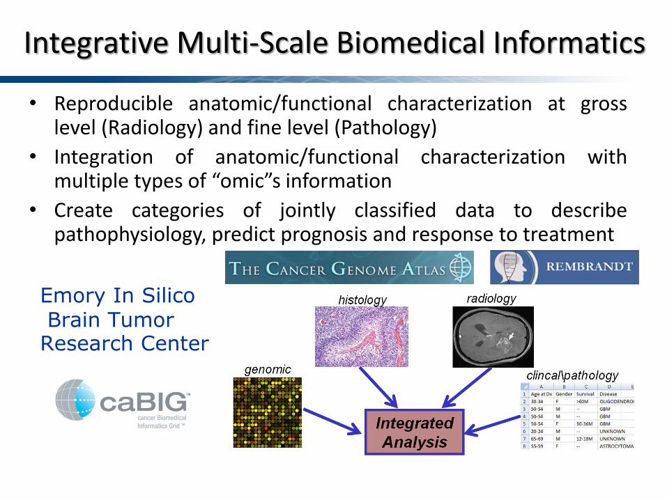
Integrative Multi-Scale Biomedical Informatics
• Reproducible anatomic/functional characterization at gross level (Radiology) and fine level (Pathology)
• Integration of anatomic/functional characterization with multiple types of “omic”s information
• Create categories of jointly classified data to describe pathophysiology, predict prognosis and response to treatment
Emory In Silico Brain Tumor Research Center

Distinguishing Characteristics from Pathology Images
… Molecular data Clinical data

Systematic Image Algorithm Evaluation
• High quality image analysis algorithms are essential to support biomedical research and diagnosis – Validate algorithms with human annotations – Compare and consolidate different algorithm results – Sensitivity study on algorithms’ parameters
• Example: What are the distances and overlap ratios between markup boundaries from two algorithms ?
Algorithm one v.s. Algorithm two
Cross match / join two spatial data sets
Need: Manage, Query and Compare Spatially Derived Information

Spatial Centric Queries Window
Nearest Neighbor
Containment Point
SPATIAL JOIN Density
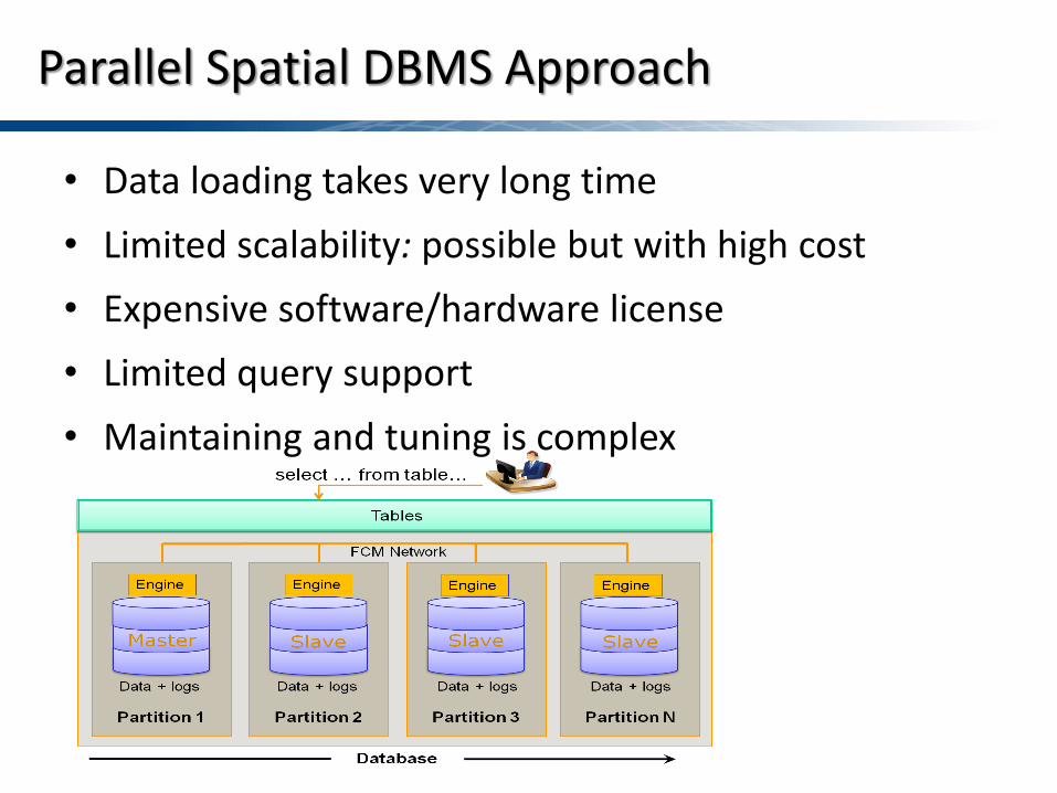
• Data loading takes very long time • Limited scalability: possible but with high cost • Expensive software/hardware license • Limited query support • Maintaining and tuning is complex
Parallel Spatial DBMS Approach

Spatial Big Data Challenges
• Explosion of derived data – 105x105 pixels per image – 1 million objects per image – Hundreds to thousands of images per study – Big data demanding for high throughput
• High computational complexity – Spatial queries include spatial refinement and spatial
measurements, based on heavy duty geometric computation algorithms
– Demanding high performance
Both Data- and Compute-Intensive

High Performance Queries with MapReduce
• MapReduce is a parallel computing framework widely used for large-scale data analysis and queries – Widely used in major internet applications, open source
version: Hadoop – Two simple UDFs for data processing : map() & reduce() – Very easy to develop scalable applications
– Parallelization automatically managed by Hadoop • Our approach:
– Build efficient spatial query engine that can run easily deployed on clusters
– Take advantage of MapReduce to run queries

SC’11 S-5
High-Level Overview of Hadoop
MapTask ReduceTask
HDFS
Shuffle
Intermediate Data
Task Tracker/Runner
Task Tracker/Runner
JobTracker
Applications
Submitter
Retained User Interface
�� HDFS and the MapReduce Framework �� Data processing with MapTasks and ReduceTasks �� Three main steps of data movement.
�� Data movement in the MapReduce framework is time-consuming
1 3
2

SC’11 S-6
Data Movement in Hadoop MapReduce Framework �� Data processing pipeline consists of three phases: Map, Shuffle/
Merge, and Reduce �� Lengthy shuffle/merge is caused by the AlltoAll global exchanging
and merging of data segments
Split MapTask
…. ….
Split MapTask
Split MapTask
MOF
MOF
MOF
MOF ReduceTask
MEM
map
ReduceTask
ReduceTask
ReduceTask
shuffle merge reduce
DFS DFS
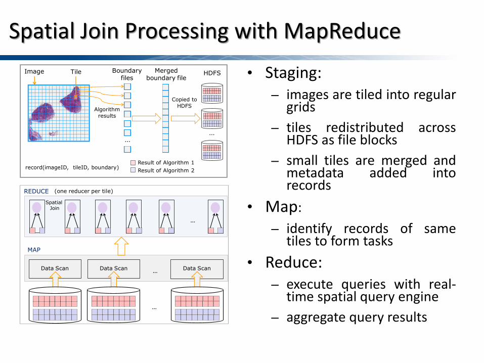
Spatial Join Processing with MapReduce
• Staging: – images are tiled into regular
grids – tiles redistributed across
HDFS as file blocks – small tiles are merged and
metadata added into records
• Map: – identify records of same
tiles to form tasks • Reduce:
– execute queries with real-time spatial query engine
– aggregate query results
Tile
…
Boundary files
Merged boundary file
record(imageID, tileID, boundary)
Copied to HDFS
…
HDFS
Result of Algorithm 1Result of Algorithm 2
Algorithm results
Image
Data Scan Data Scan Data Scan
MAP
(one reducer per tile)
Spatial Join
REDUCE
…
…
…

Boundary File1
Boundary File2
Spatial Join Algorithm
Geometry Refinement
Spatial Measure
R*-Tree File1
R*-Tree File2
Result File
Real-time spatial querying engine (RESQUE)
Bulk R*-Tree Building
Bulk R*-Tree Building
Example: Two-way Spatial Join
• Index building on demand (low overhead) • Query pipelines to combine multiple steps of query processing • Support of spatial join, multi-way spatial join, nearest neighbor,
and highest density queries, and extensible for new ones • Able to run in parallel with decoupled spatial processing in a
distributed computing environment
Real-Time Spatial Query Engine (RESQUE)

Nearest Neighbor Query Processing Workflow
e.g. for each cell find the closest blood vessel and return distance. Access methods can vary (R*-Tree, Voronoi, etc..)
Map Reduce Reduce
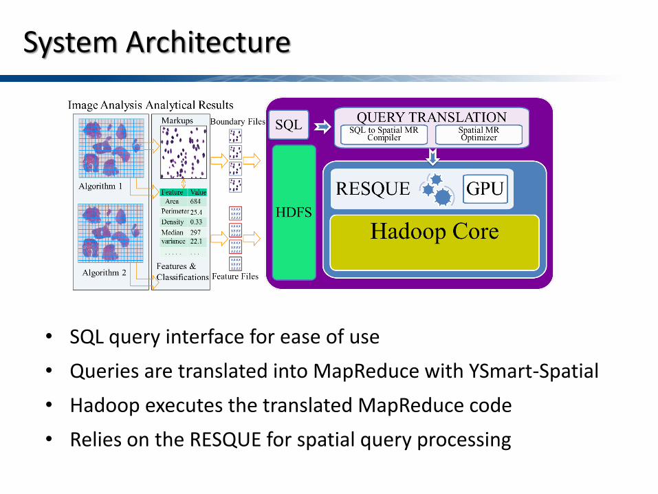
System Architecture
• SQL query interface for ease of use • Queries are translated into MapReduce with YSmart-Spatial • Hadoop executes the translated MapReduce code • Relies on the RESQUE for spatial query processing

Spatial Query Engine Performance
Querying time for a single tile Query response time
for a single image
• R*-Tree building: ~16%, R*-Tree join: ~84% • Scalability: multiple small spatial index has same performance
as combined big index • Storage: compression of boundaries in R*-Tree leave nodes as
chain code: save 42% space
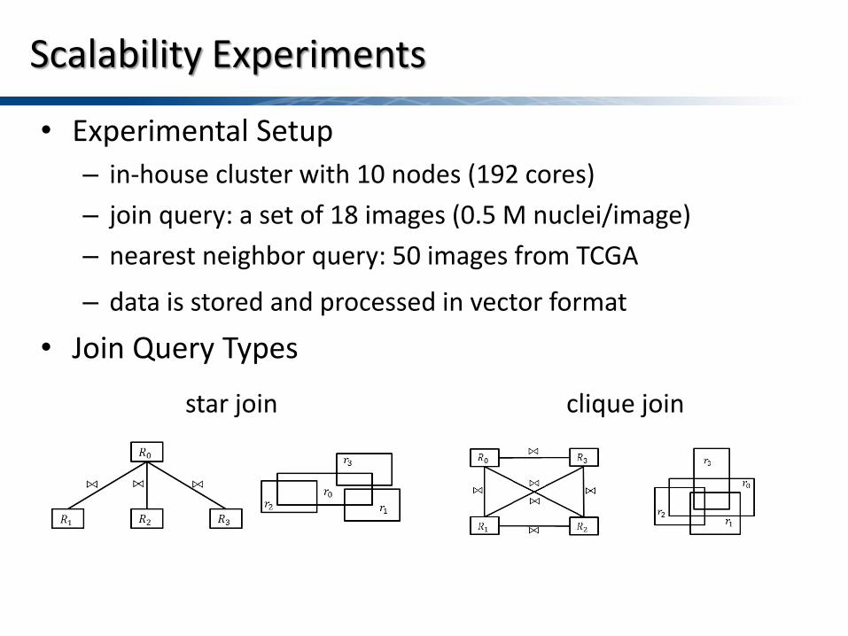
Scalability Experiments
• Experimental Setup – in-house cluster with 10 nodes (192 cores) – join query: a set of 18 images (0.5 M nuclei/image) – nearest neighbor query: 50 images from TCGA
– data is stored and processed in vector format • Join Query Types
star join clique join

Star Join
PBSM join R*-Tree join
• Choice of join algorithm – R*-Tree join – Partition based spatial merge join

Clique Join
PBSM join R*-Tree join
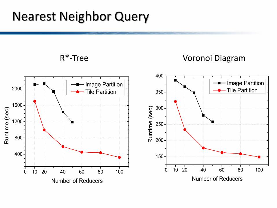
Nearest Neighbor Query
Voronoi Diagram R*-Tree

Data Skew in Spatial Query Processing
• Skew in spatial data • Hash partitioning is skew oblivious • Query runtime is bounded by the longest running partition
(straggler)
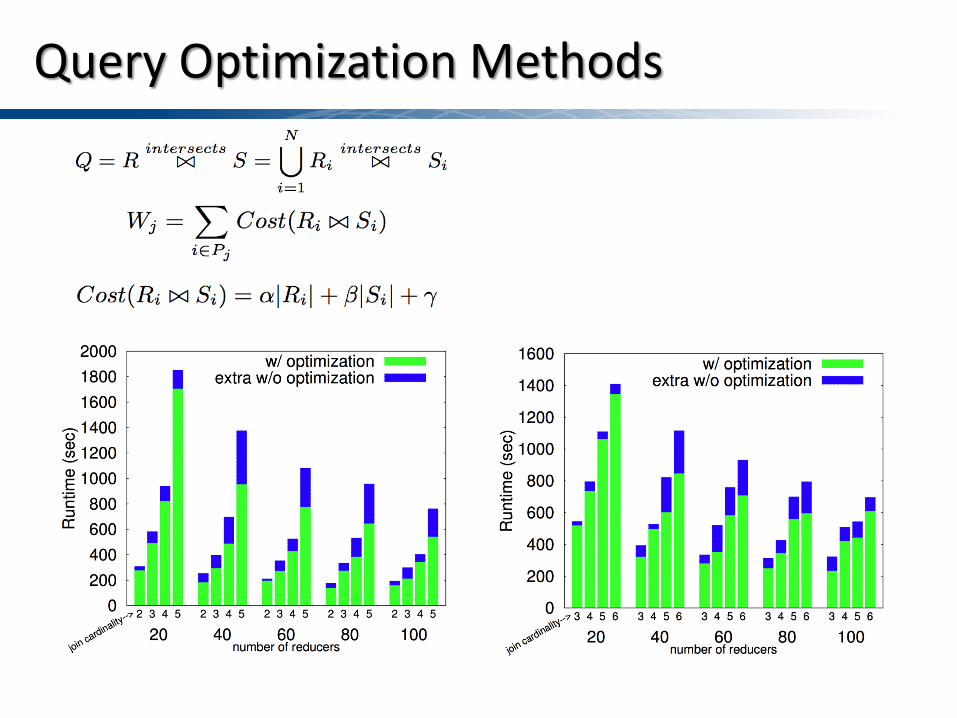
Query Optimization Methods
Summary and Future Work
21
• Effective management of big spatial data is one of the pressing challenges for next generation integrative biomedical research.
• We propose and provide a high performance MapReduce based querying system for large scale spatial data.
• We empirically test the concept with analytical medical imaging as an example application.
• The system is efficient, cost effective, scalable and easy to use. • We are planning to turbo-charge the system with GPU

Family of GIS (Updated) Map
Pathology Imaging

Questions?
Hadoop-GIS: https://web.cci.emory.edu/confluence/display/HadoopGIS