toulouse 2002 dunedin lyttelton wellington auckland correcting new zealand’s long-term sea level...
Post on 21-Dec-2015
218 views
TRANSCRIPT

Toulouse 2002
Dunedin
LytteltonWellington
Auckland
Correcting New ZealandCorrecting New Zealand’s’s long- long-term sea level records for term sea level records for
tectonictectonic upliftuplift uusingsing continuous GPS continuous GPS
observationsobservations
Paul DenysPaul Denys
John BeavanJohn Beavan
Dion MathesonDion Matheson
Mikael DenhamMikael Denham
Chris PearsonChris Pearson
John HannahJohn Hannah

Toulouse 2002
Paired CGPS and CGPS@TG sitesPaired CGPS and CGPS@TG sites
• Sites with ~100 Sites with ~100 years of TG years of TG recordsrecords
• CGPS close or CGPS close or collocated with TG collocated with TG recordersrecorders
• But … Problems … But … Problems … • TG sites not stableTG sites not stable• Possible GPS Possible GPS
masking problemsmasking problems• High multipath High multipath
environmentsenvironments
• Requires careful Requires careful monitoringmonitoring
AUCK & TAKL
WGTN & WGTT
MQZG & LYTT
OUSD & DUNT

Toulouse 2002
Tide Gauge Site Stability Monitoring Tide Gauge Site Stability Monitoring
• Local stability:Local stability: TG pole/recorder to local benchmarksTG pole/recorder to local benchmarks• Regional stability:Regional stability: CGPS@TG to regional CGPSCGPS@TG to regional CGPS
CGPS to CGPS@TG
(km)
TG to CGPS@TG
(km)
CGPS@TG to TGConnection
Method
AucklandAuckland 27.327.3 CollocatedCollocated Spirit levelSpirit level
WellingtoWellingtonn
4.24.2 0.550.55 Spirit level + Spirit level + GPSGPS
LytteltonLyttelton 12.112.1 CollocatedCollocated Spirit levelSpirit level
DunedinDunedin 11.111.1 0.40.4 Spirit levelSpirit level
Toulouse 2002
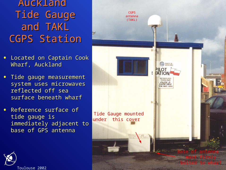
Ports of Ports of Auckland Auckland
Tide Gauge Tide Gauge and TAKL and TAKL
CGPS StationCGPS Station
• Located on Captain Cook Located on Captain Cook Wharf, AucklandWharf, Auckland
• Tide gauge measurement Tide gauge measurement system uses microwaves system uses microwaves reflected off sea surface reflected off sea surface beneath wharfbeneath wharf
• Reference surface of tide Reference surface of tide gauge is immediately gauge is immediately adjacent to base of GPS adjacent to base of GPS antennaantenna
Tide Gauge mountedunder this cover
CGPSantenna(TAKL)
Base of antenna mast firmly
bolted to wharf
Toulouse 2002
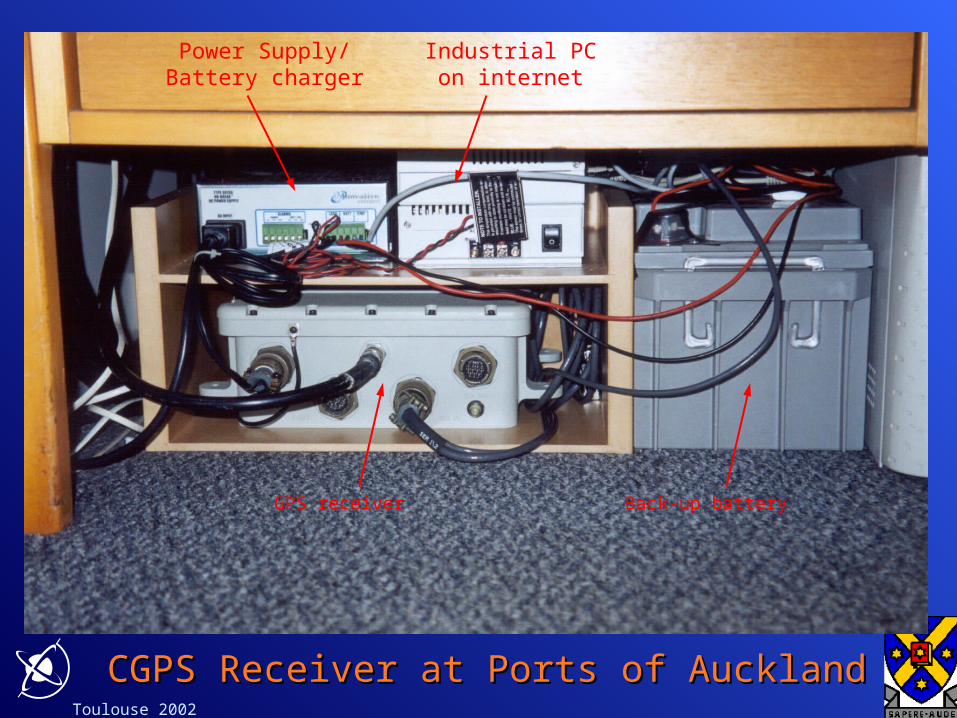
GPS receiver
Industrial PCon internet
Power Supply/ Battery charger
Back-up battery
CGPS Receiver at Ports of AucklandCGPS Receiver at Ports of Auckland

Toulouse 2002
Automatic tide gauge Manual gauge
Measuring system at Wellington float-type tide Measuring system at Wellington float-type tide gaugegauge

Toulouse 2002
WGTT Continuous GPS WGTT Continuous GPS StationStation
Mast is attached
through facing onto the mainstructural wall of the museum

Toulouse 2002

Toulouse 2002
• Install Temporary GPS (WGTA)
• 50 m from TGBM for 24 hours every 3 months
• Same antenna type and radome used at WGTT and WGTA
• Level TGBM and WGTA several times during 24 hour period
• GPS Baseline Processing
• Troposphere variation solved at WGTT as part of regional network processing
• Same troposphere variation assumed at WGTA as at WGTT when solving for the WGTT - WGTA height difference
• Another CGPS site, WGTN, is located in bedrock 5.5 km from WGTT
• Provides a check on the stability of WGTT
HEIGHT CONNECTION from WELLINGTON TIDE GAUGE BENCH MARK (TGBM) to CONTINUOUS GPS (WGTT)

Toulouse 2002
Location of WGTT CGPS (at Te Papa)
Temporary GPS used to tie between tide gauge BM and WGTT
GPS levelling: temporary GPS to WGTT CGPSGPS levelling: temporary GPS to WGTT CGPS

Toulouse 2002
Temporary GPS used to tie between tide gauge BMand WGTT
Precise levelling: Wellington tide gauge to Precise levelling: Wellington tide gauge to temporary GPStemporary GPS
Level

Toulouse 2002
Precise and GPS levelling results: Wellington Precise and GPS levelling results: Wellington tide gaugetide gauge

Toulouse 2002
Combined geodetic and GPS levelling resultsCombined geodetic and GPS levelling resultsWellington tide gaugeWellington tide gauge

Toulouse 2002
Structure Stability Problems: Wooden Wharf Structure Stability Problems: Wooden Wharf at Lytteltonat Lyttelton
Tide Gauge Hut and and GPS antenna
-60 -40 -20 0 20 40 60-60
-40
-20
0
20
40
60
Longitude (mm)
La
titu
de
(m
m)
Velocity 44.2mm/yr

Toulouse 2002
CGPS@TG site
TG recorder and tide pole
Port Chalmers: Poor GPS EnvironmentPort Chalmers: Poor GPS Environment

Toulouse 2002
Regional Stability: CGPS to CGPS@TGRegional Stability: CGPS to CGPS@TG
2000 2000.5 2001 2001.5 2002 2002.5
-20
0
20
40
60
80
100
120
140
160
OUSD-DUNT Vel: -0.6mm/yr rms: +/- 5.9mm
MQZG-LYTT Vel: -0.7mm/yr rms: +/- 4.5mm
WGTN-WGTT Vel: -1.2mm/yr rms: +/- 5.7mm
AUCK-TAKL Vel: +8.8mm/yr rms: +/- 6.9mm
Time (Years)
He
igh
t R
es
idu
al (
mm
)
Baseline Height Component

Toulouse 2002
rms of Baseline Components and Vertical rms of Baseline Components and Vertical VelocityVelocity
BaselinBaseline e
DistancDistance (km)e (km)
LatitudLatitude (mm)e (mm)
Longitide Longitide (mm)(mm)
Height Height (mm)(mm)
Velocity Velocity (mm/yr)(mm/yr)
OUSD-OUSD-DUNTDUNT
11.1 1.9 1.8 5.9 0.6
MQZG-MQZG-LYTTLYTT
12.1 4.6 2.5 4.5 0.7
WGTN-WGTN-WGTTWGTT
4.2 2.4 3.6 5.7 1.2
AUCK-AUCK-TAKLTAKL
27.3 1.6 1.8 6.9 8.8

Toulouse 2002
Tide Gauge Mean Annual Sea Level Record: Tide Gauge Mean Annual Sea Level Record: June 2002June 2002
SeaLevelSeaLeveltruetrue = SeaLevel = SeaLevelmeasuredmeasured +/- ??? +/- ???
1900 1920 1940 1960 1980 2000
1.8
2
2.2 AUCK Vel: +1.3 mm/yr rms: +/- 32.8 mm
1900 1920 1940 1960 1980 20000.4
0.6
0.8
1
Me
an
Se
a L
ev
el (
me
tre
s)
WGTN Vel: +2.1 mm/yr rms: +/- 38.5 mm
1900 1920 1940 1960 1980 2000
0.8
1
1.2
Time (Years)
LYTT Vel: +2.0 mm/yr rms: +/- 33.0 mm
??? OBSERVEDTRUE LevelSeaLevelSea

Toulouse 2002
New Zealand’s CGPS @TG New Zealand’s CGPS @TG ProjectProject
• CGPS installed at 4 CGPS installed at 4 long record TG long record TG locations locations
• CGPS collocated or CGPS collocated or within 600mwithin 600m
• Site stability monitored Site stability monitored using a variety of using a variety of methodsmethods• Precise levelling to close Precise levelling to close
BMsBMs• GPS “levelling” to GPS “levelling” to
regional CGPS and TG regional CGPS and TG BMBM
• CGPS to CGPS @TG CGPS to CGPS @TG stabilitystability
• Baselines 4, 11, 12 & Baselines 4, 11, 12 & 27km27km
• Horz rms Horz rms 2-3mm2-3mm(excluding MQZG-LYTT)(excluding MQZG-LYTT)
• Vert rms Vert rms 5-7mm5-7mm
• Vert vel ~1mm/yr Vert vel ~1mm/yr (excluding AUCK-TAKL)(excluding AUCK-TAKL)