titanium resources - report 2infohouse.p2ric.org/ref/49/48606.pdftitanium resources - report 2...
TRANSCRIPT

71-11-P TITANIUM RESOURCES - REPORT 2
Minerals Research Laboratory July 1971 Progress Report
RML Project No.5, Report No.2 Lab. Nos. (See Summary Table) Book 282, pp. 33-115
by Robert M. Lewis
INTRODUCTION
A program involving beneficiation of samples from titanium
deposits throughout the State has been undertaken by the Minerals Research
Laboratory. This is the second report of a series which will culminate
in a final publication at a later date. A majority of the samples
investigated for this report were from the Durham-Deep River-Wadesboro
Triassic Basins and Dan River area. These samples, along with their
descriptions, were submitted by Dr. Paul Thayer of the University of
North Carolina at Wilmington.
OBJECT
The object of this report is to up-date the progress made in locating
and evaluating titanium minerals in North Carolina.
PROCEDURE
No set procedure was used to beneficiate samples. Each sample was
treated according to its inherent characteristics. The key processes
involved grinding, scrubbing, desliming, and/or gravity, heavy liquid,
electrostatic, magnetic procedures.
RESULTS AND CONCLUSIONS
The location, description, and results of each sample are presented
in the Sample Data section and accompanying maps. Those samples which
contained in excess of 2.0 percent heavy minerals were given additional

- 2 -
beneficiation to determine mineral distribution.
A summary of heavy mineral content is included as Table 1.
Happy Valley Picnic Area (Caldwell County)
A sample from a large flood plain area contained 3.0 percent heavy
minerals. This area is located downstream from the Yadkin valley il-
menite mine, which may have been the source ore. This area has possibili-
ties as an ilmenite source.
-Tuscarora Iron Mine (Guilford County)
A sample from this area is representative of material from abandoned
mines and prospects in the locality. The sample contained 29.1 percent
ilmenite and 70.9 percent magnetite. The general area has promise.
Piedmont construction Company Sand Plant (Davie county)
The heavy minerals content (3.0 percent) is marginal; however, the
mineral suite - magnetite, ilmenite, and zircon - is of interest. The
plant is located on a large flood plain.
Shooting Creek (Clay County)
The Shooting Creek area is engulfed by a bowl-shaped topography
crested by Vineyard, Chunky Gal, and Eagle mountains. The bowl is open
on the west to the Chatuge Lake which is the general direction of flow
for eroded material. Samples were obtained from the Cherry Cove Branch
area. Stream samples gave indication of heavy minerals in the area. A
channel sample from a logging road cut contained 5.3 percent heavy
minerals. The need for additional prospecting in this area is indicated.
Morganton (Burke County)
Samples from the flood plain adjacent to Johns River contained

- 3 -
approximately 3.0 percent heavy minerals. Samples south of catawba
River and east of the mouth of Johns River contained 6.8-8.8 percent
heavy minerals. A sample from the mouth of Hunting Creek contained 5.0
percent heavy minerals.
A. P. Causby Sand Company (Morganton, N. C'.)
Samples averaged approximately 4.0 percent heavy minerals. The
company is sponsoring a project involving beneficiating this material.
Durham-Deep River-Wadesboro Triassic Basins
Eleven of 25 samples investigated contained more than 2.0 percent
heavy minerals.
Dan River Samples
Three of 23 samples investigated contained more than 2.0 percent
heavy minerals.

Lab. No.
3707
3715
3747 3748
3750 3751 3752 3753 3754 3755
3818 3819 3820 3821 3822 3823 3824 3825
3826 3827 3828 3829 3830 3831 3832
- 4 -
Table 1
SUMMARY
A. Western Area Samples
Location
Happy Valley Picnic Area (Caldwell Co.)
TUscarora Iron Mine (Guilford Co.)
Piedmont Construction Company (Davie Co.) u u tI U 11
Shooting Creek (Clay Co.) II II II II
II II II II
II II II II
II II " II
" " " ..
Morganton (Burke co.)
A. P. Causby Sand Company (l>1organton,N.C.) II
" .. .. II
II
(Table 1 continued on page 5)
% Heavy Minerals
2.6
99.2
3.0 3.0
5.0 8.0
12.3 5.3 6.1 3.2
2.6 3.0 6.8 8.8 5.0 2.8 1.2 1.6
2.6 4.0 4.0 4.8 3.2 6.3 4.9

Lab. No.
3759
3760
3761
3762
3763 3764 3765
3766
3767 3768 3769 3770
3771
3772 3773 3774
3775 3776 3777 3778 3779
3780 3781
3782 3783
- 5 -
Table 1
SUMMARY
(continued)
B. Durham-Deep River-Wadesboro Triassic Basin Samples
Location
Chatham County
Wake County
Durham County
Granville County
Durham County " " " "
Montgomery county
Anson County n rI
11 tI
" II
union county
Anson county II ..
.. n
Moore county It It
It II
" U
" "
Chatham County " ..
Lee County It II
(Table 1 continued on page 6)
% Heavy Minerals
4.7
2.0
0.2
0.1
5.0 0.6 3.6
4.8
3.4 1.6 3.2 1.8
0.8
1.1 trace 0.6
0.6 2.0 0.4 0.6 2.2
0.6 0.6
5.9 6.6

Lab. No.
3757 3758 3844 3845 3846 3847 3848 3849 3850 3851 3852 3853 3854
3855-3856 3857 3858 3784 3789
3785 3786 3787 3788
- 6 -
Table 1
SUMMARY
(continued)
C. Dan River Samples
Location
Rockingham County
II
" " " "
Stokes County 11 U
II "
It It
% Heavy Minerals
4.0 9.4 0.6 trace 0.6 0.6 0.6 1.8 0.8 0.6 0.2 0.8 1.2
0.4-1.6 0.2 0.6 0.6 4.0
trace 0.8 0.8 1.4

- 7 -
SAMPLE DATA
Happy Valley Picnic Area (Caldwell County)
Lab. No. 3707 Field No. 1
Location: Happy valley picnic area, 0.3 miles north of intersection
of U. S. 321 and County Road 1560.
Description: + Hand auger samples from 100 _ acre field north of
picnic area.
Results: Heavy minerals in sample (percent) 2.60
Tuscarora Iron Mine (Guilford county)
Lab. No. 3715 Field No. 1
Location: N. C. Grid - 860, 250 N., 1,718,300 E. Approximately
l~ miles north of Friendship, 200 feet west of N. C. 68.
Description: Surface pieces from area around old Tuscarora Iron Mine.
Results: Heavy minerals in sample (percent) 99.2
Distribution of heavy minerals (percent) - magnetite 70.9,
ilmenite 29.1. Analyses:
Mineral % Fe % FeO
Magnetite 6.3 65.7 22.5
Ilmenite 39.9 33.7 27.0
Total 16.1 56.4 23.8
Piedmont Construction Co. Sand Plant (Davie County)
Lab. No. 3747 Field No.1
Location: Piedmont Construction Sand Plant north of 1-40 at junction
of Yadkin River.
Description: Hand auger sample, 200 feet north of plant site on west
bank of Yadkin River.
(continued on page 8)

- 8 -
SAMPLE DATA
Piedmont Construction Co. Sand Plant (Davie County) (continued)
Results: Heavy minerals in sample (percent) 3.0
Distribution of heavy minerals (percent) - magnetite 0.7,
ilmenite 13.8, zircon 5.9, miscellaneous 79.6.
Lab. No. 3748 Field No.2
Location: Piedmont Construction Sand Plant north of I-40 at junction
of Yadkin Ri ver •
Description: Random grab sample from area around stockpile.
Results: Heavy minerals in sample (percent) 3.0
(Shooting Creek (Clay County) Lab. No. 3750 Field No. 10
Location: On Hothouse Branch, 500 ft. south of junction of Cherry Cove
Branch.
Description: Sample of creek sand
Results: Heavy minerals in sample (percent) 5.0
Distribution of heavy minerals (percent) - magnetite 2.2,
ilmenite 31.0, garnet 31.7, zircon 1.5, muscovite 1.3,
biotite 1.3, miscellaneous dark minerals 31.0.
Lab. No. 3751 Field No. 11
Location: Cherry Cove Branch, 200 ft. east of junction of Hothouse Branch.
Description: Sample of creek sand.
Results: Heavy minerals in sample (percent) 8.0
Distribution of heavy minerals (percent) - magnetite 1.7,
ilmenite 25.7, garnet 39..3, zircon 2.5, muscovite 0.9,
miscellaneous dark minerals 29.9.

- 9 -
SAf.lPLE DATA
Shooting Creek (Clay County) (continued)
Lab. No. 3752 Field No. 12
Location: 700 ft. east of junction of Cherry Cove Branch and Hothouse
Branch, 200 ft. south and up-hill from Cherry Cove Branch
along logging road.
Description: Chip sample of hard rock.
Results: Heavy minerals in sample (percent) 12.3
Distribution of heavy minerals (percent) - magnetite 0.2,
ilmenite 8.5, garnet 54.4, zircon 6.6, muscovite 7.6, biotite
1.8, miscellaneous dark minerals 20.9.
Lab. No. 3753 Field No. 13
Location: 2000 ft. east of junction of Cherry Cove Branch and Hothouse
Branch, 100 ft. south of Cherry Cove Branch near junction
of logging roads.
Description: Channel sample from logging road cut.
Results: Heavy minerals in sample (percent) 5.3
Distribution of heavy minerals (percent) - magnetite 0.4,
ilmenite 22.6, garnet 41.1, zircon 2.2, miscellaneous light
minerals 3.2, miscellaneous dark minerals 30.5.
Lab. No. 3754 Field No. 14
Location: Southernmost loop of Hothouse Branch Road where creek crosses
under road.
Description: Sample of creek sand.
Results: Heavy minerals in sample (percent) 6.1
Distribution of heavy minerals (percent) - magnetite 0.9,
ilmenite 33.3, garnet 26.4, zircon 1.7, muscovite 0.7, biotite
0.5, miscellaneous dark minerals 36.5.

r-···_······ -- --- ---
SHOOTING CREEK N 3500 _ ' N. C.
W 8337.5/7 5
Scale: 111 - • - 2000 Ft.

Lab. No. 3755
- 11 -
SAMPLE DATA
Shooting Creek (Clay County)
Field No. 15
Location: 0.37 miles S. 850 W. of Union Chapel Church, ~ mile
east of creek.
Description: Grab sample from 100 ft. of an 800 ft. road cut.
Results: Heavy minerals in sample (percent) 3.2
Distribution of heavy minerals (percent) - magnetite 0.5,
ilmenite 26 .. 4, garnet 38.5, zircon 3.2, muscovite 5.0,
miscellaneous dark minerals 26.4.
Lab. No. 3818
Morganton (Burke County)
Field No.1
Location: One mile southeast of junction of N. C. 18 and Johns River,
on bank of Johns River.
Description: Hand auger sample.
Results: Heavy minerals in sample (percent) 2.6
Distribution of heavy minerals (percent) - magnetite 2.9,
ilmenite 10.9, zircon 4.4, miscellaneous 81.8.
Lab. No. 3819 Field No. 2
Location: ~ mile southeast of junction of N. C. 18 and Johns River on
bank of Johns River.
Description: Hand auger sample from 100 ~ acre field near river.
Results: Heavy minerals in sample (percent) 3.0
Distribution of heavy minerals (percent) - magnetite 5.2,
ilmenite 5.2, zircon 3.0, miscellaneous 86.6.

- 12 -
SAMPLE DATA
Morganton (Burke County)
Lab. No. 3820 Field No. 3
Location: ~ mile east of junction of Johns River and Catawba River
on south side of river.
Description: Hand auger sample from field.
Results: Heavy minerals in sample (percent) 6.8
Distributiqn of heavy minerals (percent) - magnetite 1.3,
ilmenite 7.9, zircon 2.9, miscellaneous 87.9.
Lab. No. 3821 Field No. 4
Location: ~ mile east of junction of Johns River and Catawba River on
south side of river.
Description: Hand auger sample along river bank.
Results: Heavy minerals in sample (percent) 8.8
Distribution of heavy minerals (percent) - magnetite 0.7,
ilmenite 7.8, zircon 2.4, miscellaneous 89.1.
Lab. No. 3822 Field No. 5
Location: South bank of Catawba River at mouth of Hunting Creek.
Description: Hand auger sample along river tank.
Results: Heavy minerals in sample (percent) 5.0
Distribution of heavy minerals (percent) - magnetite 2.1,
ilmenite 2.1, zircon 4.8, miscellaneous 91.0.
Lab. No. 3823 Field No. 6
Location: One mile east of junction of N. C. 18 and Catawba River
on north side of river.
Description: Hand auger sample along river bank.
Lab. No. 3823
- 13 -
SAMPLE DATA
Morganton (Burke County)
continued from page 12
Results: Heavy minerals in sample (percent) 2.8
Distribution of heavy minerals (percent) - magnetite 2.5,
ilmenite 16.4, zircon 3.3, miscellaneous 77.8.
Lab. No. 3824 Field No. 7
Location: Along Warrior Creek, 500 ft. up stream from junction of
warrior Creek and Catawba River.
Description: Hand auger sample from 200 + acre field north of Warrior
Creek.
Results: Heavy minerals in sample (percent) 1.2
Distribution of heavy minerals (percent) - magnetite 2.6,
ilmenite 20.5, zircon 5.1, miscellaneous 71.8.
Lab. ~-1o. 3825 Field No. 8
Location: Along Warrior Creek, 1000 ft. up stream from junction of
warrior Creek and Catawba River.
Description: Grab sample from sand bar in Warrior Creek.
Results: Heavy minerals in sample (percent) 1.6
Distribution of heavy minerals (percent) - magnetite 5.3,
ilmenite 10.5, zircon 1.8, miscellaneous 82.4.
A. P. causby Sand Co. (Morganton, N. C.)
Lab. No. 3826 Field NO. 9
Location: Sand bar in catawba River at plant site.
Description: Hand auger sample from sand bar created by plant discharge
into Catawba River.

0 4 •• - •• "" ... ,...------- ------------_._ .. - 14 -
MORGANTON NORTH, N. C.
N 3545 - W 8137.5/7.5
Scale: 1" = 2000 Ft.

- 15 -
SAMPLE DATA
A. P. Causby Sand Co. (Morganton, N. C.)
Lab. No. 3826 - Results - continued from page 13
Results: Heavy minerals in sample (percent) 2.6
Distribution of heavy minerals (percent) - magnetite 0.9,
ilmenite 14.5, zircon 0.9, miscellaneous 85.5.
Lab. No. 3827 Field No. 10
Location: Plant heavy mineral storage pit.
Description: Four hand auger samples on 10-ft. centers and each
five feet deep. This material came from spiral classifier
clean-out.
Results: Heavy minerals in sample (percent) 4.0
Distribution of heavy minerals (percent) - magnetite 3.1,
ilmenite 24.7, garnet 8.7, zircon 9.8, miscellaneous 53.7.
Lab. No. 3828 Field No. 11
Location: Sand bar in Catawba River under N. C. 18 bridge at plant site.
Description: Hand auger sample from sand bar.
Results: Heavy minerals in sample (percent) 4.0
Distribution of heavy minerals (percent) - magnetite 1.2,
ilmenite 23.4, zircon 2.9, miscellaneous 72.5.
Lab. No. 3829
Location: Plant site.
Field No. 12
Description: Screw classifier clean-out material trapped by filter bag.
Results: Heavy minerals in sample (percent) 4.8
Distribution of heavy minerals (percent) - magnetite 2.6,
ilmenite 3.1, zircon 5.7, miscellaneous 88.6.

- 16 -
SAMPLE DATA
A. P. Causby Sand Co. (Morganton, N. C.) (continued)
Lab. NO. 3830 Field No. 13
Location: Plant site, fine sand stockpile.
Description: Random grab sample from fine sand stockpile.
Results: Heavy minerals in sample (percent) 3.2
Distribution of heavy minerals (percent) - magnetite 1.3,
ilmenite 1~.6, zircon 2.6, miscellaneous 76.5.
Lab. No. 3831 Field No. 14
Location: Plant site.
Description: Sample taken from bottom of large spiral classifier tank.
Results: Heavy minerals in sample (percent) 6.3
Distribution of heavy minerals (percent) - not determined.
Lab. No. 3832 Field No. 15
Location: Plant site.
Description: Sample taken from bottom of small spiral classifier tank.
Results: Heavy minerals in sample (percent) 4.9
Distribution of heavy minerals (percent) - not determined.

- 17 -
SAMPLE DATA
Durham-Deep River-Wadesboro Triassic Basins
Lab. No. 3759 Field No. TR-25
Location: Along railroad cut 100 ft. west of U. S. 1 along
Chatham County Road 1011.
Description: Medium-grained, poorly sorted, texturally immature
schist arenite.
Results: Heavy minerals in sample (percent) 4.70
Distribution of heavy minerals (percent) - magnetite 0.5,
black opaques 9.1, zircon 2.0, miscellaneous 88.4.
Lab. No. 3760 Field No. TR-46
Location: Along N. C. 55 (Wake County), 1.8 miles north of inter
section with Wake County Road 1630.
Description: Medium- to coarse-grained, poorly sorted, texturally
immature arkose.
Results: Heavy minerals in sample (percent) 2.00
Distribution of heavy minerals (percent) - not determined.
Lab. No. 3761 Field No. TR-75
Location: Along Durham County Road 1631, 0.6 mile north of inter
section with Durham County Road 1639.
Description: Coarse-grained, very poorly sorted, texturally immature
lithic arkose.
Results: Heavy minerals in sample (percent) 0.20
Distribution of heavy minerals (percent) - not determined.
Lab. No. 3762 Field No. TR-80
Location: Along Granville County Road 1127, 0.1 mile southeast of
intersection with Granville County Road 1104.

- 18 -
SAMPLE DATA
Durham-Deep River-Wadesboro Triassic Basins
Lab. No. 3762 continued from page 17.
Description: Very coarse-grained, very poorly sorted, texturally
immature arkose.
Results: Heavy minerals in sample (percent) 0.10
Distribution of heavy minerals (percent) - not determined.
Lab. No. 3763 Field No. TR-IOO
Location: Along N. c. 751, 0.6 mile south of Durham County Road 1103.
Description: Medium-grained, poorly sorted, texturally immature subarkose.
Results: Heavy minerals in sample (percent) 5.00
Distribution of heavy minerals (percent) - magnetite 0.5,
black opaques 12.2, zircon 2.3, miscellaneous 85.0.
Lab. No. 3764 Field No. TR-lll
Location: Along Interstate 85, 0.1 mile east of intersection with
U. S. 70 (Durham County).
Description: Medium-grained, poorly sorted, texturally immature arkose.
Results: Heavy minerals in sample (percent) 0.60
Distribution of heavy minerals (percent) - not determined.
Lab. No. 3765 Field No. TR-113
Location: Along U. S. 15-501 Bus., 1.3 mile east of intersection
with N. C. 751 (Durham County).
Description: Fine- to medium-grained, poorly sorted, texturally
immature arkose.
Results: Heavy minerals in sample (percent) 3.60
Distribution of heavy minerals (percent) - magnetite 0.6,
black opaques 9.7, zircon 2.5, miscellaneous 87.2.

- 19 -
SAl-IPLE DATA
Durham-Deep River-Wadesboro Triassic Basins
Lab. No. 3766 Field No. TR-136
Location: Along county Line Road (Montgomery Co.), 1.8 mile west of
Montgomery County Road 1324.
Description: Fine-grained, moderately sorted, texturally submature
subarkose.
Results: Heavy minerals in sample (percent) 4.80
Distribut~on of heavy minerals (percent) - magnetite 0.5,
black opaques 42.7, zircon 9.7, miscellaneous 47.1.
Lab. No. 3767 Field No. TR-149
Location: Along Anson County Road 1706, 0.7 mile east of intersection
with Anson County Road 1703.
Description: Very fine-grained, moderately sorted, texturally immature
subarkose.
Results: Heavy minerals in sample 3.40
Distribution of heavy minerals (percent) - magnetite 5.4,
black opaques 40.2, zircon 0.5, miscellaneous 53.9.
Lab. No. 3768 Field No. TR-lS6
Location: Along Anson County Road 1627, 1.1 mile northeast of inter
section with Anson county Road 1645.
Description: Fine-grained, moderately sorted, texturally immature
lithic arkose.
Results: Heavy minerals in sample 1.60
Distribution of heavy minerals (percent) - not determined.

- 20 -
SAMPLE DATA
Durham-Deep Rive~-Wadesboro Triassic Basins
Lab. NO. 3769 Field No. TR-162
Location: Along Anson County Road 1003, 0.7 mile east of intersection
with Anson County Road 1219.
Description: Fine- to medium-grained, moderately sorted, texturally
immature arkose.
Results: Heavy mine;als in sample (percent) 3.20
Distribution of heavy minerals (percent) - magnetite 0.5,
black opaques 27.2, zircon 1.0, miscellaneous 71.3.
Lab. NO. 3770 Field No. TR-164
Location: Along Anson County Road 1225, 0.6 mile north of intersection
with Anson County Road 1220.
Description: Fine-grained, moderately sorted, texturally immature
subarkose.
Results: Heavy minerals in sample (percent) 1.80
Distribution of heavy minerals (percent) - not determined.
Lab. NO. 3771 Field No. TR-167
Location: Along Union County Road 1919, 0.6 mile northwest of Union
county Road 1916.
Description: Medium-grained, poorly sorted, texturally immature
litharenite.
Results: Heavy minerals in sample (percent) 0.80
Distribution of heavy minerals (percent) - not determined.

- 21 -
S~WLE DATA
Durham-Deep River-Wadesboro Triassic Basins
Lab. No. 3772 Field No. TR-170
Location: Along Anson county Road 1251, 0.3 mile south of intersection
with U. S. 74.
Description: Coarse-grained, poorly sorted, texturally immature
feldspathic litharenite.
Results: Heavy minerals in sample (percent) 1.10
Distribution of heavy minerals (percent) - not determined.
Lab. No. 3773 Field No. TR-173-1
Location: Along Seaboard Coast Line railroad cut, 0.1 mile west of
intersection with Anson County Road 1422.
Description: Coarse-grained, poorly sorted, texturally immature lithic
arkose.
Results: Heavy minerals in sample (percent) - trace.
Distribution of heavy minerals (percent) - not determined.
Lab. No. 3774 Field No. TR-182
Location: Along N. C. 109 (Anson County), 0.1 mile north of intersection
with Anson County Road 1713.
Description: Medium-grained, poorly sorted, texturally immature
lithic arkose.
Results: Heavy minerals in sample (percent) 0.60
Distribution of heavy minerals (percent) - not determined.

- 22 -
SAl-tPLE DATA
Durham-Deep River-Wadesboro Triassic Basins
Lab. No. 3775 Field No. TR-184
Location: Along Moore County Road 1624, 0.5 mile north of intersection
with Moore County Road 1261.
Description: Medium-grained, very poorly sorted, texturally immature
feldspathic litharenite.
Results! Heavy minerals in sample (percent) 0.60
Distribution of heavy minerals (percent) - not determined.
Lab. No. 3776 Field No. TR-193
Location: Along Moore County Road 1493, 0.1 mile west of N. C. 22
(Moore County) •
Description: Fine-grained, moderately sorted, texturally immature
lithic arkose.
Results: Heavy minerais in sample (percent) 2.00
Distribution of heavy minerals (percent) - not determined.
Lab. No. 3777 Field No. TR-205
Location: Along Moore County Road 1006, 1.4 mile south of Glendon.
Description: Fine-grained, poorly sorted, texturally immature arkose.
Results: Heavy minerals in sample (percent) 0.40
Distribution of heavy minerals (percent) - not determined.
Lab. No. 3778 Field No. TR-2l6
Location: Along Moore County Road 1659, 0.4 mile west of Moore Co. Rd. 1658.
Description: Very fine-grained, moderately sorted, texturally immature
subarkose.
Results: Heavy minerals in sample (percent) 0.60
Distribution of heavy minerals (percent) - not determined.
- 23 -
SAMPLE DATA
Durham-Deep River-Wadesboro Triassic Basins
Lab. No. 3779 Field No. TR-22l
Location: Along Moore county Road 1625, 0.15 mile southwest of
intersection with Moore County Road 1626.
Description: Medium-grained, poorly sorted, texturally immature
feldspathic litharenite.
Results: Heavy minerals in sample (percent) 2.20
Distribution of heavy minerals (percent) - magnetite 1.6,
black opaques 56.4, zircon 8.1, miscellaneous 33.9.
Lab. No. 3780 Field NO. TR-229
Location: Along Chatham County Road 2153, 0.2 mile south of inter
section with Chatham County Road 2142.
Description: Very fine-grained, moderately sorted, texturally immature
arkose.
Results: Heavy minerals in sample (percent) 0.60
Distribution of heavy minerals (percent) - not determined.
Lab. No. 3781 Field No. TR-236
Location: In Chatham Brick Company Quarry, Gulf, N. C.
Description: Fine-grained, moderately sorted, texturally immature
arkose.
Results; Heavy minerals in sample (percent) 0.60
Distribution of heavy minerals (percent) - not determined.

- 24 -
SAMPLE DATA
Durham-Deep River-Wadesboro Triassic Basins
Lab. No. 3782 Field No. TR-24l
Location: Along Lee County Road 1537, 2.8 mile northeast of Lee
County Road 1508.
Description: Very coarse-grained, very poorly sorted, texturally
immature feldspathic litharenite.
Results: Heavy minerals in sample (percent) 5.90
Distribution of heavy minerals (percent) - magnetite 0.0,
black opaques 1.3, zircon 0.0, miscellaneous 98.7.
Lab. No. 3783 Field No. TR-242-1
Location: At Sanford Brick and Tile Company plant quarry, Colon,
Lee County.
Description: Coarse-grained, very poorly sorted, texturally immature
feldspathic litharenite.
Results: Heavy minerals in sample (percent) 6.60
Distribution of heavy minerals (percent) - magnetite 0.4,
black opaques 9.1, zircon 0.7, miscellaneous 89.8.
Dan River
Lab. No. 3757 Field No. STOP 1
Location: See location 3 in Field Trip GUidebook.* Sample taken
along Rockingham County Road 1756, 0.6 mile north of inter-
section with N. C. 700 W. Pine Hall Formation.
* Carolina Geological Society, Oct. 24-25, 1970, Field Trip Guidebook, Stratigraphy, Sedimentology and Economic Geology of Dan River Basin, North Carolina, by Paul A. Thayer, Dewey S. Kirstein, Roy L. Ingram.

- 25 -
SAMPLE DATA
Dan River
Lab. No. 3757 continued from page 24
Description: Coarse-grained, moderately sorted, texturally immature
plagioclase lithic arkose.
Results: Heavy minerals in sample (percent) 4.00
Distribution of heavy minerals (percent) - magnetite 0.4,
black opaques 2.7, zircon 1.9, miscellaneous 95.0.
Lab. No. 3758 Field No. STOP 9
Location: See location 9 in Field Trip Guidebook. Sample taken from
large boulder at southwest corner of Rockingham county road
1516 and Rockingham County road 1522. Conglomerate facies,
Stoneville Formation.
Description: Very coarse-grained, very poorly sorted, texturally
immature feldspathic litharenite.
Results: Heavy minerals in sample (percent) 9.40
Distribution of hea~I minerals (percent) - magnetite 1.7,
black opaques 17.9, zircon 0.8, miscellaneous 79.6.
Lab. No. 3844 Field No. R17-2
Location: Along Rockingham County Road 1735, 0.1 mile north of inter
section with Carolina and Northwestern Railroad crossing.
Cow Branch Formation.
Description: Medium-grained, poorly sorted, texturally immature
lithic arkose.
Results: Heavy minerals in sample (percent) 0.60
Distribution of heavy minerals (percent) - not determined.

Lab. No. 3845
- 26 -
SAMPLE DATA
Dan River
Field NO. R34-l
Location: Along Buffalo creek, 0.3 mile south of N. c. 135 (Rockingham
County). Sandstone facies, Stoneville Formation.
Description: Medium-grained, poorly sorted, texturally immature lithic
arkose.
Results: Heavy minerals in sample (percent) - trace.
Distribut~on of heavy minerals (percent) - not determined.
Lab. No. 3846 Field No. R52-l
Location: Along Rockingham county Road 2153, 0.7 mile west of inter
section with Rockingham County Road 2151. Siltstone facies,
Stoneville Formation.
Description: ~~dium-grained, moderately sorted, texturally immature
lithic arkose.
Results: Heavy minerals in sample (percent) 0.60
Distribution of heavy minerals (percent) - not determined.
Lab. No. 3847 Field No. R57-2
Location: In Stoneville, along Rockingham County Road 1369, 0.1 mile west
of intersection with Rockingham County Road 1371. Conglomerate
facies, Stoneville Formation.
Description: Very fine-grained, moderately sorted, texturally immature,
li thic arkose.
Results: Heavy minerals in sample (percent) 0.60
Distribution of heavy minerals (percent) - not determined.

- 27 -
SAMPLE DATA
Dan River
Lab. No. 3848 Field No. R59-3
Location: Along N. C. 135, 0.6 mile southwest of intersection
with Rockingham county Road 2154. Sandstone facies,
Stoneville Formation.
Description: Medium-grained, very poorly sorted, texturally immature
arkose.
Results: Heavy minerals in sample (percent) 0.60
Distribution of heavy minerals (percent) - not determined.
Lab. No. 3849 Field No. R65-l
Location: At intersection of Rockingham County Road 2208 and 2210.
Sandstone facies, Stoneville Formation.
Description: Medium-grained, moderately sorted, texturally immature
arkose.
Results: Heavy minerals in sample (percent) 1.80
Distribution of heavy minerals (percent) - not determined.
Lab. No. 3850 Field No. R65-3-2
Location: Along U. S. 200 Bypass, 1400 ft. north of its intersection
with Rockingham County Road 2208. Sandstone facies,
Stoneville Formation.
Description: Medium-to coarse-grained, poorly sorted, texturally
immature lithic arkose.
Results: Heavy minerals in sample (percent) 0.80
Distribution of heavy minerals (percent) - not determined.

- 28 -
SAMPLE DATA
Dan River
Lab. No. 3851 Field No. R65-3-20
Location: Along U. S. 220 Bypass, 1550 ft. north of its inter
section with Rockingham County Road 2208. Sandstone
facies, Stoneville Formation.
Description: Coarse-grained, poorly sorted, texturally immature
lithic ar~ose.
Results: Heavy minerals in sample (percent) 9.60
Distribution of heavy minerals (percent) - not determined.
Lab. No. 3852 Field No. R67-1
Location: Along U. S. 220 Business (in Mayodan), 0.35 mile south
of its intersection with Rockingham County Road 1313.
Sandstone facies, stoneville Formation.
Description: Very fine-grained, poorly sorted, texturally immature
lithic arkose.
Results: Heavy minerals in sample (percent) 0.20
Distribution of heavy minerals (percent) - not determined.
Lab. No. 3853 Field No. R67-2
Location: Along N. C. 135, 0.05 mile east of intersection with
Rockingham County Road 2168. Sandstone facies, Stoneville
Formation.
Description: Very fine-grained, moderately sorted, texturally
submature plagioclase arkose.
Results: Heavy minerals in sample (percent) 0.80
Distribution of heavy minerals (percent) - not determined.

- 29 -
SAMPLE DATA
Dan River
Lab. NO. 3854 Field NO. R68-l
Location: Along Norfolk and Western Railroad, 0.4 mile south of
crossing with N. C. 135. Sandstone facies, Stoneville
Formation.
Description: Very fine-grained, moderately sorted, texturally
immature plagioclase arkose.
Results: Heavy minerals in sample (percent) 1.20
Distribution of heavy minerals (percent) - not determined.
Lab. NOs. 3855 and 3856 Field NO. R73-1
Location: Along N. C. 704, 0.1 mile east of intersection with
Rockingham County Road 1168. Sandstone facies, Stoneville
Formation.
Description: very coarse-grained, very poorly sorted, texturally
immature feldspathic litharenite.
Results: Heavy minerals in sample (percent) 0.40-1.60
Distribution of heavy minerals (percent) - not determined.
Lab. NO. 3857 Field NO. R73-3-1
Location: Along Rockingham County Road 1300, 0.1 mile south of
intersection with Rockingham County Road 1316. Sandstone
facies, Stoneville Formation.
Description: Very fine-grained, moderately sorted, texturally
submature arkose.
Results: Heavy minerals in sample (percent) 0.20
Distribution of heavy minerals (percent) - not determined.

- 30 -
SAMPLE DATA
Lab. No. 3858 Field No. R82-3
Location: Along Rockingham County Road 1139, 0.4 mile west of
intersection with Rockingham County Road 1138. Sandstone
facies, Pine ~ Formation.
Description: Fine- to medium-grained, moaerately sorted, texturally
submature arkose.
Results: Heavy minerals in sample (percent) 0.60
Distribution of heavy minerals (percent) - not determined.
Lab. No. 3784 Field No. DR-l02
Location: Solite Corporation Quarry in Rockingham County along N. C.
Virginia border. Sandstone lens in Cow Branch Formation.
Description: Medium-grained, poorly sorted, texturally immature
lithic arkose.
Results: Heavy minerals in sample (percent) 0.60
Distribution of heavy minerals (percent) - not determined.
Lab. No. 3789 Field No. DR-120
Location: Along N. C. 770 (new 770 not shown on map), 0.3 mile east
of Rockingham County Road 2140. Sandstone facies, Stoneville
Formation.
Description: Coarse-grained, poorly sorted, texturally immature
lithic arkose.
Results: Heavy minerals in sample (percent) 4.00
Distribution of heavy minerals (percent) - magnetite 0.7,
black opaques 33.1, zircon 0.7, miscellaneous 65.5.
- 31 -
SAMPLE DATA
Dan River
Lab. NO. 3785 Field No. S15-3
Location: Along N. C. 65, 0.4 mile north of intersection with
Stokes Count:: Road 1932. Sandstone facies, Pine Hall
Formation.
Description: Very·fine-grained, very poorly sorted, texturally
immature sublitharenite.
Results: Heavy minerals in sample (percent) - trace.
Distribution of heavy minerals (percent) - not determined.
Lab. NO. 3786 Field No. S27-1-la
Location: Along Dan River in Stokes County approximately 0.2 mile
north of Stokes County Road 1915. Siltstone facies,
Stoneville Formation.
Description: Fine- to very fine-grained, poorly sorted, subrnature
lithic arkose.
Results: Heavy minerals in sample (percent) 0.80
Distribution of heavy minerals (percent) - not determined.
Lab. No. 3787 Field No. S27-l-lb
Location: Same location as S27-1-la (above).
Description: Fine-grained, poorly sorted, texturally submature
lithic arkose.
Results: Heavy minerals in sample (percent) 0.80
Distribution of heavy minerals (percent) - not determined.

- 32 -
SAr-1PLE DATA
Dan River
Lab. No. 3788 Field No. 535-2
Location: Along cut bank of stream next to N. C. 772, 0.2 mile
north of Stokes County Road 1901. Sandstone facies,
Stoneville Formation.
Description: Fine-grained, moderately sorted, texturally submature
feldspathic litharenite.
Results: Heavy minerals (percent) 1.40
Distribution of heavy minerals (percent) - not determined.

- 33
ANSON COUNTY
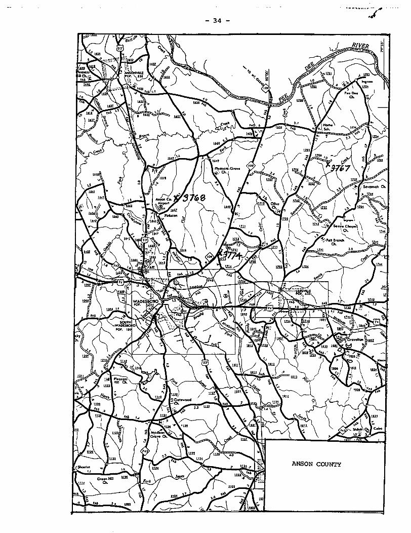
• II ............ ~. ".i1I1 ._."
J - 34 -
ANSON COUNTY

----_._----......-_-;7--- 35 -
e I
CHATHAM COUNTY
W<IOoD-
-_._------_._--- -_. -

_. - . .1:----
J - 36 -
~
" I
~ I I
.::;,
I 0
I V i
l
I I
35·'0' t
I ! ,
35" •
o
CHATHAM COUNTY
it is &iLOct ;M== I." ... :;:::;,. t tCd** 9AiiJ!WIem::: ;::::1 J Q:; (( c .... ((3 it ;,i.2pl..·
,

o
lJ
C H a \
._' •••• t.~ .. h , ....
DURHAM COUNTY

- 38 -
GRANVILLE COUNTY o

- 39 -
35'25'
C' o
LEE COUNTY
)i

40
C 0 U N T Y
o ~ 0
\ c. MONTGOMERY COUNTY

- 41
MOORE COUNTY
;

- 42 -
"0
VA. .
ROCKINGHAM COUNTY
..

- 43 -
H E K COUN' Y
ROCKINGHAM COUNTY

- 44
'lffSY
ROCKINGHAM COUNTY

c o U N
/
;0-
o
u
36'25'
z
36'10'
u
o
GUILFORD COUNTY
STOKES COUNTY

- 46 -
'0 u D
\ c 0 N
UNION COUNTY s
~ .. k ..
\ c A R 0 L N

- 47 -\
c 0 u
WAKE COUNTY