tintenbar to ewingsdale - home - roads and … · · 2014-08-30most suitable location. ......
TRANSCRIPT

TINTENBAR TO EWINGSDALECommunity information session #6 — Flora and fauna management, waste recycling and local road upgrades
26 June 2012
Mucking (removal of blast material)
Project ecologist relocating Australian Carpet Python (May 2012)

Agenda
• Welcome/introductions• Noise enquiries• Environment update• Construction update • Flora and fauna management• Waste reuse and recycling• Local road upgrades• Community involvement• Questions• Informal discussion with project team members.

Noise enquiries
• The project team has recently received a number of enquiries with regards to noise mitigation measures on the project including the noise wall at Ewingsdale and low noise pavement.
• A noise and vibration management sub-plan is being developed as part of the project which will assist in addressing these issues.
• The project team is committed to consulting with the community on issues of noise.
• A future community information session is planned to discuss noise on the project.
Environment update
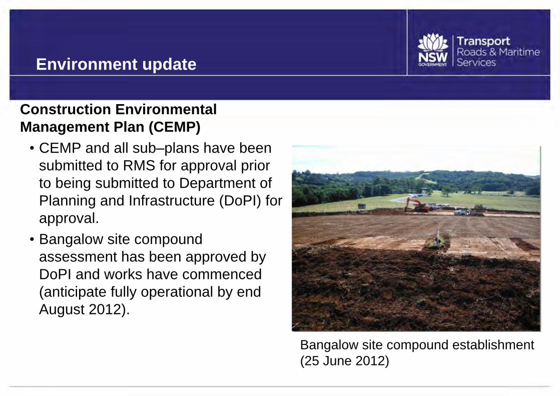
Construction Environmental Management Plan (CEMP)• CEMP and all sub‒plans have been
submitted to RMS for approval prior to being submitted to Department of Planning and Infrastructure (DoPI) for approval.• Bangalow site compound
assessment has been approved by DoPI and works have commenced (anticipate fully operational by end August 2012).
Bangalow site compound establishment (25 June 2012)

Construction update
•Early works — continuing:• Property adjustment and
demolition of houses under the highway footprint.
• Bangalow site compound establishment, including traffic management on Bangalow Road.
• Boundary fence installation.•Early works — commencing:
• Adjustment to service relocation works
• Site gate access installationBangalow compound site gate access

Flora and fauna management
A Flora and Fauna Management Sub-Plan has been developed to:• Minimise the impact to vegetation, particularly Endangered
Ecological Communities (EEC) and threatened flora species.
• Minimise the impact to fauna habitat and native fauna during construction.
• Minimise the impact on the riparian and aquatic ecosystems.
• Minimise the introduction and spread of weeds.
• Minimise the occurrence and impact of feral animals and vermin, particularly cane toads.

Flora and fauna management
The following principles have been adopted for the project:
• Avoid any impacts on flora or fauna in the first instance e.g. no unnecessary clearing of vegetation.
• Where possible, off-set or mitigate any unavoidable impacts, such as relocation of threatened species within the alignment.
• Ensure appropriate measures are implemented to comply with all relevant legislative and other contractual requirements.

Native flora
• 140 native flora species were identified within the study area, defined as the project boundary plus an extra width of 10 metres.
• The following listings under Rare or Threatened Australian Plants have been identified:
• Arrow–head vine (Tinospora tinosporoides)• Davidson’s plum (Davidsonia jerseyana)• Durobby (Syzygium moorei)• Hairy Joint Grass (Arthraxon hispidus)• Rough–shelled bushnut (Macadamia tetraphylla)• Small–leaved tamarind (Diploglottis campbellii)
Hairy Joint Grass Anthraxon hispidus
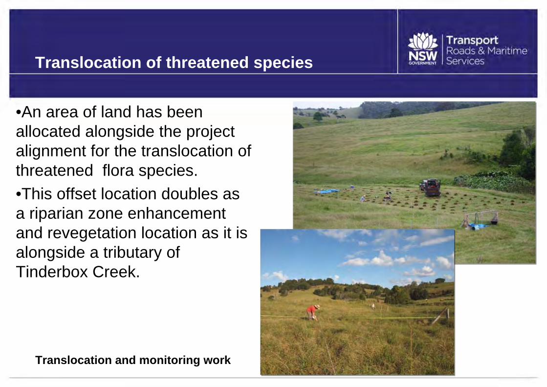
Translocation of threatened species
•An area of land has been allocated alongside the project alignment for the translocation of threatened flora species. •This offset location doubles as a riparian zone enhancement and revegetation location as it is alongside a tributary of Tinderbox Creek.
Tinderbox Valley looking SouthTranslocation and monitoring work

Impact minimisation
• Site induction and ongoing staff training to convey the requirements of the Flora and Fauna Management Sub-Plan.
• Install fencing and ‘no–go’ areas to protect areas that are not to be cleared and areas of Hairy Joint Grass.
• Prior to clearing: •clearing limits will be checked by a surveyor. •project ecologist will check for any previously unidentified hollow– bearing trees or habitat trees.

Impact minimisation
A two-stage clearing approach will be implemented to minimise the impact on fauna during clearing, including:
•Habitat and hollow–bearing trees (HBT) marked out by the project ecologist.
•Non-habitat trees removed at least 48 hours prior to felling habitat bearing trees.
•Felled trees to be left for a short time to allow fauna to escape.
•Felled habitat/HBT to be inspected by project ecologist immediately after felling.

Fauna rescue
•The project ecologist is the only person to handle injured fauna.•Any injured fauna will be given to local wildlife care groups for rehabilitation.

Terrestrial fauna
• The Environmental Assessment identified 68 species of vertebrate within the study area, including:
• Five amphibians• Two reptiles• Seven mammals• 54 different bird species.• All species are native,
except for the introduced cane toad.

Threatened fauna species
Nine of the fauna species found are listed under the EPBC Act (C’wealth) and the Threatened Species Act (NSW): •Cattle egret (Ardea ibis) migratory species.•Black–faced monarch (Monarcha melanopsis) migratory species.
•Masked owl (Tyto novaehollandiae).
•Grey–headed flying fox (Pteropus poliocephalus).
•Little bent–wing bat (Miniopterus australis).
•Large–footed Myotis (Myotis macropus).
•Giant Barred Frog (Mixophyes Iteratus).
•Rose–Crowned Fruit Dove (Ptilinopus Regina) vulnerable.
•Eastern Osprey (Pandion Cristatus).

• For the majority of listed threatened species, the highway upgrade is to have minimal to no impact on those animals or their habitats.
• Specific mitigation measures have been implemented for the conservation of the micro bat species.
Threatened fauna species
Tinderbox Valley looking south

Protection of fauna — microbats
• A maternity (breeding) colony of Large–footed Myotis has been relocated from the pipe culverts at Minor Creek and is now taking residence in the roost boxes at an alternative location.
• Other micro bat species have also been observed using the bat boxes as alternative roosts.
Large-footed Myotis Myotis macropus
Nest boxes being installed

Fauna protection
• Fauna protection is our commitment to ensuring that no wildlife is injured during construction of the highway upgrade.
• All project staff have been informed that all native fauna species, including snakes, are protected and not to be harmed.
Carpet Python relocated by ecologist from a house demolition
• Fauna found within the project corridor that are likely to be affected by works activities will be captured by the project ecologist and relocated to the most suitable location.

Fauna habitat and movement corridors
Five broad fauna habitats have been identified within the study area:
Fragmented patches of native vegetation contain important fauna habitat features such as:•Tree hollows•Riparian vegetation•Fallen logs and feeding resources•Resting locations for volant (capable of flying) species (bird and bat).
Rose Crowned Fruit DovePtilinopus Regina
Fauna habitats•Lowland rainforest •Camphor Laurel•Plantation
•Riparian•Cleared areas
High conservation areas for fauna passage
Important areas for fauna movements throughout the local area were identified and classified as below:
•Wilsons Creek/Hayters Hill sub‒regional wildlife corridor along the ridgeline of St Helena Hill.
•Riparian zones — vegetation and land close to creeks and waterways.
•Fragmented/isolated patches of vegetation occurring on opposing sides of the alignment.
•Areas of high conservation value vegetation occurring on either side of the alignment. These areas include:
• St Helena ridgeline• Byron Creek riparian zone• Scattered vegetation throughout Tinderbox Valley, either side of the
alignment.

Regional wildlife corridors and key habitats across the Pacific Highway upgrade — Tintenbar to Ewingsdale
- Road corridor
- Key Habitats
- Corridors

• There are 11 proposed locations for fauna crossings, including six under the following bridge locations:• Emigrant Creek• Minor Creek• Skinners Creek• Byron Creek and its tributaries• Tinderbox Creek and its tributaries• Former Fish Farm near the Macadamia Castle.
Proposed fauna crossing locations

Habitat corridors — enhancement strategy
Habitat corridors will be enhanced through revegetation, as follows:Fauna corridor•A major fauna movement corridor is identified over St Helena Hill.•The banana plantation in this area will be replanted with native vegetation to enhance the movement of fauna through this regional corridor.Regeneration•Several locations for regeneration of native flora species have been designated to encourage fauna movement.•Riparian zones of the Byron and Tinderbox Creek systems provide habitat for platypus and other species.•The project team is required to revegetate several riparian areas currently infested with weeds, to improve the quality of habitat and habitat connectivity.

Fauna habitat and movement corridors
Some of the animal species to be catered for by the fauna crossing include:•Koala•Platypus•Swamp wallabies•Bandicoots•Echidnas•Micro bats•Possums•Reptiles•Frog species•Fish species•Bird species•Additional mammal species•Any other animals that wish to use the crossing structures.

Fauna passage & drainage culverts
Pipe culvert
Box culvert
Combined fauna and fish friendly culvert
Fauna friendly culvert with low flow channel
Dedicated fauna accessunder new bridge over creek

Design — passages and culverts
• The design of each culvert is being assessed to consider length, width of opening, light levels and interior to encourage safe and effective passage through the culverts for various fauna species.
• The flow regime of creeks is to be retained wherever the culvert structure is a combination of fauna and drainage design.
• Original flow, velocity, afflux, riffles* and pools within the creeks need to be carried over to within the culvert to retain passageways for fish and other aquatic animals inhabiting the waterways, such as platypus.
*Riffle: A short, relatively shallow and coarse-bedded length of stream over which the stream flows at higher velocity and higher turbulence than it normally does in comparison to a pool.

Protection of riparian areas during clearing
•Grass and understory (lower level) vegetation is to be retained within 15m of rivers, creeks, watercourses and drainage lines until immediately prior to construction activities in those areas. •Vegetation is to be retained adjacent to waterways and near bridges where possible (at least a 1.5 metre buffer to be retained).
Typical waterway vegetationat Byron Creek

Protection of waterways
• Maintaining the “low flow channel” (normal level at which the stream flows) is required to be incorporated into the design for fish habitat waterways.
• Consultation with Department of Primary Industries (Fisheries), Office of Water, NSW Environment Protection Authority and Rous Water is ongoing, to determine which culverts on unnamed waterways/drainage lines require fish passage.
• Strict requirements are in place for works in and adjacent to waterways, to minimise the impact of construction e.g. working platforms, waterway diversion and temporary waterway crossings.

• A number of waterways adjoin/cross the construction areas.
• All waterways have been studied and observed to contain fish habitat.
• No threatened aquatic species under the Fisheries Management Act 1994 have been recorded in the study area.
Protection of waterways
Tinderbox Creek tributary

• For trees within riparian zones, stumps will be cut at ground level, leaving the stump and roots within the bank to minimise creek line disturbance and retain the soil.
Protection of waterways
• Banks are to be stabilised through temporary erosion and sedimentation controls e.g. covering with geofabric and rocks.
Byron Creek

Waterways — construction protection strategy
• Comprehensive erosion and sediment controls to be in place to protect waterways (prior to start of construction).
• Prevent erosion (therefore prevent soil reaching the waterways).• Staging of work to minimise the extent and duration of disturbance to
vegetation.• Waterway crossings to be constructed from rock materials that do not
contain any fine materials.• Water monitoring upstream and downstream of the work sites.• Install floating booms/sediment curtains in waterway crossings where
construction works are occurring within 50m of creeks and pools.• During construction activities, where practical, stockpile or store
materials away from the core riparian zone (40m from the top of the bank of the waterway).

Weeds
The following number of weed species were recorded in the study area:•11 noxious weed species•35 agricultural/environmental weed species•Four aquatic weed species.
Weed management requirements:•Noxious weeds are required to be continually suppressed and destroyed under the Noxious Weeds Act (1993)•Top soil used during landscaping is to be weed free.

Waste and material management
• A Waste Reuse and Recycling Management Sub-Plan has been developed for the project to:
• Document and describe the process to manage waste materials generated during the construction phase of the project.
• Provide plans of action for key waste streams.
• Ensure NSW Government and Commonwealth legislative compliance.
• Ensure adherence to the Protection of the Environment Operations Act 1997.

The waste hierarchy

Waste generated
• The main wastes expected to be generated are from the following sources:
• Cleared vegetation
• Unsuitable spoil from the project (e.g. dirt and rock)
• Materials from demolition works
• Municipal recyclable waste
• Non–recyclable waste
• Contaminated/hazardous waste.

Contaminated/hazardous waste
• Contaminated/hazardous sites have been identified along the project corridor.
• These include the former fish farm, former agricultural land, cattle tick dip sites and properties (asbestos) which will be demolished as part of the early works prior to construction.
• The project team is currently developing a remedial action plan to manage the control and disposal of this waste for the fish farm, agricultural land and cattle tick dip sites.
• All remedial action plans will be developed in line with Government environmental guidelines.

Waste reduction/recycling strategies
Strategies to reduce waste on the project include:
•Reduce packaging.
•Use products made of recycled materials.
•Use low emission fuels.
•Separate materials/waste for increased recycling.
•Store any hazardous or industrial waste (such as chemical storage containers) in a safe manner by ensuring they are properly bunded (contained) away from drainage lines or watercourses.
•All material going offsite is to be tracked and recorded.
•All hazardous, liquid or industrial waste is to be transported by an appropriately licenced waste contractor.

Planned local road upgrades
•To ensure safe and efficient construction, delivery trucks and work vehicles will access work areas via the following local roads:
• Tinderbox Road — access to and from Bangalow Road to the new alignment.
• St Helena Road — access to the southern tunnel portal.• Ivy Lane — access to the new alignment.• Martins Lane West — access to the new alignment.
•These local roads will be upgraded to ensure the safe combined use for road users and construction vehicles.

Planned local road upgrades con’td
• Local residents and Council have been consulted to identify issues and concerns and provide input into the development of mitigation strategies.
• Works are planned to start in late June/early July 2012 and will take approximately one month at each location.

Tinderbox Road upgrade
The proposed upgrade works to Tinderbox Road consist of:•Upgrade of the road west of existing culvert (crossing Tinderbox Creek) to west of the new alignment. This is part of the contract works (part 1).•Upgrade from Bangalow Road to the existing culvert. This is additional work planned to improve the safety and standard of the road (part 2).•Local residents have been consulted.•Issues and concerns will be addressed in the design phase (including noise, dust, road safety and biodiversity).
Signage will be erected and the speed limit lowered to protect koalas in the vicinity of their habitat.

Tinderbox Road upgrade (part 1)
The road in this section will be upgraded as follows:•Bitumen sealed surface•Full pavement reconstruction.

Tinderbox Road upgrade (part 2)
The road in this section will be upgraded as follows:•Preparation of existing pavement•Improve drainage•Widen shoulders (where possible)•Clean out inlets of causeway and remove deteriorated sections•Walkway (where possible)•Asphalt surface.

St Helena Road upgrade
The road in this section will be upgraded as follows:•Widen the road to 7m•Recut edge drains•Prepare surface•Bitumen seal.

Ivy Lane upgrade
The road in this section will be upgraded as follows:•Widen the road to 7m•Recut edge drains•Prepare surface•Bitumen seal•Installation of new turning bay.

Martins Lane West upgrade
The road in this section will be upgraded as follows:•Bitumen sealed surface•Full pavement reconstruction•Installation of new turning bay.

Community information, consultation and involvement
Consultation ongoing:• Meetings with property owners to support property adjustments
(continuing).• Condition inspections (continuing).• Meetings with residents for local road upgrades.Stay involved: 1800 882 787 (toll free inquiries and complaints line) [email protected] reply paid 85913 PO Box 604, Bangalow NSW 2479 www.rms.nsw.gov.au/pacific (prompts to Tintenbar to
Ewingsdale)Next community information session: Tuesday 24 July 2012