tier 1 draft environmental impact statement: executive summary€¦ · tier 1 draft environmental...
TRANSCRIPT
ATLANTA-CHATTANOOGA HIGH SPEED GROUND TRANSPORTATION PROJECT
TIER 1 DRAFT ENVIRONMENTAL IMPACT STATEMENT: EXECUTIVE SUMMARY
Prepared by: Federal Railroad Administration (FRA)
Georgia Department of Transportation (GDOT) Tennessee Department of Transportation (TDOT)
September 2016 PTSCO - 0023-00-002
PI: No. T001684

Page intentionally left blank
Executive Summary
Atlanta-Chattanooga HSGT Tier 1 DEIS 1 September 2016
EXECUTIVE SUMMARY
Overview
The Federal Railroad Administration (FRA), in cooperation with the Georgia Department of Transportation (GDOT) and the Tennessee Department of Transportation (TDOT), prepared this Tier 1 Draft Environmental Impact Statement (DEIS) for the proposed Atlanta – Chattanooga High Speed Ground Transportation (HSGT) Project (Project).
1 The Project is a proposed, new high-speed
intercity passenger service connecting Atlanta, Georgia and Chattanooga, Tennessee.
This Tier 1 Draft Environmental Impact Statement (DEIS) is a program-level document. A program-level Tier 1 Environmental Impact Statement (EIS) is prepared when large geographic areas are being addressed for proposed improvements, allowing the project sponsor to review reasonable HSGT corridors, general environmental conditions, and potential impacts. This Tier 1 DEIS states the purpose and need for the Project; assesses all reasonable corridor alternatives for the proposed action, including a No-Build Alternative; provides a broad overview of the potential transportation, natural, and human impacts; and presents the outcomes of public and agency coordination that were considered in the assessment and decision-making processes.
FRA, GDOT and TDOT have developed this Tier 1 DEIS in accordance with the National Environmental Policy Act of 1969 (NEPA) and its implementing regulations (40 Code of Federal Regulations [CFR] Parts 1500-1508); Safe Accountable Flexible Efficient Transportation Equity Act: A Legacy for Users (SAFETEA-LU); Moving Ahead for Progress in the 21
st Century Act (MAP-21);
and FRA’s Procedures for Considering Environmental Impacts (64 Federal Register [FR] 28545). Following the Tier 1 EIS process, GDOT will advance the selected Preferred Alternative for further study. If a Corridor Alternative is selected, GDOT will advance it to the Tier 2 NEPA process wherein more detailed environmental analyses will be conducted, potential alignments within the Preferred Alternative will be configured, exact station locations will be identified, a storage and maintenance facility site will be evaluated, and an HSGT technology will be selected.
The Atlanta – Chattanooga HSGT Project Tier 1 DEIS began with FRA’s publication of the Notice of Intent (NOI) (see Appendix A) in the Federal Register on August 22, 2007. The NOI announced the intent to prepare a Tier 1 EIS. Following the NOI, a scoping process was undertaken to inform the public, interest groups, and involved agencies about the proposed Project, corridor alternatives, and issues for public and agency review and input. Comments and recommendations received during the scoping meetings by the public, stakeholders and agencies were used to refine the Project’s Purpose and Need Statement, corridor alternatives, and the scope of the environmental analysis to be included in this Tier 1 DEIS. A summary of the scoping process, the public and agency coordination efforts, and the input received is documented in the Scoping Summary Report (GDOT 2008) and Chapter 7.0 of this Tier 1 DEIS. The corridors emerging from the scoping process that were carried forward into the screening phase are detailed in Chapter 2.0 of this Tier 1 DEIS.
Project Area Description
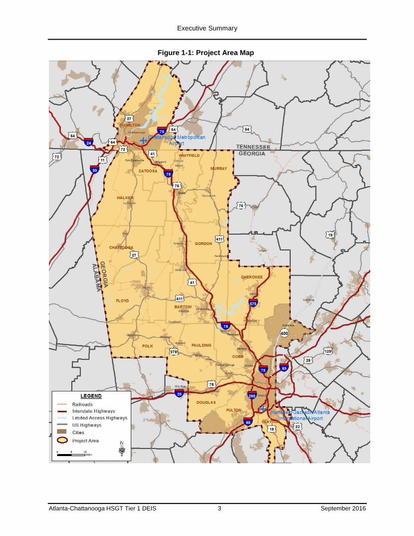
For the purpose of this Tier 1 DEIS, GDOT defined a broad geographic Project Area for study that is contained, wholly or in part, in the following counties: Fulton, Cobb, Cherokee, Floyd, Bartow, Murray, Whitfield, Gordon, Chattooga, Catoosa, Clayton, Douglas, Paulding, Polk, and Walker counties of Georgia; and Hamilton County of Tennessee. The Project Area is shown in Figure 1-1.
1 FRA defines HSGT as a self-guided intercity passenger ground transportation - by steel-wheel railroad or magnetic levitation
(Maglev) - that is time competitive with air and/or auto for travel markets in the approximate range of 100 to 500 miles. A 'market' is a city pair - two metropolitan areas and markets that, by their proximity and configuration, lend themselves to efficient service by ground transportation.
Executive Summary
Atlanta-Chattanooga HSGT Tier 1 DEIS 2 September 2016
Purpose and Need
Project Purpose
The purpose of the Project is to enhance intercity mobility and economic growth throughout the Project Area between the metropolitan areas and the airports of Atlanta, Georgia, and Chattanooga, Tennessee, by providing faster and more reliable ground transportation service to the public as an alternative to highway, intercity bus, and air travel in a manner that is safe and cost-effective, while avoiding, minimizing, and mitigating impacts on the human and natural environment. This purpose is supported by the Long Range Transportation Plans (LRTPs) of the Metropolitan Planning Organizations (MPOs) in the Project Area and the GDOT’s and TDOT’s State Implementation Plans.
Need for the Project
Commuters traveling in the Project Area primarily rely on automobiles for intercity travel since there is very limited intercity bus service and no intercity HSGT service. Currently, the highway system within the Project Area is operating at or near capacity during commuting hours, especially within the metropolitan areas of Atlanta, Rome, Dalton, and Chattanooga (as reported by Transportation Demand Models for Atlanta Regional Commission (ARC), Greater Dalton MPO, Chattanooga-Hamilton County Regional Planning Agency, and Rome-Floyd County MPOs 2013, and TDOT 2014). Traffic congestion will persist in the future as a result of increasing passenger travel demand from population, tourism, employment, and business growth.
Between the years 2000 and 2012, the population of Georgia increased 19 percent and the population of Tennessee increased 12 percent. The populations of 11 of the 16 counties within the Project Area during the same period grew by 10 percent or more including increases of 52 percent in Cherokee County and about 74 percent in Paulding County. The metropolitan Atlanta population is forecasted to increase from 5.4 million people in 2010 to 8.3 million by the year 2040 (ARC 2010).
Employment in the Project Area grew by over 40 percent from 1990 to 2012. ARC forecasts employment in metropolitan Atlanta will increase over 40 percent between 2010 and 2040, and the Chattanooga-Hamilton County Regional Planning Agency (CHCRPA) reports that employment is forecasted to increase 40 percent between 2007 and 2035.
The Georgia Interstate System Plan (GDOT 2004) reported that roadway travel demand along the majority of I-75, north of Atlanta, is projected to exceed capacity by 2030. Travel demand on US 41, US 411, and US 27, the other north-south routes between Atlanta and Chattanooga, is expected to equal or exceed capacity within the next 30 years notwithstanding planned highway improvement projects. Given the projected increases in travel demand throughout the Project Area, additional alternatives to address existing and future travel demand are needed.
Therefore, to maintain and enhance the economic vitality of the two anchor cities and throughout the Project Area, the mobility of those traveling within the Project Area requires improvement. With greater regional mobility connections to Atlanta and Hartsfield-Jackson Atlanta International Airport (HJAIA), a connection to the national and global economy would be realized for Chattanooga and Northwest Georgia.
Executive Summary
Atlanta-Chattanooga HSGT Tier 1 DEIS 3 September 2016
Figure 1-1: Project Area Map
Executive Summary
Atlanta-Chattanooga HSGT Tier 1 DEIS 4 September 2016
In this Tier 1 DEIS, FRA, GDOT, and TDOT are considering actions to address transportation needs stemming from increasing travel demand and forecast population and employment growth. Specifically, the needs for the Project include:
Enhance Regional Transportation Mobility and Accessibility
Population and Employment Growth
Congested Transportation Corridor with Increasing Demand
Limited Transportation Options
Spur Economic Growth and Regional Vitality
Provide Safe, Efficient, Reliable Transportation
Enhance Airport Access and Intermodal Connections
Improve Air Quality Nonattainment Areas and Minimize Environmental Impacts
Corridor Alternatives Considered
Scoping
One of the initial steps the agencies took in preparing this Tier 1 DEIS was the development and implementation of a public involvement program and public scoping process to solicit issues, concerns, and ideas regarding a proposed HSGT Project and the corresponding assessment of environmental impacts in the Project vicinity. During the formal scoping process, the public, stakeholders, and government agencies provided input on the following subject areas:
The Project’s purpose and need;
Potential mode technologies;
Potential proposed project corridors and station stop locations;
The scope of the assessment of potential environmental impacts for the Project;
Methodology for selecting the corridors for further study; and
Opportunities for public involvement.
High Speed Ground Transportation Technologies
In the scoping process, several HSGT train technologies were identified. HSGT is a mode of transportation that can travel at greater speeds than traditional rail technology and can provide improved passenger mobility and reduce travel times in the Project Area. For the purposes of this proposed project, HSGT is defined as trains having the ability to travel at speeds at or above 180 miles per hour (mph) and as an intercity passenger transportation mode that is time-competitive with air and highway travel for trips of 100 to 500 miles. The train technologies that were considered included: diesel multiple unit, commuter rail, intercity rail, “Low” High Speed Intercity Rail, and Very High Speed Rail (VHS), which consists of steel-wheeled and magnetic levitation (Maglev) technologies.
Identification and Screening of Corridors
During the scoping process, GDOT identified 15 unique corridors extending from HJAIA to downtown Chattanooga. Following scoping, the 15 corridors were subjected to a screening process as part of the development process for the corridor alternatives. The screening process was undertaken to identify the reasonable corridor alternatives to be evaluated in this Tier 1 DEIS.
Executive Summary
Atlanta-Chattanooga HSGT Tier 1 DEIS 5 September 2016
The screening process assessed the relative attributes of the potential HSGT corridors. The screening process included the following tasks:
Development of measures of effectiveness (MOEs);
Application of MOEs to assess how well each corridor meets the Project’s purpose and need. Screening sought to advance the best performing corridor(s) based on the criterion of transportation mobility; and
Involvement of FRA, GDOT, TDOT, participating agencies, stakeholders, and the public in the screening process.
The Project Team (FRA, GDOT, and TDOT) advanced the three corridor alternatives listed below for further evaluation in the Tier 1 DEIS since they most closely met the Project purpose and need. The three Norfolk Southern (NS) corridors (I-75 Southern Crescent NS, East Southern Crescent NS, and I-75/Rome Southern Crescent NS) were also retained, but detailed analyses of the three NS corridors were deferred to future studies as design options for the Atlanta area:
I-75 Southern Crescent;
East Southern Crescent; and
I-75/Rome Southern Crescent.
Alternatives Evaluated in this Tier 1 DEIS
Based on the results of screening (described in detail in Appendix B), the three corridors listed above were advanced in this Tier 1 DEIS to evaluate their potential environmental impacts. A No-Build Alternative was also analyzed in this Tier 1 DEIS. Both the No-Build Alternatives and the Corridor Alternatives are described in the following sections.
No-Build Alternative
Federal regulations require that a No-Build Alternative be evaluated in an EIS. The No-Build Alternative includes the existing transportation system and assumes that there would be no new HSGT improvements in the Project Area. The No-Build Alternative assumes that all transportation system improvements that are currently listed in local, regional, and state transportation plans and that have identified funds for implementation will be implemented. Thus, the No-Build Alternative represents the Project Area’s transportation system as it is anticipated to be in the planning horizon year 2040. The system includes highway and transit projects in each of the MPO’s transportation plans within the Project Area as well as aviation projects identified in the Master Plans of the two airports, HJAIA, and Chattanooga Metropolitan Airport (CMA), which currently provide passenger carrier service to the Project Area. The existing transportation system serving the Project Area can be summarized as follows:
The highway system consists primarily of Interstate highways I-75, I-285, and I-24, and of highways US 27, US 411, and US 41.
The Intercity bus transit service is provided by Greyhound and Megabus. Regional bus transit service is provided within metropolitan Atlanta by Metropolitan Atlanta Rapid Transit Authority (MARTA), Cobb Community Transit (CCT), and Gwinnett County Transit (GCT). The Georgia Regional Transportation Authority (GRTA) provides regional commuter “Xpress” bus service. Local bus service is provided by the Chattanooga Area Regional Transportation Authority (CARTA), MARTA, and the City of Rome Transit Department (RTD). MARTA also includes a 48-mile heavy rail transit system with 38 stations within metropolitan Atlanta.
The aviation system consists of two airports that currently provide passenger carrier service to the region: HJAIA and CMA.
Executive Summary
Atlanta-Chattanooga HSGT Tier 1 DEIS 6 September 2016
Corridor Alternatives
Like the No-Build Alternative, the Corridor Alternatives also assume the implementation of the transportation system improvements that are currently listed in local, regional, and state transportation plans and that are funded for construction. The three corridors that advanced from the screening process to become Corridor Alternatives are I-75 Southern Crescent, East Southern Crescent, and I-75/Rome Southern Crescent as illustrated in Figure 1-2. To streamline the naming convention used in this Tier 1 DEIS, the phrase “Southern Crescent” will be omitted as it applies equally to all.
For this Tier 1 DEIS, the Corridor Alternatives are examined within corridors 1,000 feet in width, which allows for variation in the horizontal alignments to be determined during the Tier 2 NEPA phase and is sufficiently wide to evaluate the potential environmental issues associated with the alternatives. No alignments have been defined in this Tier 1 DEIS. The vertical alignments, also to be determined during the Tier 2 NEPA phase, would vary along the corridors between at-grade, elevated structure, and tunnel, depending on the topographic conditions and existing development within each corridor alternative. All Corridor Alternatives would be constructed as exclusive facilities that do not share track with other trains and are grade separated when crossing roadways or rail lines.
In this Tier 1 DEIS, the Corridor Alternatives are considering both steel-wheeled and Maglev technologies. The potential station locations presented are conceptual and are intended to indicate general areas to be served by the alternative, not specific sites of stations. Exact locations of potential stations will be determined during the Tier 2 NEPA phase.
I-75 Corridor Alternative: The I-75 Corridor Alternative begins on the east side of HJAIA at the proposed HJAIA/Southern Crescent (HJAIA/SC) station, immediately adjacent to I-75, and follows I-75 to a point south of the proposed downtown Atlanta station. The corridor continues north underground through downtown Atlanta to I-75 north and uses the I-75 right-of-way (ROW) to the proposed Cumberland/Galleria station. It continues north along the I-75 ROW to the proposed Town Center, Cartersville, and Dalton stations. North of I-24 in Tennessee, the corridor continues along an existing CSX rail ROW to proposed stations at CMA and in downtown Chattanooga.
East Corridor Alternative: The East Corridor Alternative follows the same alignment as the I-75 corridor to the proposed Cartersville station. North of the Cartersville station, the corridor deviates from I-75 and continues along existing CSX ROW generally parallel to US 411, stops at the Dalton-Chatsworth and CMA stations, and continues to the proposed downtown Chattanooga station.
I-75/Rome Corridor Alternative: The I-75/Rome Corridor Alternative follows the same path as the I-75 and East corridors to the proposed Cartersville station. From the proposed Cartersville station, the corridor follows US 411 to Rome, continues north along an existing CSX rail ROW to rejoin I-75 between the proposed Cartersville and Dalton stations. The corridor continues north along the I-75 ROW to the proposed stations at Dalton and CMA and in downtown Chattanooga.
Each of the Corridor Alternatives includes proposed areas for stations. Stations would provide park-and-ride facilities with direct pedestrian connections to the stations. The station type, configuration, and exact location of the proposed station will be developed during the Tier 2 NEPA phase if a Corridor Alternative is selected as a Preferred Alternative to be further evaluated.

Executive Summary
Atlanta-Chattanooga HSGT Tier 1 DEIS 7 September 2016
Figure 1-2: Corridor Alternatives

Executive Summary
Atlanta-Chattanooga HSGT Tier 1 DEIS 8 September 2016
General areas for a potential storage, maintenance and inspection facility are identified in Figure 1-2. Exact locations for the storage, maintenance and inspection facilities have not been identified nor were they evaluated in this Tier 1 DEIS. Storage yard capacity requirements would be based on the required fleet and the operating plan. For the purpose of this Tier 1 DEIS, it is assumed the proposed Project would include:
A storage and heavy maintenance facility near the southern terminus in the vicinity of HJAIA. This facility also would include the command center for all systems and train wash facilities; and
A storage and inspection yard near the northern terminus within the Chattanooga area. It would provide facilities for running inspections, light duty repairs on equipment, as needed, and train storage. This yard also would include a control tower to control access to and within the yard.
Table 1-1 presents key attributes of each Corridor Alternative.
Table 0-1: Corridor Alternatives Attribute Comparison
Corridor Alternative (Potential Number of
stations)
Length of Alternative
(miles)
Projected 2040 Total Daily Ridership*
(passengers)
Time to Travel Corridor End to End
(minutes)
I-75 (8) 128 11,725 88
East (8) 139 8,556 95
I-75/Rome (9) 150 13,204 102
* Appendix D provides Travel Demand Modeling information.
Summary of Key Environmental Findings
The Tier 1 analysis of environmental consequences described in this chapter determined that the Project as well as the No-Build Alternative projects have the potential to impact the human and natural environment.
No-Build Alternative: The extent to which the projects in the No-Build Alternative would avoid or minimize impacts on the human and natural environment can only be determined through environmental analysis to be undertaken by the sponsors of those projects. Key findings of this Tier 1 assessment are that the No-Build Alternative:
Would increase capacity and expand service in selected portions of the Project Area transportation network, but would not enhance passenger mobility throughout the Project Area between the metropolitan areas and airports of Atlanta and Chattanooga;
Would not adequately address the transportation needs of projected population and employment growth in the Project Area, would not increase transportation options, would not increase airport and intermodal connections, would not fully address transportation limitations on economic growth, and would not provide faster and more reliable ground transportation service as an alternative to highway, intercity bus and air travel;
Would not improve air quality because it would not reduce the quantity or the growth rate of mobile source emissions resulting from vehicle miles traveled on the highway network in the Project Area; and
Potentially would have impacts on communities, parks, wildlife refuges and recreational areas, cultural resources, water and biological resources.
Executive Summary
Atlanta-Chattanooga HSGT Tier 1 DEIS 9 September 2016
Corridor Alternatives: Key findings of the Tier 1 assessment are that the Corridor Alternatives:
Would enhance regional mobility and accessibility in the Project Area;
Would help address the transportation needs of projected population and employment growth in the Project Area, particularly in terms of increasing transportation options, increasing airport access and intermodal connections, address transportation limitations on economic growth, and provide faster and more reliable ground transportation as an alternative to highway, intercity bus and air travel;
Would improve air quality by providing a transportation option that does not increase the quantity or the growth rate of mobile source emissions resulting from vehicle miles traveled on the highway network in the Project Area; and
Potentially would have impacts on communities, parks, wildlife refuges and recreational areas, cultural resources, water and biological resources.
In regard to potential human and natural environment impacts, the Tier 1 analysis revealed several differences among the Corridor Alternatives:
Ridership: The I-75/Rome Corridor Alternative would have the highest ridership, followed by the I-75 Corridor Alternative; the East Corridor Alternative would have the lowest ridership.
Travel time: End to end travel times vary among the Corridor Alternatives with the I-75 Corridor Alternative being the shortest at 88 minutes, the East Corridor Alternative at 95 minutes, and the I-75/Rome Corridor Alternative at 102 minutes.
Transportation: The I-75 Corridor Alternative would use the most existing transportation ROW, followed by the I-75/Rome Corridor Alternative. The East Corridor Alternative would use the least existing transportation ROW, thereby having the highest potential for adverse effects according to this measure.
Air quality: All Corridor Alternatives would result in reduced emissions. The I-75/Rome Corridor Alternative has the highest potential to transfer trips from the highway system to the HSGT and, thereby, reduce vehicular emissions. This finding is based solely on ridership.
Noise and Vibration: All Corridor Alternatives would have potential noise and vibration impact. The I-75 Corridor Alternative is the best performing for both noise and vibration sensitive land uses within their respective screening distances. This may be attributed to the fact that a longer length of the I-75 Corridor Alternative is adjacent to the interstate highway system, whereas the other two alternatives deviate from the interstate and travel along U.S. highways (which tend to have more development located closer to the roadway than interstate highways).
Population and Employment Access: County-based 2010 U.S. Census data demonstrate that the more urbanized areas typically have higher densities of minority and low-income populations compared with rural areas. The ratio of environmental justice (EJ) areas to non-EJ areas within each Corridor Alternative when measured by linear mile along each corridor is 0.6:1 for the I-75 Corridor Alternative and 0.5:1 for the East and I-75/Rome Corridor Alternatives. Moreover, not all Corridor Alternatives serve the same proposed station locations or the same EJ populations. For example, only the I-75/Rome Corridor Alternative would serve the proposed Rome station area. Similarly, only the East Corridor Alternative would serve the proposed Dalton-Chatsworth station area. Therefore, depending on the Corridor Alternative, some EJ populations in the study area would be served and some would not.
Parklands and wildlife refuges: The difference between the Corridor Alternatives in terms of total acreage of potentially affected parkland and wildlife refuges is insignificant; however, there is distinguishable difference in the number of individual parks or refuges that could be affected.
Executive Summary
Atlanta-Chattanooga HSGT Tier 1 DEIS 10 September 2016
The I-75/Rome Corridor has the highest number of potential parklands that could be affected and the East Corridor has the least.
Historic resources: The East Corridor Alternative has twice the number of known historic resources as the I-75 or I-75/Rome Corridor Alternatives. The higher number is due to the East Corridor Alternative using a lower percentage of existing transportation rights-of-way. This differentiating factor suggests the potential for a higher number of Project impacts on known historic resources if the East Corridor Alternative is advanced.
Wetlands, streams and floodplains: The I-75/Rome Corridor Alternative has more acres of wetlands and stream crossings than the other Corridor Alternatives. This difference suggests the potential for a higher number of Project impacts on wetlands and streams if the I-75/Rome Corridor Alternative is advanced. The East Corridor Alternative has a considerably higher acreage of floodplains compared with the other alternatives.
Known threatened and endangered species habitats: The East Corridor Alternative has a larger number of known threatened and endangered species habitats than the I-75 and I-75/Rome Corridor Alternatives. This differentiating factor suggests the potential for a higher number of Project impacts on known threatened and endangered species habitats if the East Corridor Alternative is advanced.
Table 1-2 summarizes the data findings for the Corridor Alternatives; these data are discussed in the remaining sections of this chapter.
In summary, despite the differences among the Corridor Alternatives, each Corridor Alternative demonstrates some level of achievement of the Project purpose based on the data available at this Tier 1 level of study and shown in Table 1-2. The East Corridor Alternative has the highest potential for impacts on known historic resources and floodplains, while the I-75/Rome Corridor Alternative has the highest potential to impact wetlands and stream crossings. Compared to the other Corridor Alternatives, the I-75 Corridor Alternative has the lowest potential for impact on known historic resources, streams, and floodplains; impacts on wetlands are similar to the East Corridor Alternative.
List of Preparers
Atlanta-Chattanooga HSGT Tier 1 DEIS 11 September 2016
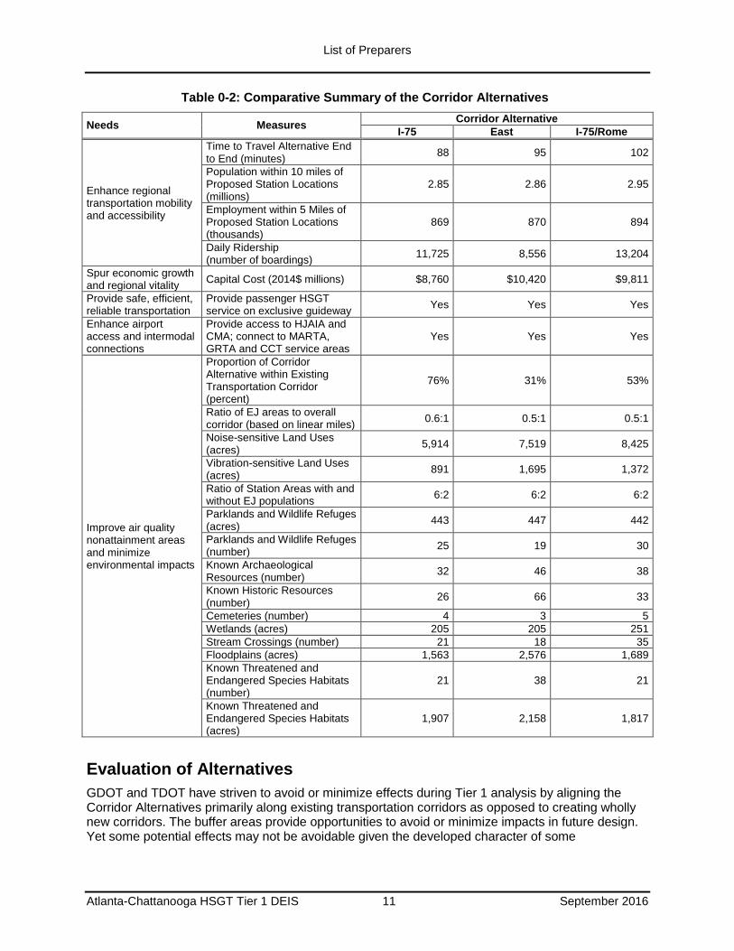
Table 0-2: Comparative Summary of the Corridor Alternatives
Needs Measures Corridor Alternative
I-75 East I-75/Rome
Enhance regional transportation mobility and accessibility
Time to Travel Alternative End to End (minutes)
88 95 102
Population within 10 miles of Proposed Station Locations (millions)
2.85 2.86 2.95
Employment within 5 Miles of Proposed Station Locations (thousands)
869 870 894
Daily Ridership (number of boardings)
11,725 8,556 13,204
Spur economic growth and regional vitality
Capital Cost (2014$ millions) $8,760 $10,420 $9,811
Provide safe, efficient, reliable transportation
Provide passenger HSGT service on exclusive guideway
Yes Yes Yes
Enhance airport access and intermodal connections
Provide access to HJAIA and CMA; connect to MARTA, GRTA and CCT service areas
Yes Yes Yes
Improve air quality nonattainment areas and minimize environmental impacts
Proportion of Corridor Alternative within Existing Transportation Corridor (percent)
76% 31% 53%
Ratio of EJ areas to overall corridor (based on linear miles)
0.6:1 0.5:1 0.5:1
Noise-sensitive Land Uses (acres)
5,914 7,519 8,425
Vibration-sensitive Land Uses (acres)
891 1,695 1,372
Ratio of Station Areas with and without EJ populations
6:2 6:2 6:2
Parklands and Wildlife Refuges (acres)
443 447 442
Parklands and Wildlife Refuges (number)
25 19 30
Known Archaeological Resources (number)
32 46 38
Known Historic Resources (number)
26 66 33
Cemeteries (number) 4 3 5
Wetlands (acres) 205 205 251
Stream Crossings (number) 21 18 35
Floodplains (acres) 1,563 2,576 1,689
Known Threatened and Endangered Species Habitats (number)
21 38 21
Known Threatened and Endangered Species Habitats (acres)
1,907 2,158 1,817
Evaluation of Alternatives
GDOT and TDOT have striven to avoid or minimize effects during Tier 1 analysis by aligning the Corridor Alternatives primarily along existing transportation corridors as opposed to creating wholly new corridors. The buffer areas provide opportunities to avoid or minimize impacts in future design. Yet some potential effects may not be avoidable given the developed character of some
List of Preparers
Atlanta-Chattanooga HSGT Tier 1 DEIS 12 September 2016
communities the Project is intended to serve, the design requirements of the Project, and the need to avoid adversely affecting future operations of the existing transportation facilities.
Consequently, the decision to advance one alternative to the next phase of study involves recognizing and understanding that GDOT and TDOT are working to balance the trade-offs between the benefits and effects of the alternatives.
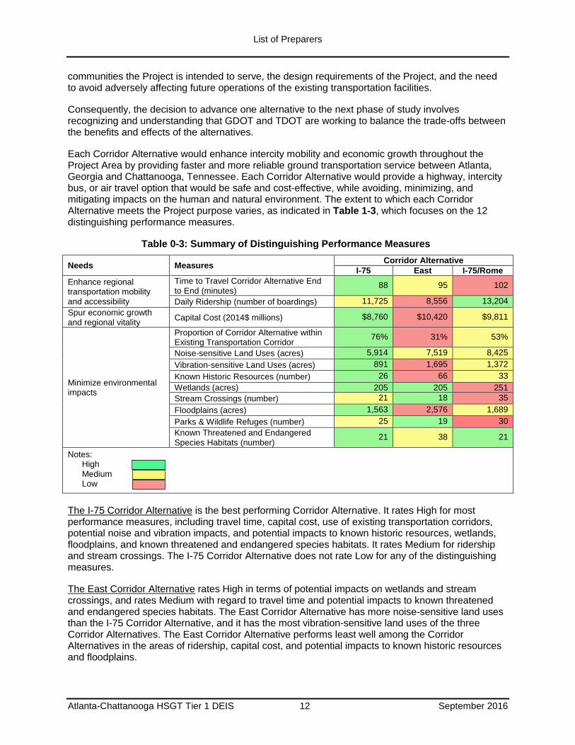
Each Corridor Alternative would enhance intercity mobility and economic growth throughout the Project Area by providing faster and more reliable ground transportation service between Atlanta, Georgia and Chattanooga, Tennessee. Each Corridor Alternative would provide a highway, intercity bus, or air travel option that would be safe and cost-effective, while avoiding, minimizing, and mitigating impacts on the human and natural environment. The extent to which each Corridor Alternative meets the Project purpose varies, as indicated in Table 1-3, which focuses on the 12 distinguishing performance measures.
Table 0-3: Summary of Distinguishing Performance Measures
Needs Measures Corridor Alternative
I-75 East I-75/Rome
Enhance regional transportation mobility and accessibility
Time to Travel Corridor Alternative End to End (minutes)
88 95 102
Daily Ridership (number of boardings) 11,725 8,556 13,204
Spur economic growth and regional vitality
Capital Cost (2014$ millions) $8,760 $10,420 $9,811
Minimize environmental impacts
Proportion of Corridor Alternative within Existing Transportation Corridor
76% 31% 53%
Noise-sensitive Land Uses (acres) 5,914 7,519 8,425
Vibration-sensitive Land Uses (acres) 891 1,695 1,372
Known Historic Resources (number) 26 66 33
Wetlands (acres) 205 205 251
Stream Crossings (number) 21 18 35
Floodplains (acres) 1,563 2,576 1,689
Parks & Wildlife Refuges (number) 25 19 30
Known Threatened and Endangered Species Habitats (number)
21 38 21
Notes: High Medium Low
The I-75 Corridor Alternative is the best performing Corridor Alternative. It rates High for most performance measures, including travel time, capital cost, use of existing transportation corridors, potential noise and vibration impacts, and potential impacts to known historic resources, wetlands, floodplains, and known threatened and endangered species habitats. It rates Medium for ridership and stream crossings. The I-75 Corridor Alternative does not rate Low for any of the distinguishing measures.
The East Corridor Alternative rates High in terms of potential impacts on wetlands and stream crossings, and rates Medium with regard to travel time and potential impacts to known threatened and endangered species habitats. The East Corridor Alternative has more noise-sensitive land uses than the I-75 Corridor Alternative, and it has the most vibration-sensitive land uses of the three Corridor Alternatives. The East Corridor Alternative performs least well among the Corridor Alternatives in the areas of ridership, capital cost, and potential impacts to known historic resources and floodplains.
List of Preparers
Atlanta-Chattanooga HSGT Tier 1 DEIS 13 September 2016
The I-75/Rome Corridor Alternative rates High for ridership and potential impacts to known threatened and endangered species habitats. It rates Medium with regard to use of existing transportation corridors and potential impacts to known historic resources and it rates Low for travel time, potential noise impacts, and potential impacts to wetlands and stream crossings.
The No-Build Alternative projects would provide some improvements in roadway and transit operations within the Project Area, by increasing capacity and expanding service in selected portions of the Project Area transportation network. It is reasonable to expect that these planned improvements would reduce travel time and congestion of roadways in the Project Area, and increase transit ridership where new or expanded transit services are proposed. However, none of the No-Build Alternative projects alone or in aggregate will enhance passenger mobility throughout the Project Area between the metropolitan areas and airports of Atlanta and Chattanooga as specified in the Project purpose. For this reason, the No-Build Alternative does not achieve the Project purpose.
The projects in the No-Build Alternative would incur costs and potential effects on the human and natural environment that would be determined by the sponsors of those projects. As the geographic scope and nature of the No-Build Alternative projects is limited, the potential effects of the projects are likely to be limited. Thus, the No-Build Alternative has the potential to cause fewer effects on the human and natural environment than the Corridor Alternatives.
The findings of this analysis indicate that the decision to be made by the Tier 1 Final EIS/Record of Decision (ROD) involves examining the trade-offs between the benefits and potential effects of the Corridor and No-Build Alternatives. Given the use of 1,000 feet wide study areas for the Corridor Alternatives, opportunity exists to avoid or minimize effects on the human and natural environment as the Project advances in Tier 2 NEPA analysis. Because most environmental impacts can be reasonably avoided/minimized, cost-effectiveness criteria provide a more distinguishing comparison between alternatives at the corridor level.
If a Corridor Alternative is selected, FRA, GDOT, and TDOT would work to preserve existing and planned transportation operations in the existing corridors they affect as well as avoid or minimize impacts on the human and natural environments. If a Corridor Alternative is selected, GDOT and TDOT will coordinate with regulatory agencies in Tier 2 to identify and refine alignments that avoid or minimize adverse effects. Likewise in the Tier 2 phase of the project, GDOT and TDOT will work with affected stakeholders and the communities to avoid or minimize adverse effects of alignments they develop during Tier 2 study.
Coordination with Agencies, Stakeholders, and the Public
In accordance with the Agency and Stakeholder Involvement Plan (ASIP) (GDOT 2014) and SAFETEA-LU requirements, between 2007 and 2013, GDOT and TDOT held meetings with participating agencies, Project stakeholders, and the public. The outcome of these meetings indicated support by attendees for the construction and operation of the Project. Public involvement activities were ongoing throughout the process and included the following:
Agency Scoping - The environmental planning and review process for the Project began with early coordination and an agency scoping process with participating agencies, which are defined by SAFETEA-LU as those with an interest in the Project. A list of participating agencies for the Project is provided in Appendix E - Agency Coordination and Public Outreach. The Project Team, which includes GDOT and TDOT, decided to defer the identification of cooperating agencies to the Tier 2 NEPA phase when a corridor alternative is selected. The scoping process began on August 22, 2007 and ended on October 4, 2007 during which two Agency Scoping Meetings were held. The scoping process was used to identify the range of mode technologies and corridors to be studied,
List of Preparers
Atlanta-Chattanooga HSGT Tier 1 DEIS 14 September 2016
the potential impacts to the human and natural environments, and the issues and concerns to be addressed in the Tier 1 analysis.
Interagency Coordination –GDOT and TDOT held meetings between federal and state lead agencies on a monthly basis. These meetings provided opportunity for ongoing coordination and discussion of the Project process, products, and issues. In addition, GDOT and TDOT held meetings with participating agencies to review the key Tier 1 NEPA milestones. Participating agencies were involved in, and participated in, the review of the Project’s purpose and need; the identification of the potential corridors and mode technologies; the corridor alternative screening and corridor alternative development; and the scope of the environmental impact assessment of the Tier 1 DEIS. GDOT and TDOT conducted agency coordination periodically between 2011 and 2013.
HSGT Steering Committee - This is a sub-committee of the Georgia State Transportation Board’s Intermodal Committee (the Georgia Board) that supported the development of the Tier 1 DEIS. GDOT and TDOT provided regular briefings to the Steering Committee throughout the development of this Tier 1 DEIS. The Steering Committee also provided input to GDOT and TDOT project management staff at key points.
Native American Tribes – Since Native American Tribes may have interests regarding natural and cultural resources that could be in the Project Area, during the Scoping Process in 2007, GDOT contacted potentially affected tribes and the Georgia Natural Heritage Program (GNHP) via letter to notify them of the Project and to invite them to participate in the planning process. GDOT and TDOT will continue to coordinate with Native American Tribes and GNHP throughout Project development
2.
Stakeholders - GDOT and TDOT engaged stakeholders, identified as any agency, organization, or group with an interest in the Project, but not designated as a participating agency, on an ongoing basis to provide timely and ongoing feedback.
In the early stages of the Tier 1 DEIS between January and June 2008, local government stakeholders were involved in 19 meetings held with local planning and technical staff in the Project Area. More than 60 local government representatives participated. From July to September 2008 over 20 stakeholder meetings were held with community, neighborhood, and business organizations. To support the corridor screening and alternative development process, nine additional stakeholder meetings were held in October and November 2010.
Public Involvement - There have been two major decision points where significant involvement from the public was solicited:
In 2007, Public Scoping Meetings were held in three different locations during September to develop the purpose and need, and the range of potential corridors and mode technologies to be evaluated in the Tier 1 DEIS. These Public Scoping Meetings were advertised in local newspapers such as the Atlanta Journal Constitution, the Rome-News Tribune, the Daily Tribune-News of Cartersville, and the Chattanooga Times-Free Press. Meetings were also announced on the Project website (https://www.dot.ga.gov/travelingingeorgia/rail/Pages/Atl-Chatt.aspx); and
In 2010, Public Information Open House Meetings were held in four different locations in November to review the corridor screening and alternative development process and results. Advertisement for the public information open house meetings appeared on the Project website and the GDOT website, a Project flyer was distributed to those listed in the contact database,
2 The coordination should not be considered full consultation under Section 106 of the National Historic Preservation Act. Section
106 consultation will be conducted during the Tier 2 NEPA phase.
List of Preparers
Atlanta-Chattanooga HSGT Tier 1 DEIS 15 September 2016
and notices were sent to chambers of commerce and other agencies in the Project Area. Public service announcements were sent to local radio stations and meeting announcements were sent to online calendars. Press releases were distributed to GDOT’s media contact list. The chambers of commerce in each city assisted in promoting the meetings by distributing flyers by email and posting on their websites.
In accordance with NEPA and FRA’s procedures, once the Tier 1 DEIS is made available for public review, there will be a minimum 45 day public comment period. During that time, FRA, GDOT and TDOT will hold a public meeting to provide interested parties to learn more about the Project, submit comments on the Project, and obtain feedback from the Project team on the Tier 1 DEIS. After the close of the meeting and public comment period, FRA, GDOT and TDOT will consider the public and agency input as well as the findings of the Tier 1 DEIS.
Next Steps
After FRA publishes the Tier 1 DEIS and the public comment period is completed, GDOT and TDOT will prepare a combined Tier 1 Final EIS (FEIS) and Record of Decision (ROD) wherein the Preferred Corridor Alternative will be identified.
3 FRA will sign the combined FEIS/ROD, thereby
selecting the Preferred Corridor Alternative. Should funding for further study become available, FRA, GDOT, and TDOT will then evaluate potential alignments configurations within the Preferred Corridor Alternative in the Tier 2 NEPA process.
Since there will be no selection of a preferred technology as part of this Tier 1 DEIS, both Maglev and steel-wheel technologies would advance for consideration with the Preferred Corridor Alternative. When a technology is selected, the selected alignment will be refined to optimize the operation of the selected technology.
3 Pursuant to Pub. L. 112-141, 126 Stat. 405, Section 1319(b), FRA will issue a combined FEIS/ROD, unless FRA determines that
statutory criteria or practicability considerations preclude issuance of such a combined document.