this digital elevation model shows the tennessee … sam moffat this digital elevation model shows...
TRANSCRIPT
BY SAM MOFFAT
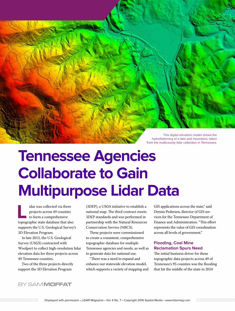
This digital elevation model shows the hydroflattening of a lake and mountains, taken
from the multicounty lidar collection in Tennessee.
Tennessee Agencies Collaborate to Gain Multipurpose Lidar DataL idar was collected via three
projects across 49 counties to form a comprehensive
topographic state database that also supports the U.S. Geological Survey’s 3D Elevation Program.
In late 2015, the U.S. Geological Survey (USGS) contracted with Woolpert to collect high-resolution lidar elevation data for three projects across 49 Tennessee counties.
Two of the three projects directly support the 3D Elevation Program
(3DEP), a USGS initiative to establish a national map. The third contract meets 3DEP standards and was performed in partnership with the Natural Resources Conservation Service (NRCS).
These projects were commissioned to create a consistent, comprehensive topographic database for multiple Tennessee agencies and needs, as well as to generate data for national use.
“There was a need to expand and enhance our statewide elevation model, which supports a variety of mapping and
GIS applications across the state,” said Dennis Pedersen, director of GIS ser-vices for the Tennessee Department of Finance and Administration. “This effort represents the value of GIS coordination across all levels of government.”
Flooding, Coal Mine Reclamation Spurs Need The initial business driver for these topographic data projects across 49 of Tennessee’s 95 counties was the flooding that hit the middle of the state in 2010
Displayed with permission • LiDAR Magazine • Vol. 6 No. 7 • Copyright 2016 Spatial Media • www.lidarmag.com

and which struck again in the state’s western counties in 2011.
“Obviously FEMA and their work with flood risk management has a need to collect very accurate elevation data to support their flood mapping program and to mitigate flooding nationwide,” Pedersen said. “We were in need of that information in the wake of those local disasters, to try to mitigate similar events in the future.”
In Tennessee, another clear use for this data is to aid in the reclamation of abandoned coal mines, which punctuate roughly 37,000 acres across the state’s Cumberland Plateau.
In 2013, Pedersen’s Office for Information Resources coordinated with the Tennessee Department of Environment and Conservation’s (TDEC) Abandoned Mine Lands (AML) program to undertake a pilot project with the hope
of demonstrating the many potential beneficial uses of lidar technology.
The AML program utilized a portion of its annual grant from the Office of Surface Mining Reclamation and Enforcement (OSMRE) for this project.
AML Program Manager Trevor Martin said there was a need for this data because the traditional aerial photogrammetry formerly used to assess the condition of abandoned mine sites did not sufficiently reflect their condition and terrain.
“With aerial photography, the contours and spoils were obscured by pine tree cover, which is plentiful in these areas,” Martin said. “With lidar, that tree cover goes away, and you can get good ground penetration through the terrain to generate a very accurate bare earth surface model.”
Prior to the Surface Mining Control and Reclamation Act (SMCRA) of 1977, it was legal for strip miners to leave a site unreclaimed, creating dangerous public health and safety hazards characterized by high walls, pits and uneven, irregular terrain.
“We had a lot of scarred areas that look like moonscapes,” Martin said.
Downtown Knoxville, Tenn., is colored by combination of intensity and a custom color cycle. This image is a low oblique, meaning you can’t see the horizon.
This oblique image of Neyland Stadium in Knoxville, home to the University of Tennessee, is colored by a
combo of intensity and a custom color cycle.
Displayed with permission • LiDAR Magazine • Vol. 6 No. 7 • Copyright 2016 Spatial Media • www.lidarmag.com

“Drainage also became an issue at these sites. And, since the material around a mine can be acidic, hazard-ous water has pooled over time and would seep through the spoils and into nearby creeks.”
With an accurate view of the landscape, TDEC is able to evaluate the actual condition of the site, assess the yardage of spoils, reestablish surface drainage patterns to boost water quality, and prioritize projects based on need and which pose the highest risk to the public.
“This lidar will help us focus our efforts much more efficiently, using our very limited resources,” Martin said. “And, combined with the GIS data, we can determine how close houses and people are to each site.”
In 46 of the 49 counties where the lidar was collected, Woolpert also is extracting building footprints directly from the lidar as a value-added service.
“Building footprints were the highest-priority planimetric feature
requested throughout the state of Tennessee,” said John Gerhard, Woolpert geospatial program director. “Structure features can be used by mul-tiple agency and government resources to improve their GIS for public safety, emergency and flood management, as well as property valuation.”
Crossroads of State and National DataThe data for these three projects was collected to meet Quality Level 2 (QL2) accuracy standards, which meet the needs of the state and of the USGS’ 3DEP.
For the collection, Woolpert employed three Cessna 404 aircraft, which were each configured with three Leica ALS80 lidar systems. These systems are capable of 500 kHz measurement rates and of recording up to five returns per laser pulse.
Woolpert created a flight plan to maximize the capability of its lidar systems and obtain data at a nominal pulse spacing (NPS) of 0.7 meters.
The data will be entered into a shared federal database to support a comprehensive national map and enabling consistent information that can be shared across states.
“It’s impressive how the state of Tennessee is collaborating with the 3DEP program and securing this data so that various departments will have consistent, highly accurate information,” Gerhard said. “And by layering the lidar with the geospatial component, this data also supports one base map for multiple purposes.”
The primary stated goal of 3DEP is to collect enhanced elevation data in the form of high-quality lidar data across the U.S. and U.S. territories over an eight-year period. The use of high-resolution lidar data often varies per the needs of each state, and on where that state is located.
On the coasts, sea level rise and inun-dation surge modeling can be addressed; whereas in the Midwest, a state’s needs might be more focused on agricultural
These images were requested by the Tennessee Department of Environment and Conservation (TDEC) for the Abandoned Mine Lands (AML) program. They show a shaded elevation model, with blue being the lowest elevation and moving from green to yellow to red as elevation rises.
Displayed with permission • LiDAR Magazine • Vol. 6 No. 7 • Copyright 2016 Spatial Media • www.lidarmag.com

modeling or to predict potential flooding along rivers.
Jeff Lovin, director of Government Solutions for Woolpert, said the impor-tance and application of 3D elevation data across the country are limitless.
“The USGS, as longtime stewards of the national map, brought us digital imagery with the Digital Orthophoto Quarter Quads (DOQQs) back in the ’90s, which has led to digital imagery becoming the base layer for everything we do,” Lovin said. “It’s exciting to think about how the benefits provided by 3DEP could greatly outweigh the
benefits provided by all of the other layers of the NSDI (National Spatial Data Infrastructure) combined.”
He added that one dataset will cross federal, state and local boundaries to meet the needs of each of those stakeholders.
“With everybody using the same data, it eliminates duplication of efforts, reduces cost and, in the case of emergency response, streamlines communication and responsiveness for everyone involved,” Lovin said.
The Broad Agency Announcement (BAA) provides information on how
states and other entities can partner with the USGS and other federal agen-cies to contribute to or gain funding for the acquisition of this data.
Gerhard said multiple projects for which Woolpert has collected lidar, including two of the three Tennessee projects, were partially funded via the BAA process.
“Agencies can submit a grant to get more funding for a project that will benefit them and their interests through the BAA process, and that also enables that data to be included with the national 3DEP database,” he said. “It’s a win-win. And, when a state or agency’s data is consistent with the national data, it only contributes to easier coordina-tion for future work.”
Value in Coordination, ConsistencyPedersen said the partnerships established between the TDECAML program, the Tennessee Department of Transportation (TDOT), the Tennessee Office of Strategic Technology
These images illustrate a combination of intensity and custom color cycle for the Tennessee collection and show shader options in blue and earth tones.
“ Jeff Lovin, director of Government Solutions for Woolpert, said the importance and application of 3D elevation data across the country are limitless. ”
Displayed with permission • LiDAR Magazine • Vol. 6 No. 7 • Copyright 2016 Spatial Media • www.lidarmag.com

Solutions, the Tennessee NRCS, the Tennessee Valley Authority (TVA) and local county offices and municipalities were key to the success of this effort.
“We created a business plan for enhanced elevation data for Tennessee, in which we were able to justify the use of the data,” Pedersen said. “We wanted to acquire high-resolution elevation data to replace the current low-resolution elevation data, which does not suitably support the needs of the state. This plan provides highly accurate elevation data for a wide variety of consumers for pennies on the dollar.”
The AML’s Martin said the decision to collaborate was based on economies of scale. For the amount of money the AML was going to spend to get 12 sites flown, he said they could develop a collection for the whole county.
“We didn’t need data for the whole county, but others did,” Martin said. “Now TDOT and TVA and multiple other agencies can use that data, which also will become publically available to engineering firms or anyone else who has a use for it.”
Martin lauded Pedersen for his plan to combine resources to fund this data to address multiple needs. Gerhard agreed, noting that having a forward-thinking director like Pedersen has helped put Tennessee geospatially ahead of many other states.
“Many times, the data is collected for one specific project,” he said. “But if you have someone thinking more comprehensively, more can be accomplished. And, as is the case with 3DEP, local and state agencies are able to leverage federal funding and meet many data requirements.”
Sam Moffat is a geospatial program director at Woolpert. The Samford University graduate is a past president (2007), treasurer (2010 – 2015) and board member for the Tennessee Geographic Information Council (TNGIC).
Woolpert extracted building footprints, such as these directly from the lidar, as a value-added service in 46 of the 49 Tennessee counties where lidar was collected.
“ Martin lauded Pedersen for his plan to combine resources to fund this data to address multiple needs. ”
Displayed with permission • LiDAR Magazine • Vol. 6 No. 7 • Copyright 2016 Spatial Media • www.lidarmag.com