the tasks of economic history || the origins of european villages and the first european expansion
TRANSCRIPT

Economic History Association
The Origins of European Villages and the First European ExpansionAuthor(s): Frederic CheyetteSource: The Journal of Economic History, Vol. 37, No. 1, The Tasks of Economic History(Mar., 1977), pp. 182-206Published by: Cambridge University Press on behalf of the Economic History AssociationStable URL: http://www.jstor.org/stable/2119455 .
Accessed: 17/09/2013 14:26
Your use of the JSTOR archive indicates your acceptance of the Terms & Conditions of Use, available at .http://www.jstor.org/page/info/about/policies/terms.jsp
.JSTOR is a not-for-profit service that helps scholars, researchers, and students discover, use, and build upon a wide range ofcontent in a trusted digital archive. We use information technology and tools to increase productivity and facilitate new formsof scholarship. For more information about JSTOR, please contact [email protected].
.
Cambridge University Press and Economic History Association are collaborating with JSTOR to digitize,preserve and extend access to The Journal of Economic History.
http://www.jstor.org
This content downloaded from 192.236.36.29 on Tue, 17 Sep 2013 14:26:01 PMAll use subject to JSTOR Terms and Conditions

The Origins of European Villages and the First European Expansion
T HE immemorial village: ever since the early surge of industrial- ization, its image has been at the center of the European pastoral
vision. Wherever we see it, in the gestures of Millet's peasants or those of Georges Rouquier's classic documentary "Farrebique," or in the stone steeple of Proust's Combray, the image is timeless. In the late nineteenth century it fed the sociological imagination of Tonnies and Weber, as well as the literary imagination of novelists and pain- ters, giving us the typology of the moral organic community and of traditional society to play against the contract world of the rationalized urban landscape. Two generations later it fed the histori- cal imagination of Marc Bloch and Roger Dion who, despite their sensitivity at once to historical change and to the fine detail of the rural world, could not resist its impulse. The original creation of the village field pattern, "whose material imprint our soil still carries, cannot be placed in time," wrote Dion. "[T]he historical cir- cumstances surrounding its appearance remain forever unknowable. . . ." It was "a remnant of the primitive social condition . . . whose origins are lost in timeless antiquity."'" In the early parts of Bloch's French Rural History it meets us at almost every turn in the argu- ment: in his account of the origins of the medieval seigneurie, of the origins of medieval serfdom in the "housing" of Roman slaves, and most glitteringly in his appeal to two different "agricultural civiliza- tions" to explain the differences between the agriculture of the north and that of the south.2
On the whole, this is not surprising. For who among us, walking down the mud and cobble street of some Picard village, past the dull grey walls of the farmyards shouldering each other out to where the fields begin, or enveloped by the yellow stucco of some Mediterra-
Journal of Economi History, Vol. XXXVII, No. 1 (March 1977). Copyright ? The Economic History Association. All rights reserved.
1 R. Dion, Essai sur la formation du paysage rural franpais (Tours, 1934), pp. 3-4, 31. According to Dion the origins of the northern form of agriculture are to be found "towards the East, towards the great plains of Europe" (p. 93), a remarkable assertion even in the 1930s.
2 M. Bloch, French Rural History (Berkeley and Los Angeles, 1970), trans. J. Sondheimer, pp. 67-69, 74-77, and the argument of ch. 2. See also Bloch's famous contribution to the Cambridge Economic History, I, (2nd ed.; Cambridge, 1966), "The Rise of Dependent Cultiva- tion and Seignorial Institutions," esp. secs. 3, 4, and 6.
182
This content downloaded from 192.236.36.29 on Tue, 17 Sep 2013 14:26:01 PMAll use subject to JSTOR Terms and Conditions

European Villages 183
nean perched town, might not have said to himself, "Surely it has always been this way."
When roused from our nostalgic dream by the remark of a naive tourist or incautious undergraduate, we tell ourselves immediately, of course, that it cannot always have been this way. These petty villages, like great cities, have their histories. They expanded and contracted, changed from one system of agriculture to another. Peasants no longer build their houses and barns as they did five hundred years ago, still less as they did a thousand years ago. We even know that identifiable medieval people founded many of these villages at identi- fiable medieval dates, especially in central Europe where seigneuriWl entrepreneurs attracted colonists from the eleventh century on, set- tled them in planned villages and market towns, swept Flemings into northern Germany, Germans into Bohemia, Silesia, Hungary, Po- land, Czechs into Hungary, Poles into the Ukraine. Farther west kings and petty lords built new towns in France and England while others beguiled colonists from the north into Hispanic lands newly seized from the Moslems.3 All this has long been the standard stuff of textbooks.
If, however, we are travelling across old settled land where the local museums are stocked with Celtic potsherds and the guide book leads us to an excavated Roman villa, where the rich earth and absence of woods would seem to have made the land attractive even to primitive agriculturalists armed only with hoe and mattock, we might be pardoned for imagining-as have, until recently, so many rural historians-that cultivators have been working this soil since prehistory and that the local villages have grown naturally and almost imperceptibly from Roman villas or pre-Roman settlements. What indeed could be more attractive in the history of rural life than a justifiable botanical metaphor?
Yet even in those areas where no grid-patterned village signals a medieval new town, where no single-street Waldhufendorf recalls a push into primitive forest, the assumption of continuity is problemati- cal. For in the obscure years between the fifth and tenth centuries the dispersed rural habitations that typified the agricultural world of Rome-the great villas and petty farmsteads found from the Mediter-
3 For a recent review of the literature see W. Schlesinger, "Zur Problematik der Erforschung der deutschen Ostsiedlung," and F. Graus, "Die Problematik der deutschen Ostsiedlung aus tschechischer Sicht," in the collective work Die deutsche Ostsiedlung des Mittelalters als Problem der europaischen Geschichte (Sigmaringen, 1975), pp. 11-75, a volume that contains surveys of colonization in Spain, France, and the Low Countries, as well as Central Europe.
This content downloaded from 192.236.36.29 on Tue, 17 Sep 2013 14:26:01 PMAll use subject to JSTOR Terms and Conditions
184 Cheyette ranean to the British Fens and from the Quadalquivir to the Rhine and Danube-disappeared. In their place (though not necessarily on their sites) the peasants of early medieval Europe constructed a dense network of nucleated villages, a network that fixed the physical pat- tern of rural habitation in the form it would retain to our own day. This too is the standard stuff of textbooks. But the full extent of this change in form has but rarely been visualized, and its consequence has but rarely been seen: that where there was a striking discontinuity of physical forms there could have been neither continuity of habita- tion, nor continuity of agriculture, nor, therefore, continuity of social forms or institutions. As strange as it may seem, the rural world of the Middle Ages, even on long-settled lands, was thus a fresh creation.
When and how this world was created is a story that can for the moment be told only in a fragmentary way. For it is a story that lies in the empty reaches between neighboring disciplines, disciplines that usually live in a cheery but unfortunate ignorance of what each other is doing-prehistoric and classical archaeology, medieval economic history, historical geography, and the new and still struggling medieval archaeology. The studies from which this story must be constructed are unevenly dispersed and are based neither on consis- tent data nor on consistent analytical methods. What follows will thus be premature and rudimentary and will ask far more questions than it answers. For all that, it is a story worth exploring, because it chal- lenges one of our most dearly held ideas about the origins of the medieval economy and of the first European expansion.
I
The image of the immemorial village assumes historical continuity: continuity of habitation, continuity of agriculture, and thus con- tinuity, at the very least, of the basic physical skeleton within which life and work were carried on-of the sites and the basic patterns that human settlement has imprinted on the landscape.
Medievalists, more attuned to reading charters and monastic in- ventories than to reading landscapes, have long attempted to recon- struct that continuity through the vocabulary of archival documents: the study of place names, to begin with, but above all through the genealogy of institutions. Wherever one finds the argument for con- tinuity, on the pages of Imbart de la Tour, or Marc Bloch, or Charles Perrin, it is hard to know whether physical continuity is assumed to prove the institutional descent, or the institutional continuity as-
This content downloaded from 192.236.36.29 on Tue, 17 Sep 2013 14:26:01 PMAll use subject to JSTOR Terms and Conditions

European Villages 185
sumed to make plausible the unbroken continuity of settlement, so inextricably mixed are the two conceptions.4 Is the manse a prehis- toric institution? Are the serfs of Carolingian estates the institutional descendants of the coloni of Late Antiquity? Are the labor services demanded on the villae of St-Germain-des-Pres in the ninth century, and the organization of demesne and tenures of which these services form the pivot, derived from estates of Late Antiquity-second- century Africa, sixth-century Ravenna?5 Only if we assume that the villae of St-Germain had been Roman villae or, at the very least, that enough vilae survived with their institutional organization, and thus presumably their physical organization, to be adopted by the re- vitalized Imperial and monastic estates of the Carolingians.
In the last two decades scholars have begun to criticize these arguments for institutional continuity. In 1958 Frangois Ganshof ar- gued that scribes began to use mansus to mean a tenure on a bipartite estate only in the course of the seventh century in the Paris area. Scribes eastward towards Burgundy and northward towards Flanders gradually imitated this use. In the early eighth century slaves and household serfs still by and large supplied the labor for the lord's reserve. More recently Adriaan Verhulst has continued this critique by arguing that seventh-century Frankish kings were the first to demand tenant labor on their reserves, and only in the eighth century did churchmen begin to do the same-and then only in certain regions of northern France.6
These critiques, to be sure, have not been universally accepted.7 And even if we accept them they would at best throw doubt on the link between institutional genealogy and the continuity of settlement
P. Imbart de la Tour, Les paroisses rurales du IVe au XI e s-le (Paris, 1900), esp. pt. 2, ch. 1, "La vile et la paroisse," C.-E. Perrin, La seigneurie rurale en France et en Allemagne, I (Paris, 1953).
6 This link was suggested by Perrin (Seigneurie rurale, I, pp. 18-24) and by P. J. Jones ("L'Italia agraria nell'Alto Medioevo: problemi di cronologia e di continuity," in Agrcoltura e mondo rurale in Occidente nelTAlto Medioevo, Settimane di Studio del Centro Italiano di Studi sull'Alto Medioevo [hereafter SSCISAM], XIII [Spoleto, 1966], pp. 83-84) and has been argued more fully by J. Percival ("Seigneurial aspects of Late Roman Estate Management," English Historical Review, 332 [1969], pp. 449-73).
6 F. Ganshof, "Quelques aspects principaux de la vie 6conomique dans la monarchie franque au VIPe siecle," in Caratteri del secolo VII in Occidente, SSCISAM, V (Spoleto, 1958), pp. 83 ff. A. Verhulst, "La genese du regime domanial classique en France au Haut Moyen Age," Agricoltura e mondo rurale, pp. 134-60.
" See the comments following the Verhulst lezione in ibid., pp. 255-57. Whether one accepts these critiques seems to depend on whether one takes the history of words to be the history of things. For a quite different argument for continuity, intentionally dismissing the words in which institutions are cast, see David Herlihy, "The Carolingian Mansus," Economic History Review, 2nd ser., 13 (1960), 79-89.
This content downloaded from 192.236.36.29 on Tue, 17 Sep 2013 14:26:01 PMAll use subject to JSTOR Terms and Conditions

186 Cheyette patterns. Is there any way we can find evidence for or against this continuity in the landscape itself? The archaeologist faced with such a question would look either for clear undisturbed stratigraphy, for one horizon resting without discontinuity on another, or for a clear de- struction layer. From medieval archaeology, still in its infancy, we cannot yet expect more than a hint. But evidence can still be found. To see it, however, we must travel south from the Frankish heartland to the shores of the Mediterranean, where ancient villas abounded, where matadors still ply their trade in Roman amphitheaters, and city dwellers still walk the streets of ancient grid plans.
Human habitation in southern France is among the oldest in Europe. In the 1960s searchers found at Tautavel, near a medieval watchtower that still guards the coastal road towards the Costa Brava, fragments of human jaws about 200,000 years old, and eastward towards Nice stone tools of homofaber from the very beginning of the Quaternary period. Early Iron Age shepherds left their tumuli scat- tered across the garrigues and causses that border the coastal plain, neighbors to another Iron Age population that established settled agricultural communities on the plain itself. By 600 B.C. merchants and warriors from the East had made contact with them and Greeks had established colonies at Marseille and Agde. Eventually, Roman armies and colonists followed Roman interests in the area- commercial, political, and military. And these Romans, founding Narbo Martius (the future Narbonne) in 118 or 114 B.C. and Colonia Urbs Julia Baeterrae (the future Beziers) in 36 B.C. provided a bedrock on which we can detect the additions of succeeding cul- tures.8
II
When a Roman colony was founded, land commissioners and sur- veyors took charge, laying out not only the grid of the urban space but a grid, called centuriation, in the countryside as well. Normally
8 H. de Lumley-Woodyear, Le Paleolithique inferieur et moyen du Midi mediterraneen, Gallia Pr6histoire, supply. V (Paris, 1969-71), I, p. 102 and II, p. 296. J. Audibert, La civilisation chalcolithique du Languedoc oriental (Bordighera, 1962). J. Guilaine, L'age du bronze en Languedoc occidental, Roussillon, Ariege, M6moires de la Societ6 pr6historique frangaise, 9 (Paris, 1972). J.-L. Roudil, L'&ge du bronze en Languedoc oriental, Memoires de la Societe pr6historique frangaise, 10 (Paris, 1972). M. Louis and 0. and J. Taffanel, Le premier age defer languedocien (Bordighera and Montpellier, 1955-60), I, esp. pp. 8 ff.; III, pp. 391 ff. G. Clemente, I Romani nella Gallia meridionale, Il-I sec. a. C. (Bologna, 1974). M. Clavel, Beziers et son territoire dan l'Antiquite, Annales litt6raires de l'Universite de Besanpon, 112 (Paris, 1970).
This content downloaded from 192.236.36.29 on Tue, 17 Sep 2013 14:26:01 PMAll use subject to JSTOR Terms and Conditions
European Villages 187
measuring 20 x 20 actus (approximately 710 x 710 meters), the squares of this grid were then subdivided, allocated by lottery among the new settlers, and the holdings recorded.9
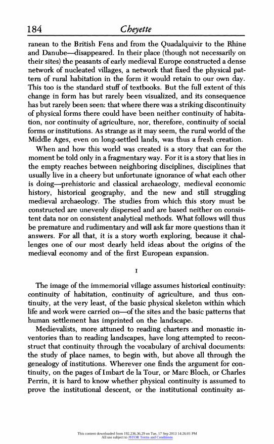
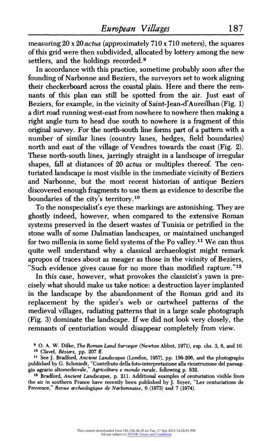
In accordance with this practice, sometime probably soon after the founding of Narbonne and Beziers, the surveyors set to work aligning their checkerboard across the coastal plain. Here and there the rem- nants of this plan can still be spotted from the air. Just east of Beziers, for example, in the vicinity of Saint-Jean-d'Aureilhan (Fig. 1) a dirt road running west-east from nowhere to nowhere then making a right angle turn to head due south to nowhere is a fragment of this original survey. For the north-south line forms part of a pattern with a number of similar lines (country lanes, hedges, field boundaries) north and east of the village of Vendres towards the coast (Fig. 2). These north-south lines, jarringly straight in a landscape of irregular shapes, fall at distances of 20 actus or multiples thereof. The cen- turiated landscape is most visible in the immediate vicinity of Beziers and Narbonne, but the most recent historian of antique Beziers discovered enough fragments to use them as evidence to describe the boundaries of the city's territory.10
To the nonspecialist's eye these markings are astonishing. They are ghostly indeed, however, when compared to the extensive Roman systems preserved in the desert wastes of Tunisia or petrified in the stone walls of some Dalmatian landscapes, or maintained unchanged for two millenia in some field systems of the Po valley.'1' We can thus quite well understand why a classical archaeologist might remark apropos of traces about as meager as those in the vicinity of Beziers, "Such evidence gives cause for no more than modified rapture. "12
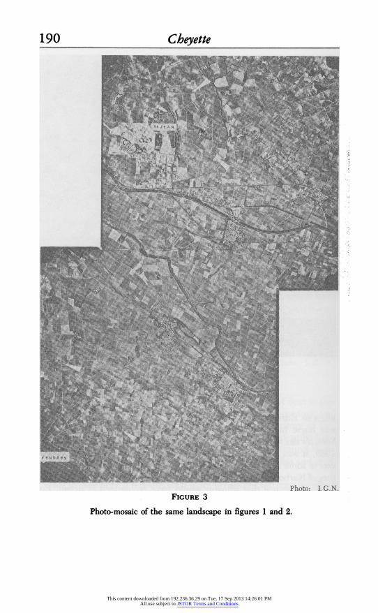
In this case, however, what provokes the classicist's yawn is pre- cisely what should make us take notice: a destruction layer implanted in the landscape by the abandonment of the Roman grid and its replacement by the spider's web or cartwheel patterns of the medieval villages, radiating patterns that in a large scale photograph (Fig. 3) dominate the landscape. If we did not look very closely, the remnants of centuriation would disappear completely from view.
9 0. A. W. Dilke, The Roman Land Surveyor (Newton Abbot, 1971), esp. chs. 3, 6, and 10. 10 Clavel, B&ziers, pp. 207 If. 11 See J. Bradford, Ancient Landscapes (London, 1957), pp. 156-206, and the photographs
published by G. Schmiedt, "Contributo della foto-interpretazione alla ricostruzione del paesag- gio agrario altomedievale," Agricoltura e mondo rurale, following p. 832.
12 Bradford, Ancient Landscapes, p. 211. Additional examples of centuriation visible from the air in southern France have recently been published by J. Soyer, "Les centuriations de Provence," Revue archeologique de Narbonnaise, 6 (1973) and 7 (1974).
This content downloaded from 192.236.36.29 on Tue, 17 Sep 2013 14:26:01 PMAll use subject to JSTOR Terms and Conditions
188 Cheyette
4
~~~~~~~~~
Photo: . G. N. FIGURE 1
SAINT-JEAN D'AUREILHAN
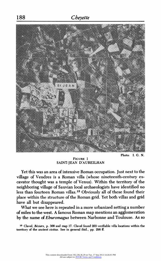
Yet this was an area of intensive Roman occupation. Just next to the village of Vendres is a Roman villa (whose nineteenth-century ex- cavator thought was a temple of Venus). Within the territory of the neighboring village of Sauvian local archaeologists have identified no less than fourteen Roman villas.13 Obviously all of these found their place within the structure of the Roman grid. Yet both villas and grid have all but disappeared.
What we see here is repeated in a more urbanized setting a number of miles to the west. A famous Roman map mentions an agglomeration by the name of Eburomagus between Narbonne and Toulouse. As so
13 Clavel, Beziers, p. 300 and map 17. Clavel found 203 verifiable villa locations within the territory of the ancient civitas. See in general ibid., pp. 296 ff.
This content downloaded from 192.236.36.29 on Tue, 17 Sep 2013 14:26:01 PMAll use subject to JSTOR Terms and Conditions
European Villages 189
i N 1 -4 A
1n
Photo: I. G. N. FIGURE 2
VENDRES
The arrows indicate traces of ancient centuriation.
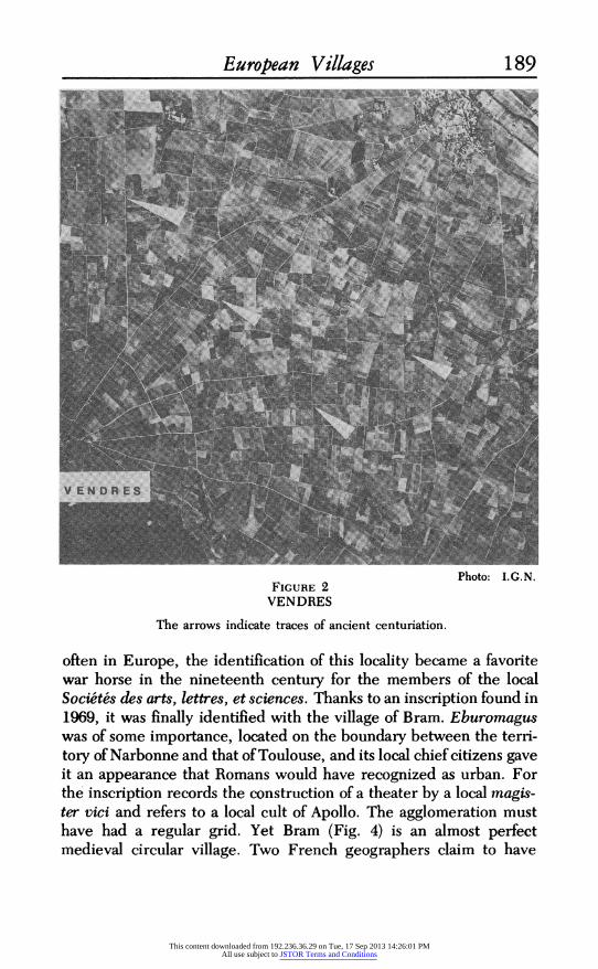
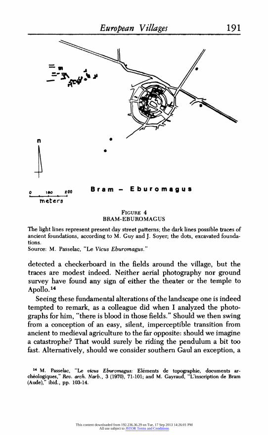
often in Europe, the identification of this locality became a favorite war horse in the nineteenth century for the members of the local Societes des arts, lettres, et sciences. Thanks to an inscription found in 1969, it was finally identified with the village of Bram. Eburomagus was of some importance, located on the boundary between the terri- tory of Narbonne and that of Toulouse, and its local chief citizens gave it an appearance that Romans would have recognized as urban. For the inscription records the construction of a theater by a local magis- ter vici and refers to a local cult of Apollo. The agglomeration must have had a regular grid. Yet Bram (Fig. 4) is an almost perfect medieval circular village. Two French geographers claim to have
This content downloaded from 192.236.36.29 on Tue, 17 Sep 2013 14:26:01 PMAll use subject to JSTOR Terms and Conditions
190 Cheyette
Photo: G. N. FIGURE 3
Photo-mosaic of the same landscape in figures 1 and 2.
This content downloaded from 192.236.36.29 on Tue, 17 Sep 2013 14:26:01 PMAll use subject to JSTOR Terms and Conditions
European Villages 191
n 0
0 to zoo Bram - E buromagus rmneters
FIGURE 4 BRAM-EBUROMAGUS
The light lines represent present day street patterns; the dark lines possible traces of ancient foundations, according to M. Guy and J. Soyer; the dots, excavated founda- tions. Source: M. Passelac, "Le Vicus Eburomagus."
detected a checkerboard in the fields around the village, but the traces are modest indeed. Neither aerial photography nor ground survey have found any sign of either the theater or the temple to Apollo. 14
Seeing these fundamental alterations of the landscape one is indeed tempted to remark, as a colleague did when I analyzed the photo- graphs for him, "there is blood in those fields." Should we then swing from a conception of an easy, silent, imperceptible transition from ancient to medieval agriculture to the far opposite: should we imagine a catastrophe? That would surely be riding the pendulum a bit too fast. Alternatively, should we consider southern Gaul an exception, a
14 M. Passelac, "Le vicus Eburomagus: El6ments de topographic, documents ar- cheologiques," Rev. arch. Narb., 3 (1970), 71-101; and M. Gayraud, "L'inscription de Bram (Aude)," ibid., pp. 103-14.
This content downloaded from 192.236.36.29 on Tue, 17 Sep 2013 14:26:01 PMAll use subject to JSTOR Terms and Conditions
192 Cheyette region of radical discontinuity on an otherwise gradually changing continent? This possibility, I believe, is no more tenable. For almost wherever one turns-northern Gaul, Britain, the Low Countries, the Rhineland, even Italy-a discontinuity is apparent. But it is a slow discontinuity, spread over centuries, flowing to a rhythm of repeated blows and partial recoveries, a long decline and profound transforma- tion.
III
Though a number of archaeologists and historical geographers have looked (some with more hope than prudence), no secure evidence has been found for centuriation beyond the edges of the Mediterra- nean.15 We therefore lack in the north that precious hard bedrock of visible but ghostly remains and are reduced to the more aleatory evidence of archaeology and to speculations based on place name evidence. Such archaeological evidence is by nature unsystematic, and the examples are too few and scattered to allow statistical manipu- lation. It is, however, suggestive.
Most similar to the evidence from southern Gaul are the photo- graphs of buried Roman villas on the plains of Picardy which Roger Agache, a French archaeologist, has made by the hundreds.'6 The very location of these villas-in the open fields-is a demonstration of
15 Dilke, Roman Surveyor, pp. 149-50, presents the evidence for non-Mediterranean Europe and in ch. 13 for Britain. But see the criticism by G. D. E. Jones in Brstannia, 3 (1972), pp. 373-74, and the remarks of Bradford concerning alleged centuriation in Germany and Switzer- land: ". . . the evidence is, at present, insufficient in its existing form" (Ancient Landscapes, p. 216). John Wacher is equally negative in The Towns of Roman Britain ([Berkeley and Los Angeles, 1974], p. 41), though there are intriguing patterns near Gloucester and fields laid out per strigas in the Vale of York (ibid., pp. 152, 176). Traces of centuriation have been claimed by R. Fossier for the vicinity of Amiens (La terre et les hommes en Picardie, I [Paris and Louvain, 1968] pp. 138 ff.), but they are limited to a few squares, and are not entirely convincing. (The author himself advances his case largely in the conditional mode.) Even less convincing are the claims of K. Filipp for the remnant of a Roman centuria in the hamlet of Goldburghausen (Ries) ("Hausformengeffige und Dorfentwicklung im Ries," Berichte zur deutschen Landeskunde, 44 [1970], 115-17). A single square, about 700 m. on a side, might surely come into existence in a landscape in a number of ways. It is the repeated pattern, and the identity of orientation over an extensive area, that make the hypothesis of centuriation plausible. There is, of course, no reason a priori to doubt that the Romans centuriated the lands they conquered in northern Europe. Quite the contrary; there is every reason to assume that they did. Some day, perhaps, convincing evidence will be discovered. Some Roman fields in the vicinity of Mayen, their date verified by excavation, showed no sign of centuriation; see K. A. Seel, "Romerzeitliche Fluren im Mayener Stadtwald," Bonner JahrbUicher, 163 (1963), 337.
18 R. Agache, Vues aeriennes de la Somme et recherche du passe, Bulletin de la Societe de prehistoire du Nord, spec. no., 5 (Amiens, 1962); Arch6ologie adrienne de la Somme; Recherches nouvelles, 1963-1964, Bull. Soc. prehist. Nord, spec. no., 6 (Amiens, 1964); Detection adrienne de vestiges protohistoriques, gallo-romains et medievaux dans le bassin de la Somme et ses abords, Bull. Soc. pr6hist. Nord, spec. no., 7 (Amiens, 1970).
This content downloaded from 192.236.36.29 on Tue, 17 Sep 2013 14:26:01 PMAll use subject to JSTOR Terms and Conditions

European Villages 193 their abandonment and probable disappearance before the fields were again put to the plow. A few cases show unmistakable discon- tinuity with village field patterns, as at Essertaux (Fig. 5) or even more strikingly at Estrees-sur-Noye where woods regrew over the site and were subsequently recleared (Fig. 6). Here, of course, we are seeing not regional patterns, as in the south, but individual sites. And discontinuity in one place does not prove discontinuity in another. Along the old Roman road from Beauvais to Amiens, in the vicinity of Essertaux, the reconstruction of four villages after the Second World War revealed no trace of ancient occupation despite both a careful search for such traces by the engineer in charge and the density of known villas in the area.17 But it is still possible that, elsewhere, Roman villas may nevertheless lie buried underneath and continuous with some medieval villages.
In the absence of archaeological excavations that will probably never be made, how might we test this possibility? For archaeological evidence we are thrown back upon datable destruction layers and the more ambiguous evidence of settlement and cemetery distribution patterns. All of this evidence, of course, suffers from the same defects: it is scattered; it is of individual sites; and, even collected together, it is an argument from silence-for who knows what might be buried at sites not dug and in regions still unsurveyed? Yet there can be no doubt about the ravages of wars and invasions, of famines and pestilence in the last centuries of the Empire.
Time and again nearly the same dates appear, whether of breaks in the sequences of pottery or coins or clearly defined destruction layers: c. 270/275 at Tours, 260 at Augusta Raurica near Basle, 275/276 at Alesia in Burgundy. The market basilica begun at Lopodunum on the Rhine in the third century was never finished. In Alsace there are important destruction layers datable to 235, 244, and 250. In Pro- vence, prehistoric grottoes were reoccupied in the same century.-18
17 Essertaux: P. Dufournet, "L'action des contraintes agraires collectives sur la formation du paysage en Ami6nois," Actes du 92e congress national des societes savantes, Strasbourg, 1967 [hereafter Actes . . . cong. soc. sav.], Sect. d'archeologie (Paris, 1970), pp. 123-61. Estr6es- sur-Noye: R. Agache, Detection a6rienne des vestiges archgologiques [slides and explanatory folder] (Paris, n. d.), slide 18.
"I Tours: J. Boussard, "Essai sur le peuplement de la Touraine du ler au VIIIe siecle," Le Moyen Age, 60 (1954), 273. Augusta Raurica: M. Martin, "Das Fortleben der spatromischen- romanischen Bevolkerung von Kaiseraugst und Umgebung im Fruhmittelalter," Provincialia: Festschriftffur Rudolf Laur-Belart (Basel, 1968), pp. 133-50. Alesia: G. Gremaud, "L'abandon des etablissements et des habitats gallo-romains en Cbte-d'Or," Actes 90e cong. soc. sav., Nice, 1965, Sect. d'arch. (Paris, 1966) p. 111. Lopodunum: W. Schleiermacher, "Die spatesten Spuren der antiken Besiedlung im Raum von Speyer, Worms, Mainz, Frankfurt, und Ladenburg," Bonner Jahrbucher, 162 (1962), 165-73. Alsace: J. J. Hatt, "Les enseignements historiques de
This content downloaded from 192.236.36.29 on Tue, 17 Sep 2013 14:26:01 PMAll use subject to JSTOR Terms and Conditions

194 Cheyette
@ < / De~~~~ondqrjts \
Vi 11CL M;L0 \ vs
Fo n J tions \
FIGURE 5 ESSERTAUX
The buried foundations of a Roman villa were revealed by aerial photography. Source: R. Agache in P. Dufournet, "L'action des contraintes agraires."
Identical coincidence is reported at the end of the fourth and early fifth century. The chronology of cemeteries in the Ardennes shows a sharp break in the fifth century, even though 60 percent of Merovin- gian cemeteries are on sites occupied by Gallo-Romans. East of the Rhine, and across the channel in Britain, the desertion this time was permanent. "Apart from the Mainz bridgehead," remarks one ar- chaeologist, "the only continuity [east of the Rhine] was a continuity of ruins." In Britain, Verulamium may have survived to beyond 450 A. D. At Cirencester large crowds were using the forum until 430; but these were among the last, and epidemic, famine, and the Saxons brought an end soon after. If towns were deserted, did isolated villas survive? Even in Languedoc traces of occupation stop abruptly in the fifth century. A Gallo-Roman villa recently excavated north of Beziers showed an impoverished second and third century followed by a
vingt ann6es de fouille en Alsace et Moselle, 1946-66," Actes 92e cong. soc. sav., Sect. d'arch., pp. 21-30. Provence: R. Boyer, "Les habitats de plaine en Provence a la fin de 1'Antiquit6," ibid., pp. 201-20. The list could be exhaustively-and exhaustingly-extended.
This content downloaded from 192.236.36.29 on Tue, 17 Sep 2013 14:26:01 PMAll use subject to JSTOR Terms and Conditions

European Villages 195
>w~~~~~~~~~~~~~~~~~~~~~~~~~~~~~~~~2;~~~~~~~~~~~~~~~~~~~~~~~~~~~~~~~. ~ ~ ~ ~ ~ ~ ~ " .
";A~~~~~~~~~~~~~~~~~~~~~~~~~~~~~
Photo: Roger Agache FIGURE 6
ESTREIES-SUR-NOYE
flourishing fourth and a sudden end at the beginning of the fifth. Excavations in a village courtyard at Bram (the Roman Eburomagus) gave pottery only from the first century B.C. to fourth century A.D. Far to the north and east, even in the area between the Ems and Saale rivers, beyond the Roman limes, where Iron Age settlement was "astonishingly dense," a large number of sites were abandoned in the fourth to fifth centuries and light woods took over land to which man had long since laid claim. Only in central Italy is there ar- chaeological evidence for continuing rural habitation on ancient sites into the sixth century, but then there too comes a break. 19
19 Ardennes: P. Perin, "Le peuplement rural de la region ardennaise," Actes 95e cong. soc. sav., Rheims, 1970, Sect. d'arch. (Paris, 1974), pp. 347-65. East of the Rhine: Schleiermacher, "Spateste Spuren" and W. A. Boelcke, "Zur Problematik der fruhen alemannischen Land- nahme im deutschen Sudwesten," in Wirtschaftliche und soziale Strukturen im saekularen Wandel: Festschriftffur W. Abel, I (Hannover, 1974), p. 25. Britain: J. Wacher, Towns of Roman Britain, pp. 411-422; A. L. F. Rivet, The Roman Villa in Britain (New York, 1969), pp. 214-15, 221-37. Languedoc: J. P. Bacon, "La villa gallo-romain de Condoumine 'a Puissalicon," Rev. arch. Narb., 4 (1971), 93-132; Passelac, "Vicus Eburomagus," p. 89. On the archeological evidence of the Visigothic invasions in this area, Clavel (alas) says only, "Des destructions dont ils sont cause t6moignent les couches de cendres parfois importantes, contemporaines, sur bien des sites du Biterrois, de leur installation," without giving either numbers or archeological references (Beziers, p. 176). Given the uncertain dating of medieval pottery until quite recently, one hardly knows how much weight to give her signalling of "Visigothic sherds" found on Roman villa sites (ibid., p. 298, map 16). Central Germany: H.-J. Nitz, "Langstreifenfluren
This content downloaded from 192.236.36.29 on Tue, 17 Sep 2013 14:26:01 PMAll use subject to JSTOR Terms and Conditions
196 Cheyette
Against this coincidence of dates for destruction and desertion there is only the evidence drawn from toponymy, a favorite of both French and German historians. When towns, farms, or fields bore names in the Middle Ages that can be derived philologically from Roman or pre-Roman personal names or nouns, these places (so it is argued) must have been continuously settled to have preserved those names.20 But does a Roman name mean a pre-fifth-century settle- ment? Recently, Michel Roblin has cast this assumption in doubt, asserting that Gallic names could have been used until the fourth century A.D., Roman names until the seventh, and Frankish names until the thirteenth. Several German scholars comparing ar- chaeological finds to place names and parish names have concluded that, given a large enough number of examples, there is general consistency among the data as far as relative chronology is concerned, but no possibility of arguing in individual cases that a place name is a piece of datable evidence. And even were toponymy a sure guide to dating it would be no proof of continuity. The demonstration again comes from Languedoc where 41 percent of place names in one de6partement and 56 percent in another are Gallo-Roman or earlier.22
zwischen Ems und Saale: Wege und Ergebnisse ihrer Erforschung in den letzten drei Jahrzehnten," Siedlungs- und Agrargeographische Forschungen in Europa und Afrika, Braunschweiger Geographischer Studien, 3 (Wiesbaden, 1972), pp. 16-17; and, above all, the recent survey of the archaeological material by H. Jankuhn, "Rodung und Wustung in vor- und fruhgeschichtlicher Zeit," in Die deutsche Ostsiedlung, pp. 111-28. Central Italy: A. Kahane, L. Murray Threipland, and J. Ward-Perkins, "The Ager Veientanus, North and East of Rome," Papers of the British School at Rome, 36 (1968), 161 ff.; and T. W. Potter, "Ricenti ricerche in Etruria meridionale," Archeologia medievale, 2 (1975), 224 ff.
The literature on late antique and early medieval habitation distribution is not always easy to use for this purpose, as many studies, especially those of cemetery distribution, are concerned primarily or exclusively with the geography of settlement rather than with establishing con- tinuity or discontinuity in its chronology. The examples are too numerous to mention. One is thus left puzzling whether a shift in location or a significant reduction in area signifies a major chronological discontinuity. Yet other studies view the problem of continuity as primarily anthropological or cultural, for the evidence that cemeteries provide consists, of course, in skeletons and cultural artifacts. See, for example, R. Straub, "Zur Kontinuitat der voralemannis- chen Bevolkerung," rpt. in W. Muller, ed., Zur Geschichte der Alemannen, (Darmstadt, 1975), pp. 49-66. And finally, most of the archeological evidence comes from the excavation of cemeteries rather than of settlements, thus adding a host of problems stemming from the relationships between settlements and cemeteries, the social structure of burials, the possible gaps in our knowledge of the distribution of cemeteries, and the special problems of dating cemetery finds. On these methodological issues, see Jankuhn, "Rodung und Wustung," pp. 81-88.
20 So powerful does this argument appear to some scholars that even where the archaeologi- cal evidence overwhelmingly indicates a discontinuity of settlement, the toponymic evidence is accepted as proving the contrary. For example, Perin, "Peuplement rural de la region arden- naise.
21 M. Roblin, Le terror de Paris aux 6poques gallo-romaine etfranque (2nd ed.; Paris, 1971), pp. 23, 89-91.
22 J. Lemoine, Toponymie du Languedoc et de la Gascogne (Paris, 1975), pp. 214-15, 219.
This content downloaded from 192.236.36.29 on Tue, 17 Sep 2013 14:26:01 PMAll use subject to JSTOR Terms and Conditions
European Villages 197 Yet this is precisely where we have seen such a graphic demonstration of discontinuity. "Toponymy is no substitute for archaeology," re- marked one historical geographer.23 I think we can all agree.
Much of the rural world, it would seem, was successively aban- doned or, more precisely, slowly emptied of its population: here more rapidly, there more slowly, each region following a rhythm deter- mined by its soil, its climate, the routes of invaders, and the vectors of bacteria. Only in the Po valley, where cities were closely packed and agriculture depended on the maintenance of drainage and irrigation ditches, was there perhaps an extensive continuity of rural life be- tween the late Empire and the early Middle Ages, a continuity for which the survival of centuriation provides the most striking evi- dence. In other localities, where the Romans had moved into building sites that had been occupied continuously since the Hallstatt or La Tene cultures, it was indeed a major break.24
Such was the visible consequence of the population decline with which the ancient world came to an end.25
I emphasize that this was a thinning of the rural world, for in large numbers the urban sites and settlements in their immediate vicinity remained alive. So too did trading and artisanal settlements along major Roman thoroughfares.26 So too did the major roads that joined these settlements. The towns on the northern and eastern fringes of the Empire disappeared. Elsewhere some were destroyed, aban- doned, reoccupied and rebuilt, but these were exceptional.27 Though
2 H. J. Nitz, "Langstreifenfluren," p. 22. For comparisons of various types of evidence for dating settlement in a region see J. C. Tesdorpf, Die Entstehung der Kulturlandschaft am westlichen Bodensee, Veroff. d. Kommission fMr geschichtliche Landeskunde im Baden- Wurttemburg, Reihe B, 72 (Stuttgart, 1972), pp. 208 ff.; and K. Bohner, "Das Trierer Land zur Merowingerzeit nach dem Zeugnis der Bodenfunde," in R. Laufner, ed., Geschwhte des Trierer Landes, I, Schriftenreihe zur Trierischen Landesgeschichte und Volkskunde, 10 (Trier, 1964), pp. 329 ff.
U Boyer, "Habitats de plaine en Provence"; Hatt, "Fouilles en Alsace"; Seel, "Romerzeit- liche Fluren."
25 See, in general, J. C. Russell, Late Ancient and Medieval Population, Transactions of the American Philosophical Society, n.s. 48, pt. 3 (Philadelphia, 1958), pp. 71-99, whose emphasis on disease- especially the plague-has been supported by Wacher, Towns of Roman Britain, pp. 414 ff.
26 For a detailed regional study, with an attempt at precise chronology and a critical review of dating techniques, see Roblin, Terroir de Paris.
27 An inventory for present-day Belgium is given in A. Wankenne, La Belgique a l'epoque romaine: sites urbains, villageois, religieux et military, Centre national de recherches ar- cheologiques en Belgique, ser. C, 3 (Brussels, 1972). For Britain, see Wacher, Towns of Roman Britain. For the Rhine-Danube frontier, see E. Ennen, "Die Entwicklung des Stiidtewesens am Rhein und Mosel vom 6. bis 9. Jahrhundert," La citta nell'Alto Medioevo, SSCISAM, VI (Spoleto, 1959), pp. 419-52; and H. von Petrikovitz, "Das Fortleben romischer Stiidte am Rhein und Donau im friuhen Mittelalter," Trierer Zeitschrift, 19 (1950), 72-81.
This content downloaded from 192.236.36.29 on Tue, 17 Sep 2013 14:26:01 PMAll use subject to JSTOR Terms and Conditions

198 Cheyette
the centuriation of Languedoc was wasted, Narbonne retained its Roman insulae. Far away on the Rhine frontier, Trier continued to be supplied from country villas in its neighborhood in the wide valleys of the Moselle and Saar. In the Gallic heartland Soissons became a residence and military headquarters of the Merovingian king Chlodoweg. Its public buildings-like those of other Merovingian residences-continued in use.28
These cities, to be sure, were no longer what they once had been. Cramped within their late Imperial walls, their great public build- ings, private villas and even cemeteries quarried for stone, their visage would have shocked a Roman of the second century. But priests were there, as they had always been. So were potters, glassmakers,29 merchants, and aristocrats. Sub-Roman or pre- medieval, the cities and their filaments of roads survived.
Out beyond the fringes of these old urban centers and the networks of highways that joined them, when did the new pattern of village networks implant itself in the landscape? To this we can now turn.
IV
Languedocian villages were predominantly walled villages. Here and there one can still spot a gate or tower or fragment of defensive wall absorbed into a village house. In the thirteenth century the quality these fortifications gave to the landscape must have been striking, for the northern crusaders who followed Simon of Montfort from the Rhone to Beziers, Carcassonne, and the strongholds of the heretics, unfailingly referred to them as castra, castles. An analysis of the field and road patterns of these villages leads to the conclusion that in most cases the walls must have been part of the original plantation: that they either predate or-more likely-are contempo- rary with the laying out of the first fields around the villages.30
28 Trier: K. Bohner, "Die Frage der Kontinuitit zwischen Altertum und Mittelalter im Spiegel der frankischen Funde des Rheinlandes," Trierer Zeitschrift, 19 (1950), 85ff.; K. Bohner, "Das Trierer Land zur Merowingerzeit"; E. Ewig, Trier im Merowingerreich (Trier, 1954), pp. 76-79. Soissons: R. Kaiser, Untersuchungen zur Geschichte der Civitas und Diozese Soissons in romischer und merouingischer Zeit, Rheinisches Archiv, 89 (Bonn, 1973), pp. 168 ff. Some other recent studies of early cityscapes are D. Claude, Topographie und Verfassung der Stadte Bourges und Poitiers bis in das 11. Jahrhundert (Lubeck, 1960); P. Leman, "De la voirie romaine a la voirie m6di6val: l'exemple de Beauvais," Actes 95e cong. soc. sav., Sect. d'arch., pp 145-53; M. Martin, "Kaiseraugst"; P. J. Tholen, "Iuliacum-Julich," Bonner Jahrbucher, 175 (1975), 231-55; P.-A. F6vrier, Le d&veloppement urbain en- Provence (Paris, 1964), ch. 3; and the articles by P. Vaccari, G. Duby, J. M. Lacarra, F. Vercauteren, and J. Hubert, in La citti nell'Alto Medioevo, SSCISAM, VI.
29 Petrikovitz, "Fortleben romischer Stidte,"? Bohner, "Die Frage der Kontinuitit." 30 The argument and techniques for analyzing the landscape are presented in my "The
This content downloaded from 192.236.36.29 on Tue, 17 Sep 2013 14:26:01 PMAll use subject to JSTOR Terms and Conditions

European Villages 199 Archaeological evidence for the date of construction of these fortifi-
cations is, once again, nonexistent. We do, however, have substantial written evidence that provides a terminus ad quem. From the mid- tenth century on, charters of this area refer to village walls, towers, and moats. "We give you," says one of 957, "the vineyard called Rodunda within the walls of Colombiers." "I give the church of St. Bauzille," says another of 969, "with half its tower and its hillock, its cella and its cemetary, its lands and vines. "31
The dates of these first mentions are striking. East of the Rhone, in Dauphine, the first mentions of such castle-villages are from just before the year 1000. In Provence, likewise, the word castrum entered the vocabulary of scribes in the eleventh century and by the twelfth had replaced the term villa for many of those agglomerations that correspond to present day villages. But perhaps most surpris- ingly, the appearance of these first mentions of village walls in Lan- guedoc corresponds exactly to the dates of the earliest contracts for the development of fortified habitations in the Sabine district of the Roman countryside.32 Looking at the way field tracks of Languedo- cian villages take their starting points at the gates of village walls, one can almost imagine that these too were originally settled by some seigneurial land developer, such as that "most high Demitrius, consul and duke," to whom in 946 the bishop of Velletri gave "a hill in its entirety on which at his own expense he is to build a castle and assemble a populace and outside the castle in the empty lands plant vines and fruit trees. . . and bring all into cultivation."33
Should we conclude from this coincidence that the tenth century witnessed the regrouping of population in nucleated and fortified settlements? That, at least around the Mediterranean, peasant families were moved at this time, by force or by inducement, to
Castles of the Trencavels: A preliminary Aerial Survey," in W. C. Jordan et al, eds., Order and Innovation in the Middle Ages (Princeton, 1976), pp. 256-63.
31 J. Rouquette, ed., Cartulaire de Beziers (livre nor), (Montpellier-Paris, 1918), nos. 25, 31. For other tenth-century charters mentioning village fortifications in Languedoc see: ibid., no. 39 (977); P. Alaus, Cassan, and E. Meynial, eds., Cartulaire de Gellone (Montpellier, 1898), nos. 279, 281 (954-986); Cassan and Meynial, eds., Cartulaire d'Aniane (Montpellier, 1900), nos. 314 (978), 292 (990); 0. Terrin, Cartulae du Chapitre dAgde (Nimes, 1969), no. 320 (956), 315 (973); Histoire g6ne6rale de Languedoc (Toulouse, 1872-92), V, col. 269 (972), col. 316 (990); Bibliotheque national, ms. Doat 55, fol. 69 (957), ms. Baluze 81, fol. 393 (987-996).
32 p. Toubert, Les structures du Latium medieval (Rome, 1973), chap. 4; J. de Font-Reaulx, "L'origine des villages dans le sud-est," Actes 90e cong. soc. sav., Sect. d'arch., pp. 237-43; E. Baratier, "Les communaut6s de Haute Provence au Moyen Age: Problemes d'habitat et de population," Provence historique, 22 (1971), pp. 237-39.
33 E. Stevenson, "Documenti dell'Archivio della Cattedrale di Velletri," Archivio della Society Romana di Storia Patria, XII (1889), pp. 73-79 [much abbreviated]. For a discussion of this and other similar tenth century charters, see Toubert, Latium, pp. 322-23.
This content downloaded from 192.236.36.29 on Tue, 17 Sep 2013 14:26:01 PMAll use subject to JSTOR Terms and Conditions

200 Cheyette
abandon a predominantly dispersed form of habitation and resettle behind village walls? It is very tempting, and a number of scholars have given way to this temptation, but it seems to me that caution is called for.34
First and foremost, we would be arguing ex silentio; and that invariably dangerous argument is extremely so when the silent cen- turies (the eighth and ninth) are the definition-by-example of histori- cal obscurity. The lack of earlier written evidence could be caused by nothing more than the paucity of private charters. In addition, their mention beginning around the mid-tenth century could be a con- sequence of a political move by higher authorities to organize the lands under their dominion. Such an organizational drive is already evident in the testaments of the counts of Carcassonne in the late tenth century.35 The family's long series of oaths of security through which they claimed control over their widespread collection of strategic castles begins at the dawn of the eleventh century.36 And one of the tenth-century Italian charters of castle foundation states specifically that the developer "will make war and peace at the command of the Pope and of the abbot" who granted the land.37
But the strongest argument against such a sudden rearrangement of human settlement is the evidence of the countryside itself. The basic building blocks of that countryside before the advent of modern roads were the village territories, most of them structured on a radiating system of field roads, strung out along the major waterways and long distance highways.38 On what frame was the dispersed habitation hung that preceded the villages? The remnants of Roman centuria- tion? Then why would it have so nearly disappeared? On some other system that has left no identifiable trace? Unlikely in the light of the permanence of the village patterns during a millenium that has in- cluded late medieval desertions, reconstruction in the sixteenth and seventeenth centuries, and reapportionment in the twentieth. The structure of the Languedocian countryside seems rather to argue for a
" This is assumed by Toubert, Font-Reaulx, and Baratier (see n. 32), as well as by J. Ward-Perkins, et al, "The Ager Veientanus," pp. 161-65.
3 Hist. Gen. Languedoc, V, col. 316 (990); ibid., col. 344 (c. 1002). It appears, likewise, in the divisions between members of the family: ibid., cols. 405, 408, 409 (c. 1034).
38 SociWte arch6ologique de Montpellier, ms. 11, Cartulaire dit "de Foix." Some of the same oaths are printed in Hist. Gen. Lauguedoc, V.
37 R. Morghen, et al., Statuti deUa Provinda Romana, Istituto Storico Italiano, Fonti per la storia d'Italia, 69 (Rome, 1930), p. 7.
3' For one regional example of village distribution, see my map in "Castles of the Tren- cavels," pp. 264-65.
This content downloaded from 192.236.36.29 on Tue, 17 Sep 2013 14:26:01 PMAll use subject to JSTOR Terms and Conditions

European Villages 201
largely empty or thinly settled landscape, one whose fundamental structures-apart from the Roman and pre-Roman tracks and roads that had never gone out of use-were extremely rudimentary, so that the new village-based structures could be drawn practically on a clean slate.
The process of reopening the countryside to agriculture-or open- ing it for the first time-of moving out from the old urban centers, the crossroad markets, and major river crossings with their crown of fields-in a word, of colonizing, was in fact a long one, continuing in the west to the fourteenth century, resuming in the east and across the Western Sea in the sixteenth. But the new pattern that would dominate this era of colonization, as the urban colony and its penumbra of dispersed villas and farmsteads had dominated the era of Roman expansion, the new pattern of nucleated villages with their organized fields was already in place well before those real estate contracts were signed, well before the first mention of walls, towers, and moats. The pattern predates the first written testimony to for- tified villages by at least a century, and probably more.
Archaeological evidence, as we may by now expect, is insufficient on this point to carry any argument.39 But documentary evidence, though scarce, is remarkably consistent. Once again we encounter in widely dispersed areas a set of roughly concordant blocks of years, in this case, years before which the rural parishes of Europe were founded. In northern Catalunya most of the villages in the upper valley of the Segre river and its tributaries already figure as parishes in the dedication charter of the cathedral of Urgel in 839. In the Auvergne region of France, most rural churches had already been built by the end of the ninth century and acquired their autonomy as parishes in the course of the tenth. Farther to the north in the area around Bourges, most of the parishes that existed on the eve of the French Revolution were the creation of the period from the seventh to the tenth centuries, forming the only geographical structures to survive the profound political and social transformations of the eleventh. Even farther to the north around Amiens, where the epis- copal see began during the late sixth century, the essential task of christianization and of founding rural parishes was accomplished in
"There are, nevertheless, at least three deserted medieval villages whose origins have been dated to the eighth century; see P. Grimm, Hohenrode, Veroffentlichungen der Landesanstalt fur Volkheitskunde zu Halle, 11 (Halle, 1939); T. Potter, "Excavations in Mazzano Romano," Papers Brit. School Rome, 40 (1972), 135-45; A. Schifer, "Die Wustung Zimmern auf Gemar- kung Stebbach," Oberrheinische Studien, 1 (1970), 357-74.
This content downloaded from 192.236.36.29 on Tue, 17 Sep 2013 14:26:01 PMAll use subject to JSTOR Terms and Conditions

202 Cheyette
the eighth. East of the Rhine, in Franconia and elsewhere, the time of foundation of the first permanent settlements is once again placed between the seventh and ninth centuries. Even in England, in Wes- sex, the creation of parishes predates the construction of Saxon earth- works called Wensdyke and Grim's Ditch, and in Hampshire 40 percent of pagan Saxon burial sites are on or near parish boundaries, suggesting that those boundaries were created early in the Saxon period.40 These parishes, with their cemeteries, their parish dues, their tithes, and their boundaries, presuppose a structured territory. Their almost universal correspondence with the boundaries of pres- ent day communes in France implies strongly that their foundations were contemporary with the founding of the villages they serve, or that the villages were already there.
In some areas, of course, and not just in the forests east of the Rhine, large areas remained to be conquered during the continued expansion of the eleventh through thirteenth centuries: Gascony, for example, and the plain of Catalunya, as well as the interstices of waste within the already settled village networks. But in many regions the basic framework of population was already solidly implanted by the tenth century. In Picardy, only 250 villages out of more than 2000 were founded in the Middle Ages after the tenth century, only 250 farms or hamlets out of 1500; since the Middle Ages, a scant 14 villages. We can surely conclude with Robert Fossier, the historian of Picardy, that before 1000 "a decisive step had been taken. "41
V
The prerequisite for this new rural pattern was assuredly a signifi- cant growth in population, one that began centuries before it is com- monly assumed, and for which some scattered evidence is beginning to appear.42 The apparent packing of population in the ninth century
40 Catalunya: P. Bonnassie, La Catalogne du milieu du Xe a la fin du XIe siecle (Toulouse, 1975), I, pp. 86 ff. Auvergne: G. Fournier, "Rural Churches and Rural Communities in Early Medieval Auvergne," in Fredric Cheyette, ed., Lordship and Community in Medieval Europe (New York, 1968), pp. 315-40. Bourges area: G. Devailly, Le Berry du Xe siecle au milieu du XIIIe (Paris, 1973), pp. 91, 108. Amiens region: Fossier, Picardie, I, pp. 167-74. East of the Rhine: M. Born, Die Entwicklung der deutschen Agrarlandschaft (Darmstadt, 1974), pp. 129-33; Nitz, "Langstreifenfluren"; H. Danuheimer, "Im Spiegel der Funde," in W. Buhl, ed., Karolingishes Franken (Wurzburg, 1973), p. 98. England: D. Bonney, "Early Boundaries in Wessex," in P. J. Fowler, ed., Archaeology and the Landscape (London, 1972), pp. 168-86.
41 Fossier, Picardie, I, p. 163. 42 The information provided by H. Stoll, ("Bevolkerungszahlen aus friihgeschichtlicher
Zeit," Die Welt als Geschichte, 8/9 [1942-43], 69-74), is commented on by Boelcke ("Prob-
This content downloaded from 192.236.36.29 on Tue, 17 Sep 2013 14:26:01 PMAll use subject to JSTOR Terms and Conditions

European Villages 203
in regions as different and as far from each other as the central Pyrenees and the Ile-de-France, long rather hard to believe, begins at last to seem reasonable.43
But why did this new pattern take the form it did? And did that form have anything to do with the great expansion of European population and the economy between the tenth and the fourteenth century? It is probably foolhardy to even pose such questions when the phenomena to be explained are in many ways still so impenetra- ble. At the end of this flight across the European countryside, how- ever, I hope I may be pardoned for a moment's fancy.
One might answer by turning the first of these questions on its head and asking, "Why not?" The Roman experience, it could be argued, was a great exception drawn across the natural development of village agriculture that had pre-existed Rome and regained primacy after Rome's fall. The dispersed centuriated landscape of the empire, dependent on the social organization of the city, on the military power of the empire, and on the economic infrastructure of the Mediterranean world, was an overlay that disappeared when they disappeared.44 The millenial reach of this argument is almost enough to make it appealing, until one realizes that what happened between the fifth and the tenth centuries was not a resumption of what had preceded, though prehistoric caves and oppida were momentarily reoccupied in times of crisis. Not only did peasants and lords move to sites never before occupied. The density of the new network was unlike anything Europe had seen before. By 1300, within 500 years, it had made possible an expansion of European population to densities that would not be exceeded in some rural areas until the eighteenth century. It seems, therefore, not to be a return to something already millenially old but something new.
To what new phenomenon in European society might we point? First, I would suggest, to the parish that provides our earliest evi- dence. Were populations gathered for evangelization? More plausi-
lematik d. alemannischen Landnahme," pp. 25 ff.). His comments would also apply to the fig- ures presented in Tesdorpf, Entstehung der Kulturlandschaft, p. 96.
43 See the figures in Bonnassie, Catalogne (I, pp. 89-90), and the arguments presented in Georges Duby, L'Vconomie rurale et la vie des campagnes dans l'Occident m6di6val ([Paris, 1962], pp. 65-71), repeated more forcefully in his recent Guerriers et Paysans ([Paris, 1973], pp. 92-97). The Parisian data are commented upon by Emily Coleman in "L'infanticide dans le Haut Moyen Age" (Annales: Economies, Societ6s, Civilisations, 29 [1974], pp. 315-35), and in her as yet unpublished "People and Property: The Rational Structure of a Medieval Manor."
" This was, in effect, the argument made by Duby in his comments at the Spoleto confer- ence, 1965, Agricoltura e mondo rurale, SSCISAM, XIII, p. 234-36.
This content downloaded from 192.236.36.29 on Tue, 17 Sep 2013 14:26:01 PMAll use subject to JSTOR Terms and Conditions
204 Cheyette ,~~~~~~
bly, did they gather not just for the protection of numbers but also for the magical protection of the saints and of consecrated land? The urban fabric of some major cities was altered in this way.45 It is surely not far-fetched to imagine it occurring in the countryside as well.
Second, we might imagine early monastic and seigneurial entre- preneurs settling populations in this manner for ease of organization and exploitation. Long a favorite argument of German historical geog- raphers, this hypothesis runs into at least one serious difficulty: the development of a numerous seigneurial class to undertake such land development seems to occur after the -village network was already in place. In some places, however, the earliest settlement may very well have been the work of great Carolingian aristocrats who (as Georges Duby has recently suggested), forced onto the defensive by the renewed pressure of the peoples beyond the frontier, now turned to the exploitation of inner resources rather than the booty of summer campaigns.'"
Third, we might imagine peasant communities sending forth col- onies of surplus population into the nearby waste, moving them as hamlets or villages because the tasks of clearing and building were more easily done by teams than by small family groups. Or the colonists may have been large clans, a familial hamlet. For such colonization there is also some sparse geographical and documentary evidence.47
It may be that the form is simply the direct consequence of popula- tion growth. In between the fifth century and the beginnings of settled village life the countryside was not completely deserted-far from it. Here the survival of place names is our best evidence, for that survival could only have occurred in human memories. Though the settlements they once named might have disappeared, the names of places in the landscape were still remembered. Such sparse ar- chaeological evidence as there is, principally from the Frankish north and the Alemannic east, suggests settlement in minuscule unstruc- tured hamlets that lasted for a century or so and were then abandoned for reasons that for the moment are unexplained.48 It may be this
4 J. Hubert, "Evolution de la topographic et de l'aspect des villes de Gaule de Ve au Xe siecle," La Citta neltalto medioevo, SSCISAM, VI, pp. 529-58.
46 See Gueriers et Paysans, parts I, II. 47 Bonnassie, Catalogne, I, pp. 99 ff.; Schifer, "Wustung Zimmern"; B. Cunliffe, "Saxon and
Medieval Settlement Pattern in the Region of Chalton, Hampshire," Medieval Archeology, 16 (1972), 1-12.
" Cunliffe, "Saxon and Medieval Settlement"; Boelcke, "Problematik d. alemannischen Landnahme," pp. 38 ff.; Dannheimer, "Im Spiegel der Funde," p. 90; Tesdorpf, Entstehung
This content downloaded from 192.236.36.29 on Tue, 17 Sep 2013 14:26:01 PMAll use subject to JSTOR Terms and Conditions
European Villages 205 mobility of early medieval settlement that makes it so much more difficult to identify early medieval place names than those after the year 900 or 1000. As population increased there would have been no place left to wander in the old settled areas and a shift would have been required to more intensive forms of agriculture and more for- mally organized village territories.
However we explain its origins, the creation of the European peasant village with its framework of tracks and fields, its organized communal life, and its increasingly intensive agriculture must be considered in some way a cause of the expansion that followed. Did this new social form lift a ceiling that the burdens of the Roman state and urban life had clamped on population for over half a millenium? Did the possibilities of colonization in this new form urge peasant youth to earlier marriage and increased fertility? The behavior both of population and the economy after this creation occurred suggest strongly that this new social form should be considered a technologi- cal innovation, moving the possibilities of productivity to new levels, an innovation that would not be abandoned even when the plague clear-cut the countryside. Never again would European agricul- turalists return to a migrant pastoral or wild-grass economy as they had in the sixth century.49 The innovation was there to stay.
VI
Whatever one may make of these fancies, the origins of the Euro- pean peasant village, despite the obscurity of its early history, should surely urge us to revise one of our favorite guiding images of medieval economic and social history. For it is here we find the true starting gate for the great movement of medieval expansion, for a growth unparalleled until the nineteenth century, which gave the European countryside the face it would wear until the present day. The thrust of that movement came from a transformation of the rural world.
Through most of the twentieth century the expansion of the medieval economy has commonly been cast in the academic folk concept of the "rise of the cities," the "rebirth of urban society" in the midst of a rural world. What we have seen is quite the reverse: a
der Kulturlandschaft, p. 71; P. Demolon, Le village merovingien de Brebieres, M6moires de la Commission D6partementale des Monuments Historiques du Pas-de-Calais, XIV (Arras, 1972).
* For such reversion to early forms in the sixth century see, for example, Tesdorpf Entutehung der Kulturlandschaft, p. 96), disputed, in part, by Boelcke ("Problematik d. ale- mannischen Landnahme," p. 31); J. Boussard, "Peuplement de la Touraine," pp. 286 ff.
This content downloaded from 192.236.36.29 on Tue, 17 Sep 2013 14:26:01 PMAll use subject to JSTOR Terms and Conditions
206 Cheyette
creation of a new rural world beyond the edge of an urban space that had never ceased to exist, an urban space that was mightily reduced from its grandest ancient days, that was itself undoubtedly ruralized, even within the narrow confines of its walls, but that never gave up the network of Roman and prehistoric roads connecting its nodes, nor the administrative, sacramental, and mercantile tasks that were its reason for being. Like the industrial revolution of the nineteenth century, the "commercial revolution" of the Middle Ages reposed upon a rebirth of agriculture. It surely cannot be fully understood without it.
Our accounts of the medieval economy must therefore begin here, with the creation of peasant villages. An innovation of the obscurest of European centuries, these villages gave to Europe the fundamental character it would retain for well over a millennium.
FREDRIC CHEYETTE, Amherst College
This content downloaded from 192.236.36.29 on Tue, 17 Sep 2013 14:26:01 PMAll use subject to JSTOR Terms and Conditions