the status of pacific lamprey (entosphenus tridentatus) in
TRANSCRIPT

The Status of Pacific Lamprey (Entosphenus tridentatus) in Idaho
Idaho Department of Fish and Game
Boise, Idaho
July 2011

i
TABLE OF CONTENTS
Page
EXECUTIVE SUMMARY ................................................................................................. 1
GOAL .............................................................................................................................. 1
OBJECTIVES .................................................................................................................. 1
Population Objectives ................................................................................................ 2
INTRODUCTION ............................................................................................................. 3
Life History ................................................................................................................ 3
Larval stage ......................................................................................................... 4
Downstream migrants .......................................................................................... 4
Ocean phase ....................................................................................................... 4
Adult spawning migration ..................................................................................... 5
ECOLOGICAL SIGNIFICANCE ....................................................................................... 5
CULTURAL SIGNIFICANCE ........................................................................................... 7
SOCIETAL SIGNIFICANCE ............................................................................................ 7
DRAINAGE DESCRIPTIONS .......................................................................................... 8
Clearwater River Drainage ........................................................................................ 8
Salmon River Drainage ........................................................................................... 13
Snake River Drainage below Hells Canyon Dam ..................................................... 16
STATUS ........................................................................................................................ 18
Historic Distribution.................................................................................................. 18
Current Distribution.................................................................................................. 18
Clearwater River Drainage ...................................................................................... 20
Potlatch River .................................................................................................... 20
North Fork Clearwater River .............................................................................. 21
Lochsa River ...................................................................................................... 22
Selway River ...................................................................................................... 23
South Fork Clearwater River .............................................................................. 23
Middle Fork Clearwater River ............................................................................ 25
Lolo Creek ......................................................................................................... 25
Mainstem Clearwater River ................................................................................ 26
Salmon River Drainage ........................................................................................... 26
Mainstem Salmon River ..................................................................................... 26
Middle Fork Salmon River .................................................................................. 27

TTAABBLLEE OOFF CCOONNTTEENNTTSS ((CCoonnttiinnuueedd))
ii
South Fork Salmon River ................................................................................... 28
Little Salmon River ............................................................................................. 28
North Fork Salmon River ................................................................................... 29
Lemhi River ....................................................................................................... 30
Pahsimeroi River ............................................................................................... 31
East Fork Salmon River ..................................................................................... 31
Yankee Fork Salmon River ................................................................................ 32
Snake River Drainage—Downstream of Hells Canyon Dam .................................... 32
Pacific Lamprey Administrative Status ..................................................................... 34
Federal .............................................................................................................. 34
Idaho ................................................................................................................. 35
Nez Perce Tribe ................................................................................................. 35
REASONS FOR DECLINE ............................................................................................ 35
MANAGEMENT ACTIONS ............................................................................................ 38
Hydroelectric Facility Impacts .................................................................................. 43
Population Recovery Goals ..................................................................................... 47
Habitat Conditions and Management Implications ................................................... 48
Predation ................................................................................................................. 52
Population Monitoring and Assessment ................................................................... 53
Population Supplementation .................................................................................... 54
LITERATURE CITED .................................................................................................... 54
APPENDICES ............................................................................................................... 60
LIST OF FIGURES
Page
Figure 1. Salmon and Clearwater River drainages in Idaho with Lower Snake River and Columbia River basin hydroelectric facilities. ............................................ 9
Figure 2. Locations sampled and Pacific lamprey distribution in the Clearwater River drainage, Idaho, 2000-2006. Open circles indicate sample locations and closed circles indicate sites of ammocoete observations. ................................ 10
Figure 3. Locations sampled and Pacific lamprey distribution in the Salmon River drainage, Idaho, 2003-2006. Open circles indicate general sample locations and closed circles indicate sites of ammocoete observations. ................................ 15
Figure 4. Pacific lamprey adult upstream passage day counts at Bonneville Dam, OR (USACE 2006). Trend line fitted through regression. .............................. 19

TTAABBLLEE OOFF CCOONNTTEENNTTSS ((CCoonnttiinnuueedd))
iii
Figure 5. Pacific lamprey adult upstream passage day counts at Ice Harbor Dam, WA 1961-2006 (USACE 2006). ..................................................................... 19
Figure 6. Day and night counts of Pacific lamprey adults passing upstream at Lower Granite Dam, WA. Night counts were discontinued after the 2002 season. .................................................................................................................. 20
Figure 7. Pacific Lamprey adult upstream passage over Ice Harbor Dam as percent of total Bonneville Dam passage 1962-1969 and 1997-2005. .................... 45
Figure 8. Daily streamflow in Kcfs and average adjusted total juvenile/ammocoete lamprey count from the downstream migrant collection and sampling facility by day at Lower Granite Dam facility 1996-2005. ................... 47
LIST OF TABLES
Page
Table 1. Status of Idaho Department of Fish and Game management objectives by drainage basin. .................................................................................................. 39
Table 2. Potential reasons for not attaining management objectives by drainage and management action needed to achieve objectives........................................... 41
Table 3. Columbia River Basin Pacific Lamprey Hydroelectric Project Passage Assessment. Modeling of number of adult Pacific lamprey that would reach and pass Columbia River and Snake River Hydroelectric Projects with different passage efficiencies. Current passage efficiency at Columbia River Basin hydroelectric projects estimated at 50% based on Moser et al. (2002). ........ 46
LIST OF APPENDICES
Page
Appendix A. Discussion of the impacts of the hydroelectric system in the Snake and Columbia Rivers to Pacific lamprey upstream and downstream passage. ....... 61
Appendix B. Pacific lamprey trend monitoring sites in the Salmon and Clearwater drainages, Idaho. ................................................................................. 65
Appendix C. Habitat utilization determination and associated sampling protocols from Claire (2003). ................................................................................................. 75
Appendix D. Pacific lamprey adult translocation protocols as discussed in Howard et al. (2005). .............................................................................................. 80

iv
This plan was adopted from the following Bonneville Power Administration technical report: Cochnauer, T. and C. Claire. 2009. Evaluate status of Pacific lamprey in the Clearwater
and Salmon River drainages, Idaho. Draft Conservation Plan. Project No. 2000-028-00, Contract No. 00000090-00001. Technical Report prepared for U.S. Department of Energy, Bonneville Power Administration, Portland, OR.
The Idaho Department of Fish and Game wishes to acknowledge the authors for their excellent work in paving the way for development of this management plan. This document was edited by Scott Grunder with additional review provided by Jeff Dillon and Bill Horton of the Department and Jody Brostrom of the U.S. Fish and Wildlife Service.

1
EXECUTIVE SUMMARY
Despite their former widespread distribution and abundance in the Columbia
River basin and Pacific Northwest, Pacific lamprey Entosphenus tridentatus were
relatively unnoticed until European settlement of the region. Pacific lamprey historically
played a critical role in ecosystem energy and nutrient flow in the basins they occupied.
European settlement and subsequent development of the Pacific Northwest have
contributed significantly to changes in the riverine habitats occupied by Pacific lamprey.
Similar to other anadromous species, these changes have altered the habitats that
Pacific lamprey require to successfully complete their life cycle. In the past decade
fisheries professionals have recognized the ecological importance of Pacific lamprey in
the ecosystems they inhabit. Additionally, there has been recognition of the precipitous
decline in Columbia and Snake River populations. This document summarizes the
current available knowledge concerning the status of the species in the state of Idaho.
The major river drainages in Idaho that remain accessible to Pacific lamprey are
discussed regarding their geology, hydrology, and anthropogenic changes. Based on
research, historical dam counts, and best professional judgment, spawning escapement
goals are defined by the Idaho Department of Fish and Game to provide reasonable
assurance the population(s) in Idaho will persist. A number of management actions
thought necessary to enhance persistence of the species are also presented.
GOAL
The goal of the Idaho Department of Fish and Game (IDFG) is to restore and
maintain viable Pacific lamprey populations in the Clearwater River, Salmon River, and
Snake River drainages. Restoration of Pacific lamprey populations will be deemed
successful when monitoring and evaluation of recovery indices indicates abundance is at
or near objectives addressed below.
OBJECTIVES
The purpose of this document is to:
1. Summarize available information on Pacific lamprey in Idaho.
2. Describe the Clearwater River, Salmon River, and Snake River drainages
in terms of geography, hydrology, and the major anthropogenic changes.

2
3. Identify specific population numerical, distributional, and biological
objectives that will ensure persistence of Pacific lamprey in Idaho.
4. Identify conservation actions that will ensure long term persistence and
viability of Pacific lamprey populations in Idaho.
Population Objectives
I. Maintain a population of Pacific lamprey in the Clearwater River drainage with
the following characteristics:
1) Distributed throughout historically occupied habitat as is feasible
excluding the North Fork Clearwater River above Dworshak Dam.
2) An average interim annual return of 10,000 adult Pacific lamprey which is
based on historic (late 1960s) counts of > 30,000 adults at Lower Snake
River dams (Ecovista 2003a).
3) Connectivity sufficient for all age classes to make normal volitional
movements in historically occupied spawning and rearing habitats
excluding above Dworshak Dam.
II. Maintain a population of Pacific lamprey in the Salmon River drainage with the
following characteristics:
1) Distributed throughout historically occupied habitat as is feasible.
2) An average annual return of 21,500 adult Pacific lamprey. This is based
on comparative productivity relating to escapement into the Clearwater
River over Lewiston Dam, counts over Ice Harbor Dam in the 1960s,
drainage area, and best professional judgment regarding productivity and
known historical distribution.
3) Natural or artificial levels of connectivity sufficient for all age classes to
make volitional movements in historically occupied spawning and rearing
habitats.
III. Maintain a population of Pacific lamprey in the Snake River corridor downstream
of Hells Canyon Dam with the following characteristics:
1) Distributed throughout historically occupied habitat within the mainstem
corridor.

3
2) An average annual return of 500 adult Pacific lamprey to Idaho tributary
streams in the reach.
*Note: The importance of the Oregon tributaries (Grand Ronde, Imnaha Rivers,
and others) to recovery of Pacific lamprey in the Snake River basin is noted,
however, further coordination is necessary between states to determine
objectives for populations under other jurisdictions).
3) Natural or artificial levels of connectivity sufficient for all age classes to
make volitional movements in historically occupied spawning and rearing
habitat.
INTRODUCTION
Lamprey are a unique group of fishes in the order Petromyzontiformes, first
recognized by fossil records in the Carboniferous Period some 360 million years ago.
Pacific lamprey Entosphenus tridentatus is one of several species of lamprey found in
the Pacific Northwest.
The distribution of Pacific lamprey in North America is from the Alaska Aleutians
to Baja California (Scott and Crossman 1998) and inland to central Idaho (Hammond
1979a). Historically they were found in all major river systems where salmon and
steelhead occurred including the Snake, Salmon, and Clearwater rivers in Idaho
(Simpson and Wallace 1982). The limit of upstream migration in the Snake River was
documented near Lower Salmon Falls by early naturalists (Gilbert and Evermann 1894).
Life History
Pacific lamprey are anadromous and are the largest lamprey species found in the
Columbia River basin. All lampreys are ―eel-like‖ in appearance being elongated with no
paired fins or scales. The lamprey skeleton is cartilaginous. They generally migrate
upriver during March to October in the year prior to spawning, overwinter in deep pools,
and spawn in the spring (April to July) when water temperatures reach 10o to 15o C in
areas of fine gravel and silt by excavating shallow depressions (USACE 2009). Female
Pacific lamprey can deposit from 40,000 to 238,000 eggs depending upon body size
(USACE 2009). The larval (ammocoete) and juvenile (macropthalmia) life history phases
reside in freshwater, prior to migration to the ocean to rear as adults, and then return to
fresh water streams for spawning to complete their life history. Pacific lamprey spawn

4
and rear in coastal and inland streams from southern California to Alaska (Hubbs and
Potter 1971; Simpson and Wallace 1982).
Larval stage
Pacific lamprey have a protracted freshwater juvenile residence time in the
stream benthos (Close et al. 2002). Pacific lamprey ammocoetes emerge from redds
after several weeks of incubation and are eyeless upon hatching (Richards and Beamish
1981). Ammocoetes drift downstream, and settle in slow depositional areas such as
pools and eddies (Pletcher 1963) occupying freshwater soft stream substrates from four
to seven years (Pletcher 1963; Kan 1975; Richards 1980; Hammond 1979a and 1979b;
Beamish and Northcote 1989; Creaser and Hann 1929; Richards and Beamish 1981;
Beamish and Levings 1991) where they filter-feed on plant and animal detritus before
undergoing transformation into macropthalmia (Creaser and Hann 1929; Richards and
Beamish 1981; Beamish and Levings 1991).
Downstream migrants
During metamorphosis, the ammocoetes go through both morphological and
physiological changes to prepare for a parasitic, saltwater existence. Transformation
changes include formation of an oral disc with the species-specific three toothed upper
disc and eyes among other morphological processes. Transformation from the larval to
young adult stage generally occurs during July through November (Pletcher 1963;
Hammond 1979a; Richards and Beamish 1981). Young adult lamprey may start their
migration to the Pacific Ocean in the fall, however, strong pulses of migration have been
documented in Idaho streams from late winter months to early summer and it is believed
that in Idaho streams downstream migration primarily occurs between February and
June.
Ocean phase
Within several months after completion of transformation, Pacific lamprey migrate
downstream to the ocean where they grow from juveniles into adults. Parasitic feeding is
thought to primarily occur in the ocean phase. The predominant growth period occurs
during this period. When macropthalmia reach the ocean they are thought to range in
length similarly to individuals leaving rearing streams (from 100-200 mm TL). As adults,

5
they have a ventral mouth consisting of a circular disc set with teeth designed for their
ocean phase parasitic life feeding on a wide range of aquatic marine organisms (Scott
and Crossman 1998) including Pacific herring Clupea pallasii, Pacific hake Merluccius
productus, walleye pollock Theragra chalcograma, salmon Oncorhynchus spp., and
steelhead trout O. mykiss among other prey for an estimated one to two years prior to
returning to freshwater to spawn. Migration routes and or extent of migration in the
ocean is unknown and the characteristics of feeding intensity, habitat depth selection,
and other attributes of the ocean life history phase of Pacific lamprey are for the most
part are poorly understood. The parasitic lifestyle may last for up to 3.5 years (Beamish
1980; Kan 1975).
Adult spawning migration
Returning adult Pacific lamprey enter freshwater between April and June and
complete migration into freshwater streams by September (Beamish 1980). Pacific
lamprey adults do not feed during the spawning migration. Once in desired freshwater
habitat they overwinter and spawn the following spring. Pacific lamprey spawn along the
Oregon Coast as early as May when water temperatures reach 10oC to 15oC and
continue to spawn through July (Close et al. 2002). Post-spawn adults die soon
thereafter. Counts at Columbia River and Snake River dams document Pacific lamprey
adults beginning upstream migrations in large numbers during June and July. Upstream
migration continues into late September when Pacific lamprey seek out boulder fields
and other cover in pools in lower reaches of tributary rivers. Pacific lamprey move very
little while in hiding until biological stimulus in the spring encourages them to continue
migration to spawning tributaries. Historically in Idaho overwintering likely occurred to a
large degree in the Snake River-Hells Canyon reach, lower Clearwater River (Kooskia,
Idaho to mouth), and the Salmon River downstream of the North Fork with movement in
April and May into tributaries to spawn. It is suspected that spawning in the Clearwater
and Salmon River drainages of Idaho occurs from late May to early July in slow riffles or
runs with adequate gravel and cobble substrates.
ECOLOGICAL SIGNIFICANCE
Larval Pacific lamprey can represent a large proportion of the biomass in streams
where they are abundant, thus making them an important component in processing

6
nutrients, nutrient storage, and nutrient cycling (Close et al. 2002). Adult Pacific lamprey
carcasses are a significant contributor of marine derived nutrients to oligotrophic streams
as adults (Wipfli et al. 1998; Fisher Wold and Hershey 1999).
Returning adult lamprey are an important part of the food web for many species
of freshwater fishes, birds, and mammals. From the perspective of a predatory mammal
the adult Pacific lamprey has at least three critical virtues: (1) it is easier to capture than
an adult salmon; (2) it is higher in caloric value per unit weight than salmon and, (3) they
can migrate in large schools. The lamprey is much richer in fats than salmon. Caloric
values for the adult lamprey ranges from 5.92-6.34 kcal/gm wet weight (Whyte et al.
1993); whereas, Pacific salmon average 1.26-2.87 kcal/gm wet weight (Stewart et al.
1983). Similarly ammocoetes ranged from 7.44-7.46 kcal/gm from Snake River basin
samples (Cochnauer et al. 2005). Adult lamprey potentially were an important buffer for
upstream migrating adult salmon from predation by marine mammals (Close et al. 2002).
Roffe and Mate (1984) revealed that the most abundant dietary item in the diet of
sampled seals and sea lions was Pacific lamprey. As a result, marine mammal predation
on salmonids may now be more significant because Pacific lamprey populations have
declined (Close et al. 2002). The ammocoete stage and spawned out carcasses of
Pacific lamprey are important dietary items for white sturgeon Acipenser transmontanus
in the Snake and Fraser rivers (Semakula and Larkin 1968; Galbreath 1979). Wolf and
Jones (1989) reported the great blue heron Ardea herodias as a predator of spawning
adult Pacific lamprey, although in one case the heron died while attempting to consume
the prey. The American mink Mustela vison are also known to prey on adult lamprey
(Beamish 1980).
Larval Pacific lamprey are an important food source for a number of aquatic
species as well. Juvenile and larval lamprey migrating downstream may also buffer
salmonid juveniles from predation by fishes and birds. Lamprey are fed upon by northern
pikeminnow Ptychocheilus oregonensis and channel catfish Ictularus punctatus in the
Columbia River system (Poe et al. 1991). Juvenile lamprey may have played an
important role in the diets of many freshwater fishes according to Close et al. (1995a and
1995b). Cochnauer and Claire (2006) found that ammocoetes, despite their low
abundance, made up a significant proportion of the diet of northern pikeminnow sampled
from the Snake River during the spring outmigration period of salmon and steelhead.

7
Pfeiffer and Pletcher (1964) found emergent ammocoetes and lamprey eggs were eaten
by salmonid fry. Merrell (1959) found that lamprey were 71% by volume of the diet of
gulls Larus spp. below McNary Dam during early May. River otter Lutra canadensis are
another predator on Pacific lamprey.
CULTURAL SIGNIFICANCE
Pacific lamprey are an integral part of tribal cultures along the Pacific coast and
inland (Anglin et al. 1979; Mattson 1949; Pletcher 1963). Pacific lamprey provided food
sustenance, were important for ceremonies, and used for medicinal purposes. Native
Americans harvested Pacific lamprey at the mouth of the Snake River and at Wallula on
the Columbia River near the mouth of the Walla Walla River (Close et al. 1995b).
Swindell (1941) documented testimony of Native American use of Pacific lamprey adults
in the main Columbia River during the late 1800s and early 1900s. The Pacific lamprey
is still significant in Native American culture (Close et al. 1995b) and they are still
harvested in the Willamette and Umpqua rivers in Oregon. In the Snake River basin,
Pacific lamprey were harvested by the Nez Perce people from several locations
including larger rapids on the mainstem Snake River in Hells Canyon where they
congregated on larger rocks. Asotin Creek named by the Nez Perce means ―Place of the
eel.‖ This stream enters the Snake River about 6 km upstream from the confluence of
the Snake and Clearwater rivers.
SOCIETAL SIGNIFICANCE
Pacific lamprey were valued not only by Native Americans but European settlers
as well in the Pacific Northwest. Fur trappers seeking coyote utilized lamprey as bait in
the early days (Mattson 1949). In the early 1900s, the State of Oregon began developing
artificial propagation of salmonids where fish culturists found that ground raw Pacific
lamprey was an ideal feed for young salmon. A commercial fishery for lamprey
developed and ran from 1941 through 1949 on the Willamette River at Willamette Falls.
From 1943 to 1949, a total of 816 tons of lamprey were harvested (Close et al. 1995a)
and estimated to be between 10 to 20 percent of the total run. The primary use of the
fish was for vitamin oil, as a protein supplement for livestock and poultry, and for fish
meal (Mattson 1949). Presently, Pacific lamprey are important for medicinal research, for
teaching specimens, and for food for both Native Americans and non-tribal Americans.

8
In recent times juvenile and larval forms have been preferred bait items for sport
fishermen seeking white sturgeon and other game fish species. As late as the 1980s
some anglers used lamprey ammocoetes to fish for sturgeon in the Hells Canyon reach
of the Snake River. However, adult Pacific lamprey in Idaho did not receive the level of
harvest attention by European settlers as salmon and steelhead species partly due to
their elusive nature and pattern of largely migrating at night.
DRAINAGE DESCRIPTIONS
Clearwater River Drainage
The Clearwater River drainage is located in north central Idaho and
encompasses approximately 2.5 million ha (Figures 1 and 2). It is a region of mountains,
plateaus, and deep canyons within the Northern Rocky Mountain geographic province.
Although basalt outflow and intrusions affect the water chemistry of tributary streams in
the middle and lower Clearwater River drainage, parent material in the three largest
subwatersheds (Lochsa River, Selway River, and South Fork Clearwater River) is
predominantly granitic geology (Ecovista 2003a) which is largely devoid of many of the
primary nutrients necessary for high stream productivity. Much of the drainage is
forested. Hydrology of the drainage is driven by winter snow and rain, with streamflows
generally peaking in late May and early June during snowmelt. The drainage is bordered
by the Salmon River drainage to the south and St. Joe River drainage to the north
(Ecovista 2003a). The major tributaries which are either known or believed to have
historically supported Pacific lamprey include the Potlatch, South Fork Clearwater, North
Fork Clearwater, Middle Fork Clearwater, Selway, and Lochsa rivers and tributaries.
The land ownership of the Clearwater River basin is 58% federal (U. S. Forest
Service, Bureau of Land Management, other), State of Idaho (6.0%), private timber
company (8.0%), Nez Perce Tribe (4.0%), and private (24.0%). Land use in the
Clearwater River drainage is primarily agricultural or livestock grazing in the lower and
central basin and forestry related in the headwater reaches.

9
Figure 1. Salmon and Clearwater River drainages in Idaho with Lower Snake River and
Columbia River basin hydroelectric facilities.

10
Figure 2. Locations sampled and Pacific lamprey distribution in the Clearwater River drainage, Idaho, 2000-2006. Open circles indicate sample locations and closed circles indicate sites of ammocoete observations.

11
The North Fork Clearwater River Drainage is 631,957 ha in size. The watershed
was already actively managed for timber extraction activities when Dworshak Dam was
constructed in 1972 eliminating anadromous access to the drainage. However, redd
surveys documented abundant B-group annual steelhead spawning runs in the
watershed prior to impoundment. Pacific lamprey were captured in the Weitas Creek
watershed (Keating 1958) and Cayuse Creek prior to1972.
The South Fork Clearwater River drains into the Middle Fork Clearwater River at
rkm 120.2. Extensive mining from the 1860s to the mid-1900s occurred in four South
Fork Clearwater River tributaries: Crooked River, Red River, American River, and
Newsome Creek (discussed in detail later). Other major South Fork Clearwater River
tributaries which likely historically supported Pacific lamprey populations include
Meadow Creek, Crooked River, and American River. As of 2007, Pacific lamprey were
present in Red River and the South Fork Clearwater River.
The Lochsa and Selway River watersheds have had a lesser degree of
anthropogenic impacts to fish habitats in comparison to the North Fork Clearwater and
South Fork Clearwater River. The Selway River watershed (discussed in detail later) is
largely in federally designated wilderness. Timber harvest has played a role in shaping
the current hydrology of the Lochsa River watershed, but reductions in harvest on
federal lands in recent years has provided for initial stages of recovery in many of the
watersheds historically impacted.
Hydroelectric project development in the Clearwater River drainage impacted
salmon, steelhead, and Pacific lamprey populations. The Lewiston Dam, consisting of
one spillway section and the powerhouse section was constructed by Pacific Power and
Light in 1927 at Clearwater River rkm 4.6 and provided power to the Potlatch Timber
Corporation Mill. The dam was originally constructed with two upstream passage
ladders, but due to a flawed engineering design obstructed steelhead and salmon
passage. During 1927-1940, the period when the problem was detected and
reconstruction efforts to the ladders corrected the problem, spring Chinook salmon and
fall Chinook salmon populations were reduced to remnant numbers and subsequently
never recovered to any degree (White 1954). However steelhead, likely due to their
extended time in the river prior to spawning, managed to annually pass the ladder in

12
numbers sufficient to maintain stock(s) in the Clearwater River drainage. The impacts of
the Lewiston Dam to Pacific lamprey downstream migrants and upstream migrating
adults are unknown. However, upstream migrant fish counts at the project documented
the continued presence of adult Pacific lamprey returning to the drainage. Removal of
Lewiston Dam in 1972 facilitated restoration of unobstructed upstream and downstream
passage into the Clearwater River drainage.
Dworshak Dam was constructed in 1972 on the North Fork Clearwater River (rkm
3.1) without provisions for upstream passage. This dam has a height of 219 m and a
crest length of 1,002 m. The hydraulic effectiveness (depth of the pool at the dam face)
is 193 m. This creates a condition where water flow, even during spring periods, is
relatively imperceptible throughout major sections of the 80+ km long pool, which make it
unlikely juvenile anadromous fish species could have successfully migrated downstream
in great enough numbers to sustain populations upstream of the project even if adults
could navigate over the project and spawn in tributary streams. There have been a
number of situations in the past 60 years in the Pacific Northwest where this has been
the case including the Snake River following the construction of Brownlee Dam and in
the Deschutes River drainage, Oregon following the construction of Round Butte Dam.
Anadromous salmon, steelhead, and Pacific lamprey populations upstream of Dworshak
Dam are now considered extirpated, although it is possible some degree of
residualization has occurred with steelhead trout.
Harpster Dam was 10 m in height and 17 m in width, when constructed in 1910
on the South Fork Clearwater River. This project blocked upstream fish migration during
1910-1934 and 1949-1963, however, impacts relating to Pacific lamprey are unknown.
Originally built without a fish ladder, wooden ladders were constructed and upstream
passage was possible, although limited, over the dam from 1935 to 1949. High flows
destroyed the fishway in 1949 eliminating adult salmonid passage (but likely not Pacific
lamprey) until the dam was removed in 1963. Adult Pacific lamprey passage may have
occurred during this entire period as the species has the ability to climb for notable
distances above water surface levels on wetted generally smooth concrete. It is likely
removal of Harpster Dam resulted in the recolonization of the South Fork Clearwater
River drainage.

13
Salmon River Drainage
The Salmon River basin is the largest watershed (3,652,850 ha) in the Snake
River basin without major obstruction of anadromous access to and from the Pacific
Ocean (Figures 1 and 3). Similar to the Clearwater River drainage, the majority of the
Salmon River drainage is comprised of relatively high mountainous landforms serrated
by deep canyons. Geology is granitic, across notable portions of the drainage, which
results in a number of low productivity stream systems, however, in the eastern half of
the drainage, varying geologies contribute greater nutrient loading to the tributaries and
mainstem Salmon River. One watershed, the Lemhi River system, is commonly
considered of very high productivity and historically supported abundant spring Chinook
salmon returns (Ecovista 2004). Streamflow is derived primarily from snow melt and
rains, with peak flows generally in late May and early June. The largest tributary, the
Middle Fork Salmon River, largely originates and flows through a portion of the Frank
Church River of No Return Wilderness which is 849,858 ha in size, encompassing
23.3% of the Salmon River drainage. Other major tributaries include the Yankee Fork,
South Fork, Lemhi, Pahsimeroi, Little Salmon, and East Fork. The land ownership of the
Salmon River basin is 82% federal (USFS 75.6%, BLM 6.8%) 17.0% private, State of
Idaho (0.5%), and 0.1% other.
The Salmon River originates in the Sawtooth Mountains near Stanley, Idaho and
flows predominantly north to Salmon, Idaho and then west/northwest for a total distance
of 660 km meeting the Snake River at rkm 304. Hydroelectric impoundments on major
Salmon River drainage streams have been limited to two sites, the mainstem Lemhi
River diversion structure near the town of Salmon, Idaho and Sunbeam Dam upstream
of the Yankee Fork of the Salmon River. Although there has been offsite tributary
hydropower developments on smaller streams in the drainage, these two dams currently
play little role in impacting fish habitats. The Lemhi River power diversion structure
constructed in 1911 was a low head structure (less than 5 m in height) with an upstream
passage ladder. Although the dam had an upstream passage ladder, the project
obstructed anadromous fish passage to varying degrees, for upstream migrants because
of irregular dewatering downstream of the diversion. The main river flow was diverted to
the location of the powerhouse which was located several kilometers to the northwest of
the diversion point on the Lemhi River. There the outflow was discharged into the main

14
Salmon River several kilometers below the confluence of the dry Lemhi River channel
and the mainstem Salmon River. Anadromous fish were attracted to the Lemhi River
flow discharging from the power plant rather than continue up the main Salmon River to
the dewatered Lemhi River channel. However, at the powerhouse fish were unable to
move through the turbines of the powerhouse into the diversion channel above and
eventually into the Lemhi River. The diversion dam was eventually removed (date
unknown) and while Chinook salmon were impacted, the hydropower plant diversions
affects to Pacific lamprey in the Lemhi River drainage are unknown.
In 1910 the Sunbeam Consolidated Gold Mines Company constructed a
hydroelectric power plant on the mainstem Salmon River immediately upstream of the
Yankee Fork of the Salmon River to supply power to the Sunbeam mine and gold ore
crushing mill. The structure was 10.7 m in height and spanned 29.0 m. Construction of a
wooden upstream passage ladder was completed in 1911; however, the passage
efficiency of the ladder was questionable. In April 1911, the Sunbeam mine and mill
were closed due to limited value of the ore extracted from the mine. In 1920 a concrete
ladder was constructed and sockeye salmon Oncorhynchus nerka passage was
documented several years during 1920-1929, but from initial construction in 1920 until
1934, salmonid passage over the structure was less than desirable and upper mainstem
Salmon River anadromous stocks were impacted significantly. In 1934 the Sunbeam
Dam was partially obliterated through the use of explosives to improve upstream migrant
anadromous fish passage. Pacific lamprey passage likely occurred to a limited degree
from 1911 to 1934 through the fishway and river tunnel that was used to facilitate
dewatering of the channel during construction and reopened following use of the project.

15
Figure 3. Locations sampled and Pacific lamprey distribution in the Salmon River drainage, Idaho, 2003-2006. Open circles indicate general sample locations and closed circles indicate sites of ammocoete observations.

16
Current land use activities in the Salmon River basin are predominantly livestock
grazing in the lower basin, Pahsimeroi, East Fork Salmon, and Lemhi river watersheds,
with forestry in the timbered habitats throughout the drainage. In the South Fork Salmon
River, timber harvest, road construction, and subsequent road mass wasting failure,
severely impacted production of summer Chinook salmon from 1965-1980s and the
legacy effects continue today. Mining in the lower and mid-reaches of the Salmon River
basin was initiated in the 1860s utilizing primarily hydraulic placer, rocker, and sluice
methods. During 1920-1960 the Warren Creek and Yankee Fork Salmon River
drainages were extensively mined with bucket dredges resulting in severe stream
channel degradation. Large-scale open pit gold mining has also occurred in several
tributaries of the headwaters of the South Fork and Middle Fork Salmon rivers.
There are more than 500 irrigation diversions located primarily in the upper
Salmon River drainage upstream of the Middle Fork Salmon River. Almost half of the
diversions and associated ditches have screening to prevent entrainment and allow
passage of downstream salmonid migrants. Even though the construction of ‗fish
friendly‘ passage routes through or around these diversion dams and ditch networks has
been focused towards salmonids, Pacific lamprey ammocoetes and macropthalmia may
have benefited to varying degrees by these modifications; however, this has not been
documented.
Snake River Drainage below Hells-Canyon Dam
Note: This document does not address the historical habitat area above Hells
Canyon Dam. The mainstem Snake River and tributary streams above this point are no
longer accessible to anadromous fish. It is recognized that the loss of these habitats
reduced the available Pacific lamprey habitat in the Snake River basin by over 55%
compared to historical. However, this document, while understanding the critical
importance of these habitats to historical conditions in the basin, focuses on addressing
conservation in the remaining accessible habitats downstream of Hells Canyon Dam.
The Snake River-Hells Canyon subbasin includes the mainstem Snake River and
the tributaries of the Snake River from Hells Canyon Dam to the mouth of the Clearwater
River at Lewiston, Idaho, a length of 175 km (Figure 1). The Snake River forms the
border between Idaho and Oregon for 114 km and Washington and Idaho for the lower

17
61 km. The subbasin below the dam including the mainstem Snake River and minor
tributaries incorporates 223,302 ha. Geology of the subbasin is of various forms, with
largely basaltic parent material directly along the mainstem Snake River for much of the
reach. Streamflow is generated predominantly from winter snowmelt and rain. About
62% of this area lies in Idaho, 31% is in Oregon, and the remaining 7% is in Washington.
The Salmon, Imnaha, Grand Ronde, and Clearwater rivers, as well as Asotin Creek, are
major tributaries that originate from outside the subbasin and join the Snake River in the
Snake River-Hells Canyon subbasin. These rivers drain a combined area of 4,993,505
ha and the high flows, sediment transport, and nutrient loadings of these tributaries have
a major influence on the water quality and hydrologic conditions in the Snake River. The
Salmon River often accounts for a dominant proportion of the total water volume of the
Snake River in the subbasin during April through June.
It is believed that Pacific lamprey were abundant in the Snake River basin above
Hells Canyon Dam and the Snake River-Hells Canyon subbasin pre-European
settlement. Based on historical distribution of the species, Ice Harbor Dam counts in the
1960s, Lewiston Dam counts, Native American accounts, and other anecdotal
information, it is believed that as many as 500,000 adults annually traveled through Hells
Canyon before entering spawning tributaries such as the Salmon and Grand Ronde
rivers. Gilbert and Evermann (1894) documented Pacific lamprey near Shoshone Falls
on the mainstem Snake River, in south central Idaho. Pacific lamprey ammocoetes were
documented upstream of the Hells Canyon Hydroelectric Complex (Brownlee, Oxbow,
and Hells Canyon dams) in the Owyhee, Weiser, and Boise River drainages prior to the
construction of Brownlee Dam (Pratt et al. 2001). Additionally, ammocoetes collected in
the Boise, Payette, and Weiser rivers prior to impoundment of the mainstem Snake
River in Hells Canyon, are catalogued in the Albertsons College fish collections (Donald
Zaroban, Albertson‘s College Fish Collection Curator, personal communications).
Construction of the Hells Canyon Hydroelectric Complex on the Snake River during the
mid 1950s to late 1960s eliminated anadromous fish above Hells Canyon Dam and
greatly reduced the accessible drainage area and available anadromous habitat in the
Snake River basin.

18
STATUS
Historic Distribution
The overall distribution of Pacific lamprey in North America is from the Alaska
Aleutians south to Baja California (Scott and Crossman 1998) and inland to central
Idaho (Hammond 1979a). In Idaho they were found historically in all major river systems
where salmon and steelhead occurred including the Snake, Salmon, and Clearwater
rivers (Simpson and Wallace 1982). Upstream migration in the Snake River was
documented up to Shoshone Falls (Gilbert and Evermann 1894). Pacific lamprey were
abundant in the Columbia River basin historically and their use was documented by
many early explorers as well as in historical accounts (Swindell 1941).
Current Distribution
Pacific lamprey are in decline in the Columbia River basin (Close et al. 1995b)
and the Snake River subbasin (Hyatt et al. 2007) as evidenced by adult counts at
Bonneville Dam on the Columbia River, and Ice Harbor and Lower Granite dams on the
Snake River (Figures 4, 5 and 6). It is difficult to enumerate Pacific lamprey for several
reasons. They tend to move at night when fish counts at dams are not conducted, they
are capable of moving past or around the crowder that guides them to the fish counting
window thus avoiding the count window, and they can climb vertically on smooth wetted
surfaces allowing them to pass upstream undetected. Despite these issues, radio
telemetry tracking of adults at both Bonneville Dam and McNary Dam and extensive
review of counts by the IDFG has indicated that the same counting issues are likely
present for the eight hydroelectric projects downstream of Idaho streams. Resultantly,
Pacific lamprey trends show the same consistent pattern at all dams regardless of the
differences in counting procedures and data processing among the different monitoring
protocols (Close et al. 1995a).

19
0
50,000
100,000
150,000
200,000
250,000
300,000
350,000
400,000
1938
1940
1942
1944
1946
1948
1950
1952
1954
1956
1958
1960
1962
1964
1966
1968
1970
1972
1974
1976
1978
1980
1982
1984
1986
1988
1990
1992
1994
1996
1998
2000
2002
2004
Year
An
nu
al
To
tal
Figure 4. Pacific lamprey adult upstream passage day counts at Bonneville Dam, OR
(USACE 2006). Trend line fitted through regression.
0
10,000
20,000
30,000
40,000
50,000
60,000
1962
1964
1966
1968
1970
1972
1974
1976
1978
1980
1982
1984
1986
1988
1990
1992
1994
1996
1998
2000
2002
2004
2006
Year
Num
ber
0
500
1000
1500
2000
1993
1995
1997
1999
2001
2003
2005
Year
Num
ber
Figure 5. Pacific lamprey adult upstream passage day counts at Ice Harbor Dam, WA
1961-2006 (USACE 2006).
20
0
200
400
600
800
1000
1200
1995
1996
1997
1998
1999
2000
2001
2002
2003
2004
Year
Num
ber
NIGHT
DAY
Figure 6. Day and night counts of Pacific lamprey adults passing upstream at Lower
Granite Dam, WA. Night counts were discontinued after the 2002 season.
Expert opinions differ as to whether dam counts are precise enough for
determining the status of the Pacific lamprey in the Columbia River basin. Close et al.
(1995b) state that dam counts can be viewed as trend data, but certainly not total counts
because there has been little standardized sampling across the years and counting is
often restricted to only daylight hours both during and around months of the main
salmonid migration period. Despite these discussions, trend and general abundance
relationships correlate very closely across all eight hydroelectric projects between Idaho
and the ocean. It is only rarely that an increase or decrease in the total number of
upstream migrating adult Pacific lamprey counted at Bonneville Dam is not reflected
similarly at the Snake River hydroelectric projects upstream.
Clearwater River Drainage
Potlatch River
The Potlatch River and its tributaries is historically a major producer of
anadromous fish within the Clearwater River drainage (Bowersox and Brindza 2006).
The river enters the mainstem Clearwater River at rkm 24.3 and the watershed is

21
189,859 ha in size. Since European settlement the drainage has been impacted by
many land use activities including agricultural, logging, and mining practices, which have
altered the hydrologic cycle, stream habitat, and riparian habitat within the drainage
(Bowersox and Brindza 2006). In the 1970s, Hammond (1979a) readily captured Pacific
lamprey ammocoetes in the lower mainstem and East Fork of the Potlatch River which
enters the main Potlatch River upstream of Kendrick. University of Idaho staff attempted
to capture lamprey in the early 1980s but they were unsuccessful using known
methodology. In 2002, 15 sites were sampled by IDFG on the mainstem Potlatch River,
Bear Creek, and the East Fork Potlatch River, but no Pacific lamprey were found
(Cochnauer and Claire 2003). Hyatt et al. (2007) resampled sites in the mainstem
Potlatch River and East Fork Potlatch River in 2005-2006 and again failed to capture
any Pacific lamprey. Based on this information and recent surveys, it is believed
thatPacific lamprey are extirpated from the Potlatch River watershed.
North Fork Clearwater River
Dworshak Dam was constructed on the North Fork Clearwater River (rkm 3.1) in
1972 and effectively eliminated Pacific lamprey migration into the North Fork watershed
which comprised approximately 25% (631,957 ha) of the Clearwater River drainage.
There has been extensive road building and logging of the North Fork Clearwater river
watershed since the 1940s, but predominantly since 1960. Numerous slope failures in
forest clearcuts and mass wasting road failures have occurred in the drainage and
remain visible in a number of locations including the Orogrande and Rock Creek
subwatersheds.
Keating (1958) documented the presence of Pacific lamprey ammocoetes in
Orogrande and Weitas creeks in the North Fork drainage. While conducting research on
mountain whitefish Prosopium williamsoni in Cayuse Creek in the 1960s, prior to
construction of Dworshak Dam, ammocoetes were regularly captured from sand
deposits by researchers (Steve Pettit, retired IDFG, personal communications). Wallace
and Ball (1978) documented the presence of ammocoetes in Dworshak Reservoir in the
1970s during the first couple of years after the reservoir was filled. Additionally, Melo
Maiolie (Idaho Department of Fish and Game, personal communications) captured six
ammocoetes in Dworshak Reservoir while trawling for kokanee in 1988-1989, which is
sixteen years after the construction of Dworshak Dam. Other species of lamprey have

22
been known to persist in the ammocoete freshwater life-phase for extended periods of
time. Based on the potential presence of a residualized population, Cochnauer and
Claire (2006) surveyed 31 sites in tributaries of Dworshak Reservoir and 12 sites along
the shoreline of Dworshak Reservoir, but failed to find any ammocoetes. Based on these
more recent survey efforts, Pacific lamprey are no longer considered present in the
North Fork Clearwater River above Dworshak Dam. There are no known populations of
Pacific lamprey that have successfully residualized following entrapment behind
impoundments in the Pacific Northwest.
Lochsa River
The Lochsa River watershed is the third largest in the Clearwater River drainage
with an area of 305,619 ha. Timber harvest activities with associated road construction
have impacted the northern half of the watershed since the 1960s. Major slope failures
and road mass wasting events remain visible in the Squaw Creek subwatershed. Mining
with sluice methods occurred only ephemerally on the banks of the mainstem Lochsa
River historically and leave little trace today. Construction of U.S. Highway 12 in the
1960s resulted in the channelization and constriction of the river in a number of locations
reducing the amount of pool habitat and increasing streamflow velocities through
restricted reaches. Most of the southern subwatersheds in this drainage are within
roadless or wilderness areas.
Although there are reports of anglers observing ammocoetes just downstream of
the Lochsa River mouth, there is no historical sampling or anecdotal information
pertaining to Pacific lamprey presence in the watershed. From 2002-2006, 60 sites were
surveyed within the Lochsa River drainage (Cochnauer and Claire 2003, 2004, 2005,
2006; Hyatt et al. 2007) including tributary streams (Brushy Fork of the Lochsa, Crooked
Fork of the Lochsa, Warmsprings, Bear, Colt Killed, Squaw, Boulder, and Pete King
Creeks). Based on these surveys, the distribution of Pacific lamprey in the Lochsa River
drainage is restricted to the mainstem Lochsa River below Weir Creek (rkm 47.9). The
presence of smaller length groups (20-30 mm TL) representing young age classes
indicate that successful spawning is occurring on an annual or semiannual basis.

23
Selway River
At 494,688 ha in size, the Selway River watershed is the second largest in the
Clearwater River drainage. The majority of the land area resides within the Selway
Bitterroot Wilderness Area. While this has provided protection from human impacts,
there were several small homestead livestock operations in the watershed historically.
Timber harvest activities have impacted only very limited portions of the lower watershed
and around homestead sites. Mining occurred at locations throughout the system, but
was nearly all small scale sluice activities with little to no legacy impacts.
There is very little historical information identifying Pacific lamprey presence in
the Selway River drainage. However, IDFG fisheries personnel report observing
ammocoetes in the mainstem Selway River in the late 1960s while constructing hatching
channels for spring Chinook salmon near the mouth of Indian Creek. From 2002-2006,
33 sites were sampled in the mainstem Selway River and 15 sites total in the following
tributaries: Bear Creek, Deep Creek, Ditch Creek, Elk Creek, Whitecap Creek, and
Gedney Creek (Cochnauer and Claire 2003, 2004, 2005, 2006; Hyatt et al. 2007). Based
on these efforts, the current distribution of Pacific lamprey in the Selway River drainage
is assessed as being limited to the mainstem Selway River from Bear Creek (rkm 126) to
the mouth. The presence of smaller length groups (20-30 mm TL) representing young
age classes indicates that successful spawning is occurring on an annual or semiannual
basis in the Selway River watershed.
South Fork Clearwater River
The South Fork Clearwater River watershed is 300,440 ha in size and the 4th
largest in the Clearwater River drainage. Harpster Dam, constructed in 1911, just
upstream from the town of Harpster, Idaho, was originally built without a fish ladder. The
project eliminated steelhead and Chinook salmon runs in the watershed, but Pacific
lamprey likely managed to scale over the wetted surface of the concrete spillway sill
during periods of high flow. Road construction, predominantly associated with timber
harvest activities in the watershed has been extensive; however, the degree of impact to
anadromous production potential in the basin is unknown. Construction of the main
Kooskia to Elk City highway involved the engineering of the road along the mainstem
South Fork Clearwater River for nearly its entire length. The river was pushed away from
the road side of the canyon wherever necessary and many miles of floodplain, pool

24
habitat, and edge area were impacted by road fill and channelization. Gold mining
occurred from 1860 to the present. In the late 1800s widespread sluice and placer
mining occurred in the watershed. Large escarpments remain where tens of thousands
of cubic meters of material were washed from hillsides hydraulically and run through
sluice boxes to separate the gold from lighter sediments. Much of the finer material from
these placer sites reached major anadromous spawning and rearing sites. In the 1930s-
1960 bucket dredging occurred in the Newsome Creek, Crooked River, American River,
and Red River subwatersheds. Dredge operations caused altered floodplains and
stream channels through direct channelization of the stream, confinement of the stream
with large extracted and redeposited tailings, and introduction of unconsolidated (free to
move) material into the hydraulically active zone. Currently the productive potential of
Newsome Creek, American River, but especially Crooked River remains impacted by
these past bucket dredge activities. Extensive habitat improvements and mining
reclamation efforts in the last 25 years by the U.S. Forest Service, BLM, and others have
improved the habitat condition in Newsome Creek, Red, American, and Crooked rivers.
There is no historical information from sampling or anecdotal observations of
Pacific lamprey in the South Fork Clearwater River drainage. Some Nez Perce tribal
elders suggest that Pacific lamprey were present in the watershed historically. From
2000-2006, 150 sites were sampled in the South Fork Clearwater River drainage
including the mainstem South Fork Clearwater River and the following tributaries:
American River, Red River, Crooked River, John‘s Creek, Leggett Creek, Little Elk
Creek, Meadow Creek, Mill Creek, Newsome Creek, Ten Mile Creek, and West Fork
American River (Cochnauer and Claire 2001, 2002, 2003, 2004; Cochnauer et al. 2005;
Cochnauer and Claire 2006; Hyatt et al. 2007). Based on these surveys, the current
distribution of Pacific lamprey in the South Fork Clearwater River drainage is restricted
to the mainstem and the lower 7.5 km of Red River. The presence of smaller length
groups (20-30 mm TL) representing young age classes indicate that successful
spawning is occurring on an annual basis or every few years. However in Red River the
absence of length groups less than 160 mm TL clearly indicates that spawning has been
extremely limited or nonexistent for a number of years. Pacific lamprey were
documented in Newsome Creek, another tributary of the South Fork Clearwater River as
recently as 2002 (Sprague and Johnson 2004), but it appears this population has been
extirpated as no ammocoetes or macropthalmia have been captured since 2002 and

25
subsequent IDFG efforts (Cochnauer and Claire 2006) failed to capture any lamprey.
Currently suitable habitat does not appear to be a limiting factor in the South Fork
Clearwater drainage as a notable number of reaches of the American River, Red River,
and Newsome Creek have fair to good quality habitat despite extensive reaches of
degraded habitat.
Middle Fork Clearwater River
The Middle Fork of the Clearwater River is a mid length reach between the
confluence of the Lochsa and Selway Rivers and the North Fork Clearwater River.
Although extensive roading and timber harvest has occurred in the major tributaries
which empty into this reach, the river itself is sparsely timbered for much of its distance
and thus impacts have been due to other causes. Construction of U.S. Highway 12
caused constriction of the floodplain in some sections.
Historically the mainstem Middle Fork of the Clearwater River likely provided
important rearing habitat for ammocoetes, but not critical for spawning. There are large
areas of softer substrate deposits interspersed with boulders in this reach currently
which provide good to excellent ammocoete rearing habitat. There are anecdotal reports
from anglers documenting collection of ammocoetes for bait in this reach of river during
the 1960s and 1970s. In 2002-2006, Pacific lamprey ammocoetes were collected from
sites sampled in the mainstem Middle Fork Clearwater River. While, a number of
tributaries (Clear, Eldorado, Lawyers, Lolo, Musselshell, and Orofino creeks) were
sampled, no Pacific lamprey were collected. Based on these surveys the current
distribution of Pacific lamprey in the Middle Fork Clearwater River is restricted to the
mainstem. While it is unclear if lamprey spawn in the mainstem Middle Fork, it is evident
that ammocoetes utilize this reach for rearing.
Lolo Creek
Lolo Creek flows into the Middle Fork Clearwater River at rkm 87.1. The
watershed drains a total of 62,937 ha. Land use activities in the watershed have
primarily been forestry related, with livestock grazing in the Musselshell Creek
subwatershed. Pacific lamprey utilized this watershed historically as Hammond (1979b)
captured lamprey in the late 1970s. Nez Perce Tribal Fisheries (NPTF) rotary screen
trapping efforts captured a total of 496 Pacific lamprey ammocoetes and macropthalmia

26
during the period 1994-2003. No Pacific lamprey were captured in 2003-2006 with
electrofishing of 15 sites in Lolo Creek, Musselshell Creek, and Eldorado Creek
(Cochnauer and Claire 2004, 2006). Based on the decline over time, current absence of
ammocoetes and macropthalmia in NPTF‘s rotary screen trap, and with the failure to
capture them in IDFG electrofishing surveys, there is near certainty Pacific lamprey are
no longer present in the Lolo Creek watershed. Surveys by IDFG have indicated that
there is abundant suitable or good quality habitat remaining in this watershed.
Mainstem Clearwater River
The mainstem Clearwater River (the reach from the North Fork to the confluence
with the Snake River) was undoubtedly important for rearing ammocoetes. Although the
construction of U.S. Highway 12 restricted and or partially channelized sections of this
reach of river, the size of the river and channel complexity for much of its extent has
remained. Timber harvest has played little role in directly impacting this reach, however,
sediment inputs from logging and agriculture practices in tributary watersheds has
influenced water quality. Flow management strategies at Dworshak Dam affect the
streamflow and temperature regimes in the lower reach of river; however, the impacts to
Pacific lamprey are currently unknown.
In 2002, a total of seven ammocoetes were collected in the mainstem Clearwater
River from one location (Cochnauer and Claire 2003). The same site was sampled again
in 2006 but no lamprey were captured. The mainstem Clearwater River currently serves
as a primary migration route for adult Pacific lamprey to access upstream spawning
areas, and as a rearing area for ammocoetes and macropthalmia. It is unclear if adults
spawn in the mainstem Clearwater River or if the presence of juveniles is a result of their
downstream migration from drainages upstream. As long as there is lamprey production
in Clearwater River tributaries, the mainstem Clearwater River will continue to serve as a
rearing area for juveniles that have migrated downstream.
Salmon River Drainage
Mainstem Salmon River
Gilbert and Evermann (1894) documented lamprey adults in the Salmon River
drainage upstream to Alturas Lake. Ammocoetes were observed when the Salmon River
was dewatered in the late 1970s at the town of Salmon to place a water line (Kent Ball,

27
retired IDFG, personal communications.). Hammond (1979a) documented Pacific
lamprey ammocoetes in the Salmon River at the town of Salmon, Idaho. Electrofishing
surveys of 74 sites in 2004-2006 in the mainstem Salmon River and minor tributaries in
the Salmon River drainage suggest Pacific lamprey are no longer present in any
tributary to the Salmon River except for the Middle Fork Salmon River (Cochnauer et al.
2005; Cochnauer and Claire 2006; Hyatt et al. 2007). In 2005-2006, sampling efforts
documented Pacific lamprey in the Salmon River upstream to the North Fork Salmon
River at rkm 381.4 (Cochnauer and Claire 2006; Hyatt et al. 2007). The presence of
smaller length groups (20-30 mm TL) representing young age classes indicates that
successful spawning is occurring on an annual basis or every several years below the
North Fork Salmon River.
Middle Fork Salmon River
The Middle Fork of the Salmon River is the largest tributary to the Salmon River.
It drains a land area of 732,967 ha and enters the mainstem Salmon River at rkm 319.5.
The majority of this land area is under wilderness management and as such has limited
impacts from human activities.
There is some historical anecdotal information from various agency and non-
agency sources (rafting outfitters) documenting the presence of lamprey ammocoetes in
this watershed upstream as far as Marsh Creek. In 2004-2006 47 sites in the Middle
Fork Salmon River and its tributaries (Bear Skin, Bear Valley, Big, Cache, Camas, Cape
Horn, Elk, Marsh, North Fork Elk, and Pistol creeks) were sampled (Cochnauer and
Claire 2006; Hyatt et al. 2007). Based on these efforts, the current distribution of Pacific
lamprey in the Middle Fork Salmon River watershed is restricted to the mainstem from
the mouth upstream to rkm 78.7, which is just upstream of Loon Creek. The length
frequency analysis of individuals captured in the Middle Fork Salmon River has shown
an incremental increase in length of minimum length groups from 2005 to 2006;
however, only future sampling will confirm any shift to older age groups, which would
indicate a lack of spawning. Habitat conditions in the Middle Fork Salmon River
watershed remain in the good to excellent range for lamprey production.

28
South Fork Salmon River
The South Fork Salmon River originates just to the southwest of Warm Lake.
Running north into the mainstem Salmon River at rkm 225.1, it drains 336,699 ha. A
notable portion of the northern drainage is under wilderness designation or relatively
uninhabited; however, summer home/resort development is fairly widespread around
Warm Lake in the headwaters of the South Fork Salmon River. Placer and sluice mining
has occurred in a number of locations throughout this watershed including notably the
Yellowpine area and along the mainstem South Fork Salmon River. Open pit mining has
occurred in the East Fork South Fork Salmon River headwaters and historically transport
of sediments from these operations to the East Fork South Fork Salmon River was
commonly observed. Timber harvest has only occurred in a relatively limited section of
the South Fork Salmon River watershed; however, several large slope failures
associated with road construction resulted in deposition of substantial volumes of
sediment in the mainstem in the 1960s. The potential impact of this sediment deposition
to lamprey is unknown. Hammond (1979b) captured Pacific lamprey ammocoetes in the
Stolle Meadows reach of the South Fork Salmon River in 1979 and Forest Service
fisheries personnel documented Pacific lamprey ammocoetes as recently as the mid- or
late- 1980s while attempting to dredge sediments deposited from road failures out of the
mainstem South Fork Salmon River channel. In 2004 and 2006, IDFG sampled 28 total
sites in the South Fork Salmon River, Secesh River, East Fork South Fork Salmon River
and tributaries (Buckhorn, Trail, Warm Lake, Cabin, and Johnson creeks) and did not
capture any lamprey. Based on sampling efforts in 2003-2006, Pacific lamprey are
probably no longer present in the South Fork Salmon River or at extremely low densities.
There is a large amount of fair to good quality habitat remaining in the South Fork
Salmon River watershed for lamprey production.
Little Salmon River
The Little Salmon River originates immediately south of New Meadows, Idaho.
The watershed is 149,183 ha in size and the river drains north to join the mainstem
Salmon River at rkm 139.5. The two most significant human-related impacts on this
system have been livestock grazing and construction of U.S. Highway 95/55. The upper
basin exhibits numerous miles of degraded stream channel associated with impacts to
the riparian community from livestock use since the late 1800s. Engineering of Idaho
State Highway 95/55 resulted in construction of the road immediately adjacent to the
29
stream for much of the lower river. The stream channel was constricted or channelized
extensively, but perhaps the greatest impact has been the steady annual recruitment of
material from cut slopes into the main channel. During flood stage events, sediment
recruitment is maximized and the resultant deposition and scour changes the channel
morphology of the Little Salmon River regularly.
The IDFG has no information documenting Pacific lamprey utilization of the Little
Salmon River watershed historically. There is a series of barrier waterfalls approximately
7 km upstream of Hazard Creek which are sufficient to block salmon and steelhead
passage, although there are differing reports on whether or not they prevented salmon
and steelhead from reaching the upper basin historically. These waterfalls would pose
little if any barrier to Pacific lamprey.
In 2003-2006 12 sites were sampled in the Little Salmon River and the major
tributaries including Hard Creek, Hazard Creek, Mud Creek, Big Creek, Rapid River, and
Goose Creek. No lamprey were collected or observed through these efforts (Cochnauer
and Claire 2004, 2005, 2006; Hyatt et al. 2007). There is sufficient fair quality habitat in
the upper basin of the Little Salmon River for Pacific lamprey production, however, the
reaches below Hazard Creek are considered poor quality habitat due to channel
instability and the lack of pools.
North Fork Salmon River
The North Fork Salmon River runs into the mainstem Salmon River at rkm 381.6.
With a drainage area of 55,426 ha, it is one of the smaller drainages of the Salmon River
basin. Timber harvest, livestock grazing, and mining have all played some role in altering
the habitat in the North Fork Salmon River; however, it retains a significant amount of
intact habitat suitable for Pacific lamprey.
Historical documentation of Pacific lamprey in the watershed is limited to reports
from IDFG that indicate lamprey ammocoetes were routinely observed in large numbers
in front of irrigation diversion screens (Kent Ball, IDFG retired, personal
communications). The IDFG sampled three locations in the drainage in 2005 and did not
capture or observe any lamprey. Pacific lamprey are considered extirpated from this
drainage.

30
Lemhi River
The Lemhi River is largely a spring fed stream that runs northwest in the valley
between the Beaverhead and Lemhi mountains. The Lemhi River enters the mainstem
Salmon River at the town of Salmon, Idaho at Salmon River rkm 416.0 and has a
drainage area of 328,929 ha. The primary land usage in the Lemhi River drainage is
livestock grazing and irrigated agriculture. Water rights for the mainstem Lemhi River
exceed the baseflow of the stream and historically the lower reaches of the river were
nearly or completely dried up in the late summer. Changes in irrigation practices
(conversion to sprinkler systems), actions to consolidate diversions, and better water
management have ameliorated low flow conditions somewhat. Major tributary streams
feeding the Lemhi River are dewatered during summer months upstream of their
confluence with the Lemhi River with the lone exception being Hayden Creek.
Historically the Lemhi River was one of the most productive Chinook salmon
streams in the Salmon River drainage. The Lemhi River dam had a major impact on
spring Chinook salmon attempting to enter the river, however, the dam was a low-head
diversion structure with a passage ladder and the main impact to both salmon and
lamprey was dewatering of the stream channel downstream of the project. Timber
management and mining have played only very limited roles in impacting the habitat of
the Lemhi River. Currently a major factor impacting Chinook salmon is the irrigation
season utilization of the peak flows during the spring high flow period, which effectively
prevents above bank full flows (high flows) in the upper Lemhi River reaches where
spawning occurs. The result is that essentially since the 1950s sediments that
historically were flushed out of the system have not been removed from the stream
channel and are now embedded into streambed gravels impacting redd construction and
egg survival (Thomas Curet, IDFG, personal communications). It is unknown if this has
contributed to the current status of Pacific lamprey in the watershed. Direct removal of
riparian forests and grazing impacts to the riparian communities over the long-term in the
watershed have reduced streambank stability, contributed to increased stream
temperatures, and resulted in increased sediment loads.
Historically, Pacific lamprey were very abundant in the Lemhi River system.
Thousands of ammocoetes were observed at irrigation diversion screens where water
was diverted into ditch systems in the late 1950s. The IDFG sampled 10 sites in 2005-

31
2006 in the mainstem Lemhi River and tributaries, but were unable to capture any
lamprey ammocoetes or macropthalmia. Additionally, it has been a number of years
since lamprey ammocoetes have been observed in the 60+ irrigation diversion screening
systems along the mainstem Lemhi River. Pacific lamprey are considered extirpated
from the Lemhi River drainage. Improvements in irrigation management in the watershed
are currently beginning to benefit spring Chinook salmon. Suitable habitat in fair to good
condition for lamprey production remains in many reaches of the mainstem Lemhi River
and Hayden Creek.
Pahsimeroi River
Like the Lemhi River, the Pahsimeroi River is a predominantly spring fed stream
running northwest between two fault block mountain ranges. It flows into the Salmon
River at rkm 489.2 and drains 218,854 ha. The IDFG could not find information
identifying Pacific lamprey use of this watershed historically, however, the system is one
of the more productive Chinook salmon streams in the Salmon River drainage and there
is little reason to suspect that Pacific lamprey were not abundant. Irrigation associated
with agriculture and livestock grazing are two of the major factors impacting salmonid
production in this watershed. It is also likely that long term alteration of the hydrograph
(elimination of very high flows) due to early season irrigation withdrawal has reduced the
ability of the system to flush out sediments and clean spawning gravels.
The IDFG sampled this watershed in 2005 and did not capture lamprey. Although
there are numerous irrigation diversions on the Pahsimeroi River, there have been no
reports from the IDFG screen tending technicians identifying lamprey. It is likely Pacific
lamprey are extirpated from the Pahsimeroi River drainage.
East Fork Salmon River
The East Fork Salmon River is a predominantly snowmelt-fed stream entering
the Salmon River at rkm 552.0 and draining a land area of 139,859 ha. The major land
use in this watershed is livestock grazing. Production of hay for livestock is the primary
use of the meadows along the mainstem. The East Fork Salmon River is impacted by
the clearing of riparian vegetation and irrigation withdrawals. Spring Chinook salmon
continue to utilize this watershed in low numbers. There is no historical information
pertaining to Pacific lamprey in this watershed that IDFG has identified. The IDFG

32
sampled 10 locations in this system during 2005 and 2006, but failed to capture any
lamprey. Most likely, the East Fork Salmon River supported Pacific lamprey historically
and there is relatively abundant habitat for this species remaining in the watershed,
primarily in the mainstem East Fork Salmon River but also Reeds Creek. However,
Pacific lamprey are believed to be extirpated from the East Fork Salmon River.
Yankee Fork Salmon River
This watershed originates from the Salmon River Mountains and runs into the
mainstem Salmon River at rkm 591.1, draining 50,505 ha. There is no documentation of
Pacific lamprey having used this watershed historically, however, lamprey were likely
present in the mainstem Salmon River in this reach. Although timber management,
livestock grazing, and agricultural activities have played only minor roles in impacting the
anadromous habitat in this watershed, mining has been the major activity impacting
habitat. Placer mining occurred in tributary watersheds in the late 1800s continuing until
ore deposits were exhausted in these locations. Beginning in the late 1930s bucket
dredge gold mining operations in the watershed were initiated and subsequently
excavated the entire stream meadow habitat adjacent to the mainstem Yankee Fork.
The substrate under these meadows was especially large and following excavation and
deposition into tailings piles the stream has been unable to move and redistribute this
material. Currently, the amount of pool habitat is less than desirable and the channel is
constricted greatly with little meander. Despite this condition the stream is in secondary
stages of recovering from mining and has relatively abundant fair quality habitat
available for Pacific lamprey. IDFG sampled six sites in this watershed during 2005-
2006, however, no lamprey were captured. Therefore, Pacific lamprey are considered
extirpated from the Yankee Fork Salmon River.
Snake River Drainage—Downstream of Hells Canyon Dam
In the late 1800s, Gilbert and Everman (1894) documented Pacific lamprey
adults in the Shoshone Falls reach of the Snake River. In the 1950s, IDFG documented
lamprey ammocoetes in Brownlee Reservoir. Otherwise, there is little information
documenting Pacific lamprey in the Hells Canyon reach of the mainstem Snake River
historically. There has been one report of historical tribal harvest of Pacific lamprey
adults at the base of one of the major rapids in this section of river, but the exact source
of the information is unknown. There have been notable changes in the river flow

33
dynamics including load following flows and instream habitat since the construction of
the Hells Canyon hydroelectric complex. Historically this reach of river was utilized by
larger ammocoetes (age 3+) for completion of rearing (Claire 2003). The presence of
ammocoetes here and their importance to the white sturgeon population likely
contributed historically to the overall productivity of the white sturgeon population that
was observed when European settlement of the region occurred. In 2002, Pacific
lamprey were documented in the Snake River downstream of the mouth of the Salmon
River (Cochnauer and Claire 2002). It is likely, however, Pacific lamprey are currently
extirpated upstream of the Salmon River, although there are a few minor accessible
spawning tributaries to contribute to rearing. IDFG sampled one site upstream of the
mouth of the Salmon River in 2002 and did not capture or observe any lamprey;
however, further sampling is needed. Between 2002 and 2006 the IDFG sampled 12
locations downstream of the mouth of the Salmon River and captured one ammocoete.
Currently the population of Pacific lamprey below the Salmon River likely consists
primarily of ammocoetes and macropthalmia migrating from the Salmon River and
utilizing the Snake River as rearing habitat. There currently remains usable fair quality
habitat in this reach of the Snake River, but the potential for Pacific lamprey is unknown.
Three major factors associated with the Hells Canyon Project potentially impact
the quantity and quality of available Pacific lamprey habitat in the Snake River from Hells
Canyon Dam to Lewiston, Idaho. These are: 1) the presence of large migration barriers;
2) flow-related alterations in shoreline habitats from project operations; and 3) alteration
of the natural hydrograph.
Impoundment of the Snake River has resulted in retention of bedload and finer-
sized sediments upstream and within the Hells Canyon Complex reservoirs (Brownlee,
Oxbow, and Hells Canyon). Retention of sediment has altered the sediment transport
regimes in the Hells Canyon reach contributing to the reduction of finer substrate (sand,
silt) deposits upstream of the Salmon River confluence, which Pacific lamprey
ammocoetes prefer (Cochnauer and Claire 2001, 2002, 2003; Hammond 1979b; Scott
and Crossman 1998). Downstream of the Salmon River, this limiting condition is
somewhat ameliorated by Salmon River sediment transport and input. Nevertheless,
rearing habitat in this reach is degraded as well.
34
In Snake River Basin streams exhibiting natural flow regimes, rearing Pacific
lamprey ammocoetes are commonly present in shoreline zone habitats with depths of
0.10 m to 1.0 m (e.g., Red River, South Fork Clearwater River, Salmon
River)(Cochnauer and Claire 2000, 2001, 2002, 2003). Pacific lamprey ammocoetes
rear in stream habitats with depths exceeding 1.0 m, but the rearing patterns in these
depths are generally impacted due to the increased streamflow velocity relationships in
the deeper zones of stream pools. Shoreline habitats are considered critical for
maximum habitat production. Downriver of Hells Canyon Dam, daily peaking operations
(load following) commonly dewater 10-20 m horizontally of strategic rearing niches.
Generally power peaking operations are considered detrimental to Pacific lamprey
rearing habitat and potentially result in increased predation of displaced lamprey
attempting to rear in substrates undergoing daily dewatering. The repeated dewatering
patterns flush important fine sediments and detritus away from these habitats and render
affected substrates uninhabitable.
Downstream movements of Pacific lamprey ammocoetes and macropthalmia
primarily occur in the spring months during elevated streamflow and outmigration of
macropthalmia to the Pacific Ocean peaks during maximum runoff conditions
(Cochnauer and Claire 2003). Reservoir storage and hydropower project operations alter
the natural hydrograph of the Snake River by moderating maximum streamflow. The
cumulative impacts of impoundments in the Snake River Basin result in significantly
reduced spring flows and velocities. As a result, outmigration may be compromised.
Pacific Lamprey Administrative Status
Federal
The Northern Region (R1) of the U. S. Forest Service lists Pacific lamprey as a
sensitive species (S) which is defined as ―a species for which population viability is of
concern as evidenced by significant current or predicted downward trends in population
numbers or significant current or predicted downward trends in habitat capability that
would reduce a species‘ existing distribution‖.
The Bureau of Land Management lists Pacific lamprey as a ‗Type 2‘ species
which is defined as a ―species that are experiencing significant declines throughout their

35
range with a high likelihood of being listed in the foreseeable future due to their rarity
and/or significant endangerment factors‖.
The decline of Pacific lamprey has caused significant regional concern regarding
the long-term viability and persistence of the species in the Columbia basin. In 1993, the
Oregon Department of Fish and Wildlife designated Pacific lamprey at risk of being listed
as threatened or endangered. Regionally, the tribes have voiced concern about the
decline of Pacific lamprey. In January 2003, the Pacific lamprey was petitioned for listing
under the Endangered Species Act. However, no funds were committed in 2003 or 2004
to make a status determination. Subsequently an ―intent to sue‖ was filed in March 2004
for failing to act on the petition and in June 2004 the suit was filed. In January 2005, a
―finding of insufficient information to evaluate status‖ was determined by the Service.
Idaho
In Idaho, Pacific lamprey are considered an S1 species (denoted in the State of
Idaho State Wildlife Action Plan as critically imperiled: at high risk because of extreme
rarity; often 5 or fewer occurrences; rapidly declining numbers, or other factors that
make it particularly vulnerable to range-wide extinction or extirpation) and as such, are
listed endangered (IDFG 2006). According to Idaho rules, endangered is defined as any
native species in danger of extinction throughout all or a significant portion of its Idaho
range. As a state defined endangered species, Pacific lamprey are afforded the following
protection: no person shall take or possess those species of wildlife classified as
Protected Nongame, or Threatened or Endangered at any time or in any manner.
Nez Perce Tribe
Under TITLE 3, Natural Resources and Environment, Chapter 3-1, Fish and
Wildlife of the Nez Perce Tribal code, Pacific lamprey are not listed as either a game fish
or threatened or endangered wildlife, so thusly, are termed ―unprotected wildlife‖.
REASONS FOR DECLINE
Since the 1960s, Pacific lamprey numbers have been declining in the Columbia
Basin (USACE 2009). There are a number of reasons contributing to the decline of
Pacific lamprey in the Pacific Northwest and Idaho. Scientists have attributed the decline
to a number of causes including pollution, habitat loss, irrigation, intentional removal,
ocean conditions, dredging, chemical poisoning, disease, non-native fishes, predation,

36
and dam passage (Luzier et al. 2009; USACE 2009). Idaho populations of Pacific
lamprey must pass eight hydroelectric facilities on the Columbia River and lower Snake
River as juveniles migrating downstream to the Pacific Ocean and again as adults
migrating upstream to their spawning grounds. Flow velocities in dam passage
structures designed for salmonids inhibit the passage of Pacific lamprey adults. Flow
regulation with associated annual fluctuations and daily power peaking affects larvae by
the dewatering of rearing habitat (Close et al. 2002). Additionally there is increased
outmigration time of travel and exposure to predators caused by reduced flows in large
reservoir pools. The number of adult Pacific lamprey annually entering the Columbia
River (Figure 4) and Snake River basin as counted at Ice Harbor Dam has declined from
an average of just over 18,000 per year in 1962-1969, to fewer than 600 per year during
1997-2006 (Figure 5). Lower Granite Dam adult passage counts have dropped from
approximately 1,200 in 1994 to less than 250 annually in 2005 and 2006 (Figure 6) (U.S.
Army Corps of Engineers 2006). Migration corridor impacts of hydroelectric facilities are
considered the primary factors contributing to declines of Pacific lamprey. Dam
construction in the Snake River basin reduced habitat accessible to anadromous fish by
about 59%. The current distribution of Pacific lamprey in the Clearwater and Salmon
River drainages is 40% and 22%, respectively, of the estimated historical distribution
documented in 1960.
Pacific lamprey are adept at moving through high velocity reaches of stream.
They are able to surmount passage obstacles, such as low waterfalls that often obstruct
salmonid passage. The mechanics with which Pacific lamprey navigate through
turbulent/high velocity reaches of stream; however, is significantly different from salmon
and steelhead. Pacific lamprey use a pattern of attaching to smooth wetted surfaces with
their suctorial disc combined with burst swimming and reattachment to move through
high velocity reaches. Often movements are at or near the surface of the water and the
organisms body is left ―surfing‖ during this burst and reattachment process. In order to
attach, burst swim, and reattach, lamprey require smooth, wetted modestly rounded or
relatively flat surfaces. At hydroelectric projects, upstream passage ladders and fishways
are constructed with 90° corners for most of the ladder flow baffles. This creates a
condition where Pacific lamprey must move through high velocity reaches without a flat
surface or rounded corner on which to burst from and reattach.

37
Moser et al. (2002) examined the passage efficiency of adult Pacific lamprey at
hydropower dams on the lower Columbia River. In an effort to identify obstacles to
migration, they documented the movements of radio-tagged adult Pacific lamprey in
specific areas of fishways (entrances, collection channels, transition areas, ladders, and
counting stations) at the first three dams lamprey encounter as they move upstream
(Bonneville, The Dalles, John Day). Moser et al. (2002) determined that lamprey
passage at the lower Columbia River fishways in all four years of the study was
consistently low relative to salmonid passage and took over four times longer. In 1996,
96% of the 837 adult spring and summer Chinook salmon radio-tagged by Bjornn et al.
(2000b) passed over Bonneville Dam, and their median passage time was one day. In
contrast, Moser et al. (2002) found that lamprey passage efficiency at Bonneville Dam
never exceeded 50% and that the median passage times each year were 4.4-5.7 days.
Moser et al. (2002) concluded that after entering the fishways, lamprey had the
greatest difficulty (1) negotiating collection channels and transition areas that lacked
attachment sites and (2) passing through the Bonneville Dam counting stations. On
average only 3% of the lamprey they tagged each year were detected upstream from the
three lowest dams in the Columbia River. Moser et al. (2002) contend that if passage
success is similar at other dams in the Columbia River basin, only a fraction of a percent
of the upstream migrants would be able to get above the eight dams encountered along
their migration to spawning areas in the Snake River basin above Lower Granite Dam.
This small number corresponds to the low annual counts documented since 2000 that
have been reported at Lower Granite Dam, the most upstream dam on the Snake River
that provides fish passage (Figure 1).
Investigations identifying the habitat needs of Pacific lamprey in the Pacific
Northwest (Pletcher 1963; Hammond 1979a; Claire 2003; Stone and Brandt 2002) have
documented lamprey utilizing habitat attributes which are generally only abundant in
streams with high habitat complexity. This generally includes leaf litter, woody debris of
all sizes distributed in pool habitats, intact and well distributed pool habitat, well sorted
finer substrates including fine sand, silt, and organic debris. Based on this, Pacific
lamprey and other lamprey species likely benefit from increased stream habitat
complexity (greater channel sinuosity, large woody debris, fine woody debris, etc.).
Generally, stream habitat complexity decreases with human manipulation of stream

38
habitats, while conversely stream and aquatic species productivity increases with
increasing stream habitat complexity.
Although hydropower development impacts in the Columbia and Snake River
basins are considered the primary contributor to the decline of Pacific lamprey, other
habitat alterations cannot be ignored. Habitat alterations from human development in the
Snake River basin including road construction, urban development, timber harvest
activities, livestock grazing, mining, and other activities have negatively impacted habitat
complexity and hydrologic regimes significantly impacting hundreds of miles of rearing
stream habitats in the Snake River basin. Activities such as mining and livestock grazing
also affected habitat by reducing riparian canopy shade, altering sediment transport
processes, and affecting nutrient movement into streams and rivers. Other potential
factors that may have led to declines in lamprey abundance include commercial and
subsistence fishing.
MANAGEMENT ACTIONS
The IDFG objectives for distribution, abundance, and connectivity are largely
unmet (Table 1). Improvements in upstream passage are necessary for any chance of
recovering Pacific lamprey populations in Idaho. The reasons for not attaining IDFG
management objectives are found in Table 2. Direct actions to facilitate improvement of
downstream and upstream passage at mainstem lower Snake and Columbia River
hydroelectric facilities are outside the regulatory purview of the IDFG. However, the
IDFG can support and promote modifications and improvements at the Federal
Columbia River Power System hydroelectric facilities so that objectives for Idaho
populations of Pacific lamprey can be realized. More directly, the IDFG is actively
pursuing and implementing fish habitat restoration throughout the Clearwater and
Salmon River basins for the benefit of salmon and steelhead. These projects also
generally benefit native resident species including cutthroat trout and bull trout. The
IDFG and its partners will need to give additional consideration to accommodate Pacific
lamprey passage at these project sites.

39
Table 1. Status of Idaho Department of Fish and Game management objectives by drainage basin.
Drainage Basin Objective Status of Objective
Discussion
Clearwater River Drainage
Distribution: Establish and maintain Pacific lamprey in accessible streams within the drainage that historically supported other anadromous fish species such as Chinook salmon.
Not Met Sampling conducted during the 2000-2006 period indicates that Pacific lamprey ammocoetes or macropthalmia are present in the Lochsa River downstream of Weir Creek (rkm 47.9), in the Selway River downstream of Bear Creek (rkm 82.0), in the Red River downstream of rkm 7.5, in the S.F. Clearwater River throughout its length, and the mainstems M.F. Clearwater and Clearwater rivers throughout their lengths. Pacific lamprey were not found in any other locations.
Abundance: Establish and maintain at least 10,000 Pacific lamprey adults in the drainage with a minimum of 100 adults in each potentially accessible stream.
Not Met Based on prorated adult passage counts at Lower Granite Dam, an estimated 200 adults enter the Clearwater River drainage.
Connectivity: Establish and maintain connectivity sufficient for all age classes and life history phases to make natural movements in historically occupied habitats, except the N.F. Clearwater River above Dworshak Dam.
Unknown Connectivity issues are probably associated with culvert or bridge placement on smaller tributaries. Additional assessment is needed.
Salmon River Drainage
Distribution: Establish and maintain Pacific lamprey in accessible streams within the drainage that historically supported other anadromous fish species such as Chinook salmon.
Not Met Sampling conducted during the 2004-2006 period indicates that Pacific lamprey ammocoetes or macropthalmia are present only in the mainstem Salmon River downstream of N.F. Salmon River at rkm 381.4 and in the M.F. Salmon River downstream of rkm 78.7. Pacific lamprey were not found in any other locations.
Abundance: Establish and maintain at least 21,500 Pacific lamprey adults in the drainage with a minimum of 100 adults in each potentially accessible stream.
Not Met Based on prorated adult passage counts at Lower Granite Dam, an estimated 200 adults enter the Salmon River drainage.
Connectivity: Establish and maintain connectivity sufficient for all age classes and life history phases to make natural movements in historically occupied habitats.
Not Met Irrigation diversions in the upper Salmon River drainage have presented passage issues for other anadromous fish. The expectation is that the same issues apply to Pacific lamprey during upstream adult migrations and

Table 1. Continued.
40
Drainage Basin Objective Status of Objective
Discussion
downstream ammocoete and macropthalmia migrations. Research is needed to determine the extent that diversions impact Pacific lamprey and what actions may be necessary to alleviate the problem so that objectives can be met.
Snake River-Lewiston upstream to Hells Canyon Dam
Distribution: Maintain suitable migratory habitat throughout the river corridor downstream of the Salmon River.
Met The Snake River itself probably provides no suitable spawning habitat for Pacific lamprey, but does provides rearing habitat for ammocoetes and macropthalmia and a passage corridor for migration. Hells Canyon Dam at rkm 399.0 is a total barrier to access historical habitats in the middle Snake River. In Oregon, Asotin Creek, the Grande Ronde River, and Imnaha River enter the Snake River downstream of Hells Canyon Dam and have historically supported Pacific lamprey populations. Several small tributaries (Rush Creek, Deep Creek) offer suitable spawning habitat in their lower reaches.
Abundance: Because there are few suitable tributary streams for Pacific lamprey spawning on the Idaho side, the adult abundance goals for the Snake River management unit are set at a very conservative 500.
Unknown
see above
Connectivity: Establish and maintain natural connectivity sufficient for all age classes and life history phases.
Met Flows for the Salmon River and releases from Hells Canyon Dam are adequate to provide suitable flows for passage and maintenance of rearing habitat for ammocoetes and macropothalmia.

41
Table 2. Potential reasons for not attaining management objectives by drainage and management action needed to achieve objectives.
Drainage Basins Potential Reasons for Not Meeting Objectives Management Actions
Clearwater River Drainage
1. Passage through hydroelectric facilities on the Columbia River and lower Snake River dams. 2. Habitat alteration 3. Impacts from non-native fish species 4. Disease
Management actions addressing this issue are outside the direct authority of the Idaho Department of Fish and Game. The Department will provide support and technical expertise in developing best management practices to be undertaken by the appropriate governmental agencies. Some proposed actions developed by IDFG and with information from the Columbia River Basin Lamprey Technical Work Group are presented in Appendix A.
Work with appropriate state and governmental agencies to ensure appropriate Best Management Practices are implemented to reduce and prevent habitat degradation due to improper grazing practices.
Work with appropriate state and governmental agencies to ensure appropriate Best Management Practices are implemented to reduce and prevent habitat degradation due to timber management practices.
Work with state and governmental agencies to identify locations where suction dredge mining activities may be harmful to existing and potential Pacific lamprey rearing and spawning habitats.
Evaluate effect of heavy metals (by-products of mining activities) on productivity and survival of juvenile lamprey.
Evaluate effect of predation from non-native fish species, and if necessary develop and implement measures to reduce or eliminate impacts.
Evaluate potential effects of known parasites and potential diseases on Pacific lamprey populations.
Salmon River Drainage 1. Passage through hydroelectric facilities on the Columbia River and lower Snake River dams. 2. Habitat alteration 3. Impacts from non-native fish species 4. Disease 5. Migration barriers at irrigation diversions
Management actions addressing this issue are outside the direct authority of the Idaho Department of Fish and Game. The Department will provide support and technical expertise in developing best management practices to be undertaken by the appropriate governmental agencies. Some proposed actions developed by IDFG and utilizing information from the Columbia River Basin Lamprey Technical Work Group are presented in Appendix A
Work with appropriate state and governmental agencies to ensure appropriate Best Management Practices are implemented to reduce and prevent habitat degradation due to improper grazing practices.
Work with appropriate state and governmental agencies to ensure appropriate Best Management Practices are implemented to reduce and prevent habitat degradation due to timber management practices.
Work with state and governmental agencies to identify locations where suction dredge mining activities may be harmful to existing and potential Pacific lamprey rearing and spawning habitats.
Evaluate effects of heavy metals (by-products of mining activities) on

TTaabbllee 22.. CCoonnttiinnuueedd..
42
Drainage Basins Potential Reasons for Not Meeting Objectives Management Actions
6. Entrainment in irrigation canals productivity and survival of juvenile lamprey.
Evaluate effect of predation from non-native fish species, and if necessary develop and implement measures to reduce or eliminate impacts.
Evaluate potential effects of known parasites and potential diseases on Pacific lamprey populations.
Evaluate potential migration barriers at irrigation diversions. If necessary develop and implement actions to reduce or eliminate obstructions to downstream and upstream migration.
Evaluate entrainment at diversions, and if necessary develop and implement corrective measures to reduce or eliminate entrainment.
Snake River Drainage 1. Passage through hydroelectric facilities on the Columbia River and lower Snake River dams. 2. Habitat alteration 3. Impacts from non-native fish species 4. Disease 5. Entrainment in irrigation canals
Management actions addressing this issue are outside the direct authority of the Idaho Department of Fish and Game. The Department will provide support and technical expertise in developing best management practices to be undertaken by the appropriate governmental agencies. Some proposed actions developed by IDFG and information from the Columbia River Basin Lamprey Technical Work Group are presented in Appendix A
Work with appropriate state and governmental agencies to ensure appropriate Best Management Practices are implemented to reduce and prevent habitat degradation due to improper grazing practices.
Work with appropriate state and governmental agencies to ensure appropriate Best Management Practices are implemented to reduce and prevent habitat degradation due to timber management practices.
Work with state and governmental agencies to identify locations where suction dredge mining activities may be harmful to existing and potential Pacific lamprey rearing and spawning habitats.
Evaluate effect of heavy metals (by-products of mining activities) on productivity and survival of juvenile lamprey.
Evaluate effect of predation from non-native fish species, and if necessary develop and implement measures to reduce or eliminate impacts.
Evaluate potential effects of known parasites and potential diseases on Pacific lamprey populations.
43
The U.S. Army Corps of Engineers has ongoing efforts to improve passage
conditions for adult Pacific lamprey at Columbia River dams (Clabough et al. 2011a),
and is actively assessing general passage and fishway use at its projects on the
Columbia River mainstem (Clabough et al. 2011b). Additionally, the U.S. Army Corps of
Engineers issued a 10-year (2008 - 2018) implementation plan for passage
improvements targeted at Pacific lamprey (U.S. Army Corps of Engineers 2009). The
goal of this implementation plan is ―...to improve both juvenile and adult lamprey
passage and survival through the FCRPS as a part of a regional effort to immediately
arrest the decline of Pacific lamprey populations within the Columbia basin and to
quickly and substantially contribute towards rebuilding these populations to sustainable,
harvestable levels throughout their historic range.‖ The plan provides a proposed funding
stream and total cost of implementing improvements, and identifies specific actions for
consideration to improve lamprey passage and survival.
The U.S. Fish and Wildlife Service (USFWS) hosted the Pacific Lamprey
Conservation Initiative Work Session on October 28-29, 2008 in Portland, Oregon. The
purpose of the gathering was to bring managers and scientists with various skills and
expertise together to facilitate communication on the current status and ongoing efforts
to conserve Pacific lamprey and to begin development of a collaborative, range-wide
Conservation Plan. In late 2010, the Service released the Pacific Lamprey Draft
Assessment and Template for Conservation Measures (formerly Conservation Plan).
The Service also released Best Management Practices to Minimize Adverse Effects to
Pacific Lamprey (USFWS 2010). In July 2008, the four treaty tribes within the Columbia
River Basin (Umatilla, Warm Springs, Nez Perce, and Yakama Nation) released a Final
Draft of the Tribal Pacific Lamprey Restoration Plan for the Columbia River Basin (Nez
Perce, Umatilla, Yakama and Warm Springs Tribes 2008). This plan describes a ten-
year (2008 – 2018) path including specific actions that can be taken for both the
Columbia/Snake Rivers and associated tributaries. The ultimate goal is restoration of
Pacific lamprey to levels supportive of their unique cultural and ecosystem values.
Hydroelectric Facility Impacts
A detailed discussion regarding the effects of hydroelectric project operations to
upstream migrating adults and downstream migrating juvenile lamprey is found in
Appendix A.

44
Moser et al. 2002 documented the impact of hydroelectric project passage
structures to upstream passage of adult Pacific lamprey. The IDFG estimates that an
approximate 50% passage rate per project has resulted in annual escapement levels
that are several magnitudes below that needed to seed unoccupied rearing habitats in
the Snake River basin (Figure 7). Table 3 reflects the number of Pacific lamprey adults
that would pass Lower Granite Dam with 50% passage efficiency, 80% passage
efficiency, and 95% passage efficiency. The IDFG modeled based on the assumption
that a portion of the Pacific lamprey adults approaching the base of Bonneville Dam will
ultimately be bound for the Snake River basin and further assuming that no immigration
of Pacific lamprey bound for the Snake River basin into tributary streams occurs. If
passage efficiency improves by 30% over the current 50% passage efficiency (to 80%)
at the eight hydroelectric projects downstream of Lewiston, Idaho, the IDFG determined
Pacific lamprey adult escapement to Lower Granite Dam could improve dramatically
(Table 3). The IDFG recognizes this is a modeling exercise and that there is normal
attrition, predation, and straying, however, the potential improvement for returns to the
Snake River basin and Idaho tributaries is significant and the calculations mirror current
poor returns to the Snake River basin very closely.
Juvenile downstream migration is currently considered impeded by the
slackwater pools created behind reservoirs. The degree of impact to populations in the
Snake River basin related to this is unknown; however, actions to increase flow
velocities currently aimed at helping salmonids will likely benefit juvenile lamprey as well.
Additional efforts to increase flow velocities through reservoir pools in the downstream
migratory period (March-July; Figure 8) will likely benefit Pacific lamprey. Slackwater
pools also create an environment where natural and introduced predators have access
to juvenile lamprey. While historical free-flowing conditions provided for reduced
exposure time and greater escape capability compared to current conditions, it is
unknown to what degree this affects predation rates for Pacific lamprey. Stresses and
direct damage of downstream migrating juvenile lamprey during passage at hydroelectric
projects has been studied to some degree (Moursund et al. 2001; see Appendix A), and
disorientation of lamprey in turbine outflow may result in high vulnerability to both avian
and aquatic predators, which has been documented at Mid Columbia River P.U.D.
Dams. Spillway route of passage has been considered the optimum pathway for salmon

45
and steelhead and is presumed to be the best migration pathway for Pacific lamprey
downstream migrants as well (see Appendix A).
0.00
10.00
20.00
30.00
40.00
50.00
60.001962
1964
1966
1968
1970
1972
1974
1976
1978
1980
1982
1984
1986
1988
1990
1992
1994
1996
1998
2000
2002
2004
Year
Perc
en
t o
f B
on
nev
ille
To
tal
Ice Harbor Percentage
0.0
1.0
2.0
3.0
4.0
5.0
6.0
7.0
8.0
9.0
10.0
1997
1998
1999
2000
2001
2002
2003
2004
2005
Year
Pe
rce
nt
Pa
ss
ag
e
Ice Harbor Escapement
Percent of total calculated from
adult lamprey passage over
Ice Harbor ÷ Bonneville Dam.
Lamprey counts were not
collected from 1970-1996.
Data from 2005 runs through
12/12/05.
Figure 7. Pacific Lamprey adult upstream passage over Ice Harbor Dam as percent of
total Bonneville Dam passage 1962-1969 and 1997-2005.

46
Table 3. Columbia River Basin Pacific Lamprey Hydroelectric Project Passage Assessment. Modeling of number of adult Pacific lamprey that would reach and pass Columbia River and Snake River Hydroelectric Projects with different passage efficiencies. Current passage efficiency at Columbia River Basin hydroelectric projects estimated at 50% based on Moser et al. (2002).
Loc./Project
Number with 50% Passage
Efficiency
Number with 80% Passage
Efficiency
Percent Improvement
80% pass.
Number with 95% Passage
Efficiency
Percent Improvement
95% pass.
Estuary 300,000 300,000 300,000 Bonneville 250,000 250,000 250,000 (Snake R. # @ base of dam) 100,000 100,000
100,000
Bonneville* 50,000 80,000 60 95,000 90 The Dalles* 25,000 64,000 156 90,250 261 John Day* 12,500 51,200 310 85,738 586 McNary* 6,250 40,960 555 81,451 1,203 Ice Harbor* 3,125 32,768 949 77,378 2,376 Lower Mnmntl.* 1,563 26,214 1,578 73,509 4,605 Little Goose* 781 20,972 2,584 69,834 8,839 Lower Granite* 391 16,777 4,195 66,342 16,884
*Number is lamprey bound for the Snake River basin to end point of at least Lower Granite Dam. Also assumes no migration of Snake River-bound lamprey into tributaries downstream of Lower Granite Dam.

47
0
200
400
600
800
1000
1200
1400
1600
1800
2000
1-J
an
18
-Ja
n
4-F
eb
21
-Fe
b
10
-Ma
r
27
-Ma
r
13
-Ap
r
30
-Ap
r
17
-Ma
y
3-J
un
20
-Ju
n
7-J
ul
24
-Ju
l
10
-Au
g
27
-Au
g
13
-Se
p
30
-Se
p
17
-Oct
3-N
ov
20
-No
v
7-D
ec
24
-De
c
Av
era
ge
Ad
jus
ted
Co
un
t
0.00
20.00
40.00
60.00
80.00
100.00
120.00
140.00
160.00
Str
ea
mfl
ow
in
Kc
fs
Average Total Adjusted Count
Inflow Average (kcfs)
Figure 8. Daily streamflow in Kcfs and average adjusted total juvenile/ammocoete lamprey count from the downstream migrant collection and sampling facility by day at Lower Granite Dam facility 1996-2005.
Population Recovery Goals
Clearwater River Drainage: The IDFG establishes an annual average
escapement goal of 10,000 Pacific lamprey spawners returning to the Clearwater River
drainage. This escapement goal is based on two factors: 1. Historical accounts of
abundance; and 2. historically occupied but currently vacant or under-seeded habitats.
In the early 1960s, Pacific lamprey adult counts at Ice Harbor Dam reached as
high as 49,000. With three dams already in place on the Columbia River downstream of
Ice Harbor (Bonneville, The Dalles, McNary), the number of lamprey bound for the
48
Snake River basin had already been reduced dramatically. Salmon River Drainage: The
Salmon River is the longest un-dammed river in the state of Idaho running over 660 km
prior to emptying into the Snake River in Hells Canyon. The overall size of the Salmon
River drainage and the numerous tributaries with high water quality historically provided
excellent habitat for Pacific lamprey. Currently the habitat in the largest tributaries (South
Fork Salmon River, Middle Fork Salmon River) is in fair to excellent condition, much of it
in federally designated wilderness. Additionally, other than smaller tributaries with
irrigation dewatering issues, all of the major tributaries in the Salmon River drainage
retain habitat capable of producing Pacific lamprey, with much of this habitat in good to
excellent condition. Based on the size of the drainage, large number of tributaries, and
productivity levels likely greater than the Clearwater River drainage, an average annual
adult spawning escapement goal of 21,500 is considered conservative.
Population goals for abundance of Pacific lamprey in the Clearwater and Salmon
River drainages are defined by the IDFG as 10,000 and 21,500 adults annually
returning, respectively on average. The IDFG suggests a critical minimum threshold
escapement level for adult lamprey over Lower Granite Dam into Snake River tributaries
is necessary to prevent extinction. Overall it is suggested that an annual escapement of
4,000 lamprey adults on average passing Lower Granite Dam is necessary to offset
continued declines and that returns greater in size are needed for recovery of
populations in the Snake River basin. This critical minimum threshold level of
escapement for adult Pacific lamprey is based on three factors: 1. Adult escapement to
the Clearwater River basin in the 1950s observed over Lewiston Dam, 2. Escapement
levels over Ice Harbor Dam during 1961-1969 and Lower Granite Dam 1993-2007, and
3. assessment of the quantity and quality of surveyed available habitat in Idaho.
Habitat Conditions and Management Implications
Although additional study may refine information pertaining to the life history
requirements of Pacific lamprey, several efforts have documented the primary needs of
the species (Hammond 1979a; Pletcher 1963; Claire 2003; Cochnauer and Claire 2006).
Pool habitat is a dominant factor in predicting the capability of a stream to produce
Pacific lamprey. The ammocoetes, though elusive and difficult to capture when
disturbed, are not powerful swimmers and seek out slower water habitats for rearing.

49
Ammocoetes prefer fine sand or silt substrates when available, but are capable
of living in cobble substrates with limited organics present. Elevated sediment loads
above historical background levels are considered detrimental to rearing Pacific lamprey.
Although further study is needed to better understand the relationship of Pacific lamprey
production relating to sedimentation rates, correlative relationship in Idaho has
suggested water quality is related to persistence of the species (Cochnauer and Claire
2006). Pacific lamprey ammocoetes are found rearing in fairly dense mudbeds at times.
Sedimentation of redds following spawning is considered an undesirable condition.
It is believed that Pacific lamprey ammocoetes have thermal preferences similar
to steelhead trout, seeking out cold water (9-18°C), but not necessarily the coldest.
Although laboratory work has shown tolerances above this range, the long term impacts
of this exposure are unknown. Claire (2003) found that ammocoete abundance in Red
River, Idaho was positively correlated with stream riparian canopy shading, however, it is
unknown if this is related to seeking out thermal refuge or avoidance of direct sunlight
(lamprey ammocoetes are highly photophobic).
Pacific lamprey, like other anadromous species in Idaho, must deal with changes
in flow volume in streams. Conditions like those which currently exist in the Lemhi River
watershed where most of the tributaries and much of the mainstem are partially or
completely dewatered on an annual basis inhibit lamprey production. Ammocoetes are
less capable of exiting dewatering substrates and locating new refuge than salmonids
due to their different swimming ability and lack of vision. Therefore they are much more
vulnerable to dewatering events. Additionally dewatering and subsequent movement out
of substrates into the open water column while attempting to find new suitable habitat
increases their risk of predation. This condition exists in the Snake River Hells Canyon
reach below Hells Canyon Dam where power peaking increases and decreases river
volume rapidly, dewatering and rehydrating shoreline substrates daily or weekly in the
zone where younger ammocoetes often rear (see Appendix B for detailed discussion).
Clearwater River Drainage Current Condition, Quantity, and Availability of
Habitat: The general condition of habitat for the individual major Clearwater River
drainage watersheds was discussed in the STATUS section. Overall when compared to
historical conditions the ability of the Clearwater River drainage to support Pacific
lamprey is considered reduced, but good. There are degraded watersheds in the

50
drainage including the Potlatch River and Lapwai Creek, however, these are exceptions.
Several tributary streams in the Potlatch River watershed (East Fork, Boulder Creek)
remain in relatively fair shape despite poor habitat conditions in the majority of tributaries
largely due to altered hydrologic conditions and elevated sediment loads. Dworshak
Dam has eliminated access to ~25% of the anadromous habitat in the Clearwater River
drainage. No other major passage impediments currently exist on major tributaries.
However, the overall potential of the Clearwater River drainage to produce Pacific
lamprey is enhanced by the largely intact habitat conditions in the Lochsa and Selway
River watersheds.
The South Fork Clearwater River watershed is in a state of recovery (American
River, Newsome Creek, Crooked River) following major mining operations and large-
scale timber harvest. However, there is abundant fair quality habitat in many reaches of
mining impacted tributaries and good habitat in a number of sections upstream of mining
impacted habitat.
The Lochsa River drainage has experienced increased sedimentation following
extensive roading and logging operations in the northern portions of the watershed.
Sedimentation above historic background levels is considered undesirable for rearing
Pacific lamprey, but lamprey continue to utilize the mainstem Lochsa River, although
lamprey are currently extirpated in the Potlatch River system and considered near
extirpation in the South Fork Clearwater River watersheds where sediment loads are
greater. A major portion of the Lochsa River watershed is within wilderness or roadless
area and thus in good to excellent habitat condition.
The Selway River watershed is currently managed under wilderness designation
for much of its land area and has retained most of the intact habitat attributes present
pre-European settlement. This river drainage is considered to have good to excellent
quality habitat to support Pacific lamprey.
Salmon River Drainage Current Condition, Quantity, and Availability of Habitat:
There are a number of major tributary streams in the Salmon River basin that have been
degraded in relation to Pacific lamprey production. The habitat conditions in the Lemhi
River, Pahsimeroi River, East Fork Salmon River, and Yankee Fork Salmon River were
discussed in the STATUS section individually. Despite major impacts restricting Pacific
51
lamprey production capability in these drainages, some of them continued to produce
lamprey well after impacts were first documented (Lemhi River) and most stream
habitats in these watersheds are currently in a stable state or recovering incrementally.
The largest watershed in the Salmon River drainage is the Middle Fork Salmon
River. The mainstem and majority of tributary reaches are under wilderness designation,
which has provided for a high degree of protection. Livestock grazing activities in Marsh
Creek and Bear Valley Creek watersheds, the major tributaries that join to form the
Middle Fork, has impacted the habitats there, however, they continue to be productive
Chinook salmon streams, which indicates water quality and habitat conditions are likely
suitable for Pacific lamprey. Approximately 120,000 acres of the Bear Valley Creek
watershed was permanently retired to livestock grazing by the U.S. Forest Service in the
1990s to protect anadromous fish habitat (Scott Grunder, IDFG, personal
communication). The condition of the Middle Fork Salmon River overall including the
tributaries has been commonly considered in good to excellent condition for Chinook
salmon production and likewise is considered fully adequate or better (mostly good to
excellent condition) for production of Pacific lamprey.
It is possible the Middle Fork Salmon River, including the tributaries, and
subsequent utilization of the mainstem Salmon River downstream to the Snake River
could provide sufficient habitat to reach the production goal of 21,500 spawning adults
for the entire Salmon River drainage. However, a number of other streams with largely
intact habitat conditions including Bargamin, Smiley, Valley, Reeds Creeks, and the
upper mainstem Salmon River in combination with the other major tributaries (Middle
Fork Salmon River, Little Salmon, North Fork, Lemhi, Pahsimeroi, East Fork, and
Yankee Fork Rivers) provide habitat likely capable of producing 3-5 times (64,500-
107,500) as many spawners as the Salmon River drainage production goal.
Measures Suggested to Protect or Enhance Habitat; Land use activities that
contribute to reducing the quantity and quality of stream pool habitat need to be
monitored. Best management practices should be implemented in land management
activities to protect habitat for Pacific lamprey and other native fishes including steelhead
trout, Chinook salmon, cutthroat trout, and bull trout.

52
Sedimentation loads above background levels are considered deleterious to
Pacific lamprey spawning and rearing environments. In this context, land management
actions which tend to increase sedimentation loading should receive careful scrutiny
prior to implementation.
Riparian vegetation with the associated rooting structure and canopy is
considered important for not only maintaining the bank stability, complexity of stream
channels, but also providing relief from solar heating. Consideration should be given to
improving management practices to enhance stream-riparian plant communities
adjacent to Pacific lamprey spawning and rearing streams.
Irrigation practices in the Salmon River drainage provide for the production of
livestock and a limited number of crops. Current screening devices when installed on
irrigation diversion ditches, are thought to protect to at least some degree against
entrainment of most age classes of ammocoetes (except age-0) into ditch networks.
However, the total dewatering of spawning and rearing streams is considered
deleterious to Pacific lamprey production. Minimum stream flows should be considered
in major tributary streams such as the Lemhi River, East Fork Salmon River, and Pole
Creek in order to protect rearing capability of these streams.
Predation
Clearwater and Salmon River drainages: Although pikeminnow, smallmouth bass
Micropterus dolomieu, and white sturgeon are predators on Pacific lamprey
ammocoetes, their impacts on Pacific lamprey populations within the Clearwater and
Salmon River drainages is not considered a major factor contributing to their current
status. Pacific lamprey rear for several years in many cases in tributary streams prior to
drifting downstream into lower watersheds where thermal conditions allow for the
proliferation of warm water species. There is, however, a notable drop in densities of
Pacific lamprey rearing in the substrates in the Salmon River below Riggins, Idaho, but
the reason for this decrease is unknown.
Snake and Columbia River Corridors: Pacific lamprey are a favorite food of not
only white sturgeon, but pikeminnow, smallmouth bass, and a host of other aquatic
predators. Historically lamprey ammocoetes likely were a significant prey item for Snake
River white sturgeon. Pikeminnow and other site feeding predators continue to capture

53
Pacific lamprey moving downstream in the Snake River system (Cochnauer and Claire
2006). Currently predation impacts to larval and juvenile lamprey outmigrants is not seen
as the predominant factor restricting recovery of the species in Idaho streams.
It is has been documented that avian predators consume large numbers of
Pacific lamprey ammocoetes and juveniles in the turbine outflow upwelling areas at
Columbia River basin dams. While this is not a desirable condition, it undoubtedly
occurred historically in turbulent reaches of stream. Undoubtedly hydroelectric facilities
have exacerbated this impact to outmigrant Pacific lamprey ammocoetes and
macropthalmia. The exact magnitude of the impact is unknown. Further study is needed
to determine the degree of predation. Current efforts to inhibit avian predation of
salmonids at the base of Columbia River and Snake River dams will undoubtedly benefit
Pacific lamprey.
Population Monitoring and Assessment
Research and assessment efforts in recent years have increased the basic
understanding of the life history, ecology, population dynamics, and habitat relationships
of Pacific lamprey in Idaho. However, the life history of Pacific lamprey is complex and
additional research and monitoring must occur over the long-term. Table 4 identifies
critical assessments, monitoring, and research actions needed to better prioritize and
implement management actions to meet stated objectives
The multiple year study done by IDFG identified 327 field sites for survey that are
strategic for assisting in defining the status of Pacific lamprey in Idaho (Appendix C).
These sites are situated within three IDFG administrative regions: Clearwater,
Southwest, and Salmon. The identified sites are are hierarchically ordered based on a
two year (where the sites are all sampled within two years) sampling rotation for sites
ranked (1), four year rotation for sites ranked (2) and whenever personnel and time allow
for sites ranked (3). Presence- absence survey data combined with subsequent analysis
of population structure when compared to recent past data will provide an overall future
assessment of the status of Pacific lamprey. Methodology for sampling techniques are
found in Appendix D.

54
Population Supplementation
A proposed action to achieve restoration of Pacific lamprey in Idaho is the
translocation of adult fish collected at one location for reintroduction purposes
elsewhere. Translocation should be viewed as an interim measure while primary limiting
factors are addressed in the long term. The Columbia River Basin Lamprey Technical
Work Group (CRBLTW) issued a draft report about the state of the science regarding
translocating adult Pacific lamprey (CRBLTW 2011). The paper provides a review of
translocation programs carried out in the Columbia River basin to date. The
Confederated Tribes of the Umatilla Indian Reservation (CTUIR) drafted guidelines for
Pacific lamprey translocation when the Northwest Power and Conservation Council
required a Umatilla Lamprey Restoration Plan prior to initiating translocations in the
Umatilla Subbasin. These guidelines were adopted for the Columbia Basin Fish and
Wildlife Authority by the Columbia River Basin Lamprey Technical Work Group (1999).
The guidelines have been further revised and adopted by the Nez Perce, Umatilla,
Yakama, and Warm Springs Tribes for inclusion into the Tribal Pacific Lamprey
Restoration Plan for the Columbia River Basin (Nez Perce, Umatilla, Yakama, and Warm
Springs Tribes 2008).
LITERATURE CITED
Anglin, D.R., W.J. Ambrogetti, and C.L. Burley. 1979. A preliminary study to determine feasible methods of harvesting adult lamprey in the Columbia River, U. S. Fish and Wildlife Service, Vancouver, WA.
Beamish, R.J. 1980. Adult biology of the river lamprey (Lampetra ayersi) and the Pacific lamprey (Lampetra tridentata) from the Pacific coast of Canada. Canadian Journal of Fisheries and Aquatic Sciences 37:1906-1923.
Beamish, R.J. and T.G. Northcote. 1989. Extinction of a population of anadromous parasitic lamprey, Lampetra tridentata, upstream of an impassable dam. Canadian Journal of Fisheries and Aquatic Sciences 46:420-425.
Beamish, R.J. and C.D. Levings. 1991. Abundance and freshwater migrations of the anadromous parasitic lamprey, Lampetra tridentata, in a tributary of the Fraser River, British Columbia. Canadian Journal of Fisheries and Aquatic Sciences 48:1250-1263.
Bjornn, T.C., M.L. Keefer, and L.C. Stuehrenberg. 2000. Behavior and survival of adult Chinook salmon that migrate past dams and into tributaries in the Columbia River drainage as assessed with radio telemetry. Pages 305-312 in J.H. Eiler, D.J. Alcorn, and M.R. Neuman, editors. Biotelemetry 15: Proceedings of the 15th
55
International Symposium on Biotelemetry. International Society of Biotelemetry, Wageningen, Netherlands.
Bowersox, B. and N. Brindza. 2006. Potlatch River basin – fisheries inventory: Latah, Clearwater, and Nez Perce Counties, Idaho. Annual Report, Idaho Department of Fish and Game, Boise, ID.
Clabough, T.S., E.L. Johnson, M.L. Keefer, C.C. Caudill, and M.L. Moser. 2011a. Evaluation of adult Pacific lamprey passage at the Cascades Island Fishway after entrance modifications, 2010. Idaho Cooperative Fish and Wildlife Research Unit Report for Project ADS-P-00-8 for the U.S. Army Corps of Engineers, Portland District, Portland, OR.
Clabough, T.S., E.L. Johnson, M.L. Keefer, C.C. Caudill, and M.L. Moser. 2011b. General passage and fishway use summaries for adult Pacific lamprey at Bonneville, the Dalles and John Day dams, 2010. Idaho Cooperative Fish and Wildlife Research Unit Report for Project ADS-P-00-8 for the U.S. Army Corps of Engineers, Portland District, Portland, OR.
Claire, C.W. 2003. Life history, habitat utilization, and distribution of Pacific lamprey in the South Fork Clearwater River drainage, Idaho. Master‘s Thesis, University of Idaho, Moscow, ID.
Close, D.A. and 17 other authors. 1995a. Pacific Lamprey Research and Restoration Project, Project No. 1994- 02600, 196 electronic pages, (BPA Report DOE/BP-00005455-1).
Close, D.A., M. Fitzpatrick, H. Li, B. Parker, D. Hatch, and G. James. 1995b. Status report of the Pacific lamprey Lampetra tridentata in the Columbia River Basin. U.S. Dept. of Energy. Bonneville Power Administration.
Close, D.A., M.S. Fitzpatrick, and H.W. Li. 2002. The ecological and cultural importance of a species at risk of extinction, Pacific lamprey. Fisheries 27 (7): 19-25.
Cochnauer, T.G. and C.W. Claire. 2000. Evaluate status of Pacific Lamprey in the Clearwater River Drainage, Idaho. Idaho Department of Fish and Game, Bonneville Power Administration Annual Report. Portland, OR.
Cochnauer, T.G. and C.W. Claire. 2001. Evaluate status of Pacific Lamprey in the Clearwater River Drainage, Idaho. Idaho Department of Fish and Game, Bonneville Power Administration Annual Report. Portland, OR.
Cochnauer, T.G. and C.W. Claire. 2002. Evaluate status of Pacific Lamprey in the Clearwater River Drainage, Idaho. Idaho Department of Fish and Game, Bonneville Power Administration Annual Report. Portland, OR.
Cochnauer, T.G. and C.W. Claire. 2003. Evaluate status of Pacific Lamprey in the Clearwater River Drainage, Idaho. Idaho Department of Fish and Game, Bonneville Power Administration Annual Report. Portland, OR.
56
Cochnauer, T.G. and C.W. Claire. 2004. Evaluate status of Pacific Lamprey in the Clearwater River Drainage, Idaho. Idaho Department of Fish and Game, Bonneville Power Administration Annual Report. Portland, OR.
Cochnauer, T.G., C.W. Claire, and S. Putnam. 2005. Evaluate status of Pacific Lamprey in the Clearwater River Drainage, Idaho. Idaho Department of Fish and Game, Bonneville Power Administration Annual Report. Portland, OR.
Cochnauer, T.G. and C.W. Claire. 2006. Evaluate status of Pacific Lamprey in the Clearwater River Drainage, Idaho. Idaho Department of Fish and Game, Bonneville Power Administration Annual Report. BPA, Portland, OR.
Columbia River Basin Lamprey Technical Work Group. 1999. Planning of Columbia Basin Pacific lamprey projects and needs. Report to the Northwest Power Planning Council and Bonneville Power Administration for the Columbia Basin Fish and Wildlife Authority.
Columbia River Basin Lamprey Technical Work Group. 2011. Translocating adult Pacific lamprey within the Columbia River basin: state of the science. Draft Report.
Creaser, C.W. and C.S. Hann. 1929. The food of larval lampreys. Michigan Academy of Sciences. 10:433-437.
Ecovista. 2003a. Nez Perce Tribe and Washington State University. Clearwater Subbasin Assessment. Pullman, WA. http://www.nwcouncil.org/fw/subbasinplanning/Default.htm
Ecovista. 2003b. Draft Clearwater Subbasin Management Plan. Contracted by Nez Perce Tribe Watershed Division. In cooperation with Clearwater Policy Advisory Committee. Pullman, WA http://www.nwcouncil.org/fw/subbasinplanning/Default.htm
Ecovista. 2004. Salmon Subbasin Management Plan. Prepared for Nez Perce and Shoshone-Bannock tribes. Pullman, WA. http://www.nwcouncil.org/fw/subbasinplanning/default.htm
Fisher Wold, A.K., and A.E. Hershey. 1999. Effects of salmon carcass decomposition on biofilm growth and wood decomposition. Canadian Journal of Fisheries and Aquatic Sciences 56: 767-773.
Galbreath, J. 1979. Columbia River colossus, the white sturgeon. Oregon Wildlife Magazine, March 1979.
Gilbert, C. and B. Evermann. 1894. A report on investigations in the Columbia River Basin, with descriptions of four new species of fishes. Bulletin of the U.S. Fish Commission. In Report of the Commissioner of Fish and Fisheries on Investigations in the Columbia River Basin in Regard to the Salmonid Fisheries.
Hammond, R.J. 1979a. Larval biology of the Pacific lamprey, Lampetra tridentatus (Gairdner) of the Potlatch River, Idaho. Master‖s Thesis. University of Idaho, Moscow, ID.

57
Hammond, R.J. 1979b. Pacific lamprey research in Idaho river basins. Unpublished File Data, Idaho Department of Fish and Game, Lewiston, ID.
Howard, J.K., D.A. Close, and A. Jackson. 2005. Pacific lamprey research and restoration annual report 2004. Confederated Tribes of the Umatilla Indian Reservation. U.S. Department of Energy. Bonneville Power Administration, Portland, OR.
Hubbs, C.L. and I.C. Potter. 1971. Distribution, phylogeny and taxonomy. In The biology of lampreys. Vol. 1. M.W. Hardisty and I.C. Potter (editors). Academic Press, London, U.K. pp. 1–65.
Hyatt, M., C.W. Claire, and T.G. Cochnauer. 2007. Evaluate status of Pacific Lamprey in the Clearwater River Drainage, Idaho. Idaho Department of Fish and Game, Bonneville Power Administration Annual Report. Portland, OR.
Idaho Department of Fish and Game. 2006. Idaho Comprehensive Wildlife Conservation Strategy. Boise, ID. http://fishandgame.idaho.gov/cms/tech/CDC/cwcs.cfm.
Kan, T.T. 1975. Systematics, variation, distribution, and biology of lampreys of the genus Lampetra in Oregon. Doctoral dissertation, Oregon State University, Corvallis, OR.
Keating, J. F. 1958. Clearwater River Fisheries Investigations. Federal Aid to Fisheries. Project F-15-R Final Report. Idaho Department of Fish and Game. Boise, ID.
Luzier, C.W. and 7 other coauthors. 2009. Proceedings of the Pacific Lamprey Conservation Initiative Work Session—October 28-29, 2009. U.S. Fish and Wildlife Service, Portland, OR. http://www.fws.gov/pacific/fisheries/sp_habcon/lamprey/pff/October%202008%20Work%20Proceedings%20Final$204-9-09.pdf. Mattson, C.R. 1949. The lamprey fishery at Willamette Falls, Oregon. in Fish Commission of Oregon Research Briefs 2(2):23-27.
Merrell, T.R. 1959. Gull food habits on the Columbia River. Research Briefs, Fish Commission of Oregon 7(1):82.
Morkert, S.B. 1993. A habitat evaluation and population estimate for larval sea lampreys Petromyzon marinus In Jordan River, Michigan. Ludington Biological Station Internal Report. 1993:93-97. Moser, M.L., P.A. Ocker, L.C. Stuehrenberg, and T.C. Bjornn. 2002. Passage efficiency
of adult Pacific lampreys at hydropower dams on the lower Columbia River, USA. Transactions of the American Fisheries Society 131:956-965.
Moursund, R.A., R.P. Mueller, T.M. Degerman, and D.D. Dauble. 2001. Effects of dam passage on juvenile Pacific lamprey (Lampetra tridentata). Final Report to U.S. Army Corps of Engineers, Portland, OR.
Nez Perce, Umatilla, Yakama, and Warm Springs Tribes. 2008. Tribal Pacific lamprey restoration plan for the Columbia River basin. Formal Draft July 17, 2008.

58
Overton, C.K., S.P. Wollrab, B.C. Roberts, and M.A. Radko. 1997. R1/R4 (Northern/Intermountain Regions) fish and fish habitat standard inventory procedures handbook. General Technical Report 346. USDA-Forest Service, Intermountain Research Station.
Pajos, T.A. and J.G. Weise. 1994. Estimating populations of larval sea lamprey with electrofishing methods. North American Journal of Fisheries Management 14:580-587.
Pfeiffer, W. and T.F. Pletcher. 1964. Club cells and granular cells in the skin of lamprey. Journal of the Fisheries Research Board of Canada 21:1083-1088.
Platts, W.S., W.F. Megahan, and G.W. Minshall. 1983. Methods for evaluating stream riparian, and biotic conditions. General Technical Report INT-138. U.S. Department of Agriculture, Forest Service, Intermountain Forest and Range Experiment Station, Ogden, UT.
Pletcher, T.F. 1963. The life history and distribution of lampreys in the Salmon and certain other rivers in British Columbia, Canada. Master‖s Thesis. University of British Columbia, Vancouver, B.C., Canada.
Poe, T.P., H.C. Hansel, S. Vigg, D.E. Palmer, and L.A. Prendergast. 1991. Feeding of predaceous fishes on out-migrating juvenile salmonids in John Day Reservoir, Columbia River. Transactions of the American Fisheries Society 120(4):405-420.
Pratt, K.L., M. Kozel, J. Mauser, L. Mauser, and R. Scarpella. 2001. Annoted bibliographies on the chronology of decline of anadromous fish in the Snake River Basin above the Hells Canyon Dam. In ―Feasibility of Reintroduction of Anadromous Fish above or Within the Hells Canyon Complex.‖ Technical Report Appendix E.3.1-2. Idaho Power Company. Boise, ID.
Richards, J.E. 1980. Freshwater life history of the anadromous Pacific lamprey Lampetra tridentata. Master‘s Thesis. University of Guelph, Guelph.
Richards, J.E., and F.W.H. Beamish. 1981. Initiation of feeding and salinity tolerance in the Pacific lamprey Lampetra tridentata. Marine Biology 64:73-77.
Roffe, T.J., and B.R. Mate. 1984. Abundances and feeding habits of pinnipeds in the Rogue River, Oregon. Journal of Wildlife Management 48(4):1262-1274.
Scott, W.B., and E.J. Crossman. 1998. Freshwater Fishes of Canada. Fisheries Research Board of Canada Bulletin 184. Oakville, Ontario, Canada.
Semakula, S.N., and P.A. Larkin. 1968. Age, growth, food, and yield of the white sturgeon (Acipenser transmontanus) of the Fraser River, British Columbia. Journal of Fisheries Research Board of Canada 25(12): 2589-2602.
Simpson, J.C., and R.L. Wallace. 1982. Fishes of Idaho. University of Idaho Press. Moscow, ID.

59
Sprague, S., and R. Johnson. 2004. Nez Perce Tribal Fisheries Chinook Salmon and Steelhead Trout Monitoring. Unpublished Field Operations Data. Nez Perce Tribe, Lapwai, ID.
Stewart, D.J., D. Weininger, D.V. Rottiers, and T.A. Edsall. 1983. An energetics model for lake trout, Salvelinus namaycush: application to the Lake Michigan population. Canadian Journal of Fisheries and Aquatic Sciences 40: 681-698.
Stone, J., J. Pirtle, and S. Brandt. 2002. Evaluate habitat use and population dynamics of lampreys in Cedar Creek. Annual Report for 2001 to U.S. Department of Energy, Bonneville Power Administration. Portland, OR.
Swindell, E. 1941. Report on source, nature, and extent of fishing, hunting, and miscellaneous rights of certain indian tribes in Washington and Oregon. U. S. Department of Indian Affairs. 1941:483.
U.S. Army Corps of Engineers (USACE). 2006. U.S. Army Corps of Engineers Annual Fish Passage Reports, Columbia and Snake River Projects. North Pacific Division U.S. Army Engineer Districts, Portland, OR and Walla Walla, WA.
U.S. Army Corps of Engineers. 2009. Pacific lamprey passage improvements implementation plan 2008 – 2018. Final Report. Portland District, Portland, OR.
U.S. Fish and Wildlife Service. 2010. Best management practices to minimize adverse effects to Pacific lamprey (Entosphenus tridentatus).
Vella, J.J., L.C. Stuehrenberg, and T.C. Bjornn. 1997. Migration patterns of Pacific Lamprey Lampetra tridentata. Marine Biology. 64:73-77.
Wallace, R.L., and K.W. Ball. 1978. Landlocked parasitic Pacific lamprey in Dworshak Reservoir, Idaho. Copeia 3:545-546.
White, C.R. 1954. The age, growth, and migration of steelhead trout in the Clearwater River Idaho. Master‘s Thesis. University of Idaho, Moscow, ID.
Whyte, J.N.C., R.J. Beamish, N.G. Ginther, and C.E. Neville. 1993. Nutritional condition of the Pacific lamprey (Lampetra tridentata) deprived of food for periods up to two years. Canadian Journal of Fisheries and Aquatic Sciences 50:591-599.
Wipfli, M.S., J. Hudson, and J. Caouette. 1998. Influence of salmon carcasses on stream productivity: response of biofilm and benthic macroinvertebrates in southeastern Alaska, U.S.A. Canadian Journal of Fisheries and Aquatic Sciences 55:1503-1511.
Wolf, B.O., and S.L. Jones. 1989. Great blue heron deaths caused by predation on Pacific lamprey. The Condor 91: 482-484.

60
APPENDICES

61
Appendix A. Discussion of the impacts of the hydroelectric system in the Snake and Columbia Rivers to Pacific lamprey upstream and downstream passage.
OPERATION AND MANAGEMENT OF HYDROELECTIC FACILITIES
Note: This section was developed by IDFG fisheries personnel in 2005 in
response to a request by several agencies, internally, and the U.S. Fish and Wildlife
Service to provide guidance to address issues impacting recovery of Pacific lamprey in
Idaho and the Columbia River basin. It contains perspectives from interaction with the
Columbia River Basin Lamprey Technical Workgroup, but is solely a product of IDFG
and is considered a foundation for discussion to address issues inhibiting recovery.
Upstream Passage
The design of fish ladders at hydroelectric projects is perhaps the most
significant factor affecting the persistence of Pacific lamprey in the Columbia River basin
upstream of Bonneville Dam. Upstream migrant adult passage conditions are believed to
have played a large role in the demise of river lamprey in the Columbia River basin.
Pacific lamprey utilize their suctoral disc in combination with burst swim performance to
navigate reaches of stream and passage ladders with velocities exceeding their
maximum swimming potential. Moser et al. (2002) and Vella et al. (1997) outline
difficulties Pacific lamprey experience navigating sections of upstream passage ladders
where velocities are high and few attachment sites exist. Ninety degree corners are a
structural design which presents a non-attachable point. Passage ladder entrances
where the ladder flow enters the river are especially troublesome. These sites usually
have ninety degree corners or slotted bulkheads which prevent lamprey from attaching,
burst swimming and reattaching along the wall. Diffuser gratings in the floor of ladders
additionally result in a limited number of attachment points in critical sections of the
ladder. The Bonneville Dam serpentine weir sections utilized to reduce flow velocities in
ladders, are an extensive reach of repeated 90° baffling combined with elevated flow
velocities which make upstream passage past the dam difficult for Pacific lamprey. To
improve upstream passage of Pacific lamprey the following actions or similar actions are
recommended:
Round bulkhead 90° corners along wall of the entrances to ladders sufficiently to
allow Pacific lamprey to attach and move at the water surface or below the
surface.

62
Round upstream passage ladder 90° baffle angles (corners) in sections with
velocity exceeding 1.0 ft/sec. at the mainstem Columbia and Snake River
hydroelectric projects.
Install flat plate (aluminum or polycarbonate) to provide Pacific lamprey
attachment points along upstream passage ladder sections with extensive
diffuser grating at mainstem Columbia and Snake River hydroelectric projects.
Redesign and modify existing upstream passage ladders to increase Pacific and
River lamprey upstream migrant passage efficiency setting a goal of 95%+.
Replace serpentine weirs at Bonneville Dam and other mainstem Columbia and
Snake River hydroelectric projects with passage ladder stream flow control
structures which are navigable to the complement of anadromous species.
Design and implement tests of new ―lamprey‖ upstream passage mechanisms
such as the lamprey ladder currently in the test phase, however, with priority on
completion of actions listed above.
Downstream Passage
The impingement of ammocoetes and macropthalmia in hydroelectric project
turbine bypass structures combined with the potential difficulty of ammocoete and
macropthalmia navigation through extensive slackwater pools behind hydroelectric
projects is likely as great a negative impact to Columbia River basin and Snake River
subbasin Pacific lamprey populations as upstream passage impediments. The potential
associated increases in predation and reduction in energy reserves due to lengthened
migration durations through reservoirs, likely contributes to decline of Pacific lamprey in
the Snake River basin. To improve downstream passage of Pacific lamprey, the
following actions are recommended.
Install the new design of hydroelectric project turbine bypass screens with
reduced screen widths in order to reduce impingement of ammocoetes in
screens.
Maintain spring period (April-July) Snake River Columbia River stream flows as
close to historically natural conditions as is possible to increase river current
velocities through pools.
Maintain or increase Columbia and Snake River hydroelectric project stream flow
spring/early summer (April 1 to July 31) spill levels through traditional gates in

63
addition to removable spillway weirs (Pacific lamprey ammocoetes travel deeper
in the water column compared to salmonids) to maximize instream passage.
Bypass collection and subsequent transport of Pacific lamprey ammocoete and
macropthalmia downstream migrants is considered detrimental. Maintenance of
current river flow spill levels should occur at the complement of mainstem
Columbia and Snake River hydroelectric projects downstream of spawning and
rearing tributaries.
Transportation Issues
Transportation of salmonids is commonly known to cause stress to those
species. It is currently thought extended (longer than several hours) retention of Pacific
lamprey ammocoetes and macropthalmia in raceways and barge holds likely results in
elevated stress response. This assessment is based on behavior of the species
observed in Lower Granite hydroelectric project collection raceways and is supported by
observations in the field (Christopher Claire, personal observation 2000, 2001, 2002,
2003). When retained in holding structures, Pacific lamprey ammocoetes and
macropthalmia swim non-stop to exhaustion attempting to locate sites in which to burrow
into the substrate.
In the spring migration year of 2001 the Columbia Basin Bulletin presented a
document identifying issues involving the transportation of Pacific lamprey ammocoetes
and macropthalmia. A barge load of salmon, steelhead trout, and lamprey ammocoetes
and macropthalmia enroute to the Columbia River below Bonneville hydroelectric project
was released prior to reaching Ice Harbor hydroelectric project when hundreds (perhaps
several thousand) of lamprey ammocoetes inserted themselves irremovably into the
exchange screens between holding divisions on the transport barge. The lamprey
ammocoetes were embedded into the screens in great enough numbers to reduce flow
exchange to the point where the holding water levels rose onto the deck of the barge.
The imbedding of ammocoetes into the screens on transport barges is a common event.
Steelhead trout are commonly observed regurgitating Pacific lamprey
ammocoetes in the Snake River basin during hydroelectric project bypass/collection
sampling operations. The total number of Pacific lamprey ammocoetes and
macropthalmia which is consumed by steelhead trout during spring outmigration is
unknown; however, they are considered a potential predator of Pacific lamprey

64
ammocoetes and macropthalmia. Snake River subbasin hydroelectric project bypass
collection and subsequent transportation of steelhead trout and Pacific lamprey
ammocoetes and macropthalmia in the same holding tank places the lamprey at high
risk of predation.

65
Appendix B. Pacific lamprey trend monitoring sites in the Salmon and Clearwater drainages, Idaho.
Clearwater River Drainage Status 2006
River/Creek Sampling Hierarchy Location
GPS (NAD 27) Zone
GPS (NAD 27) Easting
GPS (NAD 27) Northing
Present/ Absent
Clearwater River
Clearwater River 1 Gibbs Eddy (20m downstream of boat launch
11T 519030 5147114 P
Lochsa River
Lochsa River 1 0.85 km below Fire Creek 11T 620114 5120423 P Lochsa River 1 2.0 km above Squaw Creek 11T 666308 5151606 A Lochsa River 1 1 km above Castle Creek 11T 639437 5140452 P Lochsa River 1 1.5 km below Weir Creek 11T 649708 5146680 P Lochsa River 1 0.5 km above Fish Creek 11T 627859 5132511 P Colt Killed Creek 1 20 m above bridge at mouth 11T 678054 5153007 A Crooked Fork Creek 2 25 m below Road 595 bridge 11T 677494 5170792 A Crooked Fork 2 25 m above mouth Shotgun Creek 11T 678910 5163298 A Fish Creek 2 50 m above mouth 11T 627271 5132235 A Pete King Creek 2 100 m below first bridge 11T 606419 5114444 A Warm Springs Creek 2 ~150 m above mouth 11T 662216 5148441 A Weir Creek 2 0.7 km above mouth (above hot springs) 11T 650914 5147209 A
Middle Fork Clearwater River
M.F. Clearwater River 1 150 m below Three Devils Creek 11T 604538 5109756 P M.F. Clearwater River 1 5 m below Five Mile boat launch 11T 564377 5133715 P M.F. Clearwater River 2 0.01 m below Five Mile boat launch 11T 564375 5133711 P Clear Creek 1 1.6 km above Big Cedar Creek (~30 m
below bridge 11T 587743 5099708 A
Clear Creek 2 6.5 km below Big Cedar Creek 11T 582648 5104651 A Eldorado Creek 2 50 m below Road 519 bridge 11T 599317 5125670 A Lawyers Creek 3 100 m down from Hwy 59/95 bridge 11T 546495 5151530 A Lolo Creek* 1 100 m above Tribal Weir (RKM 21) 11T 578759 5126725 A Lolo Creek* 2 1.0 m below mouth of Utah Creek 11T 597380 5131206 A Lolo Creek* 1 80 m above railroad bridge 11T 564077 5135532 A Musselshell Creek 3 10 m down from culvert on Road 305 11T 596952 5135702 A Musselshell Creek 3 Lolo Creek Road bridge 11T 595513 5133702 A Musselshell Creek 3 50 m up from mouth 11T 596024 5129093 A Orofino Creek 2 ~200 m abv Cow Creek (50 m abv brdg 11T 581965 5149438 A Orofino Creek 3 5.9 km from mouth 11T 562457 5147680 A Orofino Creek 3 2.6 km above Pierce 11T 592669 5146360 A
Potlatch River
Potlatch River 1 1.61 km south of Juliaetta 11T 522577 5156977 A Potlatch River 1 between Juliaetta & Kendrick by gravel pit 11T 524231 5159692 A Potlatch River 1 1.1 km E of Kendrick, dwnstrm hwy brdg 11T 527276 5162538 A Potlatch River 2 80 m down from Road 1963 11T 541498 5179847 A

Appendix B. Continued.
66
Clearwater River Drainage Status 2006
River/Creek Sampling Hierarchy Location
GPS (NAD 27) Zone
GPS (NAD 27) Easting
GPS (NAD 27) Northing
Present/ Absent
Potlatch River 2 under Deary-Kendrick Hwy bridge 11T 527208 5162562 A Potlatch River 2 Potlatch River Road bridge, E of Kendrick 11T 532995 5164719 A Potlatch River 2 bridge at Boulder Creek Campground 11T 541479 5179867 A Potlatch River 2 2.5 km up from East Fork 11T 544396 5183403 A Potlatch River 2 60 m up from Moose Creek 11T 545366 5190672 A Potlatch River 2 1.5 km up from Jackson Creek 11T 550176 5188258 A Potlatch River 2 1.5 km down from Pine Creek 11T 530496 5163827 A Potlatch River 2 0.4 km down from Juliaetta 11T 520153 5151455 A Big Bear Creek 3 2.5 km dwn frm Moscow-Deary hwy brdg 11T 530542 5179359 A E.F. Potlatch River 1 2.5 km up from mouth 11T 545152 5182924 A E.F. Potlatch River 2 up from Road 4707 11T 531669 5187741 A
Red River
Red River 1 RKM 8 11T 623522 5072737 A Red River 2 RKM 9 11T 624081 5072415 A Red River 2 RKM 10 11T 624682 5072044 A Red River 1 50 m below red river bridge, 1 mile below
hot springs 11T 639138 5071034 A
Red River 3 100 m below bridge on Road 172 11T 636764 5068994 A Red River 2 1 ½ mile below Red River Campground 11T 633155 5067995 A Red River 1 RKM 0.6 11T 618767 5073249 P Red River 2 RKM 0.6 11T 618743 5073377 P Red River 2 RKM 0.7 11T 618759 5073216 P Red River 1 RKM 0.99 11T 618756 5072948 P Red River 1 RKM 3.43 11T 620462 5072076 P Red River 2 RKM 3.43 11T 620446 5072073 P Red River 1 RKM 5.0 11T 621663 5072366 P Red River 2 RKM 5.0 11T 621784 5072139 P Red River 2 RKM 6.0 11T 622398 5072613 P Red River 1 RKM 6.4 11T 622676 5072813 P Red River 1 RKM 7.0 11T 623294 5073057 P Red River 2 RKM 6.0 11T 622331 5072837 P Red River 2 RKM 7.0 11T 623205 5073264 P Red Horse Creek 3 approx. 2 miles up from mouth 11T 626491 5074740 A S.F. Red River 2 ¼ mile above Red River ranger station 11T 628908 5062667 A S.F. Red River 3 4.5 mi blw mouth, 1 mi above Trapper Crk 11T 628158 5059222 A S.F. Red River 3 approx. ½ mile below Trapper Creek 11T 629156 5059414 A S.F. Red River 3 approx. 1 ½ mile below Trapper Creek 11T 629470 5060184 A S.F. Red River 3 approx. 1 mile below Trapper Creek 11T 629539 5060565 A S.F. Red River 3 approx. 1 ¼ mile from mouth 11T 629321 5061440 A

Appendix B. Continued.
67
Clearwater River Drainage Status 2006
River/Creek Sampling Hierarchy Location
GPS (NAD 27) Zone
GPS (NAD 27) Easting
GPS (NAD 27) Northing
Present/ Absent
South Fork Clearwater River
S.F. Clearwater River 1 Mile marker 38 11T 609616 5075170 P S.F. Clearwater River 1 Crooked River bridge 11T 614488 5075498 P S.F. Clearwater River 1 300 m above Cougar Creek 11T 588746 5074676 P S.F. Clearwater River 1 30 m above Johns Creek 11T 586353 5074897 P S.F. Clearwater River 1 .80 km below Castle Creek Campground 11T 579557 5075693 P American River 2 BLM day picnic site East of Elk City 11T 623183 5077492 A American River 2 0.75 km up Trailhead 443 11T 619636 5084038 A American River 2 0.37 km up Trailhead 443 11T 619739 5083802 A American River 2 100 m south of campground 11T 620293 5083544 A American River 2 2 km USFS boundary Road 443 11T 620430 5083042 A American River 2 1 km below bridge Road 443 11T 620716 5081910 A American River 2 50 m down bridge Road 1189 11T 623199 5077815 A American River 2 1 km down bridge Road 1189 11T 623180 5077487 A American River 1 1 km down Buffalo Gulch 11T 619021 5074739 A American River 2 2 km up from mouth 11T 618879 5074152 A American River 1 0.5 km up from mouth 11T 618557 5073994 A Crooked River 1 1.6 km up from mouth 11T 614468 5074033 A Johns Creek 1 10 m above mouth 11T 617079 4962360 A Johns Creek 2 50 m below gauge 11T 586354 5074805 A Leggett Creek 3 2.1 km above mouth (~50 m above brdg) 11T 605464 5076619 A Little Elk 3 0.1 km down closed Road 686.1 11T 617516 5083280 A Meadow Creek 2 1.6 km below McComas Meadows 11T 583845 5081626 A Meadow Creek 2 approx. 10 m from mouth 11T 583345 5075392 A Meadow Creek 3 where Road 244 crosses the creek 11T 587186 5085100 A Meadow Creek 3 McComas Meadow at bridge 11T 583754 5082220 A Mill Creek 3 0.4 km up 11T 582808 5074990 A Newsome Creek** 2 up the trail, Newsome townsite 11T 606300 5085090 A Newsome Creek** 1 below fish weir 11T 607691 5075885 A Newsome Creek** 1 above cattle guard 11T 607386 5080955 A Newsome Creek** 2 1.5 km up from mouth 11T 607242 5077169 A Newsome Creek** 2 2.25 km up Newsome Creek Road from
highway turnoff 11T 607249 5077183 A
Ten Mile 3 35 m up from mouth 11T 602329 5073159 A Ten Mile Creek 3 100 m below Sourdough Road bridge 11T 604364 5068147 A W.F. American River 3 1.0 km down Table Meadow 11T 616194 5087682 A

Appendix B. Continued.
68
Clearwater River Drainage Status 2006
River/Creek Sampling Hierarchy Location
GPS (NAD 27) Zone
GPS (NAD 27) Easting
GPS (NAD 27) Northing
Present/ Absent
Selway River
Selway River 1 150 m below Slide Creek 11T 619797 5104309 P Selway River 1 0.3 km below Race Creek 11T 632592 5100228 P Selway River 1 3.8 km below Gedney Creek 11T 627024 5102736 P Selway River 1 150 m above Gedney Creek 11T 630609 5101407 P Selway River 1 Johnson Bar (across from Goddard Crk) 11T 611608 5106137 P Selway River 2 0.9 km above Road 443 bridge 11T 632225 5100248 P Selway River 2 1.0 km above mouth of Meadow Creek 11T 632865 5100150 P Selway River 2 0.81 km down from mouth Bear Creek 11T 666953 5098663 P Selway River 2 under bridge at Selway Lodge 11T 667125 5096593 P Selway River 3 0.81 km up from Shearer airstrip 11T 667346 5093997 A Selway River 3 2.4 km up from Shearer airport 11T 667419 5093120 A Bear Creek 2 50 m from Selway Trail brdg at Bear Crk 11T 667486 5098216 A Deep Creek 3 1 km up from mouth 11T 677957 5064119 A Ditch Creek 3 50 m from mouth 11T 666978 5096240 A Elk Creek 3 80 m up from mouth 11T 667441 5095767 A Gedney Creek 1 at the mouth 11T 630475 5101567 A Indian Creek 3 65 m up from mouth 11T 673847 5073046 A Little Clearwater River 3 140 m up from mouth 11T unknown unknown A Meadow Creek 2 0.5 km above mouth 11T 632039 5099700 A Whitecap Creek 3 1.5 km up mouth 11T 675963 5081361 A
Snake River
Snake River 2 2 km below Salmon River 11T 514153 5080658 P Snake River 1 1.0 km above Heller Bar 11T 503089 5102437 A Snake River 1 1.5 km below Heller Bar 11T 503408 5104959 A Snake River 1 80 m blw Billy Creek boat ramp (ID side) 11T 504030 5107655 A Snake River 1 200 m above Captain John Creek 11T 505139 5110606 A Snake River 1 2 km below Buffalo Eddy 11T 503867 5115320 A Snake River 1 1.5 km below Couse Creek 11T 503432 5119877 A Snake River 1 6.6 km above Asotin 11T 500031 5127765 A Snake River 1 Hells Gate Park S end, swimming beach 11T 495394 5133994 A Snake River 2 Hells Gate North end 11T 495394 5133994 A Snake River 2 E side Confluence Island, 75 m abv WA 11T 497400 5141506 A Snake River 2 2 km below Salmon River 11T 516733 5074792 A Snake River 2 approx. 9 km below Salmon River 11T 510190 5086407 A Snake River 2 0.5 km below Captain John Creek 11T 505767 5111393 A Snake River 2 0.5 km below Billy Creek 11T 504926 5108754 A

Appendix B. Continued.
69
Salmon River Drainage Status 2006
River/Creek Sampling Hierarchy Location
GPS (NAD 27) Zone
GPS (NAD 27) Easting
GPS (NAD 27) Northing
Present/ Absent
East Fork Salmon River
E.F. Salmon River 2 150 m above FS station, blw hot springs 11T 700423 4872006 A E.F. Salmon River 3 Germania Trailhead 11T 703419 4880317 A E.F. Salmon River 2 200 m below Sheep Creek 11T 703724 4883396 A E.F. Salmon River 2 2.6 km below Jimmy Lake Road 11T 712995 4891019 A E.F. Salmon River 2 2 km blw Herd Crk, 50 m abv Road Crk 11T 716643 4895996 A E.F. Salmon River 2 0.7 km above the mouth 11T 714094 4904167 A E.F. Salmon River 2 just below Herd Creek Road bridge 11T 715963 4892631 A West Pass Creek 3 0.75 km above the mouth 11T 701760 4872814 A Herd Creek 3 1.3 km above the mouth 11T 718750 4891566 A Herd Creek 3 2.5 km above mouth 11T 717562 4890679 A Germania Creek 3 0.4 km above the mouth 11T 703332 4879064 A Deer Creek 3 Germania trailhead (mouth of Deer Crk) 11T 703438 4880321 A Boulder Creek 3 1.3 km above the mouth 11T 704393 4887890 A
Lemhi River
Lemhi River 2 at sportsman access past Tendoy 12T 292758 4971347 A Lemhi River 3 2.6 km above Hayden Creek 12T 293021 4968963 A Lemhi River 2 1.0 km below Muddy Creek 12T 291853 4979461 A Lemhi River 2 10.2 km below Muddy Creek 12T 290561 4988648 A Lemhi River 2 0.66 km above mouth, behind Saveway 12T 273518 5006290 A Lemhi River 2 at Sacajawea Center, 3.9 km abv mouth 12T 275151 5005373 A Lemhi River 2 60 m above McFarland BLM access 12T 297159 4963957 A Hayden Creek 3 55 m above Hayden Pond foot bridge 12T 289501 4968218 A Hayden Creek 3 50 m below Bear Valley Creek 12T 285782 4961053 A Texas Creek 3 at bridge on Hwy Idaho Falls 12T 315632 4944489 A
Little Salmon River
Little Salmon River 2 Meadow Creek Resort 11T 556520 4983694 A Little Salmon River 2 150 m above hwy jct W Smoky Bldr Rd 11T 555198 4996678 A Little Salmon River 2 Highway 55/95 rest area 11T 550956 5020963 A Little Salmon River 2 Hwy 55/95 bridge 0.3 km above Hzrd Crk 11T 554963 5003075 A Big Creek 3 10 km upstream of New Meadows 11T 560580 4968984 A Big Creek 3 13 km above New Meadows 11T 561512 4967496 A Boulder Creek 3 2.4 km down from Ant Basin Road 11T 544843 4996346 A Boulder Creek 3 4.8 km down from Ant Basin Road 11T 546051 4997701 A Boulder Creek 3 0.4 km downstream from Lower Boulder
Creek Road 11T 549041 5001059 A
Goose Creek 3 1 km below Last Chance campground 11T 563887 4981322 A Hard Creek 3 50 m up from mouth 11T 556337 5003274 A Hazard Creek 3 20 m up from Hard Creek 11T 556347 5003348 A

Appendix B. Continued.
70
Salmon River Drainage Status 2006
River/Creek Sampling Hierarchy Location
GPS (NAD 27) Zone
GPS (NAD 27) Easting
GPS (NAD 27) Northing
Present/ Absent
Mud Creek 3 Junction Mud Creek / 051 Road 11T 548851 4988589 A Rapid River 2 1.6 km upstream from Rapid R. hatchery 11T 546548 5020475 A Rapid River 2 80 m above West Fork 11T 545655 5016778 A Rapid River 2 1.3 km below West Fork 11T 545858 5018369 A
Middle Fork Salmon River
M.F. Salmon River 2 0.9 km below Loon Creek (at RKM 45) 11T 673397 4964577 P M.F. Salmon River 2 upper Grouse Camp 11T 676350 4970746 P M.F. Salmon River 2 30 m above mouth of Camas Creek 11T 679901 4970746 P M.F. Salmon River 2 sandy beach above bend by Aparejo
Point Rapids 11T 679333 4976189 P
M.F. Salmon River 2 Mormon Ranch (RKM 30.0) 11T 679030 4979532 P M.F. Salmon River 2 1.4 km above Foundation Creek 11T 669615 4961119 P M.F. Salmon River 2 0.4 km above White Creek 11T 670721 4962198 P M.F. Salmon River 2 0.2 km above Camas Creek 11T 679811 4973423 P M.F. Salmon River 2 below Jackass Rapids 11T 679809 4973413 P M.F. Salmon River 2 above mouth of Woolard Creek 11T 679232 4991746 P M.F. Salmon River 2 0.7 km above Papoose Creek 11T 678675 5005414 P M.F. Salmon River 2 0.5 km above confluence of Salmon R. 11T 688197 5018364 P M.F. Salmon River 2 0.3 km below Stoddard Creek 11T 682697 5011557 P M.F. Salmon River 2 0.67 km below Nolan Creek 11T 684139 5013611 P M.F. Salmon River 2 100 m above boat launch 11T 635711 4932157 A M.F. Salmon River 2 beach at Gardels Hole Campsite 11T 634741 4936690 A M.F. Salmon River 2 2 m above Spike Creek 11T 636896 4941183 A M.F. Salmon River 2 1.5 km below Rapid River 11T 646543 4949985 A M.F. Salmon River 2 0.3 km above Pistol Creek 11T 646542 4953858 A M.F. Salmon River 2 0.2 km below Indian Creek 11T 651163 4959203 A M.F. Salmon River 2 0.3 km below Indian Creek 11T 651123 4959188 A M.F. Salmon River 2 300 m below Marble Creek 11T 656655 4956317 A M.F. Salmon River 2 1.0 km above Range Creek 11T 661037 4954296 A M.F. Salmon River 2 0.5 km from mouth of Mahoney Creek 11T 664510 4957376 A M.F. Salmon River 2 0.4 km below Foundation Creek 11T 668216 4960417 A M.F. Salmon River 2 1.3 km above Foundation Creek 11T 669600 4961137 A M.F. Salmon River 2 0.7 km above Placer Creek 11T 687318 5019689 A Bear Skin Creek 3 1 km above mouth 11T 620064 4917849 A Bear Valley Creek 1 0.6 km below Pole Creek 11T 629619 4916477 A Bear Valley Creek 1 20 m above Elk Creek 11T 629680 4918534 A Bear Valley Creek 1 50 m above Sack Creek 11T 626872 4912758 A Bear Valley Creek 1 bridge on Cub Crk, ~14.0 km abv mouth 11T 621432 4908657 A Bear Valley Creek 1 2.6 km below Cub Crk Rd (at campsite) 11T 624856 4910456 A Bear Valley Creek 1 50 m below Cache Creek 11T 626085 4911380 A
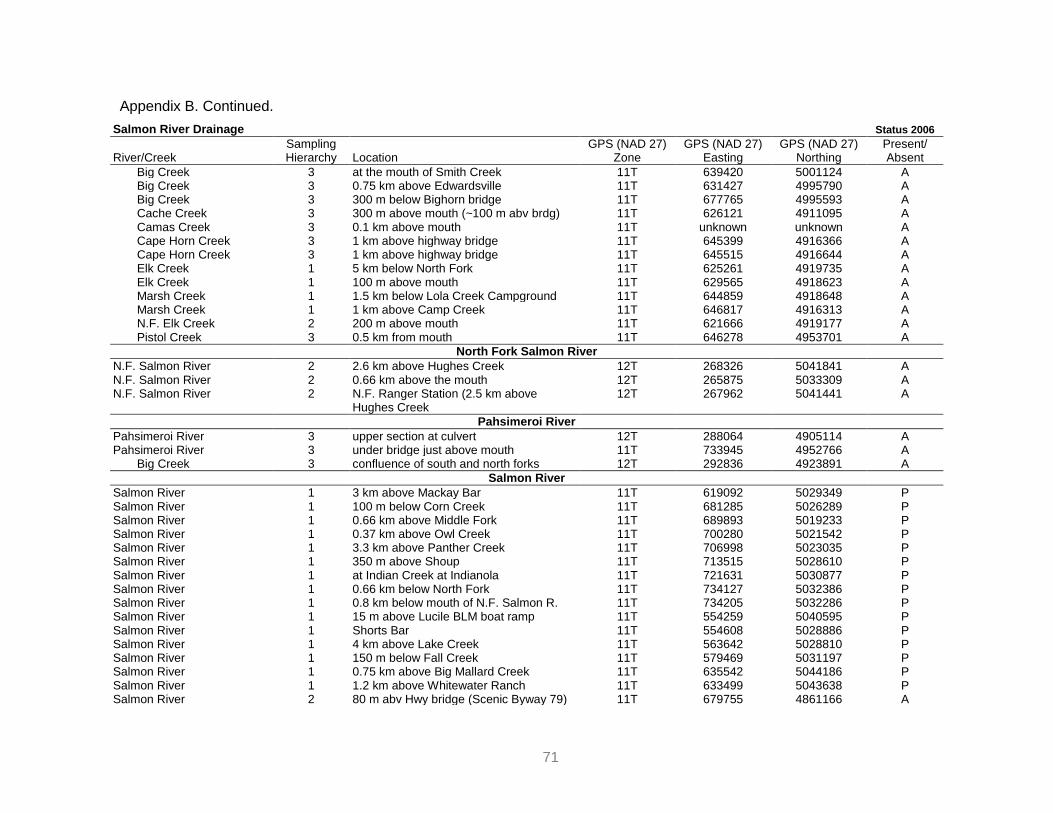
Appendix B. Continued.
71
Salmon River Drainage Status 2006
River/Creek Sampling Hierarchy Location
GPS (NAD 27) Zone
GPS (NAD 27) Easting
GPS (NAD 27) Northing
Present/ Absent
Big Creek 3 at the mouth of Smith Creek 11T 639420 5001124 A Big Creek 3 0.75 km above Edwardsville 11T 631427 4995790 A Big Creek 3 300 m below Bighorn bridge 11T 677765 4995593 A Cache Creek 3 300 m above mouth (~100 m abv brdg) 11T 626121 4911095 A Camas Creek 3 0.1 km above mouth 11T unknown unknown A Cape Horn Creek 3 1 km above highway bridge 11T 645399 4916366 A Cape Horn Creek 3 1 km above highway bridge 11T 645515 4916644 A Elk Creek 1 5 km below North Fork 11T 625261 4919735 A Elk Creek 1 100 m above mouth 11T 629565 4918623 A Marsh Creek 1 1.5 km below Lola Creek Campground 11T 644859 4918648 A Marsh Creek 1 1 km above Camp Creek 11T 646817 4916313 A N.F. Elk Creek 2 200 m above mouth 11T 621666 4919177 A Pistol Creek 3 0.5 km from mouth 11T 646278 4953701 A
North Fork Salmon River
N.F. Salmon River 2 2.6 km above Hughes Creek 12T 268326 5041841 A N.F. Salmon River 2 0.66 km above the mouth 12T 265875 5033309 A N.F. Salmon River 2 N.F. Ranger Station (2.5 km above
Hughes Creek 12T 267962 5041441 A
Pahsimeroi River
Pahsimeroi River 3 upper section at culvert 12T 288064 4905114 A Pahsimeroi River 3 under bridge just above mouth 11T 733945 4952766 A Big Creek 3 confluence of south and north forks 12T 292836 4923891 A
Salmon River
Salmon River 1 3 km above Mackay Bar 11T 619092 5029349 P Salmon River 1 100 m below Corn Creek 11T 681285 5026289 P Salmon River 1 0.66 km above Middle Fork 11T 689893 5019233 P Salmon River 1 0.37 km above Owl Creek 11T 700280 5021542 P Salmon River 1 3.3 km above Panther Creek 11T 706998 5023035 P Salmon River 1 350 m above Shoup 11T 713515 5028610 P Salmon River 1 at Indian Creek at Indianola 11T 721631 5030877 P Salmon River 1 0.66 km below North Fork 11T 734127 5032386 P Salmon River 1 0.8 km below mouth of N.F. Salmon R. 11T 734205 5032286 P Salmon River 1 15 m above Lucile BLM boat ramp 11T 554259 5040595 P Salmon River 1 Shorts Bar 11T 554608 5028886 P Salmon River 1 4 km above Lake Creek 11T 563642 5028810 P Salmon River 1 150 m below Fall Creek 11T 579469 5031197 P Salmon River 1 0.75 km above Big Mallard Creek 11T 635542 5044186 P Salmon River 1 1.2 km above Whitewater Ranch 11T 633499 5043638 P Salmon River 2 80 m abv Hwy bridge (Scenic Byway 79) 11T 679755 4861166 A

Appendix B. Continued.
72
Salmon River Drainage Status 2006
River/Creek Sampling Hierarchy Location
GPS (NAD 27) Zone
GPS (NAD 27) Easting
GPS (NAD 27) Northing
Present/ Absent
Salmon River 2 2.6 km above Stanley Highway 11T 680706 4859142 A Salmon River 2 2.6 km abv Sawtooth Hatchery (turnout) 11T 670541 4887686 A Salmon River 2 1.3 km above Williams Creek 11T 670920 4884079 A Salmon River 2 below Hell Roaring Creek 11T 673488 4877631 A Salmon River 2 1 km abv Blaine-Custer Co Hwy bridge 11T 674236 4873837 A Salmon River 2 50 m above Pole Creek Road bridge 11T 677594 4863157 A Salmon River 1 1.3 km above Red Fish Lake Creek 11T 669013 4892047 A Salmon River 1 3.9 km below Lower Stanley, bluff on SE
side of river 11T 668610 4900846 A
Salmon River 1 10.5 km below Lower Stanley 11T 676410 4903283 A Salmon River 1 O‘Brian Campground 11T 683866 4902903 A Salmon River 2 at Coleman Campground 11T 687165 4902392 A Salmon River 1 150 m below mouth of E.F. Salmon R. 11T 713432 4905189 A Salmon River 1 at mouth of Horse Creek 11T 718654 4917317 A Salmon River 2 2 km blw Challis Crk at sportsman access 11T 724181 4936420 A Salmon River 2 at Cottonwood Recreational Area 11T 731502 4950078 A Salmon River 2 1 km below Cow Creek 11T 737217 4956509 A Salmon River 1 Kilpatrick access point 11T 263907 4968209 A Salmon River 3 Deadwater picnic area 11T 730946 5030004 A Salmon River 1 at Bobcat Gulch sportsman access 12T 267746 5027662 A Salmon River 1 Morgans Bar 12T 271953 5015073 A Salmon River 1 at Fourth of July sportsman access 12T 269319 5026929 A Salmon River 2 200 m below Camp Creek at BLM access 12T 267728 4984243 A Salmon River 2 at 8 mile BLM access 12T 271312 4994995 A Salmon River 1 100 m above Hammer Creek boat launch 11T 552626 5067782 A Salmon River 1 100 m abv S Twin brdg, W side of river 11T 555112 5056497 A Salmon River 1 250 m above Elkhorn Creek 11T 571214 5027989 A Salmon River 1 Vinegar Creek boat ramp, end of road 11T 586607 5034433 A Bargamin Creek 2 at USFS campground 11T 653038 5064903 A Basin Creek 3 1 km above mouth 11T 673534 4903728 A Challis Creek 3 Mill Creek Road, 30 m above bridge 11T 716430 4937560 A Crooked Creek 3 Dixie Ranger Station 11T 616171 5041752 A Eagle Creek 3 3.4 km up from mouth 11T 520785 5095896 A Eagle Creek 3 0.16 km up from mouth 11T 523024 5093900 A French Creek 3 3 km from mouth 11T 575679 5027387 A French Creek 3 0.25 km up from mouth 11T 576226 5029792 A Little Whitebird Creek 3 10 m up from Road 642 culvert 11T 570692 5066065 A Mallard Creek 3 at Whitewater Ranch Road 11T 632023 5048428 A Mallard Creek 3 3.2 km hike, 200 m up from mouth 11T 634999 5044037 A Panther Creek 2 2.0 km above mouth 11T 704714 5019901 A

Appendix B. Continued.
73
Salmon River Drainage Status 2006
River/Creek Sampling Hierarchy Location
GPS (NAD 27) Zone
GPS (NAD 27) Easting
GPS (NAD 27) Northing
Present/ Absent
Panther Creek 2 1.3 km above Cobalt 11T 716512 4995742 A Panther Creek 2 2.6 km below Naipas Creek 11T 715823 5004112 A Pole Creek 3 2.6 km above mouth 11T 680205 4864099 A Slate Creek 3 1.6 km down from Little Slate 11T 572245 5052947 A Slate Creek 3 3.2 km down from North Fork 11T 566228 5052889 A Slate Creek 3 0.8 km up frm USFS bndry by Hurley Crk 11T 562822 5053631 A Smiley Creek 3 2 km above Smiley Creek Lodge 11T 676523 4860785 A S.F. Whitebird Creek 3 40 m down from Road 642 11T 572775 5068205 A Valley Creek 2 0.66 km abv closed brdg on Valley Crk Rd 11T 654246 4909201 A Valley Creek 2 19.7 km abv mouth at sportsman access 11T 657488 4906280 A Valley Creek 2 5.3 km above Stanley 11T 659878 4900356 A Whitebird Creek 2 1.6 km down from North Fork 11T 559209 5071050 A
South Fork Salmon River
S.F. Salmon River 1 ~50 m abv Cougar Crk trail road bridge 601454 4972280 A S.F. Salmon River 1 4.5 km below Secesh River (road end) 605326 4988947 A S.F. Salmon River 2 Fitsum Creek (across from mouth) 600791 4983518 A S.F. Salmon River 1 2 km above Krassell 600316 4978918 A S.F. Salmon River 1 Buck Horn Cmpgrnd (single site on river) 599625 4976686 A S.F. Salmon River 2 S.F. guard station (just below bridge 337) 611626 5003222 A S.F. Salmon River 1 9.5 km below Warm Lake Creek 603537 4953598 A S.F. Salmon River 1 4.0 km above mouth of Warm Lake Crk 603690 4943324 A S.F. Salmon River 1 Stolle Meadows Campground 604553 4939087 A Blackmare Creek 3 10 m up from mouth 602483 4963881 A Buckhorn Creek 3 first bridge above mouth 599631 4974597 A Cabin Creek 3 S.F. Salmon Road 604361 4946569 A Dollar Creek 3 30 m above mouth 603394 4952691 A E.F. of S.F. Salmon R. 2 3 km above road bridge 620281 4979670 A E.F. of S.F. Salmon R. 2 just above mouth of Profile Crk (~1.0 m) 623980 4979263 A E.F. of S.F. Salmon R. 2 10 km above mouth 609210 4977976 A Johnson Creek 2 48.3 km above mouth 619384 4976786 A Johnson Creek 2 0.8 km above Icehole Campground 618215 4970516 A Lake Creek 2 ~1.5 km above mouth 585897 5012787 A Secesh River 2 Chinook Campground 593529 5007293 A Summit Creek 2 2 km above mouth 585856 5010574 A Trail Creek 3 6 km up from mouth 601952 4943274 A Warm Lake Creek 3 0.2 km down S.F. Salmon River Road 604350 4946429 A Warren Creek 3 2 km below Warren / Burgdorf Road 601817 5015476 A

Appendix B. Continued.
74
Salmon River Drainage Status 2006
River/Creek Sampling Hierarchy Location
GPS (NAD 27) Zone
GPS (NAD 27) Easting
GPS (NAD 27) Northing
Present/ Absent
Yankee Fork Salmon River
Yankee Fork 2 200 m above Custer Cemetery 684812 4918116 A Yankee Fork 2 0.66 km above Jordan Creek 682090 4916508 A Yankee Fork 2 2.6 km above mouth 682093 4907286 A W.F. Yankee Fork 2 1.1 km above mouth 680674 49913483 A
Salmon River 1‘s 46 2‘s 85 3‘s 56 187 Clearwater 1‘s 41 2‘s 53 3‘s 30 124 Snake 1‘s 9 2‘s 7 3‘s 0 16

75
Appendix C. Habitat utilization determination and associated sampling protocols from Claire (2003).
METHODS
IDFG determined the 41 1-kilometer Red River sections on USGS 1:24,000
quadrangle maps from mouth to headwaters. In 2000-2002 one-hundred meter
subsample stream reaches were randomly selected from 41 1-kilometer sections and
the stream habitat was classified as pool, riffle, glide, etc., using a modified version of
stream classification methodology utilized in Platts et al. (1983) and Overton et al.
(1997). Stream habitat measurements taken in sampled habitat units included: wetted
width, channel width, habitat unit length, maximum depth, average flow velocity,
substrate (cover) size percent composition, stream temperature, and riparian canopy
cover percent (shade). In 2001 and 2002 random sampling was restricted to Red River
downstream of rkm 7.5 to in order to adjust to known Pacific lamprey distribution.
The substrates within habitat units (riffles, pools, etc.) were visually classified
using Platts et al. (1983) size classification. Substrate classification transects
perpendicular to the thalweg of the stream channel at three points (25%, unit center, and
75% of the distance from the downstream to upstream boundary) in a habitat unit were
used to augment and calibrate visual estimation in 2000. Water velocity measurements
were taken with a mechanical flow meter 1.0 cm above substrate (Hammond 1979a) and
at 60% of depth above the substrate in a habitat unit; at 25% from left bank, stream
center, and 25% from right bank. Habitat unit flow velocity measurements were also
taken at 20% and 80% of depth (at the three locations) above the substrate if the depths
were greater than two meters. Maximum depth was recorded in individual units.
Individual water velocity and site depth measurements were taken over substrates
where Pacific lamprey ammocoetes were captured on emergence. Individual site
emergence flow velocity measurements for each unit were averaged. Substrates yielding
Pacific lamprey ammocoetes were documented. Canopy cover (shade) values were
obtained using a standard concave forestry densiometer with only 17 of the total 25
squares corner points uncovered. Readings at three locations left bank, right bank, and
stream center were taken in a habitat unit at one-half the distance from downstream
boundary to upstream boundary. The densiometer was held 30 cm above the water
surface and 30 cm from the wetted edge while obtaining left bank, and right bank
readings. Upstream and downstream (2 total) readings were taken at stream center 30

76
cm above the water surface. The total of counted densiometer squares for an individual
location was multiplied by 1.5, (normal densiometer readings utilize 25 uncovered points,
17 x 1.5 = ~25 (25.5)) yielding a reading of one-quarter of the total stream shade. The
four measurements were summed to obtain canopy cover in a unit.
The habitat types in the 100 m reaches were electroshocked systematically with
an Engineering Technical Services ABP-2 electroshocker from the downstream habitat
type, working upstream without repeating sampling in like habitat types. Stream habitat
units were electroshocked from bank to bank working upstream from the lowermost point
of the riffle, pool, glide, etc., being sampled to the upstream end to ensure complete
coverage of the unit. Effective electrofisher settings were optimized, recorded, and
repeated throughout units electrofished to standardize effort. Electroshocking elapsed
times were recorded and electroshocking effort per unit of area was expressed as m2
electroshocked/minute. Pacific lamprey abundance in a unit was expressed as
ammocoetes/100 m2.
Pacific lamprey ammocoete minimum population estimates in Red River were
completed following Pajos and Weise (1994) and Morkert (1993) methodology, however,
a one-pass effort was utilized to minimize impact to lamprey. The electroshocking catch
per unit of area fished (lamprey/100 m2) for individual habitat types was expanded for
total habitat type area in a 100 m section. The Pacific lamprey densities were averaged
for individual habitat types in a 100 m section and multiplied by the estimated stream
habitat type area per kilometer of stream section. Minimum population estimates were
determined for individual kilometers utilizing Pacific lamprey average density information
obtained in corresponding kilometer reaches.
Non-random presence-absence electroshocking surveys were conducted on
potential Pacific lamprey ammocoete habitat sites in the mainstem South Fork
Clearwater River (SFCR), tributaries, Red River, and the South Fork of Red River.
Selection of sites was determined utilizing initial sampling information indicating Pacific
lamprey ammocoete preferred habitat. Five sites were sampled in upper Red River
upstream of rkm 24.0, six in the South Fork of Red River (rkm 1.5 to rkm 8.0), and 23 in
the main SFCR (mouth to Red River) and tributaries. Capture locations were recorded
and mapped in order to assess distribution of Pacific lamprey ammocoetes in the SFCR
basin and Red River subbasin.
77
Three downstream migrant traps currently operated by IDFG in the SFCR
drainage were used to monitor Pacific lamprey ammocoete and macrothalmia
downstream movements and assist in determining SFCR drainage Pacific lamprey
distribution. Traps were operated 24 hours and checked twice daily (a.m., and p.m.). The
Crooked River scoop trap (rkm 1.0) was operated in 2000 and 2001. In 2002 a 1.50 m
diameter rotary screen trap replaced the scoop trap on Crooked River. A 1.50 m
diameter rotary screen trap on American River (rkm 3.0) and another 1.50 m diameter
rotary screen trap on Red River (rkm 5.0) were operated in 2000, 2001, and 2002. Red
River rotary screen trap historical records (1992-1999) were examined to augment
Pacific lamprey 2000-2002 downstream migration information. Outmigrant estimates
past traps were made using (Beamish and Levings 1991) trap-area fished methods.
Captured Pacific lamprey were anesthetized, enumerated, measured for total
length, weighed, and released near the capture location following recovery in fresh
water. Pacific lamprey (>100 mm TL) captured while electroshocking were marked with
injections of florescent orange elastomeric solution (0.5 cm in length) under the skin.
Mark orientation and location was differentiated to distinguish between field seasons
with marks in 2000 on the left side, posterior to the gill openings, and in 2001 on the right
side, posterior to the gill openings. No Pacific lamprey ammocoetes were marked in
2002 due to the limited potential for recapture and the stress of marking to the individual
ammocoetes.
Eight kilometers of Red River and its tributaries with suitable substrates (Red
Horse Creek, South Fork of Red River) were visually surveyed for spawning adult Pacific
lamprey from April 19 to July 7 in 2000 (Appendix A1). Seven kilometers of Red River
and its tributaries were surveyed from April 30 to July 1 in 2001. In 2002, 0.3 km of Red
River were surveyed once on June 7. In 2000 redd surveys were primarily upstream of
Red River rkm 13.0. In 2001 redd surveys were expanded to include habitat in the Red
River rkm 7.5 section and the lower reaches of Red Horse Creek. Redd surveys were
reduced to one section in 2002 due to the suspected limited number of adult spawners in
the subbasin.
Red River stream temperature information was obtained from the (IDFG) Red
River trap (rkm 5.0) and plotted to determine maximum annual stream temperature in
the subbasin. Stream temperature and substrate temperature were both measured at

78
ten Red River sites on August 9, 2001. The substrate temperatures were obtained at
10.0 cm beneath the substrate surface in fine gravel-fine silt deposits.
ANALYSIS
Pacific lamprey ammocoete habitat preferences were analyzed with Analysis of
Variance (ANOVA). For analysis, Pacific lamprey density (ammocoetes/m2) values for
individual habitat types were utilized. The natural log average Pacific lamprey
ammocoete density values for individual lateral scour pools, riffles, rapids, etc., were
analyzed to determine if mean Pacific lamprey densities were different. The Pacific
lamprey density values in lateral scour pool and straight scour pool habitats were
analyzed as ―lateral scour pool‖ (a single habitat type) average densities due to similarity
in the structure of the two habitats. The riffle and riffles with pockets (pocket water)
densities were combined and analyzed as ―riffles‖ due to similarity in the structure of the
two habitats. ANOVA requires an average value (of two or greater samples), therefore
the single alcove habitat unit Pacific lamprey density was not included in ANOVA of the
ammocoete density and habitat type relationship.
The Pacific lamprey ammocoete density relationship to stream habitat unit
parameters (water velocity, maximum depth, canopy cover (shade), and substrate type)
were assessed through linear regression and modeled with best fit step-wise multiple
regression. To simplify analysis, Pacific lamprey ammocoetes/m2 natural log values
rather than ammocoetes/100 m2 were utilized. Linear and multiple regression F-tests (α
= 0.05) were utilized to determine the strength of the relationship between ammocoete
density and stream parameters. The Pacific lamprey ammocoete densities obtained in
alcove habitat and one lateral scour pool were excluded from linear and multiple
regression of the velocity, substrate, maximum depth, and canopy cover parameters.
Initial sampling in Red River indicated Pacific lamprey ammocoete density
differences were minimal when comparing substrate size classes (fine sand, sand,
coarse sand etc.). Therefore substrate classes (fine sand, coarse sand etc.) were
combined into three classifications: ―coarse‖ (large boulder, small boulder, cobble),
―medium‖ (course gravel, medium gravel, fine gravel), and ―fine‖ (course sand, fine sand,
silt/organic) and analyzed in relationship to Pacific ammocoete densities in the
corresponding units.

79
Severe difficulty was encountered visually identifying individual ammocoete
emergence sites when multiple ammocoetes emerged simultaneously. As a result there
were numerous occasions when accurate measurement and calculation of site of
emergence stream velocities, depths, and canopy cover was not possible. The habitat
unit average velocities, maximum depths, and canopy cover measurements (rather than
individual site of emergence) for corresponding units were incorporated in order to
analyze the Pacific lamprey ammocoete density in response to the parameters.
80
Appendix D. Pacific lamprey adult translocation protocols as discussed in Howard et al. (2005).
METHODS Outplanting Collection
Adult lampreys (n = 133) were collected by the United States Geological Survey
(USGS) for experiments in August, 2003 from Bonneville Dam. USGS provided the
CTUIR Lamprey Research and Restoration Project with the lampreys on January 27,
2004. Lampreys were transported to the Minthorn Springs acclimation facility located on
Minthorn Springs Creek at the mouth of the Umatilla River at river kilometer 103. The
lampreys were held at the Minthorn Springs facility to allow adults to reach maturation
with ambient river water temperatures.
Maintenance
All lampreys transported to the Minthorn Springs facility were treated with
oxytetracycline at a dose of 10 mg kg-1 for bacterial infections prior to being placed in
tanks. Fish were maintained in ~ 1,000 liter, 1.2 x 1.2 x 1.2 meter bonar tanks, using
Minthorn Spring river water. Water was supplied to the tanks with a 1/2 horsepower
submersible pump. Water is pumped into a head distribution tank that is located 2.1
meter above grade, through 2 cm hose and fittings, and is gravity fed to each holding
tank. Effluent lines are also gravity fed, and are placed in holdings tanks, so if for any
reason the pump fails, the holding tanks will not lose water. Lampreys were maintained
in outdoor tanks and were therefore subjected to a natural photoperiod. Water flowed
directly from the river channel into the tanks, and therefore water temperature was near
ambient.
Timing of Release
Efficient management of brood stock depends upon an accurate prediction of
sexual maturity and ripeness. Lamprey sexual maturity (ripeness) is often accompanied
by external changes in body shape, and pigmentation. In general females tend to swell
and become gorged with eggs making it possible to determine ripeness by detecting a
softening of the belly wall. In addition, both males and females change from a blue to
brown color when ripe. Males exhibit a similar softening of the belly wall, and easily
expel sperm when the abdomen is pressed. Lampreys were checked weekly for

81
ripeness beginning in early April when water temperatures reached 10º C. When at least
25 percent of males began spermiating, lampreys are considered ready to be released
into spawning areas of the channel.