the state of coral reef ecosystems of the republic of the marshall
TRANSCRIPT

The State of Coral Reef Ecosystems of the Republic of the Marshall Islands
387
Mar
shal
l Isl
andsThe State of Coral Reef Ecosystems of the Republic of the Marshall Islands
Maria Beger1, Dean Jacobson2, Silvia Pinca3, Zoe Richards4, Don Hess2, Frankie Harriss2, Cathie Page4, Eric Peterson5 and Nicole Baker6
InTRoduCTIon and SETTIng Located in the central Pacific Ocean and spanning more than 5,025,000 km2 (1,940,000 mi2), the Republic of the Marshall Islands (RMI) is comprised of 1,225 islands and islets including 29 atolls and five solitary, low coral islands. Only 0.01%, or 181.3 km2, of the country is dry land. The atolls and islands are arranged in two roughly parallel groupings—the eastern Ratak (or Sunrise) Chain containing 15 atolls and two islands, and the Ralik (Sunset) Chain to the west containing 14 atolls and three islands (Figure 12.1).
The RMI formed when fringing reefs began to establish and grow around emergent volcanoes. While the ancient volcanic peaks gradually sank and shrank, the fringing reefs continued to grow and eventually coral atolls formed after the volca-noes disappeared entirely beneath the sea. The five solitary islands of the RMI were formed in much the same way, but the peaks were small enough that no interior lagoon developed. Most atolls of the Marshall Islands consist of an irregular shaped reef-rim with numerous islets encircling a lagoon with water depths that can reach 60 m. The islets are more prevalent on the windward side. The atolls vary in size from Kwajalein, the world’s largest atoll with 16.4 km2 of dry land
1. The Ecology Centre and The Commonwealth Research Facility for Applied Environmental Decision Analysis, The University of Queensland2. College of the Marshall Islands3. Secretariat of the Pacific Community4. ARC Centre of Excellence for Reef Studies, School of Marine and Tropical Biology and Comparative Genomics Centre, James Cook University5. School of Architectural, Civil and Mechanical Engineering, Victoria University6. Independent consultant based in Victoria, Australia
!H
!H
170°E
170°E
160°E
160°E
15°N
15°N
5°N
5°N
Ujae
Jaluit
Namu
Ailuk
Ebon
Marakei
0 100 200 km
!H City
Land
Water <200 m
Deep Water
EEZ
Pohnpei
Abaiang
Tarawa
Butaritari
Ujelang
Namorik
Mili
Enewetak
Wotje
UtirikAilinginae
RongelapBikini
Ailinglaplap
Likiep
Toke
Bokak
Jabat
Rongerik
Kwajalein
Majuro
MaloelapErikub
Arno
Bikar
Majuro
Aur
Wotho
Kosrae
PingelapMokil
Ngatik Kili
Lae
Lib
Jemo Mejit
Nadikdik
Makin
EbeyeR A L I KC H A I N
R A T A KC H A I N
Figure 12.1. Locator map of the RMI. Map: K. Buja.

The State of Coral Reef Ecosystems of the Republic of the Marshall Islands
388
Mar
shal
l Isl
ands
and a lagoon of 2,174 km2, to Bikar with 0.5 km2 of land and 37.4 km2 of lagoon, and Namdrik with 2.7 km2 of land and 8.4 km2 of lagoon. Individual islands range from tiny sand-spits and vegetated islets that are inundated during storms and extreme high tides to much larger islands such as Kaben Island at Maloelap Atoll, and Wotho Island at Wotho Atoll, both of which are over 8 km2. Lagoons within the atolls typically have at least one natural reef pass that provides boat access; however, some, such as Namdrik Atoll, have no natural passes.
Prior to Western contact, the people of the Marshall Islands relied on fishing and tropical agriculture for subsistence. In this environment, the Marshallese developed world-renowned seafaring skills, which included the design of ocean-going canoes and the creation of a complex navigation system based on stars, swell, currents and wave refraction patterns. The culture and skills that evolved allowed the Marshallese to thrive in the widely dispersed islands. The present population of approximately 61,815 is concentrated in the urban areas of Majuro and Ebeye (Kwajalein Atoll), home to approximately two-thirds of the population (CIA, 2008). The remaining one-third lives in the more remote atolls, commonly known as the “outer islands”.
Today, coral reef ecosystems in the Marshall Islands are in excellent condition (Figure 12.2). The outer and less populated atolls in particular support healthy and diverse communities of marine life. Many threats, such as overfishing, pollution and coral disease that are common in Southeast Asia and other Pacific Islands have been comparatively low in the RMI. However, in recent years, the coral reefs in the Marshall Islands have become increasingly threatened by pressures of fisheries, climate change and sea-level rise, increased urbanization and a loss of cultural traditions. For example, the outer atolls in RMI suffer from occasional forays of fishers involved in the live fish trade and illegal shark finners. Coral reefs near the population centers at Majuro atoll (30,000) and Ebeye (15,000) are far more impacted by fishing and pol-lution than other parts of the RMI.
Many of the Marshall Islands’ coral reefs remain unexplored, but capacity for coral reef assessment and monitoring is growing. Over the past few years, the College of the Marshall Islands (CMI), Natural Resource Assessment Surveys (NRAS), Coastal Management Advisory Council (CMAC), Marshall Islands Conservation Society and the Re-Imman Project Team have collected baseline information on the condition of RMI coral reefs with strong support from the Mar-shall Islands Marine Resources Authority (MIMRA), local communities and local governments. The CMI Marine Science program is helping to build local capacity for conservation. A national database of survey data for six atolls is maintained at the CMI and MIMRA offices. The information presented in this chapter is based on these surveys, personal observa-tions by CMI staff and reports of a University of Hawaii expedition to Ailinginae atoll in 2002. A long-term comprehensive monitoring project is underway at Rongelap and similar efforts are under development for Majuro, Ailuk and other atolls in the future.
Conservation and sustainable resource management has always been a part of Marshallese traditional culture. The increasing threats to marine resources have strengthened commitment within the RMI government and communities to establish and manage community-based conservation areas in addition to other resource conservation strategies. Over the last decade, various efforts have been made to establish community-based conservation areas on different atolls. Those conservation initiatives have been led either by MIMRA, as part of the development of sustainable local fisheries, by the national Environment Protection Authority (RMIEPA) or by local atoll governments (e.g., Mili’s 2003 efforts have stalled, but a recent initiative on Ailuk established management areas and a management plan for the atoll). Other com-munities and leaders are seeking protection through international conservation efforts, such as the nomination of Ailin-ginae and Bikini Atolls for inclusion on the United Nations Educational, Scientific and Cultural Organization (UNESCO) World Heritage Site list. In 2006, the president of the Marshall Islands signed the Micronesia Challenge, a commitment by Micronesian countries and territories to “effectively conserve” 30% of nearshore marine and 20% of terrestrial resources by 2020. The need for an overarching framework for conservation area planning was recently addressed by development of a national document outlining the principles, process and guidelines for the design, establishment and management of conservation areas that are fully owned and endorsed by local communities based on their needs, values and cultural heritage (Re-Imman Project Team, 2008).
Figure 12.2. Clear water and protected lagoons combine to ensure prolific coral growth (left). Well-developed spur and groove channels provide semi-protected habitat along the exposed atoll reef fronts (center). Apex predators, such as sharks, are still common on some RMI reefs (right). Photos: A. Seale.

The State of Coral Reef Ecosystems of the Republic of the Marshall Islands
389
Mar
shal
l Isl
andsEnvIRonMEnTal and anThRopogEnIC STRESSoRS
Climate Change and Coral Bleaching Because the country is comprised of numerous low-lying islands that depend on intact coral reef ecosystems for protection from erosion, the RMI is particularly threatened by climate change and associated sea level rise. Among the anticipated effects of climate change are an increasing incidence of storms, drought and sea level rise. Recently Majuro Atoll suffered both a serious storm (October 2006) and an extended drought, which led to the declaration of a water emergency.
Sea level rise The Intergovernmental Panel on Climate Change’s (IPCC) 3rd Assessment Report (IPCC, 2001) reported that sea level has been rising an average of 0.01 to 0.02 m per century since 1000 BC, but the 4th Assessment (IPCC, 2007) estab-lished that sea level rise over 20th century was 0.17 m. For various emissions scenarios and with a nominal allowance for ice sheet effects, the IPCC projects sea level rise in the 21st century to be between 0.18 and 0.79 m, but the report also cautions that “larger values cannot be excluded” since the “understanding of these effects is too limited to assess their likelihood or provide a best estimate or an upper bound for sea-level rise” (IPCC, 2007). Rahmstorf (2007) analyzed the tendency of observed sea level rise to exceed the upper limit of IPCC forecasts, and projected a total 21st century sea level rise of 0.5 to 1.4 m unless mitigation measures are implemented.
The land area of the Marshall Islands averages about 2 m above sea level (www.rmiembassyus.org/Environment.htm); the highest elevations are generally found along shorelines with lower elevations inland (ELP, unpub. data). RMI govern-ment is very concerned with sea level rise. The potential impact of sea level rise has been demonstrated quite dramati-cally during extreme high tides when the groundwater lens rises above the surface in the low-lying areas. Building dykes and pumping would be impractical to maintain land below sea level, as the soil substrate is porous coral rubble. Construc-tion of seawalls is equally unfeasible as it would require islanders to mine nearshore areas for building materials, similar to the blast mining that occurs on Majuro reef flats (Barnett and Adger, 2001) and the widespread hand mining of beaches (McKenzie et al., 2006). There is currently a move to dredge sand and gravel from lagoons (Smith and Collen, 2004) in order to conserve ocean reefs. Ocean reefs are an initial line of defence against the sea as they dissipate wave energy, provide habitat for foraminiferans which make up most of the sand in the lagoon and cement together reef structure.
Holthus et al. (1992) estimated a 7% loss to the Marshall Islands gross national product with a 1 m sea level rise through application of the Bruun (1962) rule for beach erosion. But Forbes and Solomon (1997) assert that the Bruun rule is “clearly inappropriate where shorelines have responded to past high water levels by progradation rather than recession, and where the nearshore profile is constrained by the reef flat.” A regional high stand of sea level at about 2-3 m above the present level in 2000 B.C. (before human habitation) was responsible for the formation of island foundations (Dickinson, 2006). The current population center at Majuro Atoll, however, is not situated on this relatively high land at Laura, but on much lower and partially reclaimed land.
BleachingCorals in the Marshall Islands have been spared from mass bleaching events like those that have impacted Palau and the Caribbean, but observations made primarily on Majuro indicate that modest bleaching events have occurred on at least five occasions. Bleaching events in the RMI, which usually are restricted to intertidal depths, were first observed in an un-dated photographed used for tourism promotion between 1998 and 2000. An event beginning in September 2001 during a period of calm, cloudless weather (Abraham et al., 2005; Pinca et al., 2005) resulted in considerable coral mortality, which intensified and spread to slightly greater depths during low tides in October and November 2001. Mortality among shallow Acropora colonies on both lagoon and ocean shores was well documented (Jacobson, unpub. data). Local knowledge suggests that similar events did not occur in the RMI previously.
Coral bleaching at deeper sites was observed on Majuro in both 2003 and 2006. The 2003 event involved Acropora, Porites, Millepora and other colonies down to depths of at least 10 m. In 2006, up to 5% of massive Porites spp. colonies within the northern lagoon were entirely or partially bleached, but with no apparent mortality (Figure 12.3). At several lagoon sites, up to 90% of Acropora colonies also bleached, leading to significant mortality (approximately 20-50%) down to 3 m depth. Significantly, many massive Faviid and Platygyra colonies growing at 5-8 m on the fore reef bleached and suffered “crown” mortality in 2006. This pattern of mortality primarily affects the top surfaces of colonies and can result in scars that persist for many years; such scars had not been observed previously on Majuro (Jacobson, unpub. data). Recent subtidal bleaching events have been largely restricted to a few spe-cies and usually result in a low overall inci-dence of bleaching (typically less than 20% of all coral below several meters depth). The 2003 and 2006 events occurred during a period of elevated sea water temperatures,
Figure 12.3. In 2006, coral bleaching was documented in Majuro lagoon at the southern reef near the airport (left) and in the northern lagoon (right). Porites colo-nies appear to have recovered since then. Photos: D. Jacobson.

The State of Coral Reef Ecosystems of the Republic of the Marshall Islands
390
Mar
shal
l Isl
ands
which may have contributed to a subsequent coral disease outbreak. Widespread bleaching was observed on corals in the lagoon of neighboring Arno atoll in December 2006 (Richardson, unpub. data). The atoll’s population of Isopora cu-neata, an important reef-building species, was severely reduced or impacted. Only shaded colony bases survived.
Few reports of coral bleaching have emerged from outer atolls, but this is more likely due to a lack of monitoring and not a lack of bleaching. A visit to Jaluit atoll in 2003 and 2004 permitted scientists to document a dramatic subtidal bleaching event and subsequent coral mortality there. Bleaching on Jaluit during this event was restricted to tabulate colonies of A. robusta, a form uncommon on Majuro (Jacobson, unpub. data).
Diseases Coral disease in the Marshall Islands is not yet well characterized. An outbreak of Acropora white disease affecting tabulate colonies on the exposed outer reefs in Ma-juro is the most intensively documented case so far (Jacobson, unpub. data; Figure 12.4). A bacterial pathogen, Vibrio coralliilyt-icus, which has been shown to be the cause of white plague type II in the Caribbean, was isolated from Majuro lagoon in 2004 (Suss-man, pers. comm.); the bacteria is known to co-occur with a large histophagous ciliate and results in brown band disease in cor-als of Australia’s Great Barrier Reef (GBR; GBR; Willis, pers. comm). The outbreak of Acropora white disease has persisted for at least seven years, with a peak during 2003-2004. The peak of the outbreak coincided with the highest temperatures recorded at a lagoon site over a ten year period, and coral bleaching occurred on site at the end of 2003, indicating a possible link between temperature and disease virulence.
In 2006, disease incidence remained rela-tively low (annual mortality was 5% of live tabulate Acropora area) as it had in 2005, compared to a peak of 16% mortality in 2004. The sustained monitoring of this out-break has revealed an interesting change in disease symptoms. In 2006 and 2007, table corals were found with large disease-killed lesions, yet little or no signs of disease spreading is visible (i.e., if any white band is present, it is restricted to a small portion of the edge of the lesion). Clearly, corals are not dying as rapidly as they had in 2004. However, following a return of warm condi-tions in 2006, disease incidence in 2007 ap-pears to be increasing once again.
Two other rarely seen disease syndromes affect Platygyra and Goniastrea spp., which display progressive overgrowth with green filamentous algae (spreading at a rate of mm per week), and Turbinaria, in which mul-tiple lesions expand at a rate of 2-4 cm per year (Figure 12.5). These cases of disease were found only on the southern, pollution-impacted shore of Majuro. Coralline lethal orange disease is also common on Majuro along the southern shore, and typically spreads at a rate of 1-2 mm/day (Jacobson, in prep.)
Figure 12.4. Time series of Majuro oceanside dropoff, showing diseased and dead tabulate Acropora spp. Source: D. Jacobson.
Figure 12.5. Coral disease of unknown etiology affecting Platygyra (time series) and Turbinaria. Outlines show enlargement of lesions and coral growth after six months. Source: D. Jacobson.

The State of Coral Reef Ecosystems of the Republic of the Marshall Islands
391
Mar
shal
l Isl
andsTropical Storms
The Marshall Islands are continuously buf-feted by the Pacific Ocean. Narrow strips of land, most of which is less than a meter above high tide, are subject to erosion dur-ing storms from surge and large waves. Cli-mate change related storms and associated surge waves threaten coral reef communi-ties (Madin and Connolly, 2006), terrestrial natural resources and the livelihood of thou-sands of people in the Marshall Islands. Past typhoons and tidal waves have devastated parts of Majuro, Arno, Mili, Jaluit, Likiep and Namdrik atolls, and such storm phenomena are expected to continue and possibly inten-sify with global warming.
An October 7, 2006 storm (which later be-came Typhoon Soulik) caused large surf and a storm surge that flooded areas of Majuro, inundating parts of the highway and destroying a section of the airport seawall (Figure 12.6). Large tabulate Acropora colo-nies were damaged, coral rubble and trash were deposited on the island and some breadfruit trees were killed when salt wa-ter pooled around their roots (Figure 12.7). Fortunately, beach erosion was partially or completely offset by the transport and accu-mulation of coral rubble. However, the long-term effects of coastal erosion are readily apparent on Majuro, where waves have un-dercut the shoreline, causing the collapse of coastal land and coconut palms. Recov-ery of coral reef communities from single and chronic catastrophic events, such as, storms is expected to be slow in situations where the physical environment has been altered (Connell, 1997).
Coastal Development and RunoffThe requirements for sand, large rock and aggregate for local construction have traditionally been met by shore-based lagoon dragline dredging and reef flat blast quarrying (Figure 12.8). Although the long-term recovery of coral reef com-munities from this practice are not well studied, shallow reef flat quarry pits near the airport on Majuro and on Enewetak Island that were dredged in the past have developed extensive coral growth and high fish diversity over the intervening decades. However, recent quarrying in an area west of the Majuro airport produced deep (about 7 m) pits filled with a fine sediment that reduces the potential for coral recruitment at these sites. At one site where quarrying intersects the coral rich edge of the lagoon reef flat, the adjacent shallow reef is in surprisingly good condition and continues to support high coral cover. Over the long term, however, removal of the lagoonal reef flat may increase the vulnerability of adjacent shorelines to storm erosion and increase the amount of sediment discharged onto nearby reef habitats.
Figure 12.7. Plating Acropora species common in lagoon habitats are particularly vulnerable to storm damage (left). Photo J. Maragos. Narrow low sand dunes separate the lagoon and ocean at Arno Atoll and provide little defense against storm surges (center). Photo: Z. Richards. Narrow strips of land on Kwajelein atoll rim (right). Photo M. Beger.
HUKO (2002) T1
HUKO (2002) T1
IOKE (2006) T4
IOKE (2006) T4
FENGSHEN (2002) T4
FENGSHEN (2002) T4
FAXAI (2001) T1
FAXAI (2001) T1
FENGSHEN (2002) T5
FENGSHEN (2002) T5
IOKE (2006) T5
IOKE (2006) T5
SONGDA (2004) T1
SONGDA (2004) T1
YAGI (2006) T2YAGI (2006) T2
PODUL (2001) T4
PODUL (2001) T4
SHANSHAN (2000) T2
SHANSHAN (2000) T2
IOKE (2006) T4IOKE (2006) T4
170°E
170°E
160°E
160°E
15°N
15°N
5°N
5°N
Kosrae
Bokak
0 100 200 km
Category12345
Typhoons2000-2007
Enewetak
Kwajalein
Rongelap
Majuro
BikarBikini
ELE (2002) T3
ELE (2002) T3
Rongerik
Figure 12.6. The path, name, year and intensity of typhoons passing near the RMI from 2000-2007. Many Pacific typhoons are not named or the names are not re-corded in the typhoon database. noTE: Because Typhoon Soulik was a tropical storm when it passed the RMI, it does not appear on this map. Map: K. Buja. Source: http://weather.unisys.com/hurricane/.

The State of Coral Reef Ecosystems of the Republic of the Marshall Islands
392
Mar
shal
l Isl
ands
The threat of increased coastal erosion and the loss of some lagoon beaches have prompted a move to outlaw shore dragline dredging on Majuro. Of the two alternatives, suction dredging and importing aggregate, the latter is more expensive. As a result, plans are being made to suction dredge materials from deeper (below 10 m) areas of the northern lagoon where accumulation “deltas” of foraminifera sand are found (see the Associated Biological Communities sec-tion of this chapter for a summary of the area’s foraminifera ecology). However, land owners in the northern lagoon oppose this choice, so it is likely that suction dredging will be restricted to areas of the southern la-goon, despite the disadvantage of smaller grain size. Finding environmentally friendly local sources of aggregate and hard rock is more problematic.
Coastal Pollution Due to the collapse of the solid waste collection system between 2004 and 2007 (e.g., corroded dumpsters and broken down trucks) and insufficient toilet facilities, much household waste, as well as most fecal waste, was simply deposited along Majuro’s shoreline. The lack of an effective seawall barrier at the landfill allowed large amounts of floating garbage to escape, blanketing down-current shores with myriad bits of plastic refuse, especially bags and diapers, which can be found in the water column, particularly during high wave events. Much of this garbage becomes entangled on coral.
The solid waste landfill on Majuro is nearing capacity. A local non-governmental organization (NGO), the Marshall Is-lands Conservation Society, with New Zealand and U.S. funding, has implemented a new recycling program to increase composting of plant waste (with cardboard soon to be included) and begin community battery collections in an attempt to extend the life of the landfill and divert toxics from the environment. Regardless of improvements in waste management, black leachate continues to escape from the landfill onto the adjacent reef flat with potentially serious ramifications for the reef ecosystem. For this reason it is crucial to prevent the development of new landfills elsewhere on the atoll. In early 2007, the responsibility for solid waste collection was placed under a single authority, the Majuro Atoll Waste Corporation. Despite a perennial shortfall of funding, the corporation has succeeded in fortifying the seawall and stabilizing the refuse with a cover of sand dredged from the lagoon. Although incineration has been proposed as an alternative waste manage-ment strategy, the high cost of the incinerator and concerns over hazardous by-products (e.g., toxic emissions and ash) has prevented adoption of this option. Though the use of plastic bags and Styrofoam packaging for food is clearly unsus-tainable, these practices persist in urbanized areas and are expanding to outer atolls. In a small step in the right direction, the CMI has committed itself to use only biodegradable packaging, and encourages its vendors to do the same.
Tourism and RecreationThe good of RMI’s coral reefs and islands, and the historical significance of the RMI appeals to SCUBA divers, sport fishers and World War II history enthusiasts. The coun-try currently hosts approximately 6,000 visi-tors per year, of which 20% (roughly 1,200) are tourists, primarily from the U.S. and Japan (Figure 12.9). On Majuro, the areas of the northern lagoon are in excellent con-dition and remain the focus of reef-related tourism. Most of these developments con-sist of small-scale resorts on northern islets and a few dive shops. In 2007, the first in a series of Japanese charter flights brought in a large group of SCUBA tourists to Majuro.
Other than the small number of yachts visit-ing RMI’s outer atolls each year, few tourist operations exist on outer atolls, largely be-cause of unreliable air transport. On Bikini
Figure 12.8. Mining of hard rock along edge of lagoon fringing reef near Majuro airport, 2007. Photo: D. Jacobson.
Figure 12.9. Visitors arriving at Majuro Atoll by air. Source: Marshall Islands Visitors Authority.
8,000
7,000
6,000
ato
llM
ajur
o 5,000
4,000
to
visi
tors
3,000
2,000
1,000
01998 1999 2000 2001 2002 2003 2004 2005 2006

The State of Coral Reef Ecosystems of the Republic of the Marshall Islands
393
Mar
shal
l Isl
ands
Atoll, a community-based SCUBA diving center attracts tourists eager to explore a historic collection of WWII wrecks and visit Shark Pass, a part of the atoll that has received international attention thanks to a spectacular population of grey reef sharks. Unfortunately, the shark population at Bikini was significantly depleted by a recent visit from a single illegal shark fishing operation, highlighting the vulnerability of these outer islands to illegal fishing. A new resort is under development on Rongelap that will allow tourists to visit the atoll, which has been virtually inaccessible since the nuclear tests con-ducted in the 1950s. Plans have also been announced for the development of a large-scale Korean golf resort and paved airport on Wotje Atoll, which will require the relocation of the population center to adjacent islets. A lack of other local economic opportunities makes the plan attractive to locals, and this reality tends to override concerns about the potentially harmful affects of excess water and nutrients on the marine and terrestrial environment. While outer atoll destinations offer unparalleled diving and fishing opportunities, the remoteness of these atolls is a barrier to tourism development as well as environmental surveillance capacity.
Fishing Copra has historically been the RMI’s sole cash crop. Over the past ten years, however, increased production from Southeast Asian countries has negatively impacted the price of copra and, as a result, RMI has focused more heavily on its fisheries for income. The RMI’s Exclusive Economic Zone of over 2,128,970 km2 (822,000 mi2) supports a large popu-lation of high-grade tuna, including skipjack, yellowfin, bigeye and albacore. The RMI fisheries operate in accordance with the Forum Fisheries Agency, the regional fisheries regulatory body. The RMI, through the Ministry of Resources and Development, is pursuing a number of development opportunities in fisheries and maintains bilateral fishing agreements with several countries, including Japan, Korea and Taiwan. The licensing fees charged to foreign fishing vessels generate the majority of revenue from this resource.
A China-based fish processing plant is currently under construction on Majuro and is scheduled to begin operations in early 2008. The new plant will supply cooked loins for the canned tuna industry. Due to the wide variety of retail opera-tions, dry dock and harbor facilities, the availability of international air service and access to fuel supplies, Majuro is a competitive location for fishery growth in the region.
Sharks, a valuable tourism resource, have declined in many parts of the Pacific. While some believe that the RMI still supports robust reef shark populations, there is evi-dence that shark populations are starting to decline (Figure 12.10). Shark fins continue to be exported from Majuro, allegedly as by-catch from the long line tuna fishery. There seems to be little concern for the fate of shark populations among the Marshallese, who fear sharks for their perceived danger.
Trade in Coral and Live Reef Species Captive breeding or aquaculture ventures in RMI are a boom and bust business. The most successful operations include MIM-RA-operated tridacnid clam hatcheries on Majuro, Likiep, Mili and Arno Atolls. Coral fragments are also produced sustainably for the ornamental aquarium trade and are marketed to North America and Europe. Collection of live aquarium fish takes place primarily in Majuro, but also on Arno and Mili, and continues to be unregulated and unmonitored. Many high value target species (e.g., some butterflyfish and angelfish) are found only in deep (>50 m) habitats; their natural history is largely unknown and therefore the sustainability of these fisheries cannot be assessed. In 2006, over 52,000 individual fish were exported from Majuro (D. Jacobson, pers. obs). Various attempts have been made to farm rab bitfish (Siganus spp.), sea cucumbers and seaweed on various atolls in the country. CMI has promoted aquaculture via the Arrak research station, a research facility that includes classrooms, an algal culture laboratory, a basic science laboratory, an indoor hatchery, larval rearing tanks and grow-out facilities. In 2007 an Australian company began operating a fish farming operation that imports juveniles of barramundi cod (Cromi-leptes altivelis) for grow-out in the Majuro lagoon. The Black Pearls of Micronesia project is one of the first commercial pearl farms on Majuro.
Ships, Boats and GroundingsShortly before Christmas 2006, a 23 m abandoned Indonesian style wooden boat drifted onto the southern Majuro shore, where it became entrapped on the reef flat (Figure 12.11) and shifted back and forth along the shore for six days. After it cleared the reef, it continued drifting westward, smashing a narrow band of coral and dislodging large chunks of substrate
Figure 12.10. A healthy population of grey reef sharks on Ebon atoll still exists (as of 2005) but populations have been seriously depleted on some other atolls. Photo: D. Jacobson.

The State of Coral Reef Ecosystems of the Republic of the Marshall Islands
394
Mar
shal
l Isl
ands
along 10 km of shore. Efforts to remove the vessel failed.
In the spring of 2007, the near sinking of a dive boat at its mooring led to it being towed across the lagoon and intentionally beached in shallow water in an attempt to salvage the vessel. This resulted in a diesel spill, the de-struction of several dozen Porites colonies and the near-destruction of an endemic three banded anemone fish colony (Figure 12.12). This site is a popular, formerly intact snorkeling area in the northern lagoon of Majuro. Litigation resulting from this incident is ongoing and has the potential to result in a landmark, precedent-setting ruling for lo-cal environmental law enforcement.
Marine Debris Due to their location within the northern equatorial current, Marshall Island atolls re-ceive large amounts of marine debris, pri-marily composed of glass, plastic, rubber and other products which accumulate on the shorelines of all atolls (Figure 12.13). Based on the identity of bottles and identification of floating seeds, it appears that some of the debris originates from as far as Central and South America (Vander Velde and Vander Velde, 2006).
In addition to receiving marine debris from distant locations, Majuro exports a large amount of plastic trash to the Pacific current system. An extraordinary amount of rubbish can be found in the reef habitats of Majuro, on both ocean and lagoon shores (Figure 12.13). Disposable diapers are among the most abundant and destructive debris be-cause they stick to corals and do not de-grade for lengthy periods of time. Continual abrasion kills the local coral polyps. Plastic bags and other plastic products can reach surprisingly high densities in the water col-umn.
Aquatic Invasive SpeciesAlthough macroalgae of the genus Kappa-phycus was briefly introduced and success-fully cultivated in Majuro lagoon in 2002 as a pilot aquaculture project, this potentially invasive brown algae has evidently not be-come naturalized. Some years ago Acan-thophora spicifera, another macroalgae species, became abundant in Majuro la-goon. The potential exists for the non-native humpback grouper (Cromileptes altivelis) which was recently imported for aquaculture in lagoon cages, to become naturalized. The giant clam species Tridacna derasa was introduced as an aquaculture species, and anecdotal evidence suggests that individuals still survive at Mili and Arno atolls.
Figure 12.12. A colony of three-banded anemone fish, which are endemic to RMI, were impacted by the attempted salvage of a grounded vessel. Photo: J. Maragos.
Figure 12.11. In 2006 an abandoned, partially sunk wooden boat (resembling an In-donesian fishing vessel) resulted in several days of reef damage along the dropoff, as the currents moved the wreck back and forth along the central southern shore of Majuro atoll. Photos: D. Jacobson.
Figure 12.13. Plastic debris from both distant and local sources accumulates on Ma-juro shores, both lagoon and oceanside (left). Underwater view near the solid waste landfill before construction of a seawall (right). Photos: D. Jacobson.

The State of Coral Reef Ecosystems of the Republic of the Marshall Islands
395
Mar
shal
l Isl
andsSecurity Training Activities
The military base at Kwajalein Atoll was established in 1964 and supports the research and development needs of U.S. space and defense programs. The facility provides strategic missile defense program support as the Ronald Regan Bal-listic Missile Defense Test Site (RTS), where the military conducts research, development, testing and evaluation using cutting-edge radar, optical and telemetry sensors. The $4 billion strategic military base and the large lagoon at Kwajalein Atoll provide an ideal location for testing long-range missiles launched from the continental U.S. and short to intermedi-ate range missiles launched from elsewhere in the Pacific. In addition to military operations, RTS supports NASA and Department of Energy initiatives.
Offshore Oil and Gas ExplorationThere are currently no offshore oil and gas exploration activities occurring in the RMI.
OtherCrown-of-thorns Sea Star (COTS)No published record of elevated COTS (Acanthaster plancii) population numbers in the RMI occurred in the three decades following an event in the early 1970s, when a large outbreak triggered a professional control effort across Micronesia led by Westinghouse personnel from San Diego (D. Jacobson, unpub. data). However, in 2004 several concentrated aggre-gations (over 1,000 animals/km2) were found in Majuro’s southwestern lagoon and northern pass. Although this outbreak has subsided in most monitored regions without significant human intervention, dense aggregations persisted in some areas in 2007, including one to the west of the northern pass. Most of the lagoon is not currently monitored for COTS, so data on their abundance and distribution is collected opportunistically.
A pilot control project conducted in Majuro during the initial stages of the 2004 out-break removed over 900 animals from a 1 km long segment of fringing reef in the southwestern lagoon. Despite these efforts, the region suffered heavy coral mortality when other COTS replaced the removed in-dividuals. The result of this lagoon outbreak was over 90% mortality among Acropora, heavy mortality among massive colonies such as Pavona spp. and Lobophyllia spp., and locally high mortality (50-75% mortality, mostly in the west) among massive Porites colonies (D. Jacobson, unpub. data; Figure 12.14). The loss of large Porites colonies, which are estimated to be more than 100 years old, is significant, especially consider-ing that COTS generally avoid consuming Porites spp. elsewhere (D. Jacobson, un-pub. data). In the northern reaches of the lagoon, a patchwork of devastated reefs are interspersed with areas of low mortal-ity. Pavona cactus, Acropora, Goniastrea and many other species have been heavily impacted, with more than 95% overall coral mortality on some formerly pristine, highly diverse reefs (D. Jacobson, unpub. data).
On the ocean shore, predation by COTS caused high mortality among large table corals off Majuro’s west coast (near the town of Laura) in areas where disease mortality was also high. The outbreak seems to have spread to the east where COTS have continued to attack massive Porites colonies while avoiding branching or columnar species of Porites (i.e., P. rus and P. cylindrica). A number of smaller COTS (< 25 cm) have recently been observed near the airport.
During a brief visit to Ebon atoll in 2005, lagoon reefs exhibited significant damage associated with a COTS outbreak that persisted throughout the 1980s and 1990s. Ebon’s ocean reefs appear to have largely escaped mortality. Because most of the lagoon’s coral colonies had been devoured previously, by 2005 Ebon lagoon’s COTS population was comprised of only about a dozen animals that were observed on a large patch reef (D. Jacobson, unpub. data).
A very small population of eight COTS was also found on a small patch reef in Ailuk lagoon in June 2006. COTS are routinely found in low abundance on islands such as Majuro and Likiep. Efforts to collect additional information on COTS populations at other atolls will be facilitated by the installation of an environmental radio network, which will improve com-munication between atolls.
Figure 12.14. Majuro lagoon time series showing demise of large (2-3 m) Porites colonies from COTS predation. Photos: D. Jacobson.

The State of Coral Reef Ecosystems of the Republic of the Marshall Islands
396
Mar
shal
l Isl
ands CoRal REEf ECoSySTEMS—daTa-gaThERIng aCTIvITIES and RESouRCE CondITIon
Although there are few consistent monitoring activities ongoing throughout the Marshall Islands, a number of programs have performed assessments at targeted locations in the RMI. Much of the repetitive work is conducted at Majuro Atoll, where a large proportion of the population resides. A number of assessments have been performed at the remote atolls as well. These activities are summarized in Table 12.1. NRAS monitoring locations are pictured in Figure 12.15.
aToll oBJECTIvES STaRT daTE fundIng paRTnERSaSSESSMEnTSLikiep Assess reef-fish 2001 MIMRA CMIAilinginae BDS, REA, CB, TS
(all S)June 2002 NFWF CMI, UH, UQ
Bikini, Ailin-ginae and Rongelap
BDS, REA, CB, (all S) July-Aug. 2002 USDOI, Small Rufford Grant NRAS
Mili, Rongelap BDS, REA, CB, (all S) July-Aug. 2003 USDOI, NFWF, MIMRA, Point Defiance Zoo and Aquarium, CMI and RalGOV
NRAS
Namu, Majuro REA, CB, (all S) Nov.-Dec. 2004 US-DOI, UH Sea Grant, MIMRA, PADI Project AWARE Point Defi-ance Zoo and Aquarium, CMI
NRAS
Ailuk REA, CB (all S), CS (ongoing)
May 2006; Sept. 2006-Dec. 2007
US-DOI, Winifred Scott, Point De-fiance Zoo and Aquarium, MIMRA, Regional Natural Heritage Pro-gram, CMI
NRAS, University of Tasmania, Marine and Environmental Re-search Institute of Pohnpei, WAM
long-TERM daTa-gaThERIng EffoRTSRongelap BDS, REA, CB,
PH-tra (all long-term Monitoring)
Dec. 2006 BP-conservation programme, NOAA
CMI, MIMRA, University of Queensland, James Cook Univer-sity, Victoria University
Ailuk, Likiep, Majuro, Arno
REA, CB, Aug.-Sep. 2007 SPC CO-Fish SPC, MIMRA
Table 12.1. Data-gathering activities conducted in RMI since 2000. BDS – biodiversity swims, REA – Rapid Ecological Assessment based on transects, TS – terrestrial and turtle surveys, CS – community surveys, CB – capacity building, S – single assessment in multiple sites, Moni – temporal monitoring program.
!(!( !(!(!(!(!(
!(
!(
!(!(
!(!(!(
!(!(
!(!(
!(!(
!(
!(!(!(
!(!(
172°E
172°E
6°N
6°N
0 10 20 km
!(
!(!(
!(
!(
!(!(
!(
!(
!(
!(!(
!(
!(
!(
!(
165°30'E
165°30'E
11°3
0'N
11°3
0'N
!(
!(
!(!(
!(
!(
!(!(
!(!(
!(!(
!(
!( !(
168°E
168°E
8°N
8°N
!(!(
!(
!(
!(
!(
!(
!(
!(!(
!(!(
!(
!(!(
171°15'E
171°15'E
7°5'
N
7°5'
N
!( !(!(
!(
!(
!(!(!(
!(!(!(
!(
!(
!(!(
!(!(
!(
!(
!(!(!(
!(
170°E
170°E
10°2
0'N
10°2
0'N
!( !(!(
!(!(!(!(!(
!( !(!(!(
!(!(
!(!(
!(!(!( !(
!(!(
!(
!(!(!(
!(
!(
!(
!(!(
!(!(!(!(!(!(
!(!(!(
!(!(!(
!(
!(
!(
!(
!(!(
!(
!(
!( !( !(!(
!(
!(
!(
!(!(!(!(!(
166°40'E
166°40'E
11°2
0'N
11°2
0'N
0 10 20 km0 10 20 km 0 10 20 km
0 10 20 km0 10 20 km
MiliMajuroNamu
Bikini Rongelap Ailuk!( NRAS Monitoring Site
Land
Water <200 m
Figure 12.15. A map of the NRAS monitoring locations in the Marshall Islands. Map: K. Buja.

The State of Coral Reef Ecosystems of the Republic of the Marshall Islands
397
Mar
shal
l Isl
andsWaTER QualITy and oCEanogRaphIC CondITIonS
Leachate from unlined landfills is a major concern for reef condition in the RMI, particularly on Majuro. Until recently, many toxic substances, including materials from batteries and electronic waste, were simply dumped on the reef flats. A new program in Majuro has helped correct this problem and now diverts most toxic materials from the landfill for recycling.
Eutrophication is also a major concern for reefs near urban centers. The most heavily impacted regions, such as areas adjacent to Majuro’s sewage outfall and landfill, are characterized by the presence of a conspicuous black, non-calcified encrusting red alga that can occupy up to 30% of substrate (D. Jacobson, pers. obs.). This algae has not been detected elsewhere in the RMI, or in less-populated parts of Majuro. Impacted areas also contain an abundance of algal species that are rare are absent in the other parts of the RMI, including Dictyota sp., Padina sp. and certain cyanobacteria. In ad-dition, coral diversity and tridacnid clam abundance is very low in these impacted areas and the disease outbreak among acroporid corals is restricted to this region.
Recent events indicate that heavy metal pollution may be exerting a negative impact on invertebrate populations. Six or seven years ago a pearl farm was forced to relocate from Majuro due to high mortality rates experienced by adult pearl oysters. Another local pearl oyster hatchery in the western lagoon, far from the population center, has been plagued by high larval mortality for several years. After the addition of the metal-chelating agent EDTA in 2006, oyster mortality was sharply reduced (D. Jacobson, pers. obs.). Such effects of heavy metals on invertebrate recruitment may be a contribut-ing factor in the decline of Majuro’s tridacnid clam populations.
The construction of a large Taiwanese dry dock in Majuro lagoon to support the Pacific “superseiner” fleet is being planned for in 2008. It is unclear how activities at this industrial site will impact nearby marine ecosystems.
BEnThIC haBITaTSIt appears that many coral reefs in the RMI have so far been spared from the destructive effects of COTS outbreaks, disease, bleaching and destructive fishing methods that are apparent in so many other locations. Outer island condi-tions are largely excellent and contain unique features. For example, certain reefs on Namu atoll have unusually tall, statuesque Millepora towers. Some areas are densely colonized by large Stylastrea colonies, while elsewhere on Namu, extensive strands of yellow Turbinaria dominate the benthos. Likiep’s reefs contain a Turbinaria super-colony that forms an unusually large mound, and the island’s fore reef walls boast nearly 100% live coral cover dominated by Isopora and Montipora. On southwestern Arno, the reef hosts unusually large and abundant Heliopora colonies, a colony of Leptoria measuring several meters in width, and exhibits very high coral diversity, including species such as Symphyllia, Lobophyl-lia, Echinopora, Platygyra, Oxypora, Merulina, Oulophyllia and Favia. Another reef with very high coral cover on Ebon is dominated by relatively few coral species (mainly Isopora, Porites and Montipora, with very few large Acropora colonies). At least one outer atoll still boasts a large Tridacna gigas population, this species has been severely reduced by illegal fishing in recent decades and is a sensitive indicator of level of exploitation.
RMI atolls are unique because they enclose deep lagoons that provide immense areas of sheltered habitat conducive to coral growth. Lagoonal locations provide a surprisingly diverse community of reef organisms. Large stands of branching Acropora dominate considerable portions of the lagoon floor in many RMI atolls. Within the northern RMI atolls, large “tree-like” morphotypes of Acropora tortuosa occur in monolithic stands; such “old growth” coral communities are thought to be rare among modern day reefs. Within the lagoon of northern atolls, including Likiep, Ailuk and Rongelap, popula-tions of Pectinia and other rare corals such as Hydnophora grandis are found. Numerous species formally known only from southeast Asia (e.g. Acropora kimbeensis, Acropora halmaherae) were also found to have established healthy populations at Rongelap Atoll. Numerous distinctive coral and fish species are likewise restricted to lagoonal reef habitats in the RMI (Z. Richards and M. Beger, pers obs.). Inter-reef habitats and other deep benthic habitats remain relatively unexplored.
In contrast to this diversity, the most common coral in Majuro lagoon is Porites rus, a fast-growing species that can form extensive monospecific stands, particularly in areas that have been disturbed. Some parts of Jaluit contain stands of P. rus, but it is extremely rare on Ailuk where just two small colonies were found during 30 dives. Another common Majuro coral, Acropora clathrata, and several other tabulate species dominate much of Majuro’s southern fore reef but is absent from northern atolls. Clearly, there is a wealth of biogeographic patterns within the Marshall Islands and across the Pacific Ocean that have yet to be elucidated.
The proportion of families present within Scleractinian coral communities peaks with the families Acroporidae and Favidae as predicted by Bellwood and Hughes (2001) for the GBR, however, RMI coral communities show deviations from the predicted patterns for other families (Figure 12.16). The proportion of species within the genus Poritidae and Dendrophyl-lida appears to be less diverse than expected, and the family Pocilloporidae appears to be more diverse than in other locations tested. Thus, the community structure and assemblages of corals in the RMI is unique and worthy of special management protection.

The State of Coral Reef Ecosystems of the Republic of the Marshall Islands
398
Mar
shal
l Isl
ands
Natural Resources Assessment Surveys (NRAS)Given the realities of population growth and the potential for resource exploitation throughout the RMI, it is important to collect as much baseline data on the surrounding coral reef habitats as possible. NRAS-Conservation, a local NGO, along with the CMI and MIMRA began such efforts to document the status of RMI reefs. NRAS expeditions comprising a team of 9-10 international and local Marshallese scientists surveyed reef habitats at Likiep (2001), Bikini (2002), Rongelap (2002-2003), Mili (2003), Namu (2004), Majuro (2004) and Ailuk (2006). The NRAS surveys include baseline data on fish, sharks, corals, invertebrates and marine algae. Summary information is available at: http://www.nras-conservation.org. NRAS rapid ecological assessments (REAs) are intended to serve as baseline data for managers and scientists to aid in the establishment of Marine Protected Areas.
MethodsThe NRAS survey methods provide data on benthic composition and coral community structure along a series of four transects lo-cated at predetermined depths (Table 12.2). Coral and substrate data are collected by a diver swimming along each 50 m tape and recording the type of substrate (e.g., bed-rock, rubble, sand, dead and live coral, sea-weeds and coralline algae) below the tape at 50 cm intervals (English et al., 1997; Pin-ca, 2005). This line-intercept method of as-sessment was selected to best characterize the area as a whole, taking into account the range of depth and zones present (Pinca, 2005).
Data on fish, invertebrates and macroal-gae were also collected along four 50 m transects located at predetermined depths. More detailed fish and invertebrate survey methods are summarized in the Associated Biological Communities section. Data on the abundance and composition of mac-roalgae were collected by placing a 25 x 25 cm quadrat next to the transect line at 0, 10, 20, 30 and 40 m. Target genera and larger groups were identified, and percent coverage of each was approximated inside the quadrant and averaged for each depth. Abundance estimates were recorded according to a qualitative scale of rare, abundant and dominant.
Figure 12.16. The proportion of families present within Scleractinian coral communi-ties. GBR data from Bellwood and Hughes (2001); Ashmore data from Kospartov et al. (2006); RMI and Kimbe Bay data from Richards (unpub.).
140
120
100
noit 80
roporp 60
40
20
0
evid
ae e e e e e e e e e e e e e e ea a a a a a a a a a a a a aid id id d dit id d id dor r g ici
dyll
ida orida lid n i
p a o n pro F P u a ulin hy
l ii niid
e ylli
drinir
F g ussid
rastre
cul hy
lli
Ac A M e ectin
io p
id P oco yp
hS nd
roph
Pocill er n
M u O pE a
str ryo eDe A Ca
Trach M
Coral family
GBR RMIAshmore Kimbe Bay
Table 12.2. Methodologies used for NRAS surveys. Source: servation.org.
http://www.nras-con-
aCTIvITy TypE of daTa METhod fInal InfoRMaTIon
Coral and Fish Diversity Surveys
Species list per site, semi-quantitative abundance
Timed swim Coral and fish species lists and abundance
Line Intercept Percent cover of coral and benthos;two or three repli-cates at each site, at different depths between 5 and 15 m
50 x 5 m line transect, substrate type, life forms of corals, main genera and species
Percent cover composition of benthos and main scleractinia secies or genera
Belt Transect Fish id, counts, size estimate; inverte-brate id and counts; two or three repli-cates at each site, at different depths between 5 and 15 m
50 m x 5 m x 5 m transect, fish families and commercial target species counts and class sizes; commercial inverte-brate counts
Fish abundance by families and main species; invertebrate abundance
Algae Percent cover of al- Four 25 cm x 25 cm Algae families Quadrats gae and semi-quan- quadrats and species id
titative abundance and diversityof major groups: four replicate per transect
Macrofauna Timed swims Identify and count sharks, rays, napo-leon wrasse, turtles
Abundance of macrofauna

The State of Coral Reef Ecosystems of the Republic of the Marshall Islands
399
Mar
shal
l Isl
ands
Coral species richness was surveyed during 60 minute timed swims at each survey site. This method involves an initial direct descent to 30 m, followed by a slow, zigzag ascent to shallow parts of a reef (Beger and Pinca, 2003). Coral species were given an abundance rating according to the DAFOR scale (relative abundance scale: dominate, abundant, frequent, occasional, or rare). Overall percent cover of live coral was estimated for each site, and the three most dominant coral species were recorded (Beger and Pinca, 2003). The results of the surveys are reported in the order in which they were conducted.
Results and DiscussionLikiep Atoll Assessments (2001-2003)A general marine survey and assessment was carried out at Likiep atoll from July 29 to August 20, 2001 (Pinca 2001). The project was undertaken to address both the needs of MIMRA as well as requests from the local government and the Marshallese people for marine surveys and stock assessments. At this time, MIMRA started to show interest in gathering data to begin a process of delegation of responsibility for coastal resources management to local government councils. This project was the first pilot project conceived to furnish such information. Several underwater surveys around six is-lands in the atoll, as well as interviews with the local people and fishermen were conducted by a team of seven people. An important part of the project included the training of the participants to assess marine resources. This training resulted was particularly successful and yeilded expert staff that could be deployed in similar assessments.
Rongelap Atoll Assessment (2002, 2003)Rongelap is a small atoll comprised of 61 islets with a total land area of just over 3 mi2. Located in the northernmost part of the RMI’s Ralik Chain, Rongelap is home to what many consider some of the most robust reefs in the world, with many large fish, healthy corals, invertebrates and algae (Pinca and Beger, 2002). The excellent reef conditions are largely due to the fact that the area has been devoid of human settlement for several decades due to radioactive contamination and has thus experienced limited resource exploitation. In the 1950s, the population was forced to abandon the atoll and re-locate following a hydrogen bomb test conducted by the U.S. military. Shortly after detonation, a change in wind direction caused a cloud of radioactive ash and debris to settle over the island (Niedenthal, 2001). In 1998, a resettlement program was initiated and today the displaced Rongelapese are preparing to return to their native home.
Rongelap Atoll local government (Ralgov) aims to manage their natural resources proactively and requested baseline surveys of Rongelap’s reef resources be conducted by staff and students of the CMI Marine Science department before active resettlement beings. NRAS conducted these surveys from 2002-2003. In 2002, 14 sites around Rongelap Island were surveyed. In 2003, 30 sites were surveyed including 11 lagoonal sites and 19 ocean and pass sites.
The reefs surveyed were found in excellent condition, with a large number of fish, coral, algae and megafauna such as sea turtles, rays and napoleon wrasses were abundant (Table 12.2). The biodiversity and abundance of reef organisms at Rongelap Atoll is extraordinarily high for both fish and coral. One new species of coral, Acropora rongelapensis (Richards and Wallace, 2004) was described and has since been located in Majuro, Pohnepei and West Papua (Richards, pers. obs.).
The pinnacle in front of Enewetak Island and the northwest corner of Rongelap displayed some the highest coral cover in the area (Pinca et al., 2004). Data indicated that branching forms of Acropora (e.g., Acropora loisetteae) dominates the Eastern lagoon, while Porites spp. is more dominant near the West pass (Pinca et al., 2004b). The survey also resulted in range extensions for seven coral species that had not previously been observed in the Marshall Islands. Specimens were collected and are housed at the Museum of Tropical Queensland.
Acanthastrea brevis: • Small colonies of this species were observed growing near Rongelap. A. brevis is considered a rare species and has previously been recorded in areas of Southeast Asia, the West Indian Ocean and Red Sea (Pinca, 2003). Coscinarea monile: • This encrusting coral was recorded in both the lagoonal and wall sites at Rongelap. This species is common in the western Indian Ocean, but not in Southeast Asia. All colonies exhibited a uniform brown color and smooth surface (Pinca, 2003).
REgIon of RongElap aToll
MEan nuMBER of SpECIES
STandaRd ERRoR
avERagE % CovER
STandaRd dEvIaTIon
MaXIMuM % CovER
MInIMuM % CovER
East ocean 67.3 6.3 26.4 11.52 38.08 8.75South ocean 61.9 3.6 47.3 7.64 54.92 37.17West ocean 71.4 3.4 59.2 5.77 63.25 55.08North ocean - - 42.4 4.43 46.08 37.50East lagoon 55 4.7 21.1 10.13 34.83 5Central pinnacles 53.6 7.7 36.7 13.49 65.00 23.75West pass 75.3 4.4 52.8 - 52.75 -
Table 12.2. Mean species number and mean percent cover ± SE of zooxanthellate scleractinian corals at Rongelap Atoll. Percentage of live corals over total substrate cover; other substrate classes were: dead coral, bedrock, sand, rubble, coralline and fleshy algae, soft corals and sponges. Source: Beger and Pinca, 2003.

The State of Coral Reef Ecosystems of the Republic of the Marshall Islands
400
Mar
shal
l Isl
ands
Seriatopora dentritica:• Previously only recorded in parts of Southeast Asia, this compact, bushy coral exhibits very fine, delicate branching patterns. One adult colony was observed at a wall location. This species has never before been recorded in the Central Pacific (Pinca, 2003).Montastrea salebrosa: • Normally this coral grows as large spherical colonies, but at Rongelap the colony was en-crusting with free margins. Known to grow in Southeast Asia, the GBR and western parts of the Pacific, M. salebrosa is considered rare (Pinca, 2003). Acropora loisetteae• : Generally this species has an open branching growth form, but at Rongelap, the colonies found at one site in the lagoon had more of an arborescent table growth form. Rarely mentioned in scientific literature, little is known about its variability (Pinca, 2003). Acropora nana: • A. nana is a corymbose species with very slender, upright and non-tapering branches. Colonies were commonly observed along the shallow reef edges of Rongelap’s exposed wall, as well as at other southern island sites (Pinca, 2003). Acropora speciosa• : A. speciosa grows as a side-attached plate with fusing horizontal branches which give off taper-ing vertical branches. This coral was observed in small numbers at both lagoonal and wall habitats. A. speciosa has been recorded in SE Asia, PNG, the GBR and Fiji (Pinca, 2003).
The monitoring sites with the highest coral cover were located at a pinnacle in front of Enewetak Island (65%) and on the northwest corner of Rongelap Atoll (63%). Both sites were located on the leeward side of the atoll with respect to the prevalent winds. The lowest coral coverage was recorded on the leeward lagoon side, in front of Mellu Island (northeast of the atoll), where the general topography is a steep sand slope with sparse coral patch reefs.
The number of coral species at each site varied from 34 to 90 with an average of 67 (± 13.6) corals. Sheltered sites in the lagoon tended to support fewer coral species and lower cover, but harbored many unusual species, and site variation within the lagoon was greater than in outside areas. The highest species richness was found at sites along the southern and eastern fore reefs and at the west pass.
No sign of coral bleaching was recorded at Rongelap. No coral diseases have been recorded either, and only nine COTS were encountered during the survey period. Some human impacts were noted in the form of marine debris. Longlines were found entangled on corals at four sites in Rongelap and on outer reefs on the leeward (south and southwest) side of the atoll at a depth of 25-30 m.
NRAS Bikini Atoll Assessment (2002)Bikini Atoll is one of the most northerly atolls and includes 23 islands and 187 km2 of reef. Reef habitats at Bikini atoll include narrow fringing reef with spur and groove develop-ment, reef crest and steep vertical exposed walls, and protected sandy lagoons with patch reef development and inter-reefal fau-na (Pinca and Beger, 2002). A total of 183 species of scleractinian coral were recorded from 19 sites at Bikini Atoll in 2002 (Rich-ards et al., in press). Table 12.3 details live coral cover at six biogeographic zones.
As described in detail by Richards et al. (in press), this atoll has been subject to considerable exposure to radioactive nuclear material. Between 1946 and 1958, 23 tests were conducted at seven test sites located on the reef, at the water surface in deep and shallow areas, in the air and underwater for a combined explosive yield of 76.3 megatons. These tests resulted in the creation of five craters up to 73 m deep (Noshkin et al., 1997b) and alteration of natural sediment movement patterns (Noshkin et al., 1997a). The most highly publicized of the Bikini tests, nicknamed “Bravo”, involved the detonation of a 15 megaton hydrogen bomb on a shallow fringing reef in 1954 (Niedenthal, 2001). It obliterated three islands and sent millions of tons of sand, coral, plant and sea life from Bikini’s reef into the atmosphere. The Bikini lagoon sediment regime was fundamentally altered by the nuclear events due to the pulverization and subsequent resuspension of millions of tons of sediment that are transported and deposited throughout the lagoon to this day. Since the nuclear test-ing, impacts from pollution and tourism are presumed to have been virtually non-existent in RMI’s uninhabited northern atolls, however, the threat of illegal fishing persists.
NRAS Mili Atoll Assessment (2003)Mili Atoll is one of the most southern atolls in the Ratak Chain and supports a population of more than 800 people spread among 92 islands comprising 16 km2 (6.15 mi2) of land. In June and July of 2003, REAs were conducted at 20 sites around Mili. The surveys were requested by local landowners and political leaders to support their efforts to establish a marine sanctuary and research station in the northeastern portion of the atoll (Beger and Pinca, 2003). With the assis-tance of CMI, NRAS baseline data was collected to help determine the optimal location for a marine reserve. These data
REgIonS In ThE aToll
MaXIMuM % CovER
MInIMuM % CovER
avERagE % CovER
STandaRd dEvIaTIon
Lagoon East 57.33 8.50 35.02 24.34Lagoon north 64.00 16.03 40.61 25.06Lagoon South na na 6.03 6.03Ocean East 38.00 7.67 23.25 15.18Ocean South 27.12 16.61 21.87 7.43Pass na na 27.53 27.53
Table 12.3. Coral percent cover in Bikini atoll. Other substrate classes were: dead coral, bedrock, sand, rubble, algae and spong es. Source: S. Pinca, unpub. data.

The State of Coral Reef Ecosystems of the Republic of the Marshall Islands
401
Mar
shal
l Isl
ands
will also provide a basis for future monitoring programs and facilitate comparisons with reefs in other parts of the country and region.
A total of 20 sites were sampled during a two week period; nine dive sites were located on the ocean side of the atoll, one dive site was located in the South Pass and nine sites were surveyed in the lagoon and pinnacles (Beger and Pinca, 2003). The survey sites were selected to be representative of subregions (habitat areas) that experience environmental variation related to geographical location and degree of exposure to wind and waves (Beger and Pinca, 2003). These regions are: north ocean, west ocean, south ocean, south pass, south pinnacles and north lagoon areas.
Mili’s reefs were found to be in excellent condition, with an abundance of fish, coral, algae and other species. The moni-toring sites with the highest coral cover were located at two west lagoon sites (53 and 57%). Both sites were located on the leeward side with respect the prevalent winds. High coral cover was also found at sites in the north, west and southern ocean regions. Remaining regions showed a high proportion of sand (Beger and Pinca, 2003). The lowest coral cover was recorded on the leeward ocean side (north of the atoll). Non-Acroporid branching corals were rep-resented with the highest relative coverage in the lagoon, as well as the pinnacle areas whereas Non-acroporid encrusting corals dominated the ocean sites (Beger and Pin-ca, 2003). Overall, the most frequently oc-curring coral was Isopora palifera/cuneata. Coral cover for six biogeographic zones is listed in Table 12.4.
The number of coral species present at each site ranged from 44 to 72 with an average of 50 corals (±10.3; Beger and Pinca, 2003). Lagoon areas tended to support a higher number of corals, as well as many unique species. Additionally, northern ocean areas supported a high number of corals, while in southern ocean sites fewer coral species were docu-mented (Beger and Pinca, 2003). Lagoon and ocean sites proved to be the most diverse.
No sign of coral bleaching was recorded for the atoll of Mili. No coral diseases have been recorded and only four COTS were found. No anthropogenic impacts were recorded in Mili.
The lowest (14%) cover in fleshy seaweeds was found at the western ocean sites as well, where the highest cover of coralline algae was recorded.
NRAS Namu Atoll Assessment (2004)Namu atoll is made up of 54 islets located in the west Ralik chain and is home to approximately 800 people, distributed primarily among the main islands of Namu, Majikin, Mae, Loen. In December 2004, 21 sites were surveyed as part of a NRAS assessment: eight sites were located within the lagoon, two were at passes and 11 were on the ocean side. The eastern and northern sides of Namu were not surveyed for logistical reasons. Sites were grouped into five zones accord-ing to their location and general characteristics of topography and substrate. These included sites located in the northern part of the lagoon, two pinnacles surveyed in the northern part of the lagoon, fore reef sites of the western side of Namu, the fore reef area at the very south of the atoll around Len island and sites at the two passes, one in the north (Bok pas-sage) and one to the southwest (Anil passage).
Namu Atoll is peculiar because of the narrow shape of its lagoon and the presence of passes only on the west site which makes the lagoon a relatively closed environment with little circulation. The biological characteristics of this atoll are:
A very high abundance of alga • Microdyction in the lagoon and north-western ocean wallsHigh abundance of fish and sharks, (which were found in deeper water than at other atolls)•A high presence of Stylasteridae on the ocean walls•A high concentration of • Heliopora coerulea and Isopora sp. in the upper reef and reef flat of the ocean sidePresence of • Millepora of peculiar shape in high columns both off the walls as well as on pinnacles andA high abundance of very large sea fans (• Melithaea) in the passes.
Total relative cover of live coral was highest at the south fore reef of Namu (Ocean South) and ocean west (Ocean West) sites (Table 12.5). The two passes showed higher cover of corals than lagoon sites, which were particularly low in coral. Here most of the coral surface was covered by algae, especially Microdyction. Along the reef, the abundance of live corals decreased with depth from an average of 33% to 24% while the relative abundance of algae increased from 28 to 37 %. In the lagoon, the few sloping patches of corals near the islands supported fewer coral species and several had small patch-es of white tissue, probably resulting from COTS predation. A large area of bedrock was also found to be densely covered
REgIonS In ThEaToll
MaXIMuM% CovER
MInIMuM% CovER
avERagE% CovER
STandaRddEvIaTIon
North ocean 51.50 23.33 40.13 10.02West ocean 56.74 53.00 54.87 2.64South ocean 40.33 35.67 38.00 3.30South pass 11.67 - 11.67 0South pinnacles 16.00 8.67 12.33 5.19North lagoon 30.00 5.00 18.08 8.74
Table 12.4. Coral percent cover in Mili. Other substrate classes were dead coral, bedrock, sand, rubble, coralline and fleshy algae, soft corals and sponges. Source: Beger and Pinca, 2003.

The State of Coral Reef Ecosystems of the Republic of the Marshall Islands
402
Mar
shal
l Isl
ands
by the alga Microdyction as well as many sponges, primarily chandeliers sponges of the genus Callyspongia.
The few lagoon pinnacles at Namu host some large massive corals (Lobophyllia sp.) in deep water, many colonies of Seri-atopora hystrix and Stylophora pistillata and small massive Porites sp. In shallow water, the diversity of corals is much higher and includes large colonies of massive Porites, Caphophillia, and the soft coral Rumphella, but also bare rock. Namu supports a high abundance of Millepora, which forms high columns and complicated structures, as well as Isopora, large blue coral (He-liopora coerulea), Astreopora, massive Porites, Pavona, Faviids and many Stylasteridae. The two sites at the north pass (Bok passage) and at Anil passage in the south, were similar in appearance: both contained numerous shallow Isopora and Heliopora coerulea colonies with a dominance of massive Porites at deeper layers. Soft corals are abundant in both channels with small white Dendronephtya and Ruphella, and many small and large sea fans (Gorgonians Melithaea sp.) and Lobophyton all along the profile between 15 and 30 m, there are spectacular large gardens of Melithea and Junceella interspersed with giant sponges (Xestospongia).
The wall to the west side of Namu atoll is very rich in corals, and its appearance does not change much from north to south. Rock encrusted with Lithothamnion (a coralline alga) dominates the reef crest and upper reef of the northern sites, along with abundant Isopora, Millepora and the highest diversity of corals. Blue coral (H. coerulea) are abundant at the upper slope and crest, as well as inside the deep gullies where they compete for space with species of Stylasteridae.
The slope is densely colonized by Porites at 15-20 m, with large valleys or gullies and massive coral colonies, giving a complicated topography to the reef. The deep spurs and grooves, usually found on the windward side of atolls, are com-mon on this leeward side in Namu. The wall is fairly steep and below 20 m only rare corals are found. Abundant Lobo-phyton is found around 15-20 m and Rumpella sp. can be found below 25 m. The wall becomes more vertical at 30-35 m with large Melithea and some foliose corals. In the southern outer reef, the coral cover is dominated in the shallow reef flat (5-10 m) by Acropora, Isopora and coralline algae (Goniastrea, massive Hydnophora, Turbinaria, large colonies of Pocillopora damicornis, Stylasterina, H. coerulea). At 12-14 m, the reef is composed of many Acropora spp., small Pocil-lopora and lots of coralline algae. The upper reef slope is dominated by very large massive colonies of Porites and H. coerulea. The wall starts at 18-20 m and deeper parts of the wall are sparsely colonized by rare corals and small colonies of massive Porites.
NRAS Majuro Atoll Assessment (2004)Home to nearly half of RMI’s population, Majuro Atoll is the political and economic capital of RMI and is situated in the southern portion of the Ratak Chain. The coral reefs surrounding this heavily populated atoll suffer impacts from environ-mental and anthropogenic stressors like marine debris, terrestrial runoff, pollution and overexploitation more than reefs of the outer islands.
In 2004, 16 sites around Majuro atoll were surveyed according to standard NRAS survey protocols. Notwithstanding the high population (20,000 people), numerous construction and development activities, and the presence of more than 5,000 cars, Majuro atoll still contains healthy and diverse coral reefs at some sites. The most impacted parts of the atoll are the nearshore lagoon adjacent to the downtown area, called DUD (Darrit, Uliga, Delap) and sections of the southern coast, where heavy dredging has removed reef structure, increased siltation and sedimentation, changed water circulation patterns, and increased erosion. However, survey sites on the ocean side of the atoll generally contained high live coral cover and relatively high coral species diversity.
The sites with the highest coral cover in-cluded one site on a central pinnacle (where Porites rus formed enormous monospecific stands) and the fore reef sites on the east and north sides of Majuro atoll (Table 12.6). The highest abundance of dead coral was found at the southeast lagoon site near the airport. This area has degraded rapidly in the past 4-5 years due to shallow bleaching of the reef flat in the years 2002 and 2003, dredging associated with the construction of
REgIonS In ThE aToll
MaXIMuM % CovER
MInIMuM % CovER
avERagE% CovER
STandaRddEvIaTIon
Northeast lagoon 70.0 18.7 44.3 36.3Northwest lagoon 55.0 42.5 48.5 9.2Southeast lagoon NA NA 51.0 NACentral pinnacles (lagoon)
NA NA 73.0 NA
East ocean 59.7 58.33 59.0 0.9North ocean 64.3 52.3 57.6 6.0South ocean 78.5 17.7 45.3 26.9
Table 12.6. Coral percent cover in Majuro. Other substrate classes were: dead coral, bedrock, sand, rubble, coralline and fleshy algae, soft corals and sponges. Source: Pinca, 2005.
REgIonS In ThEaToll
MaXIMuM% CovER
MInIMuM% CovER
avERagE% CovER
STandaRddEvIaTIon
Lagoon North 23.18 7.50 16.94 5.82Lagoon Pinancles 20.00 1.67 13.78 10.49Pass 24.33 22.13 23.23 1.56Ocean West 65.67 18.33 35.28 15.82Ocean South 58.33 43.00 50.67 10.84
Table 12.5. Coral percent cover in Namu atoll; other substrate classes were: dead coral, bedrock, sand, rubble, coralline and fleshy algae, soft corals and spong es. Source: S. Pinca, unpub. data.

The State of Coral Reef Ecosystems of the Republic of the Marshall Islands
403
Mar
shal
l Isl
ands
an airport hangar and other coral mining activities. Coral diversity and cover declined and the abundance of fish dimin-ished over these few years (S. Pinca, pers. obs.). Dredging continues to occur at the present time. The substrate compo-sition changes with increasing depth along the shelf. Live coral becomes rare with depth while sand, bedrock and algae increase in abundance. Areas of high live coral cover and species richness are located on the reef flat and reef crest.
Overall coral diversity on Majuro is low, with many sites having only six genera represented by less than 20 species. Po-rites rus is one of the most common corals found in the area. P. rus, which is rare or absent on a number of remote atolls, is dramatically increasing its dominance on Majuro, particularly since it thrives in disturbed environments. This assertion is also supported by distribution patterns seen at Arno atoll. Along the western shoreline, where conditions are good, P. rus only grows in the blast-disturbed anchorage near the fishing jetty.
In many lagoon sites, non-Acropora corals (especially three species of Porites) prevail over Acropora corals, except in some parts of the outer reefs where branching and table Acropora and Isopora cuneata/palifera colonies are present in high numbers and constitute more than half of the coral population (Figure 12.16). The large Acropora tables account for less cover in the lagoon and at pinnacle sites. Acropora were found to become less abundant as depth increased, a trend not observed for non-Acropora corals.
No sign of coral bleaching was recorded during surveys in 2005. However, several COTS were recorded at the eastern part of the lagoon, and corals observed there were brittle and often covered in Dictyota. Although P. rus was the dominant species, several pockets of high species richness were found inside the lagoon and at some outer slope sites. These pockets supported abundant and healthy populations of Pocillopora sp. (in the southern lagoon area and near the airport parking lot), Seriatopora histrix, Porites cylindrica, Pachyseris speciosa, Goniopora, Montipora and Scaphopyllia.
The reefs of the northwest lagoon are singularly diverse, including large plate and foliose colonies of Echinopora, Echi-nophyllia, Pachyseris, Pavona and Leptoseris. Smaller massive and encrusting colonies such as Faviids, Goniastrea, Astreopora, Merulina, Scapophyllia, Platygyra, are spectacularly abundant. Large colonies of Lobophyllia are abundant, and species that are relatively rare elsewhere are regularly encountered. At least 24 genera were found in a single 25 m belt transect. The northwest lagoon site is the only known lagoon location where an algae that dominates at outer atolls, Microdictyon, is abundant. Unfortunately, these once-healthy reefs have suffered high levels of COTS predation since 2005 which has resulted in considerable colony mortality.
Sites along the eastern coast from Rita to Delap point were very healthy and rich in both corals and fish, which makes this area popular with sport divers. The reef flat and slope present full coral coverage with very large table Acropora and Pocillopora colo-nies down to about 15 m. Deeper than 15 m (Figure 12.17), bedrock and dead corals make up the substrate, along with healthy smaller table corals, colonies of Pavona, Montipora, large colonies of Goniopora and some soft corals (e.g., Lobophytum). The northern outer reef outside of Kolal-en pass is a beautiful and healthy area and is known by tourists as “The Riviera”. The reef flat near Kolal-en is very wide and drops off gradually along a gentle slope with very high live coral cover until it reaches a drop off at 15-18 m. Only a few live corals are found deeper than 20 m. Many Acropora
Figure 12.16. From left to right: Acropora clathrata. Photo B. Matters. Isopora cuneata with Paracirrhites forsteri in camoflauge. Photo J. Maragos. Heliopora dominates on reef fronts. Photo: B. Matters.
Figure 12.17. Large table corals, outer reef. Photo: M. Beger.

The State of Coral Reef Ecosystems of the Republic of the Marshall Islands
404
Mar
shal
l Isl
ands
corals are found in 10-15 m, along with blue coral (H. coerulea), which are replaced at deeper levels by Porites cf. lobata, Astreopora and soft corals (Sinularia).
High macroalgal cover was reported at both ocean and lagoon sites. At Majuro atoll, as well as at most other RMI atolls, the populations of macroalgae seem to be in balance with coral. On the other hand, in lagoon areas, the presence of algae is frequently associated with unhealthy conditions. For instance, Dictyota has a strong presence at northern lagoon sites, particularly Irooj Island, while Lyngbia (filamentous algae) is found in abundance at the southern side (Pinca, 2005). The high presence of these algae may indicate past bleaching events or COTS outbreaks (Pinca, 2005). Among the algae recorded, encrusting coralline algae (Halimeda sp.) and blue green algae (cyanobacteria) are overall the most frequently encountered species. Halimeda is very common on reefs and is found especially on the slopes and walls at ocean sites. The abundance of Microdyction, another very common alga on healthy reefs of RMI, is less at Majuro than at other atolls, where it can cover large areas of substrate both inside and outside the atoll. Microdyction and Halimeda are separate by depth: Microdyction is found at more shallow depths, while Halimeda is deeper. Encrusting coralline algae are found throughout the depth range but are more abundant at shallower depths. Other outer reef algae documented include Pey-ssonnellia and a few observations of algae in the genus Turbinaria. Other algal genera such as Tydemania and Padina were common at lagoon sites. The pinnacle showed the least average macroalgal cover. Blue sponges of the genera Cribochalina and Ianthella were common in the lagoon.
NRAS Ailuk Atoll Assessment (2006)Ailuk Atoll is situated in the northeast part of the RMI in the Ratak chain. It is located around 10° 58’ N and 169° 88’ E. The atoll contains approximately 55 islets and is about 24 km (15 mi) long and 11.3 km (7 mi) wide. It has a land area of 5.3 km2 (2.07 mi2) and a lagoon area of 177.3 km2 (68.47 mi2). The lagoon is deep and is delimited on the east by a rather discontinuous reef scattered with more than 50 closely-spaced islands separated by narrow, shallow channels. The whole of Ailuk atoll has four passes, all of which are located on the west side. From north to south these are Eneman passage, Morok channel, Erappu channel and Enije channel.
The main residential island, Ailuk, is small (about 300 m long and not much wider) and inhabited by about 400 people. Enejelar Island, at the Northern end of Ailuk Atoll, is another populated island where a small group of 40 people live. Ailuk is the only remaining atoll in RMI where outrigger canoes are the main means of transportation. Fishing, transport of copra and pandanus and leisure sailing are all done using traditional locally-built outrigger canoes.
During 2006, a total of 30 survey sites were assessed over the course of 14 days. Survey sites were distributed among geographical, topographical and morphological areas. During data analysis, regions with similar characteristics were grouped into six clusters based on the geographical location, geomorphology and substrate composition of each site. These clusters include lagoon east, lagoon northwest, pinnacles central, pinnacles north, ocean west and passes.
Substrate composition was graphically com-pared among the six groups. The eastern la-goon area was dominated by sand and low live coral cover. Cover of live coral increas-es from north and western lagoon areas to central pinnacles to northern pinnacles, to western ocean and the passes (Table 12.7). Sites at the central pinnacles, west-ern ocean, and in passes all have live coral cover greater than 40%. Passes A08 and A27 contain areas of high live coral cover, but pass A27 shows a higher abundance of seaweeds compared to the southwest pass (A05). Live coral cover is highest between 15 and 20 m at sites along ocean reefs and at central pinnacles, but at the northern pinnacles and pass sites, live cover peaks in shallower depths. This is a particular feature of the western ocean reef of Ailuk atoll, compared to other atolls where shallow and mid-depth layers tend to have higher live coral cover. At ocean sites, the first 10 m are dominated by bedrock and coralline algae. Cover of macroalgae is higher at ocean and pass sites than in the lagoon and at pinnacles.
Summarizing by major environments (lagoon, pass and ocean wall), sites in the lagoon show a predominance of sand, low cover of bedrock and low cover of coral which increases with depth. Coral cover in the passes is highest in shallow water. Ocean sites have high coral cover that increases with depth, more exposed bedrock and relatively high cover of coralline algae.
Although the entire perimeter of the atoll was not sampled during the surveys at Namu, Ailuk and Rongelap, it is possible to compare the results from ocean sites at these three atolls. Western ocean slopes in Namu and Rongelap had more in-tricate topography, due to the prevalence of deep spur and groove formations and large coral heads. These areas usually
Figure 12.7. Coral percent cover in Ailuk atoll. Other substrate classes were: dead coral, bedrock, sand, rubble, coralline and fleshy algae, soft corals and spong es. Source: S. Pinca, unpub. data.REgIonS In ThE aToll
MaXIMuM % CovER
MInIMuM % CovER
avERagE% CovER
STandaRddEvIaTIon
Pass 44.50 11.67 31.17 17.26Ocean west 53.33 32.67 44.11 7.40North pinnacle 39.00 21.00 31.00 9.17Lagoon north-west 20.00 18.67 19.33 0.67Lagoon east 25.33 2.00 15.93 9.26Central pinnacles 50.50 20.00 35.39 10.99

The State of Coral Reef Ecosystems of the Republic of the Marshall Islands
405
Mar
shal
l Isl
ands
contained greater diversity than the vertical walls common along Ailuk’s western reef margin. Nevertheless, regardless of the atoll, areas near pass entrances are the biologically the richest. The Acropora gardens found on a pinnacle reef adjacent to a pass at Ailuk were exceptional, and scientists recorded very high fish biomass that included large schools of jacks, snappers, trevallies, coral groupers, eagle rays, tuna, turtles and Napoleon wrasse.
Rongelap Atoll Long-term Reef Monitoring Program (2006-present)In December 2006, the initial phase of a long-term monitoring program in Rongelap was completed. Led by M. Beger and Z. Richards and funded by National Oceanic and Atmospheric Administration (NOAA), the British Petroleum Conserva-tion Leadership Programme (http://conservation.bp.com/projects/700204_proj.asp), CMI, The University of Queensland, James Cook University, MIMRA and the Australian Patrolboat program, the project initially established seven permanent monitoring sites in the vicinity of Rongelap Island. Beginning in 2008, project scientists will establish additional sites in more remote parts of the atoll. The program’s objectives include documenting trends in the reef community during re-settlement of the atoll as detailed in Table 12.8.
In a world in which many reefs have suffered significant recent and ongoing degradation (Jackson et al., 2001), Rongelap represents one of the few reefs in the world still in excellent condition. On local and regional scales, Rongelap Atoll is considered to be an important source of propagules for exploited reefs. This project is intended to provide unique insight into the patterns and processes of both natural and disturbed coral reef ecosystems. Very little is known about how a reef in natural equilibrium responds to human impacts. This project will be one of the first to proactively monitor ecosystem changes and provide data that can be considered during the establishment and implementation of marine reserves. Al-though marine reserves are a popular approach to reef management (Sladek Nowlis and Roberts, 1999; McClanahan and Mangi, 2000; Roberts et al., 2001), ongoing monitoring is essential for evaluating their success and developing adaptive management strategies. This long-term monitoring project will detect and quantify shifts in reef health that result from increased exploitation, inform the process of marine reserve management and elucidate ecosystem processes.
The Rongelap long-term reef monitoring program collects quantitative data for fishes, mobile invertebrates, benthic cover, and live coral cover and diversity. The condition of coral reefs at the sites was reported as excellent or near excellent, with a small amount of marine debris (soda tins, corrugated iron, fishing rods) observed at some lagoon sites. Monitoring has already revealed a specific change occurring within the past two years: one of the ocean sites next to the airport contained several dead colonies of table corals in the genus Acropora that had not previously been detected; since the mortality is restricted to one species, it may indicate the presence of coral disease, but other factors could also be responsible.
Oceanic circulation is important for dispersal of marine species on local, regional and global scales and influences com-munity structures and patterns (Armsworth, 2002). In addition to the biological data discussed above, the Rongelap monitoring program also collects limited climatic and oceanographic data to enable the development of a realistic circula-tion model for Rongelap Atoll that can be used to simulate larval transport among these remote clusters of atolls that are spatially isolated from continental influences (Peterson et al., 2005; Peterson et al., 2006). Wind speed was measured by installing an anemometer on the Rongelap pier for the duration of the field trip (Figure 12.18). Local tidal information was obtained by placing tide measurement probes both on the lagoon pier and on the ocean side of the atoll to measure tidal differences within and outside the atoll. Rates of flow across the reef flat was obtained by recording the track of a balloon filled with fresh water with a GPS and a depth sounder. Local land height was surveyed using land surveying equipment (Figure 12.18).
Remotely sensed imagery from the ASTER sensor was used to create a bathymetric model of the atoll (ELP, unpub. data). A linear regression model was constructed using subsamples of validation data derived from GPS tracked echo sound-ings and historic nautical charts to predict depth from the calibrated ASTER data (ELP and Reston, unpub. data).
pRoJECT oBJECTIvE dETaIlSDevelop monitoring initiative at Rongelap Island to document possible ecosystem changes with resettlement
Monitoring program with nested sites and five replicates: High-settlement island outer reef, lagoon and pass, and controls of remote island outer reef, lagoon and pass
Collect baseline data for long-term monitoring program
Add spatial explicit monitoring data of fine resolution to existing data set of Rongelap Reef status (Pinca et al., 2004b); Target sites adjacent to likely sources of impacts, such as main settlements, airport, port, proposed aquaculture venture, proposed piggery
Collect data by scientists and trained locals
Scientist monitoring for detailed analysis of population trends; Trained locals (non-scien-tists/ students) monitoring to allow low-cost continuity of the program on a sustainable and locally funded basis
Involve local surveyors trained in CMI’s Marine Science Program
People with previous survey experience refresh their skills; Recently trained people can obtain practical skills; Locals from RalGov, MIMRA, EPA and CMI
Create database for monitoring to be housed jointly by CMI and MIMRA
Database is accessible and easy to query for future reference; Database is able to also store future data
Table 12.8. Rongelap Atoll Long-term monitoring initiative project objectives and details.

The State of Coral Reef Ecosystems of the Republic of the Marshall Islands
406
Mar
shal
l Isl
ands
CMI Majuro Atoll Long-term Monitoring (2005-2006)Permanent transects are particularly valuable tools for detecting long-term changes, and are ideal for documenting the gradual ecological degradation experienced by reef ecosystems on Majuro. High resolution photomosaic documentation of transects was initiated on Majuro to document a coral disease outbreak and has since been used to record coral growth and recruitment, document mortality from COTS predation and subsequent recovery, and record damage associated with coastal dredging operations.
Six permanent 50 m transects, two of which are marked by stainless steel, were photographically monitored in 2005 in Majuro lagoon. An additional three transects were established in 2006 near a new reef flat quarry. Resurveys of these sites documented table corals that had been fractured by quarry blasts, which ultimately led to a reduction in blast inten-sity. Digital video recordings taken during five 1997 Majuro surveys have recently been analyzed and plans to revisit these sites are being made.
A reef flat quarry that was mined in 2001 is being mapped and monitored in great detail (i.e., each coral colony is mapped in a GIS) with the participation of local college students (Jacobson, unpub. data). Documenting reef recovery involves labeling and photographing individual coral colonies from which growth data can be calculated as well as recording infor-mation about fish diversity. So far, 30-40 fish species have been observed, compared to only 10 species that were found at a more recently mined reef quarry.
Ailinginae Atoll Assessment Ailinginae Atoll (11º N, 167º E) is one of the world’s few uninhabited and complete atoll ecosystems, and numerous globally depleted species, including giant clams (Tridacna gigas, Hippopus hippopus), brown booby (Sula leucogaster), sharks, groupers, bumphead parrotfish (Bolbometapon muricatum), napoleon wrasses (Cheilinus undulatus), coconut crabs (Birgus latro) and resident dolphins can be found in abundance. Although little information was available to char-acterize the distribution of habitats or to identify areas of particular biological importance that warrant special protection, in 2005, the RMI began a process to nominate Ailinginae and Bikini Atolls for World Heritage consideration. The formal nominations are expected to be submitted to UNESCO in 2009.
A comprehensive natural resource assessment for Ailinginae atoll was recently undertaken to address existing informa-tion gaps and support the nomination of Ailinginae Atoll to the World Heritage List. The project integrated field survey data collected at 45 sites around Ailinginae Atoll during 2002 and 2007 with habitat information derived from high resolution multispectral satellite imagery. Through the application of geospatial tools and the software program MARXAN, a simu-lated annealing algorithm with a GIS interface, the assessment identified areas of high biological importance within the atoll and prioritized conservation areas based on species and habitat diversity, presence of rare, depleted or endangered species, and nesting habitat for seabirds and sea turtles. The outputs of this research are being delivered to UNESCO World Heritage Centre and the government of the RMI as baseline information about Ailinginae’s resources. The data are also being used in the development of an adaptive management plan compatible with limited extractive use by the residents of Rongelap, the neighboring atoll, and future eco-tourism plans for both Rongelap and Ailinginae.
Secretariat of the Pacific Community Atoll Assessments (2007)Four atolls, Ailuk, Likiep, Majuro and Arno, were assessed by scientists from the Secretariat of the Pacific Community to determine the abundance and distribution of commercial fish and invertebrate species. At the same time, an assessment of reef health and substrate composition was completed. No results were available for inclusion in this report.
Figure 12.18. Measurement of physical data: drifting across reef flats with instruments in a dry-bag (left), wind speed logging (center) and land height surveying (right). Photos: A Seale.

The State of Coral Reef Ecosystems of the Republic of the Marshall Islands
407
Mar
shal
l Isl
andsaSSoCIaTEd BIologICal CoMMunITIES
Natural Resources Assessment Surveys (NRAS)NRAS-Conservation surveys conducted in conjunction with the CMI and MIMRA began efforts to document the status of RMI reef ecosystems in 2001. NRAS expeditions comprising a team of 9-10 international and local Marshallese scientists surveyed reef habitats at Likiep (2001), Bikini (2002), Rongelap (2002-2003), Mili (2003), Namu (2004), Majuro (2004) and Ailuk (2006). The NRAS surveys include baseline data on fish, sharks, corals, invertebrates and marine algae and summary information is available at: http://www.nras-conservation.org.
MethodsThe methods used to survey populations of living marine resources are part of a standard suite of methods discussed in the Benthic Habitat section. Simultaneously with collection of data on coral, macroalgae and other substrate/ cover types, data on fish and invertebrates was collected along four 50 m transects located at predetermined depths. Survey-ors recorded the presence and abundance of target fish species, which were selected based on their value to both the commercial food and aquariums trades, within a 5 x 50 m belt transect (survey dimensions include 2.5 m on either side of the tape, to a height of 5 m from the benthos, and a forward distance of 5 m). Observed fish were identified to family or to species when possible. Invertebrate data were collected by counting organisms located within 2.5 m on either side of the 50 m transect line.
Fish species richness was also assessed during timed swims in depths ranging from 0 to 30 m. Sharks, rays, napoleon wrasses, giant trevallies, and turtles were assessed on timed swims. These species were counted, sexed where applica-ble, and the depth at which they were first encountered was recorded. The presence of these species was also recorded opportunistically by all surveyors during other activities.
Results and DiscussionRongelap Atoll A total of 397 fish species were recorded at Rongelap in 2003 (Beger and Pinca, 2003). The number of fish species at each site varied from 91 to 205. On average sites harbored 124 (±32.4) species of fish. Sheltered sites in the lagoon tended to support less fishes in total, but they harbored many unusual species, and site variation within the lagoon was greater than in outside areas. The highest fish diversity was recorded at Jabwan point, an area which is in particularly good condition (Pinca et al., 2004b). High fish diversity values were also observed at the lagoon side of Rongelap and in the northeastern part of the atoll around Enebarbar Pass (Pinca et al., 2004b). Passes generally supported more species of fishes due to their higher habitat diversity and the strong currents that flush the passes and transport nutrients.
The highest fish abundance was document-ed at sites in the east lagoon and at west ocean reefs. The most abundant food-fish families included surgeonfish (Acanthuri-dae), wrasses (Labridae), snappers (Lutjan-idae) and groupers (Serranidae; Pinca et al., 2004; Figure 12.19). Large black and white snappers were the most frequently sighted fish and were often seen swimming in large schools. Giant coral groupers (Plectropomus laevis) and the brown-marbled grouper were notably bigger and more abundant than at atolls where fishing is more prevalent (Pinca et al., 2004). Overall, surgeonfish were the most abundant family, particularly at lagoon and ocean sites (Pinca et al., 2004b).
Given their ecological importance and pop-ularity with tourists, megafauna such as sharks and Napoleon wrasse deserve spe-cial attention, although they are not yet pro-tected in the RMI. Reefs at Rongelap Atoll are populated by several species of reef sharks, including white tip sharps, zebra sharks, gray reef sharks and nurse sharks (Pinca et al., 2004b). Their presence is threatened by a growing shark fishing trade. Shark fins continue to be ex-ported from Majuro, allegedly sourced from long line tuna bycatch. Sharks were counted on timed fish swims. Table 12.9 shows that mean abundance values for reef sharks varied between species and locations in Rongelap Atoll. Grey reef sharks (Carcharhinus amblyrhynchos) were the most abundant shark species observed at Rongelap Atoll, particularly on the northern ocean side of the atoll. Blacktip (Carcharhinus melanopterus) and whitetip reef sharks (Triaenodon obesus) were observed in each zone. Silvertip sharks (Carcharhinus albimarginatus) were rarely seen, and all sightings occurred on deep drop-offs on the eastern ocean side or at the central pinnacles. Nurse sharks (Nebrius ferrugineus) appeared to be rare and were only seen at three sites: two central pinnacles and one western ocean site.
Figure 12.19. Fish species richness from single timed swims at Rongelap survey sites. Source: Beger and Pinca, 2003.

The State of Coral Reef Ecosystems of the Republic of the Marshall Islands
408
Mar
shal
l Isl
ands
Napoleon wrasses (Cheilinus undulatus), a large proportion of which are juveniles, con-tinue to be commercially fished on a small scale for consumption in local restaurants, although one market has banned their sale. An adult can be sold to a local resort restau-rant for $200, a strong financial incentive. In 2000-2002, hundreds of Napoleon wrasse were captured for export to Asia in Maleolap, Likiep, Ujelang, Mili, Ailuk and other atolls. During surveys, C. undulatus were mainly observed in the eastern part of Rongelap Atoll (Figure 12.20), where they were found at the edge of the drop-off, on lagoon pin-nacles near passes and in passes.
Although some species of giant clam (par-ticularly Tridacna gigas) are becoming rarer in RMI waters, this is not the case at Ronge-lap (Figure 12.21). In 2003 four species of giant clam (T. maxima, T. gigas, T. squamo-sa, and Hippopus hippopus) were found in the area (Beger and Pinca, 2003; Pinca et al., 2004b).
Mili AtollA total of 373 fish species were recorded at Milli Atoll during the 2003 assessment, with the number of fish species at each site varying from 95 to 162 with and average of 124 (±15.9; Beger and Pinca, 2003). Areas sheltered from wave and wind exposure, like the lagoon, tended to support fewer fish, but contained many uncommon spe-cies. The central pinnacles in the southern lagoon and ocean areas proved to be the most diverse. Even fish species targeted by fisheries were abundant and included large individuals, as were megafauna such as sea turtles, whales, and rays. Sharks, however, were not very abundant, and there was local anecdotal evidence of illegal shark fishing by foreign fishing operations. In Mili Atoll, all shark species were relatively seldom en-countered, which was in sharp contrast with some of the northern Atolls such as Rongelap and Bikini (Beger, unpub. data). Humphead wrasses, on the other hand, were encountered during each dive (Pinca et al. 2004a). Most were seen in the northern regions of the atoll.
Figure 12.20. Occurrences of Humphead wrasses at Rongelap Atoll. Smaller icons signify locations where juveniles were seen. Source: Beger and Pinca, 2003.
Figure 12.21. A local surveyor is measuring a Tridacna gigas (Giant clam) in the lagoon. Photo M. Beger.
gREy REEf ShaRK BlaCKTIp REEf ShaRK
WhITETIp REEf ShaRK SIlvERTIp ShaRK nuRSE ShaRK
Mean Abundance SD Mean
Abundance SD MeanAbundance SD Mean
Abundance SD Mean Abundance SD
East Ocean 5.2 ± 5.45 0.4 ± 0.55 0.4 ± 0.55 1.0 ± 1.41 0.0 ± 0.00South Ocean 5.6 ± 7.83 0.4 ± 0.89 1.4 ± 1.67 0.0 ± 0.00 0.0 ± 0.00West Ocean 6.0 ± 8.49 0.0 ± 0.00 0.5 ± 0.71 0.0 ± 0.00 0.5 ± 0.71North Ocean 10.7 ± 5.51 0.3 ± 0.58 0.3 ± 0.58 0.0 ± 0.00 0.0 ± 0.00East Lagoon 3.0 ± 2.16 0.3 ± 0.49 0.9 ± 0.69 0.0 ± 0.00 0.0 ± 0.00Central Pin-nacles
7.9 ± 6.47 1.0 ± 1.29 1.0 ± 0.82 0.1 ± 0.38 0.3 ± 0.11
West Pass 6.0 ± 0.00 1.0 ± 0.00 1.0 ± 0.00 0.0 ± 0.00 0.0 ± 0.00
Table 12.9. Abundance of sharks in seven habitat zones at Rongelap Atoll. Source: Beger and Pinca, 2003.

The State of Coral Reef Ecosystems of the Republic of the Marshall Islands
409
Mar
shal
l Isl
ands
The total abundance of fish did not differ dramatically across habitat regions (Beger and Pinca, 2003). Abundance was greatest at the south and north ocean regions. Surgeonfish, wrasse, fusilier, parrotfish, snapper and grouper families were among the important commercial fish families with the highest total number of fish counted (Beger and Pinca, 2003). The highest abundance of surgeon fishes was found at the north lagoon and southern ocean sites. Relative abundance of wrasses peaked at the south pinnacles, while snappers were in greatest abundance at the west and north ocean areas (Beger and Pinca, 2003).
Shark encounters at Mili Atoll were relatively rare. Grey reef sharks, silvertip sharks, and whitetip reef sharks were ob-served on most ocean zone dives. In general, their abundance varied among habitat regions. The assessment indicates blacktip reef sharks were more frequently observed in the northern ocean zone and on the central southern pinnacles (Beger and Pinca, 2003). Nurse sharks were not observed. It was found that blacktip reef sharks preferred shallow waters about 2 m or less in depth. Silvertip sharks were observed at depths of 15 m or more, indicating a preference for moder-ate to deeper waters. Table 12.10 shows that mean abundance of reef sharks varied by species and location in Mili Atoll. Grey reef sharks (Carcharhinus amblyrhynchos), silvertip sharks (C. albimarginatus) and whitetip reef sharks (Triaenodon obesus) were seen on most dives in all ocean zones, and their abundance varied between these habitats. Blacktip reef sharks (C. melanopterus) were observed in the northern ocean zone and on the central southern pinnacles.
Four giant clam species were recorded at Mili Atoll. The highest abundance was found at the south pass where eight T. squamosa individuals were observed (Pinca et al., 2004a).
Namu AtollAt Namu atoll, mean fish abundance varied among sites and reef types. Average fish abundance was highest at the western ocean sites, which were also the sites with high coral cover. Acanthuridae are the most abundant food fish family at Namu overall, and this is probably related to the very high cover of macroalgae at most sites. Acanthurids are mostly abundant at the pinnacles and ocean south sites. Scaridae and Lutjanidae are the next most abundant fish families. Lutjanidae, mainly black and white snappers (Macolor macularis), black snappers (M. niger), humpback snappers (L. gibbus) and red snappers (Lutjanus bohar) and Serranidae are abundant everywhere in approximately the same propor-tion. Mullidae and Lethrinidae, especially big eye emperors (M. grandoculis) are present in similar numbers everywhere except at the channel. Striped bristle-tooth (Ctenochaetus striatus) and white-cheek surgeonfish (Acanthurus nigricans) are the most abundant fish at Namu; this is also the case at Majuro. Target fish species such as big nose unicorn-fish (Naso vlamingii), big eye emperor-fish (M. grandoculis), forktail rabbitfish (S. argenteus), peacock groupers (C. argus) and giant coral groupers (P. laevis) are relatively more abundant in Namu than in Majuro atoll, where the fishing pressure is higher.
Black tip sharks (Carcharhinus melanopterus), grey reef sharks (C. amblyrhyncos), white tip sharks (T. obesus), skates (Urogymnus africanus) and spotted eagle rays (Aetobatus narinari) were spotted at sites in the north and at the passes. One leopard shark (Stegastoma varium) was spotted in shallow water among the gullies. Only one small green turtle was spotted. Some marine debris in the form of fishing lines was found tangled among coral colonies at Namu, indicating that fishing occurs even at sites far from the main human settlement at Maikin.
The total number of giant clams found at Namu’s 21 sites is 559, the majority of which are Tridacna maxima. The other species found are T. squamosa, T. gigas and Hippopus hippopus. The giant clams were observed primarily at ocean sites, however a few were found in the lagoon and at pinnacles as well. The highest concentration is along the southern ocean side. A total of seven black pearl oysters were counted at the lagoon and channel sites. Sea cucumbers are rather rare, but the most abundant species, T. ananas, was found at most sites.
Microdyction was present at many of the sites at Namu, especially at northern ocean sites. This alga usually competes with Halimeda in other atolls, but it appeared to be decisively dominant in Namu. Coralline algae are more obviously abundant on the ocean side. Sand is the dominant substrate type in the lagoon although some lagoon regions contain numerous scattered patch reefs and pinnacles.
gREy REEf ShaRK BlaCKTIp REEf ShaRK
WhITETIp REEf ShaRK
SIlvERTIp ShaRK
Mean Abundance SD Mean
Abundance SD Mean Abundance SD Mean
Abundance SD
North Ocean 1.5 ± 2.3 0.3 ± 0.5 0.5 ± 0.5 1.2 ± 1.5North Lagoon 0.1 ± 0.4 0 ± 0 0.6 ± 0.8 0 ± 0West Ocean 0 ± 0 0 ± 0 0.5 ± 0.7 1.5 ± 2.1
South Ocean 1.5 ± 0.7 0 ± 0 1 ± 1.4 0.5 ± 0.7South Pass 2 ± 0 0 ± 0 3 ± 0 0 ± 0South Central Pinnacles 0 ±0 1.5 ± 0.7 0.5 ± 0.7 0 ± 0
Table 12.10. Abundance of sharks in six habitat zones at Mili Atoll. Source: Beger and Pinca, 2003.

The State of Coral Reef Ecosystems of the Republic of the Marshall Islands
410
Mar
shal
l Isl
ands Majuro Atoll
Majuro’s reef fish populations appear to be decreasing all over the atoll, according to opinion surveys conducted among local residents (Ikenoue and Adachi, 2004). However quite a few carnivorous species can be still found around Majuro; sharks and rays as well as green turtles are commonly sighted in the lagoon and near fore reef walls.
Fish populations are subject to pressure from local fishing activities as well as from live collection for the aquarium fish trade. No live food fish harvesting has been focused on Majuro atoll yet. A shark fishing enterprise was active for two years before being discontinued in 2003. Although it had permission to catch only oceanic sharks, there is evidence that reef sharks were targeted as well. Still, sharks were commonly seen during the 2003 NRAS surveys.
The fish population is decreasing all over the atoll, according to the impressions of local people (Ikenoue and Adachi, 2004). However quite a few carnivorous species are still found, and sharks and rays, as well as green turtles are com-mon around the lagoon and off the walls (although shark populations have dropped along the southern shore, as noted above). In addition to food fish (which is caught in thrown nets, set nets, illegal gill nets within the lagoon, on spears and by hook and line) ornamental aquarium fish are also targeted. At least four enterprises are active in this field, diving six days a week.
Common lagoon fish fauna include: parrotfish, many butterfly-fish (especially Chaetodon auriga), angelfish Pygoplites di-acanthus) and bicolor angelfish (Centropyge bicolor), titan triggerfish (Balistoides viridescens) nesting in the sand, many damselfish, especially Dascyllus auranus, but also big-eye emperor-fish (Monotaxis grandoculis), spotted eagle rays (Aetobatis narinari) and turtles (Chelonia mydas); near the pass, large schools of Carangoides sexfasciauts and other Carangidae and schools of barracudas; on the other reefs, occasional Napoleon wrasses (Cheilinus undulatus, in small school off the reefs of Delap), large schools of convict tangs (Acanthurus triostegus), and other surgeonfish like striped bristle-tooth (Ctenochaetus striatus, tiebdo), white-cheek surgeons (Acanthurus nigricans, A. olivaceus), black snappers (Macolor niger), rabbit-fish (Siganus argenteus), yellow spot emperors (Gnathodentex aurolineatus) and Scythe triggers (Sufflamen bursa) are common.
Surgeonfish (Acanthuridae) are overall the most abundant family. Their highest abundance is at the ocean sites. Par-rotfish (Scaridae) are the second most abundant family, followed by snappers (Lutjanidae) and goatfish (Mullidae). In terms of individual species, striped bristle-tooth surgeons (Ctenochaetus striatus) are the most abundant target food-fish, followed by white-cheek surgeons (Acanthurus nigricans), orange-spine unicorns (Naso lituratus) and big-eye emperors (Monotaxis grandoculis). Black tip sharks (Carcharhinus melanopterus), and white tip sharks (Triaenodon obesus) are frequent both at the pass and off the southern and eastern walls. Grey reef (Carcharinhus amblyrhynchos) sharks were also common, but found in deeper water.
Long-spine sea urchins (Diadema spp.) are rarely found. Sea cucumbers were often found at the northern lagoon side. Among the present species, Telenota ananas is the most common giant sea cucumbers (Holothuria anax). Many Tridacna maxima and T. squamosa were found on the outer coral crest. A total of 32 giant clams were observed at Majuro repre-senting only two, Tridacna maxima and T. squamosa, of the five species found throughout RMI. Most were recorded at the ocean sites and some were observed in the waters off Irooj Island on the lagoon side. Towards the west area of Majuro (closer to Arrak) there are several COTS and their scars on corals are visible, as well as concentrations of Drupella on Acropora corals. Growing numbers of COTS have been observed since the first invasion of Majuro’s reefs in 2004 and 2005. The animals were first found off the southwestern part of the atoll and eventually made their way to the north side, the Irooj Island area, and the northwestern regions of Majuro (Pinca, 2005). A large population, made up of 500-1,000 individuals/km of lagoon shoreline, was found for the first time off the southwestern region of the Island. Only four COTS individuals were recorded at the selected survey sites.
Ailuk AtollA total of 258 fish species were recorded from Ailuk ranging from 105 species on a western dropoff to only 65 species at some lagoon sites. This data is not directly comparable with the Rongelap data set, which was collected by a more experienced surveyor. Of the various geographic subregions (lagoon patch reefs, lagoon coastal reefs, passes, outer walls) at Ailuk, the area of highest fish species richness was recorded at outer reef sites and near passes. The size and diversity of apex predators was highest at certain passes (Pinca, 2006). Passes generally have shallow sandy bottoms, interspersed with patch reefs and caves, which creates very complex seafloor topography. Representative pass species included Lutjanus gibbus, Lethrinus nebulosus, large Aprion virescens, Haemulids, Chlorurus microrhinos, several Gym-nosarda unicolor (a school of 12), a very large Epinephelus lanceolatus, carangids of different species, acanthurids and Cheilinus undulatus. Schools of Aprion virescens (often seen as individuals elsewhere) were remarkable. Enije pass held the greatest concentration and size of fish seen in the RMI and the highest number of predatory species, including five species of carangids. Several hawksbill and green turtles were spotted here as well. Surveyors encountered 12 Napoleon wrasses (Cheilinus undulatus), five of which were found at the rich Enije channel (Pinca, 2006).
Shark populations on Ailuk were not particularly high; a total of 89 sharks were observed at the 29 survey sites (Pinca, 2006). Sharks were most abundant within and near passes. More than half, 48, were whitetip sharks (T. obesus), which were often found sleeping in caves. Although more C. amblyrhynchos were spotted in Ailuk than Namu, individuals in the former tended to be young. However, in Ailuk, as in Namu, there were far fewer sharks than at Rongelap in 2003.

The State of Coral Reef Ecosystems of the Republic of the Marshall Islands
411
Mar
shal
l Isl
ands
T. obesus was the most frequently sighted shark species in Ailuk, with at least one record at almost every site. Average abundance for fishes is highest at the northern pinnacles and lowest at the passes. This result is very similar to the distri-bution of food-fish except that the northwest lagoon site shows the lowest abundance.
Mangroves of Ailuk AtollOf the five mangrove species that occur in the Marshall Islands, only Bruguiera gymnorrhiza reaches the northern Mar-shalls, which is the limit of mangroves in the Northeast Pacific. Here, mangroves are most often found in depressions inland, as opposed to the normal coastal habitat. The shallow depressions colonized by mangroves are composed hard-bottomed coral limestone in the interior of atoll islets.
A dense mangrove forest of 123 m2 at Bigen, on the windward coast of Ailuk, is growing in a wet limestone depression on the northeast side of the island 65 m inland. The forest is approximately 1.7 m above mean sea level in a saline pond with an alkaline pH of 8.5. All trees were of the species Bruguiera gymnorrhiza, and included large mature trees with an aver-age height of 3.3 m interspersed with a dense growth of saplings and young seedlings. How this mangrove area became established inland is unknown. It could either be a relic from mid-Holocene sea-level fall, or introduced by man.
RMI Foraminifera Populations on MajuroRecently, thanks to data shared by visiting Japanese researchers, the importance of reef flat foraminifera populations was highlighted. While poor water quality has caused the loss of foraminifera populations along all densely settled shores, robust and luxuriant populations still thrive on the north-ern shore of Majuro. At low tide, the brown coloration of the reef flat is entirely a conse-quence of a continuous carpet of living “star sands” (in most cases, Calcarina; Amphiste-gina is also locally abundant; Figure 12.22). These organisms can completely cover reef flat macroalgae. The dull, brown coloration of living foraminifera is due to endosymbiot-ic diatom cells (Figure 12.22). Foraminifera form a strong, thick shell of calcium carbon-ate 1 mm in diameter, which in aggregate constitutes a major source of lagoon sand.
CuRREnT ConSERvaTIon ManagEMEnT aCTIvITIES The RMI is a country with very diverse and unique natural resources (Fosberg, 1990), with the balance between terres-trial and marine resources heavily skewed toward the marine (National Biodiversity Team of RMI, 2000). The Marshall Islands have an ancient tradition of sustainable use of marine resources controlled by complex social rules (Weissler, 2001). However, these customary values and practices have been almost entirely lost as a result of 150 years of colonial history, a transition to modern, cash-based lifestyles and the RMI’s gradual integration into the global economy. As a consequence, natural resources are being depleted and degraded (Weissler, 2001). Sedimentation, pollution from big oil stocking tankers and foreign fishing vessels, solid waste and sewage disposal, dredging, overexploitation of the marine biological resources for the live fish industry and aquarium trade and extraction for local use (fish, clams and turtles) are some of the most pressing threats to coral reef ecosystems and the coastal environment. Problems of overfishing are becoming increasingly evident, even to fishermen in the outer islands, as in Arno, Likiep and Jaluit. The limited area of land and a rapidly increasing population (1.5% annual rate of increase) are likely to amplify the intensity of anthropogenic threats to reefs, especially waste and sewage disposal.
Fisheries management in the RMI was traditionally accomplished at the direction of local chiefs, but has changed dramati-cally over the years. One important traditional fisheries management tool implemented by chiefs was the establishment of a “mo”. A mo, like a modern marine reserve, was essentially a spatial management tool that instituted taboos against fishing in particular areas in order to conserve food resources and live in harmony with the environment (National Biodi-versity Team of RMI, 2000). The rules and regulations for mo varied across the archipelago and would often involve rituals and chants. There was the belief that failure to observe the mo could have significant negative consequences, such as a bad storm for the homeward journey or a tragic accident for a member of the visiting party. Other methods for conserving natural resources included seasonal harvesting of different species and other restrictions. For example, on Wotje Atoll, harvest of coconut crabs included minimum size restrictions, and on Tibon, harvest of females with eggs was prohibited (National Biodiversity Team of RMI, 2000). On some atolls, mo are still known by the community and are respected. In areas where traditional practices have been lost, many local communities have recently begun asking for assistance from national agencies such as the EPA and MIMRA to regulate harvest of resources through reintroduction of mo and other traditional fisheries management practices. Some of the key efforts are mentioned briefly in Table 12.11.
Figure 12.22. Two species of “living sand” forams. Calcarina, with arms (left) and Amphistegina (right), both 1 mm in diameter. Photo: D. Jacobson.

The State of Coral Reef Ecosystems of the Republic of the Marshall Islands
412
Mar
shal
l Isl
ands
Communities in Ailuki proposed to entirely protect C. undulatus from fishing. The scientists fully support this decision and wish it could be the first conservation management maneuver preserving this endangered species to be followed by the entire country. A moratorium on all shark fishing was recommended as well, for which Ailuk could become the first RMI atoll to declare shark fishing illegal in its waters, along with supporting some people’s desire to seriously control the har-vest of turtles. Although the special importance for the traditional culture is recognized, the continuous harvest of these animals would most certainly deplete them very shortly. The community already proposed to stop collecting turtle eggs and increase laws and awareness on turtle consumption. Other regulations on season and quantity of lobsters catches were included in the management plan.
Researchers and RMI citizens alike have pushed for the establishment of Marine Protected Areas (MPAs) throughout the republic. In a collaborative effort to support MPA planning in the region, RMIEPA, CMI and several other local agencies and tribal organizations are working closely with their counterparts in the Pacific Islands Marine Protected Area Commu-nity (PIMPAC). PIMPAC members include regional MPA managers, NGOs, local communities and other stakeholders all working to support the use and management of MPAs in the U.S. Pacific and Freely Associated States. For more informa-tion about PIMPAC, visit: http://pimpac.org.
In December 2006, representatives from the RMI attended the Micronesia Challenge Regional Action Planning meeting in Palau. The Micronesia Challenge is a region-wide initiative aimed at conserving at least 30% of nearshore marine resources and 20% of terrestrial resources across Micronesia by 2020. Attendees focused primarily on policy decisions, coordination among members and solidification of conservation goals, among other things. As part of the meeting, each jurisdiction completed a two year work plan that outlines tasks which support the goals of the partnership. In addition to the RMI, members include the Federated States of Micronesia, Guam, Palau and the Commonwealth of the Northern Mariana Islands.
ovERall ConCluSIonS and RECoMMEndaTIonSCompared to global reef status, coral reefs in the Marshall Islands are still in good condition. It is important to keep this in mind when decisions about both development and resource management are made and implemented. An intact and healthy coral reef is a highly valuable resource that is becoming extremely scarce on a global scale. Wisely managed uses of the marine and terrestrial resources together with ecologically sustainable development will be beneficial, particu-larly in the face of future challenges (such as increasing populations, climate change and sea level rise).
Under the Micronesia Challenge, the Marshall Islands has agreed to have 30% of nearshore marine resources and 20% of terrestrial resources under “effective conservation”. Recently, a national conservation prioritization project, Project Re-Imman, was carried out by multiple national stakeholders: MIMRA, EPA, CMI and various NGOs. The resulting conserva-tion area plan does not attempt to identify specific sites for conservation but rather, develops the principles, process and guidelines for the design, establishment and management of conservation areas that are fully owned, led and endorsed by local communities based on their needs, values and cultural heritage (Re-Imman Project Team, 2008). This plan was developed by a team of resource management professionals from the Marshall Islands and other countries , over an in-tensive eight month period from November 2006 to July 2007.
Table 12.11. Conservation efforts in RMI. Source: Re-Imman Project Team, in press.naTIonal EffoRTS on polICy, plannIng and CooRdInaTIon
1999-2000 Development of the National Biodiversity Report and the Biodiversity Strategy and Action Plan
2002 Establishment of M2EIC* as a collaborative multi-agency group focused on sustainable use of coastal resources, fisher-ies management and biodiversity conservation
2005 Drafting of RMI National Coastal Management Framework and Atoll Coastal Management Plans initiated by EPA for Majuro, Jaluit , Wotje and Majuro.
2006 Evolution of M2EIC to the CMAC and development of a strategic plan
CoMMunITy/ aToll-lEvEl dRIvEn EffoRTS1997 Bikini Atoll declared a protected area under local government ordinance.
1999-2003 Development of the Jaluit Atoll Plan of Management for conservation and sustainable livelihoods and, in 2003, declaration of Jaluit Atoll Conservation Area as a Ramsar site.
2003 Ailinginae, Rongelap and Rongerik declared as protected areas under local government ordinances.
2003 Fisheries management plans for Likiep and Arno Atolls drafted.
2003 Draft management plan for Mili Conservation Area prepared.
2005 Fisheries management planning for Majuro initiated.
2007 Fisheries and conservation management plan for Ailuk Atoll prepared.
*M2EIC: Acronym for this name compiled from the names of member organizations: MIMRA, MIVA, EPA, CMI and the Ministry of Internal Affairs.
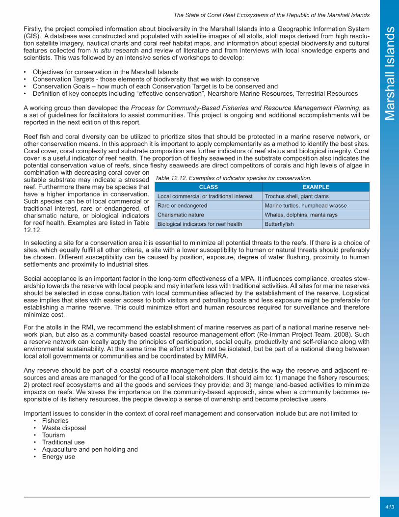
The State of Coral Reef Ecosystems of the Republic of the Marshall Islands
413
Mar
shal
l Isl
ands
Firstly, the project compiled information about biodiversity in the Marshall Islands into a Geographic Information System (GIS). A database was constructed and populated with satellite images of all atolls, atoll maps derived from high resolu-tion satellite imagery, nautical charts and coral reef habitat maps, and information about special biodiversity and cultural features collected from in situ research and review of literature and from interviews with local knowledge experts and scientists. This was followed by an intensive series of workshops to develop:
• Objectives for conservation in the Marshall Islands• Conservation Targets - those elements of biodiversity that we wish to conserve• Conservation Goals – how much of each Conservation Target is to be conserved and• Definition of key concepts including “effective conservation”, Nearshore Marine Resources, Terrestrial Resources
A working group then developed the Process for Community-Based Fisheries and Resource Management Planning, as a set of guidelines for facilitators to assist communities. This project is ongoing and additional accomplishments will be reported in the next edition of this report.
Reef fish and coral diversity can be utilized to prioritize sites that should be protected in a marine reserve network, or other conservation means. In this approach it is important to apply complementarity as a method to identify the best sites. Coral cover, coral complexity and substrate composition are further indicators of reef status and biological integrity. Coral cover is a useful indicator of reef health. The proportion of fleshy seaweed in the substrate composition also indicates the potential conservation value of reefs, since fleshy seaweeds are direct competitors of corals and high levels of algae in combination with decreasing coral cover on suitable substrate may indicate a stressed reef. Furthermore there may be species that have a higher importance in conservation. Such species can be of local commercial or traditional interest, rare or endangered, of charismatic nature, or biological indicators for reef health. Examples are listed in Table 12.12.
In selecting a site for a conservation area it is essential to minimize all potential threats to the reefs. If there is a choice of sites, which equally fulfill all other criteria, a site with a lower susceptibility to human or natural threats should preferably be chosen. Different susceptibility can be caused by position, exposure, degree of water flushing, proximity to human settlements and proximity to industrial sites.
Social acceptance is an important factor in the long-term effectiveness of a MPA. It influences compliance, creates stew-ardship towards the reserve with local people and may interfere less with traditional activities. All sites for marine reserves should be selected in close consultation with local communities affected by the establishment of the reserve. Logistical ease implies that sites with easier access to both visitors and patrolling boats and less exposure might be preferable for establishing a marine reserve. This could minimize effort and human resources required for surveillance and therefore minimize cost.
For the atolls in the RMI, we recommend the establishment of marine reserves as part of a national marine reserve net-work plan, but also as a community-based coastal resource management effort (Re-Imman Project Team, 2008). Such a reserve network can locally apply the principles of participation, social equity, productivity and self-reliance along with environmental sustainability. At the same time the effort should not be isolated, but be part of a national dialog between local atoll governments or communities and be coordinated by MIMRA.
Any reserve should be part of a coastal resource management plan that details the way the reserve and adjacent re-sources and areas are managed for the good of all local stakeholders. It should aim to: 1) manage the fishery resources; 2) protect reef ecosystems and all the goods and services they provide; and 3) mange land-based activities to minimize impacts on reefs. We stress the importance on the community-based approach, since when a community becomes re-sponsible of its fishery resources, the people develop a sense of ownership and become protective users.
Important issues to consider in the context of coral reef management and conservation include but are not limited to:• Fisheries• Waste disposal• Tourism• Traditional use• Aquaculture and pen holding and• Energy use
ClaSS EXaMplELocal commercial or traditional interest Trochus shell, giant clams
Rare or endangered Marine turtles, humphead wrasse
Charismatic nature Whales, dolphins, manta rays
Biological indicators for reef health Butterflyfish
Table 12.12. Examples of indicator species for conservation.

The State of Coral Reef Ecosystems of the Republic of the Marshall Islands
414
Mar
shal
l Isl
ands ATOLL-SPECIFIC RECOMMENDATIONS
Rongelap Atoll In Rongelap Atoll, the resource assess-ment was conducted on reefs all around the atoll, spreading the survey effort relatively evenly. As a result, a map overlaying data for all biological criteria important for marine protected area selection shows “hotspots” where several criteria are fulfilled (Figure 12.23). We recommend a Rongelap reserve network that contains (but is not limited to) sites from several of these hotspots of con-servation value around the atoll.
The reefs around Rongelap Island merit special emphasis in this report. Rongelap Island will harbor the majority of the re-turning population of Rongelapese people. Thus all human activities such as fishing, waste disposal and boat traffic will be con-centrated in this area. However, some of the most diverse, healthy and unique reef for-mations in the RMI are found here. The site at Jaboan point, Southwest tip of Rongelap Island, is outstanding in reef health and di-versity and has already been ear-marked as a protected area by RalGov. The lagoon adjacent to Rongelap Island harbors many small patch reefs and bommies that support an extraordinary variety and abundance of life. Thus, special care should be administered during the resettlement program of Rongelap.
Namu Atoll:The sites that, according to the surveys, would be best for conservation have been chosen based on information on total percentage live coral cover, fish abundance, shark sightings and number of giant clams. Sites N19, N17, N20, N18 and N09 (all on the southwestern side of Namu) are the best sites in terms of faunistic richness, based on the above param-eters. They are therefore recommended for conservation measures. Moreover, site N06 (Bok passage in the northwest) and N16 (Anil pass in the southwest) should be preserved for their peculiarity, being pass environments (richer due to the current flush and transport of food and larvae) and having special features:
Majuro Atoll A number of locations were recommended for conservation sites. Exhibiting high coral cover and diversity, as well as abundant fish stocks and a complex topography, the sites to the east and west of Kolal-en (Calalin) pass were deemed well suited for conservation purposes. The southwest part of the Majuro Atoll (ocean side survey sites) was also high-lighted for conservation priority due to high coral cover, fish abundance and the presence of sharks, turtles and Napoleon wrasses. Finally, a monitoring site off Rita Point with its extremely high coral cover, large Acropora tables and megafauna was included as another area well suited for conservation.
Ailuk AtollA striking difference between Ailuk’s residents and other atoll communities previously visited by NRAS was in the sense of natural dependency on their oceanic environment. This is probably related to the fact that in Ailuk strong signs of sus-tainable Marshallese culture can be seen beyond the land itself. For example, while both Namu and Ailuk still harvest and process coconut and pandanus for consumption and trade, the latter is the last example in RMI to heavily depend on outrigger canoes to fish and collect in remote islands of the atoll. This deeper traditional connection with the marine and terrestrial environment naturally increases people’s awareness of the strong dependence on a healthy reef for their livelihood, and consequently increases their interest in maintaining it. Moreover, the awareness and education meetings facilitated by the NRAS and Marine Resources Authority representatives helped enormously in increasing and expressing the natural feeling of the local people towards the preservation of resources.
The local community expressed concerns about having “fewer” and “thinner” fish. However this characterization did not seem to be borne out by the surveys. Although there are no baseline data for Ailuk against which to make a comparison, surveys of other atolls suggest that the marine resources of this atoll are quite healthy and deserving the people’s contin-ued good stewardship.
The islanders also expressed concern that they had to travel farther to fish. Given the size of the human population, the relatively small size of the atoll and no evidence of harmful fishing practices, any depletion of near-shore fishing populations
Figure 12.23. Map of biological integrity at Rongelap Atoll. The overlay shows crite-ria relevant to reserve selection. Source: Beger and Pinca 2003.

The State of Coral Reef Ecosystems of the Republic of the Marshall Islands
415
Mar
shal
l Isl
ands
must simply be the result of over-fishing. It stands to reason that the fish populations closest to the main village would experience the heaviest fishing pressure and hence be the first to suffer population declines.
Following the desire of the local people who have the understanding of the concept of importance and dependency on coral reefs, the obtained results were used to suggest the establishment of permanent no-fishing sites for long-term conservation of the ma-rine resources, crucial to ensuring overall marine resources health, especially under the threats of global climate change and in-creasing population (Figure 12.24). Specific areas with healthy populations were recom-mended for conservation. These are the areas with the most biomass aggregation and the feeding grounds to several pelagic species. It was suggested that the passes be extended to the adjacent reef areas near channel entrances, especially where spurs and grooves or giant bommies exist. These sites boast the highest coral and fish diversi-ties observed. Of the four passes surveyed, Enije (To-eje) channel seems to be the best food chain aggregator and the first natural choice for conservation. It appeared to be the richest site visited and analyzed, both in terms of fish and megafauna biomass. This pass was already proposed by the local gov-ernment of Ailuk as the community proposi-tion for a no-fishing area. In addition, it was suggested to preserve the area comprising the pinnacles, extending into Erappu (To-lap) channel and extending north to include Morok (Toon-malok) channel and adjacen-cies as well, especially the area around site A20, where a spotted eagle ray, terminal phase Cheilinus undulatus, Eretmochelys imbricata and a number of T. obesus sharks were spotted among coral bommies.
In addition to the passes, a goal of establishing 20% of the atoll in a system of permanent no-take areas representative of all the atoll’s marine habitats was recommended. Such percentage of an atoll surface is suggested by many conserva-tion scientists and was mentioned during the community meetings and finally accepted to being included in the Fishery Management Plans, which have been drafted by the Marine Resources Authority and the local fisheries committee with approval by the local council. The community accepted the recommended plan for conservation, but additional education and outreach would help the people understand that intact reef communities are better able to withstand natural fluctua-tions as well as catastrophic events such as hurricanes, and that these areas are an important source for breeding, re-population and spill-over.
Figure 12.24. Ailuk atoll and approved conservation sites (areas in green). Source: MIMRA.

The State of Coral Reef Ecosystems of the Republic of the Marshall Islands
416
Mar
shal
l Isl
ands REfEREnCES
Abraham, T., M. Berger, D. Burdick, E. Cochrane, P. Craig, G. Didonato, D. Fenner, A. Green, Y. Golbuu, J. Gutierrez, M. Hasurmai, C. Hawkins, P. Houk, D. Idip, D. Jacobson, E. Joseph, T. Keju, J. Kuartai, S. Palik, L. Penland, S. Pinca, K. Rikim, J. Starmer, M. Trianni, S. Victor, and L. Whaylen. 2005. Status of the coral reefs in Micronesia and American Samoa. pp 381-409. In: C. Wilkinson (ed.). Sta-tus of Coral Reefs of the World: 2004. Global Coral Reef Monitoring Network, Vol 2. Australian Institute of Marine Science, Townsville, Australia. 547 pp.
Armsworth, P.R. 2002. Recruitment limitation, population regulation, and larval connectivity in reef fish metapopulations. Ecology 83: 1092-1104.
Barnett, J. and N. Adger. 2001. Climate dangers and atoll countries. Working Paper 9. Tyndall Centre for Climate Change Research. Norwich, UK. 13 pp.
Beger, M. and S. Pinca. 2003. Coral reef biodiversity community-based assessment and conservation planning in the Marshall Islands: Baseline surveys, capacity building and natural protection and management of coral reefs of the atolls of Rongelap and Mili. Final Report to National Fishery and Wildlife Foundation. Majuro, Republic of the Marshall Islands. 38 pp. http://www.nras-conservation.org/publications.html.
Bellwood, D.R. and T.P. Hughes. 2001. Regional-scale assembly rules and biodiversity of coral reefs. Science 292(5521): 1532-1534.
Bruun, P. 1962. Sea-level rise as a cause of shore erosion. Journal Waterways and Harbours Division 88: 117-130.
Central Intelligence Agency (CIA). 2008. The World Factbook. https://www.cia.gov/library/publications/the-world-factbook/index.html.
Connell, J.H. 1997. Disturbance and recovery of coral assemblages. pp. 9-22. In: H.A. Lessios and I.G. Macintyre (eds.). Proceedings of the 8th International Coral Reef Symposium, Vol. 1. Panama City, Panama. 1040 pp.
Dickinson, W.R. 2006. Temper sands in prehistoric Oceanian pottery: geotectonics, sedimentology, petrography, provenance. Special Paper 406. The Geological Society of America. Boulder, CO. 171 pp.
English, S.A., C.R. Wilkinson, and V.J. Baker (eds.). 1997. Survey manual for tropical marine resources, 2nd edition. Australian Institute of Marine Science. Townsville, Australia. 402 pp.
Forbes, D.L. and S.M. Solomon. 1997. Approaches to vulnerability assessment on Pacific Island coasts: Examples from Southeast Viti Levu (Fiji) and Tarawa (Kiribati). Miscellaneous Report 277. South Pacific Applied Geoscience Commission (SOPAC). Suva, Fiji. 21 pp.
Fosberg, F.R. 1990. A review of the Natural History of the Marshall Islands. Atoll Res. Bull. 330. 99 pp.
Holthus, P., M. Crawford, C. Makroro, and S. Sullivan. 1992. Vulnerability assessment of accelerated sea-level rise-case study: Majuro Atoll, Marshall Islands. South Pacific Regional Environment Programme (SPREP) Reports and Studies Series 60. South Pacific Re-gional Environment Programme, Apia, Western Samoa. 107 pp.
Ikenoue, H. and K. Adachi. 2004. Majuro Atoll fisheries state research for community based fisheries management: Project for inshore fisheries resource study and management in atoll areas (atoll project). Marshall Islands Marine Resources Authority and Overseas Fisheries Cooperation Foundation. Majuro, Republic of the Marshall Islands.
Intergovernmental Panel On Climate Change (IPCC). 2007. Climate change 2007: Mitigation of Climate Change. Contribution of Working Group III to the Fourth Assessment Report of the Intergovernmental Panel on Climate Change. B. Metz, O.R. Davidson, P.R. Bosch, R. Dave, and L.A. Meyer (eds.). Cambridge University Press, Cambridge, UK and New York, NY. 851 pp. http://www.mnp.nl/ipcc/pages_media/AR4-chapters.html.
Jackson, J. B., C. Jackson, M.X. Kirby, W.H. Berger, K.A. Bjorndal, L.W. Botsford, B.J. Bourque, R.H. Bradbury, R. Cooke, J. Erland-son, J.A. Estes, T.P. Hughes, S. Kidwell, C.B. Lange, H.S. Lenihan, J.M. Pandolfi, C.H. Peterson, R.S. Steneck, M.J. Tegner, and R.R. Warner. 2001. Recent Collapse of Coastal Ecosystems. Science 293(5530): 629-637.
Jacobson, D.M. In preparation. Fine scale temporal and spatial dynamics of a Marshall Islands coral disease outbreak.
Kospartov, M., M. Beger, D.M. Ceccarelli, and Z.T. Richards. 2006. An assessment of the distribution and abundance of fish, coral, sea cucumbers, trochus, giant clam and invasive marine species at Ashmore Reef and Cartier Reef Commonwealth Marine Reserves: 2005. Report for the Department of Heritage and Environment, Australian Government. UniQuest, Queensland, Australia. 300 pp.
Madin, J.S. and S.R. Connolly. 2006. Ecological consequences of major hydrodynamic disturbances on coral reefs. Nature 444: 477-480.
McClanahan, T.R. and S. Mangi. 2001. The effect of a closed area and beach seine exclusion on coral reef fish catches. Fish. Manage. Ecol. 8(2): 107–121.
McKenzie, E., A. Woodruff, and C. McClennen. 2006. Economic assessment of the true costs of aggregate mining in Majuro Atoll, Republic of the Marshall Islands. South Pacific Applied Geoscience Commission (SOPAC). Suva, Fiji. 71 pp.

The State of Coral Reef Ecosystems of the Republic of the Marshall Islands
417
Mar
shal
l Isl
ands
Niedenthal, J. 2001. For the good of mankind: a history of the people of Bikini and their islands. Bravo Publishers. Majuro, Republic of the Marshall Islands. 226 pp.
Noshkin, V.E., R.J. Eagle, and W.L. Robison. 1997a. Fine and coarse components in surface sediments from Bikini lagoon. Report UCRL-ID-126358. Lawrence Livermore National Laboratory and U.S. Department of Energy. Livermore, CA. 27 pp.
Noshkin, V.E., W.L. Robison, K.M. Wong, J.L. Brunk, R.J. Eagle, and H.E. Jones. 1997b. Past and present levels of some radionuclides in fish from Bikini and Enewetak atolls. Health Phys. 73: 49-65.
Peterson, E.L., M. Beger, and Z.T. Richards. 2005. Hydrodynamics and biodiversity used to propose MPAs at Rongelap Atoll. pp. 27-31. In: J.C. Day, J. Senior, S. Monk, and W. Neal (eds.). Proceedings of the 1st International Marine Protected Areas Congress confer-ence (IMPAC 1). Geelong, Australia. 665 pp.
Peterson, E.L., M. Beger, and S. Pinca. 2006. Three dimensional model of atoll hydrodynamics. pp. 1434-1439. In: Y. Suzuki, T. Na-kamori, M. Hidaka, H. Kayanne, B.E. Casareto, K. Nadaoka, H. Yamano, and M. Tsuchiya (eds.). Proceedings of the 10th International Coral Reef Symposium. Okinawa, Japan. 1950 pp.
Pinca, S. 2001. Marine Resource and Biodiversity Identification and Survey: Likiep Atoll 2001, Final Report. Marshall Islands Marine Resources Authority. Republic of the Marshall Islands. 159 pp.
Pinca, S. 2003. Marshall Islands surveys to support a national effort towards reef conservation. Secretariat of the Pacific Community (SPC) Women in Fisheries Information Bulletin 13: 31-33. http://www.nras-conservation.org/nraslibrary/PincaSPC_2003.pdf.
Pinca, S. 2005. Majuro Marine Resources Assessment, 2004. National Resource Assessments Surveys (NRAS) – Conservation. Ma-juro, Republic of the Marshall Islands.
Pinca, S. 2006. Ailuk Marine Resources Assessments, 2006. National Resource Assessments Surveys (NRAS) – Conservation. Ma-juro, Republic of the Marshall Islands. 10 pp. http://www.nras-conservation.org/publications.html.
Pinca, S., M. Beger, and A. Hengeveld (eds.). 2004a. Mili Atoll Marine Surveys, 2003. National Resource Assessments Surveys (NRAS) - Conservation. Majuro, Republic of the Marshall Islands. http://www.nras-conservation.org/publications.html.
Pinca, S., M. Beger, and A. Hengeveld (eds.). 2004b. Rongelap Atoll Marine Surveys, 2003. National Resource Assessments Surveys (NRAS) - Conservation. Majuro, Republic of the Marshall Islands. 11 pp. http://www.nras-conservation.org/publications.html.
Pinca, S., M. Beger, D. Jacobson, and T. Keju. 2005. The State of Coral Reef Ecosystems of the Marshall Islands. pp. 373-386. In: J.E. Waddell (ed.). The State of Coral Reef Ecosystems of the United States and Pacific Freely Associated States: 2005. NOAA Technical Memorandum NOS NCCOS 11. Silver Spring, MD. 522 pp.
Rahmstorf, S. 2007. A semi-empirical approach to projecting future sea-level rise. Science 315 (5810): 367-370.
Re-Imman National Planning Team. 2008. Reimaanlok: National Conservation Area Plan for the Marshall Islands 2007-2012. Pub-lished by: N. Baker. 82 pp.
Richards, Z.T. and C.C. Wallace. 2004. Acropora rongelapensis sp. nov, a new species of Acropora from the Marshall Islands (Scler-actinia: Astrocoeniina: Acroporidae). Zootaxa 590: 1-5.
Richards, Z.T., M. Beger, S. Pinca, and C.C. Wallace. In press. Bikini Atoll coral biodiversity resilience revealed; five decades after nuclear testing. Mar. Poll. Bull.
Roberts, C.M., J.A. Bohnsack, F.R. Gell, J.P. Hawkins and R. Goodridge. 2001. Effects of marine reserves on adjacent fisheries. Sci-ence 294(5548): 1920-1923.
National Biodiversity Team of RMI. 2000. The Marshall Islands-Living Atolls Amidst the living Sea. St. Hildegard Publishing Company. Santa Clarita, CA. 345 pp.
Sladek Nowlis, J.S. and C.M. Roberts. 1999 Fisheries benefits and optimal design of marine reserves. Fish. Bull. 97: 604-616.
Smith, R. and J. Collen. 2004. Sand and gravel resources of Majuro Atoll, Marshall Islands. SOPAC Technical Report 360. South Pacific Applied Geoscience Commission. Suva, Fiji. 126 pp. http://www.sopac.org/data/virlib/TR/TR0360.pdf.
Vander Velde, N. and B. Vander Velde. 2006. Mary’s bean and other small drift materials of plant origin found on Bikini Atoll. Plant Spe-cies Biol. 21: 41-48.
Weissler, M.I. 2001. Precarious landscapes: prehistoric settlement in the Marshall Islands. Antiquity 75: 31-32.
Willis, B. James Cook University. Townsville, Australia. Personal communication.
Yamaguchi, T., M. Chikamori, H. Kayanne, H. Yamano, H. Yokoki, and Y. Najima. 2006. Conditions and activities supporting early prehistoric human settlement on Majuro Atoll in Marshall Islands, Eastern Micronesia. pp. 1549-1555. In: Y. Suzuki, T. Nakamori, M. Hidaka, H. Kayanne, B.E. Casareto, K. Nadaoka, H. Yamano, and M. Tsuchiya (eds.). Proceedings of the 10th International Coral Reef Symposium. Okinawa, Japan. 1950 pp.