the spatial dimensions of native title - centre … spatial dimensions of native title clare...
TRANSCRIPT

The Spatial Dimensions of Native Title
Clare Brazenor
A thesis submitted in fulfillment ofthe requirements for the degree of
Master of Geomatics Science
August, 2000
Supervisors:
Professor Ian Williamson
Mr Cliff Ogleby
Department of GeomaticsThe University of Melbourne

i
P R E A M B L E
This research does not attempt to right the wrongs of Australian history, nor does the
author speak or represent the views of indigenous Australians. The research focuses on
the spatial dimensions of the Native Title Act 1993 (Cth) of Australia.
‘from little things big things grow’
(Paul Kelly)
i i
A B S T R A C T
The importance currently placed on sustainable development recognises the
fundamental role of land administration and the management of land based resources.
This acknowledgement of the pivotal role of land administration and tenure security
reinforces the need to recognise all interest and responsibilities in land, particularly
those of a customary and traditional nature. The United Nations Draft Declaration on
the Rights of Indigenous Peoples (Pritchard 1998) respects the unique relationship
between indigenous people(s) and the land, recognising the need to protect these
traditions and cultures. A number of countries (specifically the United States of
America, Canada and New Zealand) have implemented legal and institutional
mechanisms for the recognition of this unique relationship and connection to land. In
doing so it provided the precedent for the recognition of interests in land as held by
indigenous peoples of Australia.
In Australia the legal recognition of indigenous interests in land occurred in 1992, with
the passing of the High Court’s decision concerning Mabo and others v the State of
Queensland (no.2) (1992) 175 CLR 1 and the subsequent development and
implementation of the Native Title Act 1993 (Cth). This federal act provides for the
recognition and protection of native title within the framework of the Australian legal
system. Its (native title interests) origins and foundations are those of traditional laws,
connecting indigenous Australians with land and waters (S223 NTA 1993).
The procedures and information requirements for the operation of the Native Title Act
1993are exhaustive. With numerous and varied spatial information sources required for
the lodgement, mediation and determination of native title applications. Explicitly, the
requirement to include a mapped representation and a worded description (S62 NTA
1993) detailing, with reasonable certainty (S190(B)2 NTA 1993), the external
boundaries of native title. This requirement to supply spatial information introduces
fundamental issues associated with the cartographic representation of indigenous forms
of land tenure, the assumption of scientific cartographic knowledge and the
presumption of access to appropriate spatial information resources applicants or
representatives. The significance of these assumptions and the problems inherent in
accurate determination and delineation of native title claim areas are not to be
underestimated (French 1998).
i i i
To address these issues applications for native title, were analysed to determine the
methods currently employed by applicants or representative in mapping native title
claim areas. The analysis of native title applications further highlighted the technical
and cultural considerations inherent in determining and delineating claim areas.
The spatial dimensions and the technical and cultural considerations to be accounted for
when determining and delineating the extents of native title, may be represented
through the aid and application of Geographical Information Systems (GIS). A GIS
prototype (the Native Title Applications Manager) has been developed as part of this
research, targeting applicants and representatives with limited cartographic or GIS
knowledge, the prototype aims to assist with the representing, analysing and managing
of spatial information as required by the Native Title Act 1993.

iv
D E C L A R A T I O N
This is certify that this thesis:
(a) Has not been submitted for a higher degree at any other University or
Institution;
(b) The thesis is approximately 30,000 words in length.
Clare Alison Brazenor

v
The following publication has resulted from this research;
Brazenor, C., Ogleby, C., Williamson, I. 1999, ‘The spatial dimension of Aboriginal
land tenure’, Paper presented at the 6th South East Asian Surveyors Congress,
incorporating the 40th Australian Surveyors Congress, The Institution of Surveyors
Australia, 1-6 November 1999, Fremantle, Western Australia.

vi
A C K N O W L E D G E M E N T S
I would like to sincerely thank the support of Professor Ian Williamson and Mr Cliff
Ogleby for their constant and dedicated supervision provided throughout the
undertakings of this research.
I would like to thank the members of the Cadastral Systems and Spatial Data
Infrastructures Research Group in the Department of Geomatics, the University of
Melbourne namely Serryn Eagleson, Sam Majid, Jessica Smith, Francisco Escobar,
Lisa Ting, Mary Ellen Feeney, Wolfgang Effenberg, Daniel Steudler, Mal Park, Abbas
Rajabifard. Additionally, the support of Land Victoria of the Victorian Government and
the Australian Research Council (ARC) (Grant No. C49930403).
The assistance provided by the staff at the National Native Title Tribunal Geospatial
Unit, and members of Mirimbiak Nations Aboriginal Corporation, is greatly
appreciated.
My family and friends for their unending good humour.

vii
T A B L E O F C O N T E N T S
ABSTRACT...................................................................................................................... II
DECLARATION .............................................................................................................. IV
ACKNOW LEDGEMENTS ............................................................................................... VI
TABLE OF CONTENTS ................................................................................................VII
LIST OF FIGURES ........................................................................................................XII
LIST OF TABLES .........................................................................................................XIII
LIST OF LEGISLATION ................................ ................................ ............................. XIV
TABLE OF APPENDICES .......................................................................................... XVI
ABREVEATIONS ................................ ................................ ................................ ........ XVII
CHAPTER 1 ................................ ................................ ................................ ..................... 1
1 INTRODUCTION ........................................................................................................ 1
1.1 Concepts ................................ ................................ ................................ ............. 2
1.1.1 Land and Water ............................................................................................ 2
1.1.2 Land Tenure ................................ ................................ ................................ . 3
1.1.3 Cadastre ....................................................................................................... 3
1.1.4 Native Title ................................................................................................... 3
1.1.5 Geographical Information Systems................................ ............................. 4
1.2 Research Review ................................................................................................ 5
1.2.1 Problem Statement ...................................................................................... 5
1.2.2 Hypothesis .................................................................................................... 5
1.2.3 Research Objectives .................................................................................... 5
1.2.4 Research Methodologies ................................ ................................ ............. 6
1.3 Research Significance ....................................................................................... 7
1.4 Research Scope .................................................................................................. 8
1.5 Thesis Structure ................................ ................................ ................................ . 9
CHAPTER 2 - INTERNATIONAL NATIVE TITLE ...................................................... 11
2 INTRODUCTION ...................................................................................................... 11
2.1 Sustainable Development ................................ ................................ ............... 12
2.1.1 Agenda 21 .................................................................................................. 12
2.2 The World Bank ................................................................................................ 13

viii
2.3 International Federation of Surveyors .......................................................... 14
2.3.1 Statement on the Cadastre........................................................................ 14
2.3.2 Bogor Declaration ...................................................................................... 15
2.3.3 Cadastre 2014............................................................................................ 15
2.3.4 Bathurst Declaration .................................................................................. 16
2.4 Draft Declaration on the Rights of Indigenous Peoples ............................. 17
2.5 International Precedents ................................................................................. 19
2.5.1 The United States of America.................................................................... 19
2.5.2 Canada ................................ ................................ ................................ ....... 20
2.5.3 New Zealand .............................................................................................. 22
2.6 Chapter Summary............................................................................................. 24
CHAPTER 3 - THE AUSTRALIAN LAND TENURE S YSTEM ................................ ... 25
3 INTRODUCTION ...................................................................................................... 25
3.1 Land Tenure System of Indigenous Australians .......................................... 26
3.1.1 Spiritual Connection................................ ................................ ................... 27
3.1.2 Material and Resources ............................................................................. 27
3.1.3 Traditional Limits........................................................................................ 28
3.1.4 Overlapping Interests ................................................................................. 31
3.1.5 Documentation of Traditional Interests ..................................................... 31
3.1.6 Dynamic Nature .......................................................................................... 32
3.1.7 Custodianship............................................................................................. 32
3.1.8 Diversity...................................................................................................... 33
3.1.9 Offshore ...................................................................................................... 33
3.2 Australian cadastral system ................................ ................................ ........... 35
3.2.1 Maritime Boundaries of Australia .............................................................. 36
3.2.2 Torrens Boundaries.................................................................................... 37
3.2.3 Victoria ................................ ................................ ................................ ....... 38
3.3 Review of Land Tenure Systems .................................................................... 39
3.4 Chapter Summary............................................................................................. 41
CHAPTER 4 - NATIVE T ITLE ...................................................................................... 42
4 INTRODUCTION ...................................................................................................... 42
4.1 High Court Decisions ................................ ................................ ....................... 43
4.1.1 Mabo and others v State of Queensland................................ ................... 43
ix
4.1.2 The Wik peoples v State of Queensland................................ ................... 44
4.2 The Nati ve Title Act .......................................................................................... 45
4.2.1 Defining Native Title................................ ................................ ................... 45
4.2.2 Native Title Amendments................................ ................................ ........... 46
4.2.3 Indigenous Land Use Agreements ............................................................ 46
4.2.4 State and Territories .................................................................................. 48
4.3 Native Title – Offshore ..................................................................................... 49
4.4 Native Title Procedures ................................ ................................ ................... 51
4.4.1 The Registration Test ................................................................................ 51
4.5 Spatial Information Requirements ................................................................. 53
4.5.1 Guidelines and Policies ............................................................................. 54
4.6 Spatial Extent of Native Title .......................................................................... 56
4.7 Implications of Native Title ............................................................................. 58
4.7.1 Natural Resources ..................................................................................... 58
4.7.2 Mining ......................................................................................................... 58
4.7.3 Property ...................................................................................................... 59
4.7.4 Social .......................................................................................................... 59
4.8 Chapter Summary............................................................................................. 60
CHAPTER 5 - DIMENSIO NS OF NATIVE TITLE ................................ ....................... 61
5 INTRODUCTION ...................................................................................................... 61
5.1 Native Title Application Analysis ................................ ................................ ... 62
5.1.1 Analysis Procedures .................................................................................. 63
5.1.2 Analysis Outcomes .................................................................................... 63
5.1.3 Analysis Conclusions ................................................................................. 65
5.2 Technical and Cultural Considerations ......................................................... 66
5.2.1 Notion of Property ...................................................................................... 67
5.2.2 External Boundaries................................ ................................ ................... 68
5.2.3 Notion of Ownership and Responsibility ................................ ................... 68
5.2.4 Time Dimension ......................................................................................... 68
5.2.5 Community Diversity .................................................................................. 69
5.2.6 Overlapping Claim Areas ................................ ................................ ........... 69
5.2.7 Extinguishment................................ ................................ ........................... 69
5.2.8 Spatial Information Requirements ............................................................. 70
x
5.2.9 Offshore and Water Bodies ................................ ................................ ....... 70
5.3 The Spatial Dimensions of Native title .......................................................... 71
5.4 Chapter Summary............................................................................................. 73
6 INTRODUCTION ...................................................................................................... 74
6.1 Geographical Information Systems ................................ ............................... 75
6.1.1 Components of GIS .................................................................................... 75
6.2 GIS Design ........................................................................................................ 76
6.2.1 Objectives and Requirements.................................................................... 77
6.2.2 User Requirements .................................................................................... 77
6.2.3 Data Requirements .................................................................................... 78
6.2.4 Design and Funct ional i ty ................................ ................................ ........... 78
6.2.5 Legal Considerations ................................................................................. 79
6.3 GIS applications in Land Administration ...................................................... 80
6.3.1 Land Information Systems ......................................................................... 80
6.4 GIS for Native Title ................................ ................................ ........................... 81
6.5 GIS applications - Canada and the NNTT ...................................................... 84
6.5.1 Canada ................................ ................................ ................................ ....... 84
6.5.2 National Native Title Tribunal .................................................................... 85
6.6 Chapter Summary............................................................................................. 87
CHAPTER 7 - GIS PROTOTYPE FOR NATIVE TITLE APPLICATIONS ................. 88
7 INTRODUCTION ...................................................................................................... 88
7.1 GIS Prototype for Native Title ......................................................................... 89
7.1.1 Objectives................................ ................................ ................................ ... 89
7.1.2 Required Functionalities ............................................................................ 90
7.1.3 Requirements ............................................................................................. 91
7.1.4 Design Specifications ................................................................................ 92
7.1.5 Data Specification ...................................................................................... 93
7.2 Wotjobaluk Native Title Application .............................................................. 94
7.2.1 Data Preparation ........................................................................................ 95
7.3 Review of Native Title Applications Manager ................................ ............... 97
7.4 Evaluation ....................................................................................................... 107
7.4.1 Evaluation Criteria ................................................................................... 108
7.5 Limitations ...................................................................................................... 110

xi
7.6 Future Development ....................................................................................... 112
7.6.1 Victorian Land Information System ................................ ......................... 112
7.7 Chapter Summary........................................................................................... 115
CHAPTER 8 – FUTURE TECHNOLOGIES AND NATIVE TITLE ........................... 116
8 INTRODUCTION .................................................................................................... 116
8.1 Technology ................................ ................................ ................................ ..... 117
8.1.1 Positioning Sys tems................................ ................................ ................. 117
8.1.2 Imagery ................................ ................................ ................................ ..... 118
8.1.3 Multimedia ................................................................................................ 118
8.1.4 Dissemination - World Wide Web ............................................................ 119
8.2 Future of Native Title ................................ ................................ ..................... 120
8.3 Future of Spatial Information and Native Title ........................................... 121
8.3.1 Indigenous Knowledge Systems.............................................................. 121
8.3.2 Cadastral Information .............................................................................. 121
8.3.3 Australian Spatial D ata Infrastructure ................................ ..................... 122
CHAPTER 9- CONCLUSIO NS ................................................................................... 123
9 RESEARCH SUMMARY ....................................................................................... 124
9.1 Conclusions .................................................................................................... 125
9.2 Future Research and Recommendations .................................................... 129
10 REFERENCES ................................ ................................ ................................ . 130
11 DEFINITIONS .................................................................................................. 136
12 APPENDICES .................................................................................................. 139

xii
L I S T O F F I G U R E S
Figure (2.1) – Cadastre 2014 .............................................................................................................................15
Figure (3.1) – Topography...................................................................................................................................29
Figure (3.2) – Sacred sites.................................................................................................................................. 30
Figure (3.3) – Songlines.......................................................................................................................................30
Figure (3.4) – Overlapping interests ................................................................................................................31
Figure (3.5) – Review of land tenure systems..............................................................................................39
Figure (6.1) – Hierarchy of spatial information for native title applications .........................................82
Figure (6.2) – Overlay analysis of applications ............................................................................................86
Figure (7.1) –Prototype, required functionalities ..........................................................................................90
Figure (7.2) – Prototype, user requirements of the GIS prototype ........................................................91
Figure (7.3) – Prototype, data and information requirements ................................................................. 91
Figure (7.4) – Prototype, requirements of the Native Title Act 1993 ....................................................92
Figure (7.5) – Prototype, design functionalities............................................................................................93
Figure (7.6) – VC95/02 (Wotjobaluk) native title application area .........................................................94
Figure (7.7) – Cross correlation of parcels ....................................................................................................96
Figure (7.8) – Input and Update functions of the Native Title Application Manager........................97
Figure (7.9) – Tools, Native Title Applications Manager...........................................................................99
Figure (7.10) –National Parks and attached images................................................................................100
Figure (7.11) – Other Native Title Applications ..........................................................................................101
Figure (7.12) – Cadastral information (VC95/02) ......................................................................................101
Figure (7.13) – Cadastral information (VC95/02) ......................................................................................102
Figure (7.14) – Crown Land identified by both the Applicant and the Geospatial U nit................102
Figure (7.15) – Crown land not identified by the Applicant....................................................................103
Figure (7.16) – Information categories and relationships .......................................................................103
Figure (7.17) – Initial switchboard screen....................................................................................................104
Figure (7.18) - Edit information from the GIS interface ...........................................................................106
Figure (7.19) – Function priority and performance rank..........................................................................107
Figure (7.20) – Cadastral layers ......................................................................................................................110
Figure (7.21) – Selection of parcels according to annotations .............................................................111
Figure (7.22) – VLIS, query...............................................................................................................................114

xiii
L I S T O F T A B L E S
Table (2.1) – Comparison between the United States of America’s recognition of Indian title and Australia’s recognition of native title. ...............................................................................................................20
Table (2.2) – Comparison between Canada and Australia - the recognition of Aboriginal rights and title and native title.........................................................................................................................................21
Table (3.1) – Maritime zones of Australia ......................................................................................................36
Table (4.1) –Native Title, Aboriginal land and sacred sites Legislation ...............................................48
Table (5.1) – Technical and cultural considerations ...................................................................................67
Table (6.1) – GIS for native title purposes .....................................................................................................81
Table (7.1) – Native Title Applications Manager, spatial data themes.................................................98
Table (7.2) – Table of i nformation required for native title applications .............................................104
Table (7.3) – Geographical information input parameters......................................................................105
Table (7.4) – Claimant contact information ..................................................................................................105
Table (7.5) – NNTT contact information .......................................................................................................105
Table (7.6) – Evaluation Criteria......................................................................................................................108
Table (7.7) – Comparison of Native Title Applications Manager and VLIS ......................................115
xiv
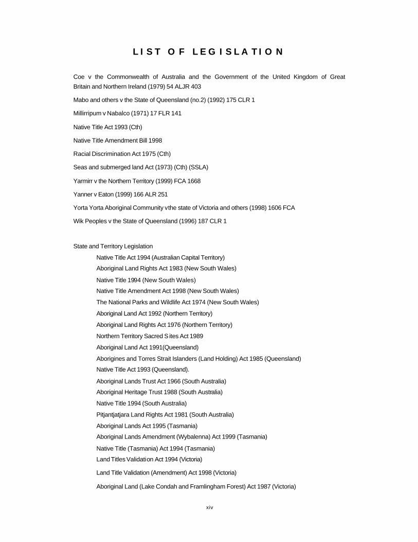
L I S T O F L E G I S L A T I O N
Coe v the Commonwealth of Australia and the Government of the United Kingdom of Great
Britain and Northern Ireland (1979) 54 ALJR 403
Mabo and others v the State of Queensland (no.2) (1992) 175 CLR 1
Millirripum v Nabalco (1971) 17 FLR 141
Native Title Act 1993 (Cth)
Native Title Amendment Bill 1998
Racial Discrimination Act 1975 (Cth)
Seas and submerged land Act (1973) (Cth) (SSLA)
Yarmirr v the Northern Territory (1999) FCA 1668
Yanner v Eaton (1999) 166 ALR 251
Yorta Yorta Aboriginal Community v the state of Victoria and others (1998) 1606 FCA
Wik Peoples v the State of Queensland (1996) 187 CLR 1
State and Territory Legislation
Native Title Act 1994 (Australian Capital Territory)
Aboriginal Land Rights Act 1983 (New South Wales)
Native Title 1994 (New South Wales)
Native Title Amendment Act 1998 (New South Wales)
The National Parks and Wildlife Act 1974 (New South Wales)
Aboriginal Land Act 1992 (Northern Territory)
Aboriginal Land Rights Act 1976 (Northern Territory)
Northern Territory Sacred S ites Act 1989
Aboriginal Land Act 1991(Queensland)
Aborigines and Torres Strait Islanders (Land Holding) Act 1985 (Queensland)
Native Title Act 1993 (Queensland).
Aboriginal Lands Trust Act 1966 (South Australia)
Aboriginal Heritage Trust 1988 (South Australia)
Native Title 1994 (South Australia)
Pitjantjatjara Land Rights Act 1981 (South Australia)
Aboriginal Lands Act 1995 (Tasmania)
Aboriginal Lands Amendment (Wybalenna) Act 1999 (Tasmania)
Native Title (Tasmania) Act 1994 (Tasmania)
Land Titles Validation Act 1994 (Victoria)
Land Title Validation (Amendment) Act 1998 (Victoria)
Aboriginal Land (Lake Condah and Framlingham Forest) Act 1987 (Victoria)

xv
Property Law Act 1958 (Victoria)
Transfer of Land Act 1958 (Victoria)
Subdivisions Act 1988 (Victoria)
Land Administration Act 1997 (Western Australia)
Titles Validation Act 1995 (Western Australia)
Aboriginal Heritage Act 1972 (Western Australia)
International Legislation
Cherokee Nations v Georgia (the United States of America)
Delgamuukw v British Columbia (1977) (Canada)
Calder v Attorney-General of British Columbia (1973) (Canada)
Crown Lands Protection Act 1839 (Canada)
The Indian Act 1876 (Canada)
New Zealand Settlement Act 1863 (New Zealand)
Te Turee Whenua Act 1993 (New Zealand)
xvi
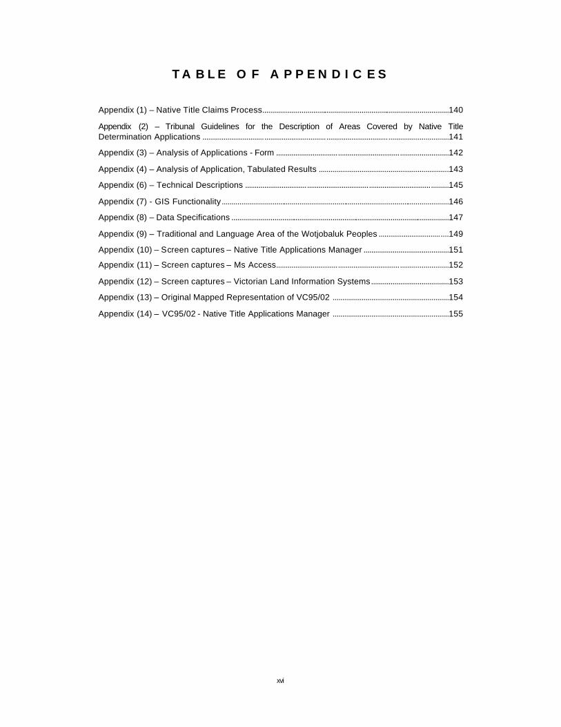
T A B L E O F A P P E N D I C E S
Appendix (1) – Native Title Claims Process................................................................................................140
Appendix (2) – Tribunal Guidelines for the Description of Areas Covered by Native Title Determination Applications ...............................................................................................................................141
Appendix (3) – Analysis of Applications - Form .........................................................................................142
Appendix (4) – Analysis of Application, Tabulated Results ...................................................................143
Appendix (6) – Technical Descriptions .........................................................................................................145
Appendix (7) - GIS Functionality.....................................................................................................................146
Appendix (8) – Data Specifications ................................................................................................................147
Appendix (9) – Traditional and Language Area of the Wotjobaluk Peoples ....................................149
Appendix (10) – Screen captures – Native Title Applications Manager ............................................151
Appendix (11) – Screen captures – Ms Access.........................................................................................152
Appendix (12) – Screen captures – Victorian Land Information Systems........................................153
Appendix (13) – Original Mapped Representation of VC95/02 ............................................................154
Appendix (14) – VC95/02 - Native Title Applications Manager ............................................................155
xvii
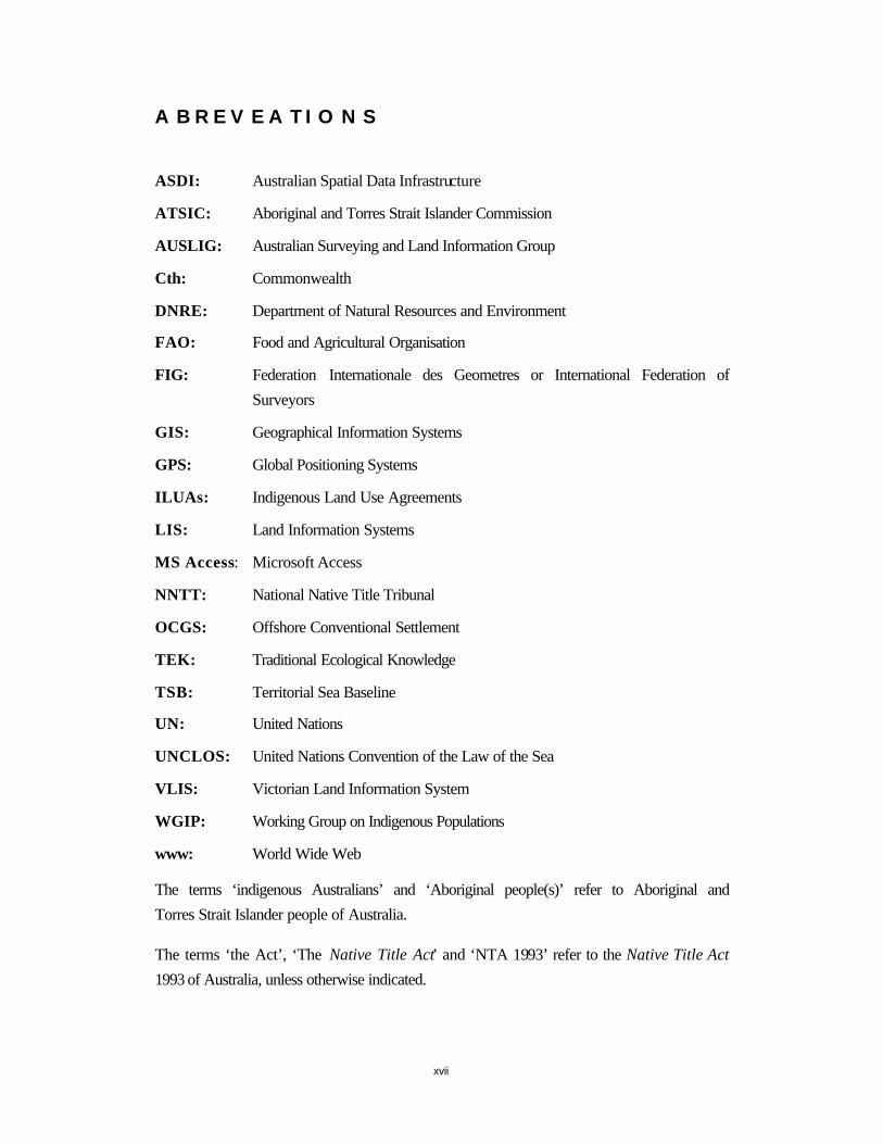
A B R E V E A T I O N S
ASDI: Australian Spatial Data Infrastructure
ATSIC: Aboriginal and Torres Strait Islander Commission
AUSLIG: Australian Surveying and Land Information Group
Cth: Commonwealth
DNRE: Department of Natural Resources and Environment
FAO: Food and Agricultural Organisation
FIG: Federation Internationale des Geometres or International Federation of
Surveyors
GIS: Geographical Information Systems
GPS: Global Positioning Systems
ILUAs: Indigenous Land Use Agreements
LIS: Land Information Systems
MS Access: Microsoft Access
NNTT: National Native Title Tribunal
OCGS: Offshore Conventional Settlement
TEK: Traditional Ecological Knowledge
TSB: Territorial Sea Baseline
UN: United Nations
UNCLOS: United Nations Convention of the Law of the Sea
VLIS: Victorian Land Information System
WGIP: Working Group on Indigenous Populations
www: World Wide Web
The terms ‘indigenous Australians’ and ‘Aboriginal people(s)’ refer to Aboriginal and
Torres Strait Islander people of Australia.
The terms ‘the Act’, ‘The Native Title Act’ and ‘NTA 1993’ refer to the Native Title Act
1993 of Australia, unless otherwise indicated.

1
C H A P T E R 1
1 I N T R O D U C T I O N
Australia is a land of cultural and geographic diversity, located in the southern hemisphere with a total land mass of approximately 7 692 024 square kilometres and a coast line that spans 59 736 kilometres (AUSLIG 2000a). Inhabited for over 40 000 thousand years (Berndt 1988) by indigenous Australians and more recently colonised by European settlement in 1788. The settlement of what is known today as Australia was on the premise of terra nullius or land belonging to no-one, which subsequently formed the basis of the Australian legal framework and Australian property law. The legal system of Australia derives from English Common Law and the system of Government is based on the Westminster system. Australia has eight jurisdictions, six states, New South Wales, Queensland, South Australia, Tasmania, Victoria and Western Australia and two territories, the Australian Capital Territory and the Northern Territory. Today, the population of Australia surges towards twenty million, with a population of indigenous Australians (both Aboriginal and Torres Strait Islanders) constituting approximately two percent of Australia’s total population (ABS 2000a).
It was not until the 1960s that indigenous Australians were permitted to vote in government elections, of significance was the 1967 Commonwealth referendum on the involvement of the Commonwealth government and Aboriginal affairs. The referendum received an unprecedented 90.77% of a yes vote towards a greater involvement of the Commonwealth government involvement in the area of Aboriginal affairs. The passing of the Racial Discrimination Act 1975, further recognised the existence and importance of the indigenous communities and peoples of Australia. More recently it has been with the passing of the High Court’s decisions of Mabo and others v State of Queensland with the rejection of terra nullius and the subsequent conception and implementation of the Native Title Act 1993(Cth), that the rights and interests of indigenous interests in land are legally recognised. It is this recognition of indigenous interests in land, through the operation of the Native Title Act 1993, that ‘forces us (as a nation) to confront the previously invisible history of our indigenous peoples and their connection to this country’ (French 1998, p 90).
This research details the land tenure systems of indigenous Australians, the operation of the Australian cadastral system (incorporating the Torrens system of title registration) and the procedures and spatial information requirements of the Native Title Act 1993. Furthermore, this research analyses methods employed in determining and representing the external boundaries of current native title applications and investigates the appropriate use of geomatic technologies, namely Geographical Information Systems, for the purposes of native title.
This chapter introduces concepts used throughout the thesis, reviews the problem statement and hypothesis, research objectives and methodologies and details the significance and scope of this research.

2
1.1 CONCEPTS
The following are primary concepts used throughout the thesis:
1.1.1 LA N D A N D W ATER
It is important to acknowledge that the concept of land and the meaning of land differs
according to cultural, social, educational, economic, environmental, legal, technical and
historical influences (Henssen 1996).
Land is described in Western contexts as ‘an area of the surface of the earth together
with the water, soil, rocks, minerals and hydrocarbons beneath or upon it and the air
above it. It embraces all things which are related to a fixed area or point of the surface
of earth’ (Kaufmann & Steudler 1998, p 22).
The term land or country within the traditional culture of indigenous Australians may
be referenced by the observations of Rose (1996):
‘People talk about country in the same way that they would talk about a person; they speak to country, sing to country, visit country, worry about country, feel sorry for country, and long for country. People say that country knows, hears, smells, takes notice, takes care, is sorry or happy… Rather country is a living entity with a yesterday, today and tomorrow, with a consciousness, and a will toward life. Because of this richness, country is home, and peace; nourishment for body, mind, and spirit; hearts ease’.
For the purposes of the Native Title Act 1993(Cth), land and waters are defined
separately, with marked differences between land and water. Land is defined as
including ‘the airspace over, or the subsoil under land’ (S253 NTA 1993).
The definition provided by Section 253 of the Native Title Act 1993(Cth) for water
includes:
(a) sea, a river, a lake, a tidal inlet, a bay, an estuary, a harbour or subterranean waters; or
(b) the bed or subsoil under, or airspace over, any waters
(c) the shore, or subsoil under or airspace over the shore, between high water and low water.
3
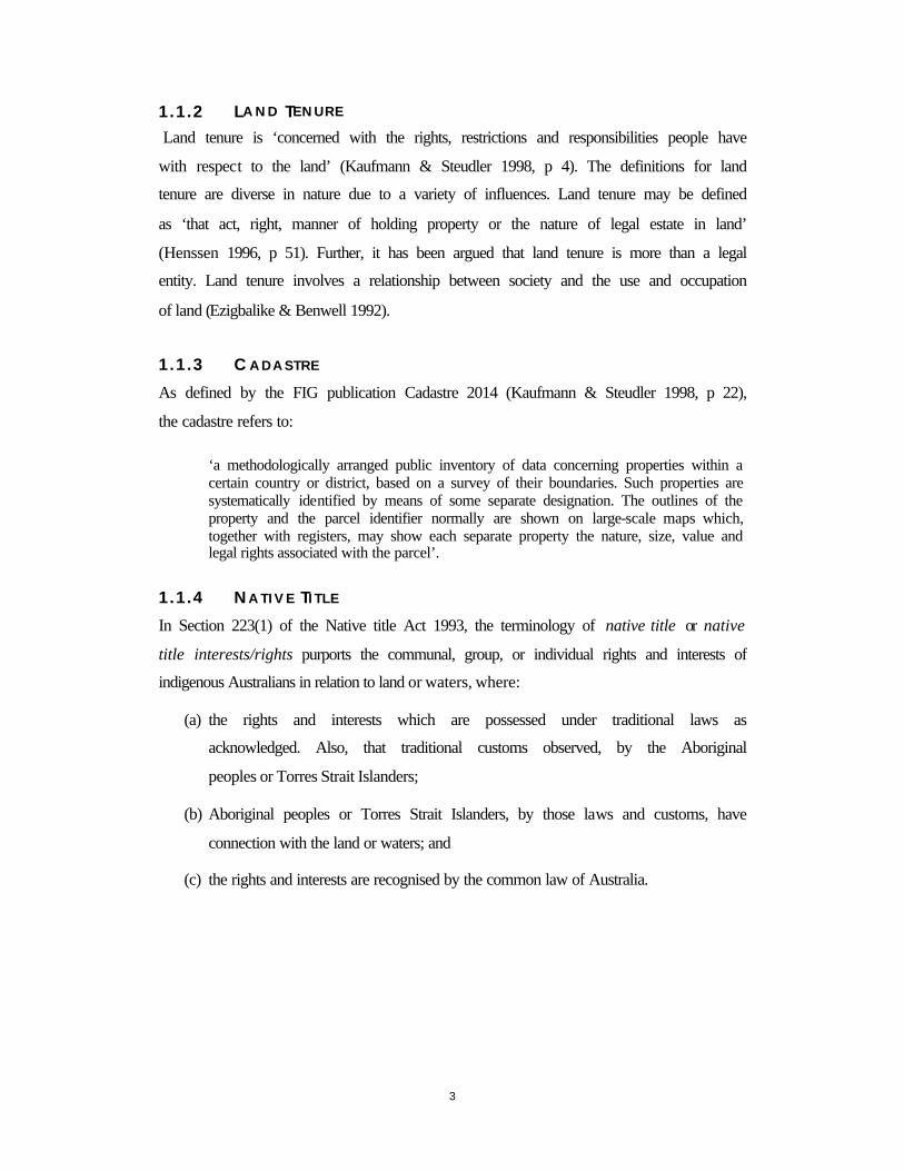
1.1.2 LA N D TE N U R E
Land tenure is ‘concerned with the rights, restrictions and responsibilities people have
with respect to the land’ (Kaufmann & Steudler 1998, p 4). The definitions for land
tenure are diverse in nature due to a variety of influences. Land tenure may be defined
as ‘that act, right, manner of holding property or the nature of legal estate in land’
(Henssen 1996, p 51). Further, it has been argued that land tenure is more than a legal
entity. Land tenure involves a relationship between society and the use and occupation
of land (Ezigbalike & Benwell 1992).
1.1.3 C ADASTRE
As defined by the FIG publication Cadastre 2014 (Kaufmann & Steudler 1998, p 22),
the cadastre refers to:
‘a methodologically arranged public inventory of data concerning properties within a certain country or district, based on a survey of their boundaries. Such properties are systematically identified by means of some separate designation. The outlines of the property and the parcel identifier normally are shown on large-scale maps which, together with registers, may show each separate property the nature, size, value and legal rights associated with the parcel’.
1.1.4 NA T I V E TI T L E
In Section 223(1) of the Native title Act 1993, the terminology of native title or native
title interests/rights purports the communal, group, or individual rights and interests of
indigenous Australians in relation to land or waters, where:
(a) the rights and interests which are possessed under traditional laws as
acknowledged. Also, that traditional customs observed, by the Aboriginal
peoples or Torres Strait Islanders;
(b) Aboriginal peoples or Torres Strait Islanders, by those laws and customs, have
connection with the land or waters; and
(c) the rights and interests are recognised by the common law of Australia.
4
1.1.5 G E O G R A P H I C A L IN F O R M A T I O N S Y S T E M S
The term Geographical Information Systems (GIS) is now used generally for any
computer based capability for the manipulation of spatial data. A GIS includes not only
hardware and software components, but also specialised devices used to input spatial
data and create map products, together with communication systems (Bernhardsen
1999).
The definition of GIS, as ‘a powerful set of tools for collecting, storing, retrieving at
will, transforming and displaying spatial data from the real world for a particular set of
purposes’ (Burrough 1998, p 11) has been adopted for the purposes of this research.

5
1.2 RESEARCH REVIEW
The research review consists of the problem statement, a research hypothesis as well as
the research objectives and methodologies, detailed below.
1.2.1 PROBLEM S T A T E M E N T
According to Section 62(2) of the Native Title Act 1993, applications are to include a
technical description and a mapped representation depicting with ‘reasonable certainty’
(190(B)2 NTA 1993) the external boundaries that constitute the native title claim area.
It is this assumption of scientific cartographic knowledge and the presumption of access
to spatial information resources by that of the applicants or representatives, which is
impeding the efficient and effective operation of the Act.
1.2.2 HY P O T H E S I S
The application of Western techniques and geomatic technologies for mapping native
title, incorporating an awareness of the spatial requirements and cultural considerations
of indigenous Australians, may assist with the determination and documentation of
native title through cartographic mediums as requested by the Native Title Act 1993.
1.2.3 R ESEARCH O BJECT IVES
The objectives of this research include investigating:
• The international initiatives and directives in recognising and protecting the
traditional and cultural relationships indigenous people(s) have with the land;
• The operation of two land tenure systems within Australia, namely that of
indigenous Australians and the Australian cadastral system. Further investigating,
the need to accommodate sustainable development directives and the United
Nations Draft Declaration on the Right of Indigenous Peoples, while being
accountable to the unique land tenure systems of indigenous Australians and the
operations of the Australian cadastral system;
• The procedures and spatial information requirements of the Native Title Act 1993,
determining the spatial dimensions and the cultural and technical considerations of
native title;

6
• The appropriate tools, from which the spatial dimensions of native title may be
determined, represented, analysed and associated spatial information managed; and
• The development of a GIS prototype, called the Native Title Applications Manager.
Developed primarily as a tool, whose purpose is to assist applicants and
representatives with the spatial requirements of native title.
1.2.4 R ESEARCH ME T H O D O L O G I E S
The research methodologies adopted investigates:
• The two land tenure systems of Australia and the operation of the Native Title Act 1993;
• The spatial requirements and cultural and technical considerations of native title; and
• The development of the Native Title Applications Manager for the purposes of assisting with the requirements and operation of the Native Title Act 1993.
The research methodology addresses the problem of assumed scientific cartographic
knowledge and the presumption of access to appropriate spatial information resources,
includes;
1. A research visit to the National Native Title Tribunal, The Geospatial Unit in Perth,
Western Australia during October 1999. During which information was collated providing a basis for an analysis of methods and techniques employed for
representing the external boundaries of claim areas;
2. Analysis of native title applications, focusing on the mapping and technical description as supplied. The applications have been collected from all jurisdictions
of Australia; and
3. The development of the GIS prototype assisting applicants and representative bodies with the collection, analysis, representation and management of native title
information.
Collaboration with a representative body was essential to collect information pertaining
to applications of native title. It should be noted that all information pertaining to the
native title application is publicly available from the National Native Title Tribunal.
This thesis, as written documentation of the research undertaken, does not contain any
culturally sensitive material.

7
1.3 RESEARCH S IGNIF ICANCE
The research has significance in a variety of fields including all levels of government;
mining, pastoral, natural resources and farming sectors; Aboriginal and Torres Strait
islander communities and those involved in the operation of the Native Title Act 1993.
The research focuses on indigenous Australians and their relationship with land, with a
review of international indigenous communities. The research has relevance
internationally with the recognition of indigenous interests and the global emphasis
being placed on the efficient and appropriate administration of land for sustainable
development prerogatives.
This research addresses many issues inherent in the cartographic representation of
indigenous forms of land tenure and the conflicts between Western and indigenous
concepts of land and lands tenure which are present in the operation of the Native Title
Act 1993.
The development of a tool to assist with the spatial and cartographic requirements of
native title and the recognition of indigenous interests in land will be flexible enough to
be transposed into similar scenarios as they occur in other countries or jurisdictions of
Australia.
Private sectors such as those in the mining industry require native title information for
planning and exploration purposes. The provision of native title information,
particularly the spatial component, will encourage investment by the private sector,
reducing uncertainty in land tenure. There exists the commercial opportunity for the
establishment of a service providing spatial information pertaining to native title
(Bowen 2000).

8
1.4 RESEARCH SC O P E
Core to this research is the understanding of the land tenure systems of indigenous
Australians, the operation of the Australian cadastral system and the procedures and
information requirements of the Native Title Act 1993. From this, it is possible to
identify the spatial dimensions of native title and the technical and cultural
considerations, which need to be accounted for when determining and delineating the
external boundaries of native title claim areas. Where possible the research has focused
on the State of Victoria.
The scope of this research is contained to the investigations of:
• International developments towards sustainable development and the recognition of indigenous interests in land through the United Nations Draft Declarations on the Rights of Indigenous Peoples and the precedents provided by the United States of
America, Canada and New Zealand for the recognition of indigenous interests in land;
• The land tenure system of indigenous Australians and the Australian cadastral system;
• The operations and spatial information requirements of the Native Title Act 1993;
• Analysis of native title applications lodged with the Federal Court of Australia and the Registrar of Claims (National Native Title Tribunal), highlighting the techniques and methods employed for determining and delineating the spatial extents of native
title;
• The identification of the technical and cultural considerations of native title;
• The application of GIS as a tool to assist with the recognition and protection of native title interests; and
• The development of a prototype GIS, specifically for use by applicants or their representative bodies, in the State of Victoria.
9
1.5 T HESIS ST R U C T U R E
The thesis, as written documentation of the research conducted, follows the structure
detailed below:
Chapter 1: Review the problem statement, research objectives and methodologies,
outlined the relevance and the scope of the research.
Chapter 2: Explore international experiences in recognising indigenous interests in
land. Organisations examined include the United Nations (UN), World Bank and the
Federation of International Surveyors (FIG) which all assist in facilitating initiatives of
sustainable development and land reform.
Chapter 3: Details the land tenure system of indigenous Australians and the Australian
cadastral system, highlighting the fundamental and conceptual differences of land, land
tenure, ownership and custodianship as well as the spatial extents of interests in land.
Chapter 4: Investigates the Native Title Act 1993, the High Court’s decisions on Mabo
and Wik and legislation relevant for native title. This chapter also outlines the
procedures and the spatial requirements of the Act, reviews native title offshore and the
implications of native title on such areas as resource management, mining and the
Australian property market.
Chapter 5: Analyses native title applications as lodged with the Federal Courts of
Australia and the National Native Title Tribunal (NNTT) with a focus on the spatial
information presented as part of the application. Details the cultural and technical
considerations inherent in determining and delineating native title.
Chapter 6: Reviews GIS concepts and design issues for the development of a GIS tool,
assisting applicants and representatives with the information requirements of native
title. Investigating, the applications of GIS in Canada for the purpose of managing
Traditional Ecological Knowledge Systems (TEK) as employed by a number of First
Nations, which subsequently supported land claims. Further, the use of GIS by the
Geospatial Unit of the NNTT for the sole purposes of facilitating the Native Title Act
1993 and managing the associated demand of spatial information.

10
Chapter 7: Examines the development objectives and technical specification of the
Native Title Applications Manager GIS prototype. Reviews its operation, evaluates
performance of the GIS and details the limitations and further development
opportunities of the prototype.
Chapter 8: Reviews additional technologies in furthering the capabilities of GIS in
managing, delineating, analysing and representing native title information.
Chapter 9: Research summary and conclusions.
11
C H A P T E R 2 - I N T E R N A T I O N A L N A T I V E T I T L E
2 I N T R O D U C T I O N
International directives as prepared by the United Nations (UN), The World Bank and the Federation of International Surveyors (FIG) stress the importance of promoting and supporting sustainable development through appropriate administration of land and resources. In addition, the UN Draft Declaration on the Rights of Indigenous Peoples emphasises the unique relationship between indigenous peoples and the land, reinforcing the need to recognise and protect the land tenure systems of traditional and customary origins.
The increasing awareness of indigenous forms of land tenure highlights the need for land administration systems to accommodate and acknowledge the dynamic humankind to land relationship, recognising that land policy is a source of social, economic and political stability (Neate 1999a).

12
2.1 SUSTAINABLE D EVELOPMENT
Sustainable development is a concept, a goal, an ideal for global, national and local
development of; technology, environment, economics and society. An accepted
definition of sustainable development is that offered by the World Commission on
Environment and Development (1987, p 89), in the publication Our Common Future.
‘Sustainable development involves development that meets the needs of the present without compromising the ability of future needs. It contains within it two key concepts: the concept of needs, in needs of the world’s poor, to which overriding priority should be given; and by the state of technology and social organisation on the environment’s ability to meet present and future needs’.
Further to this definition, the overall objective of sustainable development may be
referenced (DiSano 1999) as a multi-dimensional objective including equity for all, the
elimination of poverty, the conservation and management of the environment and the
widening the concept of development as to include social, cultural and environmental
development and not solely the development of the economy.
2.1.1 AG E N D A 21 “Agenda 21 Section 1.3, addresses the pressing problems of today and also aims at preparing
the world for the challenges of the next century”
The UN has addressed the need to support and encourage sustainable development
through Agenda 21 and the HABITAT II Global Plan of Action. Addressing the
problems of today with solutions for tomorrow, Agenda 21 aims to provide
governments with a basis upon which sustainable development initiatives may be
implemented. Agenda 21 provides a comprehensive international statement on
environmental protection and sustainability strategies and is considered to be the first
document, recognising the role of civil society in an attempt to address social,
environmental and development efforts on an international stage (DiSano 1999).
Further to this, Agenda 21 acknowledges and documents the unique relationship
indigenous people(s) have with the land and the responsibilities towards future
generations and the sharing of traditional and indigenous knowledge. With the
implementation of the principles encapsulating Agenda 21 and ‘the progression of its
objectives have clearly set the scene for a modern land information and cadastral
infrastructure’ (Robertson 1996, p 219).
13
2.2 T H E WO R L D BA N K
Since 1975 publication of the Land Reform Policy and in more recent times the World
Bank has taken an active interest in land policies and the land management practices of
developing countries. The World Bank is concerned with the economic stability of
countries, particularly developing countries and has recognised the interdependency of
investment potential and effective, efficient and reliable operation of land markets and
security of tenure.
Why is the World Bank interested in land policies and management practices?
Acknowledging that real estate is the largest category of assets in many economies, it is
the effective and efficient management of real estate and land markets that is considered
fundamental for successful economic development and sustainability. Estimates by the
World Bank, suggest that ‘the capital value of real estate constitutes half to three
quarters of a nation’s wealth: the less the domestic capital and the less developed the
economy, the higher the proportion’ (Munro – Faure 1999, p 136). The Land Reform
Policy recommended that communal tenure systems be abandoned in favour of freehold
titles and the subdivision of the commons. Today, it is recognised that some communal
tenure arrangements can increase tenure security and provide a limited basis for land
transactions in ways that are more cost effective than freehold titles (Deininger &
Binswanger 1999). The rethinking on land policies, as clearly shown with the changes
in objectives from 1975 to the present day, is the result of many influences such as
globalisation, environmental pressures, economic imperatives and social justices.
The World Bank recognised that a framework for a transparent, effective and efficient
land market coupled with security of tenure, further encourages sustainability. The
large population of indigenous communities in developing countries further encourages
the World Bank to recognise the role of indigenous land tenure within the framework of
economic reform and land evaluation and management schemes.

14
2.3 INTERNATIONAL F EDERAT ION OF SURVEYORS
The International Federation of Surveyors (FIG) is the eminent and influential
international organisation which guides the direction of surveyors and professionals
within the spatial information industry. FIG is divided into nine working commissions
and in alliance with the World Bank and the UN, initiate projects targeted towards land
reform and the administration and management of land based resources. The
development of FIG policy has produced publications and international directives,
fundamental for cadastral and land reform as well as land management. Of particular
interest are the publications including the Statement on the Cadastre (FIG 1995), the
Bogor Declaration (FIG 1996), Cadastre 2014 (Kaufmann & Steudler 1998) and the
Bathurst Declaration (FIG 1999).
2.3.1 S T A T E M E N T O N T H E C ADASTRE
The FIG Statement on the Cadastre, provides international perspectives on cadastral and
land information systems. The statement has established standard definitions for the
cadastre and other land related concepts. Over time, these definitions have altered in
accordance with social dynamics, environmental pressures and economic imperatives.
An important outcome of this publication is not only the greater awareness of cadastral
and land information issues, but the realisation that cadastral systems are dynamic.
Representing the many facets of society in which cadastral systems operate and are
intrinsically influenced by historical developments and future directions, as indicated by
governments and society.
Section One of the Statement on the Cadastre identified the need to document and
recognise traditional or customary rights to land. Identifying the need to recognise
indigenous forms of land tenure, the statement urges the effective design of technical
and juridical procedures to address conflicts. These conflicts may arise due to the clash
of Western cadastral and indigenous forms of land tenure. The statement fails to
highlight or encourage the culturally appropriate recognition of indigenous and
customary land tenure systems within that of a rigid, Westernised cadastral framework.
The Statement on the Cadastre focuses on the cadastre and issues relating to land
information, which by their very nature are unable to perceive and encompass the many

15
traditional and cultural concepts and considerations inherent in indigenous forms of
land tenure.
2.3.2 B O G O R D E C L A R A T I O N
The meeting of land management and land administration experts in Bogor, Indonesia
1996 and the subsequent Bogor Declaration was in response to Agenda 21 and the
imperatives of sustainable development. The objective of the meeting was to ‘consider
desirable requirements and options for cadastral systems with particular emphasis on
the Asia and Pacific region and to make recommendations to the UN, national
governments and appropriate non government organisations (NGOs) on cadastral and
land management issues’ (FIG 1996). Recommendations were made to UN, NGOs and
national governments, highlighting the role of cadastral systems within policies and
directives of Agenda 21 and the HABITAT II Global Plan of Action.
2.3.3 C A D A S T R E 2014
Cadastre 2014 identifies the current trend of cadastres from many countries, (those
surveyed in the period of 1996 to 1997) and provides a futuristic review of cadastral
systems while considering current influences such as society, technology,
environmental and economic imperatives. Six statements on the cadastre (Figure 2.1)
were published and represent the future direction of cadastral systems.
Figure (2.1) – Cadastre 2014
Statement one of Cadastre 2014 highlights the need to recognise and display the
complete legal situation of land, this includes the recognition of the interests, rights and
responsibilities in land as held in a customary of traditional manner.
Statement 1: Cadastre 2014 will show the complete legal situation of land, including public rights and restrictions;
Statement 2: The separation between maps and registers will be abolished;
Statement 3: Cadastral mapping will be replaced with modelling;
Statement 4: The impact of information technology on the cadastre has advanced digital means for the databasing, representation and management of cadastral information;
Statement 5: A closer working partnership between private and public sectors in maintaining and developing the cadastre; finally,
Statement 6: Cadastre 2014 will recover costs. (Kaufmann & Steudler, 1998)

16
2.3.4 B A T H U R S T D E C L A R A T I O N
The Bathurst Declaration on Land Administration for Sustainable Development
(referred hereafter as the Bathurst Declaration of 1999 focused on cadastral and land
information systems in supporting sustainable development. The Declaration confirms
many of the findings of the Bogor Declaration, while reinforcing the need and
requirements for appropriate land administration and the management of land resources.
Topics covered in the Bathurst Declaration (Williamson & Grant 1999, p 6) include:
• The dynamic humankind-land relationship;
• The role of land in sustainable development;
• Food, water and land;
• Land tenure and land administration;
• The interface between markets, land registration, spatial planning and valuation; and
• Re-engineering land administration systems.
The Declaration promotes a commitment to providing legal security of tenure and
access to property for all. Additionally, it identifies the need to promote the role of land
administration and land management practices, for the facilitation of initiatives directed
towards sustainable development. The Bathurst Declaration recognises the fundamental
and conceptual constraints of cadastral systems in the ability to recognise interests, as
held in a traditional or customary manner, of indigenous communities.
17
2.4 D RAFT D ECLARAT ION ON THE R IGHTS OF INDIGENOUS
PEOPLES
The United Nations Working Group on Indigenous Populations (WGIP) is developing a
Declaration on the Rights of Indigenous Peoples. The Declaration is divided into nine
sections, refer to Figure 2.2 of which a variety of issues relating to indigenous peoples
are addressed. Key sections of the Draft Declaration on the Rights of Indigenous
Peoples as Pritchard (1998) identifies:
• Rights to self-determination, participation in the life of the State, freedom from discrimination and nationality;
• Threats to the survival of Indigenous peoples as distinct peoples;
• Cultural, religious and spiritual, and linguistic identity of indigenous peoples;
• Educational, information and labour rights;
• Participatory rights, development, and other economic and social rights;
• Land as resource rights; and
• The exercise of self determination.
The Draft Declaration, as adopted in August 1994 by the Sub Commission on the
Prevention of Discrimination and Protection of Minorities encourages (Neate 1999a):
• Indigenous peoples to maintain and strengthen their distinctive spiritual and material relationship with the lands, which they have traditionally owned or
otherwise occupied or used;
• Indigenous peoples’ right to own, develop, control and use the lands and territories which they have traditionally owned or otherwise occupied or used; and
• Indigenous peoples right to maintain, protect, and have access in privacy to their religious and cultural sites.

18
The importance of land and resources to indigenous peoples is recognised by this Draft
Declaration. In the Draft Declaration, Articles 25 through to Article 30, relate to the
land, particularly the management and use of land in accordance with the customs and
traditions of indigenous peoples. The importance of land and resources is stated in
Article26 of the Declaration proclaiming ‘the right of indigenous peoples to own,
develop and control the lands and territories, air, water, coastal seas, sea-ice, flora and
fauna and other resources they have traditionally occupied or otherwise used’ (Pritchard
1998, p 49). This includes the right to the recognition of their laws, customs, land
tenure systems and institutions for the development and management of resources. The
Draft Declaration further highlights the intrinsic and complex relationship of indigenous
peoples to land Article 25 with acknowledgement of their responsibilities to future
generations.
19
2.5 INTERNATIONAL PRECEDENTS
The recognition of indigenous interests in land has been acknowledged in America,
Canada, New Zealand, the Pacific Islands and numerous African nations. With many
land reform projects undertaken in an attempt to ensure a viable land market on the
local, regional and national scale. To encourage a viable land market it is important to
know the spatial extent of land ownership or land use, to whom the rights and
responsibilities in land are placed and the value of land in fiscal terms. Many cadastral
and land information systems are being created, or undergoing reform to accommodate
indigenous interests in land.
The status of indigenous Australians and the recognition of interests in land ‘is neither
an aberration, nor does it occur in a vacuum’ (Pritchard 1995, p 5), referring to the
international precedents cited in the Mabo decision. Background to these precedents is
provided below, as they demonstrate the capacity in which other governments and legal
systems have recognised indigenous interests in land through legislation and legal
debate.
2.5.1 THE U N I T E D S T A T E S O F AM E R I C A
Indian title to land was acknowledged in 1787 after independence was gained from
Britain, it was established that the land and property of Indians would never be taken
from them without their consent (Gardiner-Garden 1994). The Cheokee Nations v
Georgia (commonly referred to as the Cherokee cases) provided the foundations for the
legal enactment of laws by the State of Georgia within the Cherokee Nations Territory,
establishing the relationships of the United States Government and Indian nations. A
number of federal acts, state laws and treaties were established between the American
government and Indian nations. However over time, efforts to assimilate American
Indians reduced the holdings of land and decimated the existence and the unique
relationship between culture, peoples and the land.
The major difference between the Aboriginal title of American Indians and that of
native title in Australia as outlined in Table 2.1.

20
(Dorsett & Godden, 1998)
Table (2.1) – Comparison between the United States of America’s recognition of Indian title and
Australia’s recognition of native title.
2.5.2 C A N A D A
The Canadian Supreme Court’s decision in Calder v Attorney-General of British
Columbia (1973) legally recognised Aboriginal title to land. The decision
acknowledges that ‘natives of Canada have possessory rights recognisable under
English common law, over their lands at the time of European colonisation’ (Rakai &
Nichols 1998). Negotiations were consequently initiated between the Canadian
Government and the First Nations. The framework for the determination of Aboriginal
title in Canada was further developed with the passing of Delgamuukw v British
Columbia (1977), further reinforcing Aboriginal title. As identified in the Delgamuukw
decision, Aboriginal rights may be characterised (Dorsett & Godden 1998, p 67) as
encompassing the following:
• Practices, customs and traditions integral to the distinctive culture of a group;
• Site specific activities related to a particular piece of land, does not amount to aboriginal title; and
• Aboriginal title.
The doctrine of native title in Australia does not differentiate between the right to land
and other analogous rights, as all may amount to native title. Differences between
The United States of America Australia
The transfer of land burdened to Indian title third parties, unless extinguished by congress, continues to exist.
Grant of fee simple title extinguishes native title. Native title may be extinguished by both acts of Federal and State Governments.
The American Indian Nations retained sovereignty, although somewhat diminished.
Sovereignty as held by indigenous Australians was extinguished at the time of acquisition by the Great Britain as cited in Coe v Commonwealth (1993).
The establishment of Indian title, occupation must be exclusive.
No requirement of exclusivity, the content of native title depends on customs and traditions.

21
Canada and Australia and the recognition of Canadian aboriginal land rights and
Australian native title are exemplified in Table 2.2.
Canada Australia
The Canadian Supreme Court made a distinction between Aboriginal rights, and aboriginal title based on occupation and use. Where aboriginal title may be described as sui generis, exclusive to land.
The content of native title encompasses both rights and title where the content of native title is dependent on customs and traditions.
Aboriginal title may be defined by the right of exclusive use and occupation of land.
No notion of exclusivity to land as part of a native title claim.
Aboriginal rights and title have differing dates of establishment.
Native title and the development and implementation of native title is of one doctrine and one date.
The recognition of Aboriginal rights provides a mechanism for the acknowledgement of a continual connection to the land.
The requirement to prove a continual connection to land is problematic in offshore areas.
Identifying the Aboriginal rights to preserve as part of the Constitution Act 1982 through the testing process – ‘integral to the distinctive culture test’.
The closest similarity to the ‘integral to the distinctive culture test’ is that of Registration testing.
Table (2.2) – Comparison between Canada and Australia - the recognition of Aboriginal rights
and title and native title.
Prior to the Supreme Court decisions mentioned above, treaties were established
between governments of the time and the Canadian Indians. At the time of British
colonisation, Canadian Indians were viewed as allies and trading partners. At this time
the British acknowledged the vital role and support of Canadian Indians as reflected in
Indian policy held under the auspices of the military (Dorsett & Godden 1998). The
passing of the Crown Lands Protection Act, in 1839, declared Indian lands to be of
Crown land status. Following this, in 1876 the Indian Act was passed, confirming that
the legal status of Indians is that of minors, with the Government adopting a guardian
role. The Indian Act (1876) furthered the directives of assimilation. A revised Indian
Act was passed in 1951 reducing the government’s role as one of primarily supervisory.
The creation of the Nunavut territory in Canada’s north (April 1st, 1999) was the result
of more than twenty years of negotiations and planning by the Inuit of the Eastern and
Central Arctic and the Canadian government. The Nunavut agreement gives the Inuit
people the right to self government and self determination Government (Nunavut
Government, www, 2000) to an area on fifth the size of Canada.

22
2.5.3 NE W Z E A L A N D
The Polynesian peoples, known today as Maori, have inhabited Aotearoa (New
Zealand) since approximately 800AD (Winmill & Morton 1992), the European
settlement of New Zealand was initiated by the British in the late 1700’s. It was the
degradation to land and culture that prompted the Maori people to petition the Queen
and highlight the plight of their people, their culture and their land. This petition
subsequently prompted the Treaty of Waitangi (1840). The treaty conferred on the
Maori people all the rights and privileges of a British citizen while giving the Crown
the right to purchase land at a fair price (Morad & Jay 1997). The text of the treaty was
drafted in English, translated into the Maori language, with discrepancies in the
translation of the term and meaning of sovereignty.
The complexity of relationships between the Government and Maori people escalated,
and the dealings between the two parties centred on the acquisition of land through sale
and purchase. The pressure on the Maori people(s) to sell land to the Crown, for the
purposes of settlement, caused the eruption of the ‘Maori Land Wars’. During the land
wars in the period of 1864 – 1867 appropriately three and a quarter million acres of
Maori land was confiscated on the premise of involvement by the owners in the
rebellion against the sovereignty of the Crown. The confiscation of land was facilitated
through the establishment and operation of the New Zealand Settlement Act 1863.
Subsequently, the Native Lands Court was established in an attempt to quell conflict
over the land. The functions of the Native Lands Court included ascertaining the owners
of Maori land according to Maori customs; to translation of Maori title lands into a title
recognised by English law, and; facilitating dealings in Maori land and the settlement of
the colony (Doresett & Godden 1998). The fragmentation of Maori land continued into
the twentieth century, attempts were made to increase the control of Maori land by
Maori populations, and to prevent further fragmentation of traditional lands and the
dissolve of a culture through the Te Turee Whenua Act 1993.
More recently, the Maori peoples of New Zealand have lodged and negotiated many
claims to land. The Crown has made a formal offer to the settle Ngai Tahu people(s)
long standing Treaty Claim to the South Island, dating back to the last century. The
settlement includes;
23
• An apology from the Crown, acknowledging the validity of claims to land made last
century;
• Aoraki where the Crown returns the title to the traditional owners, whom in turn
provide the commitment to co-manage the Crown lands of cultural, historical and
environmental significance;
• Economic redress in the order of $170 million to be paid in instalments, economic
redress also provides the Ngai Tahu the mechanisms and the opportunity to buy
freehold title to many of the Crown lands;
• Cultural redress, providing the Ngai Tahu’s ability to express traditional and
cultural relationships with the land and environment and exercise the cultural
responsibilities for future generations; and
• Non-tribal redress comprising of claim specific redress where the Ngai Tahu ensure
that no individual property rights will be adversely affected by the settlement.
(Ngai Tahu Negotiating Group 1998)
The settlement has taken over ten years of negotiations, the claims to land were filed
with the Waitangi Tribunal in 1986, with the settlement and Crown offered in 1998
(Ngai Tahu Negotiating Group 1998).
The settlement offer of the South Island of New Zealand highlights the exhaustive
processes and potential to redress and compensate for many of the land claims that had
not be validated during the last century of New Zealand’s history.

24
2.6 CHAPTER S U M M A R Y
It is acknowledged internationally, that if legal systems do not recognise indigenous
peoples and their traditional and customs, their important roles in resource
management, political development and the maintenance of social order, and the
continued survival of such communities is at risk (Fingelton 1999).
The high regard in which sustainable development is placed by international
organisations such as the UN and the World Bank, NGOs and government agencies
highlights the need for appropriate management and administration of land. The
management and appropriate administration of interests and restrictions in land,
traditionally the domain of cadastral systems, has meant that this previously
conservative and strictly Westernised concept of the cadastre has had to evolve to better
recognise customary and traditional interests in land as held by indigenous peoples.
The international experiences from the United States of America, Canada and New
Zealand provided a valuable precedent for the Australian High Court’s decision
concerning Mabo and the subsequent development and implementation of the Native
Title Act 1993.

25
C H A P T E R 3 - T H E A U S T R A L I A N L A N D T E N U R E S Y S T E M
3 I N T R O D U C T I O N
Two land tenure systems are currently in operation within Australia, namely the land tenure system of indigenous Australians and the Australian cadastral system, incorporating the Torrens systems of title registration. Both have operated independently of each other, up until the implementation of the Native Title Act 1993.
The land tenure systems of indigenous Australians are of spiritual and resource significance, defining identity and held in a communal manner. Contrary to this operates the Australian cadastral system, where land is viewed as a commodity, an entity able to be defined by units of metric measurements.
The two land tenure systems are fundamentally and conceptually diverse. A review of land tenure systems illustrates the diversity of the fundamental concepts of land, land tenure, ownership and custodianship as well as the spatial extents and limits of influence.
It is imperative that an understanding of the fundamental concepts and the operation of the two land tenure system is obtained for the effective and efficient operation of the Native Title Act 1993.
26
3.1 LA N D T ENURE SYSTEM OF INDIGENOUS AUSTRALIANS
tyangek
my own place, my birthplace
(Hercus 1994)
The unique relationship between indigenous Australians and land is fundamental to
their cultural identity. The land and/or sea, including the subsurface and the sky are
components, identified by indigenous Australians as country. Where country is ‘multi-
dimensional – it consists of people, animals, plants, Dreamings, underground, earth,
soils, minerals and waters, surface water, and air. There is sea country and land country;
in some areas the sky country is acknowledged’ (Rose 1996, p 8). These relationships
are not confined to the land but rather may extend offshore where, the association of
indigenous communities with the sea is tangible and is as important as their association
with land (Meyers et al 1996). Furthermore, the notion of country may extend to the
sky and linked intimately with Dreamtime myths (Rose 1996).
The relationships to land are diverse and numerous, with anthropologists documenting
the many traditional laws of the land. There are several recurring characteristics and
defining relationships between indigenous Australians and land (Berndt 1988, Davis &
Prescott 1992, Clark 1990, Munn 1970, Rose 1996, Strehlow 1970, Sutton, 1998,
Verran 1995 & 1998,) , these include:
• Spiritual connection;
• Material or resource necessity;
• Limited notion of boundaries or linear confines;
• Overlapping and the acceptance of neighbouring interests in land;
• Dynamic nature;
• Custodians and holders of responsibilities towards land and resources of the land; and
• Diversity.

27
3.1.1 S P I R I T U A L C O N N E C T I O N
A defining relationship with the land as held by indigenous Australians is one of
spiritual affiliation, existing between people and a specific site by virtue of birth
(Berndt 1988). The spiritual relationship is ‘centred on the belief that ancestral beings
created the form of the land and the people. The spatial coincidence of these activities
established the identity of clans and the limits of their territories’ (Davis & Prescott
1992, p 1). The sacred and spiritual connection to land are mythically substantiated and
ritually validated, conveying the creational epoch, known as the Dreaming or the
Dreamtime from which the land, inhabitant, vegetation, fauna were created. In a legal
setting, this spiritual connection to land was acknowledged by Blackburn J in
Millirripum v Nabalco (1971).
D r e a m i n g
The source of life, of time, of place and of people may be termed ‘The Dreamtime’ in
English. Understood as a cosmology which links the past with the present and the
future, integrating all aspects of human activity. The Dreaming connects people with
place and time, provides laws and is reinforced through song, ceremony and artworks.
The importance of the association and relationship between the Dreamtime and the land
is epitomised through the prism of cultural heritage. Where traditional owners of the
land see geological features and items of vegetation of Dreamtime activity. Rock
formations, trees, sandhills, caves, waterholes and plains assume particular significance
in the minds of traditional owners. The stories, the ceremonies and the language are
embedded in the land but maintained in the minds of successive generations of
traditional owners (Neate 1999a).
3.1.2 MA T E R I A L A N D R ESOURCES
Indigenous Australians have forged a material or resource relationship with land that
has evolved over time. The resource relationship is characterised by the use of the land
and the resources for livelihood. This dependency on the natural environment
demonstrates an extraordinarily strong spatial orientation ability as held in a traditional
knowledge system of indigenous Australians (Balodis & Pupedis 1996). This intimate
relationship with land provides indigenous Australians with the knowledge of local

28
foods and material resources at the appropriate seasonal times and locations. The semi-
nomadic movements, dominated by economic and resource necessity, were nearly
always within a defined spatial span (Berndt 1988).
3.1.3 TR A D I T I O N A L L I M I T S
The limits of traditional lands (or country) of indigenous Australians may be defined
through reference to topographic features, the location of sacred sites and the dispersed
arrangement of songlines. As observed by Verran (1998, p248):
‘… the network of places and their interconnections is memorised. This is a complex set of spatial images, a cognitive map which can be understood as held in varying extents pictured as infinite linear extensions, which can be made analogous to the infinitely extending line of integers’.
The traditional limits of country, or boundaries could be taken as representing the limits
of influence over traditional lands (Verran 1998), detailed with reference to topography,
sacred sites and dreaming tracks. There are no standards for accuracy that can be
applied to describe these external limits as the units of measurement are not
mathematical but cultural. Where the concept of totemic landscape ensured that such
things as the stability of tribal boundaries, the distribution of interlocking and
intermarrying groups, and even the firm establishment of authority and hence of the
agencies of social control and of laws and order – were all based on the geographic
environment (Strehlow 1970).
T o p o g r a p h y
Topographic features play an important role in the demarcation of territories and
boundaries. The mapping efforts by anthropologists and social scientists, particularly
Tindale (1920 - 1940s) and Clark (late 1980s), defined and delineated language and
traditional areas, where it was found that a ‘close correspondence exists between many
tribal boundaries and physiographic, geographic and ecological boundaries’ (Clark
1990, p 2). Furthermore, territories may follow seasonal or vegetation patterns. There is
little demarcation other than topographic features, where it is said the limits of influence
between indigenous communities is not delineated in treaties or demarcated on the
ground as are international and jurisdictional boundaries or those boundaries of
individual ownership and rights in Australia (Davis & Prescott 1992). Topographic
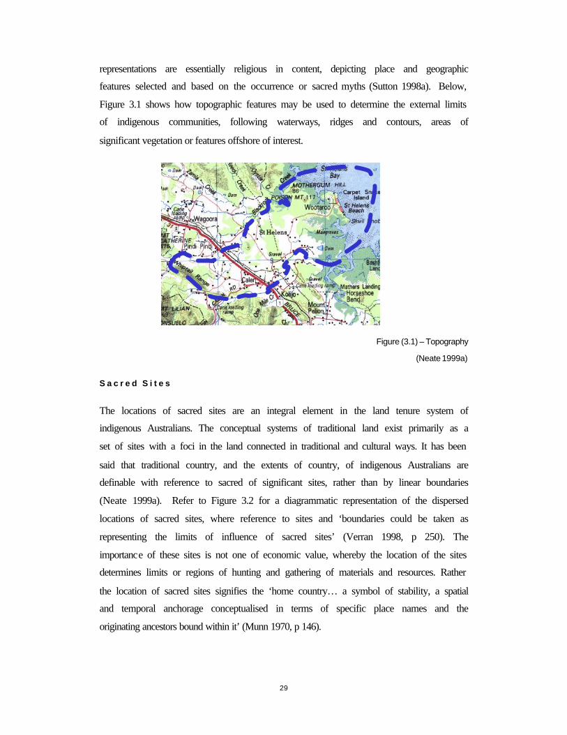
29
representations are essentially religious in content, depicting place and geographic
features selected and based on the occurrence or sacred myths (Sutton 1998a). Below,
Figure 3.1 shows how topographic features may be used to determine the external limits
of indigenous communities, following waterways, ridges and contours, areas of
significant vegetation or features offshore of interest.
Figure (3.1) – Topography
(Neate 1999a)
S a c r e d S i t e s
The locations of sacred sites are an integral element in the land tenure system of
indigenous Australians. The conceptual systems of traditional land exist primarily as a
set of sites with a foci in the land connected in traditional and cultural ways. It has been
said that traditional country, and the extents of country, of indigenous Australians are
definable with reference to sacred of significant sites, rather than by linear boundaries
(Neate 1999a). Refer to Figure 3.2 for a diagrammatic representation of the dispersed
locations of sacred sites, where reference to sites and ‘boundaries could be taken as
representing the limits of influence of sacred sites’ (Verran 1998, p 250). The
importance of these sites is not one of economic value, whereby the location of the sites
determines limits or regions of hunting and gathering of materials and resources. Rather
the location of sacred sites signifies the ‘home country… a symbol of stability, a spatial
and temporal anchorage conceptualised in terms of specific place names and the
originating ancestors bound within it’ (Munn 1970, p 146).
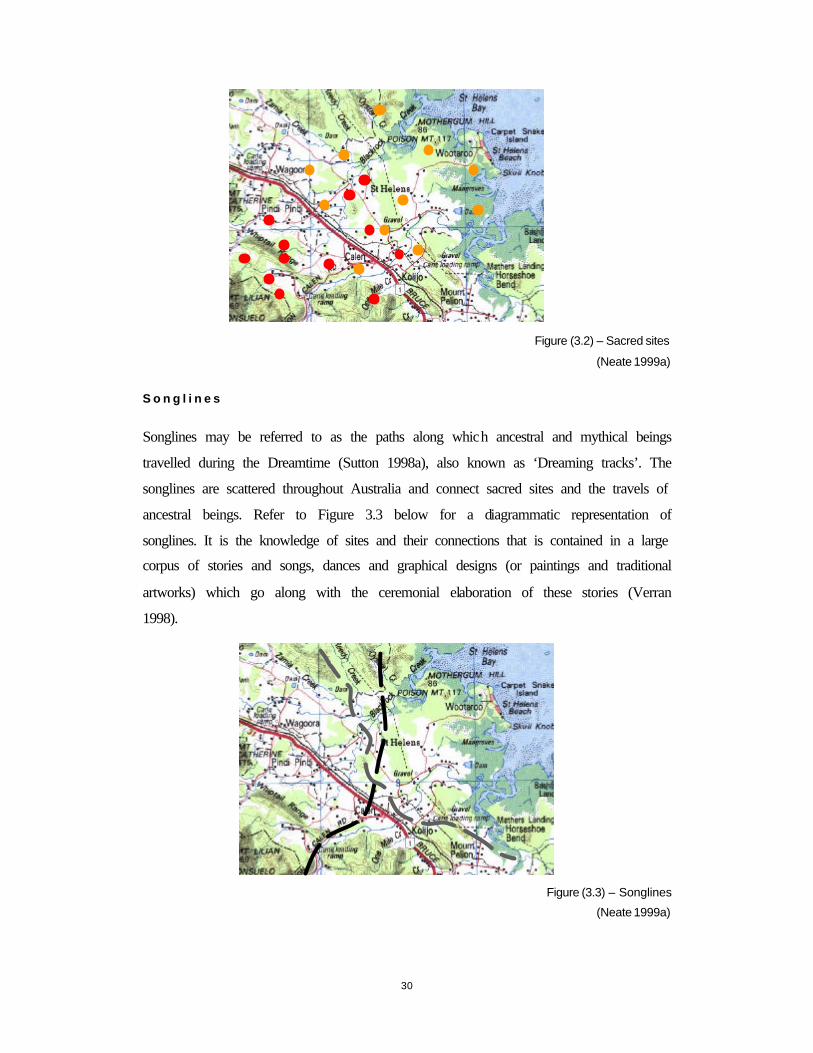
30
Figure (3.2) – Sacred sites
(Neate 1999a)
S o n g l i n e s
Songlines may be referred to as the paths along which ancestral and mythical beings
travelled during the Dreamtime (Sutton 1998a), also known as ‘Dreaming tracks’. The
songlines are scattered throughout Australia and connect sacred sites and the travels of
ancestral beings. Refer to Figure 3.3 below for a diagrammatic representation of
songlines. It is the knowledge of sites and their connections that is contained in a large
corpus of stories and songs, dances and graphical designs (or paintings and traditional
artworks) which go along with the ceremonial elaboration of these stories (Verran
1998).
Figure (3.3) – Songlines
(Neate 1999a)
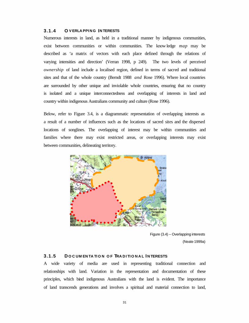
31
3.1.4 O V E R L A P P I N G INTERESTS
Numerous interests in land, as held in a traditional manner by indigenous communities,
exist between communities or within communities. The know ledge map may be
described as ‘a matrix of vectors with each place defined through the relations of
varying intensities and direction’ (Verran 1998, p 249). The two levels of perceived
ownership of land include a localised region, defined in terms of sacred and traditional
sites and that of the whole country (Berndt 1988 and Rose 1996). Where local countries
are surrounded by other unique and inviolable whole countries, ensuring that no country
is isolated and a unique interconnectedness and overlapping of interests in land and
country within indigenous Australians community and culture (Rose 1996).
Below, refer to Figure 3.4, is a diagrammatic representation of overlapping interests as
a result of a number of influences such as the locations of sacred sites and the dispersed
locations of songlines. The overlapping of interest may be within communities and
families where there may exist restricted areas, or overlapping interests may exist
between communities, delineating territory.
Figure (3.4) – Overlapping interests
(Neate 1999a)
3.1.5 D O C U M E N T A T I O N O F TR A D I T I O N A L IN T E R E S T S
A wide variety of media are used in representing traditional connection and
relationships with land. Variation in the representation and documentation of these
principles, which bind indigenous Australians with the land is evident. The importance
of land transcends generations and involves a spiritual and material connection to land,
32
where land is not measurable in mathematical terms, nor delineated through the
mapping or textual mediums of a Western society. These principles of traditional and
cultural origins are demonstrated through paintings, song, dance, symbolic totems and
oral traditions, and used to reinforce the rights, restrictions and responsibilities for
managing and protecting land. Evidence of this affiliation with land is found in the
‘ritual emblems and paraphernalia made, painted and revealed to initiates in the course
of the performance of ceremonies. These symbols, together with songs, dances, ground
designs, body markings and paintings serve as the marker of territory’ (Davis &
Prescott 1992, p 132).
3.1.6 D Y N A M I C NA T U R E
The dynamic nature of indigenous land tenure systems may be attributed to a number of
factors, including the strong associations with the natural environment relying upon the
abundance of food and resources. Where the locations of these resources may fluctuate
seasonally and as a result the limits of influence may also alter accordingly.
The tenure systems of indigenous Australians is no more dynamic than other tenure
systems held in a customary manner by indigenous communities. Indigenous
Australians have been subject to extreme and accelerated cultural change as a result of
colonisation, adversely affecting the traditions and cultures of indigenous Australians,
interrupting and often extinguishing their intrinsic relationship with the land.
3.1.7 C U S T O D I A N S H I P
The land tenure system of indigenous Australians has differing concepts of ownership
from those of Western land ownership notions. This ownership of land is based on the
need to look after the land for future generations in supporting sustainable living.
Ownership is discussed by Berndt (1988) and Munn (1970) as two levels of ownership
exist. The ownership and possession are spoken in terms of land possessing people
(Berndt 1988). Primary ownership, relates to localised areas and secondary ownership
appertains to economic and holistic perspectives of land ownership and custodianship.
The ownership is of personal significance, linked through kinship to the land and one of
socially, collectively held in trust. Berndt (1988) concurs of the ownership of land,
through membership of specific kinds of groups and kinship associations. Where
persons belong or had belonged to it (the land) through birth and spiritual linkage, the
33
possession of that land was and is ratified through the performance of land sustaining
rites.
Land is meaningful because it has specific places that belong to kinship networks,
where there is a ‘mother-land, a father-land, grandmother-land and so on’ (Verran 1995,
p 40). Thus the notion of kinship is fundamental with the land tenure systems of
indigenous Australians.
3.1.8 D IVERS I TY
There exists a diverse range of concepts as to the relationship between indigenous
communities and the land. Diversity may be between communities or within
communities, influenced by geography, social and cultural factors. The tenure systems
of indigenous Australians may reference different scales of inclusivity – households,
patronymic groups, clan, island communities and regional groups. The ‘identity at each
level is recorded in networks of named places that recall societal charter myths,
community and personal histories, attachment of sentiments, and knowledge of
geophysical, biological and ecological patterns and processes’ (Scott & Mulrennan
1999, p 153).
3.1.9 O FFSHORE
The integral role of marine resources within the culture and traditional of indigenous
Australians is established from archaeological evidence of at least 33 000 years, when
the northern areas of the Australian continent met with areas from the Melanesia and
the Soloman Islands (Meyers et al 1996).
S p i r i t u a l c o n n e c t i o n t o t h e s e a
There exists spiritual beings which represent the sea area, while locations of sacred sites
may be linked to the location of reefs and other natural features. As observed by Keen,
cited in Meyers et al (1996, p 6):
‘specific sites and general areas of the coastal waters are of as great significance to the…people as are the places on land. Just as the ancestral beings are believed to have created specific sites in land, and lodged powers therein, so they are believed to have created or been transformed into places at sea, especially rocks, reefs and sandbanks. Some open stretched of water are regarded as the routes taken by ancestral beings long ago; other waters are regarded as being inhabited still by dangerous powers’
34
T r a d i t i o n a l u s e o f t h e s e a
Traditional use of the sea includes using the sea for fishing, hunting and collecting of
resources. There exist many diverse fishing rights associated with offshore areas around
Australia. Many of these are bounded by natural extents and enter international waters.
There is little anthropological evidence documented of the traditional use of the sea.
Most evidence and findings concerning the use of the seas has been as a result of a
number of native title claims in the Torres Strait (Meyers et al 1996).

35
3.2 AUSTRALIAN CADASTRAL SYSTEM
The Australian cadastral system, incorporating the Torrens system of title registration,
has developed and evolved over the past 200 years. The imported system of land
administration and land management (in 1788) was derived from the English common
law, termed the Deeds system. The settlement of Australia was fast and uncoordinated.
It was in the middle of the 19th Century that the sovereign rights of land had been
granted to each of the States, so that land tenure and administration of land became
subject to State law. The granting of new estates (the alienation of land) was undertaken
on the basis of size, shape and location (Dale 1976). The Deeds system of title
registration was unable to deal with the demands and requirements of a developing
country.
The Torrens system of title registration was created in South Australia in 1856 and soon
became the accepted method for registering interests in land throughout Australia
replacing the archaic Deeds system. The Torrens system of title registration has five
qualities being speed, (1) simplicity, (2) cost effective and (4) suitable to the needs of
the Anglo-Australian community (Williamson 1994) at time of conception, while (5)
guaranteeing title to land (Dale 1976). Three principles characterise the Torrens system,
namely the Mirror principle (two copies of the title, one kept at the Office of Titles and
the duplicate given to the grantee), the Curtain principle (once title is under the Torrens
system all other interests are negated) and the Insurance principle (information on the
Certificate of title is guaranteed by the State or Territory body). The documentation of
title rights through the Certificate of Title includes a parcel description and
documentation of proprietor. The parcel section provides a means to identify the parcel
through graphical reference to the Plan of Survey. The proprietorship provides the
details pertaining to encumbrances, easements, any other restrictions to the land and the
holder or grantee of the title.
The mapping of parcels for inclusion with the Torrens system is ‘on the basis of
individual surveys of individual parcels, by individual surveyors for the benefit of
individual clients’ (Dale 1976, p 203). The surveying of parcels, termed cadastral
surveying, has evolved from the necessity to support the transfer of land for the
efficient operation of the land market (Williamson 1994). Cadastral surveys are not part
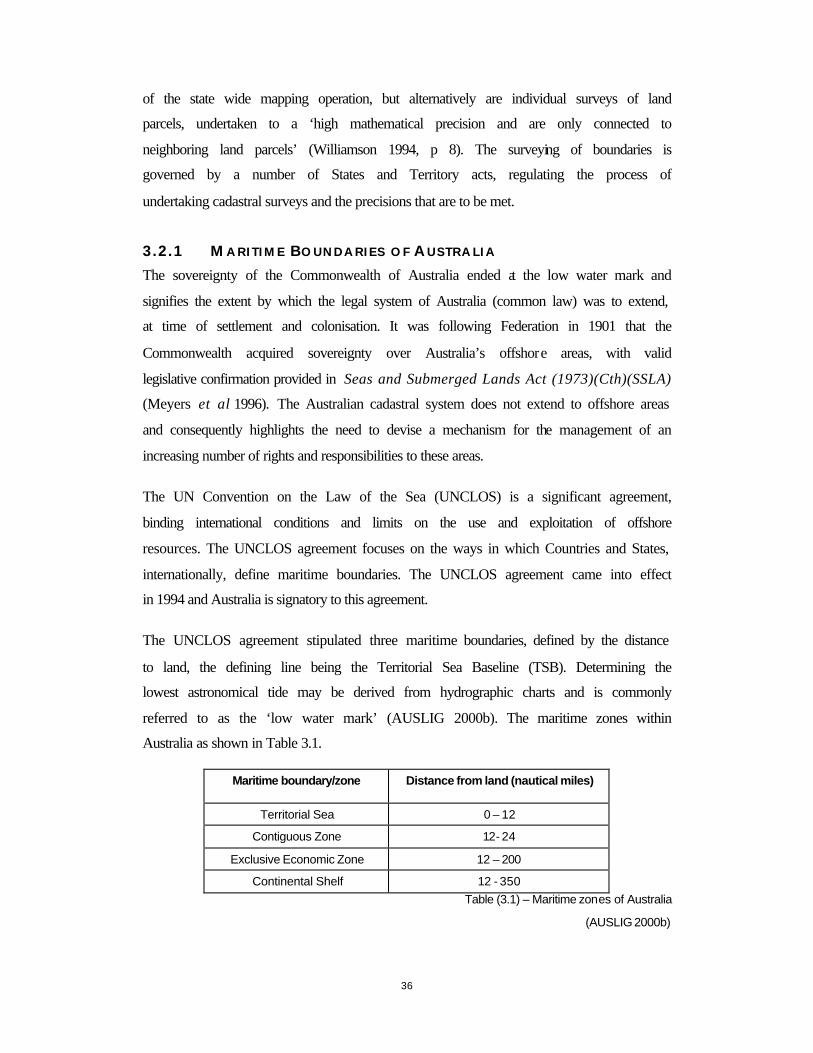
36
of the state wide mapping operation, but alternatively are individual surveys of land
parcels, undertaken to a ‘high mathematical precision and are only connected to
neighboring land parcels’ (Williamson 1994, p 8). The surveying of boundaries is
governed by a number of States and Territory acts, regulating the process of
undertaking cadastral surveys and the precisions that are to be met.
3.2.1 M A R I T I M E B O U N D A R I E S O F AU S T R A L I A
The sovereignty of the Commonwealth of Australia ended at the low water mark and
signifies the extent by which the legal system of Australia (common law) was to extend,
at time of settlement and colonisation. It was following Federation in 1901 that the
Commonwealth acquired sovereignty over Australia’s offshore areas, with valid
legislative confirmation provided in Seas and Submerged Lands Act (1973)(Cth)(SSLA)
(Meyers et al 1996). The Australian cadastral system does not extend to offshore areas
and consequently highlights the need to devise a mechanism for the management of an
increasing number of rights and responsibilities to these areas.
The UN Convention on the Law of the Sea (UNCLOS) is a significant agreement,
binding international conditions and limits on the use and exploitation of offshore
resources. The UNCLOS agreement focuses on the ways in which Countries and States,
internationally, define maritime boundaries. The UNCLOS agreement came into effect
in 1994 and Australia is signatory to this agreement.
The UNCLOS agreement stipulated three maritime boundaries, defined by the distance
to land, the defining line being the Territorial Sea Baseline (TSB). Determining the
lowest astronomical tide may be derived from hydrographic charts and is commonly
referred to as the ‘low water mark’ (AUSLIG 2000b). The maritime zones within
Australia as shown in Table 3.1.
Maritime boundary/zone Distance from land (nautical miles)
Territorial Sea 0 – 12
Contiguous Zone 12- 24
Exclusive Economic Zone 12 – 200
Continental Shelf 12 - 350 Table (3.1) – Maritime zones of Australia
(AUSLIG 2000b)

37
The Offshore Constitutional Settlement (OCS) is an agreement between the
Commonwealth 1997, and provides for the agreed divisions of the Commonwealth and
States in relation to the territorial sea and also to certain other regulations of shipping
and navigation, offshore petroleum exploration, crimes at sea and fishing legislation,
giving affect of the OCS at a Commonwealth level (AUSLIG 2000).
3.2.2 TORRENS B OUNDARIES
The definition of boundary includes the notion of an imaginary line, dividing property
and the rights to use and enjoy land. Physical boundaries dominate various methods
employed for the demarcation of boundaries. Physical monuments defining a boundary
‘must be permanent, stable, certain of identity and for preference, immediately visible’
(Dale 1976, p 18).
The creation, demarcation and delineation of title boundaries have associated standards
and requirements to be upheld by the surveying profession. These standards are well
documented within the Property Law Act 1958 (Vic), Transfer of Land Act 1958 (Vic)
and the Subdivision Act 1988 (Vic), currently operational in Victoria. The registration of
interests in land through the Torrens system offers security of tenure and a State
guaranteed title. It does not guarantee the boundaries of the land parcel. The Australian
cadastral system operates within rigid definitions of boundaries where differences in
boundary locations are a matter of law (Surveyors Board (Victoria) 1994).
38
3.2.3 V I C T O R I A
The settlement of Victoria took place after successful exploration of the lands around
what is now known as Port Phillip Bay. Surveying played a major role in the settlement
and establishment of Victoria and particularly Melbourne. The purpose of surveying
Crown land (Surveyors Board (Victoria) 1994, p 55) included:
• Defining the allotments;
• To provide information for the preparation of a diagram or other appropriate means of description, for the lease, licence, Crown Grant or reservation gazettal;
• To establish reference marks or permanent marks, or both as an aid to future reliable re-establishment of the boundaries.
The implementation of the Torrens system in 1862 improved the administration of land
within Victoria and it has been since the 1980s that a program of modernisation and
automation has been adopted by Government for the administration of land within the
State (Jacoby 1999). The formation of Land Victoria in 1996 and the bringing together
of all surveying, mapping, land titling and land management and administration
signified the beginning of a new era of land administration in the State of Victoria.
Land Victoria is moving towards electronic mediums and lodgement of land based
information and as detailed by Jacoby (1999, p 2), ‘by the year 2000 customers will be
able to point to a piece of land on an electronic map and have all the information
relevant to that piece of land at their fingertips’.
With the development of eight fundamental datasets, constituting the spatial data
infrastructure of the state include: Geodetic control, Cadastral, Address, Administrative,
Transportation, Elevation, Hydrology and Imagery. The direction of land administration
within the State of Victoria is one of digital automation with the integration of a number
of spatial datasets for a number of diverse uses. These digital datasets are employed for
the determination and representation of spatial dimensions of native title at a national
level by the Geospatial Unit of the NNTT (refer to Chapter six) and by the Native Title
Applications Manager prototype (refer to Chapter seven) developed as part of this
research.
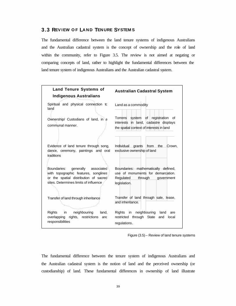
39
3.3 REV IEW OF LAND T ENURE SYSTEMS
The fundamental difference between the land tenure systems of indigenous Australians
and the Australian cadastral system is the concept of ownership and the role of land
within the community, refer to Figure 3.5. The review is not aimed at negating or
comparing concepts of land, rather to highlight the fundamental differences between the
land tenure system of indigenous Australians and the Australian cadastral system.
Figure (3.5) – Review of land tenure systems
The fundamental difference between the tenure system of indigenous Australians and
the Australian cadastral system is the notion of land and the perceived ownership (or
custodianship) of land. These fundamental differences in ownership of land illustrate
Land Tenure Systems of
Indigenous Australians Australian Cadastral System
Evidence of land tenure through song, dance, ceremony, paintings and oral traditions
Transfer of land through inheritance
Ownership/ Custodians of land, in a
communal manner.
Spiritual and physical connection to land
Boundaries: generally associated with topographic features, songlines or the spatial distribution of sacred sites. Determines limits of influence
Torrens system of registration of interests in land, cadastre displays the spatial context of interests in land
Individual grants from the Crown, exclusive ownership of land
Transfer of land through sale, lease, and inheritance.
Land as a commodity
Rights in neighbouring land are restricted through State and local
regulations.
Rights in neighbouring land, overlapping rights, restrictions andresponsibilities
Boundaries: mathematically defined, use of monuments for demarcation. Regulated through government legislation.

40
the divergence between indigenous Australians and Western views, highlighting some
of the problems associated with formal legal mechanisms of recognition. The interests
in land, as held by indigenous Australians, are not comparable to that of Anglo-
Australian cadastral system. With the recognition of native title, the lack of
comparability does not detract from the ability to recognise and enforce legislation to
protect native title rights and interests. It is the recognition of the differences and an
acceptance of both tenure systems’ fundamental concepts that will ameliorate any
process designed to recognise and protect interests in land, specifically those identified
by the Native Title Act 1993.
41
3.4 CHAPTER S U M M A R Y
The land tenure system of indigenous Australians is one based on tradition and custom.
This is in direct contrast to the operation of the Australian cadastral system, based on
the English common law system and incorporating the Torrens system of title
registration. Both systems operate in Australia, with the economic land market and
Property Law of Australian dominated by the operation of the Australian cadastral
system and the Torrens system. The recognition of the fundamental differences between
the land tenure system of indigenous Australians and the Australian cadastral system
highlights the need for an appropriate mechanism from which both systems can operate.
42
C H A P T E R 4 - N A T I V E T I T L E
4 I N T R O D U C T I O N
The Native Title Act 1993 was conceived and implemented as a response to the High Court’s decision concerning Mabo v State of Queensland (no 2) 1992. The Act was enacted by the Federal Parliament of Australia on January 1st 1994 and has subsequently been amended by the Native Title Amendment Bill 1998. The recognition of native title rights introduced three new dimensions into Australian property law: the notion of traditional indigenous Australians rights to land; the legislative power of the Commonwealth; and the principles of protection of the human rights of indigenous peoples recognised under international law (Lane 2000).
The procedures and information requirements of the Act are exhaustive. Of interest is the explicit request to supply a mapped representation and a technical description of the native title claim area. It is this assumption of scientific cartographic knowledge and the presumption of access to spatial information resources, by that of the applicant or representative that has hindered the operation of the Act.
This chapter investigates the High Court’s decisions, the operation and spatial information requirements of the Native Title Act 1993, the spatial extents and implications of native title.

43
4.1 H I G H CO U R T D ECIS IONS
The first legal debate concerning Aboriginal claims to land was not instigated until
1970 in Millirrpum v Nabalco Pty Ltd (1971) 17 FLR 141 (NTSC), whereby the
Aboriginal inhabitants of the Cove Peninsular sought to restrain the bauxite mining
operation on their traditional land. Blackburn J commented that the source of
entitlement to land is one of spiritual importance. Further concluding that ‘the
fundamental truth about the Aboriginals relationship to the land is that whatever else it
is, it is a religious relationship’ (Blackburn J in Lane 2000 , 1999, p 18).
The High Court of Australia presided over two monumental cases, namely Mabo v
State of Queensland (no 2.) (1992) (commonly referred to as ‘Mabo’) and Wik peoples
v the State of Queensland (1996) (commonly referred to as ‘Wik’). These cases
introduced the possible recognition of a form of native title with the rejection of terra
nullius (land belonging to no one) in Mabo and the co-existence of native title and
pastoral leases with the passing of the Wik decision.
4.1.1 M A B O A N D O T H E R S V S T A T E O F Q U E E N S L A N D
The High Court’s decision concerning Mabo rejected the concept of terra nullius and in
doing so created debate concerning the fundamental legal framework of Australian
property law. The High Court recognised that the Meriam peoples right to native title
has survived and in accordance with the Racial Discrimination Act 1975 , their native
title interests must be treated fairly before the law.
The decision by the High Court was passed six to one, with agreement that:
• There was a concept of native title at common law;
• The source of native title was the traditional connection to, or occupation of, the
land;
• The content of native title was determined by the character of the traditional
connection or occupation; and
• Native title could be extinguished by the valid exercise of governmental powers.
(Bartlett 1993, ix)
44
The Mabo decision entitled the Meriam people, as against the whole world, to
possession, occupation, use and enjoyment of the lands of the Murray Islands. The
decision was a catalyst for the formulation and implementation of the Native Title Act
1993, a Federal Government act, which enshrines the fundamental decisions as presided
upon in Mabo.
4.1.2 THE W IK PEOPLES V S T A T E O F Q U E E N S L A N D
Wik was another fundamental High Court decision that altered native title (concepts,
legal notions and the operation and administration of the Act) within Australia. The
Wik case tested the native title rights of the Wik and Thayorre peoples on areas of land
under pastoral lease status in Queensland. The leases under dispute were created from
Australian Statute law, for the sole purposes of encouraging and supporting the efforts
to colonise and settle the country in the early 1900s. As stated by the Australian
Government Solicitor (1998, p4):
‘nothing in the Acts under which the leases were granted, or in the lease instruments themselves, indicated an intention to totally exclude indigenous people from the land. As well as this, that there is a strong presumption that a statute is not intended to extinguish native title, or indeed valuable rights relating to property, unless there was clear and plain indication to the contrary’.
The High Court decision did not determine the native title rights of the Wik and
Thayorre peoples. The decision however confirmed the notion that native title could co-
exist with the rights and interests of a pastoral lease holder, but where conflict arises,
the rights of the pastoralist prevails. The Native Title Act 1993was amended with the
passing of the Native Title Amendment Bill 1998.

45
4.2 T H E NATIVE T ITLE AC T
The Native Title Act 1993, was established in response to the High Court’s decision of
Mabo v State of Queensland. This Federal Act applies to all areas where Australian
common law operates, this includes both land and waters. The Native Title Act
1993became law on January 1st 1994. Where determinations are presided upon in the
Federal Court however the process and procedures of the Act are facilitated by the
National Native Title Tribunal (NNTT). The role of the NNTT is to provide general
assistance with the administration and facilitation of the Act. The NNTT is not affiliated
the Aboriginal and Torres Strait Islander Commission (ATSIC) or Aboriginal Land
Councils. Its role is one of principle provider of native title mediation services and an
authoritative source of information about the native title process (NNTT 1998).
The objectives of the Act are stated in Section 3 and include:
(a) Provisions for the recognition and protection of native title; and (b) Establish ways in which future dealings affecting native title may proceed and to set standards for those dealings; and (c) Establish a mechanism for determining claims to native title; and (d) Provide for, or permit, the validation of past acts, and intermediate period acts, invalidated because of the existence of native title.
4.2.1 D E F I N I N G NA T I V E TI T L E
Native title interests are not created through the Act, they are recognised as pre-existing
interests in land as held by indigenous Australians and definable through the Australian
legal system. The origins of native title are of tradition and custom as held by
indigenous Australians, where ‘the content of those rights and interests will not
necessarily equate to other forms of property’ (Neate 1999a, p 9), as recognised by
Australian common law and further giving reason to the numerous and various forms of
native title throughout Australia.
The difference between native title and land rights is that native title is a pre-existing
right, originating from the tradition and customs of indigenous Australians. Whereas
land rights are grants from the Government, where indigenous Australians are granted a
fee simple title or lease to land.
46
4.2.2 NA T I V E TI T L E AM E N D M E N T S
The Native Title Act 1993 is still evolving, influenced by social, legal and political
factors, with amendments to the Act having been made only five years into its
operation. The amendments to the Native Title Act, as made in 1998, may be attributed
to the operation and the administration of the then current Native Title Act 1993and the
legal and political environments of the time.
In response to the Wik decision, the Government devised its Ten Point Plan as the basis
for amending the Act. The Ten Point Plan recognised the High Courts ruling on Wik
and facilitated the amendment to the Native Title Act 1993. It is argued these
amendments have removed the rights to negotiate by the applicant as a consequence of
Registration testing. Moreover, these amendments significantly changed the way in
which native title is administered, through the introduction of Registration testing of
applications, the validation of Commonwealth Acts carried out before January 1st 1994
and providing a mechanism for the negotiation of future Acts. The major amendments
to the Native Title Act 1993 with the passing of the Native Title Amendment Bill 1998,
as cited by the NNTT (1999a) include:
• Native title applications are made directly to the Federal court before the NNTT;
• The right to negotiate on pastoral leases and some other types of tenure may change;
• Native title applicants are required to pass a registration test to gain the right to negotiate;
• New state and territory equivalent bodies may assume any or all of the current responsibilities of the NNTT. These bodies will require State and Territory
legislation and be approved by the Commonwealth Minister; and
• Confirmation by the claimants that they have the authority of the people, clan or family for whom the application is made.
4.2.3 IN D I G E N O U S L A N D U SE AGREEMENTS
Part of the amendments made to the Native Title Act in 1998 was the introduction of
Indigenous Land Use Agreements (ILUAs). Where ILUAs are a voluntary agreement
designed to assist with formulating agreements over the use of land by formalising
agreements of co-existence, compensation, the exercise of native title rights and future
acts. These agreements are ‘designed to optimise the range and number of opportunities

47
for indigenous people to enter into land use and other agreements, including the
authorisation of future acts (mining and exploration in particular) which may affect
native title in their country (Padgett 1999, p 21).
There are three categories of ILUAs, these include: Area Agreements, Body Corporate
Agreements and Alternative Procedure Agreements. The benefits of ILUAs include:
• Flexibility
• Greater legal certainty and enforceability
• Improved implementation of agreement
• The development of a preferred process more attuned to cultural, social, economic
and environmental realities of the localised area.
(Neate 1999c and Padgett 1999)
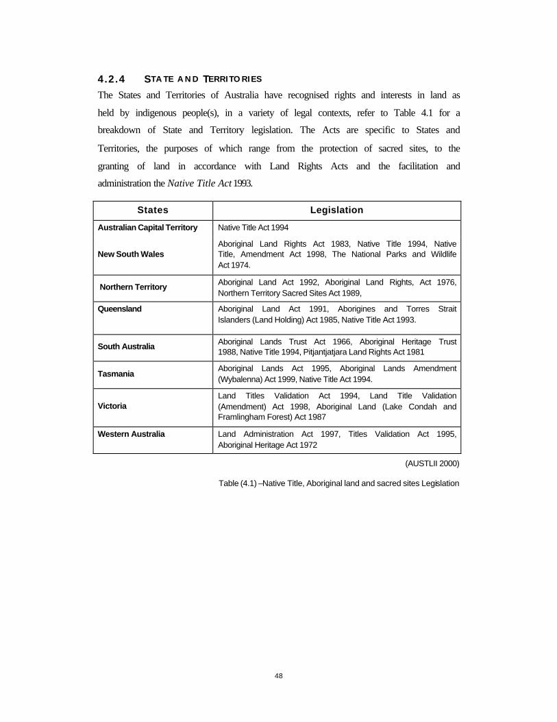
48
4.2.4 S T A T E A N D TERR I TORIES
The States and Territories of Australia have recognised rights and interests in land as
held by indigenous people(s), in a variety of legal contexts, refer to Table 4.1 for a
breakdown of State and Territory legislation. The Acts are specific to States and
Territories, the purposes of which range from the protection of sacred sites, to the
granting of land in accordance with Land Rights Acts and the facilitation and
administration the Native Title Act 1993.
States Legislation
Australian Capital Territory Native Title Act 1994
New South Wales Aboriginal Land Rights Act 1983, Native Title 1994, Native Title, Amendment Act 1998, The National Parks and Wildlife Act 1974.
Northern Territory Aboriginal Land Act 1992, Aboriginal Land Rights, Act 1976, Northern Territory Sacred Sites Act 1989,
Queensland
Aboriginal Land Act 1991, Aborigines and Torres Strait Islanders (Land Holding) Act 1985, Native Title Act 1993.
South Australia Aboriginal Lands Trust Act 1966, Aboriginal Heritage Trust 1988, Native Title 1994, Pitjantjatjara Land Rights Act 1981
Tasmania Aboriginal Lands Act 1995, Aboriginal Lands Amendment (Wybalenna) Act 1999, Native Title Act 1994.
Victoria Land Titles Validation Act 1994, Land Title Validation (Amendment) Act 1998, Aboriginal Land (Lake Condah and Framlingham Forest) Act 1987
Western Australia Land Administration Act 1997, Titles Validation Act 1995, Aboriginal Heritage Act 1972
(AUSTLII 2000)
Table (4.1) –Native Title, Aboriginal land and sacred sites Legislation
49
4.3 NATIVE T ITLE – O FFSHORE
The recognition of native title covering both land and water, is exemplified with a large
number of applications encompassing offshore regions. According to the Native Title
Act 1993, the terminology of offshore areas applies to all areas beyond the low water
mark.
The Moa and Saibai Islands determination (located in the Torres Strait) took two years
of mediation and involved many local and state government agencies; many utility
companies and the Moa and Saibai community. This determination is of interest as it
formally recognised the native title rights to land and sea as held by the Moa and Saibai
people and also the ‘traditional access rights of the inhabitants of Papua New Guinea,
which is only five kilometres from Saibai islands’ (NNTT 1999b, p 1).
The native title determination of Yarmirr v Northern Territory 1999 FCA 1668 found
that, ‘even though sovereignty over the seas under the Seas and Submerged Lands Act
1973 had only been established in 1990, native title could still be recognised’ (Olney in
Lane 2000, p 15). The application was for native title over the sea and sea bed, and any
reefs or other land in an area surrounding Crocker Island, where the applicants asserted
that they held exclusive native title rights over the area claimed’ (Lane 2000, p 14). The
determination has paved the way for the possibility of native title being made to
offshore areas and not contained within the territorial limits of the Australian common
law however, referenced within the spatial extents of the native title interests being
claimed.
When lodging native title applications to offshore areas, there are many issues to be
considered and accounted for, these include:
• Methods for determining and delineating the extent of native title offshore with
reference to tidal levels, contours or through the locations of marine vegetation and
fauna. An issue to be addressed ‘is the method to be adopted where determinations
are made beyond State and Territory jurisdictions, such as areas administered by the
Commonwealth were cadastral reference systems may not exist’ (Bowen 2000, p 5).
Posing the legal question: Does native title exist outside the boundaries of

50
Australian Common Law? Providing impetus for the development and
establishment of the marine cadastre.
• The neighbouring and encroaching of native title into international waters;
• The appropriate determination of offshore areas affected by native title; and
• The management of determined native title interests in such areas.
51
4.4 NATIVE T ITLE PROCEDURES
The administrative process for lodging native title applications has undergone
amendments in 1998, and will continually evolve according to the political, legal and
social environment of Australia. All applications are made to the Federal Court where
they are directed to the Registrar of Claims (NNTT) for the application of the
registration test (refer to Appendix 1 for the native title process).
4.4.1 THE R E G I S T R A T I O N TEST
The purpose of the registration test ‘is to ensure that only those claims with merit are
registered’ (Australian Government Solicitor 1999, p 53). The registration test is
applied by the Registrar who checks the application, ‘with reasonable certainty’
(S190(B)2 NTA 1993), identifies the area of land subject to that the application;
identifies the native title claimant group; and identifies claimed native title interests.
The inclusion of registration testing places a ‘greater reliance on geographical
descriptions of native title applications and associated mapping, including the
requirement to provide reasonable certainty in the identifications of areas being
claimed’ (Bowen 1999, p 2). The conditions and requirements for the registration of
applications by the Registrar follows S190(B)2 NTA 1993, cited below:
‘The Registrar must be satisfied that the information and map contained in then application as required by paragraphs 62(2)(a) and (b) are sufficient for it to be said with reasonable certainty whether native title rights and interests are claimed in relations to particular land and waters’.
The Registrar must also be satisfied of the factual content of the native title interest
being claimed and the continual physical connection with the land as held by the native
title claimants further that the application is not overlapping with another claim (S67
NTA 1993).
Once the registration test is applied, the notification of affected parties proceeds. The
notification process aims to determine affected parties that may either oppose or support
the application for native title. Following this, the process of mediation proceeds. The
determination, whether it be that native title exists or does not exist is presided upon in
the Federal Court of Australia. The procedures of the Native Title Act 1993are costly,

52
both in time and legal fees, with many applications requiring three or four years to
reach the Federal Court for determination. It should be stressed that the concepts of
native title are still evolving. In conjunction with this evolution, is the further
refinement and development of better administrative mechanisms for native title.
53
4.5 SPAT IAL INFORMAT ION REQUIREMENTS
The Native Title Act 1993 stipulates the inclusion of spatial information for the purpose
of determining the external boundaries of the claim area (S62) and the association of
these extents and the native title rights and interests being claimed.
(b) information, whether by physical description or otherwise, that enables the boundaries of: (i) the area covered by the application; and (ii) any areas within those boundaries that are not covered by the
application; to be identified; (c) a map showing the boundaries of the area mentioned in sub paragraph (a)(i); (d) details and results of all searches carried out to determine the existence of any
non-native title rights and interests in relation to the land a waters in the area covered by the application
(S62(2) NTA 1993)
The requirement is that both a general/written (termed throughout the thesis as a
‘technical’) description and a mapped representation of the external boundaries of the
claim area are to be provided as part of the native title applications, as identified by the
applicants.
a description of the native title rights and interests claimed in relation to particular land and waters (including any activities in exercise of those rights and interests), but not merely consisting of a statement to the effect that the native title rights and interests are all native title rights and interests that may exist, or that have not been extinguished, at law;
(d) a general description of the factual basis on which it is asserted that the native title rights and interests claimed exist and in particular that ;
(i) the native title claim group have, and the predecessors of those persons had, an association with the area; and
(ii) there exists traditional laws and customs that give rise to the claimed native title; and
(iii) the native title claim group have continued to hold the native title in accordance with those traditional laws and customs
(S63 NTA 1993)
The spatial requirements of the Act assumes that the applicants or their representatives
firstly have an understanding of cartographic techniques and the skills to translate their
geographic area of interest of country or land to a map. Secondly are able to access a
suitable map or spatial information from which they can readily define claim areas
(Bowen 1997).
54
4.5.1 G U I D E L I N E S A N D P OLICIES
The Native Title Act 1993 itself specifies no standards for the description and
cartographic representation of claim areas, the tribunal adopts a policy of ‘reasonable
certainty’. The Act does not define the terminology of map or technical (or general)
description sufficed to say the meanings are assumed. The unique nature of native title
does not allow such standards of spatial accuracy, currency and relevance to be
developed. Consequently, the NNTT has developed and disseminated practice manuals
and guidelines providing advice as to the preparation of spatial information by
applicants and representatives.
C a s e M a n a g e r s P r a c t i c e M a n u a l
The Case Managers Practice and Procedure Manual, as dated 1st of October 1999,
provides case managers with practical advice on the management and administration of
applications for native title, specifically the collection and collation of information and
the notification of all parties involved in the native title claim. The guidelines for the
preparation of the spatial information, in the form of a mapped representation and
technical descriptions, includes the following:
• A map of the claim areas; • Details of traditional physical connection or circumstances of prevention of
access to any part of the claimed area; • Information identifying the external and internal boundaries of the areas
claimed; • Details and results of any searches of non-native title rights and interests
obtained by the applicant in relation to the claimed areas; • Details of any activities carried on by the native title claim group in relation
to the area claimed.
• Anything on which there is writing; or
• Anything on which there are marks, figures, symbols or perforations having a meaning for a person qualified to interpret them; or
• Anything from which sounds, images or writings can be reproduced with or without the aid of anything else; or
• A map, plan, drawing or photograph.
(Case Managers Practice Manual, S4.3.1-2)
55
A p p l i c a t i o n G u i d e l in e s
The tribunal guidelines, for the assembly and presentation of information, comprises of
State and Territory breakdowns of information requirements and specify appropriate
formats of information (refer to Appendix 2 for a summary of these guidelines). The
guidelines have highlighted the need for applicants to ‘endeavour to frame their
applications consistently with land use information systems applicable to the relevant
State and Territory’ (NNTT 1999d, p 1).

56
4.6 SPAT IAL EXTENT OF NATIVE T ITLE
The spatial extent of native title is different from the spatial extents of traditional lands.
The spatial extents of traditional lands or country know of no concept of Australian
cadastral tenures and finite boundaries. Whereas the spatial extent of native title may be
appropriately defined through tenures or other references, coordinate and directional
references and reference to topographic features. The spatial extents of native title are
intimately associated with the actual native title interest, as the location of these
interests is dependent on the nature and character of native title.
Native title exists on land and/or waters where there has been a continual connection, in
accordance with traditions and customs held the indigenous Australians and may co-
exist with leases established from Australian Statute Law. The tenures of land where
native title may exist include:
• Vacant Crown land;
• Crown land such as State forests, National Parks and Public Reserves;
• Land held by Government agencies; and
• Land held in trust for Aboriginal communities.
The spatial extents of native title may be represented through referencing a general area
and then further detailed by identifying specific parcels of land where native title may
exist. The general area of native title may use references including topographic features,
major roads, built environments, tenures and coordinates, with the identification of
parcels reliant upon cadastral information and undertaking a historical search of each
parcel to ascertain if native title has been extinguished.
The extents of native title are not ‘fuzzy’ in determination. They may be defined by
forms of tenure, topographic features (both natural and structural) coordinates and
directions. The extents of the land may encompass many and varied tenures.
Consequently ‘care must be taken to describe with sufficient precision lands over which
native title is said to either to commence a common law action of to make a claimant
application under the Native Title Act’ (Neate 1997, p 25).

57
When determining the extent of native title, extensive tenure histories must be compiled
to ascertain whether the claimants have had a continual connection to the land.
Undertaking a historical tenure search involves identifying property dealings that
occurred for a parcel of land in the past, and deciding whether any of those dealings
were capable of extinguishing native title.
58
4.7 IMPLICAT IONS OF NATIVE T ITLE
The implications of the Native Title Act 1993, aside from revolutionising many of the
traditional concepts of Australian property law, has affected such sectors as mining,
resource management and pastoral activities. The uncertainty that surrounds native title;
the extents of native title and possible compensation, are all factors that reduce security
of tenure. Uncertainty of tenure reduces investment potential, effectively harming the
country’s economy. The implications of native title may be measured through economic
rationale and commercial viability, however there are social implications that also
require acknowledgement.
4.7.1 NA T U R A L R ESOURCES
The potential for native title to survive to some extent, on land subject to pastoral leases
in Australia, has a significant impact upon the management of natural resources on
those lands and upon the development of policy affecting those lands. Many policies
directed towards the management of natural resources are regulated by State and
National legislation, and to an extent these policies, particularly when in legislative
form, may extinguish native title (Yarrow 1997a). Many policies and legislation
regarding natural resources are directed at the inclusion of indigenous land values.
Many natural resource management projects offer indigenous communities, in remote
areas, the autonomy to control and management of natural resources.
The notion of native title of resources and to property such as vegetation, minerals, soils
and fauna was introduced in Yanner v Eaton 1999 166 ALR 251. Where the applicant
claimed fauna as part of native title, the decision highlighted the ‘new analysis of rights
and interests in land that is required as a result of recognising rights derived from
traditional indigenous connection’ to land (Lane 2000, p 17).
4.7.2 M I N I N G
Mining and mineral exploration in Australia is a multi-billion dollar turnover (from the
period of 1996 – 1997 the mining industry had a turnover of $34.1 billion (ABS 2000b).
The impact of native title applications on the exploration of minerals has large
economic implications, where uncertainty and delay are enemies of commerce

59
(MacDonald 1997, p 125). The key commercial, and more specifically mining,
implications revolve around the uncertainty of tenure. The granting of an exploration
licence over land, which may be held by another form of tenure, exacerbates the
problems of existing native title applications. It has been common practice ‘to grant
exploration titles over a defined areas with the general exclusion of any land which may
subsequently be proved to be subject to native title or with the exclusion of particular
land where past titles do not extinguish native title’ (MacDonald 1997, p 120).
4.7.3 PR O P E R T Y
The location of native title over areas of Crown land affects the release of land for
expanding cities and regional centres. Where Crown lands surround regional centres,
land for freehold has become a scarce commodity and rising the prices of land. In
Kalgoorlie, Western Australia, prices for improved land parcels are trading above the
States (Western Australia) mean average as a result of the constraint being placed on
the release of lands for freehold development by native title applications (Carrick
1998).
4.7.4 S O C I A L
The social implications of native title thus far, have included a greater awareness of
indigenous Australians interests in land and also the acceptance and realisation of the
false pretences from which terra nullius was declared. The social ramifications and
implications of the High Court’s decisions and the operation of the Native Title Act
1993includes ‘rethinking the nation’s responsibility to indigenous people requiring both
moral and practical reasoning about the co-existence of settler and indigenous cultures’
(Rowse 1993, p 1).
60
4.8 CHAPTER S U M M A R Y
The development of the Native Title Act 1993 stemmed from the High Court’s decision
of Mabo, where it was found that a form of native title existed prior to colonial
settlement and thus rejecting the traditional notion of terra nullius.
In summary:
• Native title is a pre-existing right or interest in land, one that is recognised through
the mechanisms of the Native Title Act 1993;
• The procedures and information requirements of the Act are exhaustive, specifically
the requirement to supply spatial information as part of the application for native
title. Assuming the applicants and representatives have knowledge of scientific
cartographic and mapping concepts and the access to spatial information and maps
as required.
• No standards have been stipulated for the documentation and representation of the
external boundaries and claim areas of native title applications, except for the
requirement of ‘reasonable certainty’ (S190(B)2 NTA 1993).
There exists the need to know where native title exists, the spatial dimensions of native
title and the communication of these extents and dimensions to a number of parties.
Current attempts in mapping native title by applicants and representative have been
inadequate for the purposes and requirements of the Act, hindering any attempts to
negotiate, mediate and operate the Native Title Act 1993 of Australia.
61
C H A P T E R 5 - D I M E N S I O N S O F N A T I V E T I T L E
5 I N T R O D U C T I O N
The identification of technical and cultural considerations is required for appropriate determination of areas where native title interests are spatially located and not yet extinguished. An improved understanding of these considerations, further allows the Native Title Act 1993 to evolve with the ability to recognise and protect and wider range of indigenous interests.
This chapter details the analysis of an application undertaken to identify the methods currently employed for the determination and representation of native title claim areas. Identifies the spatial dimensions of native title and details the technical and cultural considerations for determining the external boundaries of native title claim areas. These considerations are reviewed for the development of the Native Title Applications Manager GIS prototype.

62
5.1 NATIVE T ITLE APPL ICAT ION ANALYSIS
An analysis of current native title applications (focusing on the methods employed by
applicants and representative in determining and mapping the claim areas of native title
applications) was undertaken in order to identify the technical and cultural
considerations inherent in determining and delineating the spatial extents of native title.
The analysis of native title applications sampled a total of 53 applications, all lodged
with the NNTT. The analysis focuses on the current methods employed by applicants
and representatives in supplying a mapped and technical description of the application
area. Native title applications from all States and Territories within Australia are
analysed.
The purpose and objectives of the analysis of native title applications includes:
1. Identifying the methods by which applicants and representatives in different
States and Territories described and mapped the native title claim area;
2. Determining whether the technical description and the mapped representation
correlated; and
3. Assisting with the identification of the cultural and technical considerations of
native title, specific to the determination and delineation of native title claim
areas.
The collection of applications was performed in a semi-random manner. Due to the
quantity of applications currently lodged with the Register of Native Title Applications
(NNTT), and in the midst of the native title process, it was impossible to select
applications totally at random or to ensure an even distribution of applications through
the States and Territories of Australia.
The NNTT has dealt with a total of 7200 applications for native title (March 2000), of
these 701 have been accepted and 588 are yet to be accepted, 54 have been accepted
and referred to the Federal court with 95 being dismissed and 19 being rejected. A total
of 1464 applications have been determined and 4279 applications have been withdrawn
(NNTT 2000a). Currently in Victoria (March 2000), a total of 64 native title
63
applications have been lodged with the Federal Court of Australia and the Register of
Native Title Claims. Of the 64 applications, there have been 2 determinations, 7
accepted applications, 44 are yet to be accepted, 1 accepted and referred to the Federal
Court, with 5 application being withdrawn and 5 being rejected (NNTT 2000b).
5.1.1 ANALYS IS P ROCEDURES
A questionnaire was developed (refer to Appendix 3) to assist in the analysis of native
title applications. The mapped representation and technical documentation are of
particular importance and are required by the Act.
The analysis of the mapped representation focuses on the source of spatial information
and the references used to delineate the external boundary of the claim area. The clarity
of the map is observed by the author and treated as being subjective in nature.
Of interest for the technical descriptions of the application are references to tenures, to
topographic features and the use of coordinates and other positional forms such as
directions through compass bearings. The clarity of the description was also observed
(by the author) and as such is treated as subjective in nature.
5.1.2 ANALYS IS O U T C O M E S
Refer to Appendix 4 for the tabled results of the analysis. Discussion of the mapped
representations and the technical descriptions supplied as part of the application
analysed, are below, selected examples of the mapped representation and the technical
descriptions may be referred to in Appendix 5 and Appendix 6.
M a p p e d R e p r e s e n t a t i o n
The mapped representation is included as part of the native title application in
accordance with S62(2b) of the Native Title Act 1993and with reasonable certainty
(S190(B)2) representing the external boundaries of the application.
The assumption of scientific cartographic knowledge has resulted in many external
boundaries being represented with a variety of mapping sources, to an inconsistent
format or standard. From the analysis, various providers or sources of map data have
included: State agencies (Title Offices and Land Information Centres and mapping
64
agencies), the Commonwealth (AUSLIG) and the Geospatial Unit (NNTT), whilst the
inclusion of Tindale maps assisted with the location of traditional boundaries.
The use of many different map scales hinders the ability to cross correlate applications
when determining overlapping of applications, in accordance with S67 NTA 1993.
Reference to scale was represented in a variety of formats, from metres to kilometres, in
a bar format or a natural format (1:x). It was found that generally no scale details were
provided, causing problems in determining the exact spatial extents of the application
and the compatibility with other spatial information.
When referencing topographic features it is difficult to place a precision. Equally
difficult is the adaptation and location of a boundary for some native title interests
whereby the notion of a boundary is foreign.
T e c h n i c a l D e s c r i p t i o n
Technical descriptions are often complicated in nature. The most common way in
describing the external boundary is to ‘traverse’ around the perimeter, acknowledging
locations of interest. A combination of topographic and tenure information is combined
to describe the application area. The recognition that the extents of native title and those
extents of a traditional nature are different was highlighted by a number of applications
where the applicant states ‘the boundaries of the applicants or the traditional groups
extend…, however for the purposes of this application the external boundaries are as
follows’ (with reference to applications from the analysis: QC96/17, QC96/05 and
NC96/35).
State and Territory boundaries were often cited as external boundaries for native title
applications, due to the differences in the administration and management of land
information.
The use of coordinates assisted with the positions of the corners of the external
boundaries. When using coordinate references the applicant must be aware of factors
such as coordinate projections, measurement units and associated precisions.

65
The diversity of tenures provided a means to describe the native title locations. It is
common for a statement of exclusion to cover the entire area, for example: to the
exclusion of all freehold land within the application area.
The technical descriptions often reference topographic features, roads, waterbodies and
language boundaries while providing plane bearing directions and distance
measurements for descriptors of the external boundary. The issue of placing a precision
on a native title boundary can be applied in some instances, however elsewhere the
boundaries are not precise and are dynamic over time.
5.1.3 ANALYS IS C O N C L U S I O N S
The objectives of the analysis included both identifying the methods and techniques
employed to represent the external boundaries of the applications and the correlation
between the mapped and technical descriptions of the claim area. From the analysis, the
following conclusions were obtained;
• The standard of mapping was poor, many maps were photocopied without sufficient sourcing details or scale references;
• The delineation of the external boundary was often out of proportion with the application area and was of incorrect scaling;
• The maps produced from government and professional agencies provided a better representation of the extents and locations of the native title application; and
• The correlation between the mapped representation and the technical description was weighted (very good through to very poor), with a general consensus of good to
average correlation. It is important to note that the information mapped may not easily be transposed into a technical description and vice versa.
The analysis of applications provided the means for determining the dimensions of
native title applications, further highlighting the need for appropriate spatial
information resources to be made available to applicants and representatives for the
purposes of fulfilling the information requirements of the Native Title Act 1993. The
spatial dimensions of native title include the relationship of the claim area to other
applications (S67 NTA 1993), to tenures and with referenced to geospatial locations.
The technical and cultural considerations of native title are detailed in the following
section.

66
5.2 T ECHNICAL AND CULTURAL CONSIDERAT IONS
The exclusion and extinguishment of native title according to the Native Title Act 1993
and the restriction of one native title application per area and the requirement to supply
spatial information are attributes of the spatial dimensions of native title. The spatial
associations and relationships affecting native title include;
• The spatial relationship with the geographic and spatial location of the claim area;
• The spatial relationship with other tenures; and
• The spatial relationship of native title and other native title applications.
The spatial dimension of native title refers not only to the external boundary of the
claim area but also to the internal areas, where native title may be extinguished. When
determining the spatial dimensions of native title there are a number of technical
(pertaining to the Native Title Act 1993) and cultural dimensions (namely the cultural
consideration of indigenous forms of tenure) to be accounted, such considerations
include;
• Notion of property and the notion of boundaries;
• Ownership and custodianship of land;
• Time dimensions and dynamics of native title;
• Diversity of native title applications and of the nature of native title interests;
• Overlapping application areas to exist;
• Extinguishment of native title;
• Spatial location of extinguishing tenures with reference to the claim area;
• Spatial information requirements, and;
• Native title offshore or references to water bodies.
Documentation addressing the cultural and technical considerations of native title
include the Native Title Act 1993 itself and the guidelines as prepared by the NNTT.
Table 5.1 below illustrates the cultural and technical considerations when dealing with
the determination and delineation of the spatial extents of native title, as documented by
the Act and the guidelines of the NNTT.

67
Technical and Cultural Considerations NTA ‘93
Guidelines Case managers
manual (version 2, 1/10/1999)
State and Territory Guidelines
(Vic Specific) (1999)
Notion of Property S223 - - External boundaries
(determination and delineation of) S62,
S690B(2) - 6.2
Ownership/ custodianship/ responsibility to land 24BA, 44B 5.11 -
Time (the ‘freezing’ of native title in
time) - -
-
Community diversity - - -
Overlapping claim areas S61(a),S67,S68 4, 5.10 -
Extinguishment
S61(a), S225(e), S242 –
249, S237
5.9.1, 5.13
6.1, 6.3, 6.4
Spatial Information Requirements S62 1.5, 3.1, 4.2, 4.6, 4.13, 5.4.6, 5.14.11
-
Offshore and Water bodies S2(6), S253
5.4.18 -
Table (5.1) – Technical and cultural considerations
The spatial considerations are associated with relevant sections of the Act or guidelines,
produced to support the process of information collation and the management for native
title.
5.2.1 NO T I O N O F PR O P E R T Y
The idea of ‘property’ within the culture and tradition of indigenous Australians does
not equate to the notion of property supported by the Australian cadastral systems and
the Torrens system of title registration (refer to Chapter Three). The indigenous
Australians concepts of land tenure are accounted for in a limited capacity by S223 of
the Native Title Act 1993. Whereby the Act recognises that native title rights and
interests are possessed under the traditional laws, held in a communal or group manner.
In addition to this, hunting and gathering rights and interests are recognised, with the
establishment of agreements, specifically ILUAs, a more flexible approach may be
employed, better suited to the needs and considerations of indigenous forms of land
tenure.
68
5.2.2 E X T E R N A L B O U N D A R I E S
From the analysis of applications, it is evident that boundaries, and the notion of
boundaries, vary throughout Australia and vary between indigenous communities, of
which only a few appear to be directly comparable to the Australian legal perspective of
the boundary (Neate 1997). When determining the external boundaries of an application
for native title is it important to consider the following:
• Whether the traditional land tenure system of the group (claimants of native title)
includes the notion of precisise boundaries, which are able to be plotted on a map or
by any other physical description; and
• The traditional notion of the boundary for which the native title interests are
spatially representing.
(Neate 1999a)
5.2.3 NO T I O N O F O W N E R S H I P A N D R E S P O N S I B I L I T Y
The indigenous tenure system refers to a more communal holding of land where rights
are not exclusively owned but rather held in communal manner. The communal
holdings of these rights have been accounted for by the Act with the definition (S223
NTA 1993) of native title interests being held in a group or communal nature.
The concept of ownership of land is a Western perception and fundamental to the
Australian cadastral system. Conversely, the custodianship of land underlies the land
tenure of indigenous Australians. The differing concepts of ownership and
custodianship, as addressed by the Act, have been acknowledged with the establishment
of body corporate as part of the ILUA’s (S24BA NTA 1993) and the recognition of the
rights to access traditional lands (S44 NTA 1993).
5.2.4 TI M E D I M E N S I O N
The dynamic nature of traditional interests in land is one that remains unique to
indigenous communities of Australia. However with colonisation, the dilution of
tradition, as attributed by the many forced relocations of indigenous communities, has
exacerbated the concept of what native title interests remain in continuation. Hence,
69
native title is not fixed or frozen and may have changed in response to various
influences (Lane 2000 and Neate 1997).
5.2.5 C O M M U N I T Y D IVERS I TY
There exists conceptual diversity as to native title interest itself, such as the nature of
the native title interest, who (individual or community) holds the native title rights and
interests, its origins and how these may be spatially determined and represented? The
origins of native title are those of tradition and culture as held by indigenous
Australians, these origins and traditions are as diverse as the land and traditional laws
with which they are intrinsically and intimately associated. However some
generalisations about indigenous law and customs can be made, ‘in the same way as it
is possible to distinguish common features of civil law and common law systems, these
will necessarily gloss over important regional and local differences’ (Lane 2000, p 10).
Native title applications are unable to be administered as a consolidated effort due to the
variations and diversity of native title interests being claimed the diversity in
determining and delineating those interests. The diversity of native title affects the
determination of external boundaries with varied notions of what constitutes external
boundaries, the content of native title, the concepts of ownership, custodianship and the
rights to access for traditional use of the land.
5.2.6 O V E R L A P P I N G C L A I M AREAS
The overlapping or the sharing of common areas is not accepted by the Native Title Act
1993, only one determination of native title is allowed on the same area (S67 NTA
1993). The court will ensure that applications covering the same area are dealt with in
the same proceeding (S67 NTA 1993). The sharing of country or overlapping of
traditional regions is an accepted notion with the land tenure systems of indigenous
Australians.
5.2.7 E X T I N G U I S H M E N T
The analysis of native title applications found that many statements included ‘all Crown
lands’ and the ‘blanket’ exclusion of freehold tenures. The extinguishment of native
title comes about from a loss of traditional connection to the land, through government
legislation and the granting of tenures (for example freehold and leasehold).
70
Extensive tenure searches are required to determine the extinguishment of native title.
The undertakings of tenure searches are tedious, labour intensive and time consuming
with many known problems in identifying Crown lands and the current status of these
lands.
5.2.8 S P A T I A L IN F O R M A T I O N R E Q U I R E M E N T S
The Native Title Act, in its requirement to supply a mapped representation and a
technical description as part of the applications for native title assumes knowledge of
scientific cartographic principles and the access to appropriate spatial information
resources. The spatial requirements for native title includes access to spatially oriented
information that will assist with:
• The determination and delineation of the external boundaries of the application; and
• Tenure information determining the existence or extinguishment of native title at parcel level. The tenure information is used for the undertakings of a historical search of property dealings and the determination of holdings that may
have extinguished native title.
The tenure information is collated and managed by State and Territory government
agencies. In addition to the spatial information required for determining and delineating
the application area, spatial information is required so as to identify other applications
that may be of the same area and contravening S67 NTA 1993.
5.2.9 O F F S H O R E A N D W A T E R B ODIES
The Native Title Act 1993 recognises a difference between land and offshore regions.
As demonstrated through the application analysis that applications stated land or
offshore areas were included in the application. When determining the external
boundaries of water bodies, the placement of precise measurements of tidal marks,
extremities of reefs and sandbanks difficulties are presented which the applicant of the
representing body should be made aware.
71
5.3 T H E SPATIAL D IMENSIONS OF NATIVE T ITLE
The external boundaries of native title are not ‘fuzzy’ by nature; they are definable
entities, which represent the extents of native title. The need to define and describe the
location of indigenous interests in land has previously occurred with the administration
of a number of Land Rights Acts and legislation (Neate 1997) by State and Territory
governments.
Determining native title through traditional surveying methods highlights the following
issues as cited by Neate (1997):
• Whether the traditional land tenure systems of the group (the applicant) includes the notion of precise boundaries;
• What a group’s traditional notion of boundaries means; and
• The determination and delineation of the extents of native title and overlapping of application areas.
Native title boundaries may be determined and defined through the use of tenure
references, topographic references, coordinates derived from maps or positioning
systems, bearings and distances provided by traditional surveying practices. The
determination and delineation of traditional boundaries has been subject to academic
debate for a number of years, only to be re-ignited with the operation of the Native Title
Act 1993. The requirement that spatial information be supplied as part of the
application, with reasonable certainty, has provided the flexibility to combine the use of
coordinates with topographic references and tenure details. When determining the
external boundaries of the native title application, practitioners should be aware of
placing unrealistic precisions upon these entities (Bowen 2000 and Neate 1999).
The representation of spatial information for native title has been through the use of
conventional paper maps. When representing the external boundaries of native title
claim areas, unrealistic precisions are provided for the delineation of the boundary. The
use of large, thick lines on maps of small scale can render the boundary unreasonable as
the width of such a boundary can approach kilometres, as was the case for the Yorta
Yorta case (French 1998). The representation of topographic features presents unique
cartographic issues including how best to represent a ridge or a contour, or topographic

72
feature such as trees, creeks, water bodies, low water marks and structured features such
as roads.
The relationship between indigenous Australians and those within the surveying sectors
has spanned the ‘spectrum of human existence – from compassion and empathy to
aggression and ignorance’ (Ogleby 1993), it is appropriate that the professional body of
Surveyors in Australia address the many issues of native title. As such the Institution of
Surveyors, Australia, has published a Policy on Native Title (1998). The policy details
the role and the function of Surveyors and professionals within the geospatial industry
in the operation of the Native Title Act 1993.
Objectives of the Policy on Native Title as established by the Institution of Surveyors,
Australia (1998) include;
• An increased awareness of the importance of claim description;
• Improve understanding of the complexity of land tenure systems and the interaction with common law rights;
• Educate surveyors and the public of the spatial requirements of native title, educate claimants regarding claim descriptions, presentation and searching procedures;
• Progress towards creation of working models for measuring, recording and the retrieval of native title spatial information; and
• To resource the surveying, description and searching of claims adequately, to recognise the importance of land information and land resource data and the role
of surveyors in the process of its provision and management.
The question remains, how can the boundaries of native title be determined and
represented in a manner that is fully representative of native title interests claimed?
How can the technical and cultural considerations be accounted for? The answer lies
with the development of appropriate GIS tools. GIS offers the flexibility afforded to
native title and provides the ability to integrate a number of diverse datasets with the
capability of managing spatial information.
73
5.4 CHAPTER S U M M A R Y
The analysis of native title applications highlighted the deficiencies in the mapping of
native title claim areas by applicants or representative, attributed in part to the
assumption of scientific cartographic knowledge and the limited access to appropriate
sources of spatial information. The analysis identified the techniques employed to
produce a mapped representation of the claim area, as presented by the applicants. The
most common mapped representation involved using mapping products easily
obtainable, namely road maps, where the external boundary was delineated by hand.
From the analysis, dimensions of cultural and spatial importance were identified.
The spatial relationships, between the claim extents, are dependent upon:
• A geographic relationship - where the application is located;
• With other tenures - determining possible extinguishment through the historical
tenure searches; and
• With other applications – according to S67 & 68 NTA 1993 there is to be only one
native title determination per area.
From the analysis and the identification of dimensions that are to be considered for
native title, it is possible to improve mapping native title application areas and employ
appropriate technology, namely GIS to ameliorate this process and account for the
varied and numerous dimensions and considerations of native title. If the Native Title
Act 1993 states the requirement to supply a mapped representation and a technical
description, demonstrating with reasonable certainty the spatial extents of native title,
then appropriate tools and resources should be available to applicants or representatives.
In the following chapters GIS is examined, the components and the design
methodologies are reviewed, highlighting the application of GIS within land
administration and for the purposes of native title. Chapter seven details the
development of a GIS tool, of a prototype stage, assisting applicants and representatives
with the preparation of spatial information to support native title claims whilst
accounting for the cultural and technical considerations as detailed in this chapter.

74
C H A P T E R 6 - G E O G R A P H I C A L
I N F O R M A T I O N S Y S T E M S F O R
N A T I V E T I T L E
6 I N T R O D U C T I O N
The requirement to supply spatial information, as stipulated by section 62 of the Native Title Act 1993 as detailed in the previous chapter assumes; knowledge of scientific cartographic principles and concepts; access to appropriate spatial information resources by that of the applicants and/or representative; and, that the native title interest can be mapped and represented through cartographic and mapping mediums.
The analysis of native title applications concluded that if there is a requirement to supply spatial information in the form of a mapped representation and technical description, then appropriate tools are to be developed to assist or representatives, in fulfilling this requirement. Geographical Information Systems (GIS) is an appropriate tool, able to represent the dimensions of native title while considering the cultural and technical aspects of the land tenure of indigenous Australia and the operation of the Native Title Act 1993.
The purpose of this chapter is to review the components and the design methodologies of GIS, highlighting the flexibility and applicability of GIS for land administration and native title purposes. This chapter will investigate the general components of GIS, design considerations, the application of GIS in land administration and more specifically as a tool to assist with native title. The development and implementation of GIS within Canada, for the purposes of collating, storing and managing Traditional Ecological Knowledge (TEK) for resource management initiatives, and the GIS developed by the NNTT is also investigated.
75
6.1 GEOGRAPHICAL IN F O R M A T I O N SYSTEMS
Many definitions may be cited for a Geographical Information System (GIS). Most
definitions however include components of a database (where each object has a precise
geographical location) and software (to perform functions of input, management,
analysis, and output). The adopted definition for GIS, as a tool facilitating the
representation, analysis and management of spatial data and information (Burrough
1998) has been detailed in Chapter one.
The fundamental difference between GIS and other information systems is the ability of
GIS to handle large volumes of complicated spatial information while performing
detailed spatial analysis between objects and the capacity to model. GIS based
technologies have permeated into many sectors of the community, successfully
employed in such areas as environmental management, transport and logistical
operations, corporate sectors and areas of land administration and land management
practices. Of interest is the use of GIS for land administration and management
purposes, especially by indigenous communities in documenting and representing
traditional knowledge, further demonstrating ‘the close relationship between local
people and their land by illustrating the multiple dimensions of human-land relations’
(Brodnig & Mayer-Schonberger 1999, p 31). More specifically, the application of GIS
for the determination and representation of native title interests is investigated in this
chapter with the development of a GIS tool (in prototype stage) detailed in Chapter
seven.
6.1.1 C O M P O N E N T S O F G I S
The components of GIS include mapping, databasing and the analysis of spatial
information. The mapping perspective supports the notion of GIS as a medium for the
representation of spatial information and the relationships between spatial phenomena.
GIS may also be viewed from a database perspective, where ‘a sophisticated database
management systems is seen as an integral part of a GIS’ (Maguire 1991, p 13). Finally,
GIS may be viewed as an analytical tool with the ability of GIS to support functions of
spatial analysis and modelling. The view of GIS as an analytical and modelling tool for
spatial information differentiates GIS from other information systems (Maguire 1991).

76
6.2 GIS D ESIGN
The methodologies of design for a GIS tool or application involves the construction of
‘graphic and nongraphic databases, developing or obtaining information processing
capabilities, installing the appropriate computer hardware and software, and then
implementing the organisational, procedural, and staffing changes needed to operate
and use the system successfully’ (Huxhold & Levinsohm 1995, p 120). The first
component when designing a GIS is determining the user requirements and establishing
system objectives, the second stage is the development of a prototype, the evaluation
and further refinement of the functionalities and operation of the prototype and finally
implementation of the GIS tool or application. The design of GIS incorporates the
following components (Huxhold & Levinsohm 1995 and Clarke 1991 ):
Product definition
‘The GIS product definition process should result in a clear statement of the media, format, and content of the required information products’ (Clarke 1991, p 479).
Requirements
User
Data (Spatial and textual)
Design
Functionality
User Interface
Pilot Project/ Prototype
Evaluation
Implementation
Staffing
Training
Legal Considerations
Liability
Intellectual property
Security of Information

77
There are many perspectives of design from that of management, to users, and software
developers as well as from information and database engineers. It is important to
recognise that ‘each project is unique and each user has a distinct view of the system
and the geographical information produced by it’ (Gould 1994, p 1105).
6.2.1 O BJECT IVES AND R E Q U I R E M E N T S
The establishment of the objectives and requirements of the organisation or with respect
to a specific application constitutes the initial commencement of GIS design. The
establishment of objectives for the GIS design (Clarke 1991) encompasses:
• A review of overall agency or organisational objectives;
• Development of GIS project objectives, establish specifications and functionality; and
• Commencement of communication with managers and users of the GIS as to the design and requirements of the system.
6.2.2 U SER R E Q U I R E M E N T S
Determining the user requirements, in terms of spatial information, is one of the basic
and fundamental components of GIS design as each project is unique and each user has
a distinct view of the system and the geographic information produced by it.
Three levels of user requirements as identified by Clarke (1991) include information,
processing and data. The user group includes those users of information products
(decision makers), people who process data to obtain information (application
specialist) and people who collect and maintain data.
This initial stage involves identifying:
1) User groups (competencies and knowledge); and
2) The users requirements of information, processing or the functionalities required to
undertake the task. These are coupled with the requirements of computer and
technology resources.
78
6.2.3 D A T A R E Q U I R E M E N T S
The data requirement of users and the identification of the required information
products is the key to the user requirement analysis. From the product definition and the
objectives of the GIS, data requirements are determined (Clarke 1991, p 479). The
determination of data requirements detail accuracies, classifications, maintenance
frequency and data types.
Data sources include both analogue and digital formats. A number of issues associated
with the collection of spatial data and the conversion of analogue to digital formats.
Understanding the sources of data and the limitations imposed, assists with the better
application of data and ultimately better graphical representation and decision making
capabilities. Many users are unaware of the limitations of digital spatial data due to
poor metadata documentation and consequently unreasonable or inappropriate decisions
are made as a result.
The requirement to supply metadata of spatial datasets has been regulated by
governments and institutions within the spatial information industry, in an effort to
improve documentation of spatial data and better the application of spatial data for
decision making and planning processes. Metadata documents include ANZLIC Page
Zero standards for Australia. Currently, international standards for geographic
information are being developed, compliant with the ISO. The ISO standard (known as
ISO 19115) describes metadata elements and procedures for describing digital
geographic datasets (ANZLIC 1998). The documentation of metadata for geographic
datasets is required as the decisions made as a result of these datasets and the
subsequent review of information in a legal setting, places emphasis upon the
accuracies, currency, history and source of data.
6.2.4 D E S I G N A N D FU N C T I O N A L I T Y
The functionality of GIS may be defined as ‘all data collection, storage, manipulation,
analysis and presentation operations’ (Maguire & Dangermond 1991, p 219). There are
inherent problems in defining functionality of GIS is a relatively new tool and evolving
discipline and secondly the applications of GIS are diverse and are developed for a
variety of users (Maguire & Dangermond 1991). The functionality of the GIS is
determined as a result of the initial specifications of user, data and information
requirements and capabilities, refer to Appendix 7.
79
6.2.5 LE G A L C O N S I D E R A T I O N S
A legal system deals with the relations between people and relations exist between
people with regards to ‘geographical information and land information and its use, are
defined, expressed and sanctioned in the legal process’ (Epstein 1991, p 489). The legal
considerations inherent in the use GIS are examined, due to the judicial nature of native
title in Australia. Legal considerations include liability, intellectual property and
security of information.
Errors within the GIS may be as a result of the data, inappropriate application of data
sources, or the misinterpretation of information as produced by the functions of GIS.
The data may be produced by an agency for use by others who are unaware of data
error attributes and may not understand what the information represents. Errors in data
may occur at a number of stages, from the collection and delivery, the manipulation of
this data as a result of software and the erroneous use of data creates a number of
threats of legal liability (Stewart et al 1997).
Geographical information is developing into commercial commodity. Who owns the
geographical data, the collectors, the maintainers, private or State and Territory bodies,
Federal agencies? Intellectual property (IP) is frequently described as ‘relating to
intangible property rights such as patents, designs and copyright which are the product
of intellectual activity’ (Hoyle et al 1997, p 117). Geospatial information is a
fundamental component of GIS, without it GIS does not exist and therefore the
questions of IP are of emerging significance.
Security issues surrounding information have come to the forefront with the
dissemination of information over the world wide web and other digital media. The
associations of native title and culturally sensitive information requires GIS, or any
other information system, to respect the culturally sensitive material and limit users.
80
6.3 GIS APPL ICAT IONS IN L AND ADMINISTRAT ION
Adopted from the UN Economic Committee for Europe and cited by Dale & McLaren
(1999, p 859), the term land administration refers to the:
‘process of recording and disseminating information about ownership, value, and the use of land and its associated resources. It includes the determination (Sometimes known as the adjudication) of rights and other attributes of the land, the survey and description of these, their detailed documentation, and the provision of relevant information in support of land markets’
GIS has been employed within the land administration domain, allowing land records to
be delineated through the spatial representation and a basic analysis of land based
information. GIS within land administration is sometimes confused with Land
Information Systems (LIS).
6.3.1 LA N D IN F O R M A T I O N S YSTEMS
The development of LIS has been primarily for improving the efficiency of the land
market and the security and reliance of land based information. A provided by Rakai &
Williamson (1995, p30) definition of LIS includes:
‘A system for managing land related information that uses modern technology to create and maintain an up-to-date land related data base and to disseminate resulting land information, and is ultimately controlled by the surrounding organisational, institutional and social framework’.
LIS differs from GIS, in that there is little ability to perform spatial analysis within a
LIS. This is dependent on the purpose of LIS development and functionality. It may be
concluded that LIS are typically major management orientated administrative systems
on a regional, state or national basis and support government or semi government
activities such as land registration, land taxation, land administration, planning, land
subdivision, local government administration and the management of utilities and
services (Rakai & Williamson 1995).

81
6.4 GIS F O R NATIVE T ITLE
The rationale for applying GIS in the workings and operations of indigenous
communities ‘is to build on the local knowledge and articulate traditional concepts and
present them in a format that facilitates transactions with external agencies’ (Mohamed
& Ventura 2000, p 226). The requirement to perform spatial analysis of overlapping
applications or locating individual parcels is a necessity for native title purposes. There
is considerable scope for information systems specifically to facilitate the resolution of
conflict over native title, where GIS offers the opportunity to provide mapping product
and a tool for the management and dissemination of information pertaining to native
title.
The fundamental information requirements of native title encompass:
Place – The assemblage of people and place, the connection to place as held by traditions of Aboriginal and Torres Strait islander people;
People – The constitution of the group holding these traditional connections to land; and
Procedure – The traditional laws and customs of the people who hold a traditional connection to the land, the procedures of the Native Title Act 1993; and
Presentation – The medium employed to disseminate and display the unique relationships to the land as recognised by native title.
(Turk & Mackaness 1995)
Maguire (1991) outlined three perspectives of GIS (mapping, databasing and spatial
analysis), these perspectives have been supported for the purposes of native tile. The
perspectives of GIS and the required functionalities are detailed below in Table 6.1.
Perspectives of GIS Functions required for native title
Mapping The delineation of external boundaries for native title applications as required by the act
Database The storage and management of information (spatial and textual) pertaining to native title applications. The many applications lodged with the Federal Court, highlights the need for appropriate database facilities. (get no of applications lodge)
Spatial Analysis The ability to analyse tenure information and determine ‘overlaps’ of native title applications
Table (6.1) – GIS for native title purposes
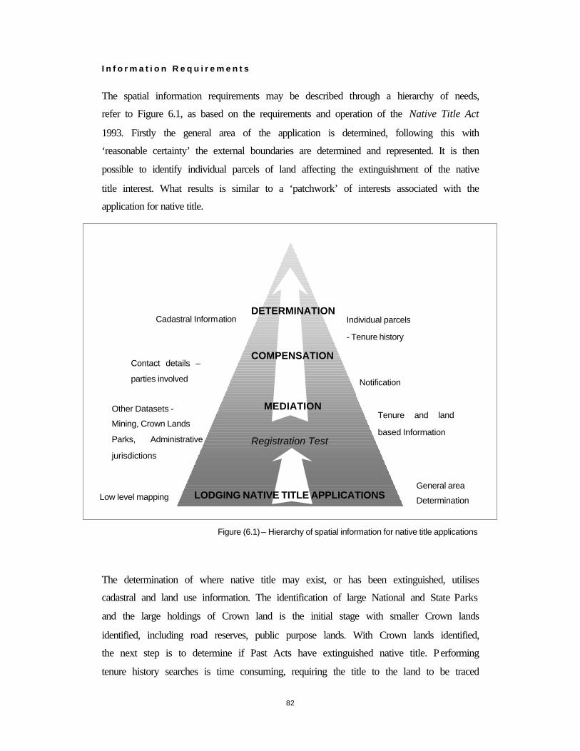
82
I n f o r m a t i o n R e q u i r e m e n t s
The spatial information requirements may be described through a hierarchy of needs,
refer to Figure 6.1, as based on the requirements and operation of the Native Title Act
1993. Firstly the general area of the application is determined, following this with
‘reasonable certainty’ the external boundaries are determined and represented. It is then
possible to identify individual parcels of land affecting the extinguishment of the native
title interest. What results is similar to a ‘patchwork’ of interests associated with the
application for native title.
Figure (6.1) – Hierarchy of spatial information for native title applications
The determination of where native title may exist, or has been extinguished, utilises
cadastral and land use information. The identification of large National and State Parks
and the large holdings of Crown land is the initial stage with smaller Crown lands
identified, including road reserves, public purpose lands. With Crown lands identified,
the next step is to determine if Past Acts have extinguished native title. Performing
tenure history searches is time consuming, requiring the title to the land to be traced
MEDIATION
DETERMINATION
COMPENSATION
Registration Test
Individual parcels
- Tenure history
Tenure and land
based Information
General area
Determination
Cadastral Information
Other Datasets -
Mining, Crown Lands
Parks, Administrative
jurisdictions
Low level mapping LODGING NATIVE TITLE APPLICATIONS
Notification
Contact details –
parties involved

83
back to its origin alienation. The reproduction of mapped representations of native title
areas is facilitated by the many functions able to be undertaken through GIS.
These information requirements have been incorporated into the development of the
GIS prototype, the Native Title Applications Manager, as detailed in Chapter seven.

84
6.5 GIS APPL ICAT IONS - CA N A D A A N D T H E N N T T
The application of GIS in Canada for the purposes of resource management, by the First
Nations, highlights the ways in which traditional knowledge systems may be
documented through GIS. Traditional knowledge, as presented in the GIS, has been
used to support a number of land claims throughout Canada. The application of GIS by
the National Native Title Tribunal (NNTT), is primarily for the assistance with the
operation of the Native Title Act 1993. Both systems demonstrate the flexibility of GIS
and the appropriate use of GIS for native title purposes and within indigenous
communities.
6.5.1 C A N A D A
The land claims in Canada provided precedent for the recognition of indigenous forms
of land tenure in Australia (as referred to in chapter two). So to has the use of GIS for
the purposes of land and title claims by the Canadian Indians and the recognition and
documented of Traditional Ecological Knowledge (TEK). TEK may be described as
information of ‘local environments accumulated through generations of contact with the
land and communicated through stories, conversation, oral history, and song’ (Duerden
& Kuhn 1996, p 49). The application of GIS as a ‘computer based tool allows TEK to
be documented and integrated with a variety of other types of information that can then
be analysed and visually displayed for litigation purposes or for land claims negotiation
purposes’ (Rakai & Nichols 1998, p 1). The use of GIS allows the overlay of a variety
of different spatial datasets, assisting with the determination of cultural areas and lands
that are associated with claims and litigation.
The application of GIS by First Nations has been prolific, sixteen years ago there were
no GIS operational and today there are eighteen, supporting the documentation,
representation, analysis and management of TEK information sources and supporting
land claims (Duerden & Kuhn 1996). With many First Nations using GIS as a tool to
assist for ordering and administration of information significant to land claims and
natural resource management, this information is being used as basis for many
agreements and negotiations to be implemented at a local or regional level. It has been
highlighted that despite the widespread adoption of GIS technology, its potential is far
from being realised, with limited ability to play an active role in decision support
85
mechanisms. Limitations to the development of GIS are due in part to the recent
acquisition of GIS technologies by many of the First Nations, the lack of trained GIS
personnel whom are aware of the intrinsic nature of land and the native Canadians, the
limited access and quality of spatial information and finally the failure of First Nations
to develop objectives for the appropriate application and development of GIS.
6.5.2 NA T I O N A L NA T I V E T I T L E TR I B U N A L
The GIS solution developed by the Geospatia l Unit, NNTT is for the purposes of
assisting with the facilitation of the Native Title Act 1993, providing case managers and
other NNTT staff with current and accurate spatial and textual information pertaining to
native title applications. The GIS solution has been developed using MapInfo,
disseminated through an Intranet within the NNTT, with a web based interface.
The design of the tools or interface are intuitive with no keyboard input required
(Bowen 2000). The functions include overlay analysis, basic information and querying,
layer control and printing functions. The operation of the Geospatial Unit of the NNTT
is a national role, where they are custodians of geospatial information associated with
native title (application and determinations), ILUAs and Future Act notices.
Additionally, the Geospatial Unit may be required to provide expert opinion with
regards to mapping and written descriptions of native title and determine spatial
relationships associated with applications, namely that of overlapping claim areas
contravening sections 67 and 68 of the Native Title Act 1993.
S y s t e m s O v e r v i e w
The system, as developed by the Geospatial Unit, is divided into two sections. Native
title applications may change when before the Federal Court as there are two
representations of applications, these being:
• Applications as per the registry; and
• Applications before the Federal Court
Applications may be referenced at a State or Territory level, where native title
application number, Local Government Area and regions may be identified and viewed.

86
F u n c t i o n s
Apart from viewing datasets through the ‘Layer Control’ option, users may analyse and
enquire (or find) specific information relating to native title applications. The ‘analyse’
option allows for all datasets that may overlap the selected area to be viewed and
documented in tabular format. The analysis that may be conducted includes the analysis
with other applications and the determination of and area measurement (km2) of the
overlapping areas, and analysis with other datasets such as local governments.
At an applications level, specific overlays (local government, ATSIC regions, NNTT
regions and more) may be viewed, where information is viewed in tabular formats.
Figure 6.2, below, is a screen capture of the NNTT GIS solution as published by
Bowen, 2000.
Figure (6.2) – Overlay analysis of applications
(Bowen 2000, p 8)
87
6.6 CHAPTER S U M M A R Y
GIS offers the opportunity to demonstrate the unique and multi-dimensions
relationships with land as held by indigenous and fundamental communities and assists
with the requirements and operation of the Native Title Act 1993. However important
spatial information and associated technologies become, they ‘can not relieve the
researcher and policy-maker from the task to determine which social, economic, and
political factors impact human-environment relations’ (Brodnig & Mayer-Schonberger
1999, p 33). In summary:
• The perspectives of GIS, identified by Maguire (1991) are easily transferable to the
functions and components required for native title, these being mapping, analysis
and data management.
• GIS has successfully been employed by many First Nations of Canada and the
management of TEK, which subsequently supported many claims to land. In
Australia, the Geospatial Unit of the NNTT recognised a need for the
representation, management and dissemination of spatial information inherent in the
native title process. The development of the intranet solution by the NNTT,
highlighted a number of issues involving access, use and compatibility of data,
highlighted by the national role of the Geospatial unit and employment of data from
various agencies of difference States and Territories.
Of the research thus far has identified the need for appropriate tools for determining and
representing the spatial dimensions of native title. The development of a GIS tool,
assisting applicants and representatives of the State of Victoria, is yet to be undertaken.
The developments of the GIS prototype, Native Title Applications Manager is detailed
in the following chapter.

88
C H A P T E R 7 - G I S P R O T O T Y P E F O R N A T I V E T I T L E A P P L I C A T I O N S
7 I N T R O D U C T I O N
The development of a Geographical Information Systems (GIS) tool for applicants and representatives in Victoria, assisting with the requirements of the Native Title Act 1993 is yet to be undertaken. This chapter details the development of the Native Title Applications Manager GIS prototype, reviews the operation of the prototype in mapping, analysing, managing and disseminating spatial information associated with the Wotjobaluk native title application (VC 95/02). Evaluating its operation, providing direction for the future development of GIS for native title.
89
7.1 GIS P ROTOTYPE FOR NATIVE T ITLE
The application of GIS, as a tool for native title, is a means for associated spatial
information to be represented, analysed, disseminated and managed. The approach to
design of the Native Title Applications Manager has focused on the requirements of
both the user and the Native Title Act 1993.
The methodology employed in designing the prototype for native title, encompasses the
following:
• Statement of the objectives;
• Identification of the required functionalities; and
• Identification of the user requirements and those of the Native Title Act 1993.
The application for native title VC95/02, termed the Wotjobaluk application, has been
used as a case study. The research focuses on the development of the Native Title
Applications Manager (the prototype) and from the evaluation of the performance and
functionality, the native title section of the Victorian Land Information System (VLIS)
was further developed.
Note: the reference to VC95/02 relates to the administrative identifier designated to the
native title application by the NNTT.
7.1.1 O BJECT IVES
The formulation of the operating and design objectives of the prototype results from the
requirement to supply spatial information as part of the Native Title Act 1993 (refer to
Chapter Four) and from the conclusions as formed from analysing current native title
applications lodged with the NNTT (refer to Chapter Five).
The primary purpose for developing a GIS prototype, as a tool for native title, is to
illustrate the potential of GIS technologies for native title purposes.
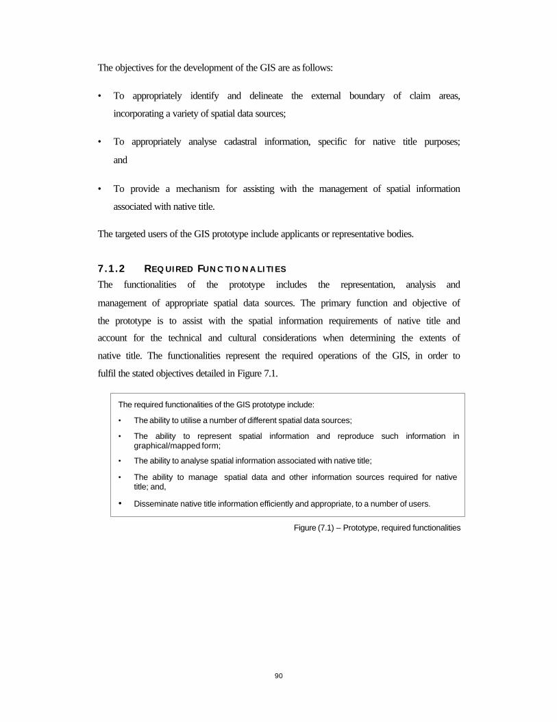
90
The objectives for the development of the GIS are as follows:
• To appropriately identify and delineate the external boundary of claim areas,
incorporating a variety of spatial data sources;
• To appropriately analyse cadastral information, specific for native title purposes;
and
• To provide a mechanism for assisting with the management of spatial information
associated with native title.
The targeted users of the GIS prototype include applicants or representative bodies.
7.1.2 R E Q U I R E D FU N C T I O N A L I T I E S
The functionalities of the prototype includes the representation, analysis and
management of appropriate spatial data sources. The primary function and objective of
the prototype is to assist with the spatial information requirements of native title and
account for the technical and cultural considerations when determining the extents of
native title. The functionalities represent the required operations of the GIS, in order to
fulfil the stated objectives detailed in Figure 7.1.
Figure (7.1) – Prototype, required functionalities
The required functionalities of the GIS prototype include:
• The ability to utilise a number of different spatial data sources;
• The ability to represent spatial information and reproduce such information in graphical/mapped form;
• The ability to analyse spatial information associated with native title;
• The ability to manage spatial data and other information sources required for native title; and,
• Disseminate native title information efficiently and appropriate, to a number of users.

91
7.1.3 R E Q U I R E M E N T S
U s e r R e q u i r e m e n t s
The users of such a GIS have been identified as applicants and representing bodies
(Mirimbiak Nations) in Victoria. The user requirements are detailed in Figure 7.2,
below. Mirimbiak Nations, currently, has no geospatial information capabilities. The
characteristics and competencies of the users include:
• Low levels of expertise in the area of computer technology;
• Low levels of cartographic knowledge;
• Little to no facilities of computers and other information technology; and
• Without GIS expertise.
Figure (7.2) – Prototype, user requirements of the GIS prototype
D a t a a n d i n f o r m a t i o n r e q u i r e m e n t s
The data and information requirements for the prototype includes information that is
specific to the native title application and spatial information pertaining to land use,
administration, and tenure information (cadastral data). Figure 7.3 details the
requirements and considerations of the spatial data and aspatial information required by
the Act.
Figure (7.3) – Prototype, data and information requirements
The user requirements include:
1. Ease of use;
2. Reliability;
3. Methods of dissemination; and
4. Resource requirements and access to spatial information.
The requirement considerations of the data and information required for the prototype include:
1. Data and information relating to cadastral and land tenure details;
2. Access;
3. Currency;
4. Accuracies; and
5. Compatibility with other data and information sources.

92
R e q u i r e m e n t s o f t h e A c t
The spatial information requirements of the Native Title Act 1993include a mapped
representation and a technical description of the claim area (S62 NTA 1993). The
inclusion of tenure histories as part of the determination of native title requires the GIS
to be able to handle large amounts of cadastral data. Figure 7.4 details the requirements
and considerations of the Native Title Act 1993 in the development of the prototype.
Figure (7.4) – Prototype, requirements of the Native Title Act 1993
7.1.4 D E S I G N S P E C I F I C A T I O N S
The four main design criteria, refer to Figure 7.5, include: mapping, analysis, data
management and dissemination and user interaction. From these criteria and
specifications the system is evaluated.
The requirement considerations of the Native Title Act 1993 for the development of the GIS prototype include:
1. S62 NTA 1993, requesting the supply of spatial information, in the form of a mapped representation and a technical description;
2. Appropriate access to spatial information for negotiations and mediations to operate; and,
3. The guidelines of the NNTT.
M a p p i n g
The prototype must be able to reproduce maps displaying the external boundaries of the native title application and the relationships between tenures and other applications. The mapping specifications include:
• Assist with the determination of the external boundaries of the native title claim area;
• Use of a variety of spatial information sources;
• Production and reproduction of spatial information in a graphical form (that of a mapped representation); and,
• The ability to represent the dimensions of native title through varied mediums.
A n a l y s i s
The analysis of information is paramount for the functionality of the prototype for the purposes of native title. The analysis specifications and requirements include:
• Manipulation of spatial data;
• Ability to query spatial information;
• Ability to identify attributes of spatial information; and,
• Analyse tenure information.

93
Figure (7.5) – Prototype, design functionalities
7.1.5 D A T A S P E C I F I C A T I O N
The use of spatial information, as gathered, maintained and distributed by a variety of
sources, highlights a need to obtain metadata. Such information documents the
accuracies and currency of spatial data and impacts upon potential use and decision
making processes for native title. It is the lack of accuracy estimates and the subsequent
‘potential to harm the reputations of both the individual and agencies and the public’s
confidence in them – particularly in cases where administrative decisions are subject to
judicial review (as is the case with native title) and the use of GIS may be called into
question’ (Hunter 1999, p 634). The specifications of the data used for the prototype
indicates the custodian and source of the data, the currency, the projection, the history
of the data and the positional accuracy of the data. The data specifications and metadata
information for the prototype are detailed in Appendix 8.
D a t a M a n a g e m e n t
The voluminous and varied spatial information sources require appropriate data management facilities. The specifications for the management of spatial and aspatial data include:
• The ability to input and edit native title information;
• Reporting mechanism for the metadata standards of the spatial information employed; and,
• Tracking of management procedures.
D i s s e m i n a t i o n a n d U s e r I n t e r a c t i o n
The dissemination and user interaction specified for the prototype include:
• The appropriate means for the dissemination of native title information to a number of interested parties; and,
• Ease of use.
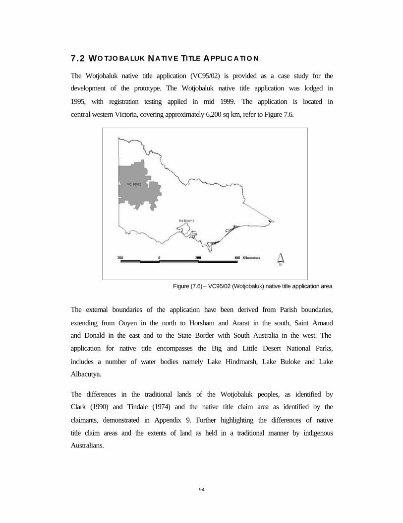
94
7.2 WO TJOBALUK NATIVE T ITLE AP P L I C A T I O N
The Wotjobaluk native title application (VC95/02) is provided as a case study for the
development of the prototype. The Wotjobaluk native title application was lodged in
1995, with registration testing applied in mid 1999. The application is located in
central-western Victoria, covering approximately 6,200 sq km, refer to Figure 7.6.
Figure (7.6) – VC95/02 (Wotjobaluk) native title application area
The external boundaries of the application have been derived from Parish boundaries,
extending from Ouyen in the north to Horsham and Ararat in the south, Saint Arnaud
and Donald in the east and to the State Border with South Australia in the west. The
application for native title encompasses the Big and Little Desert National Parks,
includes a number of water bodies namely Lake Hindmarsh, Lake Buloke and Lake
Albacutya.
The differences in the traditional lands of the Wotjobaluk peoples, as identified by
Clark (1990) and Tindale (1974) and the native title claim area as identified by the
claimants, demonstrated in Appendix 9. Further highlighting the differences of native
title claim areas and the extents of land as held in a traditional manner by indigenous
Australians.
95
7.2.1 D A T A PR E P A R A T I O N
The preparation of data for use in the prototype required spatial datasets to be re-
projected from a Geographic reference system to an Australian Map Grid, zone 54
projection. Preparation of cadastral data for the prototype required the CAD design files
(dgn) to be cleaned (the process by which nodes are connected). The preparation of
spatial data was undertaken in ArcInfo for its use in ArcView.
Tabular information, pertaining to the individual parcels of land as identified by the
applicant were obtained together with the parcels as identified by the Geospatial Unit of
the NNTT using the States digital cadastral information. The individual land parcels of
the claim are identified through allotment numbers and parish identifier and allocated a
unique (Doc_ref_no) number.
The applicants place a ‘blanket’ claim over the area to the exclusion of freehold and
other tenures. This ‘blanket’ claiming of all Crown lands (and other tenure to be
determined) requires the State, the NNTT and the applicant to identify parcels of land
claimed as part of the application for the process of negotiation and mediation. It is
therefore paramount for discrepancies to be identified and potential parcels of land be
documented. These discrepancies occur due the methods employed by the applicant in
identifying these lands and the limited completeness of digital records of Crown lands
as maintained by the State.
In the Wotjobaluk application, the applicants identified the individual parcels of Crown
land from photocopied Parish plans, where the parcels were identified by hand. Each
parcel of land is allocated a ‘Doc_ref_no’, as stipulated by the applicant. It was then
possible to correlate those parcels, refer to Figure 7.7, identified by the applicant with
those identified by the Geospatial Unit, using the State of Victoria’s digital cadastral
data. The subsequent table (VC_95_02.dbf), displays the correlation of parcel
identification. Where the Doc_ref_no is supplied, both the applicant and the Geospatial
Unit have identified the parcel, where the Doc_ref_no is zero, the parcel has not been
directly identified by the applicant.

96
Figure (7.7) – Cross correlation of parcels
The order of discrepancy was that of over 1500 parcels of land not identified by the
applicant. The applicant identified just over 1600 individual parcels of land, while the
Geospatial Unit of the NNTT identified over 3000 individual parcels of land for the
same area.
The preparation of this tabular information and the cross correlation of parcels was
performed during the research visit to the Geospatial Unit, NNTT and provides the
basis for the analysis and query functionality of the Native Title Applications Manager.
Crown Lands asidentified byapplicants
Doc_ref_no
Crown Lands asidentified by theGeospatial Unit
(NNTT)
Crown Lands
Where doc_ref_no = 1- 1600 then theCrown parcel has been identified by the
applicant
Where doc_ref_no=0 then the Crownparcel has not been identified by the
applicant but has been identified by theGeospatial Unit (nntt)
Doc_ref_nocorrelated

97
7.3 REVIEW OF NATIVE T ITLE APPL ICAT IONS MANAGER
The Native Title Application Manager utilises Microsoft Access (MS Access) and
ArcView (GIS software). MS Access is employed for data input and data management.
While ArcView software provides the GIS functionality to view and represent, query
and analyse, and manage spatial information. Refer to Figure 7.8 for the input and
update functionality of the Native Title Applications Manager.
Figure (7.8) – Input and Update functions of the Native Title Application Manager
MS ACCESS ARCVIEW
TABLEFUNCTIONS
INPUT UPDATE QUERY VIEW MAP
INPUT
UPDATE
NNTT_APPLICATIONS*.dbf file
lgaparish
QueryUserselecttables
ViewUserselect
themesview
themes
MapCreate
Map fromthe View
Input and Update functions - open table edit dialogthrough an icon button
contact details:- claimants- other parties- NNTT
Input data for aselected
*.dbf table
select *.dbf tablesto query

98
The spatial data themes (detailed in Table 7.1) as supported by ArcView, and as
employed by the Native Title Applications Manager include:
Theme name Description Format
Origin
(refer to Appendix 9 for the metadata information)
VC95/02 Claim area of VC95/02 Shapefile Parish dataset
Infrastructure Basic infrastructure of the
area, including major towns and lakes
Shapefile Infrastructure dataset
Urban Areas Urban areas Shapefile Urban dataset
Public Lands Public lands Shapefile Publcland dataset
National Parks National Parks Shapefile Nogo dataset
Crown Lands (major)
Major Crown lands as identified by DNRE
Shapefile Crown dataset
Exploration Licences Exploration Licensed Shapefile Elr dataset
Other Exploration Licences
Other exploration and mineral licences Shapefile Otherelr dataset
Parish Parish boundaries Shapefile Parish dataset
Local Government
Local Government boundaries
Shapefile LGA_95 dataset
Crown Land annotation
(lv 5 –CAD)
Crown land annotation CAD – dgn format
Extracted from the annotations layer of the cadastral data
(level 5)
Road annotations
(lv 13 - CAD) Road annotation CAD – dgn
format
Extracted from the annotations layer of the cadastral data
(level 13)
Land Parcels Land parcels, cadastral layout
CAD – dgn format
Extracted from the cadastral data, lines, level 11 and 12.
VC 95/15 Native title application
(VC 95/15) Shapefile ELR dataset
VC 96/03 Native title application (VC96/03) Shapefile Mabo dataset
VC 96/01 Native Title application (VC96/01)
Shapefile Mabo dataset
Table (7.1) – Native Title Applications Manager, spatial data themes
A number of additional tools have been developed as part of the Native Title
Applications Manager, including refining the ability to query data, the preparation of
tables for analysis, the identification of land and correlation of identified land parcels,

99
the input of tabular information, to assist with the management of tabular data and a
tool to append images associated with the themes.
Figure (7.9) – Tools, Native Title Applications Manager
A description of the additional tools of the Native Title Applications Manager (as
displayed in Figure 7.9, is as follows:
Query Data – A standard ArcView tool, additional information may be added to the
attribute table.
Set the Tables for Analysis – A tool used to establish the tables for analysis, utilises a
standard ArcView script (‘set-one-to-many’) whereby the Parish theme is established to
the many Parish attributes of the table vc_95_02.dbf (from the correlation of parcels
identified).
Identify data – Specific to the Parish theme, identifies the Parish and the correlated
section of the vc_95_02.dbf table. Allowing the user to view the Parish and the
correlated parcels identified by the applicant and the Geospatial Unit of the NNTT.
Set data tables for analysis
Query data
Data management
Append images
Input table
Identify data, correlation of parcels

100
Table input – Script created, allowing the user to input specific information (NNTT
file number, claimants, city/town, State, NNTT case manager, ATSIC region, native
title rights being claimed, date). The resulting table is stored in dbf format and
compatible with other tabular information as used by the prototype.
Data Management – Extension to ArcView, allowing the user to edit selected dbf
tables.
Append images – Script allowing the user to append images to the theme. Using the
standard hotlink option within ArcView.
M a p p i n g
The mapping of spatial data is a basic and fundamental functionality of GIS software.
Refer to Appendix 10 for screen grabs of the Native Title Applications Managers ability
to represent a number of spatial and non-spatial information. The ability to combine a
number of datasets, assists with the representation of a number of spatial associations
affecting the applications. Figure 7.10, displays the ability of the prototype to display
images associated with the National Parks. The areas of National Parks are of
significance as they are the regions whereby native title may exist. Images are appended
to the National Parks theme providing a greater graphical representation of the area.
The appending of images displays the versatility of GIS to combine a number of
mediums not only images but also that of digital video and sound clips.
Figure (7.10) –National Parks and attached images
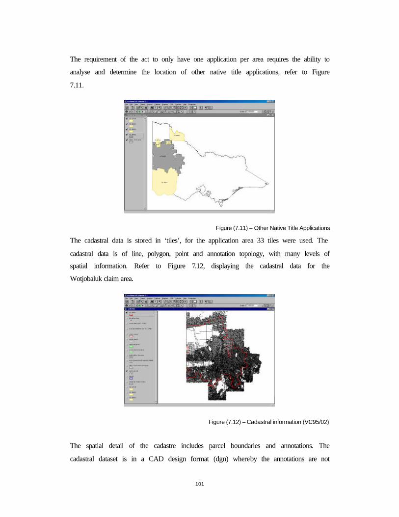
101
The requirement of the act to only have one application per area requires the ability to
analyse and determine the location of other native title applications, refer to Figure
7.11.
Figure (7.11) – Other Native Title Applications
The cadastral data is stored in ‘tiles’, for the application area 33 tiles were used. The
cadastral data is of line, polygon, point and annotation topology, with many levels of
spatial information. Refer to Figure 7.12, displaying the cadastral data for the
Wotjobaluk claim area.
Figure (7.12) – Cadastral information (VC95/02)
The spatial detail of the cadastre includes parcel boundaries and annotations. The
cadastral dataset is in a CAD design format (dgn) whereby the annotations are not

102
attached to the parcels and the cadastre itself has no retaining topology, detailing lines
and polygons. Figure 7.13 details the land parcels and the road annotations on a
separate layer.
Figure (7.13) – Cadastral information (VC95/02)
A n a l y s i s
The analysis capabilities of the Native Title Applications Manager includes the
identification of Crown lands by Parish identifier and the correlation of land parcels.
Figure (7.14) – Crown Land identified by both the Applicant and the Geospatial Unit
Where the Doc_ref_no is detailed, both the applicant and the Geospatial unit have
identified the parcel, Figure 7.14. Where the Doc_ref_no is zero, the applicant has not
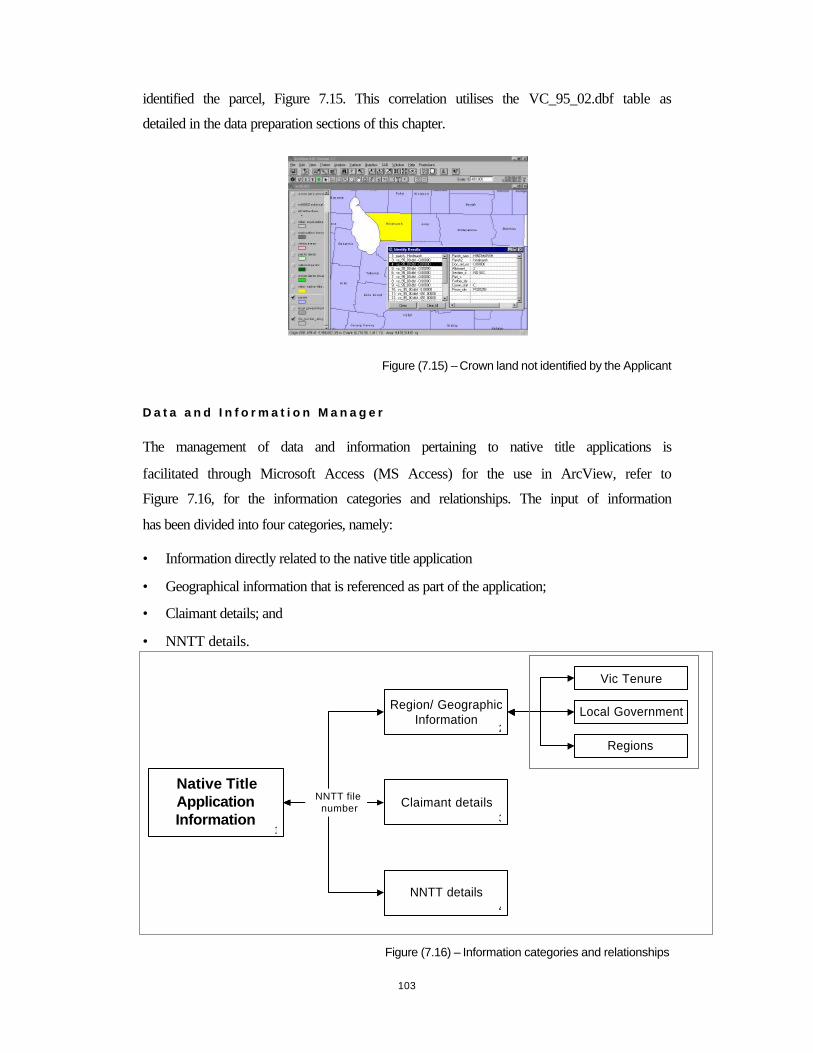
103
identified the parcel, Figure 7.15. This correlation utilises the VC_95_02.dbf table as
detailed in the data preparation sections of this chapter.
Figure (7.15) – Crown land not identified by the Applicant
D a t a a n d I n f o r m a t i o n M a n a g e r
The management of data and information pertaining to native title applications is
facilitated through Microsoft Access (MS Access) for the use in ArcView, refer to
Figure 7.16, for the information categories and relationships. The input of information
has been divided into four categories, namely:
• Information directly related to the native title application
• Geographical information that is referenced as part of the application;
• Claimant details; and
• NNTT details.
Figure (7.16) – Information categories and relationships
Native TitleApplicationInformation
Region/ GeographicInformation
Claimant details
NNTT details
Regions
Local Government
Vic Tenure
NNTT filenumber
1
2
1
3
4
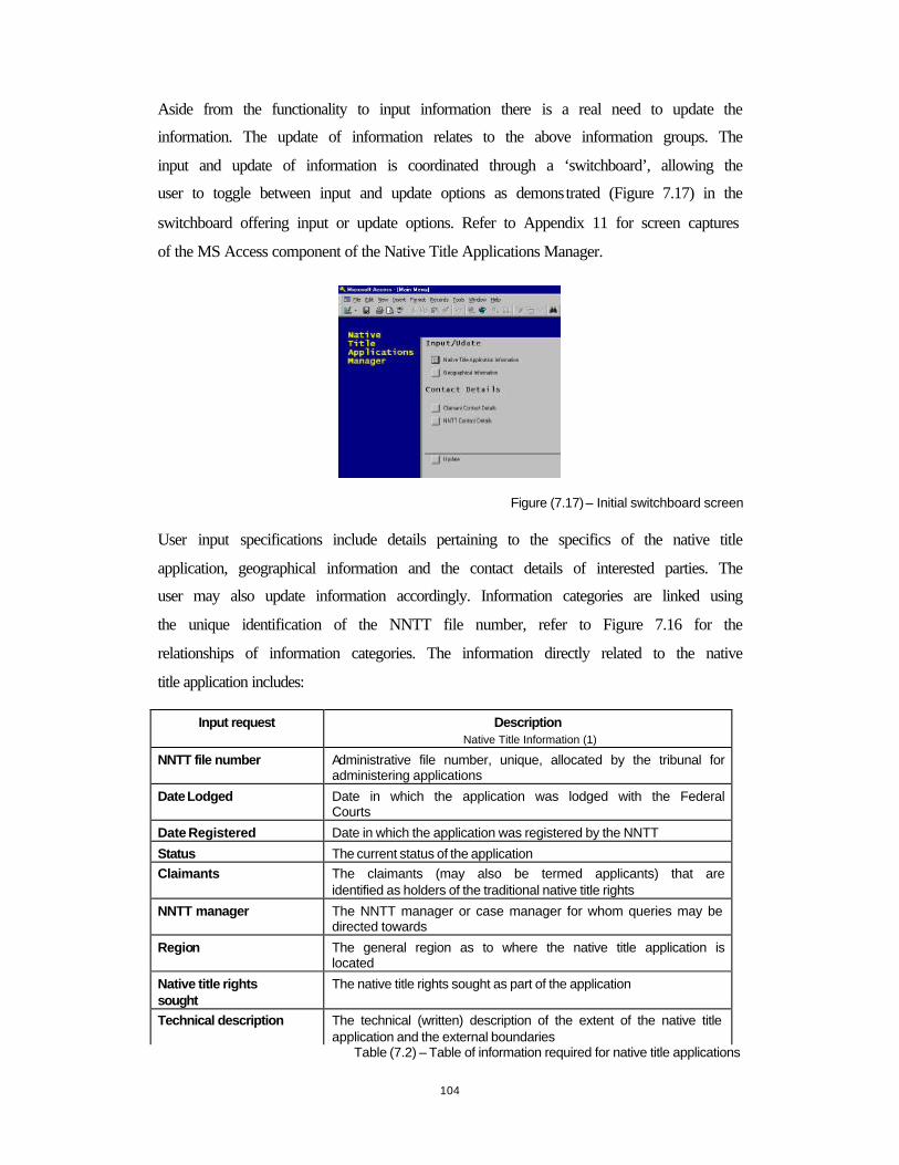
104
Aside from the functionality to input information there is a real need to update the
information. The update of information relates to the above information groups. The
input and update of information is coordinated through a ‘switchboard’, allowing the
user to toggle between input and update options as demonstrated (Figure 7.17) in the
switchboard offering input or update options. Refer to Appendix 11 for screen captures
of the MS Access component of the Native Title Applications Manager.
Figure (7.17) – Initial switchboard screen
User input specifications include details pertaining to the specifics of the native title
application, geographical information and the contact details of interested parties. The
user may also update information accordingly. Information categories are linked using
the unique identification of the NNTT file number, refer to Figure 7.16 for the
relationships of information categories. The information directly related to the native
title application includes:
Input request Description Native Title Information (1)
NNTT file number Administrative file number, unique, allocated by the tribunal for administering applications
Date Lodged Date in which the application was lodged with the Federal Courts
Date Registered Date in which the application was registered by the NNTT
Status The current status of the application Claimants The claimants (may also be termed applicants) that are
identified as holders of the traditional native title rights
NNTT manager The NNTT manager or case manager for whom queries may be directed towards
Region The general region as to where the native title application is located
Native title rights sought
The native title rights sought as part of the application
Technical description The technical (written) description of the extent of the native title application and the external boundaries
Table (7.2) – Table of information required for native title applications
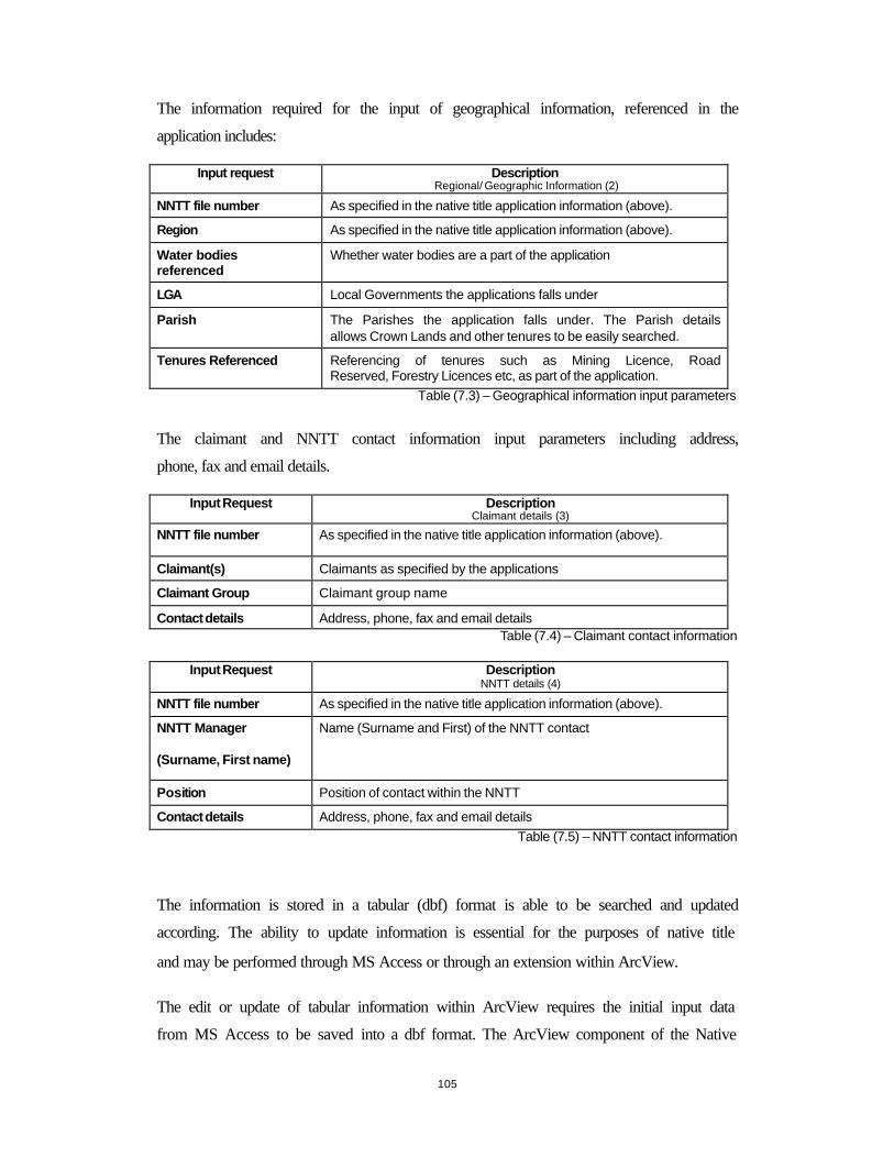
105
The information required for the input of geographical information, referenced in the
application includes:
Input request Description Regional/ Geographic Information (2)
NNTT file number As specified in the native title application information (above).
Region As specified in the native title application information (above).
Water bodies referenced
Whether water bodies are a part of the application
LGA Local Governments the applications falls under
Parish The Parishes the application falls under. The Parish details allows Crown Lands and other tenures to be easily searched.
Tenures Referenced Referencing of tenures such as Mining Licence, Road Reserved, Forestry Licences etc, as part of the application.
Table (7.3) – Geographical information input parameters
The claimant and NNTT contact information input parameters including address,
phone, fax and email details.
Input Request Description Claimant details (3)
NNTT file number As specified in the native title application information (above).
Claimant(s) Claimants as specified by the applications
Claimant Group Claimant group name
Contact details Address, phone, fax and email details Table (7.4) – Claimant contact information
Input Request Description NNTT details (4)
NNTT file number As specified in the native title application information (above).
NNTT Manager
(Surname, First name)
Name (Surname and First) of the NNTT contact
Position Position of contact within the NNTT
Contact details Address, phone, fax and email details Table (7.5) – NNTT contact information
The information is stored in a tabular (dbf) format is able to be searched and updated
according. The ability to update information is essential for the purposes of native title
and may be performed through MS Access or through an extension within ArcView.
The edit or update of tabular information within ArcView requires the initial input data
from MS Access to be saved into a dbf format. The ArcView component of the Native

106
Title Applications Manager, Figure 7.18 allows the user to view spatial information
together with the tabular information from MS Access.
Figure (7.18) - Edit information from the GIS interface
D i s s e m i n a t i o n a n d U s e r I n t e r a c t i o n
The dissemination of the native title information from the Native Title Applications
Manager is software dependent. An intranet solution involving ArcView would serve as
an appropriate means for disseminating information. However ArcView requires strict
and rigid structuring of files. The user interaction is assisted with the placement and
customisation of tools, assisting with the operation of the Native Title Applications
Manager.
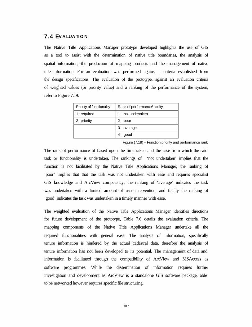
107
7.4 EVALUAT ION
The Native Title Applications Manager prototype developed highlights the use of GIS
as a tool to assist with the determination of native title boundaries, the analysis of
spatial information, the production of mapping products and the management of native
title information. For an evaluation was performed against a criteria established from
the design specifications. The evaluation of the prototype, against an evaluation criteria
of weighted values (or priority value) and a ranking of the performance of the system,
refer to Figure 7.19.
Priority of functionality Rank of performance/ ability
1 - required 1 – not undertaken
2 - priority 2 – poor
3 – average
4 – good
Figure (7.19) – Function priority and performance rank
The rank of performance of based upon the time taken and the ease from which the said
task or functionality is undertaken. The rankings of ‘not undertaken’ implies that the
function is not facilitated by the Native Title Applications Manager; the ranking of
‘poor’ implies that that the task was not undertaken with ease and requires specialist
GIS knowledge and ArcView competency; the ranking of ‘average’ indicates the task
was undertaken with a limited amount of user intervention; and finally the ranking of
‘good’ indicates the task was undertaken in a timely manner with ease.
The weighted evaluation of the Native Title Applications Manager identifies directions
for future development of the prototype, Table 7.6 details the evaluation criteria. The
mapping components of the Native Title Applications Manager undertake all the
required functionalities with general ease. The analysis of information, specifically
tenure information is hindered by the actual cadastral data, therefore the analysis of
tenure information has not been developed to its potential. The management of data and
information is facilitated through the compatibility of ArcView and MSAccess as
software programmes. While the dissemination of information requires further
investigation and development as ArcView is a standalone GIS software package, able
to be networked however requires specific file structuring.

108
7.4.1 E V A L U A T I O N C R I T E R I A
Table (7.6) – Evaluation Criteria
The evaluation criteria were devised by the author, in response to the desired
functionalities and requirements of the GIS. The weighted value is indicative of the
importance of the criteria and the rank the value of performance when undertaking the
specified task associated with the criteria.
rank
Criteria weighted value
Native TitleApplications Manager
MappingAssist with the determination of the external boundaries of thenative title claim area 1 4Use of a variety of spatial information sources 2 4Production and reproduction of spatial information 2 4
The ability to represent the dimensions of native title throughother mediums 1 3
weighted average 4
AnalysisAbility to query spatial information 2 3Ability to identify attributes of spatial information 2 3
Analyse tenure information 2 2
weighted average 3
Data ManagementThe ability to input and edit native title information 1 4
Reporting mechanism for the metadata standards of the spatialinformation employed 1 3
Tracking of management procedures 1 1
weighted average 3
Dissemination and User interactionThe appropriate means for the dissemination of native titleinformation to a number of interested parties 1 2Compatibility with other geospatial information systems 1 2Ease of use 2 2
weighted average 2
weighted average 3
109
M a p p i n g
Mapping, and the ability to represent the spatial dimensions and associations of native
title applications was a priority functionality of the GIS. The ability to reproduce
mapping products and the reproduction of spatial information is a necessity for the
operation of a GIS tool for the purposes of native title.
A n a l y s i s
The ability to query and analyse spatial information was of priority as all criteria were
weighted with a value of two. The performing of analysis and querying functions (either
the cross correlation or identification) the Native Title Applications Manager was
ranked with a value of three, indicating that the analysis component of the prototype
could be further developed. The analysis of tenure information (cadastral data) was
hampered by the lack of compatibility with other datasets and thus received a
performance rank of two.
D a t a M a n a g e m e n t
The ability to manage data was required but not a necessity as the applicant or
representative may have in place established data management facilities. The ability to
input and update information received a performance rank of four, this is due to the
customisation of the data management and input table tools. The ability to track
changes to information is not provided as part of the Native Title Applications Manager
and is a functionality that is to be developed upon in future works.
D i s s e m i n a t i o n a n d U s e r I n t e r a c t i o n
The dissemination of information and compatibility with other geospatial information
systems, aside from ArcView, is required. The limited dissemination of native title
information results from the Native Title Applications Manager being software
dependent. The ease of use was of priority, limited GIS and ArcView knowledge is
required further indicating that the prototype could be further customised to improve the
analysis and mapping of spatial information.

110
7.5 L I M I T A T I O N S
The evaluation of the Native Title Applications Manager highlights limitations with the
operation and development of the datasets and the prototype.
• The ability of the prototype to identify Crown Lands, a desired functionality for
native title, was hindered with the lack of spatial compatibility of the cadastral data
and other information datasets. The term ‘spaghetti data’, as demonstrated in Figure
7.20, has been coined for the use of design file format for GIS purposes, with many
levels of data constituting the dataset. The cadastral data required intensive
maintenance (cleaning of data and building of polygons) for its use in the
prototypes.
Figure (7.20) – Cadastral layers
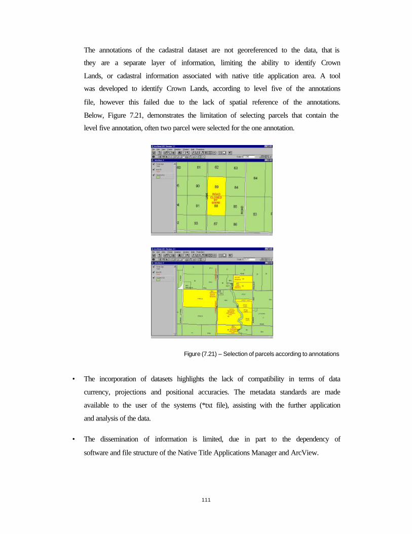
111
The annotations of the cadastral dataset are not georeferenced to the data, that is
they are a separate layer of information, limiting the ability to identify Crown
Lands, or cadastral information associated with native title application area. A tool
was developed to identify Crown Lands, according to level five of the annotations
file, however this failed due to the lack of spatial reference of the annotations.
Below, Figure 7.21, demonstrates the limitation of selecting parcels that contain the
level five annotation, often two parcel were selected for the one annotation.
Figure (7.21) – Selection of parcels according to annotations
• The incorporation of datasets highlights the lack of compatibility in terms of data
currency, projections and positional accuracies. The metadata standards are made
available to the user of the systems (*txt file), assisting with the further application
and analysis of the data.
• The dissemination of information is limited, due in part to the dependency of
software and file structure of the Native Title Applications Manager and ArcView.
112
7.6 F UTURE D EVELO P M E N T
From the evaluation of the Native Title Applications Manager and the documentation of
the limitations, it is possible to formulate directions for the future development of a GIS
tool for the purpose of native title. As identified by the evaluation, further development
is required for the ability of the prototype to manage information, specifically tracking
changes made to databases.
The capacity to analyse and build land use and planning scenarios based on native title
information can be improved, further enhancing the capabilities of incorporating native
title information into decisions support and planning mechanisms.
The ability to disseminate information by the Native Title Applications Manager is
limited as the prototype is software dependent and requires specific structuring of files.
The ability to disseminate native title information quickly and easily is a desired
functionality of GIS for native title. One option is to disseminate the prototype using
ArcExplorer, free GIS software. However this was limited due to the fact that spatial
data was still required. As such the native title information for the Wotjobaluk
application was included into a section of the Victorian Land and Information System
(VLIS), as developed by The Department of Geomatics, The University of Melbourne
(Majid 2000), where the native title information may be accessed over the www.
7.6.1 V I C T O R I A N LA N D IN F O R M A T I O N S YSTEM
The Victorian Land Information System (VLIS) as developed within the Department of
Geomatics (Majid 2000). The VLIS is a web based tool, that further develops the
concept of developing cadastral and land information system, to support a large number
of diverse land based information sources, combined with the ability to provide basic
querying functions. The inclusion of native title within the VLIS prototype displays the
increasing awareness of native title and the requirement to consider native title, within
property and land based information environments, in Australia. Refer to Appendix 12
for a review of the VLIS, native title section.

113
The objective of placing the native title application information (both in a textual and
spatial) on the web is two-fold. Firstly, to improve the dissemination of native title
information and secondly, to demonstrate the ability of future cadastral and land
information system, in recognising native title within mainstream land and cadastral
information. The dissemination of land based information over the www is an objective
of the Victorian Government and promotes the use of the web for the dissemination of
geospatial information (inline with Federal and international directives and agendas).
The themes of spatial information for use by the VLIS are prepared in ArcExplorer and
exported to the server. The preparation of queries in MS Access are required for the
ability to identify Crown lands as located in Parishes. The queries in MS Access are
hyperlinked in the VLIS. To operate the VLIS, the computer specifications and
requirements include a connection to the web with either a Netscape or Internet
Explorer web browser.
The datasets used for the VLIS are those used in the Native Title Applications Manager,
with further maintenance of these datasets required in ArcExplorer. Refer to Appendix
12 for screen captures of the VLIS.
M a p p i n g
Mapping capabilities are restricted to those on the web, paper map reproductions are not
possible at this stage of the development of the VLIS.
A n a l y s i s
The analysis of native title information is prepared through MSAccess. The query is
hyper-linked to a prepared table of Crown lands for the Parish. Refer to Figure 7.22.
The Switchboard lists the Parishes of the Wotjobaluk claim and from here the Crown
lands may be identified and displayed in a tabular format.
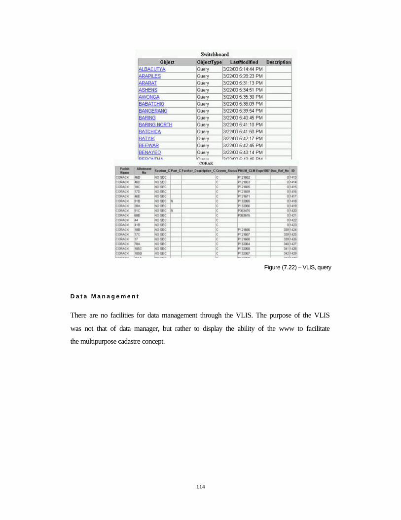
114
Figure (7.22) – VLIS, query
D a t a M a n a g e m e n t
There are no facilities for data management through the VLIS. The purpose of the VLIS
was not that of data manager, but rather to display the ability of the www to facilitate
the multipurpose cadastre concept.
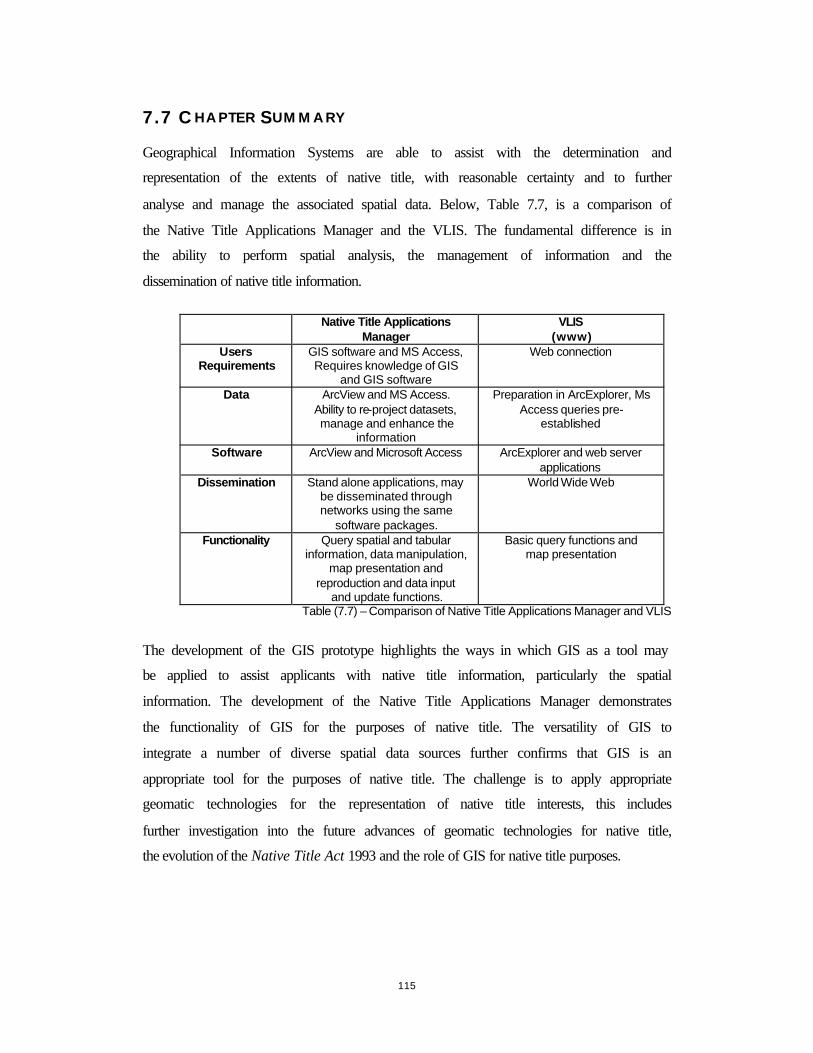
115
7.7 CHAPTER S U M M ARY
Geographical Information Systems are able to assist with the determination and
representation of the extents of native title, with reasonable certainty and to further
analyse and manage the associated spatial data. Below, Table 7.7, is a comparison of
the Native Title Applications Manager and the VLIS. The fundamental difference is in
the ability to perform spatial analysis, the management of information and the
dissemination of native title information.
Table (7.7) – Comparison of Native Title Applications Manager and VLIS
The development of the GIS prototype highlights the ways in which GIS as a tool may
be applied to assist applicants with native title information, particularly the spatial
information. The development of the Native Title Applications Manager demonstrates
the functionality of GIS for the purposes of native title. The versatility of GIS to
integrate a number of diverse spatial data sources further confirms that GIS is an
appropriate tool for the purposes of native title. The challenge is to apply appropriate
geomatic technologies for the representation of native title interests, this includes
further investigation into the future advances of geomatic technologies for native title,
the evolution of the Native Title Act 1993 and the role of GIS for native title purposes.
Native Title Applications Manager
VLIS (www)
Users Requirements
GIS software and MS Access, Requires knowledge of GIS
and GIS software
Web connection
Data ArcView and MS Access. Ability to re-project datasets, manage and enhance the
information
Preparation in ArcExplorer, Ms Access queries pre-
established
Software ArcView and Microsoft Access ArcExplorer and web server applications
Dissemination Stand alone applications, may be disseminated through networks using the same
software packages.
World Wide Web
Functionality Query spatial and tabular information, data manipulation,
map presentation and reproduction and data input
and update functions.
Basic query functions and map presentation
116
C H A P T E R 8 – F U T U R E T E C H N O L O G I E S A N D N A T I V E
T I T L E
8 I N T R O D U C T I O N
The application of GIS in Canada and by the NNTT in Australia has been successful in representing, analysing and managing traditional knowledge and native title information. The development of the Native Title Applications Manager confirms the applicability and versatility of GIS for the purposes of assisting applicant or representatives with the requirements of the Native Title Act 1993. The challenge now, is to apply developing geomatic technologies to better represent of indigenous interests in land and assist with the requirements of the Native Title Act 1993.
The development of Geographical Information Systems (GIS) has paralleled the evolution of computer technology with the first development of GIS in the late 1960s and early 1970s (Burroughs 1998) and more specifically has been enhanced with the advances in remote sensing and positioning systems and the improved compatibility of these technologies with GIS.
This chapter investigates the future direction of GIS technologies affecting native title, the evolution of the Native Title Act 1993 and the role in which spatial information, incorporating native title, may be seamlessly introduced into traditional knowledge systems, the role of native title information within the cadastre and as part of the Australian Spatial Data Infrastructure (ASDI).

117
8.1 T E C H N O L O G Y
Advances in technology have propelled computer technology and spatial information in
better representing reality through digital media. It is arguable whether advances have
been driven by transformations and the development of digital spatial data through the
means of collection such as Global Positioning Systems (GPS) and remote sensing.
Whether such advances in technology have been driven by applications and software
developments, striving for the commercial dollar?, or has society demanded such
technologies delivering information faster, with improved accuracies, greater reliability,
better currency and improved capabilities? Advances in digital data, dissemination
methods and the emergence of multimedia combine to provide an environment whereby
the collection, representation, storage, analysis, dissemination and management of
spatial information improves the capabilities of GIS and betters the use of spatial
information for decision making processes.
8.1.1 PO S I T I O N I N G S YSTEMS
Positioning systems including GPS and GLONASS are now operating in a seamless
and transparent manner within many sectors of the community such as transport and
logistics, many recreational activities, emergency services and within the geospatial
information sectors.
The collection of data for the purposes of native title and determining the spatial
dimensions of an application may utilise GPS for the collection of coordinates. As
investigated in chapters four and five, the spatial information requirements of the Native
Title Act 1993includes the determination and representation of application areas with
‘reasonable certainty’. To obtain this, the use of coordinate positions, allows, with
reasonable certainty, external boundaries to be determined. It should be acknowledged
that such technologies have been employed for the recording of the location of sacred
and culturally significant sites and for resource management is undertaken in some
regions throughout Australia (Kealy et al 2000).
The announcement by US President Clinton on May 1st 2000 that selective availability
would cease has greatly impacted upon the applications of GPS hand held units.
Combined with other errors, selective availability would add an approximate error of
between 100 – 200 metres onto any coordinate reading prior to this announcement.

118
Without selective availability, positional accuracies are within 20 metres. (US
Department of Commerce 2000). The implications of discontinuing selective
availability includes not only a better positional accuracy but also an increased
applicability of hand held GPS units for a wide variety of applications. The decision to
discontinue selective availability is the latest measure in an ongoing effort to make GPS
more responsive to civil and commercial users globally (Clinton 2000).
More specifically, for the purposes of native title and determining the external bounds
of an application, the collection of positions from hand held GPS units is now a reality.
The positional accuracies is sufficient for assisting with determining the external
boundary of native title and providing assistance in the collection of spatial data for the
purposes of native title.
8.1.2 IMAGERY
The use of the Landsat Thematic Mapper (TM) satellite mosaic image for the purposes
of native title is demonstrated in the Native Title Applications Manager (refer to
Chapter seven) emphasising the way satellite images may be use to obtain a better
‘picture’ of the earths landscape.
Digital imaging (hand held) devices are becoming commonplace. Kodak have
developed connectivity between their digital cameras and hand held GPS units,
resulting in images able to be reproduced with reference to coordinates. Many of the
imagery systems are compatible with commercial software packages, providing for the
seamless integration of technologies. The application of such technologies into a GIS
established for the purposes of native title could provide for a better and more accurate
depiction of the native title interests claimed.
8.1.3 M U L T I M E D I A
The combination of multimedia and GIS technologies provides a medium by which the
‘landscape’ as presented by GIS may be better visualised. Multimedia is ‘the interaction
with multiple forms of media supported by the computer’ (Cartwright 1999, p 1), these
forms include video, sounds, images, interactivity and increasingly the www.
Multimedia cartography is founded upon the notion that combining maps with other
media will lead to more realistic representations of the world.
119
The use of multimedia, accompanied with GIS technologies, provides a mechanism for
better visualising the traditional links and cultural connection with the land as held by
indigenous communities. As these links and relationships with land are in a variety of
mediums from dance, art, song and oral communications, the use of multimedia for the
documentation and representation provides the flexibility that is required by indigenous
communities. The use of multimedia forms such as images (Case Management Practice
Manual, S5.4) are accepted by the NNTT when representing the external boundaries of
native applications.
8.1.4 D I S S E M I N A T I O N - W ORLD W IDE W EB
The www now provides for the fast and reliable means for the dissemination of spatial
and aspatial digital information. The www specialises in providing a graphical
representation and an attractive and presentable medium for geospatial information
(Polley 1999). The dissemination of spatial information over the www, and the support
of GIS applications through a web platform provides for an easier and faster way in
which spatial information may be represented, analysed and distributed globally.
Increasingly GIS on the www is not only replacing the graphical and mapping
components of GIS but also increasing the accessibility of data, improving the spatial
analysis and management capabilities. The dissemination of information over the www,
specifically that of spatial information, combined with the advances in e-commerce and
transactions over the electronic medium indicates a future of digital lodgement. The
lodgement of information over the www is now a reality, the challenge that is presented
before government and industry is the lodgement and maintenance of spatial
information over the www. The potential to lodge applications of native title over the
www is a futuristic view with many issues to be resolved like access to spatial
information, privacy and security issues, and policies of maintenance.

120
8.2 F UTURE OF NATIVE T ITLE
The Native Title Act 1993 is evolving, amendments to the Act (1998) are evidence of
the legal, political and social influences. Native title is a main fixture of the Australian
property and legal framework, the importance of which is being recognised within the
spatial information and land information sectors of Australia. The introduction of
ILUAs has provided additional tools to negotiate such practical agreements and make
them legally binding (Neate 1999b).
The passing of State and Territory based legislation directed at the better operation of
the Commonwealths’ Native Title Act 1993, has emphasised the critical role State and
Territory governments assume in the resolution of native title applications.
The introduction of the Registration Testing process ensures all information pertaining
to the native title application is presented at this time, including spatial information.
Therefore there is a greater ‘reliance in geographic description of native title
applications and associated mapping, including the requirement to provide reasonable
certainty in the identification of areas being claimed’ (Bowen 2000, p 2).
121
8.3 F UTURE OF SPATIAL INFORMAT ION AND NATIVE T ITLE
The future of spatial information involving native title may be directed at three main
sectors. The first is the incorporation of spatial information pertaining to native title and
the spatial information supporting traditional knowledge systems. Secondly, the
involvement of native title and the cadastre and the accommodation required by the
cadastre to account for native title. Thirdly, the involvement of spatial information and
the ASDI.
8.3.1 IN D I G E N O U S K NOWLEDGE S YSTEMS
The linking of native title information with information of sacred or culturally sensitive
nature, provides for a greater appreciation and better representation of the relationships
with land as held by indigenous Australians. Much of the culturally sensitive
information is managed using GIS, the interconnectedness of a native title layer of
information with indigenous knowledge systems provides a complete information
system for indigenous communities. Canada has successfully combined Traditional
Environmental Knowledge (TEK) systems as information supporting land claims.
Knowledge of traditional lands support the evidence provided for native title
applications and the combination of information into a complete repository for
communities.
8.3.2 C A D A S T R A L IN F O R M A T I O N
In Cadastre 2014, as published by the International Federation of Surveyors (FIG),
states the need to display and legally recognise all interests in land is recognised and
documented. As native title is a legal notion, the recognition of native title rights and
legalities should be considered as a further information source for the cadastral systems
of States and Territories of Australia. The inclusion of native title information into the
cadastral systems of all States and Territories of Australia conforms to the directions
administrative and management directions. The benefits of including native title
information into the cadastre would include the further public awareness of native title,
the ability for utilities to manage resources and plan with the accurate and current
knowledge of where native title exists.
122
The cadastre will be required to acknowledge native title as a legitimate interest in land.
What may develop is a repository of native title applications, which may be displayed
as a component of the cadastre. A limitation with lodging native title applications
directly to the cadastre is that the cadastre is a relatively static entity. Changes and
alterations are often lodged to the title office and administered internally. Whereas
native title applications may change during the course of the Federal Court proceedings.
Native title may be treated as another layer of information within the cadastre, with
changes to the applications able to be detailed and monitored by a separate and external
body.
The creation of Historical tenure documents as a result of conducting tenure searches
may be archived for future use.
The access to information, particularly information pertaining to land and native title is
required by many members of the public. The mining industry relies on identifying
areas where native title applications have been lodged to commence negotiation over
the exploration of mining rights and possible compensation. The economic imperative
to include native title information as a mainstream information source is that of millions
of dollars in investment potential, particularly from mining industries.
8.3.3 AU S T R A L I A N S P A T I A L D A T A IN F R A S T R U C T U R E
The Australian Spatial Data Infrastructure (ASDI) is a national initiative providing
greater and easier access for all Australians to essential spatial information. The
primary objective of the ASDI is to ensure that users of spatial data are able to acquire
consistent datasets to meet their requirements, even though the data is collected and
maintained by different authorities (ANZLIC 1998).
It has been estimated that for the period of 1989 – 1994 approximately 1 billion dollars
has been spent in Australia on investment in geospatial data. This investment has
projected benefits within the economy in the order of $4.5 billion. The study also found
that this investment has saved users approximately $5 billion (Nairn 2000). The
inclusion of native title information within the ASDI would provide a means for
applications and determinations to be referenced at the same national standard as many
other spatial information datasets, providing better decision making capabilities.

123
C H A P T E R 9 - C O N C L U S I O N S

124
9 R E S E A R C H S U M M A R Y
In order to understand the spatial dimensions of native title, an understanding of the two
tenure systems currently operating in Australia, namely the land tenure system of
indigenous Australians and the Australian cadastral system is required. The operation of
the Native Title Act 1993 and the spatial information requirements associated with the
Act also influences the spatial dimensions of native title. The spatial dimensions of
native title includes the geographic location of where of native title, the relationship
with other tenures and other applications. Such dimensions are influenced by traditional
indigenous Australian culture coupled with the technical requirements of the Native
Title Act 1993.
The scope of the research has been to investigate the land tenure systems in Australia,
identify the spatial dimensions of native title and develop a prototype for assisting
applicants with the requirements of the Native Title Act 1993in providing spatial
information. The research has focused on Victoria for the development of the GIS
prototype and more specifically the Wotjobaluk native title application of central-
western Victoria.
125
9.1 CONCLUSIONS
The assumption of scientific cartographic knowledge and the presumption of access to
spatial information resources by that of the applicant or representative, through the
explicit request of the Native Title Act 1993 has adversely affected the operations of the
Act. The need to know where native title exists, assists with the determination of
extinguishing tenures and other native title applications. In determining where native
title exists it is possible to identify affected parties and commence the process of
mediation and negotiation. The identification of the spatial dimensions of native title
and the appropriate means, by which these dimensions should be determined and
represented, assists with the operation of the Act. The development of the GIS
prototype displays the appropriate use of geomatic technologies in assisting with
determining where native title exists, and representing, analysing and managing the
spatial information associated with native title.
The following conclusions have been deduced through the undertaking of this research:
• The international initiatives directed towards sustainable development acknowledge
the importance of recognising and protecting indigenous communities. The UN
Draft Declaration on the Rights of Indigenous Peoples highlights the integral role
and defining relationship between indigenous peoples and the land. Importantly, the
recognition of indigenous people’s interest in land by the United States of America
and the American Indians, Canada and the First Nations and New Zealand and the
Maori population has provided precedent, for the recognition of indigenous
Australians and their unique relationship with the land. It is the recognition of all
interests, rights and restrictions in land, as acknowledged by the FIG in the
publication ‘Cadastre 2014’, that will provide the appropriate land tenure system to
ensure that initiatives and directives for sustainable practices are fulfilled.
Concluding that, from the international directives and precedents it is necessary to
address the recognition and protection of indigenous peoples connection and
relationship to land in Australia.
• The operation of two land tenure systems within Australia, namely that of the
indigenous Australians and the Australian cadastral system, offer varied concepts
and notions of land, land tenure and the ownership or custodianship of land. The

126
tenure system of indigenous Australians is that of a customary and traditional
nature, where land is intimately linked to cultural identity. The Australian cadastral
system has evolved from the English common law system, incorporating the
Torrens system of title registration and supported by cadastral surveying methods.
The review of land tenure systems highlights the fundamental differences between
land, land tenure, ownership and custodianship, boundaries or limits of influence
and the transfer of rights/interest and responsibilities in land. Concluding that, in
order to appropriately recognise and protect the land tenure system of indigenous
Australians, the characteristics and relationships with land are to be considered.
• The operation of the Native Title Act 1993 requires the supply of a mapped
representation and a technical description of the external boundaries of the native
title claim area. From investigating the procedures, information requirements and
implications of Native Title Act 1993 it is evident that the requirement to supply
spatial information assumes knowledge of scientific cartographic principles and
presupposes access to spatial information resources by applicants or representing
bodies.
• An analysis of native title applications provided the means for identifying the
cartographic methods employed for determining and representing the extents of
native title. From the analysis of native title applications it is possible to conclude
that there is:
- A poor cartographic standard; - A limited access to spatial information in order to present a mapped
representation and technical description for the purposes of mediation, negotiation and determination of native title;
- In many instances the delineation of the external boundary of the claim area was inappropriate.
The identification of the spatial dimensions of native title includes the relationship
of the applications with its geographical location, the relationship with other tenures
and the relationship with other applications. Unlike the traditional limits of
influence characterised as ‘fuzzy boundaries’, native title boundaries are definable,
with reference to tenures and topographic features, determined through the use of
127
coordinates or bearing and distance references. The means by which the external
boundaries of native title should be determined and represented should include the
following considerations:
- Notion of land and property; - Concept of boundaries; - Notion and concept of ownership or custodianship; - Time dynamics; - Community diversity; - Overlapping claim areas; - Extinguishment; - Spatial information requirements; - Offshore and water bodies;
• The development of GIS for the purposes of native title provides a tool for the
appropriate determination and representation of external boundaries of native title,
and provides for the analysis and management of associated spatial information
required for native title. The development of GIS for use by the First Nations in
Canada for the recording and representation of traditional knowledge and the use of
GIS by the NNTT, Geospatial Unit provides a basis to concluded that GIS provides
the appropriate tools for applicant to better represent native title in a manner
befitting the requirements of the Native Title Act 1993 and the considerations of a
cultural and cartographic nature as identified in chapter five.
• The development of the GIS prototype (Native Title Applications Manager) is
specific to applicants and representatives of Victoria and focuses on the Wotjobaluk
native title application (VC95/02). From the development of the prototype it may be
concluded that the appropriate development of GIS as a tool for determining
external boundaries of native title and the representation, analysis and management
of associated spatial information is possible. In conclusion, the Native Title
Application Manager was successful in analysing a variety of tenures and interests
in the claim areas. Refer to Appendix 13 for the original mapped representation of
the claim area as lodged with the Federal Court and the NNTT, the mapped
representations as produced from the GIS prototypes in Appendix 14 and Table 7.6
for the evaluation the prototype.
128
• The development of GPS, remote sensing capabilities, multimedia and the www as
a tool for information dissemination, and the improving databasing abilities, all
signal the future for modelling interests in land. This ‘scenario building’ or
‘modelling’ assists with decision making capabilities. It is possible to conclude that
the advances in technology, GPS and imagery, further advances GIS as a flexible
tool that is able to facilitate the needs of the Native Title Act 1993 and better
represent the unique characteristics of the relationship between land and indigenous
Australians. The advances can only assist with the prototypes developed for the
purposes of native title.
In conclusion, the identification of the spatial dimensions of native title, the technical
and cultural considerations and the advances in GIS will assist applicants and
representatives in the future to better determine and represent the spatial extents of
native title.
129
9.2 F UTURE RESEARCH AND RECOMMENDAT IONS
Future research and recommendations include:
• Investigating better mechanisms for implementing the directives as established by
numerous of international bodies, for the recognition and protection of indigenous
populations. A greater awareness of the intrinsic connection and relationship
between indigenous peoples and the land within Australia is required. Education
and or awareness programmes may be initiated, highlighting the associations of
people and land and demystifying native title. Such a programme may assist with
the process of reconciliation in Australia.
• The establishment of the Native Title Act 1993 is one based in a court, promoting
the mentality of ‘us versus them’. Future research may be directed towards
establishing a mechanism that promotes mediation and negotiation.
• The assumption of scientific cartographic knowledge and access to spatial
information from that of the applicant or representative, encouraging the use of
technologies as GIS, multimedia and the www. The sharing and compatibility of
spatial information is a contentious issue, which many State and Territory agencies
are addressing.
• Improved access to spatial information will not by itself resolve the problems
inherent with the request for a mapped representation; applicants and those
Representative Bodies require improved awareness of scientific cartographic
principles.
130
1 0 R E F E R E N C E S
Note: The system of referencing citations is in accordance with the Style Manual for Authors, Editors and Printers, Australian Government Publishing Service, Canberra, Australia, 5th edition, 1998.
ABS. 2000a A statistical profile. Indigenous populations, http://www.abs.gov.au, July, 2000.
ABS. 2000b. A statistical profile. Mining 1996 – 1997, http://www.abs.gov.au, July, 2000.
Agenda 21. 1993, The Earth Summit: the United Nations Conference on environment and development, United Nations Conference on Environment and Development (1992), Rio de Janeiro, Brazil, Graham & Trotman/Martinus Nijhoff, London.
ANZLIC. 1998, Spatial data infrastructure for Australia and New Zealand, ANZLIC, the spatial information council., http://www.anzlic.org.au/anzlicdisc9.htm, May 2000.
Arlinghaus, S. L. 1994, Practical handbook of digital mapping: terms and concepts, CRC Press, Boca Raton.
AUSLIG. 2000a, Australian dimensions, http://www.auslig.gov.au/facts/dimen.htm, July, 2000.
AUSLIG. 2000b, Maritime boundaries, http://www.auslig.gov.au/marbound/bndrs.htm, July, 2000.
AUSTLII. 2000, State and Territory legislation, http://www.austlii.gov.au, July, 2000.
Australian Government Solicitor. 1998, Commentary on the Native Title Act 1993, Native Title Unit, Office of General Counsel, Australian Government Solicitor, Canberra.
Balodis, J. & Pupedis, G. 1996, ‘Geographic information in pre-literate human communities’, Cartography, vol. 25, no 2, pp. 13 - 22.
Bartlett, R. 1993, The Mabo decision, Butterworths, Melbourne, pp. v - xxvi.
Berndt, R. & Berndt, C. 1988, The world of the first Australians. Aboriginal traditional life : past and present, Aboriginal Studies Press, Canberra.
Bernhardsen, T. 1999, Geographical information systems : an introduction , New York, John Wiley & Sons, Inc.
Bowen, P. 1997. ‘Spatial characteristics of native title’, in "Where is Native Title?’, Proceedings of the Native Title & Spatial Information Seminar, Brisbane, Australia, Institution of Surveyors, Australia, pp. 1 - 9.
Bowen, P. 1999, ‘Native title: post wik - the need for the Australian spatial data infrastructure’, Research Notes, Consulting Surveyors Australia.
Bowen, P. 2000, ‘Mapping, recording and analysing native title - Post Wik’, paper presented at the 19th International Cartographic Conference, ICA.
Brodnig, G. & Mayer-Schonerger, V. 1999, ‘Bridging the gap: the role of spatial inform ation technologies in the integration of traditional environmental knowledge and Western science’, Proceedings of the Conference on Information Technology in Asia, Malaysia, pp. 22 - 337.
Burrough, P. & McDonnell, R. 1998, Principles of geographical information systems, New York, Oxford University Press.
Carrick, A. 1998, ‘Native title disputes fast tracked’, Property Australia, October 1999, p. 42.

131
Cartwright, W. 1999, ‘Extending the map metaphor using web delivered multimedia’, International Journal of Geographical Information Science, vol. 13, no. 4, pp. 335 - 353.
Clark, I. 1990, Aboriginal languages and Clans: An historical atlas of Western and Central Victoria, Dept. of Geography and Environmental Science, Monash University, Victoria.
Clark, I. 1998, Place names and land tenure - windows in Aboriginal landscapes: essays in Victorian Aboriginal history, Heritage Matters, Melbourne.
Clarke, A, 1991, ‘GIS specification, evaluation and implementation’, in Geographical information systems, eds D. Maguire, M. Goodchild, D. Rhind, Longman Group, UK.
Clinton, 2000. Improving the civilian global positioning systems, Office of the Press Secretary, The White House, Washington, USA. http://www.whitehouse.gov/WH/New/html/20000501_2.html, July, 2000.
Cosgrove, D. 1999, Mappings, Reaktion, London.
Dale, P. 1976, Cadastral surveys within the Commonwealth, H. M. Stationery Off, London.
Dale, P. 1991, ‘Land information systems’, in Geographical information systems, eds D. Maguire, M. Goodchild, D. Rhind, Longman Group, UK.
Dale, P. & McLaren, R. 1999, ‘GIS in land administration’, in Geographic information systems, eds P. Longley, D. Maguire, M. Goodchild, D. Rhind, John Wiley & Sons(Inc), New York.
Davis, S. & Prescott, V. 1992, Aboriginal frontiers and boundaries in Australia, Melbourne University Press, Melbourne.
De Mers, M. 2000, Fundamentals of geographical information systems, 2nd edn, John Wiley & Sons(Inc), New York.
Deininger, K. & Binswanger, H. 1999, ‘The evolution of the world bank’s land policy: principles, experience, and future challenges’, The World Bank Observer, vol. 14, no 2, pp. 247 - 276.
DiSano, J, 1999. ‘Sustainable development as a global trend’, Proceedings of the UN-FIG Conference on Land Tenure and Cadastral Infrastructures for Sustainable Development, Melbourne, http://www.sli.unimelb.edu.au/UNConf99/proceedings.htm, July, 2000.
Dorsett, H. & Godden, L. 1998, A guide to overseas precedent of relevance to native title, Panther Publishing and Printing, Canberra.
Duerden, F. & Kuhn, R. 1996, ‘The application of geographical information systems by First Nations and Government in northern Canada’, Cartographica, vol 22, no 2, pp 49 – 63.
Epstein. 1991, ‘Legal aspects of GIS’, in Geographical information systems, eds D. Maguire, M. Goodchild, D. Rhind, Longman Group, UK.
Ezigbalike, C. & Benwell, G, 1992, ‘Cadastral reform - what they never tell you about the cultural costs’, Proceedings of the International Conference on Cadastral Reform ‘92, eds G. Hunter & I. Williamson, Melbourne, Australia, 29 June -1 July 1992
FIG, 1995, Statement on the Cadastre, http://www.geom.unimelb.edu.au/fig7/cadastre/statement_on_cadastre.html, July, 2000.
FIG, 1996, Bogor Declaration on Cadastral Reform, http://www.sli.unimelb.edu.au/fig7/BogorDeclaration.html, May 1999.
FIG, 1999, Bathurst Declaration, http://www.sli.unimelb.edu.au/UNConf99/proceedings.htm, July 1999.
Fingleton, J. 1998, ‘Legal recognition of indigenous groups’, FAO - online legal papers, http://fao.org/legal/pub-e.htm, July, 2000.
132
French, J. 1998, ‘Native title - the spatial information sponge’, Cartography, vol. 27, no. 2, pp. 1 - 9.
Gardiner-Garden, J. 1994, ‘Aboriginality and Aboriginal rights internationally’, in Mabo Papers, Australians Government Publishing Service, Canberra.
Gould, M. 1994, ‘GIS design: a hermeneutic view’, American Society for Photogrammetry and Remote Sensing, vol. 60, no. 9, pp. 1105 - 1115.
Grant, D. 1998, Territoriality - concept of delimitation, presented at The Melbourne University, Inaugural Professorial Presentation, 30th April, 1998, pp. 1 - 18.
Hercus, 1994, in Macquarie Aboriginal words; a dictionary of words from Australian Aboriginal and Torres Strait Islander languages, eds N. Thieberger & W. McGregor, Macquarie Library, Macquarie University, North Ryde, N.S.W.
Henssen, J, 1996, ‘Cadastral information, an important land management tool’, ITC Journal, no 1, pp. 49 - 56.
Hoyle, A., Clark, E., Cho, G. 1997, ‘Intellectual property issues in the development, use and commercialisation of geographic information systems: an Australian perspective’, Journal of Law and Information Science, vol. 8, no. 1, pp. 113 - 155.
Hunter, G. 1999, ‘Managing uncertainty’, in Geographic information systems, eds P. Longley, D.Maguire, M. Goodchild, D. Rhind, John Wiley & Sons(Inc), New York.
Huxhold, W. & Levisohm, A. 1995, Managing geographical information system projects, Oxford University Press, New York.
Institution of Surveyors Australia, 1998, ‘Policy on native title’, The National Times, vol. 37, pp 4-5.
Jacoby S. 1999, ‘Developing a common geospatial infrastructure between State and Local Governments - a case study from Victoria, Australia’, Proceedings of 4th International Seminar on GIS in Local Government, Seoul, Korea, September 1999.
Kaufmann, J. & Steudler, D. 1998, Cadastre 2014 – a vision for future cadastral systems. FIG, Berne, Switzerland.
Kealy, A., Ogleby, C., Johnson, M., Gunn, B. 2000, ‘Saving Uluru’s story - documenting Aboriginal art’, GPS World, vol. 11, no. 3, pp. 24 - 37.
Lane, P. 2000, ‘Native title - the end of property as we know it?’, Australian Property Law Journal, vol. 8, March, pp. 1 - 37.
MacDonald, K. 1997, ‘Commercial implications of native title for mining and resources’, in Commercial Implications of Native Title, eds B Horrigan & S Young, Federation Press Queensland University of Technology.
Maguire, D. & Dangermond, J. 1991, ‘The functionality of GIS’, in Geographical information systems, eds D. Maguire, M. Goodchild, D. Rhind, Longman Group, UK.
Maguire, D. 1991, ‘An overview and definition of GIS’, in Geographical information systems, eds D. Maguire, M. Goodchild, D. Rhind, Longman Group, UK.
Majid, S. 2000. Development of a multi-purpose cadastre prototype, M GeomSci Thesis (unpublished), D. Geomatics, The University of Melbourne.
Meyers, G., O’Dell, M., Wright, G., Muller, S. 1996, A sea change in land rights law: the extension of native title to Australia’s offshore area, Native Title Research Unit, Canberra.
Mohamed, M. & Ventura, S. 2000, ‘Use of geomatics for mapping and documenting indigenous tenure systems’, Society & Natural Resources, vol. 13, pp. 223 - 235.

133
Morad, M. & Jay, M. 1997, ‘Cadastral reform of indigenous land information and environmental sustainability’, New Zealand Surveying and Land Information Systems, vol. 57, no.2, pp 120-123.
Munn. 1970, Australian Aboriginal anthropology, eds R Berndt, Australian Institute of Aboriginal Studies, The University of Western Australia Press, Western Australia.
Munro–Faure, P. 1999, ‘Sustainable development and land administration infrastructure reforms: the role of land markets and land valuation systems – agenda for change?’, Proceedings of the International Conference on Land Tenure and Cadastral Infrastructures for Sustainable Development, Melbourne, pp 134 – 140, http://www.sli.unimelb.edu.au/UNConf99/proceedings.htm, July, 2000.
Nairn, 2000, ‘Commonwealth position paper on the Australian spatial data infrastructure’, as prepared by the Commonwealth Spatial Data Committee, August 1998, http://www.csdc.gov.au/sdi4.htm, July, 2000.
Neate, G. 1997, ‘Native title and statutory indigenous land rights - some legal and practical issues’, in "Where is native title?", Proceedings of the Native Title & Spatial Information Seminar, Brisbane, Australia, Institution of Surveyors, Australia, pp 1 – 34.
Neate, G. 1999a, ‘Mapping landscapes of the mind: a cadastral conundrum in the native title era’, Proceedings of the International Conference on Land Tenure and Cadastral Infrastructures for Sustainable Development, Melbourne.
Neate, G. 1999b, Future directions in native title, seminar organised by The Centre for Energy and Resource Law, The University of Melbourne, Melbourne.
Neate, G. 1999c, Indigenous land use agreements - what certainty for Pastoralists?, 69th Annual Conference of the Pastoralists’ & Graziers’ Association of WA(Inc), Scarborough, WA.
Ngai Tahu Negotiating Group. 1998, Te Karaka special edition. Crown settlement offer, Ngai Tahu Negotiating Group, New Zealand.
NNTT. 2000a, National timetable, National Native Title Tribunal, http://www.nntt.gov.au/publications, March 2000.
NNTT. 2000b, Victorian regional timetable, National Native Title Tribunal, http://www.nntt.gov.au/publications, March 2000.
NNTT. 1999a, Understanding the amended Native Title Act, National Native Title Tribunal, http://www.nntt.gov.au/nntt/publications, May 1999.
NNTT. 1999b, Native title determinations Moa and Saibai Islands, National Native Title Tribunal, Queensland
NNTT. 1999c, Policies, procedures and guidelines: Case managers practice manual, National Native Title Tribunal, NNTT, http://www.nntt.gov.au, May 1999.
NNTT. 1999d, Tribunal Guidelines, http://www.nntt.gov.au/publications, May 1999.
NNTT. 1998, National Native Title Tribunal, Annual Report., Australian Government Publishing Service, Canberra.
Nunavut Government, 2000, Nunavut: a new government, a new vision, http://www.gov.nu.ca/eng/newgov.html, July, 2000.
Ogleby, C. 1993, ‘Terra nullius, the High Court and surveyors’, in An Anthology of Cadastral Issues in Australia, eds D. Grant & I. Williamson, Institute of Surveyors Australia, Australia, http://sunspot.sli.unimelb.edu.au/research/cad_anthology/article7.htm, July, 2000.
Padgett, A. 1999, ‘Native title and associated resource use issues: Australia’, paper presented at the Australian Agricultural & Resource Economics Society, Christchurch, New Zealand.
134
Polley, I. 1999, ‘Facilitating the use of cadastral data through the world wide web’, Masters of GeomSci, D. Geomatics, The University of Melbourne.
Pritchard, S. 1998, ‘Working group on indigenous populations: mandate, standard-setting activities and future perspectives’, in Indigenous peoples, the United Nations and Human Rights, eds Pritchard, Zed Books, London.
Pritchard, S. 1999, The international arena, indigenous internationalism and directions in indigenous policy in Australia, Indigenous Law Bulletin, vol. 4, no. 23, pp. 4 - 6.
Rakai, M. & Williamson, I. 1995, ‘Implications of incorporating customary land tenure data into a land information system’, Trans Tasman Surveyor, vol. 1, no 1, pp. 29 - 37.
Rakai, M. & Nichols, S. 1998, ‘Using GIS and traditional ecological knowledge for native title claims’, paper presented at "Who own America", Madison, Wisconsin, USA.
Robertson, W., 1996, ‘Sustainable resource management and the cadastre’, Proceedings of the Developing the Profession in a Developing World, Buenos Aires, pp. 214 - 225.
Rose, D. 1996, Nourishing terrains. Australian Aboriginal views of landscape and wilderness, Australian Heritage Commission, Canberra.
Rowse, T. 1993, After Mabo. Interpreting indigenous traditions, Melbourne University Press, Melbourne.
Scott, C. & Mulrennan, M. 1999, ‘Land and sea tenure at Erub, Torres Strait: Property, sovereignty and the adjudication of cultural continuity’, Oceania, vol. 70, pp. 146 - 173.
Stewart, K., Cho, G., Clark, E. 1997, ‘Geographical information systems and legal liability’, Journal of Law and Information Science, vol. 8, no. 1, pp. 84 - 112.
Strehlow. 1970, Australian Aboriginal anthropology, eds R. Berndt, Australian Institute of Aboriginal Studies, The University of Western Australia Press.
Surveyors Board (Victoria). 1994, Surveyors practice handbook , vol. 1 & 2, Melbourne.
Sutton, P. 1996, ‘The robustness of Aboriginal land tenure systems: underlying and proximate customary titles’, Oceania, vol. 37, pp. 7-25.
Sutton, P. 1998a, ‘Icons of country: topographic representations in classical Aboriginal traditions’, in The History of Cartography, eds D. Woodward & M. Lewis, The University of Chicago, Chicago.
Sutton, P. 1998b, ‘Aboriginal maps and plans’, in The History of Cartography, eds D. Woodward & M. Lewis, The University of Chicago, Chicago.
Tindale. N. 1974, Tribal boundaries in Aboriginal Australia, The University of California, Berkley, CA.
Ting, L. & Williamson, I. 1999, ‘Land administration and cadastral trends: the impact of the changing humankind-land relationship and major global drivers’, Proceedings of the International Conference on Land Tenure and Cadastral Infrastructures for Sustainable Development, Melbourne, Australia, pp. 252-275.
Turk, A. 1995, ‘Design consideration for spatial information systems and maps to support native title negotiation and arbitration’, Cartography, vol. 24, no. 2, pp. 17 - 28.
Turk, A., Mackaness, W., Tinlin, W. 1995, ‘Designing maps to support native title negotiation and arbitration in Australia’, Proceedings of 17th International Cartographic Conference, 10th General Assembly of ICA - Cartography Crossing Borders, Barcelona, pp. 1109 - 1115.
US Department of Commerce. 2000, Fact sheet: civilian benefits of discontinuing selective availability, http://osenct13.osec.doc.gov./public, July, 2000.
Verran, H. 1995, ‘The way of logic’, New Scientist, no. 2, December, pp. 38 - 41.

135
Verran, H. 1998, ‘Re-imaging land ownership in Australia’, Postcolonial Studies, vol. 1, no, 2, pp. 237 - 254.
Williamson, I. & Grant, D. 2000, ‘United Nations - International Federation of Surveyors declaration on land administration for sustainable development’, Proceedings of the 15th United Nations Regional Cartographic Conference for Asia and the Pacific, Kuala Lumpur, Malaysia, 11-14 April, http://www.geom.unimelb.edu.au/research/publications/IPW/UNRCC-AP(KL).pdf, July 2000.
Williamson, I. 1994, ‘The Australian cadastral systems’, paper presented at the Cadastral Reform Seminar, Korea Cadastral survey Corporation, Seoul, Korea, pp. 1 – 20, http://www.geom.unimelb.edu.au/research/publications/IPW/AustCadSystem.htm, July, 2000.
Winmill, R. & Morton, R. 1993, ‘The implications of cadastral reform for Maori land’, New Zealand Surveyor, vol. XXXIV, no. 283, pp. 28 - 39.
World Commission on Environment and Development. 1987, Our common future, Oxford University Press, Oxford.
Yarrow, D. 1997a, ‘Implications of the Wik case for natural resource management’, Indigenous Law Bulletin, vol. 4, no. 3, p. 17 - 20.
Yarrow, D. 1997b, ‘Ownership and control of natural resources and their impact on native title’, in Commercial Implications of Native Title, eds D.Horrigan & S. Young, Federation Press in association with the Centre for Commercial and Property Law, Queensland University of Technology.
Yorta Yorta, 1998, The memebers of the Yorta Yorta Aboriginal Community v The State of Victoria & Ors [1998] 1606 FCA, 18th December 1998.

136
1 1 D E F I N I T I O N S
The following is a list of definitions. Where terminology is specific to the body of text
it is supporting, a definition is supplied.
Accuracy: In exact conformity with a standard or ‘the truth’.
Boundaries: The Latin term for boundary is fines, a meaning encompassing ‘border’,
‘extremity’ and ‘region’. A boundary defines not only the end of a space or the edges of
a place, but also the essence and properties of that space or place (Cosgrove 1999).
Boundaries, in a cadastral context, may be defined as ‘imaginary lines that extends
between marks placed by surveyor of between those marks that already exist on the
ground’ (Surveyors Board (Victoria) 1994 pp 99).
Cartography: The representation of objects in a spatial context through symbology.
The ‘art and science of the creation, production and study of maps’
(Arlinghaus 1994 pp 54).
Dimensions: A measurable extent, the number of unknown or variable quantities
contained as factors or considerations.
Precision: Accurately expressed, definite and exact in nature.
Spatial: Refers to ‘space’.
Definitions associated with the Native Title Act 1993 (Cth) include:
Determination of native title: A determination whether or not native title exists in
relation to an area of interests. A determination of native title will determine:
(a) Who holds native title rights;
(b) The nature and extent of the native title rights and interests in accordance with the
determined area;
(c) The nature and extent of other interests in relation the determination area;

137
(d) The relationship between the rights and interests of the holder of native title rights
and the nature and extent of these rights; and
(e) Whether native title rights and interests confer possession, occupation, use and
enjoyment of the determination area by the native title holders to the exclusion of
others.
(S225(15) NTA 1993)
Indigenous Land Use Agreements: Voluntary agreements between native title
applicants and those parties with an interest in the land resources, that are legally
enforceable and facilitated through the Native Title Act 1993 (Cth).
Lease:
(a) Enforceable in equity; or
(b) A contract that contains a statement to the affect that is a lease;
Anything that, at or before the time of its creation, is, for any purpose, by a law of the
Commonwealth, a State or a Territory, declared to be or described as a lease.
(S242(15) NTA 1993)
Native title holder: The prescribed body corporate/ person or persons, registered with
the National Native Title Tribunal, as holding native title rights and interests on trust
(S224 NTA 1993).
Pastoral Lease: Permits the lessee to use the land and waters covered by the lease
solely or primarily for:
(I) Maintaining or breeding sheep, cattle or other animals; or
(II) Any other pastoral purpose.
(S246(15) NTA 1993)
The pastoral lease was created by Australian Statute law, primarily for the settlement of
the country.

138
Native Title Register: In accordance with part 7 of the Native Title Act 1993(Cth), the
Register of Native Title is an inventory of native title applications. The content of the
Register of Native Title include information pertaining to lodgement of the application,
date the application was lodged, date the application entered the register, contact details
for the applicant, the areas affected by the application, description of persons claiming
native title and description of native title interests being claimed.

139
1 2 A P P E N D I C E S

140
Appendix (1) – Native Title Claims Process
Application to theFederal Court
Copy of Application toNative Title Registrar
Registration TestApplied
Accepted forRegistration
Not Accepted forRegistration
Not RegisteredApplicant Not
Registered Native TitleClaimant
Notice to AffectedPersons
No Other Parties, OrOther Parties Do NotOppose Application
Application Opposed
Court Refers toMediation
Parties Do Not ReachAgreement
Court Does Not ReferTo Mediation
Parties ReachAgreement
Court Decides Matter
Court decides that native title exists, anddetermines a body corporate to hold native
title on trust or act and an agent Court decides that native titledoes not exist
Approved determineationregistered on National Native
Title Register
Approved determination registered on NationalNative Title Register. Body corporate becomes
'Registered Native Title Body Corporate
Overview of the claimant process
Registered Applicantis 'Registered Native
Title Claimant'
(NNTT 1998a)
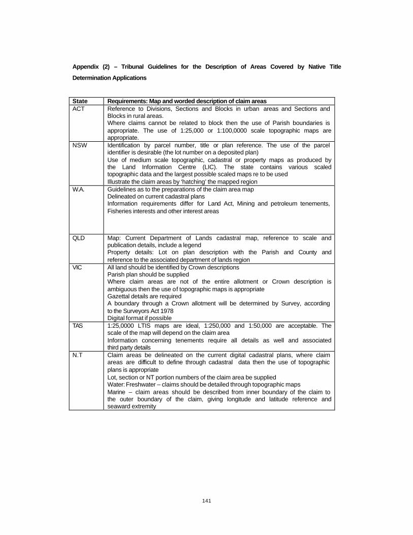
141
Appendix (2) – Tribunal Guidelines for the Description of Areas Covered by Native Title
Determination Applications
State Requirements: Map and worded description of claim areas ACT Reference to Divisions, Sections and Blocks in urban areas and Sections and
Blocks in rural areas. Where claims cannot be related to block then the use of Parish boundaries is appropriate. The use of 1:25,000 or 1:100,0000 scale topographic maps are appropriate.
NSW Identification by parcel number, title or plan reference. The use of the parcel identifier is desirable (the lot number on a deposited plan) Use of medium scale topographic, cadastral or property maps as produced by the Land Information Centre (LIC). The state contains various scaled topographic data and the largest possible scaled maps re to be used Illustrate the claim areas by ‘hatching’ the mapped region
W.A. Guidelines as to the preparations of the claim area map Delineated on current cadastral plans Information requirements differ for Land Act, Mining and petroleum tenements, Fisheries interests and other interest areas
QLD Map: Current Department of Lands cadastral map, reference to scale and publication details, include a legend Property details: Lot on plan description with the Parish and County and reference to the associated department of lands region
VIC All land should be identified by Crown descriptions Parish plan should be supplied Where claim areas are not of the entire allotment or Crown description is ambiguous then the use of topographic maps is appropriate Gazettal details are required A boundary through a Crown allotment will be determined by Survey, according to the Surveyors Act 1978 Digital format if possible
TAS 1:25,0000 LTIS maps are ideal, 1:250,000 and 1:50,000 are acceptable. The scale of the map will depend on the claim area Information concerning tenements require all details as well and associated third party details
N.T Claim areas be delineated on the current digital cadastral plans, where claim areas are difficult to define through cadastral data then the use of topographic plans is appropriate Lot, section or NT portion numbers of the claim area be supplied Water: Freshwater – claims should be detailed through topographic maps Marine – claim areas should be described from inner boundary of the claim to the outer boundary of the claim, giving longitude and latitude reference and seaward extremity

142
Appendix (3) – Analysis of Applications - Form
Criteria - Mapped representation Description
Documentation of:
Scale scale of map
Data Source source of information
Projection/ Grid projection or grid reference
Date date of map or information sources
Creator/ Maintainer creator of maintainer of the data
Clarity of boundary Graphical clarity of the boundary and the mapped representation
Method for delineationthe methods and appropriateness for delineation of the externalboundaries
Criteria - Technical Description Description
Documentation of:
Affecting tenures Reference to affecting tenures
Native title applications Reference to other native title application
Topographic featuresReference to topographic features, use of language to documenttopographic features
Language used Refers to the use of language and style of technical description

143
Appendix (4) – Analysis of Application, Tabulated Results

144
Appendix (5) – Mapped Representations
NC 96/35 - application crossing jurisdictions and the ‘splaying’ of information and of the external
boundary
QC96/17 – application crossing jurisdictions and the ‘splaying’ of information and of the external
boundary
QC97/24 – use of GPS coordinates, aiding the determination and delineation of the external
boundaries of the claim area
QC98/44 – poor clarity
VC97/15 – tenure references

145
Appendix (6) – Technical Descriptions
QC 96/17 – reference to traditional lands and to the lands as claimed for native title
QC 97/05 – reference to the traditional lands and the lands as claimed for native title
QC 97/24 – GPS reference position
TC 95/02 – application crossing jurisdictions ‘principally in Tasmania but includes area in the
State of Victoria’
VC 97/13 – Propose pipeline
VC 97/15 – exploration licences
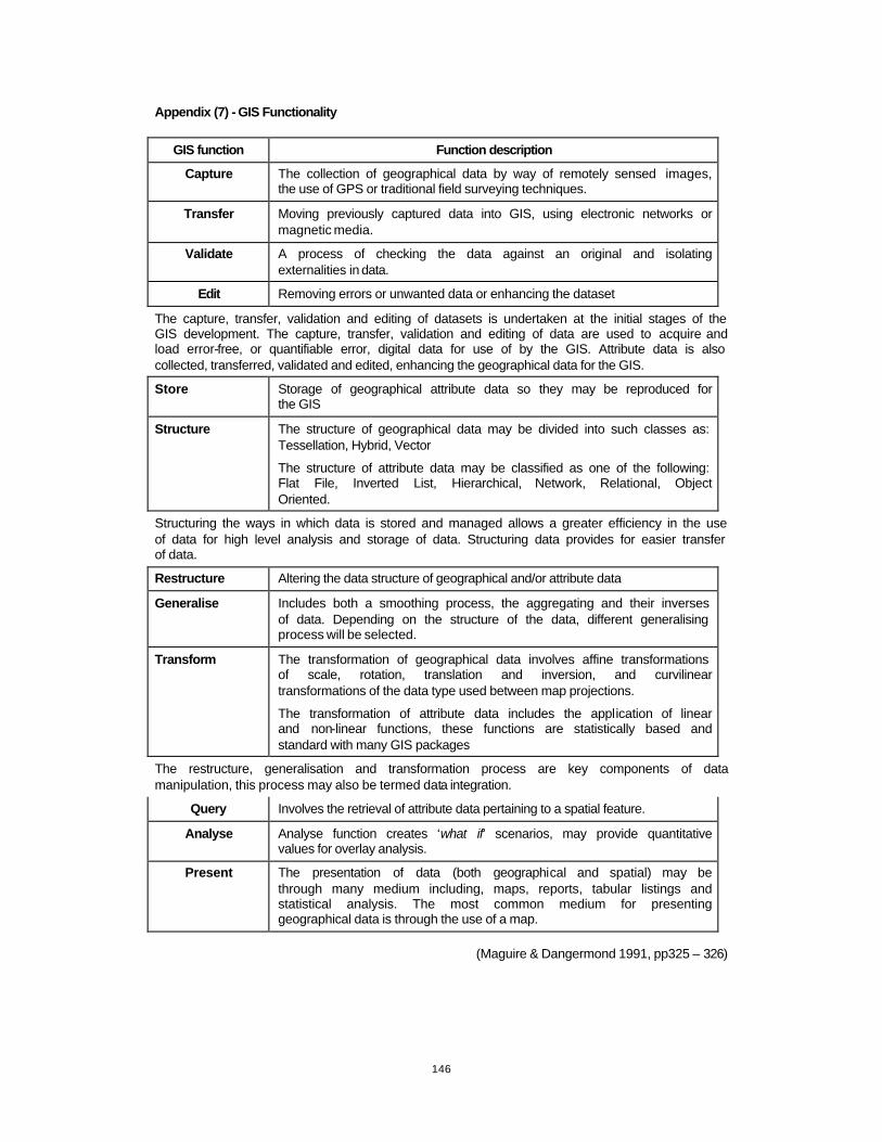
146
Appendix (7) - GIS Functionality
GIS function Function description
Capture The collection of geographical data by way of remotely sensed images, the use of GPS or traditional field surveying techniques.
Transfer Moving previously captured data into GIS, using electronic networks or magnetic media.
Validate A process of checking the data against an original and isolating externalities in data.
Edit Removing errors or unwanted data or enhancing the dataset
The capture, transfer, validation and editing of datasets is undertaken at the initial stages of the GIS development. The capture, transfer, validation and editing of data are used to acquire and load error-free, or quantifiable error, digital data for use of by the GIS. Attribute data is also collected, transferred, validated and edited, enhancing the geographical data for the GIS.
Store Storage of geographical attribute data so they may be reproduced for the GIS
Structure The structure of geographical data may be divided into such classes as: Tessellation, Hybrid, Vector
The structure of attribute data may be classified as one of the following: Flat File, Inverted List, Hierarchical, Network, Relational, Object Oriented.
Structuring the ways in which data is stored and managed allows a greater efficiency in the use of data for high level analysis and storage of data. Structuring data provides for easier transfer of data.
Restructure Altering the data structure of geographical and/or attribute data
Generalise Includes both a smoothing process, the aggregating and their inverses of data. Depending on the structure of the data, different generalising process will be selected.
Transform The transformation of geographical data involves affine transformations of scale, rotation, translation and inversion, and curvilinear transformations of the data type used between map projections.
The transformation of attribute data includes the application of linear and non-linear functions, these functions are statistically based and standard with many GIS packages
The restructure, generalisation and transformation process are key components of data manipulation, this process may also be termed data integration.
Query Involves the retrieval of attribute data pertaining to a spatial feature.
Analyse Analyse function creates ‘what if’ scenarios, may provide quantitative values for overlay analysis.
Present The presentation of data (both geographical and spatial) may be through many medium including, maps, reports, tabular listings and statistical analysis. The most common medium for presenting geographical data is through the use of a map.
(Maguire & Dangermond 1991, pp325 – 326)

147
Appendix (8) – Data Specifications
C a d a s t r a l I n f o r m a t i o n
The cadastral data (State Digital Map Base), a state wide database relating aspatial data
and spatial data to land parcels.
Coverage: Sate of Victoria
Currency: June, 2000
Format: design file (*.dgn) file format
Accuracy: All cadastral data is of BB nominally positional accuracy classification as
established by the Victorian Survey Co-ordination Act. This requires that 90% of well defined points lie within plus or minus 1mm of their true position at plan scale .
For the purposes of the prototype, the cadastral data is an Australian Map Grid (zone
54) projection.
S a t e l l i t e I m a g e
The satellite image used for the prototype was supplied by the Department of Natural
Resources (Victoria) and the Decision Support Team associated with the Department of
Geomatics. The specifications of the images are as follows:
Custodian: DNRE
Scale : 1: 500 000
Data Currency : 1993
Data Accuracy : 90 meter resolution
Projection : Vicmap
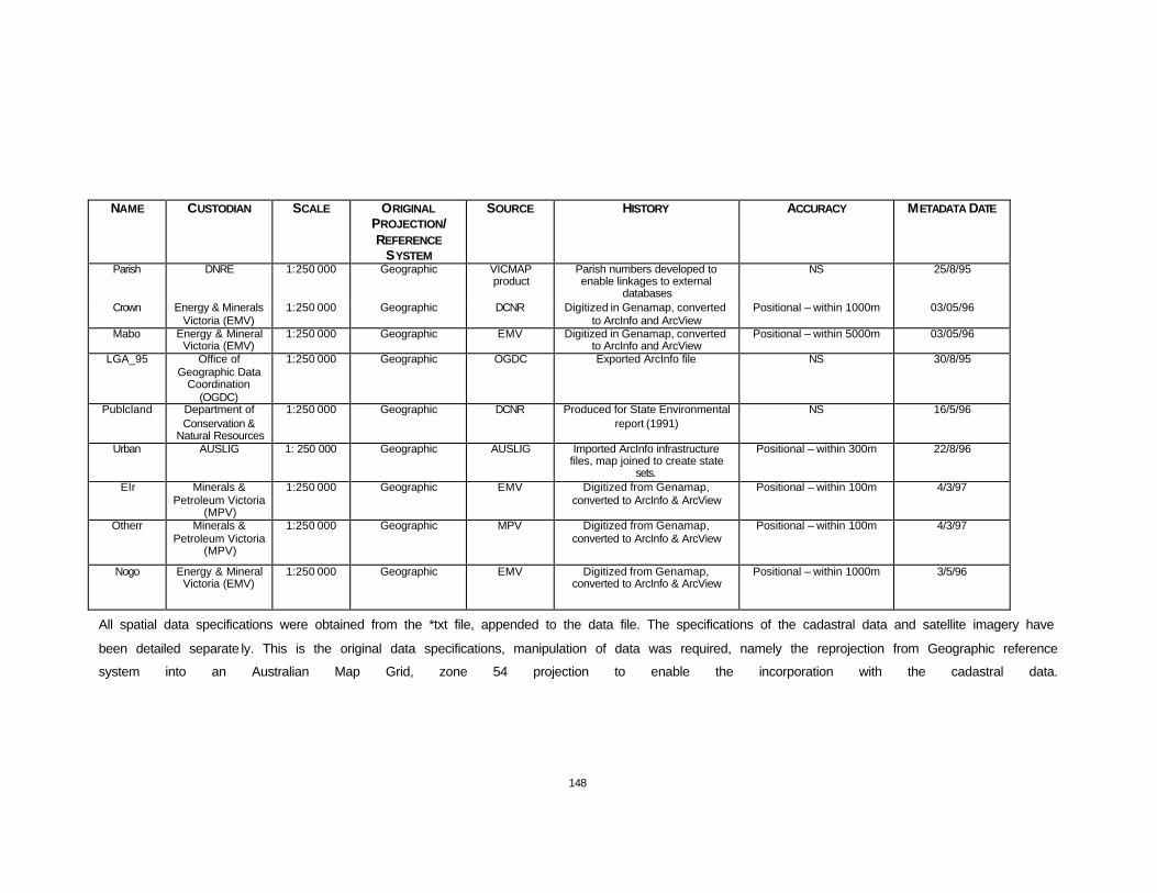
148
NAME CUSTODIAN SCALE ORIGINAL PROJECTION/ REFERENCE
SYSTEM
SOURCE HISTORY ACCURACY METADATA DATE
Parish DNRE 1:250 000 Geographic VICMAP product
Parish numbers developed to enable linkages to external
databases
NS 25/8/95
Crown Energy & Minerals Victoria (EMV)
1:250 000 Geographic DCNR Digitized in Genamap, converted to ArcInfo and ArcView
Positional – within 1000m 03/05/96
Mabo Energy & Mineral Victoria (EMV)
1:250 000 Geographic EMV Digitized in Genamap, converted to ArcInfo and ArcView
Positional – within 5000m 03/05/96
LGA_95 Office of Geographic Data
Coordination (OGDC)
1:250 000 Geographic OGDC Exported ArcInfo file NS 30/8/95
Publcland Department of Conservation &
Natural Resources
1:250 000 Geographic DCNR Produced for State Environmental report (1991)
NS 16/5/96
Urban AUSLIG 1: 250 000 Geographic AUSLIG Imported ArcInfo infrastructure files, map joined to create state
sets.
Positional – within 300m 22/8/96
Elr Minerals & Petroleum Victoria
(MPV)
1:250 000 Geographic EMV Digitized from Genamap, converted to ArcInfo & ArcView
Positional – within 100m 4/3/97
Otherr Minerals & Petroleum Victoria
(MPV)
1:250 000 Geographic MPV Digitized from Genamap, converted to ArcInfo & ArcView
Positional – within 100m 4/3/97
Nogo Energy & Mineral Victoria (EMV)
1:250 000 Geographic EMV Digitized from Genamap, converted to ArcInfo & ArcView
Positional – within 1000m 3/5/96
All spatial data specifications were obtained from the *txt file, appended to the data file. The specifications of the cadastral data and satellite imagery have
been detailed separate ly. This is the original data specifications, manipulation of data was required, namely the reprojection from Geographic reference
system into an Australian Map Grid, zone 54 projection to enable the incorporation with the cadastral data.

149
Appendix (9) – Traditional and Language Area of the Wotjobaluk Peoples
(Clark 1990, pp 20)
(Clark 1990, pp 256)
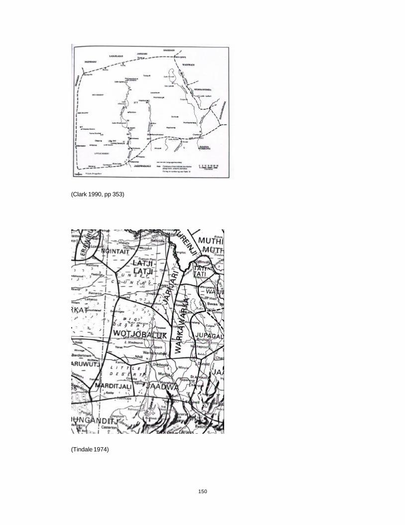
150
(Clark 1990, pp 353)
(Tindale 1974)

151
Appendix (10) – Screen captures – Native Title Applications Manager
1. Native title applications affecting VC95/02
2. Native title applications affecting VC95/02 (zoomed in)
3. Native title applications and regional centres and natural features
4. Parishes – constituting the VC95/02 claim area
5. Parishes
6. Parishes and Crown Lands
7. Parishes and Crown Lands (zoomed in and annotated)
8. National Parks and images attached
9. Public Lands
10. National Parks and Exploration Licences
11. Crown Lands and Exploration Licences
12. Local Governments and VC95/02
13. Cadastral Information
14. Cadastral information (annotated)
15. Cadastral information (annotated)
16. Cadastral Information and Parishes
17. Cadastral Information and Parishes (zoomed in and detailed)
18. Parish details selected, land parcel correlation
19. User input table
20. User input form
21. Satellite image (LandSat TM) – State of Victoria
22. Satellite image (LandSat TM) and VC95/02 claim area
23. Satellite image (LandSat TM) and VC95/02 claim area (zoomed in)

152
Appendix (11) – Screen captures – Ms Access
(Ms Access component of the Native Title Applications Manager)
1. Switchboard – input parameters
2. Switchboard – update parameters
3. Input form for native title application information
4. Input form for geographical information relating to the native title application
5. Input form for claimant contact details
6. Input form for NNTT contact details
7. Update form for native title application informati on
8. Update native title applications information
9. Update form for geographical information
10. Update form for claimant contact details
11. Update form for NNTT contact details

153
Appendix (12) – Screen captures – Victorian Land Information Systems
1. Other Native Title Applications affecting VC 95/02
2. Local Governments and VC95/02
3. Crown Lands
4. Urban Regions
5. Cadastral Information
6. Cadastral Information (annotations)
7. Cadastral Information (annotations)
8. LandSat TM Satellite image (note: Vicmap projection, not able to be projected into AMG 54)
9. LandSat TM Satellite image (note: Vicmap projection, not able to be projected into AMG
54)

154
Appendix (13) – Original Mapped Representation of VC95/02

155
Appendix (14) – VC95/02 - Native Title Applications Manager