the site of the northwest company post on sandy...
TRANSCRIPT

THE SITE OF THE NORTHWEST COMPANY POST ON SANDY LAKE
The post of the Northwest Company on Sandy Lake in Aitkin County was the first enduring establishment of its type west of Fond du Lac on Lake Superior, and, from the date of its erection in 1794 to the close of the period of British occupancy of the region after the War of 1812, it was one of the most important fur-trading stations in the Northwest. The location on Sandy Lake was determined by its proximity to the route between Lake Superior and the Mississippi by way of the St. Louis and East Savanna rivers, the Savanna Portage, the West Savanna and Prairie rivers, Sandy Lake, and Sandy River. This route, which gave access tO' the great regions lying south, west, and north, had probably been used by the Indians for centuries before the advent of the white man.^ It was by this route that Du Luth in the summer of 1679 "penetrated with his lively crew of voyageurs tO' the Sandy Lake country, being probably the first white trader upon the head-waters of the Mississippi," ̂
Here in 1794, William Morrison, according to his brother Allan, built " the original fort on Sandy Lake," Whether or not the fort built by Morrison is the one which became the Northwest Company post is unknown. He himself says that he went into the country " in opposition to the old N. W. Co.," and that he "opposed all the N. W. posts until 1805."^ He " found Bousquai at Sandy Lake." Charles Bousquet was the trader of the Northwest Company at Sandy Lake between
1 Jacob V. Brower, " Prehistoric Man at the Headwaters of the Mississippi River," in Minnesota HLHorical Collections, 8 : 238.
2 Reuben G. Thwaites, " The Story of Chequamegon Bay," in Wisconsin Historical Collections, 13: 407.
3 Grace L. Nute, ed., " The Diary of Martin McLeod," ante, 4 : 384 n.; Jacob V. Brower, Itasca State Park, 47 {Minnesota Historical Collections, vol. 11).
311

312 IRVING H. HART DEC
1794 and 1797,* It is reasonably certain, however, that in the year 1794 the Northwest Company erected a permanent establishment here, which, probably from its form and strength, came to be known as " the fort." °
Zebulon M. Pike gives the first detailed description of the Northwest Company post on Sandy Lake. Having left the main body of his expedition encamped upon the banks of the Mississippi, Pike and one companion pushed on northeastward to the station on Sandy Lake. They evidently missed the old portage trail that led from the river to the lake, for Pike writes, " we traversed about two leagues of a wilderness
. and at length struck the shore of Lake de Sable [Sandy Lake], over a branch of which our course lay. The snow having covered the trail made by the Frenchmen who had passed before with the rackets [snowshoes], I was fearful of losing ourselves on the lake. . . . Thinking that we could observe the bank of the other shore, we kept a straight course, some time after discovered lights, and on our arrival were not a little surprised to find a large stockade. The gate being open, we entered." °
Assuming that Pike had veered to the right of the portage trail, he must have struck the lake shore on the south side of Fisherman's Bay, which would form the " branch " mentioned by him. What is now Brown's Bay was probably at that time a small lake connected with the main lake only at high water. A map of Sandy Lake in i860 shows such a small lake lying southeastward of another somewhat larger body of water, which is probably Bass Lake.'' Pike relates that the " fort
* Jean Baptiste Perrault, " Narrative of the Travels and Adventures of a Merchant Voyageur," in Michigan Pioneer and Historical CoUections, Z7 •• S04, S70, 573. 574-
5 William W. Folwell, A History of Minnesota, 1:68 (St. Paul, 1921). " Zebulon M, Pike, Expeditions to the Headwaters of the Mississippi
River, 1:138, 139, 281 (Coues edition. New York, 1895), ^ This is one of the numerous manuscript maps among the Alfred J,
Hill Papers, in the possession of the Minnesota Historical Society,

1926 THE SANDY LAKE POST 313
at Sandy Lake is situated on the S, side, near the W, end," He " marks the site on his map, and gives it as ij4 m, S. of the discharge of the lake into the short thoroughfare by which this reaches the Mississippi." ° George Henry Monk, Jr., writing in 1807, also locates the fort on the south side of the lake.°
\ .'Fun CoMfAMT POST
.Prawn 6r
MAP OF SANDY LAKE, SHOWING THE SITES OF THE POSTS OF
THE NORTHWEST AND AMERICAN F U R COMPANIES
Coues's statement that " The N. W. Co. house where Pike was entertained stood on the W. shore of Sandy 1., next to the Mississippi " is inaccurate. The editor of the Pike journals made a canoe voyage to the source of the Mississippi at
8 Pike, Expeditions, i : 138 n., 281. 8 See ante, 5 : 36.

314 IRVING H. HART DEC
the time that the first government dam was being constructed on Sandy River, and might, had he cared to do so, have definitely located the site of the Northwest Company post. He seems, however, to have depended for the location of this post solely upon Pike's original map, which is drawn to a very small scale and which in the nature of the case could not show the location with any degree of accuracy. Coues's own " His-torico-Geographical Chart of the Upper Mississippi River " is drawn to a scale only a little larger than that of Pike, but is more accurate with regard to this location than is his statement."
After the treaty of 1783, which ended the Revolutionary War and which endeavored to fix the boundary between the possessions of Great Britain and those of the United States in this region, and even after the withdrawal of the British garrison from Mackinac in 1796 as a result of Jay's treaty, the Northwest Company continued to occupy and exploit the upper Mississippi Valley. It was not until after the War of 1812 and the treaty of Ghent that the jurisdiction of the United States over the Sandy Lake region was definitely established. This treaty and the passage by Congress in 1816 of an act restricting the Indian trade to American citizens brought to an end the activities of the Northwest Company here. The company sold all its posts and outfits south of the Canadian boundary to John Jacob Astor, who had previously organized the American Fur Company." In 1820, when the Cass expedition passed through Sandy Lake on its way to the headwaters of the Mississippi, the agents of the American Fur Company were found established in the old fort, which Schoolcraft describes in almost the exact words used by Pike. Between 1820 and 1832, when Schoolcraft for the second
"> Coues, in Pike, Expeditions, i : 138 n., 283 n.; and maps accompanying volume 3 of the same work.
11 Folwell, Minnesota, i : 132, 133. See also Morrison's statement in Brower, Itasca State Park, 47.

1926 THE SANDY LAKE POST 315
time visited Sandy Lake, the American Fur Company's post was moved to a point just north of the mouth of Sandy River, where it flows into the Mississippi, later the location of the Libby post office.̂ ^
Edmund F. Ely, a Congregational missionary to the Indians, who was stationed at Sandy Lake in 1833 and 1834, refers several times in his journal to the old fort, at that time occupied by a man named Abbott, who had there a fur-trading station in competition with that of the American Fur Company at the mouth of Sandy River. Ely speaks of coming back from Abbott's post at " the old fort " to the station of the American Fur Company across the ice of the lake, and says, " a strong N. W. wind in my face rendered it [walking] quite tedious." "
In the year 1833, William Johnston, a representative of a rival of the American Fur Company, writes of a visit to Sandy Lake:
We arrived at the trading house of one of our clerks; it is pleasantly situated on a point of land extending some distance into the Lake. And the woods having been cleared, when it was occupied by the North West Company gives it the appearance of a White settlement; And it commands a view of the Savan river, and the one which empties into the Mississippi; which is necessary for a trading post, in order to watch the movements of the opposition and Indians.^*
Johnston's reference to the site of the post is somewhat obscure. There is only one " point of land extending some distance into the lake " which commands a view of the river emptying from the lake into the Mississippi, and that is
12 Henry R. Schoolcraft, Narrative Journal of Travels througli the Northwestern Regions of the United States to the Sources of the Mississippi River, 218 {Albany, 1821) ; Coues, in Pike, Expeditions, 1 : 138 n.
13 Ely Diaries, October 12, November 22, December 7, December 24, 1833. The originals of these diaries are in the collection of the St. Louis County Historical Society at Duluth; copies are in the possession of the Minnesota Historical Society.
^^ Michigan Pioneer and Historical Collections, 37:173.

3i6 IRVING H. HART DEC
Brown's Point. There is no point on the lake which commands a view of both the Savanna River and the Sandy River. Johnston's statement can be reconciled to local geography only by omitting the " and " following " Savan river " and assuming that by the " Savan " river he means Sandy river. Johnston nowhere mentions the name of the clerk of his company on Sandy Lake, but he was probably the Abbott mentioned by Ely.
No significant references have been found to the location of the old Northwest Company post between 1833 and 1894. In the latter year Brower wrote, " On the south shore of Sandy Lake are visible the old landmarks of the trading post and station of a hundred years ago which Lieut. Z. M. Pike so carefully described, . . . It is now an abandoned waste, soon to be obliterated farther by the flood from the government reservoir dam about to be completed." ̂ °
Within a comparatively few years following Abbott's occupation of the old fort, the site seems to have been abandoned entirely by the trading companies, and, according to local tradition, the few available maps, and the more reliable evidence of findings all along the north shofe of Brown's Point, the old post and its surrounding clearing became again the site of an Indian village.^° The Hill Papers contain a map
1̂ Brower, in Minnesota Historical Collections, 8: 238. The first government dam on Sandy Lake was in the process of construction at the time that Brower wrote. As a matter of fact, neither this dam nor the second dam, which is now standing, served to " obliterate " the site of the old fort, as it lies entirely above the high water mark. At times of high water in the Mississippi, Sandy River sometimes flowed back into the lake, causing great floods which covered the country for many miles around. Ordinarily, however, it would seem that the level of water in the lake was considerably lower than at present. See Newton H. Winchell and Warren Upham, The Geology of Minnesota, 54 (Geological and Natural History Survey of Minnesota, Final Report, vol. i — Minneapolis, 1881).
1' Brown's Point had evidently been occupied by a Chippewa village at a much earlier date. Warren's detailed account of the battle of Sandy Lake between the Chippewa and the invading Sioux clearly indicates that

1926 THE SANDY LAKE POST 317
drawn in 1886 which shows the location of the Northwest Company's post on Sandy Lake. It is based upon data furnished by Ely from a map drawn for him on the ground by the Sandy Lake Indians in i860. There are two obvious historical errors on this map, one of which Hill has noted and corrected. The station at the mouth of Sandy River is labeled " Site of old N, W, Fur Co,'s post or Aitkin's trading post in 1832," whereas there is no evidence that the Northwest Company ever had a post on this spot, Aitken's post was that of the American Fur Company, occupied after the old fort on the south shore was abandoned by the company. About halfway up the point north of Fisherman's Bay on the same map is a spot marked, " Fort according to E, F, Ely here ( i860) but evidently wrong 1" Hill has corrected the error in the location of the Northwest Company post by marking a location on what is now called Brown's Point with the notation, " Suppositious site of fort." This map also locates an " Indian village in i860 " near the " suppositious site " of the fort. From the evidence of this map it might be thought that Ely was unaware that the site of Abbott's post was the same as that of the original Northwest Company station of 1794, It is more probable, however, that his indication of the location of the post was inaccurate or was misunderstood by Hill. A small map drawn by Lieutenant James Allen, a member of the Schoolcraft expedition of 1832, confirms the locations of the two posts. Allen marks the post at the mouth of Sandy River, " Trading H of A. F, Co." and that on Brown's Point, " Old Trading House." "
this point was the site of that memorable encounter. See William W. Warren, " History of the Ojibways," in Minnesota Historical Collections, S: 177, 225-234. At the present time, rice holes dot almost the entire central and eastern portions of the point. Numerous graves may be located by rectangular depressions on the ridges at the western end. Excavations for cabin sites near-by have opened up many of these with the usual revelation of Indian relics.
I'' Allen's map appears with his report in American State Papers: Military Affairs, 5: 313.
3i8 IRVING H. HART D E C
In 1900 the point on which the Northwest Company post was situated was purchased by Thomas Edward Brown, according to his daughter, Mrs. Jessie Brown Cleaves. Plis log
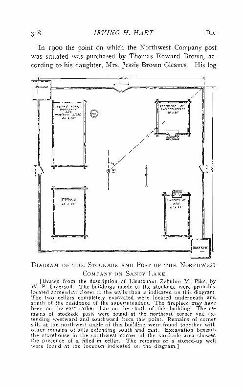
DIAGRAM OF T H E STOCKADE AND POST OF THE NORTHWEST
COMPANY ON SANDY L A K E
[Drawn from the description of Lieutenant Zebulon M. Pike, by W. P. Ingersoll. The buildings inside of the stockade were probably located somewhat closer to the walls than is indicated on this diagram. T h e two cellars completely excavated were located underneath and south of the residence of the superintendent. The fireplace may have been on the east ra ther than on the south of this building. The remains of stockade posts were found at the northeast corner and extending westward and southward from this point. Remains of corner sills at the nor thwest angle of this building were found together with other remains of sills extending south and east. Excavat ion beneath the storehouse in the southwest corner of the stockade area showed the presence of a filled-in cellar. T h e remains of a stoned-up well were found at the location indicated on the diagram.]
1926 THE SANDY LAKE POST 319
cabin stood there until four years ago. Before Brown's death the north shore of the point was subdivided into lots, which have since been sold for cabin sites. Today it has the appearance of the usual tourist resort. Mr, WilHam P, Ingersoll, at present a resident on the point, says that Mr, Norbert Ohrenberg, who worked for Brown while he was clearing his land for cultivation, stated that innumerable evidences of Indian occupancy were turned up by the plow. Stone hammers, tomahawks, and other indestructible articles were heaped up and hauled away, while bones and all combustible materials were piled up and burned. Stone walls or foundations were also said by Mr. Ohrenberg to have been found, but the locations of these have been forgotten.
The task, therefore, of determining with any degree of accuracy the location of the old Northwest Company post was one for which exact data were not available. The descriptions of the fort by Pike and Schoolcraft were the most definite and helpful. The Ely Diary and the Hill maps served to confirm the Pike data. Fortunately one of the Hill maps shows the location of the " suppositious site " of the fort with reference to the government survey, marking it on the mainland southwest of the northwest corner of section i, township 49 north, range 24 west, which description locates the fort on Brown's Point beyond the possibility of question.
Pike says that the fort consisted of " a stockade 100 feet square, with bastions [blockhouses] at the S. E. and N. W. angles, pierced for small-arms." Pike's description continues :
The pickets are squared on the outside, round within, about one foot diameter, and 13 feet above ground. There are three gates: the principal one fronts the lake on the N., and is 10 x 9 feet; the one on the W. 6 x 4 feet; and the one on the E. 6 x 5 feet. As you enter by the main gate you have on the left a building of one story, 20 feet square, the residence of the superintendent. Opposite this house on the left of the E, gate, is a house 25 x 15 feet, the quarters of the men. On entering the W, gate you find the

320 IRVING H. HART DEC
storehouse on the right, 30 x 20 feet, and on your left a building 40 x 20 feet, which contains rooms for clerks, a workshop, and provision store.
On the W. and N. W. is a picketed inclosure of about four acres, in which last year they raised 400 bushels of Irish potatoes, cultivating no other vegetables. In this inclosure is a very ingeniously constructed vault to contain potatoes, and which likewise has secret apartments to conceal liquors, dry goods, etc.^*
To this description, Schoolcraft adds no significant details other than that the pickets of the main stockade were of pitch pine, and were " pinned together with stout plates of the same wood." *=
The fact that several depressions, much larger than those marking the old Indian rice holes and evidently showing the locations of old cellars, were still visible on lots 16 and 17 of the Sandy Lake Beach subdivision on Brown's Point, led the investigators to begin excavations on this site under Mr. Ing-ersoll's direction in August, 1926. The first spadeful of earth turned up yielded an Indian medicine man's carved " swallow-ing-bone," thus encouraging further search. Within a few minutes unmistakable evidences of white man's work were uncovered in the form of rotting cedar sills and the shredded remnants of vertical posts, located at varying intervals and covered by from fourteen to eighteen inches of sand, char, and soil. Further excavations at different places near-by showed without exception the presence of a well-defined stratum of charred wood, as though a comparatively large conflagration had at some time taken place. This layer of char lies at a depth of from twelve to fifteen inches below the present irregular surface.
The place at which the first excavations were made is about thirty feet south of the beginning of the slope leading to the edge of the lake. The finding of remains of vertical posts at intervals on lines running west and south and the presence
18 Pike, Expeditions, i: 281. 1° Schoolcraft, Narrative Journal, ai8.

1926 THE SANDY LAKE POST 321
within the angle formed by these lines of a large depression make it seem possible that this was the northeast corner of the old stockade. In this case the depression may be what is left of a cellar beneath the superintendent's residence. From this northeast corner southward for some distance in extension of the line on which remains of vertical posts were found there is a ridge of earth one and one-half to two feet in height, such as might have accumulated along the east line of the stockade. Approximately one hundred feet to the west a similar ridge of earth runs southward parallel tO' the first, and this may be the line of the west side of the stockade. Some thirty feet to the east of this west ridge, underneath a cabin belonging to Mr. Enoch Johnson of Palisade, were found, during the process of the erection of the cabin by Mr. Ingersoll, the remains of what had evidently been a stoned-up well. The location of this well within the putative outlines of the stockade would place it east of the workshop and provision store mentioned by Pike. Immediately back of the Johnson cabin is another relatively large depression, possibly the site of a cellar underneath the storehouse. Excavation here to a depth of three or four feet showed a sandy loam which had plainly been deposited at a comparatively late date and the omnipresent layer of char. Nothing else was found that was significant.
The site of the larger depression in the northeast corner was excavated with exceeding care and for its entire extent with very satisfactory results. The approximate dimensions of the depression were fifteen by thirty feet, the longer dimension extending north and south. A low ridge of earth was to be seen running directly across the depression about twelve feet from the northern end. The assumption that this ridge marked a cross wall in the cellar or a partition between two cellars was confirmed by the excavations, as beneath it were found in their original position horizontal cedar poles from four to six inches in diameter laid up to form a wall.
322 IRVING H. HART DEC
The poles were, however, so rotten that in spite of the greatest care they crumbled away or caved in after a few minutes' exposure to the air. At several places along the side walls of the cellars, fragmentary remains of similar poles were found, but nowhere else in such quantity or in such regular position. Several of the pieces of timber were partially charred by fire.
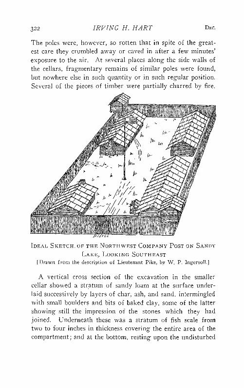
IDEAL SKETCH, OF T H E NORTHWEST COMPANY POST ON SANDY
LAKE, LOOKING SOUTHEAST
[Drawn from the description of Lieutenant Pike, by W. P. Ingersoll.]
A vertical cross section of the excavation in the smaller cellar showed a stratum of sandy loam at the surface underlaid successively by layers of char, ash, and sand, intermingled with small boulders and bits of baked clay, some of the latter showing still the impression of the stones which they had joined. Underneath these was a stratum of fish scale from two to four inches in thickness covering the entire area of the compartment; and at the bottom, resting upon the undisturbed

1926 THE SANDY LAKE POST 323
native blue clay, was a layer of miscellaneous debris of neither common composition nor consistency. Excavation to the outer walls of undisturbed sand and clay showed that the original dimensions of the two compartments had been twelve by ten feet and twelve by twenty-four feet, respectively, with a common depth beneath the present surface of approximately four feet.
Every shovelful of earth was examined as it was removed, with the result of the discovery of gunflints, the trigger guard and a part of the breechblock of an old flintlock gun, a light ax of the type locally known as the " Hudson Bay" ax, a handmade two-edged knife or dagger, a handmade metal lock, an old metal door latch, many pieces of heavy old glass bottles and demijohns, pieces of figured porcelain dishes, bits of mortar and melted glass, and many scattered remnants of charred and rotted timbers, all plainly evidences of the white man's occupancy of the site many years ago. Few relics of Indian origin were found during this excavation, although at other places within the limits of the supposed area of the stockade were discovered a carved " swallowing-bone," a hollow bone ornament, a copper bracelet, hand-carved beads, and many pieces of the blue and green figured porcelain of the trade patterns common in this region. The Indian relics were generally found just beneath the sod, while the evidences of white man's occupancy were found buried often two feet or more beneath the surface. No pottery remains whatsoever were found, although fragments of potsherds are tOi be found in quantities elsewhere on the islands of Sandy Lake and the mainland. The failure to find any pottery here would seem to indicate that the Indian occupancy of which these relics are evidence occurred at a time subsequent to that of the white traders.
About midway of the line which marks the beginning of the slope from the north side of the site to the present shore line of the lake, there are traces of what may well be the re-

324 IRVING H. HART DEC
mains of a gradual approach to the main gate of the stockade. The site lies about a mile and a quarter south and a little east of the entrance of the lake into Sandy River. To the west lies a comparatively level tract of land upon which by actual measurement a square four-acre garden might be laid out.
SANDY LAKE
S I T E OF T H E NORTHWEST COMPANY POST AND GARDENS ON
SANDY L A K E
Beyond this level tract rises a low ridge composed of boulders and coarse gravel, succeeded in turn by a little valley and a higher and heavily wooded ridge, an extension of those which border the western shore of the lake.

1926 THE SANDY LAKE POST 325
The conclusion that these findings serve to determine the site of the old fort has been reached only after the most careful consideration of all the available data and of various conflicting local traditions with regard to the location. No' other place on Brown's Point satisfies all conditions set up by the descriptions of Pike, Schoolcraft, and Johnston. This site does.
It would seem probable that, after the final abandonment of the fort, it was burned, the ashes and charred remains of the conflagration forming the stratum of ash and char underlying the whole area. The cellars were gradually filled with soil washings and debris, and soon became mere depressions. Timbers and lumber that escaped destruction and remained exposed were doubtless used for firewood. The Indians reoccupied the point, erected their tepees, dug their rice holes, buried their dead, and used the clearing for their gardens, thus giving to this area the name " Indian Gardens " by which it was known to the early settlers. Second-growth timber sprang up, and the site became, with the gradual decay and removal of the Indian population, the " abandoned waste " of which Brower wrote in 1894.
A temporary marker will be placed upon the site, and if, after further study and investigation, the conclusions of the present investigators are confirmed by adequate authority, a permanent monument should be erected to mark one of the most interesting and significant spots in all the great Northwest.
IRVING HARLOW HART IOWA STATE TEACHERS COLLEGE
CEDAR F A I X S , IOWA

Copyright of Minnesota History is the property of the Minnesota Historical Society and its content may not be copied or emailed to multiple sites or posted to a listserv without the copyright holder’s express written permission. Users may print, download, or email articles, however, for individual use. To request permission for educational or commercial use, contact us.
www.mnhs.org/mnhistory