the secret history of the meherrin
TRANSCRIPT

W&M ScholarWorks W&M ScholarWorks
Dissertations, Theses, and Masters Projects Theses, Dissertations, & Master Projects
1994
The Secret History of the Meherrin The Secret History of the Meherrin
Shannon Lee Dawdy College of William & Mary - Arts & Sciences
Follow this and additional works at: https://scholarworks.wm.edu/etd
Part of the Indigenous Studies Commons, and the United States History Commons
Recommended Citation Recommended Citation Dawdy, Shannon Lee, "The Secret History of the Meherrin" (1994). Dissertations, Theses, and Masters Projects. Paper 1539625864. https://dx.doi.org/doi:10.21220/s2-gpp0-9a92
This Thesis is brought to you for free and open access by the Theses, Dissertations, & Master Projects at W&M ScholarWorks. It has been accepted for inclusion in Dissertations, Theses, and Masters Projects by an authorized administrator of W&M ScholarWorks. For more information, please contact [email protected].

THE SECRET HISTORY
OF THE MEHERRIN
A Thesis
Presented to
The Faculty of the Department of Anthropology
The College of William and Mary in Virginia
In Partial Fulfillment
Of the Requirements for the Degree of
Master of Arts
by
Shannon Lee Dawdy
1994

APPROVAL SHEET
Approved, May 1994
This thesis is submitted in partial fulfillment of
the requirements for the degree of
Master o f Arts
Shannon Lee Dawdy
Theodore R. Reinhart
Kathleen J. Bragdon
Helen C. Rountree
Professor of AnthropologyDepartment o f Sociology and Criminal JusticeOld Dominion University

TABLE OF CONTENTS
ACKNOWLEDGEMENTS.................................................................................... iv
LIST OF TABLES................................................................................. v
LIST OF FIGURES.............................................................................................. vi
ABSTRACT......................................................................................................... vii
CHAPTER I. INTRODUCTION....................................................................... 1
CHAPTER H. ARCHAEOLOGY OF THE MEHERRIN................................. 28
CHAPTER m . THE MEHERRIN CA. 1585-1711:AT THE FRINGES OF CHIEFDOM AND COLONY.......................... 58
CHAPTER IV. SETTLING ON THE BOUNDARIES, 1711-1835 ..................... 92
CHAPTER V. CONCLUSIONS ....................................................................... 130
APPENDIX A. PROFILES OF PROBABLE MEHERRIN S IT E S .................... 145
APPENDIX B. INVENTORY OF REFERENCES TO THEMEHERRIN IN HISTORIC DOCUMENTS............................................ 150
BIBLIOGRAPHY................................................................................................. 171
iii

ACKNOWLEDGEMENTS
I wish above all to express my gratitude to the Meherrin people who have shared their history with me and made a stranger feel welcome. The possibility that an academic project such as this may give something back to them has spurred me on. Andre Austin, the Meherrin Tribal Office Director, bent over backwards to make the tribe's files available and point me in new directions.
Helen Rountree was responsible for suggesting the Meherrin and has been the most energetic advisor one could hope for - down to chauffering fieldtrips. Howard MacCord, Douglas Summer Brown, David Phelps, Randy Turner, and George Stevenson generously shared their enthusiasm, knowledge, and resources on the area. Thanks also to my committee members, Kathleen Bragdon and Ted Reinhart,for seeing me through the process.
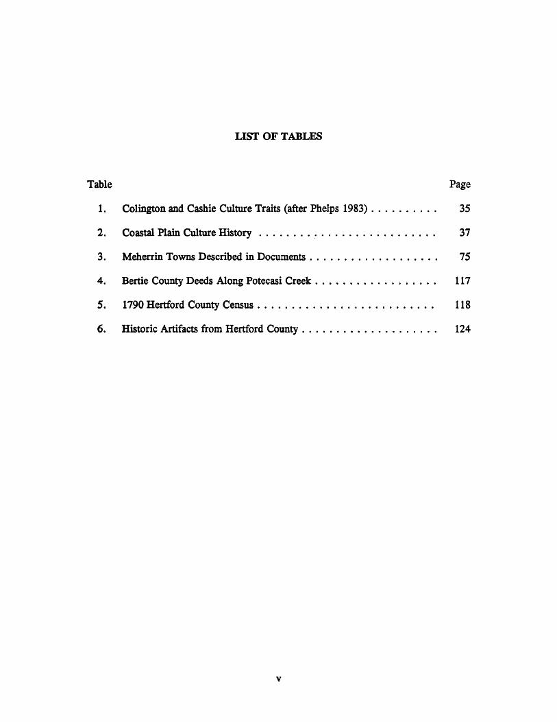
LIST OF TABLES
Table Page
1. Colington and Cashie Culture Traits (after Phelps 1983).......................... 35
2. Coastal Plain Culture H isto ry ................................................................. 37
3. Meherrin Towns Described in Documents............................................... 75
4. Bertie County Deeds Along Potecasi Creek............................................. 117
5. 1790 Hertford County Census................................................................. 118
6. Historic Artifacts from Hertford County.................................................. 124
v

6
39
42
47
63
65
71
77
107
112
114
LIST OF FIGURES
Meherrin Pow Wow, October 1993 ...............................
Prehistoric and Protohistoric Meherrin Site Distribution
Archaeological Sites in Meherrin Territory..................
Meherrin Territory in Relation to Indian Trade Routes .
Mercator-Hondius Map of 1606 ....................................
Dudley Map of 1646 ...................................................
Lederer’s Map of 1670 ...................................................
Historic Meherrin Sites and Documented Settlements . .
Meherrin Reservation Bounds......................................
Edward Moseley’s Map of 1733 ....................................
Collet Map of 1770 ......................................................
vi

ABSTRACT
Using historical documents, archaeological data, and ethnographic analogy, this thesis will reconstruct the experiences of the Meherrin Indians from the protohistoric period to circa 1835. The Meherrin were a small group at the frontiers of diverse culture cores. This status contributed to a pattern in Meherrin foreign relations which allowed them to adapt to colonialism while conserving fundamental cultural traditions. This pattern consists of an ability to negotiate multiple political, economic, and marital alliances. Factors internal to Meherrin social structure facilitated this strategy. The Meherrin worldview consists of a network of partnerships, lineages, paths, rivers, and creeks. It did not place much importance on boundaries.

CHAPTER I
INTRODUCTION
"Our history is twisted quite a hit. "
— Meherrin Chief Patrick Riddick (Virginian-Pilot March 11, 1980)
This paper will untwist a bit of history by: (1) presenting the first ethnohistorical and
archaeological overview of the Meherrin Indians from the protohistoric period to circa 1835; (2)
demonstrating how the "foreign relations" of pre-contact Native American societies determined
their particular response to colonialism; and (3) explaining how Indians "disappear" and yet
survive.
When I moved to Virginia I was at first amused and then intrigued to be living near a
place called "The Great Dismal Swamp." I was amused because it conjured up images of
melodramatic, urbane Elizabethans confronting the unfathomable fecundity of the land they named
Virginia. I became intrigued when I realized that Euro-Americans have still not penetrated The
Great Dismal Swamp to any real extent. Looking at a modern map, one sees a long, rough
rectangle that begins on at the southern edges of the cities of Suffolk and Chesapeake, Virginia,
then extending down, about 20 miles past the North Carolina border into Gates, Camden and
Pasquotank counties where it is drained by the river systems of Albemarle Sound. The swamp
is now dignified with the term "wild life preserve," but I suspect that its preservation is a de facto
result of its natural resistance to agriculture and modem development. I became further intrigued
1

2
when I, too, failed to gain access to this "no man’s land" inhabited by Swamp Bears. On a
weekend trip, my husband and I drove nearly all the way around the rectangle on the map,
searching for an entrance road into the preserve, to no avail.
The title for this paper is taken from a work relating another expedition that encountered
The Great Dismal Swamp. William Byrd n*s published journal The Secret History o f the
Dividing Line (1966) was a direct inspiration for the course of my inquiries. Byrd was one of a
party assigned to survey a boundary line between Virginia and North Carolina in 1728. His work
is important for three reasons. First, because it provides one of the best ethnographic
descriptions we have of the Nottoway and Meherrin Indians. These closely related Iroquoian
groups existed at contact in an area between the Powhatan Chiefdom to the northeast, the
Tuscarora Confederacy to the south, and the Piedmont Siouian groups to the west. The Meherrin
and Nottoway piqued my interest because of their ambiguous geographic, political, and cultural
positions. They are difficult to place in the big picture of Indian relations. Everywhere they
seem to be on the margins.
The second reason Byrd’s work is important is his description of another order of cultural
liminality in Southside Virginia. In this world Indian, African, and European individuals took
refuge, shared resources and knowledge, lived side by side, and married each other. The survey
party encountered a "hermit," presumably white, whose living condition is described thus:
His habitation was a bower covered with bark after the Indian fashion, which in that mild situation protected him pretty well from the weather. Like the ravens, he neither plowed nor sowed but subsisted chiefly upon oysters, which his handmaid made a shift to gather from the adjacent rockes...But as for raiment, he depended mostly upon his length of beard and she upon her length of hair, part of which she brought decently forward and the rest dangled behind quite down to her rump, like one of Herodotus’s East Indian Pygmies. Thus did these wretches live in a dirty state of nature and were mere Adamites, innocence only excepted (Byrd 1966:180).
A few days later, the party stumbled upon a maroon settlement:
... we came upon a family of mulattoes that called themselves free, though by the shyness of the master of the house, who took care to keep least in sight, their freedom seemed a little doubtful. It is certain many slaves shelter themselves in this obscure part of the world, nor will any of their righteous neighbors discover them (ibid.: 186).

3
Elsewhere, Byrd describes the practice of traders marrying Indian women and the effect upon
native society (Byrd 1966:310).
These descriptions stimulated my thinking about frontier situations and cross-cultural
interaction. How does anthropological theory, and its weak sister archaeology, handle truly
"multi-cultural" situations or even "multi-cultural settlements" as Byrd seems to describe? One
answer pointed to a term that is gaining use in historical archaeology: creolization (Mouer 1993;
Ferguson 1992). That is, a process of cultural syncretism whereby elements from different
cultures are combined and adapted into an evolving colonial culture. These elements can be
ideological, material or social. "Culture brokers," an idea based on situational analysis and
individual action, is another useful concept which allows us to understand an ephemeral state
where new modes of living are being negotiated. Byrd stepped into a cultural frontier where
Indian, African, and European individuals were actively mixing. It is difficult to speak of a
Frontier Culture or a Dismal Swamp Culture because the participants were raised in diverse
societies. Rather, these people were spatially and temporally at the margins of cultures - in a
liminal zone where they acted as individuals and culture brokers in a process of creative survival.
These ideas struck a chord within me because of what they mean for the interpretation
of culture change. I am not alone in being discontent with run-of-the-mill acculturation and
assimilation models applied to Native American history. I would like to supplant the insufficient
terms assimilation and acculturation with creolization, for the simple reason that the term allows
that everyone was changing due to contact. Although creolization will not be a central argument
in this paper, it is necessary to reveal my ideological appraoch to culture change and thus, my
understanding of how the Meherrin transformed from who they were at contact to who they are
today. To say that Native Americans such as the Meherrin have assimilated is to say that
European culture "won" a contest of survival. It is to ideologically reinforce the supremacy of
the so-called dominant culture. It does a poor job of addressing only one fraction of the

4
dynamics of culture contact. Many anthropologists and historians are now recognizing that
encounters with Native American societies and African peoples had a major effect on the
development of "American Culture" out of a European core (Drinnon 1990; Axtell 1985; Sobel
1987). Furthermore, assimilation models leave the oxymoron of "assimilated Indians" (Mochon
1968). If groups such as the Meherrin are assimilated to the dominant culture, what is Indian
about them? Their blood? Is "Indian" at base a racial category?
The third reason The Secret History o f the Dividing Line is significant is that it reveals
the stratigraphy of history. Byrd’s Secret History was a candid and sometimes satirical version
of his official report on the survey expedition entitled The History o f the Dividing Line Between
Virginia and North Carolina. By the hand of one author we have two different perspectives on
the same events. I assume that Edward Mosley, another participant in the survey, would have
told a quite different history (or two). Through Byrd’s observations, we can see that there were
yet other "unofficial" histories as seen through the eyes of the frontiersmen and Native Americans
he encountered. As most of our understanding of Virginia history must perforce be based on
official documents from members of the dominant culture, we are often at pains to see the secret
histories between the lines. Revisionists have recently attempted to correct a number of fallacies
in the "official" history of Virginia-Carolina, such as: a clear 300 year separation of the races
(Sobel 1987); a subservient white laboring class that merely mirrored elite beliefs (Breen 1976);
Indians who "died out" (Dippie 1982); slaves who feared the Indians and the woods so much they
didn't run away (Forbes 1993); and a dominant white culture which totally wiped out and
replaced the culture of Indians and blacks (Rountree 1990; Ferguson 1992). Earlier scholarship
in Southeastern history and archaeology had affirmed these biased perspectives partly for
ideological reasons, but also because the most obvious sources (written by and for elite whites)
do draw such a scenario. This dominant history is not simply "wrong"; rather, it is only one side
of a multi-faceted story. William Byrd opens a small window into a world which clashes sharply

5
with dominant history. It has stimulated me to embark on a search for secret histories. The
challenge is to find enough data among obscure sources.
Another reason I am a believer in Secret Histories is the existence of a group today who
call themselves the Meherrin. Official documents, historians, and archaeologists have all
pronounced the Meherrin Indians dead by the middle of the 18th century. However, a group of
approximately 500 people living in a small rural community in and around Hertford County,
North Carolina have come out of the woodwork and reasserted their identity. Their community
is located in the same area as a colonial reservation first given to the tribe in 1705. If there are
Meherrin today and there were Meherrin in the 18th century, were there Meherrin in between?
If so, their history is a secret one. I have the unique privilege of unraveling one strand of that
history. One of the driving question of this paper will be: "How do Indians disappear?" How did
the Meherrin’s history become "twisted quite a bit"?
The Meherrin
Fifteen miles west of the Great Dismal Swamp lies the town of Winton, North
Carolina. Here, in 1977, an effort to organize a local community with deep historical roots
succeeded with the non-profit charter of The Meherrin Indian Tribe. The late Chief Reuben R.
Lewis had succeeded in bringing his people into public life again. The purpose of the
organization was to promote cultural awareness and efforts for state and federal recognition.
In 1986, the North Carolina Commission of Indian Affairs officially recognized the tribe.
With a tribal roster that has grown over the years to the current level of 541 members, the
Meherrin are North Carolina’s smallest recognized tribe.1 Enrolled members elect seven Tribal
Council members and a Tribal chief to govern the tribe. Current efforts are directed towards
regaining community land and a petition for federal recognition. The tribe is involved in state
and national Indian affairs and holds an annual Pow Wow in October. Many tribal members

Figure 1
Meherrin Pow Wow, October 1993
581648272871

7
work in agricultural and blue collar trades, some commuting up to the Norfolk-Newport News
shipyards. Others are small business owners, teachers, and physicians.
The majority of Meherrin tribal members live in and around the town of Winton, the seat
of Hertford County. This rural area of northeastern North Carolina is composed of peanut fields,
cotton fields, and tree farms separated by strips of cypress swamp and mixed eastern forest.
Virginia’s Blackwater River becomes the Chowan at the state border and this branch of the
Albemarle Sound creates the eastern border of Hertford County. The Meherrin River descends
from the northwest comer of the county before switching eastward to drain into the Chowan.
The county is crossed with many east-west tributary creeks, creating pockets of swampy land.
The populated portions of the county exist in dry patches on the edges of the wetlands.
Most of the present-day Meherrin are descendants of a tribe which in colonial times was
described as a small group (not above 500) having close affiliations with the Nottoway and the
Tuscarora. They also possess genealogical ties to the neighboring Chowanoke and Nansemond
tribes. One of the themes of this paper will be the pattern of inter-marriage between the
Meherrin and other Indian communities before and after contact.
Very little of the Meherrin’* traditional aita and crafts have survived to the present. The present day Meherrin Indians have no knowledge of their language. The language has been extinct for years. In certain families, the art of brain tanning of deer hides has survived. Some knowledge of herbs used [for] medicinal purposes have survived. There has been a resurgence of interest in the traditional arts and crafts, and culture of the Meherrin and closely related tribes of Virginia and North Carolina by the present membership of the Meherrin Indian Tribe (Meherrin Indian Tribe n.d.).
Like many tribes on the eastern seaboard, the Meherrin have undergone tremendous
change since their first contacts with European and African colonists. One could say they are
Meherrin-Americans. Their houses, dress, speech, religion, and recreation does not reveal any
obvious cultural difference with their African-American, Anglo-American, or Italian-American
neighbors. Cultural continuities with the prehistoric Meherrin may lie in subtle nuances and the
"grammar," rather than the vocabulary, of material and mental life (Ferguson 1992). An
ethnography of the Meherrin is needed to reveal where these continuities exist.

8
An Iroquois attribution to the Meherrin has been deduced by scholars from their
association with the Nottoway and Tuscarora, and the preservation of a few place names. A
definite Iroquoian assignment can be given to the Tuscarora, a large tribe found in North
Carolina at the time of contact who migrated up to New York to become the sixth nation of the
Iroquois Confederacy in the 18th century. Two existing vocabularies for the Nottoway
(comprising about 150 words) also point to an Iroquois stock (National Anthropological Archives
MS. 3844 and MS. 3602).
The Meherrin Indians and the Meherrin River have been virtually inseparable since the
protohistoric period. The first documented contact with the Meherrin occurred in 1650 when
Edward Bland, some English associates, and an Appamattuck guide set out on an expedition to
Tuscarora territory. At that time the Meherrin had a main village approximately 30 miles
upstream from where they now reside, located just west of Emporia, Virginia. From 1650 to
1726, the Meherrin gradually shifted their main settlement downstream, until they reached the
mouth of the river in modem Hertford County. From this location, the Meherrin played a central
part in a boundary dispute between the Virginia and North Carolina colonial governments
between 1703 and 1726. In 1726, the government of North Carolina acknowledged the
Meherrin’s rights to a six-mile reservation in the land called "Meherrin Neck" which later became
known as Maney’s Neck, and in the 20th century, Parker’s Ferry.
It is unknown how the Meherrin lost their communal holdings to the Parker Ferry
reservation. This is largely due to the fact that Hertford is a "burned county," meaning most of
its public records were lost in the Civil War. However, through maps and colonial papers, it is
known that there were at least three other Meherrin settlements in the area. At one time in the
first quarter of the 18th century, some Meherrin were living near the mouth of Wiccacon Creek.
In 1726, they were settled across the river in Gates County, near the Chowanoke Indian territory,
while a major settlement at Potecasi Creek in the swampy western half of the county appears to

9
date from the second half of the 18th century.
Following a pattern typical for Indian groups in the eastern U.S., the Meherrin’s
documentary record becomes sketchy after the Revolutionary War. At that point they are never
referred again to in the few available documents as a corporate, political entity. This partly
reflects the federal government’s failure to continue treaty relations that the British colonial
government created. But it also coincides with a period during which Indian groups were
experiencing intense assimilation pressures, economic stress, and racism. A typical reaction was
a retreat from public life and a reluctance to herald Indian identity outside their community.
These self-isolated groups are called "enclaves." There are exacting methods for tracing enclaves
through public records which involve the development of genealogies and community
relationships. This transition from reservation Indians to enclave is described in the Meherrin’s
own words:
Because of steady encroachment of colonists onto the reservation and white introduced diseases, the Meherrins left the reservation and migrated into the surrounding swamps and less desirable areas of Hertford County. Becoming individual land owners, the Meherrin Indians had to conceal their identity in order to survive in the racial climate of the era. Racial prejudice prevented the Meherrins from re-organizing as a tribal group until 1977 (Meherrin Indian Tribe: n.d.).
This paper will trace the history of the Meherrin up to their transition into an enclave.
It will be shown that protohistoric patterns were carried over into the contact period and were
proactive in determining Meherrin adaptations to colonialism. But before delving into the
particulars of the Meherrin’s secret history, it is necessary to understand the causes for voluntary
and imposed "secrecy."
How Indians Disappear - The Dead Indian Syndrome
I had originally proposed to do an ethnohistorical and archaeological study of the
Nottoway. I wanted to understand why and how the Nottoway survived into the 19th century
while their cousins, the Meherrin, died out a century earlier. I had fallen prey to the "Dead

10
Indian Syndrome."
What I call the Dead Indian Syndrome is a combination of beliefs, theories, policies, and
wishful thinking that serve to make the "Indian Problem" disappear by making the Indians
disappear. Brian Dippie (1982:x) calls it the myth of the "Vanishing American," a tradition,
rich in pathos, and older than the Republic. The Indians, this tradition holds, are a vanishing race; they have been wasting away since the day the white man arrived, diminishing in vitality and numbers until, in some not too distant future, no red men will be left on the face of the earth.
A counterpoint to Manifest Destiny is the belief that the Indians were fated for extinction.
Historians Richard Drinnon (1990) and Dippie (1982) have assembled multiple examples of this
phenomenon and its corollary, "The Metaphysics of Indian Hating." Expressions of the Dead
Indian Syndrome are varied. It can be seen in the self-serving policies of the Federal
Government which today refuses to recognize over 100 organized Indian groups in the United
States. A belief in the Native American’s ultimate extinction justified the policies of removal,
forced assimilation, and termination. It was thought these policies were kind acts to save
individuals from a doomed culture. Of course, the policies worked to ensure the prediction was
accurate.
The Dead Indian Syndrome has also been perpetuated by "friends" of the Indians. The
creations of 19th century writers James Fenimore Cooper and William Cullen Bryant, and the
painter George Catlin, portray Native Americans in a sympathetic (though not necessarily
accurate) light while spelling out their romantic, tragic, and inevitable end. Historians of the era
were given to the same notions:
What can be more melancholy than their history? By a law of nature, they seem destined to a slow, but sure extinction. Everywhere, at the approach of the white man, they fade away. We hear the rustling of their footsteps, like that of the withered leaves of autumn, and they are gone for ever. They pass mournfully by us, and they return no more. — Justice Joseph Story, "Discourse, Pronounced at the Request of the Essex Historical Society, September 18, 1828, in Commemoration of the First Settlement of Salem, Massachusetts (quoted in Dippie 1982:1).
There has been a plethora of revisionist American history in the last decade (Limerick
1987; Drinnon 1990; Sobel 1987; Wolf 1982) such that the discovery of something like the

11
"Dead Indian Syndrome" among policy makers, BIA agents, novelists, or 19th-century historians
comes as no surprise. What concerns me is its parallel among 20th-century anthropologists,
archaeologists, and historians - and its very real impact upon Native Americans.
Franz Boas, the great mentor of American ethnography, initiated his campaign to collect
information on America’s native groups based on his belief that they were vanishing before his
eyes.
Day by day the Indians and their cultures are disappearing more and more before the encroachments of modem civilization, and fifty years hence nothing will remain to be learned in regard to this interesting and important subject. — 1906 address to International Congress of Americanists on "Ethnological Problems in Canada" (quoted in Dippie 1982:232).
What was actually vanishing were Indian cultures "pristine" from contact with European
colonists.
The work of Boas and his students is in no way to be diminished. I believe it is
important to seize opportunities to conduct ethnology in those windows of time between major
changes. Some things, such as language, can be lost forever. However, the neglect of "affected"
Indian peoples led to the impression that they were not Indian at all. Always searching for
traditional culture and a frozen ethnographic present, anthropologists have contributed to populist
beliefs about real Indians - they wear feather headdresses, ride horses, grind their own com, and
worship thunder. By emphasizing "real Indians," anthropologists have played a major role in
ignoring the survivors of conquest, even pronouncing them dead. Although they may be aware
of ways in which adapted Indian groups differ from the dominant culture, these differences have
not been given the attention they deserve. Most discussion of culture change has been in terms
of "acculturation" and "assimilation" (Linton 1940; Spicer 1960; Mochon 1968), with much less
attention on "survival" and "adaptation." When it comes to Native Americans, it is as if
anthropologists have forgotten their own directive: listen to what people call themselves.
Specific to the Meherrin, the Bureau of American Ethnology’s Handbook o f American
Indians North o f Mexico discusses the Meherrin consistently in the past tense, without explication

12
(Smith 1912:839). The Meherrin are omitted from Gilbert’s list (1948) of surviving Indians in
the eastern U.S. And as recently as 1992, Lerch was unaware that the Meherrin had achieved
state recognition.
I have painted one dominant trend in anthropology which contributes to the "Dead Indian
Syndrome." But this does not account for everyone. There have been some excellent studies of
modern Indians in the south, such as Blu (1980), Rountree (1990), Neely (1991), Williams et al.
(1979), Paredes et al. (1992) and Sider (1993). However, my concern is that my chosen
anthropological sub-field, archaeology, has not caught up with these writers in its approach to
historic Native Americans.
When I believed the Meherrin were "dead," my chief source of information was Lewis
Binford. His dissertation and related articles covering the ethnohistory and archaeology of
numerous coastal plain Indian groups remains the most comprehensive work on the Meherrin to
date. However, one of Binford’s weak points is his impatience with the historical record. He
ends the "ethnohistory" of Native Americans when they stop leaving a prehistoric type of
archaeological record. Binford calls his work "the comparative history of socio-cultural extinction
for the three groups in scrutiny" (1967:110-111). Ignorant of the Meherrin’s 1726 and 1729
reservation grants and continuing presence in Hertford County, he assumes that before 1730, "the
Meherrin withdrew in the face of colonial expansion and became amalgamated with the
Tuscarora" (ibid.: 193).
The extinction of the Meherrin is essential to Binford’s thesis. Basically, he believes the
socio-cultural system of the Meherrin is so intrinsically tied to their adaptation to the ecological
system, that significant change in the latter will cause a complete unraveling of the former. It
is disturbing that the man who heralded scientific thinking in archaeology based his Ph.D. on
such a poorly examined premise:
Since the sequence of events which this study documents eventually terminates with the cultural-biological
13
extinction of the social units under investigation, these data should provide suggestions as to the variables operative in a system of increasing maladjustment to the environment (Binford 1964:195, my italics).
To be fair, Binford simply fell victim to a deeply ingrained American tradition of disappearing
Indians.
Certainly, Binford’s cold, scientific death knell for the Meherrin was ethnologically naive
and, for the tribe, politically dangerous. His language and position as a social scientist lend an
authoritative ring to the Dead Indian Syndrome. Because his work is practically the only
scholarly work published on the Meherrin, it has been the source used by historians, perpetuating
the myth that the Meherrin utterly disappeared in the middle of the 18th century. F. Roy
Johnston (1968:44) says the Meherrin experienced "decay" and then "completely lost" their tribal
identity. Ruth Wetmore (1975:62) conjectures: "The last of this tribe probably went north with
the Tuscarora in 1802". Peter Houck (1984:138) describes the Meherrin as "obsolete".
Local historians may know differently, having some awareness of the Meherrin enclave,
but their descriptions can be tainted by a persistent romantic belief in extinction:
The story of the Meherrins in North Carolina, typical of many Indian nations, is both brief and sad. War and disease so ravaged them that by the middle of the 18th century they had been reduced to a straggling handful eking out a dismal livelihood at a tiny village on Potecasi Creek. They are survived today only by a few place- names and by a few drops of their blood which yet linger in the veins of certain Hertford county families (Parramore 1969:11-13).
Recently, archaeologists have reinforced the idea that the choice for Native Americans
in the Southeast has been one of assimilate or die. Jack Wilson (1983:207) says:
In the Southeast, the acculturation process consisted of a series of actions and reactions which transformed the Protohistoric and Historic Indians, ultimately, into assimilated peoples, unless they became extinct before the process was fulfilled.
The reasons for archaeologists* susceptibility to the Dead Indian Syndrome are manifold. First
of all, they are in the business of studying dead people. With the exception of William Rathje
and ethnoarchaeologists, most archaeologists are interested in societies and cultures pre-existing
the living generation. Secondly, the primary data available to archaeologists reflects material
culture. The artifacts of daily life appear to be those cultural items which are most easily

14
replaced and changed. Most cultures possess few taboos against technological "improvements'1
(Douglas 1979). Connected to this is the fact that the culture categories of archaeologists
necessarily differ from those used by ethnologists. Archaeological cultures are based upon a
matrix of site and artifact traits, any significant change in which precipitates the naming of a new
culture, or at least, phase. Thus, when the material culture of colonized peoples changes
significantly, the archaeologist will be led to announce the death of the old culture. Although the
archaeologist knows there are all-important ideational components to culture, many archaeologists
feel their data is inadequate for detecting them (Binford 1983).
There is a structuralist strain in archaeological thinking, however, which does not give
up so easily. The life work of James Deetz (1977, 1993) has been devoted to squeezing clues
to the "mental template" behind the archaeological record. Leland Ferguson has suggested an
intriguing approach that uses the metaphors of "vocabulary" and "grammar." He proposes that
one way to explore the dynamics of the acculturative process is to allow that word/artifacts may
change easily with contact and influence, but that the syntax in which they are used is more
conservative (Ferguson 1992). This admittedly presents a much more difficult task for the
archaeologist. However, there are a few examples of similar approaches to historic Indian
populations (Deagan 1983; Bragdon 1988; Burley 1989) which illustrate its potential to unlock
the secrets of vanishing Indians.
I have explained here two of the reasons Indians disappear. First, there is a self-fulfilling
prophecy in American popular thought and scholarship that Indians are destined to disappear.
Secondly, specific to anthropology and archaeology, misconceptions regarding cultural purity
recur. Indians without a pure culture (which they never had) are not Indians at all. It may well
be asked: What then is "Indian", if not a cultural category?

15
How Indians Disappear - A Bi-Racial Society
It is helpful to understand the experience of the Meherrin in the context of broader
patterns of Native Americans survival in the Southeast. In answer to the previous question,
Charles Hudson (1975) suggests three categories of Indianness: cultural, social, and genetic.
Using these categories, he characterizes surviving Indian groups in the Southeast as falling into
one of three types: (1) those that have retained aspects of their pre-contact culture; (2) those who
have lost much of their pre-contact culture, but yet retain strong genetic and social identities as
Indians; and (3) groups whose cultural and genetic heritage is mixed, but who emphasize a social
identity as Indians. Karen Blu (1980) would add a further distinction: those Southeastern Indians
who have preserved a link with a historical tribal identity as opposed to those, such as the
Lumbee, who have no proven continuity with a specific ancestral group. The modem Meherrin
appear to be a curious combination of Hudson's third type and Blu’s second type. The tribe has
an inclusive membership with a diverse family tree. They also have one of the strongest cases
of historical continuity of any tribe in North Carolina due to the fact that they have remained in
the area of their 18th-century reservation and can trace their genealogical roots to that period.
With Hudson's three types of Indianness there is a decreasing degree of legitimacy
accorded Indian groups by outsiders. Americans will use purity tests in the cultural and genetic
categories to determine "real Indians.” Over the course of my research, when I explained to
laypersons what my project was, most times the response had two phases: (1) surprise that there
were even Indian groups left in Virginia or North Carolina, and (2) the question: how many of
them are purebloods? or alternatively, are they real Indians? This is not atypical. Williams
(1979:194) describes a double standard under which Native Americans in the Southeast have had
to struggle.
The difference is an inability to recognize that Indiana have a history and go through historic changes just like other people. If Indians are seen as changed, according to this stereotype, they cease to be "real Indians." Such a double standard is based upon an unrealistic concept of cultural identity in defining Indians, and has placed a burden upon modem descendants of the first Americans to prove that they are in fact real Indians.

16
Likewise, there persists an unrealistic concept of genetic identity. There are two
principles of the racial caste system which the Civil Rights Movement has not changed: (1) the
one-drop rule, and (2) a rigid two-race classification system which does not admit other
categories. Whether the balance of your family tree be white or Native American, one African
American ancestor is enough for a Black identity, with phenotype determining whether or not one
has a choice in emphasizing one heritage over the other (Blu 1980:3-5). One does no! have the
choice of choosing both, as far as the world of census forms and college applications are
concerned. The only words available in colloquial English are derogatory: "mulatto,"
"halfbreed," "high yellow," and "mustee" (Forbes 1993).
The tendency to create a two-caste society often clashed with the reality of a territory which included many different types of people, of all colors and different degrees of intermixture of European, African and Asian. American Indian people, whether of unmixed ancestry or mixed with other stocks, were at times affected by the tendency to create a purely white-black social system... (Forbes 1993:65).
This two-race system developed as a control device in the colonial slave state. Elites in the South
eventually triumphed in forcing an artificial classification system over a frontier society in which
inter-racial marriages were not uncommon. Separation of the races was achieved with legislation
dictating anti-miscegenation and segregation. The laws would not have been necessary, nor so
vigilantly enforced, had there been not been a tendency of members of society, particularly lower
class whites and free blacks, to cross these lines. The mystification which has occurred is that
the social classification, black/white, reflects biological reality, such that anyone claiming a
different identity is suspected of deception in the attempt to escape the lower black caste. It is
still not generally recognized that categories on the U.S. census have been more reflective of
caste membership than gene pools, or, for that matter, ethnic identity.
Indian groups bump up against two problems in the bi-racial South. First of all, there
is no place for Indians. In most areas, their numbers were too small to require the creation of
a category significant to the dominant society. The first American census of 1790, and all those
afterward up to 1910, had three categories to choose from: White, Black, or Free Person of

17
Color (changed to Colored after emancipation). Indians would fall into the last by default.
Secondly, as a strategy for survival and, in the case of the Meherrin, as a natural
outgrowth of pre-contact patterns, Indian groups were agents in a blurring of ethnic, social, and
racial divisions. Particularly in areas were there was no predominant tribe,
...individuals of numerous groups tended to coalesce into small multi-tribal communities. These diverse communities, often of very small numbers of people, sometimes adopted English as their only mutually understandable language, and retreated into isolated, economically marginal lands that white settlers did not want. They gradually absorbed more European culture, sometimes through individual whites or escaping black slaves who joined them, but remained in isolation from the surrounding white society. This process accounted for the rise of numerous "tri-racial isolates” in various areas of the South (Williams 1979:9).
"Tri-racial isolate" is a contribution by physical anthropologists (see for example: Price 1953;
Pollitzer et al. 1966; Pollitzer 1972; Beale 1972). Unfortunately, cultural and social
anthropologists have not given these minority groups equal attention until quite recently. Not all
groups designated "tri-racial isolates" (also known condescendingly as the "Little Races",
Thompson 1972), have always asserted an Indian social identity (for example, the Melungeons
of Tennessee, the Turks of South Carolina, the Portuguese of North Carolina, and the Moors of
Delaware, Thompson 1972:1303-1304). Tri-racial isolate studies have had a negative effect by
reinforcing the impression that Indian identity is simply a matter of racial purity; most of this
work has questioned the right of these groups to an Indian identity, or at least left the question
quite open.
Studies of Indians in the Southeast have observed various strategies to deal with the race
question. In many areas a rigid three-part segregation system arose with the Civil War (Rountree
n.d., 1979,1986,1992; Blu 1980; Rice 1993). During Reconstruction and Jim Crow times, some
groups "disowned" darker skinned families who then either integrated with the African-American
community or established their own enclave (Rountree 1979; Rice 1993). New tribal rules arose
to bar inter-racial marriages (Rountree 1979:37). Indian groups were not simply going with the
flow of the times. Stakes were high. Indian groups in Virginia lost reservations and legal status
due in part to their perceived lack of "purity" (i.e. the Gingaskin and Nottoway, Rountree 1979).

18
What emerges is an upside-down bell-curve in the relations between Indians and other
groups from colonial times to the present. In the first "frontier" stage of colonial times, many
Southeastern groups were open to inter-marriage with whites and blacks. Black and white
traders, in particular, are known to have taken Indian wives. At a political level, inter-marriage
was a method for cementing friendly alliances. The practice of adopting war captives, current
throughout eastern North America among Algonquian and Iroquois groups, contributed to an easy
integration of foreign members into Indian society. Colonial documents and run-away slave
advertisements attest to the fact that Indian groups frequently gave sanctuary to Africans escaping
enslavement (Forbes 1993). As the last of the Indian Wars were lost in the 18th century and
reservations remained behind the advancing frontier, inter-marriage intensified. Population loss
due to disease, war, and migration was certainly a critical factor in the incorporation of new
members into reservation society. This resulted in the consolidation of smaller Indian groups as
well as out-marriage with whites and blacks. Some reservations such as those of the Nottoway
(Rountree 1987), Pamunkey (Rountree 1979), Catawba (Hudson 1979), and the Meherrin were
"refuges" for runaways, free blacks, and marginal whites. At this point in time, group
boundaries were at their most "open." Then, a combination of increasingly racist sentiments
among dominant whites and threats of land loss set off a movement for the closure of Indian
group boundaries. When the loss of communal land was realized, enclaves remained. Enclaves
further tightened their borders under the onslaught of Reconstruction and Jim Crow, resulting in
a high level of endogamy. Although the groups may have been highly insular, this did not ensure
protection from racism. Some groups feared for their lives if they were to go "public" with their
Indian identity (Rountree 1979:40). The curve began to reverse direction after the turn of the 20th
century with a new national interest in Indians sparked by the policies of Collier and a relaxation
of race relations. The Civil Rights Movement has accelerated that change. There are once again
many mixed marriages among Indian members, but there is also a groundswell of Indian enclaves

19
going public and reasserting their Indian social identity. Critical points in this process occurred
at different times for Indian communities, depending on the date of their first contact with
colonists, their role in colonial trade, degree and duration of physical isolation from colonial
settlements, etc.
The above discussion should indicate that the question of Indian identity and the question
of racial identity are two separate issues. Both are socially determined on two planes: in-group
and out-group. The issue of a genetic Indian heritage, however, is not to be disposed of; one
would not want to give license to all Indian "wannabes" and pretenders to partake of the
conciliations allotted Indian people. What should be dispensed with entirely is an unrealistic and
racist notion of "purity." The recognition test for Native American groups should rest on their
establishing a continuity in social Indiarmess, not blood factors or phenotype.
Finally, a new look needs to be taken at the many surviving Native American communities, primarily along the east coast, who have been denied recognition because of being classified in the past as mulattoes or people of color. Needless to state, the presence of African ancestry should be no bar to state and federal recognition as Indians ... That racial mixture has occurred is obvious but its significance for ethnic and cultural self- definition is a quite separate matter (Forbes 1993:220).
Race was not an important indigenous criterion for group inclusion. It should not, therefore, be
weighed too heavily in the recognition of Native American survivors. The fact that a community
has since colonial times remained distinct from surrounding groups by maintaining an Indian
identity should satisfy most socio-cultural anthropologists. Boas may have believed in the
Vanishing American, but he also set out a very simple (though easily forgotten) principle for
anthropologists to follow when comparing human groups: language, race, and culture are
independent variables which can occur in any possible combination. I would add social identity.
Ultimately, the "assimilation" question should be: did Indians adopt whites and blacks, or did
whites and blacks adopt Indians? This paper will address this question for the case of the
Meherrin.

20
Continuity in Meherrin Culture: Marriage. Politics, and Boundaries
The preceding discussions have been intended to explain some of the external factors
which caused the Meherrin to "disappear" for a period between the Revolutionary War and the
late 20th century. The purpose was to establish that there are no good grounds for doubting a
continuity between the Meherrin of the 18th century and the Meherrin of the present. Versions
of the same arguments have been made for all Indians in the Southeast. The rest of this paper
will be devoted to telling the Meherrin’s history and demonstrating some of the internal factors
which may have determined their survival strategies.
Inter-marriage with other Indian groups, blacks, and whites has typically been painted
by historians and anthropologists as evidence of "decay" and "stress" in native society. So have
a small population, a lack of differentiated roles, a factionalized political scene, and low group
boundary maintenance (Binford 1964; Parramore 1978; Sasser 1978; Hudson et al. 1975). I
argue that at least for the Meherrin, these traits are not simply the results of "decay." They are,
in fact, consistent with protohistoric patterns.
Thesis Statement
The Meherrin were a small group at the edges of diverse culture cores. This status
contributed to a pattern in Meherrin foreign relations that allowed them to adapt to colonialism
while conserving fundamental cultural traditions. This pattern consists of an ability to negotiate
multiple political, economic, and marital alliances with outside groups while maintaining a distinct
identity. Factors internal to Meherrin social structure facilitated this strategy:
(1) a low level of social stratification with the related phenomena of council government, dispersed settlement, and segmentary political organization;
(2) status based on achievement in hunting, war, trade, and peace-making; and
(3) an ethnic identity based primarily upon an open kinship system and sense of place.

21
The implication for acculturation theory is that patterns in pre-contact foreign relations are critical
to understanding post-contact adaptations. The rate and course of change will in part be
determined by the negotiating power of the native society (in terms of both ability and leverage)
and the degree to which the colonial society's behavior conforms to familiar "foreigner" roles.
Cultural change among the Meherrin was relatively limited for the first 150 years of
contact - until the group lost the power to negotiate their relations with outsiders. Rather than
integrate into a new order in which they were powerless, the Meherrin isolated themselves from
outside relations and formed an enclave.
An idea related to my main thesis will run as an undercurrent in this discussion. The
Meherrin’s approach to foreign relations and their internal social order are expressions of a basic
"mental template," or worldview. The traditional Meherrin saw the social and geographical
landscape much like a spider’s web. They thought in terms of linking lines and nodes - a
negotiable network of war paths, trading paths, rivers, creeks, marriage ties, partnerships,
symbolic lineages, real lineages, and wartime alliances. The Meherrin, as a group and as
individuals, were free to employ whatever path or tie best suited a situation. It is a worldview
that confuses Western notions of group boundaries.
I believe a useful approach to understanding cultural change is "creolization." Taken
from a linguistic model, the idea is simply that structural elements of culture - the grammar, or
syntax - will change very slowly, while the "vocabulary" of lifeways is subject to a rapid
substitution of equivalent elements. Thus, the Meherrin’s mental template in the shape of
multiple networks was a conservative structure while the nodes and elements of that network were
interchangeable.

22
Explanation of Anthropological Terms and their Application
The definitions that follow are mine unless otherwise noted.
Enclave
An enclave is a socially isolated, highly endogamous community in the context of a
dominant or complex society. They are usually focused in close geographic settlements with some
degree of physical isolation from outside groups, occupying marginal or remote lands. Both
enclave members and outsiders have a clear idea of membership, although labels applied to the
group may differ. Participation in the legal, economic, and educational life of the dominant
society are often quite limited; many enclaves are marked by their own institutions - churches,
stores, schools, etc. Since they rarely participate in the public life of the surrounding community
as a corporate entity, their existence must be traced through records which show a recurrent
association between certain individuals and families, shared resources, supportive relationships,
and adjacent land ownership. It is usually possible to establish a handful of surnames belonging
to the enclave and a genealogical network.
Out-group marriage
Out-group marriage is exogamous marriage which crosses cultural or ethnic group lines.
This is distinguished from exogamy which is merely outside clan or moiety lines. For the
purpose of this thesis, out-group marriage need not be a marriage rule, merely a common
practice. It is also recognized that there is a gradual spectrum of ethnic differences between
groups. Out-group marriage may involve groups with significant linguistic, social and religious
systems, or even different "races." Out-group marriage may also involve groups that are
linguistically and culturally almost indistinguishable (such as, for example, the Nottoway and the
Meherrin, the Mattaponi and the Pamunkey), which yet retain some separate identity above the
village level of organization.

23
Low degree of social stratification
A basic anthropological concept, stratification refers to the differentiation and hierarchical
placement of social roles with respect to decision-making, economic resources, and status. A low
degree of social stratification means that there are few specialized roles in society and few status
distinctions. Whatever high status roles that are available are usually achieved rather than
ascribed. In Mary Douglas’(1973) grid and group scheme, a low degree of social stratification
is equivalent to "low grid." The Meherrin exhibit many parallels with her "small group" model.2
Kin-based Ethnic Groups
Ethnic boundaries can be perceived on two planes: the emic and the etic (Barth 1969).
Emically, ethnicity is a self-conceived identity used to distinguish and define a group vis-a-vis
outsiders, often via the utilization of public symbols. Etically, ethnic groups are usually
conceived as being a biological and culturally homogeneous group that is viewed by others as
categorically distinct (Cohen 1978). I am concerned here with emic ethnicity. I believe that etic
ethnicity informs us only about the anthropologist’s cultural categories.
Holy (1976) has discussed ethnographic examples of groups who use a kinship ideology
to express ethnicity but also provide for easy adoption into the kinship system. This facility to
adopt new members into the kin group is tied to cosmology and the perception of the landscape.
...the commitment to maintain the group strength can and does override descent as a recruitment principle, descent or kinship still seems to be an ideology in whose terms the solidarity of the local group is expressed. Immigrants seems to be quickly absorbed into the group... the ties of co-residence are converted into the ties of kinship...the process of conversion of co-resident cognates into full members of the agnatic group associated with a given locality is facilitated by the native’s parallel conceptualization of identity through locality and identity through descent... Another way in which they share substance is through the consumption of food grown on clan land. Food creates substance just as procreation does and thus is a mediator between locality and kinship in the native’s conceptual world (Holy 1976:115-116).

24
Summary of Following Chapters
Chapter Two synthesizes what is known archaeologically about the Meherrin. An effort
is made to place the Meherrin within the larger context of archaeology of the Coastal Plain. A
list of sites identified by myself and others as probably Meherrin appears in Appendix A. My
review of prehistoric sites focuses on settlement patterns, intermarriage patterns as seen in
pottery, and trade networks. The work of archaeologists Binford, MacCord, and Phelps is
analyzed. Using ethnographic analogies and historical information, I present my own
interpretation of some of the material.
Chapter Three covers the documentary history of the Meherrin from ca. 1585 to 1711,
from the Roanoke Colony to the eve of the Tuscarora War. Using information in travel accounts
and colonial records, key events are related and a discussion about the Meherrin’s population,
settlements, subsistence, foreign relations, and involvement with trade is developed. My
interpretations will be compared with those of other writers.
The fourth chapter will describe the gradual transformation of the Meherrin from an
Indian tribal community3 into an enclave between 1711 and ca. 1835. The Tuscarora War,
continuing land disputes, the reservation, and a retreat into the swamps are topics for the first half
of the chapter. Meherrin involvement in the Revolutionary War, their absorption into the "free
person of color" category, and their reaction to increasing racial tension continues the story.
External pressures will be shown to have caused some significant changes in Meherrin culture
at the turn of the 18th century, particularly regarding out-group marriage.
The concluding chapter will pull together themes and threads in Meherrin history.
Patterns in both their external relations and their internal organization will be discussed. The
Meherrin’s "foreign relations" strategy will be compared to that of other Native Americans to
support my thesis. In conclusion, I will suggest lines for future research using archaeology to
test the interpretations outlined here.

25
Scope of Research and a Note on Sources
This study focuses on the period from protohistoric times to circa 1835. I regret that I
was not able to go further into the 19th century with my research, as this would be helpful to the
Meherrin in building their recognition case. I have presented some of the 19th century
information that the tribe has provided for the benefit of the reader. However, I found that given
time limitations, I could not give the 19th century the attention it deserves. That, and the
ethnography of the modem Meherrin, is another thesis.
To date, only three anthropological or ethnohistorical works discuss the Meherrin in any
detail. Binford’s dissertation (1964, and derivative articles 1965, 1967) has already been
mentioned. Douglas Boyce’s 1978 article in the Handbook o f North American Indians, gives the
best overview of what was known about the Meherrin up to the reservation period. A more
detailed ethnohistorical report was written by Wes (Taukchiray) White in 1977 for the North
Carolina Commission of Indian Affairs, but it has never been published. Outside these works,
there have been some helpful references on the closely related Nottoway (Rountree 1979, 1987,
Ms; Smith 1971; Sasser 1978) and Tuscarora (Boyce 1975; Johnson 1967, 1968).
Primary document research on the Meherrin presents a challenge due to the fact that their
home-base is within a "burned" county, having lost all public records during the Civil War.
However, for the period ca. 1670 to ca. 1760, the Meherrin make frequent appearances in the
colonial records of Virginia and North Carolina. To my knowledge, many of these references
are made available for the first time here. I have transcribed the more significant references in
Appendix B and will refer to specific documents throughout the text with designations such as
"Document B-l," meaning document in Appendix B, first document. I did this so that the reader
could refer quickly to the original and also to create a beginning database for Meherrin historical
research. Restricted searches (deeds and wills for the period up to the creation of Hertford
County) were conducted among the records of Bertie and Northampton counties, both
26
predecessors of Hertford County. Other important sources have been Bland's account of his visit
with the Meherrin on an expedition in 1650, Lawson’s descriptions of Carolina (1967), Byrd's
histories of the boundary survey (1966), and the letters of Virginia Governor Alexander
Spotswood (1882).
I spent six days in the North Carolina State Archives in an effort to till in the gaps
between 1740 and 1835. A few clues outside of the expected tax and census records were
uncovered. Also, the Meherrin Tribal Council office bent over backwards to make me feel
welcome and to share their tiles. Most of the genealogical information presented was kindly
provided by them. I have tried, however, not to discuss genealogies in detail, out of respect for
the privacy of Meherrin families.

ENDNOTES
Nevertheless, the Meherrin Tribe is probably larger than Virginia’s most populous tribe, the Pamunkey, who number around 80 people on the reservation (though several hundred more are eligible for membership, they do not keep an official role) (Helen Rountree, personal communication 1994).
I am purposefully avoiding an involved discussion of the forms of social organization (tribe, rank and chiefdom, etc.) usually applied from the ideas of Service (1962) and Fried (1952). There is not space enough in this thesis to adequately address the pros and cons of etic typologies. I hope the reader will allow me to apply some simple social anthropological terms without justifying their use, or attempting to squeeze the Meherrin into a Linnean scheme.
By this I mean a group which interacts with outsiders as an ethnically and politically distinct group using public symbols and institutions to assert their identity and manage their affairs. In contrast, an enclave is a "private" community lacking a clear public image or defined political role within a complex society.

CHAPTER II
ARCHAEOLOGY OF THE MEHERRIN
"Now make yourself provision of bread, fill your basket, it is now time you should go to marry. After finishing your provision three days, then you must go south (that is, Split-the-Sky), and half way there you will find a stream or river running through there. You must pass that place, and when you have lodged three nights on your way you will after a while reach a place where you will see a building, a bark house, and beside the house a tree stands called Celandine, and the opened flowers that it has lights this world."
— Origin myth collected among the Tuscarora by J.N.B. Hewitt in 1888.
Iroquoian archaeology echoes the cultural metaphors and realities of marriage, paths,
streams, and flowering trees. Meherrin archaeology at this point must be based on analogies to
other branches of the southern Iroquoian family tree - the Nottoway and Tuscarora.1 Not one
Phase HI archaeological investigation has been conducted on a significant Meherrin River site.
Survey work has been accomplished by Binford, MacCord, and Smith to identify many probable
Meherrin Indian sites, but there remain many unanswered questions. This is part of a larger
archaeological neglect of the interior Coastal Plain in southern Virginia and northern North
Carolina. It was only in 1983 that David Phelps suggested a tentative culture history and
chronology for the area (Phelps 1983). Many of his suggestions have yet to be tested in the
ground. As a result, in addition to the survey work, much of this chapter will draw on
archaeological interpretations of Nottoway and Tuscarora sites. Until we have data that
demonstrate otherwise, I will accept the idea that essential cultural patterns of these two groups
were paralleled among the Meherrin.
I will be relying on Lewis Binford’s survey of the Nottoway and Meherrin territory
(1964), Gerald Smith’s excavations of the Hand Site (identified as Nottoway) and survey of
Meherrin territory (1971), Howard MacCord’s excavations (1970) at the John Green Site
28

29
(Meherrin), and David Phelp’s work on Iroquois sites in North Carolina (1983).
Environment
By at least 1100 A.D. (and perhaps as early as 800 A.D., Phelps 1983), the Meherrin’s
ancestors occupied the Interior Coastal Plain of southern Virginia and northern North Carolina.
The Coastal Plain is usually divided into two basic regions: the Tidewater, a strip from the
shoreline to the estuarine freshwater transition in Virginia, and the Interior Coastal Plain, which
continues westward to the fall line. An additional north-south division may be made in southern
Virginia where the freshwater transition line becomes the Suffolk Scarp, a 100,000 year old
beach line (Phelps 1983:2). In Virginia, the northern limit of the Interior Coastal Plain is
narrowly capped by King George County along the Potomac. It then gradually increases in width
down through North Carolina.
Sand and loam soils over a clay lens form flat to sloping uplands across the Interior
Coastal Plain. Dry ground is interrupted by rivers, tributaries, swamps, and pocosins.
Elevations fluctuate from around 30 feet in the tidal zone to 700 feet along North Carolina’s fall
line. The uplands are dominated by oak-hickory and pine forests, while gum-cypress and pond
pine stands are found in the flooded bottoms. Most scholars (Binford 1964; Boyce 1978; Smith
1971) suppose that the Iroquois groups of the area seasonally exploited eastern portions of the
Piedmont. This region is characterized by rolling hills of red clay dotted with outcroppings of
igneous rock. Mixed deciduous forests occupy "hollers" in between grassy knolls.
Subsistence
The Interior Coastal Plain furnished a particularly rich homeland:
Recently, environmental studies of eastern Virginia have suggested that the Interior Coastal Plain offers more floral and faunal diversity, and a larger biomass more desirable to humans, than either the Piedmont or Estuarine Coastal Plain (Egloff 1985:231).

30
The Meherrin cultivated two crops of corn per year (Bland 1911:12), as well as gourds, squash,
beans, and probably tobacco. These supplied staples around which the Meherrin structured a
seasonal harvest of wild foods. Correspondences between historic accounts (e.g. Smith 1608,
1624; Beverly 1705; Lawson 1709) and archaeological data make it possible to draw up their
seasonal subsistence cycle with reasonable confidence (Smith 1971:71, 82).
Winter was a sedentary time when families subsisted largely on foodstuffs preserved from
the previous seasons. Life in early spring (March and April) revolved around fish runs. Weirs,
poison, and spear fishing were employed to catch anadromous sturgeon, rockfish (striped bass),
and members of the herring family (alewife, shad, thread herring).2 As stores of com and beans
were depleted, tuckahoe (a wild tuber) and caches of nuts collected in the fall became important -
acorns, walnuts, hickory nuts (especially noted for the Nottoway, Smith 1971:79, 83), hazel
nuts, chinquapin, and chestnuts. Small game such as turkey, rabbit, squirrel, and tortoise
complemented spring and summer diets. July and August were marked by the first com harvest
and the gathering of fresh fruits (for example, grapes, huckleberries, wild cherries, crabapples,
and strawberries, Smith 1971:182). The fall was a period of intense activity with the last crops
of cultigens maturing as well as wild harvests of nuts, persimmons, and cranberries. It is well-
documented that the Nottoway, Meherrin, and Tuscarora people made late fall-early winter deer
drives in the western fringes of their territories (Lawson 1967). This is consistent with patterns
observed among the Northern Iroquois.
After the harvest, hunting parties of men and a few women abandoned the villages, leaving the old people, some pregnant women, and children, and walked several days into the forest where they set up camp to hunt deer and bear, dry the meat, and pack it home at midwinter (Fenton 1978:298).
Bear and elk were also important large game. Mussels, clams, and freshwater fish (especially
gar and catfish) were available year-round.
The Hand Site (44SN22), attributed to the protohistoric Nottoway, confirms this expected
pattern. Smith recovered floral and faunal material from multiple trash and storage pits: "Deer,

31
sturgeon, hickory nuts, and com are by far the most plentiful food remains present at the site"
(Smith 1971:83). He also found remains of herring, gar, catfish, persimmons, tortoise, mussels,
and turkey. Seasonality of the pits led him to the conclusion that the site was occupied mostly
in the spring and fall. Phelps found very similar evidence at the Jordan’s Landing Site (31BR7)
(probably Tuscarora):
Subsistence data from the site are typical of mulitple adaptive pattern; maize and beans have been reclaimed from the ditch and hearths, along with charred hickory nutshells, a wide range of fauna including bear, deer, raccoon, possum, rabbit, and other mammals; numerous fish; turtle and terrapin; and turkey and mussel. The wide variety of food resources clarifies the choice of site location where all these natural foods were available, and arable land for agriculture was also adjacent (Phelps 1983:46).
Settlement
Smith argues that the fall and winter were communal times, when families or bands came
together in larger villages (Smith 1971:82-86, 182). A spring dispersal was necessitated by a
depletion of food stores and the discrete availability of wild food. This pattern continued into the
summer when families scattered out along the river banks in order to be near their fields. Binford
proposed a scheme for the Meherrin which recognizes a variety in site size and function:
The type of settlement pattern was designated multiple village neighborhoods, composed of dispersed villages. Fortified sites were of at least two types: the functionally specific defensive site, and the fortified core or adispersed village or a fortified nucleated village The Nottoway-Mcherrin probably exhibited a singlesettlement type similar to the dispersed villages of the Tuscarora. They certainly had a single inter-territorial settlement pattern, each group making up a single multiple village neighborhood (Binford 1964:142).3
Palisaded villages were recorded in colonial times for the Nottoway, Meherrin, and Tuscarora.
One at the Hand Site has been confirmed archaeologically. However, there still remains a
question about prehistoric fortification practices. They are known for the northern Iroquois (Latta
1987), but more archaeological testing needs to be done to determine the case for the Meherrin
and their neighbors.4
I believe combining Binford and Smith’s ideas leads to the most plausible scenario. Here
I am in agreement with Phelps, who envisions a "dispersed settlement pattern of small villages,
farmsteads, and camps for specialized activities" (Phelps 1983:43). Archaeological evidence

32
(ibid., Smith 1971) and historic documents (e.g. Lawson, Byrd, Bland) suggest that winter
hunting quarters and spring fish camps were located upstream near the fall line, while spring
through fall agricultural and gathering activities were dispersed along the floodplains downstream.
Seasonal shifts up towards the sparsely populated Piedmont would make sense in terms of
subsistence strategy because of larger deer herds and easier weir fishing (facilitated by the
narrowing of the rivers and availability of large cobbles). This information indicates that we need
to reconsider the territorial range of proto-historical Iroquois groups and interpretations of historic
"migrations." It also means that archaeological surveys conducted thus far have been limited to
the lower portion of a seasonal range.
Population
Estimates of pre-contact population levels for any Native American group are extremely
difficult to calculate and bound to be fraught with controversy. "Censuses" of native populations
appear in colonial papers and miscellaneous accounts which shed light on historic populations.
These are usually expressed in numbers of "bowmen" or men eligible to tight. Since Mook
(1944), it has been accepted practice by ethnohistorians to calculate the entire population using
a 3.3 or 3.5 ratio to the bowmen count (Binford 1964). The earliest of these counts we have for
the Meherrin is 1670 (Stanard 1907:289) and it reports 50 bowmen, or a population of 175.
Nevermind the vagaries of colonial census taking, simply consider that this is more than
80 years since the Roanoke colony (an expedition of which probably passed through Meherrin
territory) and the first exposure to European diseases. It is not unreasonable to assume a
substantially larger proto-historic population than 175. Binford suggests a 1609 population of 250
(Binford 1964:138), while Smith suggests an aboriginal population of 450-500 (Smith 1971:212),
though he suspects this to be low. I find Binford’s method of calculation to be completely
unsatisfactory, having projected back the "rate of decline" among the Meherrin between 1669 and

33
1729. Eras filled with disease, wars and migrations are not likely to yield stable rates of decline.
Interestingly, based on his excavations of 109 burials at the Hand Site, Smith proposed a net
population growth for the Nottoway between 1590 and 1620 (Smith 1971:195). Dobyns (1983)
would calculate a significantly higher aboriginal population for the Meherrin, but I do not have
enough information to be able to apply his algorhythmic method.
Considering the fact that both historic and modem anthropological population estimates
have consistently had to be revised upwards, I would propose a return to Mooks’ conservative
estimate in the 700-800 range.
Culture History and Ceramics
As mentioned above, Phelps (1983) was the first to propose a culture history for the
Interior Coastal Plain of North Carolina. Shortly thereafter Egloff (1985) presented a more
hesitant description for Virginia’s side of the border, although it agrees in many ways with
Phelps’ scheme. Clearly, the North Carolina-Virginia boundary held no significance whatsoever
for prehistoric Native Americans. A parochialism among archaeologists sometimes prevents them
from agreeing upon terminologies and developing regional histories across state lines (see for
example, Phelps’ complaint about the application of Virginia ceramic terms to North Carolina
sites, and Egloff and Potter’s [1982] ceramic terms restricted to Virginia). I will make an effort
to bridge sides and propose a culture history for the central portion of the Interior Coastal Plain,
historically occupied by Iroquoian groups.
One important point all scholars of the area agree upon is that there is a clear congruence
between ceramic type distributions and historically delineated territories. In other words,
Algonquian and Iroquoian boundaries coincide with ceramic boundaries. There are good reasons
to question claims equating historic cultures with archaeological cultures, or ethnicity with
ceramics (Shennan 1989). However, in southeastern Virginia and northeastern North Carolina

34
the direct historical evidence does point to such a parallel. This phenomenon is not restricted to
Virginia-Carolina. Using the direct historical approach, Latta has found diagnostic Iroquoian
ceramics in Ontario (1987:182-183). Smith (1971:21) goes further to suggest that paste
distinctions fell along linguistic and political divisions, while motif variations distinguish smaller
cultural units (i.e., ethnic tribes) during the Late Woodland-early historic period, since "the style
and many motifs present on apparently contemporaneous pottery made by two different groups
are quite distinct."
A bigger surprise is the age of the parallel between ceramics and territorial extents.
Binford’s surveys led him to conclude that there was a stable ceramic complex for 1500 years
across the Tuscarora, Nottoway, and Meherrin territories (1964:445). Phelps (1983:44) expresses
similar confidence, although recent radiocarbon dating moves the date forward a few centuries.
From A.D. 800 onward archaeological assemblages of Late Woodland period in the North Coastal region can be related to ethnohistoric information and studies, thus providing the relative comfort of social and linguistic identities and the use of direct historical approach. (Phelps 1983:36)
Egloff (1985:229) concurs for Virginia:
Research in eastern Virginia has revealed that ceramic variability across the Coastal Plain conforms, in general, to specific environmental provinces and reflects spheres of cultural interaction.
The basic distinction lies between a shell-tempered tradition and a grit-tempered tradition
(pebbles & sand). Series in the shell-tempered and grit-tempered wares are divided into types
according to surface finishing, such as fabric-impressed, simple-stamped, plain, and incised.
Geographic distribution of the shell tradition coincides with the historic range of the Algonquian
speaking tribes in the Tidewater, while the grit tradition is restricted to the Interior Plain -
Iroquoian territory. Phelps has named both the shell wares and the associated cultural complex
"Colington." The grit wares and associated culture are called "Cashie." His suggestions for
culture traits, based on archaeological evidence, are described in Table 1. He considers
Colington and Cashie to be the ancestral cultures of the historic Algonquian tribes (Chowan,
Weapemoc, Secotan, etc.) and Iroquoian tribes (Tuscarora, Nottoway, Meherrin), respectively.

Table
1
mooON
Mcl,13cuI'w'
.sCO
H<u«->aau<DX33uT3
aIau
•oTJ
Cd
o -oW)•o s? art c«m js
« 09
. _T w* w8 £
•oZI •o
OU >v
"T312
cr•o
X)
•a ac os <aCO CO

36
Prior to this cultural split on the cusp of Middle Woodland and Late Woodland periods, around
800 A.D., a more homogenous set of culture traits predominates in the North Coastal Region.
This split may have been the result of a Iroquoian migration into the area from the north.
Glottochronology indicates that the Tuscarora-Nottoway branch of Iroquoian languages split off
from the Five Nations and Huronian branches around 2000 years ago (Lounsbury 1978:336).
Egloff finds a Virginia parallel for Colington in "Townsend" ceramics and culture, which
he dates to A.D. 945 - 1590. He accepts Phelps' Cashie terminology, but does not see a split
until A.D. 1150. He also cuts this tradition off from the protohistoric one, which he terms
Gaston. To make matters more confusing, Binford (1964:416) invented the still current term
"Branchville" for the Nottoway-Meherrin area variant of Cashie pottery (the latter term did not
yet exist), while noting parallels to Coe's Clement wares. Smith (1971) split Branchville into
three local wares: Haley's Bridge, Sturgeon Head, and Branchville.
Although there are certainly significant geographic and temporal variations in the shell
and grit temper traditions about which we are speaking, I feel it would be useful to unite the
Virginia and North Carolina schemes in order to achieve some coherent overview of the culture
history of the Interior Coastal Plain. Quite simply, I suggest using combination terms such as
"Townsend-Colington" and subsuming local traditions under regional trends. A graphic
representation of this regional history appears in Table 2. I allow for disagreements about the
dating of changes by showing an overlap between periods. I have elaborated the "sub-traditions”
for our topical Cashie culture, but not for the Townsend-Colington, which in fact exhibits more
variation.
The attribution of Cashie ceramics may provide some guidance in identifying Meherrin
sites and those of their ancestors. Much more work needs to be done to fine-tune
ceramic sequences in the Meherrin River valley. From their surveys, both Smith (1971) and
Binford (1964) were confident that Meherrin ceramics could be distinguished from those of the

Coas
tal P
lain
Cultu
re H
istor
y

38
Nottoway and Tuscarora. These assertions have lately been questioned and it is advisable to be
cautious when attributing ceramics to historically known cultures, particularly when based on a
characteristic such as temper, which may be mandated as much by local resources as by cultural
preference (Theodore Reinhart, personal communication 1994). Stylistic variation would
probably be a much more reliable index, however, a comparative study on styles and surface
treatments has not yet been done for the coastal plain. Based on the direct historical approach,
geographic position, and ceramic types, I have assembled a descriptive list of 47 probable
Meherrin sites in Appendix A. This list is provisional due to the questions remaining about
Cashie ceramics, but it at least provides a starting point for site prediction. Some identifications
were made by the authors discussed (Binford, Smith, MacCord, Phelps). Others were made by
myself through an examination of records and reports in the Virginia Department of Historic
Resources and the Archaeology Branch of the North Carolina Division of Archives and History.
There has not yet been a study of Cashie settlement patterns and distribution (Phelps
1983:1), so it is not possible to put the Meherrin in a developed regional picture. Despite the
lack of Phase m excavations on Meherrin sites, the ceramics and other "Cashie" traits have
yielded enough clues to begin to make some generalizations.
Sites
Probable Meherrin sites have been identified through surveys in Brunswick, Greensville,
and Southampton counties in Virginia and in Hertford and Northampton counties in North
Carolina. The majority identified occur in Greensville and Hertford counties. Most of these are
Late Woodland sites with "Cashie" type ceramics. At least 15 of the sites appear to have a
colonial period component. General site distribution is represented in Figure 2. To my
knowledge, only four sites have been tested beyond surface collections. The first is the John
Green, or Triangle Site (44GV1), where Howard MacCord dug two test squares and one burial

Figure 2
Prehistoric and Protohistoric Meherrin Site Distribution
6 /ack
North “oA/i
N°Uo
H'-wa. > r7
M e h e r r j n f i ^ dj
Kirby Cr.Poteci
Dismal
Swamp
(Meherrin Neck
°a n o k e R. \ Gvrt*Ura*'
W/ccacon Qr
C T ^ > ) 5 %v i
------- EPv

40
pit in 1968. He published a brief report in the Quarterly Bulletin of the Archaeological Society
of Virginia (1970) which described both Late Woodland and historic components. Located on
the Meherrin River two miles east of Emporia, MacCord thinks it may be the historic town of
"Unote" described by depositions given in the first quarter of the 18th century (Stanard 1900:340-
341). Branchville pottery dominated the site. MacCord uncovered evidence of small circular
houses and a persistent indigenous subsistence pattern (dogs were the only domesticated animal
remains recovered) for the last phases of the site.
The six burials (3 women and 3 infants) MacCord excavated were attributed to the
historic period due to the presence of European-made grave goods such as kaolin pipes, glass
beads, and a copper kettle. Although there appears to have been some symbolic value attached
to the European goods, the burial practice was otherwise in a native fashion: the deceased were
placed in a flexed position in two to three feet deep oval pits (MacCord 1970:121-124). The
historic component dates from between the last quarter of the 17th century and the first quarter
of the 18th. This is somewhat surprising considering the conservation of Native American
culture indicated by the data. MacCord’s excavations were limited, and the site is largely intact,
so there is hope that in the future the Green Site may help us to understand the Meherrin’s
resistance and adaptation to the colonial invasion.
Much less is known about the evidence from the other three "tested" sites. The Ellis Site
(44SN24) yields surface collections of Colington, Cashie, and historic components. Binford
(1964) thought this might be the site of Unote. Smith found much of his Sturgeon Head ceramic
here, as well as shell tempered wares. He postulated a Meherrin-Chowanoke-Late Meherrin
sequence for the site. An ossuary in one portion of the site was recently excavated by David
Phelps of East Carolina University, but an Iroquoian or Algonquian attribution may be difficult
to make. When published, perhaps that site report will provide us with more information on
Meherrin archaeology.
41
In Hertford County, two adjacent sites (31HF20 and 31HF30) are located south of
present-day Winton and are considered to be in traditional Chowanoke territory. Site 31HF30
itself is assumed to be a major Chowanoke town. However, excavators noted the strong
possibility of an 18th-century Meherrin occupation (Green 1986:89), without further analysis
offered.
Other possible major Meherrin sites which have been identified, but not tested are:
44GV9 (Smith 1971), a Late Woodland site; 44GV49 (MacCord 1993 ms.), possibly a Late
Woodland village; the Faison Site (44SN156-157) (MacCord 1993 ms.), possibly palisaded Late
Woodland village; and 31NP5 (Smith 1971) which has a significant Cashie component. In
addition, the Parker’s Ferry Site (31HF1 and 31HF12) is a major village site located near the
Meherrin’s present tribal office that has significant "Colington" and "Cashie" components, the
latter in association with colonial artifacts. This may be the purported Chowanoke village of
Ramashonok (Smith 1971; Binford 1964). Locals refer to the site as "the Old Meherrin Town."
It is located in a neck of land within the Meherrin’s 1729 reservation bounds. The site has been
looted for generations (and continues to be so), but it may hold thg most significant clues to the
Meherrin’s process of cultural adaptation in the 18th century, and the mystery of how they lost
their reservation. We can only hope that it will be preserved for future generations of the
Meherrin.
The other site which is important for comparative purposes is the Hand Site (44SN24),
excavated by Gerald Smith in the 1960s. Located in the Nottoway River valley, its
preponderance of Cashie type ceramics gives it a likely Nottoway association. The Hand Site is
a palisaded village with multiple occupations. Smith’s excavations concentrated on 109 burials
discovered at the site. A handful of colonial artifacts recovered indicate a date from
the protohistoric to the first quarter of the 17th century (Turner 1991:7). This site has been the
most productive source of information on status, intra-site settlement, and subsistence for the

Figure 3
Archaeological Sites in Meherrin Territory on the Interior Coastal Plain

protohistoric Nottoway, and so by close analogy, the Meherrin.
43
EMERGING PATTERNS
Inter-Marriage
Although the coincidence of ceramic territories and linguistic territories is unusually
strong, there exists an undercurrent of exchange in the Coastal Plain. Many archaeologists in the
area have noted a consistent diversity within ceramic assemblages, particularly at cultural
frontiers. The Colington and Cashie societies were not immutable monoliths isolated from one
another. As an examination of Table 1 reveals, they in fact had quite a lot in common. On the
opposite side of Meherrin territory, Piedmont Siouan groups added to the inter-cultural exchange
at the natural meeting point of the Coastal Plain. A recent volume edited by Helen Rountree
(1993), presents copious evidence of inter-cultural exchange through the perspective of "Powhatan
Foreign Relations." In his article for the volume, Randolph Turner (1993:89) reflects on a
southern sphere of interaction:
substantial ceramic variability, indicating a rather fluid situation, exists south of the James River, with apparently considerable interactions occurring between James River Algonquian groups and both Algonquian and Iroquoian groups to the south.
Earlier, Egloff (1985:242) had described a central (Coastal Plain) ceramic pattern:
From the movement of Estuarine Coastal Plain wares (i.e., Mockley, Townsend, and Roanoke) and the Piedmont ceramic traits (i.e., large particle temper, thickened rims, pinching, and cord decorations) into the Interior Coastal Plain, one might hypothesize that societal contact (trade, marriage, warfare, etc.) in eastern Virginia took place predominately in the Interior Coastal Plain. Perhaps the appealing resources of this area coupled with its strategic location caused more intensive cultural interaction.
Uniting the "southern" and "central" zones of interaction, we find they overlap in the Nottoway,
Meherrin, and Chowan river valleys. Puzzled by this same ceramic variability, Binford
(1964:445) had referred to "ethnic confusion" in the area of the Chowan River due to the
distributions of Chickahominy (shell-tempered) and Branchville series ceramics. It should be
noted that the assemblages about which he speaks appear to be contemporaneous; consecutive

44
occupations of sites by different groups is not a satisfactory explanation in every case.
A possible explanation for this archaeological phenomenon may be a practice referred to
in historical records - out-group marriages. These relationships were the result of alliances
forged in peacetime, as well as the capture and adoption of war prisoners. The documentary
evidence for specific Meherrin cases will be brought out in Chapters Two and Three, but it is
generally known that
Regular contacts among Indian people produced liaisons and marriages in the mid-Atlantic region and elsewhere. Edward Bland’s Appamattuck guide in 1650 had a "Sweetheart" among Indians far to the south [a Meherrin]. In Maryland a Patuxent man married a Wicomiss woman across the Chesapeake Bay and went to live with her people, where an explorer met him in 1635. And by 1700 the people of the Carolina piedmont made regular provision for casual liaisons with visiting traders, Indian and European alike (Rountree 1993:24, my comment).
In this chapter I simply wish to suggest two archaeological corollaries for this pattern.
The first type of evidence is physiological. Ubelaker (1993) conducted an overview study
of the biological remains of Virginia Indians. Summarizing his work, Rountree (1993:207) says,
The Powhatan* and their neighbors, both immediate and distant, shared a general physical type...There were some variations from population to population, of course; and more interestingly there was more variation among females within any given locality, yet less variation among females when whole regions are considered. That indicates movement of females from place to place, as captives or as brides. (1993:207)
Despite Smith’s disinterrment of 117 Nottoway individuals, we do not have specific biological
data for that or any other Iroquoian site. Nevertheless, I would expect that such a study would
reinforce Ubelaker’s findings, and probably discover one "source" of physically different women
among the Powhatan groups.
An extensive kinship network crossed over political, linguistic, and cultural lines.
Whether out-group marriages were the result of exogamy and virilocal rules, trading alliances,
political alliances, bride capture, or war, the offspring of such marriages would probably
strengthen the bonds between groups through visits and relations with their maternal family
(Rountree 1993:222). Villages were connected by both affine and cognate ties.5
The second type of archaeological evidence lies in the relatively common occurrence of
a small percentage of foreign wares in archaeological assemblages. Archaeologists usually

45
explain these away as "trade wares," but at least one anthropologist has suggested an alternative
explanation, "they may have been made by nonlocal female residents" (Rountree 1993:223). I
find this explanation to be more satisfying when we consider the percentage and distribution of
"foreign" wares.
For example, Phelps (1983:37) has consistently found Cashie series "trade wares" at
Colington sites (1983:37), while "Colington ceramics...and other items native to the coast have
been found in Cashie phase sites on the lower Roanoke and indicate an extensive trading
relationship between the two culture" (ibid.:44). There are two problems with this explanation.
First of all, what historical references we have for Indian-to-Indian trade make no mention of
ceramic vessels (though the Tuscarora were known for their wooden bowls and ladles) (Lawson
1967:64; Rountree 1993). And secondly, most of the trading relationships noted were based on
the simple principle of supply and demand. Coastal groups traded what they had in supply - salt,
shell beads, and fish - for what they were not able to make or produce themselves - copper and
puccoon. The Colington and Cashie wares are so functionally and decoratively similar that it is
doubtful one supplied something the other lacked. It may be that vessels were traded with their
contents - the puccoon, fish, yaupon, etc. But if we accept that inter-marriage was a fact of life
for the Coastal Plain groups, then the incorporation "foreign" women becomes an equally
plausible source.
For the Meherrin, evidence so far suggests close protohistoric ties to the Tuscarora. A
relationship with the Chowanoke also intensified in the protohistoric period:
During the early part of the final period, roughly corresponding to the 16th Century A.D. shell tempering and incised decoration became characteristic of the Nottoway and Chowan Districts, with style and motif distinctions. During this same time span the sand-tempering tradition continued in the Meherrin District... until the terminal prehistoric period, when large dominant villages appear in the Chowan and Meherrin Districts. District ceramic distinctions become more complex during this stage, as do territorial extents along the Meherrin (Smith 1971:19).
There is evidence that the Nottoway may have had particularly strong ties to the Algonquians.
Besides the Chowanoke (who were a short canoe ride downstream), there were the Algonquian

46
groups near the falls of the James River. Turner (1993:86) notes,
Recently Gaston/Cashie simple stamped sherds have been shown to be a significant ware in a critical area of the Powhatan chiefdom, namely, the upper reaches of the James River, including the Appomattox River.
Given their proximity, the Nottoway are the most logical source for these foreign wares. As will
be seen in Chapter Three, historical accounts indicate there may have been a particularly close
tie between the Nottoway-Meherrin tribes and the Appamattuck people.
There are enough tantalizing clues to justify regional inter-site research to trace the links
between inter-marriage and ceramic variability, perhaps along the lines of Deetz’s (1965) work
on Ankara ceramics.
Trade
There is no doubt that trade was a central factor in Meherrin foreign relations. Their
territory occupied a unique middleman position between the peoples and resources of the
Piedmont, the Interior Coastal Plain, and the sea coast. Their historic and protohistoric villages
were positioned at a cross-roads of well-established trading routes along the fall line.6
Helen Rountree (1993) has scoured historical sources for clues as to what was traded to
whom in the protohistoric era. She emphasizes that Virginia and North Carolina Indians were
"cosmopolitan" travelers and traders. Medicinal and stimulant plants, dyes and mineral pigments,
copper, deerskin, flint, fish and shellfish, pearls, salt, shells and shell beads, and steatite were
among the most important items crossing the Virginia-Carolina Coastal Plain (ibid. :44-49). Many
of these items have been noted in the archaeological record.
Based on the natural distribution of specific materials used in the manufacture of surviving artifacts, available archaeological data show movement of lithic and marine-shell artifacts within the region, additional copper artifacts altering the region from the west (Turner 1993:91). (see also Phelps 1983:44-48; Smith 1971:93; MacCord 1970:123)
Copper and shell beads are ubiquitous in Cashie burials. These two items are indexes of both
the western and the coastal trading connections maintained by the Iroquoians. Smith found

Figure 4
Meherrin Territory in Relation to Indian Trade Routes (from Simpkins 1992)
Meherrin
cx (***#(( m I vm*io
DURHAMMYER*I92R
1 O ctonaochi M k2 Sou<o- Sof>on Trail'3 C roat Indian Warpath A. Twtdo- Sowra RothI CharloH* Com I Hovm Iran d i
4 O c c o n a o T a rii A Sowra Fork
SKonaar lo ad .
Map 11. Trails of the Intermediate Region
miichomSVTI
7 Ruthorford't War Trot#S W il m in g t o n T ro il
M O SELEY 1 /3 3 9 Indian Tiodrng Rood

48
archaeological evidence for the Nottoway’s involvement in the skin trade. The Hand Site was
littered with multiple pits which he interpreted to be "smudge pits" used to dry and tan hides
(Smith 1971:39).
The Meherrin were positioned to take advantage of least two major trade routes. The map
in Figure 4 illustrates their geographical relationship to a network of trading paths. The first
major vein
was the route along the Roanoke River-Albemarle Sound connecting the Colington (Algonkian) and Cashie (Tuscarora) territories with the Piedmont and Mountains, along which unmodified marine shells, shell beads, pottery vessels, turtle shells, and probably many other items were traded (Phelps 1983:50-51).
Significandy, the famous mercantile Occaneechi were the Meherrin’s nearest western neighbor.
Simpkins (1992:212-213), in a revisionist archaeology of the Carolina Piedmont, suggests that
the Occaneechi supplied copper in exchange for salt and that they were in fact Iroquoians (since
James Mooney they have been assumed to be Siouian). The salt would have originated at the
coast and been transferred inland by the Meherrin and Nottoway. Copper would be passed to
the Powhatan area overland going northeast via the Occaneechi Trail through upper Meherrin
territory.7
A second South-North route connected the Tuscarora to the heart of the Powhatan
chiefdom.
Relations with the piedmont Siouans were generally hostile, and the ceramics of the two zones differ. Relations with the Iroquoian-speakers in Virginia and central North Carolina were friendlier, with much trading apparently going on...the Iroquoian connection was probably the route by which Powhatan imported puccoon and copper (Rountree 1993:208.)
John Smith's writings make clear the high value copper obtained among the Powhatan as a status
item. Due to the enmity between the Piedmont peoples and the chiefdom, and frequent mention
of trading partners to the south, the Tuscarora have been thought to be the source of copper for
the Powhatans, although they probably in turn obtained it from groups further west.8 Certainly
by the historic period, this trade route is well established with rum, deerskins, and guns
channeled up and down the path; the trading post at Fort Henry on the Appomattox became the

49
end of the line for Tuscarora, Catawba, and Cherokee traders. While participating in this traffic,
the Meherrin may have shared a local monopoly with the Nottoway on puccoon, a red root used
to color the skin and hair. This scarce commodity grows now only in Sussex County, Virginia
and counties in southeastern South Carolina (Rountree 1993:48). It was probably not a great deal
more common in protohistoric times.
Socio-Political Organization
The two major works completed in the Nottoway-Meherrin culture area, Binford’s (1964)
and Smith’s (1971) dissertations, devote considerable attention to classifying socio-political
organization of the Meherrin and Nottoway. These efforts employ documentary and
archaeological clues permiting a placement in one of the taxonomies developed by social
anthropologists in the 1950s and 1960s, particularly the work of Service (1962), Sahlins (1958),
and Fried (1967). After an examination of historical records, Binford (1964:463-464) concluded
that the Tuscarora, Nottoway and Meherrin were
organized into loose political units with a titular hereditary headman. The power of this leader was very limited, his primary role being to serve as chairman of the council meetings where decisions were made...Locality, residence, and individual achievements were more important determinants of status than was birth__In short, the Tuscarora, Nottoway and Meherrin societies were organized in terms of local groups, and status was achieved instead of ascribed. Sharing out constituted the major form of economic integration, without any of the redistributive complexity seen among the Powhatan.
He concluded that the Nottoway and the Meherrin fit within Fried’s "tribe" (ibid.: 137), based
primarily upon evidence of how political decisions were made. Documents mention both councils
and "kings" for the Iroquoian groups. It is also clear from the lack of a confederacy during the
Tuscarora war, that political loyalties were decided at a village level. In contrast to the
Powhatans, there was no tributary system or hegemony among the small groups (Feest 1978;
Potter 1989). Other evidence indicates that even within a village, the "kings" and council men
were not necessarily able to rein in all village members. Their sanctionary power was quite
limited (Binford 1967:140; Boyce 1975, 1978:283; British Public Records Office B.T. 13-0-118;

50
Saunders, Vol. 11:188-189). All this seems well supported. However, the "inherited" kingship
or headmanship is based on their references to one another as brothers (for example, the
Nottoways Chounterounte and Oyeocker in Bland’s account), and one reference to the Meherrin’s
youthful "werrowance" (Bland in Salley 1911:11). It may be naive to translate "brother" as a
literal blood relation. The next day in the same village, Bland also refers to the Meherrin "great
men" and the "old King Maharineck" (ibid.: 12). There appears to have been more than one
special status position.
The northern Iroquois towns "had three chiefships, each belonging to a segment, lineage,
or household" (Fenton 1978:309). In addition, the positions of "War Captain," "Speaker for the
Council," and "Speaker for the Women" were achieved through personal abilities in war and
oration (ibid.:314). "Next to warfare and attending council, hunting enjoyed great prestige"
(ibid. :298). Although speculative, this ethnographic analogy would help explain the co-existence
of a Meherrin werrowance, an old king, and a council of great men who all appeared to have
responsibilities in dealing with the foreign traders. Taken from a group that was linguistically
related, and with whom there is evidence of a connection sustained from at least Late Woodland
times, the analogy becomes even more plausible. Additionally, it provides a better explanation
for what Gerald Smith discovered in the Nottoway burials at the Hand Site. Smith (1971:221)
admits difficulty in placing the Nottoway into Fried and Service’s taxonomies, but he nevertheless
perseveres: "Nottoway sociopolitical organization as proposed in this study fits fairly comfortably
into Fried’s rank society stage" (ibid.:222). This classification was based exclusively on his
interpretation of burial practices:
Three status levels in the community are suggested by contrasts in burial customs: (1) those buried with a ceremony including use of a fire in the grave as well as insertion of grave offerings (2) those buried with a ceremony including only the insertion of grave offerings with the body, and (3) those buried with neither a fire in the grave nor grave offerings... The overall pattern of the cemetery data is suggestive of a ranked social system with local communities composed of a dominant core of cognadc kin plus a roughly equivalent number of individuals outside... (Smith 1971:ii).
There are a number of problems with Smith’s interpretation of the burial data, not the least of

51
which is that he assumes differences in burial practices are direct indexes of rank. Other
plausible (and ethnographically verifiable) explanations are that different burial customs are
elected according to how the individual died (war, infectious disease, witchcraft, etc.), intra
village societies (such as, for example, Hopi religious societies), the season of death, whether or
not the person had immediate family members to perform burial rites, and most importantly,
customs could vary according to clan or moiety membership. The function of northern Iroquois
moieties is primarily ceremonial: "they act reciprocally to condole and bury each other’s dead"
(Fenton 1978:310). In 1877, Morgan observed a moiety grouping of clans among the Tuscarora
who had moved to New York. Furthermore, "burial of the dead in special areas according to clan
affiliation - perhaps once a common Iroquois custom - has long been Tuscarora practice" (Landy
1978:523).
Smith’s (1971:93) data supports a moiety interpretation of Nottoway village organization:
...grave inventories are quite variable and do not correlate with the apparent distinction in rank between the two categories of burials involved. Diametrically opposed clustering of burials in the cemetery was noted in all subphases except the first, but was most apparent in the two middle subphases. Burials associated with the fire ceremony were restricted to the eastern half of the cemetery (ibid. :93).
Latta (1987:185) has demonstrated that a clan pattern is discemable in the archaeological record
in the case of the Ontario Iroquois in comparative studies of intra-site and inter-site patterns
(1987:185). I would therefore suggest a model for Meherrin socio-political organization founded
upon clan/moiety groupings in which high status positions were based on achievements in either
foreign relations (war, peace-making oratory) or hunting. There may have been differing degrees
of wealth amongst families according to success in trade and hunting. But wealth probably
contributed to higher status, rather than being a privilege of it - in contrast to the Powhatans,
where access to symbolic wealth was tightly controlled (see Potter 1989).
The settlement pattern of dispersed villages contributes to the impression that the
Meherrin and other "Cashie" societies possessed a segmentary tribal organization. Where
competing political or economic factions arose, new villages split off. As independent villages

52
grew, they formed their own socio-political units of connected but dispersed village
neighborhoods. One factor which facilitated this was a relatively low population density in the
Interior Coastal Plain. Binford (1964) calculated the Coastal Plain population density to be about
.61 people per square smile, while the Tidewater had 1.18 people per square mile.9 Examining
Figure 2, we see a pattern of scattered villages and hamlets, some of which were certainly
contemporary. Further archaeology is needed to determine inter-site relationships and test this
hypothesis.
Dovetailing with a segmentary socio-political and settlement organization is the manner
in which groups migrate. Latta (1987:183) found in archaeological data from Ontario Iroquoian
sites that
"population movements’' took place on the level of the individual family and that groups might fragment andreform without clear reference to former geopolitical affinities.
As we will see in Chapters Two and Three, this is precisely how the Meherrin operated. In all
likelihood, it is also how their prehistoric predecessors operated. The combination of a
segmentary sociopolitical system and a dispersed settlement pattern probably was the cause for
the original separation of the Nottoway and the Meherrin from the core Iroquoian group known
as the Tuscaroras.
Ethnicity
One large question looms in any discussion of the Nottoway and Meherrin: Who were
they? Were they simply northern Tuscarora villages which stood out because they were the first
the English dealt with and became tributaries to the Virginia government? Were the Nottoway
and the Meherrin different neighborhoods of the same society? Or did each of these groups
conceive of themselves as ethnically distinct? This is a very difficult question to answer with the
available archaeological data and documentary records.

53
Binford (1964:137) compromised on the Nottoway and Meherrin:
Although these two groups are generally considered separate ethnic groups no more sociological reasons for separating them than for separating different neighborhoods of the Tuscarora have been found. For this reason as well as the fact that there is very little information available for either of them they are considered together in the sense of an ethnic group and not as a single socio-political system.
In other words, he saw them as ethnically identical, but socially and politically independent. In
Binford’s case, he was defining ethnicity etically - something observable to group outsiders.
Latta (1987:181) follows a definition of ethnicity tailored for archaeologists with some
difficult questions:
Ethnic groups can be etically defined as groups which differ in two or more culture categories, including: (a) language; (b) geographical location; (c) kinship and inheritance systems... (f) religious and burial practices; and (g) major material culture traits. Emically, they are self-defining— Can edc archaeology recognize and utilize these emic distinctions? Conversely, what does this information tell us about the degree of precision to be obtained from the study of prehistoric ethnicity?
There are very few clues in the documentary record about how the Nottoway and Meherrin
thought about themselves and one another. We know only that the English consistently referred
to these groups separately, associated them with the rivers bearing the same names, and described
each as consisting of multiple villages and hamlets. Close political and trading relations with the
Tuscarora are evident, as is frequent traffic between all three groups. Cases of historic
intermarriage are known and will be discussed in Chapters Two and Three. Following Latta’s
criteria, we know that the Meherrin, Nottoway, and Tuscarora differed geographically.
Linguistically, the Nottoway and Tuscarora spoke distinct dialects, with Nottoway being "the
more conservative in phonology" (Lounsbury 1978:335). Archaeologically, the ossuaries
excavated by Phelps seem to differ quite remarkably from the burials with the "fire ceremony"
at the Hand Site, so perhaps this is an indication of religious differences. We do not have
comparable data for the Meherrin. Materially, the only difference the data yields thus far is a
distinction in ceramic decoration motifs. Smith (1971:18-19) interprets these stylistic differences
to be emic ethnic markers:
The appearance of self-conscious, multi-community social units seems implied by the fact of definable district ceramic varieties and the apparent use of 44 SN 67 as the sole campsite for visitors to the Nottoway District

54
from the Meherrin District.
He may be right, but the archaeological record is unable to tell us whether or not pottery
decoration was a self-conscious ethnic marker. All we know is that there are stylistic differences
between Nottoway and Meherrin pots; they easily could be the result of different family
traditions, without the weight of any "ethnic" meaning. Although there are some tantalizing
hints, I do not think the archaeology provides us with enough information to determine prehistoric
ethnicity. Even with extensive region-wide excavations, I am not sure we could get to the bottom
of this emic question. Most symbols of ethnic difference were embedded in the perishable things
of culture - tatoos, hair styles, songs, and dances. Given the accordances between southern
Iroquoian archaeology and northern Iroquoian ethnography thus far, I think the following
description probably best fits the Meherrin self-conception:
Iroquois society, in their terms, may be summarized as a body of relatives, "my people," who are residents of a place - a village or settlement. The public includes everyone (so that any stranger must be adopted). They see themselves as a "nation,” literally "a native land," a concept that is at once kindred and territorial (Fenton 1978:315).
As the English colony descended on the Nottoway and the Meherrin, differences between
the groups become clearer. The Nottoway adopted certain European cultural traits (such as hog
raising and rum drinking) sooner than the Meherrin. Rountree (1987) has described the rise and
fall of their reservation and what life was like for them in the colonial and federalist periods.
Archaeologically, the Nottoway have contributed to a debate about what was once called
"Colono Indian Ware." Binford (1964, 1965) identified and named "Courtland Series," a smooth
or burnished, sand-tempered, hand-made ware formed in the shape of European vessels. It
belongs to a class of similar wares that appear up and down the Atlantic coast from the second
half of the 17th century to the first half of the 19th. A debate involving eminent archaeologists
such as James Deetz (1988), Ivor Noel Hume et al. (1993), and Leland Ferguson (1992) has
raged over whether these ceramics were made by African slaves or acculturated Native
Americans. While this is not a problem this paper can solve (I side with Ferguson in thinking

55
the answer is "both" - varying geographically), Courtland ware is found on sites identified as
historic Nottoway and seems to have developed out of the Branchville or Gaston series. It may
have been made as a utilitarian ware to trade with Europeans, which is an economic adaptation
historically documented for the Pamunkey and the Catawba. It in fact has been found in
signficant quantities on at least one colonial European site, the Pope site in Southampton County
(Theodore Reinhart, personal communication 1994). It may have also been made for the use of
the Indians, who had been influenced by European styles.
Binford (1964:446-447) noted a "marked contrast in the archaeological remains of the
Meherrin and Nottoway groups. The conventional vessel shapes of the Meherrin remained
unchanged throughout the historic period," while the Nottoway had switched completely from
Branchville to Colono-Courtland by 1735 (1964:446-447). Supporting this difference, his surveys
revealed that Courtland occurred almost exclusively in the Nottoway-Blackwater area, with only
negligible counts in Meherrin territory. Binford (ibid.:406) attributed these small samples to
trade with the Nottoway. Smith’s (1971:25-26) surveys reinforced this assertion; he, in fact,
found no Courtland pottery at all in the Meherrin district.
Returning to the John Green Site, the only Meherrin site for which we have excavation
data, we find remarkable conservation of subsistence strategies and cultural traits over the period
1675-1725. Archaeology points to some distinctions between the historic Nottoway and
Meherrin, with a more conservative cultural pattern among the Meherrin.
Summary
In this chapter I have used the extant literature for Nottoway, Meherrin, and Tuscarora
archaeological sites to compose a sketch of protohistoric Meherrin life. They occupied a portion
of Virginia-Carolina which was fertile both ecologically and culturally. The Meherrin were part-
time com agriculturalists who also depended heavily on wild resources. Their forays brought

56
them to the western edge a river-long range in the spring and late fall to take advantage of fish
runs and deer herds. Their setdements were generally dispersed villages with seasonal camps and
farmsteads. Village density was greatest at the winter quarters. I have proposed a revised
population estimate for the protohistoric Meherrin of 700-800 people.
The Meherrin were a group belonging to a regional Iroquoian culture Phelps (1983) has
designated "Cashie" that dates to at least 1150 A.D. in North Carolina. I have proposed
combining Virginia and Carolina ceramic and culture phase terms in order to achieve a coherent
picture of regional culture history. This grew out of a desire to put the local Meherrin into a
larger cultural context. It also facilitated the identification of potential Meherrin sites.
Although much more archaeology is needed, I have identified three emerging patterns
worth testing: 1) Meherrin "foreign relations" were characterized by out-group marriages, easy
adoptions, and a pivotal position in a prehistoric trade network; 2) the Meherrin possessed a
segmental tribal system that was based on clan-moiety membership and status achieved in
hunting, war, and oratory - all of which seems to be reflected in burial practices; and 3) group
identity or "ethnicity" was tied more to kinship and lineage than to ethnic markers.

ENDNOTES
By "Southern Iroquoian" I mean Tuscarora, Nottoway, and Meherrin. These groups were linguistically and culturally similar to the Northern Iroquois (Seneca, Cayuga, Onondaga, Oneida, and Mohawk). The Cherokee, also southern and also speaking an Iroquoian language, are excluded. Their linguistic differences with the other groups were significant (Lounsbury 1978), and they where heavily influenced by Muskogean and Mississippian cultures in the area.
Smith’s faunal assemblage recovered from the Hand Site (1971) shows Binford’■ (1967:113) speculation that the Nottoway and Meherrin had a "distinct disadvantage" in exploitation of anadramous fish to be incorrect.
A question occurs to me with Binford’s "dispersed villages". His survey work was largely surface collection, with very few test units made for stratigraphic control. How did he establish contemporanity of sites? Clearly, his ceramic chronology was tentative at the time, and subsequently shown to be faulted.
It would not be surprising to find prehistoric palisades, given their existence among the Piedmont Siouans. I personally excavated a Woodland fortified site on the New River in the summer of 1993 with the William and Mary Center for Archaeological Research.
Traditional Northern Iroquoian lineage was matrilineal. We do not have enough information to assert that the Meherrin were also matrilineal, nor do I know how this could be resolved with the evidence pointing towards virilocality unless the virilocality pertained only to cross-cultural marriages.
Turner (1993) describes the fall line as a "buffer zone" that may have provided a neutral territory for trading transactions.
One possible archeological test for this salt-copper trade would be the distribution of flat-bottomed "salt pans" and their ware types. However, none of the reports I consulted for sites along the Meherrin routes identified this vessel type.
The question of a copper source is still quite open; there are historical references to it coming from both the south and the west. Some deposits have been found in western Virginia, but no archaeological evidence as yet that it was mined (Turner 1993:82). There was also an ancient trading tradition of Great Lakes copper which could have filtered down into Virginia-Carolina.
I accept Binford’s estimates for density despite my objections to his head counting, because he used the same method to calculate all groups, so a ratio would be the same.

CHAPTER III
THE MEHERRIN ca. 1585-1711:AT THE FRINGES OF CHIEFDOM AND COLONY
Ti* a great Misfortune, that most of our Travellers, who go to this vast Continent in America, are Persons of the meaner Sort, and generally of a very slender Education; who being hir’d by the Merchants, to trade amongst the Indians, in which Voyages they often spend several Yean, are yet, at their Return, uncapable of giving any reasonable Account of what they met withal in those remote Parts; tho’ the Country abounds with Curiosities worthy a nice Observation.
— John Lawson (1709).
Lawson’s regret is the ethnohistorian’s lament - although a "gentlemen’s" view is not
what is wanting; a document describing the 17th-century Virginia-Carolina Indian frontier from
"the meaner sort" would be highly prized. Lacking a source which yields any indepth
ethnographic details on Meherrin life forces us to rely for the most part on observations of their
neighbors - the Nottoway and the Tuscarora. But if you read between the lines, the secret history
emerges.
Before 1650
Previous authors (Binford 1967; White 1977; Boyce 1978) have dated the first
documented contact between the Meherrin and Europeans to the 1650 Bland expedition. This is
certainly the first narrative description of the Meherrin by name. However, Bland did not
approach either the Nottoway or the Meherrin towns with exploratory anticipation. The towns
were known stops along the path to Tuscarora territory; the "narrative makes it plain that the
region covered was already familiar ground to the Virginia traders" (Alvord and Bidgood
1912:50). For their part, the Meherrin prepared a customary welcome for the expedition. Their
58

59
reactions to the Englishmen’s guns indicates they were fully knowledgeable about the danger of
firearms and probably justifiably jumpy given the recent devastating defeat of the Powhatan
chiefdom in 1646.
And a little before night the old King Maharineck came to ua, and told us, that the people in the Towne wereafraid when the guns went off, and ran all away into the Woods (Bland in Salley 1911:12).1
It is therefore quite puzzling that the Meherrin and Nottoway, living so near the Powhatan
confederacy and the Carolina Algonquians encountered by the Roanoke colonists, do not appear
by name in the written record of the first 65 years of European occupation (1585-1650). The
same is true of the large and powerful Tuscarora, whose name does not appear on maps until the
Comberford map of 1657 (see Cumming 1958: plate 32). This late arrival into the documents
has led some historians (Hawks 1858; Johnson 1968) to believe that the Iroquoian groups arrived
only shortly before the Europeans. Archaeology now informs us that the Iroquoian occupation
of the Virginia-Carolina coastal plain was at least 600 years old when colonial efforts were
initiated. An ambiguity between the archaeological and documentary record (Leone and Potter
1988) provides us with good cause to investigate further.
On second look, the documentary record does offer us a few fleeting glimpses of the
Meherrin and their neighbors - albeit through the eyes and ears of Algonquians. Most of the
early accounts of Indian settlements in Virginia and Carolina were based in small part on first
hand experience (Smith 1608; Strachey 1612), and in large part on second hand accounts from
Native Americans whose terms for other groups varied across dialects and languages. The names
given to communities and ethnic groups were not necessarily continuous through time; also,
English orthography of the time was incredibly inconsistent - one author could spell a word
entirely differently twice in a sentence. Group names appear to have often derived from chiefs’
names, the prime example being Powhatan, so that group names might change with each
generation. Given these factors, we should seriously consider the possibility of alternate names

60
for the Iroquoian groups who became known in the second half of the 17th century as Nottoway,
Meherrin, and Tuscarora.
Only Tuscarora appears to be a self-name in the Iroquoian tongue (meaning "Hemp-
Gatherers", Lounsbury 1978). "Nottoway" is an Algonquian term for "enemy," "snakes" or
"stealthy ones" from the Proto-Algonquian "*na’towe’wa" (Boyce 1978:289; Goddard in Fenton
1978:320). We know from early 19th-century vocabularies that the Nottoway term for
themselves was "Cherohakah" (National Anthropological Archives ms. 3603). The meaning of
"Meherrin" is unknown although the modem Meherrin believe it means "people of the muddy
water" (linguistic basis unknown). In historical documents it is rendered variously as: Maharineck
(Bland 1650), Menheyricks (1669 census), Mendoerink (1670 Lederer), Mendwrink (1670
Lederer), Menchaerink (1670 Lederer), Menderink (1671 Ogilby map), Maherine (1703
Saunders) Maherin (1705 Saunders), Maherring (1710 Lawson), Meherron (1711 Saunders)
Meherins (1712 Saunders), Meherring (1715 Saunders) Maharim (1722 Newman), Menherring
(1722 Saunders), Meherine (1724 Saunders), Maherrin (1726 Saunders), Maherron (1726
Saunders), and Mahering (1728 Saunders).
The Meherrin name bears some similarity to other group names of non-Algonquians
appearing in the first half of colonial history, such as: Mahock, Mannahoac, Monacon, and
Mangoak. The first three terms apply to Siouan communities located in the Virginia Piedmont.
The term, "Mangoak" has stimulated some discussion (Binford 1967:121-125; Mook 1943:383;
Boyce 1978:288), as it was a term applied to some or all of the Iroquoian peoples. According
to Boyce, the name "continues the Proto-Eastern Algonquian tribal name "me’nkwe’w" (i.e.
Mohawk, Mingo, etc.), perhaps also meaning "enemy." The likelihood of "Meherrin" being an
Algonquian term from this or another root is made more likely by the fact that Iroquoian
languages lack the "m" labial sound (Lounsbury 1978:337).
In one of the Hakluyt volumes, an account by S. Richard Grenville ("Grinvile," under

61
the leadership of Ralph Lane) details the experiences of the colonists between August 17, 1585,
and June 18, 1586. It gives us the first mention of "Mangoaks."
There be sundry Kings, whom they call Weroanccs, and Countreys of great fertility adjoyning to the same [the Chesepians’ territory], as the Mandoages, Tripanicks, and Opossians, which all came to visite the Colonie of the English, which I had for a time appointed to be resident there (Hakluyt 1907 [1600]: 142).
A few pages later Grenville clarifies that the Moratoks and Mangoaks are "another kinde of
Savages, dwelling more to the Westward of the said River" (ibid.: 146). He tells of a confederacy
formed between the Mangoaks and the Chowanokes which aimed to destroy the Roanoke colony.
Grenville and his crew embarked on a trip in order to head off this attack and to learn more about
"a Province to the which the said Mangoaks have recourse and trafique up that River of Moratuc
[now Roanoke], which hath a marvellous and most strange Minerall" (ibid.: 148). An additional
statement that the Mangoak country was "but one dayes journey from Chawanook" over land
(though seven days by water) verifies the identification of the Mangoaks with the Tuscarora.
Grenville’s account substantiates that political alliances could cross major linguistic boundaries.
Captain John Smith’s writings hint at contacts between the Iroquoian groups and the
Jamestown colonists. "Mangoags" appear on Smith’s 1606 map in a vague territory south of the
Powhatan towns which may be interpreted to refer to Nottoway, Meherrin, and/or the Tuscarora.
Smith describes the expedition of Master Powell and Anas Todkill in search of the Roanoke
colony; the party was conducted by the Quiyoughcohannocks into Mangoag country:
Three dayes journey they conducted them through the woods; into a high country towards the Southwest, where they saw here and there little come fields, by some little springs or smal brooke, but no river they could see: the people in all respects Hire the rest except there language: they live most upon rootes, fruites and wilde beats; and trade with than towards the sea and the fatter countreys for diyed fish and come, for skins (Smith 1986:87- 88).
Barbour (1971:215) interpreted these "Mangoak" to be the Sioux of the Piedmont; however, the
description and placement applies equally well to the Meherrin or Tuscarora. In any case, it is
difficult to imagine a three-day southwestern journey from Jamestown that did not pass through
Nottoway or Meherrin territory. It also would seem logical that the Powhatan would refer to and
have terms for those "foreign" Indians nearest their borders, with whom they presumably

62
interacted.
Further ambiguity arises from the De Bry map of 1590 (North Carolina Archives MC
150) and the Mercator-Hondius map of 1606 [Figure 5] which place the "Mongoack" much
further south, below modem Raleigh, North Carolina. On the Mercator-Hondius map, in very
large letters, the name "Sanawanoock" occupies a space between the Chowanoke territory and
the James River. The Jansson map of 1641 repeats this designation, with the added clarification
that the term does not refer to the Powhatan, who are given their own prominent label. None
of the authors consulted (Binford 1964, 1978; Feest 1978a, 1978b; Boyce 1978; Barbour 1971)
discussed the "Sanawanoock"; it seems to have escaped their notice. Three explanations for
"Sanawanoock" occur to me: 1) a dialect version of Chowanoke, 2) another general designation
for Iroquoians, or 3) a name for the Meherrin and/or Nottoway. Unfortunately, I have neither
the linguistic expertise nor the corroborating evidence to fully support any of these hypotheses.
I merely wish to point out the overlooked possibility of references to the Meherrin prior to 1650.
The Zuniga map (1608) outlines the Chowanoke river system with the words
"Chawwone," "Nettawmusawone," and "Ocanahowan" drawn along its branches. Binford
(1967) incorrectly interpreted the town "Ocanahowan" as being on the Roanoke. A comparison
of the river bends and branches of the Chowanoke section of the map with modem hydrography
reveals that it is in fact placed along what could only be the Meherrin River. Furthermore, in
his eagerness to see the Tuscarora town "Hocomawananck" in the word "Ocanahowan" Binford
seems to have forgotten that "Ocanahoen" is frequently cited in maps and the Roanoke accounts
as a Chowanoke village. If its placement on the Meherrin is to be taken literally (rather than just
an approximation), it is tempting to identify this village site with the protohistoric Chowanoke
movement up that river which Gerald Smith (1971) detected in his archaeological surveys (later
followed by a counter-movement downstream and replacement by Meherrin settlements). The
term "Nettawmusawone" is a mystery, there being no similar terms on other maps or accounts.

Figure 5
Mercator-Hondius Map of 1606
64
However, it bears a phonetic resemblance to Nottoway.
Instructions sent to the Governor of Virginia in 1609 (Kingsbury 1933:12-24), indicate
there is a place named "Mangueocke" lying somewhere between the Weyanock settlement on the
south side of the James and the Chowanoke town of Oconahoen. Twenty miles from
Mangueocke towards Oconahoen lies "Caththega," "and as much from thence to Oconahoen you
shall finde a brave and fruiteful seate every way unaccessable by a straunger enemy, much more
abundant in Pochon and in the grasse silke" (ibid.). Binford was the first to suggest that
"Mangueocke" was equivalent to a major Nottoway town, while "Caththega" was Meherrin. I
would point out two facts that lend support to this identification. First, we now know that the
Nottoway-Meherrin territory was and is one of the few places in the Virginia-Carolina area where
the pucoon plant (IMhospermum caroliniense) grows (Rountree 1993:47). Secondly, in
depositions given by colonists in the Virginia-Carolina boundary dispute (Documents B-21, B-22,
B-27, B-28, B-29, B-39),2 the Nottoway are reported to have lived on "Monksneck Creek" in the
1660s. This is almost certainly an English corruption of Mangueocke-Mangoak. The Bland
account also refers to "old fields of Manks Nessoneicks" (Salley 1911:19) lying just west of the
1650 Nottoway town.
One last possibility occurs in the Velasco map of 1611 (Cumming 1958: plate 25) and
the Dudley map of 1647 [Figure 6]. In both maps a village sketched above the Nansemonds is
called "Mattanock" (Velasco) or "Mattaneck" (Dudley). Although placed too close to the James
River, I think the authors may have stylized the placement of villages so that they would appear
in a consecutive line along the James River. Given this, the north-south placement is correct for
the Meherrin vis-a-vis Algonquian villages. Again, the lack of linguistic work on Virginia-
Carolina synomyny prevents me from making more of the Mattaneck-Maherineck-Meherrin
parallel.3
I have searched in vain for a definite link to a pre-1650 Meherrin reference; however,

Figure 6
Dudley Map of 1646
5 E H GN G D I POVHATAN
V -VSTOTV
prpimay mj/owcudcu In<xl&sv
omanc.
cuvcbru
gvnicu Occidentalsdm. © I RcULF.i: del’{Precedent^a m a j
$ ov ^
a,mu>ncL
C h c u w o n s .
0CUQ5.
'Vwcuvcitaruo■Alo-yco n u n
epanckz/

66
I am confident that somewhere in the possibilities I have illustrated the Meherrin do exist. The
question of the discrepancy between the archaeological and documentary record remains. Why
is there no unequivocal reference to the Meherrin before 1650? I can think of at least three
reasons:
1) Obviously, there is a strong possibility that the Meherrin and their villages bore different labels than those by which they were later known.
2) The Meherrin were able, when they so desired, to isolate themselves from the Algonquians due to the geography of their territory (i.e., retreating to the falls and eastern Piedmont); note the 1609 description of the area as "every way unaccessable by a straunger enemy."
3) At contact, the Meherrin did not have an ethnic identity distinct enough from the general Iroquoian-Tuscarora-Mangoak-Cashie culture to stand out with a unique tribal name, at least as far as Algonquian informants were concerned. They were probably allied with the Tuscarora politically so that they were viewed as ethnically Tuscarora. This would explain the wide and varied use of the term "Mangoak" in the documents.
I suspect that all three factors contributed to the Meherrin’s low profile in early colonial history.
It is hoped that future research will turn up clues to the "Sanawanoock," "Caththega," and
"Mattaneck" connections.
In any case, the Meherrin had to have been affected in some ways by the European
presence. In all likelihood, the primary avenue of influence would have been trade. From 16th-
century shipwrecks along Cape Hattaras, to the 1570 Spanish Mission in Virginia, and the
Roanoke Colony in the 1580s, European objects began making their way through the native
exchange system. The effect of these items on Meherrin society and material life were probably
minimal.4 By the 1620s, Jamestown colonists became vigorously involved in the native trade
network. This directed influence began to entwine the native economy into the European one
(Bruce 1907 Vol. 11:386). Stephen Potter (1989) has drawn a convincing portrait of the
unravelling impact of trade on Algonquian Tidewater societies. The Meherrin, however, lacked
the wealth and status stratifications of the Algonquian people.5 Social status was based more on

67
deeds than goods, so that it is unlikely the Meherrin experienced the same degree of social
disruption, regardless of their relative physical isolation.
The Bland Expedition
By the time the Bland expedition appeared at Maharineck in 1650, the Meherrin had
undoubtedly seen Europeans, traded with them, and learned to be wary. Whatever their relations
with the Powhatan Algonquians were prior to contact, the Meherrin did not ally themselves in
either the 1622 or 1644 uprisings. They had an entrepreneurial interest in the skin trade, but
were not so dependent on the colonial trade that their subsistence patterns had changed. Bland's
account reveals the Meherrin to be quite accustomed to traders and transactions.
It was night when we entred into Maharineck, where we found a House ready made for us of Matts; and Come stalkes layd in severall places for our Horses, the Inhabitants standing, according to their custome, to great us: and after some discuourse with their Werrowance, a Youth, to whom wee presented severall gifts, we certified them the cause of our comming was to Trade in way of friendship, and desired the great men that what Wares or Sons the Town did afford, might be brought to our Quarters next morning; and also a measure for Roanoak, which they promised would be done...August 30. Being weaned with our last dayes travell, we continued at Maharineck, and this day spake with aTuskarood Indian... (Salley 1911:11).
The Meherrin were to supply skins, and perhaps pots, while the English offered "Roanoak,"
tubular shell beads which for the Meherrin had symbolic-medicinal value (Lawson 1967) as well
as serving as a form of international currency.6 The visiting Tuscarora man exemplifies the
Meherrin’s close ties with those neighbors.
The passage describes a "Werrowance" role fulfilled by a youth (perhaps a War Captain).
He appears to be a spokesman or diplomatic figure who does not control the flow of wealth into
the community. The "great men" of the town made a group decision to accept the offer of trade
and then prepared to negotiate their own deals.
Bland subsequently relates a case of deception on the part of the Meherrin which may
have been an effort to protect their kingpin position on the trade route between Fort Henry and
the Tuscarora. Chounterounte, a Nottoway great man, had begged the Bland expedition to turn

68
back, warning of grave danger. Bland interpreted his warning as a tactic to keep them from
Tuscarora business, but he later learned the warning was serious, though perhaps not motivated
by concern for Bland’s welfare. The next day at Maharineck, a Meherrin man pretended to be
a Tuscarora "werowance" who promised to make the English welcome at his village of
Hocomawananck (ibid.: 12). Then the Meherrin, purportedly with the help of the Weyanoke and
the Nottoway (there may have been more than one smokescreen in an effort to shift the blame
to other "spies"), sent runners out to the Tuscarora towns with a warning that the English "were
come to cut them o ff (Salley 1911:16). This had the intended effect of raising an alarm among
the Tuscarora. The Bland expedition got a cold reception in Tuscarora territory and cut their
explorations short for fear of their lives.
The English and their Appattamax interpreter-guide, Pyancha, felt they had been the
victims of shady manipulations. From their own perspective, the Meherrin were strategically
defending their middle-man position in the skin trade. This is a role which later devolved on the
Tuscarora, as Lawson describes:
The next Day, early, came two Tuskeruro Indians to the other side of the River... These Two Fellows were going among the Schoccores and Achonechy Indians, to sell their Wooden Bowls and Ladles for Raw-Sldns, which they make great Advantage of, hating that any of these Westward Indians should have any Commerce with the English, which would prove a Hinderance to their Gains (Lawson [1709] 1967:64).
I also suspect that the Meherrin and Tuscarora were not naive as to the real purpose of
the expedition: to reconnoiter their lands for future plantations (Bland in Salley 1911:5). The
expedition included white-handed gentlemen such as Edward Bland, Abraham Woode, Sackford
Brewster, and Elias Pennant - not the gruff, lower class traders with whom the Indians were
accustomed to dealing (Lawson 1967:5). It would have been a shrewd act of self-defense for the
Meherrin to arrange for the murder of the party (and thus discourage would be land-grabbers)
without taking the blame. This is the first of many Meherrin acts of wile and defiance. Their
instinct for survival and skills in the foreign arena earned them a reputation as "the most false
and treacherous to the English of all the Indians in the neighborhood" (Byrd 1966:213).

69
Bland's account supports archaeological interpretations. He confirms the relative fertility
of the Interior Coastal Plain, the importance of sturgeon and com, and the prominence of certain
aboriginal trade items:
... the Inhabitants relate that there is plenty of Salt made to the sunne without art; Tobacco Pipes have beene scene among these Indians tipt with Silver, and they weare Copper Plates about their necks... (Bland in Salley 1911:6).
Bland clearly delineates a separate group identity for the Meherrin. He refers to
Oyeocker, Chounterounte, and the Meherrin spy with the terms "Nottoways" and "Maharineck
Indians" (Bland in Salley 1911:16) (also, "Woodford Indians", Bland’s moniker for the Meherrin
River). People are identified with the rivers on which they live rather than resident towns, of
which Bland describes three, and possibly a fourth.
Pyancha, the Appamattuck guide, is a personal example of the ties which linked the
Meherrin to Algonquian groups. Either a cause or an effect of his interpreter-guide skills within
the Iroquois territory was the fact that Pyancha had a Meherrin "sweetheart" (ibid.: 18). Not just
a liaison, this woman had a strong enough relationship with Pyancha that she warned him to steer
clear of a plot planned to attack the group at the Nottoway towns upon their return. They
followed her advice and took a route west of the falls.
Lastly, Bland’s narrative contains a passage full of information on early historic foreign
relations:
our Appamattuck Guide made a atop, and cleared the Westerly end of the path with his foote... but Oyeocker [their Nottoway guide] at his comming up cleared the other end of the path, and prepared himselfe in a most serious manner to require our attentions and told us that many yeares since their late great Emperour Appachancano came thither to make a War upon the Tuskarood, in revenge of three of his men killed, and one wounded, who escaped, and brought him word of the other three murthered by the Hocomawananck Indians [a Tuscarora tribe] for lucre of the Roanoake they brought with them to trade for Otter skins. There accompanyed Appachancano severall petty Kings that were under him, amongst which there was one King of a Towne called Pawhalan, which had long time harboured a grudge against the King C ha wan, about a yong woman that the King of Chawan had detayned of the King of Pawhatan: Now it hapned that the King of Chawan was invited by the King of Pawhatan to this place under pretence to present him with a Guift of some great vallew, and there they met accordingly, and the King of Pawhatan went to salute and embrace the King of Chawan, and stroaldng of him after their usuall manner, he whipt a bow string about the King of Chawans neck, and strangled him; and how that in memoriall of this, the path is continued unto this day, and the friends of the Pawhatans when they passe that way, cleanse the Westerly end of the path, and the friends of the Chawans the other (Bland in Salley 1911:13-14).

70
From this passage we learn the following.
1) The Powhatans had been involved in a war against the Tuscarora, sometime between ca. 1600 and 1644.
2) The Tuscarora supposedly valued Roanoke enough to murder.
3) The Powhatans were trading Roanoke for the Tuscarora’s otter skins.
4) A case of apparent bride capture caused hostilities between two Algonquian groups - the Chowanoke and the Powhatans.
5) The Nottoway, Meherrin, and Tuscarora considered themselves the friends of the Chowanokes, but not the Powhatans.
In sum, the Bland account helps to fill out the sketch of protohistoric Meherrin patterns
drawn from the archaeological data.
The 1670s
The Meherrin do not make an appearance in the documentary record again until 1670,
when Lederer passed through their town without comment (Lederer 1958:33). This town (called
"Menchoerinck" in the text and "Mendaerink" on map) appears on Lederer’s map [Figure 7] and
its derivatives such as the 1672 Ogilby map (Cumming 1958: plate 37) and the 1687 Morden map
(North Carolina Archives MC 150, with the unusual spelling "Monderm"). It is shown situated
at or above the falls along a well travelled path connecting the Appamattuck with Tuscarora
territory. Assuming this is the same as Bland’s Maharineck7, it is notable that the explorers
found these towns inhabited in late summer given that other accounts indicate the falls area was
important mainly for spring and fall activities, with summer com cultivation occuring further
downstream. It may be that intensified trade had made the western Meherrin towns more
permanent and changed their seasonal patterns. Such changes have been noted for Algonquian
groups heavily involved in the fiir trade of New York (Ceci 1977). Lederer gives us no idea how
life may have changed for the Meherrin since 1650, but obviously, their main town was still an

Figure 7
Lederer’s Map of 1670
Wrfnjy
> 4»*
'Hju t>w jo ijP yg
♦ t^1|"yjgv»y/p IT r7pwy*|r' rr^jfr7’1, -9
y u Kjfr pt,,[i „Hti , -Jj
■„,*& mumi J~*iT r?f't 6*ijn ° j »*K7” ’(w ” ^ rC ?>*“?ay? *uy»*»]i3*p £
ty-ov-jr* ̂ •KTw<fnO' * »>(} 1-
•£?9HDiLVX^ aaaK X ylHrrm ayaO M i/tfforASagS^I3/tVM j/jlHOXiy}I3Xa'KH^aHvL d o dVWF"

72
important trading center and a stopover for frontier traffic. In 1667, Richard Booth, with another
Englishman and a Weyanoke Indian, made a trip up the river by canoe to trade at the "Meherrin
towns" (Document B-22).
The Meherrin were reported as having 50 bowmen in Charles City County (which then
encompassed much of Southside Virginia) in 1669, or 185 people. Whether this represented one
town or the total population, we cannot determine. If it is anywhere near correct for the total
population, it would indicate English traffic had taken its toll on the Meherrin, probably by
disease. A crude coastal map of North Carolina from 1671 (Cumming 1958: plate 35) bears
many similarities to Lederer's inland map in its naming and placement of Indian communities.
It also places "Menderink" on the north side of the Meherrin River towards the falls, due south
of the Monacons. Curiously, all these maps cite Meherrin town, but omit the more populous
Nottoway town (the 1669 census reported 90 Nottoway bowmen, Neill 1886:326), which Lederer
also visited. Three possible explanations occur to me: 1) an omission originating with Lederer’s
map was simply copied by others; 2) the Nottoway town was generally known and not necessary
to map - this would mean the Meherrin Town was still a frontier settlement in 1670; and 3) the
Meherrin Town was more significant for traders, perhaps due to its placement near both the
Tuscarora and Occaneechi paths.
A turning point for the Meherrin took place in the middle of the 1670s. Bacon's
Rebellion shattered their relative isolation from the politics of the Virginia colony. There are
conflicting reports as to how the Meherrin were affected by the rebellion. A reference in North
Carolina's records is ambiguous:
[the Chowanoakc] continued peaceably till about the year 167S about which time by incitements of the Rebelious Indians of Virginia who fled to them they committed hostility upon the Inhabitants of this Government (Saunders, Vol. 1:657-600).
It is not entirely clear whether these Indians were rebellious with or against Bacon. Some authors
(Forest n.d.; Meherrin Indian Tribe n.d.) have assumed them to be Meherrin. They may have

73
also been Susquehannah refugees who settled in the Chowan area. If so, the Susquehannah
brought the same curse of destruction to the Chowanoke they had brought to the Occaneechi, as
the Chowanoke were nearly eliminated by the North Carolina colonists after this disturbance.
Another reason for suspecting the Meherrin were victims of Bacon is that Ununtequero,
"king of the Meherrin" and Harehannah, "the Meherrin’s 2nd chief" signed a version of the 1677
treaty.* This treaty was written up by the reinstated Berkeley government in order to repair
relations with the Pamunkeys and other victimized Indian groups. It would have been odd to
make the same conciliatory gesture to "rebel" Indians. In any case, the Meherrin became official
tributaries to the Virginia Colony for the first time in 1680. The basic conditions of the treaty
were that in exchange for a protected land base (to be three miles around their towns), the
Meherrin were to act as buffers against foreign Indians and ally with the English in wartime. The
treaty’s most significant effect was not felt until thirty years later, when it served as a linchpin
in the Virginia-Carolina boundary dispute.
The 1670s were a period of movement and upheaval for Indian communities up and down
the western frontier (Rights and Cumming in Lederer 1958:114). The Susquehannock had been
making frequent trips down the fall line, as their presence at Occaneechi town on Lederer’s visit,
and during Bacon’s Rebellion, indicates. The Iroquois Five Nations were also making war raids
into the south as part of their training of young warriors. At various times they made attacks on
Tuscarora, Nottoway, Saponi, and Catawba targets. In 1703, a party of seven in a bark boat was
sighted on the Meherrin River, which the Meherrin assumed to be Seneca. The Meherrin
attacked and killed five men who then turned out to be English (Document B-9). A Seneca party
attacked the Nottoway around this same time and their "king" was taken prisoner. In 1704 the
Meherrin were included in a group of tributaries requesting permission to travel to the Seneca
to negotiate his release (Document B-ll). The direct effect of these northern incursions and the
domino effect created by attacks on Piedmont Siouan groups was a major factor in the Meherrin’s

abandonment of their settlements along the fall line.
74
The Move East
One of the overriding themes of Meherrin history in the period from ca. 1683 to their
"disappearance" from official documents in the 1770s is a downstream shift in their settlement
from the falls to the mouth of the Meherrin River, and beyond. Before attempting to understand
the cause for this peculiar migration which took them towards English settlements rather than
away, it is necessary to establish the location and duration of historic villages. Table 3 outlines
the available information on Meherrin settlements, while Figure 8 situates the sites with historic
"Meherrin" archaeological sites.
Most of the information on the Meherrin’s early movements comes from depositions
given by Englishmen between 1707 and 1711, who were queried in an investigation of the
Virginia-Carolina boundary dispute (see Documents B-21, B-22, B-27, B-28, B-29, B-39). These
men were early settlers along the Meherrin or Chowan Rivers and had personal and frequent
contacts with the Meherrin. Two of them, Thomas Wynn and Thomas Briggs, had served as the
Meherrin’s official interpreters in colonial business. Although their memory may not be perfect,
the authority of the deponents is indisputable (assuming, of course, they did not conspire to
commit perjury). According to their testimony, the Meherrin lived at two villages upstream in
Virginia ca. 1660: Cowinchahawkon and Unote. We know the Meherrin had vacated Unote by
the year 1667, as the Weyanokes, in their perpetual flight, had settled there for a season upon
"old fields." The Meherrin then reoccupied the Unote site at some point and remained there until
the mid-1680s. All the accounts agree on one important fact: the Meherrin had abandoned the
two old towns of Cowinchahawkon and Unote between 1683 and 1685. No reason is given.
They then settled at a place downstream, probably near present-day Boykins, Virginia, which
they called Tawarra. Here the accounts diverge. Wynn says around the same time of the

Meh
errin
Town
s De
scrib
ed
in D
ocum
ents
fi 2 x x& ftx a
C- c u i-'^ c
u S
j=
•g•o
a« <J
<s
X )
M
M M

76
Tawarra settlement (1685), they also established themselves at the mouth of the Meherrin where
it flows into the Chowan (over the North Carolina border in Hertford County). Briggs says this
settlement was not made until 1695. They may be reconciled if Brigg’s account is interpreted
to mean only that the main settlement was at Tawarra until the seat was shifted to Meherrin Neck
ten years later.
None of the depositions mention a brief and unsuccessful attempt some of the Meherrin
made to settle north of the Blackwater River in 1687.
...the Nation of Indiana Called the Meherins hath Deserted their former place of Residence, or Habitations, and hath lately Seated themselves on the North Side of the Blackwater, Contrary to the Limitts, and Bounds in former ycares Sett unto the Indians, and to which the Meherins never made any pretention unto, and being Come upon the Skirts, and Borders of the English Plantations they are Injurious to them in their Stocks, by private Killing, and destroying of them, and not only soe, but by their Insolent Carriadge, terrifye, and affright the Inhabitants... (Mcllwaine, Vol. 1:83-84, April 29, 1687).
Since the 1677 treaty, the Blackwater River had served as the southern boundary delimiting the
English plantation area from Indian country. The Meherrin had ignored the boundary and
transplanted themselves into English territory. Their demeanor indicates that rather than running
to the English for protection from their enemies (a recourse the Weyanoke took many times), the
Meherrin felt they had rights to this territory north of the Meherrin River banks.
The Meherrin responded to the pressure of Iroquois (and possibly Catawba) attacks by
moving out of the danger zone and closer (by canoe) to their strongest allies - the Tuscarora. In
1700, the Meherrin were included in an attempt to negotiate a peace with "foreign Indians"
(Document B-6). The Siouan Saponi (after moving up and down the Piedmont for a generation)
established a village on the upper Meherrin between 1711 and 1715 (Spotswood 1882). They or
other Siouans may have been intruding on Meherrin territory since the crisis period of the 1680s,
in their own effort to evade the marauding Iroquois. In 1715, Spotswood moved the Saponi
further downriver to Fort Christanna, near old Maharineck on the falls. This effectively
eliminated the possibility of a counter-migration for the Meherrin when land disputes erupted
between them and North Carolina settlers.

Figure 8
Historic Meherrin Sites and Documented Settlements
Key1 = Cowinchahawkon2 = Unote3 = Taurara4 = Meherrin Neck
5 = Potecasi Creek6 = W iccocan Creek7 — Chowan Fields
° t t
VA Dismal
Sw am pNC
Kirby Cr.
W/ccacon Q r
VAN C

78
One thing is clear - the Meherrin were experiencing a major disruption in the mid-1680s
which caused them to move into the eastern edges of their traditional territory. Factors other
than Seneca raids may have intervened. The evidence is indirect, but it is possible their role in
the trade system had been crippled by Bacon's Rebellion and northern incursions. European
traders had by that time established strong enough trading relations with the Tuscarora that they
may have been eliminating Indian middlemen one way or another - the Occaneechi by genocide,
perhaps the Meherrin by detour. Another possibility is that the skin trade had depleted the
formerly game-rich fall zone. Sturgeon and other anadromous fish were already on their way
to extinction due to Englishmen’s harvesting downstream (Bruce 1907). Thus, the economic
reasons for maintaining a settlement at the falls - trade, fish, and game - had diminished by 1685.
It may be that the attacks on English livestock were acts of hunger as much as hostility. Despite
the forced changes in their subsistence strategy, the Meherrin were apparently not yet dependent
on European trade goods, given their demeanor towards the English settlers - they were not
attempting to establish friendly trade relations by moving closer to the plantations.
Despite all this upset, the Meherrin population appears to have remained stable, if the
census of 1702 (Document B-7) is a reflection of reality. The Meherrin are reported with 60
bowmen, or 210 people. In 1709, Lawson reported a similar number - 50 bowmen - although
he noted only one Meherrin town (Lawson 1967:242). It is difficult to make much of these
figures except to say that there was at least no drastic reduction from the 1670 census. In 1705,
Beverly (1968) reports that the Meherrin have only 30 bowmen "by Nansemond," which probably
accounts for only one of their settlements at the time - either the Tawarra or the Meherrin Neck
Town (either could be interpreted as "by Nansemond" - one to the east, the other to the south).
The Border Dispute
The North Carolina charter of 1665 stated that the colony’s border with Virginia would

79
be established at 30 minutes north of 36° latitude (Lefler in Lawson 1967:xix). The charter’s
survey instructions tied the 36° parallel to the mouth of Weyanoke Creek. For fifty years, the
Virginians and the Carolinians had two different notions of Weyanoke Creek. The Virginians
thought it was Wiccocan Creek, south of the Meherrin’s mouth. The Palatines insisted it was the
Nottoway River, a good 15 miles to the north. The source of the problem was the Weyanoke
Indians, who had moved around so much in the 17th century, that almost every tributary in
southside Virginia and northern North Carolina could have at one time been called Weyanoke
Creek (they moved at least seven known times, Feest 1978:256) - including the two waterways
mentioned. The ambiguous border did not present a problem as long as the area was a sparsely
settled frontier zone. Both colonies issued a handful of patents without serious conflict for the
first thirty years. Then, a 1703 petition from North Carolina regarding the Meherrin presence
in "their" territory, opened the eyes of the Virginia oligarchs.
Upon reading a letter from Henderson Walker Esqr. President of the Province of North Carolina complaining that the Maherine Indians do daily commit! great injuiys to the Inhabitants of that Province by destroying their Stocks and burning their timber and houses, refusing to pay Tribute or render obedience to that Government upon pretence that they are Tributarys to this her Majesty* Colony and Dominion, altho their living is amongst the Inhabitants of the Province of North Carolina. It is the opinion of the honorable Council that it doth not appear that the said Mcherinc Indians live within the bounds of the Province of Carolina, but that the said Indians have always been reputed Tributary* and have accordingly paid Tribute to this Government as living under the same, And therefore the Province of North Carolina hath no pretence of demanding Tribute of them... (Mcllwaine, Vol. 11:314-316).
Apparently, communication was so poor between the colonies that North Carolina was not even
aware of the royal treaty signed by the Meherrin. The Meherrin were defiantly defending a
homeland that had been sanctioned by colonial decree. Their notoriously fierce spirit had
obviously not been dampened by their displacement into North Carolina.
* Virginia's response to North Carolina’s complaints was to order the Meherrin lands to
be surveyed and bound, as was provided for in the 1677 treaty but never carried out. The
purpose was to make clear what were Meherrin lands and what were patentable lands. So, on
April 28, 1705, the Meherrin received their first "reservation."
Resolved That The Bounds of The Maherin Indians Land be Laid out as Followeth (viz.) a Streight Lie Shall

80
be Run up The Middle of The Neck between Maherin River and Nottoway River from The Mouths of the Said Riven so far as will Include between that Line and Maherin River So much Land as will be Equal in Quantity to a Circle of Three Miles Round Their Town. (Mcllwainc, House of Burgesses 1702-1712:98).
As far as Virginia was concerned, the Meherrin had clear title. But North Carolina
considered the property of Meherrin Neck to be within their rights to patent. Thus ensued a 25
year battle between the two colonies which the Meherrin attempted to field to their best
advantage. Virginia would repeatedly defend the Meherrin’s rights to land and just treatment,
while North Carolina would try to undermine the same. Virginia's motivations were only partly
tied to the possible loss of land. Virginia had by that time developed an Indian policy which
valued a tributary buffer zone against foreign Indians. They also claimed a sense of royal
responsibility to the tributaries. In 1706, the Virginia Executive Council proposed to the Queen
that even if the Meherrin Town was discovered to lie within North Carolina that "the said Indians
still have their dependance on this government" (Mcllwaine, Vol. 111:112).
Around this same time trouble was also brewing south of the new Meherrin reservation.
The Meherrin continued their prehistoric and protohistoric pattern of dispersed settlements. A
number of families had moved south of the Meherrin River mouth and initiated a settlement near
the juncture of Wiccacon Creek and Chowan River. This land had been patented under North
Carolina by Lewis Williams, who was quite perturbed by their presence. A man named Thomas
Garrett was sent to order the Meherrin off Williams's land. His report back to the governor is
preserved in a handwritten letter in the North Carolina Archives (Colonial Court Records, Box
of Miscellaneous Papers, 1677-1775). It contains key clues to Meherrin life in October of 1706:
And After a long consultation amongst them-selves Theirc Answer it would Ruin than to remove!,] now all Indians is a going a great way of[f] a hunting!.] now is the time a yeare to gett skins be sides they must shell theire come befor they can Remove it and bark will note strip now!.] they cannot bueld up theire cabins againe neather have they Any land to go tow for the great towne is full they say[.] but this winter they will provide themselves with land and remove all they have the spring clear of Lewis Williames land!.] they desire to have that liberty till the spring but if they cannot have that liberty the Inglis may work this winter uppon the land!,] only they are vcrry dutfull they will Receave great damidges by reson theire come and Cabins lieth all open!.] they desired that we might make no lise of them for they heard some doth make a great manny lise of than/ they did not give a misbehaveing word to Anybody but wear verry civell and Idnde/ more Resons then I doe heare Expres in Excuse for them not removeing this winter...

81
Garrett’s conversation with the Meherrin reveals the following:
1) They did not have an authoritative leader with whom Garrett exclusively dealt; rather, their decision was made by a council discussion.
2) They were dependent on com agriculture and continued to live in bark-covered houses.
3) Their population was large enough that the approximately 28 square mile area of the main town was not sufficient to support them.
4) They were still involved in a fall hunting routine and the skin trade (though whether they hunted in their old territory at the falls of the Meherrin River is questionable).
5) They were aware of their negative reputation among the English and, at least in this case, desired to refute it.
North Carolina countered Virginia’s "reservation" with a claim that they had rights to the
Meherrin Neck land by virtue of conquest from the Chowanokes, who once inhabited the same.
They also claimed to have made a previous treaty with the Meherrin in which the Indians
promised to remain on their "ancient place of habitation." Virginia doubted this "clandestine”
treaty, and in fact a copy has never been found or referred to elsewhere (George Stephens of
North Carolina Archives, personal communication, December 2, 1993). The North Carolina
government, out of supposed generosity, overlooked this obligation and offered to the Meherrin
that they would be allowed to remain in Meherrin Neck upon paying tribute to the colony. Such
a demand doubled the ire of Virginia. North Carolina’s argument provides a colorful profile of
the Meherrin and the political concerns of the time, so that it is worth quoting in length:
some of their straglera planted come and built Cabbins on the Chowanacke old fields and continued more and more to make their Incioachments till they became an Intolerable annoyance to her Majesty* subjects Commiting Repeated Injuiys upon their stocks and makeing frequent affrays upon their persons as far as Moratuck River [Roanoke R.]... it was concluded that the stragling and vagrant Indians of that Nation shouldremove to their town on the North side of the River it seems to us yet more advisable... [that they] shouldbe compelled to return to the place of their former habitation, than that they should be suffered to possess the mouth of a navigable River considering how they have hitherto behaved themselves...noe need to Relate to you our Reasons for makeing the Maherine River the bounds who are all very well acquainted with ye Indians planting Come without fence so that no English can seate near them without danger of trespassing by their Cattle andd Horses and which ye Indians and especially that Nation are very ready to Revenge without measure, so that the Question is not between the Right of Lewis Williams and ye Maherine Nation but whether near a hundred family* of her Majty’s subjects of Carolina should be disseased of their freehold to lett a few vagrant and Insolent Indians rove where they please without any Right, and Contrary to their Agreement besides we

82
have always thought it necessaiy that the Indians should live together in towns where all their young men may be under the immediate inspection of their own Govemrs. to prevent their private mischiefs that may be moreeasily done and concealed in single and separate family s Williams being willing to be in peaceable possessionof his Land at any Rate Condisended to pay them a horse and fifteen bus hells of come which was all they at that time desired & the Greatest part they have received and ye Remainder has been tendered but upon their Return from Virginia they have Refused to receive the Remaining part and made a barbarous assault upon him in his own house so that his Life is doubted of and his family in Danger of further trouble from which we believe it our Duty to rescue him for we can’t interprett your Propositions to mean that in the mean time any of her Majestys subjects should be left to the merciless insults of savage people... (Saunders, Vol. 1:657-660, June 17, 1707).
The document repeatedly underscores the defiant warrior character of the Meherrin, as well as
the Carolinians* fear and lack of respect for Indian rights. It specifically mentions the
"mischiefs" of young Meherrin men, their "rovings" as far as the Roanoke River, and their
quickness to revenge. The colonists had observed that the Meherrin elders at Meherrin Town
professed little control over the young men. I suspect their mobility was due to the acquisition
of horses (in a pattern better known from the American Plains). Part of the payment demanded
by the Meherrin for improvements made on Lewis Williams's land was a horse. As noted in the
Garrett letter, many of the Meherrin men were off hunting skins in October; considering their
new eastern position and the depletion of deer in their former hunting quarters, they probably had
a long distance to travel to find game (Theobald 1980). Words in North Carolina's complaint
such as "stragling," "vagrant," and the reference to single family homesteads leave no doubt that
the Meherrin continued their traditional pattern of dispersed setdements.
Before the Virginia government could respond to North Carolina's arguments, policy took
a violent turn.
one Collo. Pollock of the province of No. Carolina with seveiall armed men Inhabitants of that province did lately and in hostile manner sett upon the Maherine Indians Settlement and having taken 36 of the said Indians prisoners kept them two dayes in a Forte till with the excessive heat and for want of water they were almost Destroyed after having broke down their Cabins and Committed severall other outrages threatening to Cutt up their Come and to turn them off their land (Mcllwaine, Vol. Ill: 152-153, September 2, 1707).
On September 15, 1707, E. Jenings, a member of the Virginia Governor's Council, composed
a letter to North Carolina censuring their actions and defending the Meherrin's rights in the
strongest, most condescending terms (Document B-26). It is not entirely clear whether the
settlement attacked was the one on Williams's land or the main town on Meherrin Neck. North

83
Carolina had expressed a desire for the Meherrin to vacate both. A reference in Jenings’ letter
disputing the title of Williams’s patent indicates it was probably the former (which may be
interesting from a population standpoint - there being 36 Meherrin at a satellite hamlet). Virginia
ordered the Meherrin to stay put and ignore the threats and demands of North Carolina. Jenings*
letter also reveals a deep division in perceptions and policy towards Indians. He quotes North
Carolina,
It is then as plain that those Indians are not to be considered as a Nation of Savages on whom the Govemement of Carolina have power to Revenge injurys by force of Armes but as her Majestys Subjects who are as much under her protection as any of her Subjects of Virginia... We might with as much justice treat those who possess the adjoining Lands (and pretend to belong to Carolina) with the same severity as you have used those poor Indians since we have at least as much Reason to believe them within the bounds of Virginia as you have to imagine the Maherine Indians to be within yours... And if this late attempt be not the ready way to irritate those Indians to shake off their obedience to her Majesty and by bringing forreigne Indians to Revenge their Wrongs involve both us and yourselves in war and all this for no other Account but to satisfy the selfish interest of Colic. Pollock and some few insatiable people who aim at the Indians land... (ibid.) [my italics]
North Carolina perceived the Meherrin’s marauding to be a threat, but Virginia perceived their
potential for revenge to be even more dangerous, due to their ability to draw on powerful and
populous allies. It is likely that the "forreigne Indians" referred to were the Tuscarora, who had
begun to express their discontent with colonial intrusions. That the Meherrin, as well as the
Nottoway, maintained close ties to the Tuscarora in this period is evidenced by a reference to an
unsuccessful ban on trade with the Tuscarora:
occasioned by the clandestine practice of diverse persons who under pretence of tradeing with the Nottoway and Maherine Tributary Indians... have by their means entertained a Commerce with the said Tuscaruros (Mcllwaine, Vol. 111:200, October 26, 1708).
Meherrin Town, although no longer on the fall line, was still a marketplace. It is interesting that
in this same Council session, the Pamunkey were given permission to visit the Nansemond and
Meherrin towns, although whether "their particular occasions" were social or business is
unknown. William Byrd, in his secret diary entry for February 23, 1709, notes that two
Nansemond and two Meherrin were used as messengers to the English by the Tuscarora (Byrd
1941:7).
Further support for the close Meherrin-Tuscarora connection comes from the boundary

84
case investigations. In the spring of 1711, Nick Major, a Meherrin "chief and "Severall of the
old men of the Maherin Indians 69 and upwards" were examined by North Carolina
Commissioners Edward Moseley and John Lawson regarding the Weyanock Indian towns and the
names of the rivers, in hopes of settling the boundary dispute (Document B-33). Nick Major®
commented that he knew a Tuscarora queen and two kings "very well."
The threat of Meherrin relations with "forreign Indians" may have also been a reference
to a growing alliance with the northern Iroquois (usually referred to with the rather generic term
"Seneca"). Byrd relates a visit by some unnamed Indians (probably Saponi): "Several Indians
came here yesterday to complain that the Nottoway Indians and several northern Indians had
conferred together to cut them o ff (Byrd 1947:319, March 26,1711). This was part of the same
bond that led to the Tuscarora becoming the Sixth Nation of the Iroquois.
Pollock’s attack squelched neither the Meherrin’s defiance nor their determination to settle
south of the river mouth. In an apparent recognition of Virginia’s authority over the Meherrin,
Col. Hyde of North Carolina complained to Virginia in 1711 of the Meherrin’s continuing
harassment of settlers between the mouth of the Meherrin and Wiccacon Creek, in which territory
they now claimed a second 3-mile round reservation (Document B-36). A number of letters
passed back and forth between the two governments in which Virginia expressed the sentiment:
"if those injurys are done to persons within the contraverted bounds I think they have as little
reason to complain as they have Right to be there..." (Saunders, Vol 1:751, February 3, 1711).
It may not be unreasonable to imagine that Virginia encouraged Meherrin attacks on North
Carolinians. At the very least, we can say Virginia was allied with the Meherrin against North
Carolina.
Behind the scenes lay another contention between Virginia and North Carolina: a struggle
for control of the southwest Indian trade. North Carolina had attempted to create a monopoly
on trade within their borders, and had even arrested and expelled a number of Virginia traders

85
from their territory (Theobald 1980). Thus, Virginia’s second motivation for supporting the
Meherrin (after their stake in the disputed strip of land), was a desire to maintain good relations
with the Tuscarora, who were important not only as trade partners in their own right, but as
gatekeepers to the lucrative trade further south - the Catawba and Cherokee. As for the
Meherrin, they had developed a partnership with Virginia traders which influenced their
allegiance to that colony. In 1713, North Carolina's Governor Pollock reflected that "it was only
the convenience of trade that drew them to submit to yours [government]... (Saunders, Vol.
11:73-74; November 16, 1713). Their eastward move may have been related to a new trading
path forging a direct route between Tuscarora territory and Williamsburg.
On the eve of the Tuscarora War, the Meherrin were closely allied with the Tuscarora,
still involved in the skin trade, maintaining a defiant stance towards settlers, and using their
tributary status with Virginia to acquire and protect reservation lands. That they understood the
politics of the situation is entirely clear from colonial accounts. Not only did they submit their
own petitions, but in their arguments with Carolina settlers they frequently cited their rights and
authority as granted by Virginia (see for example, Document B-36).
The Meherrin exhibit a surprising conservation of cultural patterns through the period
from 1650 to 1715. However, they had obviously been affected by migrations, wars, and
increasing limitations on subsistence. One of Hyde's letters refers to the Meherrin killing cattle
and hogs (B.P.R.O.B.T. Virginia Vol. 13. O. 77. January 21, 1711). The Garrett letter makes
it clear that English encroachments had squeezed the Meherrin such that they were having
difficulty finding enough arable land for their com fields. The impact of their eastern migration
on the winter hunting pattern can only be guessed at - they had to travel further afield for skins
and meat, perhaps using horses.
86
Lawson’s Ethnographic Observations
John Lawson’s 1709 book, A New Voyage to Carolina, provides us with a unique window
into Indian life of the period. His experiences were primarily among the Tuscarora, whose
language he spoke and with whom he unwisely argued in 1711, losing his life and precipitating
the Tuscarora War. His descriptions of Indian culture are generalized "North Carolina Indians,"
but I believe we can accept them as suggestive of Meherrin lifeways because of their affinity with
the Tuscarora, and because Lawson had first-hand experience with the Meherrin. He personally
examined many of them in their own tongue during the boundary investigations.10
In the early part of the 18th century, the Tuscarora continued to move between seasonal
settlements, although their subsistence strategy appeared to be under stress:
we met with about 500 Tuakcruros in one Hunting-Quartcr. They had made themselves Streets of Houses, built with Pine-Baik, not with round Tops, as they commonly use, but Ridge-Fashion, after the manner of most other Indians. We got nothing amongst them but Com, flesh being not plentiful, by reason of the great Number of their People. For tho’ they are expert Hunters, yet they are too populous for one Range; which makes Vension [sic] very scarce to what it is amongst other Indians, that are fewer (Lawson 1967:65).
We have no direct statements verifying winter hunting quarters for the Meherrin; however, we
do know that they were not always "at home." In 1706, Garrett found the southern settlement
on Williams’s land unoccupied and upon finding some of them at Meherrin Town, he was
informed that, "most Indians were off hunting." In October of 1710, Philip Ludwell and
Nathaniel Harrison, who were surveying the border area, tried to pay a visit to the Nottoway,
"... But the Nottoway old men being gone to gather Chinkopens," they proceeded to the
Nansemond Town. After this visit they went down to Meherrin Town at the mouth of the river
to find them "not at home" (Saunders, Vol. 1:740-743). These examples argue strongly for a
persistence in settlement and subsistence strategies designed around lowland agriculture in the
long summer and wild upland foods in the fall and winter. Where the Meherrin went to hunt and
whether they, like the Tuscarora, made semi-permanent villages in the Piedmont during this
period is open to question. Given that the Saponi were at this time occupying the Meherrin’s

87
traditional winter area, I suspect that the Meherrin were joining the Tuscarora at their hunting
quarters. Their proximity to the Roanoke River mouth from the Chowan would have made this
a feasible journey and indeed, the documents discussed above indicate that the Meherrin ranged
as far as the Roanoke.
After Pyancha’s relationship with the Meherrin woman, few specific examples of inter
marriage are illustrated in the documents. Inter-Indian affairs of this nature were not the stuff
of official colonial records. Lawson sums up in one paragraph the nature of marriage alliances,
political confederacies, and open cultural boundaries in Carolina Iroquoian society:
when several Towns, or sometimes, different Nations have made Peace with one another; then the Song suits both Nations, and relates, how the bad Spirit made than go to War, and destroy one another; but it shall never be so again; but that their Sons and Daughters shall many together, and the two Nations love one another, and become as one People (Lawson 1967:177).
Cross-group or out-group liaisons and marriages were not limited to other Indian groups.
Lawson reports a curious custom of "trading girls" who negotiated a price with non-Indian traders
and practiced some form of birth control (ibid.: 190, 194; see also Byrd [1966:82] on the
Weyanoke and Nottoway). He also remarked upon frequent "inter-racial" marriages.
The Indian Traders are those which travel and abide amongst the Indians for a long space of time; sometimes for a Year, two, or three. These Men have commonly their Indian Wives, whereby they soon learn the Indian Tongue, keep a Friendship with the Savages; and, besides the Satisfaction of a She-Bed-Fellow, they find these Indian Girls very serviceable to them, an Account of dressing their Victuals, and instructing ’o n in the Affairs and Customs of the Country. Moreover, such a Man gets a great Trade with the Savages; for when a Person that lives amongst them, is reserv’d from the Conversation of their Women, ’tis impossible for him ever to accomplish his Designs amongst that People (Lawson 1967:192).
Lawson's comments also reveal the powerful role of women in southern Iroquoian society. It
is possible that the Meherrin, like their relatives among the Five Nations, reserved some political
decisions for elder women, such as the choice of War-Captain. They may have also had veto
power over council and chiefs decisions through an egalitarian system of social approbation -
"the Conversation of their Women." We know that the Tuscarora, like the Algonquians, had
"Queens" for leaders. This is all the more interesting given the evidence that Tuscarora and
Nottoway leadership roles were only weakly hereditary. Smith (1971) was at a loss to explain

88
the presence of weapons among the grave goods of Nottoway women at the Hand Site. He
simply lacked the imagination to see that other cultures might grant women leadership roles in
hunting, warfare, and politics. Among the Northern Iroquois, it was the women who made the
call to arms and the pleas for peace (Fenton 1978:311).
Lawson's description also indicates that Indian-white marriages resulted in whites
acculturating to Indian ways rather than the reverse. Lawson says this is even more true for the
offspring of such marriages, "the Children always fall to the Women's Lot" (Lawson 1967:192).
... we often find that English Men, and other Europeans that have been accustom'd to the Conversation of these savage Women, and their Way of Living, have been so allur’d with that careless sort of Life, as to be constant to their Indian Wife, and her Relations, so long as they liv'd, without ever desiring to return again amongst the English, although they had fair Opportunities of Advantages amongst their Countrymen; of which sort I have known several (ibid.).
That the Nottoway and Meherrin also brokered liaisons, marriages, and alliances with whites is
beyond a doubt. William Byrd (1941:423-425) describes in his diaries a stay at the main
Nottoway Town in 1711 in which he frequently comments on sexual play with willing Nottoway
women. He also describes traditional Nottoway entertainment: a shooting contest for the boys,
a running race for the girls, a men's war dance, and a women's love dance.
Lawson provides us with more vital information on traditional Indian marriages including
the role of bride-price, virolocality, and most important, rules of exogamy:
They never many so near as a first Cousin; and although there is nothing more coveted amongst them, than to many a Woman of their own Nation, yet when the Nation consists of a very few People (as now adays it often happens) so that they are all of them related to one another, then they look out for Husbands and Wives amongst Strangers. For if an Indian lies with his Sister, or any very near Relation, his Body is burnt, and his Ashes thrown into the River, as unworthy to remain on Earth (Lawson 1967:193).
Thus, we would expect to find that the incidence of out-group marriage among the Meherrin
would be quite high, given their relative low population levels in this period and their taboos
against cousin marriages. Lawson's observations indicate a consistent agreement between the
marriage rules of the Southern and Northern Iroquois - specifically a ban on cross-cousin
marriages (Fenton 1978) and exogamous moieties (Morgan 1877).
In a priceless ethnographic insight, Lawson paints in crystal clear terms the low level of

89
social stratification operating in Carolina Iroquoian society11:
... they find something Valuable in themselves above Riches. Thus, he that is a good Warriour, is the proudest Creature living; and he that is an expert Hunter, is esteem’d by the People and himself; yet all these are natural Vertucs and Gifts, and not Riches, which are as often in the Possession of a Fool as a Wise-man. Several of the Indians are possess’d of a great many Skins, Wampum, Ammunition, and what other things are esteem’d Riches amongst them; yet such an Indian is no more esteem’d amongst them, than any other ordinary Fellow, provided he has no personal Endowments, which are the Ornaments that must gain him an Esteem among them... (Lawson 1967:206)
Thus, we can now better understand the motivations of those young "marauding" Meherrin
warriors. Their acts of defiance were not simply expressions of frustration under the pressures
of colonialism. They were motivated by a desire to achieve and gain prestige in terms that
Meherrin society respected. The inability of community leaders to control the young men was
only partly due to a lack of sanctioned authority in a relatively egalitarian12 society. It also would
have been hypocritical, considering their basic cultural values.
Summary
We have only fleeting glimpses of the Meherrin in the documentary record before 1650.
Three possible synonyms would grant them an earlier appearance: Sanawanoock, Caththega, and
Mattaneck. In 1650, Bland visited the Meherrin and provided a record of low social
stratification, a serious investment in international trade, and a separate ethnic identity. His
account also provides information on relations between the Meherrin and the Tuscarora,
Chowanoke, and Powhatan prior to 1650. We know that cross-group marriage ties, and even
bride capture, were not uncommon occurrences. In the 1680s, the Meherrin experienced major
disruption along the western edge of their territory and reacted by settling villages further
downstream, setding at the mouth of the Meherrin River in Hertford County between 1685 and
1695. During this same period, the Virginia government recognized the diplomatic importance
of the Meherrin and prevailed upon them to negotiate a peace with the "Foreign Indians" - the
Tuscarora and the Seneca. In the 1710s, despite population loss and migration, the Meherrin

90
retained most of their traditional lifeways. They were still involved in trade (through the Virginia
skin traders), practiced com agriculture supplemented by seasonal hunting and gathering, lived
in bark cabins, and made decisions by council government. Lawson's account suggests they
continued to make marriage alliances and base social status on achievements in war and hunting.
Due to the boundary dispute, the Meherrin were treated by Virginia and North Carolina as a
"nation." The Meherrin dealt with Virginia's government as they would their other large allies,
and reacted to North Carolina as they would to traditional enemies. The friction between the two
colonies supported these traditional foreigner roles.

91
ENDNOTES
1. Here I adamantly disagree with Binford and Boyce’s interpretation that the Meherrin were unfamiliar with guns. Later in the Bland narrative the Meherrin and Nottoway both cite the fearful stories of English violence told them by the Weyanoke. It is highly unlikely that the Meherrin were oblivious to the reprisals against their Algonquian neighbors after the 1622 and 1644 uprisings. The source of their fear was in experience, not ignorance.
2. In Appendix B, I have transcribed excerpts from the most important public documents concerning the Meherrin dating between 1670 and 1763. Citations from these documents will be abbreviating Document B-l, B-2, etc., to frgjUhiie immediate comparisons to the original texts. Sources for these documents are noted at the top of their Appendix heading.
3. The Dudley map shows a town in the general Chowan area called "Waratan" which sounds close to the Nottoway town "Rowantce," where they lived in the 1660s.
4. Recall, for example, Smith’s excavations of Nottoway burials from the first quarter of the 17th century.
5. This is not to say that personal charisma was not also important for Powhatan chiefs (Rountree 1989).
6 . Differing slightly, the Algonquians valued Roanoke as a symbol of wealth and status, and under European influence after 1650, as money (Potter 1989 and Helen C. Rountree, personal communication 1994).
7. One is also tempted to think "Maharineck" was an Appattamax pronunciation while "Mencheorinck" is a rendering from the dialect of Lederer’s Susquehanna guide. Dropping the "men" prefix, "cheorinck" approaches the Nottoway name for themselves, "Chereonhaka."
8 . The Meherrin actually signed a later (1680) version than the original signed by the Queen of the Pamunkey.
9. Nick Major may be an anglicization of an Iroquois name rather than an adoption of an English name, i.e., the Tuscarora king named Nicotaw Warr, Document B-33.
10. This is a correction of Smith (1971), who discounted Lawson’s account because he thought Lawson would have had no first-hand knowledge of the Meherrin.
11 . I would argue that Lawson was a gifted anthropologist and even beat Jefferson to archaeology, having dug a "well" in North Carolina, noted its stratigraphy, and the manufacture of the artifacts he discovered (Lawson 1967:172-173).
12 . I recognize the potential problem of idealizing societies as "egalitarian" (for a discussion of this issue, see Cancian 1976). However, it is still a useful description of relatively low social stratification where the status and power of political leaders is quite limited by public opinion and the lack of sanctions.

CHAPTER IV
SETTLING ON THE BOUNDARIES, 1711-1835
The natives could by no means persuade themselves that the English were heartily theirfriends so long as they disdained to intermarry with them.
— William Byrd n, The Secret History of the Dividing Line
Over the course of the period 1711-1835, the Meherrin applied their traditional "foreign
policies" to the English - war, trade, espionage, negotiation, pacts, marriage, and adoption. As
time went on, the English reciprocated less and less, until the Meherrin dropped from public
view.
The Tuscarora War
The Tuscarora War (1711-1714) was as pivotal an event in the Meherrin process of
adaptation as it was for the Tuscarora. Although the Meherrin had been allied with the Tuscarora
prior to the war, the Tuscarora were not a united confederacy (Boyce 1975). The Meherrin had
to decide whether to side with the angry southern Tuscarora led by Hancock, or with Tom
Blount’s neutral northern towns.1 Consistent with their segmentary organization and low level
of social stratification, the Meherrin’s reaction was not united either.
Four "Maherines," including a Mr. Thomas and his two sons, went north to buy
ammunition (Document B-38). Shortly thereafter "Mister Thomas" was "delivered up by the said
Nation for corresponding with the Tuscaruros." His sons were placed on probation until it was
determined how they performed in battle against the Tuscarora under Capt. Hix.2 Thus, one
92

93
family was suspected of aggression while the Meherrin "Great Men" cooperated with the colonial
authorities against them. However, this cooperation may not accurately reflect the Great Men’s
true sentiments. Virginia’s Governor Spotswood had found it necessary to "send out
Detachements of our Militias to prevent Our Tributary Indians joining with these Savages"
(Spotswood 1882:117, letter to Council of Trade 3/6/1711). In another blatant effort to guarantee
fidelity during the conflict, Spotswood arranged for two sons of the Meherrin chiefs* men to be
brought to the college at Williamsburg. He did not disguise his intentions to use the students as
hostages, if necessary (1882:127, letter to Bishop of London, 11/11/1711). The Meherrin had
been intimidated into a nominal alliance with the colonists.
But behind the diplomatic front, some Meherrin were not complacent to pass up a battle
with the English.
...several sorts of wearing Aparell belonging to the palatines lately settled in Carolina have been discovered among the Maheiine Indians which give just suspition that the sd Indians or some of them are concerned in the sd Malfiancc. It is thereupon ordered that a Detachment of the Militia of Nansemond Co. by forthwith sent to the Maherine Town to make search for such suspected goods and that upon discovery thereof they seize all the men of that Nation and send them under a guard to Wlmsburgh in order to be examined & txyed for the same and that all the Women & Children be likewise secured untill further order (British Public Record Office, Colonial Office 412/28, Sessional Papers 1709-1712; Virginia Colonial Records Project: SR 1476 (1605)/27:Reel #88, pp. 248-249; November 26, 1711, [my transcription]).
We have no record of the results of this investigation, so we cannot ascertain whether the
Meherrin were punished as ordered, but we do have further testimony to the Meherrin’s
involvement in the war. We have it on the authority of the neutral Tuscarora leader:
Tom Blunt just now inforanes me of an Meherrin Indian lately at his towne, named Tut-sech, bas:queat [sic] - so that it is not to be doubted but that they supply them with what ammunition they use and cary what newes
they know of... (Saunders, Vol. I, December 23, 1712, letter by Gov. Pollock)
This betrayal of the Meherrin by Blount no doubt set the stage for a retaliatory attack the
Meherrin later made on Blount’s town, kidnapping two children (Document B-48). The account
is also noteworthy for giving us our last example of a name in the Meherrin dialect, with the
oddly rendered "Tut-sech, bas:queat." A later account attests that
The Baron De Graffen Reed offering his Oath that one Nick Major in Particular being one of the present Maherrin Indians Satt with the Tuscaroroes at his Try all and was among them when Mr Lawson the Survr Genl

94
was killed by them ...(Saunders, Vol. 11:641-645; O ctober 27 , 1726).
The Meherrin may have been allied against North Carolina as much as they were allied
with the insurgent Tuscarora. Reflecting their history of animosity, Governor Pollock says "as
for the Meherrins... there is no trust to be put in them" (Saunders, Vol. 1:884, October 1712).
On the other hand, the Meherrin cooperated with the Virginia Governor to the extent that they
captured two "Waccon" Indians (probably Waccamaws, a Sioux group from southern North
Carolina who had joined Hancock's forces) and delivered them up to him "in pursuance to my
orders" (Document B-44). Though again, this may have been a move the Meherrin were forced
into for the sake of their hostages. Virginia continued to assert its right to control the Meherrin
as their tributaries and told them not to respond to North Carolina's conscription orders
(Document B-38). The Meherrin continued to be useful in the Virginia-Carolina boundary
dispute.
Paralleling these events was a continuation of hostilities between the Meherrin and North
Carolina settlers along the Chowan River. Pollock sent yet another complaint to the Virginia
government illustrating that the Meherrin continued to vigorously assert their rights to any lands
near the Meherrin River and did not hesitate to flex their military muscle.
... I have often complaints brought to me of the insolency of the Meherrin Indians on this syde of Meherrin River, wth. a jealousy of their Killing and driveing back the peoples stocks, on John Beverly, who lives near them, againstt whom they have a great hatred, haveing had a mare or twoe shot lately - Also having ordered the Rangers and hunters, for to take upe any Indians they should meet with on this syde Meherrin River; and haveing taken one of than, brought him in to the fond. Beveiiys- in a little time about eighteen of the Meherrin Indians came upe, most of them armed and forced them to lett loose the indians they had taken, giveing them threatening and abusive language - so that besydes their Killing the peoples stocks, supplying the Tuscaroroes wth ammunition, I am in great doubt they may doe further mischief on this shore, and lay it on other Indians...(Saunders, Vol. I, December 23 , 1712).
Despite these acts of aggressive defense and suspicions of their collusion with the warring
Tuscarora, it does not appear that the Meherrin ever received a serious counter-attack after
Pollock’s raid back in 1707. Their settlements were spared the seiges suffered by the southern
Tuscarora towns in the second phase of the war (1713-1714), when Indian-English mercenary

95
forces were sent up from South Carolina. After a couple major defeats, the Tuscarora survivors
dispersed into small groups throughout the North Carolina and Virginia piedmont, some of them
continuing to launch guerilla attacks on outlying settlements, but not presenting the threat they
once had (Johnson 1968:147-153). Most of them made their way up to the Five Nations within
a few years, having accepted an offer to become the Sixth Nation. Those Tuscarora that stayed
behind were united by treaty with the English under the leadership of Tom Blount and a
reservation eventually made for them in present-day Gates County, North Carolina (Johnson
1968).
Foreign Relations
Governor Spotswood’s plans for using the tributaries in an Indian "buffer zone"
resurfaced after the war. His plans for the Meherrin served two purposes:
Whereas the Maherine Indians have removed off the lands assigned them by the Articles of Peace in 1677 and settled at the mouth of Maherine River in the bounds now in Controversy between this Colony and Carolina, and by their frequent disobedience to the orders of this Government, have given just cause to suspect their future behaviour. It is therefore the opinion of the Council that the Governor take a suitable time to order the Removal of the said Maherine Indians to Christanna, where they may be under the command of the Fort there; and that in case the said Indians shall refuse to remove they be compelled thereto by seizing their wives and Children, to be conveyed to Christanna aforesaid, and put under the care of the guard there untill such time as the said Indians shall Voluntarily remove themselves to the land which shall be assigned them there (McQwaine, Vol. 111:395-396, February 23, 1715).
Through their suspicious (or at least ambivalent) actions in the late war, the Meherrin had
lost the stalwart support of the Virginia government and now risked losing their lands at Meherrin
Neck. Both the Meherrin and Nottoway protested plans to incorporate them with their traditional
Siouian enemies, the Saponi (a name given to joined remnants of the Saponi, Tutelo, and
Occaneechi), who resided at Fort Christanna. Luckily for the Meherrin, Spotswood lost the
backing of the Burgesses and the Board of Trade and was forced to abandon the whole scheme,
including the "civilizing" experiment at Fort Christanna (Spotswood 1881,11:144-165).
No longer having the back-up of their Tuscarora military allies, Meherrin survival now

96
depended on more conciliatory relations with North Carolina settlers, if they were to retain their
lands in Meherrin Neck. From 1715 forward, there are few complaints about Meherrin
militancy. The Meherrin continued to resist incursions by settlers, but their tactics switched to
politics and diplomacy; they became adept at government petitions. Another explanation for
the change in the tenor of Meherrin-English relations may be a significant population decline.
A yellow fever epidemic swept North Carolina in 1712 (Hawks 1858) and may very well have
struck the Meherrin; Byrd commented in 1728 about the toll of smallpox on Indians in the
neighborhood. Most authors writing on the Meherrin (Binford 1967; Parramore 1967; Boyce
1975; etc.) have assumed that the entire tribe joined the Tuscarora in their move to New York.
While this is untrue, it is plausible that like the Tuscarora, the Meherrin divided into factions -
one that preferred to fight and one that preferred to negotiate. If this was the case, the
pugnacious faction probably would have elected to join the Iroquois. This, too, would have
reduced the number of Meherrin remaining in North Carolina.
Even if there were factions, it would appear: 1) there were still some warriors left
among the Meherrin, and 2) the remaining Meherrin quickly went to work forging new Indian
alliances. In 1718, the Nottoway and Meherrin went to the Seneca with a wampum belt, in an
offer of peace. This made the Virginia government anxious about "the danger of suffering the
Nottoway and Maherine Indians to bring in the said Northern Indians" (Mcllwaine, Vol. 111:513-
514, November 3, 1719). The alliance posed a threat not only to the colonists, but to other
Indians:
Eight Nottoway* and twelve Maherine* (a List of whose names they gave in at the Board) did joyn the Senequas and Tu8comros and attack the Saponies at the Fort of Christanna in October last... (Mcllwaine, Vol. 111:517, December 9, 1719).
The Meherrin also made a formal peace in 1720 with Pennsylvania's Conestoga, Ganowass, and
Shawnee Indians (Mcllwaine, Vol. 111:533-534; November 12, 1720, Document B-x). In this
effort they were associated with the Nottoway and Nansemond tribes, while the Saponi, Tutelo,

97
Stukanox, and Occaneechi formed a separate diplomatic group. These references make it clear
that in this period the Nottoway and Meherrin (and perhaps the Nansemond as well) were acting
as a single political unit in matters of foreign relations. In fact, their names are more closely
associated in the 18th century than they were in the 17th.
In 1727, the Meherrin suffered an assault on their town; 12 or 14 Meherrin were killed
and the son of Chief Robin King was taken prisoner. In the government’s investigation of the
matter it is recorded:
I had a conference with all their great men upon the subject of your letter. They all in general utterly deny that they have any quarrel with the Nottoway Indians, or ever suspected them of having any hand in the attack that was lately made upon their nation, and Captin Rogers, who is their chief man, says that he has no doubt of the Nottoway friendship - having his mother’s sister and several of her children grown up, now living with these people. They laid the whole blame on the Old Occoneechy King and the Saponi Indians...(Palmer et al.: 214).
In confirmation of an expected pattern, the Nottoway and Meherrin’s political alliance was
cemented by kinship ties. In all probability, there were other examples of inter-marriage between
the groups, particularly considering the closing field of possibilities due to population decline.
Many Nansemond incorporated with the Nottoway (Rountree 1987:194), so it would not be
surprising if marriage ties between the Nansemond and Meherrin also existed, given their close
association in colonial documents and the physical proximity of Nansemond and Meherrin Towns
in the late colonial period.
An investigation revealed that the Meherrin’s aggressors were actually the Catawba.
Nathaniel Harrison’s exchange with the "King" of the Catawbas is instructive; having explained
that their attack was in revenge for the Tuscarora’s killing "our Brothers and Friends," - the
Saponis - Harrison asks:
If that only was your business here, how came you to Kill the Maherin Indians, that were not concerned in that Murder you tullr of?
King: When we went from hence with design to go to the Tus’s we met with two white Men, who told us that the Maherins and Tusks, were all one and were always together, which occasioned us to resolve to fall upon them in our way... (P.R.O., C.O. 5:1321, 7-17 [transcripts] August 30, 1727).
The white men’s comments could be interpreted as a genuine observation of Meherrin-Tuscarora

98
unity, but it may have also been motivated by a desire to cause trouble for the Meherrin, who
were still not secure in their North Carolina land holdings. In any case, they played a successful
hand of the game "divide and rule," much to the detriment of the Meherrin.
The Meherrin’s exchanges with the Seneca in the first quarter of the 18th century may
help explain the name of a "Meherrin" man who was accused and tried for murder in North
Carolina in 1726.
the Maherron Indians had delivered up an Indian man belonging to them for killing an English Woman and two children whom he Committed... The Maherrin Indians having had notice to attend... A Bill of Indictment was found by the Grand Jury against George Senecca an Indian Man of Bertie Precinct for having feloniously Murthered Catherine Groom Wife of Thomas Groom of Bertie precinct aforesd planter and Two Infants Children Daughter of the said Thomas and Catherine who upon his Arraignment Pleaded Guilty and he was thereupon sentence to be hanged...(Saunders, Vol. 11:640; August 26, 1726).
No motive or explanation is given in the records of the Court of Oyer and Terminer, so we do
not know if this was an act of "revenge," in the tradition of Meherrin warfare, or simply an
individual act of violence (the murders were committed with an axe). His name suggests he was
a Seneca who married into the tribe or was living amongst the Meherrin. But the case remains
a mysterious strand in Meherrin history.
The Boundary Dispute
During the Tuscarora war, the Boundary Dispute subsided except for one letter to
Spotswood from North Carolina. Pollock was still fighting the idea that the Meherrin were
Virginia tributaries.
... as for the Meherrin Indians, you have had wrong information concerning them: for they have answered to our Courts, they have submitted themselves to this government, they have paid tribute here; so that they have not always been accounted in your government; but, on the contrary, have always here been taken to be in this (Saunders, Vol. 11:73-74; November 16, 1713).
Pollock’s claims are to be doubted, as the documentary history substantiates Meherrin resistance
rather than submission to North Carolina control and tribute demands. Ten years later, when the
Meherrin were again having difficulty with intrusions by North Carolina settlers, they petitioned
the Virginia government rather than North Carolina. From the Meherrin perspective, they were

99
still tributary to Virginia and viewed its government as their advocate against North Carolina.
The petition itself is a curious linguistic artifact:
To the most onrable Govner of vergeny, a petshen from the mehren Engyes to your most onrable hiness and exelency, wee pore Engns have kneed for to Complain to your most onrable hiness, for our Land is all taken from us and the Englesh do say that thay will come and take our com from ous, that wee have made in our com felds, and wee cannot Live at rest, Except your most onrable hiness do order Sumthing to the Contray, for Wee ar your most oblein Subgetes and Will bee to His Most Railly Magasty, and under your most onrable Comand, and in hope of Sum Releif by your most onrable hiness (Palmer et &1., Vol. 1:205; September 9, 1723).
I am tempted to interpret the document as being from the hand of a literate Meherrin (such as
one of the boys sent to William and Mary). It possesses the grammatical awkwardness of a non
native speaker and an oratorical formality reminiscent of traditional Iroquoian speeches. But read
aloud, it becomes a phonetic version of a heavily accented colloquial English - almost like
Cockney. Whatever the authorship, the response of Virginia was a repeat performance - another
defense of the Meherrin’s rights and a challenge to North Carolina’s claims in the boundary area
(Document B-61).
By 1726, Virginia’s case with regard to identification of Weyanoke Creek had become
untenable. In the intervening years so many patents had been issued by North Carolina up and
down the Chowan River that it would have caused rebellion to turn over such a large area to
Virginia. The settlers had been paying North Carolina taxes and going to North Carolina courts
for a generation or more. What was left was for the colonies to agree on a survey line based on
the more northerly "Weyanoke Creek." Thus, although the line was not yet definite, it was
becoming clear that most of Meherrin Neck was going to fall to North Carolina.
In 1726, the Meherrin found it necessary petition again - this time to the North Carolina
Council. They complained specifically against Col. William Maule and William Gray who had
surveyed their town and begun clearing land. A deed to William Maule (with William Gray as
witness) appears in the Bertie County Records in 1723 for 320 acres along the north side of the
Meherrin River adjacent to the Chowan River and "Indian Creek" (George Martin to William

100
Maule, Bertie County Deed Book A:4). By 1727, William Gray owned 640 acres on the north
side of the Meherrin River, "at forked cypress in Chowan and Maherrin Pocoson at Indian
Creek" (Bertie County Deed Book C:77, 160).
Maule and Gray told the Meherrin that since their land was within North Carolina bounds
and they had tributary status only with Virginia, the Indians no longer had any rights to the land.
The Meherrin’s petition asked that North Carolina take them on as tributaries so that their lands
could be surveyed and protected under North Carolina law. In the same hearing,
... allso was Read the Petitions of Sundry Inhabitants Living near the said Indians Shewing That Sundry Familys of the Indians called the Meherrin Indians have lately Enroacht and settled on their Land which they begg leave to Represent with the true account of those Indians who are not original Inhabitants of any Lands within this Government but were formerly called Susquahannahs... (Saunders, Vol. 11:641-645; October 27, 1726).
Here lies the source of a persistent rumor in the depiction of Meherrin identity. In
sources as diverse as Swanton (1952), Hawks (1858), Binford (1964, 1967), Johnson (1958),
Smith (1912), Parramore (1969), and Wetmore (1975), one version or another of the
"Susquehannah myth" appears. It needs to be laid to rest. The myth says that the Meherrin were
actually the notorious Susquehannahs who had taken refuge in North Carolina after Bacon’s
attacks in 1675. A milder version holds that the 17th-century "real" Meherrin integrated with
either the Tuscarora or the Nottoway and that the people who became known as the Meherrin in
the 19th century were a Susquehannah remnant. An anthropological take on the myth is to suggest
that a significant number of Susquehannah had incorporated with the Meherrin. I do not dispute
the possibility of the last. However, four points need to be affirmed:
1) The stronger versions of the myth are entirely false: archaeology shows a continuity between the 18th-century Meherrin and ancestors in the region from A.D. 1000.
2) The source for the myth is an account which should be examined with utmost skepticism. Land-hungry settlers had everything to gain from casting aspersions on Meherrin claims; further, the lengthy account of the "Susquehannahs" actions and migrations is impossibly confused and unreliable.3
3) The only reference to the Susquehannah cooperating with any Indians in the area was with the Chowanokes in 1676.

101
4) This first and only Susquehannah attribution to the Meherrin was not made until 50years after had they supposedly moved into the area.
Assuming there is some grain of truth in this history of hearsay, I think the most plausible
scenario would be that after the Susquehannah cooperated with the Chowanoke in the Chowanoke
War of 1677 and were defeated, some or all of the surviving Susquehannah group remained and
incorporated with their Chowanoke allies. The Chowanoke were granted a reservation on the east
side of the Chowan along Bennet’s Creek - which would explain that reference in the account.
The Chowanoke population had been decimated and only a few families survived the reservation
era (Wetmore 1975:57-58). Not only is it plausible that these Chowanoke-Susquehannah people
intermarried with the Meherrin, but genealogies from living Meherrin families confirm that this
was indeed the case by the turn of the 18th century. One thing that probably is true is that the
account reflects confusion among the English created by the open group boundaries of the
Meherrin people. It is quite possible that they incorporated Susquehanna individuals, but what
is important is that they continued to identify the group as "Meherrin."
In the end, the council concluded that the Meherrin were to have their lands surveyed and
bound, "Running three miles up Blackwater River and then a Straight Line to such a part of
Maherrin River as shall be Two miles from the mouth thereof" (Saunders, Vol. 11:641-645;
October 27, 1726). Thus, the Meherrin were granted their second reservation. Although the
Meherrin must have been greatly relieved by the council’s action, they had trouble with settlers
respecting these bounds. Colonists continued to plant com and build houses on Meherrin land.
In 1729 "An Act for the More quiet settling of the bounds of the Meherrin Indian Lands"
(Document B-69) was designed to remedy these problems by giving teeth to reservation rights.
It ordered "all English people, or any other, living in the said bounds, shall move off, and that
no persons but the said Indians shall inhabit or cultivate any lands within the limits aforesaid"
(ibid.). A schedule of fines and punishment for offenders was included. Enforcement and

102
administration was to be the responsibility of a "commissioner" for the Indians. The act also
extended the Meherrin’s land farther up the neck and very specifically describes metes and
bounds. Most important of all the act says, "neither shall the said Indians have liberty or leave
to rent, sell, or in anyways dispose of the said lands" (ibid.). Thus, the land was held in
common by the Meherrin people and inalienable by law.
The Meherrin’s 45 year fight for recognition from the North Carolina colonial
government was finally over. Appropriately, after the act was signed and sealed, Virginia then
acknowledged that the Meherrin actually lived in North Carolina.
The Indians tributary to this Government are reduced to a small number the remains of the Maherin and Nansemond Indians are by running the Boundary fallen within the limits of North Carolina... (B.P.R.O.B.T. Virginia. Vol. 19. R. 127, September 14, 1730).
It is not known whether this reference means Nansemonds were living with the Meherrin or not,
but there is no North Carolina act for the settling of Nansemond bounds. It remained to be seen
if the Meherrin’s reservation would shield them from white pressures.
Window into the Secret Life
By his membership on the Virginia Governor’s Council and his adventures with the final
surveying expedition on the border in 1728, Byrd had first-hand experience with the Nottoway,
Weyanoke, Nansemond, and Meherrin communities. During the expedition, the survey party had
set up camp near the mouth of the Nottoway River,
In this camp three of the Meherrin Indians made us a visit. They told us that the small remains of their nation had deserted their ancient town, situated near the mouth of the Meherrin River, for fear of the Catawbas, who had killed fourteen of their people the year before; and the few that survived that calamity had taken refuge amongst the English on the east side of Chowan. Though if the complaint of these Indians were true, they are hardly used by our Carolina friends. But they are the less to be pitied because they have ever been reputed the most false and treacherous to the English of all the Indians in the neighborhood (Byrd 1966:213).
The impression that the Meherrin had suffered a significant population loss by 1728 is supported,
although this was only partly due to the Catawba attack. The Meherrin temporarily located
themselves on the east side of the Chowan, for the first time forced to seek protection among the

103
English. Nevertheless, their reputation followed them and they were harassed by the Carolinians.
Byrd’s detailed description of the Nottoway town which they visited shortly thereafter
provides us with images that were probably paralleled in the Meherrin town during this period.
... the female scouts, stationed on an eminence for that purpose, had no sooner spied us but they gave notice of our approach to their fellow citizens by continual whoops and cries, which could not possibly have been more dismal at the sight of their most implacable enemies. This signal assembled all their great men, who received us in a body and conducted us into the fort (Byrd 1966:217).
The Nottoway were in a defensive military mode in 1728 - probably alert against the Catawba.
The scouts may be a direct clue as to the significance of the weapons in the female burials at the
Hand Site. Apparently Nottoway society (and probably Meherrin society) supported a military
role for women - a role that had not diminished under colonial rule. The persistence of
governance by council is also significant. It means that the English had not coerced the social
structure into a more manageable colonial form of English appointed "kings," as they had done
elsewhere.
If this Nottoway town is ever discovered archaeologically, Byrd will solve most questions
of site interpretation.4 He describes a square fort with "substantial puncheons," each side about
100 yards in length. The Nottoway were living in bark and sapling cabins without smoke holes
and, "the Indians have no standing furniture in their cabins but hurdles to repose their persons
upon which they cover with mats or deerskins..." (Byrd 1966:217). Byrd also clarifies that the
fort was a place of retreat for the Nottoway. It did not encompass their entire settlement, which
spread out into the periphery.
In addition to the persistence of traditional house forms and material culture, a
preservation of social norms regarding marriage and group boundaries/relations is indicated.
Byrd reports the Nottoway-Meherrin perspective, saying, "the natives could by no means
persuade themselves that the English were heartily their friends so long as they disdained to
intermarry with them" (Byrd 1966:160). He goes on to describe the retention of other traditional
cultural forms:

104
The young men had painted themselves in a hideous manner, not so much for ornament as terror. In that frightful equipage they entertained us with sundry war dances, wherein they endeavored to look as formidable as possible. The instrument they danced to was an Indian drum, that is, a large gourd with a skin braced taut over the mouth of it. The dancers all sang to this music, keeping exact time with their feet while their head and arms were screwed into a thousand menacing postures...
Upon this occasion the ladies had arrayed themselves in all their finery. They were wrapped in their red and blue matchcoats... Their hair was braided with white and blue peak and hung gracefully in a large roll upon their shoulders.
This peak consists of small cylinders cut out of conch shell, drilled through and strung like beads. It serves them both for money and jewels, the blue being of much greater value than the white... (Byrd 1966:217-218).
Byrd’s account portrays a conservation of symbolic life. In personal adornment, music, and
dance lie reinforcements of warrior values, native religion, and Indian identity. Contrary to any
embarrassment about their Indian ways, the Nottoway presented an efficacious performance of
their Indianness for the English gentlemen. Under Spotswood, the Nottoway had experienced
the threat of directed contact in the form of "education" and missionary activity (Byrd 1966:220-
221; Spotswood 1881). They were aware of the English desire for acculturated Indians, but were
refusing to acquiesce. Byrd reports the utter failure of Christianizing and civilizing efforts on
these tributaries (Byrd 1966:220-221).
Unfortunately, we do not have a parallel description of the Meherrin town. However, I
am convinced that the conservation of Meherrin cultural traits in 1728 was equal, if not greater,
than that of Nottoway, given that the Nottoway and Meherrin were mentioned in the same breath
in the 1710s and 1720s. Moreover, the Nottoway town had been used as an administrative center
for Indian affairs by the Virginia government since at least 1711 (Spotswood 1881), with an
English presence so frequent that at times the town fed and housed militiamen. Throughout the
period 1650-1729, the reputations of the Nottoway and the Meherrin were somewhat different.
The Nottoway were known for their cooperation with the colonial governments and their
relationships with English traders. The Meherrin, as I have shown, were known for their Indian
stubbornness and warrior demeanor. They were also considerably more isolated from English
society and commerce, given their location in a relative backwater and unfriendly relations with
their English neighbors. Thus, it seems safe to assume that if the Nottoway were conserving

105
their ways of house construction, warfare, material and symbolic life, then the Meherrin were
doing it more so.
Byrd’s account does depict some European influence. The women were wearing the
coarse woolen matchcoats acquired in trade; however, the manner in which they were worn was
still Indian. Byrd observes a similar acculturative adaptation in subsistence. Nottoway men were
still chiefly employed in hunting and fishing, but "they now use nothing but firearms, which they
purchase of the English for skins" (Byrd 1966:219). English goods and technology had
supplanted Indian forms, but the grammar - or artifact use - remained essentially Native
American. At this point in time, the Nottoway and Meherrin were in fact choosing to live in a
largely Indian fashion, as seen in Byrd’s uncomprehending condescension:
Though these Indians dwell among the English and see in what plenty a little industry enables them to live, yetthey choose to continue in their stupid idleness and to suffer all the inconveniences of dirt, cold, and want...(Byrd 1966:219)
Reservation Period
The period after the Meherrin received their reservation has remained either unknown or
ignored by previous scholars (Binford 1967; Boyce 1978; etc.). However, North Carolina
records continue to chronicle the struggles of the Meherrin up to 1763, after which point they
are not referred to again as a tribal entity until the turn of the 19th century. Late colonial
references indicate the Meherrin stayed in the vicinity of modem Hertford County.5
The Meherrin were reassessing their survival strategy. They had suffered a serious
population loss during the previous 30 years through warfare, migration, and epidemic; Indian
warfare had taken a larger toll than their guerilla battles with the English. With the loss of their
Tuscarora allies and their movements restricted by the Catawba, they had no choice but to seek
a peaceful path under the North Carolina government. This was an experience paralleled by
other "remnant" communities in North Carolina. In 1731, George Burrington included the

106
Meherrin in his list of North Carolina tribes, remarking that "not one of these Nations exceed
20 Familys excepting the Tuscarora..." (Saunders, Vol. 111:153; July 2, 1731). This would
mean the Meherrin had somewhere in the neighborhood of 80 to 120 people, a 100% decline
from their 1702 level.
The skin trade was one of the keys to the conservation of Meherrin and Nottoway culture.
It had permitted an economic adaptation that did not require a radical alteration in subsistence or
division of labor. However, after 1730, it is unlikely that the Meherrin could have relied on the
skin trade any longer. The bottom fell out of Virginia and North Carolina's market as the deer
populations receded and tobacco planting came to dominate white economic ventures (Bruce
1907; Theobald 1980).
We know that the Meherrin "quietly enjoyed" their reservation until 1742, when Thomas
Jemagoon (Jonekin) and "sundry inhabitants" complained to the North Carolina council of
Meherrin encroachments. The area under contention was the same northern section of Meherrin
territory - around the branching of Indian/Horse Pasture Creek (also called Indian Swamp) - that
had been contested with Maule and Gray in the 1720's and had instigated the creation of the first
North Carolina reservation. The Act of 1729 extended the reservation to include land in the neck
south of Indian Creek. In 1739 and 1740, a slue of Bertie County deeds for tracts south of the
creek passed between white men presuming title from earlier patents which should have been
nullified by the 1729 Act.6 Figure 9 approximates the Meherrin’s three known "reservations"
located on Meherrin Neck: the land granted by Virginia in 1705, the 1726 North Carolina
bounds, and the 1729 extension.
The Jemagoon family purchased 575 acres from a Richard Holland which is described,
"on Chowan River known by name Indian Town on SS Indian Creek" (Bertie County Deed Book
C:100, also D:22). Jemagoon had to have been aware of the Meherrin claim on the property.
It would appear that the Meherrin had a town site on this tract prior to 1728, but had since
Figure 9
Meherrin Reservation Bounds
Key1 = 1705 Virginia Reservation2 = 1726 North Carolina Reservation3 = 1729 North Carolina Extension

108
moved their main settlement back to the mouth of the Meherrin. Regardless, this land was
included in the Act of 1729 and the Meherrin began to re-survey the bounds to assert their rights,
raising Jemagoon’s alarm. He sent a petition to North Carolina’s council wherein it was reported
that the Meherrin "threatened to drive them off the land" (Saunders, Vol. IV:615-616; May 4,
1742).7 The Meherrin still had some fight left in them.
The Council’s response gives us a clue to the mystery of how the Meherrin eventually
lost their reservation land. The council, while recognizing the Meherrin’s legal entitlement to
the land, effectively revoked the Meherrin’s exclusive right to occupy and control the land.
Ordered that the said Indians may quietly enjoy the Land with the bounds mentioned by the said Act of Assembly not seated by the petitioners or other white persons, but that the said petitioners and others in possession of Lands within the said bounds may hold the said Lands upon payment to the said Indians a sum not exceeding five pounds pr hundred acres Virginia money... (Saunders, Vol. IV:616-617. May 5, 1742, Document B-73).
In other words, the Meherrin were forced to accept rent from the English squatters and had their
rights limited to that land within the bounds not "not seated by the petitioners or other white
persons." The executive order is of dubious legality considering that the 1729 reservation bounds
and conditions were set by an Act of Assembly. Even under colonial procedure it should have
required a second Act of Assembly to amend the law which specifically prohibited the Meherrin
from renting or leasing lands. The document is doubly of significance for specifying for the first
time a white/Indian dichotomy. All previous references had been to "English or other
Europeans." An incipient redefinition of social relations into terms of race makes its appearance.
The Meherrin persevered. Perceiving the split in government branches, they petitioned
the Assembly directly in 1746. They complained not only of white intrusions (ignoring the order
that they view the whites as tenants), but of their appointed commissioner, who had clearly failed
to protect their interests. (Document B-74). The records indicate that a second bill for "quieting
the possession of the Meherrin Indians" (ibid.) was passed, but unfortunately, we have no record
of its content. The bill must have countered the effect of the "rent" order, or at least put a stop

109
to any new squatters, because 12 years later, in 1758, the North Carolina council passed a
resolution to help enforce the rights of the Meherrin:
Upon complaint of the Meherrin Indians being disturbed in their possession by several persons, contrary to act of 1729, Ordered that the Attorney General do prosecute all persons who disturb the said Meherrin Indians in their possessions (Saunders, Vol. V:995; November 29, 1758).
Thus, we know that the Meherrin occupied their reservation lands until, at the very least, 1759,
and probably a good many years after this. However, at this point the paper trail becomes cold.
We do know who took over Meherrin Neck, and thus, who may have been responsible
for the Meherrin*s illegal land loss. In 1740, among the deeds passed on Meherrin territory near
Indian Creek was one to James Manney (Bertie County Deed Book F:163). This man was
presumably one of Jemagoon’s co-petitioners and subsequently a "tenant" of the Meherrin. By
the middle of the 19th century, the Manney (or Maney) family had by some means acquired so
much of the Meherrin’s land that Meherrin Neck became known as "Maney’s Neck" (Winbome
1906:109).
Other references to the Meherrin in mid- 18th century documents concern their warriors.
A small number of Meherrin soldiers are counted in a muster of the Meherrin Neck Division of
the Northampton Regiment in 1748 (North Carolina State Records XXII:273-274; March 4,
1748). In musters of 1754 and 1755, their contribution is specified as "seven or eight fighting
men" (Saunders, Vol. V: 161-163, 320-321). If this were taken to be parallel to early counts of
"bowmen" it would suggest a drastic population decline since 1731, down to 25 or 30 people.
I suggest instead that the regiment musters reflect those younger men eager to volunteer - perhaps
half the mature males. This would adjust the population estimate to 50 or 60 people. A census
of 1761 bolsters this interpretation, listing the Meherrin with 20 total "fighting men" (Saunders,
Vol. VI:616). I would regard a minimum estimate of the Meherrin population in the 1750s and
1760s, therefore, to be 60 people. A comment by Bishop Spagenburg hints that the Meherrin
may have received another epidemic hit in the late 1740s or early 1750s:

110
The condition of the Indians in N.C. is rather a deplorable one. The tribe of Chowtuu is reduced to a few families. Their land has been taken away from them. The Tuscaroras live about 35 miles from here & are still in possession of a fine tract of land... Those that have remained here are treated with great contempt, St will probably soon be entirely exterminated.
The Meherring Indians live farther to the West* St are also reduced to a mere handful. It would seem that a curse were resting upon them and oppressing them (Saunders, Vol. V: 1; September 13, 1752).
Spagenburg’s account reveals two additional facts of life for the Meherrin in the middle of the
18th century: they survived within a climate of hatred, and they had not "incorporated" with
either the Tuscarora or the Chowan. In fact, up until the tribe’s last documentary appearance in
1770 (the Collet Map), the Meherrin are clearly delineated as an Indian group with their own
identity.9
In 1757, Meherrin soldiers responded to a call from Colonel Washington to fight in the
French and Indian Wars. They were going to fight as Indians.
The President... gave an Audience to King Blunt and thirty three Tuscaroroes, seven Meherrins, two Saponies and thirteen Nottoways [they] said what the Colonel had writ was very agreeable to them, and they had heartily accepted the Invitation, all they wanted was to be assisted with Arms, Ammunition, Cloathing, and Paint - they had buried deep under Ground their Guns, Tommahawks, and Hatchets; but exasperated and inflamed by the shocking cruelties exercised on their Brethren by the French and their base Indians, they had now concured in raising up their Arms determined not to lay them down till they had vanquished their barbarous Enemies, or proved their Fidelity by dying in the Attempt... (Mcllwaine, Vol. VI:34, 38-39. April 4, 1757).
The request for war paint is significant. Despite spending a number of years living quietly, they
were ready to fight in a traditional Indian manner. By 1757 the frontier had passed over the
Meherrin. Hemmed into their reservation by settlers, they had nevertheless preserved traditional
values regarding valor, fidelity, revenge, and the symbolism of war paint. They had not yet
disappeared into "acculturated Indians." It is not entirely clear who are the Meherrin’s "Brethren"
- the English or the Northern Iroquois - but the pull of foreign alliances in either case remained
potent. The Meherrin were not a remnant island in 1757.
Obviously, by being confined to the reservation, the Meherrin were forced to limit their
previous pattern of dispersed settlement. Given the decline of the skin trade and the burgeoning
settlements on the western frontier, it is unlikely the Meherrin were still removing their villages
to winter hunting quarters. It may be that the men were hiring themselves out as guides and

I l l
hunters, in a pattern noted throughout North Carolina and Virginia (Bruce 1907; Rountree 1990).
A 1761 report to the Board of Trade says the Meherrin and Tuscarora "live chiefly by hunting"
(Document B-83). This would be a consistent "grammatical" pattern; it did not require a
redefinition of male roles or the basis for esteem in the community. That agriculture was not the
sole support of the reservation is suggested by the fact that the Meherrin requested and received
provisions for their women and children while the men were away to war (Document B-81).
From Reservation to Enclave
Documented land disputes refer directly to the reservation land in Meherrin Neck between
the Meherrin and Chowan Rivers. However, the Meherrin staked settlements outside these
bounds throughout the 18th century. Edward Moseley’s map of 1733 [Figure 10] (Cumming
1958: Plate 53), clearly shows the Meherrin Indian Town in the neck between the rivers. It
illustrates with equal clarity a second Meherrin Indian settlement to the southeast of the fork.
Although printed in 1733, information for Moseley's map was collected during the 1728
boundary survey on which he accompanied William Byrd. This second settlement represents the
Meherrin’s retreat from the Catawba attack, as described to Byrd by his Meherrin visitors. The
Meherrin abandoned this settlement soon after their reservation bounds were secured in 1729.
Moseley’s map also shows that a number of Englishmen had planted themselves along the
Meherrin River, on the western edge of the neck. These plantations would have cut the Meherrin
off from most of their "home" river, and perhaps from any traffic upon it. On the other hand,
the Chowan's banks are devoid of English settlements. We would thus expect Meherrin
settlements in the neck to demonstrate a shift from the east Meherrin River bank to the west
Chowan River bank. In fact, this is where the "Indian Town" on Jemagoon’s 1742 land claim
was located. Moseley’s map depicts the Nansemond Town upriver, just under the branching of
the Nottoway. Communication between the two Indian towns would have been easy.

Figure 10
Edward Moseley’s Map of 1733
: - . v . •x ̂ ̂ A .t i i vsp .;}.f ~-Thr~:c ■*-?* i / I i * c / j I
.iiuuL- in
Vanf^moi
y ±~ Ft A -L
rJH
/■■r.■J * h e r i» - ( <iu n 11< >11if *r . * <
[e h e m i tInd . A- "V u/"̂ y
A. ^
Z lD ifm
JSiA
/. X
.Chowan}
R L s*£xt*'‘f,rrry i c iatfn-- S Mr+j** H
C2lr"
Kc U 'C j i ik t
U lKi r I i ; 11
Hi
•*.<-
,1’" / riC* 4̂/*̂ na t
A l b e m a r l e S i
\A •t /-L.
j& y tf , **. e-s- 5> n“*'*>•* x
S 'K
- S ’ f A-- -L
•? - </ -Lcr i_

113
The Collet map of 1770 provides the only clue regarding the date the Meherrin left their
reservation lands [Figure 11]. This map fails to show any Meherrin settlement in the neck, but
it clearly plots the "Meherrin Indians Town" southwest of the river mouth, along Meherrin Creek
(later called Potecasi Creek). A family settlement may have been established along the creek
earlier in the century, as Moseley’s map, though not indicating a Meherrin town, does name the
same tributary "Meherrin Creek."10 The Meherrin shifted their main settlement from Meherrin
Neck to Meherrin/Potecasi Creek sometime between 1759 and 1770. Typical Meherrin
movements were gradual, so a number of Meherrin families probably continued on the
reservation lands for some time after 1770.
Potecasi Creek was the first and probably main settlement of the non-reservation
Meherrin. Potecasi Creek is fed westward by three branches: Potecasi, Urahaw, and
Cutawhiskey. The area is a remote, swampy section above the modern town of Auhotsky. The
place names reinforce its Indian history. This was the region where the Weyanokes retreated in
1646 (Feest 1978; Binford 1967) and may have also been in the area of one of the old
Chowanoke towns from the days of Raleigh. Deeds for the area make frequent mention of an
old Indian path along the main creek that connected ancient Tuscarora and Chowanoke towns
(Bertie County Deed Book C:85, F:151, F:176, F:183, F:188, G:189, G:214, H:236, H:238,
H:244, H:249). Deeds mention an "Indian Spring" near the Cuttawhiskey branch that would
have made swamp living feasible (Bertie County Deed Book A:8). The area was familiar
territory for the Meherrin. A tentative clue to the early Potecasi Creek settlement comes from
a Bertie County deed to a "John Mahha" appearing in 1728 (Bertie County Deed Book B:413).
He paid six pounds for 100 acres off the "Mill Path," which maps show crossed Potecasi Creek
right where Collet places the new Meherrin Town (Bell 1977:iii). The unusual name "Mahha,"
sounds like a corruption of "Meherrin."
The Meherrin’s legal loss of the reservation may have coincided with the American

Figure 11
Collet Map of 1770

115
Revolution, when patriots seized lands controlled by the colonial government. In a pattern
repeated throughout the east (Kathleen Bragdon, personal communication, 1993), colonial
governments had defended Indian lands against the demands of settlers. This protection was in
many cases viewed as yet another colonial injustice by the Americans (Drinnon 1990; Dippie
1982), so that patriot victory in many cases meant Indian defeat. At the same time, the new
United States did not feel any obligation to observe treaties made between the British Government
and non-threatening Native Americans. As a result, as far as Americans were concerned, the
Meherrin and similar remnant groups no longer possessed a political identity. This did not
necessarily reflect the internal perceptions of the Meherrin, who in all likelihood continued some
form of traditional council government. Simply stated, the Meherrin became politically
insignificant - so they "disappeared" from official public documents. References to the Meherrin
as a corporate body cease after 1770. Although it is likely that some references to them occurred
in the lost Hertford County records (as in they do for the Chowanoke in Gates County's Pleas
and Quarter Sessions, 1794-1799, Vol. I, with references to the Chowanoke’s indigence and
being bound out as apprentices), it is unlikely these references would have continued far into the
19th century. Of course, the Meherrin people were still living in Hertford County and
negotiating a way of life under the new government. But their appearances in public life were
now as individuals rather than as a political entity. It is at this point that strategies for
researching remnant tribal history must reverse direction. We need the names of individual
Meherrin before we can again pick up their trail in the records, so we start with the living and
work backwards.
The modern Meherrin tribe can provide surnames of those families in Hertford County
who have a tradition of being Indian. Prominent among these names are: Archer, Nickens,
Bizzell, Chavers (Chavis), Manley, Sessums (or Sessions), Lewis, Melton, and Weaver.
Confirmation of the existence of a Meherrin enclave on Potecasi Creek is found in Bertie County

116
deeds, the antecedent to Hertford County (which was established in 1759). Deeds in the Potecasi
Creek area bear three of these names - Archer, Weaver, and Nickens - as seen in Table 4. Not
only are some of the properties adjacent to one another, but members of each family bore witness
for the others, showing they were close associates. All of the land transactions occurred between
1740 and 1754 - after the Moseley map of 1733 (which does not show a Meherrin settlement on
Potecasi Creek) and before the Collet map (which does). The Meherrin are extremely fortunate
among groups struggling for federal recognition in possessing a definite link between the 1770
"Meherrin Indian Town" (Collet Map) and the surnames of modem descendants. It almost
overcomes the documentary handicap incurred by the loss of Hertford County records.
Two other Meherrin surnames appear in deeds with adjacent properties - Manley and
Sessums - although the information provided does not allow us to locate the properties. Three
members of the Collins family bore witness, another Meherrin surname.
Using these names as signposts, we can trace other aspects of Meherrin life in the second
half of the 18th century. The Hertford County rosters of Revolutionary War soldiers list: Caleb
Archer, Dempsey Archer, Evans Archer, David Boon, Caesar Chavis, Henry Chavers, Moses
Manley, Southam Manley, Gabriel Manley, Mark Manley, Moses Manley, Jr., and John Weaver
(Winborne 1906:40-42).
The next step in identifying Meherrin households is the first U.S. census of 1790. Native
American people were placed in the "Free Colored" column which was equivalent to "non-white"
(Forbes 1993). A list of the Meherrin names from the Hertford County returns is presented in
Table 5. Entries are presented regardless of race. The results demonstrate that the Archer,
Nickens, and Manley names of the Potecasi Creek deeds were almost exclusively associated with
the "Free Colored" category (one exception being the William Archer household). Bass and
Bizell households are also "Free Colored." The Reynolds and Boone names were attributed to
both white and colored households. The Sessums households reported were white, perhaps

Table 4
Bertie County Deeds Along Potecasi Creek Bearing Meherrin Surnames
Note: the following landmarks indicate the Potecasi Creek neighborhood: "Potecasi Creek" also called *Meherrin Creek"; "HotHouse" or "Hot House Creek," "MUl Creek" or "Carter's M ill," and "Old Indian Path " (Bell 1977)
THOMAS STEVENSON & WIFE REBECCA TO WILLIAM WEAVER fWEVERl(n.d., ca. 1740) 70 pds. for 300 A. Adj. Allexander Cotten, Jonathan Clifts, Thomas Johnston. Wit: Thomas Archer. Elizabeth Staples. (Deed Book F: 170) [Archers and Weavers together here - and on 1779 tax list] (location determined by metes with Johnston and Johnston with Archer -see below).
THOMAS STEVENSON TO JOHN ARCHERMarch 6, 1742. 40 pds. for 200 A. "on the Hot House in Edward Carters Line" adj. Peter West. Wit: Edward Moor, Peter West, Jun. (Deed Book F: 352).
EDWARD CARTER & WIFE MARGARET TO MARGARET NICKEN. wife of JAMES NICKEN.May 10, 1750. 1 sh. (Deed of Gift) for 200 A. "...of one part and Margaret Nicken (our well Beloved Daughter) wife of James Nicken and the Heirs o f her Body lawfully begotten..." Land in Society Parish on ES Pottecasie Creek. Wit: JA. Lockerman, John Brickell. [James Nicken (Nicldns) on 1779 tax list] (Deed Book G: 212).
THOMAS JOHNSON of Onslow Co. to THOMAS ARCHERJuly 6, 1750. *. 340 A. adj. — Johnson, Thomas Stephenson. Wit: Martthew (Mather) Whitfield, William Coller, Francis Sanders (Deed Book G: 216) (location determined by Archer to Archer, see below).
THOMAS WALKER TO WILLIAM WEAVERAug. 27, 1753 . 23 pds. for 100 A. Land adj. JOHN CARTERS Mill "that the said Walker sold to John Carter...to a deep bottom near a place called Morning (?) Glorvs whole..." On Pottacasv Branch. Wit: Gills trap Williams, Rosanna Williams, Elizabeth Pender (Deed Book H: 227).
THOMAS ARCHER TO HANCOCK ARCHER, son of THOMAS ARCHERMarch 29, 1754 400 A. "..did buy in conceit (Dec. 8, 1742) of Daniel Hough late o f said county a tract of land..by free consent o f each other have divided the above mentioned four hundred acres.." Land on SS Maharrin Creek at Hothouse Creek bv the side of Indian Path. Wit: John Brickell, Reuben Powell, Benjamin Wynns (Deed Book H: 238).
OTHER ASSOCIATIONS
H212 GABRIEL MANLY. SEN. & SON ABEL MANLEY TO JAMES DAVIS* 150 A. "bargained and swapped". Land adi. Culmer Sessums. Wit: Isaac Brawler, Merey(?) Willebee (242).
H 345 JAMES DAVIS, to JOSEPH THOMAS, yeomanMay 9. 1756 15 pds. for 140 A. "on main road, near the end of a casway..." Adj. Culmer Sessums. Gabriel Manlv. Wit: Mich’l Collins, Jesse Collins, Absolom Collins (249).

Table 5
1790 Hertford County Census
Head of Household Free White Free White Free White Free SlavesMales over Males Females Colored16 under 16
Archer, Armstrong 4
Archer, Evans 3
Archer, Jacob 6
Archer, William 1 5
Archer, Peggy 2
Archer, Caleb 5
Archer, Thomas 5
Boone, Arthur 6
Boone, Allen 1 3 3 2
Bass, Willis 4
Bizell, Solomon 11
Boone, Mary 1 2 2 3
Boone, Nicholas 1 2 3 1 4
Manley, Gabriel 2
Nickins, Malichi 5
Nickins, James 3
Reynolds, Thomas 1
Reynolds, Jesse 11
Sessoms, Ann 2 3 2 14
Sessoms, Rachel 2 2 6
Weaver, Ned 7

119
indicating that the Meherrin had yet to intermarry with this family (although the Sessum
association with the Manley properties reported in the deeds suggest under-reporting of a
"Colored" Sessums branch). Given these census results, we can be certain that at least three of
the Revolutionary War veterans were Meherrin soldiers - Caleb Archer, Evans Archer, and
Gabriel Manley. Perhaps the others did not survive the war to be counted in the 1790 census.
The economic condition of the Meherrin people during this period may be garnered from
a few surviving tax lists. A 1779 tax list survives for Hertford County (Hertford County
Miscellaneous Deeds and Records). Jacob Archer (who appears in the 1790 census) owned 125
acres of land, one horse and four cattle of cattle, and money. Perhaps the same Thomas Archer
who split 400 acres on Potecasi Creek with his son Hancock11 in 1754 is listed as owning 200
acres, five cattle and two horses. James Nickins still holds the 200 acres on Potecasi Creek
willed to his wife in 1750. Moses Manley owned 50 acres and 14 cattle while Solomon Bizell
owned 40 acres. The list contains other individuals with Meherrin surnames who were not land
holders; Jesse Wever and Abel Archer were levied only a pole tax while Baker Archer, Clear
Turner12, David Bizell, and Ezekial Archer at least had horses or cattle. Overall, the pattern
strongly suggests some of the Meherrin had adopted European subsistence patterns between 1730
and 1779. The prevalence of cattle is particularly revealing.13 Significantly, most of the
Weavers, Archers, Nickens, and Manleys lived in the Third Tax District of the county. These
families lived within one of the five districts dividing a small county, suggesting neighborly
proximity. This would lead one to suspect the Third Tax District covered the Potecasi Creek
settlement area.
A few years later, in 1784, some Meherrin seemed to be prospering: Henry Chavers
owned 170 acres, Jesse Weaver owned 230 acres and Edward Weaver held 200 acres (Allen 1983
ms.: 12). Armstrong Archer, William Archer, and Abel Mandley were also listed as property
owners. Thomas Archer was still in possession of his 200 acres, having sustained his family on

120
that property for 34 years. Far from indigent, key members of the Meherrin community had
overcome the loss of their reservation and acquired the means to purchase peace in the unwanted
swampy domains of Potecasi Creek.
A pattern of inter-marriage with other Indians, whites, and free blacks from 1779 to the
1820s is suggested by surnames and other evidence. "Bass" and "Weaver," names which appear
on the 1790 Hertford County census, are signatures of the surviving Nansemond tribe (Rountree
1990), implying intermarriage between the tribes. "Robins" is a name that appears in Hertford
County in association with Meherrin descendants around 1810. It is one of two Chowanoke
surnames (the other being Bennet from Bennet Creek - where their original reservation lay). The
Chowanoke lost their reservation lands in 1821 after a period of indigence before merging with
the Meherrin community (Gates County Records, Fouts 1984:6, 54). A Noah Robins moved into
Hertford County ca. 1810. Genealogy of the Robins family shows that his son, Jackson Robins,
married two women with Meherrin surnames - Salley Reynold and Susan Archer. The 1790
Census for Bertie County in the area of the Tuscarora Reservation (still occupied until ca. 1811),
turns up a handful of "Meherrin" names - Archer, Chavis, and Manley. The Pierce family tree
can be traced to the Algonquian Machapunga. The Turner name suggests a Nottoway connection
(Rountree 1987). The Bizzell family has a tradition of being descended from a white man named
James Bizzell (perhaps the father of Solomon Bizzell in 1790 census) and a Meherrin woman in
the 18th century.
Unfortunately, marriage records do not usually date prior to the Civil War, so it is
difficult to give more specific examples of Meherrin marriages patterns. However, there must
have been an fairly high incidence of white-Indian marriage in the 18th century, which led to the
passage of numerous acts against miscegenation in North Carolina. Although we have references
to Indian women marrying traders and frontiersmen, the laws seem directed primarily at white
women and their partners. In 1715, the penalty for intermarriage with a white woman was 50

121
pounds: any white woman "whether bond or free, who shall have a bastard child by any negro,
mulatto, or Indian" (Clark, State Rec. XXHL65). The law was apparently not entirely effective,
for in 1741, two more measures were passed; the first said the child of a white servant woman
by a "Negro, Mulatto, or Indian" would be bound out by Church wardens; the second refers to
both men and women intermarrying with Negros, Mulattos, "Mustees" (African-Indian people),
or Indians, will pay 50 pounds. (Clark, State Rec. XXIII: 160). A 1777 law makes reference
marriages across the spectrum:
All Negroes, Indians, Mulattoes, and all Persons of Mixed Blood descended from Negro and Indian ancestors to the fourth generation inclusive...whether bound or free...incapable in law to be Witnesses..except against each other" (Clark, State Rec. XXTV, p. 61).
The Meherrin, who had been harassed and hated by their North Carolina neighbors since
the 1680s, found even more need for a safe harbor in the 19th century. Race relations in the
south (and particularly in southern Virginia and North Carolina) became more bitterly defined.
Whereas "free coloured" communities had been tolerated in the 18th century, by the 1810s they
were becoming suspected and feared as potential leaders of slave revolts. These fears become
reality in the 1831 Nat Turner Rebellion which took place in old Meherrin territory -
Southampton County. The Turner Rebellion sent hysterical waves into Hertford County,
resulting in acts of unprovoked vigilantism (Winbom 1906; Parramore 1978) and a general fear
of free non-white communities. The 1820s and 1830s Assembly Minutes are full of laws
restricting the movements, rights, and living conditions of free blacks, even including measures
on re-enslavement for debt (North Carolina Laws 1831-35:10).
Clear examples of intermarriage cease around 1835, after which the Meherrin became
a relatively endogamous, close-knit community. Meherrin names recycle through subsequent
generations and some families, such as the Weavers, Reynolds and Collinses, developed a
tradition of marriage ties.14 Obviously, it would be difficult for the Archers, Weavers, Manleys,
and Nickens of today to have any memory of Meherrin identity had the descendants of the
122
Potecasi Creek settlers all "married out." By the 1820s, American society had forged a tight
biracial classification system (Forbes 1993). Although local whites would have been aware of
the ambiguous nature of the Meherrin, the system pushed Indians into the "free colored"
category. This trend became even stronger in the Civil War and "Jim Crow" eras. The more
ambiguous and low-profile the Meherrin could be, the better their chance of retaining a minimum
of freedom and rights. Pressures of the time combined with the Meherrin’s tradition of resistance
to create a protective wall around their enclave on Potecasi Creek. Out-group marriage alliances
were a cultural tradition they could no longer afford.
Irrefutable evidence of the negative effect intermarriage had on the Meherrin is recounted
in an 1852 North Carolina Supreme Court case where a man named Melton "of Indian descent"
was prosecuted for marrying a white woman (cited in Forbes 1993:223). Melton's descendants
are now counted on the Meherrin tribal roll. Melton was prosecuted under the newly revived
anti-miscegenation laws. His defense rested on demonstrating that his "colored" status derived
from being one-quarter Indian and three-quarters white, a racial mixture within the law. Melton
won his case, but it probably did litde to relieve the burden of racism under which the Meherrin
lived from the 1820s to the Civil Rights Era.
Historical Archaeology
Theories that the Meherrin incorporated with the Tuscarora, migrated out of the area, or
simply died off, have been refuted. Why their continued presence in the Hertford County area
was overlooked by so many scholars remains a bit of a mystery. I have already suggested that
one reason is that many of them were Virginia-based researchers who may have not tracked the
later North Carolina references. The archaeological oversight, however, interests me more.
Why was Binford not able to find any of the post-Tuscarora War settlements in his surveys? I
would suggest that he may, indeed, have found them, but that he discounted the pertinence of

123
historical artifacts even when they were found in association with aboriginal ceramics. In pursuit
of this idea, I examined his surface collections held at University of North Carolina to see if I
could identify and date the historic material (information not provided in his dissertation). The
results are presented in Table 6. Although the samples are not stratigraphically controlled, two
18th-century components provide a starting point from which to search for reservation and
enclave period Meherrin sites.
One pattern that emerges is that although Binford found little "Courtland," or Colonoware
in Hertford County, he found a small sample on every Meherrin site with a historic component.
Two implications are possible: 1) these sherds represent intermarriage or trade with the
Nottoway, or 2) the Meherrin also made Colonoware, although they did not adopt this form until
after they moved to Meherrin Neck (which would have only been 15 years after the Nottoway
tradition begins). Since Binford was unaware of the Meherrin’s 1726 and 1729 reservation
grants, he discounted the colonial material at sites within Meherrin Neck, such as the Parker
Ferry sites, 31HF1 and 31HF12. In the case of Site 31HF15, he pushed the dates back despite
the overwhelming evidence of historic ceramics dating to the second half of the 18th century.
The latter site may represent a settlement within the expanded reservation area of 1729. Of
course, it is also possible that further testing would show that the historic and late aboriginal
components are not mixed. However, it presents enough of a question to justify further
investigation. Another late site, 31HF13 is located south of Meherrin Neck between Potecasi
Creek and the Chowan River. If the late Cashie type sherds are found to be in association with
the 17th-century artifacts, then it may be possible to link the site to a southern hamlet, such as
that which caused the strife with Lewis Williams in 1706. The recently (1983) identified
31HF75, bounded on three sides by Potecasi Creek and yielding Cashie ceramics among many
other components, also warrants further testing for a link to the enclave. Lastly, site 31HF68
is almost certainly a historic Indian site that could be pinned down to one of the Meherrin's

Table 6
Historic Artifacts from Hertford County Meherrin Sites, Binford Collection
31HF1 696(1) Courtland Burnished 1670-1760(2) Courtland Plain 1670-1760(33) Sturgeon Head? - Courtland type body, aboriginal form(1) native pipe stem(5) domestic pipe stems 1625-1700(4) kaolin pipe stems (look 17th-c.)(1) kaolin pipe bowl fragment(2) very duck green/black wine bottle 1650-1750
glass bases with large pontil scars(1) heavy bronze scrap terminus post quemu « 1670
median date * 1699
31HF12 725(33) Sturgeon Head? Courtland type body, aboriginal form(1) Courtland ware 1670-1760(2) pipestems(5) kaolin pipe bowl fragments, unidentifiable(1) 17th century pipe bowl fragment (bulbous) 1600-1700(1) English gunflinl (grey)
terminus post quern * 1670 median date * 1683
31HF13 726(30) Sturgeon Head? Courtland type body, aboriginal form(2) pieces of Courtland ware 1670-1760(2) Westerwald, incised/molded blue and grey 1600-1775(1) Dotted Slipware 1700-1775(2) utilitarian redware(1) creamware - flat 1762-1820(1) Rhenish stoneware (no cobalt) 1600-1775(3) Tin-glazed earthenware 1600-1800(2) Fulham bottle 1690-1775(1) peartware 1780-1900(1) white salt-glazed stoneware 1740-1775(2) pipestems, 1 with decorative molding(3) domestic pipe stems 1625-1700(28) kaolin pipe stem fragments(3) pipe bowl fragments, unidentifiable(1) wig curler 1700-1780(3) green wine bottle glass fragments(1) cast copper alloy button with sautered shank 1760-1785(1) lead/pewter decorative gun hardware(2) pewter scraps terminus post quern * 1780
median date « 1735
31HF15 789(9) Sturgeon Head? Courtland type body, aboriginal form(4) Courtland ware 1670-1760(1) redware, dark lead glaze 1700-1820(2) pearlware (tea cup and plate) 1780-1840(3) coarse earthenware(1) kaolin pipe fragment terminus post quern ”= 1780
median date * 1762

125
documented occupations.
The results of my analysis were not as conclusive as I had hoped, but I feel confident that
a more systematic survey of the area will yield a greater understanding of the location of historic
Meherrin settlements. The documentary evidence now available should help focus the study area.
Epilogue
The Meherrin Tribe is in the process of collecting information pertaining to their history
in the 19th century. The establishment of Pleasant Plains Church in 1851, "founded for Indians
and free colored people" was a landmark event. It is located between Winton and Ahoskie in
Hertford County. The list of founders provides a Who’s-Who of the Meherrin community in the
mid-19th century. Among others were members of the Boone, Nickens, Bizzel, Hall, Weaver,
Reynolds, Manley, Collins and Reid families (Meherrin Tribal Council n.d.).
An oral tradition was transmitted to F. Roy Johnson in 1960 by a local white man whose
great aunt, bom about 1820
remembered two groups of Indians living on Potecasi Creek when she was a young child. Both these groups were headed by the same "chief"; one group lived in what was known as the "old Indian Hole", the other about a mile down the creek in what was called the "old Roach Hole." The time frame for this occupation would have been in the 1830’s to early 1840’s, based on Ms. Jenkin’s recollection... The land containing the old Indian Hole on Curie Neck is also known as the John Reid tract. John Reid was one of the early Meherrin community leaders, being one of the persons who, in 1851, came together to organize Pleasant Plains Church for the Indians of that area (Meherrin Tribal Council n.d.).
I suspect that either the "old Indian Hole" or "old Roach Hole" was the same as the 1753
"Morning Glory's Whole" described in land sold to William Weaver (Bertie County Deed Book
H:227). The oral accounts validate the identification of the Meherrin with the Potecasi Creek
settlers and roots the Pleasant Plains Baptist Church firmly in Meherrin history. Today, the
church is still the center of Meherrin community life.
Many Meherrin families have oral traditions of their Indian heritage, but the story of
Sallie M. Lewis (b. 1838, d. 1904) stands out. An article about her with a photograph appeared

126
in a local newspaper in 1959 (Johnson 1968). Besides dwelling on her physical appearance and
being "one of the last full blood Meherrin," it notes that she grew gourds in her garden and herbs
to make medicines for her family. Indian historian Wes White interviewed some of Lewis’
descendants in 1977 who said that she pronounced Meherrin "more like Mohawk."
Nolie Melton’s mother, Nancy Ann Reid, had told her that when her mother, Sallie M. Lewis, was a teenager, "the white people attacked the Meherrin reservation,” and Sallie and two or three other women fled through a swamp down to Ahoskie.... Wayne Brown then asked Mrs. Melton, "What happened to the other women?" And she replied, with a thrusting, open palm gesture and in an emphatic tone of voice, "married out” - her words exactly (White: 1977).
This story, passed through the generations, is the only indication we have that some Meherrin
families continued to live on the reservation lands as late as the 1840s. Without the county
records, it is difficult to say whether they still held legal title to the land. Mrs. Melton’s
comment on marriage boundaries unveils in one elegant motion the existence of the enclave and
its key vulnerability.
Summary
The Meherrin’s ambivalent actions in the Tuscarora War reflected a political squeeze
between two important allies: the Tuscarora and the Virginians. After the war, the Meherrin
quickly regrouped to solicit stronger relations with the Northern Iroquois, Susquehannah, and
Shawnee. These diplomatic ties ensured that the Meherrin were still important to the colonial
government in the 1720s and 1730s. In 1726, the boundary dispute between North Carolina and
Virginia was approaching resolution. The Meherrin maneuvered to mend their formerly hostile
relationship with North Carolina and they were granted a reservation in Meherrin Neck. But the
Meherrin were probably still wary of North Carolina settlers who had not proven true
"friendship" by marriage ties and other reciprocal relations expected of allies. Although the
vocabulary of material life had changed, many important aspects of symbolic life persisted. The
Nottoway and Meherrin were actively resisting acculturative pressures from Euro-Americans.

127
Around 1730, the skin trade in Virginia and North Carolina declined, and the Meherrin’s
partnership with English traders became meaningless. Conflict with North Carolina settlers
erupted again over the Meherrin’s reservation lands. This time, the Meherrin viewed their allies
as the North Carolina Assembly vs. the local settlers, their commissioner, and the governor's
council. Their petitions were only partly successful in the 1740s and 1750s. The Meherrin did
not have much diplomatic leverage left. By the 1750s their settlement and subsistence strategies
had begun to adapt to English forms, but culture change was gradual. The Meherrin still fought
as Indian warriors in the French and Indian war of 1754-1763. Two final disruptions in the
Meherrin’s "foreign relations" caused them to retreat into an enclave at Potecasi Creek: losing
"nation" status with the American Revolution, and a redefinition of social relations from
"peoples" to "races." The Meherrin had always lived at the edges of larger societies, but now
their traditional strategies for dealing with these groups no longer applied.

128
ENDNOTES
1. For a description of the conditions leading up to the war see Parramorc (1982), for the war itself see Johnson (1968) and Hawks (1858).
2. This connection to Hix is intriguing as he operated a trading fort at the Meherrin’s old town in Emporia. Theymay have relationship with him through the sldn trade. See also MacCord (1970) on the John Greensite.
3 . The account of "Suaquehannah-Meherrin” history is a hodge-podge of Indian identities and events. After relating a fairly accurate account of the Susquehanna’s fight against Bacon, it reads:[they] settled at old Sapponie Town upon Maherrin River near where Arthurs Cavenah now lives but being disturbed by the sapponie Indians they drew down to Tarrora Creek on the same River where Mr. Arthur Allen’s Quarters is; afterwards they were drove thence by the Jennetto Indians down to Bennets Creek and settled on a Neck of Land afterwards Called Maherrin Neck because these Indians came down Maherrin River and after that they began to take the name of Maherrin Indians; but being known the English on that side would not suffer them to live there, then they removed over Chowan River and Settled at Mount Pleasant where Capt. Downing now lives but being very Troubelsome there one Lewis Williams drove them higher up and got an order from the Government that they should never come on the So. side of Wickkacones Creek and they settled at Catherines Creek a place since called Little Towne but they being still Mischievous by order of the Government Coll Pollack brought in the Chief of them before the Govr & Council and they were then ordered by the Govemmt. never to appear on the south side of Maherrin. They then pitched at the mouth of Maherrin River on the North side called old Maherrin Town where they afterwards remained... (Saunders, Vol. 11:641- 645; October 27, 1726)
The account does not relate how the Susquehannah actually fled directly to the Chowan area after the attack at Occaneechi Island - an event described in accounts of the rebellion and colonial documents. Instead, it claims they first settled at "old Sapponi Town” at a location that could only have been "old Meherrin Town," either Cowinchahawkon or Maherineck. This is the only reference to any Indian group being harassed by the "Jennetto" Indians, a reference to Indians from Juniata River in Pennsylvania. (The Tuscarora had a temporary settlement in this traditional Susquehannah territory after their flight from North Carolina, but this was at least 10 years after the "drive”). These supposed attackers would have been other Susquehannahs. The description of movements of the Meherrin may contain some accuracy with regard to the placement of hamlet settlements; there is some coincidence with the boundary depositions and the Lewis Williams conflict 20 years earlier. However, the account curiously overlooks the fact (repeatedly confirmed in colonial accounts) that regardless of smaller settlements and movements, the Meherrin’s mam settlement was always in the neck of land at the mouth of the Meherrin, since ca. 1685. The account is designed to make it appear that the Meherrin constantly wandered and did not have an old claim to the reservation lands. The petition undercuts itself with its opening description of the Meherrin’s dispersed settlement pattern: "Sundry Family $ o f the Indians called the Meherrin Indians have lately Enroacht..." (ibid.).
4. Historic artifacts at the Hand Site pre-date this town.
5. Hertford County was formed from Chowan, Bertie, and Northampton Counties in 1759.
6 . For example: Bryan to Williams, May 29, 1720 Book B:32; Martin to Maule, March 20, 1723, Book A:4;Hooks to Corbett: Aug 9, 1726, Book B:32; Gray to Little, Feb. 22, 1727. Book C:64; Holland to Jemagan (Jemigan), Nov. 20, 1728, Book C:67; Gray to Little, Feb. 22, 1729, Book C:73; Sumner & Drew to Ellyson, Sept. 1 1733. 200 acres "in a Valley nigh the head of Great Branch" on the land whereon David Jamagan now lives called Indian Town Land on Chowan River. Now in the possession of James Manney, Book D:94; Lee to Lee: — 13, 1734, Book D:106; Corbat to Tame, Nov. 4, 1739, Book E:145; Lee to Tame, Nov. 12, 1739, BookE:145. Butter to Battle, Feb. 11, 1739,Book F: 150. Lee to Bulter (Butter), Sept. 29, 1739, BookF:151. Bulter to James Manney (Maney), Jan. 3, 1740, Book F:163.

129
7 . Also submitted was a petition "to the same effect as the foregoing" by one Jonas Shcvcrs, whose name sounds suspiciously similar to the later Meherrin surname "Chavis" which they share with a number of North Carolina Indian descendants.
8 . "West” has been interpreted as a printing error - the Meherrin were actually east of the remnant Tuscarora at the time.
9 . One might push up the "last reference" to 1775 with the Mouzon map (White 1977:146), which also shows the Potecasi settlement; however I believe this map to be simply a copy of the Collet map.
10. The difficulty in making a definite statement (such as, the Meherrin definitely left the reservation by 1770) is that Collet not only leaves off Meherrin Town in the neck, he does not show any English plantations that were undoubtedly there either. It appears as if the neck was above the limit of Collet’s surveys, as the rest of the area on the northern edge of the map is vague compared to its detail elsewhere. So it is also difficult to assess the "disappearance" of Moseley’s Chowanoke and Nansemond towns. We in fact have a better idea about what happened to the Chowan’s reservation through documents in the North Carolina archives and Gates county records. They began to sell their lands as early as 1707 (Feest 1978) and continued to do so until many of their children were bound out as apprentices due to the poverty of the tribe (Laird et al. 1977 Gates County, North Carolina Land Deeds, 1776-1795, Vol. II, see pages 79,85; Pouts 1984, pages 6, 53).
11. The "Christian” name Hancock is intriguing. It seems that the individual was named after the rebel Tuscarora leader who instigated the Tuscarora War.
12. This is a prominent Nottoway surname from the reservation period (Rountree 1987), and may indicate continuing marriage ties between the Nottoway and the Meherrin.
13. There is an early reference (1699) to the Nottaway keeping livestock (specifically hogs -Surry County Order Book. 1691-1713, p. 83, cited in Rountree 1987:194) but no where is there any description of the Meherrin doing the same.
14. I cannot provide more genealogical information out of respect for Meherrin privacy.
15. "Terminus Post Quern" is an archaeological dating designation meaning an assemblage was deposited after that date.

CHAPTER V
CONCLUSIONS
"I wouldn *t change fo r anything in the world. I ’d rather be a dead Indian thanno Indian at all. ”
— Meherrin Chief Rev. Reuben R. Lewis (Virginian-Pilot, March 11, 1980)
The history of the Meherrin challenges the stereotype of "decaying’' tributary remnants.
First, a persistence in cultural forms of subsistence, settlement, council government, warrior’s
honor, and symbolic expression is evidenced up until the time they "disappear" from the
documentary record. Secondly, the Meherrin had a remarkable ability to negotiate and control
the terms of their relationship with the colonies, despite their small size. When the Meherrin were
not successful in negotiation, they were quick to pick up and fight. Their actions over the course
of colonial history speak of a self-conscious will to survive.
In reviewing and reinterpreting archaeological research in the Meherrin cultural area, I
have found supporting evidence for ethnohistorical observations of Meherrin settlement,
subsistence, social organization, and foreign relations. More than the direct historical approach,
my interpretive strategy has been to create a dialogue between the archaeological record and the
documentary record to discover where they concur and where they diverge. Concurrences allow
us to make statements regarding traditional elements of Meherrin culture with a fair degree of
confidence. Divergences provoke questions for further research. Ethnographic analogies have
130

131
been used to lend support to my interpretations and to suggest solutions to the problems
encountered.
Protohistoric Patterns
I propose the following hypotheses regarding protohistoric Meherrin culture patterns:
(1) Meherrin subsistence was based equally on agriculture and on wild resources.
Seasonally, the year began in the spring with a focus on fish runs near the falls of the
river. After the first crop of com and other cultigens was planted, the collection of fruit,
tubers, and other wild plants continued throughout the summer. After the second crop
of com was harvested in the fall, the deer and bear hunting season ensued until winter
weather arrived. The Meherrin survived the winter on stored foods.
(2) Meherrin settlements shifted between concentrated and dispersed patterns, lowland and
upland locations, over the course of the seasons. Small fish camps and larger late fall
hunting quarters were located at or near the falls of the river, in the Coastal Plain-
Piedmont transitional zone. In the late spring to early fall period, hamlets of family
farms were scattered in the floodplain along the lower sections of the river - all the way
down to its mouth in Meherrin Neck. The Meherrin never composed more than three
main towns of 200 to 300 people each in protohistoric times.
(3) The historic Meherrin tribe were the heirs of an Iroquoian tradition in the Virginia-
Carolina Coastal Plain that dates back to A.D. 800-A.D. 1050. It may be marked by
grit-tempered ceramics distinguished from the Algonquian and Siouian culture spheres,
and called "Cashie." This ware and its preliminary division into series may allow us to
identify and order proto-Meherrin sites in the Meherrin River valley, although more in

depth research on the reliability of the ceramic typology is needed.
132
(4) The existence of foreign ceramics among "Cashie" assemblages and the inverse pattern
among "Colington-Townsend" assemblages may be taken to be indicative of a persistent
trend in cross-cultural marriages and adoptions. This is further supported by regional
skeletal analysis (Ubelaker 1993). The Meherrin formed kinship ties which frequently
crossed political and linguistic lines.
(5) The protohistoric Meherrin were significantly invested in a cross-cultural trade network.
Their villages were positioned near major trade routes and they probably maintained a
middleman position between coastal and piedmont resources, in addition to supplying
their own items (possibly puccoon, deer hides, and wooden utensils).
(6) Archaeological and ethnohistorical evidence so far supports an interpretation of a general
Northern Iroquois socio-political organization whose components included: exogamous
clans organized into moieties; clan chief positions assigned by a combination of
inheritance and ascription (possibly by election of clan mothers); the positions of Speaker
and/or War Captain, who was responsible for administering relations with "foreigners";
relatively low social stratification. For men, status was weakly inherited and largely
achievable by personal exploits in hunting, war, trade, speaking, and diplomacy. Less
is known about women’s status, but there are indications that there may have been an
important women’s role in warfare. The basic political unit was the village, which was
ruled by council. The council operated on a consensus-building basis and lacked strong
sanctionary control; factional groups could simply split off and form new
villages/political units. Future research should be designed to test these ethnographic

133
analogies. The existence of protohistoric clans and moieties is particularly difficult to
prove, but also one of the most interesting possibilities.
(7) The Meherrin possessed a social identity distinct from the Nottoway and Tuscarora
groups. Whether or not this was an emic ethnicity in the protohistoric period is not
known. Most likely, the Meherrin’s identity was based more on common lineage,
political independence, and territory than on cultural distinctions with the other Iroquoian
groups. This type of group identity is consistent with Northern Iroquoian models and
would also permit and explain the extensive cross-group marriage patterns.
(8) Despite their small size, foreign relations were an extremely important part of Meherrin
culture. External relations - be they peaceful alliances cemented by marriage, loose
confederacies formed for war, trading partnerships, traditional enemies, or sometime
enemies resulting from blood feuds - were integral for the maintenance of interned
relations in Meherrin society. Achieved status revolved around these relations and the
political raison d’etre of group identity depended upon them. The Meherrin’s position
on the frontiers of three cultural core areas - Algonquian, Iroquoian, and Siouian - was
a causative, or at least supportive, factor in the evolution of this external-internal
feedback system in social relations.
Many of the protohistoric patterns outlined above persisted into the colonial period. What
is most significant, however, is the way in which patterns in Meherrin foreign relations
determined their response to the colonization.
Although we do not have any direct evidence of the Meherrin before 1650, there are hints
in the historical record, particularly maps, that they may have been known by a self-name other

134
than the Algonquian moniker "Meherrin." In any case, early documents make it clear that the
Algonquians barely distinguished the three Iroquoian groups (Meherrin, Nottoway, and
Tuscarora) politically or ethnically from one another.
The Meherrin’s role in the pre-historic trade network segued into and probably expanded
with the introduction of European traders and trade goods. By 1650, when the Bland expedition
visited the Meherrin town near the falls, Maharineck was already a well-known stop along the
trails to the Tuscarora and Occaneechi. The Meherrin worked to control their corner in the new
market and manipulate foreign relations to their best advantage. Bland saw these actions as
"treacherous"; the Meherrin probably viewed the same as savvy, skilled, and praiseworthy.
That the historic Meherrin may have had significant marriage ties to Algonquian groups
(particularly Appamattuck and Chowanoke) is supported by references in the Bland account. His
account also reveals a long tradition of political affiliation with the Tuscarora and Chowanoke,
and a less friendly or consistent relationship with the Powhatan. Nevertheless, the account makes
the political nature of these ties clear - the Meherrin possessed a unique identity in the
international arena.
The period between 1675 and 1695 was one of uncertainty and strife for the Meherrin.
Northern Iroquois war parties pushed the Meherrin out of their western territorial range towards
the east - and towards the colonists. This forced the Meherrin to develop a more consistent
policy towards the Europeans. And for the first time, they were required to defend rights to their
traditional lands. The rapid expansion of trade had kept the Meherrin settlements near the
Piedmont, so that when English plantations began to be settled on the south side of the James,
the lower reaches of the Meherrin River were considered uninhabited. Archaeology and the
Meherrin’s behavior towards the settlers informs us that, in fact, the Meherrin had a historical
claim to the area.
From the first clash north of the Blackwater in 1687 to petitions appearing in North

135
Carolina documents in the second half of the 18th century, the Meherrin perceived settlers to be
the enemy. When the boundary dispute developed, the Meherrin interpreted the colonial tensions
to mean that Virginia and North Carolina were traditional enemies. The Meherrin cultivated a
mutual alliance with Virginia. Although the term "tributary" is used in reference to the
Meherrin, this was a political inheritance from the Powhatan chieftainship and did not reflect
Meherrin worldview. It is likely that they viewed themselves as a small - but fundamentally
equal - ally. The Meherrin’s petitions to the Virginia government called on their larger "brother"
to help them defend their rights and revenge their wrongs. The Meherrin assiduously avoided
a dependency relationship with the Virginia colony up to and including Spotswood's attempts to
relocate them near Fort Christanna.
Meanwhile, the Meherrin’s relationship with the Tuscarora strengthened as it became
even more important as a bargaining chip against the colonists. By 1711, a new friendship with
their former Seneca enemies was developing rapidly. Despite disruptions from migration, wars,
land disputes, and increasing limitations on their subsistence strategy, the Meherrin traditional
cultural patterns appear to have been largely conserved on the brink of the Tuscarora War. It
may even be argued that the Meherrin were experiencing a revitalization movement among the
younger generation in their frequent demonstrations of warrior bravery and prowess in the years
1687 to 1715.
The Tuscarora War created a conflict for the Meherrin - whether to side with their
Virginia or Tuscarora allies. The documents indicate that many of the Meherrin were inclined
to support the Tuscarora. Their motivations were probably dual: first, their alliance with the
Tuscarora was cemented with marriage ties that the Virginia alliance largely lacked, and
secondly, the war presented an opportunity to achieve glory on the warpath. That the Virginia
government did not trust the strength of Meherrin loyalty is demonstrated by Spotswood sending
militia to the towns at the outset of the war and his arrangement for two Meherrin youths to be

136
held hostage at the college in Williamsburg. An additional motivation was their traditional
enmity with North Carolina settlers.
The defeat of the Tuscarora greatly weakened Meherrin bargaining power with foreign
groups - both Indian (particularly the Catawba) and colonial. Nevertheless, the Meherrin
continued to control their external relations. They quickly rebounded to solidify alliances with
the Five Nations, the Susquehannah, and the Shawnee. As the boundary dispute came to a close,
they regrouped and solicited a friendship with the North Carolina government. Plagued with
illegal land encroachments from the time of their first North Carolina reservation in 1726 until
the time they drop out of the public record, the Meherrin remained politically savvy and
ambitious. Seeing a division between the Governor’s Council and the Assembly (a division which
had brought North Carolina to the edge of Civil War at least twice in its colonial history, Hawks
1858), the Meherrin selected their allies in a political chess game.
In the meantime, if William Byrd’s description of life at Nottoway Town in 1728 can be
taken to be indicative of Meherrin life in the 1730s and 1740s (which I think it can), the
Meherrin were responding to increasing assimilation pressures by a reassertion of Indian symbols,
values, and identity.
As the frontier passed over the Meherrin reservation and they gradually lost the power
to negotiate external social relations, the Meherrin turned inward. When it became evident that
the Meherrin no longer had the means to win the battle over the land in Meherrin Neck, Indian
families began acquiring land in the swampy areas of Hertford and Northampton counties - land
they would not have to lose battles over. Acculturative change was gradual. The status of
warriors in Meherrin society and the symbolism of war paint still carried weight in the 1750s,
as the Meherrin volunteered to fight in the French and Indian War to revenge their "brothers."
The same traditions probably propelled young Meherrin men to fight on the patriot side in the
Revolutionary War.

137
A continuity in Meherrin patterns is reflected in efforts to normalize relations with their
North Carolina neighbors in the formation of marriage alliances. This tradition, along with open
group boundaries, a small population, and strong exogamy rules, was the cause for inter-marriage
with Chowanoke and Nansemond survivors as well possible inter-marriage with whites and
African Americans. Life in Potecasi Swamp in the 18th and early 19th centuries probably
paralleled that described for the neighboring Great Dismal Swamp by William Byrd. Internally,
it was possible for the Meherrin to adopt these "foreign" cognates into their group without a loss
of ethnic identity. Meherrin identity was and is based primarily upon an extension of kinship and
a connection to place - home territory. However, important Meherrin social traditions depended
upon their external identity. Although some form of clan councils prevailed, the visible roles of
War Captain and Speaker were no longer necessary.
Given this persistence in cultural forms and a conscious resistance to European pressures
dating from 1585 to at least 1758 (the date of the last official "complaint" of the Meherrin against
North Carolina settlers), how then did the Meherrin, become "acculturated Indians?"
Undoubtedly, changes in Meherrin subsistence, settlement, and economy had occurred
between 1726 and the Revolutionary War. However, I believe that radical socio-cultural change
coincided with the end of the 18th century, when the walls of racism closed in on the Meherrin
and sealed their enclave. Ironically, this isolation led to an acceleration in culture change rather
than a protection from acculturative influences. Two very critical ramifications of the enclave
transformation were: 1) by losing an external identity (i.e., a corporate public image and
political organization capable of negotiating relations with non-Meherrin groups), they lost the
central basis for the achievement of status through war, trade, and peace-making - and thus,
internal social differentiation; 2) by being forced into endogamy, the Meherrin had to break their
ancient marriage rules which undermined the identity and purpose of the clan and moiety social
organization. The ceremonies, dances, songs, and symbols associated with social achievement

138
and clan identity rapidly became meaningless. Having never had a centralized political or
settlement organization, it is easy to see how the Meherrin faded from public view into dispersed
family hamlets.
A paradox for the modem Meherrin is that the two main challenges to their recognition
claims stem from traditional cultural patterns. Their openness to inter-marriage has raised the
specter of "racial purity." A relatively informal, consensus-based form of council government
has left them with the challenge to document "Criterion 54.7(c)" - continuity in political
organization (United States Department of the Interior 1978:9).
New and Old Questions
Many questions about Meherrin culture and its continuing transformation remain. I have
offered an explanation for the Meherrin’s dogged determination to keep Indian ways through the
18th century, only to rather abruptly "disappear" from view. The Meherrin kept up an external
group identity as long as it meant something to them internally. Having always valued skills in
foreign relations that included bilingual and bicultural abilities, it is likely that many Meherrin
took on the role of "culture brokers." As individuals, the Meherrin continued to negotiate and
translate with members of other groups for their best survival advantage. It is important to keep
in mind the flip side - that the Meherrin found members of the other groups Mailing to exchange
and intermarry. English traders and runaway slaves were also adept culture brokers. Where they
met on the frontier - or in the nether regions of Potecasi Swamp - a dynamic cultural exchange
took place. One of the most undercited refutations of purported "Indian disappearance" is rural
southern folk culture. Native American traditions survive and continue in "creolized" form -
from farming techniques, soul food, and architecture to Brer Rabbit (Wright 1990). To dismiss
these examples as minor or simply quaint is to participate in the Dead Indian Syndrome.
Historians have come around to seeing the pervasive connections and exchanges in African

139
American and southern white cultures (Sobel 1987). Although their numbers may have been
smaller in many regions, the Native American element deserves the same attention. It takes on
new significance once we realize that blacks and whites were forced to meet as equals when
living on the Native American frontier; this happened in the case of the free black Indian traders
among the Tuscarora (Lawson 1967) and the multi-colored maroon settlement in the Great Dismal
Swamp.
This study has not relieved all the problems arising from the Meherrin’s apparent
"disappearance.N They do, indeed, fade from the documentary scene as a group after the War
of Independence up until the late 19th century. I believe that historical archaeology offers the
best opportunity to uncover the Meherrin’s secret history in the late 18th and 19th centuries.
Additionally, the interpretations offered here on traditional Meherrin social organization must be
regarded as tentative. Given the lack of detailed ethnohistorical documents specific to the
Meherrin, the best chance for confirming or disproving my reconstructions leads back to
archaeology. Therefore, I will close this paper with some proposed strategies for future
archaeological research on the Meherrin. It is in the form of a "wish list," which would together
be too much for a single project. However, any of these avenues of research would greatly aid
our understanding of the Meherrin’s secret history.
Archaeological Strategies
(1) To test my idea that the Meherrin’s range included the eastern edge of the Piedmont, this
area should be surveyed along the Meherrin River from Emporia up to Keysville,
Virginia. Identification of Meherrin sites would depend on their varieties of Cashie ware
as defined by Smith (1971).
(2) Given what we now know about the Meherrin Reservation period and the Potecasi Creek
settlement, these areas should be extensively surveyed in the effort to pinpoint village and
140
domestic sites. Although we know there were probably Meherrin settlements at 31HF1
and 31HF12 (the Parker’s Ferry Site), we do not know to what period these date. Also,
historical accounts indicate that the Meherrin continued their pattern of dispersed
settlement, in which case it is unknown whether this was the "Old Town" site or simply
a satellite (although the latter seems likely). Single test units should be excavated to
better establish the relationship between historic and aboriginal components (none of the
previous surveyors have done this).
(3) If the opportunity were presented to excavate a prehistoric Meherrin site, questions would
be: does intra-site pattern support a clan/moiety social structure?; are "foreign wares"
stratigraphically restricted and stylistically consistent such that they could be attributed
to individual makers?; is there any other evidence which would contradict the impression
of a relatively egalitarian society with a decentralized political organization and low social
stratification?
(4) If the opportunity were presented to excavate a historic Meherrin site, questions would
be: what is the percentage of European versus aboriginal artifacts and does this change
over time?; are European objects used in European or Native American fashions?; how
does intra-site structure reflect European or aboriginal ways of life?; what are
conservative cultural elements and what are not?; did the Meherrin ever produce a
"colonoware"?; is there evidence of cultural differences in men and women’s activities?
(a sign of intermarriage, using a model such as Deagan’s 1974, 1983); at what point do
"Meherrin sites" become indistinguishable from other poor rural sites - or do they?; is
there any cultural continuity in creole form, such as Ferguson has identified for African
American culture in South Carolina?

141
It has been my central thesis that an understanding of Native American "foreign relations"
before contact can help explain specific and differential reactions to colonization. Another way
to approach the same idea is through "worldview." Todorov (1984) has interpreted texts of
contact period Aztec and Spanish cultures in order to understand their conflicting worldviews and
concomitant response to foreigners (in his philosophical terms, "the other"). He offers persuasive
reasons for Spanish success in conquest and the spectacular Aztec defeat. Todorov’s failing is
to not give equal attention to Mexican survival.
The Meherrin saw (and probably still see) social geography as a universe full of
changeable partnerships and paths - a network of relations. Even their warfare was not based on
irreconcilable differences or traditional boundaries. The "enemy" was a means to reinforce other
social relations, either internal (in the achievement of status and organization of village life), or
external (to affirm bonds with allies). It was not very important who fulfilled the enemy role,
thus sides changed over the course of Meherrin history - sometimes quite rapidly, as in the case
of the Seneca and the North Carolinians.
To better understand how this perspective differed from that of the European settlers, one
need only consider the boundary dispute of Virginia and North Carolina, and the "Indian buffer
zone" created by the Virginia government. Social relations were thought of in terms of groups
within compartments, boxes, and boundaries. This obsession carried over into the rapid
proliferation of counties that appears like a growth of cancerous cells through the 17th and 18th
centuries. These Georgian social boxes could be moved and occasionally rearranged
hierarchically, but (with the exception of what happened at the frontiers) it was rare for
individuals to jump lines across classes, races, or cultures. This contrast in Meherrin and
European conceptions of social space may also help to explain why the Meherrin moved closer
to the English settlements ca. 1685. As far as they were concerned, they were following a line -
the Meherrin River - to safety, fresh arable land, or new opportunities. They probably did not

142
conceive that they were crossing a boundary into the colonists* "zone."
Another comparison may help to explain why the Meherrin apparently relinquished their
reservation lands in the 18th century, while other former tributaries, such as the Pamunkey,
retained their land and reservation status. Discussions by archaeologists (Turner 1993) and
ethnohistorians (Rountree 1989; Feest 1978) have revolved around the Powhatan Chieftainship
of the 17th century. I will not pretend to an opinion as to whether the Powhatan "confederacy"
was an incipient state or a reaction to contact, etc. At minimum, it is clear from documentary
and archaeological evidence that historical Virginia Algonquian societies possessed a significantly
greater degree of social stratification than the Meherrin of the same time period. Rank was based
on inheritance and wealth and reinforced with political and symbolic institutions. Politically and
militarily, the actions of the Powhatan differed from their Iroquoian counterparts. Chief
Powhatan’s objective was clearly to subjugate smaller groups and make them tributary to his
power. The com and roanoke demanded of the tributary tribes worked to reinforce the internal
order of Powhatan society based on the accumulation of wealth (Potter 1989). In contrast, the
Tuscarora and Meherrin pattern was to raid and run, with the motivation being revenge and war
glory. The frequent adoption of war captives is further evidence that the Iroquoians did not view
individuals as inseparable from their group origins - they in fact violently yanked them out of
their former social, ethnic and linguistic "boxes." In possessing a hereditary "aristocratic" class,
Powhatan world-view approached the European end of the spectrum in terms of observing more
permanent group components and a hierarchical arrangement thereof.
After the second uprising of 1644, the Powhatan "remnants" were politically placed into
a tributary relationship with Virginia and physically placed into reservations. They had suffered
a devastating defeat, but they were placed in a social role they knew and understood from their
own system. The Meherrin, on the other hand, probably never got the hang of tributary and
reservation status. At the same time they were trying offset the incursions of the Carolinians,

143
they were "straggling" outside the boundaries, following the waterways down to Potecasi Creek.
Their mid-century petitions to individual political factions and rejection of their "commissioner"
demonstrate that the Meherrin continued to believe their world was a negotiable network.
If my idea about the connection between protohistoric patterns and post-contact
adaptations holds water, then we would expect to see a similar fate for the Nottoway. The
Reservation Period of the Meherrin’s kin, the Nottoway, is rather fully documented and has been
covered by Rountree (1987). Among other things, the documents include a census of the
reservation population in 1808 that illustrates in detail the combinations of inter-marriage with
whites and blacks that occurred. The Nottoway retained group title to a portion of their
reservation land until 1878, and some of the land remained in the hands of Nottoway descendants
until 1953 (Rountree 1987). However, at the same time the Meherrin were petitioning the North
Carolina government for relief from English squatters on their reservation (1742-1744), the
Nottoway were petitioning the Virginia government for permission to sell off tracts. Fifteen
years later, the Meherrin again protested encroachments on their lands while the Nottoway were
selling off more land. Why the difference?
I believe the Nottoway and the Meherrin originally had a very similar worldview and
foreign policy. However, the Meherrin were in some ways "blessed" from the outset with an
inimical relationship to the surrounding settlers. The Nottoway Town, on the other hand, was
a center for English traders and administrative affairs up to at least the 1720s. Although the
Nottoway had occasional spats with their neighbors (such as that over their ranging hogs),
indications are that they generally pursued the path of alliances with the local English -
particularly through trade. This trade impoverished them, creating endemic alcoholism and debts
which forced them into land sales. On the other hand, the Meherrin (as their "badboy" reputation
attests) had hostile relations with North Carolinians for nearly 50 years before they were granted
reservation lands. It is unlikely that their land grant (which was unquestionably in conflict with

144
some white claims the settlers thought legitimate) did anything to improve relations with local
English. It probably exacerbated tensions. This alienation protected the Meherrin from falling
into a dangerous "allied" relationship with local whites, at least for as long as we have a record.
Although we have the benefit of a fuller documentary record for the Nottoway up to the middle
of the 19th century, almost nothing is known about modern Nottoway descendants. They seem
to be silent and invisible in contrast to the thriving 500 member Meherrin community.
When the identity of the Meherrin Tribe no longer meant anything in group negotiations,
undoubtedly, the Meherrin continued to adapt in individual negotiations. Group membership,
political boxes, and reservation boundaries could not contain the Meherrin. They disappeared
into their own network of social relations and swampy creeks. This is not to say that the
Meherrin stopped thinking of themselves as Meherrin. Meherrin identity remained true to its
source - kinship - the most fundamental network of relations. Once a Meherrin, always a
Meherrin. The Meherrin never "disappeared" from themselves. Meherrin identity does not mean
being part of a bounded ethnic group. It means being connected in the family tree - a tree with
roots nourished on the Meherrin River and branches always reaching out in new directions. The
secret to the Meherrin’s history of the dividing line is that they refused to see it.

APPENDIX A
Profiles of Probable Meherrin Sites
Brunswick County. Virginia
44BR4 Multicomponent, including Late Woodland; 3 miles west of Lawrenceville(MacCord 1993 ms.).
44BR63 200 meters from Meherrin River, surface collection includes Stoney Creek,Clarksville, and possible Cashie ceramics (site tiles of Virginia Department of Historic Resources [hereafter VDHR]).
Greensville County. Virginia
44GV1 "John Green" or "Triangle" site; Howard MacCord dug 2 test squares and oneburial pit in 1968; has both Late Woodland and historic components; pipestems (1) 9/64 = 1630, (1) 7/64 = 1665, (2) 6/64 = 1690. "Wide range of European artifacts at this village complex, including lead objects, glass objects, kaolin pipes, and textiles found in plowzone and features and dating to ca. last quarter of the 17th century through first quarter of 18th century" (Turner 1991: 7). MacCord (1970) reports circular house patterns, European grave goods with infant burials and thinks that may be site of "Unote," but didn’t find evidence of a palisade. He thinks it dates post 1710. Located 2 miles east of Emporia (site files of VDHR; MacCord 1993 ms.)
44GV2 Very Late Woodland hamlet; triangular points, sherds, pipestems; 2 miles eastof Emporia (site files of VDHR and MacCord 1993 ms.)
44GV9 Smith (1971) attributed a major Meherrin component.
44GVI1 Smith (1971) identified minor Branchville component; says this site best fitsBland’s Meherrineck.
44GVI2 Smith (1971) says Meherrin probably occupied this site in their movementdownstream ca. 1680-1690.
44GV14 Smith (1971) identified minor Branchville component.
145

44GV19
44GV20
44GV48
44GV49
44GV67
44GV170
44GV171
44GV210
44GV246
44GV248
44GV250
44GV251
44GV321
44GV322
44GV323
146
Multicomponent camp; Woodland and colonial material; 1 mile east of Emporia (site files of VDHR and MacCord 1993 ms.)
Gaston pottery, flakes, quartzite, Morrow Mt. & colonial material; 1 white pipe stem; 1 creamware, 1 Townsend sherd; 1 mile SE of Emporia (site files of VDHR and MacCord 1993 ms.)
Late Woodland "hamlet"; pottery mostly Branchville, points, Clarksville, quartz; 1 mile SE of Emporia (site files of VDHR and MacCord 1993 ms.)
Late Woodland, possibly village; pottery mostly Branchville cord-marked with some possible Stony Creek; points and pit features; located on South side of Meherrin river; 4 miles southeast of Emporia (site files of VDHR and MacCord 1993 ms.)
"Vicks Site"; "Hamlets", including Late Woodland, Colonoware. Located at Fontaine Creek at North Carolina line (site files of VDHR and MacCord 1993 ms.)
"Kennel Site"; Multicomponent camp, including Late Woodland; Cashie pottery. 5 miles southeast of Emporia (site files of VDHR and MacCord 1993 ms.).
Cashie pottery, Triangular scraper (site files of VDHR).
"Turner Site" Stony Creek and Branchville; a "camp" on South side of Meherrin River; Mrs. Brown thinks this may be Saponi Fort of ca. 1700; local tradition of human burials (site files of VDHR).
3 Cashie (Branchville) sherds (site files of VDHR).
Multicomponent camp, including Late Woodland; may have historic Indian component; 6 miles southeast of Emporia (site files of VDHR and MacCord 1993 ms.)
Archaic to Middle Woodland points; 8 Cashie sherds, 27 Stony Creek (site files of VDHR).
Multicomponent camp, including Late Woodland. 7 Cashie, 6 Stony Creek sherds; Morrow Mt., Savannah River, Bradley and Piscataway; 6 miles southeast of Emporia (site files of VDHR and MacCord 1993 ms.)
Woodland; Cashie (Branchville) sherds, debitage, archaic points. MacCord says in area of Saponi town (site files of VDHR).
Woodland; Cashie (Branchville) sherds; debitage. MacCord says also in area of Saponi town (site files of VDHR).
Small number of Cashie (Branchville) sherds. MacCord says in area of Saponi town (site files of VDHR).

147
Southampton Countv. Virginia
44SN24 "Ellis Site," possibly palisaded. Binford’s Misc. # 5.; he thought it was"Unote"; sherds, pipestems, gunflints; Hand #24. "Extensive surface collections at site document presence of Late Woodland ceramics in association with occasional occurrence of Colono-ware and European pipe fragments as well as gunflints. Site serves as best example of several Southampton County sites at which both Native American and European artifacts have been recovered through surface collections in a context suggestive of early historic Native American occupation" (Turner 1991: 6). MacCord disagrees with Binford’s Unote identification because it doesn’t conform to historical description of town; also Unote would date ca. 1665-1680+, but artifacts suggest earlier occupation ca. 1620s. An ossuary has been found on one part of the site and excavated by David Phelps (to be published). Smith (1971) identified a major Sturgeon Head component here; he interprets an early Meherrin-Chowanoke-late Meherrin chronology for the site. Located 6 miles SE of Emporia (site files of VDHR and MacCord 1993 ms.).
44SN25 Multicomponent camp, including Late Woodland. Binford’s Misc. #5. Smith(1971) identified minor Branchville component; as for SN24, he interprets an early Meherrin-Chowanoke-late Meherrin chronology for the site; north of Haley’s Bridge (MacCord 1993 ms.)
44SN67 Smith (1971) says this was "the sole campsite for visitors to the NottowayDistrict from the Meherrin District" due to the presence of sand-tempered ceramics.
44SN156 "Faison Site." Multicomponent camp, including Late Woodland. 4 milessoutheast of Emporia (MacCord 1993 ms.)
44SN157 "Faison Site." Late Woodland ceramics. Palisaded? 4 miles southeast of Emporia(MacCord 1993).
44SN163 Multicomponent camp, including Late Woodland; Colonoware (site fries of VDHR and MacCord 1993 ms.)
Hertford County. North Carolina
31HF1 "Parker’s Ferry" site. Multicomponent, including Late Woodland; probablyRamushonok of John White. Smith (1971) identified major Branchville component. Shell-tempered and grit-tempered aboriginal traditions represented. Colonial artifacts consisting of bottle glass, and kaolin pipes were abundant. Locals have referred to site as "Old Meherrin Town." On north bank of the Meherrin River about 1/2 mile west of the mouth, a finger or neck of land. Large site extends for about one mile. High concentration of cultural material. Binford’s M-l. (Binford 1964, MacCord 1993 ms.)
31HF2 Smith (1971) identified minor Branchville component, suggested Meherrin.

148
31HF3
31HF6
31HF7
31HF11
31HF12
31HF13
31HF15
31HF20
31HF30
Smith (1971) identified minor Branchville component here, suggested Meherrin.
Smith (1971) identified minor Branchville component, suggested Meherrin.
Village 2 acres in extent. Smith (1971) identified a minor Branchville component, also suggested an early Meherrin component.
Smith (1971) identified Sturgeon Head and Branchville ceramics here, suggested Meherrin. Binford’s Misc. 1; he found a thick midden, local tradition of being "Ohaunoock" of Chowanoke and DeBry. On west bank of Chowan about 7.5 miles SE of Winton on point of land known as "Petty’s Shore."
"Parker’s Ferry" site, Binford’s M-2. Binford found large concentration of eighteenth-century material, including green bottle glass, gun flints and kaolin pipe fragments in definite association with Branchville sherds in a small pit. Located in western limits of HF1.
Binford’s Misc. 2, this is a large site on an area of land called Chowan beach, about 1-1/2 miles south of the mouth of the Meherrin River on the West side of the Chowan (old Negro Beach). "A great deal of 17th-century material was recovered...Mixed with this material were sherds of aboriginal manufacture; however, the latter were not restricted to the single finger of land which yielded the European material" (Binford 1964: 270). The aboriginal sherds are a large sample of late Branchville (Sturgeon Head).
Binford’s M-3. 2 1/2 miles upriver from Parker’s Ferry, small concentration of cultural material including Branchville ceramics and colonial artifacts: glass, pipes, one piece of glazed brick. He proposes a Meherrin occupation between 1713 and 1723.
"A concentration of Cashie ceramics in surface deposits of the southern part of 20-B relates as noted elsewhere, to a post-1708 settlement by Iroquoian-speaking Meherrin" (from North Carolina Archaeology Branch [hereafter NCAB] files and Green 1986: 89); no domesticated animals besides dog found at site.
A historic occupation of old Chowanoke town between 1690 and 1725, when their remnant is reported to be on East side of river, may be attributable to the Meherrin; "Finally, Colono-Indian and Euro-American wares occur in 30-F (31HF30, area F), indicating occupations in the later seventeenth and eighteenth centuries" (Green 1986: 89). 60 pipe stems found in this area yielded a Binford formula date of 1690.47, while South’s Mean Ceramic Formula yielded 1723 (ibid: 228-229). Historic material also possible for Euro-american occupation: "a fairly well off middle class family dwelling, possibly of wood frame and brick construction, based on the amount of nails recovered and the small amount of brick" (ibid.: 229).
31HF68 Possible historic Indian site: gun flints, green wine bottles, glass sherds possibly modified as tools (from NCAB files).

149
31HF72 "Bunch Site"; multicomponent (MacCord 1993 ms.)
31HF75 Multi-component site Bounded on three sides by Potecasi Creek, possibly havingan Iroquoian component, "possibly Late Woodland Cashie series ceramics were also observed in lesser frequencies. Although the project area is located within the Historic Algonkian territory... The presence of possible Cashie series materials suggests that the site may have received limited occupation by Iroquoian speaking aboriginal populations, such as the Tuscarora" (from NCAB files, Anthony and Ash 1983: 42).
31HF79 "Bunch Site" also, near Parker’s Ferry; "Brunswick" Colonoware (from NCAB files).
Northampton Countv. North Carolina
31NP2 Smith (1971) suggested a major early Meherrin component.
31NP5 Smith (1971) identified a minor Branchville component and a "major" SturgeonHead component here, suggested Meherrin occupied this site after Parker’s Ferry.
31NP6 Smith (1971) identified both Sturgeon Head and Branchville ceramics andinterprets an early Meherrin-Chowanoke-Meherrin chronology for the site. Binford’s Misc. 6?

APPENDIX B
INVENTORY OF REFERENCES TO THE MEHERRIN IN HISTORIC DOCUMENTS
1. Virginia M agazine o f History and Biography XIV (S tanard, ed.), Jan u ary 1907, No. 3: 289. 1670Census.
50 Meherrins in Charles City County.
2. Virginia M agazine of History & Biography XIV (Stanard, ed.), Jan u ary 1907, No. 3: 287-296. Treatyo f M ay 2 9 ,1677 (1680).
Ununtequero, "king" o f the Meherrin, signed a 1680 second version o f the 1677 treaty; he was joined by Harehannah, the Meherrins’ "second chief."
3. Virginia Executive Jou rnal o f Council (Mcllwaine), I: 83-84; April 29, 1687
[Marauding Meherrins on the north side o f the Blackwater - ordered to move south]
"The Honorable Coll John Lear haveing acquainted this Board, that the Nation of Indians Called the Meherins hath Deserted their former place o f Residence, or Habitations, and hath lately Seated themselves on the North Side of the Blackwater, Contrary to the Limitts, and Bounds in former yeares Sett unto the Indians, and to which the Meherins never made any pretention unto, and being Come upon the Skirts, and Borders of the English Plantations they are Injurious to them in their Stocks, by private Killing, and destroying o f them, and not only soe, but by their Insolent Carriadge, tenifye, and affright the Inhabitants, which this Board takeing into their serious Consideration, and the ill Effects, which from such ungovemed Neighbours may be, if not timely prevented, have therefore upon due Consideration had of the same, Desired and Ordered the Honorable Coll: William Cole, and Coll John Lear two of his Majesties Councell, to meet at the House of Coll John Lear, Sometime towards the latter End of May next, to Cause to Come before them the Warowance, or Chiefe Man of the Meherins, and some o f his Great Men, as also the Warrowance of Nanzemond, and some of his Great Men and to know the Reason why the Meherins come to Seate soe neer upon the Skirts o f Our Inhabitants, and on Lands they have noe pretensions unto, and therefore they are not to think soe to Continue, to make a fixed Being. But if they have for this present yeare there planted Come, that they may Continue to Tend that Come, and when Ripe, to Remove the Come together with themselves to the Southside of the Blackwater, where they may be Suffered to Sett down, and make Seatment for themselves, no Injuring, Molesting, nor Destroying the Englishmens Stocks; It is also further Ordered, that what Effect this Treaty appointed hath, with those Meherins, Coll William Cole, and Coll John Lear are to Report to his Excellency and Councell, att the next meeting of the Councell, at Mr. Auditor Bacon’s on the Sixteenth day o f June that accordingly Such Measures may be taken as shall be found fitt.
4. Virginia Executive Journal o f Council (Mcllwaine) I: 146-147. Jan u ary 26, 1691.
"... the begining of this Month Eight or ten of the Kings and Great men of the Tuskaroro Indians Complained to him that two of their Indians were wanting, and they Imagined the English had killed them, but a Maherin Indian being present told them that Danll Pugh of Nansimond County in this Government had Sent them to Barbados, on which they threatnd Revenge"
150

151
5. Virginia Executive Journal of Council (Mcllwaine) II: 22. November 2, 1699.
"Ordered that Mr. Thomas Blunt Interpreter to the Indians on the south side of James River do cause such of the Nottoway Nansemund and Meheren Indians as he shall be directed by Benjamin Harrison Esqr to appear before His Excellency and the Councill at James Citty, on Friday the tenth day of this Instant November, and also that the said Interpreter himself do give his attendance at the same time and place. ”
6. Virginia Executive Journal o f Council (Mcllwaine) II: 41. F ebruary , 1700.
"Whereas in Obedience to an Order o f ye second o f November last, the Great men of ye Nottoway Meheren, Nansemund, Pamunkey, Chickahomini, Rappahanock, and Natiatico Indians appeared before His Excellency and the Councill and being examined concerning a Peace they intended to make with some foreign Indians without ye knowledge or consent o f His Majtys Government of this Dominion they Confessed that they had Designed a Treaty o f Peace with ye Tawittawayes and other foreign Indians and accordingly] every respective nation of them had prepared a Peake belt (being the token that usually passes between them when they desire a treaty o f Peace) and put them into ye hands of ye Natiaticoes to be sent to ye said foreign Indians but since his Excellency and ye Councill were not pleased to allow such a Treaty they would not proceed any further therein and also they promised that ye Peake belts should be brought to James City and delivered to his Excellency which being accordingly done and this day laid before ye Councill it is thought necessary that they be restored to ye severall Nations to whom they belong respectively therefore, His Excellency by and with ye advice of his majts Honble Councill is pleased to direct that ye Interpreters to ye serverall Nations of Indians aforementioned to whom ye said belts belong do cause them to send two great men of every Nation to James City the next time they pay their tribute to receive their belts back again."
7. Virginia M agazine o f History and Biography (Stanard, ed.) Vol. 1 (1894): 362-363. July 8 ,1702
"List o f Navigable Rivers, Creeks e t’d & officers belonging to the high Court o f Admiralty, Custome house officers, PUotts and Tributary Indians on the Severall Rivers in Virginia" — E. Jenings
"Indians and No. of - Nansemond & Weyanokes, 10; Ma: Herrings, 60; Nottoways, 80."
8. Virginia Executive Journals o f Council (Mcllwaine) II: 314-316. April 24 ,1703
[Minutes o f the Council - Meherrin harassing North Carolina residents, Virginia Council asserts Meherrin rights to land and their tributary status to Virginia.]
"Upon reading a letter from Henderson Walker Esqr. President o f the Province of North Carolina complaining that the Maherine Indians do daily committ great injurys to the Inhabitants o f that Province by destroying their Stocks and burning their timber and houses, refusing to pay Tribute or render obedience to that Government upon pretence that they are Tributarys to this her Majestys Colony and Dominion, altho their living is amongst the Inhabitants o f the Province of North Carolina. It is the opinion of the honorable Council that it doth not appear that the said Meherine Indians live within the bounds of the Province of Carolina, but that the said Indians have always been reputed Tributarys and have accordingly paid Tribute to this Government as living under the same, And therefore the Province o f North Carolina hath no pretence of demanding Tribute of them but if any injuries or Outrages have been or shall be committed by the said Indians to the Inhabitants o f North Carolina, upon due proof thereof make; His Excellency and the honorable Council will take suteable measures for punishing the said Indians, and giving all reasonable Satisfaction to the Inhabitants of the said Province of North Carolina therein."
"Upon reading at this Board a Petition of the King and Great men o f the Nattoway and Maherine Indians praying that Thomas Wynn may be appointed their Interpreter in the room o f Thomas Blunt with whom they have expressed a dissatisfaction. Ordered that a Commission be accordingly prepared Constituting and appointing Thomas Wynn Interpreter to the said Nattoway, Meherine, and Nansemond Indians in the room o f the said Thomas Blunt.”
"Whereas the Nansemond Indians have made application to his Excellency that no Person may be allowed to take up land below a place called Bear Swamp adjacent to their land, It is ordered that Thomas Wynn Interpreter to the said Indians make dilligent enquiry what and how much land the said Indians now possess...”

152
9. Virginia Executive Journals o f Council (Mcllwaine) II: 323. June 17,1703.
"Whereas Coll. Thomas Godwin Commander in cheif o f the Militia in Nansemd County hath informed his Excellcy that the Maherine Indians having discovered a bark boat coming down the Maherine River with about seven men in it, the said Indians supposing th an to be Spyes come from the Senequa Indians laid wait and killed five of the men in the said boat, the other two making their escape, but when the said Indians came up to the Boat they found the Slain to be white men having sevll English goods with them.”
10. N orth Carolina State Records (Saunders et al.) XXII: 734-735. August 5 ,1703 .Letter from William Gale to his father.
"As to what y ’u desire to know off ye Ind’s, some are Civil & some barbarous, they using ye Seabord. They live in small Townes and barke Cabbins, pallisado’d in w ’th 2 or 3 Rows of Stakes; every Towne or nation has its perticular King & different language; they have some notion o f ye Flood, butt verry obscure. They off ye First Fruits o f every thing they eat to ye Devil, by whome they cure deseases & act severall strainge things, as laying ye wind, &c. Ye nations I am as yett acquainted with are, the Portes, Leites, Nazimumbs, Choans, Maherins, Pampticoughs, Bay Rivers, Marchipoongs, News Rivers, Cores, Corennines, Connomocksocks, w ’th all w ’ch (ye Cores & Corennines excepted) & ye Tuscaroorays, have verry Free commerce w ’th."
11. Virginia Executive Journals o f Council (Mcllwaine) II: 378, 380-381. August 9 ,1704 .
"Application being made to his Excellency by the Nattoway, Maherine, Nansemond, Pamunlde, Chicahominy and Nansiatico Indians that two men of each of the said Nations may have leave to go to the Northward to conclude a Peace with the Senequas, and that likewise two men of the Tuscoruro Indians may be included in the Pass to be granted for that Purpose, and also that they may endeavour the ransoming of the Nattoway King taken Prisoner last Summer as they suppose by the said Senequa Indians or some others living to the northward;
12. Virginia Executive Journals o f Council (Mcllwaine) II: 385. Septem ber 12, 1704
That the Interpreter to the Nattoway and Maherin Indians acquaint the said Indians that the Council having recieved Information of a barbarous murder committed by the Nansiatico Indians on Rappannock river, and being apprehensive that some Forreign Indians may be in Confederacy with them who may probably attempt to do further mischief on our Frontiers, have thought fitt to informe them thereof, Requiring them to be as dilligent as may be to discover any strange Indians that may happen to come on the Frontiers, have thought fitt to informe them thereof, Requiring them to be as dilligent as may be to discover any strange Indians that may happen to come on the Frontiers o f this Colony, and forthwith to informe the honble Mr. President Byrd or Collo. Beja Harrison thereof and to be aiding and assisting to the Officers o f the Militia in apprehending any of the said Indians.
13. Virginia Executive Journals o f Council (Mcllwaine) II: 389-390. Septem ber 28 ,1704 .
Ordered that the Interpreter to the Maherine, Nattoway & Nansemond Indians and the Interpreter to the Pamunky & Chicahominy Indians attend the Commrs of Oyer and Terminer for trial of the Nansiatico Indians at Richmond County Court house on the fifth day of October next, and be assisting at the sd Trial as they shal be directed by the said Commrs. And it is further Ordered that the said Interpreters take with them two or three of the great men of each of the respective Nations to which they are Interpreters, that they may be present at the Trial o f the sd Nansiatico Indians, and be witnesses of the equity of the Proceedings agt them for the crimes for wch they stand accused, & that they may be able to informe the rest o f their Nations at their return. But forasmuch as it may be dangerous to admitt any communication to be had between the said Indians & the Nansiaticos the said Interpreters are hereby requested to be very carefull to prevent ye same, by keeping them asunder. And the sd Interpreters are further directed to cause the sd Indians [to] take with them necessary Provisions for their Journey, and the time they shal be attending the said Trial. And for their more expeditious Proceeding on their Journey, in case any o f the said Indians shall become lame & not able to travell, the sd Interpreters respectively are hereby authorized to impress horse or horses for carrying of them."
14. Virginia Journals o f House o f Burgesses, 1702-1712: 98. April 28, 1705

153
[Three-mile round reservation to be set out for Meherrin between the Meherrin and Nottoway Rivers.]
"Resolved That The Bounds of The Maherin Indians Land be Laid out as Followed! (viz.) a Streight Lie Shall be Run up The Middle of The Neck between Maherin River and Nottoway River from The Mouths o f the Said Rivers so far as will Include between that Line and Maherin River So much Land as will be Equal in Quantity to a Circle of Three Miles Round Their Town.
Resolved That Provision be made That when any Englishman Shall Do any Injury to an Indian upon Complaint made to the next Magistrate he shall Send a Warrant for the person Complained against and if he finds The matter within his Cognizance he shall do the Indian The Same Right that should be Done to an Englishman....”
15. British Public Record Office, Colonial Office 412/27, Sessional Papers 1704>1705; Virginia Colonial Records Project: SR 1475 (1604)/11: Reel #87, p. 51vo. M ay 31 ,1705 .
Sessional Papers [my transcription]
"Ordered that the Surveyor of Nansemond County do withall convenient speed lay out & survey the land oppoitioned for the use of the Mahorin Indians by an Act passed the last session of the Assembly Entitled an Act concerning the Nansiatico & other Indians according to the directions of the said Act."
16. British Public Record Office, Colonial Office 412/27, Sessional Papers 1704-1705; Virginia Colonial Records Project: SR 1475 (1604)/11: Reel #87, p. 51 vo. June 26 ,1705
"And for the better concealing o f it, it is ordered that the Cleric of the Council do not issue the Order of Council 31st May to the Surveyor o f Nansemond for laying out the Maherin Indians’ land till Mr. Minge be ready to go out with him to take the aforesaid observation, that the people of North Carolina may have no other suspicion than that those surveyors are only going about the laying the Maherin Indians’ land."
17. Virginia Executive Journals o f Council (Mcllwaine) III: 83. April 26 ,1706 .
"The Great men of the Maherine Indians making application to his Excellency that their possession of certain Small parcells o f land Seated and planted by them without the bounds allowed them by act o f Assembly may be continued to them, Ordered the Surveyor of Nansemond County make enquiry & Report to his Excellency what allowed them by law and in whose Entrys the Same be to ye end that where patent shall be granted for ye said lands the possession o f the Said Indians may be Reserved to them for Such time as this Board shall think Reasonable & in the Mean time it is ordered that ye Said Indians have liberty to occupy & enjoy the Sevll plantations whereon they arc now Seated without any trouble or Molestation."
18. Virginia Executive Journals o f Council III: 112. June 22 ,1706
"Upon reading at this Board an address to his Excellency from the Burgesses relatcing to the bounds between this Colony and Carolina Ordered that a letter be prepared for his Excellencys Signing directed to Sir Nathaniel Johnson Governor of Carolina to desire him to give directions to his Deputy Governor that no encroachments be made on the Inhabitants o f this Colony nor any disturbance offered to the Maherine Indians untill the bounds between both Governments be settled, and it is the opinion and advice of the Council that his Excellency represent to her Majesty the case of the said Indians they haveing been tributarys to this Government long before the Charter o f the proprietors o f Carolina, and pray her Majestie, that if the lands possesst by those Indians should fall within the bounds of their Charter her Majestie will be pleased to declare that the same and the said Indians still have their Dependance on this Government."
19. M anuscript, N orth Carolina State Archives. Colonial C ourt Records, Box o f Miscellaneous Papers, 1677-1775.
Letter o f October 17, 1706from Thomas Garrett to Thomas Pollock, [my transcription]
" October the: 17: 1706Honorable Sir
I thought to a bean ****

154
mysclfc butt not being well at present haveing a could I thought going from home might Increase itt theirefoie I send my son to give you Accounte aboute the Indians - they weare gon to menhearin Towne no men at the Cabins uppon Lewis Williams Land I tould them to gottogether all the Indians and I would tell them my besines/ then I warned them of Lewis William es his land and to be gon with theire com e and Cabins* outher wise they must expeckt to be forced of if they did not be gone by the twenty day o f this Instant making them senseable the meaning plane of this warning making them senseable the Evill and danger they would bring uppon them selves if they did not hasten a way by the time limited And After a long consultation amongst them - selves Theire Answer it would Ruin them to remove now all Indians - is a going a great way o f a hunting now is the time a yeare to gett skins be sides they must shell theire com e be for they can Remove it and bark will note strip now they cannot bueld up theire cabins againe neather have they Any land to go tow for the great towne is full they say but this winter they will provide themselves with land and remove all they have the spring clear o f Lewis Williames land they desire to have that liberty till the spring but if they cannot have that liberty the Inglis may work this winter uppon the land only they are verry dutfull they will Receave great damidges by reson theire com e and Cabins lieth all open they desired that we might make no lise of them for they heard some doth make a great manny lise of them/ they did not give a misbehaveing word to Anybody but wear verry civell and kinde/ more Resons then I doe heare Exp res in Excuse for them not removeing this winter/your humble servant to command Tho. Garrett"
20. N orth Carolina Colonial Records (Saunders), Series I I , Vol V II: 7. November 1, 1706.
Petition from Meherrin Indians asking to have until spring 1707 to effect their removal to north side o f Meherrin River. Granted — to be moved by the end o f March 1707.
21. Virginia M agazine o f History and Biography 1897 (Stanard, ed.), V (l): 47-50, 1707.Depositions o f Benjamin Harrison
"The Waynoaks came into Meheren River where the Tuscaioras fell upon them and then they sent again to the Governor, who sent another party o f men out to them of which this deponent was one [in 1667], they found the Indians in an old field called Unotee very near the banke of Meheren river on the north side o f it sheltered with an half moon made with puncheons...”
22. N orth C arolina Colonial Records (Saunders) I: 661-662. January , 1707.

155
Deposition o f Richard Booth
"...in the year 1667 he being employed by one William West to go in a Canoe with Certain goods &c. to the Maherine Indian Towns one Jno Browne and a certain Weyanoke Indian called Tom Frusman being in the Canoe with him as they went down Blackwater River..."
23. Virginia Executive Journals o f Council (Mcllwaine), Vol III: 143. April 16, 1707.
"Whereas it hath been represented to this Board by the Maherine Indians that sevll persons under pretence of grants from ye Govement of North Carolina have seated plantations within their bounds and have proceeded so far as to make Cornfields within their Towns and threatened to turn them out of their Settlement which they have enjoyed for many years. It is the opinion of the Council that the Maherine Indians having alwayes been tributary to this Government and enjoying the protection thereof together with their lands by Vertue of the Articles of peace concluded between the Govemmt & the said Indians ought still to be protected in the possession thereof from the pretensions of the Government of Carolina... ”
24. North Carolina Colonial Records (Saunders) I: 657-660. June 17,1707.
Letter to Virginia Council
"We recieved yours containing the complaints o f the Maherine Indians pretending encroachments made on them by the Inhabitants o f this Government &c Upon consideration of which we thought we could not better answer yours than by sending you the true state of that matter being always as willing to give all reasonable satisfaction concerning our proceedings as Zealous to assert the undoubted Right o f the Lords proprietors and her Majestys Subjects o f this Governments Of a long time before the memory of man the Lands on the Southside of that River which is now called Maherine were in the Rightfull possession of the Chowanoake Indians by Virtue of a Grant from the Yawpin Indians and no other Indians (as plainly appears by successive accounts of that Nation by Original Writings and undoubted evidences) has had any Right to any Land there to this day... [the Chowanoake] continued peacably till about the year 1675 about which time by incitements of the Rebelious Indians of Virginia who fled to them they committed hostility upon the Inhabitants o f this Government in Violation of their Treaty Whereupon... open ware was made upon the said Indians in prosecution whereof they were wholly subdued and had Land for their habitation assigned them where they remained to this day so that all the tract o f Land on the Southside of the Maherine River was at that Time resigned into the immediate possession of the Lords Proprietors... and has now been peacably by them held without any Claime now thirty years during which Time the Maherine Indians removing themsleves from their ancient place of habitation (where by Virtue of a Treaty with Commissioners appointed by his late Majty King Charles 2nd they were settled) placed themselves at the mouth of the Maherine River on the North side and a great part o f the Tract o f Land on the southside lyeing wast some of their straglers planted come and built Cabbins on the Chowanacke old fields and continued more and more to make their Incroachments till they became an Intolerable annoyance to her Majestys subjects Commiting Repeated Injurys upon their stocks and makeing frequent affrays upon their persons as far as Moratuck River [Roanoke R.] for the necessary Redressing of which growing Incroachments and preventing worse mischeifs which is daily threatened and Reasonably feared, the Government here held a treaty with the Chiefs of the said Indians and instead of insisting upon satisfaction for the wrongs already done were content to make only necessary provision for the security of her Majesty’s subjects for the future. In order to which it was concluded that the stragling and vagrant Indians of that Nation should remove to their town on the North side of the River that towne they should peaceably enjoy for a certaine tribute which was as we believe the first title that ever they had to it for their treaty with the Commers. aforementioned gives them no more right to the Land whereon they now dwell than it would do to Land on the Noithside Potomack or the southside of Cape Feare if they should remove themselves to either of those places: and it seems to us yet more advisable and would tend more to her Majestys service and present settlement as well o f Virga. as of this Province that they in force of their said treaty and for preserving o f their Right to their Majesty’s protection by virtue o f it should be compelled to return to the place of their former habitation, than that they should be suffered to possess the mouth of a navigable River considering how they have hitherto behaved themselves which we seriously Recommend to your Consideration noe need to Relate to you our Reasons for makeing the Maherine River the bounds who are all very well acquainted with ye Indians planting Come without fence so that no English can seate near them without danger of trespassing by their Cattle and Horses and which ye Indians and especially that Nation are very ready to Revenge without measure, so that the Question is not between the Right o f Lewis Williams and ye Maherine Nation but whether near a hundred familys of her Majty’s subjects o f Carolina should be disseased

156
o f their freehold to lett a few vagrant and Insolent Indians rove where they please without any Right, and Contrary to their Agreement besides we have always thought it necessary that the Indians should live together in towns where all their young men may be under the immediate inspection of their own Govemrs. to prevent their private mischiefs that may be more easily done and concealed in single and separate family s ... To this we add that Lewis Williams can’t be called any new settlement for he had Right to that Land some ycares agoe And he has been hindered settleing by those Indians who have dallyed with this Government from time to time by promise to Depart and at last being called to shew reason of their Delay they only could alledge that they had cleared some ground for which they desired satisfaction and Williams being willing to be in peaceable possession of his Land at any Rate Condisended to pay them a horse and fifteen bushells o f come which was all they at that time desired & the Greatest part they have received and ye Remainder has been tendered but upon their Return from Virginia they have Refused to receive the Remaining part and made a barbarous assault upon him in his own house so that his Life is doubted o f and his family in Danger o f further trouble from which we believe it our Duty to rescue him for we can’t interprett your Propositions to mean that in the mean time any of her Majestys subjects should be left to the merciless insults of savage people but that every one in the Respective Governments as they are now deemed should quietly enjoy their propertys till the matter be determined to which we readily assent...”
25. Virginia Executive Journals III: 152-153. Septem ber 2 ,1 7 0 7
"Whereas this Board have received Information that one Collo. Pollock of the province of No. Carolina with severall armed men Inhabitants of that province did lately and in hostile manner sett upon the Maherine Indians Settlement and having taken 36 o f the said Indians prisoners kept them two dayes in a Forte till with the excessive heat and for want of water they were almost Destroyed after having broke down their Cabins and Committed severall other outrages threatening to Cutt up their Come and to turn them off their land. This board takeing into Consideration the ill Consequence of such unwarrantable procedings not only as they respect the frighting of the said Indians from their obedience to this her Majestys Government o f Virginia but irritateing the said Indians to revenge themselves as well upon her Majesties Subjects o f this Government as upon those of Carolina, It is therefore ordered that a letter be writt to the Deputy Governor or President and Council o f No. Carolina ascerting her Majesties right to the land on which the Maherine Indians now live and to appoint the said Deputy Governor or president and Council that the said Indians have their Dependance upon and are under the protection of this Government assured to the Treatise of peace made by them and to desire the said President and Council not to molest the said Indians untill the matter o f right Concerning the lands whereon they live be Determined.
Ordered that Collo. Harrison send to the great men of the Maherine Indians and Caution them not to leave their Town upon any threatenings that may be made them by the Inhabitants of Carolina and to assure them that if any Disturbance be offered them by any person within that province the Council will take care to protect them and in the mean time to Caution the said Indians that they offer no provocation to the Inhabitants o f Carolina."
26. N orth Carolina Colonial Records (Saunders) I: 668-671. Septem ber 15 ,1707 .
Letter from E. Jenings, VA Governors Council, to NC Commissioners
". ..As to the Right which you say was derived from the Yawp in e Indians by Grant to the Chowanoakes and from them acquired by the Lords Proprietors by Conquest We can’t apprehend it so easie a matter to ascertain what Rights an Indian Nation had to such a particular Tract of Land before the memory of man their Title begin as precarious as their means o f Transmitting the same to posterity are Defective but supposeing the whole to be True which we must take Leave to doubt of till we are better satisfyed of the Validity of those imaginary Indian rritings and Records...
W e admire to hear it offered that a Clandestine Treaty between the Government o f Carolina and the Maherine Indians should Create a Title to their Lands or be a pretence of exacting Tribute from them who were long before Tributary to her Majesty Dominion o f Virginia by Virtue of a treaty which has the Royall Approbation And it is Strange that the Government o f Carolina should go about to prescribe bounds to those Indians in Lands which their Charter gives them no Right to at least which hath been alwayes Claimed by the Government of Virginia... On the Contrary it will be found that the Government of Carolina have been the Agressors and by granting Lands to any one that would purchase it without considering whether they had Right or not so to do have endeavoured so to streighton the said Indians that they might be no longer able to subsist where they live in hopes afterwards to possess themselves of their Lands by the same Title they hold the other Lands thereabouts...”

157
... We shall not think fitt to alter their present Settlement especially since we know the Indians have possest their Lands long before Lewis Williams had any pretence of Right to his and we cannot perceive how the Supporting the possession of those Indians can be called a disseising her Majestys subjects o f Carolina of their freehold if their settling there be (as we doubt not it will appear) without any Title...
... one Collo. Pollock of Carolina with about sixty armed men in an hostile manner sett upon the Maherine Indian towne makeing all the Indians that were therein prisoners and so keeping them pent up for two days in a small fort till with the straitness of the place the excessive heat of the weather and their want of W ater they were almost famished, threatening further to bum their Cabbins and broke and destroyed such poor furniture as the Indians had therein, and to make that Action the more unaccountable (to give it no more name) the said Pollock had the assurance to affirm he had the Queens order for what he did.
Gentlemen your own letter plainly intimates that you are not unsensible of the Maherine Indians being under his Majesty Subjection as o f h o 1 Dominion o f Virginia by Virtue of a Treaty Concluded with them and that they are thereby entitled to her Majestys protection It is then as plain that those Indians are not to be considered as a Nation of Savages on whom the Govemement o f Carolina have power to Revenge injurys by force o f Armes but as her Majestys Subjects who are as much under her protection as any of her Subjects o f Virginia... W e might with as much justice treat those who possess the adjoining Lands (and pretend to belong to Carolina) with the same severity as you have used those poor Indians since we have at least as much Reason to believe them within the bounds o f Virginia as you have to imagine the Maherine Indians to be within yours... And if this late attempt be not the ready way to irritate those Indians to shake off their obedience to her Majesty and by bringing forreigne Indians to Revenge their Wrongs involve both us and yourselves in war and all this for o other Account but to satisfy the selfish interest o f Collo. Pollock and some few insatiable people who aim at the Indians land We think ourselves obliged in her Majestys name and on Behalf of this her Majestys Colony to demand Reparation for so unwarrantable an attempt and that you'l punish Collo. Pollock and those concerned with him as such an insolence Deserves But if no such satisfaction be given us we shall then conclude he acted by your authority..."
27. Virginia M agazine o f H istory and Biography (Stanard, ed.) VII(4), 1900: 340-341. 1707
Deposition o f Robert Bolling.
" ... And that at the same time [ca. 1670] the Meherin Indians lived upon Meherin River; some o f them at Cowinchahawkon, and the others at Unote; and there they continued to Live till about the year one thousand six hundred and eighty, or Longer, as the Deponent believes, but he cannot particularly remember the time of their Removall."
28. Virginia Magazine of History and Biography (Stanard, ed.) VII(4), 1900: 342. November 12,1707
Deposition c f Thomas Wynn [Meherrin Interpreter].
"That about thirty years ago [ca. 1677] the Meherrin Indians Lived part at Cowonchahawkon and parte at Unote; and about two and twenty years ago [ca. 1685] they settled their chief Town at the mouth of the River where they now live. That about fifteen years ago this Deponent having some Discourse with the old Meherin Indians, they told him that Waynoke creek lay to the Southward of Meherrin River, about Eight or Tenn miles from the present Meherrin Town..."
29. Virginia M agazine o f H istory and Biography (Stanard, ed.) VTI(4), 1900: 343. November 12 ,1707
Deposition o f James Thweat
"That about fourty-eight years ago [ca. 1659] the Meherin Indians lived upon Meherin River at Cowochahawkon, and some o f them at Unote, and about four and twenty years ago they Lived Some o f them at Unote and some at Taurara [ca. 1683], but how long they lived there after that time, he cannot particularly remember.”
30. Virginia Executive Journals o f Council (Mcllwaine) III: 198, 200. October 26 ,1708 .
"On the petition o f the Pamunkey Indians by two of their great men Leave is granted them to go to the Maherine and

158
Nansemond Indians on their particular occasions and that a pass be given them accordingly they delivering to Mr. President the names of such of their nation as they intend to go on that Journey....
Whereas the late proclamation for prohibiting Trade with the Tuscaruro Indians hath not had the desired effect, occasioned by the clandestine practice o f diverse persons who under pretence o f tradeing with the Nottoway and Maherine Tributary Indians and with other Nations in amity have by their means entertained a Commerce with the said Tuscaruros... It is ordered that a proclamation issue prohibiting all manner of persons to trade with the Tuscaruro Indians or any other Indians liveing to the Southward of James River and ordered that Mr. Attorney Generali prepare the said proclamation."
31. North Carolina Colonial Records (Saunders) I: 740-743. October 1710
Journal by Phillip LudweU <£ Nathaniel Harrison re: dividing line
"... But the Nottoway old men being gone to gather Chinkopens We deferred the taking their Examinacons till our Return, and went to the Nansemond or Potchiak Indians Town. In our way thither we mett one Richard Bratwell who told us that he had entered for about 1000 acres of land with Mr. Moseley and had it surveyed upon Maherine River, being persuaded to it by the sd Moseley, who assured him it was in the Carolina Government...
The 23rd. We took the Examincons of Great Peter the Nansemond Indian after his Examination he told us, that sometime before, he was sent for to Coll: Pollocks, where were Governor Hyde, Mr. Lawson, Coll: Pollock & others, they examined him concerning the Wyanoake Indians and Weyanoke Creek that he gave them the same relation he has given us, and that thereupon Coll. Pollock was angry with him & said, such storys would do the Propreitors a mischeif; he answered that he did not come o f himself to tell any storys, but was sent for, & if he desired to hear it, he would tell him the truth, but if that would not please him he would not tell him a lye. That M r Hyde said he was in the right, he said Coll. Pollock urged him very much to drink, but he thought they had a design upon him & would not.
Then we proceeded to the Maherine Indian Town and took their Examinacon. At this place there was one John Beverley, who reckons himself an inhabitant of Carolina...The 2nd.The Maherine Indians not being at home, we proceeded to the Nansemond Indian Town.”
32. Virginia Executive Journals o f Council (Mcllwaine), Vol. I l l : 260. October 27 ,1710 .
"The Petitions of the Nansemond and Maherine Indians praying their lands be laid out for them according to the Articles o f Peace are referred until the bounds between this Colony and Carolina be settled."
33. Virginia M agazine of H istory and Biography (S tanard, ed.) V III (1901176): 4-11. O ctober 7, 1710 - May 22, 1711
The Examination o f Nick, Major, and Severall o f the old men o f the Maherin Indians 69 and upwards, say:
"That the Wyanoke Indians removed from J. River for fear of the Resentment of the Engl, after the Massacre and went to Roanoke River to a place called Towawink upon Roanoke R. where they planted Come (they think) 2 years and from thence they Removed to Wycocone Creek in a fork surrounded with Swamps and myery Pocoson and Lived there about 6 years and Planted Come in Severall places on both Sides of the creek and that he has heard theyr old men say that 2 Tuscarorra Kings one called Nico tan watts and the other called Corronwhankcokektold them that they had sold the Wyanoke Indians all the lands to the Southward of Cotchawhesco creek and upon Wycocons Creek and on the N. side of Roanoke R. from the heads of those Creeks Downward and that they have heard both from theyr ancestors and the Tuscaroras that these lands did really belong to these Kings; they alsoe say that they have heard from theyr ancestors that they went from thence to Wreckeck upon Nottoway R. and they never heard either from theyr ancestors or since they can remember any other name for it then Nottoway from the mouth upwards, and theyr nation called the Creek Wycocoms Quaraurawkebut the Indian fields upon the Creek they called the Wyanoke fields, and they never heard of any other place called Wyanoke Except at James River and that at Roanoke, and that they never knew nor heard that the Wyanoke Indians ever Lived at the mouth of Nottoway River or opposite to it on the other side black
159
water nor any other Indians Except the Chowans, nor ever heard of any Wyawnoke neck therabouts, and they say that they have heard there were such Indians as the Yawp in es but the lived soe farr off that thy never saw any of them nor ever heard that they ever claimed the Lands betwixt Roanoke and Maherrin River. They also say that Maherin River always went by that name.”
[document continues]
May 22, 1711
Nick Major and other old man o f the Maheerink Indians, aged as we supose about sixty years, being examined and strictly forbidden to tell any untruth in hoes to please or fear o f displeasing anybody, and charged to tell the whole truth, say:
"... they have heard theyr old men say that two Tuscarora Kings, one name Nicotaw W arr and the other named Corrowhaughcoheh, and one Tascaroora Queen called Ervetsahekeh (which two kings and queen Nich Major knew very well), told them that they had sold the Wyanoke Indians all the land to the Southward o f Cotchawesco Creek and upon Wycocons Creek and on the North side o f Roanoke River from the heads o f those creeks downward to Chowan...
This examination taken in presence of Mr. Edward Moseley and Mr. John Lawson, Commissioners appoynted for the settlement o f the Boundaryes between Virginia and Carolina."
34. B .P.R .O .B .T . Virginia Vol. 13. O. 77. January 21 ,1711.
Letter from ColL Hyde
"... I have great complaints how they in Virginia drive over the Meherron River great stocks of Cattle, which drive stocks o f this Colony along with them, and if the owners look after them, they are upbraided with destroying those they have nothing to do with, The Meherron Indians are very insolent and very abusive to our Inhabitants, and kill Cattle and Hoggs of ours, supposing they can have protection from you..."
35. N orth Carolina Colonial Records (Saunders) 1: 751. February 3 ,1 7 1 1 .
Unknown author’s response to Hyde’s letter o f 1/21/1711.
"I’m sorry to hear that our Tributary Indians disturb or injure any of her Majesty’s subjects, and shall take care to prevent as much as I can any ground of complaint as to the Maherines; but if those injurys arc done to persons within the contra verted bounds I think they have as little reason to complain as they have Right to be there...”
36. N orth Carolina Colonial Records (Saunders) I: 752. January 29 ,1711 .Letter from Col Hyde
"... I take it to be necessary also to acquaint you, that the Meherron Indians made an agreement with this Government, that they would not claim any land on the south side o f Maherin River. Notwithstanding which they have interrupted the present Possessors of Lands between Maherin River and Wiccouse Creek, requiring them to leave their plantations without delay within three miles of their town, and have been very insolent therein, which they pretend an authority from your Government for so doing, and are encroaching upon the branches of Wiccouse, which may with reason be hoped will be checked by you."
37. Virginia Executive Journals o f Council (Mcllwaine) III: 265. February 6, 1711.
"The Governor haveing been pleased to communicate to this Board two letters from Collo. Hyde Governor of North Carolina dated the 21st and 29th of January complaining that the Maherine Indians disturb the Inhabitants o f that Province between Maherine River and Wiccons Creek, and have required them to leave their Plantations within three miles of the said Indian town, and desiring that a Check be put to their proceedings in that kind till the bounds be determined which he promising to forward by pressing their Commissioners to act in conjunction with those appointed for this Colony, but with all desiring that this affair may not be precipitated till their Commissioners can joine. Upon consideration of which this Board are of opinion that as to what concerns the Maherine Indians they have much more reason to complain than the Inhabitants o f Carolina, the latter haveing been all along the Aggressors in disturbing the

160
antient possessions of the Indians by their new encroachments, and that the Government o f Carolina would have no reason to complain of disturbances from those Indians if they had followed the same method as has been observed here of restraining the takeing up Land within the controverted bounds to which they cannot be said to have a Right untill the bounds be determined, the presumption of Right being till then more strong in favour of her Majesty, And therefore this Government are obliged in the mean time to protect the Indians in the possession o f those lands to which they are entitled by the Articles of Peace against the pretentions of the Inhabitants o f that Province, And as to what relates to the meeting of the Commissioners for settling the boundarys this Board are o f Opinion that a letter be writt to the Governor of Carolina signifying to him that after the many delays which the Commissioners for that Province have used, it cannot be justly said to be precipitations, if the Commissioners for this Colony are directed to proceed without them in case they do not speedily fix a time for proceeding jointly in this Negotiation."
38. Virginia Executive Journals o f Council (Mcllwaine) 111:352. O ctober 16, 1713
"A Maherine Indian named Mister Thomas being pursuant to the Governor’s Orders delivered up by the said Nation for corresponding with the Tuscaruros; And on his examination alledging that he was taken and carry ed prisoner by the said Tuscaruros against his Will. It is Ordered that he be delivered to the Greatmen o f the said Maherine town to be kept by them, untill it appear how his two Sons who are lately gone in the expedition under the command o f Capt. Hix shall behave themselves, Or that further proof be made that the said Mister Thomas his Correspondence with the Tuscaruros was involuntary as he pretends.
"The Great men of the Maherine Indians this day representing to the Governor in Council that the President o f North Carolina hath not only demanded Tribute of them, but hath sent his Orders to command their men to assist that Government, as if they were Tributarys thereto, It is the Opinion o f the Council that the said Indians ought not to acknowledge any Subjection to the Government of Carolina, they having been constantly Tributarys to Virginia since the Treat o f Peace made at Middle plantation in the year 1677, and living within the bounds claimed by Virginia. And It is Ordered that the said Indians do not obey any Summons sent them by the Government of Carolina, nor furnish any men upon such summons without the License of the Governor o f this Colony first obtained for so doing."
39. Virginia M agazine of History and Biography (Stanard, ed.) VII(4), 1900: 351. O ctober 3 , 1711
Deposition o f Henry Briggs, Indian Interpreter.
"Quest. 6. How long have year heard of Meherrin River & by what name has it gone by?Ana. 6. About 28 years I have known it at Tawaro & severall other places & I never heard it called by any other name to this day but Maherrin.Ques. 7. Where have the Meherrin Indians lived since you have known them?Ans. 7. About 34 years agoe [ca. 1677] they lived at Cowinckehoccauk as I have been told by ye Indians, but the first time I was at theyr Towne, which was about 26 years agoe [ca. 1685], Tawarra, about 16 years [ca. 1695] they have lived at ye mouth of Maherrin River."
40. British Public Record Office, Board of T rade. Virginia. Vol. 13. O. 118. November 7 ,1711 .
CoL Spotswood to the Board o f Trade
”... five of the great men of that nation [the Tuscarora] arrived very opportunely just at the time I had brought the Militia under some discipline... they were very much desirous to continue in peace with this Government and seemed much concerned that nay of their Nation should have joined in the Massacre in Carolina. I then proposed to them either to carry on a war against those Indians upon the promise of rewards to be paid them, or to join with her Majesty’s Subjects o f Carolina for extirpating those Assassins, and that for the better assuring us o f their future good behaviours they should deliver two children of the great men of each town to remain as Hostages and to be educated at our Colleges. But as they had no Authority to conclude anything without the concurrenceof the rest o f their Nation, they desired time to informe their Townes and promised to retume with an Answer...
... yet I have prevailed so far by offering to remitt their whole tribute o f skins so long as they kept their children at the College, that the King of the Nansemonds has already sent his son and Cousin, the Nottoway and Maherines have sent each two of their Chief mens sons to be brought up to Learning and Christianity..."
161
41. British Public Record Office, Colonial Office 412/28, Sessional Papers 1709-1712; Virginia Colonial Records Project: SR 1476 (1605)/27: Reel £88, pp . 248-249; November 26, 1711.
Sessional Papers [my transcription]
"Whereas this board are informed by Letters from Collo. Hyde Governor of North Carolina and from Collo. Thomas Milner of Nansemond Co. that several sorts of wearing Aparell belonging to the palatines lately settled in Carolina have been discovered among the Maherine Indians which give just suspition that the sd Indians or some of them are concerned in the sd Malfrance. It is thereupon ordered that a Detachment of the Militia o f Nansemond Co. by forthwith sent to the Maherine Town to make search for such suspected goods and that upon discovery thereof they seize all the men of that Nation and send them under a guard to Wmslburgh in order to be examined & tryed for the same and that all the Women & Children be likewise secured untill further order. And it is further resolved that in case such discovery be made amongst the Maherines the like search be made in the Nottoway and Saponie Towns, and they in like manner secured if any goods be found among them that may give just cause o f suspition. And this board are further of the opinion that imediately upon seizing any of the said Indians the Rangers on the Frontiers be doubled for preventing the attempts which may be made on this Colony by their Accomplices."
42. Executive Journals o f Council (Mcllwaine), Vol III: 306. April 23 ,1712 .
"The Nottoway, Maherine and Nansemond Indians attending this day the Governor in Council and promiseing to bring back their Hostages. It is Ordered that two of the Great men of each Nation remain in town till the Return of the said Hostages."
43. N orth Carolina Colonial Records (Saunders) I: 884. October 1712
Letter from Pollock
"as for the Meherrins... there is no trust to be put in them."
44. N orth Carolina Colonial Records (Saunders) I: 891. December 13, 1712.
Letter to Gov. Pollock from Williamsburg.
".. I intended to deliver up to you all the Indian prisoners that are here: among wch. there are now two Waccon Indians taken lately by the Meherins in pursuance to my orders..."
45. N orth Carolina Colonial Records (Saunders) I: December 23 ,1712.
Letter by Gov. Pollock.
... I have often complaints brought to me of the insolency of the Meherrin Indians on this syde o f Meherrin River, wth. a jealousy of their Killing and driveing back the peoples stocks, on John Beverly, who lives near them, againstt whom they have a great hatred, haveing had a mare or twoe shot lately - Also having ordered the Rangers and hunters, for to take upe any Indians they should meet with on this syde Meherrin River; and haveing taken on of them, brought him in to the forsd. Beverlys- in a little time about eighteen of the Meherrin Indians came upe, most o f th an armed and forced them to lett loose the indians they had taken, giveing them threatening and abusive language - so that besydes their Killing the peoples stocks, supplying the Tuscaroroes wth ammunition, I am in great doubt they may doe further mischief on this shore, and lay it on other Indians.~
[in a postscript:]
Hond: SrTom Blunt just now informes me of on Meherrin Indian lately at his towne, named Tut-sech, bas:queat - so that it is not to be doubted but that they supply them with what ammunition they use and cary what newes they know o f - wch I doubt not yr honor will consider."
46. Virginia Executive Journals o f Council (Mcllwaine), Vol. I l l : M ay 2 ,1 7 1 3 .
162
"Information being given to this Board that sundry Tracts o f strange Indians have been discovered on the Frontiers o f the Countys o f Surry and Isle of Wight...And that for the better pursuing the Tract of the said strange Indians, ten o f the Maherine and Nansemond Indians be appointed to joine the detachment from Isle of Wight, and a like number of the Nottoway Indians to joine the detachment from Surry County..."
47. N orth Carolina Colonial Records (Saunders) II: 73-74. November 16,1713.
Letter from Col Pollock to Spotswood
..."as for the Meherrin Indians, you have had wrong information concerning them: for they have answered to our Courts, they have submitted themselves to this government, they have paid tribute here; so that they have not always been accounted in your government; but, on the contrary, have always here been taken to be in this; and it was only the convenience o f trade that drew them to submit to yours...
As for your Honor’s acquainting us that we may not expect any assistance of men from the Meherrins, and that you have ordered them not to acknowledge our government...
We have had nothing of moment worth communicating to you these several months last past, only that some scattered parties of our enemies do still distress us out of their swamps and lurking-places, killing many of our people..."
48. N orth Carolina Colonial Records (Saunders) II: 117. January 23 ,1714 .
Journal o f North Carolina Council* Complaint o f King Blount
"the Meherrin Indians having taken two Indian children belonging to the said Blount... and do detain the same as slaves; wherefore this resolved by this Board that the President do write to the said Meherrin Indians commanding them to deliver the said Indians as they shall answer the contrary at their peril; and upon refusal, that the President do take such further measures as he shall think fit to com pell them thereto."
49. Virginia Executive Journals o f Council (Mcllwaine) III: 362-366. January 27 ,1714 .
Indian treaty agreements at close o f Tuscarora War.
"After which the Governor was pleased to communicate to the Council the Scheme he had framed for the Settlement o f the Indians and the Security of the Frontiers Which is as follows Viz. That the Maharines be incorporated with the Nottoways and Settled upon Roanoak River with a party of twelve English men to reside among them, who shall observe all their motions and some of them to go out constantly with their hunting Parties and that the grounds for their hunting be assigned them between Roanoak River and Appomattox. That this Settlement consisting of a considerable body of Indians would serve as a good Barrier to the Inhabitants against the Southern Indians, whose incursions are now most to be dreaded...”
50. V irginia Executive Journals of Council (Mcllwaine) III: 375-376. O ctober 15 ,1714.
"The Governor acquainted the Council that pursuant to the Trust reposed in him by the General Assembly he had for the better securing the Frontiers erected a Fort at Christanna on the South side of Maherine River... and on the opposite Side of the River another Tract for the Nottoways and Maherines who had represented to him the impossibility of their being able to Subsist on the Land intended for them in the fork of James River, by reason of its barrenness, o f which he himself had been an eye witness during his late Progress."
51. Virginia Executive Journals o f Council (Mcllwaine) III: 395-396. F ebruary 23 ,1715 .
"Whereas the Maherine Indians have removed off the lands assigned them by the Articles of Peace in 1677 and settled at the mouth of Maherine River in the bounds now in Controversy between this Colony and Carolina, and by their frequent disobedience to the orders of this Government, have given just cause to suspect their future behaviour. It is therefore the opinion o f the Council that the Governor take a suitable time to order the Removal o f the said Maherine Indians to Christanna, where they may be under the command of the Fort there; and that in case the said Indians shall

163
refuse to remove they be compelled thereto by seizing their wives and Children, to be conveyed to Christanna aforesaid, and put under the care of the guard there untill such time as the said Indians shall Voluntarily remove themselves to the land which shall be assigned them there."
52. Virginia Executive Journals o f Council (Mcllwaine) III: 407. August 12,1715.
"... one Nathaniel Tatum hath entertained a Tuscaruro Indian named Tony who has been suspected of poisoning divers Indians & hath lately threatned to poyson some of his Majesties Subjects. It is orderd that the Sheriff o f Surry County forthwith take the sd Tuscaruro Indian into his custody & cause him to be conveyed to the Great men of the Maherine Indians either to be punished by th an according to their Laws for his poysoning one of that Nation or to be by th an delivered up to his own Nation to be dealt with as they shall think fitt. And it is ordered that the sd Tatum pay the Charge of conveying the sd Indian to the Maherine Town, or else that he be prosecuted upon the late Act o f Assembly for entertaining the sd Indian without a Passport."
53. Virginia Executive Journals o f Council (Mcllwaine) 111:397-398. April 25, 1715.
"The Governor further acquainted the Council that the Senequa Indians have lately signified their inclination to renew their Treaties o f Peace with this Government and its Tributaries by sending him a Belt (as their custom is) and offering to come in with one another upon the return of another Belt from hence, he had judged it expedient for the better establishing a Peace with that nation in order all the Nations of Indians Tributary to this Govemmoit to join in making the sd. Belt & intended to dispatch it hither by some of the Nottoways and Maherines."
54. Virginia Executive Journals o f Council (Mcllwaine) III: 513-514. November 3 ,1 7 1 9 .
"The Governor desiring the advice o f the Council how the incursions of the Indians may be best prevented and the Inhabitants freed from the frequent Alarms occasioned by their Marches through our Frontier Plantations and also representing the danger o f suffering the Nottoway and Maherine Indians to bring in the said Northern Indians, and the Tuscoruros to Revenge their Quarrel on the Saponies.... That in order thereto the great Men of the Nottoway Maherine and Saponie Indians be directed to attend this Board on Tuesday the Eighth of December next..."
55. Virginia Executive Journals o f Council (Mcllwaine) III: 517. December 9 ,1719 .
"...And that neither the Tuscoruros nor the Saponies are come in as was expected but there being now here some of the Senequas, Nottoways and Maherine Indians he thought it proper to discourse them after dispatching some other affairs which he had now to lay before this Board."
56. Virginia Executive Journals o f Council (Mcllwaine) III: 517. December 9 ,1 7 1 9 .
"The Nottoway and Maherine Indians were brought before the Governor in Council and Interrogated why they did not prosecute their Complaint against the Saponies and bring down the Witnesses they pretended to have for proving the murder Complained of - Answered that the Great Men of the Saponies told him he would not come to Williamsburgh nay more about that matter and therefore they thought it unnecessary to Attend and being further asked if they had any Witnesses to prove the Saponies guilty o f that Murther they said they had no other but the one of their own Nation whom they mentioned when they were last here then they were asked if they did not since a time was appointed for hearing their complaint joyn with the Senequas and Tuscoruros in an Attack on the Saponies at Christanna where they knew the English at that time Lived, They acknowledged that Eight Nottoways and twelve Maherines (a List of whose names they gave in at the Board) did joyn the Senequas and Tuscoruros and attack the Saponies at the Fort of Christanna in October last....
Ordered That the Northern Indians have Leave to Stay at the Nottoway Town or amongst the English Inhabitants untill the tenth o f January..."
57. Virginia Executive Journals o f Council (Mcllwaine) III: 521. December 10,1719.
The Maherine Indians complaining that one John Chesshire hath Seated a Plantation within Two miles o f their Town under a Grant from North Carolina and praying to be Redressed therein..."

164
58. Virginia Executive Journals o f Council (Mcllwaine) III: 533-534. November 12, 1720.
"Pursuant to the Orders of this Board the Chiefmen deputed by the several Indian Nations Tributarys to this Government Viz. the Nottoways, Maherine, Nansemond, Saponies, Totteros, Stukannoes, Oeconeeche’s, attended the Governor and Council, and were told that the Govemour of Pennsylvania having in behalf o f the Connestogo, Ganowass and Showanoe Indians living under that Government sent hither to desire a peace with the said Tributary Indians and for that purpose sent two Belts o f Wampum in token of their Friendship... the said Deputys in behalf of their respective Nations Declared that they were very desirous on their part to live in Peace with the said Pensilvania Indians and accordingly did agree that from henceforth there shall be a firm Peace between them and the said Indians of the Conestago Ganowass and Showanoe Nations, And that for preventing all occasions o f future Discord; they will not at any time herafter... Cross the great Mountains nor pass to the Northward of Potomack River And it is further agreed that at a Confirmation of this Peace, One belt o f Wampum shal be made by the Nottoway, Maherine and Nansemond Indians and one other by the Saponie, Tottero Stukanox Occonechee Indians and delivered to the Governor..."
59. Virginia Executive Journals o f Council (Mcllwaine), Vol. IV: 2-3. O ctober 30, 1721.
".. .it is hereby Ordered, That in Case ye said Willm Flower or any other person shal under such pretended Grant from the Government o f North Carolina, or otherwise offer to seat any Plantations, o r make any Buildings or improvements upon any of the Lands assigned either to the said Nansemond Indians, or ye Maherines, that then upon Notice thereof given to the Sherifs o f the Countys of Nansemond or Isle of Wight or either of them, the said Sherifs and each of them be, and they are hereby Ordered & Required forthwith to pull down and destroy all Houses, Fences, and other improvements so made on or near any of the said Indian Lands. And in Case o f resistance to take with them respectively the Posse of their Countys for the better putting this Order in Execution."
60. C alendar o f Virginia State Papers (Palm er et al.) I: 205. September 9, 1723.
"To the most onrable Govner of vcrgeny, a petshen from the mehren Engyes to your most onrable hiness and exelency, wee pore Engns have kneed for to Complain to your most onrable hiness, for our Land is all taken from us and the Englesh do say that thay will come and take our com from ous, that wee have made in our com felds, and wee cannot Live at rest. Except your most onrable hiness do order Sumthing to the Contray, for Wee ar your most oblein Subgetes and Will bee to His Most Railly Magasty, and under your most onrable Comand, and in hope of Sum Releif by your most onrable hiness.
To the most onrable Govner o f verginy - A Complaint to your most onrable hiness and Exlenci, that wee pore Ingnes of Nancy mum town have great need, for Except your most onrable Exelenci will help us, wee Canot Live, for all the Land that wee have, Com feels and Cabens is Survaied by the order of North Carolina, and now the Englesh do send their creatuers upon us and eat up our Com, and say the Land is thares, and thay ar Going to bilding of tharc houses at our Com fildes."
61. Virginia Executive Journals o f Council (Mcllwaine) IV: 53-54. October 24 ,1723 .
"Whereas the Maherine and Nancemond Indians have this day complained that notwithstanding the repeated Orders of this Government for securing to them the possession of their Lands whereon they have for many Years past been seated between Nottoway and Maherine Rivers divers persons under pretence of Grants from the Government of No. Carolina have surveyed the Lands of the said Indians, and begun to make Settlements within their cleared Grounds; It is the Opinion of the Council that the Governor be requested to repeat his Instances to the Governor or President o f No. Carolina for the time being to recall all such Grants as have been made by that Government within the Bounds in dispute between the two Collonys; and more particularly that the Goverment o f No. Carolina take care no persons pretending to Authority from thence to disturb the Indians in the possession of the Lands they enjoy by Virtue of Treaties of the Peace which have been approved and confirmed by the Crown. And because the President of No. Carolina has hitherto thought fitt to take no Notice of a Letter sent him last April upon a former Complaint of the Nancemond and Maherine Indians, It is Ordered that a Copy of the Order of this Board dated the 30th of October 1721 be now sent to the Governor or president o f No. Carolina for the time being with Intimation that in Case that Government do not immediately put a stop to the Incroachments complained o f by the said Indians; and also recall all Grants and to annull all Surveys made within the contoverted Bounds since the mutuall Agreement entred into by both

165
Governments in the Year 1714 Orders will be forthwith given pursuant to the Resolutions o f the Board the 30th of October 1721 for removing by force all persons seated within the said controverted Bounds under pretence of any Grant or Authority from the said Government of No. Carolina."
62. Colonial Records of North Carolina II: 526-517. April 9, 1724.
"Upon complaint o f the Maherine Indians, setting forth that their lands were all taken up and surveyed by the English their neighbors, and that they were forewarned off from their clear grounds and forbid to plant com thereon..."
63. Colonial Records o f North Carolina II: 639-640. August 3, 1726.
"Read the petition o f the Meherron Indians complaining against divers o f the inhabitants o f this Government for molesting them in their settlements and takeing up their lands. At the same time was read also the petition o f Beale Brown (and) Edward Powers in behalf of themselves and others living near the said Indians, for molesting them. Ordered, that the parties on each side do attend this Board at their sitting in October next. And that in the meantime, neither of the said parties give one another any disturbance in their settlements."
64. N orth Carolina Colonial Records (Saunders) II: 665. August 25, 1726.
Grand Jury Verdict
"The Jurors for our Soverign Lord the King on their Oath do present that George Seneka an Indian Man o f Bertie precinct not having the fear of God before his eyes but movd by ye instigation of the Devil & his own Cruel Peirce & Savage nature Vizi in Bertie precinct aforesayd on or about ye twenty fifth day of July one thousand seven hundred & twenty six by force & Arms an Assault did make upon Catherine Groom the Wife o f Thomas Groom o f Bertie & on two Infant Children Daughters of the sayd Thomas & Catherine Groom & with an Axe of the value of two shillings which in his hand he then he the sayd George feloniously Voluntarily and of malice forethought in Bertie precinct aforesaid Struck & barbarously wounded the sayd Catherine on the head & also the sayd two Infants with the sd Instrument then & there in like manner did wound so that of the sayd Cruel wounds the sayd Catherine & the sd two infants did then & there instantly dye & so the Jurors aforesayd on their sayd Oath do way that the sayd George ... o f malice forethought feloniously & voluntarily did kill & murder..."
65. N orth Carolina Colonial Records (Saunders) II: 640. August 26, 1726.
Council Hearing on Meherrin Murder Trial
"The Honoble the Governor Informing this Board that the Maherron Indians had delivered up an Indian man belonging to them for killing an English Woman and two children whom he Committed... call a Special Court o f Oyer and Terminer for the Tryall of the sd Indian The Maherrin Indians having had notice to attend... A Bill o f Indictment was found by the Grand Jury against George Senecca an Indian Man of Bertie Precinct for having feloniously Murthered Catherine Groom Wife o f Thomas Groom o f Bertie precinct aforesd planter and Two Infants Children Daughter o f the said Thomas and Catherine who upon his Arraignment Pleaded Guilty and he was thereupon sentence to be hanged...
[in footnote:]The fact appeared to have been very barbarous, and I see no cause to recommend him to mercy. CGCJ."
66. N orth Carolina Colonial Records (Saunders) II: 641-645. October 27 ,1726.
Council Journal o f Meherrin’s and Counter Petitions.
"This day was read at the Board the Petition of the Meherrin Indians shewing that they have lived and Peaceably Enjoyed the said Towne where they now live for such a space of time as they humbly concieve Entitles them to an Equitable Right in the same that they have not only lived there for many years but long before there were any English Settlements near that place or any notion of Disputes known to them concerning the dividing bounds between this Country and Verginia and have there made large improvements after their manner for the better support and maintanancc o f themselves and Families by their Law full and Peaceable Industry Notwithstanding which Coll. Wm. Maule and Mr. William Gray have lately intruded upon them and have Surveyed their sd Towne and cleared Grounds

166
on pretence that it lye in this Government and that the sd Indians have allways held it as Tributaries to Verginia which is not so praying this Board to take them into their Protection as their faithful and Loyall Tributaries and to secure them a Right & Property in the said Towne with such a convenient Quantity o f Land adjoyning to it to be laid off by meets and Bounds as to them shall seem meet
Then allso was Read the Petitions of Sundry Inhabitants Living near the said Indians Shewing That Sundry Familys of the Indians called the Meherrin Indians have lately Encroacht and settled on their Land which they begg leave to Represent with the true accont of those Indians who are not original Inhabitants o f any Lands within this Government but were formerly called Susquahannahs and Lived between Mary-Land and Pensilvania and committing serverl Barbarous Massacrees and Outrages there Killing, as tis reported all the English there settled excepting Two Families, they then drew off and fled up to the head of Potomack and there built them a fort being pursued by the M ar Land and Verginia Forces under the Comand o f One Major Trueman who beseiged the fort Eight months but at last in the night broke out thro the main Guard and drew off round the heads of several Rivers and passing them high up came into this country and settled at old Sapponie Town upon Maherrin River near where Arthurs Cavenah now lives but being disturbed by the sapponie Indians they drew down to Tarrora Creek on the same River where Mr. Arthur Allen’s Quarters is; afterwards they were drove thence by the Jennetto Indians down to Bennets Creek and settled on a Neck of Land afterwards Called Maherrin Neck because these Indians came down Maherrin River and after that they began to take the name of Maherrin Indians; but being known the English on that side would not suffer them to live there, then they removed over Chowan River and Settled at Mount Pleasant where Capt. Downing now lives but being very Troubelsome there one Lewis Willimas drove them higher up and got an order from the Government that they should never come on the So. side o f Wickkacones Creek and they settled at Catherines Creek a place since called Little Towne but they being still Mischievous by order of the Government Coll Polloack brought in the Chief o f them before the Govr & Council and they were then ordered by the Govemmt. never to appear on the south side of Maherrin They then pitched at the mouth o f Maherrin River or the North side called old Maherrin Town where they afterwards remained tho they were never recieved or became Tributaries of this Govemmt. nor ever assisted the English in their w arn against the Indians but were on the contrary very much suspected to have assisted the Tuskarooroes at the massacree The Baron De Graffen Reed offering his Oath that one Nick Major in Particular being on o f the present Maherrin Indians Satt with the Tuscaroroes at his Tryall and was among them when M r Lawson the Survr Genl was killed by them So that these Maherrins were not originally of this Country but Enemies to the English every where behaving themselves Turbulently and never lookt on as true men or friends to the English nor ever paid due acknowledgement to this Government Some years agoe Coll. Maule the Surveyr Genl. obtained an Order to Survey the Lands at old Maherrin Towne which was accordingly done and Pattented afterwards since that they have paid Tribute to this Govemmt. and have been allowed by the Govemmt. to remain on those Lands but since that a great sickness coming among them swept off the most of them and those that remained moved off those Lands at Maherrin Towne and Sundry of them have lately seated and Encroached on your Petitioners Lands some miles higher up the River, destroyed their Timber & Stocks and hindering them from Improving their Lands they being unwilling themselves forcibly to remove the sd Indians least some disorders might arise thereon; praying an order to the Provost Marshall That if the sd Indians do not remove off in some convenient time they may be compelled thereto &c Whereupon by the consent o f both parties It is ordered in Council That the Surveyr Genl or his Deputy do lay out uno the said Indians a certain parcell o f Land lying between Maherrin River and Blackwater River Running three miles up Blackwater River and then a Straight Line to such a part of Maherrin River as shall be Two miles from the mouth thereof and if the same line shall leave out the settlement of Capt Roger a Maherrin Indian that then the Surveyr Genl. do lay out a Tract o f 150 acres the most convenient to his Dwelling Which Land when Surveyed the surveyr. is to make return thereof into the Sectys. Office that Grants may pass for the same to the said Indians It is further Ordered by this Board that the sd Indians shall Quietly hold the sd Lands without any molestation or disturbance of any Persons claiming the same so as the same Persons Right or pretentions to the sd Lands be Reserved into them whereby they or those claiming under them shall have the preferrence of taking up the same when the said Indians shall desart or remove therefrom."
67. P .R .O ., C .O . 5:1321, 7-17 (transcripts) August 30, 1727.
"The Government having been informed, that a great Body of Cautauba Indians, had been on the Southern Frontiers of this Country, and that they had committed several Murthers on the Maherin Indians, and Robery’s on the English, that lived remote...
(journal entries of conversation between Nathaniel Harrison and "King" of the Catawbas follow:]
King: I have not brought any of my people here with design to do any harm to or disoblige the English of
167
this Country but hearing, by two white men called, Colsons, That the Tuskororoes had killed many of the Sappony Indians last Winter, that are our Brothers and Freinds, we came to assist them, to take Revengeon those Murderers.
Harrison: If that only was your business here, how came you to Kill the Maherin Indians, that were not concerned in that Murder you talk of?
King: When we went from hence with design to go to the Tus’s we met with two white Men, who told us that the Maherins and Tusks, were all one and were always together; which occasioned us to resolve to fall upon them in our way, and as that Mischeif happened to be done; but if I had known, that the English would have been angry at it, as I now understand they are, we would not have done it.
[journal entries continue with Harrison demanding an equal number of men to be turned over to Meherrins and one Meherrin boy prisoner]
68. C alendar o f Virginia State Papers (Palm er et al.) (1875) 1727: 214.
” I had a conference with all their great men upon the subject o f your letter. They all in general utterly denythat they have any quarrel with the Nottoway Indians, or ever suspected them o f having any hand in the attack that was lately made upon their nation, and Captin Rogers, who is their chief man, says that he has no doubt of the Nottoway friendship - having his mother’s sister and several of her children grown up, now living with these people. They lad the whole blame on the Old Occoneechy King and the Saponi Indians, who as they are your tributaries, they ask justice from you on the offenders. They had twelve persons killed and a boy belonging to one of their great men named Robin King taken prisioner, who they desire may be restored to them, and the like number o f Sapponies as they have lost delivered to them to be put to death."
69. N orth Carolina Colonial Records (Saunders) XXV: 211. November, 1729
An Act for the More quiet settling o f the bounds o f the Meherrin Indian Lands.
I. Whereas complaint is made by the Meherrin Indians, that the English people disturb them in their settlements, by coming to inhabit and send com among them; and also, that their bounds allowed by order o f council dated October the twenty sixth, one thousand seven hundred and twenty six did not extend high enough up from the fork o f Meherrin Neck: for remedy whereof.II. Be it Enacted, by his Excellency the Palantine, and the rest o f the true and absolute Lords Proprietors o f Carolina, by and with the advice and consent o f the rest of the members of the General Assembly now met at Edenton, for the North East Part o f the said Province, and by the authority of the same, that the said order o f council be vacated, and that the Indian bounds and limits shall be extended as followeth, viz. beginning at the mouth o f Meherrin river, and so up the river to the mouth o f Horse Pasture Creek formerly called Indian creek; then by the said creek up to the fork of it; then by the North East branch thereof to the head of the same; then by a straight line across to Chowan river, by the upper line of Mulberry old field survey, to Samuel Power’s lands; then along the various courses of the river, to the first station.m . And be it also enacted, by the authority aforesaid, that all English people, or any other, living in the said bounds, shall move off, and that no persons but the said Indians shall inhabit or cultivate any lands within the limits aforesaid, while the said Indians remain a nation, and live thereon: and if any person shall offend against this act, on complaint made to Mr. John Boude, who is hereby appointed a commissioner for the said Indians, he shall grant his warrant to the constable, requiring him with aid (if need be) to remove such person, at or before the twenty fifth of December next ensuing; and any person refusing to remove, shall be brought before the said Commissioners, and upon his conviction of the same, shall forfeit for the first offence, five pounds: and if he still persist, and refuse to go off from the said lands, after warning from the commissioner, or by his order, for the second offence shall forfeit the sum of ten pounds, and for the third time of his so offending shall forfeit Twenty Pounds, and Two months Imprisonment, and give security for his or their good behaviour to be recovered by bill, plaint, or information, in any court o f record in this government; wherein no essoin, protection, or wager of law, shall be allowed or admitted of.IV. And be it further Enacted, by the authority aforesaid, that the said commissioner is hereby impowered and ordered to reinstate and settle the said Indians, in giving them peaceable possession of the said lands, and to turn off any other person or persons inhabiting within the said bounds, unless such person have special leave from the Governor and Council, for continuing thereon; provided that this act shall not invest the fee-simple or the said lands in the Indians,

168
but such as have patents for the same, or any part thereof, their title shall be good and valid; neither shall the said Indians have liberty or leave to rent, sell, or in anyways dispose of the said lands."
70. B .P.R .O .B .T . Virginia. Vol. 19. R. 127. September 14, 1730.
Lieut. Governor Gooch’s Answer to Queries
"The Indians tributary to this Government are reduced to a small number the remains of the Maherin and Nansemond Indians are by running the Boundary fallen within the limits of North Carolina... and the Nottoways on the South side of the James River whose strength exceeds not fifty fighting men."
71. George B urrington to Duke o f Newcastle. NC Colonial Records III: 153. July 2, 1731.
"85th Instruction mentions the Indians here; O f late years they are much diminished, there are six Nations amongst us, they all live within the English Settlements having Land assigned them, and chuseing the Places most secure from the attacks o f Forreign Indians that delight in slaughtering one another, the names of our Indian People are the Hatteras, the Maremuskeets, the Pottaskites, the Chowans, the Tuscarora, and the Meherrins not one of these Nations exceed 20 Familys excepting the Tuscarora..."
72. North Carolina Colonial Records (Saunders) IV: 615-616. May 4, 1742.
Read the petition o f Thomas Jonekin, and Sundry other Inhabitants of Meherrin Neck - setting forth that they had been in possession o f several small Tracts o f Land on the said neck for several years; That they had cultivated the same at great expence, and paid quit rents; That the Indians had lately surveyed the said Lands in order to get a patent for the same, and had Included their Lands in the lines, and threatened to drive them off said Land; and therein prayed relief
Delayed till tomorrow afternoon Read the petition of Jonas Shevers [Chavis?] to the same effect as the foregoing
Referred the Consideration thereof till tomorrow"
73. N orth Carolina Colonial Records (Saunders) IV: 616-617. May 5, 1742.Council held at Newbeme.
Resumed the Consideration of Thomas Jemagoon’s Petition Yesterday. It appearing that the Indians therein complained of were intitled by Virtue of an Act of Assembly past in November 1729 to all the Land lying between the mouth of the Meherrin River and so up the River to the mouth of horse pasture Creek formerly called Indian Creek then by the said Creek up to the fork of it then by the North Easterly branch thereof to the head thereof then by a straight line across to Chowan River by the upper line of Mulberry old field a Survey of Samuel Powers Land then along the various courses of the River to the first Station so long as they should continue a nation and Inhabit the same
Ordered that the said Indians may quietly enjoy the Land with the bounds mentioned by the said Act o f Assembly not seated by the petitioners or other white persons, but that the said petitioners and others in possession o f Lands within the said bounds may hold the said Lands upon payment to the said Indians a sum not exceeding five pounds pr hundred acres Virginia money, if they shall demand the same, And that such persons who have not taken out Warrants for the Lands by them respectively held shall be Intitled to the same upon payment of the said sum or other agreements with the said Indians properly certified. And to the end that Strangers may not be imposed upon by the said Indians by their offering to sale any Lands within the said bounds already patented.
Ordered that the said Indians do not presume to sell or dispose of any Lands as aforesaid heretofore pretended by the Petitioners or others his Majestys Subjects within this Province...
74. N orth Carolina Colonial Records (Saunders) IV: 820. June 17, 1746.
House Minutes.
"The House met according to Adjournment. Read the Petition of the Meherin Indians, setting forth the hardships they labour under by reason of the white people intruding on their Possessions and also that the Commissioners appointed by an Act of the General Assembly to settle the said Indians in the quiet possession o f their possessions, and praying relief thereon.

169
On reading o f which said Petition Mr. Benjamin Hill moved for leave to bring in a Bill pursuant to a prayer of the sd Petition.Ordered that he have leave & that he prepare & bring in the same."
75. N orth Carolina Colonial Records (Saunders) IV: 822. June 18, 1746.
House Minutes.
"Received from the Council the following Bills (that is to say) The Militia Bill and the Bill for quieting the Possession of the Meherin Indians. Endorsed June 18th 1746 In the Upper House read the first time & passed."
76. N orth Carolina State Records XXII: 273-274. M arch 4, 1748
John Dawsons’s Account o f Northampton Ridgment
"William Battle, Capt Meherrin Neck 85Joseph Brett, Lieut’t ...........Elisha Darden, Insoign..........Two Corpralls & four Searjents.
...The Militia o f the s ’d Ridgment are provided Cheifly with Gunns and Swords. Indian Nations, only one, called the Meherrins, and that Consisting of very few in Number."
77. N orth Carolina Colonial Records (Saunders) V: 1. September 13, 1752.
Diary o f Bishop Spangenburg.
"The condition o f the Indians in N.C. is rather a deplorable one. The tribe of Chowans is reduced to a few families. Their land has been taken away from them. The Tuscaroras live about 35 miles from here & are still in possession of a fine tract o f land. They are a remnant of that tribe that waged war with N .C.; & then took refuge with the 5 Nations, & became incorporated with them. Those that have remained here are treated with great contempt, & will probably soon be entirely exterminated.
The Meherring Indians live farther to the West, & are also reduced to a mere handful. It would seem that a curse were resting upon them and oppressing them."
78. N orth Carolina Colonial Records (Saunders) V: 161-163. December 1754.
Secretary o f State Records: Returns from Counties.
"Northampton- Northampton County John Dawson Coll: 7 Companys officers included 739 Captn Willm Short recommended for Major as eldest Captn in Room of Major James Manny deceased The return suggested to be Short by 200 No arms &c in store no Indians but the Meherrins about 708 fighting men. [has to be typo for 7 or 8 fighting men - same report gives Tuscarora o f Bertie County 100 men]
79. N orth Carolina Colonial Records (Saunders) V: 320-321. January 4, 1755.
Report on Indians in North Carolina.
" Northampton CountyThe Mecharens about 7 or 8 fighting men...These are all the Indians except about 8 or 10 Maramusket Indians and as many on the Islands or Banks
80. Virginia Executive Journals VI: 34, 38-39. April 4, 1757.
"The President acquainted the Board that, on the 29th of last Month, he with Mr. Auditor and Mr. Commissary gave
8
20 "

170
an Audience to King Blunt and thirty three Tuscaroroes, seven Meherrins, two Saponies and thirteen Nottoways, who came in Company the Day before to Williamsburg; that after saluting them all and desiring them to sit, he addressed himself to them in these Words. "I have given you this early Meeting, in order to hear what you have to propose, and to know your Wants that they may be speedily supplied.” That Captain Jack the Chief o f the Tusks next to the King who was old and feeble, produced and delivered to him a Letter from Colonel Washington inviting and encouraging them to come and join us against our Enemies and said what the Colonel had writ was very agreeable to them, and they had heartily accepted the Invitation, all they wanted was to be assisted with Arms, Ammunition, Cloathing, and Paint - they had buried deep under Ground their Guns, Tommahawks, and Hatchets; but exasperated and inflamed by the shocking cruelties exercised on their Brethren by the French and their base Indians, they had now concured in raising up their Arms ditermined not to lay them down till they had vanquished their barbarous Enemies, or proved their Fidelity by dying in the Attempt- To which Speech he returned the following Answer.
BrethrenW e are glad to see you and to know that you are come with willing and chearful Hearts to join and assist your Brethren the English in defending our and your Country against the unjust and wicked Attacks o f the French and their deluded Indians. W e shall furnish you with Arms, Ammunition, and Cloathing, and what more you are now in Want of, going to War. And as we hope your Bravery will make you successful, so you may depend on King George’s further Favor, and of our giving you Rewards on you Return from War as each shall deserve.... We heartily shake Hands with you and bid you Farewell.”
81. N orth Carolina Colonial Records (Saunders) V: 839. May 26, 1757.House Resolution
"[resolved] that the sum of 40 pounds money be paid to Mr. Williams and Mr. Whitemell out o f the taxes to be applied by them in purchasing provisions for the wives and children of the Tuscarora and Meherrin Indians who are gone (to the assistance of Virginia)."
82. N orth Carolina Colonial Records (Saunders) V: 995. November 29 ,1758 .Council Journal
"Upon complaint o f the Meherrin Indians being disturbed in their possession by serveral persons, contrary to act of 1729, Ordered that the Attorney General do prosecute all persons who disturb the said Meherrin Indians in their possessions."
83. N orth Carolina Colonial Records (Saunders) VI: 616. 1761.
Response to Queries from Board o f Trade.
"Quere 13 What is the number of the Indians inhabiting those parts of America lyeing within or bounding upon your province? What Contracts o r Treaties o f Peace have been made with them and are now in force? What Trade is carried on with them and under what Regulations and how have these Regulations been established
Answer The only Tribes or remains o f Tribes of Indians residing in this Province are the Tuskerora Sapona Meherin and Maramuskito Indians. The Tuskerora have about 100 fighting men the Saponas and Meherrin Indians about 20 each and the Maramuskitos about 7 or 8. the first 3 are situated in the Middle o f the Colony upon and near Roanoak and have by Law 10,000 acres o f Land allotted to them in Lord Granvilles District they live chiefly by hunting and are in perfect friendship with the Inhabitants."
84. N orth Carolina Colonial Records (Saunders) VI: 989. June 17, 1763.Dobbs to Board o f Trade.
"... we have no complaints or leagues with the Catawba Indians who are now reduced to less than fifty fighting men, the Tuskaroras and Meherrens being also reduced..."

BIBLIOGRAPHY
PRIMARY SOURCES
Bell, Mary Best, ed.1963 Colonial Bertie County North Carolina Deed Books A-H 1720-1757. Easley, SC:
Southern Historical Press.
Bertie County Deed and Order Books A-H, 1720-1763. North Carolina State Archives.
Beverly, Robert1968 [1705] The History and Present State o f Virginia, ed. Louis B. Wright. Chapel
Hill: University of North Carolina Press.
Bland, Edward1911 [1650] "The Discovery of New Brittaine." in Alexander S. Salley, Jr., editor,
Narratives o f Early Carolina, 1650-1708. New York: Charles Scribner’s Sons.
Byrd, William, II1941 The Secret Diary o f William Byrd o f Westover 1709-1712. edited by Louis B.
Wright and Marion Tinling. Richmond: the Dietz Press.1966 The History o f the Dividing Line betwixt Virginia and North Carolina, editedy by
Louis B. Wright. Cambridge: Belknap Press.
Fouts, Raymond Parker1984 Minutes o f County Court Pleas and Quarter Sessions Gates County, North
Carolina. 1794-1799, Volume I. Cocoa, FL: GenRec Books.1985 Minutes o f County Court Pleas and Quarter Sessions Gates County, North
Carolina. 1800-1805, Volume II. Cocoa, FL: GenRec Books.
Fries, Adelaide L., editor1922 Records o f the Moravians in North Carolina, Vol. 1. Raleigh: North Carolina
Historical Commission.
Gatschet, Albert S.1883-1885 [Tuscarora Notebook containing Vocabulary, Texts and Miscellaneous Notes
from Fieldwork Among the Tuscarora, New York Reservation.] MS 372-b in the J.N.B. Hewitt Papers, National Anthropological Archives, Smithsonian Institution, Washington.
171

172
Hakluyt, Richard1907 [1600] The Principal Navigations, Voyages, Traffiques, and Discoveries o f the
English Nation, Vol. 6. New York: E.P. Dutton & Co.
Hamor, Ralph1957 [1615] A True Discourse o f the Present State o f Virginia. Richmond: Virginia
State Library.
Hariot, Thomas1931 [1588] A Briefe and True Report o f the New Found Land o f Virginia. Ann Arbor:
Edwards Brothers. Facsimile Series.
Hening, William Waller, ed.1809-23 Statutes at Large Being a Collection o f all the Laws o f Virginia from the first
Session o f the Legislature, Richmond: Samuel Pleasants.
Hofmann, Margaret M.1972 Chowan Precinct North Carolina 1696to 1723: Geneaological Abstracts o f Deed
Books. Weldon, NC: Roanoke News Company.
Laird, Marilyn Poe, Vivian Poe Jackson and Judith Krause Reid1977 Gates County, North Carolina Land Deeds, 1776-1795. (published by authors)
Lawson, John1967 [1709] A New Voyage to Carolina, edited by Hugh Talmage Lefler, Chapel Hill:
University of North Carolina Press.
Lederer, John1958 [1672] The Discoveries o f John Lederer. edited by William P. Cumming.
Charlottesville: University Press of Virginia.
Mcllwaine, H.R.1925-1928 Executive Journals o f the Council o f Colonial Virginia, Vols. I-V. Richmond: The
Virginia State Library.
National Anthropology Archives Ms. 2190.
National Anthropology Archives Ms. 3602.
National Anthropology Archives Ms. 3844.
Garret, Thomas[1706] Manuscript letter of 10/17/1706, Colonial Court Records Box, Miscellaneous
Papers 1677-1775, North Carolina Division of Archives and History.
Palmer, et al.1875-1893 Calendar o f State Papers, Virginia. Richmond: Virginia State Library.

173
Sainsbury, W. Noel et al, compilers1860-1926 Calendar o f State Papers, Colonial Series, 60 vols. London: Longman, Green
and Roberts.
Saunders, William L., compiler1886 The Colonial Records o f North Carolina, Vols. I-VI. Raleigh: P.M. Hale.
Smith, John1986a [1608] HA True Relation" in Travels and Works o f Captain John Smith Part /,
edited by Philip L. Barbour. Chapel Hill: University of North Carolina Press.1986b [1624] "The Generali Histories of Virginia, New England, and the Summer
Isles." The Complete Works o f Captain John Smith, Vol. II, edited by Philip L. Barbour. Chapel Hill: University of North Carolina Press.
Spotswood, Alexander1882 The Official Letters o f Alexander Spotswood (2 vols.). edited by R.A. Brock,
Richmond: Virginia Historical Society.
Strachey, William1953 [1612] The Historie o f Travel! into Britania. 2nd Series, Vol. 103, edited by
Louis B. Wright & Virginia Freund. Cambridge: The Hakluyt Society.
Weeks, Stephen B., compiler and editor1911 The Colonial Records o f North Carolina. Charlotte, NC.
SECONDARY SOURCES
Alvord, Clarence Walworth and Lee Bidgood1912 The First Explorations o f the Trans-Allegheny Region 1650-1674. Cleveland:
Arthur H. Clark Company.
Auger, Reginald, Margaret F. Glass, Scott MacEachem and Peter H. McCartney, editors 1987 Ethnicity and Culture. Archaeological Association, University of Calgary.
Axtell, James, ed.1981 The Indian Peoples o f Eastern America: A Documentary History o f the Sexes.
New York: Oxford University Press.1985 The Invasion Within: the Contest o f Cultures in Colonial North American. New
York: Oxford University Press.
Barbour, Philip L.1971 "The Earliest Reconnaisance of the Chesapeake Bay Area: Captain John Smith's
Map and Indian Vocabulary." Virginia Magazine o f History and Biography 79: 280-302.
Barth, Fredrik, ed.1969 Ethnic Groups and Boundaries. Boston: Little, Brown & Co.

174
Beale, Calvin L.1972 "An Overview of the Phenomenon of Mixed Racial Isolates in the United States."
American Anthropologist 74(3): 704-710.
Beaudry, Mary C.1979 "Excavations at Fort Christanna, Brunswick County, Virginia." Williamsburg:
College of William and Mary.1988 (ed.) Documentary Archaeology in the New World. Cambridge: Cambridge
University Press.
Berde, Stuart1984 "Nowhere to Hide: A Theoretical and Documentary Quest into Coharie Indian
History." Lumbee River Legal Services, Inc. & The Coharie Intra-Tribal Council.
Berlin, Ira1974 Slaves Without Masters: The Free Negro in the Antebellum South. New York:
Pantheon Books.
Berry, Brewton1963 Almost White. New York: Macmillan.1978 "Marginal Groups." in Handbook o f North American Indians, Vol. 15: 290-295.
Bruce G. Trigger, ed., Washington: Smithsonian Institution.
Bertelsen, Kevin J.1984 "Indian Slavery in Colonial Virginia and South Carolina". M.A. thesis,
Department of History, College of William and Mary.
Billings, Warren Martin1969 "Virginia’s Deploured Condition, 1660-1676: the Coming of Bacon’s Rebellion."
Ph.D. dissertation, Northern Illinois University.
Binford, Lewis R.1964 "Archaeological and Ethnohistorical Investigation of Cultural Diversity and
Progressive Development among Aboriginal Cultures of Coastal Virginia and North Carolina." Ph.D. dissertation, University of Michigan.
1965 "Colonial Period Ceramics of the Nottoway and Weanok Indians of Southeastern Virginia." Quarterly Bulletin o f the Archeological Society o f Virginia. 19(4).
1967 "An Ethnohistory of the Nottoway, Meherrin and Weanok Indians ofSoutheastern Virginia." Ethnohistory 14.
1983 In Pursuit o f the Past. London: Thames and Hudson.
Blick, Jeffrey P.1987 "The Huskanaw and Ossuary Rituals of the Quiyoughcohannock Indians of
Southeastern Virginia." Quarterly Bulletin o f the Archeological Society o f Virginia. 42: 193-204.
Blu, Karen I.1980 The Lumbee Problem: the making o f an American Indian people. Cambridge:

175
Cambridge University Press.
Boissevain, Ethel1963 "Detribalization and Group Identity: The Narrangansett Indian Case."
Transactions o f the New York Academy o f Sciences9 2nd ser., 25:493-502.
Booker, Karen M., Charles M. Hudson, Robert L. Rankin1992 "Place Name Identification and Multilingualism in the Sixteenth Century
Southeast." Ethnohistory 39(4):399-451.
Boyce, Douglas W.1973 "A Glimpse of Iroquois Culture History Through the Eyes of Joseph Brant and
John Norton." Proceedings o f the American Philosophical Society. 117(4): 286- 294.
1975 "Did a Tuscarora confederacy Exist?" in Four Centuries o f Southern Indians, edited by Charles M. Hudson. Athens: University of Georgia Press, pp. 28-45.
1978 "Iroquoian Tribes of Virginia-North Carolina Coastal Plain." in Handbook o fNorth American Indians, vol. 15 (Northeast). Ed. Bruce G. Trigger. Washington: Smithsonian Institution.
Bragdon, Kathleen J.1988 "The Material Culture of the Christian Indians of New England." in Mary C.
Beaudry, ed. Documentary Archaeology in the New World. Cambridge: Cambridge University Press, pp. 126-131.
Breen, Timothy H., editor1976 Shaping Southern Society: the colonial experience. New York: Oxford Unversity
Press.
Briceland, Alan Vance1987 Westward from Virginia: The Exploration o f the Virginia-Carolina Frontier,
1650-1710. Charlottesville: University Press of Virginia.
Brown, Douglas S.n.d. "Beyond the Blackwater." 1993 ms. on file on Institute of Early American
History and Culture, College of William and Mary.
Buchignani, Norman1987 "Ethnic Phenomena and Contemporary Social Theory: Their Implications for
Archaeology." in Reginald Auger, Margaret F. Glass, Scott MacEachem and Peter H. McCartney, editors, Ethnicity and Culture. Archaeological Association, University of Calgary, pp. 15-24.
Burley, David V.1989 "Function, Meaning, and Context: Ambiguities in Ceramic Use by the Hivemant
Metis of the Northwestern Plains." Historical Archaeology 23(1): 97-106.
Bushnell, David I.1935 "The Manahoac Tribes in Virginia, 1608." Smithsonian Miscellaneous

176
Collections 94(8).
Cancian, Frank1976 "Social Stratification." Annual Review o f Anthropology 5:227-48.
Carson, Jane1965 Travelers in Tidewater Virginia 1700-1800: A Bibliography. Williamsburg
Research Studies, Charlottesville: University Press of Virginia.
Ceci, Lynn1977 "The Effect of European Contact and Trade on the Settlement Pattern of Indians
in Coastal New York, 1524-1665: The Archaeological and DocumentaryEvidence." Ph.D. dissertation, City University of New York.
Coe, Joffre Lanning1964 The Formative Cultures o f the Carolina Piedmont. Transactions of the American
Philosophical Society. 54 (5). Philadelphia.
Cohen, Ronald1978 "Ethnicity: Problem and Focus in Anthropology." Annual Review o f
Anthropology 7:379-403.
Crane, Vemer W.1928 The Southern Frontier, 1670-1732, Durham: University of North Carolina.
Craven, Wesley Frank1971 White, Red, and Black: The Seventeenth-Century Virginian. Charlottesville:
University Press of Virginia.
Cumming, William P.1958 The Southeast in Early Maps. Princeton: Princeton University Press.
Deagan, Kathleen1974 "Sex, status and role in the Mestizaje of Spanish Colonial Florida." Ph.D.
dissertation, University of Florida.1983 Spanish St. Augustine: the archaeology o f a colonial Creole community. New
York: Academic Press.
Deetz, James1965 "The Dynamics of Stylistic Change in Arikara Ceramics." Illinois Studies in
Anthropology, No. 4, Urbanna.1977 In Small Things Forgotten. New York: Doubleday.1988 "American Historical Archaeology: Methods and Results." Science 239(4838):
239-367.1993 Flowerdew Hundred: the Archaeology o f a Virginia Plantation, 1619-1864.
Charlottesville: University of Virginia.
Dippie, Brian W.1982 The Vanishing American: White Attitudes and U.S. Indian Policy. Middletown,

177
CT: Wesleyan University Press.
Dobyns, Henry F.1983 Their Number Become Thinned: Native American Population Dynamics in North
America. Knoxville: University of Tennessee Press.
Douglas, Mary and Baron Isherwood1979 The World o f Goods. New York: W.W. Norton & Co.
Drinnon, Richard1990 Facing West: The Metaphysics o f Indian Hating and Empire Building. New
York: Schocken Books.
Duck, Lloyd1966 Indian Relations in Virginia during Bacon's Rebellion. B.A. thesis, College of
William and Mary.
Egloff, Keith T.1985 "Spheres of Cultural Interaction across the Coastal Plain of Virginia in the
Woodland Period." in Structure and Process in Southeastern Archaeology, ed. Roy S. Dickens, Jr. and H. Trawick Ward. Tuscaloosa: University of Alabama Press, pp. 229-42.
Egloff, Keith T. and Stephen R. Potter1982 "Indian Ceramics from Coastal Plain Virginia." Archaeology o f Eastern North
America. 10: 95-117.
Elsass, Peter1992 Strategies fo r Survival: The Psychology o f Cultural Resilience in Ethnic
Minorities. New York: New York University Press.
Fausz, J. Frederick1985 "Patterns of Anglo-Indian Agression and Accomodation along the Mid-Atlantic
Coast, 1584-1634." in Cultures in Contact: the European Impact on Native Cultural Institutions in Eastern North America, A.D. 1000-1800. ed. William W. Fitzhugh. Washington, D.C.: Smithsonian Institution Press, pp. 225-68.
Feest, Christian P.1978 "North Carolina Algonquians." in Handbook o f North American Indians, Vol.
15: 271-281, Bruce G. Trigger, ed., Washington: Smithsonian Institution.
Fenton, William N.1978 " Northern Iroquoian Culture Patterns." in Handbook o f North American Indians,
Vol. 15: 296-321. Bruce G. Trigger, ed., Washington: Smithsonian Institution.
Ferguson, Leland1989 "Lowcountry Plantations, The Catawba Nation, and River Burnished Pottery."
In Studies in South Carolina Archaeology: Essays in Honor o f Robert L. Stephenson, edited by Albert c. Goodyear, HI and Glen T. Hanson.
178
Anthropological Studies 9. Occasional papers of the South Carolina Institute of Archaeology and Anthropology.
1992 Uncommon Ground. Washington D.C.: Smithsonian Institution.
Fitzhugh, William W. (ed.)1985 Cultures in Contact: the European Impact on Native Cultural Institutions in
Eastern North America, A.D. 1000-1800. Washington, D.C.: Smithsonian instituion Press.
Forbes, Jack D.1993 Africans and Native Americans: The Language o f Race and the Evolution o f Red-
Black Peoples. Urbana: University of Illinois Press.
Fried, Morton H.1967 The Evolution o f Political Society. New York: Random House
Gilbert, William Harlen,1948 "Surviving Indian Groups of the Eastern United States." Annual Report o f the
Smithsonian Institution, pp. 407-438. Washington: U.S.G.P.O.
Glazer, Nathan and Moynihan, Daniel P., eds.1963 Beyond the Melting Pot. Cambridge: Harvard University Press.1975 Ethnicity: Theory and Experience. Cambridge: Harvard University Press.
Gonzalez, Ellice B.1986 "Tri-racial Isolates in Bi-Racial Society: Poospatuck Ambiguity and Conflict."
in Strategies fo r Survival: American Indians in the Eastern United States, edited by Frank W. Porter, III, Greenwood Press, pp. 113-37.
Greenbaum, Susan1991 "What’s in a Label? Identity Problems of Southern Indian Tribes." Journal o f
Ethnic Studies 19(2): 107-126.
Hantman, Jeffrey L.1990 "Between Powhatan and Quirank: Reconstructing Monacan Culture and History
in the Context of Jamestown." American Anthropologist 92: 676-90.
Hatt, D.G.1987 "Folk Generalizations and Expert Generalizations about Human Differences." in
Reginald Auger, Margaret F. Glass, Scott MacEachem and Peter H. McCartney, editors, Ethnicity and Culture. Archaeological Association, University of Calgary, pp. 1-3.
Hawks, Francis L.1858 History o f North Carolina, Vols. I &. II. Fayetteville: E. J. Hale & Son.
Hazel, Forest1985 "Black, White and Other: the Struggle for Recognition." Southern Exposure
13(6).

179
Hewitt, J.N.B.1903 "Iroquoian Cosmology." Twenty-first Annual Report o f the Bureau o f American
Ethnology 1899-1900, pp. 127-339.
Hicks, George L., and David I. Kertzer.1972 "Making a Middle Way: Problems of Monhegan Identity." Southwestern Journal
o f Anthropology. 28: 1-24.
Hoffman, Bernard G.1967 "Ancient Tribes Revisited: a summary of Indian distribution and movement in the
Northeastern United States from 1534 to 1779." Ethnohistory 14(1-2): 1-46.
Holy, Ladislav1976 "Kin-Groups: Structural Analysis and the Study of Behaviour." Annual Review
o f Anthropology 5:107-131.
Houck, Peter, W., M.D.1984 Indian Island in Amherst County. Lynchburg: Lynchburg Historical Research Co.
Hudson, Charles M.1971 (editor) "Red, White and Black: Symposium on Indians in the Old South."
Southern Anthropological Society, Proceedings No. 5.1975 (editor) Four Centuries o f Southern Indians. Athens: University of Georgia Press.1979 "The Catawba Indians of South Carolina: A Question of Ethnic Surival." in
Walter L. Williams, ed., Southeastern Indians Since the Removal Era. Athens: University of Georgia Press, pp. 110-122.
Isajiw, Wsevolod W.1974 "Definitions of Ethnicity." Ethnicity 1: 111-24.
Johnson, F. Roy1967 The Tuscaroras: Mythology, Medicine, Culture, Vol. 1. Murfreesboro, NC:
Johnson Publishing Company.1968 The Tuscaroras: History, Traditions, Culture, Vol. 2. Murfreesboro, NC:
Johnson Publishing Company.
Johnston, James Hugo1929 "Documentary Evidence of the Relations of Negroes and Indians." Journal o f
Negro History 14(1): 21-43.1970 [1937] Race Relations in the Virginia and Miscegnation in the South 1776-1860.
Amherst, MA: University of Massachusetts Press.
Kegley, F.B.1938 Kegley’s Virginia Frontier, Roanoke: Southwest Virginia Historical Society.
Landy, David1978 "Tuscarora Among the Iroquois." in Handbook o f North American Indians, Vol.
15: 518-524. Bruce G. Trigger, ed., Washington: Smithsonian Institution.

180
Latta, Martha A.1987 "Archaeoethnic Research and the Ontario Iroquoians." in Reginald Auger,
Margaret F. Glass, Scott MacEachem and Peter H. McCartney, editors, Ethnicity and Culture. Archaeological Association, University of Calgary, pp. 181-189.
Lerch, Patricia Barker1992 "State-Recognized Indians of North Carolina, Including a History of the
Waccamaw Sioux." in J. Anthony Paredes, ed. Indians o f the Southeastern United States in the Late 20th Century. Tuscaloosa: University of Alabama Press, pp. 44-71.
Limerick, Patricia Nelson1987 The Legacy o f Conquest: the Unbroken Past o f the American West. New York:
W.W. Norton.
Linton, Ralph (ed.)1940 Acculturation in Seven American Indian Tribes. New York: D. Appleton-Century
Co.
Lounsbury, Floyd G.1978 "Iroquoian Languages." in Handbook o f North American Indians, Vol. 15: 334-
343. Bruce G. Trigger, ed., Washington: Smithsonian Institution.
Lurie, Nancy Oestreich1959 "Indian Cultural Adjustments to European Civilization." in Seventeenth Century
America: Essays in Colonial Historyed. edited by James Morton Smith: 33-60. Chapel Hill: University of North Carolina Press.
MacCord, Howard A., Sr.1970 "The John Green site, Greensville County, Virginia." Quarterly Bulletin o f the
Archeological Society o f Virginia 25(2): 89-125.1989 "The Contact Period in Virginia." Journal o f Middle Atlantic Archaeology 5:
121-128.1993 "Meherrin River Surveys - 1983-1993." author’s manuscript.
Meherrin Indian Triben.d. "Historical Overview, Meherrin Indian Tribe." undated Ms. on file with
Meherrin Indian Tribal Council.
Mochon, Marion Johnson1968 "Stockbridge-Munsee Cultural Adaptations: ’Assimilated Indians'." Proceedings
o f the American Philosophical Society. 112(3): 182-219.
Mook, Maurice1943 "The Ethnological Significance of Tindall’s Map of Virginia, 1608." William and
Mary Quarterly 23(4) [2nd Series].1944 "The Aboriginal Population of Tidewater, Virginia." American Anthropologist
46: 193-208.

181
Mooney, James1894 "The Siouan Tribes of the East." Bureau o f American Ethnology Bulletin 22.
Washington: Smithsonian Institution.
Mouer, L. Danieln.d. "Beyond Exchange: Ceramics Analysis and the Study of Social and Political
Systems." Ms. on file with Virginia Department of Historic Resources, Richmond.
1993 "Chesapeake Creole." Ms.
Mouer, L. Daniel, Mary Ellen N. Hodges, Stephen R. Potter, Susan L. Henry, Ivor Noel Hume,Dennis J. Pogue, Martha W. McCartney and Thomas L. Davidson
(1993) "’Colono’ Pottery, Chesapeake Pipes, and ’Uncritical Assumptions’." Ms. inpress.
Nash, Gary B.1972 "The Image of the Indian in the Southern Colonial Mind." William and Mary
Quarterly [3rd series] 29: 197-230.
Neely, Sharlotte1991 Snowbird Cherokee: People o f Persistence. Athens: University of Georgia Press.
Neill, Edward D.1886 Virginia Carolorum: The Colony Under the Rule o f Charles the First and Second
A.D. 1625 - A.D. 1685. Albany: Joel Munsell’s Sons.
Painter, Floyd E.1961 "The Last of the Nottoway." Quarterly Bulletin o f the Archeological Society o f
Virginia 15(4): 34-38.
Paredes, J. Anthony, ed.1992 Indians o f the Southeastern United States in the Late 20th Century. Tuscaloosa:
University of Alabama Press.
Parramore, Thomas C.1969 The Ancient Maritime Village o f Murfreesboro 1787-1825. Murfreesboro, NC:
Johnson Publishing Co.1978 Southampton County, Virginia. Charlottesville: University Press of Virginia.1982 "The Tuscarora Ascendency." The North Carolina Review 59(4): 307-326.
Phelps, David Sutton1983 "Archaeology of the North Carolina Coast and Coastal Plain: Problems and
Hypotheses." in Mark A. Mathis and Jeffrey Crow (eds), The Prehistory o f North Carolina. Raleigh: North Carolina Divisions of Archives and History, pp. 1-51.
Pollitzer, William S.1972 "The Physical Anthropology and Genetics of Marginal People of the Southeastern
United States." American Anthropologist 74(3): 719-734.

182
Pollitzer, William S., R.M. Menegaz-Bock, and J.C. Herion1966 "Factors in the Microevolution of a Tri-Racial Isolate." American Journal o f
Human Genetics 18: 26-38.
Porter, Frank, ID, editor1986 Strategies fo r Survival: American Indians in the Eastern United States.
Greenwood Press.
Potter, Stephen R.1989 "Early English Effects on Virginia Algonquian Exchange and Tribute in the
Tidewater Potomac." in Wood, Waselkov, and Haley, eds., Powhatan's Mantle: Indians in the Colonial Southeast. Lincoln: University of Nebraska Press, pp. 151 -172.
Price, Edward T.1953 "A Geographic Analysis of White-Negro-Indian Racial Mixtures in Eastern
United States." Annals o f the Association o f American Geographers 43: 138-155.
Rand, James Hall1913 The North Carolina Indians. James Sprunt Historical Publications 12(2), Chapel
Hill: University of North Carolina.
Reinhart, Theodore R. and Mary Ellen Hodges (eds.)1992 Middle and Late Woodland Research in Virginia. Richmond: Archeological
Society of Virginia Special Publication no. 29.
Reynolds, Judith1962 "Marriage between the English and Indians in Seventeenth-century Virginia."
Quarterly Bulletin o f the Archeological Society o f Virginia 17(2): 19-25.
Rice, Gerald M.1993 Lumbee Indian Histories: Race, ethnicity, and Indian identity in the southern
United States. Cambridge: Cambridge University Press.
Rights, Douglas L.1957 The American Indian in North Carolina. Winston-Salem: John F. Blair.
Robinson, Walter S., Jr. [alis W. Stitt Robinson]1952 "Indian Education and Missions in Colonial Virginia." Journal o f Southern
History. 18: 152-68.1953 "The Legal Status of the Indian in Colonial Virginia." Virginia Magazine o f
History and Biography 61:247-279.1959 "Tributary Indians in Colonial Virginia." Virginia Magazine o f History and
Biography 67: 44-49.1983a (ed.) Early American Indian Documents: Treaties and Laws, 1607-1789. Vol. 4.
Virginia Treaties, 1607-1722. Frederick, MD: University Publications of America.
1983b (ed.) Early American Indian Documents: Treaties and Laws, 1607-1789. Vol. 5.Virginia Treaties, 1723-1775. Frederick, MD: University Publications of

183
America.
Rountree, Helenn.d. "Pressured into Being ’Vanishing Indians’: the Gingaskin, Nottoway, and
Pamunkey Reservation Cases, 1750-1850." Ms., paper presented at 1992 meeting of the American Historical Association.
1979 "The Indians of Virginia: A Third Race in a Biracial State, in Walter L.Williams, ed., Southeastern Indians Since the Removal Era. Athens: University of Georgia Press, pp. 28-28.
1987 "The Termination and Dispersal of the Nottoway Indians of Virginia." VirginiaMagazine o f History and Biography 95: (2): 193-214.
1989 The Powhatan Indians o f Virginia: Their Traditional Culture. N o r m a n : University of Oklahoma.
1990 Pocahontas' People: The Powhatan Indians o f Virginia Through Four Centuries. Norman: University of Oklahoma Press.
1993 (ed.) Powhatan Foreign Relations, 1500-1722. Charlottseville: University ofVirginia Press
Sahlins, Marshall1976 Culture and Practical Reason. Chicago: University of Chicago Press.
Sasser, Ray P., Jr.1978 "Personality and History as Motivational Variables in Differential Reaction of
Two Communitites to Acculturation: An Ethnohistorical Analysis of the Saponi and Nottoway Indians of Southeastern Virginia." M.A. thesis, Ball State University.
Service, Elman1962 Primitive Social Organization. New York: Random House.
Shennan, S.J. (ed.)1989 Archaeological Approaches to Cultural Identity. Boston: Unwin Hyman.
Sider, J.1993 Lumbee Indian Histories: Race, Ethnicity and Indian Identity in the Southern
United States. New York: Cambridge University Press.
Simpkins, Daniel L.1992 "Aboriginal Intersite Settlement System Change in the Northeastern North
Carolina Piedmont During the Contact Period." Ph.D. dissertation, University of North Carolina, Chapel Hill.
Smith, Gerald P.1984 "The Hand site, Southampton County, Virginia" Virginia Archeological Society
Special Publications No. 11, Richmond.1971 "Protohistoric Sociopolitical Organization of the Nottoway in the Chespeake Bay-
Carolina Sounds Region." Ph.D. dissertation, University of Missouri - Columbia.

184
Smith, P.C.1912 Handbook o f American Indians North o f Mexico, Part I. Bureau of American
Ethnology. Washington: Smithsonian Institution.
Sobel, Mechal1987 The World They Made Together: Black and White Values in Eighteenth-Century
Virginia. Princeton: Princeton University Press.
Spicer, Edward H. (ed.)1961 Perspectives in American Indian Culture Change. Chicago: University of
Chicago Press.
Stanard, W.G., editor1894 "Letter from Mr. Jennings, Sec. of Virginia to ye Board..." Virginia Magazine
o f History and Biography. Vol. 1 , pp. 362-363.1897 "Boundary Line Proceedings, 1710." Virginia Magazine o f History and
Biography. Vol. 5: 5-6.1898 "The Meherrin Indians." Virginia Magazine o f History and Biography. Vol. 5(3)
January 1898, pp. 268-271.1900a "The Indians of Southern Virginia." Virginia Magazine o f History and
Biography. Vol. 7(4) April 1900, pp. 337-378.1900b "The Indians of Southern Virginia." Virginia Magazine o f History and
Biography. Vol. 8(1) July 1900, pp. 1-11.
Swanton, John Reed1946 "The Indians of the Southeastern United States." Bureau o f American Ethnology
Bulletin 137. Washington: Smithsonian Institution.
Theobald, Mary Miley1980 "The Indian Trade in Colonial Virginia, 1584-1725." M.A. thesis, College of
William and Mary.
Thompson, Edgar T.1972 "The Little Races." American Anthropologist 74(5): 1295-1306.
Thurman, Melbum D.1985 "A Cultural Synthesis of the Middle Atlantic Coastal Plain, Part I: ’Culture Area*
and Regional Sequence." Journal o f Middle Atlantic Archaeology 1: 7-32.
Todorov, Tzvetan1984 The Conquest o f America. New York: Harper Perennial.
Turner, E. Randolph, HI1990 "Survey of Historic period Indian sites in Virginia." 1990 Ms. on file with the
Virginia Department of Historic Resources.1993 "Native American Protohistoric Interactions in the Powhatan Core Area." in
Helen Rountree, editor, Powhatan Foreign Relations, 1500-1722. Charlottseville: University of Virginia Press, pp. 76-93.
185
United States Department of the Interior, Bureau of Indian Affairs1978 "Guidelines for Preparing a Petition for Federal Acknowledgement as an Indian
Tribe." Washington: U.S. Government Printing Office.
Valentine, C.A.1975 "Voluntary Ethnicity and Social Change: Classism, Racism, Marginality,
Mobility, and Revolution with Special Reference to Afro-Americans and Other Third World Peoples." Journal o f Ethnic Studies 3(1): 1-27.
Wetmore, Ruth Y.1975 First on the Land: the North Carolina Indians. Winston-Salem: John F. Blair.
White, Wes (Taukchiray)1977 "History of the Meherrin Indians, 1650-1761." 1977 Ms. report on file with the
North Carolina Commission of Indian Affairs.
Williams, Gary M.1967 "Some Notes on the Nottoway Tribe." Quarterly Bulletin o f the Archeological
Society o f Virginia. 21(4): 127-132.
Williams, Walter L., ed.1979 Southeastern Indians Since the Removal Era. Athens: University of Georgia
Press.
Willis, William S.1963 "Divide and Rule: Red, White, and Black in the Southeast." Journal o f Negro
History 48: 157-167.
Wilson, Jack Hubert1983 "A Study of the Late Prehistoric, Protohistoric, and Historic Indians of the
Carolina and Virginia Piedmont: Structure, Process and Ecology." Ph.D. dissertation, University of North Carolina, Chapel Hill.
Winbome, Benjamin B.1906 The Colonial and Stale Political History o f Hertford County, N.C.
Murfreesboro, NC: Benjamin B. Winbome.
Wittkofski, J. Mark1985 Manuscripts at the National Anthropological Archives: Virginia Indian
References. Yorktown: Virginia Division of Historic Landmarks.
Wolf, Eric R.1982 Europe and the People Without History. Berkeley: University of California Press.
Wright, J. Leitch1990 "Indian Cultural Contributions." in Charles Wilson, editor, The Encylopedia o f
Southern Culture, pp. 407-408. Chapel Hill: University of North Carolina Press.
VITA
Shannon Lee Dawdv
Born in Santa Rosa, California, July 19, 1967. Graduated from El Molino High School
in Forestville, California in June, 1984; B.A. Reed College, 1988 with a concentration in
Anthropology. Honor's thesis completed on the aesthetics of Yoruba and Inuit religious art.
After working three years for The Fine Arts Museums of San Francisco, entered the masters
program in Historical Archaeology of the College William and Mary in August, 1992.
At this writing, the author is employed as an archaeologist with Earth Search, Inc., in
New Orleans, Louisiana.