the river hun - norfolk rivers · pdf filethe river stiffkey a water framework directive local...
TRANSCRIPT

THE RIVER STIFFKEY A WATER FRAMEWORK DIRECTIVE LOCAL CATCHMENT PLAN | PAGE 1
THE NORFOLK RIVERS TRUSTRESTORING NORFOLK’S RIVERS
THE RIVER HUNA WATER FRAMEWORK DIRECTIVE LOCAL CATCHMENT PLAN
DEVELOPED IN PARTNERSHIP WITH
WITH SUPPORT FROM

CONTENTSIntroduction 3
The Water Framework Directive 3
River statistics 3
THE CATCHMENT
The community 4
Why restore rivers? 4
Overview of restorations options 5
A geological and human history of the catchment 6
Wildlife surrounding the Hun 8
Wildlife profiles 10
The Hun from source to mouth 11
From source in Hunstanton Park – A149 Road Bridge 11
A149 Road Bridge start of Holme Nature Reserve 14
Holme Nature Reserve 16
THE PROBLEMS AND SOLUTIONS
River structure 18
Connectivity between the river and the surrounding landscape 18
Fish passage 18
Water quality 19
Ecosystem 19
Invasive species 20
Trees and woody debris 21
AN ACTION PLAN
A149 Road Bridge to outfall start of Holme Nature Reserve 22
Holme Nature Reserve 23
Costs and timeline 24
INTRODUCTION
THE WATER FRAMEWORK DIRECTIVE
This plan has been produced by Norfolk Rivers Trust in consultation with the Environment Agency, landowners, and interested local people. The plan provides an outline for improvement of the ecological status of the Hun, guided by the Water Framework Directive. Delivery of the actions outlined in the plan will lead to improvements in the wildlife and amenity value of the river.
The plan begins by providing an audit of the current state of the catchment. Information gathered is then used to identify ecological pressures in the catchment. In the final stages of the plan, solutions to these pressures are identified, costed and prioritised.
The Water Framework Directive (WFD) was introduced in 2000 and commits European Union member states to improving the physical and ecological quality of their streams, rivers and lakes. Each member state is required to bring its water bodies to good status by 2015. Where this is not possible, good status must be achieved by 2021 or 2027, depending on the severity of the barrier to good status. A majority of the UK’s rivers currently
fail to meet good status. In England, the Environment Agency are responsible for WFD delivery. Most streams are assessed by the Environment Agency in detailed Waterbody Reports, however, because the Hun is so small it has not been formally assessed. Therefore, this report draws on ad hoc data from some existing monitoring and field observations. It forms a first step in understanding the River Hun.
This plan has been enriched by contributions from many different people and organisations. Norfolk Rivers Trust would like to thank all those involved for their help:
Philip Amies
Andrew Brown
Gary Hibberd
Michael Meakin
Tim Holt-Wilson
Lorraine Marks
Helen Blower
Rory Sanderson
Charles Rangeley Wilson
John Dobson
Jonah Tosney
THANKS
Author: Olly van Biervliet of Norfolk Rivers Trust
THE RIVER HUN A WATER FRAMEWORK DIRECTIVE LOCAL CATCHMENT PLAN | PAGE 3
RIVER STATISTICSApproximate river length: 6 km
Protected areas: SSSI (for Esker in Hunstanton Park; Holme Dunes Nature Reserve and Redwell Nature Reserve), Nature reserves and coast are also designated as: SAC, SPA and Ramsar sites.
Designations: Bathing Waters Directive

PAGE 4 | THE RIVER HUN A WATER FRAMEWORK DIRECTIVE LOCAL CATCHMENT PLAN THE RIVER HUN A WATER FRAMEWORK DIRECTIVE LOCAL CATCHMENT PLAN | PAGE 5
The Hun is a very small chalk stream (6 km) which carries its waters from its source in Hunstanton Park to its mouth in Holme Nature Reserve. Wildlife abounds in the surrounding area with a profusion of birdlife in particular.
Nevertheless, the river habitat has been degraded by centuries of modification and could benefit from conservation work.
SECTION 1 THE CATCHMENT
THE COMMUNITYIt is part of the Norfolk Rivers Trust’s mission to gain the active participation of the community to restore their river. Stakeholders help us to set objectives, keep us informed about issues on the ground such as pollution, and actively volunteer to make many more worthwhile projects possible.
The River Hun has a rural catchment, containing the towns and villages of Hunstanton, Holme next to the sea and Thornham within the catchment. So far, we have been very pleased with the enthusiasm and participation of several locals in the process of planning future conservation work, and would be very happy to hear from anyone who has an interest in conservation around the River Hun
WHY RESTORE RIVERS?Britain’s rivers generally fail to reach “good” ecological quality. This is both a problem in itself and a sentinel of trouble.
A well-functioning river system is an inseparable combination of good water quality, distinctive physical processes and diverse wildlife. These factors interact to provide benefits. A naturally functioning river has a floodplain with sufficient capacity to absorb inundation and to act as a store for silt carried by high flows. The river channel is also self-scouring. This reduces flood risk and the need for expensive management. Headwater forests reduce surges of water into the system by increasing drainage and removal of water. Moreover, the vegetation, microbes and invertebrates in the river corridor also
absorb and process pollutants. This enhances water quality within limits, however, very polluted rivers have less wildlife and in turn a reduced capacity to provide such benefits. This leads to a downward spiral. Wildlife itself has an intrinsic value and is enjoyed by groups such as fishermen, ramblers and bird watchers.
If any of the three pillars of the river system are damaged (water quality, physical processes, ecosystem), then the value of the entire interconnected system is reduced. Arguably, we also have a responsibility to repair our damaged natural heritage for future generations. Thus, ecological restoration aims to enhance the functioning, as well as the intrinsic value of our beautiful rivers.
OVERVIEW OF RESTORATIONS OPTIONSSummary of possible restoration options on the river Ingol. These proposals will greatly enhance the value, water quality and wildlife value of the river. It is stressed that these are subject to landowner consent and are only outline ideas at this stage.

THE RIVER HUN A WATER FRAMEWORK DIRECTIVE LOCAL CATCHMENT PLAN | PAGE 7
The open fields were productive and supported a relative dense human population. The Doomsday population for the Hunstanton area is amongst the highest in England.
During the late 1700s and early 1800s a series of enclosure awards reorganised this landscape with many of the commons disappearing. Sheep were still the basis of fertility but crops such as turnips and rape used with clover rotations replaced the commons and fallow.
In the 1630s Sir Nicholas Le Strange and the Dutch engineer Van Haesdonck built a series of sea banks from Thornham through Holme to Hunstanton which enabled an area of marsh to be drained. A sluice excluded tidal inflow totally from the river upstream to Hunstanton Hall. The river was canalised from Hunstanton Hall to the sluice and drainage ditches constructed in the river valley marshes. These sea banks enabled drainage of some 60 acres.
Holme was enclosed in 1820 which had limited impact on the coastal common and the river downstream of the sluice. In 1860 a large part of Hunstanton and Holme Common was enclosed, an embankment was created from the older 1630 wall west of Thornham Staithe road towards the north joining the dunes near the east of The Broadwater (a former tidal creek).
The river was diverted to flow south of the old course at Beach Road, Holme, and was canalised in Holme parish and the surrounding land drained. The resulting Polder grasslands remained grassland until the 1960s when some arable cultivation developed. The area has now reverted to cattle grazed grassland. The lower Hun was substantially deepened during World War 2 in order to act as a barrier to enemy assault using tanks.
More recently, The Norfolk Wildlife Trust and The Norfolk Ornithological Association have created a number of pools and reedbeds by re-flooding old creeks. These are fed by springs found at Redwell and Holme Marsh, otherwise surface water depends on rainfall. The hard work of these conservation groups has helped to reinstate a vibrant wildlife community in the area.
Contribution: Philip Amies, with thanks from Norfolk Rivers Trust
Some 7,400 years ago sea level started to rise, eventually flooding the area which is now The Wash, and which had been an area of woodland. Fluctuations of sea level are preserved in sequences of peat and marine clay found exposed on the modern beach at Holme.
The coastal plain was several kilometres wide during the Neolithic to Bronze Age (roughly 6000 to 4000 years ago). Freshwater reeds and alder woods developed from saltmarshes forming peat which was subsequently covered by marine clays as the sea covered the area. These fluctuating conditions have preserved a rich series of wooden artefacts including the well-known Sea Henge at Holme.
During this period, human settlements existed on the higher ground and woodland was cleared over much of the area. By the Iron Age (some 2,500 years ago) the coastline was similar to today, and it is likely that woodland had been almost completely cleared. Grazing by livestock on steep chalk and nutrient poor glacial sands formed an extensive series of downs and heaths which developed into common land. The chalk rich till and the gentler slopes with deeper soils eventually developed into open field systems.
Poorer soils could be farmed with the addition of lime (hence chalk pits) which could make some of the easily ploughed light soils of the glacial sands available for arable farming for a few years before nutrient levels dropped and grassland would be re-established. Such areas, known as Brecks, have been recorded at Ringstead. The basis of farming was the transfer of nutrients from the commons (coastal saltmarsh and dunes and the heaths and downs) to the cultivated arable fields. This was enabled by sheep being grazed by day on the commons (and open field fallow) being penned at night in a fenced enclosure in the arable field which was fertilised by their dung this is called sheepfold.
Some enclosure occurred by agreement in the Medieval period during which Hunstanton Hall and park developed, evidence such as moats and documents of other medieval manors exists, forming a complex pattern of landownership and manorial rights.
PAGE 6 | THE RIVER HUN A WATER FRAMEWORK DIRECTIVE LOCAL CATCHMENT PLAN
Painting of barge being unloaded near Hunstanton, Peter de Wint ©, early nineteenth century
A GEOLOGICAL AND HUMAN HISTORY OF THE CATCHMENT
The landscape surrounding the Hun has been formed by powerful processes acting in the deep past. Overall the landscape can be divided into a coastal plain, a slope (scarp) and a plateau dissected by now dry valleys caused by past erosion by streams (during the Ice Age). The scarp was a sea cliff in earlier periods before the most recent ice age.
At Hunstanton Cliffs, the geological sequence is exposed. The basal Carstone is a sandstone with pebble beds. A red chalk (Hunstanton Formation) is overlain by younger white chalks (Photo 1).
During the Pleistocene period, 2.6 million to 11,700 years ago, there were some 8 ice ages, with this region either on the edge of the ice sheet or covered by deep sheets of ice which extended far to the south. Each ice age has eroded the deposits of earlier ice ages leaving a partial picture.
Hunstanton Park contains another fascinating relic of glacial times. This is a landform called an esker. An esker is formed by the sands and gravels derived from the bed of an ice-age river running through the heart of a glacier. When the glacier finally melted, the gravels were deposited. Hunstanton Park Esker is about 1.5km long running from just north of Ringstead Down to Hunstanton Hall (Photo 2).
Photo 2. Hunstanton Park Esker (SSSI). The meandering form of the river can still be discerned in the winding form of the esker.
Photo 1. Philip Amies Copyright . Hunstanton cliffs.
Photo 2. Hunstanton Park Esker (SSSI). The meandering form of the river can still be discerned in the winding form of the esker.

THE RIVER HUN A WATER FRAMEWORK DIRECTIVE LOCAL CATCHMENT PLAN | PAGE 9PAGE 8 | THE RIVER HUN A WATER FRAMEWORK DIRECTIVE LOCAL CATCHMENT PLAN
Moreover, a colourful array of dragon flies and damsel flies beguile visitors to the marshes. These include ruddy darter, common darter, emperor dragonfly, banded demoiselle, emerald damselfly, common and azure damselfly. Lunar hornet moth (lava feeding in willow trunks) and hornet moth (lava feeding in poplars) are found in the river valley, these impressive moths are good mimics of hornets. There are also a number of scarce plants are found including marsh orchids and a variety of wetland species.
The grazing marshes around the mouth of the Hun are a haven for a variety of wildlife. Birds, amphibians, mammals and invertebrates thrive in this highly productive area.
Iconic species such as bittern and marsh harrier inhabit Holme Marsh. Ducks such as mallard, gadwall, shoveller, shelduck, tufted duck, and pochard also breed in the marshes. Breeding waders include oystercatcher, lapwing, avocet and redshank. Large flocks of pink-footed geese, brent geese, wigeon, teal, curlew are present in the winter.
WILDLIFE SURROUNDING THE HUN
Otter are starting to be recorded more frequently, kingfishers winter in the area (up to 6) and water vole are found in good numbers along the river and in marsh ditches. Barbastelle bat has been recorded using the river valley by Keith Fox. This is a rare species which uses long linear feeding habitats such as coastal grassland or river valleys flying considerable distances (8 – 14 miles). Natterjack toads enrich the soundscape, calling loudly at dusk from the marsh.
In summary, the marshes surrounding the lower Hun represent a thriving ecosystem, which gives pleasure to innumerable local people and visitors.
Contribution: Philip Ames, with thanks from Norfolk Rivers Trust
Photograph: © Philip Ames Photograph: © Jack Perks
Photograph: © Philip Ames
Photograph: © Philip Ames
Photo 4. Banded demoiselle
Photo 6. Spoonbill, “Watching a flock of spoonbills feeding on a shoal of sticklebacks is impressive. The flock moves in a rough line sweeping their bills and constantly catching and swallowing small fish eating hundreds of them. At times it gets really frantic and they catch a fish on almost every sweep.”
Photo 3. Pink footed geese
Photo 5. Bittern, One of Britain’s most endangered animals, the Bittern is a secretive bird inhabiting reed beds. It quietly stalks eats fish, amphibians and insects during most of the year, but the male has an incredible, booming call during the spring.

THE RIVER HUN A WATER FRAMEWORK DIRECTIVE LOCAL CATCHMENT PLAN | PAGE 11PAGE 10 | THE RIVER HUN A WATER FRAMEWORK DIRECTIVE LOCAL CATCHMENT PLAN
WILDLIFE PROFILES
Wildlife profile: The Eurasian Otter, Lutra lutra
The otter is a predatory mammal which uses its excellent swimming ability and specialised teeth to feed on a variety of prey such as fish but also amphibians and occasionally birds. They have even been shown to be capable of eating toads despite their poisoned skins. They corral the amphibians into groups before proceeding to skin them and eat the nutritious innards. Otters hold territories against the same sex, and this stops their numbers building up into high densities, especially when food is scarce. This beautiful and reclusive animal is wide ranging and can be seen around ponds, lakes, rivers and marine habitats. Text, Mark Rylands,
Photograph: © Jack Perks
Wildlife profile: River plants
Aquatic plants exert important influences on the lowland river environment. Their sinuous fronds create a large surface area for colonisation by algae, bacteria and invertebrates which in turn process nutrients and organic matter within the river. Their physical role in the stream is also vital. They narrow the channel in places and cause water to accelerate, as well as holding water up in other places. This allows differential scour and deposition of sediment, which helps river channels to remove and store sediment. Together with trees, they are nature’s architects of channel structure, helping rivers which have been artificially straightened to recover to a more meandering form. Their delicate greens and subtle white flowers are also one of the wonders of the British countryside.
THE HUN FROM SOURCE TO MOUTH
From source in Hunstanton Park – A149 Road BridgeThis section of the River Hun is predominantly a seasonally running stream with permanent flow only originating just above the A149 road bridge. Such streams, where flow is seasonal, are called winterbournes. This section has a natural form, defined only by a gentle undulation and no clear channel. It is not a useful concept to think of a winterbourne as having one particular source all the time. Rather, as one reaches the uppermost sections, the
point of first flows moves up the course with increasing groundwater levels. Flows are augmented by side-channels during wet periods. The surrounding land is estate park land which is grazed by sheep. The stream runs through several shallow ponds and eventually into the moat of Hunstanton Hall. Some ponds which are ephemeral, have very clear water, but the moat and more permanent ponds have black, bacterial waters. The surroundings are grazed parkland. Below the hall the river is channelized and deepened as it flows through a damp meadow, and past a lake towards the road bridge.
River Hun with upper section highlighted. Light blue shows the winterborne (ephemeral) section of the river and dark green represents the permanent section.
Photo 9. The uppermost source along the winterborne section or the river forms a pond, and can feed the stream through the depression in the foreground when levels are high.

THE RIVER HUN A WATER FRAMEWORK DIRECTIVE LOCAL CATCHMENT PLAN | PAGE 13PAGE 12 | THE RIVER HUN A WATER FRAMEWORK DIRECTIVE LOCAL CATCHMENT PLAN
Photo 10. Subtle depression in the ground where the ephemeral section of the stream flows when the water table is high.
Photo 11. Dystrophic permanent pond.
Photo 12. Crystal clear water entering the Hun from an ephemeral groundwater-fed pond during higher water levels and joining the main river course.
Photo 13. River enters moat at manor house at Hunstanton Park.
Photo 14. River in deepened and vegetated channel below the moat.

THE RIVER HUN A WATER FRAMEWORK DIRECTIVE LOCAL CATCHMENT PLAN | PAGE 15PAGE 14 | THE RIVER HUN A WATER FRAMEWORK DIRECTIVE LOCAL CATCHMENT PLAN
A149 Road Bridge start of Holme Nature ReserveBelow the road bridge several springs contribute to a substantial increase in flow. A majority of water in the Hun arises from the clear flows of the springs which are located near Waterworks Road, as shown in Photo 17. A ditch running adjacent to the golf course, which also functions as a storm drain brings more water. The surrounding land use in this section is comprised of rough grassland, and
an arable field to the East, and a golf course to the West. The river is very deepened and has a straight-sided banks at this point with a featureless silty substrate. The majority of this section flows through an artificial landscape because it is a tidal area which has been reclaimed from the sea. Historically the river would have flowed through tidal creaks in freshwater and salt water marshland, and the consequent a lack of gradient has important implications for any restoration options.
Lower section of River Hun highlighted.
Photo 15. Below A149 road bridge.
Photo 16. There is a diversity of vegetation and flows in this slightly “wilder” section of the river.
Photo 17. Flows of clear, high quality water originating from springs close to Waterworks Road.
Photo 19. A representative picture of the silty and canalised lower Hun
Photograph: © Philip Ames
Photo 18. A representative picture of the silty and canalised lower Hun.

THE RIVER HUN A WATER FRAMEWORK DIRECTIVE LOCAL CATCHMENT PLAN | PAGE 17PAGE 16 | THE RIVER HUN A WATER FRAMEWORK DIRECTIVE LOCAL CATCHMENT PLAN
Holme Nature ReserveHolme Dunes Nature Reserve and Redwell Marsh Nature Reserves are Sites of Special Scientific Interest, designated for the quality of the habitat which they provide for birds. The Hun runs in a straight line through the reserves and remains deepened and channelized.
The fringes are bordered by reeds, thus providing some ecological value as refuges for invertebrates and birds.The tidal outfall is through a sluice, and the Hun then flows through tidal creaks to the sea.
Photo 20. Old creaks and scrapes represent excellent bird habitat
Photo 21. Broadwater, a lake which was probably a tidal meander of the river in the past.
Photo 22. The Hun just upstream of the tidal sluice.
Photo 24. Tidal section of River Hun.
Photo 23. Tidal sluice at Hun outfall in to salt marshes.

PAGE 18 | THE RIVER HUN A WATER FRAMEWORK DIRECTIVE LOCAL CATCHMENT PLAN
Due to the heavily deepened and engineered nature of the channel, and its low gradient, it would be of dubious value to increase the sinuosity of the channel overall. This is because sustaining functioning river meanders requires a certain slope which enables the river water to have sufficient energy. However, the over-capacity of the channel means that there might be scope for the stream to gain some sinuosity within the channel. This could be encouraged by the addition of stable woody debris which would constrict the river flow in some places and create pools in others. This variety of different habitats, and the shelter provided by the woody material itself would increase the biological richness of the stream. Therefore, tree planting now would provide woody material which would be very valuable in the future. These ideas are expanded in the Action Plan section.
The upper part of the river is unusual in that the winterbourne section probably resembles a natural form. All too often upper sections of winterbourne rivers have been converted to ditches, and it is good to see this sensitive management of the river throughout most of Hunstanton Park.
Currently, the area below the confluence with the waters from Waterworks Road is totally straightened and artificial. In the lower river, there is a 1.3 km section of river which is absolutely straight. Little is known about the biological community of the river, due to a lack of monitoring of key groups such as water plants, fish and invertebrates. However, it appears likely that these communities are very impoverished as a consequence of the poor habitat.
SECTION 2 THE PROBLEMS AND SOLUTIONSThe natural state of the river Hun is best understood by imagining the landscape without the tidal wall. The stream would flow from its gentle beginnings as a diffuse area of steadily-moving wetted ground, and would be gradually met by more springs. It would rapidly have met freshwater
RIVER STRUCTURE
FISH PASSAGE
In terms of barriers to fish passage, the tidal sluice could represent some barrier to fish passage, however the significance of this has not been quantified. A flounder was observed close to Redwell Nature reserve, demonstrating that the structure is passable in some circumstances.
Limited point-samples of the Hun’s water quality suggest that it is relatively low in nutrients and good in quality. Ad hoc samples taken between September 2013 and March 2014 indicate that levels of salinity do increase close to the
WATER QUALITY
Very little is known about the aquatic ecosystem in the River Hun due to a lack of biological surveys. Generalist aquatic vegetation such as water starwort (Callitriche sp), sedge species (Carex sp.) and fool’s watercress (Apium nodiflorum) were have been observed during walkovers. More specialist chalk stream vegetation may be excluded due to siltation. Anecdotal reports suggest that vegetation undergoes a major seasonal dieback below the golf course. Water quality monitoring has been undertaken to determine whether saline intrusion could be the cause, but this does not seem to be the case (see previous section).
The lower river represents poor habitat for most aquatic species due to the lack of cover such as that provided by trees, and variation in substrate and flow velocities.
ECOSYSTEM
marshland which would have backed up from the salt marshes which themselves would have been much further inland. The ecological value of this area would have been great, providing extensive breeding habitat for birds and nursery areas for young fish.
Figure 1. Salinity changes as distance from tidal sluice increases. Sea water has a concentration of around 35,000 mg/l CHECK , CHECK of chloride, and concentrations in the low hundreds are not thought to be damaging to wildlife such as plants or invertebrates.
tidal sluice, but not at concentrations which are damaging to freshwater wildlife. Nevertheless, more water quality data is needed to determine seasonal fluxes in nutrients, and to determine to what extent saline ingression occurs.
THE RIVER HUN A WATER FRAMEWORK DIRECTIVE LOCAL CATCHMENT PLAN | PAGE 19
Photograph: © Wikicommons / Peter van der Sluijs
CONNECTIVITY BETWEEN THE RIVER AND THE SURROUNDING LANDSCAPE
The extensive wetlands which would have occupied this area clearly cannot be re-instated due to the residential and agricultural land uses in the area. However, there could be scope to create wet platforms (“2 stage channels”) bordering the channel which would increase the marginal habitat available (see Error! Reference source
not found.). Within the nature reserve, some channel structure work could be possible, and raising of the water levels could also locally re-wet some of the creaks, thus further extending marginal habitat (see Action Plan section for details).
PAGE 20 | THE RIVER HUN A WATER FRAMEWORK DIRECTIVE LOCAL CATCHMENT PLAN THE RIVER HUN A WATER FRAMEWORK DIRECTIVE LOCAL CATCHMENT PLAN | PAGE 21
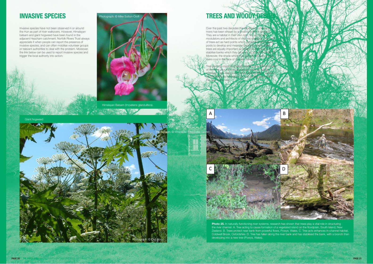
Over the past two decades the importance of trees to rivers has been shown by a growing body of research. They are a habitat in their own right, act as nutrient modulators and architects of channel structure. The roots of trees act as hard points which deflect flow and cause pools to develop and meander bends to initiate. Fallen trees are equally important as deflectors of flow and to stabilise banks which they fall onto, as shown in Photo 25. Moreover, the shade which they provide will help to keep rivers cool in the face of climate change.
Tree planting could be of great benefit to the habitat quality of the River Hun for both aquatic and riparian wildlife. However, trees need to be placed strategically in sections of river which do not impact ground nesting birds within the nature reserves.
TREES AND WOODY DEBRIS
Invasive species have not been observed in or around the Hun as part of river walkovers. However, Himalayan balsam and giant hogweed have been found in the adjacent Heacham catchment. Norfolk Rivers Trust always appreciate it when people can report the presence of invasive species, and can often mobilise volunteer groups or relevant authorities to deal with the problem. Moreover, the link below can be used to report invasive species and trigger the local authority into action:
INVASIVE SPECIES Photograph: © Mike Sutton-Croft
Photograph: © Wikipedia: Fritz Geller-Grimm
Photograph: © Olaf Booy
Giant hogweed
Himalayan Balsam (Impatiens glandulifera).
Photo 25. In naturally-functioning river systems, research has shown that trees play a vital role in structuring the river channel. A. Tree acting to cause formation of a vegetated island on the floodplain, South Island, New Zealand. B. Trees protect near bank from powerful flows, Powys, Wales. C. Tree acts enhances in-channel habitat, Coldwell Brook, Oxfordshire. D. Tree has fallen along the river bank and has stabilised the bank, with a branch then developing into a new tree (Powys, Wales).

such as alders (Alnus sp) and willows (Sallix sp) in areas more distant from the nature reserves. Closer to the nature reserves plants of a more bushy nature such as blackthorn could be planted, or emergent water plants allowed to colonise the platforms. Error! Reference source not found. summarises the current state of the lower Hun and shows how planting and some channel morphology work could greatly improve the value to wildlife and, arguably, the aesthetic value of the river.
PAGE 22 | THE RIVER HUN A WATER FRAMEWORK DIRECTIVE LOCAL CATCHMENT PLAN THE RIVER HUN A WATER FRAMEWORK DIRECTIVE LOCAL CATCHMENT PLAN | PAGE 23
SECTION 3 AN ACTION PLAN
Actions for the River Hun should take into account local people’s views, current land usage, and aim to enhance the ecological potential of the river.
In the future, the River Hun could be a river with varied marginal habitat, supporting a range of birds, small mammals and invertebrates. The stream channel itself could also have increased natural sinuosity with a patchwork of shade, and different water velocities provided by marginal trees and in-channel woody debris. This would improve the nursery and breeding habitat for fish and invertebrates. Thus, a degree of the river’s natural function could be restored without compromising other land uses in the area. To provide this, actions should focus on the river below the confluence with waters from the Waterworks Road.
The section of river below the additional flows from the springs at Waterworks Road would benefit from tree planting, which would provide woody debris in the long term. Trees should be positioned strategically to avoid providing perches for predatory birds which could impact ground nesting birds in the nature reserves. This could be achieved in synchrony with channel modification by production of a two stage channel which would provide low-level platforms for the planting of water-loving trees
A149 ROAD BRIDGE TO OUTFALL START OF HOLME NATURE RESERVE
Figure 2. Schematic showing: A. The siltation and poor habitat caused by the current form of the river channel. B. Potential improvements to the straightened river channel which would improve habitat diversity and wildlife value in the long term. Nearer the nature reserve, lowered platforms could be planted with reeds instead of trees.
HOLME NATURE RESERVE
in Figure 4. This may be excessive, so some physical reduction in the height of the beds of the creaks may be required, which will allow water to flow into lower areas. Depending on the eventual increase in levels suggested, other creaks may also be re-wetted as a result, for instance those show in Figure 4 and 5. A hydrological modelling exercise would be needed to determine if this was appropriate to the area. A more ambitious plan put forward in a report by UEA in the early 1990’s suggested more extensive channel morphology work, but this plan could to cost prohibitive.
Within the nature reserve there could be some scope re-flooding of historic creaks. Features such as Hun Pool and Broadwater Pool are the old tidal meanders of the River Hun itself and are clearly seen on Figure 4. It has been suggested by managers of the nature reserve that re-wetting some historic creaks by raising water levels using a sluice would be desirable for bird habitat and could be achieved using an existing sluice. From an initial assessment, it appears that water levels in the lower river would need to be raised by around 50 cm to increase the wetted area effectively in the creaks investigated, shown
Figure 3. Elevation analysis of River Hun in Holme Nature Reserve to assess the feasibility of re-wetting historic tidal creaks to improve bird habitat. Green areas are of higher elevation and increasingly dark blue areas are lower. Cross sections are taken left-right looking downstream as is standard practice. The area pictured is about 290 metres upstream of the tidal sluice. Because the creaks under examination historically originated from the Broadwater side it can be seen that they are in fact of greatest elevation closer to the river and reduce in elevation as they approach Broadwater. As a result once water has reached the creaks from the river system it will easily flow to fill the rest of the creak system. Bunds to protect Broadwater from filling from the river would need to be checked. To fill the creaks as they stand, a 50-60 cm increase in water levels and removal of what appears to be a bund at the top of the creak system would be required. It may be that this increase in water levels would be excessive. In this case, some physical work to lower the bed of the first section of the creaks would to allow the water to flow into the rest of the system. This will mean that less of an increase in water levels would be needed.

PAGE 24 | THE RIVER HUN A WATER FRAMEWORK DIRECTIVE LOCAL CATCHMENT PLAN
HOLME NATURE RESERVE
in Figure 4. This may be excessive, so some physical reduction in the height of the beds of the creaks may be required, which will allow water to flow into lower areas. Depending on the eventual increase in levels suggested, other creaks may also be re-wetted as a result, for instance those show in Figure 4 and 5. A hydrological modelling exercise would be needed to determine if this was appropriate to the area. A more ambitious plan put forward in a report by UEA in the early 1990’s suggested more extensive channel morphology work, but this plan could to cost prohibitive.
Within the nature reserve there could be some scope re-flooding of historic creaks. Features such as Hun Pool and Broadwater Pool are the old tidal meanders of the River Hun itself and are clearly seen on Figure 4. It has been suggested by managers of the nature reserve that re-wetting some historic creaks by raising water levels using a sluice would be desirable for bird habitat and could be achieved using an existing sluice. From an initial assessment, it appears that water levels in the lower river would need to be raised by around 50 cm to increase the wetted area effectively in the creaks investigated, shown
Figure 4. Elevation analysis of another area in the River Hun in Holme Nature Reserve. Green areas are of higher elevation and increasingly dark blue areas are lower. Cross sections are taken looking downstream as is standard practice. They show that river Hun is lower in elevation than the historic of the creaks by 0.2 – 0.5 metres.
COSTS AND TIMELINEIn the case of most rivers there would be a Water Framework Directive target set, and the Hun’s progress would be judged against relatively rigorous biological physical and chemical standards. Due to its small size and consequent low profile, the Hun is not given a status or objective under the Water Framework Directive. This means that this catchment plan has particular significance as a step in determining what objectives should be set.
As a result of centuries of modification, the lower sections of the river could benefit from measures which would increase the habitat quality, which is currently extremely poor. Increased cover, and a variety of in channel habitat in particular will need to be addressed.
Overall, the order of priorities for the river are as follows:
1. To improve stream habitat diversity for aquatic wildlife in the lower section of the river.
2. To maintain public access along the middle section of the river.
3. To investigate the possibility of raising water levels in Holme Nature reserve, with the aim of enhancing habitat for birds within the reserve.
Measures to maintain public access between Old Hunstanton and Holme Nature reserve is usually the role of the local authorities. However, if this is not possible, maintenance could be undertaken by volunteer groups, and this could commence when it is required as plants begin to grow in the spring.
In the longer term, tree planting and channel morphology work could be undertaken where landowner permission can be gained. Investigating the possibility of raising water levels in Holme Nature Reserve could be undertaken when funding is available to undertake hydrological modelling.
Action Number of kilometres / sites
Predicted cost Achievable timeline Responsibility / capability
Tree planting 190 trees £ 900(less with volunteer help)
Ongoing to 2027 Volunteers/ Norfolk Rivers Trust/ / EA
Channel morphology work
2 km £ 38, 000 Ongoing to 2027 Norfolk Rivers Trust/ EA
Improvements to public footpath
1.4 km Ongoing Volunteers with support of NRT
Hydrological modelling to determine viability of raising water levels in Holme Nature Reserve
1 site £ 8, 000 When desirable to NWT
NWT/ support from NRT
FURTHER INFORMATION
THE RIVER HUN A WATER FRAMEWORK DIRECTIVE LOCAL CATCHMENT PLAN | PAGE 25

THE NORFOLK RIVERS TRUSTRESTORING NORFOLK’S RIVERS
THE RIVER HUN A WATER FRAMEWORK DIRECTIVE LOCAL CATCHMENT PLAN
The Norfolk Rivers Trust
Stody Hall Barns, Stody, Near Holt,
Norfolk NR24 2EDwww.norfolkriverstrust.org