the presettlement forest and natural disturbance cycle...
TRANSCRIPT

The Presettlement Forest and Natural Disturbance Cycle of Northeastern MaineAuthor(s): Craig G. LorimerReviewed work(s):Source: Ecology, Vol. 58, No. 1 (Jan., 1977), pp. 139-148Published by: Ecological Society of AmericaStable URL: http://www.jstor.org/stable/1935115 .Accessed: 06/04/2012 13:51
Your use of the JSTOR archive indicates your acceptance of the Terms & Conditions of Use, available at .http://www.jstor.org/page/info/about/policies/terms.jsp
JSTOR is a not-for-profit service that helps scholars, researchers, and students discover, use, and build upon a wide range ofcontent in a trusted digital archive. We use information technology and tools to increase productivity and facilitate new formsof scholarship. For more information about JSTOR, please contact [email protected].
Ecological Society of America is collaborating with JSTOR to digitize, preserve and extend access to Ecology.
http://www.jstor.org

THE PRESETTLEMENT FOREST AND NATURAL DISTURBANCE CYCLE OF NORTHEASTERN MAINE'
CRAIG G. LORIMER2
School of Forestry and Environmental Studies, Duke University, Durham, North Carolina 27706 USA
Abstract. Land survey records of 1793-1827 containing forest data for 1.65 X 1Off ha of northern Maine were analyzed for species composition, successional status, and frequency of large-scale disturbance. Quantitative data consists of 1,448 sample trees spaced 1.6 km apart along a 9.7- X 9.7-km grid. Species which each comprised > 10% of the total were Picea spp., Fagus grandifolia, Abies balsamea, Thuja occidentalis, and Betula lutea. These forests appeared to be largely in a climax state as indicated by the dominance of shade-tolerant species and the small percentage (8% ) of intolerant or early successional species. However, 9.3% of the tract was burned land and birch-aspen forest at the time of the survey, mostly the result of large fires in 1803 and 1825. Windfalls occurred along 2.6% of the surveyed distance. If the amount of disturbed forest at this time was typical of the natural disturbance regime, then the average recurrence interval of fire and large-scale windthrow for a given site would be 800 and 1,150 years, respectively. Data on the structure of remnant virgin stands in the region likewise suggest that the time interval between severe disturbances was much longer than that needed to attain a climax, all-aged structure.
Key words: Climax; disturbance; fire; forest structure; insect epidemics; Maine; presettle- ment forests; windthrow.
INTRODUCTION
The character of the presettlement forests in New England is not well known due to the paucity of virgin forest remnants and lack of detailed historical records. In Maine, commercial logging for pine (mostly Pinus strobus and Pinus resinosa) was under- way by 1650. All forest types have been cut heavily since 1850 (Wood 1935, Coolidge 1963) and even small virgin stands are now rare. Previous data on virgin forests of northern Maine are limited to ac- counts of 19th century travelers and a few studies on small virgin forest remnants. Thoreau (1 864) traversed the waterways of the region and commented on the dominance of spruce (Picea spp.) and fir (Abies balsamea), but had little opportunity to ob- serve the upland forests. Useful quantitative data on virgin forest remnants in the mountains of western Maine were gathered by Cary (1894, 1896) and Hosmer (1902). Hosmer found that the percentage of red spruce (Picea rubens) in the overstory varied from 38% on a lower mountain slope to 82% on the upper slope. Codominant species on the lower slope were yellow birch (Betula lutea, 17%), beech (Fagus grandifolia, 17%), sugar maple (Acer saccharum, 12%), and hemlock (Tsuga canadensis, 9%).
The use of government land surveys to recon- struct the composition of the presettlement forest has generally not been possible in New England since,
with the exception of northern Vermont (Siccama 1971), most of the land had already been cleared or logged by the time such surveys were made. The present report is based largely on land survey records made between 1793 and 1827 in north-central and northeastern Maine. (Records of the commissioners under the act Qf separation, microfilm roll no. 47, Maine State Library, Augusta,) After the separation of Maine from Massachusetts in 1820, the new government made a concentrated effort to survey the undivided lands in the northern half of the state. The northwest corner of the state, not included in this study, was surveyed 15-25 yr later.
The objectives of this study are to estimate the species composition of the presettlement forests, to interpret their successional status, and to provide evi- dence on the frequency of large-scale natural dis- turbances. This study was initiated and much of the data collected while the author was at Colby College, Waterville, Maine. The forest data from the land survey reflect successional trends and disturbance frequency over a large region prior to extensive in- fluence by European man, and will also be helpful in assessing man's impact on the forests of this area.
STUDY AREA CHARACTERISTICS
The survey area encompasses much of the middle and upper Penobscot and Aroostook River valleys. The topography is generally characterized by rolling hills 150-450 m above sea level, interspersed with flat lowlands having numerous lakes and bogs of glacial origin (Flint 1959). Scattered peaks above
' Manuscript received 6 October 1975; accepted 24 September 1976.
2 Present address: Harvard Forest, Petersham, Massa- chusetts 01366.

140 CRAIG G. LORIMER Ecology, Vol. 58, No. 1
Quebec MAINE * New
( a_ 5 Seboeis R. _ ~~~~Houlton
Piscotoquis River
Penobscot River-\
Bangor/.
Miles
0 15 30
0 20 40
Km
FIG. 1. Location of the study area (land survey of 1793-1827). Burned lands (stippled areas) are shown in relation to major river systems. Dots represent small burned tracts that cannot be drawn to scale. Diagonal hatching represents burned land reported outside the survey boundaries. The northern boundary of the 1825 fire on the West Branch Penobscot is uncertain because three of the township lines were only partially surveyed.
900 m occur mostly in the western portion of the survey. Soils are generally podzolized stony loams developed on glacial till (Marbut 1924, Arno et al. 1972).
The mean annual precipitation during the late 19th and early 20th century ranged from 71 cm in Houlton at the eastern edge of the tract to 109 cm in Millinocket near the center of the tract, and was fairly well distributed throughout the year. The mean annual temperature was about 40C for most stations on the tract, with a January mean of -11 C and a July mean of 18'C. The mean length of the growing season ranged from 104 to 110 days (U.S. Weather Bureau 1920).
At the time of the survey the tract was essentially unpopulated, with the exception of a few homesteads and the settlement of Houlton near the eastern edge (Fig. 1). In 1810 the population of the Penobscot
Valley was 7,471, distributed in 19 towns to the south of the survey area (Morse 1819). The sur- veyors noted in several places evidence of recent logging for pine, all of which were situated along major navigable rivers. Although the proportion of forest cut at this time was insignificant, loggers may have had a significant impact as a result of accidental fires.
METHODS
The study area (Fig. 1) encompasses an area of 1,650,000 ha. Most of the tract north of the dashed line in Fig. 2E was surveyed by Joseph Norris and his son from 1825 to 1827. The remainder of this area was surveyed by three other men at the same time. The smaller area south of the dashed line was surveyed by 12 surveyors at various times from 1793 to 1822.
Both quantitative and qualitative forest data were recorded by surveyors. In order to mark the position of the township lines on the ground, surveyors were instructed to blaze one "witness tree" at the end of each measured mile (1.6 km) and to record the species (Roll 47, land survey microfilms, Maine State Library). Most townships on the tract are 6 miles (9.7 km) on a side and therefore the witness trees were regularly spaced in a grid pattern. From the sample of 1,448 witness trees it is possible to estimate quantitatively the average forest composition of the tract. The use of these witness trees to reconstruct forest composition is made on the assumption that they constitute a representative sample of the original forest, and therefore that bias in the selection of tree species was not significant. Methods of checking for bias are discussed below.
The number of witness trees is less than the num- ber of miles of township line because no witness trees were recorded for the area south of the dashed line in Fig. 2E, some township lines cross large lakes, and parts of other township lines could not be surveyed because of impassable terrain.
Qualitative descriptions of the forest cover, in which the dominant species were usually listed, were also given at 1-mile intervals and were recorded for 1,804 miles (2,903 km) of township line on the tract. Other information consistently recorded in- cluded a description of the soil quality and topo- graphic features, and the occurrence of burned land, windfalls, and natural meadows. These data were taken partly for the purpose of determining the monetary value of each township. The supervisors of the survey were notified that "it will be particu- larly important that the surveyors take extensive field notes of everything in the situation and face of the Country thro' which they pass, which will enable us with your assistance to judge both of the absolute

Winter 1977 PRESETTLEMENT FOREST OF MAINE 141
X -1 X
L .J BALSAM CONSIDERABLE' r
HEMLOCK | | ~~FIR P . s INEFLS
CEDARFI
i ---| Wl NESS TREES t . . 1PIN W \ ;@@~ ..... ~@ . :. .X
L.7-
A *. i C
BALSAM HEMLOCK FIR .. ~.WINDFALLS
WITNESS TREES
J-1 ~ ~ ~ ~ ~ ~ ~ ~~*
DEF
FIG. 2. A-D: Distribution of tree species as indicated by surveyors' descriptive comments. Species not shown were distributed rather evenly throughout the tract. Each point represents a 1-mile segment for which the species was listed as one of four dominants. Boundaries of the three forest regions (associations) are shown in D. E: Distribution of balsam fir witness trees. F: Locations of windfalls reported by surveyors.
and relative value of the land . . ." (Roll 47, land survey microfilms).
Soil quality was assigned to one of four classes based on rockiness and drainage, and was assessed "without any reference to waters, growth of timber, or local situation" (Roll 47, land survey microfilms). Soils designated as 1st-rate were well-drained loams suitable for cultivation, while 2nd- and 3rd-rates were typical of rocky sites with only small tillable patches. Land designated 4th-rate was "either ex- tremely rocky or ledgy; flat, wet, and gravelly, or open bog, and may be considered as of no value ex- cept for the growth and mill sites" (Roll 47, land survey microfilms).
For analytical purposes I transcribed the witness tree data, forest descriptions, and soil quality ratings for each township line onto data sheets. All observa- tions pertaining to natural disturbances were noted. Locations of mountains, rivers, lakes, and swamps
were checked against topographic maps and found to be accurate in all areas of the survey.
RESULTS
Species composition and forest associations
Those species which each comprised > 10% of the witness trees were spruce, beech, balsam fir, cedar (Thuja occidentalis), and yellow birch (Table 1 and Appendix I.). Compared to other surveys in the Northeast and Lake States (Lutz 1930, Gordon 1940, Stearns 1949, McIntosh 1962, Siccama 1971), northern Maine had less hemlock and beech but a greater proportion of spruce, fir, and cedar.
Descriptions of the forest by surveyors suggest that the species were segregated into physiognomic communities or forest types. All surveyors recog- nized three types: hardwoods (i.e. communities of broad-leaved deciduous trees), conifers, and mixed

142 CRAIG G. LORIMER Ecology, Vol. 58, No. 1
TABLE 1. Percent species composition of the presettlement forest based on land survey witness trees
Entire tract
Total sample Subsamplel Regions Species (1,448 trees) (500 trees) Northern Western Southern
Spruce spp. 20.7 20.1 ? 1.7 19.0 29.2 17.6 Birch spp. 17.0 16.4 19.8 16.2
Yellow birch 10.3 10.9 ? 0.9 11.1 6.4 11.9 White birch2 2.6 2.7 ? 0.5 1.3 7.7 1.1 Unspecified 4.1 4.1 ? 1.2 4.0 5.7 3.2
Beech 14.9 14.6 ? 1.2 12.9 11.1 22.2 Balsam fir 14.1 14.1 ? 1.4 20.5 8.4 5.4 Cedar 11.9 12.3 ? 1.4 14.8 6.7 9.8 Maple spp. 8.1 8.3 6.4 9.5
Sugar maple 4.4 4.8 ? 0.4 5.4 1.0 5.1 White maple 1.8 1.7 ? 0.3 1.7 2.7 1.4 Unspecified 1.9 1.8 ? 0.3 1.2 2.7 3.0
Hemlock 4.2 4.2 ? 0.8 2.4 3.0 8.9 Ash spp. 2.6 2.7 2.7 1.9
Blackash 1.9 1.6 + 0.4 2.0 2.0 1.4 Yellow ash 0.1 0.1 ? 0.08 0.1 0.0 0.0 Unspecified 0.6 0.6 ? 0.2 0.6 0.7 0.5
Poplar spp.2 2.3 2.8 ? 0.6 0.1 6.0 3.8 Pine spp. 1.3 1.4 ? 0.4 0.5 2.7 1.9 Larch 1.0 0.7 ? 0.2 1.0 1.3 0.8 Moosewood 0.8 0.7 ? 0.2 0.6 1.7 0.5 Hornbeam 0.3 0.3 ? 0.1 0.3 0.0 0.5 Alder 0.3 0.2 ? 0.1 0.4 0.0 0.3 Willow 0.3 0.3 ? 0.1 0.0 0.7 0.5 Cherry 0.1 0.1 ? 0.09 0.0 0.3 0.0
No. of trees 1448 500 781 298 369
'Mean values of 10 independent subsamples of 500 trees, followed by average deviations from the mean. 2A large proportion of the poplar and white birch witness trees were on the area covered by the 1803 fire. If
this area is excluded, the percentage of poplar witness trees was 0.0 for the southern region and 1.1 for the western region, and the percentage of white birch was 0.6 for the southern region and 7.2 for the western region.
conifer-hardwoods (usually called "mixed forest"). There was a clear correlation of these types with soil quality and topography. Eighty-two percent of the hardwood stands occurred on 1st-rate soil, 57% of the mixed forest on 2nd-rate soil, and 83% of the conifer stands on 3rd- and 4th-rate soils. The hard- wood stands occurred most often on upland soils relatively free from rocks, while typical conifer sites were stony flats and upper mountain slopes. How- ever, an analysis of witness trees which occurred within stands of each type suggest that the hardwoods or conifers did not usually occur in pure stands, for the conifer type averaged 76% conifers and the hardwood type averaged 65% hardwoods. Thus most of the region was actually mixed forest, with hardwoods or conifers locally achieving partial domi- nance due to physiographic variation. Similar re- sults are indicated by the stand tables of Graves (1899) and Chittenden (1905) for virgin "hard- wood land" and "spruce flats". The variation in species composition due to soil quality is indicated in Table 2.
Each of these three communities occurred through- out the study area. Thus there was no continuous belt of northern hardwoods in northeastern Maine as recognized by Shantz and Zon (1924) and Kiichler (1964). Although the entire area was covered by
mixed conifer-hardwood forest, there was consider- able variation in species composition on different parts of the tract. Some species occurred as domi- nants over the whole tract, while hemlock, balsam fir, and cedar were common only in the southern, north- ern, and eastern portions, respectively (Fig. 2).
A systematic way of mapping forest associations in this region would be to recognize each unique combination of dominants as a separate association. Thus, for this area, three associations could be recog- nized: (1) a western region of spruce-hardwood forest, (2) a southern region of spruce-cedar-hem- lock-hardwood forest, and (3) a northern region of spruce-fir-cedar-hardwood forest. Boundaries were placed subjectively but were based on the geographic distribution of hemlock, fir, and cedar as indicated in the surveyors' descriptions (Fig. 2). Table 1 gives the average species composition of each of these associations.
The question of surveyor bias
Bourdo's (1956) method of testing for bias in wit- ness tree selection is not applicable to the Maine survey data since stakes or posts were not used to mark township corners. Although statistically sig- nificant bias in witness tree selection has not been found in other land surveys (Kenoyer 1930, Bourdo

Winter 1977 PRESETTLEMENT FOREST OF MAINE 143
TABLE 2. Percent species composition on soil quality types'
Species 1st-rate 2nd-rate 3rd-rate 4th-rate
Beech 26.5 17.2 4.3 16.72 Birch spp. 19.3 11.2 9.5 9.7
Yellow birch 12.6 6.0 5.2 6.9 White birch 0.0 0.9 2.6 2.8 Unspecified 6.6 4.3 1.7 0.0
Maple spp. 8.4 8.6 6.9 2.8 Sugar maple 5.4 3.4 2.6 1.4 White maple 1.2 3.4 2.6 0.0 Unspecified 1.8 1.7 1.7 1.4
Spruce spp. 12.6 29.3 33.6 31.9 Fir 16.3 19.8 17.2 11.1 Cedar 9.6 6.9 17.2 18.1 Hemlock 4.2 1.7 3.4 6.9 Pine spp. 0.6 1.7 0.9 1.4 Larch 0.0 0.9 0.9 1.4 Black ash 1.8 1.7 3.4 0.0 Other 0.6 0.9 2.6 0.0
No. trees 166 116 116 72
'Not including the area covered by the 1803 fire. 2This prominence of beech on poor soils is limited to
the southern region, and is supported by the descriptive comments.
1956, McIntosh 1962, Siccama 1971, Delcourt and Delcourt 1974), it is desirable to evaluate each survey on an independent basis. One alternative to compar- ing stake-to-tree distances consists of compiling a list of the qualitative descriptions for comparison, for these descriptions were intended to give a reasonable account of forest composition. Since the species in hardwood stands were frequently not enumerated, it is necessary to treat conifers and hardwoods sepa- rately. Table 3 shows that the relative importance of species in the surveyors' descriptions is similar to that in the witness tree data, with spruce and cedar as the dominant conifers and birch, beech, and maple as the dominant hardwoods. However, the prominence of fir in the qualitative descriptions is much less, and that of pine considerably greater, than in the witness tree counts. An accurate estimate of pine density is particularly important since white and red pine are generally considered to be early successional or sub- climax species (Fowells 1965), and hence are im- portant in assessing the sucessional status of these forests.
The discrepancy with pine might suggest that surveyors were reluctant to use commercially valu- able trees that might be cut down within a few years. However, independent estimates of pine den- sity in this region reveal that the witness tree estimate of 1.3% pine is a reasonable one. From 1826 to 1846 more than 25 townships were sampled by timber cruisers to determine the amount of mer- chantable pine timber, and several of these townships were in or adjacent to the present study area (Rolls 4 and 6, land survey microfilms). These timber cruise estimates are probably conservative but indi-
TABLE 3. Citation frequency of tree species in surveyors' descriptive lists
Position in lists
Species lst-4th 1st 2nd 3rd 4th
Conifers:' Spruce 444 136 182 73 53 Cedar 354 166 108 56 24 Pine 156 44 30 48 34 Hemlock 123 32 34 50 7 Fir 92 3 32 34 23 Larch 42 11 13 11 7
Hardwoods: Birch 193 58 54 60 21 Beech 129 52 56 15 6 Maple 126 57 43 23 3 Poplar' 34 26 3 2 3 Ash 18 0 3 9 6
' Conifers and hardwoods must be listed separately because species composition of hardwood forests was less often specified.
2 Most of these references to poplar (aspen) were in the area of the 1803 fire.
cate an average of 290 board-feet per acre, which is less than the timber volume of an average-sized tree (Bickford 1951). An idea of what surveyors felt to be "considerable pine" (cf. Fig. 2) is revealed by the comment that "there is considerable pine timber in the valleys, say 500 feet to the acre, . . ." (Roll 6, land survey microfilms). For townships in which the total number of trees was specified, some were aver- aging less than one pine tree per 8 ha (Table 4).
The generally small dimensions of balsam fir (Cary 1894, 1896) and its short lifespan and suscep- tibility to decay (Spaulding and Hansbrough 1944) would make it a poor choice for witness trees if other species were readily available. The prominence of fir in the witness tree data compared to the surveyors descriptions may merely reflect the fact that balsam fir was common in the subcanopy layer but not in the canopy (Cary 1896).
Sample adequacy
Adequacy of the sample size in estimating average species composition was tested empirically by cal- culating percent species composition as a function of increasing sample size. The values obtained for each species seem to be independent of sample size for samples of > 100 witness trees, and the results obtained from 150 randomly chosen witness trees are similar to those obtained from all 1,448 trees. This suggests that a much more intensive sample would not necessarily have improved the estimate of species composition. The second column of Table 1 shows the mean percentage for each species and the average deviation from the mean calculated from 10 random, independent subsamples of 500 witness trees.

144 CRAIG G. LORIMER Ecology, Vol. 58, No. 1
TABLE 4. Density of merchantable pine trees in some townships in northern Maine, 1826-1846.' * Starred townships denote those in which some of the better quality pine adjacent to rivers had been cut
Amount of Board-ft./ No. hectares/ Township pine acre pine tree2
Northern region and adjacent townships *TLR2 1,000 M3 43 9.4 TMR2 1,200 M 69 5.9
*T17R3 5,150 M 224 1.8 T17R4 4,200 M 182 2.2 T17R5 23,000 M 998 0.4 T17R6 13,000 M 564 0.7
*T17R7 9,000 M 391 1.0 T16R8 600 M 26 15.6 T17R8 6,000 M 208 1.9
Southern region T2R4 3,700 t4 161 2.5 TiR5 5,260 t 228 1.8 T2R5 1,000 t 54 7.5 T3R5 1,100 t 48 8.4 TAR7 6,000 t 195 2.1
Other townships T5R9 1,400 M 61 6.6 T6R9 30,000 M 1302 0.3 T16R9 6,500 M 282 1.4 T17R11 2,000 M 87 4.7 T18R11 4,500 M 195 2.1 T19R11 5,500 M 179 2.3 T18R12 10,000 M 434 0.9
Average 6,700 M 290 1.4
'Compiled from roll no. 4 and 6 of the land survey microfilms, Maine State Library, Augusta.
2This value calculated from no. board-feet/acre by assuming a conservative average value (as indicated by surveyors) of 1,000 board-feet/tree.
3 M denotes 1,000 board-feet. 4 t denotes the number of individual trees.
Presettlement fires
Inasmuch as other surveys in the Northeast have not reported extensive tracts of burned land, the occurrence of three such areas in the Maine survey is of considerable interest, especially in light of recent theories that the northern conifer forests are fire-de- pendent ecosystems which originally burned at in- tervals shorter than the maximum lifespan of the trees (Mutch 1970, Heinselman 1971, 1973, Habeck and Mutch 1973).
The approximate shape and extent of the large fires can be determined by marking those township lines or portions of lines along which burned land was reported (Fig. 1). Two of the large fires oc- curred in 1825, shortly before the survey was made. Comments of the surveyors indicate that these were severe crown fires which killed and partially con- sumed most of the trees. The fire along the Seboeis River covered approximately 32,000 ha and the fire along the Penobscot River covered over 10,000 ha. The year 1825 is known to have been a very dry one, and south of the study area, smoldering fires set by
early settlers and stirred up by a gale burned 324,000 ha (Loring 1880, Coolidge 1963).
The fire of 1803, sometimes known as the "Katahdin fire of 1795" (Cary 1894, Coolidge 1963, Brown and Davis 1973), covered approximately 80,000 ha in the survey area alone. At the time of the survey in 1827 the area was covered with young birch-aspen forest which the surveyors estimated to be 20-30 yr-old. Morse (1819) stated that "The trees on this extensive tract were first prostrated by some violent tempest, which happened about the year 1795 . . . [The tract] was set on fire (whether by lightning, or by the carelessness of the Indian hunters, or through design, for the convenience of hunting, is uncertain) about the year 1803, at the time the inhabitants first began to settle on those townships, which lie N. of the Waldo Patent ...." This agrees with reports of surveyors who in 1801 found numer- ous windfalls in the area later burned by the fire. There was no mention of burned land at this time, but in 1820 a surveying party found the timber of several townships to be . . . "universally blown down and burnt." Thus, regardless of its cause, this holocaust probably gained momentum by passing through an area with extensive blowdowns.
In addition to the large burns, 24 smaller ones were reported which had dimensions of 0.3 to 3.2 km where crossed by the township lines. In all, the amount of burned land was 9.3 % of the total surveyed distance and equivalent to 132,600 ha.
Since these fires occurred at the time of the earliest logging and land clearing operations, the amount of burned land was not necessarily indicative of the natural fire regime. The three largest fires all straddled navigable branches of the Penobscot River (Fig. 1). Land clearing operations are known to have been in progress from 1799-1803 along the Piscataquis River, close to the southern portion of the 1803 burn (Loring 1880), and fire was commonly used in land clearing at that time (Loring 1880, Perley 1891). Also, surveyors in 1825 noted logging for pine in progress at several points along the Seboeis River. When they returned to finish survey- ing the area in the next year, they found that all the timber along the Seboeis had been burned to the headwaters (Fig. 1). Thus, the presettlement fire regime in northern Maine may be obscured by clear- ing and logging fires that were common throughout the 19th century (cf. Coolidge 1963). Similar forest types of northern Vermont surveyed in the previous century had no recorded evidence of burned land (Siccama 1971).
Windthrow
The surveyors made 50 references to fallen timber on the tract. The pattern of windfalls shows some

Winter 1977 PRESETTLEMENT FOREST OF MAINE 145
evidence of localization (Fig. 2) and may have been caused largely by one storm. All but two of the wind- falls occurred in conifer forest on stony flats and swamps, while the adjacent uplands escaped dis- turbance. Most of the fallen trees were spruce and fir, which are typically shallow-rooted and vulner- able to windthrow (Fowells 1965). Windfalls oc- curred along 2.6% of the total number of one-mile township segments. The actual proportion of wind- thrown areas may have been less since windfalls prob- ably did not extend along the entire length of each of these township segments.
There was apparently considerable variation in the severity of wind disturbance, but these differences were not usually described in detail. Of the damage caused by the storm of 1795, surveyors in 1801 re- ported that "in many places the trees appeared to be almost all down-some places about half & some scarcely any . . ." (Roll 6, land survey microfilms).
Insect epidemics
The survey records do not contain references to any extensive areas of defoliated or dead trees. However, in four isolated areas "much dead and down spruce" were reported in 1822, 1825, and 1826 (Roll 47, land survey microfilms). Three of these areas were less than 1 km where crossed by township lines, and the fourth about 3.2 km. These appear to be the only possible instances of severe spruce budworm outbreaks, which have reached epi- demic proportions in the 20th century. Coolidge (1963) stated that the epidemic which started in 1909 killed about 40% of the spruce and 75% of the fir in the state.
Blais (1964) found evidence of a spruce budworm epidemic in northern Maine from 1802 to 1815 based on suppression patterns in the growth rings of spruce logs. However, the survey data seem to indicate that if this outbreak occurred within the present study area, it probably did not result in enough dead trees to significantly affect the timber value of the land, and hence did not warrant comments by the surveyors. The deterioration of insect-killed spruce usually takes many years (Schmid and Hinds 1974), and most of the trees killed in the 1802-1815 out- break would probably still have been standing at the time of the survey.
Climax status and natural disturbance cycle
Since spruce-cedar-hardwood stands are composed largely of shade-tolerant species and do not require severe disturbance for their regeneration, they may be considered climax according to the concept of Clements (1916). By this definition, a climax forest is not necessarily all-aged (cf. Gates and Nichols
1930, Baker 1934) or in a steady state with respect to such attributes as biomass, productivity, and nu- trient cycling (cf. Odum 1969). Not only are the latter criteria difficult to test, but they also do not affect the basic property of climax communities, that of self-perpetuation. The survey data indicate that approximately 88% of the forest area in northeastern Maine was in a climax state by this definition. Shade-intolerant species, such as white birch (Betula papyrifera), aspen (Populus spp.), pin cherry (Prunus pensylvanica), larch (Larix laricina), and pine were of minor importance (Tables 1, 2, 4). Thus, although natural disturbances are common in this region, their frequency has probably been over- estimated by some ecologists. Cline and Spurr (1942) theorized that only limited areas in New England supported climax stands in precolonial times. Davis (1966) theorized that multi-aged spruce-fir stands in coastal Maine were uncommon in presettle- ment times due to the frequency of windthrow and fire. The age structure of presettlement stands is dis- cussed below.
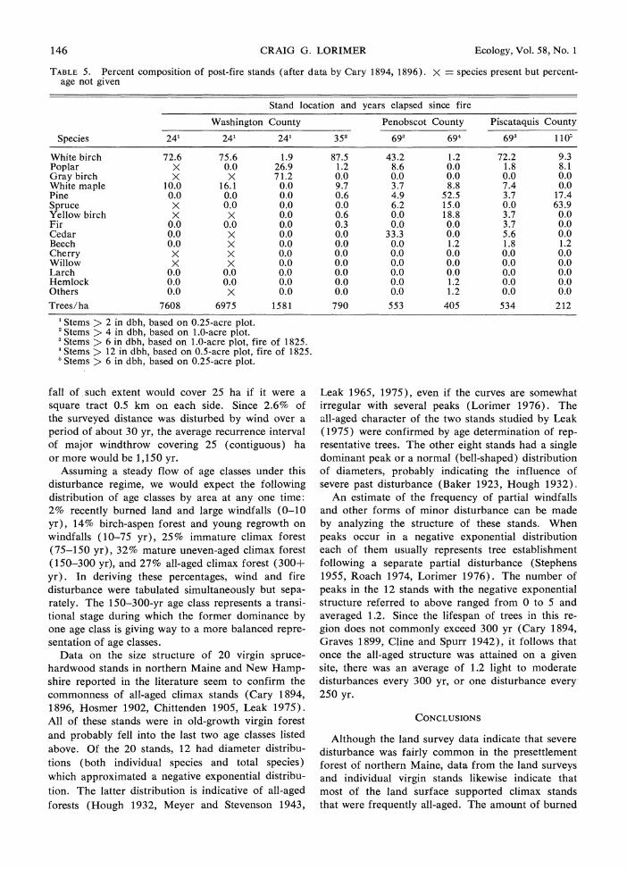
Data from the land survey and representative virgin stands give an indication of the frequency of severe disturbance in this region. Since most of the region was covered by climax forest, the average interval between crown fires on a given site must have been longer than the time needed to reach climax. The data of Cary (1894, 1896) in Table 5 suggest that the time needed to reach climax after a crown fire is somewhat longer than 100 yr. However, if the average recurrence interval of fire on a given tract were as short as 100 yr, well over half the total area would support birch-aspen forest at any one time. The dominance of birch-aspen appears to last at least 75 yr after a fire (Table 5). If the 9.3% of the tract in burned land and birch-aspen forest thus represents a typical amount burned in 75 yr, then the time required to burn the whole tract (and hence the recurrence interval of fire) is 806 yr. If some of the fires reported by surveyors were caused by man, the natural recurrence interval might be con- siderably longer. For example, if the 1803 fire was caused by man and the others by lightning, then the natural recurrence interval would be 1,923 yr.
An estimate of the recurrence interval of large windfalls can be made if the approximate range of "ages" for the windfalls in Fig. 2 is known. Since the surveyors in 1825-27 recognized burned and un- burned windfalls in the area covered by the storm of 1795 and the fire of 1803, it seems reasonable to as- sume that the windfalls in Fig. 2 occurred over at least a 30-yr period. Presumably, surveyors recorded only windfalls larger than a certain size. Since some windfalls were recorded on portions of township lines as small as V mile (0.5 km), I have assumed that this is the minimum size recorded by surveyors. A wind-
146 CRAIG G. LORIMER Ecology, Vol. 58, No. 1
TABLE 5. Percent composition of post-fire stands (after data by Cary 1894, 1896). X - species present but percent- age not given
Stand location and years elapsed since fire
Washington County Penobscot County Piscataquis County
Species 241 241 241 352 693 694 693 1 105
White birch 72.6 75.6 1.9 87.5 43.2 1.2 72.2 9.3 Poplar X 0.0 26.9 1.2 8.6 0.0 1.8 8.1 Gray birch X X 71.2 0.0 0.0 0.0 0.0 0.0 White maple 10.0 16.1 0.0 9.7 3.7 8.8 7.4 0.0 Pine 0.0 0.0 0.0 0.6 4.9 52.5 3.7 17.4 Spruce X 0.0 0.0 0.0 6.2 15.0 0.0 63.9 Yellow birch X X 0.0 0.6 0.0 18.8 3.7 0.0 Fir 0.0 0.0 0.0 0.3 0.0 0.0 3.7 0.0 Cedar 0.0 X 0.0 0.0 33.3 0.0 5.6 0.0 Beech 0.0 X 0.0 0.0 0.0 1.2 1.8 1.2 Cherry X X 0.0 0.0 0.0 0.0 0.0 0.0 Willow X X 0.0 0.0 0.0 0.0 0.0 0.0 Larch 0.0 0.0 0.0 0.0 0.0 0.0 0.0 0.0 Hemlock 0.0 0.0 0.0 0.0 0.0 1.2 0.0 0.0 Others 0.0 X 0.0 0.0 0.0 1.2 0.0 0.0
Trees/ha 7608 6975 1581 790 553 405 534 212
1 Stems > 2 in dbh, based on 0.25-acre plot. 2 Stems > 4 in dbh, based on 1.0-acre plot. 3 Stems > 6 in dbh, based on 1.0-acre plot, fire of 1825. 'Stems > 12 in dbh, based on 0.5-acre plot, fire of 1825. ? Stems > 6 in dbh, based on 0.25-acre plot.
fall of such extent would cover 25 ha if it were a square tract 0.5 km on each side. Since 2.6% of the surveyed distance was disturbed by wind over a period of about 30 yr, the average recurrence interval of major windthrow covering 25 (contiguous) ha or more would be 1,150 yr.
Assuming a steady flow of age classes under this disturbance regime, we would expect the following distribution of age classes by area at any one time: 2% recently burned land and large windfalls (0-10 yr), 14% birch-aspen forest and young regrowth on windfalls (10-75 yr), 25% immature climax forest (75-150 yr), 32% mature uneven-aged climax forest (150-300 yr), and 27% all-aged climax forest (300+ yr). In deriving these percentages, wind and fire disturbance were tabulated simultaneously but sepa- rately. The 150-300-yr age class represents a transi- tional stage during which the former dominance by one age class is giving way to a more balanced repre- sentation of age classes.
Data on the size structure of 20 virgin spruce- hardwood stands in northern Maine and New Hamp- shire reported in the literature seem to confirm the commonness of all-aged climax stands (Cary 1894, 1896, Hosmer 1902, Chittenden 1905, Leak 1975). All of these stands were in old-growth virgin forest and probably fell into the last two age classes listed above. Of the 20 stands, 12 had diameter distribu- tions (both individual species and total species) which approximated a negative exponential distribu- tion. The latter distribution is indicative of all-aged forests (Hough 1932, Meyer and Stevenson 1943,
Leak 1965, 1975), even if the curves are somewhat irregular with several peaks (Lorimer 1976). The all-aged character of the two stands studied by Leak (1975) were confirmed by age determination of rep- resentative trees. The other eight stands had a single dominant peak or a normal (bell-shaped) distribution of diameters, probably indicating the influence of severe past disturbance (Baker 1923, Hough 1932).
An estimate of the frequency of partial windfalls and other forms of minor disturbance can be made by analyzing the structure of these stands. When peaks occur in a negative exponential distribution each of them usually represents tree establishment following a separate partial disturbance (Stephens 1955, Roach 1974, Lorimer 1976). The number of peaks in the 12 stands with the negative exponential structure referred to above ranged from 0 to 5 and averaged 1.2. Since the lifespan of trees in this re- gion does not commonly exceed 300 yr (Cary 1894, Graves 1899, Cline and Spurr 1942), it follows that once the all-aged structure was attained on a given site, there was an average of 1.2 light to moderate disturbances every 300 yr, or one disturbance every- 250 yr.
CONCLUSIONS
Although the land survey data indicate that severe disturbance was fairly common in the presettlement forest of northern Maine, data from the land surveys and individual virgin stands likewise indicate that most of the land surface supported climax stands that were frequently all-aged. The amount of burned

Winter 1977 PRESETTLEMENT FOREST OF MAINE 147
land, birch-aspen forest, and windfalls at the time of the survey also support the conclusion that the re- currence interval of severe disturbance was con- siderably longer than that needed to attain a climax, all-aged structure. These results suggest that recent findings of relatively short cycles of fire and major disturbance in some areas (Heinselman 1971, 1973, Habeck and Mutch 1973) probably do not apply to the conifer-hardwood forests of northern New En- gland.
ACKNOWLEDGMENTS
I thank Shirley Thayer and the reference librarians at the Maine State Library for several extended loans of the survey microfilms, and W. H. Gilbert for advice and assistance during the early phase of the project. I also appreciate the careful reviews of the manuscript by N. L. Christensen, W. B. Leak, and T. G. Siccama.
LITERATURE CITED
Arno, J. R., R. B. Willey, W. H. Farley, R. A. Bither, and B. A. Witney. 1972. Soil survey of Somerset County, Maine: southern part. U.S. Dep. Agric., Washington. 74 p.
Baker, F. S. 1923. Notes on the composition of even- aged stands. J. For. 21:712-717.
1934. Theory and practice of silviculture. McGraw-Hill, New York. 502 p.
1949. A revised tolerance table. J. For. 47: 179-181.
Bickford, C. A. 1951. Form-class volume tables for estimating board-foot content of northern conifers. Northeast. Forest Exp. Sta. Pap. 38. 33 p.
Blais, J. R. 1964. History of spruce budworm out- breaks in the past two centuries in southeastern Que- bec and northern Maine. Can. Dep. For. For. En- tomol. Pathol. Branch Bi-Mo. Progr. Rept. 20(5):1-2.
Brown, A. A., and K. P. Davis. 1973. Forest fire: control and use. 2nd ed. McGraw-Hill, New York. 686 p.
Bourdo, E. A. 1956. A review of the General Land Office Survey and of its use in quantitative studies of former forests. Ecology 37:754-768.
Cary, Austin. 1894. On the growth of spruce, p. 20- 36, and Early forest fires in Maine, p. 37-59. In Second Ann. Rept. For. Commissioner State of Maine. Augusta.
1896. Report of Austin Cary, p. 15-203. In Third Ann. Rept. For. Commissioner State of Maine. Augusta.
Chittenden, A. K. 1905. Forest conditions of northern New Hampshire. U.S. Dep. Agr. Bur. For. Bull. 55, 100 p.
Clements, F. E. 1916. Plant succession. Carnegie Inst. Washington Publ. 242, 512 p.
Cline, A. C., and S. H. Spurr. 1942. The virgin up- land forest of central New England: a study of old growth stands in the Pisgah Mountain section of southwestern New Hampshire. Harv. For. Bull. 21, 58 p.
Coolidge, P. T. 1963. History of the Maine woods. Furbush-Roberts, Bangor, Maine. 805 p.
Davis, R. B. 1966. Spruce-fir forests of the coast of Maine. Ecol. Monogr. 36:79-94.
Delcourt, H. R., and P. A. Delcourt. 1974. Primeval magnolia-holly-beech climax in Louisiana. Ecology 55:638-644.
Fernald, M. L. 1950. Gray's manual of botany. 8th ed. American Book Co. 1632 p.
Flint, R. F. 1959. Glacial map of the United States east of the Rocky Mountains. Geol. Soc. Am., N.Y.
Fowells, H. A. (comp.). 1965. Silvics of forest trees of the United States. U.S. Dep. Agr. For. Serv., Agr. Handbook 271, 762 p.
Gates, F. C., and G. E. Nichols. 1930. Relation be- tween age and diameter in trees of the primeval north- ern hardwood forest. J. For. 28:395-398.
Gordon, R. B. 1940. The primeval forest types of southwestern New York. N.Y. State Mus. Sci. Serv. Bull. 321, 102 p.
Graves, H. S. 1899. Practical forestry in the Adiron- dacks. U.S. Dep. Agr. Div. For. Bull. 26, 85 p.
Habeck, J. R., and R. W. Mutch. 1973. Fire depen- dent forests in the northern Rocky Mountains. Quat. Res. 3:408-424.
Heinselman, M. L. 1971. The natural role of fire in northern conifer forests, p. 61-72. In Fire in the northern environment: a symposium. Pacific N.W. For. Range Exp. Sta.
1973. Fire in the virgin forests of the Boundary Waters Canoe Area, Minnesota. Quat. Res. 3:329-382.
Hosmer, R. S. 1902. A study of the Maine spruce, p. 62-108. In Fourth Rept. For. Commissioner State of Maine. Augusta.
Hough, A. F. 1932. Some diameter distributions in forest stands of northwestern Pennsylvania. J. For. 30:933-943.
Kenoyer, L. A. 1930. Ecological notes on Kalamazoo County, Michigan, based on the original land survey. Pap. Mich. Acad. Sci. Arts Lett. 11:211-217.
Ktchler, A. W. 1964. Potential natural vegetation of the conterminous United States. Am. Geog. Soc. Spec. Pub. 36.
Leak, W. B. 1965. The J-shaped probability distri- bution. For. Sci. 11:405-409.
1975. Age distribution in virgin red spruce and northern hardwoods. Ecology 56:1451-1454.
Lorimer, C. G. 1976. Stand history and dynamics of a southern Appalachian virgin forest. Ph.D. Thesis, Duke Univ. 207 p.
Loring, Amasa. 1880. History of Piscataquis County, Maine. Hoyt, Fogg, and Donham, Portland, Maine. 304 p.
Lutz, H. J. 1930. Original forest composition in north- western Pennsylvania as indicated by early land sur- vey notes. J. For. 28:1098-1103.
McIntosh, R. P. 1962. The forest cover of the Cats- kill Mountain region, New York, as indicated by land survey records. Am. Midl. Nat. 68:409-423.
Marbut, C. F. 1924. Soils of the United States, p. 1-98, Part III. In Atlas of American agriculture, U.S. Dep. Agr., Washington.
Meyer, H. A., and D. D. Stevenson. 1943. The struc- ture and growth 'of virgin beech-birch-maple-hemlock forests in northern Pennsylvania. J. Agr. Res. 67: 465-484.
Morse, J. 1819. The American universal geography. Vol. 1. Charlestown. 898 p.
Mutch, R. W. 1970. Wildland fires and ecosystems-a hypothesis. Ecology 51:1046-1051.
Odum, E. P. 1969. The strategy of ecosystem de- velopment. Science 164:262-270.

148 CRAIG G. LORIMER Ecology, Vol. 58, No. 1
Perley, Sidney. 1891. Historic storms of New England. Salem Press and Printing Co. 341 p.
Roach, B. J. 1974. Selection cutting and group selec- tion. State Univ. N.Y., Applied For. Res. Inst., Misc. Rept. 5, 9 p.
Schmid, J. M., and T. E. Hinds. 1974. Development of spruce-fir stands following spruce beetle outbreaks. U.S. Dep. Agr. For. Serv. Res. Pap. RM-131. 16 p.
Shantz, H. L., and R. Zon. 1924. The physical basis of agriculture: natural vegetation, p. 1-29, Part IV. In Atlas Am. Agriculture, U.S. Dep. Agr., Washing- ton.
Siccama, T. G. 1971. Presettlement and present forest vegetation in northern Vermont with special reference to Chittenden County. Am. Midl. Nat. 85:153-172.
Spaulding, P., and J. R. Hansbrough. 1944. Decay in balsam fir in New England and New York. U.S. Dept. Agr. Tech. Bull. 872, 30 p.
Stearns, F. W. 1949. Ninety-years change in a north- ern hardwood forest in Wisconsin. Ecology 30:350- 358.
Stephens, E. P. 1955. The historical-developmental method of determining forest trends. Ph.D. Thesis, Harvard Univ. 232 p.
Thoreau, H. D. 1864. The Maine Woods. Ticknor and Fields, Boston. 328 p.
U.S. Weather Bureau. 1920. Summary of climato- logical data for the United States, by sections. Re- print of section 106-Maine. 10 p.
Wilson, B. F., and B. C. Fischer. 1977. (In press.) Striped maple: shoot growth and bud formation re- lated to light intensity. Can. Jour. For. Res.
Wood, R. G. 1935. A history of lumbering in Maine 1820-1861. Univ. Maine Studies, 2nd ser. no. 33. 267 p.
APPENDIX I.
Common Probable Tolerance names used scientific to
by surveyors names' shade2
Alder Alnus spp. Beech Fagus grandifolia Very tolerant Black ash Fraxinus nigra Intermediate3 Cedar Thuja occidentalis Tolerant Cherry Prunus pensylvanica Very intolerant Fir Abies balsamea Very tolerant Gray birch Betula populifolia Very intolerant3 Hemlock Tsuga canadensis Very tolerant Hornbeam Ostrya virginiana Very tolerant3 Larch Larix laricina Very intolerant Moosewood Acer pensylvanicum Very tolerant' Pine Pinus strobus Intermediate
Pinus resinosa Intolerant Poplar (aspen),
popple Populus tremuloides Very intolerant Populus grandidentata Very intolerant Populus balsamifera Intolerant
Rock maple, sugar maple Acer saccharum Very tolerant
Spruce Picea rubens Tolerant Picea mariana Tolerant Picea glauca Tolerant
White birch Betula papyrifera Intolerant White maple Acer rubrum Tolerant3 Willow Salix spp. Very intolerant3 Yellow ash Fraxinus pennsylvanica Intolerant
(?) Yellow birch Betula lutea Intermediate
'Nomenclature follows that of Fernald (1950). 2Source: Fowells (1965). 3Source: Baker (1949). 'Source: Wilson and Fischer (1977).