mkindo forest reserve: forest disturbance report
TRANSCRIPT

Mkindo Forest Reserve
Forest Disturbance Report
Consultant: Claire Bracebridge
May 2006
Participatory Environmental Management
Programme (PEMA)

Mkindo Forest Reserve: forest disturbance report
i
Acknowledgements The Mkindo Forest Reserve consultancy was financed by the Tanzania Forest Conservation Group (TFCG) through the Participatory Environmental Management Programme (PEMA). Many thanks to the TFCG staff in Turiani particularly David Loserian, Ernest Benson and Ally Said for providing logistical and practical support. TFCG Executive Officer: Charles Meshack Senior Technical Advisor: Nike Doggart Project Officer (PEMA): David Loserian Project Assistant (PEMA): Ernest Benson PEMA Programme Coordinator: Charles Ehrhart Field Team Team Leader: Claire Bracebridge Field Assistants: Ernest Benson, Ramathan Rajabu Maingo, Kibaba
Petro, Felix Gregory Camp Assistants: Manyama Msambaa, Rashid Saidi Driver: Ally Saidi Assistant District Catchment Forest Officer: Jonathan Mpangala (Bunduki Forest Station) Report writing: Claire Bracebridge Suggested citation: Bracebridge, C. (2006). Mkindo Forest Reserve: forest disturbance report. Report for Tanzania Forest Conservation Group and Participatory Environmental Management Programme, Dar es Salaam, Tanzania. FOR MORE INFORMATION CONTACT: Tanzania Forest Conservation Group PO Box 23410 Dar es Salaam Tanzania Tel.: 255 (0)22 2669007 E-mail: [email protected] www.tfcg.org
Participatory Environmental Management Programme P.O. Box 23410 Dar es Salaam Tanzania Tel. 255 (0)22 2780029 Email: [email protected] www.pema-eastafrica.org

Mkindo Forest Reserve: forest disturbance report
ii
Executive Summary The forest disturbance survey was conducted in Mkindo Forest Reserve, Mvomero District, between 1st May and 19th May 2006. This survey is a part of the Participatory Environmental Management Programme (PEMA), which is implemented by Tanzania Forest Conservation Group (TFCG). The work will contribute to the characterisation of the Nguru South Mountains landscape with the aim of poverty alleviation, natural resource management and biodiversity conservation. Mkindo Forest Reserve (FR) is located within the Nguru South Mountains, part of the Eastern Arc Mountains, latitude 6o 12’ – 6o 16’S and longitude 37o 28’ – 37o 34’ E. It is situated in Mvomero District, 12 km from Turiani and 10 km from Mvomero, and was established in 1954 for its water catchment value supplying surrounding villages and the larger Wami catchment area. It covers 5244 ha and consists of miombo (Brachystegia) woodland and riverine / lowland forest. It has an elevational range of 380 – 800 m above sea level (asl) and an average rainfall of 1200 – 1500 mm per year (Lovett and Pócs 1993). This study conducted 12 forest disturbance surveys and recorded opportunistic observations of animals and disturbance throughout Mkindo Forest Reserve. Forest disturbance A total transect length of 11.0 km was conducted in Mkindo FR (10 transects at 1000m, one transect at 700m and one transect at 300m). A total of 2,125 poles (defined as woody stems 5-15 cm dbh), 2,696 timber trees (defined as woody stems 15-30 cm dbh) and 826 large timber trees (defined as woody stems 30 cm dbh and above) were recorded. An average of 168.9 live, 13.5 dead and 10.7 cut poles were recorded per hectare, with an average of 212.5 live, 23.1 dead and 9.5 cut timbers recorded per hectare and an average of 68.8 live, 5.4 dead and 0.9 cut large timbers recorded per hectare. Of the total poles and timbers recorded, 5.5% of poles, 3.9% of timbers and 1.2% of large timbers were cut. However, when comparing old (three months and over) and new (less than three months) cutting, 94% and 85% were old cut poles and timbers, respectively,with 80% old cut large timbers. However, overall extraction of pole and timber resources is low in the reserve. Casual observations highlighted the north east of the reserve, an area of riverine and lowland forest as being targeted for current cutting of Pterocarpus angolensis and other timber species. This was particularly prevalent along the Kigombezi river. Several old pitsawing sites were also recorded in this area of lowland / riverine forest. Many of the large trees had already been extracted. Other types of disturbance recorded were grazing, charcoal burning, mining, cultivation and paths. Grazing is of major concern as it was noted along 40.9% of the transects. Cattle are brought into the reserve for dry season grazing. The impact of this should be investigated, as very few signs of medium to large mammals were seen throughout the reserve. The pressure of grazing is also linked to the yearly fires, which although an integral part of the miombo woodland ecosystem, should be monitored as previous fire damage was noted within lowland / riverine forest in the north east of the reserve. An area of cultivation was seen in the north west of the reserve, where several farmers are planting crops in a valley by the main Mkindo – Mdera path. Apparently the farmers have been granted permission to farm here by Forestry. This should be investigated. Charcoal burning is occurring within the reserve, two fresh sites were recorded, targeting Pterocarpus angolensis. Cutting is also occurring for firewood collection.

Mkindo Forest Reserve: forest disturbance report
iii
There is a lack of clear forest boundaries on the west of the reserve, where there was some confusion as to exactly where the boundary was; no beacons were located. The east is clearly marked by a well established line of teak trees (Tectona grandis). Future management plans should try to clearly demarcate these boundaries. Of particular note, although not directly linked to Mkindo Forest Reserve, was the confiscation of a number of planks in the reserve. There is a lucrative business (which is sadly occurring throughout the South Nguru Mountains) of illegal timber extraction from the montane forests of Nguru South FR. The planks are carried through Mkindo FR to be loaded on to lorries at night at Mkindo village. Despite being common knowledge within Mkindo village, none of the relevant authorities have taken action to stop this activity. This puts into question the complicity of members of the village government and other officials as well as undermining the joint forest management process that has been established for the reserve. Opportunistic fauna observations Opportunistic observations were made of all fauna throughout the survey period. In total, 62 observations of fauna were made, 52 within the reserve and 10 observations in the grassland and farmland (shamba) surrounding the reserve. 38 species of bird were recorded with 14 species of mammal, six species of reptile and four species of amphibian. One frog species was found to be an endemic to the Eastern Arc Mountains (Callulina cf kreffti) whilst one primate species (Galagoides zanzibaricus) is near-endemic to the Eastern Arc Mountains and is also listed as Vulnerable to extinction by IUCN. Recommendations The following recommendations are based on the results of the forest use disturbance survey: Joint Forest Management • Investigation into the reasons why Joint Forest Management (JFM) is not addressing the
illegal activities occuring in Mkindo • Provide training to the Mkindo forest officer so that he is more aware of his role and
responsibilities • Increase communities’ capacity to participate in joint forest management • Inform the local communities of the results of the survey by summarising and translating
into Swahili to assist with management of the reserve
Specific management issues within Mkindo FR • Investigation of the allocated farmland within the reserve and the appropriate action taken • Continued monitoring of the timber planks being brought from Nguru South FR to
Mkindo village as a JFM activity • Clear boundary demarcation and maintenance, particularly in the west and south of the
reserve • Fire management within the reserve, including fire breaks between miombo and forest
habitats • Investigation of the impact of grazing, if there is overgrazing, in the reserve and
appropriate action taken; • Active patrols and prosecution of people involved in pitsawing and charcoal burning in
the reserve as a part of JFM Research • Conduct a zoological survey in the riverine and lowland forest where Eastern Arc species
should be present to provide a species inventory and abundance of key species (a floral survey has already been conducted, Malimbwi and Mugasha, 2002)

Mkindo Forest Reserve: forest disturbance report
iv
• Repeat forest use survey in five years to look at management effectiveness and monitoring of human resource use in Mkindo FR

Mkindo Forest Reserve: forest disturbance report
v
Table of Contents Acknowledgements.........................................................................................................i Executive Summary .......................................................................................................ii Acronyms.....................................................................................................................vii 1 Introduction............................................................................................................1 2 Study Site ...............................................................................................................4
2.1 Location .........................................................................................................4 2.2 Site Description..............................................................................................4 2.3 Vegetation ......................................................................................................5 2.4 Topography....................................................................................................5 2.5 Geology and soils...........................................................................................5 2.6 Climate...........................................................................................................5 2.7 Hydrology ......................................................................................................5 2.8 Land Use ........................................................................................................5 2.9 History and Status ..........................................................................................5 2.10 Management plans .........................................................................................6 2.11 Forest boundary maps ....................................................................................6
3 Methodology..........................................................................................................8 3.1 Disturbance transects ...................................................................................10
3.1.1 Aim ......................................................................................................10 3.1.2 Method of sampling .............................................................................11 3.1.3 Procedure .............................................................................................11 3.1.4 Data entry.............................................................................................13
3.2 Opportunistic observations ..........................................................................14 3.3 Key definitions and information sources for fauna......................................14
4 Results..................................................................................................................15 4.1 Pole and timber counts.................................................................................15 4.2 Habitat types ................................................................................................17 4.3 General disturbance .....................................................................................18 4.4 Opportunistic observations of fauna ............................................................23
4.4.1 Bird Observations ................................................................................23 4.4.2 Mammal observations..........................................................................27 4.4.3 Retile observations...............................................................................29 4.4.4 Amphibian observations ......................................................................30
5 Discussion............................................................................................................31 5.1 Forest Disturbance .......................................................................................31 5.2 Faunal observations .....................................................................................32 5.3 Maps and forest boundary............................................................................32 5.4 Management issues ......................................................................................32
6 Conclusions..........................................................................................................33 7 Recommendations................................................................................................33 8 References............................................................................................................35 Appendix 1 GPS Co-ordinates in Mkindo Forest Reserve ..........................................36
Summary of basecamps and centre points ...............................................................36 Summary of camera trap sites..................................................................................36 Summary of transects...............................................................................................36 Summary of opportunistic disturbance observations...............................................38 Summary of miscellaneous waypoints.....................................................................38
Appendix 2 Summary of transecting data....................................................................39

Mkindo Forest Reserve: forest disturbance report
vi
Appendix 3 Pole and timber raw data per transect ......................................................40 Appendix 4 Habitat notes per transect .........................................................................50 Appendix 5 Example of data sheets used for the Mkindo FR survey..........................60
Disturbance transect and habitat notes data sheet....................................................60 Camera trap forms....................................................................................................61 GPS data sheets........................................................................................................64
List of Tables Table 1 Summary of sampling effort in Mkindo Forest Reserve ..................................8 Table 2 Summary of work site / centre points in Mkindo Forest Reserve ....................8 Table 3 Locations and lengths of disturbance transects in Mkindo FR.......................11 Table 4 Summary of the pole and timber counts along disturbance transects.............15 Table 5 Summary of poles and timbers per transect....................................................16 Table 6 Summary of opportunistic fauna observations in and around Mkindo Forest Reserve.........................................................................................................................23 Table 7 Bird observations in Mkindo Forest Reserve .................................................23 Table 8 Mammals observations in Mkindo Forest Reserve.........................................28 Table 9 Reptile observations in Mkindo Forest Reserve .............................................29 Table 10 Amphibian observations in Mkindo Forest Reserve.....................................30 List of Figures Figure 1 Map of the Eastern Arc Mountains .................................................................2 Figure 2 Map of Nguru South Mountains......................................................................3 Figure 3 Spot satellite image of Nguru South and Mkindo Forest Reserve (2005) (sourced from Dr. N. Burgess).......................................................................................4 Figure 4 Sketch map of Mkindo FR, based on the 1954 Jb 212 boundary map (not to scale) ..............................................................................................................................6 Figure 5 Comparison of the two forest boundary maps (sketch map from 1954 and a GIS map)........................................................................................................................7 Figure 6 Basecamps and centre points in Mkindo FR ...................................................9 Figure 7 Disturbance transects in Mkindo FR .............................................................10 Figure 8 Timber and pole recognition .........................................................................12 Figure 9 Percentage of poles and timbers within disturbance categories ....................16 Figure 10 Miombo (brachystegia) woodland ..............................................................17 Figure 11 Habitat types recorded within 50m sections along the 12 transect lines.....17 Figure 12 Vegetation layer types and cover recorded within 50m sections along 12 transect lines.................................................................................................................18 Figure 13 Percentage of 50m sections with various types of human disturbance .......19 Figure 14 Cutting of Mninga (Pterocarpus angolensis)..............................................19 Figure 15 Farmland inside the west of the reserve ......................................................20 Figure 16 Fresh charcoal site, transect 3......................................................................20 Figure 17 Confiscated planks (Mfimbo) on the Mdera path in Mkindo FR................21 Figure 18 Disturbance recorded within Mkindo FR....................................................22 Figure 19 Large antelope track seen near Dizingwi river............................................27 Figure 20 Gaboon viper seen along transect 8 in a grassy valley, Mkindo FR ...........30

Mkindo Forest Reserve: forest disturbance report
vii
Acronyms BREAM Biodiversity Research and Awareness in the Lesser Known Eastern Arc
Mountains CITES Convention on the International Trade of Endangered Species CMEAMF Conservation and Management of the Eastern Arc Mountain Forests CP Centre point FAO Food and Agricultural Organisation FR Forest Reserve FT Frontier-Tanzania GPS Global positioning system IUCN The World Conservation Union JFM Joint Forest Management SUA Sokoine University of Agriculture PEMA Participatory Environmental Management Programme TFCG Tanzania Forest Conservation Group WS Worksite

Mkindo Forest Reserve: forest disturbance report
1
1 Introduction Background This report describes the results of a forest disturbance survey conducted on behalf of the Tanzania Forest Conservation Group as part of the PEMA Programme in Mkindo Forest Reserve during May 2006. The report aims to provide an overview of the current human activities occurring within Mkindo Forest Reserve. This report includes a summary of the systematic data collection recorded along 12 transects, opportunistic disturbance observed throughout the reserve and other opportunistic observations of fauna. The objectives of the work were:
1. To systematically document forest disturbance along 12 one km transects within Mkindo Forest Reserve (5244 ha) with representative coverage of the reserve.
2. To train one member of PEMA staff and one district representative in how to carry out disturbance transects (details provided in Mkindo Forest Reserve: Training and logistics report).
About the Tanzania Forest Conservation Group The Tanzania Forest Conservation Group is a national non-governmental organisation established in 1985. TFCG’s mission is ‘to conserve and restore the biodiversity of globally important forests in Tanzania for the benefit of the present and future generations. We will achieve this through capacity building, advocacy, research, community development and protected area management, in ways that are sustainable and foster participation, co-operation and partnership.’ TFCG has focused its support for forest conservation in the Eastern Arc and Coastal Forests. TFCG has been working in the South Nguru Mountains since 2003.
About PEMA PEMA is a partnership programme. In Tanzania, the programme involves the Tanzania Forest Conservation Group (TFCG) and CARE-Tanzania. The programme is financed by DANIDA. TFCG is leading the implementation of the PEMA programme in the South Nguru Mountains, Mvomero District, and contracted this consultancy work in Mkindo Forest Reserve. The PEMA programme works towards achieving integrated rural poverty alleviation, natural resource management and biodiversity conservation. PEMA aims to involve multiple stake holders at local, national and international level in key stages of programme implementation. As part of a process of characterising the South Nguru landscape, PEMA has been developing a landscape monitoring programme. One of the tools that has been selected for inclusion in this programme is forest disturbance monitoring. This involves systematically recording forest disturbance along transects. The method was developed by Frontier-Tanzania. Disturbance transects were conducted throughout the Eastern Arc Mountains by Conservation and Management of the Eastern Arc Mountain Forests (CMEAMF) during 2005 using a very low sampling intensity; however members of the project team decided that a more intensive sampling strategy is necessary in order to provide an adequate baseline for the South Nguru landscape. Frontier-Tanzania is in the process of completing disturbance transects at this higher sampling intensity for Kanga and Nguru South Forest Reserves.

Mkindo Forest Reserve: forest disturbance report
2
About the Nguru South Mountains and Eastern Arc Mountains The South Nguru Mountains are part of the Eastern Arc Mountains, which range from the Taita Hills in southern Kenya to the Udzungwa Mountains in southern Tanzania. Nationally, these mountains are important water catchment areas supplying water to Dar es Salaam, Morogoro, Iringa, Chalinze, Tanga and many other smaller settlements. Internationally, the area is part of a biodiversity hotspot, particularly known for its high levels of species endemism. Mkindo Forest Reserve (5244 ha) is one of three large forest reserves within the Nguru South Mountain landscape, the other two are Kanga (6664 ha) and Nguru South (18,792 ha) FRs. Mkindo FR lies in the foothills of Nguru South FR within the Mkindo water catchment.
Figure 1 Map of the Eastern Arc Mountains

Mkindo Forest Reserve: forest disturbance report
3
;
;
;;;; ; ;
;;;
;
;
;;;;
;
;;; ;
;;;
;
;
;
;;
; ;
;
;;
; ;
;;
;
;;
;
;
;
;
;
;
;
;
;;
;;
;
;
;;
;
;;;
;;;;
; ;;
;;;
;;;
;
;
;;
;
;;
;
;;;;
;
;
;;
;
; ;
Nguru South FR
Mkindo FR
Kanga FR
Lusunguru FR
Mtibwa FR
Forest ReservesRiversRoads
; Villages
N
EW
S
Figure 2 Map of Nguru South Mountains
20 km

Mkindo Forest Reserve: forest disturbance report
4
2 Study Site Information is taken from Lovett and Pócs (1993). 2.1 Location Mkindo Forest Reserve (FR) is located on latitude 6o 12’ – 6o 16’S and longitude 37o 28’ – 37o 34’ E in the foothills of the Nguru South Mountains. It covers an area of 52.44 km2 (5244 ha) and lies in Mvomero District, Morogoro Region, covering land approximately 12 km from Turiani town and 10 km from Mvomero. 2.2 Site Description Name: Mkindo Forest Reserve Area: 5244 ha (from 1980; the 1954 map states 7451 ha {18,635 acres}) Status: Catchment Forest Reserve (protective), established in 1954 Maps: Ordnance Survey topographic maps 1:50,000, Series Y 165/2, 165/4, 166/1, 166/3 Division Map No. Jb. 212 (1954), Jb. 2034 (1980) Gazettement notice: GN 409 of 3/12/1954. There is no variation order.
Figure 3 Spot satellite image of Nguru South and Mkindo Forest Reserve (2005) (sourced from Dr. N. Burgess)
Red indicates closed forest graduating to pink indicating woodland, tree-crop agricultural systems, agroforestry and bracken. Green indicates no cover at all, which can represent natural grassland or areas cleared of trees. It can be seen that Mkindo FR is mostly woodland.
Nguru South Forest Reserve
Mkindo Forest Reserve

Mkindo Forest Reserve: forest disturbance report
5
2.3 Vegetation The vegetation is lowland and riverine forest with grassland clearings on level ground and along rivers, with miombo (Brachystegia) woodland on the hills in drier areas. Mango trees indicate past cultivation. Lowland and riverine forest: Broken to intact canopy 20-30 m tall with emergents (Sterculia appendiculata) to 40 m. Trees include: Afrosersalisia cerasifera, Albizia sp., Antiaris toxicaria, Anthocleista grandiflora, Breonadia salicina, Khaya anthotheca (formerly K. nyasica), Malacantha alnifolia, Milicia excelsa, Pachystela brevipes, Sterculia appendiculata, Trilepisium madagascariensis. Woodland: Trees to 10 m, including: Anonna senegalensis, Brachystegia boehmii, B. spiciformis, Combretum molle, Cussonia arborea, Pterocarpus angolensis. A survey by Malimbwi and Mugasha (2002) of vegetation provides more details on vegetation types and distribution. 2.4 Topography Mkindo FR covers the southern foothills of the South Nguru Mountains around the Mkindo river from an altitude of 380 – 800 m asl and is characterised by an undulating landscape. 2.5 Geology and soils The soils under woodland are sandy brown loams over gneissic basement rock with some rocky outcrops on the hills. 2.6 Climate Mkindo FR is influenced by oceanic rainfall with oceanic temperatures. Rainfall per annum is estimated at 1200 – 1500 mm / year with good ground water recharge capacity. The nearest rainfall station is at Mtibwa Sugar estate. The dry season starts from June to September and temperatures range from a maximum of 26 ºC in February to a minimum of 21 ºC in July. 2.7 Hydrology There are some permanent rivers, including Mkindo, Dizingwi and Kigombezi rivers, which are almost impassable in the rainy season. There are also tributaries originating from Mkindo FR and the bordering forest of Nguru South FR. The river supplies water to the bordering villages and the Mkindo rice project sponsored by FAO. There are two water intake pipes at Mkindo and Dizingwi rivers. As well as a local importance, the water sources feed into the Wami river and subsequent Wami catchment area from which people from Chalinze until Tanga depend. 2.8 Land Use The presence of old Mango trees in the reserve indicates that it was formerly inhabited. Areas of grassland within the forest may be relicts of fields. In the past Mvule and Mkangazi were harvested, and Mvule is still being extracted by pitsawing. There is some collection of firewood and building poles from the woodland, though this is not a great pressure as woodland still exists on public land on the edge of the reserve. Fire occurs every year in the woodlands. 2.9 History and Status Mkindo FR was gazetted for its important water catchment value in 1954 and to protect these water sources.

Mkindo Forest Reserve: forest disturbance report
6
Beacon Contours Forest boundary Mdera path River Road
Mkindo R. Kitungwi R. Line of teak
trees
Mtandhor R.
Dihuazi R.
Mdera path Dului R.
To Mvomero
To Turiani
Mawe R.
Mahululu R.
Nguru South Forest Reserve
Mdera village ⌂
Mkindo village ⌂
2.10 Management plans Mkindo Forest Reserve is part of a Joint Forest Management pilot project, along with seven other FRs in Morogoro region. Forest operations and various activities have been carried out including the formation of by-laws; formation of Village Natural Resources Committees (four of six surrounding villages); training on nursery techniques; boundary demarcation; normal patrol operations and fire protection activities. 2.11 Forest boundary maps The sketch map in Figure 4 shows the boundary shape of Mkindo FR as based on the 1954 Jb 212 boundary map. There is also a 1980 Jb 2034 boundary map, which has UTM coordinates and would allow creating a shapefile in GIS for mapping. However the map was unavailable at the Morogoro Catchment offices and at the Mapping department at the Ivory Rooms in Dar es Salaam. The 1980 map has in fact been digitised; however this was also unavailable at the time of writing. It seems that the reserve boundary size changed from 1954 (7451 ha) to 1980 (5244 ha), therefore the sketch map below is not completely accurate and representative of the current boundary. Unfortunately when ground truthing the reserve during the survey work, no beacons were located and the only clear boundary was the line of teak trees on the east and the rivers Kitungwi and Mkindo.
Figure 4 Sketch map of Mkindo FR, based on the 1954 Jb 212 boundary map (not to scale)

Mkindo Forest Reserve: forest disturbance report
7
Further confusion occurred during the survey, as the topographical map indicates that the reserve is larger than it is with an area to the east of Kitungwi river and the line of teak trees (shown on the map) being part of the reserve. In reality, this area is out of the reserve and is now cultivation. The land has obviously been cleared since the production of the topographical map (1972) approximately 30 years ago. The GIS maps produced by Sokoine University of Agriculture (SUA) show the forest boundary for Mkindo FR based on the topographical map of forest. This GIS boundary map has been used throughout the report to assist orientation of transects, basecamps and centre points within the reserve, despite the inaccuracy of the additional coverage to the east. No other shapefile was available to at least provide representation of Mkindo FR. Presumably this boundary mistake will be rectified in GIS once the digitalised boundary maps have been released. Below are the two boundary maps which can be used to compare the two contrasting boundary outlines. The main Mkindo and Kitungwi rivers can be used to assist in orienting between the two maps as the scales of the maps are not comparable.
Figure 5 Comparison of the two forest boundary maps (sketch map from 1954 and a GIS map)
Mkindo R.
Kitungwi R.
Mkindo R.
Kitungwi R.
Cultivation

Mkindo Forest Reserve: forest disturbance report
8
3 Methodology Fieldwork was conducted during the long rains between 1st May and 19th May 2006 for 3 weeks. Survey work concentrated on investigations of the reserve’s human disturbance, with methods based on those employed by Frontier-Tanzania in their current Biodiversity Research and Awareness in the Lesser Known Eastern Arc Mountains (BREAM) survey in the Eastern Arc Mountains. Twelve transects were conducted within Mkindo Forest Reserve. Three base camps were established corresponding with the three worksite centre points (Table 2) (Error! Reference source not found.). Only three worksites were established, contrary to the planned four, as the size and shape of the reserve limited placement to three worksites. Please see Appendix 1 for GPS co-ordinates of all working locations. Some problems occurred by using the sampling methodology of Frontier-Tanzania. Four one km transects were placed around a centre point and followed the N, E, S and W directions. However, transect 8 (west) had to be moved approximately 500m south of the centre point as the original transect hit a cliff almost immediately. In addition, some problems were encountered in trying to identify the reserve boundary. This led to one transect being out and repeated (transect 2) (but due to some unforeseen health and safety issues was not completed) and one transect was short (transect one). Transect 11 was completed but had to change direction from south to west as the transect met the border (as indicated by a few discontinuous teak trees). The sampling effort is summarised below in Table 1. Table 1 Summary of sampling effort in Mkindo Forest Reserve
Survey technique (and sampling unit)
Target taxa Total sampling effort
Human disturbance Transects Human
disturbance 12 transects, 11 km
(10 x 1km, 1 x 700m, 1 x 300m)
Opportunistic observation
Human disturbance
19 days
Fauna Opportunistic observation/collection
All animal taxa 19 days
Table 2 Summary of work site / centre points in Mkindo Forest Reserve
Grid ref (E)
Grid ref (N)
Work site / Centre point
Waypoint Description of location
Work conducted
UPS UTM
Altitude (m)
Work site / Centre point 1
MK-CP1 Near basecamp 1 by Mkindo river
4 transects 0337391 9311529 427
Work site / Centre point 2
MK-CP2 On ridgetop in miombo in north of reserve
4 transects, 4 camera traps
0337278 9313851 684
Work site / Centre point 3
MK-CP3 South west of reserve in open miombo
4 transects 0334914 9309452 466

Mkindo Forest Reserve: forest disturbance report
9
Figure 6 Basecamps and centre points in Mkindo FR
b
b
b
$
$
$
;
;
;
;
;
;
;
;
;
;
;
Centrepoint 2
Basecamp 2
Basecamp 1Centrepoint 1
Basecamp 3
Centrepoint 3
Mkindo river
Kitungweriver
Dizingwiriver
Forest ReserveRiversRoad
b Centrepoints
$ Basecamps
; Villages N
EW
S

Mkindo Forest Reserve: forest disturbance report
10
3.1 Disturbance transects
3.1.1 Aim To determine major types of forest disturbance and proportion of habitat affected by forms of disturbance, through assessing the level of human disturbance with reference to pole cutting and timber extraction.
$
$
$
Centre point 2
Centre point 1
Centre point 3
5
6
21
87
3
49
1011
12
Forest reserveRivers
$ Centre pointsTransect lines
N
EW
S
Figure 7 Disturbance transects in Mkindo FR
10 km
Mkindo Forest Reserve: forest disturbance report
11
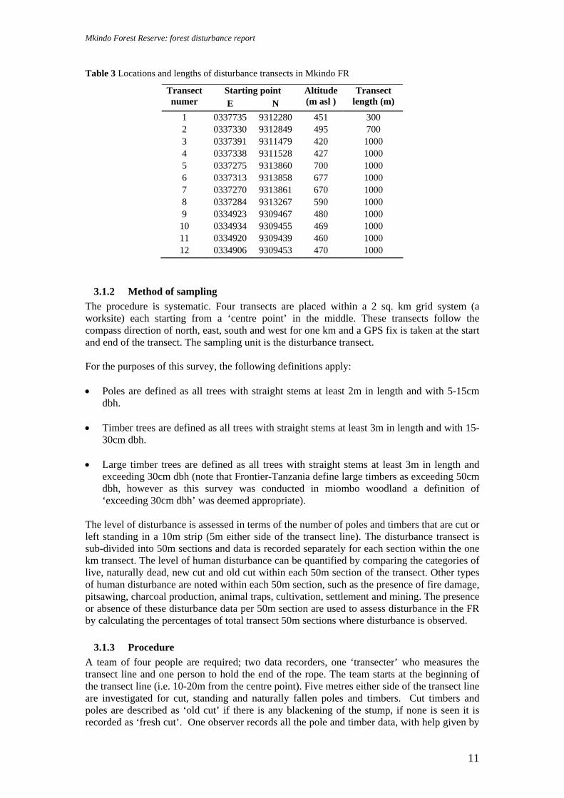
Table 3 Locations and lengths of disturbance transects in Mkindo FR
Starting point Transect numer E N
Altitude (m asl )
Transect length (m)
1 0337735 9312280 451 300 2 0337330 9312849 495 700 3 0337391 9311479 420 1000 4 0337338 9311528 427 1000 5 0337275 9313860 700 1000 6 0337313 9313858 677 1000 7 0337270 9313861 670 1000 8 0337284 9313267 590 1000 9 0334923 9309467 480 1000
10 0334934 9309455 469 1000 11 0334920 9309439 460 1000 12 0334906 9309453 470 1000
3.1.2 Method of sampling The procedure is systematic. Four transects are placed within a 2 sq. km grid system (a worksite) each starting from a ‘centre point’ in the middle. These transects follow the compass direction of north, east, south and west for one km and a GPS fix is taken at the start and end of the transect. The sampling unit is the disturbance transect. For the purposes of this survey, the following definitions apply: • Poles are defined as all trees with straight stems at least 2m in length and with 5-15cm
dbh. • Timber trees are defined as all trees with straight stems at least 3m in length and with 15-
30cm dbh. • Large timber trees are defined as all trees with straight stems at least 3m in length and
exceeding 30cm dbh (note that Frontier-Tanzania define large timbers as exceeding 50cm dbh, however as this survey was conducted in miombo woodland a definition of ‘exceeding 30cm dbh’ was deemed appropriate).
The level of disturbance is assessed in terms of the number of poles and timbers that are cut or left standing in a 10m strip (5m either side of the transect line). The disturbance transect is sub-divided into 50m sections and data is recorded separately for each section within the one km transect. The level of human disturbance can be quantified by comparing the categories of live, naturally dead, new cut and old cut within each 50m section of the transect. Other types of human disturbance are noted within each 50m section, such as the presence of fire damage, pitsawing, charcoal production, animal traps, cultivation, settlement and mining. The presence or absence of these disturbance data per 50m section are used to assess disturbance in the FR by calculating the percentages of total transect 50m sections where disturbance is observed.
3.1.3 Procedure A team of four people are required; two data recorders, one ‘transecter’ who measures the transect line and one person to hold the end of the rope. The team starts at the beginning of the transect line (i.e. 10-20m from the centre point). Five metres either side of the transect line are investigated for cut, standing and naturally fallen poles and timbers. Cut timbers and poles are described as ‘old cut’ if there is any blackening of the stump, if none is seen it is recorded as ‘fresh cut’. One observer records all the pole and timber data, with help given by

Mkindo Forest Reserve: forest disturbance report
12
the habitat note recorder if the forest becomes dense. For this survey, most of the transects were in miombo woodland and relatively open. The disturbance transects are sub-divided into 50m sections, and records are taken separately for each section. Every live tree, live pole, naturally dead tree, naturally dead pole, cut tree stump and cut pole is measured by the observers within the disturbance transect. Dbh is measured at the standard height of 1.3m above the ground using a calibrated dbh tape. The diameter of cut trees and poles is measured at the point of the cut. Fallen tree trunks or branches are not counted. This reduces possible duplicate counts as one does not count a trunk further along the transect but only counts the base from which it came.
Old cut timber if tree would have had a diameter of ≥ 15cm at 1.3m prior to cut. Old cut pole if pole would have had a diameter of ≥ 5cm but <15cm prior to cut. Dead timber if burnt stump would have had a diameter of ≥ 15cm at 1.3m prior to fire. Dead timber if actual timber stump is found within the 5m strip either side of transect. New cut timber if timber stump is found within 5m strip either side of transect Two new cut poles if estimated diameter of both poles is ≥ 5cm and < 15 cm at 1.3m height. Two dead poles if burnt/dead poles have estimated diameter of ≥ 5cm and <15cm at 1.3m height. Two live poles if new growth from stump (not obviously cut) consists of two poles ≥ 5cm and <15cm at 1.3m height. Two live timbers if a large trunk divides below 1.3m and both resulting branches are≥ 15cm diameter at 1.3m height.
Three live poles if 3 or the 4 multi-trunks are ≥ 5cm and <15cm at 1.3m height.
Figure 8 Timber and pole recognition

Mkindo Forest Reserve: forest disturbance report
13
Habitat notes are recorded per 50m section. Topography, canopy cover, shrub layer, ground layer and altitude (m asl) are noted. The cover density estimates for canopy, shrub and ground layers are given in broad percentage categories: <10%, 10-50% and >50%. Additional points of interest are noted.
3.1.4 Data entry For each transect, the disturbance is recorded on the data sheet titled DISTURBANCE SURVEY SUMMARY (See Appendix 5). F.R. CODE Forest reserve code. TRANSECT NO Write the transect line number. One transect was recorded on one
sheet. DISTURB. CAT. Write the disturbance categories in this section SECTION Record the disturbance information per section. NO. OF LIVE POLES Record the number of standing, live saplings. Saplings were defined
as 5 - 15cm dbh and a straight trunk of at least 2m in length. NO. OF NAT. DEAD POLES
Record the number of dead saplings, either standing or fallen. Saplings were defined as 5 - 15cm and a straight trunk of at least 2m in length.
NO. OF CUT POLES OLD/FRESH
Record the number of cut live saplings. Saplings were defined as 5 - 15cm dbh. To be considered as cut, the panga mark must be visible. Old was defined as anything other than clean, white marks which were classified as fresh.
NO. OF LIVE TIMBERS
Record the number of standing, live timber. Timbers were defined as 15 – 30 dbh and a straight trunk of at least 3m in length.
NO. OF NAT. DEAD TIMBERS
Record the number of standing, live timbers. Timbers were defined as 15 - 30 dbh and a straight trunk of at least 3m in length.
NO. OF CUT TIMBERS OLD/FRESH
Record the number of standing, live timbers. Timbers were defined as 15 - 30 dbh. To be considered as cut, the panga or saw mark must be visible. Old was defined as anything other than clean, white marks which were classified as fresh.
NO. OF LIVE LARGE TIMBERS
Record the number of standing, live large timbers. Large timbers were defined as >30 dbh and a straight trunk of at least 3m in length.
NO. OF NAT. DEAD LARGE TIMBERS
Record the number of standing, live large timbers. Large timbers were defined as >30 dbh and a straight trunk of at least 3m in length.
NO. OF CUT LARGE TIMBERS OLD/FRESH
Record the number of standing, live large timbers. Large timbers were defined as >30 dbh. To be considered as cut, the panga or saw mark must be visible. Old was defined as anything other than clean, white marks which were classified as fresh.
For each transect, the habitat notes are recorded on the data sheet titled DISTURBANCE SURVEY SUMMARY below the pole and timber data. SECTION Record the habitat information per section. TOPOGRAPHY Record the overall topography of the landscape throughout the
transect, such as gentle or steep mid, lower and upper slope; ridge top; plateau; gully; valley floor.
CANOPY COVER Estimate the extent that the foliage blocks out the sky and record the percentage, defined as <10%, 10-50% and / or >50% cover
SHRUB LAYER Estimate the extent that the lower canopy blocks out the sky and record the percentage, defined as <10%, 10-50% and / or >50% cover
GROUND LAYER Estimate the extent that the grass and herb layer covers the ground

Mkindo Forest Reserve: forest disturbance report
14
and record the percentage, defined as <10%, 10-50% and / or >50% cover
ALTITUDE
Record altitude in metres above sea level using the Global Positioning System (GPS)
NOTES Record additional notes about gross habitat type, disturbance seen or any other relevant information
3.2 Opportunistic observations Observations of human disturbance were made along the transect lines (i.e. those areas outside of the 10m width of the transect) and throughout the reserve. It was hoped that this would complement the standard quantifiable methods employed and give a fuller picture of the state of the reserve with regards to human impact. Opportunistic observations were also noted of fauna observed within the reserve and are presented as a table in the results section with information on habitat and range of each species. 3.3 Key definitions and information sources for fauna Within the summary table presented for the opportunistic observations of fauna, the following definitions are used: Endemic Status: • E – Endemic: Occurring only in the Nguru South Mountains; • N – Near endemic: Species with limited ranges in the Eastern Arc mountains and/or the
East African lowland forests; • W - Widespread distribution through Tanzania and Kenya and beyond The following references were used for identification and information purposes: Mammals: Kingdon (1997) Birds: Stevenson & Fanshawe (2002) Reptiles: Spawls et al (2002) Amphibians: Channing and Howell (2006)

Mkindo Forest Reserve: forest disturbance report
15
4 Results Survey work aimed at investigating the level of human forest use within the reserve. Results are split into several sections: a summary of the pole and timber counts along the transect; a summary of the habitat notes along the transect; a discussion of other disturbance recorded along the transect, and; opportunistic observations of disturbance and fauna.
4.1 Pole and timber counts A total of 12 transects were completed throughout the survey period, resulting in a total transect length of 11 km. The transects ranged from an altitude of 390m asl to 790 m asl, thus sampling the full altitudinal range of the reserve. Table 4, Table 5 and Figure 9 provide summaries of the disturbance data. Some problems were encountered in trying to establish the boundary of the reserve, therefore in retrospect transect one was found to be out of the reserve except for the last 300m and the original transect two was entirely out. A replacement transect was conducted, which was aborted at 700m due to two separate incidences of health and safety which prevented two attempts to complete the transect. Transect 11 met the border at 250m and turned west to complete the 1000m. The border was unclearly marked but the team saw a few discontinuous teak trees and made a decision that a change in the transect direction was needed to be sure to collect data in the reserve. Table 4 Summary of the pole and timber counts along disturbance transects
Total transect length
(m)
Total area of transect
(m2)
Total no.
stems sampled
Live (% of total)
Average live per
area hectare
(ha)
Dead (% of
total)
Average dead per area
hectare (ha)
Old Cut (% of
total)
Average cut per area hectare (ha)
New Cut (% of
total)
Average cut per
area hectare
(ha)
Poles 11,000 110,000 2125 1858 (87.4) 168.9 149
(7.0) 13.5 111 (5.2) 10.1 7
(0.3) 0.6
Timbers 11,000 110,000 2696 2338 (86.7) 212.5 254
(9.4) 23.1 89 (3.3) 8.1 15
(0.6) 1.4
Large Timbers 11,000 110,000 826 757
(91.6) 68.8 59 (7.1) 5.4 8
(1.0) 0.7 2 (0.2) 0.2
11,000m = 10 transects x 1000m, one transect x 300m, one transect x 700m
A total of 2125 poles, 2696 timbers and 826 large timbers were surveyed along the transect lines (Table 4). The majority of these were live poles or timbers (87.4% live poles, 86.7% live timbers and 91.6% live large timbers) with a small percentage of naturally dead trees recorded (7.0% dead poles, 9.4% dead timbers and 7.1% dead large timbers). Most of these dead trees were the result of the fires that are an integral part of the miombo woodland ecosystem, but many are caused by villagers, either spreading from farmland nearby or deliberately set to encourage a new flush of grass for cattle grazing in the dry season within the reserve.
The level of cutting in the FR was relatively low with 5.5% of total poles being cut, 3.9% for timbers and 1.2% for large timbers. When assessing the old and new cut trees separately, it was found that the levels of old cutting (three months and over) is greater than new cutting with 5.2 old and 0.3 new poles cut per hectare. Timber cutting per hectare was 3.3 old cut and 0.6 new cut with large timbers having an average of 1.0 old cut and 0.2 new cut large timbers per hectare. Poles have the highest cutting per hectare, which suggests that villagers utilise the forest more for local building materials (poles) than for commercial building materials (timber and planks).

Mkindo Forest Reserve: forest disturbance report
16
0
10
20
30
40
50
60
70
80
90
100
% Live % Dead % Old cut % New cut
Tree categories
Perc
ent (
%)
poles timbers large timbers
Figure 9 Percentage of poles and timbers within disturbance categories
Table 5 Summary of poles and timbers per transect
Number of poles / saplings per hectare
Number of timbers per hectare Number of large timbers per hectare
Transect
Number Live Nat.
Dead Old Cut
New Cut
Live Nat. Dead
Old Cut
New Cut
Live Nat. Dead
Old Cut
New Cut
1 153 7 10 3 130 63 3 0 87 3 3 0 2 66 3 4 1 56 27 1 0 37 1 1 0 3 116 2 2 1 149 24 14 2 25 0 1 2 4 223 6 7 2 173 7 6 0 84 6 2 0 5 230 36 8 0 256 56 6 0 101 11 1 0 6 158 5 0 0 259 14 10 0 89 6 1 0 7 162 16 12 1 339 26 3 5 81 5 0 0 8 71 12 8 1 181 15 4 5 34 5 0 0 9 240 13 9 0 236 17 3 0 57 8 0 0
10 130 10 20 0 169 23 6 3 67 2 0 0 11 249 20 27 0 238 22 19 0 102 12 0 0 12 133 12 7 1 161 18 9 0 67 1 0 0
Overall, fresh cutting was seen infrequently across all transects with the highest average being five new cut timbers per hectare in transects seven and eight in the north and north west of the reserve. Four transects had no evidence of fresh cutting. Transect 11 had the highest old cutting of poles (27) and timbers (19) per hectare; this corresponds with the charcoal burning seen most frequently in this south west part of the reserve.

Mkindo Forest Reserve: forest disturbance report
17
4.2 Habitat types The majority of the forest reserve is miombo woodland with 70.9% of 50m transect sections recorded in miombo. 13.6% of 50m sections were recorded in lowland / riverine forest along transects two, four, five and six. This is the north eastern area of the reserve where there are a series of rivers and streams, some of which flow from Nguru South FR whilst others originate in Mkindo FR itself. Therefore less than 25% of the reserve can be described as Eastern Arc vegetation.
8.2% of these transects were recorded in a grassland habitat of which over half was within transect three in the south central part of the reserve. It is an area heavily grazed and close to Mkindo village. The other grassland patches were small and found within transects six and eight.
1.8% of these transects were farmland, all of which were in the west of the reserve at the end of transect eight. In the south west part of the reserve, some Acacia dominated woodland was recorded along transect nine (4.5% of 50m sections).
Figure 10 Miombo (brachystegia) woodland
70.9
13.68.2
4.5 1.80
10
20
30
40
50
60
70
80
Miombowoodland
Riverine /lowland forest
Grassland Acaciawoodland
Farmland
Habitat types
Perc
enta
ge o
f 50m
sect
ions
(%)
Figure 11 Habitat types recorded within 50m sections along the 12 transect lines
Note that these percentages do not add up to 100% as some 50m sections recorded two habitat types in one section.

Mkindo Forest Reserve: forest disturbance report
18
For the vegetation layers, the dominant percentage categories of cover (<10%, 10-50% and >505) were: >50% canopy cover for 46.8% (103 out of 220) of 50m sections, <10% shrub layer cover for 65.9% (145 out of 220) of 50m sections and >50% ground layer cover for 77.7% (141 out of 220) of 50m sections. This is a typical description of woodland with a covered ground layer (in this case tall grasses), a minimal shrub layer and a moderately open canopy (i.e. >50% cover can mean a canopy cover of half to completely closed). These descriptions correspond to the overall designation of miombo woodland which covered 70.9% of the transect lines. The closed canopy will also account for the areas of lowland and riverine forest which consistently had a canopy cover of >50%.
28.6
65.9
12.3
24.518.2
10.0
46.8
15.9
77.7
0.0
10.0
20.0
30.0
40.0
50.0
60.0
70.0
80.0
90.0
Canopy Cover Shrub Layer Ground Layer
Vegetation layers
Perc
enta
ge o
f 50m
sect
ions
(%)
<10%10-50%>50%
Figure 12 Vegetation layer types and cover recorded within 50m sections along 12 transect lines
4.3 General disturbance This section covers both systematic disturbance recorded along the transect line and opportunistic observations of disturbance throughout the reserve. Human forest use recorded in 50m sections along the transect lines reveal several types of human activities occurring within the reserve. Fire, although a necessary and natural part of the miombo woodland ecosystem, is included here as it is still mainly a human caused activity and relates directly to the pressure on the reserve for grazing cattle. 91.4% (201 out of 220 50m sections) of all sections were noted as having previous fires. This does not correspond to the 70.9% miombo habitat recorded along the transects and must also include riverine and lowland forest if looking at the percentages in Figure 9. Transect six, which is 65% riverine / lowland forest, has signs of previous fire along the whole transect.

Mkindo Forest Reserve: forest disturbance report
19
1.8 1.8
91.4
0.5
40.9
0.5
26.8
0.9 3.2 3.2 0.50.0
10.020.030.040.050.060.070.080.090.0
100.0
Charco
al burn
ing
Cultivati
on Fire
Firewood
colle
ction
Grazing
MiningPath
Pitsaw
(new
)
Pitsaw
(old)
Track
Traps
Type of disturbance
% o
f 50m
sect
ions
Figure 13 Percentage of 50m sections with various types of human disturbance
Signs of grazing were recorded in 40.9% of all 50m sections (90 out of 220 50m sections). Evidence was a mixture of cattle paths / old dung and was found throughout the central and western parts of the reserve. 26.8% of 50m sections crossed or followed human paths (59 out of 220 50m sections). However 64.4% of these paths (38 out of 59) was actually one path only, which followed a ridge and was recorded along transect five and seven. Most human paths were encountered on ridge tops or by rivers and reflect areas of use rather than access to other villages. Figure 14 Cutting of Mninga (Pterocarpus angolensis)
Only one path runs through the reserve which is used for access to another village – the Mdera path; this is used on a daily basis to travel between Mdera and Mkindo villages, particularly on market day. 3.2% of 50m sections recorded vehicle tracks / roads (7 out of 220 50m sections). Two tracks lead to the intake pipes at Dizingwi river, although one was also a logging track and another was an old logging track by Mkindo river. All tracks were wide enough for tractors. Old and new pitsawing sites were recorded along the transects. 78% of all pitsaw sites were old (seven out of nine 50m sections), however in total across all the transects only 3.2% and 0.9% of 50m sections recorded old pitsaw and new pitsaw sites (7 out of 220 and 2 out of 220

Mkindo Forest Reserve: forest disturbance report
20
respectively). Five of the old pitsaw sites were recorded along transect six in riverine and lowland forest. Casual observations along the Kigombezi river also confirmed that people are currently cutting many trees along this river and generally in this forested area. The two new pitsaw sites were located along transect seven and transect four, both in miombo woodland. Three additional fresh pitsaw sites were recorded opportunistically, two on the ridge to centre point two (where the well trodden path is located that accounted for 64.4% of recordings) and one by the Kitungwi river.
Other human disturbance was recorded in low numbers throughout the reserve. Cultivation was recorded in 1.8% of all 50 m sections, as was charcoal burning sites (4 out of 220 50m sections). An area of farmland was recorded at the end of transect eight in the north west of the reserve. The local labourers present (who were not the actual farmers) stated that permission to farm this land (a valley) had been granted by Forestry. It is unknown who authorised the permission and at what level within Forestry (i.e. local or regional). There were over three different farmers farming maize and other crops in the area. The main Mdera village path crossed the edge of this farmland.
Figure 15 Farmland inside the west of the reserve
Fresh charcoal burning sites were seen at the end of transect 10 and transect three. Two old sites were also seen on transect 12 as was a site used for firewood collection. The charcoal mining site by transect 10 was active with two men and three dogs present as the team were transecting. As soon as they saw the team leader, they ran away. However, after inspecting the site, it was clear that most of the charcoal had been taken to the village. A small fire and cooking pots were present at the site.
Figure 16 Fresh charcoal site, transect 3
An old mining site was located along transect three close to where a fresh charcoal site was recorded. It was approximately 10m deep and Kibaba (pers. comm.) stated that the site was approximately three years old and targeted mining of rubies. Transect three was mostly marshy grassland and there was evidence of clearance for new farmland despite the fact that this was inside the reserve on the west side of the Mkindo river which acts as the FR border at this point. There is very little hunting within the reserve with only one out of 220 50m sections recording an animal trap for the Giant pouched rat (Cricetomys gambianus).This was located in riverine / lowland forest along transect six. Additional opportunistic observations noted the same type of trap at the end of transect one near the Kigombezi river. Another small mammal trap was

Mkindo Forest Reserve: forest disturbance report
21
noted near the Dizingwi river where a small cave had an old fire, a rag and the small mammal trap outside. It may be possible that medium to large mammals have already been over-hunted, as there were very few signs of animals such as bush pig and small antelope within the reserve. Apparently local people do hunt but only those crop raiding species, such as Yellow baboon (Papio cynocephalus), Syke’s monkey (Cercopithecus mitis monoides) and Bushpig (Potamochoerus larvatus). Gunfire was heard from base camp two after alarm calls from baboons (all from the same direction). In a shamba, on the opposite side of the Mkindo river to base camp one (thus out of the reserve), two large steel traps were found. These had been set by the river, where baboons were seen to cross by the survey team. Animals had already been trapped that morning as there was a strong smell of baboon and one trap had hair on it that may have been from the Marsh mongoose (Atilax paludinosus) (R. Rajabu, pers. comm.). The most important and revealing opportunistic observations occurred whilst walking on the Mdera – Mkindo path to centre point two. On 08/05/06, three men were encountered with two planks each of ‘Mfimbo’ (Kiswahili name). They immediately dropped the planks and ran away; the planks were duly confiscated and taken to the PEMA office at a later date.
Figure 17 Confiscated planks (Mfimbo) on the Mdera path in Mkindo FR
There is a trade of planks from Nguru South FR via Mdera village to Mkindo village, where planks are loaded on to a truck during the night according to various local sources. Reportedly there are over 300 planks stored at Mdera village and this is known amongst Mkindo villagers, such as Kibaba (as Chairman of the Natural Resources committee), the Forest Officer, the Village Chairman and the Village Executive Officer. As a result of this first episode, Benson (TFCG) contacted Ibrahim of the Regional Catchment Morogoro office and requested an investigation into the matter. Benson and Kibaba talked to more villages within their shambas bordering the reserve to gain further information (the consultant did not become involved within this latter activity as it was felt that her presence might be intimidating). On 14/05/06, Ibrahim and two police officers came to Mkindo and caught two people with planks at their houses in the village. The following day they walked to Mdera village and caught two more people with 15 planks. These cases are being taken to court in Morogoro. Further information regarding the outcome of the court cases or follow up action in Mkindo and Nguru South FRs should be sought at the Morogoro Reigonal Catchment office or PEMA, Turiani.

Mkindo Forest Reserve: forest disturbance report
22
##
#
###$
$
%
%
%
%
%%%%%
%
%
#Y#Y#Y#Y#Y
Forest ReserveRivers
# Charcoal burning$ Firewood collection$ Mining% Pitsaw sites
Transects#Y Cultivation N
EW
S
Figure 18 Disturbance recorded within Mkindo FR

Mkindo Forest Reserve: forest disturbance report
23
4.4 Opportunistic observations of fauna A summary of the number of species encountered for birds, mammals, amphibians and reptiles is presented in Table 6 below, whilst Tables 7, 8, 9 and 10 present species names recorded within each taxon. In total, 62 observations of fauna were made, 52 within the reserve and 10 observations in the grassland and shamba surrounding the reserve. One frog species was found to be an endemic to the Eastern Arc Mountains (Callulina cf kreffti) whilst one primate species (Galagoides zanzibaricus) is near-endemic to the Eastern Arc Mountains and is also listed as Vulnerable to extinction by IUCN.
Table 6 Summary of opportunistic fauna observations in and around Mkindo Forest Reserve
Taxon Total no. species observed
No. species observed in the FR
No. species observed in areas surrounding the FR
Bird 38 29 9 Mammal 14 13 1 Reptile 6 6 0 Amphibian 4 4 0 Total 62 52 10
4.4.1 Bird Observations All information in Table 7 is compiled from Stevenson and Fanshawe (2002). In total 38 birds were recorded, 29 within the forest reserve, mostly within miombo woodland and 9 in the shamba and grassland surrounding the reserve, especially on the east side. All birds were widespread throughout Tanzania and/or Kenya and Tanzania and common in more open habitat types, such as woodland and grassland. No species were threatened to extinction as listed by IUCN. Table 7 Bird observations in Mkindo Forest Reserve
Species Common name
Range Habitat Observation type and location
Certainty of identification
SCOPIDAE Scopus umbretta Hammerkop Widespread Range of habitats
near water source Seen, heard and nests by Mkindo and Dizingwi rivers
Certain
THESKIORNITHIDAE Bostrychia hagedash Hadada Ibis Widespread Grasslands, marshy
areas, damp forest edges, gardens and cultivation
Seen and heard flying by to night roost by Mkindo and Dizingwi rivers
Certain
ACCIPITRIDAE Gypohierax angolensis Palm-nut
vulture Resident and locally common from W Uganda and SW Tanzania and in coastal belt
Along coastal and major rivers
Seen at Mkindo river, basecamp 1
Certain

Mkindo Forest Reserve: forest disturbance report
24
Species Common name
Range Habitat Observation type and location
Certainty of identification
Circaetus fasciolatus Southern-banded snake eagle
Coastal and inland along major river systems inland
Coastal forest, lowland forest and forest close to the coast
Seen along transect 9
Certain
Stephanoaetus coronatus
African crowned eagle
Widespread Dense forest and woodland, including riverine and isolated patches
Heard in northern part of reserve
Certain
NUMIDIDAE Numida meleagris Helmeted
guineafowl Widespread Grassland, bush
country, woodland and cultivation
Heard around worksite 3
Certain
PSITTACIDAE Poicephalus cryptoxanthus
Brown-headed parrot
Coastal Kenya and E Tanzania
Well-wooded and baobab country
Heard throughout reserve
Certain
STRIGIDAE Strix woodfordii African wood
owl NE Tanzania and Kenya
Forest, forest edge, woodland and mature gardens
Heard at basecamp 2
Certain
CAPRIMULGIDAE Caprimulgus sp Nightjar ? ? Heard at
basecamp 2 Certain
TROGONIDAE Apaloderma narina Narina trogon Widespread Forest and richer
woodland Seen along transect 6 near to riverine forest
Certain
ALCEDINIDAE Alcedo semitorquata Half-collared
kingfisher Mainly S Tanzania
Well-wooded streams, rivers and lakes
Heard along Mkindo river
Probable
PHOENICULIDAE Phoeniculus purpureus Green wood-
hoopoe Widespread Range of wooded and
forest habitats Seen and heard throughout the reserve; often in mixed feeding parties
Certain
BUCEROTIDAE Bycanistes bucinator Trumpeter
hornbill Widespread throughout Tanzania
Forests, woodlands and mature gardens
Seen and heard throughout the reserve
Certain
Tockus alboterminatus Crowned hornbill
NE and NW Tanzania and S Kenya
Woodland and forest edges
Seen and heard throughout the reserve
Certain
CAPITONIDAE Stactolaema olivacea Green barbet Coastal Kenya
and NE to SW Tanzania
Forest and woodland Seen along transect 5 in closed miombo
Certain
PICIDAE

Mkindo Forest Reserve: forest disturbance report
25
Species Common name
Range Habitat Observation type and location
Certainty of identification
Dendropicos fuscescens Cardinal woodpecker
Widespread Forest edge and clearings, open woodland, dry bush and cultivation
Seen and heard throughout the reserve
Certain
HIRUNDINIDAE Psalidoprocne holomelas
Blacksaw-wing
NE and W Tanzania, C and W Kenya
Clearings in forest or over riverine woodland
Seen over miombo and shamba on forest edge
Certain
Hirundo abyssinica Lesser striped swallow
Widespread Range of habitats except for very arid country
Seen on forest edge in shamba
Certain
MOTACILLIDAE Motacilla clara Mountain
wagtail NE to SW Tz and C Kenya
Residents along fast-flowing rivers, most common in highlands but down to 500m asl
Seen and heard along Mkindo river at 430m asl
Certain
PYCNONOTIDAE Pycnonotus barbatus Common
bulbul Widespread Virtually all habitats Seen and heard
around basecamp 1
Certain
MUSCICAPIDAE Muscicapa caerulescens
Ashy flycatcher
Widespread Locally common in canopy and middle levels of forest edge, clearings and well-wooded rivers
Seen near basecamp 1 by Mkindo river
Probable
MONARCHIDAE Terpisphone viridis African
paradise flycatcher
Widespread Forest, open woodland, gardens and bush
Seen throughout the reserve
Certain
MALACONOTIDAE Dryoscopus cubla Black-backed
puff back Widespread Forest edge,
woodland and gardens
Heard in worksite 1 and 2
Certain
Laniarius aethiopicus Tropical boubou
Widespread Undergrowth of woodlands, thick bush and gardens
Heard in worksite 1 , miombo
Certain
PRIONOPIDAE Prionops scopifrons Chestnut-
fronted helmet shrike
NE Tanzania Woodland and forest canopy
Seen and heard in worksites 1 and 2; mixed feeding parties
Certain
DICRURIDAE Dicrurus adsimilis Fork-tailed
drongo Widespread Forest edge, open
woodland, semi-arid bush and cultivated areas
Seen and heard in worksites 1 and 2
Certain
ORIOLIDAE Oriolus larvatus Black-headed
oriole Widespread Woodlands, forest
edge, gardens and bush
Seen in worksite 2
Certain

Mkindo Forest Reserve: forest disturbance report
26
Species Common name
Range Habitat Observation type and location
Certainty of identification
Oriolus chlorocephalus Green-headed oriole
NE Tanzania Forest, mature woodland and well-established secondary growth
Seen along transect 5, closed miombo on ridge
Certain
STURNIDAE Onychognathus morio Red-winged
starling Widespread Near rocky hills and
cliffs Seen flying over basecamp 3
Certain
PLOCEIDAE Ploceus bicolor Dark-backed
weaver Coastal Tanzania and W Tanzania
Variety of forest types
Seen in mixed party along transect 5 in closed miombo near lowland forest
Certain
Euplectes ardens Red-collared widowbird
Widespread in parts of Tanzania and Kenya
Tall grass, wheat fields, overgrown cultivation and rank herbage
Seen in shamba and grassland surrounding reserve
Certain
Euplectes capensis Yellow Bishop E and W Tanzania
Bushed grassland and cultivation
Seen in shamba and grassland surrounding reserve
Certain
Euplectes orix Southern red bishop
Across Tanzania, except coastal areas
Marshes, high grasses cultivation
Seen in shamba and grassland surrounding reserve
Certain
EMBERIZIDAE Uraeginthus sp Cordon-bleu Widespread Variety of habitats
except forest interior Seen in shamba and grassland surrounding reserve
Certain
Lagonosticta rubricata African firefinch
E and W Tanzania and S Kenya
Woodland, thickets and overgrown cultivation
Seen in shamba and grassland surrounding reserve
Certain
Lonchura cucullata Bronze mannikin
Widespread All habitats except desert
Seen at basecamp 3
Certain
Vidua macroura Pin-tailed whydah
Widespread Woodland, bush country, cultivation and gardens
Seen in shamba and grassland surrounding reserve; breeding males
Certain
Vidua chalybeata Village indigobird
Widespread Variety of habitats Seen in shamba and grassland surrounding reserve
Certain
Mkindo Forest Reserve: forest disturbance report
27
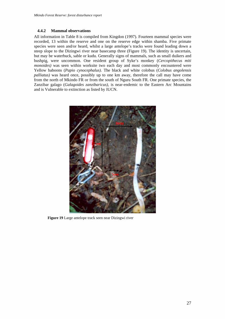
4.4.2 Mammal observations All information in Table 8 is compiled from Kingdon (1997). Fourteen mammal species were recorded, 13 within the reserve and one on the reserve edge within shamba. Five primate species were seen and/or heard, whilst a large antelope’s tracks were found leading down a steep slope to the Dizingwi river near basecamp three (Figure 19). The identity is uncertain, but may be waterbuck, sable or kudu. Generally signs of mammals, such as small duikers and bushpig, were uncommon. One resident group of Syke’s monkey (Cercopithecus miti monoides) was seen within worksite two each day and most commonly encountered were Yellow baboons (Papio cynocephalus). The black and white colobus (Colobus angolensis palliatus) was heard once, possibly up to one km away, therefore the call may have come from the north of Mkindo FR or from the south of Nguru South FR. One primate species, the Zanzibar galago (Galagoides zanzibaricus), is near-endemic to the Eastern Arc Mountains and is Vulnerable to extinction as listed by IUCN.
Figure 19 Large antelope track seen near Dizingwi river
5cm
12 cm
10cm

Mkindo Forest Reserve: forest disturbance report
28
Table 8 Mammals observations in Mkindo Forest Reserve
Species Common name
Range Habitat Observation Certainty of Identification
COLUBRIDAE Colobus angolensis palliatus
Black and White colobus
Widespread Montane and lowland forests
Heard from transect 6 coming from either the north of the reserve or from Nguru South
Certain
CERCOPITHECIDAE Papio cynocephalus Yellow
baboon Widespread Miombo woodland,
dry bushland, thickets
Seen and heard throughout the reserve
Certain
Cercopithecus mitis monoides
Syke's monkey
Widespread Evergreen forest and woodland
Seen and heard in worksite 2, miombo
Certain
GALAGONIDAE Otolemur crassicaudatus
Greater galago
Widespread Miombo woodland, coastal and montane areas
Heard at basecamp 1 and 2
Certain
Galagoides zanzibaricus
Zanzibar galago
NE Tanzania and S Kenya, Eastern Arc near-endemic
Coastal lowland rainforest and thickets, riverine forest and secondary growth
Heard at basecamp 2, riverine forest
Probable
THRYONOMYIDAE Thryonomys sp Cane rat Widespread Grassland areas Signs of eating
grass seen in shamba on edge of reserve
Certain
CRICETOMYINAE Cricetomys gambianus Giant
pouched rat Widespread Rainforest Traps designed to
trap in lowland forest along transect 6
Certain
HERPESTIDAE Herprestes sanguinea Slender
mongoose Widespread Wooded savanna,
thicket and forest Seen by river at transect 1
Certain
Atilax paludinosus Marsh mongoose
Widespread River courses and lake-shores areas
Tracks seen by Mkindo river
Certain
PROCAVIDAE Heterohyrax brucei Bush hyrax Widespread Wooded localities on
riverbanks, escarpments and rocky outcrops
Urine and dung signs along transect 6 in lowland / riverine forest
Probable (Certain it is hyrax)
SUIDAE Potamochoerus larvatus
Bushpig Widespread Forested and woodland habitats
Dung and tracks through the reserve
Certain
TRAGELAPHINI Tragelaphus scriptus Bushbuck Widespread Thick cover in forest
and woodland Grazing signs seen along transect 3
Certain
CEPHALOPHINI Cephalophus harveyi Red duiker Widespread Coastal thickets to
montane forests Tracks seen in northern part of reserve
Certain

Mkindo Forest Reserve: forest disturbance report
29
Species Common name
Range Habitat Observation Certainty of Identification
Large antelope, such as Waterbuck, Kudu or Sable
? ? Tracks of single individual seen descending to the Dizingwi river, miombo. Tracks 12cm long and width 5cm and 11.5cm
Uncertain
4.4.3 Retile observations
All information in Table 9 is compiled from Spawls et al (2002). Six reptile species were observed in Mkindo FR, none of which are endemic or threatened by extinction, as listed by IUCN or CITES. The sighting of a Gaboon viper (Bitis gabonica) was interesting as this species is not commonly seen (Figure 20). Table 9 Reptile observations in Mkindo Forest Reserve
Species Common name
Range Habitat Observation Certainty of identification
AGAMIDAE Agama agama Red-headed
agama Widespread Coastal thicket and
woodland, moist and dry savanna
Seen on rocky outcrops throughout the reserve; saw male and females
Certain
BOIDAE Python natalensis
Southern african rock python
Widespread Coastal thicket, grassland, moist savanna and woodland
Seen by RR in grassland on edge of reserve
Certain
COLUBRIDAE
Philothamnus sp Green snake ? ? Seen in worksite in miombo. Large golden eye with bright green body and black along the scales. Blue chin
Certain
SCINCIDAE Mabuya cf varia Variable skink Widespread Coastal thicket,
woodland, moist and dry savanna and high-altitude grassland
Seen throughout the reserve on rocks
Probable
VARANIDAE Varanus niloticus
Nile monitor Widespread Near water sources in a variety of habitats
Juvenile seen basking on a rock by the Dizingwi river, basecamp 3
Certain
VIPERIDAE Bitis gabonica Gaboon viper Widespread
but disjunct range. Coastal Tanzania
Coastal forest and thicket, woodland, forest-savanna mosaic, well-wooded savanna and forest
Seen in open grassland area along transect 8. Brown form about 1.5m long
Certain

Mkindo Forest Reserve: forest disturbance report
30
Figure 20 Gaboon viper seen along transect 8 in a grassy valley, Mkindo FR
4.4.4 Amphibian observations
All information in Table 10 is compiled from Channing and Howell (2006). Four amphibians were observed in Mkindo FR, three of which are common and widespread. One amphibian species, Callulina cf kreffti, is of particular interest as it is an Eastern Arc endemic genus and four new species have already been found within the montane forests of the Nguru South Mountains within the last year and a half (Doggart and Loserian, 2006). This individual was heard calling in the north of the reserve in lowland forest (750m asl) after rain at midday; no sightings were made. No species were threatened to extinction as listed by IUCN and CITES, although it is likely with revisions that Callulina cf kreffti will have a categorisation of Endangered or Critically Endangered (IUCN). Table 10 Amphibian observations in Mkindo Forest Reserve
Species Common name
Range Habitat Observation Certainty of identification
ARTHROLEPTIDAE Arthroleptis stenodactylus
Common squeaker
Widespread Range of woodland and forest
Seen throughout reserve within miombo woodland
Certain
BUFONIDAE Bufo cf guttaralis Toad Widespread Range of
woodland and forest
Seen at basecamp 1 each evening
Certain
MICROHYLIIDAE Callulina cf kreffti Warty frog Eastern Arc Forest,
cultivated or wild bananas
Vocalisation heard in lowland forest at end of transect 5 after rain
Certain
RANIDAE Phrynobatrachus sp Puddle frog Widespread Range of
woodland and forest
Seen along transect 9 on side of wet rock
Certain

Mkindo Forest Reserve: forest disturbance report
31
5 Discussion 5.1 Forest Disturbance From both the systematic survey and opportunistic observations in Mkindo FR, it is clear that people are utilising the woodland and forest resources. In general there has been an increase in human populations in the lowlands surrounding the Nguru South Mountains increasing the demand on woodland and forest resources. Loss of forest between the 1970s and 2000 is estimated at 6% (based on analysis of satellite images, Mbilinyi and Kashaigili, in prep.) and most of this is concentrated at lower altitudes. Such trends correspond with the observation that the land surrounding the east side of Mkindo FR, shown as forest on the 1972 topographical map, is now farmland right up until the forest border. Fortunately in the east of the FR the boundary is extremely clear with a line of mature teak trees and there can be no confusion, accidental or wilful, as to where the boundary lies. The situation is less clear in the south west of the reserve and boundary demarcation should be addressed in management plans. An area of cultivation was recorded in the west of the reserve by the main Mdera – Mkindo path. Locals present at the shamba stated that farming in this valley had been permitted by Forestry, although it is unclear by whom, at what level of authority (local or regional), the legality of the permission and in what form it was granted (verbal or written). This matter should be investigated and confirmed with the appropriate action taken by Forestry. The majority of Mkindo FR is miombo (Brachystegia) woodland, so the pressures on the FR are likely to be different to those of Nguru South and Kanga FRs, which are submontane and montane Eastern Arc forests. Grazing of cattle in the dry season occurs throughout the reserve. Open woodland is commonly used to graze cattle due to the density of grasses, especially after the yearly fires, so the concern (apart from the fact that this activity is illegal within a catchment forest reserve) must be whether over grazing is occurring and affecting the ecology of miombo. The demand for grazing within the reserve will be directly linked to the setting of yearly fires to encourage the new flush of grasses for cattle. Fire is an inherent part of miombo woodland, such that some seed germination relies on fire and many of the tree species have fire resistant bark. Therefore, fire per se is not necessarily of concern; it is uncontrolled fire that must be managed. Old fire damage was seen within the lowland and riverine forest in the north east of the reserve. These forests are not fire-adapted and if yearly fires are consistently spreading to these areas, this must be of great concern not only in terms of the rich Eastern Arc biodiversity expected in these pockets of forest but also in terms of damage to the forest structure and species composition. Fire management is needed and should be coordinated by the Forest Officer and Natural Resources Committee as part of the Joint Forest Management (JFM) initiative. Charcoal burning is occurring in Mkindo FR, mainly Pterocarpus angolensis and seems to be located in the west and south of the reserve. This activity should also be stopped by JFM. Pole cutting and timber extraction were both recorded in Mkindo FR at low levels. Old pitsaw sites were found in the lowland / riverine forests and there was evidence of much cutting along both the Kigombezi and Kitungwi rivers. Most timber extraction is for Pterocarpus angolensis, however in the forest other species were targeted but were not identified in this report. Historically timber extraction has been a significant cause of forest loss. Commercial timber operations took place in Nguru South FR until a government ban in catchment forests in 1992. Since then timber extraction has continued illegally and on a smaller scale, particularly from Nguru South FR, although activities are also increasing in Kanga FR (C.Bracebridge, pers.comm.). Evidence of these illegal activities was encountered within Mkindo FR with planks being brought out through Mkindo FR from Nguru South FR. Transportation of the planks (a species called Mfimbo in Kiswahili; the scientific name unknown) is carried out at night from Mkindo village. Given that nothing has been done to

Mkindo Forest Reserve: forest disturbance report
32
prevent this illegal activity and given that this forest reserve is part of a Joint Forest Management scheme, it suggests complicity of different authorities. Hunting is occurring at low levels in Mkindo as are actual signs of medium to large mammals. In open woodland, the presence of large grazing antelope would be expected. It is known that elephant and buffalo migrate in to this lowland area at certain times of year with elephant raiding village crops (Felix, pers. comm.). A track was observed of a large antelope, but of one individual only. It is uncertain, without some historical data, exactly which species were / are present in Mkindo, in what densities and if all these species are migratory or resident. There may always have been a low abundance of large mammals in this area or it is possible that hunting has already severely decreased numbers of large mammals. Given that hunting pressure is particularly high in Nguru South FR (in comparison to Kanga FR; Doggart and Loserian, 2006) it seems possible that hunting in the foothills, which are more easily accessible than the mountains, has already taken place. Hunting within the woodland and forest for food is differentiated from killing crop raiding ‘pests’ within shamba, which is common around Mkindo FR. 5.2 Faunal observations Opprtunistic observations were recorded for fauna. The majority of observations were birds. A low number of mammals were recorded and even fewer reptiles and amphibians. Only two species were not widespread and common in distribution and most species live in a variety of more open habitats. The Zanzibar galago is an Eastern Arc near-endemic species and the Callulina frog is an Eastern Arc endemic. Both of these species were recorded in riverine / lowland forest. It would be useful to conduct a zoological survey of the reserve, especially the forest where Eastern Arc species are present, by systematic trapping to sample small fauna (such as pitfalls and Sherman traps) and setting more camera traps for medium to large mammals. 5.3 Maps and forest boundary As discussed in the section 2, there was some confusion with forest boundaries, both when using the maps and actually during the survey on the ground. The Jb 2034 map was not available for the survey; topographical maps (1972) and the 1954 Jb 212 boundary map were relied on. Unfortunately the topographical map no longer represents the correct vegetation cover as maize, ufuto (a plant grown for oil) and ground nut cultivation have replaced the miombo to the east of the reserve. The 1954 map was hard to translate on to the topographical map to define reserve boundaries as there are no UTM coordinates and the accuracy of the drawing (such as placement of rivers and names of rivers) makes it difficult to compare to the topographical map. The 1980 boundary map has been digitised but is currently unavailable. This should help clarify the reserve border on the topographical map and enable the correction of the GIS reserve shape file created by SUA and used in this report. This reserve shape file was constructed based on the vegetation cover on the 1972 topographical map. As a result of the uncertainty, one transect was partly out of the reserve whilst another was completely out and was repeated in another location inside Mkindo FR. 5.4 Management issues Mkindo FR is part of a Joint Forest Management pilot in Morogoro Region. By-laws have been passed and Natural Resources Committees set up in four of the six villages surrounding Mkindo FR. Other activities have been conducted to facilitate and encourage JFM in Mkindo FR. This survey did not witness any JFM activities happening during the three weeks in the area. Most salient is the incidence with the storage and transportation of planks from Mkindo village and the common knowledge of the activities with no action taken against those people involved. Firstly this questions the activities and motives of the Mkindo Forest Officer and other responsible members of the village. Secondly, it questions the presence of active JFM in Mkindo FR. Conversations with Kibaba, who joined the survey team and is the chairman of

Mkindo Forest Reserve: forest disturbance report
33
the Natural Resources Committee for Mkindo, confirmed that the Forest Officer and the villagers are not working together in any JFM activities and that no management of any kind appears to be happening. The Natural Resources Committee understand the principles of JFM, are aware that Mkindo is a FR that should have JFM and that by-laws are in place that allow the villagers to act against illegal activities themselves. Despite this, JFM at this time is not being actively implemented. The Technician Manager of a government water project in the area stated that despite the water project working inside the reserve, having set up water pipes at the Mkindo and Dizingwi rivers, there was no liaison with the local Forest Officer (Salum Ali, pers. comm.). It is hoped that Kibaba’s participation in the survey and the success of involving Morogoro Catchment staff in confiscating the planks from Nguru South FR and prosecuting those involved, will motivate and empower him to take some positive action in the future.
6 Conclusions Mkindo Forest Reserve may not be as biologically rich as the montane areas of the Nguru South landscape, yet it does have one of the few areas of Eastern Arc lowland and riverine forest in the landscape and should be conserved for this biological value. The main importance of Mkindo FR remains its water catchment value with several large rivers feeding into the Wami river, which the surrounding local communities and the people of Chalinze and Tanga depend on. Further forest loss could have a significant negative impact. However it is clear that the local communities depend on Mkindo FR for some natural resources and the sustainability of this use must investigated and managed. . The Nguru South landscape is in the process of being defined both from a biophysical and a natural resource management and livelihoods perspective. This survey, by quantifying human forest use and identifying current management issues in Mkindo Forest Reserve, will hopefully contribute to the larger participatory environmental management and joint forest management schemes in the landscape and assist in conservation management and poverty alleviation, which to succeed, must continue hand in hand.
7 Recommendations The following recommendations are suggested for the conservation and management of Mkindo Forest Reserve in the future: Joint Forest Management • Investigation into the reasons why there is no Joint Forest Management (JFM) in Mkindo • Provide training to the Mkindo forest officer so that he is more aware of his role and
responsibilities in JFM • Increase communities’ capacity to participate in JFM • Inform the local communities of the results of the survey by summarising and translating
into Kiswahili to assist with management of the reserve
Specific management issues within Mkindo FR • Investigation of the allocated farmland within the reserve and the appropriate action taken • Continued monitoring of the timber planks being brought from Nguru South FR to
Mkindo village as a JFM activity • Clear boundary demarcation and maintenance, particularly in the west and south of the
reserve • Fire management within the reserve, including fire breaks between miombo and forest
habitats

Mkindo Forest Reserve: forest disturbance report
34
• Investigation of the impact of grazing, if there is overgrazing, in the reserve and appropriate action taken;
• Active patrols and prosecution of people involved in pitsawing and charcoal burning in the reserve as a part of JFM
Research • Conduct a zoological survey in the riverine and lowland forest where Eastern Arc species
should be present to provide a species inventory and abundance of key species (a floral survey has already been conducted, Malimbwi and Mugasha, 2002)
• Repeat forest use survey in five years to look at management effectiveness and monitoring of human resource use in Mkindo FR

Mkindo Forest Reserve: forest disturbance report
35
8 References Channing, A. and Howell, K.M., 2006. Amphibians of East Africa. Cornell University Press, New York. Doggart, N. and D. Loserian, Eds., 2006. South Nguru Mountains: A Description of the biophysical landscape. TFCG Technical Paper No 11. DSM Tz pp 1 – 66. Lovett, J.C., and Pócs, T., 1993. Assessment of the Condition of the Catchment Forest Reserves, a botanical appraisal. Dar es Salaam, Tanzania: Prepared for The Catchment Forestry Project, under the Forestry and Beekeeping Division. Ministry of Tourism, Natural Resources and Environment. Kingdon, J. 1997. The Kingdom field guide to East African Mammals. Academic Press, London, Spawls S., Howell K., Drewes R., and Ashe J., 2002. A Field Guide to the Reptiles of East Africa. Academic Press, Hong Kong.
Stevenson T., and Fanshawe J., 2002. Field guide to the birds of East Africa. T. & A. D. Poyser, London. Malimbwi, R.E. and Mugasha, A.G., 2002 Inventory report for Mkindo Forest Reserve in Morogoro, Tanzania. SUA FORCONSULT, Morogoro, Tanzania. Morogoro Catchment Forestry Office, 2002. Management plan for Mkindo Catchment Forest Reserve, Mvomero, Morogoro. Report prepared for Forestry and Beekeeping Division, Ministry of Natural Resource and Tourism, Dar es Salaam, Tanzania.

Mkindo Forest Reserve: forest disturbance report
36
Appendix 1 GPS Co-ordinates in Mkindo Forest Reserve Longitude and Latitude in degrees, seconds, minutes and Grid references in UTM/UPS Summary of basecamps and centre points
Worksite Waypoint Description of location Latitude (S) Longitude (E)
Grid ref (E)
Grid ref (N)
Altitude (m asl)
Basecamp 1 MK-BC1 Basecamp 1 by Mkindo river in miombo 06º 13' 45.0" 037º 31' 53.0" 0337526 9311314 400 Basecamp 2 MK-BC2 Basecamp 2 at south east reserve by teak tree line
boundary in riverine forest 06º 13' 01.0" 037º 32' 20.0" 0338348 9312654 402
Basecamp 3 MK-BC3 Basecamp 3 in west of reserve by Dizungwi river im miombo
06º 14' 56.0" 037º 30' 15.0" 0334518 9309112 456
Centr point 1 MK-CP1 Near basecamp 1 by Mkindo river 06º 13' 38.0" 037º 31' 49.0" 0337391 9311529 427 Centre point 2 MK-CP2 On ridgetop in miombo in north of reserve 06º 12' 22.0" 037º 31' 45.0" 0337278 9313851 684 Centre point 3 MK-CP3 South west of reserve in open miombo 06º 14' 45.0" 037º 30' 28.0" 0334914 9309452 466
Summary of camera trap sites
Worksite Waypoint Description of location Latitude (S) Longitude (E)
Grid ref (E)
Grid ref (N)
Altitude (m asl)
Worksite 2 MK-CT2 Deercam 2 in lowland forest 06º 11' 49.0" 037º 31' 47.0" 337331 9314854 770 Worksite 2 MK-CT3 Deercam 3 in lowand forest 06º 11' 50.0" 037º 31' 47.0" 0337331 9314824 790 Worksite 2 MK-CT4 Deercam 4 in miombo 06º 12' 07.0" 037º 31' 45.0" 0337275 9314307 774 Worksite 2 MK-CT5 Deercam 5 in miombo 06º 12' 09.0" 037º 31' 47.0" 0337313 9314238 765
Summary of transects
Worksite Waypoint Description of location Latitude (S) Longitude (E)
Grid ref (E)
Grid ref (N)
Altitude (m asl)
Worksite 1 MK-T1N Start of transect 1, north; miombo (OUT) 06º 13' 36.0" 037º 32' 00.0" 0337730 9311580 425 Worksite 1 T1N700 700m of transect 1, north. The former part of transect is
out. This is the new start point 06º 13' 10.0" 037º 32' 00.0" 0337735 9312280 451

Mkindo Forest Reserve: forest disturbance report
37
Worksite Waypoint Description of location Latitude (S) Longitude (E)
Grid ref (E)
Grid ref (N)
Altitude (m asl)
Worksite 1 T1NEND End (1000m) of transect 1, north, miombo 06º 13' 03.0" 037º 32' 00.0" 0337740 9312586 459 Worksite 1 MK-T1E Start of transect 2a, east; river edge, shamba (OUT) 06º 13' 37.0" 037º 31' 56.0" 0337620 9311537 399 Worksite 1 T1EEND End of transect 2a, east; grassland (OUT) 06º 13' 03.0" 037º 32' 00.0" 0338607 9311540 452 Worksite 1 MK-T1E Start of transect 2b, east; miombo (replacement
transect) 06º 12' 55.0" 037º 31' 47.0" 0337330 9312849 495
Worksite 1 T1E700 End (700m) of transect 2b, east; miombo (replacement transect)
06º 12' 55.0" 037º 32' 07.0" 0337951 9312822 490
Worksite 1 MK-T1S Start of transect 3, south; miombo 06º 13' 39.0" 037º 31' 49.0" 0337391 9311479 420 Worksite 1 T1SEND End (1000m) of transect 3, south; grassland 06º 14' 11.0" 037º 31' 55.0" 0337579 9310509 390 Worksite 1 MK-T1W Start of transect 4, west; miombo 06º 13' 38.0" 037º 31' 47.0" 0337338 9311528 427 Worksite 1 T1WEND End (1000m) of transect 4, west; miombo 06º 13' 41.0" 037º 31' 19.0" 0336469 9311419 469 Worksite 2 MK-T2N Start of transect 5, north; miombo 06º 12' 22.0" 037º 31' 45.0" 0337275 9313860 700 Worksite 2 T2NEND End (1000m) of transect 5, north; lowland forest 06º 11' 49.0" 037º 31' 46.0" 0337281 9314854 771 Worksite 2 MK-T2E Start of transect 6, east; miombo 06º 12' 22.0" 037º 31' 47.0" 0337313 9313858 677 Worksite 2 T2EEND End (1000m) of transect 6, east; lowland forest 06º 12' 25.0" 037º 32' 17.0" 0338263 9313764 630 Worksite 2 MK-T2S Start of transect 7, south; miombo 06º 12' 22.0" 037º 31' 45.0" 0337270 9313861 670 Worksite 2 T2SEND End (1000m) of transect 7, south; miombo 06º 12' 54.0" 037º 31' 46.0" 0337301 9312853 508 Worksite 2 MK-T2W Start of transect 8, west; miombo 06º 12' 41.0" 037º 31' 46.0" 0337284 9313267 590 Worksite 2 T2WEND End (1000m) of transect 8, west; farmland 06º 12' 44.0" 037º 31' 15.0" 0336350 9313159 515 Worksite 3 MK-T3N Start of transect 9, north; miombo 06º 14' 44.0" 037º 30' 28.0" 0334923 9309467 480 Worksite 3 T3NEND End (1000m) of transect 9, north; acacia woodland 06º 14' 13.0" 037º 30' 28.0" 0334919 9310435 758 Worksite 3 MK-T3E Start of transect 10, east; miombo 06º 14' 45.0" 037º 30' 29.0" 0334934 9309455 469 Worksite 3 T3EEND End (1000m) of transect 10, east; miombo 06º 14' 46.0" 037º 31' 00.0" 0335907 9309435 590 Worksite 3 MK-T3S Start of transect 11, south; miombo 06º 14' 45.0" 037º 30' 28.0" 0334920 9309439 460 Worksite 3 T3S250 250m of transect 11, turn west as reach border; miombo 06º 14' 53.0" 037º 30' 27.0" 0334887 9309203 450 Worksite 3 T3SEND End (1000m) of transect 11, south/west; miombo 06º 14' 54.0" 037º 30' 05.0" 0334202 9309178 493 Worksite 3 MK-T3W Start of transect 12, west; miombo 06º 14' 45.0" 037º 30' 28.0" 0334906 9309453 470 Worksite 3 T3WEND End (1000m) of transect 12, west; miombo 06º 14' 56.0" 037º 29' 57.0" 0333954 9309423 563

Mkindo Forest Reserve: forest disturbance report
38
Summary of opportunistic disturbance observations
Worksite Waypoint Description of location Latitude (S) Longitude (E)
Grid ref (E)
Grid ref (N)
Altitude (m asl)
Worksite 2 MK-PS1 Fresh pitsaw site on ridge to CP2; Mninga (Pterocarpus angolensis)
06º 12' 45.0" 037º 31' 47.0" 0337319 9313152 585
Worksite 2 MK-PS2 Fresh pitsaw site on ridge to CP2; Mninga (Pterocarpus angolensis)
06º 12' 29.0" 037º 31' 46.0" 0337285 9313620 664
Worksite 2 MK-PS3 Pitsaw site at Kitungwi river 06º 12' 43.0" 037º 31' 38.0" 0337053 9313205 532 Worksite 2 MK-CUT Fresh cut Mninga on ridge to CP2 06º 12' 41.0" 037º 31' 47.0" 0337319 9313252 590 Worksite 3 MK-CHA Charcoal burning site near Transect 10 06º 14' 47.0" 037º 30' 58.0" 0335832 9309386 576 Worksite 3 MKCHA2 Old charcoal burning site near BC3 06º 14' 57.0" 037º 30' 06.0" 0334234 9309082 481
Summary of miscellaneous waypoints
Worksite Waypoint Description of location Latitude (S) Longitude (E)
Grid ref (E)
Grid ref (N)
Altitude (m asl)
Worksite 1 MK-3STR 3 river meeting point in Central Mkindo 06º 14' 15.0" 037º 31' 54.0" 0337558 9310370 385 Casual VILLAGE small village/ settlement on east side, out of forest
reserve 06º 13' 25.0" 037º 32' 43.0" 0339065 9311907 438
Casual MKTEAK Teak tree line border 06º 13' 12.0" 037º 32' 00.0" 0337728 9312325 451

Mkindo Forest Reserve: forest disturbance report
39
Appendix 2 Summary of transecting data
Tran-sect no.
Total LP
Aver-age LP per 50m
Total DP
Aver-age DP per 50m
Total OC P
Aver-age
OC P per 50m
Total NC P
Aver-age
NC P per 50m
Total LT
Aver-age LT per 50m
Total DT
Aver-age DT per 50m
Total OCT
Aver-age
OCT per 50m
Total NCT
Aver-age
NCT per 50m
Total LT*
Aver-age
LT * per 50m
Total DT*
Aver-age DT* per 50m
Total OCT*
Aver-age
OCT* per 50m
Total NCT*
Aver-age
NCT* per 50m
1 46 7.67 2 0.33 3 0.50 1 0.17 39 6.50 19 3.17 1 0.17 0 0.00 26 4.33 1 0.17 1 0.17 0 0.00 2 100 7.14 15 1.07 8 0.57 0 0.00 138 9.86 13 0.93 8 0.57 0 0.00 24 1.71 2 0.14 2 0.14 0 0.00 3 116 5.80 2 0.10 2 0.10 1 0.05 149 7.45 24 1.20 14 0.70 2 0.10 25 1.25 0 0.00 1 0.05 2 0.10 4 223 11.15 6 0.30 7 0.35 2 0.10 173 8.65 7 0.35 6 0.30 0 0.00 84 4.20 6 0.30 2 0.10 0 0.00 5 230 11.50 36 1.80 8 0.40 0 0.00 256 12.80 56 2.80 6 0.30 0 0.00 101 5.05 11 0.55 1 0.05 0 0.00 6 158 7.90 5 0.25 0 0.00 0 0.00 259 12.95 14 0.70 10 0.50 0 0.00 89 4.45 6 0.30 1 0.05 0 0.00 7 162 8.10 16 0.80 12 0.60 1 0.05 339 16.95 26 1.30 3 0.15 5 0.25 81 4.05 5 0.25 0 0.00 0 0.00 8 71 3.55 12 0.60 8 0.40 1 0.05 181 9.05 15 0.75 4 0.20 5 0.25 34 1.70 5 0.25 0 0.00 0 0.00 9 240 12.00 13 0.65 9 0.45 0 0.00 236 11.80 17 0.85 3 0.15 0 0.00 57 2.85 8 0.40 0 0.00 0 0.00
10 130 6.50 10 0.50 20 1.00 0 0.00 169 8.45 23 1.15 6 0.30 3 0.15 67 3.35 2 0.10 0 0.00 0 0.00 11 249 12.45 20 1.00 27 1.35 0 0.00 238 11.90 22 1.10 19 0.95 0 0.00 102 5.10 12 0.60 0 0.00 0 0.00 12 133 6.65 12 0.60 7 0.35 1 0.05 161 8.05 18 0.90 9 0.45 0 0.00 67 3.35 1 0.05 0 0.00 0 0.00
Total 1858 100.41 149 8.00 111 6.07 7 0.47 2338 124.41 254 15.20 89 4.74 15 0.75 757 41.40 59 3.11 8 0.56 2 0.10 P = Pole, T = Timber, T*= Large timber; L = Live, D = Dead, OC = Old cut, NC = New cut

Mkindo Forest Reserve: forest disturbance report
40
Appendix 3 Pole and timber raw data per transect Each transect is 1000m length x 10m width = 10 000m2, apart from two transects which were shortened in length: transect 1 was 300m and transect 2 was 700m.
Date Work-site
Transect no.
Direction Section Section disturbance category
No. live
poles
No. of nat.dead
poles
No. of cut poles
No. of live
timbers
No. nat. dead
timbers
No. of cut timbers
No. live large
timbers
No. nat. dead large
timbers
No. cut large
timbers
old cut
new cut
old cut
new cut
old cut
new cut
03/05/2006 1 1 North 700-750 F, TR 7 0 0 0 10 0 0 0 3 0 0 0 750-800 F 11 0 0 1 3 0 0 0 9 0 0 0 800-850 F 6 0 1 0 6 5 0 0 9 0 0 0 850-900 F 6 0 1 0 6 5 0 0 2 0 0 0 900-950 F 13 1 1 0 7 9 1 0 3 1 0 0 950-
1000 F 3 1 0 0 7 0 0 0 0 0 1 0
13/05 and 15/05/06
1 2 East 0-50 F 4 0 1 0 14 1 0 0 1 0 0 0
50-100 F 12 1 0 0 19 1 0 0 2 0 1 0 100-150 F 9 2 0 0 10 0 0 0 0 0 0 0 150-200 F 11 0 0 0 21 1 0 0 2 0 0 0 200-250 F 5 0 1 0 6 0 1 0 1 0 0 0 250-300 F 12 0 1 0 7 2 0 0 2 0 0 0 300-350 F 13 1 5 0 20 1 1 0 0 1 0 0 350-400 5 0 0 0 8 1 3 0 3 0 0 0 400-450 4 1 0 0 6 1 0 0 7 0 0 0 450-500 2 0 0 0 7 1 3 0 2 0 1 0 500-550 F 5 1 0 0 8 4 0 0 1 0 0 0 550-600 F 11 3 0 0 8 0 0 0 0 0 0 0

Mkindo Forest Reserve: forest disturbance report
41
Date Work-site
Transect no.
Direction Section Section disturbance category
No. live
poles
No. of nat.dead
poles
No. of cut poles
No. of live
timbers
No. nat. dead
timbers
No. of cut timbers
No. live large
timbers
No. nat. dead large
timbers
No. cut large
timbers
old cut
new cut
old cut
new cut
old cut
new cut
600-650 F 7 4 0 0 2 0 0 0 2 0 0 0 650-700 F 0 2 0 0 2 0 0 0 1 1 0 0
04/05/2006 1 3 South 0-50 F 28 0 1 0 21 3 2 0 3 0 0 0 50-100 F 18 0 0 0 28 3 1 0 1 0 0 0 100-150 F 23 0 0 0 14 3 1 0 2 0 0 0 150-200 F 4 0 0 0 9 1 1 0 0 0 0 0 200-250 F, Gr, M 14 0 0 0 5 1 1 0 2 0 0 0 250-300 F, Gr 0 0 0 0 3 6 0 0 2 0 0 0 300-350 F, Gr, R 7 0 0 0 8 1 0 0 3 0 0 0 350-400 F, Gr 0 0 0 0 7 2 1 0 0 0 0 0 400-450 F, Gr, R 0 0 0 0 0 0 3 0 0 0 0 0 450-500 F, Gr, R 0 0 0 0 0 0 2 0 0 0 0 0 500-550 F, Gr, R, Tr 0 0 0 0 0 0 0 0 1 0 0 0 550-600 F, Gr 2 0 0 0 8 0 0 0 4 0 0 0 600-650 F, Gr, Tr 5 0 0 0 4 0 0 0 0 0 0 0 650-700 F, Gr, Tr, B 0 0 0 0 2 0 0 0 1 0 1 0 700-750 F, Gr 2 0 0 0 5 0 2 0 1 0 0 0 750-800 F, Gr 3 1 0 0 11 1 0 0 1 0 0 0 800-850 F, Gr 4 0 0 0 21 2 0 0 0 0 0 0 850-900 F, Gr 0 0 0 0 1 0 0 0 1 0 0 0 900-950 F, Gr, Tr 0 0 0 0 0 0 0 0 1 0 0 0 950-
1000 F, Gr, R 6 1 1 1 2 1 0 2 2 0 0 2
03/05/2006 1 4 West 0-50 F 13 0 1 0 4 0 0 0 4 0 0 0 50-100 F, Gr 11 0 0 0 5 0 0 0 0 0 0 0 100-150 F 12 0 1 0 0 0 0 0 8 1 0 0

Mkindo Forest Reserve: forest disturbance report
42
Date Work-site
Transect no.
Direction Section Section disturbance category
No. live
poles
No. of nat.dead
poles
No. of cut poles
No. of live
timbers
No. nat. dead
timbers
No. of cut timbers
No. live large
timbers
No. nat. dead large
timbers
No. cut large
timbers
old cut
new cut
old cut
new cut
old cut
new cut
150-200 F 3 1 0 0 14 0 1 0 5 1 0 0 200-250 F 0 4 0 0 5 0 0 0 11 0 0 0 250-300 F 0 0 1 0 1 0 0 0 0 2 0 0 300-350 F 18 0 0 2 20 0 1 0 4 0 2 0 350-400 9 0 3 0 10 1 0 0 4 0 0 0 400-450 F 14 0 0 0 5 0 2 0 8 0 0 0 450-500 F, Gr 10 0 0 0 8 0 0 0 6 0 0 0 500-550 F, Gr 9 0 1 0 6 2 0 0 9 0 0 0 550-600 F, Gr 14 0 0 0 6 0 1 0 6 0 0 0 600-650 F, Gr 6 0 0 0 3 0 1 0 4 0 0 0 650-700 F 5 0 0 0 13 2 0 0 2 0 0 0 700-750 F 15 0 0 0 10 2 0 0 7 0 0 0 750-800 F, Gr, R 21 0 0 0 3 0 0 0 0 0 0 0 800-850 24 0 0 0 14 0 0 0 0 0 0 0 850-900 20 0 0 0 28 0 0 0 2 0 0 0 900-950 10 0 0 0 15 0 0 0 4 0 0 0 950-
1000 Gr 9 1 0 0 3 0 0 0 0 2 0 0
08/05/2006 2 5 North 0-50 F, R 7 0 0 0 12 0 0 0 7 0 0 0 50-100 F, R 10 0 1 0 10 0 0 0 7 0 0 0 100-150 F, R 16 0 0 0 13 1 0 0 5 0 0 0 150-200 F, R 13 1 0 0 11 0 0 0 3 1 0 0 200-250 F, R 1 1 1 0 6 3 1 0 1 0 0 0 250-300 F, R 6 0 0 0 10 0 0 0 4 0 0 0 300-350 F, R 4 0 0 0 9 3 0 0 8 0 0 0 350-400 F, R 5 1 0 0 14 1 0 0 6 0 0 0

Mkindo Forest Reserve: forest disturbance report
43
Date Work-site
Transect no.
Direction Section Section disturbance category
No. live
poles
No. of nat.dead
poles
No. of cut poles
No. of live
timbers
No. nat. dead
timbers
No. of cut timbers
No. live large
timbers
No. nat. dead large
timbers
No. cut large
timbers
old cut
new cut
old cut
new cut
old cut
new cut
400-450 F, R 12 0 0 0 16 2 0 0 7 0 0 0 450-500 F, R 5 4 0 0 13 6 0 0 8 0 0 0 500-550 F, R 4 3 0 0 15 1 1 0 9 0 0 0 550-600 F, R 7 4 0 0 11 7 0 0 5 0 0 0 600-650 F, R 14 3 0 0 23 4 0 0 5 0 0 0 650-700 F, R 21 3 0 0 10 3 0 0 2 0 0 0 700-750 F, R 13 1 0 0 12 2 2 0 1 1 0 0 750-800 F, R 29 0 3 0 20 2 1 0 7 4 0 0 800-850 F, R 28 10 1 0 12 14 1 0 7 1 1 0 850-900 R 11 1 1 0 16 1 0 0 2 1 0 0 900-950 15 4 1 0 5 3 0 0 5 0 0 0 950-
1000 9 0 0 0 18 3 0 0 2 3 0 0
07/05/2006 2 6 East 0-50 F 16 0 0 0 5 0 0 0 2 0 0 0 50-100 F 10 0 0 0 2 0 0 0 3 1 0 0 100-150 F 8 0 0 0 6 1 1 0 9 1 0 0 150-200 F, P (old) 10 0 0 0 11 0 0 0 3 0 0 0 200-250 F 1 0 0 0 5 3 3 0 0 0 0 0 250-300 F 2 0 0 0 2 2 2 0 0 0 0 0 300-350 F, P (old) 0 1 0 0 11 1 1 0 2 0 1 0 350-400 F 1 0 0 0 11 0 0 0 6 1 0 0 400-450 F, T, P (old) 6 0 0 0 20 1 1 0 3 0 0 0 450-500 F, P (old) 22 1 0 0 16 0 0 0 4 1 0 0 500-550 F 15 0 0 0 18 0 0 0 0 1 0 0 550-600 F 11 0 0 0 14 1 1 0 7 0 0 0 600-650 F 8 0 0 0 12 0 1 0 2 0 0 0

Mkindo Forest Reserve: forest disturbance report
44
Date Work-site
Transect no.
Direction Section Section disturbance category
No. live
poles
No. of nat.dead
poles
No. of cut poles
No. of live
timbers
No. nat. dead
timbers
No. of cut timbers
No. live large
timbers
No. nat. dead large
timbers
No. cut large
timbers
old cut
new cut
old cut
new cut
old cut
new cut
650-700 F, P (old) 3 0 0 0 9 1 0 0 3 0 0 0 700-750 F 15 0 0 0 16 1 0 0 4 0 0 0 750-800 F 7 0 0 0 20 0 0 0 7 0 0 0 800-850 F 5 0 0 0 27 0 0 0 5 0 0 0 850-900 F 8 2 0 0 13 0 0 0 15 0 0 0 900-950 F 1 0 0 0 20 1 0 0 11 0 0 0 950-
1000 F 9 1 0 0 21 2 0 0 3 1 0 0
11/05/2006 2 7 South 0-50 F, R 9 0 0 0 20 1 0 0 6 0 0 0 50-100 F, R 7 1 0 0 6 1 0 0 4 0 0 0 100-150 F, R 12 0 1 0 21 0 0 0 1 1 0 0 150-200 F, R 14 2 0 0 21 3 0 0 0 1 0 0 200-250 F, R 22 2 1 0 13 6 0 3 8 2 0 0 250-300 F, R 19 4 2 1 20 0 0 0 2 0 0 0 300-350 F, R 2 2 1 0 27 4 0 0 2 1 0 0 350-400 F, R 7 0 0 0 29 1 0 0 4 0 0 0 400-450 F, R 9 0 0 0 10 2 0 0 4 0 0 0 450-500 F, R, Gr 2 1 1 0 14 1 0 1 6 0 0 0 500-550 F, R 7 1 0 0 11 1 0 0 3 0 0 0 550-600 F, R 4 0 1 0 18 1 0 1 6 0 0 0 600-650 F, R 4 0 1 0 18 1 0 0 6 0 0 0 650-700 F, R, P 5 2 0 0 19 1 1 0 4 0 0 0 700-750 F, R 3 1 0 0 15 0 0 0 6 0 0 0 750-800 F, R 10 0 0 0 19 1 0 0 9 0 0 0 800-850 F, R 16 0 1 0 9 0 0 0 4 0 0 0 850-900 F, R 2 0 0 0 15 1 0 0 4 0 0 0

Mkindo Forest Reserve: forest disturbance report
45
Date Work-site
Transect no.
Direction Section Section disturbance category
No. live
poles
No. of nat.dead
poles
No. of cut poles
No. of live
timbers
No. nat. dead
timbers
No. of cut timbers
No. live large
timbers
No. nat. dead large
timbers
No. cut large
timbers
old cut
new cut
old cut
new cut
old cut
new cut
900-950 F, R 5 0 1 0 10 1 0 0 0 0 0 0 950-
1000 F, R 3 0 2 0 24 0 2 0 2 0 0 0
12/05/2006 2 8 West 0-50 F 4 0 0 0 12 1 0 0 0 0 0 0 50-100 F 7 1 0 0 17 0 0 0 4 0 0 0 100-150 F 12 2 1 0 24 0 1 0 1 0 0 0 150-200 F 13 2 0 0 22 5 0 0 0 1 0 0 200-250 F 3 0 0 0 8 1 0 0 6 2 0 0 250-300 F 0 0 0 0 5 0 0 0 0 0 0 0 300-350 F 6 0 0 0 12 1 1 1 10 0 0 0 350-400 F, R 7 1 1 0 15 1 1 0 3 0 0 0 400-450 F 8 0 2 0 18 0 0 0 0 0 0 0 450-500 F 7 4 1 0 7 5 0 0 2 0 0 0 500-550 F 3 2 0 0 14 0 0 0 3 0 0 0 550-600 F 1 0 0 0 11 0 0 0 1 0 0 0 600-650 F 0 0 0 0 0 0 0 0 0 0 0 0 650-700 F 0 0 0 0 0 0 0 0 0 0 0 0 700-750 F, C 0 0 0 0 1 1 0 0 0 0 0 0 750-800 F 0 0 0 0 3 0 0 0 0 1 0 0 800-850 F, C 0 0 0 0 5 0 0 0 0 1 0 0 850-900 F 0 0 3 1 1 0 0 3 0 0 0 0 900-950 F, C, R 0 0 0 0 6 0 1 1 4 0 0 0 950-
1000 F, C 0 0 0 0 0 0 0 0 0 0 0 0
17/05/2006 3 9 North 0-50 F, Gr 4 1 2 0 18 0 0 0 3 0 0 0 50-100 F, Gr 1 0 0 0 10 1 0 0 5 0 0 0

Mkindo Forest Reserve: forest disturbance report
46
Date Work-site
Transect no.
Direction Section Section disturbance category
No. live
poles
No. of nat.dead
poles
No. of cut poles
No. of live
timbers
No. nat. dead
timbers
No. of cut timbers
No. live large
timbers
No. nat. dead large
timbers
No. cut large
timbers
old cut
new cut
old cut
new cut
old cut
new cut
100-150 F, Gr 7 0 1 0 14 0 1 0 0 4 0 0 150-200 F, Gr 10 0 1 0 5 1 0 0 1 0 0 0 200-250 F, Gr 3 0 0 0 14 0 0 0 2 1 0 0 250-300 F, Gr 21 0 0 0 7 2 0 0 5 0 0 0 300-350 F, Gr, P
(old) 17 0 2 0 16 2 0 0 6 0 0 0
350-400 F, Gr 13 0 2 0 9 0 0 0 4 0 0 0 400-450 F, Gr 15 5 0 0 8 1 0 0 1 0 0 0 450-500 F, Gr 12 0 0 0 14 1 0 0 4 1 0 0 500-550 F, Gr 88 0 0 0 16 0 0 0 4 0 0 0 550-600 F, Gr 3 0 0 0 10 0 0 0 2 0 0 0 600-650 F, Gr, R 8 1 1 0 17 4 1 0 2 1 0 0 650-700 F, Gr 8 1 0 0 17 2 1 0 1 1 0 0 700-750 F, Gr 2 0 0 0 2 0 0 0 0 0 0 0 750-800 F, Gr 3 1 0 0 9 2 0 0 4 0 0 0 800-850 F, Gr 1 0 0 0 11 0 0 0 3 0 0 0 850-900 F, Gr, P
(old) 14 2 0 0 20 1 0 0 5 0 0 0
900-950 F, Gr 7 1 0 0 14 0 0 0 4 0 0 0 950-
1000 F, Gr 3 1 0 0 5 0 0 0 1 0 0 0
18/05/2006 3 10 East 0-50 F, Gr 12 1 0 0 3 0 0 0 2 0 0 0 50-100 F, Gr 14 1 3 0 19 2 0 0 2 1 0 0 100-150 F, Gr 5 1 4 0 4 0 0 0 1 0 0 0 150-200 F, Gr, R 4 0 0 0 7 5 0 0 2 0 0 0 200-250 F, Gr 9 0 1 0 9 0 0 0 1 0 0 0

Mkindo Forest Reserve: forest disturbance report
47
Date Work-site
Transect no.
Direction Section Section disturbance category
No. live
poles
No. of nat.dead
poles
No. of cut poles
No. of live
timbers
No. nat. dead
timbers
No. of cut timbers
No. live large
timbers
No. nat. dead large
timbers
No. cut large
timbers
old cut
new cut
old cut
new cut
old cut
new cut
250-300 F, Gr 9 1 2 0 15 1 0 0 1 0 0 0 300-350 F, Gr, R 11 1 7 0 10 2 3 0 6 0 0 0 350-400 F, Gr 2 0 0 0 10 0 0 0 0 0 0 0 400-450 F, Gr 10 1 0 0 7 2 1 0 0 0 0 0 450-500 F, Gr 5 0 0 0 3 0 0 0 2 0 0 0 500-550 F, Gr 9 0 0 0 9 2 0 0 4 0 0 0 550-600 F, Gr 1 0 0 0 2 0 0 0 1 0 0 0 600-650 F, Gr 8 1 1 0 6 0 0 0 5 0 0 0 650-700 F, Gr 7 0 1 0 20 1 0 0 6 0 0 0 700-750 F, Gr 6 0 1 0 10 1 2 0 9 0 0 0 750-800 F, Gr 3 1 0 0 4 6 0 0 11 0 0 0 800-850 F, Gr 2 0 0 0 5 0 0 2 4 0 0 0 850-900 F, Gr, B 5 0 0 0 6 1 0 0 6 1 0 0 900-950 F, Gr 6 2 0 0 13 0 0 1 2 0 0 0 950-
1000 F, Gr 2 0 0 0 7 0 0 0 2 0 0 0
19/05/2006 3 11 South / west
0-50 F, Gr, R 1 1 1 0 8 1 0 0 6 0 0 0
50-100 F, Gr 12 0 0 0 9 0 0 0 3 2 0 0 100-150 F, Gr 11 0 0 0 8 0 1 0 7 2 0 0 150-200 F, Gr 13 0 0 0 13 1 2 0 6 0 0 0 200-250 F, Gr 10 1 0 0 9 0 0 0 5 2 0 0 250-300 F, Gr 10 0 2 0 21 4 2 0 12 0 0 0 300-350 F, Gr 12 2 3 0 15 1 1 0 6 0 0 0 350-400 F, Gr 22 1 0 0 19 1 1 0 6 0 0 0 400-450 F, Gr 21 1 0 0 23 0 1 0 5 0 0 0

Mkindo Forest Reserve: forest disturbance report
48
Date Work-site
Transect no.
Direction Section Section disturbance category
No. live
poles
No. of nat.dead
poles
No. of cut poles
No. of live
timbers
No. nat. dead
timbers
No. of cut timbers
No. live large
timbers
No. nat. dead large
timbers
No. cut large
timbers
old cut
new cut
old cut
new cut
old cut
new cut
450-500 F, Gr, R 28 0 0 0 20 0 0 0 3 0 0 0 500-550 F, Gr 14 0 2 0 8 0 1 0 2 0 0 0 550-600 F, Gr 5 1 2 0 12 1 2 0 2 3 0 0 600-650 F, Gr 11 1 0 0 8 2 0 0 3 0 0 0 650-700 F, Gr 12 1 3 0 5 6 1 0 4 1 0 0 700-750 F, Gr, R 13 2 1 0 8 0 1 0 1 0 0 0 750-800 F, Gr 11 4 4 0 7 0 2 0 5 1 0 0 800-850 F, Gr 12 2 4 0 15 3 0 0 11 0 0 0 850-900 F, Gr 11 3 2 0 13 2 1 0 7 1 0 0 900-950 F, Gr, R 7 0 0 0 8 0 0 0 5 0 0 0 950-
1000 F, Gr, R, Tr 13 0 3 0 9 0 3 0 3 0 0 0
16/05/2006 3 12 West 0-50 F, Gr 18 1 0 0 6 0 0 0 2 0 0 0 50-100 F, Gr, R x2 8 0 1 1 12 1 2 0 3 1 0 0 100-150 F, Gr 4 0 0 0 5 2 0 0 2 0 0 0 150-200 F, Gr 6 0 1 0 7 1 0 0 8 0 0 0 200-250 F, Gr 13 0 0 0 7 4 1 0 7 0 0 0 250-300 F, Gr 11 0 0 0 3 1 0 0 1 0 0 0 300-350 F, Gr 14 0 0 0 11 0 0 0 6 0 0 0 350-400 F, Gr 4 0 0 0 13 1 0 0 2 0 0 0 400-450 F, Gr 2 1 0 0 5 1 0 0 1 0 0 0 450-500 F, Gr 8 0 0 0 6 1 2 0 2 0 0 0 500-550 F, Gr 6 1 0 0 5 0 0 0 2 0 0 0 550-600 F, Gr 3 0 1 0 9 1 1 0 3 0 0 0 600-650 F, Gr, Tr 4 0 0 0 3 0 0 0 3 0 0 0 650-700 F, Gr 6 0 1 0 6 1 0 0 0 0 0 0

Mkindo Forest Reserve: forest disturbance report
49
Date Work-site
Transect no.
Direction Section Section disturbance category
No. live
poles
No. of nat.dead
poles
No. of cut poles
No. of live
timbers
No. nat. dead
timbers
No. of cut timbers
No. live large
timbers
No. nat. dead large
timbers
No. cut large
timbers
old cut
new cut
old cut
new cut
old cut
new cut
700-750 F, Gr, R, B 1 1 0 0 5 0 0 0 2 0 0 0 750-800 F, Gr, FC 11 2 1 0 17 0 0 0 5 0 0 0 800-850 F, Gr, B 5 2 1 0 7 1 1 0 5 0 0 0 850-900 F, Gr 2 0 0 0 6 0 0 0 7 0 0 0 900-950 F, Gr 4 2 1 0 11 2 2 0 2 0 0 0 950-
1000 F, Gr 3 2 0 0 17 1 0 0 4 0 0 0
Key: B = Charcoal burning, C = cultivation, F = Fire damage, FC = Firewood collection, Gr = Grazing, M = Mining site, P = Pitsawing, R = path, T = Traps, Tr = track

Mkindo Forest Reserve: forest disturbance report
50
Appendix 4 Habitat notes per transect
Date Worksite Transect no.
Direction Section Topography Canopy Cover (%)
Shrub layer (%)
Ground layer (%)
Altitude (m asl)
Habitat type Notes
03/05/2006 1 1 North 700-750 GMS <10 <10 >50 451 Grassland Cross track; cross teakline of FR boundary
750-800 GMS 10-50 <10 >50 452 Miombo 800-850 RT >50 >50 <10 450 Miombo Red duiker track 850-900 RT >50 >50 <10 470 Miombo 900-950 RT >50 >50 <10 475 Miombo Hear Sykes monkey north 950-1000 SMS 10-50 10-50 >50 468 Miombo Open disturbed woodland
13/05 and 15/05/06
1 2 East 0-50 GMS <10 <10 >50 495 Miombo Open, grassy, old fire
50-100 GMS 10-50 10-50 10-50 480 Miombo Open, grassy, old fire 100-150 GMS <10 10-50 >50 510 Miombo Open, grassy, old fire 150-200 GMS >50 10-50 <10 505 Miombo Cross stream; dense shrubby; old fire 200-250 GMS 10-50 >50 >50 495 Miombo Shrubby; old fire 250-300 GLS 10-50 >50 <10 490 Miombo old fire 300-350 GLS 10-50 <10 >50 490 Riverine / lowland
forest old fire
350-400 GLS 10-50 <10 >50 490 Riverine / lowland forest
Cross Kigombezi river
400-450 GLS >50 <10 >50 490 Riverine / lowland forest
450-500 GLS >50 <10 >50 490 Riverine / lowland forest
Cross river
500-550 GLS <10 >50 >50 480 Miombo Open grassy; old fire 550-600 GLS <10 >50 >50 470 Miombo old fire 600-650 GMS <10 >50 >50 480 Miombo old fire

Mkindo Forest Reserve: forest disturbance report
51
Date Worksite Transect no.
Direction Section Topography Canopy Cover (%)
Shrub layer (%)
Ground layer (%)
Altitude (m asl)
Habitat type Notes
650-700 GMS <10 >50 >50 495 Miombo old fire; transect aborted as Kibaba lands on panga and cuts thumb deeply; to hospital
04/05/2006 1 3 South 0-50 SLS 10-50 <10 >50 420 Good Miombo 50-100 SLS 10-50 <10 >50 420 Good Miombo 100-150 GLS 10-50 <10 >50 420 Good Miombo 150-200 GLS <10 <10 >50 410 Miombo open in to bowl 200-250 GLS <10 <10 >50 405 Miombo open; 10m deep hole, 3 yrs old mining
site for rubies 250-300 GLS <10 10-50 >50 400 Miombo open; charcoal burning ongoing 300-350 GLS 10-50 >50 10-50 395 Miombo Shrubby; cross footpath 350-400 GLS <10 <10 >50 395 Miombo Open; marshy 400-450 VF <10 <10 >50 395 Marshy grassland Cross footpath 450-500 VF <10 <10 >50 395 Marshy grassland Cross footpath; charcoal burning as
casual obs 500-550 VF <10 <10 >50 395 Marshy grassland Path and old logging track 550-600 VF <10 <10 >50 395 Marshy grassland Mongoose digging 600-650 VF <10 <10 >50 395 Marshy grassland follow old track 650-700 VF <10 <10 >50 395 Marshy grassland Cross track; charcoal burning 700-750 VF <10 <10 >50 395 Marshy grassland 750-800 GLS >50 10-50 <10 400 Riverine forest shrub/tangle 800-850 GLS >50 <10 <10 400 Riverine forest shrub/tangle 850-900 VF <10 <10 >50 395 Marshy grassland 900-950 VF <10 <10 >50 390 Marshy grassland Cross logging road 950-1000 VF <10 <10 >50 390 Marshy grassland follow path
03/05/2006 1 4 West 0-50 SLS 10-50 <10 >50 427 Good miombo Sign of baboons 50-100 SMS 10-50 <10 >50 440 Good miombo Sign of grazing cattle 100-150 SUS/RT 10-50 <10 >50 470 Good miombo Cut Mpingo

Mkindo Forest Reserve: forest disturbance report
52
Date Worksite Transect no.
Direction Section Topography Canopy Cover (%)
Shrub layer (%)
Ground layer (%)
Altitude (m asl)
Habitat type Notes
150-200 SUS <10 <10 >50 470 Good miombo Rocks; tracks like chui 200-250 SUS <10 <10 >50 470 Good miombo Large cliff; baboon dung 250-300 SMS <10 <10 >50 460 Good miombo Rocky 300-350 GLS >50 10-50 <10 450 Riverine forest Tangled. Old path; pitsaw mninga 350-400 GLS 10-50 <10 >50 450 Good Miombo 400-450 GMS >50 10-50 >50 470 Good Miombo 450-500 GMS >50 10-50 >50 480 Good Miombo Grazing signs 500-550 GMS >50 <10 >50 497 Good Miombo Grazing signs 550-600 SUS 10-50 <10 >50 510 Good Miombo Grazing signs 600-650 SUS/RT <10 <10 >50 530 Open miombo Grazing signs 650-700 SUS 10-50 10-50 >50 530 Open miombo 700-750 SUS <10 10-50 >50 510 Open miombo 750-800 SMS <10 >50 >50 490 Open miombo Grazing signs 800-850 SLS >50 >50 <10 480 Riverine forest 850-900 VF >50 >50 <10 475 Riverine forest Tangled; cross small river 900-950 VF >50 >50 <10 475 Riverine forest Tangled; black headed oriole 950-1000 VF <10 <10 >50 475 Grassland Dry season grazing area
08/05/2006 2 5 North 0-50 RT >50 >50 10-50 705 Good Miombo Cross or follow path on ridge 50-100 RT >50 >50 10-50 710 Good Miombo Cross or follow path on ridge 100-150 RT >50 >50 <10 715 Good Miombo Cross or follow path on ridge 150-200 RT >50 >50 10-50 725 Good Miombo Cross or follow path on ridge 200-250 RT <10 10-50 >50 735 Good Miombo Cross or follow path on ridge; tree fall
area 250-300 RT 10-50 <10 >50 745 Good Miombo Cross or follow path on ridge 300-350 RT >50 <10 >50 760770 Good Miombo Cross or follow path on ridge 350-400 RT >50 10-50 10-50 780 Good Miombo Cross or follow path on ridge 400-450 RT 10-50 >50 10-50 790 Good Miombo Cross or follow path on ridge; duiker
tracks

Mkindo Forest Reserve: forest disturbance report
53
Date Worksite Transect no.
Direction Section Topography Canopy Cover (%)
Shrub layer (%)
Ground layer (%)
Altitude (m asl)
Habitat type Notes
450-500 RT >50 <10 >50 790 Good Miombo Cross or follow path on ridge 500-550 RT 10-50 10-50 >50 790 Good Miombo Cross or follow path on ridge; baboon
digging 550-600 RT >50 10-50 >50 785 Good Miombo Cross or follow path on ridge 600-650 RT >50 10-50 >50 780 Good Miombo Cross or follow path on ridge 650-700 RT >50 >50 10-50 780 Good Miombo Cross or follow path on ridge 700-750 RT >50 10-50 >50 780 Good Miombo Cross or follow path on ridge 750-800 RT >50 >50 <10 780 Good Miombo Cross or follow path on ridge 800-850 RT <10 >50 >50 780 Lowland
forest/miombo Cross or follow path on ridge; bracken; old cutting
850-900 RT >50 10-50 >50 775 Lowland forest Bamboo 900-950 GUS >50 >50 <10 770 Lowland forest Bamboo 950-1000 SUS >50 10-50 >50 765 Lowland forest Bamboo
07/05/2006 2 6 East 0-50 SUS >50 10-50 <10 675 Good miombo 50-100 SMS >50 10-50 <10 650 Good miombo 100-150 SMS >50 >50 <10 630 Good miombo Tree fall open area. Bushpig digging.
Hyrax urine smell 150-200 SMS >50 >50 <10 620 Good miombo Old Pitsaw site / bench 200-250 GMS <10 <10 >50 615 Grassland forest edge 250-300 GLS <10 <10 >50 605 Grassland with bracken 300-350 GLS <10 10-50 >50 602 Grassland into
disturbed riverine forest
350-400 GLS >50 10-50 >50 590 Disturbed Riverine forest
Cross Kigombezi river. People fishing
400-450 GLS >50 10-50 >50 580 Disturbed Riverine forest
Old pitsaw site. Hyraxurine / dung. Giant Pouched rat squash trap

Mkindo Forest Reserve: forest disturbance report
54
Date Worksite Transect no.
Direction Section Topography Canopy Cover (%)
Shrub layer (%)
Ground layer (%)
Altitude (m asl)
Habitat type Notes
450-500 GLS <10 >50 >50 580 Disturbed Riverine forest
Tangled. Old Pitsaw site. Hear B & W Colobus from north of transect
500-550 GLS >50 <10 10-50 580 Good riverine forest 550-600 GLS >50 10-50 <10 590 Good riverine forest 600-650 GLS >50 10-50 10-50 595 Good riverine forest Cross stream 650-700 GLS >50 10-50 <10 600 Good riverine forest Old pitsaw site; cross stream 700-750 GLS >50 >50 <10 600 Good riverine forest Cross stream; steep slope, tree fall 750-800 SMS 10-50 <10 >50 610 Lowland forest open due to tree fall 800-850 GUS >50 <10 >50 620 Good Lowland
forest
850-900 GUS >50 <10 >50 625 Good Lowland forest
900-950 GUS >50 10-50 <10 625 Good Lowland forest
950-1000 GUS >50 <10 10-50 630 Good Lowland forest
11/05/2006 2 7 South 0-50 RT >50 >50 10-50 670 Good miombo follow ridge and footpath 50-100 RT >50 >50 10-50 660 Good miombo follow ridge and footpath 100-150 RT >50 >50 10-50 645 Good miombo follow ridge and footpath 150-200 RT >50 >50 10-50 635 Good miombo follow ridge and footpath 200-250 RT >50 >50 10-50 635 Good miombo follow ridge and footpath ; cutting
Mninga 250-300 RT 10-50 10-50 >50 630 Good miombo follow ridge and footpath 300-350 RT 10-50 10-50 10-50 630 Good miombo follow ridge and footpath; Burnt
Pterocarpus angolensis 350-400 RT 10-50 <10 10-50 625 Good miombo follow ridge and footpath 400-450 RT <10 <10 >50 615 Good miombo follow ridge and footpath 450-500 RT <10 <10 >50 610 Good miombo follow ridge and footpath; old cow dung

Mkindo Forest Reserve: forest disturbance report
55
Date Worksite Transect no.
Direction Section Topography Canopy Cover (%)
Shrub layer (%)
Ground layer (%)
Altitude (m asl)
Habitat type Notes
500-550 RT <10 <10 >50 603 Good miombo follow ridge and footpath 550-600 RT 10-50 <10 10-50 590 Good miombo follow ridge and footpath 600-650 RT >50 <10 >50 586 Good miombo follow ridge and footpath 650-700 RT 10-50 <10 >50 586 Good miombo follow ridge and footpath; pitsaw site
Mninga 700-750 RT 10-50 <10 >50 580 Good miombo follow ridge and footpath 750-800 RT >50 <10 >50 575 Good miombo follow ridge and footpath 800-850 RT 10-50 10-50 10-50 570 Good miombo follow ridge and footpath 850-900 RT <10 <10 >50 560 Good miombo follow ridge and footpath 900-950 RT 10-50 <10 >50 540 Good miombo follow ridge and footpath 950-1000 RT <10 <10 >50 525 Good miombo follow ridge and footpath
12/05/2006 2 8 West 0-50 RT <10 <10 >50 590 Miombo Old fire 50-100 SUS 10-50 10-50 >50 570 Miombo Old fire 100-150 GMS 10-50 >50 10-50 560 Riverine forest Old fire 150-200 GLS >50 10-50 >50 547 Disturbed Riverine
forest Old fire
200-250 GLS <10 >50 >50 540 Disturbed Riverine forest
Old fire; cross Kitungwi river
250-300 GLS <10 <10 >50 540 Grassland Old fire, disturbed, old cutting 300-350 SLS 10-50 10-50 >50 544 Disturbed miombo Old fire 350-400 GUS 10-50 10-50 10-50 558 Disturbed miombo Old fire; cross human path 400-450 GUS <10 <10 >50 550 Open miombo Old fire; old cutting 450-500 GUS 10-50 10-50 >50 548 Disturbed miombo Old fire 500-550 GMS 10-50 <10 >50 540 Disturbed miombo Old fire 550-600 GLS <10 <10 >50 527 Grassland Old fire; this area called 'Bonde la
Mantori'; see Gaboon Viper 600-650 VF <10 <10 >50 503 Grassland Old fire
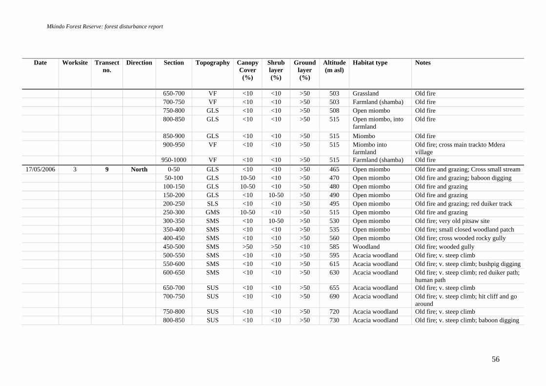
Mkindo Forest Reserve: forest disturbance report
56
Date Worksite Transect no.
Direction Section Topography Canopy Cover (%)
Shrub layer (%)
Ground layer (%)
Altitude (m asl)
Habitat type Notes
650-700 VF <10 <10 >50 503 Grassland Old fire 700-750 VF <10 <10 >50 503 Farmland (shamba) Old fire 750-800 GLS <10 <10 >50 508 Open miombo Old fire 800-850 GLS <10 <10 >50 515 Open miombo, into
farmland Old fire
850-900 GLS <10 <10 >50 515 Miombo Old fire 900-950 VF <10 <10 >50 515 Miombo into
farmland Old fire; cross main trackto Mdera village
950-1000 VF <10 <10 >50 515 Farmland (shamba) Old fire 17/05/2006 3 9 North 0-50 GLS <10 <10 >50 465 Open miombo Old fire and grazing; Cross small stream
50-100 GLS 10-50 <10 >50 470 Open miombo Old fire and grazing; baboon digging 100-150 GLS 10-50 <10 >50 480 Open miombo Old fire and grazing 150-200 GLS <10 10-50 >50 490 Open miombo Old fire and grazing 200-250 SLS <10 <10 >50 495 Open miombo Old fire and grazing; red duiker track 250-300 GMS 10-50 <10 >50 515 Open miombo Old fire and grazing 300-350 SMS <10 10-50 >50 530 Open miombo Old fire; very old pitsaw site 350-400 SMS <10 <10 >50 535 Open miombo Old fire; small closed woodland patch 400-450 SMS <10 <10 >50 560 Open miombo Old fire; cross wooded rocky gully 450-500 SMS >50 >50 <10 585 Woodland Old fire; wooded gully 500-550 SMS <10 <10 >50 595 Acacia woodland Old fire; v. steep climb 550-600 SMS <10 <10 >50 615 Acacia woodland Old fire; v. steep climb; bushpig digging 600-650 SMS <10 <10 >50 630 Acacia woodland Old fire; v. steep climb; red duiker path;
human path 650-700 SUS <10 <10 >50 655 Acacia woodland Old fire; v. steep climb 700-750 SUS <10 <10 >50 690 Acacia woodland Old fire; v. steep climb; hit cliff and go
around 750-800 SUS <10 <10 >50 720 Acacia woodland Old fire; v. steep climb 800-850 SUS <10 <10 >50 730 Acacia woodland Old fire; v. steep climb; baboon digging

Mkindo Forest Reserve: forest disturbance report
57
Date Worksite Transect no.
Direction Section Topography Canopy Cover (%)
Shrub layer (%)
Ground layer (%)
Altitude (m asl)
Habitat type Notes
850-900 GUS 10-50 <10 >50 740 Acacia woodland Old fire; v. steep climb; old pit saw site 900-950 SUS 10-50 <10 >50 735 Acacia woodland Old fire; v. steep climb; cross smal gully 950-1000 SUS <10 <10 >50 750 Acacia woodland Old fire; v. steep climb; rocky
18/05/2006 3 10 East 0-50 SLS <10 <10 >50 470 Miombo Old fire and grazing; rocky 50-100 GLS <10 <10 >50 455 Miombo Old fire and grazing 100-150 GLS <10 <10 >50 440 Miombo Old fire and grazing; cross stream 150-200 GLS <10 <10 >50 435 Miombo Old fire and grazing; old cow dung;
human path 200-250 GLS <10 <10 >50 440 Miombo Old fire and grazing 250-300 GLS <10 <10 >50 450 Miombo Old fire and grazing 300-350 GLS /
GULLY >50 10-50 <10 460 Closed miombo Old fire and grazing; by stream ; human
path 350-400 GLS <10 <10 >50 478 Open miombo Old fire and grazing 400-450 SLS <10 <10 >50 493 Open miombo Old fire and grazing 450-500 SMS <10 <10 >50 515 Open miombo Old fire and grazing; cliff go around;
see teak tree to south, border but not clear line
500-550 SUS <10 <10 <10 535 Open miombo Old fire and grazing; very rocky; Euphorbia candelabra
550-600 RT <10 <10 <10 550 Open miombo Old fire and grazing; rocky 600-650 RT <10 <10 >50 557 Open miombo Old fire and grazing 650-700 RT <10 <10 >50 564 Open miombo Old fire and grazing 700-750 RT <10 <10 >50 590 Open miombo Old fire and grazing 750-800 RT 10-50 <10 >50 600 Open miombo Old fire and grazing 800-850 RT <10 <10 >50 612 Open miombo Old fire and grazing 850-900 SUS 10-50 <10 >50 604 Open miombo Old fire and grazing; charcoal burning 900-950 SUS <10 <10 >50 596 Open miombo Old fire and grazing ; (casual charcoal
burning site)

Mkindo Forest Reserve: forest disturbance report
58
Date Worksite Transect no.
Direction Section Topography Canopy Cover (%)
Shrub layer (%)
Ground layer (%)
Altitude (m asl)
Habitat type Notes
950-1000 SUS <10 <10 >50 595 Open miombo Old fire and grazing 19/05/2006 3 11 South /
west 0-50 GLS 10-50 <10 >50 460 Miombo
50-100 GLS / GULLY
<10 <10 >50 455 Miombo Old fire and grazing; cross path
100-150 GLS <10 <10 >50 445 Miombo Old fire and grazing; cross stream 150-200 GLS 10-50 <10 >50 451 Miombo Old fire and grazing 200-250 GMS >50 <10 >50 440 Miombo Old fire and grazing; rocky; see one
teak tree just east, assume border is straight line, so turn transect WEST
250-300 GMS >50 <10 >50 450 Miombo Old fire and grazing 300-350 GUS 10-50 <10 >50 470 Miombo Old fire and grazing; big rock 350-400 GUS 10-50 <10 >50 490 Miombo Old fire and grazing 400-450 GUS <10 <10 >50 510 Miombo Old fire and grazing 450-500 RT / SUS <10 <10 >50 520 Miombo Old fire and grazing; path 500-550 SMS <10 <10 >50 485 Miombo Old fire and grazing; rocky 550-600 SLS <10 <10 >50 460 Miombo Old fire and grazing 600-650 GLS >50 10-50 <10 440 Riverine forest 650-700 VF / GLS <10 <10 >50 440 Miombo Old fire and grazing; cross Dizingwi
river; cross water intake pipe 700-750 SLS <10 <10 >50 450 Miombo Old fire and grazing; cross water intake
pipe and path 750-800 SLS / SMS <10 <10 >50 470 Miombo Old fire and grazing 800-850 SMS <10 <10 >50 485 Miombo Old fire and grazing 850-900 SUS / RT <10 <10 >50 510 Miombo Old fire and grazing 900-950 SMS / SLS <10 <10 >50 495 Miombo Old fire and grazing; rocky; cow path 950-1000 VF / GLS <10 <10 >50 480 Miombo Old fire and grazing; path and track

Mkindo Forest Reserve: forest disturbance report
59
Date Worksite Transect no.
Direction Section Topography Canopy Cover (%)
Shrub layer (%)
Ground layer (%)
Altitude (m asl)
Habitat type Notes
16/05/2006 3 12 West 0-50 GLS <10 <10 >50 468 Miombo Old fire and grazing 50-100 GLS <10 <10 >50 460 Miombo Old fire and grazing; human path x 2 100-150 GLS 10-50 <10 >50 470 Miombo Old fire and grazing; follow / cross path 150-200 GLS >50 <10 >50 470 Miombo Old fire and grazing; follow / cross path 200-250 GLS >50 <10 >50 475 Miombo Old fire and grazing; follow / cross path 250-300 GLS >50 <10 >50 480 Miombo Old fire and grazing; follow / cross path 300-350 GLS 10-50 <10 >50 485 Miombo Old fire and grazing 350-400 SMS 10-50 <10 >50 495 Miombo Old fire and grazing 400-450 GMS <10 <10 >50 490 Miombo Old fire and grazing 450-500 GULLY <10 <10 >50 485 Miombo Old fire and grazing; cross Dizingwi
river 500-550 GULLY /
GLS 10-50 <10 >50 480 Miombo Old fire and grazing
550-600 GMS 10-50 <10 >50 490 Miombo Old fire and grazing; cross small stream 600-650 GLS <10 <10 >50 484 Miombo Old fire and grazing; cross road to
intake 650-700 GMS <10 <10 >50 490 Miombo Old fire and grazing 700-750 GMS <10 <10 >50 500 Miombo Old fire and grazing; charcoal burning;
path 750-800 SMS 10-50 <10 >50 515 Miombo Old fire and grazing; firewood
collection 800-850 SMS 10-50 <10 >50 525 Miombo Old fire and grazing; charcoal burning 850-900 SUS >50 <10 >50 535 Miombo Old fire and grazing 900-950 SUS >50 <10 >50 550 Miombo Old fire and grazing 950-1000 GUS / RT 10-50 <10 >50 570 Miombo Old fire and grazing
Key: B = Charcoal burning, C = cultivation, F = Fire damage, FC = Firewood collection, Gr = Grazing, M = Mining site, P = Pitsawing, R = path, T = Traps, Tr = track

Mkindo Forest Reserve: forest disturbance report
60
Appendix 5 Example of data sheets used for the Mkindo FR survey Disturbance transect and habitat notes data sheet

Mkindo Forest Reserve: forest disturbance report
61
Camera trap forms
Camera-Trap Form 1: monitoring of cameras
# Cam. type* Site/GPS Date-time Placed/checked/removed – prog. photos taken
Notes Observer
* CamTrakker, DeerCam, TrailMaster, Vision Scouting, etc

Mkindo Forest Reserve: forest disturbance report
62
Camera-Trap Form 2: camera station description
Forest site…………………….. Site number…………………… Forest study area………………………….. Data collector…………………………. Camera type………………………Camera number…………UTM coordinates…………………. Nearest cameras and approx distance……………………………………………………………… Altitude (m a.s.l.)………. Slope (deg.)…………… Placed (date/time)………………………………..Removed (date/time)…………………………. Sampling effort (days /hours)…………………. Placed on: large trail (elephant trail) small trail (duiker trail)
Other……………………………. Bait used: ……………………… Any signs/dungs already in site…………………… Gross habitat: lowland forest submontane forest montane forest swamp regenerating forest riverine plantation woodland bamboo grassland cultivation Other habitat……………….….. Canopy cover (for forest habitats): closed canopy regenerating shrubby open Floor cover: shrub/thickets > 2m height < 2m seedlings grass leaf litter rock Cover density dense moderately dense open Dominant tree species……………………………………………………………… Dominant understorey species……………………………………………………… Any further relevant description (e.g. more details on microhabitat)………………………………

Mkindo Forest Reserve: forest disturbance report
63
Camera-Trap form 3: data recording sheet Site number (refer to Form 2) Total trap hours Camera num and type Total trap days UTM Easting (7 digit integer) Total number of pics of wildlife
UTM Northing (7 digit integer) Number of pics of known
mammals
Latitude (deg-min-seconds) Number of pics of known birds Longitude (deg-min-seconds) Number of pics of known other Start date and time Number of unknown pics Stop date (day/month/year) Film negative number Stop time (or time when film used up)
Data collector
Comments (broken, batteries died, etc.)
# dd-mm, time Genus species # dd-mm, time Genus species

Mkindo Forest Reserve: forest disturbance report
64
GPS data sheets F.R. Code
Plot ID / Transect no.
Waypoint Description of location Latitude (S) Longitude (E) Grid ref (E) Grid ref (N)