the poets trails - ring of gullion · the poets trails and other walks a ... clonlum cairn...
TRANSCRIPT

The Poets Trails and other walks
A selection of routes through exceptional countryside rich in folklore, archaeology, geology and wildlife
www.ringofgullion.org

A25
A29
B30
B134
B113
A1
BlackMountain
SlieveGullion
CamloughMountain
WARRENPOINT
NEWRYBELLEEK
CAMLOUGH
MEIGH
JONESBOROUGH
DRUMINTEE
FORKHILL
MULLAGHBANE
SILVERBRIDGE
CREGGAN
CourtneyMountain
Slievenacappel
SlieveBreac
Slieveacarnane
StandingStone
Cashel
ChamberedGrave
KillevyChurch
AdventurePlayground
St Bline’sWell
The Long Stone
KilnasaggartInscribed
Stone
Victoria Lock
MilitownLough
GreenonLough
DerrylechaghLough
CamLough
Creggan Route
Welcome to walks inthe Ring of GullionThe Ring of Gullion lies within aregion long associated with anancient frontier that began withthe earliest records of man’shabitation in Ireland. It was alongthese roads and fields, and overthese hills and mountains, thatCúchulainn and the Red BranchKnights, the O’Neills andO’Hanlons roamed, battled anddied. The area, which has alwaysrepresented a frontier from theancient Iron Age defences of theDorsey, through the Anglo-Norman Pale, and latterly themodern border, is alive withhistory, scenic beauty and culture.
This area reflects the mix ofcultures from Neolithic to thepresent, while the rollingcountryside lends itself to theenjoyment of peaceful walks,excellent fishing and a friendlywelcome at every stop.
Key to Map
Forkhill Route
Ballykeel Route
Slieve Gullion Route
Camlough Route
Annahaia Route
Ring of Gullion Way Marked Way
02 | www.ringofguillion.org www.ringofguillion.org | 03
Glassdrumman Lake Art Mac Cumhaigh’s Headstone

POETS TRAIL – CREGGAN ROUTE POETS TRAIL – CREGGAN ROUTE
A29
B30
R177
SlieveBreac
3
1
5
Roche Castle
Creggan Church& Graveyard
1 Interpretation Panels
Areas of Special Scienti!c Interest
Red Squirrels
CREGGAN
GLASSDRUMMAN
BALLSMILL4
2
1
04 | www.ringofguillion.org www.ringofguillion.org | 05
This route is a series of minor roads and country paths winding throughSouth Armagh into North Louth and back again. You can follow thefolklore and life and times of the Poets and Scholars of the area.
Start at Creggan Churchyard (Information Board 1) and turn right heading south along theGlassdrummond Road for roughly 4km passing Glassdrumond Church and ontoGlassdrummond Lake where the O’Neills sited their Castle (Information Board 2).Take the first right past the lake onto the Leeter Road, and continue for roughly 1km.
Following the Poets Trail signs take the left turning to Mounthill, and continue for roughly2.5km until you see Roche Castle Straight ahead (Information Board 3).
Turn left at the cross-roads and continue for roughly 1km before turning left towardsBallsmill. Continue for roughly 1km before veering right through Ballsmill Village past theamenity site (Information Board 4). Continue for roughly 1.5km and take the first left ontothe Cortreasla Road, after roughly 1km (Information Board 5) walk through the tight bend
in the road. After a further 1km turn right onto the Lurgan Road and continue for roughly1.5km, past Hearty’s Folk Cottage on the left and take the first turn on the left at Murrays Road.
Continue for roughly 1.5km taking the first turn to the right, Cregganbane Road, thencontinue for roughly 0.5km and at the junction turn left always following the waymarkers.At the bottom of the road turn right back to Creggan Parish Church.
Did You Know?Creggan graveyard is a truly ecumenical place as members of both Catholic and Protestantdenominations still bury in its fragrant clay. It contains the remains of poets; scribes; clergymen; raparees; militia; magistrates; revolutionaries; landlords and tenants; labourers;housekeepers; wives and husbands; beggars and bankers.
Creggan Glen
Glassdrumman Lake

POETS TRAIL – FORKILL ROUTE POETS TRAIL – FORKILL ROUTE
06 | www.ringofguillion.org www.ringofguillion.org | 07
Start at the Welcome Inn on Main Street,renowned for its traditional music sessions(Information Board 1).Head south andcontinue for roughly 0.5km and take the firstturn left down a country track, part of theRing of Gullion Waymarked Way.
Continue for roughly 1.5km along this track,which was the old funeral road to UrneyGraveyard (Information Board 2).
After visiting the grave of Peadar Ó Doirnínfollow the track south for roughly another0.5km. At the end of the lane turn right andcontinue for roughly 1km straight throughthe crossroads.
Continue for roughly 1.5km to the nextjunction and turn left onto the Carrive Roadand after roughly 300m turn right. Continuefor roughly 3km along Glendesha whichprovides magnificent views of SlieveGullion.
At the end of this road turn right andcontinue for roughly 0.5km to Forkill Churchof Ireland which is now a residentialproperty (Information Board 3).
Continue along this road into Forkill Village.
Did You Know?It was the folk belief that there was aspecial indulgence earned by beingburied at Urnaí. Those buried here arethought to have a more direct line to heaven.
This route is series of minor roadsand country paths windingaround Croslieve starting in thehistorical village of Forkill.
Fox!eld
SlieveGullionForest
MullaghbaneMountain
SlieveBreac
Rath
Rath
Rath
ForkillFolly
MarketStone
Rath
Fort
Quilly
St BrigidsVillas
Drumintee
St Patricks Park
2
1
3
DRUMINTEE
FORKILL
The resting place of Peadar Ó Doirnín Forkhill Folly
Urnaí Graveyard
Did You Know?Townlands - Tullymacrieve means Rice’s ‘field’or ‘grassy hillock’. The name Ó Maolchraoibheis anglised as Rice, Mulcrevy and Mulgrew. Cashel means ‘the stone ring fort’.
There was formerly an old graveyard knownlocally as the ‘reilig’ in Tullymacrieve and acairn in Cashel.
POETS TRAIL – BALLYKEEL ROUTE POETS TRAIL – BALLYKEEL ROUTE
B30
B134
Slievenacappel
Flaxmill
Portal Tomb
1
4
3
2
MULLAGHBANE
SILVERBRIDGE
08 | www.ringofguillion.org www.ringofguillion.org | 09
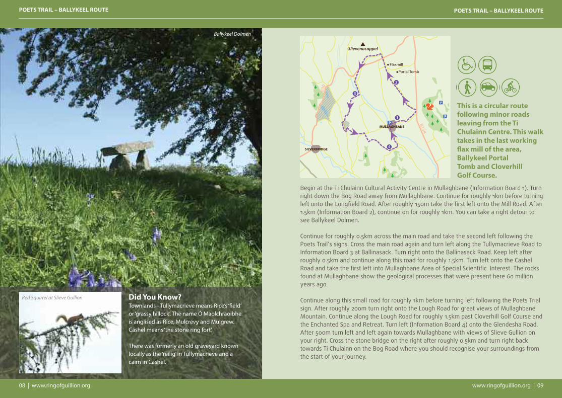
Begin at the Ti Chulainn Cultural Activity Centre in Mullaghbane (Information Board 1). Turnright down the Bog Road away from Mullaghbane. Continue for roughly 1km before turningleft onto the Longfield Road. After roughly 150m take the first left onto the Mill Road. After1.5km (Information Board 2), continue on for roughly 1km. You can take a right detour tosee Ballykeel Dolmen.
Continue for roughly 0.5km across the main road and take the second left following thePoets Trail’s signs. Cross the main road again and turn left along the Tullymacrieve Road toInformation Board 3 at Ballinasack. Turn right onto the Ballinasack Road. Keep left afterroughly 0.5km and continue along this road for roughly 1.5km. Turn left onto the CashelRoad and take the first left into Mullaghbane Area of Special Scientific Interest. The rocksfound at Mullaghbane show the geological processes that were present here 60 millionyears ago.
Continue along this small road for roughly 1km before turning left following the Poets Trialsign. After roughly 200m turn right onto the Lough Road for great views of MullaghbaneMountain. Continue along the Lough Road for roughly 1.5km past Cloverhill Golf Course andthe Enchanted Spa and Retreat. Turn left (Information Board 4) onto the Glendesha Road.After 500m turn left and left again towards Mullaghbane with views of Slieve Gullion onyour right. Cross the stone bridge on the right after roughly 0.5km and turn right back towards Ti Chulainn on the Bog Road where you should recognise your surroundings fromthe start of your journey.
This is a circular routefollowing minor roadsleaving from the TiChulainn Centre. This walktakes in the last workingflax mill of the area,Ballykeel PortalTomb and Cloverhill Golf Course.
Ballykeel Dolmen
Red Squirrel at Slieve Gullion

SLIEVE GULLION CIRCULAR ROUTE SLIEVE GULLION CIRCULAR ROUTE
10 | www.ringofguillion.org www.ringofguillion.org | 11
St Moninna’s Well
Bell’sCastle
KilleavyChurch
1800s Courtyard &Walled Garden
Drum
inte
e Road
Chapel Road
Church Road
Long!eld Rd
Lake and Millstone
Slieve Gullionpassage tomb
Clonlum Cairn‘King’s Ring’
Sarah Daly’sBridge
BallardLongstone
Slieve GullionAdventure Park
Camlough Lake
Swimming/Canoeing/Fishing
i
i
ii
i
The walk starts and finishes at the Slieve Gullion Forest Adventure Park.
Follow an uphill path from the top left of the car park. The path continuesuphill through deciduous woodland for about 1km until arriving at a logbench opposite a way marker post. Turn right on to the forest drive andcontinue uphill through a stand of beech trees for 800m. Turn right onto ashort section of forest track to the forest drive. Turn left on the forestdrive and continue for about 2km until the upper car park on the left.
This section of the trail has magnificent views of the Ring of Gullion peaks of, Slievebreac,Slieve na Bola, Slieve Mór and the Dhaichalmór.
Turn right fifty metres beyond the car park up an initially steep mountain path. Continuethrough a kissing gate until a stone shelter is reached. The views in this section expand toinclude the peaks of Slievenacapple and the Fews to the North west.
Passing to the right of the stone shelter the path becomes steeper, traversing rockyground. After 500m the path arrives at the summit of Slieve Gullion and the Neolithic
Passage Grave, which you can enter from just below the summit. Panoramic views fromthe summit take in the Mourne Mountains, Carlingford Lough, The Cooley Peninsula, theArmagh Drumlins and beyond.
The path continues North-West along the summit plateau arriving at Calliagh Berra’s Loughafter 800m. Continue past the lough to the North Cairn which is also a Bronze Age burialchamber.
Continue on the path and descend for about 2km down the North side of the mountainuntil reaching the Ballard Road. Turn right along the country lane and follow it as itundulates through the countryside. Keep right after 2km where the road forks andcontinue to Killeavy Old Churches dating from the 5th Century. St Moninna is buried in thechurchyard.
Continue along the country lane, past Clonlum Portal Tomb on the left and Killeavy Castle on the right for a further 2km before turning right at a cross roads. Continue throughgateposts on to the exit from the car park.
Did You Know?Seamus Mór Mac Murphy and his friend Peadar Ó Doirnín organised a rally on the summit ofSlieve Gullion in the summer of 1744 to gather support for ‘ the King over the water’. SeamusMór and many South Armagh MacMurphys went to Scotland to fight for Bonnie Prince Charliein the rebellion which ended in defeat for the Jacobites at Culloden in 1746.
Camlough Lake

CAMLOUGH MOUNTAIN ROUTE CAMLOUGH MOUNTAIN ROUTE
CamloughWood
CamloughWood
AghmakaneWood
CamLough
CamloughMountain
BallymacdermotMountain
Chambered Grave
BernishViewpoint
CarrickbrackanWood
CamloughQuarry
i
i
i
CAMLOUGHVILLAGE
12 | www.ringofguillion.org www.ringofguillion.org | 13
The walk starts and finishesin the Village of Camlough.
Follow the Quarter Road to theright of Doyle’s Pub. Continue alongthis road for about 50m then turnleft onto the Church Road. Continuealong this narrow country road forabout 2.5km until you reach a roadon your right opposite large greengates. Turn uphill and continue pastthe house on your right. Afterabout 200m keep right and continuealong this road for about 1km.
Enter through the Forest Service gate and keep almost immediately to your left. ThisForest Service track continues for roughly 3km through dense pine and heather along thesummit and plunges back into pine before exiting into open fields. At the junction turnright onto the Tamnaghbane Road. Continue for about 2km before turning right again ontothe Keggall Road where you can have a picnic overlooking Camlough lake at the amenitysite. The Keggall Road can be busy, please exercise caution here.
After roughly 1km Camlough Quarry will rise out of the mountain on the right. The rocks ofthe Camlough area were born from fire. Over 400 million years ago molten rock cooledunder ground to form granadiorite. Then again 58 million years ago molten rock was
present in this area and as it cooled it became dolerite. You can see the darker coloureddolerite intruding into the much older lighter coloured grandiorite.
After 200m keep to the right onto the Mountain Road. Continue on this route for roughly 1.5kmbefore turning left down towards Camlough. At the junction turn right and after 300m the trailcomes to an end where you should recognise your surroundings from the start. CamloughVillage is the perfect place to stop off and have lunch or dinner after a day’s walking.
Did You Know?It’s all in the name, Camlough Mountain’s real name is Slieve Girkin, its translation is a littlemore complex but most take it to mean ‘mountain of the cocks comb’ as the crag resembles acomb. The village name Camlough doesn’t come from any townland, it’s taken from thenearby lake. The village lies in the townlands of Cross and Carrickcroppan.
Camlough Lake
Camlough Mountain

ANNHAIA - HAWTHORN HILL NATIONAL NATURE RESERVE ANNHAIA - HAWTHORN HILL NATIONAL NATURE RESERVE
Viewpoint
Seated Area
Courtyard& Café
BellsCastle
Slie
ve G
ullio
n Fo
rest
Driv
e
Adventure
Park
B113
Mei
gh
Fork
hill
Slieve Gullion
Summit
14 | www.ringofguillion.org www.ringofguillion.org | 15
Begin at the Slieve Gullion Courtyard and walk up towards the AdventurePark and take the first track on the left and continue straight uphillthrough deciduous woodland for about 750m until arriving at a foresttrack with a log bench on the right hand side of the path.
From this point magnificent views can be had of the the Ring ofGullion near Forkill. Keeping to the right, continue on the path backinto the woodland. The path continues for 850m, first uphill, beforedescending directly to the Slieve Gullion Forest Adventure Park andstart point.
This circular woodland walk takes in magnificent views of the Ring of Gullion peaks, and you can find red squirrels on this side ofSlieve Gullion as well as smooth newts, jays, pine martins and manyothers!
The Courtyard was originally constructed as farm buildings about1820 by the Landlord Hunt Chambre. Chambre was fascinated with
Did You Know?The owner of Killevy Castle in the 1830s, Powell Foxall,was involved in the Newry bank at what now is the ArtsCentre on Bank Parade. There is still a plaque on thebuilding. The bank eventually failed. In 1830 he built thisimpressive mock gothic castle to rival the new house ofhis neighbour and cousin Hunt Chambre.
the Napoleonic wars and had great reverence for TheDuke of Wellington. Chambre’s residence was surroundedby extensive woods which were reputedly planted in theformation of Wellington’s army at the Battle of Waterloo.Hawthorn Hill is now a Forest Nature Reserve owned bythe Forest Service.
Killeavy Castle
View from Slieve Gullion Courtyard

MORE INFORMATION MORE INFORMATION
16 | walkni.com walkni.com | 17
www.ringofgullion.orgFor further information on the Area of Outstanding Natural Beauty, places of interestArchaeology, Biodiversity, Built Heritage, Cultural Heritage, Geology and lots more downloadablemaps and brochures visit www.ringofgullion.org and to keep up to date with announcementsand projects ‘like’ Ring of Gullion on Facebook.
Leave No TraceIn order to minimise your social and environmental impacts on the outdoors, please follow theprinciples of Leave No Trace. Leave No Trace is an outdoor ethics educational programmedesigned to promote and inspire responsible outdoor recreation through education, researchand partnerships. For more information please visit www.leavenotraceireland.org.
Go PreparedWeather conditions in the Slieve Gullion area can be changeable even during summer months.Waterproof and windproof clothing are essential and strong walking boots are advised.
EmergencyIn the event of an emergency call the police on 999, or Police Service NI (central switchboard)+44 (0)845 600 8000; or Daisy Hill Hospital A&E, Newry +44 (0)28 3083 5000
Public TransportTranslink operates a number of services from Newry Bus centre; 40a, 41, 42, 43, and town servicesto Camlough and Bessbrook; 338E and 41B. Timetables are available from Bus Stations or TouristInformation Centres across Northern Ireland.
The main Belfast to Dublin train stops off in Newry and there is pedestrian access into Camlough,or Town Service 341 will bring you down to the bus station.
For more information call (028) 9066 6630 or visit www.translink.co.uk. Over 60’s travel free onpresentation of a valid SmartPass.
Forest ParksPlease be aware that Slieve Gullion and Camlough Forest Parks are working environments.Sections of the trail may close from time to time to facilitate forestry and other essentialoperations. Please take care on forest tracks as some are used as bridle paths and all are used byforestry vehicles.
WalkNI.comFor further information on these walks, other walks in the Ring of Gullion and all other walksacross Northern Ireland, please visit www.walkni.com. Here you will find short, medium and longdistance walks, as well as downloadable maps, suggested itineraries and everything you need toknow when planning a walking trip in Northern Ireland. Gap ‘O the North Walking Club also runguided walks, to get in contact email them on [email protected]. You can also find guideson www.bluebadgeireland.com
Other Activities & Places to SeeThe Ring of Gullion is renowned for its natural beauty, culture, tradition, folklore, heritage and itsoutdoor recreation. In addition to walking, a wide variety of activities and attractions are on offer,including cycling, horse riding, arts and crafts markets, castles, dolmens and ruins to explore. Tofind out more visit Newry or Crossmaglen Tourist Information Centre (contact details below).
Tourist Information Newry Tourist Information CentreBagenal's Castle, Castle Street, Newry, BT34 2DAwww.visitnewryandmourne.comE [email protected] (028) 3031 3170
Crossmaglen Tourist OfficeO’Fiaich House, 25-26 O’Fiaich Square, Crossmaglen, BT35 9HGwww.visitnewryandmourne.com & www.ringofgullion.orgE [email protected] (028) 3086 8900
For any questions on walking in Northern Ireland contactOutdoor Recreation NIThe Stableyard, Malone Road, Barnett's Demesne, Belfast BT9 5PBTel: +44 (0)28 9030 3930Email: [email protected]
This guide is available in English and Irish.
Ring of Gullion Red Squirrel Group: Watch out for squirrels around the Ring of Gullion and if you seeany we would ask that you report your sighting by clicking the Red Squirrel Logo on www.ringofgullion.org. You can also find out more about the group and information on how to become a member
DisclaimerEvery care has been taken to ensure accuracy in the compilation of this guide. The information provided is, to thebest of the promoter’s knowledge, correct at the time of going to print. The promoters cannot accept responsibilityfor any errors or omissions but if any are brought to their notice, future publications will be amended accordingly.
Land AccessSome popular walking routes in Northern Ireland are not formally designated public rights of way. Access is on a de-facto basis and depends on the goodwill and tolerance of local landowners. Walkers are advised to respect that they may be walking on private land and are encouraged to make themselvesaware of and adhere to the principles of 'Leave No Trace' www.leavenotraceireland.org.