the monumental urban complex at urkesh · the monumental urban complex at urkesh ... (the great...
TRANSCRIPT
The Monumental Urban Complex at Urkesh
Report on the 16th Season of Excavations, July-September 2003
GIORGIO BUCCELLATI
The sixteenth (2003) season at Tell Mozan/Urkesh focused on the exploration of a monumental urban complex that links the palace and temple over a distance of ca. 250 meters.This report details the results of this exploration and exposure of substantial new evi- dence for the palace and the sacral area presumed to have been the abi and adjacent kaskal kur. An Akkadian tablet from the palace is also described. In addition, the report provides details on the archi- tecture of the palace and urban complex, the nature of the Hurrian presence at Urkesh, and the later Mittani levels of the second millennium, as well as related undertakings at the site.
A major overriding question loomed large during the sixteenth season of exca- vations. Do we have, in Urkesh, a monumental urban complex that links palace and temple across a vast distance of some 250 meters?' As a result of the season's work, we were able to put together most of the pieces of the puzzle, and yet the scale is so grand that we cannot yet grasp visually the full dimension of the monumental complex. We must still rely on the inferential argument that can be built from the evidence at hand, and that leaves little room for doubt. Only one important element is still missing-whether or not there was a third level to the palace. This question will be with us yet next year, tantalizing and exciting because of its vast implications. In the process, we also stumbled on another monumental, if hidden, aspect of the construction process-a large drain that serves the service wing of the palace but must ultimately come from the formal wing situated at a higher level than the service wing. We have also gained a better insight into the access sector, even though we still do not have the main entrance to the whole building. The architecture of the palace remains thus the major focus of our current work, and we watch with an ever greater sense of surprise how homogeneous the planning was, for all its complexity
' As we had intimated in our last report, G. Buccellati and M. Kelly-Buccellati, "Bericht iiber die 15. Kan~pagne in Tell Mozan/UrkeB, August-September 2002," MDOG in press.
Studies on the Civilization and Culture of Nuzi and the Hurrians - 15 02005. All rights resewed.

4 GIORGIO BUCCELLATI
(the great drain was a case in point this last summer). As if to validate our ap- preciation of the ancient architects, we found a tangible trace of their planning in the form of a clay tablet on which is inscribed, as far as we can tell at the moment, the floor plan of one of the room suites in the palace that we have partly exposed.
As always, it is more than mere routine to acknowledge the support of all who have made our work possible. In the first place, the Director General of Antiquities and Museums, Dr. Tammam Fakouch, and the Director of Excava- tions, Dr. Michel Maqdissi, whose welcome was particularly meaningful to us this year, so fraught with dark clouds on the broader political horizon. At the local level, we are grateful to the Director of the Hassaka Department, Mr. Abd el-Mesiah Bagdou, the Director of the Qamishli division, Mr. Ibrahim Murad, and to our representative, Mr. Abd el-Rahman Kusa.
Once more and with undiminished generosity, the following Foundations made our work possible: the National Geographic Society, the Catholic Biblical Association, the S. H. Kress Foundation, the L. J. and M. L. Skaggs Foundation, the Ahrnanson Foundation, Syria Shell Petroleum Development B.V., the Urkesh Founders and various donors. Also, we benefited from a new grant from the Cotsen Institute of Archaeology specifically designed to make it pos- sible for a graduate student in a different field (in our case, Chinese archae- ology) to gain field experience in a field outside the student's specialization.
The field season lasted from the 4th of July to the 19th of September, 2003. The staff included Marilyn Kelly-Buccellati (director, glyptics, ceramics), Giorgio Buccellati (co-director, field director, epigraphy), Beatrice Angeli (conservation), Alessandra Asteriti (J1 west), Sophie Bonetti (conservation and J1 east), Federico Buccellati (assistant field director and systems), Dennis Cecchin (Jl), Daniela Crasso (A12/A14), Nicoli, Dell'Unto (GIs), Maurizio Forte (GIs), Giuseppe Gallacci (photography), Kenneth Garrett (photography), Rick Hauser (A10 and figurine typology), Minna Haapanen (AM), Jeffrey Jarmakani (photography), Abd el-Rahman Kusa (A18), John Lynch (A12/A14), Bruna Mariani (conservation), Antone Mathys (J1 west), Jamal Omar (A15/A17 and ceramics), Alexia Pavan (AM), Fonda Portales (curator and drafting), Barbara Pritzkat (surveying), Laura Ramos (AM), Mary Stancavage (A15/ A17), Jim Walker (A15/A17), Claudia Wettstein (drafting).
To properly attribute ethnic identity to any ancient social group requires cautious judgment and methodological awareness. To narrow it down to a city entails an even greater risk. And to invoke a specific Hurrian configuration for such ethnic identity and for such an early period may seem like wishful thinking. If I nevertheless propose it for third-millennium Urkesh, it is on account of certain arguments that I can only summarize here. Whatever their ultimate merit, it seems useful to state them clearly, if for no other reason than to enunciate the criteria that may be used to approach this issue. One reason for

THE MONUMENTAL URBAN COMPLEX AT URKESH 5
broaching the subject of ethnicity in this context is to place in their proper perspective the surprisingly new architectural finds that are emerging from the excavations at Tell Mozan.
In my view, "the key elements that help define an ethnic group are as follows. It is (1) sufficiently large to preclude the possibility of face-to-face association, and (2) sufficiently consistent through time to span several generations while retaining its internal aggregation. It has (3) a marked sense of identity, generally expressed through a proper name referring to the group. The members share (4) a number of cultural traits, ranging from material culture to ideology and religion, from customs and lifeways to language. These traits are (5) ascribed (they are acquired at birth, or through a birthlike process of assimilation), but they are (6) nonorganizational, i.e., they do not, in and of themselves, motivate the group into a special kind of coordinate action, and they are mostly (7) symbolic in nature."2
In the case of third-millennium Urkesh we can point to a number of factors that distinguish it from any other contemporary city and meet several of the criteria just stated. I will list here the most salient cultural traits that we can evince from both the written and the archaeological record. (1) Language and scribal tradition. The foundation inscription of Tish-atal and the seal legends of King Tupkish and his courtiers are the earliest record we have of the language that we call Hurrian, using a term that came into use at a later date. While obviously extremely limited in size, this corpus is coherent in its overall con- figuration, and bears witness to a scribal tradition that appears to be too well established and defined to have been occasional and haphazard. (2) Onomastics is a special component of the linguistic dimension. While we cannot super- ficially equate isolated names with the ethnic identity of their bearers, we must recognize the significance of distinctive distributional patterns when they occur. Such distribution is apparent in Urkesh, where the kings (but not the queens) bear Hurrian names, and so do all major courtiers, including those who are specifically identified as being in the service of the queen. (3) Political ideology. Two of the rulers of Urkesh bear the Hurrian title endan, which is equated (in the case of Tupkish) with the Sumerian logogram LUGAL. Tupkish reigned at the height of the Akkadian dynasty, and thus the use of the term acquires the strength of a political statement that aims at emphasizing Hurrian distinctiveness in juxtaposition with the expansionism of Akkad. It is also significant that the extremely limited third-millennium Hurrian corpus con- sists of political inscriptions (foundation deposits and seal legends). (4) Cult. The evidence pertaining to the abi, i.e,. the underground necromantic structure3
G. Buccellati, "Urkesh and the Question of Early Hurrian Urbanism," in M. Hudson and B. A. Levine, eds., Urbanization and Land Ownership in the Ancient Near East (Peabody Museum Bulletin 7; Cambridge: Peabody Museum of Archaeology and Ethnography/ Harvard University, 1999) 243.
As interpreted by M. Kelly-Buccellati, "Ein hurritischer Gang in die Unterwelt," Mitteilungen der Deutschen Orient-Gesellschaft 134 (2002) 13148.

6 GIORGIO BUCCELLATI
to the southwest of the Royal palace (see below, section), is highly distinctive. The morphological links with the cult attested in the later texts (and, to a limited extent, the later archaeology) of Hittite religion is very explicitly Hurrian. Even the word that was borrowed into Hebrew to describe the same cultic setting, 'db, is Hurrian in origin. More importantly, the religious conception that underlies this cultic phenomenon is greatly at variance with Mesopotamian customs and beliefs. (5) Mythology. Equally late, but equally as important, is the evidence of Hurrian mythology as preserved in Hittite culture. In particular, the narratives about Kumarbi and Silver do, in my estimation, preserve an archaic tradition that reflects much earlier formative periods, well into the third millennium. And central to this tradition is Urkesh, specifically mentioned in the myths as the urban center where Kumarbi resides and that is in close contact with the northern highlands. This, too, solidly anchors Urkesh into an explicit Hurrian ideology, explicit on account of the mythologemes, the geographical setting, the onomastics, and the language.
The five points I have briefly outlined apply to Urkesh as they do to no other known city of the third millennium-not, for instance, Nagar. Which is why, in spite of the presence of occasional Hurrian proper names there, I do not consider Nagar a Hurrian city.
Next to these specific cultural traits that warrant, in my view, speaking explicitly of a Hurrian identity of Urkesh, there is a host of additional elements that speak for a northern distinctiveness of the Urkesh material culture: they are both distinctive vis-2-vis the south and in some cases linked to other traditions known from the northern highlands. While these do not have in and of them- selves any specific link to such Hurrian identity, they can be associated indi- rectly to the explicit cluster of traits just described. (1) Household material cultures. An important set of attributes is discussed by M. Kelly-Buccellati in a separate article in this volume: in particular, the andirons are significant because of the ideological valence suggested by the decorations and their geographical distribution. (2) Fashion. Some aspects of clothing are beginning to emerge that seem characteristic of Urkesh iconography, for instance a floppy hat that is reminiscent of a modern Basque beret. (3) Representational style. From glyptic to sculpture, we can begin to identify with Urkesh a number of dis- tinctive stylistic traits, such as a frankly expressionistic rendering of figures, circylarity in the motion of multiple figure arrays, double frontality of single figures in the round, the use of explicit formal means to show dynamic action, concern for a realistically descriptive setting of glyptic scenes (see on this the article by M. Kelly-Buccellati in this same volume). (4) Architectural style. This takes us to the results of the last seasons of excavation, and in particular the monumental urban complex that we have began to identify during the last season-as presented in the remainder of this report.

THE MONUMENTAL URBAN COMPLEX AT URKESH 7
We are proposing that the entire western and central part of the tell was occupied in antiquity by a single monumental complex that combined palace and temple. As such, this would be one of the most impressive third-millen- nium architectural complexes in Syro-Mesopotamia, covering a vast area and spanning a difference in elevation of almost 15 meters. Figure 1 shows a projection of this complex. All the pieces are documented, except for the higher level of the palace, for which we have, however, inferential evidence. Here are the facts.
FIG. 1
Schematic reconstruction of the monumental urban complex, with remains of the old city wall. The palace is shown with three stages-the existence of the third stage is, however, uncertain.
(After a drawing by Dana Reemes)
The first result of this year's excavations is a wide exposure of the curvature in the stone wall that delimits the ovale4 It is a massive structure, more than 3 meters in height-and from the subsurface view provided by the geo-magnetic
First identified by the geophysical survey carried out by C. Hiibner and S. Giese under the sponsorship of P. Pfalzner as part of the Deutsche Orient-Gesellschaft work at Tell Mozan, see H. Dohmann-PMlzner and P. Pfalzner, "Ausgrabungen der Deutschen Orient- Gesellschaft in der zentralen Oberstadt von Tall Mozan/UrkeS ," MDOG 134 (2002) esp. pp. 168-72.

8 GIORGIO BUCCELLATI
survey we may expect it to continue for a circumference of some 150 meters. It is also likely that it may reach deeper than the 3 meters already exposed.
Fronting this terrace wall there was a large plaza, and a second important result of the 2003 season is the definition of the deposit above the floor level of the plaza. We always knew (ever since our first surface collection in 1984) that the central portion of the tell had an extremely scanty sherd cover in contrast with the rest of the tell, and we had assumed that, indeed, the higher deposit must have been rather sterile. This has been amply confirmed by the current excavations. What is even more interesting is the fact that the higher levels are extremely hard, while below the soil is once again of a regular hardness and compaction. We explain this by assuming that, following the Khabur period, the central plaza took the shape of a bowl, by virtue of the Mittani-period houses coming to rest on the ridges that had been shaped by the more extensive Khabur period settlements. From the late second millennium B.C. until present, this bowl has prevented the water from the winter rains to run off the tell, resulting in the formation of a small pool of water--still very much of a reality on modem Tell Mozan. This body of water (which often freezes in wintertime) percolates through the ground and must be the cause for the extreme hardness of the soil beginning with the end of the Mittani period and coming all the way to the surface.
The third major effort was a search for the eastem perimeter of the palace. As it happens, we overshot our mark, and have instead exposed what we believe to be the area just outside the palace (see below, section 4). We infer this from the presence of a massive brickfall (at least 1.5 m thick), which we confidently identify as coming from the perimetral wall that has eluded us: the consistency and color of the brick is very distinctive, and is otherwise found only in the palace. Also the ceramic remains are those of phase 2, i.e., the time when the palace was built. It seems certain that we are near the perimetral wall at a place where it fell onto the outside plaza to the east. Such brickfall is con- sistent with what we have on top of the large stone courtyard (H3) excavated last year. In contrast with the service wing AK, it appears that the formal wing suffered considerable damage. Since the lowest portion of the brickfall matches that of the stone courtyard (H3), it is possible that, while we do indeed have here the eastern edge of the building, there was, in fact, no third level but rather the second level extended this far.
Eor the sake of argument, it may be useful to mention the reasons that would suggest the existence of a third level. The first is that the second-millen- nium settlements that followed the abandonment of the palace seem to have come into being on the basis of a topography of the tell that sloped upward from west to east, i.e., precisely, along the gradient that would have corresponded to the three steps of the palace. This means that we are expecting a stratigraphic situation whereby houses at a higher elevation are stratigraphically cotermi- nous with those at a lower elevation. The proposed understanding of the an- cient topography as sloping uphill helps in understanding the massive Khabur- period brickfall that characterizes large portions of the deposit. The explanation

THE MONUMENTAL URBAN COMPLEX AT URKESH 9
is that the brickfall comes from houses at the higher elevation falling down in the open areas between houses at the lower elevation. The difference in elevation may be explained as resulting from both the split-level layout of the royal palace and the presence of the large courtyard H3 where a lesser amount of palace brickfall would have occurred.
FIG. 2
Perimetral wall of the temple terrace. It is not clear whether the stones in front of the wall are the remains of a buttress or the result of a collapse.
(Photo J. Jarmakani)
As a result, we can point to the great urban monumental complex of Urkesh as a unique organism of astounding proportions and remarkably well pre- served. While not all details are fully clear or certain, we can expect to have, within a few years, one of the most remarkable urban landscapes of ancient Syro-Mesopotamia. It extends for a length of over 250 m from west to east, the size of many a smaller tell. The perception of volumes and spaces would have been (and will be again, when fully excavated) quite impressive. Proceeding from west and walking on an upward slope to the east, we have first on the left the service wing of the palace, which would have served as a step to the higher structures. The next such structure was the formal wing of the palace, with walls standing to a height of some 3 m above the roof line of the service wing. Presumably forming an L-shaped frame to the far left (north), this would have

10 GIORGIO BUCCELLATI
been an arresting view for a person coming up from the plain level (some 4 m below the floor level of the service wing). We assume a frontal gateway to the palace visible from the lower western approach (alternatively, the entrance may have been on the left). And nested between the service wing and the access sector of the formal wing was the dbi-a mere circular wall in phase 2 and a hidden stone trap door in phase 3. To its left, is the sacral area with the platform that we assume to have been the kuskal kur. Visually, the dbi was a modest set of installations. But the framing was impressive: a highly visible corner of the palace that hugged, as it were, this unique proclamation of Hurrian ideology.
Whether or not there was a third, higher level of the palace, it seems certain that the palace fronted the wide open plaza at the center of the tell, as if a dividing line between the secular and the sacred. And beyond it, a structure whose multi-stage design seems to echo, visually, the multi-stage arrangement of the palace. First, there is a single high wall entirely built in stone (up to 5 m high if its base in phase 2 was at elevation 85). Given the wide horizontal reach of this wall (whether properly oval or polygonal) and its great height over the surface of the plain (10 m or more at its base), the perspective view would have been quite awesome. Above the stone wall, a sloping terrace would lead to the top where the main temple stood, visible for miles around.
Ideologically, the organic unity of this urban monumental complex was clinched, we believe, by the semiotic bracketing between the dbi and the temple. The temple at the top is, in my understanding, the one originally dedicated by Tish-atal to K~marbi .~ What I assume to be the chthonic character of the deity (Kumarbi) worshipped in the high temple is echoed by the abi and the kaskul kur at the bottom of the hill, two structures that reach to the netherworld. We thus have a complex semiotic valence that accompanies a visually unique urban landscape.
Last year we were able to clarify fully the nature and function of the large underground structure as a Hurrian dbi, and its stratigraphic history in rela- tionship to the palace (these results are in press in the forthcoming issue of MDOG). Excavations have continued this year at a slow pace because we wanted to achieve as good an understanding as possible of the nature of the dep&it. During this season we have excavated only about 1 m, and the perennial lateral fissure tells us that we have at least one more meter of stone lining. This means that the stone lining is at least 8 m high. It should be noted
Archaeologically, it makes sense to suppose that the bronze lions sold in Amuda in 1948 came from excavations at the top of the tell, where the temple is located. Having hit upon the large stones of the entry platform, under which we presume there was a foundation deposit with the lions, the local people who were seeking to bury their dead moved the cemetery slightly to the northeast, where it now remains. Philologically, we interpret the term Nergal in the text as a logogram for Kumarbi, whose mythological type is that of a chthonic god. The identification of Kumarbi as a grain-god is late.

THE MONUMENTAL URBAN COMPLEX AT URKESH 11
that, as a result of the ancient contamination resulting from the filling in of the lateral fissure, we decided to proceed with two very oddly shaped loci--one in the form of a ring and the other in the form of a circle within the ring. The width of the ring is about 1 m, and we presume that to be sufficient to eliminate the danger of contamination. In other words, we assume that only the material from the central circle was free of such contamination.
In A14, excavations were limited but quite revealing. We believe that we have defined the interface between the sacral and the non-sacral uses of the area. The area began with the nbi itself and the platform that we have inter- preted as the kaskal kur. This platform underwent a number of transformations, and by the end it consisted of no more than a few bricks laid in the ground above the level of the platform and small reed mats. This is at about the same elevation as the top of the stones of the nbi itself, so we can envisage the same juxtaposition of rituals that would have taken place when the structures were more sub- stantial. The time for this interface is after the Khabur period: at this juncture, there is digging for pits and burials and the construction of small bins-all of which suggests a loss of sacrality for the area as a whole.
4. THE SEARCH FOR THE EASTERN WING OF THE PALACE
A key question we posed at the beginning was whether there might be a raised third wing of the palace, which we labeled AR (for residential). The pertinent finds are considerable, but the results are still inconclusive.
The three western squares of J1 were opened precisely to explore the possibility that we may find here the eastern edge of the palace. The target elevation was 87-the elevation at the base of the staircase in C2 as excavated so far by P. Pfalzner and H. Dohmann-Pfalzner. Here, material contemporary with the Tupkish strata of the palace was found, laying on the surface of what is assumed to be the large plaza UP), west of the Temple terrace. It seemed reasonable to assume that this plaza would extend to the edge of the palace, and that the palace would front this plaza at an analogous elevation. This would place a possible third-floor level of the palace at elevation 87. Since the floor level of the formal wing of the palace (AF) is 2.5 m above the floor level of the service wing (AK), we projected a similar difference in elevation between AF and the proposed residential wing (AR), and assumed that an elevation of 87.5 might be a reasonable target for a possible elevation of AR.
The excavations in J1 (west, see Fig. 7) have, indeed, reached levels with materials that can be typologically associated with the palace, but they are deeper than expected. Below the Mittani strata (phase 6) we have found directly material from phase 4, consisting especially of wide ash layers, without structures. These overlaid a floor surface of mud with a substratum of small pebbles that may be considered to belong to an outdoor area. This was at an elevation of about 88. A pit that was cut through this floor in phase 4 revealed the presence of a brickfall that is very similar, in texture and color, to that on top of the stone courtyard H3. The color is bright red, just like the bricks of the phase

floors and accumulations
A17
A15
walls 1
FIG. 3
General plan of the royal palace AP. Excavations as of 2003. (Drawing G. Buccellati)

FIG. 4
Aerial view of palace. In the service wing to the left the drain is visible as excavated (compare Fig. 3). In the center, the stone-paved courtyard H3 and the iibi are clearly in evidence. To the right, remains of the Khabur-period and (upper right) Mittani-period hOll es and graves.
(Photo G. Gallacci)

14 GIORGIO BUCCELLATI
2 palace, and the texture granular. While no clear bricks or brick bats could be outlined, the consistency of the material seems unequivocal. The presence of considerable amounts of ash points, in turn, to destruction by fire. Finally, the limited ceramic material places this brickfall within phase 2 of the palace, that of Tupkish. The brickfall, then, would come from the perimetral wall of the palace and would have come to rest outside the palace, on the floor of the Plaza. The problem with this interpretation is that the elevation at the bottom of the brickfall is 85, i.e,. some 2 m lower than the plaza level as we have it by the staircase of the temple terrace. Two explanations are possible: either (a) the phase 2 accumulations are heavier near the staircase, and the level of the plaza is, in fact, lower than we thought, or else (b) the plaza was not level, but was rather sloping up from the palace toward the temple terrace.
5. THE ACCESS SECTOR IN THE FORMAL WING OF THE PALACE
The palace plan is looming larger and larger with each new season of excavation, and as of now we still have only one corner of the building, the one in the southwest. As we proceed to the east, we are gaining more insight into the general layout of the structure, but the distance from our goal becomes also greater. As a result of this year's excavations, we are projecting a new layout for the entrance to the palace as a whole, as shown in the plan in Fig. 3 and in the photo in Fig. 4. We assume that the entrance faces west, and that access to the main stone-paved courtyard is through a corridor that makes two turns. While this remains purely hypothetical, important new insights have been gained on the access sector as a whole.
Room H4 is bounded to the east not by a doorway (as we had projected in our earlier plans), but by a solid wall. This wall is preserved well at its base, and is covered with a good white plaster that is preserved on the inside of the stone substructure.
The upper part of the stone substructure shows signs of damage such as we have not seen so far in the other walls of the palace. While elsewhere only evidence of brickfall has been observed, here the stones, too, are partly fallen and have partly moved out of place in a westerly direction. This wall was plastered. The floor, too, seems to have been plastered, but was heavily damaged by the wall collapse. It must be noted that the sealings with the imprc?ssion of the seal of Tar'am-Agade, found in 2000, come from the western end of this same damaged floor (in room H2), but were not covered by the collapsed wall. Interestingly, on the floor itself, below the wall collapse, we have found a seal impression of Uqnitum (A1.323), the wife of Tupkish, the original builder of the palace.
Room H6 is accessed from the north through a wide opening, marked by a low threshold, about 10 cm higher than the floor in room H4. Room H6 has a beautiful mudbrick floor, which is well preserved, but shows no trace of plaster. Since this space was heavily re-used in phase 3, it is conceivable that the floor had originally been plastered (as in the small fragment in the northwest corner

THE MONUMENTAL URBAN COMPLEX AT URKESH 15
of room HI), but that no trace of it remains. It is curious that the wide openingto this room was not flanked by the marked door jambs that are otherwisefound throughout the building. Instead, coming from the north (i.e., from thecourtyard), one would have seen a wide roofed, and rather dark, space,extending partly to the left (east). Light would probably have come from whatwe presume to have been a stairwell that may have led to the roof, possibly onits way to the residential wing AR (if this was indeed at a higher elevation). Ifso, we envision a situation whereby the king would come down from theresidential quarter and use the H suite before proceeding to some formal settingwithin the courtyard (possibly a raised podium along the western wall of thecourtyard, as we hypothesized in the report currently in press for MOOG).
The reconstruction proposed in the floor plan is, of course, tentative and itsuggests tl1at room 13 caused a major jog in the outer perimeter, therebyproviding a directional pointer-equivalent, as it were, to a magnified rabbeting. If so, a visitor would enter from the west, alongside the (hidden) tibi, andmake a double turn (as suggested by our arrow) to eventually enter the largestone-paved courtyard H3.
FIG.5
View of palace from the south. The walls are covered for protection and torender the volume of the architecture. The darker color on the left is greenand it stands for the service wing, the lighter color (gold) for the formal wing.
(Photo J. ]armakani)

16 GIORGIO BUCCELLATI
FIG. 6
View of the necromantic structure (abi) from the west. The maximum depthreached in 2003 was 7 m, but a broad fissure along the edges of the circleshows that the stone lining continues for at least another meter.
(Photo J. Jarmakani)

THE MONUMENTAL URBAN COMPLEX AT URKESH 17
FIG. 7
View of Jl (west). This deep locus was dug in an effort to locate the easternperimetral wall of the palace. At the deepest point in the center, the bottom ofa pit showed (in section) a red brickfall typically associated with the palace.The brickfall continued for another meter below the bottom of the pit. Thebottom of the brickfall is at approximately the same elevation as the stonepaved courtyard H3 (see Figs. 3-4).
(Photo G. BuccellatO
The reconstruction of the three-room suite I is based in part on the discoveryof a tablet with a floor plan that seems to fit the evidence currently available forrooms Il-3. The tablet (A12.321, see Fig. 8) was found on the damaged portionof the floor of room H4, in the northeastern comer of the room, by the base ofthe two comer walls. At just this comer, the wall is damaged all the way to itsbase, the stones being out of place at the same level as the floor. The tablet may,of course, have been dropped after the damage had occurred. But it is alsopossible to assume that it was dropped (or even placed) within the wall itself,and it may have fallen onto the floor when the wall gave way. Since the remainsof rooms Il-3 as excavated so far match a portion of the floor plan found on thetablet, I am proposing as a possibility that the tablet may constitute theassignment for the work crew responsible for the construction of this suite. It is

18 GIORGIO BUCCELLATI
FIG. 8
Tablet with floor plan A12.321. The tablet was found in the collapse of the wallbetween sectors H and I on the floor of room H4. It may represent a plan for rooms 1113, and if so, it may have been used as a work assignment for the building crew. Themark on the lower left may refer to the location of a benchmark used in the laying outof the building.
(Photo G. BucceIlati)

THE MONUMENTAL URBAN COMPLEX AT URKESH 19
not an architectural floor plan in the strict sense of the term, because no sizes are indicated. But it might make sense as a generic definition of the walls to be built by a crew that was illiterate but able to understand the map as drawn, and take scaled measurements by means of appropriate ropes. The mark on the lower left of the tablet, that at first looks like the cuneiform sign BAR, may, in fact, have shown the location of the benchmark from which measurements would have been taken with the ropes by the "father of the rope" (abi aBIim in Akkadian), i.e., the surveyor. The question will find an answer through future excavations. If suite I turns out to be as projected, then there would be little doubt that the plan, by virtue of matching the actual structure, was designed precisely in function of its construction. If so, this would be the first time that such a correlation between a map on a floor plan and an actual building has ever been established in Syro-Mes~potamia.~
6. THE SERVICE WING AND THE GREAT PALACE DRAIN
A minor ancient break in a floor of the service wing of the palace has given us a significant insight into an important aspect of the hydraulic engineering that went into the construction of the palace. When we thought we were completing excavations in room C4, we realized that the floor surface (a thin white plas- tered surface, the same as with all other first floors in the service wing of the palace) was broken in the southern portion of the room. Below the level of the floor, some stones were showing. We removed one of the stones, and we found the channel of a drain, about 20 cm in width. It seemed clear that the floor surface had been broken in antiquity to reveal the drain, possibly to allow cleaning of the drain. The sheer size of the drain in room C4 suggested that it should be part of a larger system, and so we began to follow its course outside the limits of the room, which led to some very interesting overall results.
The main trunk of the system (see Figs. 3,4 and 9) runs in a north-south direction through sectors D and C, ending in the outlet just outside the building that we had already excavated in earlier seasons. Its point of origin is not known, but the turn to the northeast suggests that the drain originates in the upper rooms of the formal wing of the palace (AF). This would have resulted in a rather sharp slope, since the difference in elevation between the formal wing AF and the service wing AK is of about 2.5 m. And it is such a drop that may have been the reason for the heavy masonry construction of the drain since the rush of water may have been too strong for it to be absorbed by normal baked brick.
The portion of the drain that was opened showed that it was almost filled to within 5-10 cm from the top with very wet soil, as if water had run through
For a comprehensive recent discussion of the subject, with a thorough review of the literature, see R. Dolce, "Some Architectural Drawings on Clay Tablets: Examples of Planning Activity or Sketches," in P. Matthiae et al. (eds.), Proceedings of the First International Congress on the Archaeology of the Ancient Near East (Roma 2000) esp. pp. 369-71.

20 GIORGIO BUCCELLATI
FIGS. 9a-9b View of the great drain in the service wing AK. 9a is a view looking north in room C5 and 9b is a view looking south in room GI (see Figs. 34). Notice the large size of the stones and how they are bonded with the foundations of the walls of the palace.
(Photos 1. Jarmakani)

THE MONUMENTAL URBAN COMPLEX AT URKESH 21
the drain very recently. This suggests that the drain is in practice still operative, at least in the sense that there is some inlet to the northeast from where the water from winter rains can seep through. This means, in turn, that we should be able to find such an inlet in future excavations.
It is interesting to note that we can exclude the presence of a drain system in sectors B and A, since erosion had removed a good portion of the floor surfaces and relative accumulations, thus revealing a massive packing that had been set in place to level the area.
There is an important stratigraphic inference that can be drawn from the existence of this large drain. The drain was clearly built at the same time as the walls and the floors, since it is bonded with the walls and is set in the packing that underlies the floors. It belongs thus clearly to phase 2. Its connection with the formal wing of the palace is very probable (even though it cannot as yet be proven), and this represents, at the moment, the most explicit stratigraphic argument to support the structural connection between the formal wing AF and the service wing AK. We have argued in past publications for such a connection on the basis of inferential arguments (building techniques, sharing of walls, functional aspects), but in the absence, up to now, of doorways and staircases, the drain system provides the strongest and most plausible argument in this regard.
A cuneiform tablet (A10.377) was found near the main floor in room C4 (see Fig. 10). It has nine lines on the obverse, and is blank on the reverse. Strati- graphically, it belongs clearly in phase 2, the time of Tupkish. A preliminary reading leads to the following considerations. (1) The text is in Akkadian, since the preposition a-na is found in lines 5 and 6, and possibly in line 4. (2) In line 5 the text reads a-na PA.TE-si, in Akkadian ana iSSiakkirn "to the governor." There seems to be no city name associated with this title in line 6. Since it is clearly in a phase 2 context, we assume that the title refers to a well-known governor answering to Tupkish, possibly someone who was in charge of the city of Urkesh itself. (3) In line 1 the sign DUMU "son" occurs. Since we expect a reference to a commodity in this context, this might refer to a class of indi- viduals (e.g., singers) who are assigned to someone or to some task, mentioned in line 2 (where one reads x-tim.KI). The same word may perhaps occur in line 4 as well. (4) In line 7 there is a reference to GUR,, e~edum "harvest(ing)," which suggests a variety of topics being included in the tablet.
Also in this area of the palace (in room Cl), a cache of clay tags was excavated, all sealed with the same geometric motif. While most were broken, a nearly complete example was also found. In the literature these flat tags are sometimes identified as trial pieces for a seal cutter to test, as it were, the design of the seal or in the case of a client, to demonstrate the design and style of the seal. Since ours were found together and were all sealed with the same seal, it seems more plausible to assume that they may have accompanied, for instance, a shipment of several bales of cloth.

FIG. 10
Cuneiform tablet A10.377. The tablet was found on the earliest floor of the palace in room C4 of the service wing. It is an administrative text written in Akkadian and referring to a "governor."
(Photo G. Buccellati, copy G. BuccellatO

THE MONUMENTAL URBAN COMPLEX AT URKESH 23
FIG. 11
View of Khabur- and Mittani-period settlements. Khabur-period houses in the foreground and grave structures in the background. Mittani-period houses in the top levels. Notice the heavy brickfall in the sections.
(Photo G. BuccellatO
7. THE LATER SETTLEMENTS
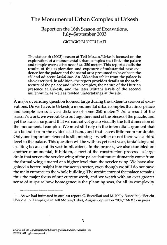
The palace remained in use for only about a century, and after it was abandoneda series of settlements followed each other above its ruins. At first, from about2100 B.C., there was mostly a type of scattered occupation that developed infunction of a residential settlement further to the north and the east (phase 4).Architectural remains for this phase are minimal at this stage of the excavations,but we do have some interesting objects. One is a necklace of small beads(AI5.260, see Fig. 12a), consisting of tiny white stone beads made of a softbluish-white material, probably frit, a central lapis lazuli bead spacer with twoholes, which would have separated both strands and kept them in place, andthree tiny gold beads (there must originally have been four). While both tubularholes are evident on the reverse of the lapis bead and can be clearly distinguished, the obverse was undivided so that the bead was square on the frontand decorated with concentric circles. Another piece of jewelry is a small bonependant (A15.319, see Fig. 12b), very finely carved in spite of its diminutive size.It must have hung at the bottom of another necklace that also broke in antiquity.(lowe the description of these two objects to M. Kelly-Buccellati.)
24 GIORGIO BUCCELLATI
FIGS. 12a-12b
Necklace (A15.260) and pendant (A15.319). From the scattered occupation inthe period immediately following the abandonment of the palace.
(Photos G. Buccellati)
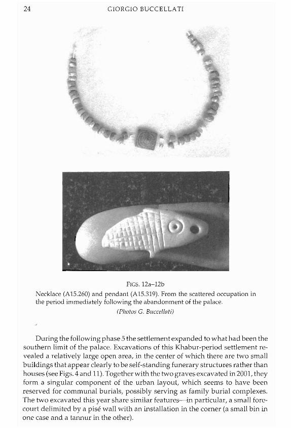
During the following phase 5 the settlement expanded to what had been thesouthern limit of the palace. Excavations of this Khabur-period settlement revealed a relatively large open area, in the center of which there are two smallbuildings that appear clearly to be self-standing funerary structures rather thanhouses (see Figs. 4 and 11). Together with the two graves excavated in 2001, theyform a singular component of the urban layout, which seems to have beenreserved for communal burials, possibly serving as family burial complexes.The two excavated this year share similar features-in particular, a small forecourt delimited by a pise wall with an installation in the corner (a small bin inone case and a tannur in the other).
THE MONUMENTAL URBAN COMPLEX AT URKESH 25
The structure on the west is a two-story building with a very small arched room at the base and another small room built as a second-story accessible through an external staircase of which only a little remains to the west. The floor of the second story is largely collapsed, and we have excavated only the top part, leaving in place the lower part of the remains. The second story of the northeast corner is still standing, and a small tannur is still visible at that level.
The structure on the east is a single-story building, but is also divided into two distinct areas, both rectangular and vaulted. Access to the outside is through one of the two chambers, fronting on a small forecourt bounded by a pis6 wall. Access to the back room was blocked, at which point the back wall of the front room was also rebuilt, resulting in a narrower front room. The new wall partly blocked the vaulted access to the back room.
Reviewing together the evidence for A16 (excavated in 2001) and A18, it appears that we have a common, if diversified, typology. We have three complexes, each consisting of two chambers--one vaulted and one not. Access to the vaulted one is blocked in each case. In one example, the bipartition results in a two-story structure. In two other cases, a small forecourt provides a special frame for the main doorway. In another, there are two tannurs (lower and upper story). The chambers are all very small, too much so to allow them to be considered as houses. In one case we have found a regular inhumation. In another, two fractured skulls were found, possibly washed down from one of the structures, and a partial sub-adult cranium and adult mandible were found in the doorway of yet another structure (I owe these details to L. Ramos, who was the supervisor of the excavations in this area).
It would appear as though these structures were meant as miniature houses for the dead, simulating the real houses inhabited by the living contemporaries. If so, this would be an extension, on the symbolic level, of the concept that is at the basis of all other burials, and for which we have a regular corresponding cliche in the literature: the dead needed food and drink, hence the presence of goblets and bowls as minimal inventory of the graves. Analogously, our buildings would show that the dead could also use a house. The almost eerie juxtaposition of a quarter reserved for the houses of the dead, on the one hand, and the houses for the living, on the other, would reinforce this symbolic symbiosis between the two realms. And so would the need to remain identi- fied physically with the remains: the fact that no human bones are found in some of these structures and that the doors were blocked suggests that the remains of the family ancestors were removed, perhaps when the settlement was abandoned.
The private houses of the Mittani period were slightly mQre important in this area than at other parts of the tell excavated so far. In particular, we have found a nice stone pavement (presumably a courtyard) in J1, and rather well preserved walls in the same area. It is also interesting to note (an observation first made by Laura Ramos) that the eastern section in A18 shows very pronounced slope upward toward the south, where, however, nothing is left of the strata to which the slope leads. It seems likely that these levels were re-

GIORGIO BUCCELLATI
Our conservation effort continued also within the lab in the expedition house. Beatrice Angeli, together with a student, joined us again from the Opifi- cio delle Pietre Dure, and through the support of a grant from the Kress Founda- tion we were able to afford special training to two graduate students.
The 2003 season was long and rich in other results as well. We report here briefly on some of the major projects that were undertaken besides excavations.
We are continuing the geo-physical survey of the outer city that was started two years ago by the DOG team. As in the past, this year's project was under the direction of Christian Hiibner and Stephan Giese. The results are of the utmost interest, because they confirm two major hypotheses that we had formulated in earlier years. The rise all along the outer perimeter seems to de- note, beyond doubt, a very large city wall. A continuous line indicates the presence of a stone structure that matches perfectly the rise shown by the topographic relief. The second major result of the survey is the confirmation of the presence of numerous structures within the walls. These appear as large stone foundation blocks, and/or as regular lines crossing at right angles that can be interpreted as houses.
An intensive study period by Drs. Maurizio Forte and Nicolh Dell'Unto resulted in a highly promising pilot project concerning virtual reality and a reconstruction of the paleo-environment. Work focused on the palace (with digital photo rendering), the objects (in particular, a cuneiform tablet, rendered three-dimensionally), and a broad and intensive analysis of the tell in its modern configuration with the ancient buildings. A joint paper on the research (M. Forte, N. Dell'Unto, F. Buccellati, "The Mozan/Urkesh archaeological pro- ject: an integrated approach of spatial technologies") was already presented at a conference held in Rome in November 2003. We plan to follow through in the coming years with a major effort in this direction.
Toward the end of the excavations, and just before the beginning of the study period, we were joined by Kenneth Garrett, the National Geographic photographer, who remained with us for ten days of very productive work and most enjoyable company. This was an important climax in our relationship with the Society, which has generously been supporting our work at Mozan for the last several years. Part of the work with Ken Garrett took place in the Museum of Der ez-Zor, where we went to take pictures of the best objects from previous years. We also took this opportunity to document with digital photo- graphy a large number of objects for which we had only regular slides and black-and-white photographs. This year, we also completed the transfer to the Museum of the bulk of objects from earlier seasons that were still in Mozan. Upwfard of 3000 items have now been documented and transferred.


STUDIES ON THE CIVILIZATION
AND CULTURE OF
NUZI AND THE HURRIANS
Volume 15
GENERAL STUDIES AND EXCAVATIONS AT NUZI 11 / 1
Edited by David I. Owen
and Gernot Wilhelm
CDL Press Bethesda, Maryland
2005

O 2005. All rights reserved. This book may not be reproduced, in whole or in part, in any form (beyond that copying permitted by Sections 107 and 108 of the U. S. Copyright Law and except by reviewers for the public press), without written permission from the publisher.
Published by CDL Press, P.O. Box 34454, Bethesda, MD 20827; E-Mail: [email protected]; website: www.cdlpress.com; Fax: 253-484-5542
ISBN 1-883053-897
General Studies and excavations at Nuzi 11/1 / edited by David I. Owen and Gernot Wilhelm.
p. cm. - - (Studies on the civilization and culture of Nuzi and the Hurrians ; v. 15)
Includes bibliographical references and index. ISBN 1-883053-89-7
1. Nuzi (Extinct city) 2. Excavations (Archaeology)- Iraq- -Nuzi (Extinct city) I. Owen, David I. 11. Wilhelm, Gernot. 111. Series.

The Publication of Volume 15 of Studies on the Civilization and Culture of Nuzi and the Hurrians
was made possible by a generous subvention by
Charles ("Chuck") Mund, '51 and Carol Winter Mund, '52 devoted Cornell University alumni
and The Occasional Publication Fund of
the Department of Near Eastern Studies Cornell University, Ithaca, New York.

The excavations at Tel Mozan and the subsequent identification of the site with Urkesh have provided the earliest attestations for the Hurrians. Indeed the emergence of a Hurrian dynasty at Urkesh during the Sargonic period and the associated material remains of their palaces, cultic structures and artistic style as described by the Buccellatis below, allow us to better understand the evolution of Hurrian civilization previous known primarily from second millennium sources. Furthermore, the excavation of a Mittani era tablet at Umm el-Marra published here by Cooper, Schwartz and Wes tbrook adds to a growing number of texts emerging from sites under strong Hurrian cultural influence. The report by Richter on the text discoveries at Qatna further confirms the presence and strong influence of the Hurrians in southern Syria in the late Bronze Age. The contribution by Widell on seeding and plowing practices and Negri Scafa demonstrate again how Nuzi continues to provide the major documentation for the Hurrians as its excavated texts yield more insights into the language and customs of this community. The article on the use of bricks demonstrates the fruitful joint effort of a philologist, Lion, and an archaeologist, Sauvage. Additional studies by Roseler and Wilhelm on the meaning of certain Hurrian terms each provides important new details on Hurrian practices and further expands our knowledge of their rich culture. These and other contributions to this volume continue to reflect the importance of Hurrian studies in general and Nuzi studies in particular.
"Nuzi Notes," such as those contributed here by Lion and Koliliski, provide the vehicle for important, brief communications, additions and corrections relating to previously published texts.
The "Excavations at Nuzi" series continues at the hand of Barbara Spering (Wiirzburg) as EN 11/1 1-60. The goal is to catalogue and copy the remaining unpublished Nuzi texts and fragments in the Harvard Semitic Museum. As with the preceding EN 10/1-3 by Jeanette Fincke, future volumes will contain additional contributions until all remaining significant tablets and fragments are published. Eventually all the Nuzi texts and fragments will be available in transliteration via an internet site now being developed.
The prompt publication of this volume was made possible thanks to the generous subventions provided by two devoted Cornell University alumni,

vi PREFACE
Charles ("Chuck") Mund, '51 and his wife, Carol Winter Mund, '52 and the Cornell University Department of Near Eastern Studies, Occasional Publi- cation Fund. We are most grateful for their interest in and support of this series.
Appearing at the same time is SCCNH 16, Maynard P. Maidman's The Nuzi Texts of the Oriental Institute: A Catalogue Raisonne'. This volume provides a definitive catalogue of all the tablets and fragments excavated at Nuzi that have been or still are housed at the Oriental Institute in Chicago.
* * * The editors will be pleased to consider articles submitted on historical, philological, archaeological and art historical topics relating to the general topics of Nuzi, Hurrians, Hurrian and Hurro-Akkadian, Hurro-Hittite and Urartian in their widest chronological and geographical contexts. In addition, book-length manuscripts will be considered for publication. Accompanying photos must be printed on gloss paper and clearly labeled. Charts and line drawings should be made so that they can be accommodated in the format size of this volume. Alternatively photographs and drawings may be submitted on CD/DVD in high resolution suitable for printing. Manuscripts from Europe should be sent directly to Professor Gernot Wilhelm, Institut fur Altertums- wissenschaften, Lehrstuhl fur Altorientalistik, Universitat Wurzburg, Ludwig- straf3e 6, D-97070 Wurzburg, Germany. Those from North America and Asia should be sent to Professor David I. Owen, Near Eastern Studies, White Hall 409, Cornell University, Ithaca, NY 14853-7901 USA. Inquiries may also be made by electronic mail to [email protected]; by facsimile to (USA) 607-255- 6450 or [email protected]; facsimile (Germany) 049-931-31-26-74. Manuscripts should be submitted in electronic form (IBM or MAC format) with the name and version of the word processor accompanied by a printed copy made on a laser or equivalent printer. A brief abstract should accompany the article. Abbreviations and footnotes must conform to the style reflected in the series. Contributors will be provided with a free volume. Volume 17 will be considered until March 15,2006 for publication later that year.
Studies on the Civilization and Culture of Nuzi and the Hurrians (SCCNH), volulines 1-5 (and following), may be obtained directly from Eisenbrauns, POB 275, Winona Lake, IN 46590 USA, e-mail orders@eisenbra~~ns.com; website www.eisenbrauns.com. Volumes 6-16 and following may be obtained directly from CDL Press, P. 0 . Box 34454, Bethesda, MD 20827 USA; fax: 253-484-5542; e-mail: [email protected]; website: www.cdlpress.com; or from your book- seller.
David I. Owen & Gernot Wilhelm
Ithaca and Wiirzburg February, 2005

Preface ......................................................................................................................... v
Part I: General Studies
Giorgio Buccellati, "The Monumental Urban Complex at Urkesh" ........................................ 3
Marilyn Kelly-Buccellati, "Urkesh and the North: Recent Discoveries" ........................................ 29
Jerrold Cooper, Glenn Schwartz, and Raymond Westbrook, "A Mittani-Era Tablet from Umm el-Marra" ........................................... 41
Margarit L. Khachikyan "On the Origin and Evolution of the Particle -ne in Hurrian" ......... :... 187
Brigitte Lion and Martin Sauvage, "Les Textes de Nuzi Relatifs aux Briques" ........................................ 57
Aicha Rahmouni, "The Term prz in Ugaritic-Hurrian Texts: A Possible Ugaritic-Hurrian 'Epithet Component"' ............................ 101
Thomas Richter, "Qawa in the Late Bronze Age: Preliminary Remarks" ...................... 109
Ingeborg Roseler, "Zu den hurritischen Begriffenfirubatbe und alubafbe in Texten aus Nuzi" ............................................................ 127
Paola Negri Scafa, "Documents from the Buildings North of the Nuzi Temple: The 'Signed' Texts from Square C" ......................................................... 133
vii

. . . vlll CONTENTS
Helga Schneider-Ludorff, "takulatbu 'Lampenstander, Kandelaber"' ........................................ 161
Magnus Widell, "Seeding and Plowing Practices at Nuzi" ........................................ 169
Gernot Wilhelm, 'fsradi 'auswartiger Gast,'fsrados'be 'Gastehaus'" ........ ....... . ........ ......... 175
Gernot Wilhelm, "Zum Hurritischen in Ekalte" ................................................................. 185
Part 11: Nuzi Notes, 67-69
Rafai Kolitiski, "The Archives of Tell FaNar Revisited" .............................. 195
Brigitte Lion, "Deux copies d'une meme tablette: HSS 5 48 (= SMN 1348) = EN 9/3 499 (= SMN 3722)" ......................... 199
Brigitte Lion, "HSS 16 326 (= SMN 3505) = EN 9/3 284 (= SMN 3157)?" .................. 200
Part I11
Barbara Spering, "Excavations at Nuzi 11/1, 1-60" ....................................... 203
Part IV
D.I. Owen and G. Wilhelm, "Lexical Index" .................................................... 255