the modelling the flow of the mekong booklet is part of an information series on ibfm research and...
TRANSCRIPT

MRC Management Information booklet series No. 3
The Modelling the flow of the Mekong
November 2009
Meeting the needs, keeping the balance
Modelling the flow of the Mekong
MRC Management Information Booklet Series No.32
INTRODUCTION
Integrated Basin Flow Management (IBFM) activities at the Mekong River Commission (MRC) are designed to provide information to decision makers on the potential impacts of water resources development in the Lower Mekong Basin.
The basin’s foreseeable water resource development projects involve altering the flow of the river in one way or another. This booklet is part of an information series on IBFM research and findings. It focuses on the practical tools used in IBFM to model, or forecast, the hydrological and hydraulic changes caused by these modifications. The booklet firstly examines how the models draw on a variety of physical, meteorological and biological data to develop an understanding of the hydrology and hydraulics of the Mekong River System and then how the models are used to make predictions. It illustrates the modelling process with three examples of modifications to the flow regime brought about by hypothetical, but possible development increases in hydropower and increased abstractions for irrigated agriculture.
The models are used to evaluate how the physical character of the river, the extent to which amounts of water present in its channels, floodplains and delta will change as a result of modifications to flow. Physical changes will in turn alter the biology and ecology of the river system and impact the people who depend on these resources for their livelihoods and way of life. These impacts are the subjects of other information booklets in this series.
MODELLING THE FLOW OF THE MEKONG
A model is a simplified description of a complex system that has many connected and interacting components. Models of river basins have been used for more than 50 years in river management. Models are used to understand how the river system works and predict how it will react if one or more of its components are modified or even removed. Models can be small-scale physical representations of the system under investigation. For example, wind tunnels were once used to study the aerodynamics of aeroplanes. These used a scaled down physical replica of the plane and a large fan to model the flow of air across the wings and fuselage. Nowadays, computers have mostly replaced the physical replicas. Systems are now described mathematically and their behaviours are simulated using sophisticated computer programmes. The tremendous power of modern computers means that even very complex systems, such as the Mekong River system, or even much more complex systems, such as entire earth’s atmosphere, can be described in great detail and their possible future behaviour simulated very rapidly.
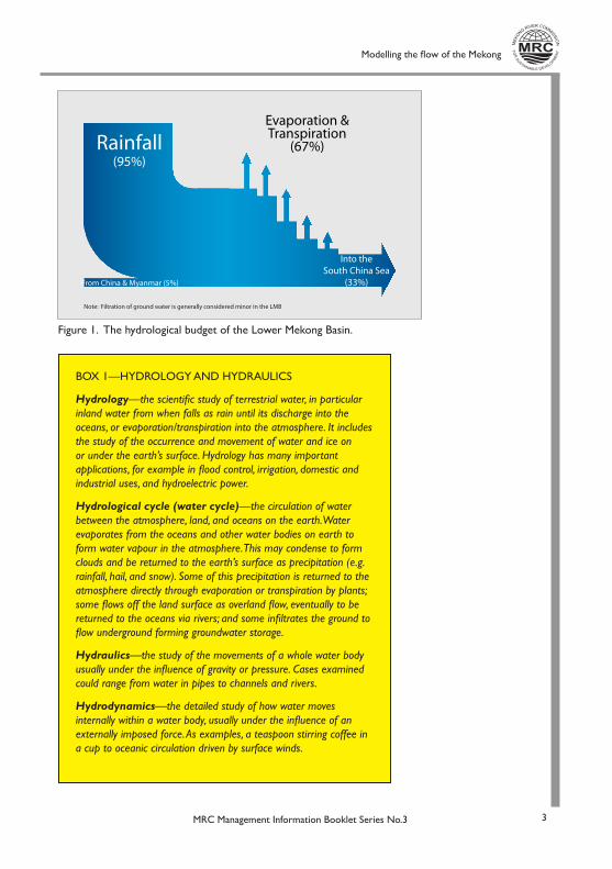
The MRC has developed in-house software designed to model the hydrologic and the hydraulic characteristics of the lower Mekong River system (see Box 1). The hydrologic component of the software models water moving through the hydrological cycle. The amount of water leaving the basin must balance the amount of water entering it. Most of the water comes into the lower Mekong River system as rain (the rivers of the Upper Mekong Basin contribute only a small fraction) and returns directly to the atmosphere through evaporation or by transpiration from plants. Only a third finds its way to the South China Sea through the Mekong and its tributaries. (Figure 1)1
The information needed to model this cycle comes from:
• metrological stations scattered across the Lower Mekong Basin that provide comprehensive rainfall and temperature records dating back to 1985;
Modelling the flow of the Mekong
MRC Management Information Booklet Series No.3 3
Figure 1. The hydrological budget of the Lower Mekong Basin.
Rainfall(95%)
From China & Myanmar (5%)
Into the South China Sea
(33%)
Evaporation &Transpiration
(67%)
Note: Filtration of ground water is generally considered minor in the LMB
BOX 1—HYDROLOGY AND HYDRAULICS
Hydrology—the scientific study of terrestrial water, in particular inland water from when falls as rain until its discharge into the oceans, or evaporation/transpiration into the atmosphere. It includes the study of the occurrence and movement of water and ice on or under the earth’s surface. Hydrology has many important applications, for example in flood control, irrigation, domestic and industrial uses, and hydroelectric power.
Hydrological cycle (water cycle)—the circulation of water between the atmosphere, land, and oceans on the earth. Water evaporates from the oceans and other water bodies on earth to form water vapour in the atmosphere. This may condense to form clouds and be returned to the earth’s surface as precipitation (e.g. rainfall, hail, and snow). Some of this precipitation is returned to the atmosphere directly through evaporation or transpiration by plants; some flows off the land surface as overland flow, eventually to be returned to the oceans via rivers; and some infiltrates the ground to flow underground forming groundwater storage.
Hydraulics—the study of the movements of a whole water body usually under the influence of gravity or pressure. Cases examined could range from water in pipes to channels and rivers.
Hydrodynamics —the detailed study of how water moves internally within a water body, usually under the influence of an externally imposed force. As examples, a teaspoon stirring coffee in a cup to oceanic circulation driven by surface winds.
Modelling the flow of the Mekong
MRC Management Information Booklet Series No.34
• gauges in the river at Chiang Sean in northern Thailand that measure the flow from the Upper Mekong Basin;
• digital maps of topography, vegetation and land use;
• a series of hydrographic atlases held at the MRC that provide details of the depth, geometry and morphology of the mainstream channel along the entire length of the Mekong from northern Thailand to the Mekong Delta, including the Tonle Sap system.
The hydrological model uses measured rainfalls and flows for calibration and, once it has the relationship between the two satisfactorily defined, can calculate how much water enters the Mekong River or any of its tablatures at any place using only rainfall data. The hydrological model can be tested further by inputting rainfall data not used in the original calibration and checking if this produces flows that the match data from gauge stations.
The hydraulic component of the software takes the information on the amount and seasonal variations of water entering the river and tributaries provided by the hydrological component. The hydraulic model determines where the water moves to and with what force. This is a much more complex calculation, but, as with the hydrological component, the output can be validated against current and historical data. The hydraulic component is particularly important in modelling the flow in the Tonle Sap-Great Lake and the Delta systems where the timing, duration, depth and geographic extent of the annual flood is critical.
Having established the model as a fair representation of the flows in the LMB, it is then possible to change any of the input parameters to see how the hydrology and hydraulics of the system will change. For example:
THE EFFECTS OF CLIMATE CHANGE CAN BE SIMULATED BY ALTERING THE RAINFALL, EVAPORATION, TEMPERATURE AND VEGETATION DATA;
• the impact of developments in the Upper Mekong Basin can be modelled by changing the amount of water entering the system at Chiang Saen;
• the changes caused by hydropower and irrigation developments on the Mekong’s tributaries can be forecast by changing the timing and duration of the seasonal variation of flow—hydropower dams usually impound water during the wet season and release it during the dry season.
LIMITATIONS
A model is only as good as the data that goes into it. Fortunately, in recent decades the MRC has accumulated a large database of hydrological and meteorological records from throughout the Lower Mekong Basin1, allowing reasonably reliable input into the simulation. Still, as with all models, the output carries a degree of uncertainty. (This arises partly from some inaccuracy in the input data, partly from possible errors within the model, and partly from assumptions and limitations of the model.) This uncertainty is greatest where the river system is most complex, for example in the Mekong Delta.
Modelling the flow of the Mekong
MRC Management Information Booklet Series No.3 5
For these reasons, while the broad nature and direction of flow changes (increases or decreases during different seasons and at different locations) is reliable, the timing and magnitude of the predicted changes are uncertain.
More data, better records, improved modelling packages and a clearer definition of development projects and schemes, will generate outputs that are increasingly more accurate.
MODELLED FLOW REGIMES
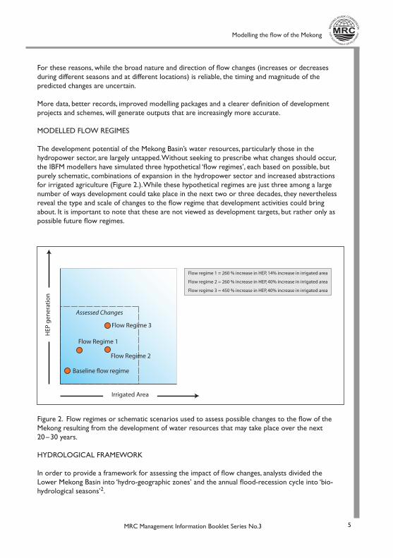
The development potential of the Mekong Basin’s water resources, particularly those in the hydropower sector, are largely untapped. Without seeking to prescribe what changes should occur, the IBFM modellers have simulated three hypothetical ‘flow regimes’, each based on possible, but purely schematic, combinations of expansion in the hydropower sector and increased abstractions for irrigated agriculture (Figure 2.). While these hypothetical regimes are just three among a large number of ways development could take place in the next two or three decades, they nevertheless reveal the type and scale of changes to the flow regime that development activities could bring about. It is important to note that these are not viewed as development targets, but rather only as possible future flow regimes.
Figure 2. Flow regimes or schematic scenarios used to assess possible changes to the flow of the Mekong resulting from the development of water resources that may take place over the next 20 – 30 years.
HYDROLOGICAL FRAMEWORK
In order to provide a framework for assessing the impact of flow changes, analysts divided the Lower Mekong Basin into ‘hydro-geographic zones’ and the annual flood-recession cycle into ‘bio-hydrological seasons’2.
Flow Regime 3
Flow Regime 2
Flow Regime 1
Baseline flow regime
Assessed Changes
HEP
gen
erat
ion
Irrigated Area
Flow regime 1 = 260 % increase in HEP, 14% increase in irrigated area
Flow regime 3 = 450 % increase in HEP, 40% increase in irrigated area
Flow regime 2 = 260 % increase in HEP, 40% increase in irrigated area
Modelling the flow of the Mekong
MRC Management Information Booklet Series No.36
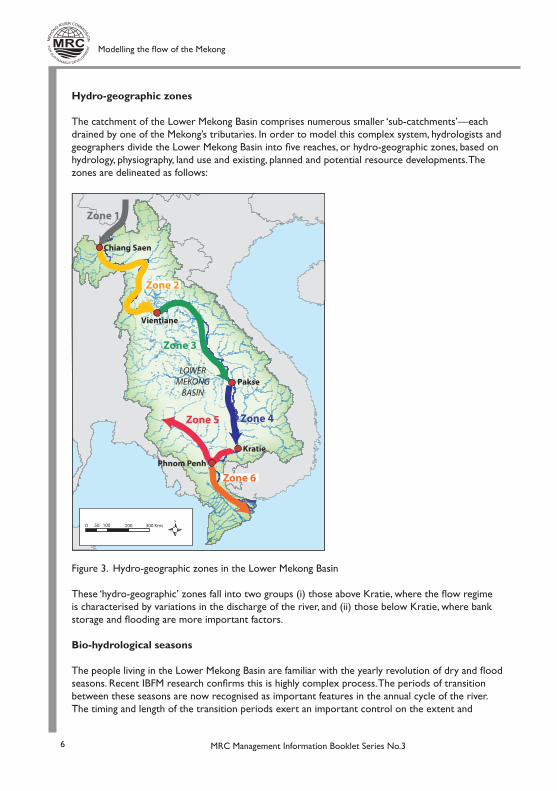
Hydro-geographic zones
The catchment of the Lower Mekong Basin comprises numerous smaller ‘sub-catchments’—each drained by one of the Mekong’s tributaries. In order to model this complex system, hydrologists and geographers divide the Lower Mekong Basin into five reaches, or hydro-geographic zones, based on hydrology, physiography, land use and existing, planned and potential resource developments. The zones are delineated as follows:
Figure 3. Hydro-geographic zones in the Lower Mekong Basin
These ‘hydro-geographic’ zones fall into two groups (i) those above Kratie, where the flow regime is characterised by variations in the discharge of the river, and (ii) those below Kratie, where bank storage and flooding are more important factors.
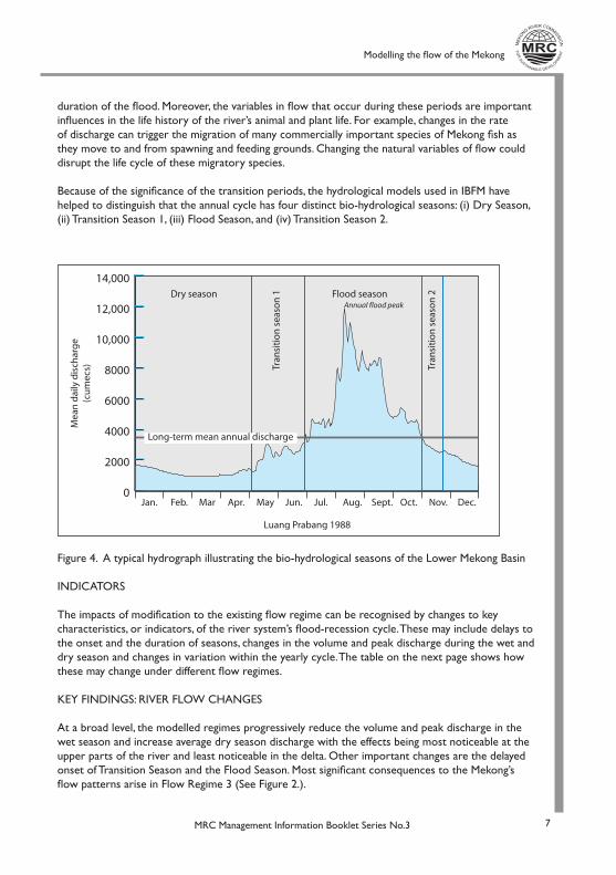
Bio-hydrological seasons
The people living in the Lower Mekong Basin are familiar with the yearly revolution of dry and flood seasons. Recent IBFM research confirms this is highly complex process. The periods of transition between these seasons are now recognised as important features in the annual cycle of the river. The timing and length of the transition periods exert an important control on the extent and
0 50 100 200 300 Kms
Chiang Saen
Zone 3
Zone 4Zone 5
Zone 6
Vientiane
Pakse
Kratie
Phnom Penh
Zone 1
Zone 2
LOWER MEKONG
BASIN
Modelling the flow of the Mekong
MRC Management Information Booklet Series No.3 7
duration of the flood. Moreover, the variables in flow that occur during these periods are important influences in the life history of the river’s animal and plant life. For example, changes in the rate of discharge can trigger the migration of many commercially important species of Mekong fish as they move to and from spawning and feeding grounds. Changing the natural variables of flow could disrupt the life cycle of these migratory species.
Because of the significance of the transition periods, the hydrological models used in IBFM have helped to distinguish that the annual cycle has four distinct bio-hydrological seasons: (i) Dry Season, (ii) Transition Season 1, (iii) Flood Season, and (iv) Transition Season 2.
Figure 4. A typical hydrograph illustrating the bio-hydrological seasons of the Lower Mekong Basin
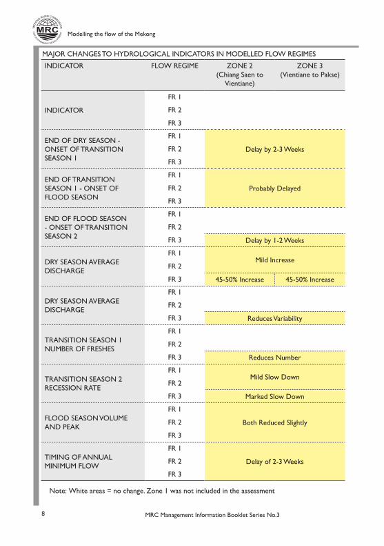
INDICATORS
The impacts of modification to the existing flow regime can be recognised by changes to key characteristics, or indicators, of the river system’s flood-recession cycle. These may include delays to the onset and the duration of seasons, changes in the volume and peak discharge during the wet and dry season and changes in variation within the yearly cycle. The table on the next page shows how these may change under different flow regimes.
KEY FINDINGS: RIVER FLOW CHANGES
At a broad level, the modelled regimes progressively reduce the volume and peak discharge in the wet season and increase average dry season discharge with the effects being most noticeable at the upper parts of the river and least noticeable in the delta. Other important changes are the delayed onset of Transition Season and the Flood Season. Most significant consequences to the Mekong’s flow patterns arise in Flow Regime 3 (See Figure 2.).
0
2000
4000
6000
8000
10,000
12,000
14,000
Jan. Feb. Mar Apr. May Jun. Jul. Aug. Sept. Oct. Nov. Dec.
Dry season
Tran
siti
on
sea
son
1
Tran
siti
on
sea
son
2Flood season
Mea
n d
aily
dis
char
ge
(cu
mec
s)
Luang Prabang 1988
Annual flood peak
Long-term mean annual discharge
Modelling the flow of the Mekong
MRC Management Information Booklet Series No.38
INDICATOR FLOW REGIME ZONE 2(Chiang Saen to
Vientiane)
ZONE 3(Vientiane to Pakse)
INDICATOR
FR 1
FR 2
FR 3
END OF DRY SEASON - ONSET OF TRANSITION SEASON 1
FR 1
Delay by 2-3 WeeksFR 2
FR 3
END OF TRANSITION SEASON 1 - ONSET OF FLOOD SEASON
FR 1
Probably DelayedFR 2
FR 3
END OF FLOOD SEASON - ONSET OF TRANSITION SEASON 2
FR 1
FR 2
FR 3 Delay by 1-2 Weeks
DRY SEASON AVERAGE DISCHARGE
FR 1Mild Increase
FR 2
FR 3 45-50% Increase 45-50% Increase
DRY SEASON AVERAGE DISCHARGE
FR 1
FR 2
FR 3 Reduces Variability
TRANSITION SEASON 1 NUMBER OF FRESHES
FR 1
FR 2
FR 3 Reduces Number
TRANSITION SEASON 2 RECESSION RATE
FR 1Mild Slow Down
FR 2
FR 3 Marked Slow Down
FLOOD SEASON VOLUME AND PEAK
FR 1
Both Reduced SlightlyFR 2
FR 3
TIMING OF ANNUAL MINIMUM FLOW
FR 1
Delay of 2-3 WeeksFR 2
FR 3
MAJOR CHANGES TO HYDROLOGICAL INDICATORS IN MODELLED FLOW REGIMES
Note: White areas = no change. Zone 1 was not included in the assessment

Modelling the flow of the Mekong
MRC Management Information Booklet Series No.3 9
ZONE 4(Pakse to Kratie)
ZONE 5(Kratie to Phnom
Penh)
ZONE 6(Delta)
INDICATOR
INDICATOR
END OF DRY SEASON - ONSET OF TRANSITION SEASON 1
Probably DelayedEND OF TRANSITION SEASON 1 - ONSET OF FLOOD SEASON
END OF FLOOD SEASON - ONSET OF TRANSITION SEASON 2
Mild Increase20-35% Increase
DRY SEASON AVERAGE DISCHARGE
35% Increase 20-35% Increase 20-35% Increase
DRY SEASON AVERAGE DISCHARGE
TRANSITION SEASON 1 NUMBER OF FRESHES
TRANSITION SEASON 2 RECESSION RATE
Both Reduced Slightly
Volume Reduced Slightly
FLOOD SEASON VOLUME AND PEAK
Delay of 1 WeekTIMING OF ANNUAL MINIMUM FLOWEarlier by 2-4 Weeks

Modelling the flow of the Mekong
MRC Management Information Booklet Series No.310
Increased dry season flows
• Permanent inundation in all zones of low-lying riverbank areas that presently become exposed during the dry season.
• A proportion of the floodplain areas that presently dry out each dry season would become permanently inundated. This would affect all zones where floodplains exist but most importantly on the Cambodian floodplains in Zone 4, where small increases in water levels would inundate large areas due to the very flat terrain. Dry-season water levels could increase by 0.2 m - 0.9 m or more, permanently inundating up to an additional 1,100 km2 of land around the Tonle Sap-Great Lake system. This would result in a significant loss of the seasonal floodplain and flooded forest surrounding the lake.3
• Low- lying rocky islands in the channel in Zones 1, 2 and 3 will be partially or completely inundated by higher dry-season flows, causing many to permanently disappear, threatening the potential loss of certain unique types of vegetation.
• Saline intrusion into the Mekong Delta (Zone 5) will decrease with flow regimes that increase dry-season flows.
Delayed starts to Transition Season 1 and the Flood Season
• The delayed onset of the wet seasons would reduce the duration of the wet season as the onset of the dry season is largely unchanged. This, combined with the reduced flood season flows, would reduce the extent and duration of the inundation of the floodplains and contribute to bank erosion and infilling of deep pools.
Progressive reduction in flood-season flows
• A reduction in the extent and duration of floodplain flooding. Among the direct impacts would be a 10% reduction in inundated area due to a decrease in flood peaks. Linked to this would be the predicted increase in dry-season flows and a related increase in the dry-season Great Lake area of up to 45%.
• Lower flood peaks reduce the capacity of the river to carry sediment. This, combined with reduced sediment supply caused by dams, may change the nature of channels in the river system. Where the river splits into several channels, such as in Zone 3, the slower water will cause deposition of sediment potentially resulting in blocking and eventually infilling of channels. Another effect of these combined factors will be to increase bank erosion in Zone 2 (and Zones 3 and 4 to a lesser extent) as the system of river meanders is modified. However, there may be a decrease in bank erosion in Zone 5, where reduced discharge in the wet season may more than compensate for increased dry season flow.
• Reduced connectivity between the Tonle Sap River and its floodplain due to delays in the onset of the flood season and to lower flood peaks.
• Increased sedimentation and reduced scouring of deep pools, reducing their depth through infill.

Modelling the flow of the Mekong
MRC Management Information Booklet Series No.3 11
END NOTES
1. Further details of the hydrology of the Mekong River System can be found in the MRC publication An Overview of the Hydrology of the Mekong Basin and the preceding booklet in MRC Information Booklet No. 2: The flow of the Mekong.
2. Definitions of the hydro-geographic zones and bio-hydrological seasons can be found in MRC Information Booklet No. 2: The flow of the Mekong.
3. Under Flow Regime 3 the permanent area of the Great Lake will increase by 1,100 km2.
Permanent Lake
Average flooded area
Increased area of permanent lake under FR3
Kilometres0 50
Great Lake, Cambodia
FUTURE DIRECTION
The examples used in this booklet represent a small subset of the possible flow changes that may happen in the future. The development of IBFM will involve building a database that holds information on a variety of modifications to the flow regime and the resulting changes to the hydrology, hydraulics and physical characteristics of the Mekong River Basin. The database, which will be structured around the Hydro-geographic Zones and the Bio-hydrological seasons, will also store information on what these changes will mean to the animal and plant life of the basin and the lives of the people who depend on these resources. The aim is to cross-check any simulated future flow changes against the information held in the database to assess their possible impacts.
Printed by the MRC Secretariat – September 2009Series editor Dr Tim BurnhillMekong River Commission
P.O. Box 6101, 184 Fa Ngoum Road, Unit 18, Ban Sithane NeuaSikhottabong District, Vientiane 01000 Lao PDR
Telephone: (856) 21 263 263 Facsimile: (856) 21 263 264E-mail [email protected] Website www.mrcmekong.org
Other publications available in this series:
MRC Management Information Booklet No.1: Adaptation to climate change in the countries of the Lower Mekong Basin
MRC Management Information Booklet No.2: The flow of the Mekong