the land information system - prhouser.com · uses topmodel concepts to model groundwater ......
TRANSCRIPT
The Land Information Systemhttp://lis.gsfc.nasa.gov
P. Houser (GMU/CREW, formerly NASA/GSFC-614.3)C. Peters-Lidard (NASA/GSFC-614.3)
S. Kumar (UMBC)Y. Tian (UMBC)
J. Geiger (NASA/GSFC-587)L. Lighty (NASA/GSFC-587)S. Olden (NASA/GSFC-586)
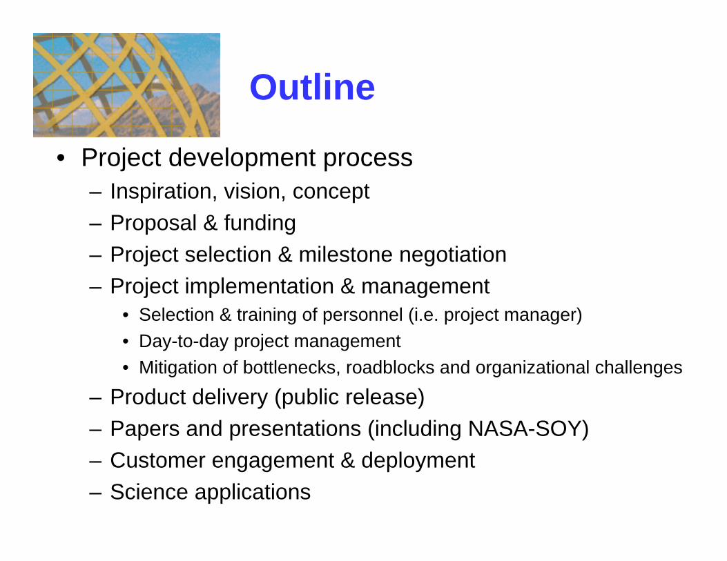
• Project development process– Inspiration, vision, concept– Proposal & funding– Project selection & milestone negotiation– Project implementation & management
• Selection & training of personnel (i.e. project manager)• Day-to-day project management• Mitigation of bottlenecks, roadblocks and organizational challenges
– Product delivery (public release)– Papers and presentations (including NASA-SOY)– Customer engagement & deployment– Science applications
Outline

Background & Vision
•• Knowledge of land surface water, energy, and carbon conditions are of critical importance to real-world applications (agriculture, water management, and flood/drought prediction)
• Preliminary 25km Land Data Assimilation System (LDAS) integrates remotely-sensed and model-derived land surface data in a data assimilation framework.
• However, to fully address the land surface research and application problems, this system must be implemented globally at very high resolution (1km), and these predictions must be made transparently available to end users.
LIS components:(1) A high-resolution (1km) Global Land Data Assimilation System, with several land surface models,
data assimilation technologies, and integrated database operations (500X+ increase). (2) A web-based user interface that accesses data mining, numerical modeling, and visualization tools. (3) A portable system for download together with a small database to a independent system for use in
smaller applications, or used on a centralized server for large applications. (4) LIS will define land surface modeling and assimilation standards (i.e. the Earth System Modeling
Framework (ESMF)).

LLand and DData ata AAssimilation ssimilation SSystemsystems: : MotivationMotivation
Quantification and prediction of land surface variability Quantification and prediction of land surface variability •Surface temperature, soil moisture, and snow, significantly influence Earth system processes and predictability at multiple scales•Improved knowledge of land conditions will promote better land resource management, natural hazard mitigation, and homeland security
Maturing of land surface observation and prediction tools:Maturing of land surface observation and prediction tools:•Observation: Forcing, storages(states), fluxes, and parameters. •Simulation: Land process models (Hydrology, Biogeochemistry, etc.). •Assimilation: Short-term state constraints.
““LDASLDAS”” concept: concept: Bring state-of-the-art tools together to operationally obtain high quality land
surface conditions and fluxes.
Critical Application
4DDA Value-Added Products
Model PhysicsAncillary Data
DroughtFlood
Frozen

Input - Output = Storage ChangeP + Gin –(Q + ET + Gout) = ΔSRn - G = Le + H
Background: Background: Land Surface ModelingLand Surface Modeling
Overland Flow
Subsurface Flow
Total Flow
ET and Precip
Infiltration
Source Area
Soil
Canopy
rsoil
rararc
rdrsurf
rplant
EH
ea
e*(Ts)MPr
ABL
Mosaic (Koster, 1996):Based on simple SiB physics.Subgrid scale "mosaic"
CLM (Community Land Model, ~2003): Community developed “open-source” model.10 soil layers, 5 layer snow scheme.
Catchment Model (Koster et al., 2003): Models in catchment space rather than on grids.Uses Topmodel concepts to model groundwater
NOAA-NCEP-Noah Model (NCEP, ~2004): Operational Land Surface model.
BARE SOIL: 15%
10%
GRASSLAND:50%
SHRUBS:
NEEDLELEAFTREES: 25%
Also: vic, bucket, SiB, etc.
Land Surface Prediction: Accurate land model prediction is essential to enable data assimilation methods to propagate or extend scarce observations in time and space. Based on water and energy balance.

Land Surface ObservationLand Surface Observation
Forcing•Precipitation•Wind•Humidity•Radiation•Air Temperature
States•Soil Moisture•Temperature•Snow•Carbon•Nitrogen•Biomass
Fluxes•Evapotranspiration•Sensible Heat Flux•Radiation•Runoff•Drainage
Calibration
Off-line LDAS
Validation
AssimilationParameters
•Soil Properties•Vegetation Properties•Elevation & Topography•Subgrid Variation•Catchment Delineation•River Connectivity
Soil MoistureSnow, Ice, Rainfall Snow
VegetationRadiation forcing
Soil MoistureSnow, Ice, Rainfall Snow
VegetationRadiation forcing

Class Observation Technique Example Platform Temporal Spatial Leaf area and greenness optical/IR AVHRR, MODIS, NPOESS weekly 1km Albedo optical/IR MODIS, NPOESS weekly 1km Emissivity optical/IR MODIS, NPOESS weekly 1km Vegetation structure lidar ICESAT, ESSP lidar mission weekly-monthly 100m
Land Parameters
Topography in-situ survey, radar GTOPO30, SRTM episodic 30m–1km Wind profile radar Air Humidity and temperature IR, MW TOVS, GOES, AVHRR, MODIS, AMSR hourly-weekly 5 km Near- surface radiation optical/IR GOES, MODIS, CERES, ERBS, etc. hourly-weekly 1km
Land Forcings
Precipitation microwave/IR TRMM, GPM, SSMI, GEO-IR, etc. hourly-monthly 10km Temperature IR, in-situ IR-GEO, MODIS, AVHRR, TOVS hourly-monthly 10m-4km Thermal anomalies IR, NIR, optical AVHRR, MODIS, TRMM daily-weekly 250m–1km Snow cover and water optical, microwave SSMI, TM, MODIS, AMSR, AVHRR, etc. weekly-monthly 1km Freeze/thaw radar Quickscat, HYDROS, IceSAT, CryoSAT weekly 3km Total water storage gravity GRACE monthly 1000km
Land States
Soil moisture active/passive microwave SSMI, AMSR, HYDROS, SMOS, etc. 3-30 day 10-100 km Evapotranspiration optical/IR, in-situ MODIS, GOES hourly-weekly 10m-4km Solar radiation optical, IR MODIS, GOES, CERES, ERBS hourly-monthly Longwave radiation optical, IR MODIS, GOES hourly-monthly 10m-4km
Land Fluxes
Sensible heat flux IR MODIS, ASTER, GOES hourly-monthly 10m-4km
The availability of new observations strongly motivates advances in
understanding, prediction, and application.

Land Surface Land Surface DData ata AAssimilationssimilation
Data Assimilation merges observations & model predictions to provide a superior state estimate.
Hydrologic State or storage observations (temperature, snow, moisture) are integrated with models.
∂∂
xt dynamics physics x= + +Δ
Data Assimilation Methods: Numerical tools to combine disparate information.
1. Direct Insertion, Updating, or Dynamic Initialization:
2. Newtonian Nudging:3. Optimal or Statistical Interpolation:4. Kalman Filtering: EKF & EnKF5. Variational Approaches - Adjoint:
Real Time Data Collection
Observations have error and are irregular in time and space
Irregular 3D Data Flow in Real Time
Data Assimilation ModelOptimally merges 3D array of observations with previous predictions
Interpolation in time and space
Model
Pred
iction
Model
Pred
iction
Model
Pred
iction
Model
Pred
iction
SVATS Model SVATS ModelSVATS Model
QualityControl
Obs Model4DDAImproved products,
predictions, understanding

Land Surface Data Assimilation SummaryLand Surface Data Assimilation Summary
Observation
Assimilation with Bias Correction
AssimilationNo Assimilation
SSM/I Snow ObservationSSM/I Snow Observation
∂∂
xt dynamics physics x= + +Δ
Soil Moisture AssimilationSoil Moisture Assimilation
Skin Temperature AssimilationSkin Temperature Assimilation
Snow Cover AssimilationSnow Cover Assimilation
Snow Water AssimilationSnow Water Assimilation
Theory DevelopmentTheory Development
Model Integration
DataInsertion of Data into the Model
Obs Model4DDAImproved products,
predictions, understanding

Observations Predicted: AMIP
Predicted: Scaled LDASPredicted: LDAS
1988 Midwestern U.S. Drought
(JJA precipitation anomalies, in mm/day)
10
-10
0
0.2
-0.2
0.5
-0.5
1.
-1.
3.
-3.
Withoutsoil moistureinitialization
With soil moisture
initialization
(Koster and Suarez, 2003)

Developing the Land Information System (LIS)

Land Information System: Land Information System: Determining Outstanding IssuesDetermining Outstanding Issues
Near-term Key to Success: End-to-end science, design, and software development plan. i.e. a plan that will be the core of land modeling development for the next decade.
-Generalized approach to handling subgrid-scale land processes: dynamic variability in vegetation, topography, soils, forcing, etc.
-Explicit design on how components link and work together: Land Driver, Models, Data, Grads, DODS, GUI, various platforms, clustering, ESMF.
Practical Needs: Known near-term issues-Eliminate ocean points from LDAS driver code-Interpolate from “Base” parameters and forcing (1/8 degree and 1km)-Decide on 1km projection scheme-Make 1-D land models and other major code components libraries-Parallelization issues (SGI, Linux, Cluster, IBM, etc.)-Standardize I/O protocol (i.e. ALMA and Grib)-Learn from existing state-of-the-art land code
(LDAS, NCAR)

Date
A) Software engineering plan completed Jun. 2002
E) Global LDAS Code baseline completed Jul. 2002
B) FY02 Annual Report Aug. 2002
H) Design policy for interoperability and community delivery Feb. 2003
F) First code improvement completed (LIS V1.0) Mar. 2003
I) Interoperability prototype tested (LIS V2.0) Jul. 2003
C) FY03 Annual Report Aug. 2003
G) Second code improvement completed (LIS V3.0) Feb. 2004
J) Full interoperability demonstrated using improved codes Jul. 2004
K) Customer delivery accomplished (LIS V4.0) Feb. 2005
D) Final Report delivered May. 2005
Land Information System: Land Information System: MilestoneMilestone--based Project Managementbased Project Management

Land Information System: Land Information System: Preliminary DesignPreliminary Design

• run control• HPCC• time• I/O• Utilities
• Start/stop• Task delegations • “Tiling”• miscellaneous tools
(runtime statistics, etc.)• Interlanguage support(C – Fortran)
• Timestepping• Calendar• Alarms
(ESMF tool-based)
• Generic routines• Input- GDS support
• Output - binary- grib- netcdf
• regridding• error logging- sequential/parallel modes
• dynamic memory management control
• Different modes of operation- mpi, GDS
• Domain decomposition• Parallel I/O with GDS• Fault tolerance• Grid Computing ready
LIS driver
Land Information System: Land Information System: Functional DesignFunctional Design
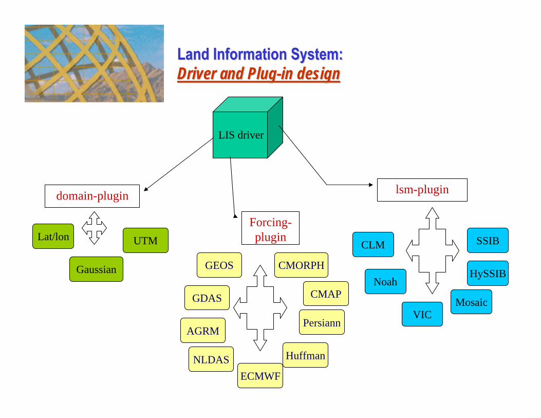
LIS driver
domain-plugin lsm-plugin
CLM
Noah
VICMosaic
HySSIB
SSIB
Forcing-pluginLat/lon
Gaussian
UTM
GEOS
GDAS
AGRM
NLDASECMWF
CMAP
Persiann
Huffman
CMORPH
Land Information System: Land Information System: Driver and PlugDriver and Plug--in designin design

GRIB dataNetCDF data
GrADS data
etc..
Result cache
holds temporary data (uploaded, generated by a previous operation, or transferred directly from another server) for use in remote analysis
GrADSbatch mode
interface code
DODS server libraries
performs analysis
operations
manages sessions, translates dataset
names
Java servlet
supports extended request types for analysis, upload
internet
DODS data and requests
Joe Wielgosz/COLA: 5/25/00
DODS client libraries
GrADS
Matlab
IDL
etc..data appears to client as local file, in a standard format (i.e, NetCDF, etc.)
Client
Encapsulated Analysis Requests
Land Information System: Land Information System: Data Flow DevelopmentData Flow Development

• LIS User’s Guide-How to install, run
• LIS Developer’s Guide-How to customize
•Public Software Engineering Documents (Quality)
•Sourceforge-based bug-tracking and help desk
Documentation and User Support

LIS implementation and management Challenges
Funding/Support:-Science playing in a HPCC/IT competition.
Selection & training of personnel-Attracting and hiring project manager (Peters-Lidard)-Attracting and hiring software engineers-Detailing expertise from support organizations-Training everyone, letting go
Day-to-day project management-Team meetings, reporting, goal setting, schedule, budget.
Mitigation of bottlenecks, roadblocks, organizational challenges
-No computer capable of I/O for global 1km simulations-Space, power and cooling for 200node cluster-Accounting system transitions-Delayed and inpoerative partner contributions

LIS Today
• A high-resolution land surface modeling system for mission planning, level-4 product generation and Earth-Sun system modeling;
• High-performance parallel computing software that enables near-real time modeling at the scale of Earth Observing System-era observations;
• An advanced data management system with Internet technologies;
• High-quality software technology with a strong, expanding user base
Missions
Technology
Science
Quality of life
LIS Impacts

• Funded by NASA Earth Science Technology Office (ESTO) Computational Technologies Project (CT) CAN for “Grand Challenge Applications” in 2002.
• LIS team from 3 GSFC branches and UMBC GEST center.
• 4 major software releases.
• Over 150,000 lines of C/Fortran90 code.
• Over 150 registered users from over 30 countries.
• 260,000 hits on website over past 12 months.
• A Linux cluster with 200 nodes built as test bed.
Land Information System: Land Information System: History & StatusHistory & Status

Overview: LIS Science and Data Flow
Topography,Soils
Land Cover and Vegetation (MODIS, AMSR,TRMM, SRTM)
Meteorology Modeled &
Observed (TRMM, GOES, Station)
Observed Land States(Snow, ET, Soil
Moisture, Groundwater, Carbon, etc.)
Land Surface Models (LSM)Physical Process Models
Noah, CLM, VIC, SiB2, Mosaic, Catchment, etc.
Data Assimilation Modules(EnKF, EKF)
Physical Space Analysis System (PSAS) 3-D VARRule-based
)
Water Fluxes:Runoff
Surface States:
Moisture, Carbon, Ts
Inputs OutputsPhysics
WaterSupply &Demand,
Agriculture,Hydro-ElectricPower,
EndangeredSpecies,
WaterQuality
ImprovedShort Term
&Long TermPredictions
Applications
Energy Fluxes:Le & H
Biogeo-chemistry:
Carbon, Nirtogen, etc.
(Peters-Lidard, Houser, Kumar, Tian, Geiger)

Land Information System: Land Information System: Final System ArchitectureFinal System Architecture

Execution and Job management GUI• Running on LIS Beowulf cluster at GSFC• Can also run locally on laptop
Resolution 1/4 deg 1 kmLand Grid Points 2.43E+05 1.44E+08Disk Space/Day (Gb) 1 800Memory (Gb) 3 1843
Every box contains 200 thousand points
TERRA throughput=850Gb/day=200 DVDs or 1500 CDs
Land Information System: Land Information System: Systematic ExecutionSystematic Execution

• Current supported platforms– Linux laptops, desktops and clusters– Compaq Alphas (Halem)– SGIs (Lomax, Chapman)– IBM SPs– Windows– Mac OS
Usability: Portability
• Benchmarking on Columbia (SGI Altix)

Usability: Configurability

LIS Cluster(200 nodes, ~40TB storage)
Usability: Job management GUI

Software Engineering Documents •Publicly Available•Reviewed/Quality Assured
Documents Reflect Process:• Software Engineering Plan• Requirements Document• Requirements Traceability Matrix• Software Design-Interoperability• Software Design-Data Management• Software Design-User Interface• Code Maintenance Manual• Test Plan• LIS User’s Guide (Usability)• LIS Developer’s Guide (Usability)
Quality: Industry-standard software engineering

InnovationParallel I/O with distributed data storage for high throughput with inexpensive hardware

Innovation
192 nodes
Real-time: 1day/dayParallel scaling enablesNear-Real-Time operations

InnovationHigh performance, scalable data replication with peer-to-peer (P2P) technology enables use of EOS-era data in models
Data replication performance comparison between conventional Network File System (NFS) and LIS peer-to-peer (P2P) technology.
Terra+AquaTotal bandwith

InnovationLIS data-on-demand web services for public data distribution
LIS user interface architecture based on web services and distributed storage.

• Hydrosphere States Mission (Hydros) level 4 products• Gravity Recovery and Climate Experiment (GRACE) science team• Tropical Rainfall Measurement Mission (TRMM) science team• Aqua Advanced Microwave Scanning Radiometer-EOS (AMSR-E) science team• Cold Land Processes Pathfinder ESSP-4 Proposal Planning
NASA missions:
• The Global/National Land Data Assimilation System (GLDAS/NLDAS)• ESTO/Advanced Information Systems Technology (AIST)• Goddard Modeling and Assimilation Office (GMAO)
NASA Earth-Sun science:
Land Information System: Land Information System: Impact on NASA Missions and ScienceImpact on NASA Missions and Science

Impact: NASA Mission Planning
Noah Domain Averaged Daily Average RMSE Values Versus Repeat Time for 30m-5010m resolutions
0
10
20
30
40
50
60
0 5 10 15 20 25 30
Repeat Time (Days)
RM
SE (m
m s
now
)
30909905010
Hypothetical Error
Requirement
3 7
Snow Water EquivalentRetrieval Error vs. Revisit Time
HorizontalResolution
(m)

25km
1km
Impact: Science
High-resolution (enabled by LIS):-See small, medium, large cities-Demonstrate impact of EOS-era observations (e.g., MODIS)
Traditional resolution (before LIS):-See only large size urban areas-Overpredict magnitude of heat island (nonlinear averaging)

Long-term land reanalysis

Impact: Coupled Earth System Modeling
Interoperability with standards:• The Earth System Modeling
Framework (ESMF)• Assistance for Land Modeling
Activities (ALMA)LIS
Ocean Models
Atmos. Models
12-Hours Ahead Atmospheric Model Forecasts
LIS Impact Example: Coupling to a Weather Model
WithLIS
WithoutLIS
ObservedRainfall

Temporal Resolution impact on coupling
Precipitation
• Impact on LSM: Temporal resolution of forcing affects intensity of rainfall and can degrade accuracy of other forcing variables, smoothing out high frequency changes. These alterations directly impact simulation of variables such as soil moisture, and latent/sensible heat fluxes.
nldase.precip.avi

Impact: LIS in the News

Users and Beneficiaries: (current, potential)
National Centers for Environmental Prediction (5, 100)
Air Force Weather Agency (2, 200)US Environmental Protection Agency (3, 100)Bureau of Reclamation (2, 50)
US Army Corps of Engineers (2, 1000)
Baron Advanced Meteorological Systems (BAMS) (5, 100)
National agency users:
Over 100 unique registered organizations from over 30countries …potentially impacting millions of users
WMO Coordinated Enhanced Observing Period (CEOP) WCRP Global Energy and Water Cycle Experiment (GEWEX)
Commercial users:
International program users:
University users:e.g., Princeton, Colorado State U., (80, 1000)

ImpactOver 100 registered users organizations from over 30 countries and still growing …
Top 30 of 52 Total Countries
# Hits Files KBytes Country
1 6852 29.51% 3501 26.87% 139390 0.08% US Commercial2 3677 15.84% 2845 21.84% 4231983 2.57% Unresolved/Unknow
n3 3044 13.11% 1822 13.98% 9259070 5.62% US Government4 2979 12.83% 1762 13.52% 1992364 1.21% Network5 2285 9.84% 2110 16.19% 84378734 51.18% Sweden6 1392 6.00% 1153 8.85% 29713125 18.02% Netherlands7 1199 5.16% 849 6.52% 17305011 10.50% US Educational8 393 1.69% 373 2.86% 17641006 10.70% Non-Profit
Organization9 233 1.00% 196 1.50% 143094 0.09% Japan
10 165 0.71% 134 1.03% 662 0.00% Canada11 116 0.50% 109 0.84% 292 0.00% Finland12 93 0.40% 30 0.23% 100 0.00% Turkey13 91 0.39% 50 0.38% 11265 0.01% United Kingdom14 56 0.24% 47 0.36% 3190 0.00% Singapore15 52 0.22% 33 0.25% 1837 0.00% US Military16 49 0.21% 22 0.17% 165 0.00% Australia17 48 0.21% 5 0.04% 21 0.00% Jordan18 45 0.19% 30 0.23% 3578 0.00% Poland19 42 0.18% 35 0.27% 4735 0.00% Argentina20 42 0.18% 42 0.32% 131 0.00% Czech Republic21 35 0.15% 19 0.15% 162 0.00% Switzerland22 29 0.12% 21 0.16% 2446 0.00% Belgium23 25 0.11% 19 0.15% 3869 0.00% Germany24 22 0.09% 7 0.05% 33 0.00% Malaysia25 19 0.08% 14 0.11% 2357 0.00% Italy26 18 0.08% 13 0.10% 2377 0.00% Spain27 18 0.08% 15 0.12% 134 0.00% Hong Kong28 18 0.08% 14 0.11% 111 0.00% Portugal29 15 0.06% 5 0.04% 18 0.00% Brazil30 14 0.06% 5 0.04% 1542 0.00% Taiwan

Example User Feedback
“The LIS software has been developed using industrial standard software development procedures and best practices recommended by CT. It is built around and deploys high-performance computing technology such as pool-of-processors and creative adaptation of Peer-to-Peer (P2P) technology for high performance data replication and delivery that not only allow a significant increase in the resolution of the land data assimilation product produced but also allow creation of these products at an unprecedented rate. The fact that all this runs well on inexpensive pc-clusters makes it breakthrough technology.”– Dr. Shujia Zhou, NASA ESTO/CT
“One of the creative new feature I like is that user can choose among different models incorporated in the LIS system. Flexibility in designrunning domain at run time is another innovative solution I like most.”– Prof. Linus Zhang, Lund University, Sweden

Climate models’ grid-box representation of Earth’s processes...
Each grid-box can only represent the “average” conditions of its area.
However, controlling processes of the water cycle (e.g. precipitation) vary over much smaller areas.
LIS Future: Advanced Process-Resolving Models
Developing Advanced ProcessDeveloping Advanced Process--Resolving ModelsResolving ModelsUseful prediction is critical – it is the link to stakeholders.We must move towards a new paradigm of climate models that
produce useful weather-scale, process-scale, and application-scale prediction of local extremes (not just mean states).
We must more fully constrain climate models with observations, to improve their realism and believability.

• LIS makes significant contributions to - NASA missions and projects- Earth sciences- National agency and international applications - General public
• LIS innovates- the scientific modeling and prediction process - the mission planning process- parallel computing with cluster technologies- data management with Internet technologies
• LIS is sophisticated but easy to use- portable, interoperable and configurable- extensive documentation- GUI and community support
Summary