the kalatrancani petroglyph complex, … · bola chanka, santivañez petroglyph complex, about 40...
TRANSCRIPT
219Rock Art Research 2015 - Volume 32, Number 2, pp. 219-230. R. QUEREJAZU LEWIS et al.
KEYWORDS: Petroglyph – Cupule – Abraded groove – Ethnography – Age estimation
THE KALATRANCANI PETROGLYPH COMPLEX, CENTRAL BOLIVIA
Roy Querejazu Lewis, David Camacho and Robert G. Bednarik
Abstract. The Kalatrancani petroglyph complex is one of several rock art concentrations located at the foot of Tunari Mountain near Cochabamba, Bolivia. So far twenty-seven sites have been located and examined in an area measuring under 2 km2, all of them on glacial erratics of schistose rock dispersed over an alluvial fan. The petroglyphs are dominated by cupules and abraded grooves, but other petroglyphs also occur, especially in the earlier phases of the rock art. Microerosion analyses secured age estimates from several sites, indicating that the production of petroglyphs continued well into historical times, and in one case even to near-present times. The very recent use of some of the sites raises the subject of their ethnography, which is placed within the regionally available record of traditional belief systems. At the other end of the time scale, empirical evidence is presented suggesting that petroglyphs were created at Kalatrancani well beyond the time from which they could have survived the rapid weathering of the schistose rocks comprising all sites.
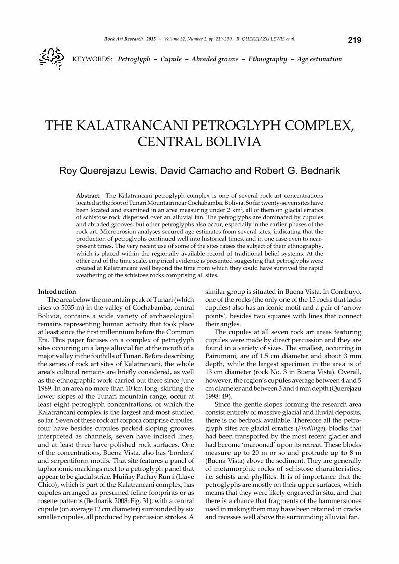
IntroductionThe area below the mountain peak of Tunari (which
rises to 5035 m) in the valley of Cochabamba, central Bolivia, contains a wide variety of archaeological remains representing human activity that took place at least since the first millennium before the Common Era. This paper focuses on a complex of petroglyph sites occurring on a large alluvial fan at the mouth of a major valley in the foothills of Tunari. Before describing the series of rock art sites of Kalatrancani, the whole area’s cultural remains are briefly considered, as well as the ethnographic work carried out there since June 1989. In an area no more than 10 km long, skirting the lower slopes of the Tunari mountain range, occur at least eight petroglyph concentrations, of which the Kalatrancani complex is the largest and most studied so far. Seven of these rock art corpora comprise cupules, four have besides cupules pecked sloping grooves interpreted as channels, seven have incised lines, and at least three have polished rock surfaces. One of the concentrations, Buena Vista, also has ‘borders’ and serpentiform motifs. That site features a panel of taphonomic markings next to a petroglyph panel that appear to be glacial striae. Huiñay Pachay Rumi (Llave Chico), which is part of the Kalatrancani complex, has cupules arranged as presumed feline footprints or as rosette patterns (Bednarik 2008: Fig. 31), with a central cupule (on average 12 cm diameter) surrounded by six smaller cupules, all produced by percussion strokes. A
similar group is situated in Buena Vista. In Combuyo, one of the rocks (the only one of the 15 rocks that lacks cupules) also has an iconic motif and a pair of ‘arrow points’, besides two squares with lines that connect their angles.
The cupules at all seven rock art areas featuring cupules were made by direct percussion and they are found in a variety of sizes. The smallest, occurring in Pairumani, are of 1.5 cm diameter and about 3 mm depth, while the largest specimen in the area is of 13 cm diameter (rock No. 3 in Buena Vista). Overall, however, the region’s cupules average between 4 and 5 cm diameter and between 3 and 4 mm depth (Querejazu 1998: 49).
Since the gentle slopes forming the research area consist entirely of massive glacial and fluvial deposits, there is no bedrock available. Therefore all the petro-glyph sites are glacial erratics (Findlinge), blocks that had been transported by the most recent glacier and had become ‘marooned’ upon its retreat. These blocks measure up to 20 m or so and protrude up to 8 m (Buena Vista) above the sediment. They are generally of metamorphic rocks of schistose characteristics, i.e. schists and phyllites. It is of importance that the petroglyphs are mostly on their upper surfaces, which means that they were likely engraved in situ, and that there is a chance that fragments of the hammerstones used in making them may have been retained in cracks and recesses well above the surrounding alluvial fan.
Rock Art Research 2015 - Volume 32, Number 2, pp. 219-230. R. QUEREJAZU LEWIS et al.220
Figure 1. The Kalatrancani rock art complex, west of Cochabamba, central Bolivia.
221Rock Art Research 2015 - Volume 32, Number 2, pp. 219-230. R. QUEREJAZU LEWIS et al.
The Kalatrancani complexOf the eight known rock art concentrations in
the area, the Kalatrancani rock art site complex is of particular interest, because of the ethnographic information available for the rock art and because it is the most thoroughly studied. The complex is located at an elevation of about 2750 m above sea level, some 18 km west of Cochabamba, and approximately 1 km from the margins of the steep foothills of the Tunari range. On four of its twenty-nine known individual rocks or sites, the highest placed cupules are connected with sloping pecked channels to connect to lower natural crevices, which in turn descend to the soil. Rainwater flows through these conduits and it is possible that the arrangements were deliberately made to channel a liquid for some ritual purpose. The same circumstances apply elsewhere in the wider region. For instance there is an arrangement of reticulate channels and several cupules at various levels on a sloping rock panel at Bola Chanka, Santivañez petroglyph complex, about 40 km to the south of Cochabamba. Again, the complex arrangement presents an intimation that it served to channel liquid.
The Kalatrancani complex extends over a few square kilometres of a gently sloping terrain, dissected by deeply cut water courses and partly used for agriculture (Fig. 1). There is very limited tree cover across the area, which overlooks the densely populated valley of Cochabamba. The sites so far recorded are:
(1) Ph’alta Rumi (formerly called Roca Fortunato 1); ph’alta is ‘flat’, rumi is ‘rock’ in Quechua, estimated to comprise up to 2000 cupules.
(2) Huiñay Pachay Rumi, which means ‘Forever Sacred Rock’in Quechua; (formerly called Llave Chico, which means ‘Small Key’ in Spanish; 90 cupules.
(3) Thojya Rumi (formerly Kalatrancani 1); the name means ‘Broken-up Rock’ in Quechua; 160 cupules.
(4) Thojya Rumi East, 5 cupules.(5) Iscay Rumi North (formerly Kalatrancani 2); the
name means ‘Two Rocks’ in Quechua, water channels.
(6) Iscay Rumi South (formerly Kalatrancani 3); no indigenous name recorded, 16 cupules.
(7) Muyuj Rumi (formerly Kalatrancani 4); the name means ‘Rotating Rock’ in Quechua; 14 cupules.
(8) Roca Iglesia South 1, which means ‘Church Rock’ in Spanish; 13 cupules.
(9) Roca Iglesia South 2, 13 cupules.(10) Roca Dentro del Eucalipto, Spanish; 7
cupules.(11) Baile Rumi 2, which means ‘Dance Rock’
in Quechua; 161 cupules.(12) Granja Rumi 1 (west), which means
‘Farm Rock’ in Spanish; 14 cupules.(13) Granja Rumi 2 (east); 30 cupules.(14) Llantero Phata Moqho Rumi, ‘Above
Woodcutter’s Place’ in Quechua; 71
cupules.(15) Roca Toquetu Ñaupac, which means ‘Ancient
Hole’, partially destroyed; approx. 115 cupules.(16) Kh’elgata Rumi, ‘Inscribed Rock’ in Quechua; 37
cupules. (17) Kh’elgata Rumi South; 20 cupules, hammerstone
found.(18) Molle Rumi, which means ‘Molle Tree Rock’ in
Quechua; 30 cupules.(19) Th’unita Rumi, which means ‘Small Rock’, located
S of cemetery wall, 28 cupules and a few abraded grooves, eroding.
(20) Panteòn Puncu, which means ‘Cemetery Gate’ in Spanish, ~100 m NE of cemetery; 86 cupules, distinctive sub-parallel grooves.
(21) Jhuusqh’u Rumi, ‘Hoe Rock’ in Quechua; 50 cupules.
(22) Rock on patio of house, partially destroyed; 160 cupules.
(23) Roca Destruida, ‘Destroyed Rock’ in Spanish; 5 cupules.
(24) Propiedad Alba, named after land owner; 77 cupules.
(25) Mesa Rumi, name a combination of Spanish and Quechua; 30 cupules.
(26) Enmallada, named after landowner, with wire fence; 116 cupules.
(27) Baile Rumi, which means ‘Dance Rock’; the ancient name is Mama Rumi, ‘Mother Rock’ in Quechua; 55 cupules.
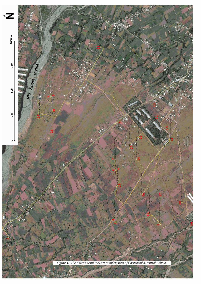
Only the sites listed below have so far received any detailed attention. Huiñay Pachay Rumi (Llave Chico), a rock about 5 m high and well rounded, is located next to a gravel road and some houses. Its petroglyphs differ stylistically from most other Kalatrancani sites, particularly through the occurrence of the rosette arrangements of cupules (Fig. 2). The other cupules are grouped in clusters.
Thojya Rumi, a few hundred metres further and visible from the same road, is only about 2 m high and
Figure 2. Huiñay Pachay Rumi petroglyphs, including several ‘rosette’ arrangements.
Rock Art Research 2015 - Volume 32, Number 2, pp. 219-230. R. QUEREJAZU LEWIS et al.222
its petroglyphs still appear to attract ritual attention. Some objects, such as paper streamers, spent fire crackers and food traces found there seem to derive from offerings, but ethnographic confirmation is lacking. The heavily weathered block exhibits distinctly laminar structure and most petroglyphs occur on a surface that was exposed when a dense layer became exfoliated, suggesting their relatively recent age. A few metres from the rock, a used hammerstone of white quartz was collected and subjected to microerosion analysis of its impact facet (see below).
Iscay Rumi North is located a few hundred metres downslope from Thocyac Rumi and consists of two separate rocks (at least above ground). The upper rock, almost 4 m high, features a panel of cupules and connecting channels on its highest part, about 1.8 m long, which seems to vaguely resemble the region’s topography, with the highest point possibly representing Tunari.
Iscay Rumi South is a further 200 m down the gentle slope dotted by small cairns. The block measures 15 m N–S and 12 m E–W. Its pronounced uppermost platform is 5.7 m long and 3.1 m wide, sloping at 4° from 20° W of N. This flat platform is 62 cm above a lower platform extending mostly towards S and E, to W only 1–2 m, expressing the distinctly laminar structure of the rock. The platforms measure together 12 m by 10 m and are of uniform inclination. The schist has been dissected vertically by stress fractures. The petroglyphs resemble those of the other sites of the complex. Among
them, from natural cracks in the rock’s upper surface, several minute splinters of white quartz were collected, at about 3 m height above the surrounding floor. Since they cannot have been deposited by natural means it is very likely that they derive from hammerstones used to pound the schistose rock, which means that their fracture edges must date from events of petroglyph production. The schist is distinctly laminated and exfoliates at 1–2 mm thickness, and the degree of weathering is well expressed in the developing stepped profiles of cupules. This allows the petroglyphs to be arranged relatively according to their ages, showing that a range of ages are represented in the rock art.
Kh’elgata Rumi was identified in 1997 and is located in the S side of a creek bed, a low rock of 5.5 m exposed length. The 37 cupules occur in two groups and are unpatinated, whereas the rock bears a distinct reddish patina.
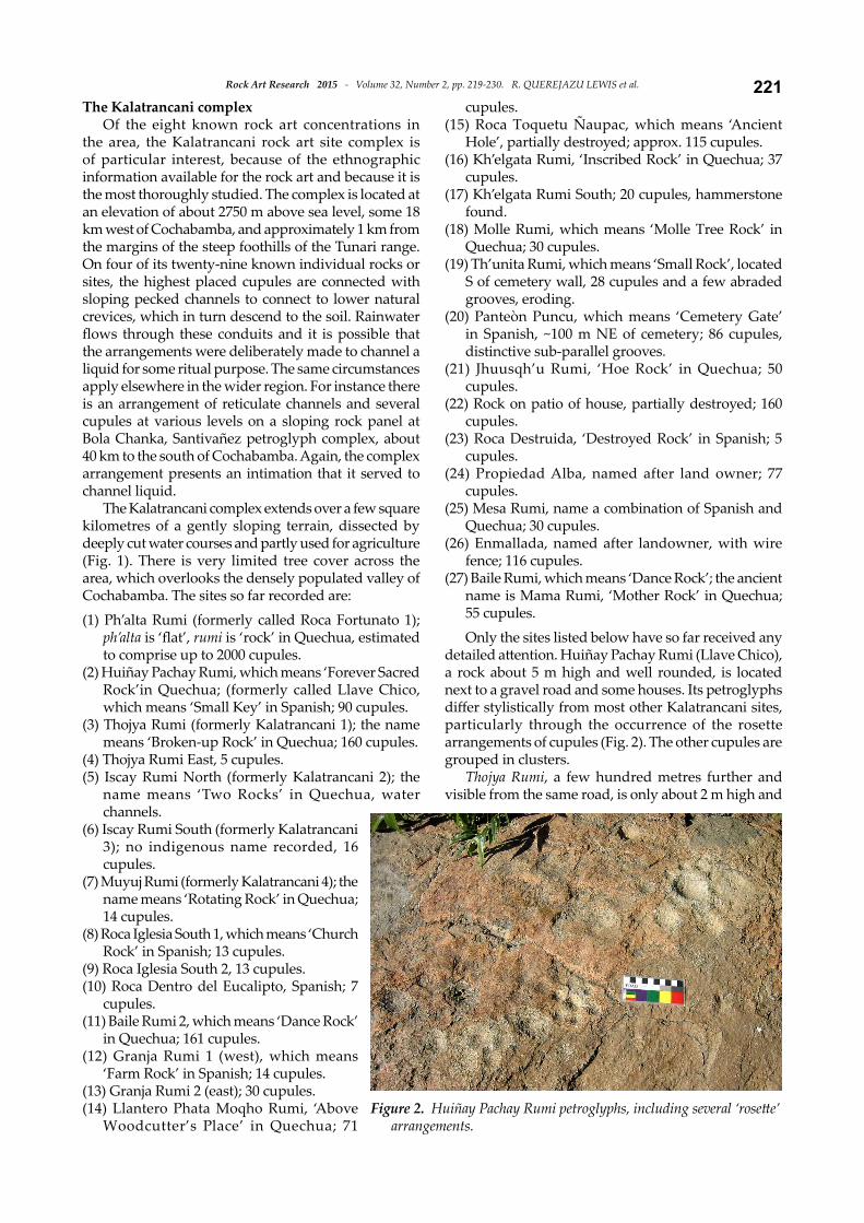
Ph’alta RumiThis site is 360 m due W of Kh’elgata Rumi South
and 440 m due S of Thojya Rumi. The morphology of this block is determined by the same laminar structure as Kalatrancani 3, but its very different orientation confirms that these are not exposures of bedrock; they are glacial erratics. Ph’alta Rumi is located several hundred metres downslope from Thojya Rumi. The schist is better metamorphosed than that of Iscay Rumi South but is subjected to similar reticulate fracture pattern (Fig. 3). Material nearest to the vertical stress
Figure 3. Part of upper panel of Ph’alta Rumi, looking west, showing reticulate fracture pattern and partial reddish patination.
223Rock Art Research 2015 - Volume 32, Number 2, pp. 219-230. R. QUEREJAZU LEWIS et al.
fractures has exfoliated, dividing the sloping platforms into panels. These bore inherited iron-oxide deposits, much of which have also been shed. Some1500–2000 cupules have survived on most of the upper surfaces, representing a considerable timespan, but there are also numerous incisions, including some on vertical surfaces, and a number of relatively early complex percussion petroglyphs.
Most cupules appear to be randomly distributed but exceptions occur. A few rosette arrangements appear in one location, on the E side; and on a peripheral platform below the main panel, cupules appear in alignments.
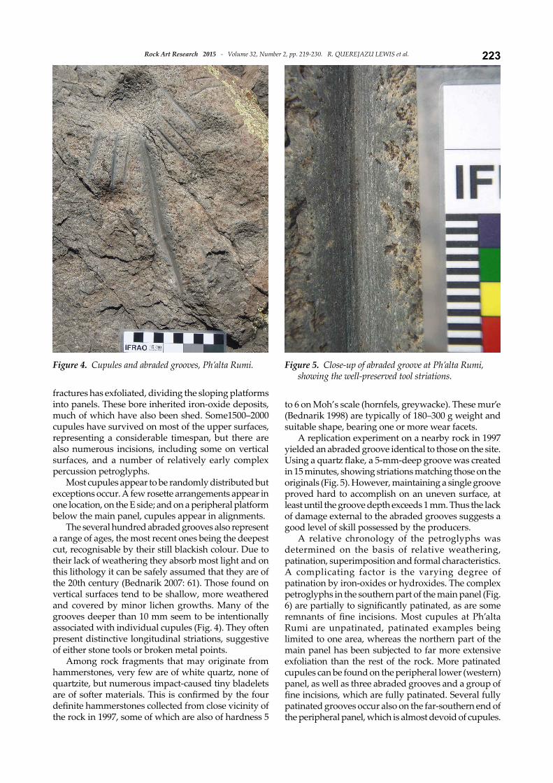
The several hundred abraded grooves also represent a range of ages, the most recent ones being the deepest cut, recognisable by their still blackish colour. Due to their lack of weathering they absorb most light and on this lithology it can be safely assumed that they are of the 20th century (Bednarik 2007: 61). Those found on vertical surfaces tend to be shallow, more weathered and covered by minor lichen growths. Many of the grooves deeper than 10 mm seem to be intentionally associated with individual cupules (Fig. 4). They often present distinctive longitudinal striations, suggestive of either stone tools or broken metal points.
Among rock fragments that may originate from hammerstones, very few are of white quartz, none of quartzite, but numerous impact-caused tiny bladelets are of softer materials. This is confirmed by the four definite hammerstones collected from close vicinity of the rock in 1997, some of which are also of hardness 5
to 6 on Moh’s scale (hornfels, greywacke). These mur’e (Bednarik 1998) are typically of 180–300 g weight and suitable shape, bearing one or more wear facets.
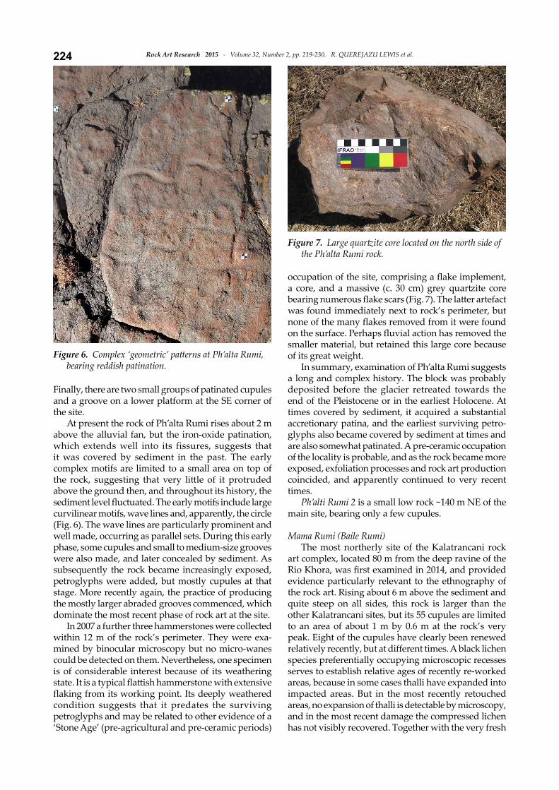
A replication experiment on a nearby rock in 1997 yielded an abraded groove identical to those on the site. Using a quartz flake, a 5-mm-deep groove was created in 15 minutes, showing striations matching those on the originals (Fig. 5). However, maintaining a single groove proved hard to accomplish on an uneven surface, at least until the groove depth exceeds 1 mm. Thus the lack of damage external to the abraded grooves suggests a good level of skill possessed by the producers.
A relative chronology of the petroglyphs was determined on the basis of relative weathering, patination, superimposition and formal characteristics. A complicating factor is the varying degree of patination by iron-oxides or hydroxides. The complex petroglyphs in the southern part of the main panel (Fig. 6) are partially to significantly patinated, as are some remnants of fine incisions. Most cupules at Ph’alta Rumi are unpatinated, patinated examples being limited to one area, whereas the northern part of the main panel has been subjected to far more extensive exfoliation than the rest of the rock. More patinated cupules can be found on the peripheral lower (western) panel, as well as three abraded grooves and a group of fine incisions, which are fully patinated. Several fully patinated grooves occur also on the far-southern end of the peripheral panel, which is almost devoid of cupules.
Figure 4. Cupules and abraded grooves, Ph’alta Rumi. Figure 5. Close-up of abraded groove at Ph’alta Rumi, showing the well-preserved tool striations.
Rock Art Research 2015 - Volume 32, Number 2, pp. 219-230. R. QUEREJAZU LEWIS et al.224
Finally, there are two small groups of patinated cupules and a groove on a lower platform at the SE corner of the site.
At present the rock of Ph’alta Rumi rises about 2 m above the alluvial fan, but the iron-oxide patination, which extends well into its fissures, suggests that it was covered by sediment in the past. The early complex motifs are limited to a small area on top of the rock, suggesting that very little of it protruded above the ground then, and throughout its history, the sediment level fluctuated. The early motifs include large curvilinear motifs, wave lines and, apparently, the circle (Fig. 6). The wave lines are particularly prominent and well made, occurring as parallel sets. During this early phase, some cupules and small to medium-size grooves were also made, and later concealed by sediment. As subsequently the rock became increasingly exposed, petroglyphs were added, but mostly cupules at that stage. More recently again, the practice of producing the mostly larger abraded grooves commenced, which dominate the most recent phase of rock art at the site.
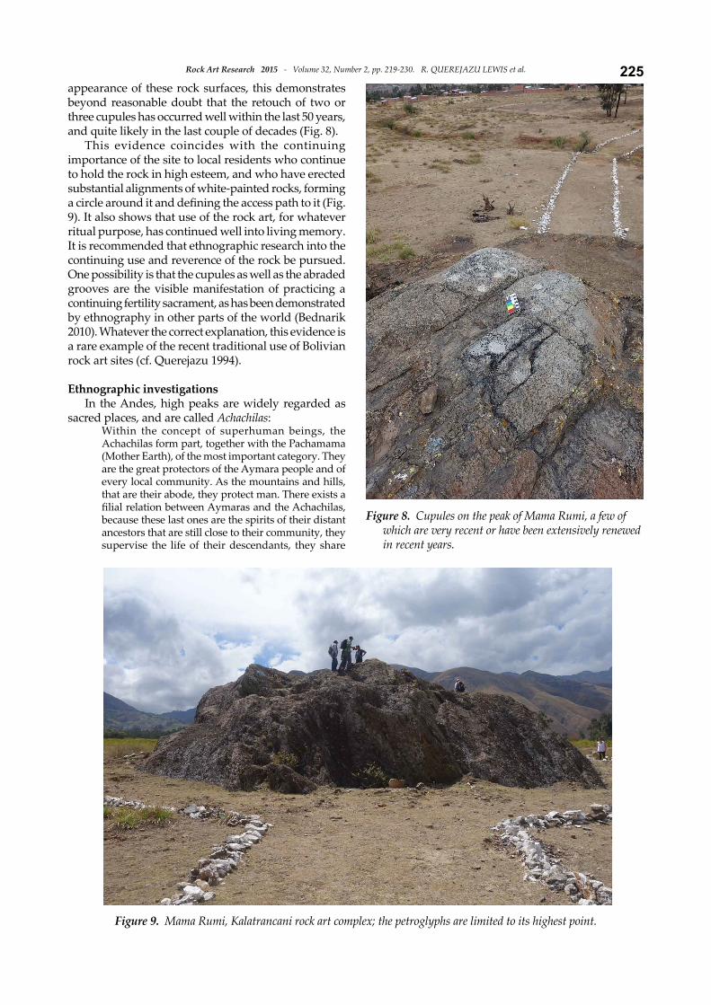
In 2007 a further three hammerstones were collected within 12 m of the rock’s perimeter. They were exa-mined by binocular microscopy but no micro-wanes could be detected on them. Nevertheless, one specimen is of considerable interest because of its weathering state. It is a typical flattish hammerstone with extensive flaking from its working point. Its deeply weathered condition suggests that it predates the surviving petroglyphs and may be related to other evidence of a ‘Stone Age’ (pre-agricultural and pre-ceramic periods)
occupation of the site, comprising a flake implement, a core, and a massive (c. 30 cm) grey quartzite core bearing numerous flake scars (Fig. 7). The latter artefact was found immediately next to rock’s perimeter, but none of the many flakes removed from it were found on the surface. Perhaps fluvial action has removed the smaller material, but retained this large core because of its great weight.
In summary, examination of Ph’alta Rumi suggests a long and complex history. The block was probably deposited before the glacier retreated towards the end of the Pleistocene or in the earliest Holocene. At times covered by sediment, it acquired a substantial accretionary patina, and the earliest surviving petro-glyphs also became covered by sediment at times and are also somewhat patinated. A pre-ceramic occupation of the locality is probable, and as the rock became more exposed, exfoliation processes and rock art production coincided, and apparently continued to very recent times.
Ph’alti Rumi 2 is a small low rock ~140 m NE of the main site, bearing only a few cupules.
Mama Rumi (Baile Rumi)The most northerly site of the Kalatrancani rock
art complex, located 80 m from the deep ravine of the Rio Khora, was first examined in 2014, and provided evidence particularly relevant to the ethnography of the rock art. Rising about 6 m above the sediment and quite steep on all sides, this rock is larger than the other Kalatrancani sites, but its 55 cupules are limited to an area of about 1 m by 0.6 m at the rock’s very peak. Eight of the cupules have clearly been renewed relatively recently, but at different times. A black lichen species preferentially occupying microscopic recesses serves to establish relative ages of recently re-worked areas, because in some cases thalli have expanded into impacted areas. But in the most recently retouched areas, no expansion of thalli is detectable by microscopy, and in the most recent damage the compressed lichen has not visibly recovered. Together with the very fresh
Figure 6. Complex ‘geometric’ patterns at Ph’alta Rumi, bearing reddish patination.
Figure 7. Large quartzite core located on the north side of the Ph’alta Rumi rock.
225Rock Art Research 2015 - Volume 32, Number 2, pp. 219-230. R. QUEREJAZU LEWIS et al.
appearance of these rock surfaces, this demonstrates beyond reasonable doubt that the retouch of two or three cupules has occurred well within the last 50 years, and quite likely in the last couple of decades (Fig. 8).
This evidence coincides with the continuing importance of the site to local residents who continue to hold the rock in high esteem, and who have erected substantial alignments of white-painted rocks, forming a circle around it and defining the access path to it (Fig. 9). It also shows that use of the rock art, for whatever ritual purpose, has continued well into living memory. It is recommended that ethnographic research into the continuing use and reverence of the rock be pursued. One possibility is that the cupules as well as the abraded grooves are the visible manifestation of practicing a continuing fertility sacrament, as has been demonstrated by ethnography in other parts of the world (Bednarik 2010). Whatever the correct explanation, this evidence is a rare example of the recent traditional use of Bolivian rock art sites (cf. Querejazu 1994).
Ethnographic investigationsIn the Andes, high peaks are widely regarded as
sacred places, and are called Achachilas: Within the concept of superhuman beings, the Achachilas form part, together with the Pachamama (Mother Earth), of the most important category. They are the great protectors of the Aymara people and of every local community. As the mountains and hills, that are their abode, they protect man. There exists a filial relation between Aymaras and the Achachilas, because these last ones are the spirits of their distant ancestors that are still close to their community, they supervise the life of their descendants, they share
Figure 8. Cupules on the peak of Mama Rumi, a few of which are very recent or have been extensively renewed in recent years.
Figure 9. Mama Rumi, Kalatrancani rock art complex; the petroglyphs are limited to its highest point.
Rock Art Research 2015 - Volume 32, Number 2, pp. 219-230. R. QUEREJAZU LEWIS et al.226
their sufferings and sorrows, and they confer on them their blessings. Men pay them for all this, respecting them, and offering them prayers and offerings. There are various kinds of Achachilas. A first category is composed by the big Achachilas, usually identified with the highest mountains of the Andean mountain chain (van den Berg 1985: 11).
Johan Reinhard, in his studies about the sacred mountains of the Andes, has contributed to clarifying various important aspects. He mentions the role that mountains had (and continue to have) in the beliefs and ritual practices of Andean indigenous people. He confirms the belief that they are places where the spirits of the dead reside, and that frequently, they were considered as the original ancestors of the people. But Reinhard includes another vital element in the relation of Andean people (Aymaras and Quechuas) with the high mountain: fertility of agricultural fields and fertility of domestic animals by means of water that originates and descends from the high sacred mountains. According to this author ‘it was the concept of fertility, with water as its principal element, that has been found underlying in the vast majority of the beliefs related to mountains’. He contends that
mountain deities were considered essential for fertility of animals and fields, and it was mainly in their condition as controllers of meteorological phenomena that they earned a position so important in Andean religion. Such beliefs certainly precede the Incas and they have been found along the Andes. In fact, they are based on basic ecological facts: rain, clouds and lightnings frequently originate in the mountains and rivers descend from them (Reinhard 1985: 314).
With regard to the Tunari mountain there are suffi-cient data to perceive it as a sacred mountain, with a preponderant importance for the local population beneath it, with regards to its supposed supernatural powers as a controller of meteorological phenomena that gave place to fertility in the agricultural fields and in domestic animals. Archaeological remains on the lower slopes of the mountain include two altars, the best-preserved being in Combuyo, at 2745 m altitude and 3.4 m high. Consisting of dry-laid stone walls, it appears to have been of square shape, with walls being 9–10 m long. In 1992 one of its exterior sides that once was a perron leading to the top were still well preserved (Querejazu 1992: 53). In that year one of us (RQL) located another altar, also built with rough stones and also situated on the lower slopes of the Tunari mountain range, in Molle Molle. This altar has a rectangular shape, measures approximately 14.2 m by 7.4 m and is 2.75 m high. It is also situated at 2745 m above sea level.
Ethnographic research carried out in 1989 with the tiny community of Jankokala (altitude 4100 m) northeast of the peak of Tunari recorded some vestiges of ancient legends related to the mountain (Querejazu 1992). Accordingly Tunari mountain lent its poncho to Illimani mountain (to the north-west) in order to protect it from the cold, and having done this, it passed over part of its power to this other mountain. In spite of this, Tunari continues to have power and local people still fear it and make offerings to it. These include bones of female aged llamas, coca leaves, cigarettes, alcohol in tins, singani (an alcoholic beverage made of distilled grapes) and incense. Also offered were akullico (masticated coca leaves) thrown or spat onto apachetas, which are conical cairns of stones offered when Andean walkers pass from one environment to another, on the high mountains. Throwing a stone on the mound has the purpose of mitigating weariness, which is obtained by first rubbing the stone on the body to transfer the fatigue to it. While throwing the akullico the supplicant cries out ‘I leave you my weariness, give me new strength’. The group interviewed in Jankokala has a very strong respect for Tunari. They are not supposed to talk just for the sake of talking, because ‘Tunari listens to everything’. If they promised anything they had to accomplish it. It was evident in them that they feared very much being punished by the mountain (Querejazu 1992: 53–54).
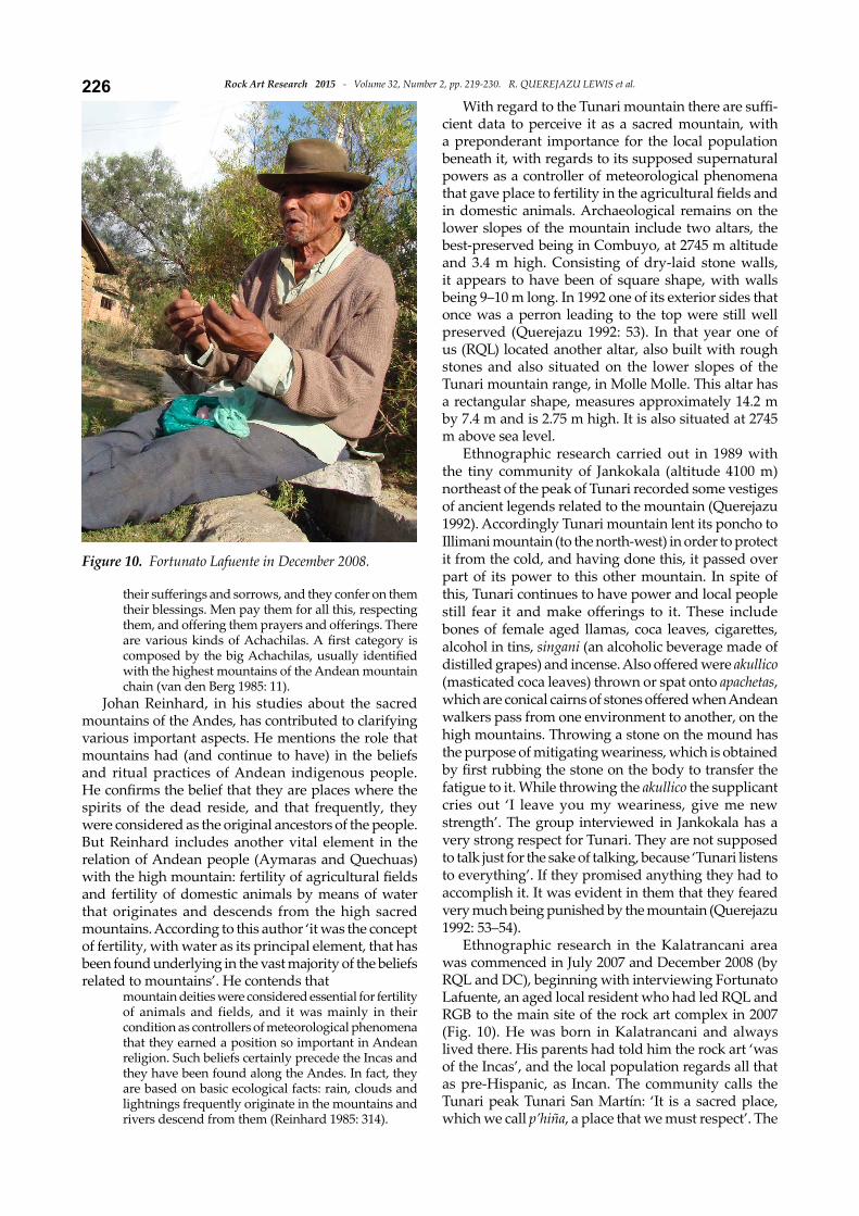
Ethnographic research in the Kalatrancani area was commenced in July 2007 and December 2008 (by RQL and DC), beginning with interviewing Fortunato Lafuente, an aged local resident who had led RQL and RGB to the main site of the rock art complex in 2007 (Fig. 10). He was born in Kalatrancani and always lived there. His parents had told him the rock art ‘was of the Incas’, and the local population regards all that as pre-Hispanic, as Incan. The community calls the Tunari peak Tunari San Martín: ‘It is a sacred place, which we call p’hiña, a place that we must respect’. The
Figure 10. Fortunato Lafuente in December 2008.
227Rock Art Research 2015 - Volume 32, Number 2, pp. 219-230. R. QUEREJAZU LEWIS et al.
combination of Tunari (an Aymara word) and Saint Martín evidences the cultural syncretism that took place in the area since Colonial times. Lafuente stated
when one wants to go up there, near the peak there is a small lagoon, it makes you see illusions, oranges, fruit trees, illusions. When you arrive, you enter the lagoon and you don’t return. They call it el encanto, the enchantment.When it doesn’t rain in the valley they must go up to the peak to give an offering — coca. They must reach the lagoon Challando with chicha or alcohol oblations, and one has to throw stones with a sling, and at that moment clouds appear and it starts to rain.Tunari San Martín was fiercer before. Now it has calmed down. No one used to touch it. It had many enchantments. Once some gringos possibly came from foreign countries in a helicopter or air plane and made holes to extract gold and they remained there covered in the mountain peak. The enchantment covered them. Tunari San Martín ate them. It always had that name.Tunari San Martín is related to water, to fertility, to the agricultural field, for everything and for everybody, at least it drizzles (Fortunato Lafuente, pers. comm. 7 December 2008).
Tomás González is perhaps the oldest person in Katatrancani and has received from his parents and grandfathers, by oral tradition, beliefs and myths about the region and its enchanted mountain. Nevertheless, recently he has been converted to an Evangelist religion, and in consequence now says that all the cupules and other petroglyphs of his area, including the high mountain, are the work of God. In spite of this change of religion (he was Catholic before, a religion with a high proportion of syncretism in Bolivia) he also talked about his previous beliefs based on the ancestral myths that survive since pre-Hispanic times. These were his words:
Before this mountain was — hechadero — it had no owners. Before, in order to leave our cattle we left an offering. If we left a cow to graze, Pachamama (Mother Earth) was in charge of looking after her. We also left offerings to Tata (Father) Tunari. We made liquid oblations (challar) with chicha or alcohol.Ancient people, before sowing, made their offering (challa), they asked permission of Tunari, for his blessing, and so that he will be in charge of the cultivated plants.When the Incas lived they had power. If a stone disturbed, the Inca made that it was removed. If he wanted water, it was produced. The curse came when they killed the Inca. The Inca left his blood to a child, but these evil spirits that live in the heights maltreated the child and took away his blood. From that moment all our history changed.In this area we have two enchanted mountains, Khuturipa, that is in front of San Martín Tunari. We also have our festivities: Mama Asunta, Tata Exaltación (he also has power), and Mama Rosario, the 7th of October.Before making an offering we must mention Khuturipa, Pachamama, and San Martín Tunari, saying ‘in your hands I am leaving this cultivation field’, so that it will produce better (Tomás González, pers. comm.
28 December 2008).That day we also held a conversation with another
aged man, Antonio Fernandez, who confirmed some of the information of the two previous informants and complemented it.
Our ancestors baptised the mountain as San Martín. San Martín Tunari has a small lagoon, it has a lot of power. No one reaches it. It has an enchantment. In the lagoon there is an orchard with fruit. If you enter to obtain some fruit you don’t come out. In that lagoon an aeroplane has entered.
With relation to the cupules and pecked channels on the rocks of the area Fernandez said:
The Incas made them, they were drawings on stone; before they did not know how to draw on paper. It has some meaning. We do not know what it means. When we make offerings we invite Pachamama (Antonio Fernandez, pers. comm. 28 December 2008).
The interviews with the local indigenous people suggest that those of less than fifty years of age maintain no cultural relation with the rocks featuring cupules, grooves or incised lines. However, the older generation is aware that the petroglyphs were made by their ancestors; they repeatedly mention ‘the Incas’, although they do not know what the rock art means nor what its purpose was. Neverthess, they consider the Tunari mountain peak as sacred, with an enchantment that has power for good and for evil. Until recent times this Kalatrancani population invoked the mountain, whose name is combined with that of a Catholic saint’s (San Martín), in order to receive water and good crops.
The physical evidence from Mama Rumi suggests that some people in the Kalatrancani communities, whose settlements currently encroach directly on some of the rock art sites, still use the sites occasionally, to leave offerings or even retouch a cupule, for whatever purpose.
Analytical investigationsSome preliminary analytical observations have
already been mentioned above. Schistose rocks are highly erodible (Bednarik 2012) and any unprotected rock art on such facies is therefore unlikely to be of very great age. The effects of the weathering are amply evident in the Kalatrancani rock art complex. Elsewhere it has been established that anthropogenic marks on such rocks fade to a lighter colour in a matter of a few years (Bednarik 2009: Fig. 5, 2012), which is attributable to the change in optical properties of the surface layer. Hydration then begins to convert the surface. Schists that are devoid of a significant content of non-micaceous minerals weather readily (Anderson and Hawkes 1958; Fahey 1983; Wells et al. 2006), as they hydrate to their previous phases and thus ultimately revert to mud, forming again the clayey soils from which they originate (Chigira 1990). For instance the chlorite of quartz-chlorite schist weathers via vermiculite to kaolinite (Murakami et al. 1996; Wells et al. 2005). The weathering front is abrupt, and pedoplasmation follows geological structures, forming a clay-rich soil material (Zauyah
Rock Art Research 2015 - Volume 32, Number 2, pp. 219-230. R. QUEREJAZU LEWIS et al.228
and Stoops 1990). This excludes a priori an antiquity exceeding 2000
years for the Kalatrancani petroglyphs. However, as the earliest examples in Ph’alta Rumi were very probably concealed by sediment for a time, this could have retarded deterioration. For all petroglyphs not subject to this qualification the expected age would be well within this constraint, but more concrete age estimates were desired. The only direct rock art dating method for petroglyphs that can determine the target event (rather than the age of an index that is older or younger; cf. Dunnell and Redhead 1988) is microerosion analysis. Unfortunately, none of the major component minerals of the Kalatrancani rocks has ever been calibrated for this method, nor is that likely to be feasible. The method’s preferred material is quartz, preferably as large grains or crystals (Bednarik 1992). In short, the method cannot be applied to the petroglyphs of these sites.
However, there are two other possibilities, both first explored in Bolivia (Bednarik 1998, 2000, 2010b, 2010c). Instead of analysing the surface of the petroglyph, the damage caused to a quartz hammerstone or alternatively the broken edges of tiny splinters that became detached from that tool by impact could be examined to determine how long ago the percussion occurred. The problem with this approach is that the age determined, although very reliable, only establishes when the hammerstone was used. It is incapable of deciding which of the petroglyphs in a site was made or modified at that time. Nevertheless, such information is still most relevant archaeologically, because it establishes that rock art was made at a specific time.
Both of these strategies were employed in Kalatran-cani. The immediate vicinity of several outcrops was searched for hammerstones with distinctive evidence of having been used in the production of percussion petroglyphs; and the crevices on the rock platforms,
immediately adjacent to the rock art, were carefully searched for tiny spalls of quartz that may have become detached from the tools during impact. The first strategy resulted in finding one white quartz hammerstone with suitable fracture edges at Thojya Rumi. That tool yielded a tentative age of E700 years bp (Bednarik 2010b: 37), while none of the seven hammerstones collected at Ph’alta Rumi offered suitable fractures or mineral crystals. However , a hammerstone, 100.9 mm long and up to 49.8 mm wide, found 1 m from the rock’s periphery of Kh’elgata Rumi South, provided two micro-wanes on 90° edges suitable for analysis. The first, 2.1 mm long, yielded seven wane measurements with a mean of 30.3 μm; the second, 2.4 mm long and immediately next to the tool’s point, provided eight values with a mean of 24.2 μm. These measurements are considered to be too far apart in time to relate to the same percussion event, so it seems the tools were used on two separate occasions. Since there is no calibration curve is available from the region (or, indeed, from anywhere in South America) the environmentally most closely comparable values from Grosio, in the Alps of northern Italy, were experimentally applied (Bednarik 2001). It needs to be noted that the following provisional age estimates will need to be adjusted once a local calibration curve does become available. On this basis, the Kh’elgata Rumi South hammerstone was used E2840 +160/-220 years ago, and again E2270 +170/-210 years bp, i.e. very probably beyond the range of survival of the cupules. In other words, as at Ph’alta Rumi, petroglyphs are likely to have been created before those that survive today.
The second strategy yielded seven white quartz splinters from cracks on top of the Iscay Rumi South erratic, found within centimetres of petroglyphs, and four more from Ph’alta Rumi. Because these rock plat-forms are well elevated above the alluvium and the
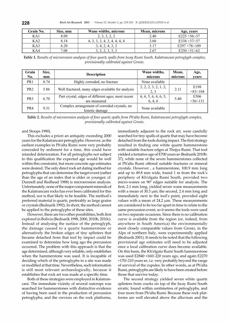
Grain No. Size, mm Wane widths, microns Mean, microns Age, yearsKA1 8.09 2, 3, 3, 2, 2 2.40 E225 +56/-37KA2 8.18 4, 3, 3, 3, 4, 3, 4, 4, 4, 4 3.60 E338 +37/-57KA3 6.20 3, 4, 2, 4, 3, 3 3.17 E297 +78/-109KA4 7.08 3, 2, 2, 3, 3, 3 2.67 E250 +31/-62
Table 1. Results of microerosion analysis of four quartz spalls from Iscay Rumi South, Kalatrancani petroglyph complex, provisionally calibrated against Grosio.
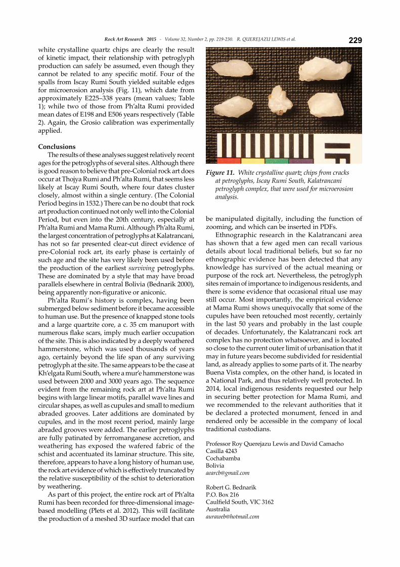
GrainNo.
Size,mm Description Wane widths,
micronsMean,
micronsAge, years
PR1 0.74 Highly corroded, no fracture None available
PR2 5.86 Well fractured, many edges available for analysis 2, 2, 2, 3, 2, 1, 2, 2, 3 2.11 E198
+83/-104
PR3 6.70 Part crystal, edges of different ages; most recent are measured
6, 6, 5, 6, 4, 6, 5, 6, 4, 6 5.40 E506
+56/-131
PR4 9.31 Complex arrangement of corroded crystals, no kinetic damage None available
Table 2. Results of microerosion analysis of four quartz spalls from Ph’alta Rumi, Kalatrancani petroglyph complex, provisionally calibrated against Grosio.
229Rock Art Research 2015 - Volume 32, Number 2, pp. 219-230. R. QUEREJAZU LEWIS et al.
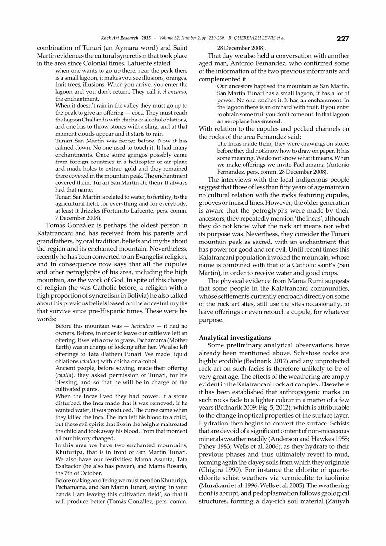
white crystalline quartz chips are clearly the result of kinetic impact, their relationship with petroglyph production can safely be assumed, even though they cannot be related to any specific motif. Four of the spalls from Iscay Rumi South yielded suitable edges for microerosion analysis (Fig. 11), which date from approximately E225–338 years (mean values; Table 1); while two of those from Ph’alta Rumi provided mean dates of E198 and E506 years respectively (Table 2). Again, the Grosio calibration was experimentally applied.
ConclusionsThe results of these analyses suggest relatively recent
ages for the petroglyphs of several sites. Although there is good reason to believe that pre-Colonial rock art does occur at Thojya Rumi and Ph’alta Rumi, that seems less likely at Iscay Rumi South, where four dates cluster closely, almost within a single century. (The Colonial Period begins in 1532.) There can be no doubt that rock art production continued not only well into the Colonial Period, but even into the 20th century, especially at Ph’alta Rumi and Mama Rumi. Although Ph’alta Rumi, the largest concentration of petroglyphs at Kalatrancani, has not so far presented clear-cut direct evidence of pre-Colonial rock art, its early phase is certainly of such age and the site has very likely been used before the production of the earliest surviving petroglyphs. These are dominated by a style that may have broad parallels elsewhere in central Bolivia (Bednarik 2000), being apparently non-figurative or aniconic.
Ph’alta Rumi’s history is complex, having been submerged below sediment before it became accessible to human use. But the presence of knapped stone tools and a large quartzite core, a c. 35 cm manuport with numerous flake scars, imply much earlier occupation of the site. This is also indicated by a deeply weathered hammerstone, which was used thousands of years ago, certainly beyond the life span of any surviving petroglyph at the site. The same appears to be the case at Kh’elgata Rumi South, where a mur’e hammerstone was used between 2000 and 3000 years ago. The sequence evident from the remaining rock art at Ph’alta Rumi begins with large linear motifs, parallel wave lines and circular shapes, as well as cupules and small to medium abraded grooves. Later additions are dominated by cupules, and in the most recent period, mainly large abraded grooves were added. The earlier petroglyphs are fully patinated by ferromanganese accretion, and weathering has exposed the wafered fabric of the schist and accentuated its laminar structure. This site, therefore, appears to have a long history of human use, the rock art evidence of which is effectively truncated by the relative susceptibility of the schist to deterioration by weathering.
As part of this project, the entire rock art of Ph’alta Rumi has been recorded for three-dimensional image-based modelling (Plets et al. 2012). This will facilitate the production of a meshed 3D surface model that can
be manipulated digitally, including the function of zooming, and which can be inserted in PDFs.
Ethnographic research in the Kalatrancani area has shown that a few aged men can recall various details about local traditional beliefs, but so far no ethnographic evidence has been detected that any knowledge has survived of the actual meaning or purpose of the rock art. Nevertheless, the petroglyph sites remain of importance to indigenous residents, and there is some evidence that occasional ritual use may still occur. Most importantly, the empirical evidence at Mama Rumi shows unequivocally that some of the cupules have been retouched most recently, certainly in the last 50 years and probably in the last couple of decades. Unfortunately, the Kalatrancani rock art complex has no protection whatsoever, and is located so close to the current outer limit of urbanisation that it may in future years become subdivided for residential land, as already applies to some parts of it. The nearby Buena Vista complex, on the other hand, is located in a National Park, and thus relatively well protected. In 2014, local indigenous residents requested our help in securing better protection for Mama Rumi, and we recommended to the relevant authorities that it be declared a protected monument, fenced in and rendered only be accessible in the company of local traditional custodians.
Professor Roy Querejazu Lewis and David CamachoCasilla 4243 [email protected]
Robert G. BednarikP.O. Box 216Caulfield South, VIC [email protected]
Figure 11. White crystalline quartz chips from cracks at petroglyphs, Iscay Rumi South, Kalatrancani petroglyph complex, that were used for microerosion analysis.
Rock Art Research 2015 - Volume 32, Number 2, pp. 219-230. R. QUEREJAZU LEWIS et al.230
REfEREnCEs
Anderson, D. H. and H. E. Hawkes 1958. Relative mobility of the common elements in weathering of some schist and granite areas. Geochimica et Cosmochimica Acta 14(3): 204–210.
Bednarik, R. G. 1992. A new method to date petroglyphs. Archaeometry 34: 279–291.
Bednarik, R. G. 1993. Geoarchaeological dating of petroglyphs at Lake Onega, Russia. Geoarchaeology 8: 443–463.
Bednarik, R. G. 1998. Age estimates of Bolivian petroglyphs. AURA Newsletter 15(1): 4.
Bednarik, R. G. 2000. Age estimates for the petroglyph se-quence of Inca Huasi, Mizque, Bolivia. Andean Past 6: 277–287.
Bednarik, R. G. 2001. Petroglyphs in Italian Alps dated. Acta Archaeologica 72(2): 109–114.
Bednarik, R. G. 2010a. The interpretation of cupules. In R. Querejazu Lewis and R. G. Bednarik (eds), Mysterious cup marks: proceedings of the First International Cupule Conference, pp. 67–73. BAR International Series 2073, Archaeopress, Oxford.
Bednarik, R. G. 2010b. Some analytical observations of Bolivian rock art. Quellca Rumi 1(1): 33–38. Algunas obser-vaciones analíticas sobre el arte rupestre Boliviano. Quellca Rumi 1(1): 39–42
Bednarik, R. G. 2010c. Estimating the age of cupules. In R. Querejazu Lewis and R. G. Bednarik (eds), Mysterious cup marks: proceedings of the First International Cupule Conference, pp. 5–12. BAR International Series 2073, Archaeopress, Oxford.
Chigira, M. 1990. A mechanism of chemical weathering of mudstone in a mountainous area. Engineering Geology 29: 119–138.
Dunnell, R. C. and M. L. Readhead 1988. The relation of dating and chronology: comments on Chatters and
Hoover (1986) and Butler and Stein (1988). Quaternary Research 30: 232–233.
Fahey, B. D. 1983. Frost action and hydration as rock weath-ering mechanisms on schist: a laboratory study. Earth Surface Processes and Landforms 8(6): 535–545.
Murakami, T., H. Isobe, T. Sato and T. Ohnuki 1996. Weathering of chlorite in a quartz-chlorite schist: I. Mine-ralogical and chemical changes. Clays and Clay Minerals 44(2): 244–256.
Querejazu Lewis, R. 1992. El Tunari: montaña sagrada. In R. Querejazu Lewis (ed.), Arte rupestre Colonial y Republicano de Bolivia y países vecinos. Contribuciones al Estudio del Arte Rupestre Sudamericano 3, pp. 52–66. SIARB, La Paz.
Querejazu Lewis, R. 1994. Contemporary indigenous use of traditional rock art sites at Yaraque, Bolivia. Rock Art Research 11(1): 3–9.
Querejazu Lewis, R. 1998. Tradiciones de cúpulas en el Departamento de Cochabamba. SIARB Boletín 12: 48–58.
Reinhard, J. 1985. Sacred mountains: an ethnoarchaeological study of high Andean ruins. Mountain Research and Development 5(4): 314.
Van den Berg, H. 1985. Diccionario religioso Aymara. CETA – IDEA, Iquitos.
Wells, T., P. Binning and G. Willgoose 2005. The role of moisture cycling in the weathering of a quartz chlorite schist in a tropical environment: findings of a laboratory simulation. Earth Surface Processes and Landforms 30(3): 413–428.
Wells, T., P. Binning, G. Willgoose and G. Hancock 2006. Laboratory simulation of the salt weathering of schist: I. Weathering of schist blocks in a seasonally wet tropical environment. Earth Surface Processes and Landforms 31(3): 339–354.
Zauyah, S. and G. Stoops 1990. A study of the ferralitic weathering of an amphibole schist in peninsular Malaysia. Pertanika 13(1): 85–93.
RAR 32-1172
AURANETAURANET, the Web presence of IFRAO and AURA, is the
largest rock art resource on the Internet. It has been relocated to a new server last year and is being upgraded and expanded progressively, and now includes downloadable rock art books.
Please visit
AURANET - http://www.ifrao.com/(includes AURANET Library)