the impact of land titling on land...
TRANSCRIPT
THE IMPACT OF LAND TITLING ON LAND TRANSACTION ACTIVITY AND REGISTRATION SYSTEM SUSTAINABILITY: A CASE STUDY OF ST. LUCIA
By
CHARISSE GRIFFITH-CHARLES
A DISSERTATION PRESENTED TO THE GRADUATE SCHOOL OF THE UNIVERSITY OF FLORIDA IN PARTIAL FULFILLMENT
OF THE REQUIREMENTS FOR THE DEGREE OF DOCTOR OF PHILOSOPHY
UNIVERSITY OF FLORIDA
2004
Copyright 2004
by
Charisse Griffith-Charles

To Ainsley, Aidan and Tristan.
ACKNOWLEDGMENTS
I owe a great deal of gratitude to my advisor, Professor Grenville Barnes, and to the
other members of my academic advisory committee: Professor Bon Dewitt and Professor
David Gibson of the Geomatics program, and Professor Marianne Schmink and Professor
Thomas Ankersen. Without their knowledge and guidance this work would not have
been completed.
I thank Professor Grenville Barnes, not only for allowing me to benefit from his
vast international experience in cadastral research, but also for arranging for my working
with Dr. Peter C. Bloch and Dr. Susana Lastarria-Cornheil of the Land Tenure Center of
the University of Wisconsin, Madison on the St. Lucia leg of a development project
assessment exercise funded by USAID. This work not only provided funding for the data
acquisition phase of my research, but also allowed me to work with persons who are
dedicated to research on land titling and land registration projects internationally. I also
thank Rufinus Baptiste and Celsus Baptiste, land surveyor and valuation surveyor
respectively, of St. Lucia, for contributing to making my stay in St. Lucia, in the data
acquisition phase, both productive and enjoyable. I also thank the various professionals
in St. Lucia who answered my many questions, and the beautiful people who responded
to my questionnaires with warmth and friendliness while trying their best to teach me
how to speak patois.
I acknowledge the Fulbright Foundation and LASPAU, the agency that manages
the Fulbright programs, for without the Fulbright scholarship grant my two years of full-
iv
time study would not have been financially possible. I also thank the persons at
LASPAU, with whom I interacted on a continuous basis via e-mail, for their prompt
assistance with financial anxieties.
I acknowledge The University of the West Indies for allowing me the study leave
to pursue my education.
I also thank my fellow graduate students at the University of Florida: Levent Genc
and Mark Lee for offering the benefit of their own doctoral study experiences, and
Bharath, Sachin, Giri, Eben, and my other fellow graduate students for their friendship.
Last of all, I wish to profusely thank my husband, Ainsley, my parents Russel and
Reva, and my sister and brothers, Celina, Hugh and Peter, for providing much needed
emotional support during this arduous task. I also thank my sons Aidan and Tristan who
unknowingly supported me with their infectious and boundless energy when I felt that I
had none left.
v
TABLE OF CONTENTS page ACKNOWLEDGMENTS ................................................................................................. iv
LIST OF TABLES...............................................................................................................x
LIST OF FIGURES ......................................................................................................... xiii
ABSTRACT.................................................................................................................... xvii
CHAPTER 1 INTRODUCTION ........................................................................................................1
Background...................................................................................................................1 Definitions in Land Titling and Land Registration.......................................................2 Justification for the Research........................................................................................3 Research Problems........................................................................................................9 Research Questions.......................................................................................................9 Research Methodology .................................................................................................9 Organization of Dissertation.......................................................................................12
2 THEORETICAL FRAMEWORK OF LAND TITLING PROGRAMS AND LAND
REGISTRATION SYSTEMS ....................................................................................14
Development Theories................................................................................................14 Property and Tenure Theories ....................................................................................17
Individualization of Tenure—Economic Aspects of Property Rights.................17 History of individualization .........................................................................17 Description of individualization...................................................................18 The ETLR: individualization to titling to land markets ...............................20 Restrictions to individualization...................................................................23
Formalization of Tenure—Legal Aspects of Property Rights.............................25 Informal Tenure...................................................................................................27 Communal Tenure—Social Aspects of Property Rights.....................................28 Security of Tenure ...............................................................................................31
Cadastral Reform Frameworks ...................................................................................32 Cadastral System Sustainability—Technical ......................................................32 Cadastral System Sustainability—Data...............................................................35 Cadastral System Sustainability—Participation..................................................42
vi
Summary.....................................................................................................................47 3 FACTORS CONTRIBUTING TO PROGRAM IMPACT AND SYSTEM
SUSTAINABILITY ...................................................................................................49
Empirical Data on Land Titling Impacts ....................................................................49 Existing Studies and Methodologies in Land Titling ..........................................49
Empirical data from Africa ..........................................................................50 Empirical data from Asia .............................................................................53 Empirical data from the Caribbean ..............................................................55 Empirical data from Latin America .............................................................55 Empirical data from Transitional Economies...............................................58
Factors Impacting Land Titling Outcomes..........................................................58 Summary.....................................................................................................................60
4 METHODOLOGY .....................................................................................................62
Background of the Case Study ...................................................................................62 Overview of St. Lucia..........................................................................................62 Justification and Aims of the LRTP ....................................................................63 The LRTP Process...............................................................................................65 The Baseline Study..............................................................................................68 Current Functioning of the Land Registry...........................................................69 Current Land Market Environment .....................................................................71 Current Transaction Processes ............................................................................74
Methodology...............................................................................................................75 Comparative Analysis Data Requirements..........................................................75 Sampling Methods...............................................................................................76
Community sample design ...........................................................................76 Field sample design......................................................................................81 Registry sample design.................................................................................83
Analysis Methods ................................................................................................85 Data Acquisition Procedure.................................................................................87 Analysis Procedures ............................................................................................89
Summary.....................................................................................................................89 5 ANALYSIS OF IMPACT OF LAND TITLING AND LAND REGISTRATION ON
LAND TRANSACTIONS IN ST. LUCIA.................................................................91
The Impact of the LRTP on the Land Market ............................................................91 Land Market Activity ..........................................................................................91
Sales and mortgages .....................................................................................91 Mitigating influences—location, tenure type, parcel size, mutation............99
Tenure Security .................................................................................................113 Tenure type as a measure of security .........................................................113 Documentation as a measure of security....................................................118 Perceptions as a measure of security..........................................................121
vii
Land use intensity as a measure of security ...............................................121 Summary...................................................................................................................124
6 ANALYSIS OF THE SUSTAINABILITY OF THE LAND REGISTRATION
SYSTEM IN ST. LUCIA .........................................................................................126
Sustainability of the Land Registry ..........................................................................126 Conformity Between Registry and Ground.......................................................126 Perceptions Affecting Adoption of Technology................................................129
Relative advantage .....................................................................................129 System compatibility..................................................................................132 System complexity .....................................................................................134 System observability ..................................................................................135
Impact of Sustainability.....................................................................................137 Summary...................................................................................................................140
7 COMPARATIVE ANALYSIS OF TITLING IMPACT AND SYSTEM
SUSTAINABILITY .................................................................................................142
Comparative Analysis...............................................................................................142 Comparative Indicators .....................................................................................142
Percentage of parcels registered .................................................................143 Percentage of transfers that are registered..................................................145 Annual registered transactions as a percentage of registered parcels ........145 Annual registered transfers as a percentage of registered parcels..............146 Annual registered mortgages as a percentage of registered parcels...........147 Time to complete registration of transfer ...................................................147 Number of registries per 1 million population ...........................................148 Number of registries per 100,000 sq. km area ...........................................148 Average working days to pay for average transaction cost........................148
Comparison with Alachua County, Florida.......................................................149 Benchmarking....................................................................................................150
Summary...................................................................................................................151 8 CONCLUSIONS AND RECOMMENDATIONS...................................................153
Conclusions...............................................................................................................153 The Impact of Land Titling and Land Registration ..................................................153
Land Transactions .............................................................................................153 Overturning the theoretical land registration/land transaction link............153 Overturning the theoretical land titling/tenure security/credit use link......155
Sustainability .....................................................................................................156 Gaps in the Model .............................................................................................158
Recommendations.....................................................................................................159 Further Research.......................................................................................................161 Epilogue....................................................................................................................162
viii
APPENDIX A LAND REGISTRY MAP SHEETS: FIELD SURVEYED PARCELS...................163
Micoud Map Sheets ..................................................................................................164 Babonneau Map Sheets.............................................................................................168
B QUESTIONNAIRES USED IN THE RESEARCH.................................................171
Questionnaire on the Sustainability of Land Registration Systems..........................172 Questionnaire on the Growth of Land Markets in St. Lucia.....................................174
C DISTRIBUTION OF TENURE TYPES IN STUDY AREAS.................................179
Babonneau ................................................................................................................180 Micoud......................................................................................................................183
D DISTRIBUTION OF SALES BY TENURE TYPE IN STUDY AREAS ...............187
Babonneau ................................................................................................................188 Micoud......................................................................................................................191
E ADDITIONAL TABULAR AND GRAPHICAL DATA........................................195
REFERENCE LIST .........................................................................................................199
BIOGRAPHICAL SKETCH ...........................................................................................212
ix
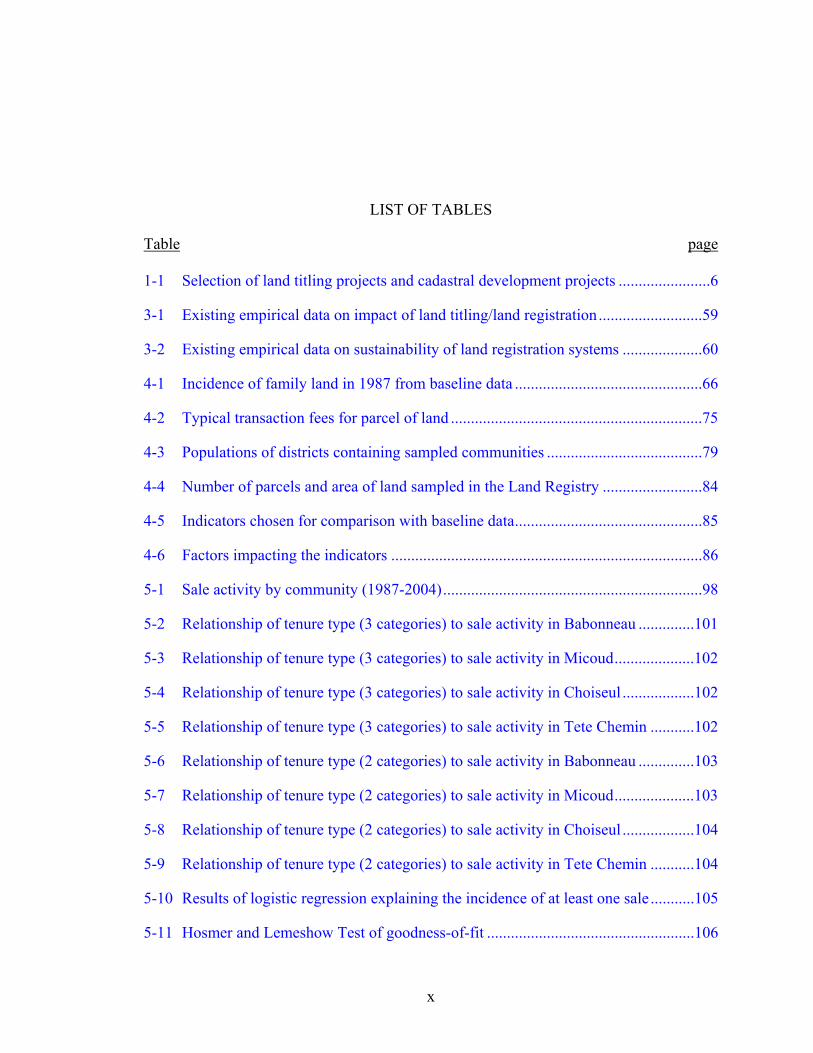
LIST OF TABLES
Table page 1-1 Selection of land titling projects and cadastral development projects .......................6
3-1 Existing empirical data on impact of land titling/land registration..........................59
3-2 Existing empirical data on sustainability of land registration systems ....................60
4-1 Incidence of family land in 1987 from baseline data ...............................................66
4-2 Typical transaction fees for parcel of land ...............................................................75
4-3 Populations of districts containing sampled communities .......................................79
4-4 Number of parcels and area of land sampled in the Land Registry .........................84
4-5 Indicators chosen for comparison with baseline data...............................................85
4-6 Factors impacting the indicators ..............................................................................86
5-1 Sale activity by community (1987-2004).................................................................98
5-2 Relationship of tenure type (3 categories) to sale activity in Babonneau ..............101
5-3 Relationship of tenure type (3 categories) to sale activity in Micoud....................102
5-4 Relationship of tenure type (3 categories) to sale activity in Choiseul ..................102
5-5 Relationship of tenure type (3 categories) to sale activity in Tete Chemin ...........102
5-6 Relationship of tenure type (2 categories) to sale activity in Babonneau ..............103
5-7 Relationship of tenure type (2 categories) to sale activity in Micoud....................103
5-8 Relationship of tenure type (2 categories) to sale activity in Choiseul ..................104
5-9 Relationship of tenure type (2 categories) to sale activity in Tete Chemin ...........104
5-10 Results of logistic regression explaining the incidence of at least one sale ...........105
5-11 Hosmer and Lemeshow Test of goodness-of-fit ....................................................106
x
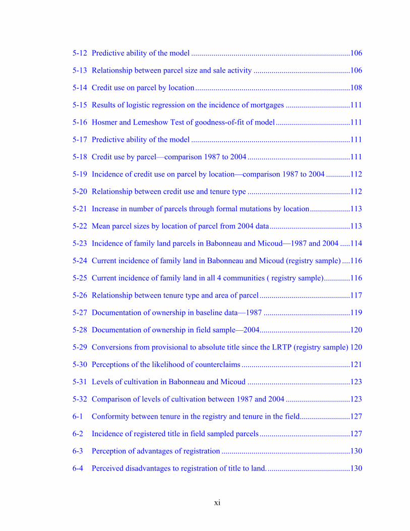
5-12 Predictive ability of the model ...............................................................................106
5-13 Relationship between parcel size and sale activity ................................................106
5-14 Credit use on parcel by location.............................................................................108
5-15 Results of logistic regression on the incidence of mortgages ................................111
5-16 Hosmer and Lemeshow Test of goodness-of-fit of model .....................................111
5-17 Predictive ability of the model ...............................................................................111
5-18 Credit use by parcel—comparison 1987 to 2004 ...................................................111
5-19 Incidence of credit use on parcel by location—comparison 1987 to 2004 ............112
5-20 Relationship between credit use and tenure type ...................................................112
5-21 Increase in number of parcels through formal mutations by location....................113
5-22 Mean parcel sizes by location of parcel from 2004 data........................................113
5-23 Incidence of family land parcels in Babonneau and Micoud—1987 and 2004 .....114
5-24 Current incidence of family land in Babonneau and Micoud (registry sample) ....116
5-25 Current incidence of family land in all 4 communities ( registry sample).............116
5-26 Relationship between tenure type and area of parcel .............................................117
5-27 Documentation of ownership in baseline data—1987 ...........................................119
5-28 Documentation of ownership in field sample—2004.............................................120
5-29 Conversions from provisional to absolute title since the LRTP (registry sample) 120
5-30 Perceptions of the likelihood of counterclaims ......................................................121
5-31 Levels of cultivation in Babonneau and Micoud ...................................................123
5-32 Comparison of levels of cultivation between 1987 and 2004 ................................123
6-1 Conformity between tenure in the registry and tenure in the field.........................127
6-2 Incidence of registered title in field sampled parcels .............................................127
6-3 Perception of advantages of registration ................................................................130
6-4 Perceived disadvantages to registration of title to land..........................................130
xi
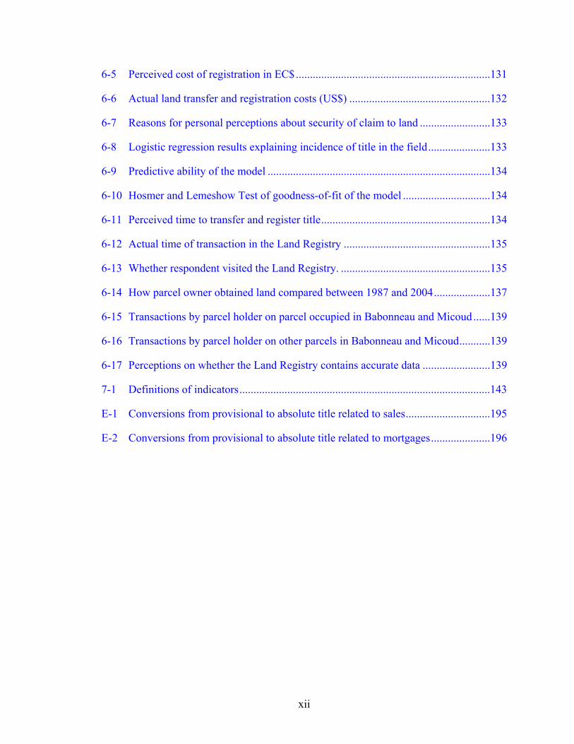
6-5 Perceived cost of registration in EC$.....................................................................131
6-6 Actual land transfer and registration costs (US$) ..................................................132
6-7 Reasons for personal perceptions about security of claim to land .........................133
6-8 Logistic regression results explaining incidence of title in the field......................133
6-9 Predictive ability of the model ...............................................................................134
6-10 Hosmer and Lemeshow Test of goodness-of-fit of the model ...............................134
6-11 Perceived time to transfer and register title............................................................134
6-12 Actual time of transaction in the Land Registry ....................................................135
6-13 Whether respondent visited the Land Registry. .....................................................135
6-14 How parcel owner obtained land compared between 1987 and 2004....................137
6-15 Transactions by parcel holder on parcel occupied in Babonneau and Micoud ......139
6-16 Transactions by parcel holder on other parcels in Babonneau and Micoud...........139
6-17 Perceptions on whether the Land Registry contains accurate data ........................139
7-1 Definitions of indicators.........................................................................................143
E-1 Conversions from provisional to absolute title related to sales..............................195
E-2 Conversions from provisional to absolute title related to mortgages.....................196
xii
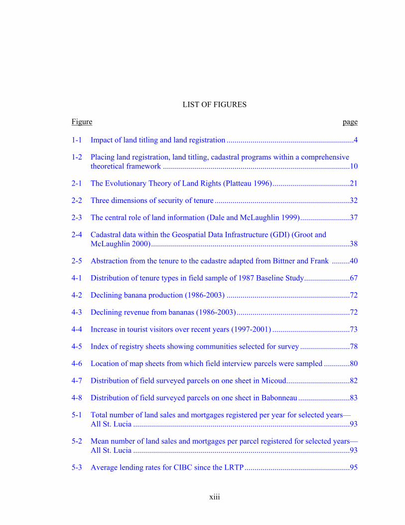
LIST OF FIGURES
Figure page 1-1 Impact of land titling and land registration ................................................................4
1-2 Placing land registration, land titling, cadastral programs within a comprehensive theoretical framework ..............................................................................................10
2-1 The Evolutionary Theory of Land Rights (Platteau 1996).......................................21
2-2 Three dimensions of security of tenure ....................................................................32
2-3 The central role of land information (Dale and McLaughlin 1999).........................37
2-4 Cadastral data within the Geospatial Data Infrastructure (GDI) (Groot and McLaughlin 2000)....................................................................................................38
2-5 Abstraction from the tenure to the cadastre adapted from Bittner and Frank .........40
4-1 Distribution of tenure types in field sample of 1987 Baseline Study.......................67
4-2 Declining banana production (1986-2003) ..............................................................72
4-3 Declining revenue from bananas (1986-2003).........................................................72
4-4 Increase in tourist visitors over recent years (1997-2001) .......................................73
4-5 Index of registry sheets showing communities selected for survey .........................78
4-6 Location of map sheets from which field interview parcels were sampled .............80
4-7 Distribution of field surveyed parcels on one sheet in Micoud................................82
4-8 Distribution of field surveyed parcels on one sheet in Babonneau ..........................83
5-1 Total number of land sales and mortgages registered per year for selected years—All St. Lucia .............................................................................................................93
5-2 Mean number of land sales and mortgages per parcel registered for selected years—All St. Lucia .............................................................................................................93
5-3 Average lending rates for CIBC since the LRTP.....................................................95
xiii
5-4 Total real GDP compared with selected sectors 1990-2002 in EC$ ........................95
5-5 Total number of sales registered per year for selected years in the 4 survey communities .............................................................................................................96
5-6 Mean sales per parcel for the 4 survey communities compared with total ..............97
5-7 Total value of sales per year for 4 survey communities in EC$...............................97
5-8 Value of sales per year adjusted to constant 1990 prices in EC$.............................98
5-9 Mean number of sales per parcel over 16 years in sampled communities ...............99
5-10 Distribution of tenure categories by percentage of area in each community. ........100
5-11 Spatial distribution of sales by tenure type on sheet 1247B, Babonneau ..............105
5-12 Relationship between parcel size and sale activity ................................................107
5-13 Total number of mortgages per year in all four communities................................109
5-14 Total number of mortgages per year for each of the four communities.................109
5-15 Total value of mortgages in EC$ for all four communities....................................110
5-16 Total value of mortgages per year in EC$ for each of the four communities ........110
5-17 Comparison of tenure types in sampled sheets—1987-2004 .................................114
5-18 Comparison of incidence of tenure types in field samples—1987 to 2004 ...........115
5-19 Spatial distribution of tenure types on sheet 1247B, Babonneau...........................117
5-20 Spatial distribution of tenure type on Sheet 1228B, Micoud .................................118
5-21 Distribution of parcel sizes in registry sample .......................................................119
5-22 Perception of likelihood of counterclaim to ownership of parcel ..........................122
5-23 Comparison of percentage of parcels in field sample under different levels of intensity of cultivation (Babonneau—1987 and 2004) ..........................................123
5-24 Comparison of percentage of parcels in field sample under different levels of intensity of cultivation (Micoud—1987 and 2004)................................................124
6-1 Incidence of registered title in field sampled parcels .............................................128
6-2 Landholder perceptions of cost of transaction in EC$ ...........................................131
xiv
6-3 Frequency of visiting registry by type of transaction.............................................136
6-4 How parcel owner obtained land—comparison 1987 to 2004...............................138
7-1 Comparison of sales between Alachua County and St. Lucia................................149
7-2 Comparison of sales as a percentage of the total number of parcels......................150
8-1 Gaps in the model linking titling and registration to posited outcomes.................159
A-1 Distribution of field surveyed parcels on Micoud Sheet 1228B ............................164
A-2 Distribution of field surveyed parcels on Micoud Sheet 1427B ............................165
A-3 Distribution of field surveyed parcels on Micoud Sheet 1428B ............................166
A-4 Distribution of field surveyed parcels on Micoud Sheet 1430B ............................167
A-5 Distribution of field surveyed parcels on Babonneau Sheet 1247B.......................168
A-6 Distribution of field surveyed parcels on Babonneau Sheet 1446B.......................169
A-7 Distribution of field surveyed parcels on Babonneau Sheet 1448B.......................170
C-1 Distribution of tenure types on Babonneau Sheet 1247B ......................................180
C-2 Distribution of tenure types on Babonneau Sheet 1446B ......................................181
C-3 Distribution of tenure types on Babonneau Sheet 1448B ......................................182
C-4 Distribution of tenure types on Micoud Sheet 1228B............................................183
C-5 Distribution of tenure types on Micoud Sheet 1427B............................................184
C-6 Distribution of tenure types on Micoud Sheet 1428B............................................185
C-7 Distribution of tenure types on Micoud Sheet 1430B............................................186
D-1 Distribution of sales by tenure type on Babonneau Sheet 1247B ..........................188
D-2 Distribution of sales by tenure type on Babonneau Sheet 1446B ..........................189
D-3 Distribution of sales by tenure type on Babonneau Sheet 1448B ..........................190
D-4 Distribution of sales by tenure type on Micoud Sheet 1228B................................191
D-5 Distribution of sales by tenure type on Micoud Sheet 1427B................................192
D-6 Distribution of sales by tenure type on Micoud Sheet 1428B................................193
xv
D-7 Distribution of sales by tenure type on Micoud Sheet 1430B................................194
E-1 Incidence of sales by tenure type ...........................................................................196
E-2 Discrepancy in tenure between field and registry ..................................................197
E-3 Incidence of sale on parcel by location ..................................................................197
E-4 Incidence of mortgage on parcel by location .........................................................198
E-5 Incidence of mortgage on parcel by tenure ............................................................198
xvi
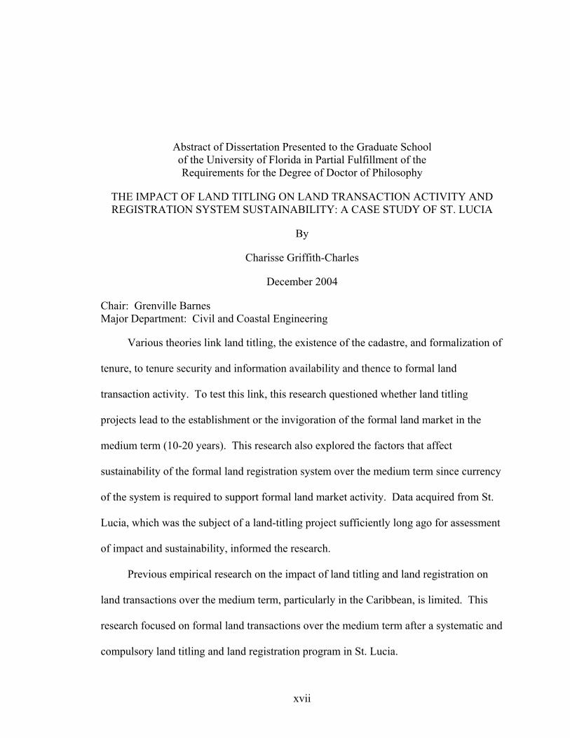
Abstract of Dissertation Presented to the Graduate School of the University of Florida in Partial Fulfillment of the Requirements for the Degree of Doctor of Philosophy
THE IMPACT OF LAND TITLING ON LAND TRANSACTION ACTIVITY AND REGISTRATION SYSTEM SUSTAINABILITY: A CASE STUDY OF ST. LUCIA
By
Charisse Griffith-Charles
December 2004
Chair: Grenville Barnes Major Department: Civil and Coastal Engineering
Various theories link land titling, the existence of the cadastre, and formalization of
tenure, to tenure security and information availability and thence to formal land
transaction activity. To test this link, this research questioned whether land titling
projects lead to the establishment or the invigoration of the formal land market in the
medium term (10-20 years). This research also explored the factors that affect
sustainability of the formal land registration system over the medium term since currency
of the system is required to support formal land market activity. Data acquired from St.
Lucia, which was the subject of a land-titling project sufficiently long ago for assessment
of impact and sustainability, informed the research.
Previous empirical research on the impact of land titling and land registration on
land transactions over the medium term, particularly in the Caribbean, is limited. This
research focused on formal land transactions over the medium term after a systematic and
compulsory land titling and land registration program in St. Lucia.
xvii
This research finds that land titling programs have limited impact over the medium
term on formal land transaction activity. In this research, family land tenure was found to
significantly affect the volume of land market transactions. Despite the posited benefits,
no significant movement from family land tenure toward individualization was found.
Failure to register inheritances and leases was found to be the primary manifestation of
the lack of sustainability of civil participation in the land title registration system.
These findings can be used to determine what are the outcomes to be anticipated
from embarking on programs to perform comprehensive establishment or re-engineering
of cadastral and registration systems, particularly in the presence of community tenure
forms in developing countries. This empirical research adds to the body of information
that tests the validity of the theories under different conditions and contributes to the
design of more effective and comprehensive land administration programs.
xviii
CHAPTER 1 INTRODUCTION
Background
Property and tenure theories posit that security of land tenure is required for
reducing risks in land transactions (Demsetz 1967; Palmer 1996). Reducing these risks
facilitates the formal transaction process for sale or mortgage, leading to an increase in
the volume of these transactions. Security of tenure also increases the confidence the
landholder has of a) being able to claim the return on any investments made on the land,
b) being able to convert the land into cash, and c) being able to use the land as collateral
for accessing credit (Alchian and Demsetz 1973; Demsetz 1967; Feder and Nishio 1999).
Thus, increasing security of tenure should encourage increased investment, improved
productivity and enhanced ability to access credit. According to this body of theory, land
titling, privatization of land, land registration and establishment of cadastres all
contribute to an increase in tenure security on the part of land occupants. Projects to
perform these processes have therefore been promoted as being able to achieve the
security of tenure required for invigoration of land markets (Feder and Nishio 1999;
Deininger et al. 2003; World Bank 2000; World Bank 1997; Agency for International
Development 1974; Agency for International Development 1985). Systems to acquire
and store data on the tenure status of land must remain current and accurate to maintain
the security of tenure and to facilitate land transactions (Dale and McLaughlin 1988,
1999; Groot and McLaughlin 2000).
1
2
Definitions in Land Titling and Land Registration
For the purposes of this research, land titling is the initial process of formally
recognizing rights to land. Land registration is the process of initially recording legally
valid rights to land. Title registration carries the additional guarantee of not only those
rights, but also the guarantee of the transactions regarding those rights being legally valid
by virtue of the recordation process. In practice, though, depending on the efficiency and
security of the land registration system, there may be little difference between the
confidence held in the documents recorded in title registration systems and that held in
the documents recorded in other land registration systems, such as deeds registration
systems. Titling often (but not necessarily) occurs concurrently with the initial
registration in the land registration system. Subsequent transactions in land must be
recorded in the registration system at the time of transaction to be legally valid or to have
legal priority over unregistered transactions. Individualization is the evolution toward
increasing control by the individual landholder over land use decisions.
The cadastral system is that combination of tenure records and the related
description of the smallest individually definable land units over which rights can be held
in a jurisdiction. Cadastral reform denotes the process of making the cadastral system
better able to acquire, store, manage or disseminate the relevant information. Security of
tenure is the confidence landholders have that their rights over land will be upheld by the
society, by local communities or by the state. The projects that this research discusses
are therefore those that are introduced as part of a planned and implemented program
with technical, social, and economic development goals in mind.
Spatial data infrastructure comprises the networked systems, standards, institutions,
personnel and databases that allow the integration of spatial data and thus provides for the
3
access and use of that data (Groot and McLaughlin 2000). Groot and McLaughlin (2000)
define spatial data or geospatial data as spatially referenced data.
Justification for the Research
The land market activity resulting from the implementation of land titling/land
registration projects should lead to economic and social development both by promoting
access to credit to be used in development and by facilitating the reallocation of land to
those who are more productive (Feder and Nishio 1999). Yet the nexus between land
titling projects and equity in land access, credit access, poverty alleviation and
productivity has been questioned, since other market and cultural factors affect whether
and how titled land can be used to foster economic growth. Equity concerns arise
because economic growth flowing out of land market activity may not accrue evenly to
all members of society (Platteau 1996; Dujon 1997; Place and Migot-Adholla 1998).
Cadastral information system frameworks focus on the availability of current land
information to facilitate land markets, to manage the use and distribution of land
resources and to improve the spatial data infrastructure in a jurisdiction (Dale and
McLaughlin 1988, 1999; Palmer 1996). Land titling, land registration and cadastral
programs acquire, formalize and record tenure information and establish mechanisms for
maintaining the information in a current state.
Land titling projects, therefore, are not always applicable for promoting sustainable
development in developing countries since the positive effect on security of tenure is not
always attained (Roth and Haase 1998) and the efficacy of the project for sustainable land
management is doubtful in some circumstances where the culture is accustomed to
alternative property systems (Platteau 1996; Kombe and Kreibich 2000; Agarwal 2001;
Jansen and Roquas 1998). The technology introduced for storing and maintaining the
4
data may also not be consistent with the level of technology with which the society is
comfortable.
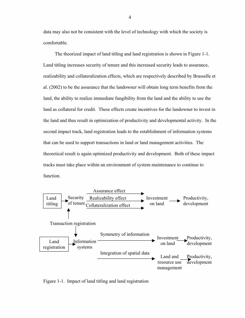
The theorized impact of land titling and land registration is shown in Figure 1-1.
Land titling increases security of tenure and this increased security leads to assurance,
realizability and collateralization effects, which are respectively described by Brasselle et
al. (2002) to be the assurance that the landowner will obtain long term benefits from the
land, the ability to realize immediate fungibility from the land and the ability to use the
land as collateral for credit. These effects create incentives for the landowner to invest in
the land and thus result in optimization of productivity and developmental activity. In the
second impact track, land registration leads to the establishment of information systems
that can be used to support transactions in land or land management activities. The
theoretical result is again optimized productivity and development. Both of these impact
tracks must take place within an environment of system maintenance to continue to
function.
Land titling
Land registration
Realizability effectCollateralization effect
Investment on land
Security of tenure
Productivity, development
Information systems
Symmetry of information
Land and resource use management
Investment on land
Productivity, development
Productivity, development
Transaction registration
Integration of spatial data
Assurance effect
Figure 1-1. Impact of land titling and land registration
5
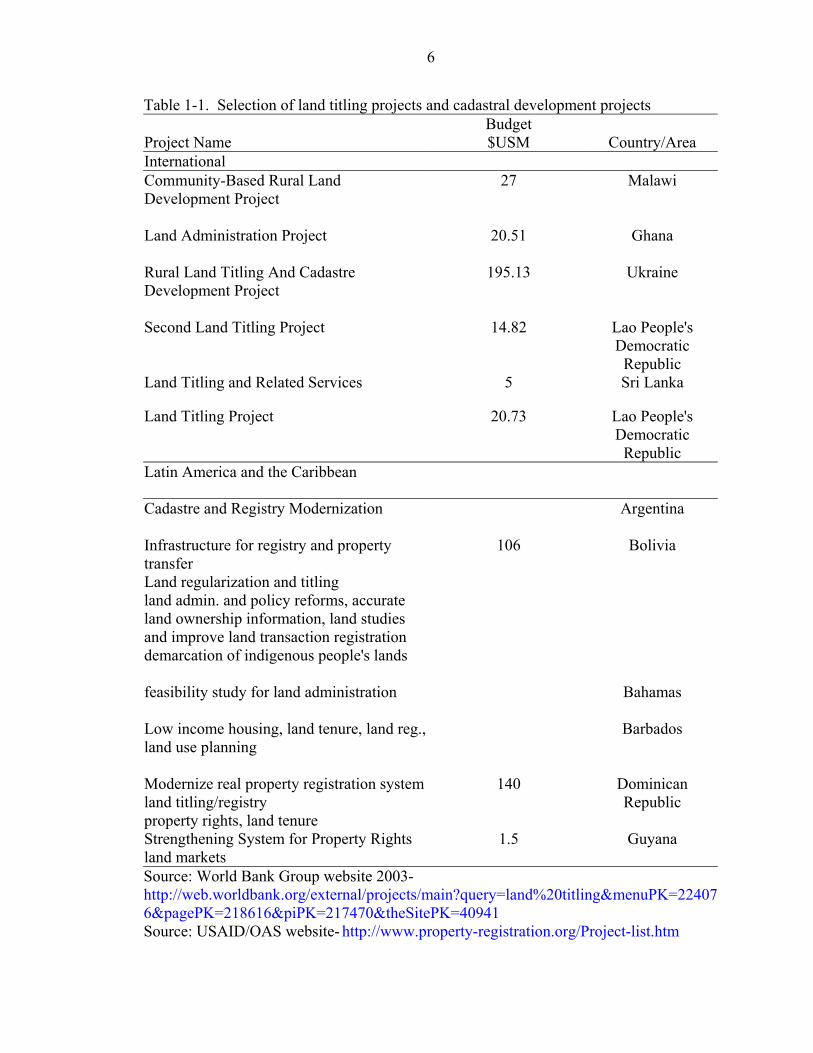
Significant investments are being made across the developing world in the
establishment of cadastral and registration systems, as part of land administration
programs, by governments hoping to achieve economic and social benefits. As an
illustration of the scale of these projects, a search on land titling projects on the World
Bank Group website (World Bank Group 2003) returns a list of land titling project costs
ranging from $US 5 million for a land titling and related services project in Sri Lanka to
$US 195 million for a rural land titling and cadastre development project in the Ukraine.
A USAID/OAS website (USAID/OAS 2003) also lists projects in land titling and
cadastral development. Some of these projects are listed in Table 1-1.
Internationally funded land administration programs are in various stages of
planning and implementation in many countries with varied economic and social
challenges such as Croatia, Nicaragua, Cambodia, Bolivia, Panama, Phillipines,
Honduras, and Bulgaria amongst others (World Bank Group 2003; Inter American
Development Bank [IDB] 2003; U. S. Agency for International
Development/Organization of American States [USAID/OAS] 2003). A search on the
World Bank website (World Bank Group 2003), for titling, registration and cadastral
projects returns 66 projects. A search on the Inter-American Development Bank (IDB)
website (IDB 2003) returns some 56 documents on land administration programs.
As an indication of the land administration activity in the Caribbean and South
American region, a USAID/OAS website (USAID/OAS 2003) lists 20 programs in 9
Caribbean countries, 61 programs in 8 Central American countries and 42 programs in 7
South American countries that deal broadly with land administration. An example of
some of these projects in South America and the Caribbean is also shown in Table 1-1.
6
Table 1-1. Selection of land titling projects and cadastral development projects
Project Name Budget $USM Country/Area
International Community-Based Rural Land Development Project
27 Malawi
Land Administration Project
20.51 Ghana
Rural Land Titling And Cadastre Development Project
195.13 Ukraine
Second Land Titling Project 14.82 Lao People's Democratic
Republic Land Titling and Related Services 5 Sri Lanka
Land Titling Project 20.73 Lao People's Democratic
Republic Latin America and the Caribbean
Cadastre and Registry Modernization
Argentina
Infrastructure for registry and property transfer Land regularization and titling land admin. and policy reforms, accurate land ownership information, land studies and improve land transaction registration demarcation of indigenous people's lands
106 Bolivia
feasibility study for land administration
Bahamas
Low income housing, land tenure, land reg., land use planning
Barbados
Modernize real property registration systemland titling/registry property rights, land tenure
140 Dominican Republic
Strengthening System for Property Rights land markets
1.5 Guyana
Source: World Bank Group website 2003- http://web.worldbank.org/external/projects/main?query=land%20titling&menuPK=224076&pagePK=218616&piPK=217470&theSitePK=40941 Source: USAID/OAS website- http://www.property-registration.org/Project-list.htm
7
Much of Latin America has had land administration programs or such programs are
proposed for implementation (Barnes 2003). The Caribbean also has projects in various
stages of implementation in Jamaica, Belize, and Trinidad and Tobago amongst others
(USAID/OAS 2003). Most of the land administration programs have a land titling, land
registration, or cadastral reform component although it would be difficult to identify
exactly what proportion of the expenditure is allotted to each particular component.
Documented empirical evidence is needed to test whether investments in the
improvement of land administration systems are socially and economically viable.
Country governments must be aware that the cost incurred by the implementation of the
project must include the succeeding recurrent expenditure required for maintaining the
systems. Empirical research tests the theories that relate the implementation of these
projects to the development of land markets and therefore allows for more effective
project design that incorporates supportive activities within a holistic program to effect
development.
Empirical research on the benefits achieved by land administration programs
provides a better understanding of the actual benefits of the programs and also provides
information for improving future programs. Platteau (1996) contends that anticipated
benefits have been overestimated and are not justified by the cost of the programs.
Brasselle et al. (2002) present evidence for questioning the link between security of
tenure and agricultural investment in sub-Saharan Africa.
Freyfogle (2002) and Agarwal (2001) question, not the programs themselves, but
the structure of the individualized land tenure regime that is normally instituted and its
efficacy for land use sustainability. More specifically, Barnes (1990b; 2003), van der

8
Molen (2002) and the World Bank (2001) call for more research on the sustainability of
land information systems to ensure that longer-term benefits derive from these programs.
Maintenance of civil participation is a key area of the overall sustainability of the land
registration system. While there has been research in different jurisdictions concerning
the link between land registration and access to credit, land values, investments in land
and output and income from land, there have been relatively fewer studies dealing with
the link between titling and land registration projects and land transactions. Feder and
Nishio (1999) identify further research needs in this area, including more empirical
research on the actual impact of registration systems on transactions in the land market
and state:
… the reduction of uncertainty regarding ownership is expected to enhance the level of activity in the land market, affording increase in the overall efficiency of land allocation. However, there has been a paucity of empirical research on the veracity of this proposition, and on the actual extent of land transactions under different levels of formality of the property rights system. (Feder and Nishio 1999, p40)
Feder and Nishio (1999) also speak of the importance of analyzing the justification
for such systems in the local or regional context of various countries, particularly where
tenure systems with distinct characteristics exist. This research is therefore particularly
useful in the Caribbean where the “family land” type of communal tenure coexists with
the more conventional private, individual tenure. Data on medium term impacts of
completed programs would close this gap in the knowledge of the impact of the programs
on land transactions and of the sustainability of the installed information systems. For
the purpose of this research, medium term is defined to be 10 to 20 years after the
completion of the land titling or land registration project.
9
Research Problems
There is therefore a dearth of evidence to support the assertion that land titling and
land registration projects lead directly to increases in land transactions over the medium
term, particularly within the economic, social, and tenurial context of the Caribbean
region. There is also a paucity of medium term data on the sustainability of the land
registration information systems established by land titling projects. There are, in
addition, conflicting reports from various studies in different regions on the impacts of
land titling and land registration projects. This empirical research is therefore required to
assist in filling these gaps.
Research Questions
This research investigates the following research questions:
• Do land titling/land registration projects lead to the establishment or the invigoration of the formal land market, as measured by the registration of sales and mortgages?
• Are formal land registration systems sustainable over the medium term?
Research Methodology
The approach was firstly to locate this research within the context of the various
disciplinary and theoretical themes that frame it. Figure 1-2 indicates that the boundaries
of the major development theories determine the structure of the development processes
that are proposed and implemented. Land-based development solutions form a large part
of the development framework, supported by tenure and property theories that link tenure
on land to development.
Many of these land-based development solutions require the support of the
cadastre, including the land registration system, the form and function of which is
founded on cadastral information system concepts and affected by diffusion theories. It
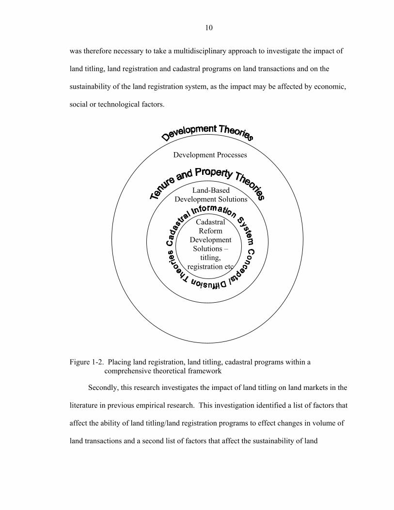
10
was therefore necessary to take a multidisciplinary approach to investigate the impact of
land titling, land registration and cadastral programs on land transactions and on the
sustainability of the land registration system, as the impact may be affected by economic,
social or technological factors.
Development Processes
Land-Based Development Solutions
Cadastral Reform
Development Solutions –
titling, registration etc
Figure 1-2. Placing land registration, land titling, cadastral programs within a
comprehensive theoretical framework
Secondly, this research investigates the impact of land titling on land markets in the
literature in previous empirical research. This investigation identified a list of factors that
affect the ability of land titling/land registration programs to effect changes in volume of
land transactions and a second list of factors that affect the sustainability of land
11
registration systems. From the theory and the literature, an approach was suggested to
investigate the case study.
Thirdly, the empirical part of the research was based on the case study of St. Lucia.
Data were collected, both from the Land Registry records and from administering
questionnaires to land occupants, to address the research questions. Additional
information on the economic, social and technological environment in St. Lucia was
derived from interviews with land-based professionals such as lawyers, land surveyors,
and valuation surveyors. The first research question was addressed by observing the
extent to which landholders formally registered their land transactions in the formal land
market after the titling project. The second research question was addressed by observing
the congruence between the formal data acquired in the Land Registry with the data
acquired in the field.
It is acknowledged that there are a myriad of confounding exogenous economic and
social factors that complicate the relationship between land titling and formal land
markets (Binswanger and Deininger 1993; Deininger et al. 2003). The quantification of
the relative impact of all the possible contributing factors is beyond the scope of this
research, which is focused on empirically testing the impact of land titling and land
registration programs on land transactions and on land registration system sustainability.
The scope of the practical aspect of this research was therefore limited to investigating
and testing empirically the correlation between land titling/land registration and land
markets, and between land titling/land registration and the sustainability of the land title
registration system in the case study area. Comparing land transactions across different
12
tenure types within St. Lucia also helped to control for major economic and social
conditions that affect the country as a whole.
The sustainability of the information system introduced via the land-titling project
was examined. Societal perceptions regarding the system were also documented to
determine whether they affected the sustainability of the system. Data on volume and
type of land transactions since completion of the property formalization program were
collected to illustrate the impact of the program on the formal land market and the
progress of the impact over time. The data on volume and type of land transactions,
collated into sales, gifts and bequests illustrated the activity in the formal market. The
data on volume and type of informal land transactions illustrated the activity in the
informal land market.
Organization of Dissertation
Chapter 1 introduced the research problem, and presented the research questions
and structure of the research. Chapter 2 investigates the structure of land administration
programs and how tenure and property theories fit within these programs. The chapter
also develops cadastral and land registration system frameworks and diffusion theory to
describe how culture has been determined to impact on geographic and land information
system adoption in general.
Chapter 3 reviews existing empirical research in the literature to develop a list of
factors drawn from this research that impact on the ability of land titling and land
registration programs to lead to increased land transactions and to sustainable land
registration systems.
13
Chapter 4 describes the case study characteristics relevant to the research and
identifies the data acquisition methodology used in the case study country and in the
analysis of the data.
Chapter 5 analyzes the data captured in the case study related to formal land
transactions, compares the findings to the baseline study findings and describes the
relevance of the outcomes of the analyses.
Chapter 6 analyzes the data captured in the case study related to sustainability of
the land registration system, compares the findings to the baseline study findings and
describes the relevance of the outcomes of the analyses.
Chapter 7 discusses the generalizability of the findings by comparing the indicators
derived in Chapter 5 and Chapter 6 to indicators from other international jurisdictions
gleaned from published work. Chapter 8 summarizes and concludes the research and
recommends approaches to instituting land titling and land registration projects and
further investigation on factors that impact sales and mortgages, and the adoption of land
title and land registration system technology.
CHAPTER 2 THEORETICAL FRAMEWORK OF LAND TITLING PROGRAMS AND LAND
REGISTRATION SYSTEMS
The following sections describe the theories that have impacted on and have shaped
the form and structure of land administration programs. Cadastral reform draws on
theories in land tenure, property systems, and information systems to develop
frameworks for the optimal form and function of the cadastral system (Dale 1976; Dale
and McLaughlin 1999; Larsson 1991; Williamson and Ting 2001). While development
theories are presented here to briefly describe the general economic foundations that
motivate the overall development process, land tenure and property theories are detailed
to more closely describe the concepts that position land and cadastral systems within, and
as important components of, development processes. Cadastral reform and technology
diffusion concepts are detailed here to even more precisely describe the way the cadastral
and land administration systems, as information systems, are structured and how they
relate to societies as they attempt, as comprehensively as possible, to describe and record
the complex human-land relationship.
Development Theories
Many development theories have evolved over the last 6 decades and their
implementation has been pursued globally. Modernization theory, which is one of the
more fundamental theories in development, became established after World War II.
Modernization, summarized, states that nations are poor because they lack capital,
technology and modern social values. Despite being criticized in later years for failing to
14
15
extricate poor nations from the grasp of poverty, these modernization theories retain their
proponents and the concepts are still used as the basis for many current development
programs (Roberts and Hite 2000). Development programs structured around land, based
on this modernization theme, introduce the technology and capacities required to install
or elevate land administration institutions into modern entities and attempt to establish a
land market, whereby capital can be generated from land, to fund growth and
development.
Globalization, as an emerging major development theory, states that power derives
from a hold on information, technology and world banking institutions (Roberts and Hite
2000). Land administration development programs of this type aim to improve the
accessibility and transparency of land markets so that land can be traded as a commodity
on international markets and used as securitization for international investors seeking
investment opportunities.
Development theories continue to evolve as the very definition of development is
questioned by postmodernists who champion the validity of alternative perspectives to
development (Roberts and Hite 2000). Such debates are fueled by some of the harmful
social, economic and environmental consequences of conventional ideas of development.
Imperatives for preserving economic and social equity and environmental sustainability
now underlie proposals for development. However, solutions proposed in these debates
still focus on the more judicious management and use of land.
Development theories are linked to the concept of ownership of landed property by
the fact that land is one of the primary ingredients of the development theories. Land can
provide the capital required for modernization efforts to occur. Access to land can
16
correct the inequities decried by Marxism and dependency theorists. Global corporations
require land to make use of the resources in targeted nations. Land is still a major factor
of production. So that whichever theory is espoused, land remains central to its
implementation. Many development programs are therefore focused around the
redistribution, restitution, privatization, individualization, titling, registration or
recordation of land.
Supporting programs deal with the introduction of legislation and legislation
changes required to facilitate these processes and the institutional structuring and
restructuring required to implement and manage these processes and the data that
emanate from their implementation. The World Bank policy on development via land
reform has evolved to where acknowledgement is made of the value of supporting the
creation of more owner-occupied family farms, securing property rights for increasing
investment in land and increasing the volume of transactions in the land market,
improving policy and legislation to support land migration to more productive users and
uses, supporting land rental markets together with land sale markets and encouraging
equity in land distribution (Deininger and Binswanger 1999). Whereas in 1975, the
World Bank land reform policy was specific in its recommendation to convert communal
tenure systems to individualized tenure systems, the policy has shifted to recommending
that governments facilitate communal systems, where they exist, in their management
while still guiding the evolution to individualization (Deininger and Binswanger 1999).
However, some researchers still deplore the economic land market emphasis as put
forward by international development agencies (Dujon 1997).
17
Land related development is therefore a key focus of national development funded
by international agencies and adopted by governments.
Property and Tenure Theories
Individualization of Tenure—Economic Aspects of Property Rights
History of individualization
Property theories also support the importance of land and security of land tenure to
growth and development of the individual and ultimately the society. While societies
have historically used various tenure mechanisms to manage coexistence on land, the
economic view of landed property has significantly shaped the western world’s attitude to
land ownership. By so doing, this economic view has affected the implementation of
development projects related to land as proposed by western development funding
institutions. The economic view is that land is simply a factor of production and
therefore conforms to factor market characteristics.
Few have been as instrumental in initially defining this economic view as John
Locke whose analyses of property are viewed as being foundational to market theories
(McMurtry 1997). Statements by philosophers such as John Locke (1690) and, later,
Jacques Rousseau (1754) supporting individualization of property within ethical limits
preceded theories on the natural inevitability of individualization and those on the
economic advisability of individualization as opposed to common property and later, the
imperative to encourage individualization as a catalyst for development.
John Locke philosophized that “as much land as a man tills, plants, improves,
cultivates, and can use the product of, so much is his property” (Locke 1690, Section 32).
He modified this radical statement by declaring that an individual’s ability to amass
property by dint of his labor should be tempered by the “rule of propriety”, which
18
requires that each person only take what was required for sustenance, leaving the rest for
the other members of the society to extract their own sustenance. Labor, he claimed was
the only way to give land any economic value. Even though Locke is thought of as
supporting individualization of landed property, which is part of neoclassical economic
theory, the difference is that the neoclassicist is not constrained by morality but must
obey the laws of economic self interest in order to support the economic system whereas
Locke held the overriding morality of the “rule of propriety” as being paramount in
preventing inequity in the world (Henry 1999). Theorists such as Hardin (1968) deride
the ability of ethics to provide a workable solution to problems of finite resource use
since, in an open access system, ethical behavior would doom the highly moral individual
to a disadvantaged position and then to exploitation and ultimately to elimination from
the user community. This view is evidence of the need for some rule-based structure to
land and resource management. Since it was not the intention of his argument, Hardin
did not discuss the fact that many communal groups had social rules and sanctions that
provided the rule based structures that would allow the communal resource use system to
function. Judge (2002) posits that the self-regulating ethical rule structure of Locke’s
perspective on property is analogous to the community sanctions provided by a functional
communal land use system.
The history of the thinking on individualization is still fundamental to the way ideal
property structures are conceived by economists and recommended in development
(Deininger and Binswanger 1999).
Description of individualization
Individualization is conceived of as being gradual when it occurs naturally in
response to market forces of increasing population, external market demands or other
19
increases in demand for scarce land or land-based resources. Theoretically, land tenure
systems, given these typical scenarios, must move inexorably towards individualized land
holding since this type of system most effectively maximizes economic benefits from the
land resource (Demsetz 1967; Binswanger and Deininger 1993). In the agricultural
economics context, Binswanger and Deininger (1993, p1250) state that “under simple
technology there are no scale economies in farming and independent family farms are
economically the most efficient mode of production, except for a very limited set of
plantation crops.”
The individualization process begins to occur in many countries or jurisdictions
when the population increases and land space decreases, resulting in an increase in value
of land and land resources. Where land was once open access, smaller more
homogeneous communal ownership groups such as families or tribes develop (Larsson
1991). Demsetz (1967) described this process in economic terms as internalizing of
externalities. While the value of the land is low in situations where land is freely
available and the population is small, the cost of acquiring and policing ownership on an
individual parcel of land to the casual user of the parcel is an externality. The definition
of externality is not precisely defined in economic terms but Demsetz (1967) specifies the
term to mean costs that do not impact on economic decision-making because such costs
are too high to be feasible to consider. When the value of the land, or the gains to be
achieved from internalization, increases to exceed the cost to the ownership group of
having the open ownership system and the cost of internalization, then these costs of
acquiring and policing are internalized and are therefore reflected in the increased cost of
acquiring exclusive use of a parcel of land. The economically ideal situation is where all
20
externalities, whether positive or negative, become part of the negotiations into the
transfer of land between individually rational parties (Demsetz 1967).
The ETLR: individualization to titling to land markets
The individualization process may take years, decades or even centuries depending
on the relative impact of the external factors that cause the value of the land to increase.
These factors may include the rate of growth of the population depending on the land or
land resource for survival, the area of suitable land, the availability of land resources, and
the rate of growth of the external markets for the land resource.
The economic view of individualization and its link to land markets and attendant
benefits first began to be empirically tested in the 1980’s in the context of a World Bank
funded project in Thailand. Gershon Feder, a researcher in the World Bank, was
instrumental in this advancement of the theory, developing conceptual models of the
process and testing the models with data from Thailand (Feder and Onchan 1987; Feder
et al. 1988). The land titling project in Thailand, begun in 1984, was the largest project
of this kind in the world and was therefore a natural case study for the theory.
Evidence of the individualization process, called the evolutionary theory of land
rights (ETLR) by Platteau (1996) and gleaned by him from previous descriptions of the
theory by economists such as Feder et al. (1988), Demsetz (1967) and Feeny (1988), was
also researched in the African context. Platteau graphically illustrated the concept as
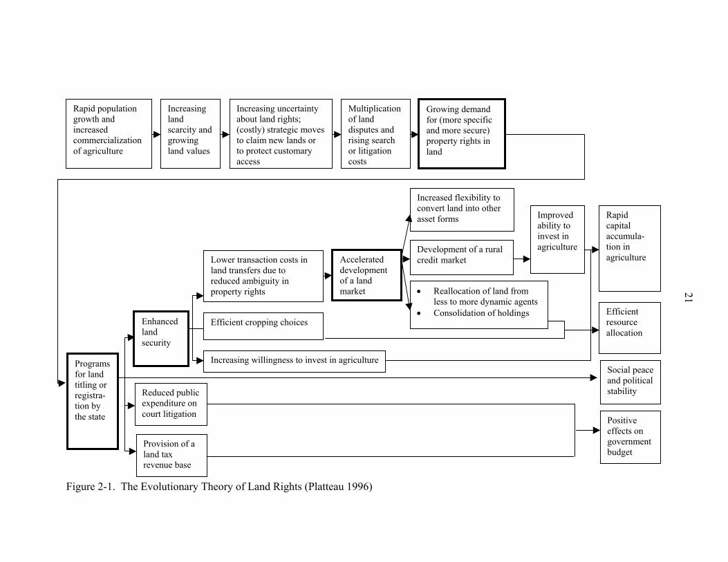
shown in Figure 2-1. This model follows the individualization process from increasing
population and land scarcity through the conflicts that result from the competition for
agricultural land. Two alternate views exist on the direction the land tenure takes from
this point. One view is that the land tenure does not automatically evolve towards
individualization but that individualization must be forcibly introduced to the
Rapid population growth and increased commercialization of agriculture
Increasing land scarcity and growing land values
Increasing uncertainty about land rights; (costly) strategic moves to claim new lands or to protect customary access
Multiplicationof land disputes and rising search or litigation costs
Programs for land titling or registra- tion by the state
Enhanced land security
Reduced public expenditure on court litigation
Provision of a land tax revenue base
Lower transaction costs in land transfers due to reduced ambiguity in property rights
Efficient cropping choices
Increasing willingness to invest in agriculture
Accelerated development of a land market
Figure 2-1. The Evolutionary Theory of Land Rights (Platteau 1996)
21
Growing demand for (more specific and more secure) property rights in land
Increased flexibility to convert land into other asset forms
Development of a rural credit market
• Reallocation of land from less to more dynamic agents
• Consolidation of holdings
Improved ability to invest in agriculture
Rapid capital accumula-tion in agriculture
Efficient resource allocation
Social peaceand political stability
Positive effects on governmentbudget
22
tenure system. The second view, shown in Figure 2-1, is that the society in conflict
naturally, at some point, exerts pressure on the state to individualize land through titling
mechanisms. This necessity for the state to intervene is the ETLR view. Three different
economic and social benefit streams are then identified.
Firstly, the increase in tenure security, introduced by the land titling process,
would lead: a) to a greater volume of transactions in land at lower costs due to the
available information, b) to more economically advantageous agricultural decision
making and c) to increased investment in agriculture since there would be less necessity
for investment in protection of property rights.
Secondly, the decrease in land conflicts would lead to a more stable and peaceful
society. Thirdly, the state benefits from the taxation that is possible with the available
information and from the reduction in court litigation costs.
Platteau (1996) acknowledges the negative impacts to this scenario as a result of
inequity in land distribution arising from land being lost through foreclosure on
mortgages and acquired by entrepreneurs as investment opportunities. He disregards the
impact of this side effect as merely “ a natural accompaniment to specialization and
growth from which everybody will benefit” (Platteau 1996, 37).
The ETLR theory was supported by empirical research from Kenya that indicated
a shift from sales that were redeemable to the original seller to increasingly irredeemable
sales (Barrows and Roth 1989). The number of sales occurring was also positively
related to the population density in Rwanda and Ghana (Migot-Adholla et al. 1991).
Sales occurring only within communal groups gradually evolved to sales occurring to
persons outside the group first only with group approval and then requiring no approval

23
(Bruce 1986). Although Platteau (1996) agreed with the ETLR view that what was
occurring in sub-Saharan Africa was a natural evolution towards increased
individualization and heightened transferability in land he disagreed with the inevitability
of the society-induced demand for titling in all situations.
Restrictions to individualization
Empirical evidence, in the situation of sub-Saharan Africa, suggested to Platteau
that the ETLR process did not naturally occur without technological change and
economic alternatives to land holding accompanying the other market drivers. He
therefore concluded that land tenure arrangements did evolve under increasing land
scarcity but that state imposed land titling was not necessarily the result. Other informal
and communal land tenure arrangements (as opposed to formal, individualized land
titling, and registration instituted by the state) could evolve to respond in a more socially
positive way to land scarcity. While he noted that empirical evidence was scarce, as only
Uganda, Zimbabwe, and Kenya had performed large-scale land registration and formal
individualization programs, he cited evidence from these countries, and from other areas,
where informal individualization had occurred to support his stance. He suggested that
formal, individualized land titling might only be appropriate in situations where other
socially cohesive institutions, such as communal tenure, did not exist. This view
therefore acknowledges the importance of culture to the determination of whether land
titling is an appropriate intervention. He also suggested that formal, individualized land
titling should only be performed at the appropriate time in the ETLR sequence. There
must be pressure from the society due to land scarcity and rising population before land
titling is warranted. Empirical evidence from case studies that Platteau cited in Africa
found that, contrary to the ETLR, land registration could lead to reduced security of
24
tenure and more land conflict (Atwood 1990). This occurred where supportive,
overlapping, customary and residual rights of women, uneducated, nomadic and other
marginalized groups were not acknowledged and recorded in the formal individualization
and titling process.
Binswanger and Deininger (1993) opined that market imperfections prevent the
evolutionary theory from achieving the benefits. These imperfections can be:
• Political inequalities • Policy distortions, • Absent or imperfect land markets, • Asymmetric information, • Historical inequities in distribution and access to land • Absence of insurance.
Perfect land markets with perfectly symmetrical information allowing voluntary
transactions would therefore result in the stated benefits in a relatively short space of
time. However, perfect land markets do not exist in reality, since land, unlike some other
market products, is a variable product the price of which is affected by perceptions, and
emotions of the buyer and seller (Stringer 1988). Additionally, risks in transactions are
increased because of differences between transfer rights and physical possession and use
rights.
Land administration programs accelerate the gradual individualization process by
instituting individualized property systems via titling and registration, together with the
supporting surveys and cadastre development. Whereas, under the evolutionary process,
individualization would have been gradual, allowing the supporting institutions,
legislation, and cultural acceptance of the technology to grow and develop, the imposed
25
development program model faces problems related to inadequate capacity and resistance
to adoption.
Formalization of Tenure—Legal Aspects of Property Rights
In keeping with the thinking of Alchian and Demsetz (1973), the legal view of
individualization is that formalized, private rights are easier to administer because they
provide for the self-regulation of individuals and benefit society. In 1968 Garrett Hardin
(1968) had been instrumental in publicizing this perspective of the efficacy of formal
individualization for management of land as a resource even though other researchers had
held this view prior to Hardin’s publication of “the tragedy of the commons” (Freyfogle
2002). Even though land management was not the focus of his arguments, his goal being
to apply game theory to the problem of world overpopulation, and even though he
erroneously termed as common property a situation that could better be described as open
access resource use, the examples he used were believed to speak to the inadequacy of
common property for resource management. In Judge’s (2002) perception, however,
there is no such thing as open access property as all resources belong to some entity,
including the state or all of humankind, who may or may not demand compensation for
the effect of use by individuals. The legal view of individualization, therefore, focuses
on the gradual change in formal rights to use and transfer land that occurs as societies
evolve.
Hernando de Soto (2000) is another key proponent of the benefits of formalization
as put forward by Demsetz and illustrated diagrammatically by Platteau (see Figure 2-1).
He suggests links between formal land titling and economic development at the level of
the individual that are more ambitious than those put forward by Platteau, and operate
beyond the agricultural sphere to include the urban environment. Firstly, he cites
26
instances where the lack of a formal property system can lead to lack of development
since occupiers of land who are members of the informal system in a country would not
be able to count on the support of the property system for securing their land or for
financing their entrepreneurial activities. This would leave them at an economic
disadvantage in comparison to those who have these supports. There is also a cost
attached to being informal that they must pay from their already meager resources, since
most of those who remain informal are poor, as they cannot buy their way out of
informality. Secondly, he postulates that a cadastral system can be used to positively
foster development by allowing the owner access to capital to fund enterprises. De
Soto’s ideas, while attractive to many, have also been discredited by many others such as
Gilbert (2002), Fernandes (2002), Unruh (2002), and Payne (2002) for lack of
transparency in the empirical evidence collected in various countries and for exaggeration
of positive outcomes. Unruh (2002) states that formal systems are usually more easily
imposed on migrant societies such as those of early North America, which is often cited
as an example of a functional property system. Imposing formal systems on traditionally
communal or established alternative tenure systems with functional rules meets
resistance, again citing the example of the impact of formal tenure systems on the
indigenous populations of North America.
Feder and Nishio (1999) also relate formal land registration to increased access to
formal credit opportunities, higher land values, greater investment in land based
enterprises, and increased output to income ratios for land based investment, by analyzing
empirical evidence from several countries, primarily Thailand.
27
Informal Tenure
Gilbert (2002) cites empirical evidence obtained from Latin America to show that,
contrary to de Soto’s statements, illegality and informality did not prevent development.
He also found evidence that land titling did not necessarily either encourage the accessing
of credit or improve the ability to access credit and did not increase the mobility of
homeowners in the manner required for a vibrant land market. Instead he found land
occupiers who, despite being informal, achieved perceived security of tenure based on
political tolerance, service provision and the duration of time in undisturbed possession.
He also found vibrant, informal land markets unhindered by lack of formal titles.
Brasselle et al. (2002) also state that security of tenure is indeed present in tests for
investments but this is because performing investment related activities increases security
of tenure for agriculturists and not vice versa as advanced by the ETLR. Brasselle et al.
(2002), speaking for the rural agricultural environment (as opposed to Gilbert (2002),
who presents evidence from primarily the urban environment), and speaking, also, for the
link between security of tenure and farm-based investment solely in the African context,
found conflicting evidence. They found empirical research from Green (1987), Migot-
Adholla et al. (1991), Pinckney and Kimuyu (1994) where systematic titling had no
impact on investment on agricultural land. They also found research from Harrison
(1992) that indicated that the promise of more secure tenure was not an incentive for
farmers to voluntarily register land nor did it affect their productivity. They found
research (Gavian and Fafchamps 1996; Saul 1993; de Zeeuw 1997) that stated that in
informal areas, investments were not affected (although in informal areas security of
tenure is expected to be tenuous). However, Brasselle et al. (2002) systematically list
other research (Migot-Adholla et al. 1994b; Place and Hazell 1993; Migot-Adholla et al.
28
1991) where security of tenure was related to investments in some communities while in
other communities the relationship was not found.
These empirical studies conflict with the ETLR view by indicating instances where
informal occupation does not restrict security of tenure or investments on land and that
land markets can exist, albeit informal, without titling.
Communal Tenure—Social Aspects of Property Rights
A developing literature on resource management and communal land tenure
questions the governance structures in individualized land tenure systems for achieving
sustainable development and for maintaining sustainable information systems (Baland
and Platteau 1996; Ostrum 1990; Wade 1988; Freyfogle 2002; Oestereich 2000). These
perspectives follow a different track to the largely economic view of land tenure that the
ETLR espouses. This alternate perspective views land tenure and property rights as a
dynamic social relationship that must be constantly negotiated and renegotiated as
cultures and societies change (Williamson and Ting 2001). Furubotn and Pejovich (1972,
1139) stated that “Property rights do not refer to relations between men and things but
rather, to the sanctioned behavioral relations among men that arise from the existence of
things and pertain to their use”.
This flexibility in the relationship demands flexibility in the structures required to
manage the smooth functioning of the system and the inevitable conflicts that would arise
as it shifts and changes with time and conditions. Management of this type of structure is
performed at a group or community level. This social construct may be reflected in or be
in conflict with the formal laws of the society. While it can be argued that the economic
view provides flexibility in land tenure arrangements, since this view is founded on the
ability of the land market to adapt spontaneously to the economic forces of demand and
29
supply, the sociological view provides for a more controlled response to the social
situation so that equity can be preserved.
Williamson and Ting (2001) tracked this changing social relationship between
mankind and land historically, describing the global catalysts that have progressively
accelerated this changing relationship. These global catalysts are described as being;
• Imperatives for sustainable development, • Globalization, • Economic reform and • The realities of urbanization and advances in technology.
While economists argue that individualized land holding is optimal for economic
purposes for the individual, legal and land management minds such as Freyfogle (2002)
and Oestereich (2000) take the view that land management is best performed at larger
scales. This latter view therefore supports the existence of communal tenure
arrangements. Communal tenure systems even allow for greater internalization of
externalities since the positive externalities of conservation are better captured while the
negative externalities of degradation are better allocated. Individual ownership allows
individuals to focus on effects that would be felt over one lifetime while environmental
effects have long-term impact and require management structures that would base
decisions on longer time frames (Oestereich 2000).
Agarwal (2001) presented an expository analysis of current research methodologies
used in the area of communal tenure and their governance structures by Baland and
Platteau (1996), Ostrum (1990) and Wade (1988) and suggested more rigidly structured
comparative analyses that would derive models for sustainable governance that look
beyond the institutions to incorporate the many factors that apparently impact the
sustainability, equity and efficiency of the communal resource system. These factors
30
relate to the several characteristics of the resource system, the communal group, the
relationship between the resource system and the group, the institutional rules, the
relationship between the resource system and the institutional rules, and the external
environment. Cadastral and land registration systems analyses, since they deal with the
land as being composed of individually definable and registrable units, would benefit
from the resource and common pool literature as this suggests mechanisms for
cooperative maintenance of the information systems and also mechanisms for legislating
and defining land management units and authorities. The common pool research also
suggests alternatives to the land titling of individualized parcels such as modifying
existing communal governance structures, to bring them in line with what is posited as
being the ideal, in order for these communal governance structures to be better able to
manage land rights.
Much of the research on communal tenure describes the social benefits attributable
to the communal tenure regime. While the economic view of individualization assumes a
strictly linear process leading to complete individualization, the social view accepts a
need for communal tenure to continue to exist alongside growing individualization as
support and insurance for those in the society. Thus, Besson (1987) describes the
symbolic nature of communal tenure systems in the Caribbean and their necessity for
providing status, prestige, solidarity and economic insurance to their members. Family
land tenure exists in Jamaica, Antigua, Nevis, Montserrat, Dominica, St. Lucia, St.
Vincent, Grenada, Bequia, the British Virgin Islands, St. John in the American Virgin
Islands, Barbados, Providencia, and Trinidad and Tobago (Besson 2003). Also,
Ezigbalike et al. (1996) speak of the religious significance of land in communal tenure
31
systems in Africa and McLaughlin et al. (1994) compare the indigenous North
Americans’ tenure systems with those of the colonizers.
Security of Tenure
The various concepts of land and property pivot on the notion that security of
tenure is required for increasing productivity, supporting development and providing
peace of mind for individuals in the society. Just as tenure has been described here to
exist on different levels; individual and communal, formal and informal, and the
permutations and gradations of these categories, the security of tenure that each level
provides also differs.
Security of tenure exists on three dimensions, each one having different importance
to different professionals (Bruce 1998). The depth of the security of tenure, or assurance
as it is termed by Place et al. (1994), relates to the degree of confidence that landholders
have that their rights to hold and use the land would be supported by the local
community, the society as a whole, and the state. This dimension is important to the
legal profession and can be indicated by the strength and the degree of enforcement of the
legislation and regulations that exist governing land rights in the jurisdiction. The
breadth of the security of tenure relates to the range of supported uses to which the land
can be put. This dimension is important to land use and land resource managers and can
be indicated by a list of possible uses to which the land can be put ranging from rights to
use, occupy, or develop, to rights to mortgage, sell, or bequeath. The duration of the
security of tenure relates to the length of time for which the rights may be held. This
dimension is important from an economic perspective and can be indicated by the value
of the investments and the production output that can be achieved within the time allotted
for the rights. These time periods can range from month-to-month to leasehold for fixed
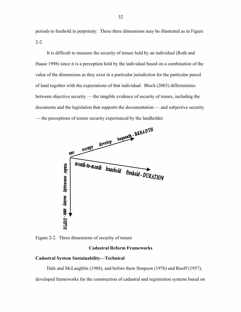
32
periods to freehold in perpetuity. These three dimensions may be illustrated as in Figure
2-2.
It is difficult to measure the security of tenure held by an individual (Roth and
Haase 1998) since it is a perception held by the individual based on a combination of the
value of the dimensions as they exist in a particular jurisdiction for the particular parcel
of land together with the expectations of that individual. Bloch (2003) differentiates
between objective security — the tangible evidence of security of tenure, including the
documents and the legislation that supports the documentation — and subjective security
— the perceptions of tenure security experienced by the landholder.
Figure 2-2. Three dimensions of security of tenure
Cadastral Reform Frameworks
Cadastral System Sustainability—Technical
Dale and McLaughlin (1988), and before them Simpson (1976) and Ruoff (1957),
developed frameworks for the construction of cadastral and registration systems based on
33
observation and comparison of the efficiencies and benefits of then existing and historical
systems and technologies. They also adapted technical, legal and sociological principles
to determine what structure the cadastral and registration system should take. Some of
these observations of then extant and historical systems are detailed in Dale (1976) and
Dowson and Sheppard (1968). The cadastral system describes the land tenure in a
country and must be able to keep pace with and support land-based development. A
cadastre is defined in the Fédération Internationale des Géomètres (FIG) statement on the
cadastre as:
… normally a parcel based and up-to-date land information system containing a record of interests in land (e.g. rights, restrictions and responsibilities). It usually includes a geometric description of land parcels linked to other records describing the nature of the interests, and ownership or control of those interests, and often the value of the parcel and its improvements. It may be established for fiscal purposes (e.g. valuation and equitable taxation), legal purposes (conveyancing), to assist in the management of land and land use (e.g. for planning and other administrative purposes), and enables sustainable development and environmental protection. (FIG 1995)
The use of the terms “normally” and “may” makes concessions for the fact that
many jurisdictions contain only some of the characteristics listed but use the term
cadastre for the system that they possess. Cadastral reform is therefore prescribed to
either establish or reengineer these systems, including laws, institutions and technology,
for recording the ownership, value and use of land. Maseyk (1993) defined cadastral
reform as “… the processes of bringing about change in the cadastral systems, which will
improve the efficiency, the operation of or the value of those systems.” (Maseyk 1993,
p376)
The role of the cadastre through the years has evolved from strictly the recording of
ownership information, value and use in the early history, through supporting land
markets in the post industrialization era to management and planning of land use, to
34
current foci on environmental, social equity and sustainable development issues (Barnes
1990a; Williamson and Ting 2001). Frameworks for developing the cadastral system
have always stressed precision in the definition of land parcels on the spatial side as well
as precision in the determination of ownership on the legal side in order to ensure the
efficiency of the system. With the change in the role of the cadastre, the requirements for
recording ownership, value and use have expanded to where the systems must now
support a myriad of other uses. To do so, they must form part of a spatial data
infrastructure (Groot and McLaughlin 2000). Finley et al. (2000) cite examples of
infrastructures of this type that incorporate cadastral information in their form. These
examples include infrastructures developed and managed by Service New Brunswick of
Canada, the US state of North Carolina, the Public Sector Mapping Agencies of Australia
and the Dutch clearinghouse for geospatial information.
As technology advances to provide opportunities for increased precision in
measurement, acceleration in speed of computations and improved clarity and flexibility
of geospatial visualization, it has become difficult to determine, for a particular
jurisdiction, exactly what level of the technology is necessary for supporting the social
functions of the cadastre, of providing peaceful occupation of land and evidence for
protection from contestation of claim, and at what point the use of technology results in
greater conflict and contestation of land rights. This implementation problem, as it
affects the global spatial data infrastructure has been highlighted by Lummaux (1997), as
quoted in Groot and McLaughlin (2000, p23):
If it merely serves to emphasize the chasm between those who have and those who don’t, if it would be another model for the former to profit at the expense of the latter, and if it would just aggravate the technological and economic dependencies
35
which already exist, this infrastructure would indeed become a terrible instrument of oppression and retreat.
This problem is more marked in the establishment or reengineering of cadastral
systems in developing countries where technology can serve as a disincentive to the
registration of transactions by landowners. This can occur because, inasmuch as the
technology provides new options for efficiency and speed of operations and increasingly
more complex representations, technology itself also has limitations and therefore
restricts the system to being able to record and recognize only rights that can be clearly
and verbally described and boundaries that can be numerically and graphically depicted.
Where technology and legislation are, by nature, precise, standardized and generally
inflexible, tenure rules can be flexible and negotiable. For example, innovations such as
3-D cadastres are in the experimental stage of more accurately describing the spatial
extent of vertically layered rights (Stoter and Salzmann 2003) and video was used
experimentally in Algeria to visually and orally document rights (Roux and Barry 2001).
On the other hand, Ankersen and Barnes (in press) discuss the difficulties of recording
and maintaining information on the spatially, temporally and hierarchically differentiated
use rights within community concessions, extractive reserves and forest ejidos in Latin
America since the use rights are so intricately interwoven.
Cadastral System Sustainability—Data
The technical structures of the cadastre must be able to move beyond the
establishment of the cadastral land information systems to not only system scalability
requirements but also to the capacity building and institutional strengthening required to
maintain the systems over time. Dale and McLaughlin (1988, 1999), developed models
for the structure of the land administration system, and checklists for the establishment of
36
the multi-purpose cadastre including the institutions, technology, spatial infrastructure
and mapping required based on observation of existing systems and previous research by
National Research Council (1980), Holstein et al. (1985) and others. They envision the
ideal structure of the land administration system to be based on land information
integrated from the institutions that traditionally acquire and manage data on the
ownership, use, and value of land, that is, the land registry, the planning department and
the tax department respectively. A model of the integrated system is as shown in Figure
2-3.
Dale and McLaughlin (1988, 1999) indicate the need for detailed, accurate and
current land information to meet the requirements of land managers and ultimately the
interests of equity, the environment and economic development, but they also stress the
importance of maintenance of the information:
Maintenance is more important than initial system creation for without it, the system will become an historical monument and a folly at that. Not only must external changes be recorded within the system but also the system must itself be capable of change as the levels of sophistication both of the hardware and software and of the people operating them grow. (Dale and McLaughlin 1999, 161)
Groot and McLaughlin (2000) describe the necessity for the cadastral system to be
part of an information infrastructure that would allow the sustainability of the available
land information and also maintain its reliability, increase its utility and provide lowered
costs to the users. They define the Geospatial Data Infrastructure (GDI) as
encompassing:
… the networked geospatial databases and data handling facilities, the complex of institutional, organizational, technological, human, and economic resources which interact with one another and underpin the design, implementation, and maintenance of mechanisms facilitating the sharing, access to, and responsible use of geospatial data at an affordable cost for a specific application domain or enterprise. (Groot and McLaughlin 2000, 5)
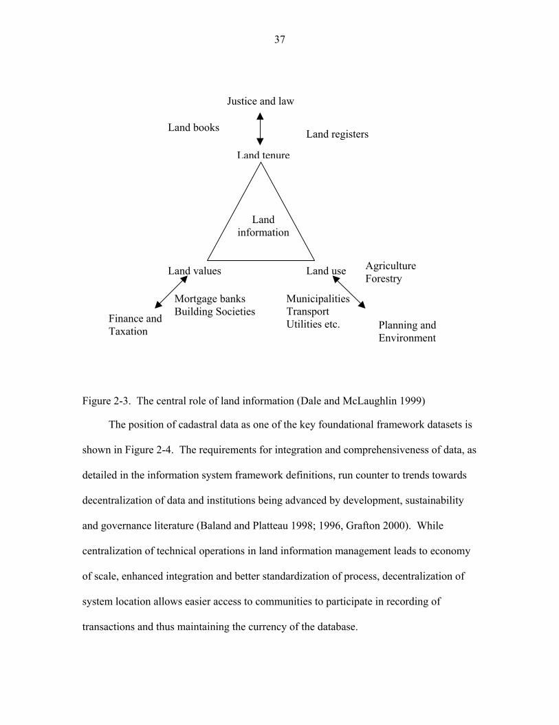
37
Land tenure
Justice and law
Land registers Land books
Land values Land use
Mortgage banks Building SocietiesFinance and
Taxation
Municipalities Transport Utilities etc.
Agriculture Forestry
Planning and Environment
Land information
Figure 2-3. The central role of land information (Dale and McLaughlin 1999)
The position of cadastral data as one of the key foundational framework datasets is
shown in Figure 2-4. The requirements for integration and comprehensiveness of data, as
detailed in the information system framework definitions, run counter to trends towards
decentralization of data and institutions being advanced by development, sustainability
and governance literature (Baland and Platteau 1998; 1996, Grafton 2000). While
centralization of technical operations in land information management leads to economy
of scale, enhanced integration and better standardization of process, decentralization of
system location allows easier access to communities to participate in recording of
transactions and thus maintaining the currency of the database.
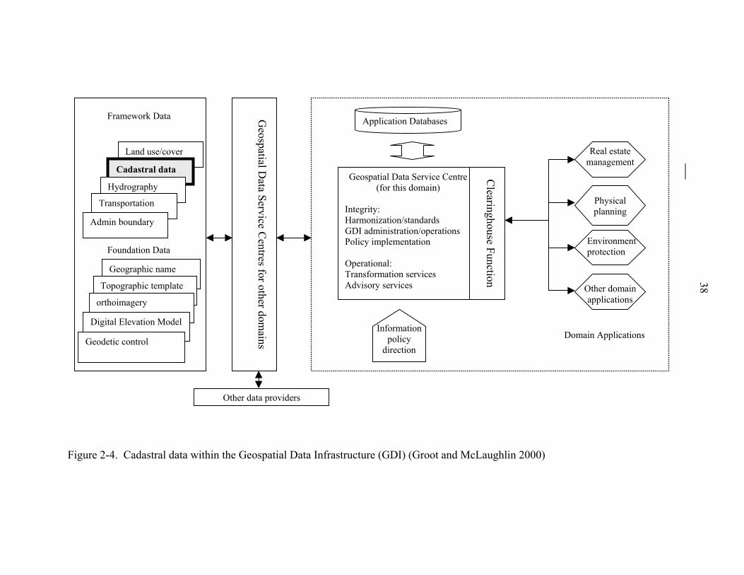
Land use/cover
Cadastral data
Hydrography
Transportation
Admin boundary
Geographic name
Topographic template
orthoimagery
Digital Elevation Model
Geodetic control
Framework Data
Foundation Data
Geospatial D
ata Service Centres for other dom
ains
Other data providers
Figure 2-4. Cadastral data within the Geospatial Data Infrast
InHGP OTA
ru
38
Real estate management
Geospatial Data Service Centre(for this domain)
tegrity: armonization/standards DI administration/operations olicy implementation
perational: ransformation services dvisory services
Clearinghouse Function
Physical planning
Other domain applications
Domain Applications
Environment protection
Information policy
direction
Application Databases
cture (GDI) (Groot and McLaughlin 2000)
39
The decentralized institutions are more readily accepted by the local communities and
can adapt to suit the communities’ needs.
Van der Molen (2002) differentiates between the static components and the
dynamic components of administration systems, positing that the recording of the facts at
the point in time of the creation of the system is static whilst those components that are
dynamic over time such as the relationship of people to land in the jurisdiction, the
acceptance of this relationship by the statutory authorities, and the normal transactions
that occur in a market environment require consideration prior to construction of the
system to allow the system to remain sustainable. This sustainability requires flexibility
in the initial conceptual design of the system since the system structure cannot be
frequently changed, as this would create instability and lack of confidence in the system.
Maintenance of the information within a cadastral system is also a function of the
legislation, which is part of the model of the system. Bittner and Frank (2002) develop a
model for the registration of information in the cadastre. They define the correctness of
the cadastre as the degree of equivalence between the information held in the cadastre
and the legal situation on the ground. The information represented in the cadastre is an
abstraction of the legal situation on the ground, but the legal system also is an abstraction
of the actual tenure situation on the ground as it does not completely reflect reality. For
example, a cadastre that does not accommodate strata titles is inadequate in its abstraction
if the legislation allows strata titles. Legislation that makes no provision for dealing with
strata titles is inadequate in its abstraction if strata ownership exists and is not proscribed
by law. Informality occurs when occupation or use is in direct contravention of the law.
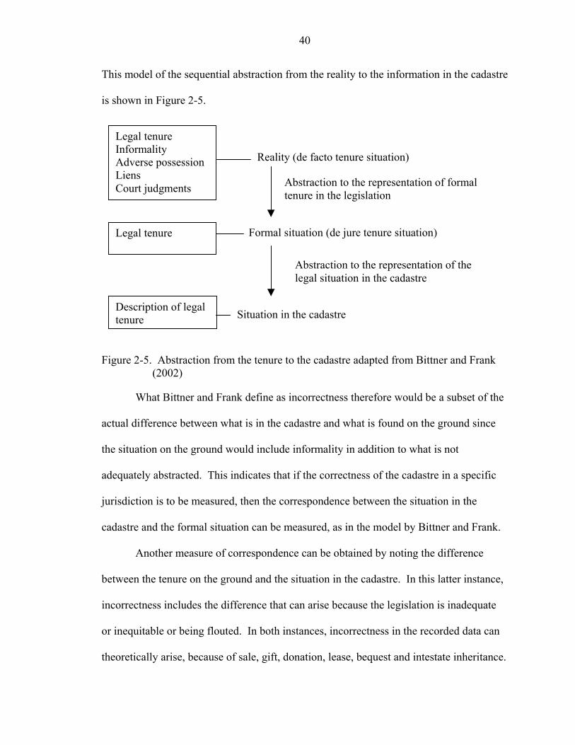
40
This model of the sequential abstraction from the reality to the information in the cadastre
is shown in Figure 2-5.
Reality (de facto tenure situation)
Abstraction to the representation of formal tenure in the legislation
Formal situation (de jure tenure situation)
Abstraction to the representation of the legal situation in the cadastre
Situation in the cadastre
Legal tenure Informality Adverse possession Liens Court judgments
Legal tenure
Description of legal tenure
Figure 2-5. Abstraction from the tenure to the cadastre adapted from Bittner and Frank
(2002)
What Bittner and Frank define as incorrectness therefore would be a subset of the
actual difference between what is in the cadastre and what is found on the ground since
the situation on the ground would include informality in addition to what is not
adequately abstracted. This indicates that if the correctness of the cadastre in a specific
jurisdiction is to be measured, then the correspondence between the situation in the
cadastre and the formal situation can be measured, as in the model by Bittner and Frank.
Another measure of correspondence can be obtained by noting the difference
between the tenure on the ground and the situation in the cadastre. In this latter instance,
incorrectness includes the difference that can arise because the legislation is inadequate
or inequitable or being flouted. In both instances, incorrectness in the recorded data can
theoretically arise, because of sale, gift, donation, lease, bequest and intestate inheritance.
41
Then the recorded rights holder would not be the same as the actual rights holder. While
legislation can prescribe for transfers of sale, gift, donation and lease to be invalid unless
recorded and so preserve correctness of the registration system, this is impractical in
instances of bequest or intestate inheritance since the property cannot continue to belong
to the deceased until registered in the heir. The record therefore becomes incorrect
immediately upon the death of the registered owner.
Bittner and Frank recommend linking the land registry to the other registries or
institutions where real world changes impacting land rights are recorded. They develop
an automated system for marking the land registry records as being incorrect when digital
information about changes is received from other sources. The level of incorrectness of
the land registry data would thus be known until the requisite legal and administrative
procedures are completed to formally register the change. A level of correctness in the
registration system of 100% cannot be attained as information on deaths, adverse
possession, liens and personal court judgments for example would not be attainable
immediately. A level of acceptable correctness that would not affect the confidence in
and the functioning of the system is required to be specified. This level of acceptable
correctness must be set by the institution responsible for the cadastre after consideration
of the institutional capacities, the measured or anticipated impact on the users of
incorrectness, and the user requirements. This level can be amended as capacities and
technologies improve. The Ordnance Survey of Great Britain, for example, sets
benchmark targets for the currency of its topographic maps, which are used as cadastral
maps (Ordnance Survey 2004). These targets have progressed to higher and more
stringent specifications as capacities and technologies have improved.
42
Cadastral System Sustainability—Participation
The state institutions responsible for the data are required to maintain the
information system but the responsibility also falls on civil society to maintain the data.
Larsson (1991) determined that certain conditions encouraged society to maintain the
registers. These conditions he noted to be:
• The advantages of registration communicated to the landowners,
• The ease of registration provided by centralization of operations and simplification of process,
• Linkages between state processes that would automatically trigger updating,
• Lowered costs of registration.
Palmer (1996) suggested that government sanctions, or credit-centered incentives,
such as facilitating access to credit for registered owners or assigning a credit risk rating
to parcels, could be utilized to encourage the support of the land registration information
system and ensure its currency. However, the model of correctness illustrated in Figure
2-4 shows that if the legislation causes low correspondence between the reality and the
abstraction to the formal situation, then the system information would appear to be more
incorrect when compared with the de facto situation and would also be less acceptable to
the society.
This need for participation and interaction between the technology and the society
has required the cadastral reform process to be more flexible and to take into
consideration more of the endogenous social issues of the jurisdiction in which it is to be
implemented. Suggested methodologies to marry the technological requirements of the
reform with the social requirements to form one proposal have come from Bittner et al.
(2000), Fourie and van Gysen (1995), Williamson and Fourie (1998), and Zevenbergen
43
(1998) amongst others. There have, however, been few attempts to test these
methodologies, and the technology-based structure of the cadastral reform process
remains largely unchanged. Williamson and Fourie (1998) suggested case study
methodologies for assessing the situation in the jurisdiction in which the cadastral reform
process is to be implemented prior to proposal of a solution.
Literature on the technological advances in information systems acknowledges
that there is a significant cultural effect on the adoption and diffusion of land information
systems from country to country and culture to culture. Even though the initial
expenditure may be high, establishing high technology cadastral information systems as
part of a land administration development program can tend to be more cost effective
than more labor-intensive methods. Compare the cost and efficiencies of data acquisition
and maintenance using a high technology land registration process including GPS, digital
photogrammetry and GIS software with that based on surveying individual parcels using
conventional methods and manual drafting and updating. Barnes et al. (1998) for
example, found that in the study area of Albania, conventional methods surveyed 10
hectares per day while GPS techniques surveyed 37 hectares per day. However, if the
receiving culture does not accept and adopt the technology, there would be difficulties in
maintaining the efficiency over time. Al-Gahtani (2003) posits that even though
provision of IT occurs in 90% of development banks’ lending, evidence shows that the
lack of adoption of the technology by institutions and individuals can prevent benefits
accruing from the expenditure. This is particularly important in developing countries
where other factors such as infrastructure, politics and costs already encumber the
effectiveness of the technology.
44
There has been much research on diffusion of innovations to identify the
particular characteristics of technology that determine the rate at which the technology
would be adopted by the receiving society. Acceptance and adoption by civil society
would encourage participation in the maintenance of the data. Rogers (1983) listed these
characteristics as being:
• Relative advantage, • Compatibility, • Complexity, • Trialability and • Observability.
The relative advantage is defined as the benefit perceived by the user to accrue on
adoption of the innovation. This can be a value benefit or it can be prestige attached to
being seen as adopting. Compatibility defines how closely the innovation corresponds to
the preceding technology and therefore how easy it is to adopt the new technology.
Complexity defines how difficult it is to adopt the new technology as well as the
steepness of the learning curve to adoption. Trialability defines whether the innovation
can be tested without negative repercussions if it were to be abandoned. Observability
denotes whether the adoption by others can be viewed so that any benefits accruing to
other adopters can be observed. Researchers in the area of GIS adoption have largely
upheld these general characteristics that are applicable for all technology adoption (Chan
and Williamson 1999). In GIS the adoption is stated to be determined by the
characteristics of the system and the characteristics of the organization within which the
GIS is established (Chan and Williamson 1999). In LIS, and registration systems in
particular that are established for the entire society, the adoption can be determined by
the characteristics of the registration system and the culture of the society. Al-Gahtani
45
(2003) in a study on computer adoption in Saudi Arabia found that up to 87% of
computer usage was explained by the perceived diffusion characteristics. Nedovik and
Godschalk (1996) found, in a study of the adoption of GIS technology in four agencies in
North Carolina, USA, that perceived relative advantage and compatibility of the new
system with previous computer experience of the adopters were major determinants of
the adoption of the technology.
Diffusion is defined as “the process of communicating an innovation to and
among the population of potential users who might choose to adopt or reject it” (Onsrud
and Pinto 1991, 447) or as “the process by which an innovation is communicated through
certain channels over time among the members of a social system” (Rogers 1995, 5). An
innovation is defined as “an idea, practice, or object that is perceived as new by an
individual or other unit of adoption” (Rogers 1995, 11). The information system
established as a result of the land titling/registration program may be considered to be the
innovation to be adopted, but the concept of individualized land tenure, insofar as it may
be a new process particularly for societies where communal or other traditional forms of
tenure were previously prevalent, can be regarded as the innovation required to be
adopted and diffused.
Maitland (1998) posits that even prior to introducing new technology, the culture
of the society can be assessed to determine the potential for successful introduction and
rate of diffusion. However, in researching the diffusion of interactive networks, Maitland
indicates the difficulties of operationalizing the variables defining culture and presents
tentative propositions relating the variables to the adoption. While there are many
theories defining methods of categorizing national cultures in order to scientifically
46
measure the impact of culture on diffusion, Hofstede (1980; 1991) defined five categories
that may be used to determine the impact on the adoption of land information technology.
These categories define the ways in which the society engages:
• Power hierarchies within its structure • Uncertainties and problems it encounters • Gender differences • Individuality as opposed to group action • Long as opposed to short term orientation
Van den Toorn and de Man (2001), speaking from the perspective of GIS in
general and not necessarily registration information systems, posit that societies with
vertical power hierarchies would utilize GIS for management functions and downplay
any inherent sharing and social benefits. Societies with more horizontal power
hierarchies would do the opposite. Societies that value direct management of problems
and uncertainties would be quick to use all the novel functionalities of the GIS. Societies
that are regarded as masculine or which differentiate between treatment of males and
females would again use GIS for management and control, while more feminine cultures
would adopt the relationship building and networking aspects of GIS. They regard
individualism as being strongly and inversely correlated with power hierarchy so no
additional information is attained by adding information on the status of the
individualism in the society.
While there may be cultural differences even within a country relating to urban and
rural cultures, or amongst different organizations within the country, general
categorizations can be made about the country as a whole where the heterogeneity within
the country is less marked than that across countries. The way these categories affect
diffusion in land information systems has been investigated by van den Toorn and de
47
Man (2001) who admit that adequate systematic knowledge is lacking about the factors
that determine adoption of land information systems. The impact of these cultural
variables on the diffusion of interactive networks was also investigated by Maitland
(1998) but since the variables are confounding, no clear consensus on a model could be
derived using all the variables derived from the categories. Applying the variables to
land registration systems, a hypothesis can be stated where masculine societies would
adopt the system for management of the data and the use of land. Conversely a feminine
society would adopt the system for supporting equitable distribution of land. This
inconsistency in determining the direction of causality of the relationship between the
variable and the outcome arises for all the variables leading to van den Toorn and de Man
(2001) stating that the relationship is multidimensional. Maitland’s (1998) proposed
hypotheses would need to be empirically tested.
To address the conflict between the technology and the society into which the
information system is being injected, van den Toorn and de Man (2001) suggest hybrid
methods that can be revised over time since culture is dynamic. However, these hybrid
approaches can prove to be expensive and less efficient.
Summary
Chapter 2 presents the background theory that drives the move to institute land
titling programs internationally and also shapes the structure of such programs.
Arguments that support the need for formal individualized tenure systems conflict
with research that suggests that other less formal and more communal tenure forms are
just as beneficial to investment, productivity and security of tenure.
Sustainability of the cadastral system, of which the registration system is a part, has
technical, data, and social participation components. The social participation component
48
is impacted by culture and can be modeled using diffusion concepts of perceived system
characteristics and also using cultural categorization.
Chapter 3 that follows details the empirical findings of current research on the
impact of land titling on land markets and sustainability of land registration systems in
various jurisdictions.
CHAPTER 3 FACTORS CONTRIBUTING TO PROGRAM IMPACT AND SYSTEM
SUSTAINABILITY
Empirical Data on Land Titling Impacts
The following sections trace the major empirical studies that have been done on the
impact of land titling/land registration programs on land market transactions of sale,
mortgage and lease. The eventual sustainability of the land registration systems in these
studies is also examined where noted. Studies that investigate the impact of land titling
and land registration on change in security of tenure are also described since security of
tenure is theoretically an intermediate requirement to transacting in the market. The
factors that contribute to the programs achieving the outcomes are identified.
Existing Studies and Methodologies in Land Titling
There have been empirical impact assessments of land titling and land registration
performed in various regions of the world using different methodologies. Few of these
have measured the sustainability of the land title registration system or the impact of land
titling programs on the formal land market over the medium term. There is very little
empirical data on these issues to be found on the Caribbean region. The applicability of
the findings in the impact studies to other cultures and regions is also questionable due to
the wide ranges of exogenous factors that affect the land registration system and the land
market. Some of the studies presented here are not based on the installation of a focused
land titling program but are comparisons between documented tenure and undocumented
tenure in a jurisdiction.
49
50
Other measures of assigning land rights that stop short of individualized title, such
as Community Land Trusts (CLTs) and Temporary Occupation Licences (TOLs) in
Kenya, Certificates of Comfort (COCs) in Trinidad and Tobago, Transitional Certificates
in Romania and Concession of the Real Right to Use (CRRU) in Brazil, have been
attempted particularly in the urban environment, but these are not considered here. The
focus here is on addressing both of the research questions, the first relating to formal land
transactions in the land market and the second relating to land registration systems
sustainability over the medium term.
There have also been studies on the impact of land titling or secure tenure on land
values (Thailand, Philippines, Indonesia, Peru), investments (Costa Rica, Ghana (Besley
1995) Thailand (Feder and Onchan 1987), India (Pender and Kerr 1994)), incomes
(Ecuador, Paraguay, Costa Rica) and productivity (Zimbabwe (Moor 1996)). These
outcomes, while they may be mentioned, are not the primary focus of this research.
Empirical data from Africa
Kenya and Tanzania. Pinckney and Kimuyu (1994) compared titled areas in
Kenya with untitled areas in Tanzania to determine the difference in the volume of
transactions between the locations. While Kenya had been the subject of land titling, the
Government of Tanzania had been concerned that titling would result in loss of equity in
landholding and had nationalized and leased land instead to occupants. The study found
that there was no difference in the number of transactions, formal or informal, between
the two locations. The study also found an insignificant number of land secured loans in
the Kenyan sample and no land-secured loans in the Tanzanian sample. The researchers
therefore concluded that land titling in Kenya had not led to an increase in transactions,
both formal and informal, and that the tenacity of the customary tenure had negated the
51
impact. They suggested that the resources of the country that were being invested in land
titling be otherwise deployed.
Kenya. Platteau (1996) questioned the applicability of the evolutionary theory of
land rights in the Sub-Saharan African context despite the fact that other researchers such
as Feder and Nishio (1999) presented empirical evidence from several other countries in
other regions, of titled farmers receiving more credit and investing more on their land
than untitled farmers. Platteau (1996) based his critique on empirical research done by
Land Tenure Center (LTC) (1990), Roth et al. (1994a; 1994b), Migot-Adholla et al.
(1994a; 1994b) and others in the Sub Saharan African context. These studies were
focused on access to credit and the corresponding impact on agricultural productivity and
not necessarily on the growth of the land market in terms of the changes in the number of
transactions performed on land. Platteau found that, in Kenya, whereas land sales had
increased in the short term following land reform, that is, when land registration had not
yet been completed, this growth in the formal land market was not sustained over time.
The registered parcels also soon reverted to customary transacting processes causing loss
of sustainability of the land registration system. A significant cultural effect therefore
mitigated any direct impact of land titling on the land market and on the sustainability of
the land title registration system.
Place and Migot-Adholla (1998), re-examining data from a study performed in
1988 in Kenya, found insufficient evidence to support any significant effect of
registration and land titling on the perception of security of tenure, on the use of credit by
landowners, on agricultural productivity and on land sales and the reallocation of land.

52
They also suggested a redirection of resources towards other measures if an increase in
agricultural productivity were the goal.
Security of tenure was measured, in the Kenyan study, by the incidence of land
titles, by the incidence of current registration, and by enumerating the use rights
perceived to be held and the number of land related disputes, including boundary and
legitimacy disputes, that had occurred. The number of sales and leases that had occurred
were also measured to determine the impact of land titling on the land market and on land
concentration. The study found 34.6% of titles were held under the current household
head and 57.7% of parcels were correctly recorded in the registry, pointing to problems in
the sustainability of the registration system and also leading to conclusions that the
landholders perceived security of tenure even without current registration (Place and
Migot-Adholla 1998).
Place and Migot-Adholla suggested lack of demand by the farmers, costs of
registration, lack of awareness, and corrupt or bureaucratic institutional processes as
reasons for the lack of sustainability. These issues correspond to the relative advantage,
observability and complexity of diffusion frameworks. These factors along with the
proximity to urban centers, difference in land values, and history of commercialization in
the area, they determined, explained the disparity in the frequency of land titles across the
four study areas. The lack of transactions of sale they attributed to the indigenous tenure
system restricting the demand for and the social approval to perform transactions on land.
The titling project they analyzed had begun in 1954 based on 1908 land titling
legislation. While the project systematically adjudicated and surveyed in rural areas, new
settlers were required to pay for land before they could obtain title. This was therefore a
53
significant factor that would have impacted on the sustainability of the land title
registration system and the perceptions of tenure security experienced by the occupants.
Although many occupants of land did not pay and thus were not eventually titled, the
government’s policy was not to remove the occupants, so few parcels had been
repossessed. While this policy would have negatively affected incentives to register, it
would have positively impacted on perceived security of tenure but not on documentary
security of tenure.
Burkino Faso. More recently, Brasselle et al. (2002) point to flaws in the design
and concept of empirical tests that both support and question the positive link between
individualized tenure and security of tenure and then to investment on land. They opine
that there is always some form of endogenous tenure underlying the titling and this must
be accounted for and controlled before statements about the correlation between security
of tenure and investments can be made. The researchers attempt to control for this effect
by choosing for analysis newly settled communities where no endogenous tenure and
therefore no tenure security would have existed prior to the titling. They then examined
investment after a short period of 5 years to determine if investments increased with
increasing security of tenure. Instead they found that investments increased security of
tenure and not the other way around. The study was performed in a community of
Burkino Faso in Africa where there was no land market so that the impact on transactions
could not be investigated.
Empirical data from Asia
India. Pender and Kerr (1994) found, in India, that any differences in credit use
between titled land and assigned state land were due to the difference in quality of the
land and not to increased security of tenure as a result of the land titling.
54
Thailand. The Thailand land titling project began in 1984 and presented an
opportunity for empirical testing of the benefits of instituting land titling and land
registration. It was determined in an empirical study (Feder et al. 1988) on rural Thailand
that farmers who were in possession of titled land accessed 52-521% more formal credit
than those farmers who had no title. Feder and Nishio (1999) also cited a study done 3 to
4 years after the Land Titling Project in one area of rural Thailand that indicated that
activity in the land market had grown over the short term from 35% to 205% households
engaged in transactions in the titled area as opposed to the yet untitled area.
These studies attributed the difference partially to the fact that the economic
environment supported the ability of the farmers to access credit and receive returns on
their investments in agriculture. Pinckney and Kimuyu (1994) also attributed the impact
to the fact that no previous customary tenure existed in the areas surveyed in Thailand,
that would have caused resistance to the new system and reluctance to mortgage.
Pinckney and Kimuyu also pointed to the supply of credit advanced by the government of
Thailand as contributing to the impact of the land titling on credit access. Though
focused more on the success of project output than the project outcomes,
Rattanabirabongse et al. (1998) determined that the success of the Thailand titling project
was due to the thriving agricultural sector, the focus of the project solely on land titling,
the capacities and efficiencies of the implementing institutions, the supportive legislative
environment, the absence of customary tenure, and the existence of continued political
support.
More recent studies, however, question the success of socially equitable longer
term project outcomes in Thailand, citing corruption in land distribution which has led to
55
land concentration, marginalization of the poor who have occupied land categorized as
forest land for decades, and eventual landlessness caused by rising prices that became out
of the reach of the poor (Leonard and Narintarakul Na Ayutthaya 2003).
Empirical data from the Caribbean
Jamaica. An IDB study (1986), performed in Jamaica, found that farmers on titled
land had planted almost twice as many permanent and semi-permanent crops as those on
untitled land in a voluntary sporadic titling process.
Empirical data from Latin America
Peru. De Soto (1989) presented the case of Peru and the difference between the
tenure security offered by untitled and titled land. Tenure security was deduced from the
fact that 13% of the lots on informal untitled land were involved in litigation. The titled
land was also valued nine times higher than the untitled land.
Brazil. Alston et al. (1996) performed research in Brazil on the impact of titling on
land values, demand for title and magnitude of investment. While this study did not
directly focus on security of tenure or on the volume of land transactions of sale and
mortgage, information on documentary security of tenure may be deduced from the
observed incidence of title. The distance from the market center and the duration of
occupation were determined to be related to the incidence of title. Title was required to
provide security in the contested regions close to the market center.
Paraguay. In Paraguay, Carter and Olinto (1996) found that land titling increased
the incidence of credit but that this credit access was affected by the size of the farm
because the transaction costs were a larger percentage of the value of the land for small
farmers.
56
Honduras. The impact of land titling on credit was researched in Honduras by
López (1996). Based on a survey of 450 households, the study found that 8% more titled
farmers than the untitled ones received credit and the titled farmers received almost 4
times what the untitled farmers received in credit.
Jansen and Roquas (1998) also assessed the Honduran land titling project that was
initiated in 1982. The project was intended, as is usually proposed in order to derive the
benefits posited by the ETLR, to improve security of tenure and by so doing to facilitate
credit access and agricultural productivity. From their assessment of the outcomes in one
village the researchers determined that the project was unsuccessful in its aims because of
the political environment in which the land titling had occurred. The project had a social
aim of empowering the poor, yet payments were required for obtaining titles on the land
the poor occupied. The payments were out of the reach of most of the landholders.
Political conflict and mistrust led to a decrease in security of tenure as a result of the
project. The alternate land market arrangements involving private sale contracts were
supported by the landholders, leading to non-adoption of the formal registration process
and lack of sustainability of the land registration system. The process was not systematic,
so participation was not comprehensive. The outcome was that perceived security of
tenure was not improved but was reduced in some instances, formal credit access did not
improve, and agricultural productivity did not increase. The study explored the impact of
the titling project by interviewing villagers in the study area and documenting their
perceptions of the process and outcomes of the titling project.
Nicaragua. Deininger et al. (2003) examined the land rental and land sales
markets during the implementation of land policy reforms in Nicaragua between 1995
57
and 1998. Between 1995 and 2001, 30,000 titles were awarded to occupants of land in a
selective systematic process. The comparison over the short interval pointed to only
modest improvement in equity in land holding and an inverse relationship between
productivity and farm size. However, while the land reform had involved titling and
registration of land to occupants, the program was still ongoing at the time of the
assessment.
The focus of the land reform program was on rural agricultural land markets. The
methodology used was the sampling of 2000 agricultural households. Information was
acquired on several socio-economic indicators including size of land holdings, area of
land purchased within the 5 years preceding the study, access to credit and type of land
tenure possessed. The size of holdings per household was normalized to size of holdings
per adult and plotted against the net purchases of land area in 1995 and 1998. This
visualization of the impact of the land reform on the land market indicated no significant
difference between the sizes holdings purchased in the two years. It was determined that
2% of the sample had purchased land during the 5-year study period. The rental markets,
however, increased for large landowners.
Other more rigorous statistical regression analyses were also performed to
determine the relative impact of several other factors on land sales and rentals beyond the
presence or absence of title, such as age of head of household, years of education of the
head of household and other variables. The researchers attributed the lack of growth in
the land market to credit market imperfections, which restricted demand for land, and
suggested that accompanying legislation and policy measures were necessary to foster
land market growth.
58
Empirical data from Transitional Economies
Projects in transitional economies in Europe and Central Asia are focused on
individualizing land for creating land markets (Williamson 2001). However, it is too
soon to determine the medium term impact of these projects, as the projects are still
ongoing. Market activity is flourishing in some cases, such as in Armenia, where
transactions have doubled over one year (Burns et al. 2003), but may not continue over
the medium term. Bloch (2000) reported very few sale transactions occurring in Albania
between the transfer of land to citizens in 1991 and the study period in 1995.
Factors Impacting Land Titling Outcomes
The findings from the selection of empirical studies can be collated to derive the
key recurring factors that appear to affect the ability of the land titling and land
registration programs to lead to the anticipated benefits. Table 3-1 and Table 3-2
condense the findings in the studies. These factors are contextual but they represent a
broad view of the factors that have been determined to be relevant in different
jurisdictions. From this assessment a list of recurring factors can be compiled.
A list of factors that impact on the ability of land titling and land registration
programs to lead to enhanced security of tenure, improved credit use, and increased sale
transactions can be gleaned from the empirical data to comprise:
• Culture in the form of tenure type, perceptions and practices • Credit market status – availability of credit, opportunities, and insurance • Appropriateness of land related legislation • Appropriateness of land related policy • Cost of titling/registration • The nature of political relationships • Presence of alternative transacting arrangements including informal arrangements • Whether land titling was systematic or sporadic, voluntary or compulsory
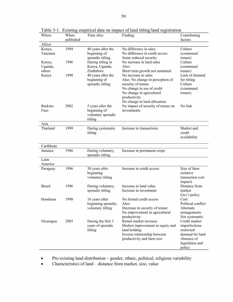
59
Table 3-1. Existing empirical data on impact of land titling/land registration Where When
published Time slice Finding Contributing
factors Africa Kenya, Tanzania
1994 40 years after the beginning of sporadic titling
No difference in sales No difference in credit access Some reduced security
Culture (communal tenure)
Kenya, Uganda, others
1996 During titling in Kenya, Uganda, Zimbabwe
No increase in land sales Also: Short term growth not sustained
Culture (communal tenure)
Kenya 1998 40 years after the beginning of sporadic titling
No increase in sales Also: No change in perception of security of tenure No change in use of credit No change in agricultural productivity No change in land allocation
Lack of demand for titling Culture (communal tenure)
Burkino Faso
2002 5 years after the beginning of voluntary sporadic titling
No impact of security of tenure on investments
No link
Asia Thailand 1999 During systematic
titling Increase in transactions Market and
credit availability
Caribbean Jamaica 1986 During voluntary,
sporadic titling Increase in permanent crops
Latin America
Paraguay 1996 30 years after beginning voluntary titling
Increase in credit access Size of farm (relative transaction cost impact)
Brazil 1996 During voluntary, sporadic titling
Increase in land value Increase in investment
Distance from market Gov’t policy
Honduras 1998 16 years after beginning sporadic, voluntary titling
No formal credit access Also: Decrease in security of tenure No improvement in agricultural productivity
Cost Political conflict Alternate arrangements Not systematic
Nicaragua 2003 During the first 3 years of sporadic titling
Rental market increase Modest improvement in equity and land holding Inverse relationship between productivity and farm size
Credit market imperfections restricted demand for land Absence of legislation and policy
• Pre-existing land distribution – gender, ethnic, political, religious variability • Characteristics of land – distance from market, size, value
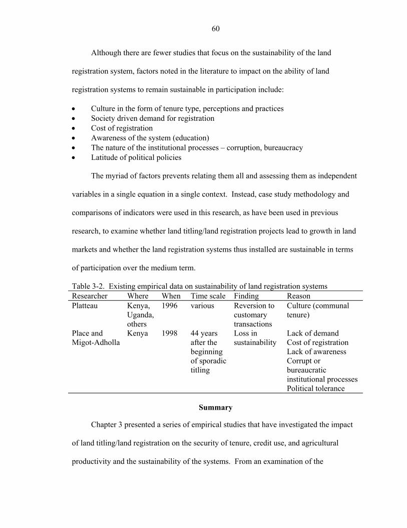
60
Although there are fewer studies that focus on the sustainability of the land
registration system, factors noted in the literature to impact on the ability of land
registration systems to remain sustainable in participation include:
• Culture in the form of tenure type, perceptions and practices • Society driven demand for registration • Cost of registration • Awareness of the system (education) • The nature of the institutional processes – corruption, bureaucracy • Latitude of political policies
The myriad of factors prevents relating them all and assessing them as independent
variables in a single equation in a single context. Instead, case study methodology and
comparisons of indicators were used in this research, as have been used in previous
research, to examine whether land titling/land registration projects lead to growth in land
markets and whether the land registration systems thus installed are sustainable in terms
of participation over the medium term.
Table 3-2. Existing empirical data on sustainability of land registration systems Researcher Where When Time scale Finding Reason Platteau Kenya,
Uganda, others
1996 various Reversion to customary transactions
Culture (communal tenure)
Place and Migot-Adholla
Kenya 1998 44 years after the beginning of sporadic titling
Loss in sustainability
Lack of demand Cost of registration Lack of awareness Corrupt or bureaucratic institutional processes Political tolerance
Summary
Chapter 3 presented a series of empirical studies that have investigated the impact
of land titling/land registration on the security of tenure, credit use, and agricultural
productivity and the sustainability of the systems. From an examination of the
61
conclusions of these studies, a list of contributing factors that impact on the ability of
land titling/land registration to achieve results is derived. The studies do not test for
medium term impact after systematic titling.
Chapter 4 presents the methodology for testing for medium term impact after
systematic titling in the case study jurisdiction of St. Lucia within the context of the
jurisdiction.
CHAPTER 4 METHODOLOGY
Background of the Case Study
Overview of St. Lucia
The island nation of St. Lucia, in the Caribbean, shares the topography and
geomorphology of several of its also volcanically formed island neighbors such as
Grenada, Montserrat, and St. Vincent. The topography is therefore steep, rising to 950m
above sea level within a total area of 616 sq. km. The country had a population of
158,000 persons in 2001 (Central Statistical Office [CSO] 2003), all of whom value land
highly and especially prize the limited quantity of available flat or gently sloping areas.
St. Lucia is particularly well suited for a study of this type at this time since the
systematic titling program that was performed there between 1984 and 1987 was one of
the few land titling programs that completed an entire country over a short time span. All
parcels were therefore recorded and issued with titles, even if the titles were provisional
in some instances, making the project an extremely successful one in terms of the project
output. This gives a starting point from which to assess the current status and the impact
of land titling and land registration programs on project outcomes. The 16 years that
have elapsed since the program also allow the initial impact to have been felt and
absorbed, so that the current transaction activity would not be affected by any unnatural
initial activity resulting from the institution of the program and the land title registration
system. The stable political and peaceful social environment owing in part to a society
that is relatively ethnically and culturally homogeneous removes some of the exogenous
62
63
factors that impact on the success of land titling and land registration projects and land
markets. The population is predominantly African and 90% Roman Catholic.
While St. Lucia’s unique status is an asset to its selection for this research, the
country also has similarities with other jurisdictions that would make generalization of
the findings possible. The economic environment is similar to other small island
Caribbean countries in the dependence on agriculture and tourism. The “family land”
system of multiple owner tenure is also common to several other islands in the Caribbean
and has its parallel in the communal ownership systems of many developing countries
such as the indigenous tenure systems of Latin America and the customary tenure
systems of Africa.
Justification and Aims of the LRTP
The Government of St. Lucia established a land reform commission in 1979
(Stanfield 1988a) that reported on the land tenure in the country and its effect on
agricultural productivity and therefore the economy. The early history and settlement
patterns of the country were believed to have led to an inequitable landholding situation
where most of the agricultural producers were small scale farmers on poor and marginal
lands while a few land holders commanded large highly fertile areas. The “family-land”
form of communal tenure that exists in the country and in other countries of the
Caribbean was also singled out as being responsible for the inability of landholders to
access working capital and effect efficient management and production decisions on the
land. The systems for recording rights to land were also inadequate and difficult to
negotiate, being based on transaction recording.
The family-land tenure type, which was believed to be the bane of the land tenure
system and of productive agriculture, is defined as one in which the holders of the land
64
have inherited undivided shares in the land, usually after a series of intestate devolutions
with no documentary identification of the size of individual shareholding nor the names
of persons entitled. Using a strictly legal interpretation of inheritance legislation, the
number and size of shareholding usually can be determined with some difficulty.
However, the actual practice for deciding membership in the entitled group deviates
somewhat from this formal determination, as extended family members may be accepted.
The effect of this type of communal tenure is similar to that of communal groupings in
traditional settings in Africa, Latin America and elsewhere (Bruce 1983). Conflicts can
occur over use and physical limits of occupation, transactions and some development
decisions require the approval of a large number of individuals and so are difficult to
effect, and credit institutions are reluctant to extend credit to individual group members
for fear of the difficulty of negotiating transaction decisions with the entire group
(Stanfield 1988a). More recent research submits that the family land form of tenure is to
be commended for being a resilient entity in St. Lucia that provides economic support for
farmers in the uncertain market environment (Dujon 1995).
The result of the reports on the identified problems was that the Government
decided to focus on specific areas to improve the agricultural productivity. These areas
included (Stanfield 1988a):
• Diversification away from the dependence on banana growing • Introduction of agricultural technology • Promotion of agriculture as an attractive profession to youths • Rationalization of the land tenure situation
The Land Registration and Titling Program (LRTP) was proposed to address the
last point of focus, the rationalization of the land tenure situation, by improving security
of tenure on individually owned land through titling and recording titles, by reducing the
65
incidence of family land and putting legislation and institutions in place to encourage and
facilitate individualization of land and by installing a land title registration system to
replace the deeds registration system and thereby to promote investment in the land
market from credit institutions and potential buyers.
The LRTP Process
The LRTP began with the introduction of appropriate legislation to give authority
to the process. The Saint Lucia Land Registration Act No. 12 of 1984, the Land
Adjudication Act No. 11 of 1984 and the Land Surveyors’ Act No. 13 of 1984 were the
primary laws that, at the time of the LRTP, superseded the provisions of the St. Lucia
Civil Code Chapter 242 on matters of land rights and interests in land (Deterville 1988).
The LRTP proceeded to systematically and compulsorily adjudicate, demarcate, survey,
and record, rights to land over all rural areas in St. Lucia and finally over the urban area
of Castries, resulting in a complete graphic and textual record of rights to over 33,000
parcels over all of St. Lucia (United Aerial Mapping Inc. 1988).
Absolute, provisional and leasehold titles were given depending on a) whether the
parcel holder could prove ownership by documentary evidence or had been in occupation
for over thirty years, b) whether the parcel holder had been in occupation for less than
thirty years even with documentary evidence and c) whether the parcel holder was party
to an agreement for lease of the parcel for a period of two years or greater. The Land
Registration Act, Section 29 (3) provides for the upgrading of provisional title to absolute
title upon the expiration of 12 years from first registration. Conversion from provisional
title to absolute title based on this regulation, however, requires application by the
proprietor of the land and assessment by the Registrar to ascertain whether the conversion
should be granted.
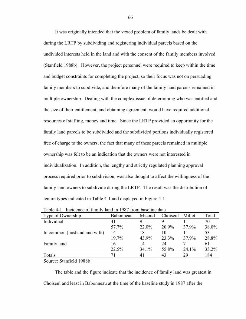
66
It was originally intended that the vexed problem of family lands be dealt with
during the LRTP by subdividing and registering individual parcels based on the
undivided interests held in the land and with the consent of the family members involved
(Stanfield 1988b). However, the project personnel were required to keep within the time
and budget constraints for completing the project, so their focus was not on persuading
family members to subdivide, and therefore many of the family land parcels remained in
multiple ownership. Dealing with the complex issue of determining who was entitled and
the size of their entitlement, and obtaining agreement, would have required additional
resources of staffing, money and time. Since the LRTP provided an opportunity for the
family land parcels to be subdivided and the subdivided portions individually registered
free of charge to the owners, the fact that many of these parcels remained in multiple
ownership was felt to be an indication that the owners were not interested in
individualization. In addition, the lengthy and strictly regulated planning approval
process required prior to subdivision, was also thought to affect the willingness of the
family land owners to subdivide during the LRTP. The result was the distribution of
tenure types indicated in Table 4-1 and displayed in Figure 4-1.
Table 4-1. Incidence of family land in 1987 from baseline data Type of Ownership Babonneau Micoud Choiseul Millet Total Individual 41 9 9 11 70 57.7% 22.0% 20.9% 37.9% 38.0%In common (husband and wife) 14 18 10 11 53 19.7% 43.9% 23.3% 37.9% 28.8%Family land 16 14 24 7 61 22.5% 34.1% 55.8% 24.1% 33.2%Totals 71 41 43 29 184 Source: Stanfield 1988b
The table and the figure indicate that the incidence of family land was greatest in
Choiseul and least in Babonneau at the time of the baseline study in 1987 after the
67
completion of the LRTP. However, individualized parcels, including parcels held in
community1 were greater in number in all the communities except Choiseul.
Babonneau
57%20%
23%
Micoud
22%
44%
34%
Choiseul
21%
23%56%
Millet
38%
38%
24%
M i l l etIndividual
In common (husband and w ife)
Family land
Figure 4-1. Distribution of tenure types in field sample of 1987 Baseline Study
1 Whereas the LRTP recorded husband and wife ownership as “in common” ownership according to the Land Registration Act, a subsequent amendment restored the ability of the Civil Code to recognize this type of husband and wife ownership as “in community”. The application of succession rules differs between the two types of registration (Deterville 1988, Stanfield 1988b).
68
The Baseline Study
The baseline study was carried out between July and December 1987 by the Land
Tenure Center of the University of Wisconsin at Madison, funded by the USAID, which
also funded the LRTP. The reports on the data acquisition and data analysis were
published in 1988. At the time of the baseline study the LRTP had not yet concluded but
the areas surveyed during the study had already been adjudicated, titled and registered.
The baseline study was proposed to be the first phase of diachronic research on the long-
term effects of the LRTP. The research intended to show the impact of the LRTP via the
indicators of number of transactions on agricultural land, value of agricultural land, and
productivity of agricultural land (Stanfield 1988a).
Community case studies were carried out in the communities of Babonneau,
Micoud, Choiseul and Millet, which fall substantially but not wholly within the
administrative quarters of Rural Castries, Micoud, Choiseul and Anse La Raye (Gomes
1988; Thornburg 1988a; Crichlow 1988; Barrow 1988). Initial analyses were also done
on the status of the sectors where impacts of the LRTP were likely to be experienced
(Stringer 1988; Barnes 1988; Thornburg 1988b; Dickerman 1988). These areas were the
land market, the cadastral information system, agricultural credit access, and land tenure.
These data provide useful comparisons to determine the change in St. Lucia after
the LRTP. Barnes (1990b) also assessed the effectiveness of the cadastral system shortly
after completion of the program. His assessment therefore covered not only the registry
information but also the graphical aspects of the cadastre. The system was assessed using
the criteria of efficiency, complexity, maintainability, cost, quality and utility. Barnes
alluded to the future potential problems in maintainability of the registers including
professional acceptance and informal activity especially on inheritance. He referred to
69
recommendations by Liverpool (1986) to have the Land Registrar acquire continued
information from the Registrar of Births and Deaths. It was further suggested by
Liverpool that the Land Registrar be authorized to confiscate to a trust, lands not
registered after inheritance after a sufficient period of publication of notice.
Current Functioning of the Land Registry
The Saint Lucia Land Registration Act 1984 provided legal authority for the
registration of different categories of rights to distinguish prescriptions or restrictions in
the use or transmission of those rights. While the Act originally superseded previous law
governing land, an amendment subsequently reinstated the ability of the Civil Code to
override specific prescriptions in the Act. The Land Registry, registers the following
categories of rights by qualifying the type of rights possessed on registration based on the
1984 legislation and the Civil Code:
1. Individual ownership—unqualified sole proprietorship
2. Ownership in community—Ownership by the community of marriage
3. Ownership in shares—the situation where more than one but less than four persons hold undivided shares
4. Executor or administrator of the estate of the deceased
5. Trusts for sale—registration of four or more owners of undivided shares
6. Heirs of ‘X’ deceased—the mechanism for recording family land tenure
7. Rights of survivorship
8. Crown land2
9. Crown and private
2 Though independent, St. Lucia is under the British monarchy and the titular head of state is Queen Elizabeth II. Crown land is equivalent to state land.
70
The majority of “ownership in shares” was found to be in the names of two owners,
apparently husband and wife.
The registration of the “executor or administrator of the estate of the deceased”,
“trusts for sale”, “heirs of ‘X’ deceased” and “rights of survivorship” were all
mechanisms used in an attempt to ameliorate the problems of the communal tenure
system being experienced in St. Lucia prior to the LRTP.
In the instances where a list of the persons accepted to be owners by the communal
group could be provided, the list was attached to the adjudication records and the first
four persons named were declared to be the trustees for sale. These four then had legal
authority to perform any actions requiring the authorization and signature of the owners
of the land. There have been queries about the legality of the actual process of
determining the four names to be registered as trustees for sale (Deterville 1988) and
anecdotal evidence of some of the trustees acting in their own interests and not in the
interests of the communal group.
In instances where no clear indication of actual membership in the communal
group could be provided, the land was registered in the name of “heirs of ‘X’, deceased”.
Registration with “rights of survivorship” allows the number of owners in the communal
group to decrease by attrition.
The registration of the “administrator or executor of the estate of the deceased”
sometimes indicates a reversion to unregistered status since, on viewing the land registry
data, it can be observed that these registrations are many years old. This suggests that the
parties involved have been delayed in assenting or transmitting the interests by conflict or
cost or are not interested in so doing.
71
An understanding of the way the society treated these various categories was
important for determining the level of acceptance of the land registration system.
Current Land Market Environment
Parallel with the promise offered by the LRTP to improve the functioning of the
land market came the negative effect on the land market of the gradual loss of
preferential trading with the United Kingdom. The formation of the European Union
resulted in a managed cessation of preferential prices on banana export to the United
Kingdom between 1992 and 2000 (Dujon 1997). More stringent production and product
quality standards are required to be met in order to remain in the market. In addition,
weather and pest conditions also affected banana production. Banana production has
been declining over the years with a corresponding drop in revenue as shown in Figure 4-
2 and Figure 4-3 while tourism has been increasing over recent years to alleviate the
shortfall in the economy (International Monetary Fund [IMF] 1999) as illustrated by the
increase in tourists in Figure 4-4.
The last 5 years have seen an increase in defaulters on mortgages because of the
effects of the problems in the banana industry. Foreclosures, however, are difficult to
accomplish and, when they are accomplished, sometimes result in a loss to the credit
institutions. Financial institutions have therefore tended to be rather conservative in how
much credit is approved in relation to the value of the collateral. Only an amount
equivalent to 66 2/3 % of the value of the land is loaned. Secondary sources of income
are also required beyond any income that may be derived from the project for which the
loan is being requested.
The foreclosure mechanism is governed by the Civil Code. Mortgages do not carry
a power of sale clause so in the instance of default the credit institution must sue the
72
defaulter personally. In the overburdened St. Lucian court system, the suit may take as
long as 3 years.
0
20
40
60
80
100
120
140
160
1985
1987
1989
1991
1993
1995
1997
1999
2001
2003
Years
Ban
ana
Prod
uctio
n ('0
00 to
nnes
)
Source for data: St. Lucia Government Statistics Department 2004a. http://www.stats.gov.lc/agri2.htm Figure 4-2. Declining banana production (1986-2003)
020406080
100120140160180200
1985
1987
1989
1991
1993
1995
1997
1999
2001
2003
Years
Ban
ana
Rev
enue
from
UK
(E
C$M
illio
n)
Source for data: St. Lucia Government Statistics Department 2004a. http://www.stats.gov.lc/agri2.htm Figure 4-3. Declining revenue from bananas (1986-2003)
73
If judgment is in favor of the credit institution then the court is responsible for
conducting a public auction to recover the outstanding loan amount. If fewer than 3 bids
are received for the sale then the sale cannot be completed, the auction is voided and the
process repeated. There is anecdotal evidence that some defaulters send an agent to place
an unrealistically high bid, thus ensuring that no bids would follow3.
0
100
200
300
400
500
600
700
800
1997 1998 1999 2000 2001
Years
No.
of T
ouris
ts (0
00's
)
Source for data: St. Lucia Government Statistics Department 2004b. http://www.stats.gov.lc/main4.htm Figure 4-4. Increase in tourist visitors over recent years (1997-2001)
During the long period required to resolve the issue the defaulter remains in
possession of the property at no cost. This legal process is socially beneficial as it delays
or prevents loss of land, but it does not encourage credit institutions to extend credit
easily. There is little or no secondary mortgage market to provide additional capital for
entrepreneurial activities.
3 Personal interviews with lawyers (incl. Clarence Rambally, Norman Francis and Andre Arthur) and bankers (incl. Andrew Baptiste) in St. Lucia
74
Current Transaction Processes
The current transaction process for sale involves, in most cases, the survey of the
parcel to be sold if no previous cadastral survey exists. The approximate demarcation
done during the LRTP is considered inadequate for transaction purposes. A cadastral
survey performed to legal specifications as prescribed in relevant legislation and
performed by authorized professionals is required. Survey fees are based on the area to
be surveyed4 and could be EC$ 25005 (US$ 926) for a typical residential lot. If mutation
(subdivision) is required, approval from the planning authority is necessary. This process
attracts a fee ranging from EC$20 (US$7) for parcels under 3000 sq. ft. to EC$30 (US$
11) for parcels over 7000 sq. ft. Infrastructure may be required to be installed prior to
obtaining approval for the subdivision.
A lawyer is required by law (Land Registration Act 1984, Part VI, Section 67) to
prepare any instrument that deals with the transfer of land. The lawyer’s fee is usually on
a sliding scale based on a percentage of the value of the property beginning at 7% for a
vacant lot. The financial institution also charges a fee for processing of a mortgage if one
is to accompany the purchase of the land.
Government taxes are payable on all transfers of sale or donation based on the
value stated in the transfer document. Purchasers must pay 2% of the value of the land.
For parcels valued over EC$ 50,000 (US$ 18,500) (the vendor must also pay a tax based
on a sliding scale. Non-nationals must pay a flat rate of 10% of the value of the property
as a purchase tax.
4 From personal interviews with land surveyors (incl. Rufinus Baptiste, Fosh Modeste and Peter Felix).
5 The St. Lucia currency is pegged at EC$2.70 = US$ 1.00
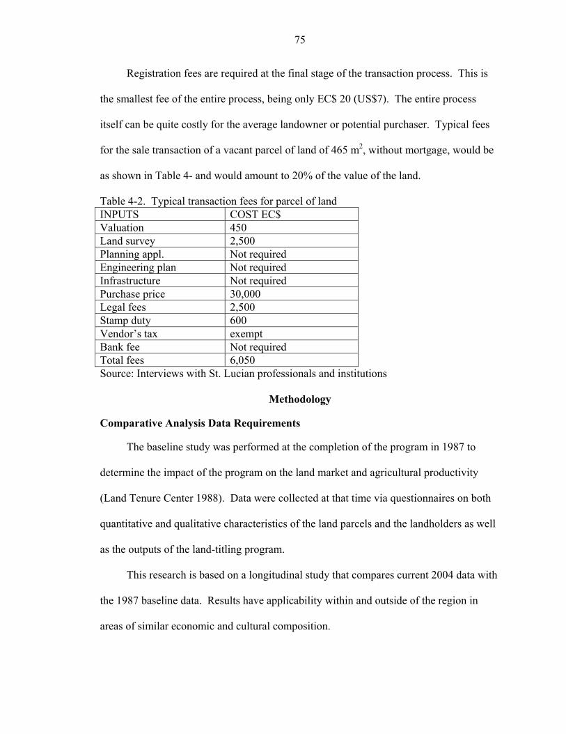
75
Registration fees are required at the final stage of the transaction process. This is
the smallest fee of the entire process, being only EC$ 20 (US$7). The entire process
itself can be quite costly for the average landowner or potential purchaser. Typical fees
for the sale transaction of a vacant parcel of land of 465 m2, without mortgage, would be
as shown in Table 4- and would amount to 20% of the value of the land.
Table 4-2. Typical transaction fees for parcel of land INPUTS COST EC$ Valuation 450 Land survey 2,500 Planning appl. Not required Engineering plan Not required Infrastructure Not required Purchase price 30,000 Legal fees 2,500 Stamp duty 600 Vendor’s tax exempt Bank fee Not required Total fees 6,050 Source: Interviews with St. Lucian professionals and institutions
Methodology
Comparative Analysis Data Requirements
The baseline study was performed at the completion of the program in 1987 to
determine the impact of the program on the land market and agricultural productivity
(Land Tenure Center 1988). Data were collected at that time via questionnaires on both
quantitative and qualitative characteristics of the land parcels and the landholders as well
as the outputs of the land-titling program.
This research is based on a longitudinal study that compares current 2004 data with
the 1987 baseline data. Results have applicability within and outside of the region in
areas of similar economic and cultural composition.
76
To determine the impact of the land titling and registration program through a
longitudinal comparison of current and baseline land market data, comparable data
needed to be acquired. The questionnaire and the data gathered for this research
therefore had to be the same or a subset of the data gathered in the baseline study, so
therefore this requirement constrained the selection of sample data. Additional data
describing the economic and social and land related environment was derived from
interviews with professionals in the land market including land surveyors, valuation
surveyors, bankers and lawyers.
Sampling Methods
Community sample design
Some statements on how representative the samples selected are of the population
of parcels and landholders under study are provided in this section.
At the time of the baseline study in 1987, the population of communities in the
country was grouped into blocks on the basis of observed land-driven socio-economic
variability amongst communities for purposes of a community case study (Stanfield
1988). Four communities—Babonneau, Micoud, Choiseul and Tete Chemin—were
selected at that time to represent this variability.
Babonneau is peri-urban to Castries and represented then and continues to represent
more of the urban consciousness that impacts perceptions about land and land tenure.
This community has a large number of individualized land holdings of relatively high
land values, and growing areas of residential and commercial land use. Micoud is rural
and agricultural, deriving income from bananas, still an important mainstay in the St.
Lucian economy. Choiseul and Tete Chemin are also rural and primarily agricultural,
and are more isolated farming communities. In 1987, Choiseul was a community with an
77
agricultural base in vegetables while Tete Chemin had just begun agricultural production.
Subsequently, much of the land at Tete Chemin was acquired by the state for the
construction of a dam. Some small areas, unutilized in the dam construction, were
returned to the original owners or resold to private individuals. Much of the land,
however, remains state land, which would distort any current analyses of land markets
and landowner perceptions even should the state parcels be removed from the analysis.
These four communities represent the major land-based factors and perceptions that
impact on the functioning of both the Land Registry and the land market in the St. Lucian
environment. The four communities are also geographically well distributed over the
island as seen in Figure 4-5. The differences among the communities and the growth and
urbanization of rural Castries in which Babonneau lies can be illustrated by the
population statistics published by the St. Lucia Government Statistics Department
(2004c) and reproduced here in Table 4-3. The figures given are for the districts in which
the sample communities fall. Rural Castries displays the largest population and the
largest growth between 1990 and 2001 of all the districts. Registry map sheets that
covered these communities were then stratified, in the 1987 survey, on the basis of
tenurial variability within the communities.
Tenurial variability was represented by the incidence of family land, which is the
type of tenure more common in rural areas. Therefore the map sheets for each
community were separated into two groups: one containing greater percentages of family
land parcels, and the other group containing smaller percentages of family land parcels
and therefore larger percentages of individualized parcels. Fifteen registry sheets were
chosen at random at that time from sheets with higher and lower incidences of family
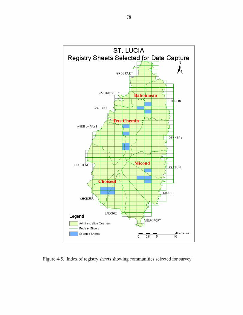
78
Choiseul
Babonneau
Tete Chemin
Micoud
Figure 4-5. Index of registry sheets showing communities selected for survey
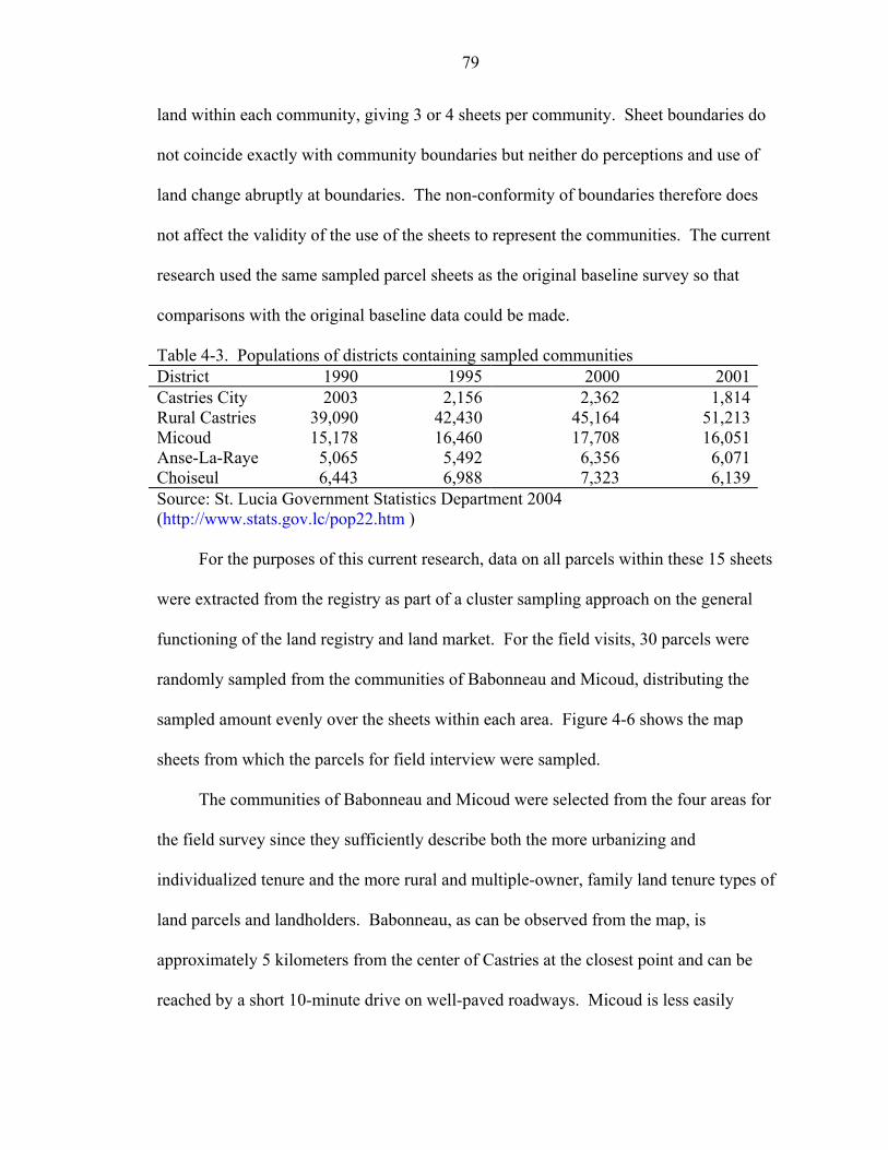
79
land within each community, giving 3 or 4 sheets per community. Sheet boundaries do
not coincide exactly with community boundaries but neither do perceptions and use of
land change abruptly at boundaries. The non-conformity of boundaries therefore does
not affect the validity of the use of the sheets to represent the communities. The current
research used the same sampled parcel sheets as the original baseline survey so that
comparisons with the original baseline data could be made.
Table 4-3. Populations of districts containing sampled communities District 1990 1995 2000 2001Castries City 2003 2,156 2,362 1,814Rural Castries 39,090 42,430 45,164 51,213Micoud 15,178 16,460 17,708 16,051Anse-La-Raye 5,065 5,492 6,356 6,071Choiseul 6,443 6,988 7,323 6,139Source: St. Lucia Government Statistics Department 2004 (http://www.stats.gov.lc/pop22.htm )
For the purposes of this current research, data on all parcels within these 15 sheets
were extracted from the registry as part of a cluster sampling approach on the general
functioning of the land registry and land market. For the field visits, 30 parcels were
randomly sampled from the communities of Babonneau and Micoud, distributing the
sampled amount evenly over the sheets within each area. Figure 4-6 shows the map
sheets from which the parcels for field interview were sampled.
The communities of Babonneau and Micoud were selected from the four areas for
the field survey since they sufficiently describe both the more urbanizing and
individualized tenure and the more rural and multiple-owner, family land tenure types of
land parcels and landholders. Babonneau, as can be observed from the map, is
approximately 5 kilometers from the center of Castries at the closest point and can be
reached by a short 10-minute drive on well-paved roadways. Micoud is less easily
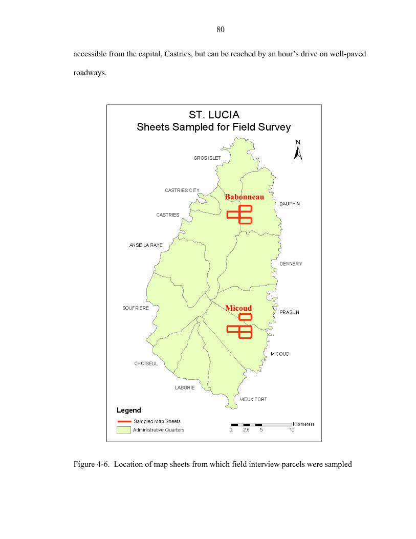
80
accessible from the capital, Castries, but can be reached by an hour’s drive on well-paved
roadways.
Babonneau
Micoud
Figure 4-6. Location of map sheets from which field interview parcels were sampled
81
Field sample design
A sample size of 30 was chosen for the field sample in each of the 2 communities
of Babonneau and Micoud. This sample size allows standard statistical tests about
population means to be performed when the data on the variable being tested are
normally or near normally distributed. A sample size of 30 also allows comparison of
binomial type responses, of maximal variability, that is, 50% success and 50% failure,
between the two areas to within ± 17.5% at the 95% confidence level. A total sample
size of 60 in the two communities allows comparison of binomial type responses, of
maximal variability, between the current study and the previous baseline study to ±12.5%
at the 95% confidence level. This means that for instances where the probability of the
event occurring is equal to the probability of the event not occurring, these precisions
apply. Otherwise, precisions will be greater. Since many of the questions were binomial
in type, for example whether there had been a sale or not, these precision statements are
valid for most of the derived statistics.
A simple sample size equation was used to determine the precision of the surveys
given the sample sizes (see equation 1).
)1..(..........)1(2
2
eppZn −
=
where n is the sample size,
Z is the abscissa of the normal curve which bounds, on either side of the mean, the
area 1-α or the desired confidence level.
p is the estimated proportion of a favorable (or unfavorable) response.
e is the desired level of precision.
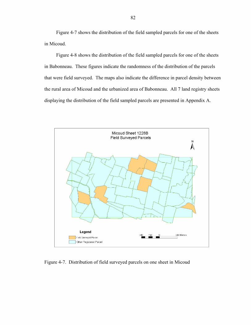
82
Figure 4-7 shows the distribution of the field sampled parcels for one of the sheets
in Micoud.
Figure 4-8 shows the distribution of the field sampled parcels for one of the sheets
in Babonneau. These figures indicate the randomness of the distribution of the parcels
that were field surveyed. The maps also indicate the difference in parcel density between
the rural area of Micoud and the urbanized area of Babonneau. All 7 land registry sheets
displaying the distribution of the field sampled parcels are presented in Appendix A.
Figure 4-7. Distribution of field surveyed parcels on one sheet in Micoud
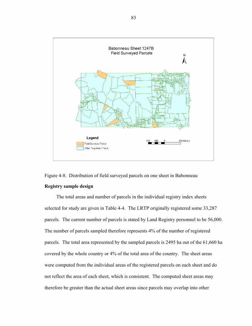
83
Figure 4-8. Distribution of field surveyed parcels on one sheet in Babonneau
Registry sample design
The total areas and number of parcels in the individual registry index sheets
selected for study are given in Table 4-4. The LRTP originally registered some 33,287
parcels. The current number of parcels is stated by Land Registry personnel to be 56,000.
The number of parcels sampled therefore represents 4% of the number of registered
parcels. The total area represented by the sampled parcels is 2495 ha out of the 61,660 ha
covered by the whole country or 4% of the total area of the country. The sheet areas
were computed from the individual areas of the registered parcels on each sheet and do
not reflect the area of each sheet, which is consistent. The computed sheet areas may
therefore be greater than the actual sheet areas since parcels may overlap into other
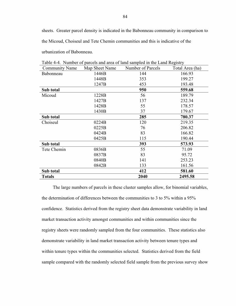
84
sheets. Greater parcel density is indicated in the Babonneau community in comparison to
the Micoud, Choiseul and Tete Chemin communities and this is indicative of the
urbanization of Babonneau.
Table 4-4. Number of parcels and area of land sampled in the Land Registry Community Name Map Sheet Name Number of Parcels Total Area (ha) Babonneau 1446B 144 166.93 1448B 353 199.27 1247B 453 193.48 Sub total 950 559.68 Micoud 1228B 56 189.79 1427B 137 232.34 1428B 55 178.57 1430B 37 179.67 Sub total 285 780.37 Choiseul 0224B 120 219.35 0225B 76 206.82 0424B 83 166.82 0425B 115 190.44 Sub total 393 573.93 Tete Chemin 0836B 55 71.09 0837B 83 95.72 0840B 141 253.23 0842B 133 161.56 Sub total 412 581.60 Totals 2040 2495.58
The large numbers of parcels in these cluster samples allow, for binomial variables,
the determination of differences between the communities to 3 to 5% within a 95%
confidence. Statistics derived from the registry sheet data demonstrate variability in land
market transaction activity amongst communities and within communities since the
registry sheets were randomly sampled from the four communities. These statistics also
demonstrate variability in land market transaction activity between tenure types and
within tenure types within the communities selected. Statistics derived from the field
sample compared with the randomly selected field sample from the previous survey show
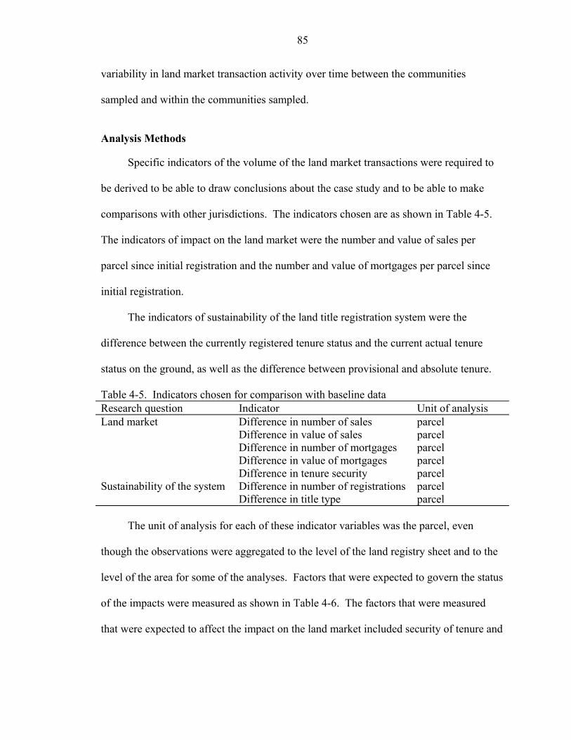
85
variability in land market transaction activity over time between the communities
sampled and within the communities sampled.
Analysis Methods
Specific indicators of the volume of the land market transactions were required to
be derived to be able to draw conclusions about the case study and to be able to make
comparisons with other jurisdictions. The indicators chosen are as shown in Table 4-5.
The indicators of impact on the land market were the number and value of sales per
parcel since initial registration and the number and value of mortgages per parcel since
initial registration.
The indicators of sustainability of the land title registration system were the
difference between the currently registered tenure status and the current actual tenure
status on the ground, as well as the difference between provisional and absolute tenure.
Table 4-5. Indicators chosen for comparison with baseline data Research question Indicator Unit of analysis Land market Difference in number of sales parcel Difference in value of sales parcel Difference in number of mortgages parcel Difference in value of mortgages parcel Difference in tenure security parcel Sustainability of the system Difference in number of registrations parcel Difference in title type parcel
The unit of analysis for each of these indicator variables was the parcel, even
though the observations were aggregated to the level of the land registry sheet and to the
level of the area for some of the analyses. Factors that were expected to govern the status
of the impacts were measured as shown in Table 4-6. The factors that were measured
that were expected to affect the impact on the land market included security of tenure and
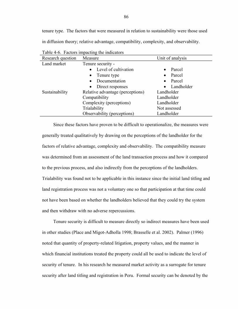
86
tenure type. The factors that were measured in relation to sustainability were those used
in diffusion theory; relative advantage, compatibility, complexity, and observability.
Table 4-6. Factors impacting the indicators Research question Measure Unit of analysis Land market Tenure security - • Level of cultivation
• Tenure type • Documentation • Direct responses
• Parcel • Parcel • Parcel • Landholder
Sustainability Relative advantage (perceptions) Landholder Compatibility Landholder Complexity (perceptions) Landholder Trialability Not assessed Observability (perceptions) Landholder
Since these factors have proven to be difficult to operationalize, the measures were
generally treated qualitatively by drawing on the perceptions of the landholder for the
factors of relative advantage, complexity and observability. The compatibility measure
was determined from an assessment of the land transaction process and how it compared
to the previous process, and also indirectly from the perceptions of the landholders.
Trialability was found not to be applicable in this instance since the initial land titling and
land registration process was not a voluntary one so that participation at that time could
not have been based on whether the landholders believed that they could try the system
and then withdraw with no adverse repercussions.
Tenure security is difficult to measure directly so indirect measures have been used
in other studies (Place and Migot-Adholla 1998; Brasselle et al. 2002). Palmer (1996)
noted that quantity of property-related litigation, property values, and the manner in
which financial institutions treated the property could all be used to indicate the level of
security of tenure. In his research he measured market activity as a surrogate for tenure
security after land titling and registration in Peru. Formal security can be denoted by the
87
existence of legal documentation and formal registration. Tenure security was measured
in the baseline study in 1987 by incidence and type of documentation. Informal tenure
security can be denoted by perceptions of security experienced by the land holders
(Jansen and Roquas 1998).
For the purposes of this research, the indirect measures of security of tenure used
were, in addition to the market activity and tenure type, level of cultivation on the parcel
and the incidence of documentation of ownership. These measures were the same as
those used in the baseline survey, for comparison purposes. Responses to direct queries
on perceptions of security of tenure put to the land users were also used as measures of
tenure security. Formal security is linked to the performance of formal land markets but
perceptions of security are linked to societal peace and well being and equity.
Questionnaires and statistical methods have been used previously in information
system research, especially in the area of determining perceptions about technology and
diffusion (Newsted et al. 1998; Al-Gahtani 2003). The questionnaires were administered
directly to the respondents so that the probability of response would be greater than self-
administered questionnaires, and clarifications could be immediately made to questions if
the need arose (Ott and Longnecker 2001).
Data Acquisition Procedure
To investigate the impact of land registration and titling on the land market, data on
sales and mortgages were extracted from the registry records. The registry records
comprised title register books for each registry index map sheet. Each parcel on the map
sheet had its status documented on one page of the register that represented the sheet.
When there are a long series of transactions on one parcel, the information registered may
exceed one page and then more pages are inserted to accommodate the information. In
88
instances of subdivision the page representing the original parent parcel is removed from
the register and placed in one of the parcel folders that contain supporting information for
each parcel. These parcel folders are filed separately. The information for each new
parcel is then put on a new, separate page and all the subdivided parcel pages are then
appended to the end of the book and numbered sequentially. Transfers of rights appear
on the front of the register page while encumbrances such as mortgages appear on the
back of the page.
Since the title register did not detail whether the transfers documented were
donation, sale, gift or inheritance, further investigations were performed by searching the
parcel files, which contained supporting contract documents for sale, mortgage or assent
for the particular parcel. Individual pages are removed from the book for updating and
photocopying on a regular basis and some misfiled pages were found during the course of
the data extraction exercise. Aggregated data for transfers and mortgages registered per
month were maintained by the Land Registry but were only current to 2002.
To determine the currency of the registry data, the randomly sampled subset of
parcels were visited in the field in order to interview the registered owner or the de facto
owner. Issues that could potentially affect the reliability of the data include the difficulty
experienced in locating the specific parcel owners on the randomly generated parcel list,
and the language barrier in some of the interviews. The name or names of the registered
parcel owners, administrators of the estate or trustees for sale and the address noted in the
registry records to locate the persons were used to locate the owner or rights holder of the
parcel. St. Lucia has no household mail delivery service so the listed address was usually
that of the post office where the landholder collected mail. There was therefore some
89
difficulty in locating landholders. In addition, St. Lucians tend to have several different
names so many of their acquaintances, friends, neighbors and even relatives were
sometimes not helpful in locating the landholder as they were unfamiliar with the name
given. Many of the more elderly landholders spoke primarily a local “french patois”
called “kweyol” (Creole). The questions therefore had to be translated into “kweyol” and
their responses translated back into English. It is hoped that the nuances of their
perceptions about land and tenure security were not distorted by translation.
Analysis Procedures
Statistical procedures were used to draw conclusions and support the findings. Chi-
square measures of relationships between variables were used to determine the factors
that mitigated the anticipated impact of the LRTP on the land market in the case study
area. Logistic regression was used to determine relative impacts of the various factors on
the incidence of land transactions.
A land information system (LIS) was created to visualize the distribution of the
variables in the research. The graphic data for the LIS were input by scanning and
digitizing the analog maps and appending attribute files containing data extracted from
the registry and the field. This graphic view allowed comparisons between the areas that
were field sampled to be observed, and suggested spatial patterns in the distribution of
the variables.
Summary
Chapter 4 provided background data on the land situation in St. Lucia, on the LRTP
program conducted in St. Lucia, and on the baseline study performed in 1987, as a
precursor to analyzing the data acquired in the research. The case study selected
possessed attributes that benefited the research—a land titling and registration project had
90
been performed sufficiently long ago for assessment of medium term impact, the project
had titled and registered in a complete, systematic fashion, and there was available
baseline data for comparison. The methodologies used were framed in part by the
baseline methodology for the baseline survey that was performed in 1987 but additional
research methods were also used to acquire data on sampled sheets in the Land Registry
and in the field for assessing the sustainability of the registration system.
Chapter 5 presents the data acquired in the research and the analyses performed on
the data, with comparisons to the data acquired in 1987.
CHAPTER 5 ANALYSIS OF IMPACT OF LAND TITLING AND LAND REGISTRATION ON
LAND TRANSACTIONS IN ST. LUCIA
This chapter presents the registration system and land market data on St. Lucia
acquired both at the Land Registry, from registry books and parcel files, and in the field,
from questionnaires administered to landholders. The analyses performed and results
obtained are also detailed.
The Impact of the LRTP on the Land Market
Data were acquired on the land market as it has operated in St. Lucia since the end
of the LRTP in 1987. Impacts on the land market of the land titling and registration were
determined by measuring:
• Change in market activity, and • Change in security of tenure
The indicators measured to assess the impacts were:
• The number and value of sales and mortgages, and
• The documentation possessed and the perceptions of landowners about security of tenure
Land Market Activity
Sales and mortgages
Information on formal land market activity was derived from analyzing registry
data aggregated for the whole country and also from statistical analysis of the registry
data from the 15 cluster sampled registry sheets. Additional data on credit use was
91
92
derived from the field interviews and compared with data from the 1987 baseline sample
survey.
Figure 5-1 illustrates the total number of sales and mortgages registered for all of
St. Lucia in the Land Registry for selected years. The years selected are at 5 year
intervals beginning with 1989. All parcels were not in the Land Registry until the
beginning of 1988 so figures taken earlier would have been distorted. Since figures for
the year 2004 were not available, figures for the year 2002 were included instead.
Figure 5-2 illustrates the mean number of sales and mortgages per parcel registered
formally in the Land Registry for all of St. Lucia for the selected years. The number of
parcels for intermediate years between 1989 and 2002 was interpolated from Land
Registry index figures of 33,300 registered parcels after the LRTP in 1987 and 56,000
registered parcels currently in 2004.
The data indicate that activity increased and then peaked for sales around the year
1995 while for mortgages, after an initial increase, the peak occurred around the year
1999. There is a downward trend after the peak in both measures of activity. These
figures indicate an initial increase in formal land market activity that suggest an
association with the land titling and registration process and the ease of transacting in
land that the process facilitated. No corresponding figures for registered transactions for
all of St. Lucia prior to the institution of the Land Registry were obtained. While such
figures would have lent support to the suggestion that the volume of transactions
increased after the LRTP, obtaining such figures is problematic.
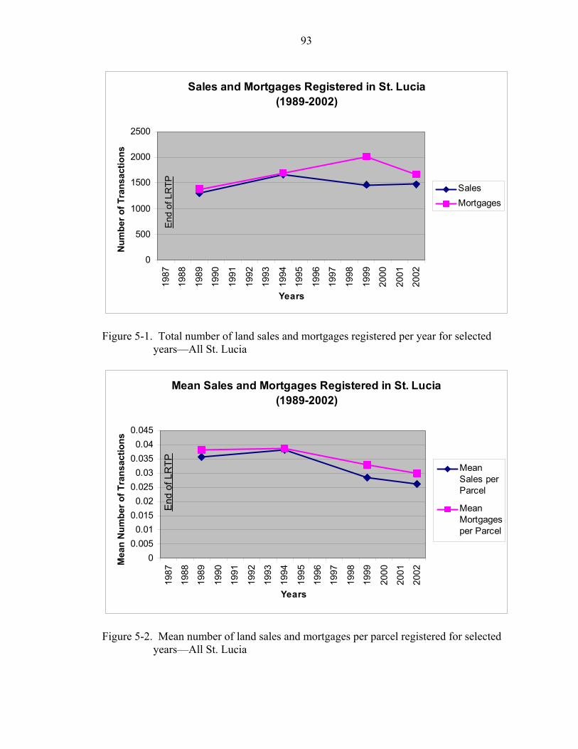
93
Sales and Mortgages Registered in St. Lucia (1989-2002)
0
500
1000
1500
2000
2500
1987
1988
1989
1990
1991
1992
1993
1994
1995
1996
1997
1998
1999
2000
2001
2002
Years
Num
ber o
f Tra
nsac
tions
SalesMortgages
End
of L
RTP
Figure 5-1. Total number of land sales and mortgages registered per year for selected
years—All St. Lucia
Mean Sales and Mortgages Registered in St. Lucia (1989-2002)
00.0050.01
0.0150.02
0.0250.03
0.0350.04
0.045
1987
1988
1989
1990
1991
1992
1993
1994
1995
1996
1997
1998
1999
2000
2001
2002
Years
Mea
n N
umbe
r of T
rans
actio
ns
MeanSales perParcel
MeanMortgagesper Parcel
End
of L
RTP
Figure 5-2. Mean number of land sales and mortgages per parcel registered for selected
years—All St. Lucia
94
The inefficiencies of the previous deed registration system prevent accurate
determination of the numbers and types of different transactions and the legality of such
transactions (Stanfield 1988a). There are also cases of parcels having been sold multiple
times under the previous system of deed recordation.
While the absolute numbers of both sales and mortgages initially increased, this
increase is mitigated by the increase in the number of parcels so that there is an actual
decrease in mortgages relative to the number of parcels and a decrease in sales relative to
the number of parcels, as indicated in the graphs.
The LRTP was intended to make transactions in land more efficient and less costly
in order to attract potential investors. Yet, to have a sustained economic impact on the
country the initial land market activity must be sustained over the medium term. This has
not happened in this case. Factors that have also impacted the land market include the
reduction in profitability of the banana industry, caused by lowered prices and rejection
of fruit as a result of disease or low quality.
The average lending interest rates at one bank in St. Lucia are given in Figure 5-3.
This figure shows a downward trend, which should be attractive to investors in land and
thus should have increased the volume of mortgages and, by extension, purchases of land.
The rates are only given for one bank but these rates do not vary by more than 1%
amongst banks in the banking sector in St. Lucia.
The real GDP for St. Lucia together with the share of the GDP derived from the
real estate and agricultural sectors is illustrated in Figure 5-4. The trend of the GDP line
is similar to that of the mortgages, indicating, as expected, a correlation between
mortgage interest rates and GDP. Exogenous factors impacting on the GDP also impact
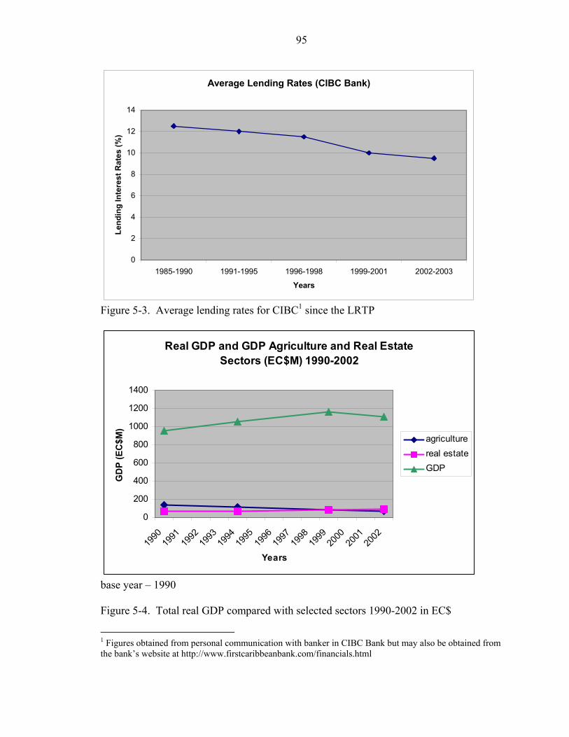
95
Average Lending Rates (CIBC Bank)
0
2
4
6
8
10
12
14
1985-1990 1991-1995 1996-1998 1999-2001 2002-2003
Years
Lend
ing
Inte
rest
Rat
es (%
)
Figure 5-3. Average lending rates for CIBC1 since the LRTP
Real GDP and GDP Agriculture and Real Estate Sectors (EC$M) 1990-2002
0
200
400
600
800
1000
1200
1400
1990
1991
1992
1993
1994
1995
1996
1997
1998
1999
2000
2001
2002
Years
GD
P (E
C$M
)
agriculturereal estateGDP
base year – 1990 Figure 5-4. Total real GDP compared with selected sectors 1990-2002 in EC$
1 Figures obtained from personal communication with banker in CIBC Bank but may also be obtained from the bank’s website at http://www.firstcaribbeanbank.com/financials.html

96
on the real estate sector. The real estate sector also forms an input to the GDP so that
changes in the real estate sector also are reflected to a lesser extent in the GDP.
The total number of sales registered per year in the four survey communities of
Babonneau, Micoud, Choiseul and Tete Chemin shown in Figure 5-5 indicates the same
trend as the graph for the country overall for years 1989 through 1999, showing that the
sample is representative of the country’s level of land market activity. However, the
sales during 2002 for the sample communities show an upward trend as opposed to the
downward trend in the overall sales for the country. This upward trend is primarily due
to a larger volume of sales in the peri-urban community of Babonneau. Because of the
overall low level of sales, one large, uncharacteristic subdivision and sale of 12 parcels
from one mutation of a large estate can be seen as a spike in the graph for sales in
Micoud for the year1989.
No. of Sales in Sample Communities
05
101520253035
1989
1991
1993
1995
1997
1999
2001
Years
No.
of S
ales
BabonneauMicoudChoiseulTete CheminTotal Sample
Figure 5-5. Total number of sales registered per year for selected years in the 4 survey
communities
Figure 5-6 shows the mean sales per parcel for the four survey communities
compared with the mean sales per parcel for the country. Again, similar trends can be

97
observed. Figure 5-7 shows the value of sales in EC$ while Figure 5-8 shows these
values adjusted to constant EC$.
0
0.005
0.01
0.015
0.02
0.025
0.03
0.035
0.04
0.045
1989
1990
1991
1992
1993
1994
1995
1996
1997
1998
1999
2000
2001
2002
Years
Mea
n Sa
les
per P
arce
l
BabonneauMicoudChoiseulTete CheminAll St. Lucia
Figure 5-6. Mean sales per parcel for the 4 survey communities compared with total
Year of Sale
2002200019981996199419921990
Tota
l Val
ue o
f Sal
es fo
r Yea
r (E
C$
000'
s)
1200
1000
800
600
400
200
0
Loc
a
Figure 5-7. Total value of sales per year for 4 survey c
B
M
C
o
h
te Chemin
Te
m
ationBabonneau
bonneauMicoud
icoudChoiseul
oiseulTete Chemin
munities in EC$

98
Year of Sale
2002200019981996199419921990
Val
ue o
f Tot
al S
ales
(in
EC
$000
's A
t 199
0 P
rices
) 1000
800
600
400
200
0
Location
Babonneau
Micoud
Choiseul
Tete Chemin
Babonneau
Micoud
Choiseul
Tete Chemin
Figure 5-8. Value of sales per year adjusted to constant 1990 prices in EC$
The summary of the sale activity in the individual communities represented by the
registry sheets is shown in Table 5-1.
Table 5-1. Sale activity by community (1987-2004) Whether at Least One Sale Occurred TotalLocation None At Least 1 Sale Babonneau No. 723 219 942 % 76.8% 23.2% 100.0%Choiseul No. 356 38 394 % 90.4% 9.6% 100.0%Micoud No. 230 55 285 % 80.7% 19.3% 100.0%Tete Chemin No. 348 38 386 % 90.2% 9.8% 100.0%Total No. 1657 350 2007 % of Total 82.6% 17.4% 100.0%
Welch statistic2 indicates at least one difference in means amongst areas p<0.001(variances and sample sizes unequal) 2 The Welch statistic was used because the variances of the mean sales per parcel in each area and the sample sizes in each area are both unequal. Welch statistic is preferable to the F statistic under these conditions.
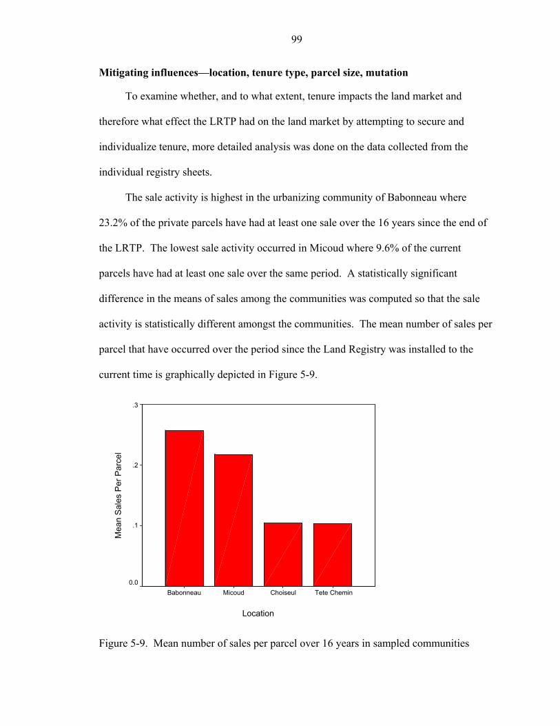
99
Mitigating influences—location, tenure type, parcel size, mutation
To examine whether, and to what extent, tenure impacts the land market and
therefore what effect the LRTP had on the land market by attempting to secure and
individualize tenure, more detailed analysis was done on the data collected from the
individual registry sheets.
The sale activity is highest in the urbanizing community of Babonneau where
23.2% of the private parcels have had at least one sale over the 16 years since the end of
the LRTP. The lowest sale activity occurred in Micoud where 9.6% of the current
parcels have had at least one sale over the same period. A statistically significant
difference in the means of sales among the communities was computed so that the sale
activity is statistically different amongst the communities. The mean number of sales per
parcel that have occurred over the period since the Land Registry was installed to the
current time is graphically depicted in Figure 5-9.
Location
Tete CheminChoiseulMicoudBabonneau
Mea
n S
ales
Per
Par
cel
.3
.2
.1
0.0
Figure 5-9. Mean number of sales per parcel over 16 years in sampled communities

100
The mean number of sales is higher in Babonneau and Micoud than it is in
Choiseul and Tete Chemin. This suggests a correlation between tenure type and land
market activity since there are more family land parcels in the rural area and fewer sales,
and more individualized parcels in the peri urban area and more sales. It could also
suggest a correlation between the land values and/or proximity to the peri urban area, and
land market activity, since there are fewer sales in the rural area and more sales in the
peri urban area.
Figure 5-10 shows the distribution of tenure categories of 1 or 2 owners, family
land owners and crown land by the percentage of the total area covered by each tenure
type in each of the four registry sampled communities.
1 or 2 Owners
Family Land
Crown Land
Babonneau Micoud
Choiseul Tete Chemin
1 or 2 Owners
Family Land
Crown Land
1 or 2 Owners
Family Land
Crown Land
1 or 2 Owners
Family Land
Crown Land
Figure 5-10. Distribution of tenure categories by percentage of area in each community.
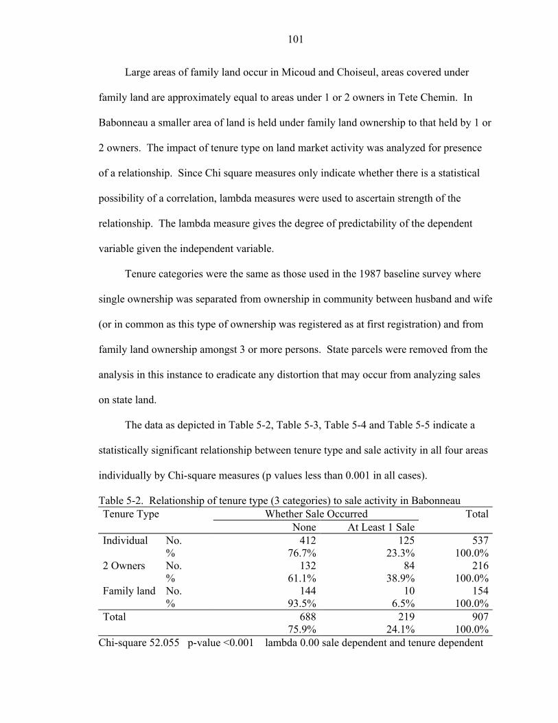
101
Large areas of family land occur in Micoud and Choiseul, areas covered under
family land are approximately equal to areas under 1 or 2 owners in Tete Chemin. In
Babonneau a smaller area of land is held under family land ownership to that held by 1 or
2 owners. The impact of tenure type on land market activity was analyzed for presence
of a relationship. Since Chi square measures only indicate whether there is a statistical
possibility of a correlation, lambda measures were used to ascertain strength of the
relationship. The lambda measure gives the degree of predictability of the dependent
variable given the independent variable.
Tenure categories were the same as those used in the 1987 baseline survey where
single ownership was separated from ownership in community between husband and wife
(or in common as this type of ownership was registered as at first registration) and from
family land ownership amongst 3 or more persons. State parcels were removed from the
analysis in this instance to eradicate any distortion that may occur from analyzing sales
on state land.
The data as depicted in Table 5-2, Table 5-3, Table 5-4 and Table 5-5 indicate a
statistically significant relationship between tenure type and sale activity in all four areas
individually by Chi-square measures (p values less than 0.001 in all cases).
Table 5-2. Relationship of tenure type (3 categories) to sale activity in Babonneau Tenure Type Whether Sale Occurred Total None At Least 1 Sale Individual No. 412 125 537 % 76.7% 23.3% 100.0%2 Owners No. 132 84 216 % 61.1% 38.9% 100.0%Family land No. 144 10 154 % 93.5% 6.5% 100.0%Total 688 219 907 75.9% 24.1% 100.0%
Chi-square 52.055 p-value <0.001 lambda 0.00 sale dependent and tenure dependent
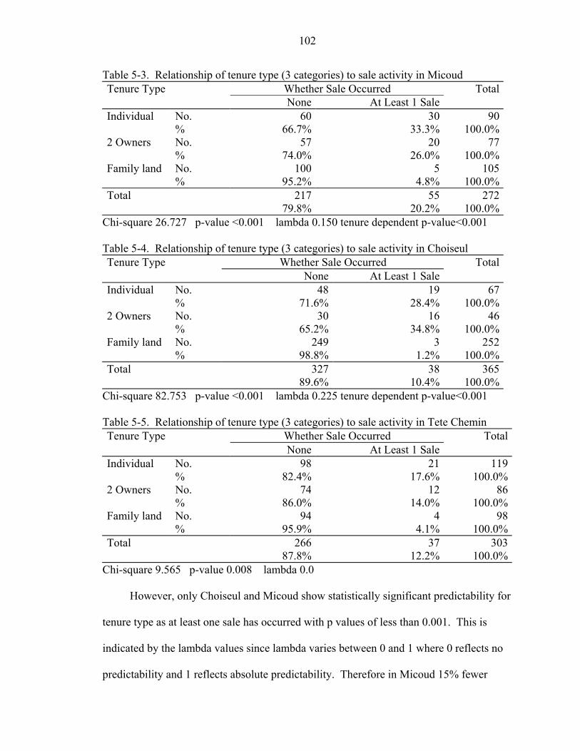
102
Table 5-3. Relationship of tenure type (3 categories) to sale activity in Micoud Tenure Type Whether Sale Occurred Total None At Least 1 Sale Individual No. 60 30 90 % 66.7% 33.3% 100.0%2 Owners No. 57 20 77 % 74.0% 26.0% 100.0%Family land No. 100 5 105 % 95.2% 4.8% 100.0%Total 217 55 272 79.8% 20.2% 100.0%
Chi-square 26.727 p-value <0.001 lambda 0.150 tenure dependent p-value<0.001 Table 5-4. Relationship of tenure type (3 categories) to sale activity in Choiseul Tenure Type Whether Sale Occurred Total None At Least 1 Sale Individual No. 48 19 67 % 71.6% 28.4% 100.0%2 Owners No. 30 16 46 % 65.2% 34.8% 100.0%Family land No. 249 3 252 % 98.8% 1.2% 100.0%Total 327 38 365 89.6% 10.4% 100.0%
Chi-square 82.753 p-value <0.001 lambda 0.225 tenure dependent p-value<0.001 Table 5-5. Relationship of tenure type (3 categories) to sale activity in Tete Chemin Tenure Type Whether Sale Occurred Total None At Least 1 Sale Individual No. 98 21 119 % 82.4% 17.6% 100.0%2 Owners No. 74 12 86 % 86.0% 14.0% 100.0%Family land No. 94 4 98 % 95.9% 4.1% 100.0%Total 266 37 303 87.8% 12.2% 100.0%
Chi-square 9.565 p-value 0.008 lambda 0.0
However, only Choiseul and Micoud show statistically significant predictability for
tenure type as at least one sale has occurred with p values of less than 0.001. This is
indicated by the lambda values since lambda varies between 0 and 1 where 0 reflects no
predictability and 1 reflects absolute predictability. Therefore in Micoud 15% fewer
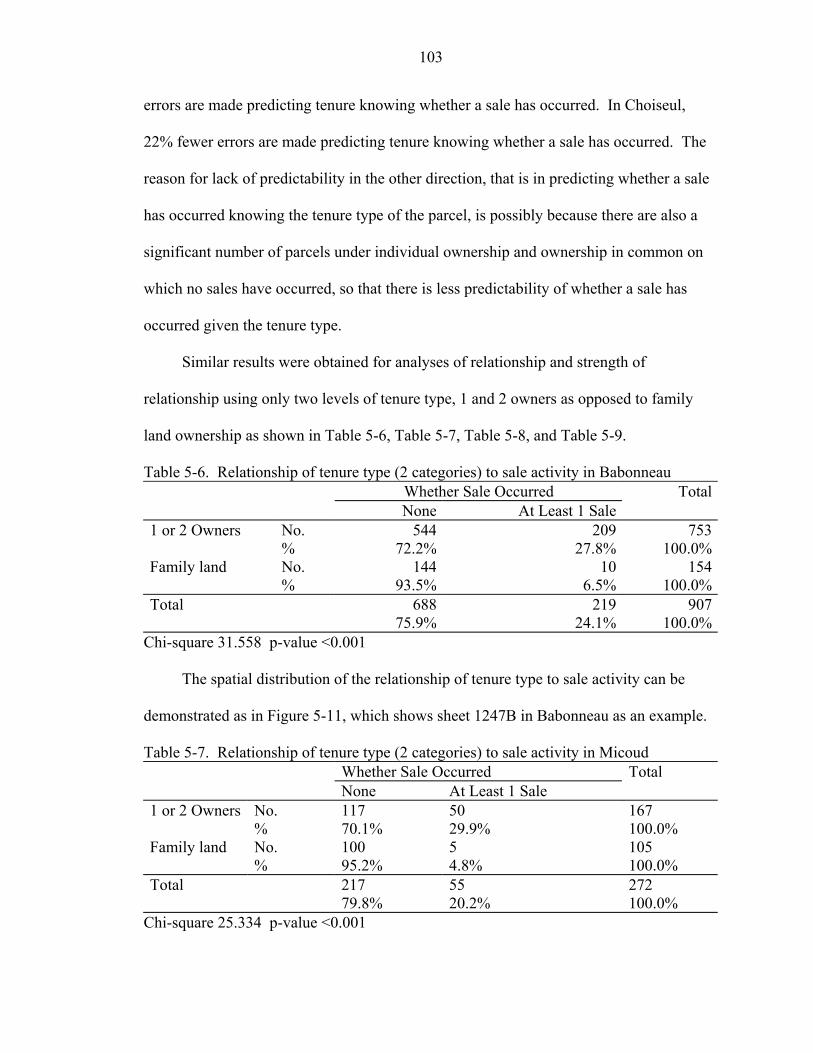
103
errors are made predicting tenure knowing whether a sale has occurred. In Choiseul,
22% fewer errors are made predicting tenure knowing whether a sale has occurred. The
reason for lack of predictability in the other direction, that is in predicting whether a sale
has occurred knowing the tenure type of the parcel, is possibly because there are also a
significant number of parcels under individual ownership and ownership in common on
which no sales have occurred, so that there is less predictability of whether a sale has
occurred given the tenure type.
Similar results were obtained for analyses of relationship and strength of
relationship using only two levels of tenure type, 1 and 2 owners as opposed to family
land ownership as shown in Table 5-6, Table 5-7, Table 5-8, and Table 5-9.
Table 5-6. Relationship of tenure type (2 categories) to sale activity in Babonneau Whether Sale Occurred Total None At Least 1 Sale 1 or 2 Owners No. 544 209 753 % 72.2% 27.8% 100.0%Family land No. 144 10 154 % 93.5% 6.5% 100.0%Total 688 219 907 75.9% 24.1% 100.0%
Chi-square 31.558 p-value <0.001
The spatial distribution of the relationship of tenure type to sale activity can be
demonstrated as in Figure 5-11, which shows sheet 1247B in Babonneau as an example.
Table 5-7. Relationship of tenure type (2 categories) to sale activity in Micoud Whether Sale Occurred Total None At Least 1 Sale 1 or 2 Owners No. 117 50 167 % 70.1% 29.9% 100.0% Family land No. 100 5 105 % 95.2% 4.8% 100.0% Total 217 55 272 79.8% 20.2% 100.0%
Chi-square 25.334 p-value <0.001
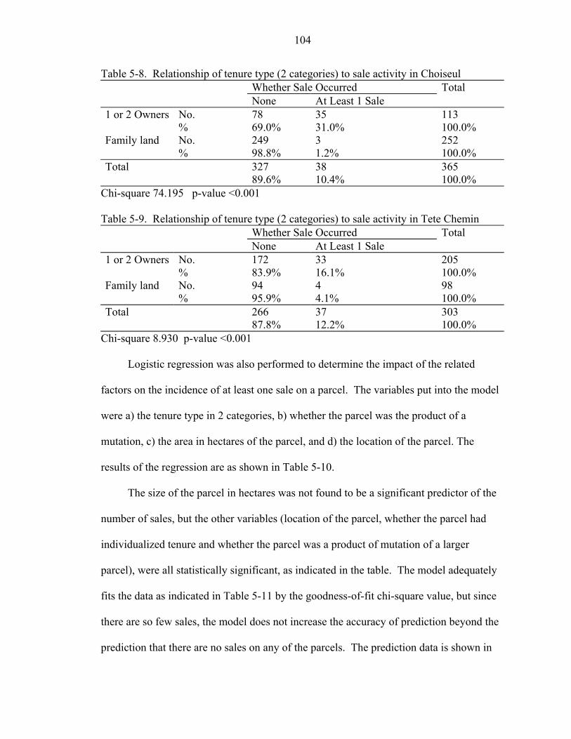
104
Table 5-8. Relationship of tenure type (2 categories) to sale activity in Choiseul Whether Sale Occurred Total None At Least 1 Sale 1 or 2 Owners No. 78 35 113 % 69.0% 31.0% 100.0% Family land No. 249 3 252 % 98.8% 1.2% 100.0% Total 327 38 365 89.6% 10.4% 100.0%
Chi-square 74.195 p-value <0.001 Table 5-9. Relationship of tenure type (2 categories) to sale activity in Tete Chemin Whether Sale Occurred Total None At Least 1 Sale 1 or 2 Owners No. 172 33 205 % 83.9% 16.1% 100.0% Family land No. 94 4 98 % 95.9% 4.1% 100.0% Total 266 37 303 87.8% 12.2% 100.0%
Chi-square 8.930 p-value <0.001
Logistic regression was also performed to determine the impact of the related
factors on the incidence of at least one sale on a parcel. The variables put into the model
were a) the tenure type in 2 categories, b) whether the parcel was the product of a
mutation, c) the area in hectares of the parcel, and d) the location of the parcel. The
results of the regression are as shown in Table 5-10.
The size of the parcel in hectares was not found to be a significant predictor of the
number of sales, but the other variables (location of the parcel, whether the parcel had
individualized tenure and whether the parcel was a product of mutation of a larger
parcel), were all statistically significant, as indicated in the table. The model adequately
fits the data as indicated in Table 5-11 by the goodness-of-fit chi-square value, but since
there are so few sales, the model does not increase the accuracy of prediction beyond the
prediction that there are no sales on any of the parcels. The prediction data is shown in
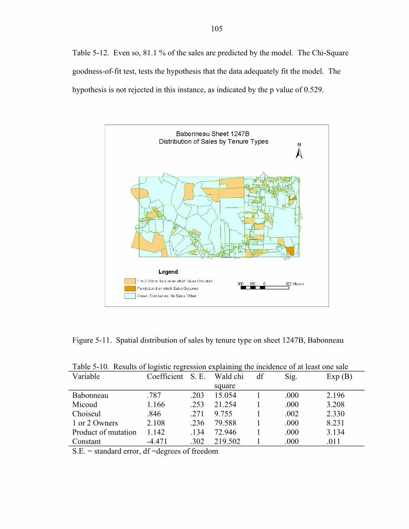
105
Table 5-12. Even so, 81.1 % of the sales are predicted by the model. The Chi-Square
goodness-of-fit test, tests the hypothesis that the data adequately fit the model. The
hypothesis is not rejected in this instance, as indicated by the p value of 0.529.
Figure 5-11. Spatial distribution of sales by tenure type on sheet 1247B, Babonneau
Table 5-10. Results of logistic regression explaining the incidence of at least one sale Variable Coefficient S. E. Wald chi
square df Sig. Exp (B)
Babonneau .787 .203 15.054 1 .000 2.196 Micoud 1.166 .253 21.254 1 .000 3.208 Choiseul .846 .271 9.755 1 .002 2.330 1 or 2 Owners 2.108 .236 79.588 1 .000 8.231 Product of mutation 1.142 .134 72.946 1 .000 3.134 Constant -4.471 .302 219.502 1 .000 .011 S.E. = standard error, df =degrees of freedom
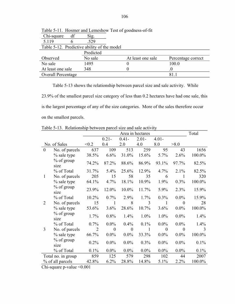
106
Table 5-11. Hosmer and Lemeshow Test of goodness-of-fit Chi-square df Sig. 5.119 6 .529
Table 5-12. Predictive ability of the model Predicted Observed No sale At least one sale Percentage correct No sale 1495 0 100.0 At least one sale 348 0 .0 Overall Percentage 81.1
Table 5-13 shows the relationship between parcel size and sale activity. While
23.9% of the smallest parcel size category of less than 0.2 hectares have had one sale, this
is the largest percentage of any of the size categories. More of the sales therefore occur
on the smallest parcels.
Table 5-13. Relationship between parcel size and sale activity Area in hectares Total
No. of Sales <0.2 0.21-0.4
0.41-2.0
2.01-4.0
4.01-8.0 >8.0
0 No. of parcels 637 109 513 259 95 43 1656 % sale type 38.5% 6.6% 31.0% 15.6% 5.7% 2.6% 100.0% % of group
size 74.2% 87.2% 88.6% 86.9% 93.1% 97.7% 82.5%
% of Total 31.7% 5.4% 25.6% 12.9% 4.7% 2.1% 82.5%1 No. of parcels 205 15 58 35 6 1 320 % sale type 64.1% 4.7% 18.1% 10.9% 1.9% 0.3% 100.0% % of group
size 23.9% 12.0% 10.0% 11.7% 5.9% 2.3% 15.9%
% of Total 10.2% 0.7% 2.9% 1.7% 0.3% 0.0% 15.9%2 No. of parcels 15 1 8 3 1 0 28 % sale type 53.6% 3.6% 28.6% 10.7% 3.6% 0.0% 100.0% % of group
size 1.7% 0.8% 1.4% 1.0% 1.0% 0.0% 1.4%
% of Total 0.7% 0.0% 0.4% 0.1% 0.0% 0.0% 1.4%3 No. of parcels 2 0 0 1 0 0 3 % sale type 66.7% 0.0% 0.0% 33.3% 0.0% 0.0% 100.0% % of group
size 0.2% 0.0% 0.0% 0.3% 0.0% 0.0% 0.1%
% of Total 0.1% 0.0% 0.0% 0.0% 0.0% 0.0% 0.1%Total no. in group 859 125 579 298 102 44 2007% of all parcels 42.8% 6.2% 28.8% 14.8% 5.1% 2.2% 100.0%
Chi-square p-value <0.001
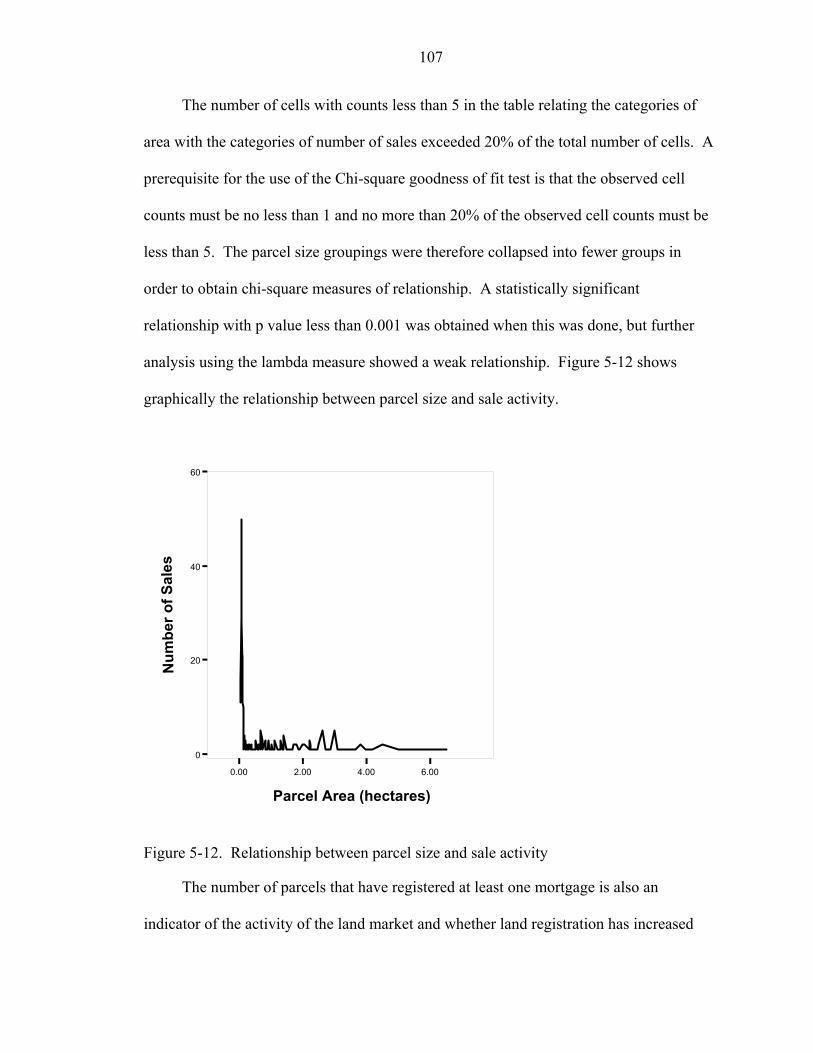
107
The number of cells with counts less than 5 in the table relating the categories of
area with the categories of number of sales exceeded 20% of the total number of cells. A
prerequisite for the use of the Chi-square goodness of fit test is that the observed cell
counts must be no less than 1 and no more than 20% of the observed cell counts must be
less than 5. The parcel size groupings were therefore collapsed into fewer groups in
order to obtain chi-square measures of relationship. A statistically significant
relationship with p value less than 0.001 was obtained when this was done, but further
analysis using the lambda measure showed a weak relationship. Figure 5-12 shows
graphically the relationship between parcel size and sale activity.
0.00 2.00 4.00 6.00
Parcel Area (hectares)
0
20
40
60
Num
ber o
f Sal
es
Figure 5-12. Relationship between parcel size and sale activity
The number of parcels that have registered at least one mortgage is also an
indicator of the activity of the land market and whether land registration has increased
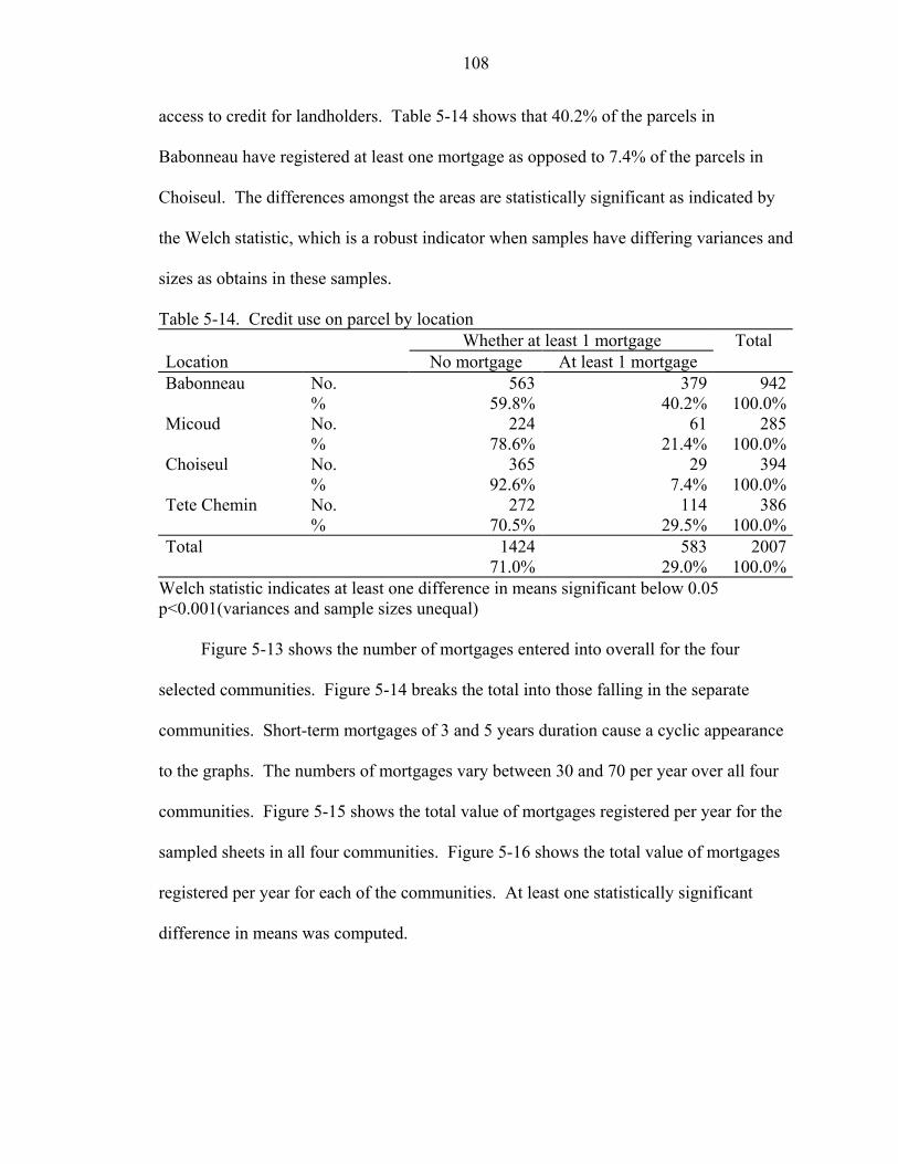
108
access to credit for landholders. Table 5-14 shows that 40.2% of the parcels in
Babonneau have registered at least one mortgage as opposed to 7.4% of the parcels in
Choiseul. The differences amongst the areas are statistically significant as indicated by
the Welch statistic, which is a robust indicator when samples have differing variances and
sizes as obtains in these samples.
Table 5-14. Credit use on parcel by location Whether at least 1 mortgage Total Location No mortgage At least 1 mortgage Babonneau No. 563 379 942 % 59.8% 40.2% 100.0%Micoud No. 224 61 285 % 78.6% 21.4% 100.0%Choiseul No. 365 29 394 % 92.6% 7.4% 100.0%Tete Chemin No. 272 114 386 % 70.5% 29.5% 100.0%Total 1424 583 2007 71.0% 29.0% 100.0%
Welch statistic indicates at least one difference in means significant below 0.05 p<0.001(variances and sample sizes unequal)
Figure 5-13 shows the number of mortgages entered into overall for the four
selected communities. Figure 5-14 breaks the total into those falling in the separate
communities. Short-term mortgages of 3 and 5 years duration cause a cyclic appearance
to the graphs. The numbers of mortgages vary between 30 and 70 per year over all four
communities. Figure 5-15 shows the total value of mortgages registered per year for the
sampled sheets in all four communities. Figure 5-16 shows the total value of mortgages
registered per year for each of the communities. At least one statistically significant
difference in means was computed.
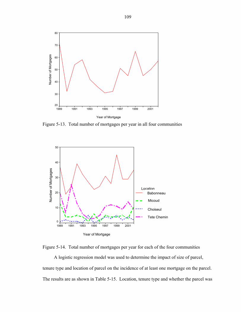
109
Year of Mortgage
2001199919971995199319911989
Num
ber o
f Mor
tgag
es
80
70
60
50
40
30
20
Figure 5-13. Total number of mortgages per year in all four communities
Year of Mortgage
2001199919971995199319911989
Num
ber o
f Mor
tgag
es
50
40
30
20
10
0
Location
u
Babonneau
Figure 5-14. Total number of mortgages per year for e
A logistic regression model was used to determin
tenure type and location of parcel on the incidence of a
The results are as shown in Table 5-15. Location, tenu
BM
MC
CT
T te Chemin
eabonneaicoud
icoudhoiseul
hoiseulete Chemin
ach of the four communities
e the impact of size of parcel,
t least one mortgage on the parcel.
re type and whether the parcel was
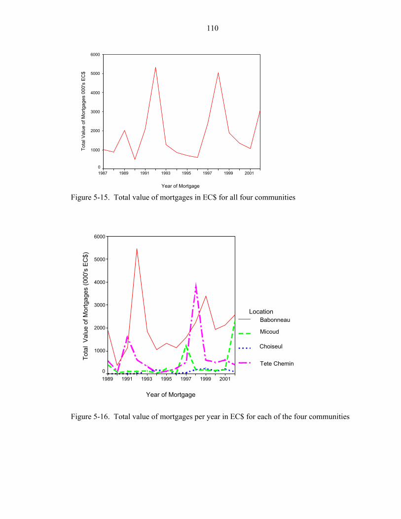
110
Year of Mortgage
20011999199719951993199119891987
Tota
l Val
ue o
f Mor
tgag
es 0
00's
EC
$
6000
5000
4000
3000
2000
1000
0
Figure 5-15. Total value of mortgages in EC$ for all four communities
Year of Mortgage
2001199919971995199319911989
Tota
l V
alue
of M
ortg
ages
(000
's E
C$)
6000
5000
4000
3000
2000
1000
0
Location
Babonneau
Micoud
Choiseul
Tete Chemin
Babonneau
Micoud
Choiseul
Tete Chemin
Figure 5-16. Total value of mortgages per year in EC$ for each of the four communities
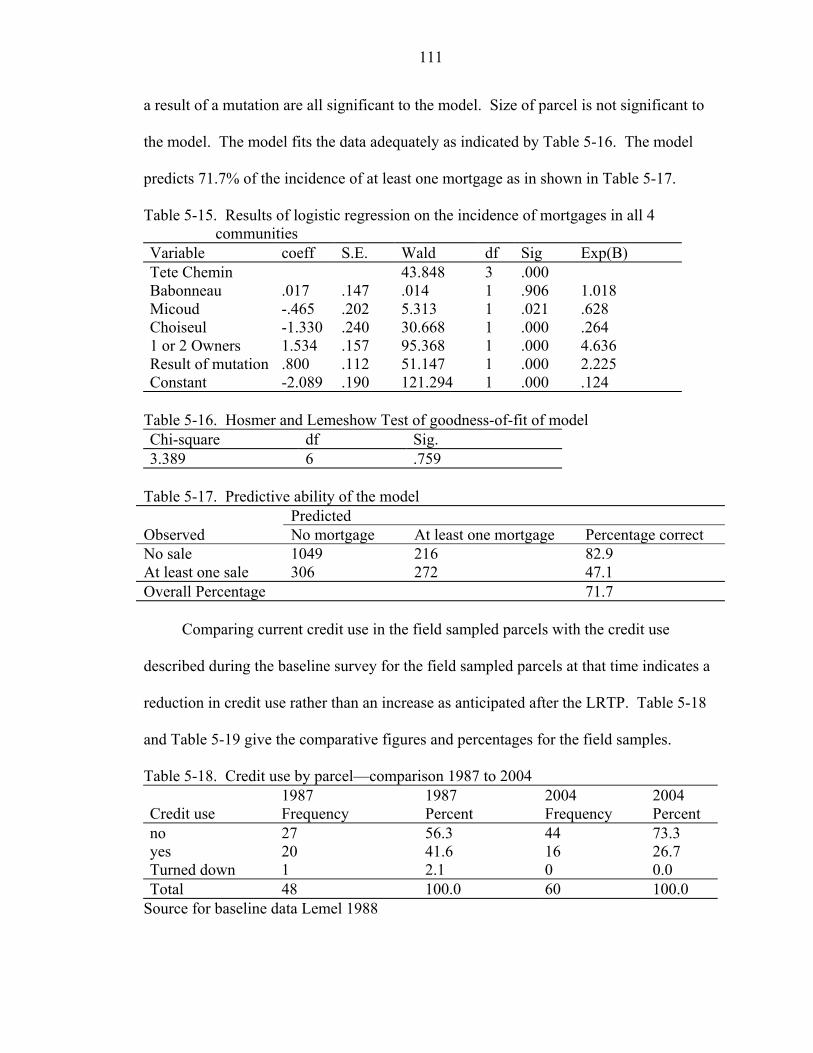
111
a result of a mutation are all significant to the model. Size of parcel is not significant to
the model. The model fits the data adequately as indicated by Table 5-16. The model
predicts 71.7% of the incidence of at least one mortgage as in shown in Table 5-17.
Table 5-15. Results of logistic regression on the incidence of mortgages in all 4 communities
Variable coeff S.E. Wald df Sig Exp(B) Tete Chemin 43.848 3 .000 Babonneau .017 .147 .014 1 .906 1.018 Micoud -.465 .202 5.313 1 .021 .628 Choiseul -1.330 .240 30.668 1 .000 .264 1 or 2 Owners 1.534 .157 95.368 1 .000 4.636 Result of mutation .800 .112 51.147 1 .000 2.225 Constant -2.089 .190 121.294 1 .000 .124
Table 5-16. Hosmer and Lemeshow Test of goodness-of-fit of model Chi-square df Sig. 3.389 6 .759
Table 5-17. Predictive ability of the model Predicted Observed No mortgage At least one mortgage Percentage correct No sale 1049 216 82.9 At least one sale 306 272 47.1 Overall Percentage 71.7
Comparing current credit use in the field sampled parcels with the credit use
described during the baseline survey for the field sampled parcels at that time indicates a
reduction in credit use rather than an increase as anticipated after the LRTP. Table 5-18
and Table 5-19 give the comparative figures and percentages for the field samples.
Table 5-18. Credit use by parcel—comparison 1987 to 2004
Credit use 1987 Frequency
1987 Percent
2004 Frequency
2004 Percent
no 27 56.3 44 73.3 yes 20 41.6 16 26.7 Turned down 1 2.1 0 0.0 Total 48 100.0 60 100.0
Source for baseline data Lemel 1988
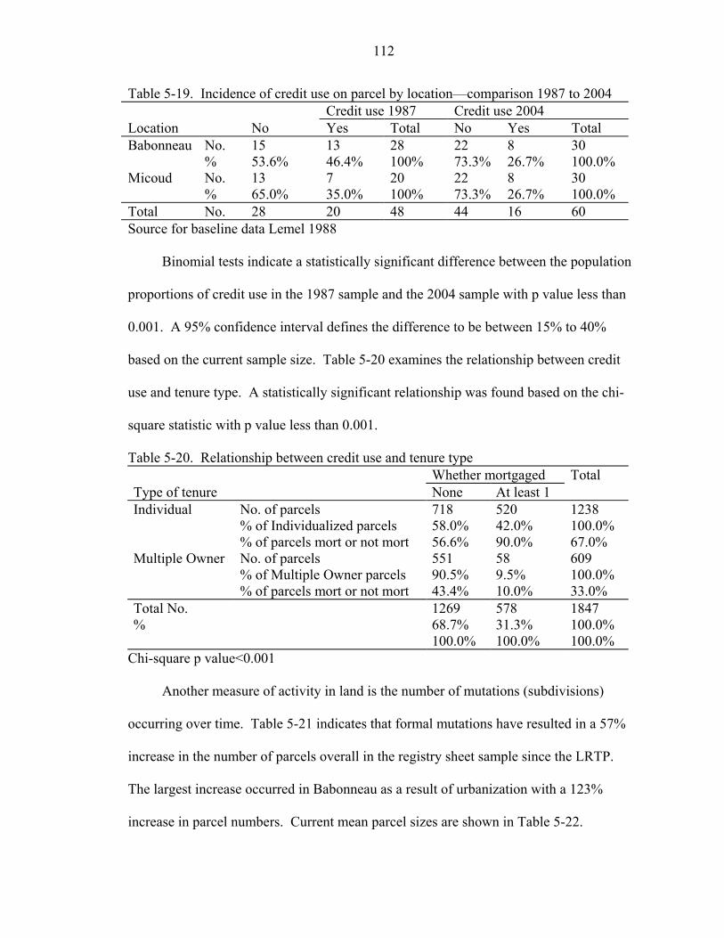
112
Table 5-19. Incidence of credit use on parcel by location—comparison 1987 to 2004 Credit use 1987 Credit use 2004 Location No Yes Total No Yes Total Babonneau No. 15 13 28 22 8 30 % 53.6% 46.4% 100% 73.3% 26.7% 100.0% Micoud No. 13 7 20 22 8 30 % 65.0% 35.0% 100% 73.3% 26.7% 100.0% Total No. 28 20 48 44 16 60 Source for baseline data Lemel 1988
Binomial tests indicate a statistically significant difference between the population
proportions of credit use in the 1987 sample and the 2004 sample with p value less than
0.001. A 95% confidence interval defines the difference to be between 15% to 40%
based on the current sample size. Table 5-20 examines the relationship between credit
use and tenure type. A statistically significant relationship was found based on the chi-
square statistic with p value less than 0.001.
Table 5-20. Relationship between credit use and tenure type Whether mortgaged Total Type of tenure None At least 1 Individual No. of parcels 718 520 1238 % of Individualized parcels 58.0% 42.0% 100.0% % of parcels mort or not mort 56.6% 90.0% 67.0% Multiple Owner No. of parcels 551 58 609 % of Multiple Owner parcels 90.5% 9.5% 100.0% % of parcels mort or not mort 43.4% 10.0% 33.0% Total No. 1269 578 1847 % 68.7% 31.3% 100.0% 100.0% 100.0% 100.0%
Chi-square p value<0.001
Another measure of activity in land is the number of mutations (subdivisions)
occurring over time. Table 5-21 indicates that formal mutations have resulted in a 57%
increase in the number of parcels overall in the registry sheet sample since the LRTP.
The largest increase occurred in Babonneau as a result of urbanization with a 123%
increase in parcel numbers. Current mean parcel sizes are shown in Table 5-22.
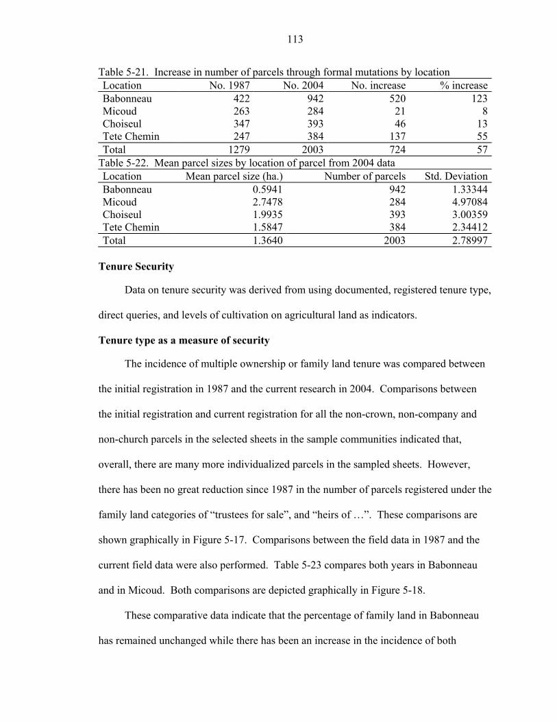
113
Table 5-21. Increase in number of parcels through formal mutations by location Location No. 1987 No. 2004 No. increase % increaseBabonneau 422 942 520 123Micoud 263 284 21 8Choiseul 347 393 46 13Tete Chemin 247 384 137 55Total 1279 2003 724 57
Table 5-22. Mean parcel sizes by location of parcel from 2004 data Location Mean parcel size (ha.) Number of parcels Std. DeviationBabonneau 0.5941 942 1.33344Micoud 2.7478 284 4.97084Choiseul 1.9935 393 3.00359Tete Chemin 1.5847 384 2.34412Total 1.3640 2003 2.78997
Tenure Security
Data on tenure security was derived from using documented, registered tenure type,
direct queries, and levels of cultivation on agricultural land as indicators.
Tenure type as a measure of security
The incidence of multiple ownership or family land tenure was compared between
the initial registration in 1987 and the current research in 2004. Comparisons between
the initial registration and current registration for all the non-crown, non-company and
non-church parcels in the selected sheets in the sample communities indicated that,
overall, there are many more individualized parcels in the sampled sheets. However,
there has been no great reduction since 1987 in the number of parcels registered under the
family land categories of “trustees for sale”, and “heirs of …”. These comparisons are
shown graphically in Figure 5-17. Comparisons between the field data in 1987 and the
current field data were also performed. Table 5-23 compares both years in Babonneau
and in Micoud. Both comparisons are depicted graphically in Figure 5-18.
These comparative data indicate that the percentage of family land in Babonneau
has remained unchanged while there has been an increase in the incidence of both
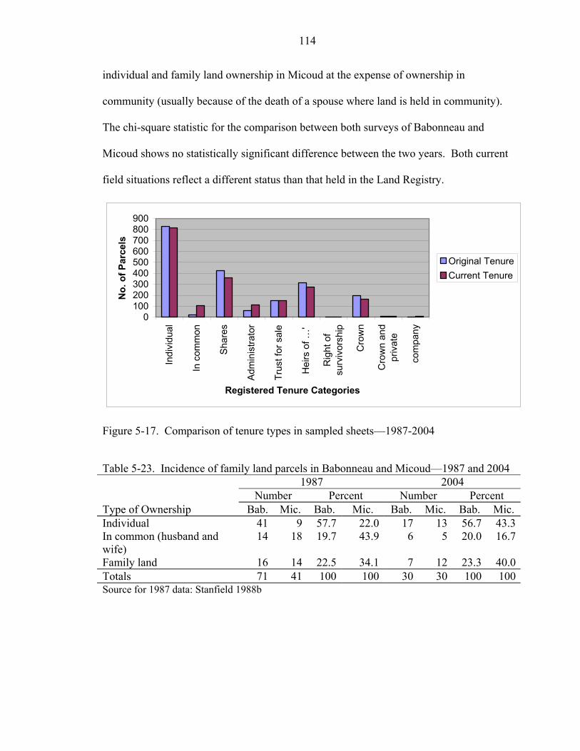
114
individual and family land ownership in Micoud at the expense of ownership in
community (usually because of the death of a spouse where land is held in community).
The chi-square statistic for the comparison between both surveys of Babonneau and
Micoud shows no statistically significant difference between the two years. Both current
field situations reflect a different status than that held in the Land Registry.
0100200300400500600700800900
Indi
vidu
al
In c
omm
on
Sha
res
Adm
inis
trato
r
Trus
t for
sal
e
Hei
rs o
f …'
Rig
ht o
fsu
rviv
orsh
ip
Cro
wn
Cro
wn
and
priv
ate
com
pany
Registered Tenure Categories
No.
of P
arce
ls
Original TenureCurrent Tenure
Figure 5-17. Comparison of tenure types in sampled sheets—1987-2004
Table 5-23. Incidence of family land parcels in Babonneau and Micoud—1987 and 2004 1987 2004 Number Percent Number Percent Type of Ownership Bab. Mic. Bab. Mic. Bab. Mic. Bab. Mic. Individual 41 9 57.7 22.0 17 13 56.7 43.3In common (husband and wife)
14 18 19.7 43.9 6 5 20.0 16.7
Family land 16 14 22.5 34.1 7 12 23.3 40.0Totals 71 41 100 100 30 30 100 100Source for 1987 data: Stanfield 1988b
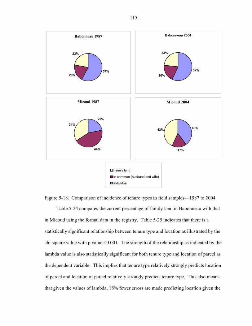
115
Babonneau 1987
57%20%
23%
Babonneau 2004
57%20%
23%
Micoud 1987
22%
44%
34%
Micoud 2004
40%
17%
43%
Family land
In common (husband and wife)
Individual
Figure 5-18. Comparison of incidence of tenure types in field samples—1987 to 2004
Table 5-24 compares the current percentage of family land in Babonneau with that
in Micoud using the formal data in the registry. Table 5-25 indicates that there is a
statistically significant relationship between tenure type and location as illustrated by the
chi square value with p value <0.001. The strength of the relationship as indicated by the
lambda value is also statistically significant for both tenure type and location of parcel as
the dependent variable. This implies that tenure type relatively strongly predicts location
of parcel and location of parcel relatively strongly predicts tenure type. This also means
that given the values of lambda, 18% fewer errors are made predicting location given the
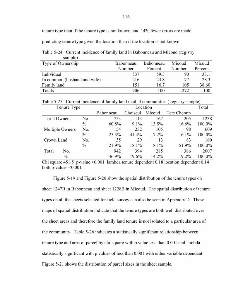
116
tenure type than if the tenure type is not known, and 14% fewer errors are made
predicting tenure type given the location than if the location is not known.
Table 5-24. Current incidence of family land in Babonneau and Micoud (registry sample)
Type of Ownership Babonneau Number
BabonneauPercent
Micoud Number
Micoud Percent
Individual 537 59.3 90 33.1In common (husband and wife) 216 23.8 77 28.3Family land 151 16.7 105 38.60Totals 906 100 272 100 Table 5-25. Current incidence of family land in all 4 communities ( registry sample)
Tenure Type Location Total Babonneau Choiseul Micoud Tete Chemin 1 or 2 Owners No. 753 113 167 205 1238 % 60.8% 9.1% 13.5% 16.6% 100.0%Multiple Owners No. 154 252 105 98 609 % 25.3% 41.4% 17.2% 16.1% 100.0%Crown Land No. 35 29 13 83 160 % 21.9% 18.1% 8.1% 51.9% 100.0%Total No. 942 394 285 386 2007 % 46.9% 19.6% 14.2% 19.2% 100.0%
Chi square 451.5 p-value <0.001 lambda tenure dependent 0.18 location dependent 0.14 both p-values <0.001
Figure 5-19 and Figure 5-20 show the spatial distribution of the tenure types on
sheet 1247B in Babonneau and sheet 1228B in Micoud. The spatial distribution of tenure
types on all the sheets selected for field survey can also be seen in Appendix D. These
maps of spatial distribution indicate that the tenure types are both well distributed over
the sheet areas and therefore the family land tenure is not isolated to a particular area of
the community. Table 5-26 indicates a statistically significant relationship between
tenure type and area of parcel by chi-square with p value less than 0.001 and lambda
statistically significant with p values of less than 0.001 with either variable dependant.
Figure 5-21 shows the distribution of parcel sizes in the sheet sample.
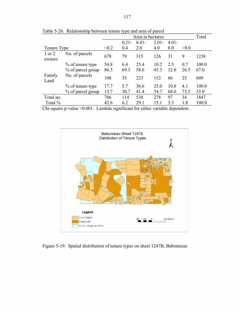
117
Table 5-26. Relationship between tenure type and area of parcel Area in hectares Total
Tenure Type <0.2 0.21-0.4
0.41-2.0
2.01-4.0
4.01-8.0 >8.0
1 or 2 owners
No. of parcels 678 79 315 126 31 9 1238
% of tenure type 54.8 6.4 25.4 10.2 2.5 0.7 100.0 % of parcel group 86.3 69.3 58.6 45.3 32.0 26.5 67.0 Family Land
No. of parcels 108 35 223 152 66 25 609
% of tenure type 17.7 5.7 36.6 25.0 10.8 4.1 100.0 % of parcel group 13.7 30.7 41.4 54.7 68.0 73.5 33.0 Total no. 786 114 538 278 97 34 1847 Total % 42.6 6.2 29.1 15.1 5.3 1.8 100.0
Chi-square p-value <0.001. Lambda significant for either variable dependent.
Figure 5-19. Spatial distribution of tenure types on sheet 1247B, Babonneau
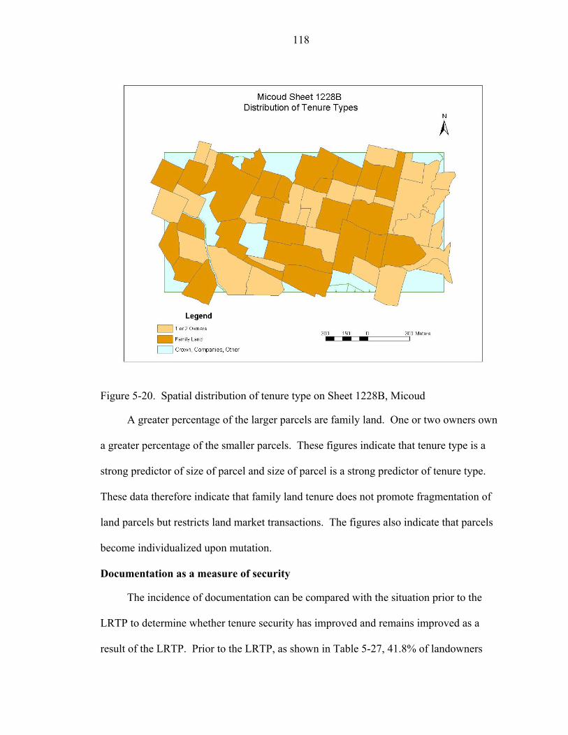
118
Figure 5-20. Spatial distribution of tenure type on Sheet 1228B, Micoud
A greater percentage of the larger parcels are family land. One or two owners own
a greater percentage of the smaller parcels. These figures indicate that tenure type is a
strong predictor of size of parcel and size of parcel is a strong predictor of tenure type.
These data therefore indicate that family land tenure does not promote fragmentation of
land parcels but restricts land market transactions. The figures also indicate that parcels
become individualized upon mutation.
Documentation as a measure of security
The incidence of documentation can be compared with the situation prior to the
LRTP to determine whether tenure security has improved and remains improved as a
result of the LRTP. Prior to the LRTP, as shown in Table 5-27, 41.8% of landowners

119
held no documentation or documentation other than a deed to prove ownership (Stanfield
1988). Currently, as shown in Table 5-28, 27.8% of owners hold no documentation or
documentation other than registered title to prove ownership.
0.00 5.00 10.00 15.00
Area of Parcels (hectares)
0
50
100
150
Num
ber o
f Par
cels
Figure 5-21. Distribution of parcel sizes in registry sample
Table 5-27. Documentation of ownership in baseline data—1987 Documentation Total Tenure No or Other Document Deed Individual No. 22 48 70 % 31.4% 68.6% 100.0%Family Land No. 44 17 61 % 72.1% 27.9% 100.0%2 owners No. 11 42 3 % 20.8% 79.2% 100.0%Total 77 107 184 41.8% 58.2% 100.0%
Source for baseline data: Stanfield 1988
Taking title registered in the name of the occupant as an indicator of tenure
security, this indicates an increase in formal or objective tenure security from pre-LRTP
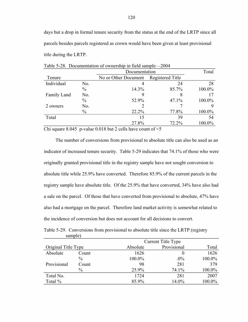
120
days but a drop in formal tenure security from the status at the end of the LRTP since all
parcels besides parcels registered as crown would have been given at least provisional
title during the LRTP.
Table 5-28. Documentation of ownership in field sample—2004 Documentation Total Tenure No or Other Document Registered Title Individual No. 4 24 28 % 14.3% 85.7% 100.0%Family Land No. 9 8 17 % 52.9% 47.1% 100.0%2 owners No. 2 7 9 % 22.2% 77.8% 100.0%Total 15 39 54 27.8% 72.2% 100.0%
Chi square 8.045 p-value 0.018 but 2 cells have count of <5
The number of conversions from provisional to absolute title can also be used as an
indicator of increased tenure security. Table 5-29 indicates that 74.1% of those who were
originally granted provisional title in the registry sample have not sought conversion to
absolute title while 25.9% have converted. Therefore 85.9% of the current parcels in the
registry sample have absolute title. Of the 25.9% that have converted, 34% have also had
a sale on the parcel. Of those that have converted from provisional to absolute, 47% have
also had a mortgage on the parcel. Therefore land market activity is somewhat related to
the incidence of conversion but does not account for all decisions to convert.
Table 5-29. Conversions from provisional to absolute title since the LRTP (registry sample)
Current Title Type Original Title Type Absolute Provisional TotalAbsolute Count 1626 0 1626 % 100.0% .0% 100.0%Provisional Count 98 281 379 % 25.9% 74.1% 100.0%Total No. 1724 281 2007Total % 85.9% 14.0% 100.0%
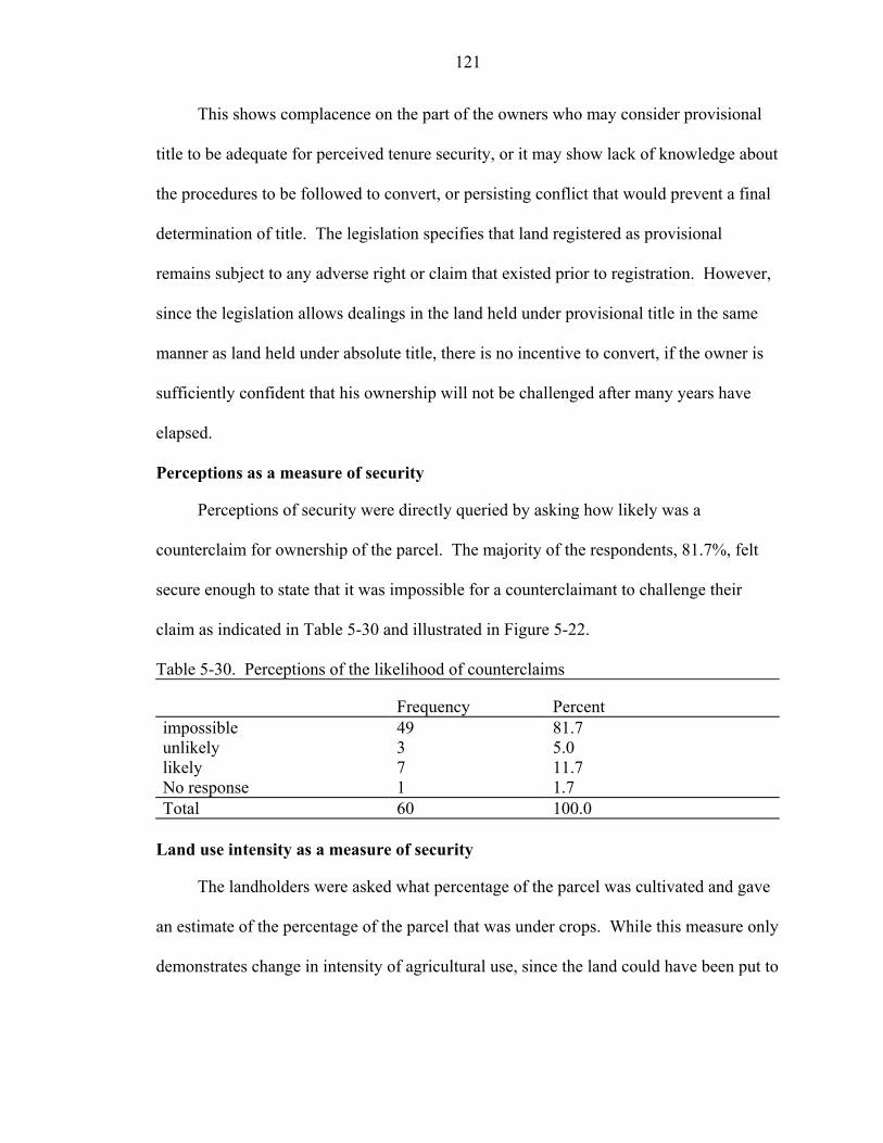
121
This shows complacence on the part of the owners who may consider provisional
title to be adequate for perceived tenure security, or it may show lack of knowledge about
the procedures to be followed to convert, or persisting conflict that would prevent a final
determination of title. The legislation specifies that land registered as provisional
remains subject to any adverse right or claim that existed prior to registration. However,
since the legislation allows dealings in the land held under provisional title in the same
manner as land held under absolute title, there is no incentive to convert, if the owner is
sufficiently confident that his ownership will not be challenged after many years have
elapsed.
Perceptions as a measure of security
Perceptions of security were directly queried by asking how likely was a
counterclaim for ownership of the parcel. The majority of the respondents, 81.7%, felt
secure enough to state that it was impossible for a counterclaimant to challenge their
claim as indicated in Table 5-30 and illustrated in Figure 5-22.
Table 5-30. Perceptions of the likelihood of counterclaims
Frequency Percent impossible 49 81.7 unlikely 3 5.0 likely 7 11.7 No response 1 1.7 Total 60 100.0
Land use intensity as a measure of security
The landholders were asked what percentage of the parcel was cultivated and gave
an estimate of the percentage of the parcel that was under crops. While this measure only
demonstrates change in intensity of agricultural use, since the land could have been put to
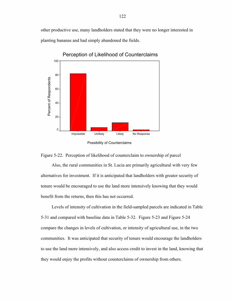
122
other productive use, many landholders stated that they were no longer interested in
planting bananas and had simply abandoned the fields.
Perception of Likelihood of Counterclaims
Possibility of Counterclaims
No ResponseLikelyUnlikelyImpossible
Per
cent
of R
espo
nden
ts
100
80
60
40
20
0
Figure 5-22. Perception of likelihood of counterclaim to ownership of parcel
Also, the rural communities in St. Lucia are primarily agricultural with very few
alternatives for investment. If it is anticipated that landholders with greater security of
tenure would be encouraged to use the land more intensively knowing that they would
benefit from the returns, then this has not occurred.
Levels of intensity of cultivation in the field-sampled parcels are indicated in Table
5-31 and compared with baseline data in Table 5-32. Figure 5-23 and Figure 5-24
compare the changes in levels of cultivation, or intensity of agricultural use, in the two
communities. It was anticipated that security of tenure would encourage the landholders
to use the land more intensively, and also access credit to invest in the land, knowing that
they would enjoy the profits without counterclaims of ownership from others.
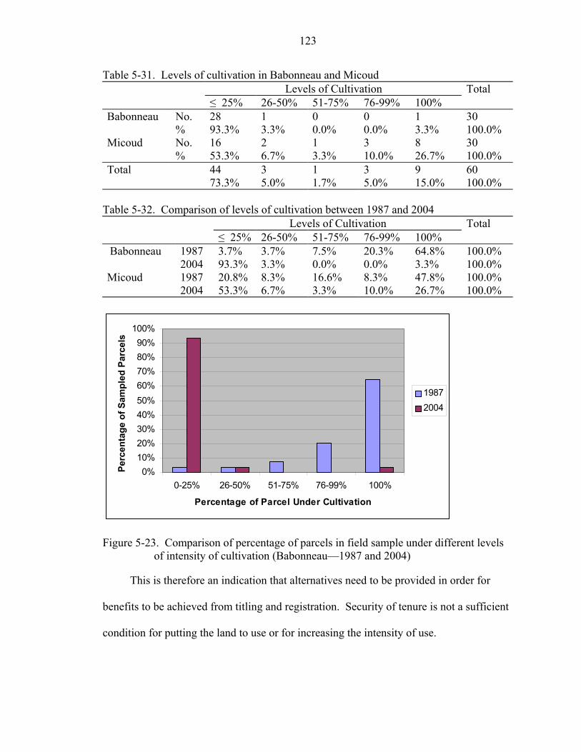
123
Table 5-31. Levels of cultivation in Babonneau and Micoud Levels of Cultivation Total ≤ 25% 26-50% 51-75% 76-99% 100% Babonneau No. 28 1 0 0 1 30 % 93.3% 3.3% 0.0% 0.0% 3.3% 100.0% Micoud No. 16 2 1 3 8 30 % 53.3% 6.7% 3.3% 10.0% 26.7% 100.0% Total 44 3 1 3 9 60 73.3% 5.0% 1.7% 5.0% 15.0% 100.0%
Table 5-32. Comparison of levels of cultivation between 1987 and 2004 Levels of Cultivation Total ≤ 25% 26-50% 51-75% 76-99% 100% Babonneau 1987 3.7% 3.7% 7.5% 20.3% 64.8% 100.0% 2004 93.3% 3.3% 0.0% 0.0% 3.3% 100.0% Micoud 1987 20.8% 8.3% 16.6% 8.3% 47.8% 100.0% 2004 53.3% 6.7% 3.3% 10.0% 26.7% 100.0%
0%10%20%30%40%50%60%70%80%90%
100%
0-25% 26-50% 51-75% 76-99% 100%
Percentage of Parcel Under Cultivation
Perc
enta
ge o
f Sam
pled
Par
cels
19872004
Figure 5-23. Comparison of percentage of parcels in field sample under different levels
of intensity of cultivation (Babonneau—1987 and 2004)
This is therefore an indication that alternatives need to be provided in order for
benefits to be achieved from titling and registration. Security of tenure is not a sufficient
condition for putting the land to use or for increasing the intensity of use.
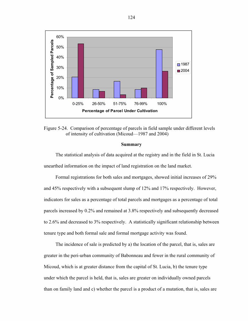
124
0%
10%
20%
30%
40%
50%
60%
0-25% 26-50% 51-75% 76-99% 100%
Percentage of Parcel Under Cultivation
Perc
enta
ge o
f Sam
pled
Par
cels
19872004
Figure 5-24. Comparison of percentage of parcels in field sample under different levels
of intensity of cultivation (Micoud—1987 and 2004)
Summary
The statistical analysis of data acquired at the registry and in the field in St. Lucia
unearthed information on the impact of land registration on the land market.
Formal registrations for both sales and mortgages, showed initial increases of 29%
and 45% respectively with a subsequent slump of 12% and 17% respectively. However,
indicators for sales as a percentage of total parcels and mortgages as a percentage of total
parcels increased by 0.2% and remained at 3.8% respectively and subsequently decreased
to 2.6% and decreased to 3% respectively. A statistically significant relationship between
tenure type and both formal sale and formal mortgage activity was found.
The incidence of sale is predicted by a) the location of the parcel, that is, sales are
greater in the peri-urban community of Babonneau and fewer in the rural community of
Micoud, which is at greater distance from the capital of St. Lucia, b) the tenure type
under which the parcel is held, that is, sales are greater on individually owned parcels
than on family land and c) whether the parcel is a product of a mutation, that is, sales are
125
greater on parcels which had previously been subdivided. These 3 factors were also
shown to predict the incidence of mortgage in the same way. There was no significant
increase in the number of persons accessing credit over the 1987 figures. The field
sample indicated a statistically significant reduction in credit use over the 1987 baseline
sample. No reduction in the number of family land parcels was found in the field
samples in the Babonneau and Micoud communities, so that the family land tenure type
was found to be persistent.
Based on these empirical data and contrary to the premise of the project, the land
registration and titling project in St. Lucia has not led to a sustained increase in volume of
land transactions of sale and mortgage, over the medium term since the conclusion of the
project.
Chapter 5 presented the analysis of the data acquired on land transactions in the
case study of St. Lucia. Chapter 6 presents the analysis of the data acquired on land
registration system sustainability in the case study.
CHAPTER 6 ANALYSIS OF THE SUSTAINABILITY OF THE LAND REGISTRATION SYSTEM
IN ST. LUCIA
Sustainability of the Land Registry
Sustainability of the Land Registry was investigated in this research by comparing
data acquired in the Land Registry with data acquired from questionnaires for the
landholders of the same sample set of parcels. The data acquired for comparison, and the
analyses performed, are presented in this chapter. The reasons for non-conformity
between the formal data and what exists on the ground were examined by obtaining the
landholders’ perceptions of the characteristics of the registration system. These
perceptions are stated in diffusion literature to affect the adoption of technology. Data
acquired for determining the land-users’ perceptions of the characteristics and the
analyses performed are also presented in this chapter.
Conformity Between Registry and Ground
Data were acquired from the Land Registry on the number of registered owners on
the parcels. In the field interviews, data on the current number of de facto owners were
also acquired. The categories of ownership were collapsed into three categories, (parcels
with 1 owner, those with 2 owners and parcels with 3 or more owners), then the instances
of occurrence were compared between the registry data and the field, and the results
shown in Table 6-1 were obtained. There is 18% discrepancy between the tenure
information in the registry and that in the field, based solely on numbers of owners. This
126
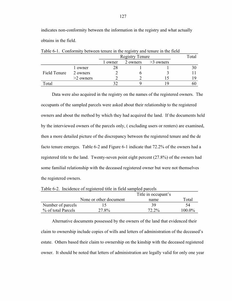
127
indicates non-conformity between the information in the registry and what actually
obtains in the field.
Table 6-1. Conformity between tenure in the registry and tenure in the field Registry Tenure Total 1 owner 2 owners >3 owners 1 owner 28 1 1 30Field Tenure 2 owners 2 6 3 11 >2 owners 2 2 15 19Total 32 9 19 60
Data were also acquired in the registry on the names of the registered owners. The
occupants of the sampled parcels were asked about their relationship to the registered
owners and about the method by which they had acquired the land. If the documents held
by the interviewed owners of the parcels only, ( excluding users or renters) are examined,
then a more detailed picture of the discrepancy between the registered tenure and the de
facto tenure emerges. Table 6-2 and Figure 6-1 indicate that 72.2% of the owners had a
registered title to the land. Twenty-seven point eight percent (27.8%) of the owners had
some familial relationship with the deceased registered owner but were not themselves
the registered owners.
Table 6-2. Incidence of registered title in field sampled parcels
None or other document Title in occupant’s
name Total Number of parcels 15 39 54 % of total Parcels 27.8% 72.2% 100.0%
Alternative documents possessed by the owners of the land that evidenced their
claim to ownership include copies of wills and letters of administration of the deceased’s
estate. Others based their claim to ownership on the kinship with the deceased registered
owner. It should be noted that letters of administration are legally valid for only one year

128
and must be reapplied for if they are to be used for legally effecting decisions on the
estate of the deceased. Renewal has not occurred in some instances.
28%
72%
No Title
Title
Figure 6-1. Incidence of registered title in field sampled parcels
Non-conformity between the data on encumbrances in the Land Registry and the
situation on the ground was also found in relation to leased parcels. None of the 6 parcels
in the sample that were occupied under some type of lease agreement between the owner
and the user, was the subject of a registered lease. The lease periods had become
continuous beyond the 2-year minimum required for registration under the Land
Registration Act No. 12 of 1984.
All the landholders were also asked whether they would consider leasing their land.
The owners offered various reasons for non-registration of existing leases and for their
attitudes toward leasing in general. In one instance, the owner had not transferred the
inherited title to his name so could not register a lease. Some owners felt that a lease is a
private transaction between owner and lessee and did not require public registration.
Others felt that leases that were month-to-month did not require registration. In some of
the arrangements there was no rental payment or sharecropping occurring, and so the

129
activity could be better described as ‘borrowing’ of land. Some had negative attitudes to
leasing of land, stating that they knew of situations where the lessee could not eventually
be removed from the land. The non-registration of these arrangements reflects a further
lack of accuracy and completeness of the registry data.
Perceptions Affecting Adoption of Technology
Data were acquired about the reasons for non-conformity between registry data and
the reality on the ground, based on the interviewees’ perceptions of the characteristics of
technology that influence its adoption and use. These characteristics are: relative
advantage, compatibility, complexity, trialability and observability.
Relative advantage
In response to the open-ended question regarding whether there was any advantage
to registering title to land, 15% of the land users stated that there was none, as is shown in
Table 6-3. Three percent did not know whether there was any advantage while the
majority of persons (82%) detailed various advantages to title registration such as
security of tenure of the land, improvement in the ability to access credit, the elimination
of prior conflict, and the prevention of future ones. Most of those interviewed therefore
perceive some relative advantage to be obtained from registration of land. The 82%
recorded as perceiving advantage compares to 91% of persons in the baseline study in
1987 who thought the LRTP to be beneficial (Gomes 1988). The decrease in the number
of persons who view registration as an advantage will result in a decrease in willingness
to register. Perception of a relative advantage to the adoption of an innovation motivates
users to adopt.
In response to the open-ended question of whether there were any disadvantages to
registration of title to land, 63.3% stated that there were none as shown in Table 6-3.
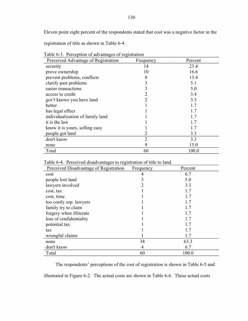
130
Eleven point eight percent of the respondents stated that cost was a negative factor in the
registration of title as shown in Table 6-4.
Table 6-3. Perception of advantages of registration Perceived Advantage of Registration Frequency Percent security 14 23.4 prove ownership 10 16.6 prevent problems, conflicts 8 13.4 clarify past problems 3 5.1 easier transactions 3 5.0 access to credit 2 3.4 gov't knows you have land 2 3.3 better 1 1.7 has legal effect 1 1.7 individualization of family land 1 1.7 it is the law 1 1.7 know it is yours, selling easy 1 1.7 people got land 2 3.3 don't know 2 3.3 none 9 15.0 Total 60 100.0
Table 6-4. Perceived disadvantages to registration of title to land. Perceived Disadvantage of Registration Frequency Percent cost 4 6.7 people lost land 3 5.0 lawyers involved 2 3.3 cost, tax 1 1.7 cost, time 1 1.7 too costly esp. lawyers 1 1.7 family try to claim 1 1.7 forgery when illiterate 1 1.7 loss of confidentiality 1 1.7 potential tax 1 1.7 tax 1 1.7 wrongful claims 1 1.7 none 38 63.3 don't know 4 6.7 Total 60 100.0
The respondents’ perceptions of the cost of registration is shown in Table 6-5 and
illustrated in Figure 6-2. The actual costs are shown in Table 6-6. These actual costs
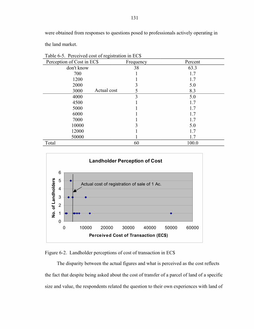
131
were obtained from responses to questions posed to professionals actively operating in
the land market.
Table 6-5. Perceived cost of registration in EC$ Perception of Cost in EC$ Frequency Percent
don't know 38 63.3 700 1 1.7 1200 1 1.7 2000 3 5.0 3000 5 8.3 4000 4500 5000 6000 7000 10000 12000 50000
Total
L
0
1
2
3
4
5
6
0 10000
Pe
No.
of L
andh
olde
rs
Actual
Figure 6-2. Landholder
The disparity betw
the fact that despite bein
size and value, the respo
Actual cost
3 5.0 1 1.7 1 1.7 1 1.7 1 1.7 3 5.0 1 1.7 1 1.7 60 100.0andholder Perception of Cost
20000 30000 40000 50000 60000
rceived Cost of Transaction (EC$)
cost of registration of sale of 1 Ac.
perceptions of cost of transaction in EC$
een the actual figures and what is perceived as the cost reflects
g asked about the cost of transfer of a parcel of land of a specific
ndents related the question to their own experiences with land of
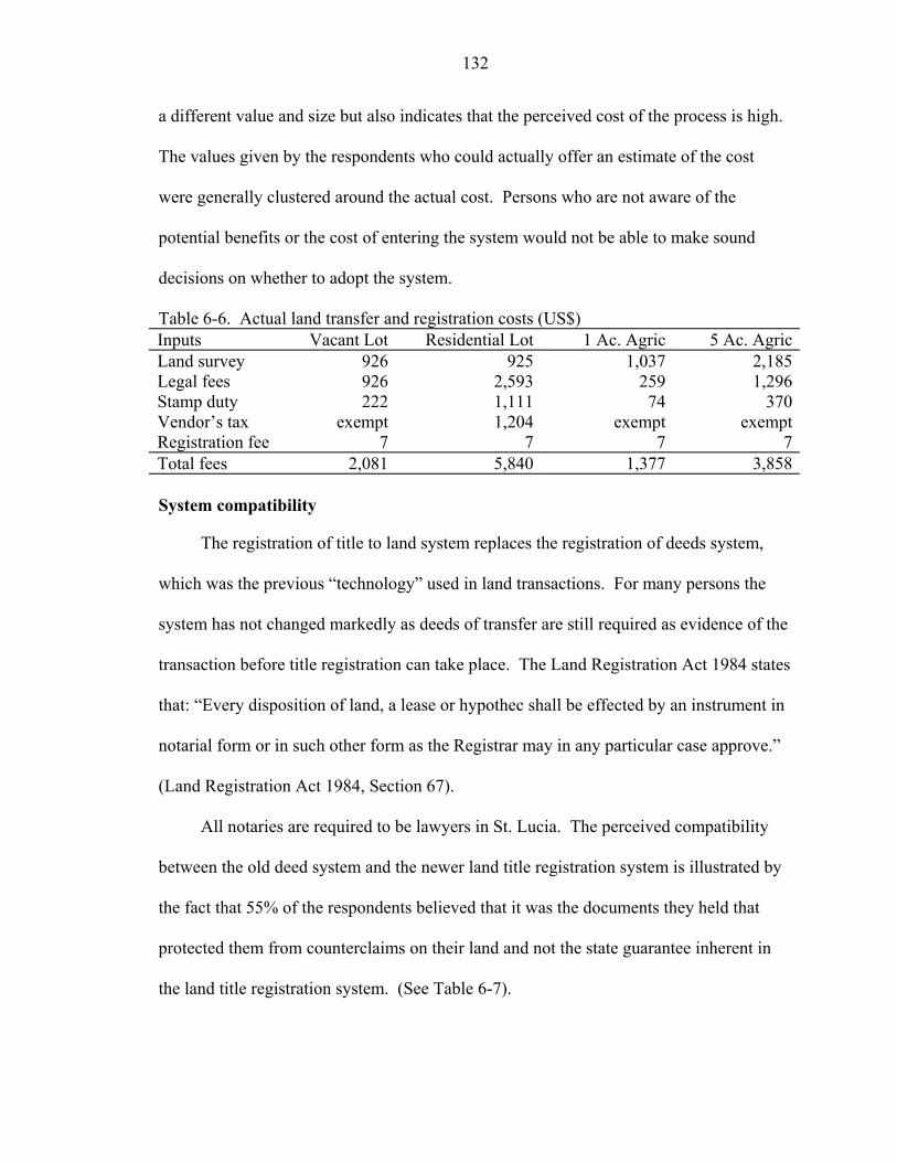
132
a different value and size but also indicates that the perceived cost of the process is high.
The values given by the respondents who could actually offer an estimate of the cost
were generally clustered around the actual cost. Persons who are not aware of the
potential benefits or the cost of entering the system would not be able to make sound
decisions on whether to adopt the system.
Table 6-6. Actual land transfer and registration costs (US$) Inputs Vacant Lot Residential Lot 1 Ac. Agric 5 Ac. AgricLand survey 926 925 1,037 2,185Legal fees 926 2,593 259 1,296Stamp duty 222 1,111 74 370Vendor’s tax exempt 1,204 exempt exemptRegistration fee 7 7 7 7Total fees 2,081 5,840 1,377 3,858 System compatibility
The registration of title to land system replaces the registration of deeds system,
which was the previous “technology” used in land transactions. For many persons the
system has not changed markedly as deeds of transfer are still required as evidence of the
transaction before title registration can take place. The Land Registration Act 1984 states
that: “Every disposition of land, a lease or hypothec shall be effected by an instrument in
notarial form or in such other form as the Registrar may in any particular case approve.”
(Land Registration Act 1984, Section 67).
All notaries are required to be lawyers in St. Lucia. The perceived compatibility
between the old deed system and the newer land title registration system is illustrated by
the fact that 55% of the respondents believed that it was the documents they held that
protected them from counterclaims on their land and not the state guarantee inherent in
the land title registration system. (See Table 6-7).
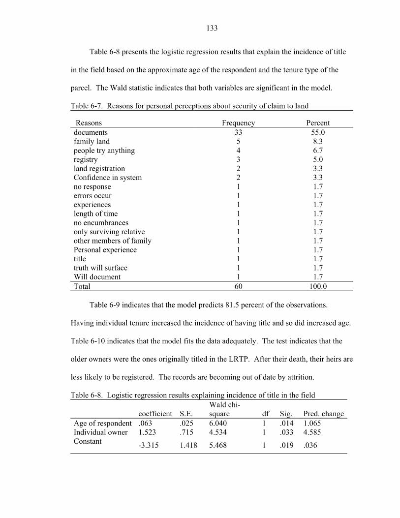
133
Table 6-8 presents the logistic regression results that explain the incidence of title
in the field based on the approximate age of the respondent and the tenure type of the
parcel. The Wald statistic indicates that both variables are significant in the model.
Table 6-7. Reasons for personal perceptions about security of claim to land
Reasons Frequency Percent documents 33 55.0 family land 5 8.3 people try anything 4 6.7 registry 3 5.0 land registration 2 3.3 Confidence in system 2 3.3 no response 1 1.7 errors occur 1 1.7 experiences 1 1.7 length of time 1 1.7 no encumbrances 1 1.7 only surviving relative 1 1.7 other members of family 1 1.7 Personal experience 1 1.7 title 1 1.7 truth will surface 1 1.7 Will document 1 1.7 Total 60 100.0
Table 6-9 indicates that the model predicts 81.5 percent of the observations.
Having individual tenure increased the incidence of having title and so did increased age.
Table 6-10 indicates that the model fits the data adequately. The test indicates that the
older owners were the ones originally titled in the LRTP. After their death, their heirs are
less likely to be registered. The records are becoming out of date by attrition.
Table 6-8. Logistic regression results explaining incidence of title in the field
coefficient S.E. Wald chi-square df Sig. Pred. change
Age of respondent .063 .025 6.040 1 .014 1.065 Individual owner 1.523 .715 4.534 1 .033 4.585 Constant -3.315 1.418 5.468 1 .019 .036
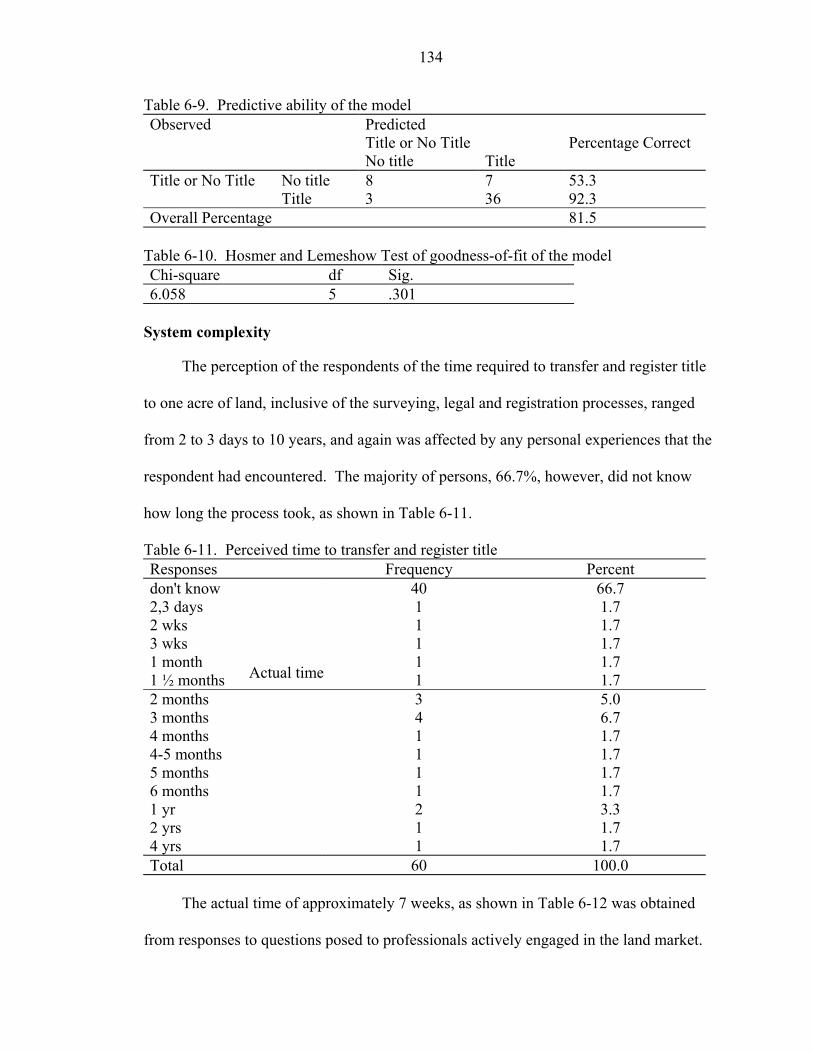
134
Table 6-9. Predictive ability of the model Observed Predicted Title or No Title Percentage Correct No title Title Title or No Title No title 8 7 53.3 Title 3 36 92.3 Overall Percentage 81.5
Table 6-10. Hosmer and Lemeshow Test of goodness-of-fit of the model Chi-square df Sig. 6.058 5 .301
System complexity
The perception of the respondents of the time required to transfer and register title
to one acre of land, inclusive of the surveying, legal and registration processes, ranged
from 2 to 3 days to 10 years, and again was affected by any personal experiences that the
respondent had encountered. The majority of persons, 66.7%, however, did not know
how long the process took, as shown in Table 6-11.
Table 6-11. Perceived time to transfer and register title Responses Frequency Percent don't know 40 66.7 2,3 days 1 1.7 2 wks 1 1.7 3 wks 1 1.7 1 month 1 1.7 1 ½ months 1 1.7 2 months 3 5.0 3 months 4 6.7 4 months 1 1.7 4-5 months 1 1.7 5 months 1 1.7 6 months 1 1.7 1 yr 2 3.3 2 yrs 1 1.7 4 yrs 1 1.7 Total 60 100.0
The actual time of approximately 7 weeks, as shown in Table 6-12 was obtained
from responses to questions posed to professionals actively engaged in the land market.
Actual time
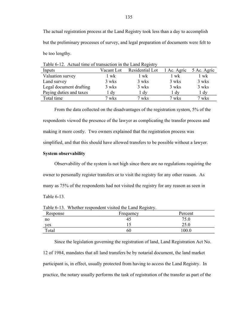
135
The actual registration process at the Land Registry took less than a day to accomplish
but the preliminary processes of survey, and legal preparation of documents were felt to
be too lengthy.
Table 6-12. Actual time of transaction in the Land Registry Inputs Vacant Lot Residential Lot 1 Ac. Agric 5 Ac. AgricValuation survey 1 wk 1 wk 1 wk 1 wk Land survey 3 wks 3 wks 3 wks 3 wks Legal document drafting 3 wks 3 wks 3 wks 3 wks Paying duties and taxes 1 dy 1 dy 1 dy 1 dy Total time 7 wks 7 wks 7 wks 7 wks
From the data collected on the disadvantages of the registration system, 5% of the
respondents viewed the presence of the lawyer as complicating the transfer process and
making it more costly. Two owners explained that the registration process was
simplified, and that this should have allowed transfers to be possible without a lawyer.
System observability
Observability of the system is not high since there are no regulations requiring the
owner to personally register transfers or to visit the registry for any other reason. As
many as 75% of the respondents had not visited the registry for any reason as seen in
Table 6-13.
Table 6-13. Whether respondent visited the Land Registry. Response Frequency Percent no 45 75.0 yes 15 25.0 Total 60 100.0
Since the legislation governing the registration of land, Land Registration Act No.
12 of 1984, mandates that all land transfers be by notarial document, the land market
participant is, in effect, usually protected from having to access the Land Registry. In
practice, the notary usually performs the task of registration of the transfer as part of the
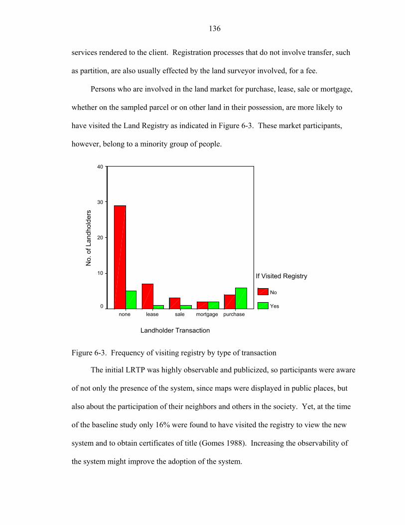
136
services rendered to the client. Registration processes that do not involve transfer, such
as partition, are also usually effected by the land surveyor involved, for a fee.
Persons who are involved in the land market for purchase, lease, sale or mortgage,
whether on the sampled parcel or on other land in their possession, are more likely to
have visited the Land Registry as indicated in Figure 6-3. These market participants,
however, belong to a minority group of people.
Landholder Transaction
purchasemortgagesaleleasenone
No.
of L
andh
olde
rs
40
30
20
10
0
If Visited Registry
No
Yes
Figure 6-3. Frequency of visiting registry by type of transaction
The initial LRTP was highly observable and publicized, so participants were aware
of not only the presence of the system, since maps were displayed in public places, but
also about the participation of their neighbors and others in the society. Yet, at the time
of the baseline study only 16% were found to have visited the registry to view the new
system and to obtain certificates of title (Gomes 1988). Increasing the observability of
the system might improve the adoption of the system.
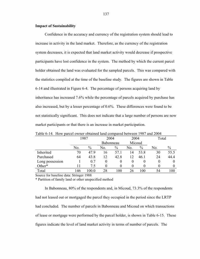
137
Impact of Sustainability
Confidence in the accuracy and currency of the registration system should lead to
increase in activity in the land market. Therefore, as the currency of the registration
system decreases, it is expected that land market activity would decrease if prospective
participants have lost confidence in the system. The method by which the current parcel
holder obtained the land was evaluated for the sampled parcels. This was compared with
the statistics compiled at the time of the baseline study. The figures are shown in Table
6-14 and illustrated in Figure 6-4. The percentage of persons acquiring land by
inheritance has increased 7.6% while the percentage of parcels acquired by purchase has
also increased, but by a lesser percentage of 0.6%. These differences were found to be
not statistically significant. This does not indicate that a large number of persons are now
market participants or that there is an increase in market participation.
Table 6-14. How parcel owner obtained land compared between 1987 and 2004 1987 2004
Babonneau 2004
Micoud Total
No. % No. % No. % No. % Inherited 70 47.9 16 57.1 14 53.8 30 55.5Purchased 64 43.8 12 42.8 12 46.1 24 44.4Long possession 1 0.7 0 0 0 0 0 0Other* 11 7.5 0 0 0 0 0 0Total 146 100.0 28 100 26 100 54 100
Source for baseline data: Stringer 1988 * Partition of family land or other unspecified method
In Babonneau, 80% of the respondents and, in Micoud, 73.3% of the respondents
had not leased out or mortgaged the parcel they occupied in the period since the LRTP
had concluded. The number of parcels in Babonneau and Micoud on which transactions
of lease or mortgage were performed by the parcel holder, is shown in Table 6-15. These
figures indicate the level of land market activity in terms of number of parcels. The
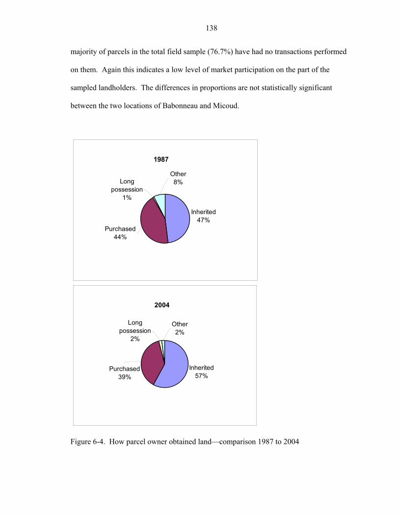
138
majority of parcels in the total field sample (76.7%) have had no transactions performed
on them. Again this indicates a low level of market participation on the part of the
sampled landholders. The differences in proportions are not statistically significant
between the two locations of Babonneau and Micoud.
1987
Inherited47%
Other8%Long
possession1%
Purchased44%
2004
Inherited57%
Other2%
Long possession
2%
Purchased39%
Figure 6-4. How parcel owner obtained land—comparison 1987 to 2004
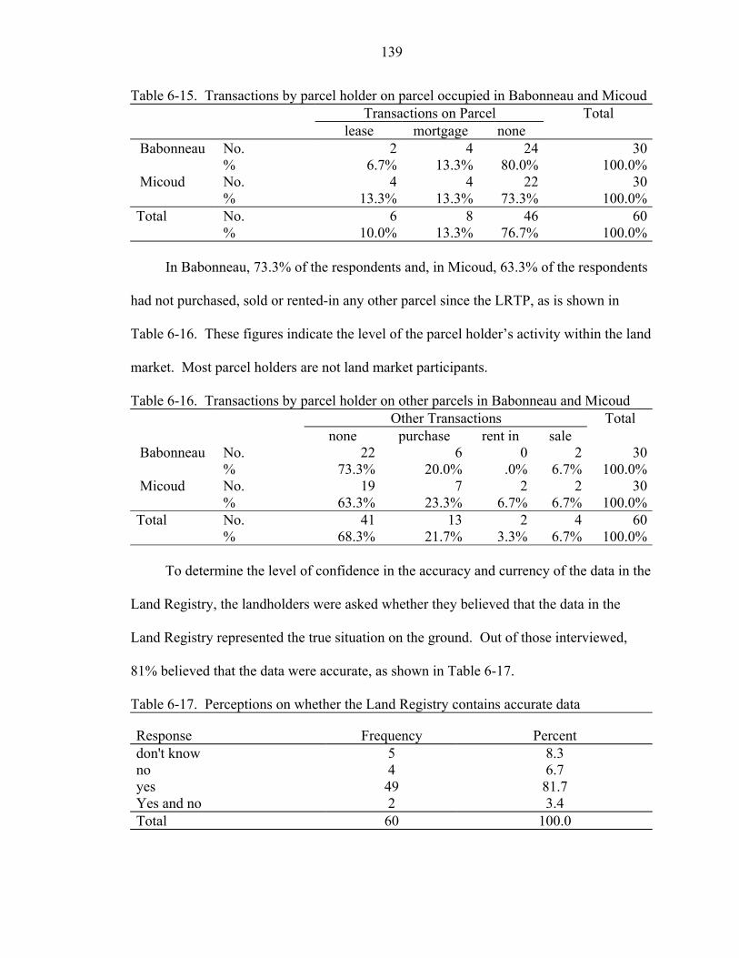
139
Table 6-15. Transactions by parcel holder on parcel occupied in Babonneau and Micoud Transactions on Parcel Total lease mortgage none Babonneau No. 2 4 24 30 % 6.7% 13.3% 80.0% 100.0% Micoud No. 4 4 22 30 % 13.3% 13.3% 73.3% 100.0%Total No. 6 8 46 60 % 10.0% 13.3% 76.7% 100.0%
In Babonneau, 73.3% of the respondents and, in Micoud, 63.3% of the respondents
had not purchased, sold or rented-in any other parcel since the LRTP, as is shown in
Table 6-16. These figures indicate the level of the parcel holder’s activity within the land
market. Most parcel holders are not land market participants.
Table 6-16. Transactions by parcel holder on other parcels in Babonneau and Micoud Other Transactions Total none purchase rent in sale Babonneau No. 22 6 0 2 30 % 73.3% 20.0% .0% 6.7% 100.0% Micoud No. 19 7 2 2 30 % 63.3% 23.3% 6.7% 6.7% 100.0%Total No. 41 13 2 4 60 % 68.3% 21.7% 3.3% 6.7% 100.0%
To determine the level of confidence in the accuracy and currency of the data in the
Land Registry, the landholders were asked whether they believed that the data in the
Land Registry represented the true situation on the ground. Out of those interviewed,
81% believed that the data were accurate, as shown in Table 6-17.
Table 6-17. Perceptions on whether the Land Registry contains accurate data
Response Frequency Percent don't know 5 8.3 no 4 6.7 yes 49 81.7 Yes and no 2 3.4 Total 60 100.0
140
The confidence in the Land Registry is, therefore, high and should not restrict
potential land market participants from performing transactions in the land market. There
is no evidence to show that the market participants are aware of the erosion in the registry
data.
Summary
The statistical analysis of data acquired at the registry and in the field in St. Lucia
unearthed information on the sustainability of the land registry.
Discrepancies between the registered information on tenure and what was found in
the field indicated a 28% erosion of the registry since the LRTP. This 28% decline in the
accuracy of the registry was primarily due to non-registration of inheritance and did not
include the lease information that also was not registered. This decline in the currency of
the registry data will be problematic for the functioning of the land market. At this rate
of non-registration, the Land Registry would be more than 50% eroded by 2020,
especially as the originally titled owners pass on.
Positive factors in the current environment that promote the maintenance of the
land registry data were found to be the perceptions of relative advantage by the system
users, and the perception of compatibility with the previous systems. Negative factors
were the complexity of the system and its lack of observability. The users of the system
indicated that they are not aware of the discrepancies in the system so this has not begun
to affect the functioning of the land market. Since 70% of the landholders are not market
participants, the erosion of the data in the Land Registry does not impact them.
Chapter 6 presented the analysis of the data acquired in the case study country of
St. Lucia in relation to sustainability of the land registration system. Chapter 7 compares
performance indicators derived from the data regarding the land market and the land

141
registration system with other international jurisdictions as a means of placing the status
of the case study in context.
CHAPTER 7 COMPARATIVE ANALYSIS OF TITLING IMPACT AND SYSTEM
SUSTAINABILITY
Comparative Analysis
Comparative Indicators
The indicators used to analyze the impact of land titling over the medium term in
St. Lucia were used in a comparative analysis with other jurisdictions in order to better
understand the land market dynamics. Data from several countries are compared with the
data acquired from the case study, and the indicators computed from the acquired data in
this section.
A comparative study was recently completed on land administration systems
around the world (Burns et al. 2003) using several indicators of the effectiveness of the
land administration systems. The indicators used by Burns et al and selected for
comparison in this research, were those for which data were available for other countries
for comparative purposes. These indicators are given in Table 7- 1 together with some
issues that need to be taken into consideration when viewing and comparing the values of
the indicators.
The values of the indicators are given in Table 7-2. Data from the analysis of St.
Lucia are compared with data acquired by Burns et al. (2003). Only the indicators from
countries from which data are available and are directly related to the land market and the
sustainability of the land title registration system are used here.
142
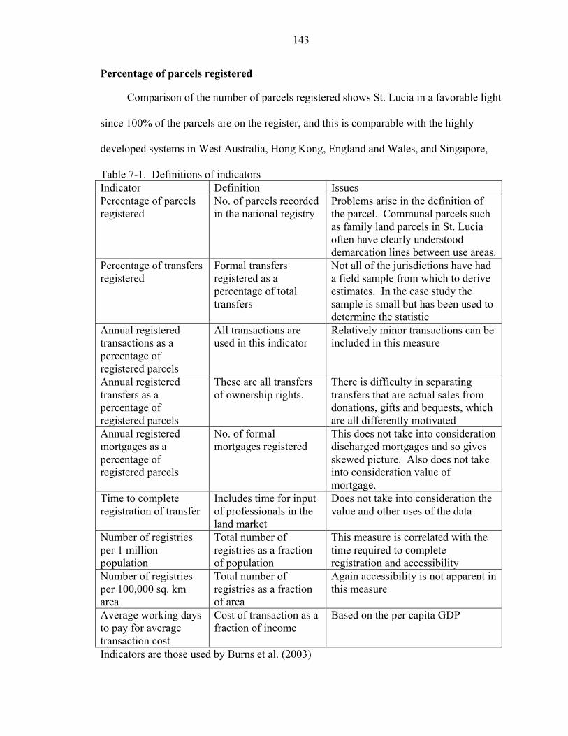
143
Percentage of parcels registered
Comparison of the number of parcels registered shows St. Lucia in a favorable light
since 100% of the parcels are on the register, and this is comparable with the highly
developed systems in West Australia, Hong Kong, England and Wales, and Singapore,
Table 7-1. Definitions of indicators Indicator Definition Issues Percentage of parcels registered
No. of parcels recorded in the national registry
Problems arise in the definition of the parcel. Communal parcels such as family land parcels in St. Lucia often have clearly understood demarcation lines between use areas.
Percentage of transfers registered
Formal transfers registered as a percentage of total transfers
Not all of the jurisdictions have had a field sample from which to derive estimates. In the case study the sample is small but has been used to determine the statistic
Annual registered transactions as a percentage of registered parcels
All transactions are used in this indicator
Relatively minor transactions can be included in this measure
Annual registered transfers as a percentage of registered parcels
These are all transfers of ownership rights.
There is difficulty in separating transfers that are actual sales from donations, gifts and bequests, which are all differently motivated
Annual registered mortgages as a percentage of registered parcels
No. of formal mortgages registered
This does not take into consideration discharged mortgages and so gives skewed picture. Also does not take into consideration value of mortgage.
Time to complete registration of transfer
Includes time for input of professionals in the land market
Does not take into consideration the value and other uses of the data
Number of registries per 1 million population
Total number of registries as a fraction of population
This measure is correlated with the time required to complete registration and accessibility
Number of registries per 100,000 sq. km area
Total number of registries as a fraction of area
Again accessibility is not apparent in this measure
Average working days to pay for average transaction cost
Cost of transaction as a fraction of income
Based on the per capita GDP
Indicators are those used by Burns et al. (2003)
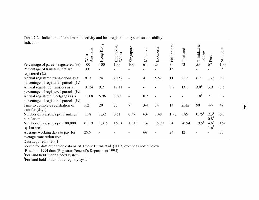
Table 7-2. Indicators of Land market activity and land registration system sustainability Indicator
Wes
t A
ustra
lia
Hon
g K
ong
Engl
and
&
Wal
es
Sing
apor
e
Mol
dova
Indo
nesi
a
Phili
ppin
es
Thai
land
Trin
idad
&
Toba
go
Peru
St. L
ucia
Percentage of parcels registered (%) 100 100 100 100 61 23 30 63 53 67 100Percentage of transfers that are registered (%)
100
0.119 1,315 16.54 1,515 1.6 15.79 54 70.94 19.51 2
1.63 162
Average working days to pay for average transaction cost
29.9 - - - 66 - 24 12 - - 88
- - - - - 15 - - 75
Annual registered transactions as a percentage of registered parcels (%)
30.3 24 20.52 - 4 5.82 11 21.2 6.7 13.8 9.7
Annual registered transfers as a percentage of registered parcels (%)
10.24 9.2 12.11 - - - 3.7 13.1 3.01 3.9 3.5
Annual registered mortgages as a percentage of registered parcels (%)
11.08 5.96 7.69 - 0.7 - - - 1.81 2.1 3.2
Time to complete registration of transfer (days)
5.2 20 25 7 3-4 14 14 2.5hr 90 4-7 49
Number of registries per 1 million population
1.58 1.32 0.51 0.37 6.6 1.48 1.96 5.89 0.751 2.32 0.83 4.6
6.3
144
Number of registries per 100,000 sq. km area
Data acquired in 2001 Source for data other than data on St. Lucia: Burns et al. (2003) except as noted below 1Based on 1994 data (Registrar General’s Department 1995) 2For land held under a deed system. 3For land held under a title registry system
145
for example. The figure also exceeds those for Moldova, Indonesia, Philippines,
Thailand, Trinidad and Tobago, and Peru. However, the definition of the parcel used is
to be noted. Some of the multiple owned parcels in St. Lucia are occupied in a fashion
that suggests clear internal demarcation of use rights. Occupants own individual houses
on the parcel and feel secure in that occupation even though legal subdivision has not
taken place. Ownership of these separately owned and operated parcels is not formally
registered since the parcels are extralegal and not legally acknowledged. If these were
identified as de facto separate parcels the percentage of parcels would be a much lower
figure.
Percentage of transfers that are registered
Burns et al. (2003) describe the problems attached to obtaining accurate
information on this indicator. A rigorous field survey, as was performed for this research
in St. Lucia, would be required in each of the countries to determine the extent of
informal market transactions in comparison to registered transactions. Because of this
there is very little recorded data to compare against. Estimates of the percentage of
formally registered transfers to all transfers performed in Philippines are as low as 15%.
In the instance of St. Lucia, the percentage of transfers that are registered was
determined as a percentage of the field sample. The figure of 75% transfers given for St.
Lucia does not take into consideration the lease and land borrowing arrangement found in
the field survey. This 75% is lower than the 100% given for the developed registry
system in Western Australia.
Annual registered transactions as a percentage of registered parcels
The figure is also very much less than all the developed systems. The figures
computed by Burns et al. (2003) include all transactions such as sale, gift, inheritance,
146
mortgage and discharges, leases, caveats, liens, easements, rights of way, and covenants.
The partial list of transactions offered as services and recorded in the St. Lucia Land
Registry is as follows:
• Land transfer • Lease transfer • Hypothec transfer • Undivided share transfer • Personal Representative transfer • Lease or sub lease • Surrender of lease • Hypothec • Discharge hypothec • Discharge vendor's privilege
These transactions, as listed, can be relatively minor instances of accessing the
registry but as a measure of the adoption of use of the land registry system the measure
can be a valuable indicator. However, it is difficult to compare this indicator with other
systems without knowing exactly which transactions were included in the count. Also,
some services are not rendered, available nor required by some registry systems.
Comparative data would require a higher order of specificity in the definition of the
indicators for comparisons to be more revealing.
Annual registered transfers as a percentage of registered parcels
The complete coverage systematic titling and registration performed in St. Lucia
has not appeared to have led to a vibrant land market since the total number of annual
registered transfers in St. Lucia is slightly below that of the other jurisdictions with
undeveloped registration systems. The figure of 3.5% transfers in St. Lucia compares
with 3.7% in the Philippines and 3.9% in Peru. These figures are considerably below the
9.2% of Hong Kong, the 10.24% of Western Australia and the 12.11% of England and
Wales. This measure notes all transfers of rights, as stated by Burns et al. (2003, p.147)
147
including not only sales but donations, gifts, and bequests. Ideally, these various actions
should be separated, as donations, gifts and bequests do not reflect activity in the land
market but the natural progression of mortality and social linkages. The primary focus of
the study by Burns et al. however, is to assess the functioning of land administration
systems and not necessarily the land market. A comparison of the total transfers with the
sale transfers only can illustrate the level of sustainability of the registry.
Annual registered mortgages as a percentage of registered parcels
The status in St. Lucia compares favorably with the sparse data available in some
of the undeveloped registry systems but less so with the data available from the
developed systems. The 3.2% registered mortgages in St. Lucia exceeds the 2.1 % in
Peru and the 0.7% of Moldova but is below the 5.96 % of Hong Kong, 7.69% of England
and Wales and the 11.08% of West Australia. These figures cannot be taken at face value
as, while they indicate the level of access to credit available to the landowner, they
obscure the actual value of the credit being accessed. Some terms and limits on value
may be restrictive and cause frequent application for renewal, while others may be more
lenient. The former situation would therefore appear as more vibrant activity in the land
market.
Time to complete registration of transfer
Only Trinidad and Tobago (90 days) takes longer than St. Lucia (49 days) in this
regard and this impacts on the incentives to register and thus maintain the sustainability
of the system. Times required in other countries range from 2.5 hours in Thailand to 25
days in England and Wales. What is obscured in this indicator is the impact registration
has on the integrity and value of the spatial databases of the jurisdiction. Some countries
may require comprehensive checking procedures, surveys and the input of various
148
professionals to build and maintain the databases of the country. Other situations may
involve cursory administrative checking.
Number of registries per 1 million population
The value of this indicator for St. Lucia (6.3) compares well with the other
countries because of the small population in St. Lucia, despite the fact that there is only
one registry. Figures range from 0.37 in Singapore to 6.6 in Moldova. This indicator
adds to the description of the accessibility of the land registration system and therefore to
the observability of the system and thus to the potential for adoption of the system by the
society.
Number of registries per 100,000 sq. km area
The value of this indicator for St. Lucia (162) also compares well with the other
countries because of small area of St. Lucia again despite the fact that there is only one
registry. This makes this indicator less realistic to compare with other jurisdictions.
Average working days to pay for average transaction cost
This value was derived for St. Lucia by dividing the total cost of an average
transaction of sale of a parcel by the per capita GDP. The large value of 88 days for St.
Lucia greatly exceeds the 66 days required by Moldova and the 12 and 24 days required
by Thailand and Philippines respectively. In West Australia the number of days required
is 29.9. The level of professional input and professional specifications is partly
responsible for the number of days required in St. Lucia being so high. The input that the
professional is making in the spatial and textual databases of the country needs to be
taken into consideration when this comparison is assessed.
149
Comparison with Alachua County, Florida
Comparisons of sale activity were also made with a developed land market in
Alachua County, Florida. Both the absolute number of all sale transfers, which includes
sales, gifts or transfers between family members, and sales only land market sales, which
indicates only true land market sales, show growth in the instance of Alachua County, but
decline in St. Lucia’s case. This comparison is shown in Figure 7-1. Taken as a
percentage of the total number of parcels in either jurisdiction to normalize the measure,
the values of the indicators in Alachua County still far exceed those in St. Lucia. This
comparison is shown in Figure 7-2.
Comparison of Sales: Alachua and St. Lucia
0
2,000
4,000
6,000
8,000
10,000
12,000
14,000
1990
1992
1994
1996
1998
2000
2002
Years
No.
of S
ales
All Sale Transfers-AlachuaAll Sale Transfers- St.LuciaSales Only -Alachua
Sales Only-St. Lucia
Source for data for Alachua County: Alachua County Property Appraiser’s Office All sale transfers include gifts and donations while Sales Only Transfers denote true market value sales Figure 7-1. Comparison of sales between Alachua County and St. Lucia
150
Comparison of % Sales: Alachua and St. Lucia
0
2
4
6
8
10
12
14
16
1990
1992
1994
1996
1998
2000
2002
Years
Perc
enta
ge o
f Par
cels % Sales-Alachua
% All Transfers-Alachua
% All transfers-St.Lucia% Sales-St. Lucia
Source for data for Alachua County: Alachua County Property Appraiser’s Office Figure 7-2. Comparison of sales as a percentage of the total number of parcels
Benchmarking
Benchmarking, once applied to manufacturing and industrial processes, is now
applied to business, academia and other industries both to assess the process used and the
results obtained (Steudler et al. 1997).
Several problems can arise from comparing with other dissimilar jurisdictions.
There may be differing perspectives about the value of certain services and there may be
differing definitions for the same or a similar term. Steudler et al. (1997) list problems
encountered in benchmarking cadastral systems. These problems can include:
• Different interpretations of definitions used in the area of cadastres • Legal, social, cultural, institutional and physical differences amongst jurisdictions
that affect impacts • Data acquired at different scales, in different categories or computed into different
performance indicators
151
• Data not documented
A fundamental problem is in the definition of a parcel. In the context of the
cadastral system benchmarking exercise conducted between 1996 and 1997, Steudler et
al. (1997) defined a parcel to be:
• Spatially and legally defined • Registered • Capable of being transferred
Parcels in fact may possess a subset of these characteristics. Burns et al. (2003)
prefer to deal with the problem by stating a figure and then qualifying the figure with any
notable clarification that would give a better understanding of what is considered a parcel
in the particular jurisdiction.
Summary
Chapter 7 presented the comparative data that were used to determine the status of
the land market and the status of sustainability within the Land Registry in the case study
country. Considerable problems arise, however, from using comparisons and
benchmarking in the determination of the statuses of individual systems, without regard
to detailed and comprehensive background knowledge of the social, political and
economic environment in which the titling and land registration system operates. This
background knowledge modifies and qualifies the assessment of the status. Assessment
of impact of land titling and land registration programs cannot be a strictly quantitative
exercise.
However, in the comparison, St. Lucia was found to have all parcels registered, on
par with developed jurisdictions such as West Australia and Hong Kong, and greater than
Indonesia (23%), Philippines (30%) and others. Registered sales and mortgages in St.
152
Lucia (3.5% and 3.2% respectively) were, however, lower than the figures in the
developed jurisdictions of West Australia (10.24% and 11.8% respectively), and Hong
Kong (9.2% and 5.96% respectively), but were greater than at least one other developing
country, such as Trinidad and Tobago (3.0% and 1.8% respectively). The comparison
indicates that despite having a well titled and registered parcel system, St. Lucia’s land
market is not on par with several other countries with developed land registration
systems.
The cost and duration of the land transaction registration process in St. Lucia (88
working days and 49 days respectively) stand out as being impediments to the growth of
the land market since they drastically exceed those of West Australia (29.9 and 5.2
respectively), and all the other jurisdictions used in the comparison except for Trinidad
and Tobago.
Chapter 8 concludes the dissertation by synopsizing the process and findings of the
research and defining its impact within the discipline and then sets out recommendations
for future research.
CHAPTER 8 CONCLUSIONS AND RECOMMENDATIONS
Conclusions
The research questions posed in this dissertation were: (a) dies land titling lead to
the establishment and growth of formal land markets over the medium term and, (b) are
land title registration systems sustainable over the medium term? These questions were
successfully addressed in the research, as concluded in this chapter. Recommendations
for future research are also presented here.
The Impact of Land Titling and Land Registration
Land Transactions
Overturning the theoretical land registration/land transaction link
The impact of the land registration and titling program on the number and type of
land transactions in St. Lucia was determined empirically in this research. The ETLR
predicts that land registration induces land transactions. Initially, in the case study, the
absolute number of sales and mortgages, over the entire country, increased to a maximum
number of 1675 (a 29% increase over 1989 sales total) and 2021 (a 45% increase over
1989 mortgages total) respectively. However, the number of sales declined after 1994
(by 12% up to 2002) and the number of mortgages declined after 1999 (by 17% up to
2002). The decline in transactions coincided with the decline of the banana industry
(47% decline in volume of production and 25% decline in revenue between 1994 and
2002). Within the case study, impacting factors other than tenure existed over the
153
country, therefore, the relative impact of land titling and land registration on volume of
154
land transactions at different levels of formal tenure—individualized tenure and
communal tenure—was determined. Even if the economic impact of the problems in the
banana industry is taken into consideration, the number of transactions conducted were
far fewer on family land than on individually owned parcels (94% of the parcels that had
had at least one sale since 1987 in the registry sampled data were individualized parcels
as opposed to family land parcels and 90% of parcels that had had at least one mortgage
between 1989 and 2002 in the registry sampled data were individualized parcels as
opposed to family land parcels). Family land tenure, therefore, was found to restrict the
number of sales and mortgages conducted on land. These findings are in keeping with
established ideas that family land tenure restricts transactions, but does not explain why
the tenure type persists in St. Lucia despite the mechanisms, such as trusts for sale, put in
place during the LRTP to encourage individualization transactions even on family land.
One conclusion to this research, therefore, is that land titling did not provide a sustained
increase in the level of transactions in the land market and that land titling did not provide
the same level of impact on the different levels of formal registration namely
individualized registration and family land registration.
Overall there was a low level of sale and mortgage activity, as compared to other
jurisdictions internationally, both where there are undeveloped land registration systems
and where there are fully developed systems. Owing to a 68% increase in the number of
parcels in St. Lucia between 1987 and 2004, the figure for mortgages as a percentage of
parcels (3.8% in 1989) did not change between 1989 and 1994 but decreased after 1994
to reach 3% in 2002. The figure for sales as a percentage of parcels (3.6% in 1989)
increased slightly to 3.8% in 1994 but decreased after 1994 to reach 2.6% in 2002. Using
155
these per-parcel measures of transactions for comparison purposes, St. Lucia’s sales and
mortgage figures, in 2000, were 3.5% and 3.2% respectively, while formal sales and
mortgages for Western Australia, for 2000, were 10.3% and 11.1% respectively. The
figures for Peru are more comparable with St. Lucia, with sales and mortgage figures of
3.9% and 2.1% respectively, even though Peru has only 67% of its parcels held in the
registration system as opposed to 100% for St. Lucia. A conclusion of the research is,
therefore, that the presence of a comprehensive registration system did not, as posited in
the ETLR theory, induce a large volume of formal transactions in the case study.
Overturning the theoretical land titling/tenure security/credit use link
The ETLR credits the titling process with providing an increase in tenure security,
which leads to increased credit use, increase in intensity of land use, and higher land
values, the latter leading to more demand for individualization. Comparisons of current
data with baseline data, from 1987, instead indicated a decline of between 15% and 40%
in credit use in the field communities sampled, a reduction in intensity of cultivation (a
60% drop in the number of parcels that were 100% cultivated in Babonneau, and a 20%
drop in the number of parcels that were 100% cultivated in Micoud), and no statistically
significant decrease in the number of parcels held under family land tenure (currently
38% in Micoud and 17% in Babonneau). An increase in formal or objective tenure
security was found, since, whereas prior to the LRTP 41.8% of landholders possessed no
registered documentation in their name, the current quantity of landholders without title
in their name is 27.8%. An important conclusion of the research was, therefore, that the
titling process did not lead to increased credit use, increase in intensity of agricultural
land use, and a demand for individualization, despite having increased formal tenure
security.
156
There were other factors that impacted the ability of the land registration system to
promote a land market besides the family land tenure, including the structure of the credit
market, and the perception of, and actual high cost and great complexity of the land
transaction process. While the land registration system has a key role to play in allowing
transactions to be efficient and timely, land markets can flourish only where these other
factors also facilitate transactions. A list of factors that negatively impact on land titling
and land registration leading to formal land markets, as derived from this research,
includes:
• Prevailing tenure type, perceptions and practices – family land • Credit market status – lack of availability of, and stringent requirements for,
obtaining credit, lack of alternative investment opportunities beyond agriculture, and lack of insurance
• Low demand for transactions in land • Appropriateness of land related legislation – stringent requirements and complex
procedures for transactions • High cost of transaction registration • Presence of alternative transacting arrangements including informal arrangements
for recording of leases
From the case study and comparisons with international evaluative studies it can be
concluded that instead of land titling and land registration leading to flourishing land
markets as is posited in the ETLR, it is only one of several supportive factors that create
an environment in which land markets would grow.
Sustainability
To assess the sustainability of the land registration system over the medium term in
St. Lucia the difference between what was currently registered in the Land Registry and
what existed on the ground was measured. Twenty-eight percent (28%) erosion in
sustainability of the land registration system was found, primarily because of failure of

157
the landholders to register inheritances and leases. There is very little data to compare
with in other jurisdictions (except for a reported drastic 85% erosion in the Philippines
and 100% sustainability in West Australia) because of the considerable effort required to
continuously assess this indicator. However, a loss in sustainability presents a problem
for the growth of the land market and for the confidence in the land titling system.
Taking non-registration of inheritances as a return to family land tenure for parcels
previously individualized, the erosion in sustainability indicates that positive perceptions
of family land still exist, despite attempts to reduce the incidence of the tenure type
during the project. The case study indicated that 57% of the current field sample of
landowners obtained the land by inheritance. Ten percent of the field sample of
occupiers had obtained the land through a private, unregistered lease agreement. Another
important conclusion to the research was, therefore, that inheritances and leases require
special attention when the sustainability of the land registration system is being
considered. This attention is especially required when, as obtained in the case study, the
majority of landholders acquire access to land via inheritance and lease.
The high cost of the entire registration process (for example, registration of a sale
can cost 20% of the value of a vacant parcel), and the perception that it is higher than the
reality (22% of the field sampled landholders gave estimated costs of a specific
transaction as being higher than the actual) discourage the registration of inheritances and
leases. The perception of the complexity of the entire registration process (75% of the
field sampled landholders gave estimated times required for registration of a specific
transaction as being higher than actual) also discourages the registration of inheritances
and leases. The low level of land taxation, and lack of enforcement of payment does not

158
discourage lack of registration. The low level of visibility of, and low level of access to,
the land registry data (75% of the field sampled landholders had never visited the registry
and individuals are discouraged from accessing the land registry data unless they are
interested rights holders on the parcel being researched) does not encourage registration
of transactions.
The research, therefore, also answers questions about the medium term
sustainability of land registration systems. A list of factors that negatively impact on the
sustainability of social participation in land registration systems as derived from this
research includes:
• Prevailing tenure type, perceptions and practices – family land • High costs of registration of transactions • Lack of awareness of the system, lack of observability of the system • Complex transaction processes including lengthy processes • Lack of penalties for failure to register transactions
A conclusion of this research is, therefore, that land registration information
systems are not sustainable over the medium term in the presence of the factors listed.
Gaps in the Model
The posited ETLR model that links land titling and land registration to increases in
land transactions has several gaps where the linkages do not hold. The factors that have
been shown in this research to impact the ability of the land titling and land registration to
lead to the posited outcomes, affect the model at different points as indicated in Figure 8-
1. The tenure forms that pre-exist the titling project (family land tenure), and any
alternative arrangements that can be entered into (informal leasing arrangements),
together with the costs and complexities of the system, can affect whether the system is
utilized fully and, therefore, whether the system remains current. In the case study, the
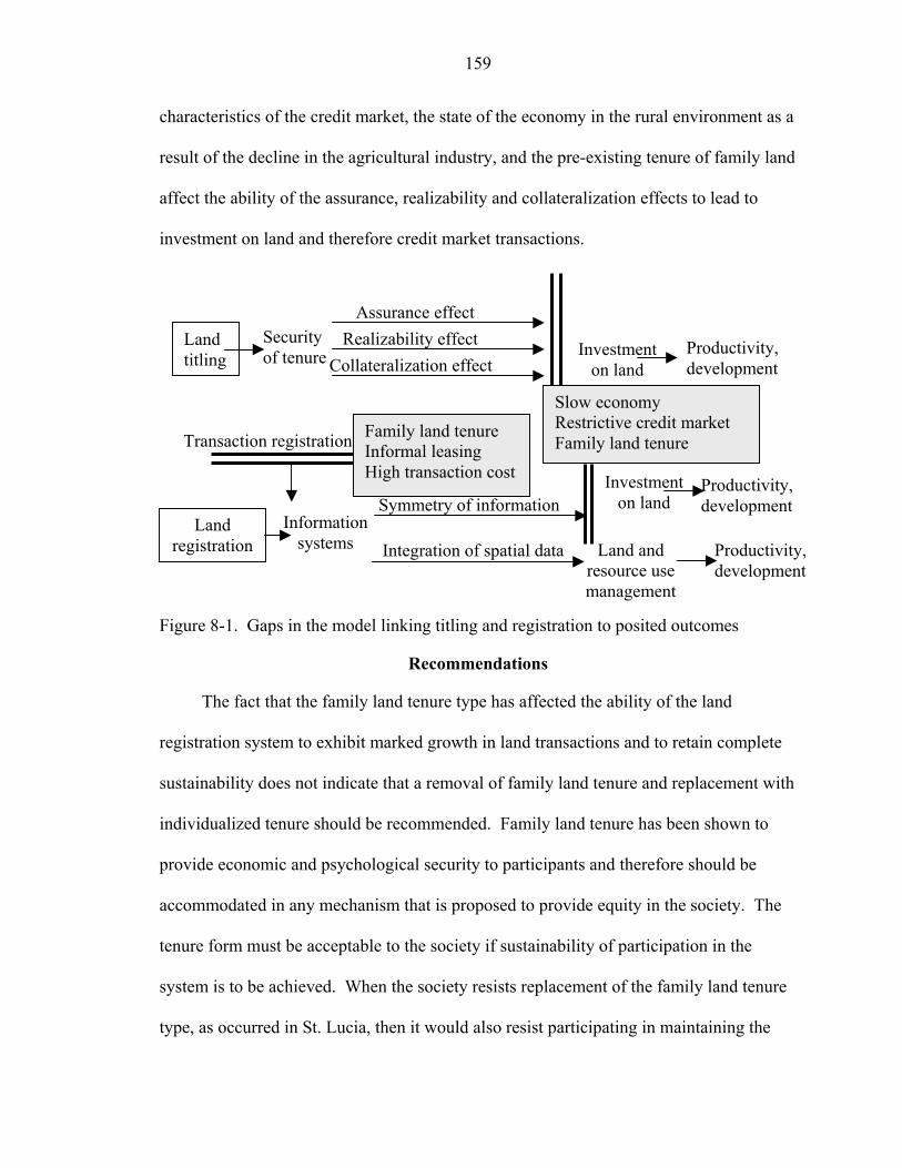
159
characteristics of the credit market, the state of the economy in the rural environment as a
result of the decline in the agricultural industry, and the pre-existing tenure of family land
affect the ability of the assurance, realizability and collateralization effects to lead to
investment on land and therefore credit market transactions.
Figure 8-1. Gaps in the model linking titling and registration to posited outcomes
Recommendations
The fact that the family land tenure type has affected the ability of the land
registration system to exhibit marked growth in land transactions and to retain complete
sustainability does not indicate that a removal of family land tenure and replacement with
individualized tenure should be recommended. Family land tenure has been shown to
provide economic and psychological security to participants and therefore should be
accommodated in any mechanism that is proposed to provide equity in the society. The
tenure form must be acceptable to the society if sustainability of participation in the
system is to be achieved. When the society resists replacement of the family land tenure
type, as occurred in St. Lucia, then it would also resist participating in maintaining the
Land titling
Land registration
Assurance effect Realizability effect
Collateralization effectInvestment
on land
Security of tenure Productivity,
development
Information systems
Symmetry of information
Land and resource use management
Investment on land
Productivity, development
Productivity, development
Transaction registration
Integration of spatial data
Slow economy Restrictive credit market Family land tenure
Family land tenure Informal leasing High transaction cost
160
system. Sustainability, therefore, would be an expensive proposal of re-survey and re-
title every few years. Growing urbanization increased the level of individualization in St.
Lucia and this effect is in keeping with the ETLR but contrary to the ETLR, the
communal tenure persists.
The effect of the family land tenure on the volume of transactions indicates that
prior to embarking on land titling and land title registration programs, land administrators
in developing countries should become aware of the status of the mitigating factors, such
as the tenure type, that influence the outcome of the program within the jurisdiction.
Knowledge of this status allows administrators to modify the expectations of the
outcomes and to channel the focus of the program to suit the required outcomes.
Knowledge of this status also allows land administrators to institute alternative and
additional supportive measures to allow the outcomes to be attained. In St. Lucia,
empirical information on the tenacity of the family land tenure could have been used to
redirect the program towards a goal of providing and supporting equity in land
distribution and access to land, instead of seeking the creation of a vibrant land market.
Then, an alternative process for recording and maintenance of records on rights holders
within family lands could have been instituted. Such a process would be based on
institutional support from the state, and participation from the communities and the
families within the communities.
Recording of rights in land is important for the administration of land and for
providing equity in a society. Expectations of minimal impact on the land market should
not deter governments from entering into titling and registration programs but should
allow them to plan the implementation to suit the more probable outcomes based on local
161
conditions. For example, a project aim of creating a free land market is inconsistent with
project aims of social equity or environmental sustainability. The ETLR goal of moving
land from the less productive to the more productive can result in a growing landless
group on one hand and overly exploited land resources on the other. Despite attempts to
integrate all three demands within one policy there must be an overriding concern that
would take priority in instances where dichotomous options are presented. The
overriding concern would depend on the particular environment that is the subject of the
development agenda.
The LRTP program aimed to individualize all land in St. Lucia, and there was a
sense of failure when this could not be done because of resource constraints, and the
difficulty of determining efficient mechanisms for so doing. The main benefit of the
program was in the adjudication process, which many of the respondents referred to by
stating that land problems were addressed. This was a significant benefit that served to
clarify rights and resolve longstanding conflicts. It also served to create an information
system that has potential applications, provided that it remains current, in many areas of
land and resource management.
Further Research
The results of this research point to a need for further research on land markets in
the Caribbean and other developing countries that would determine the feasibility of
maintaining differentiated markets that satisfy active market participants, and also satisfy
those unwilling to actively participate in the land market given the presence and the
tenacity of communal tenure.
Future research in sustainability of land registration systems should be directed
towards integrating systems for maintaining the land registry databases. Simple linkages
162
between different state institutions, for example between the Registrar of Births and
Deaths and the Land Registry, would allow information to be exchanged, primarily when
landowners die. The land registry records can be marked, by the Registrar, to denote that
a death, or some other action, has occurred that would impact the status of the land rights.
There would still be procedures that the administrator of the estate or the executor of the
estate would be required to perform, but the system would then contain more information
than it does at the moment in the form of an advisory to anyone accessing the system for
information.
Epilogue
The family land tenure type has proven to be resilient in the face of pressures from
urbanization and from implemented individualization programs. Family land as a
communal form of land holding should be promoted and encouraged especially in the
light of research that has demonstrated the benefits of this tenure form for equitable land
distribution and optimal land resource management. Also, while land registration
systems can assist in supporting the growth of a land market, other roles for land
registration systems, in supporting land management and land resource use management,
mandate that titling and registration programs continue to be carried out, albeit with a
different focus. Therefore, in the implementation of land titling and registration
programs, it is necessary to pay special attention to communal systems where they exist,
and to try to accommodate them as much as possible into the cadastral fabric.

APPENDIX A LAND REGISTRY MAP SHEETS: FIELD SURVEYED PARCELS
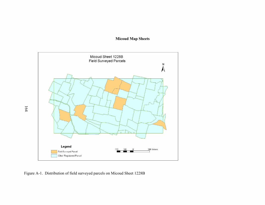
164
Micoud Map Sheets
Figure A-1. Distribution of field surveyed parcels on Micoud Sheet 1228B
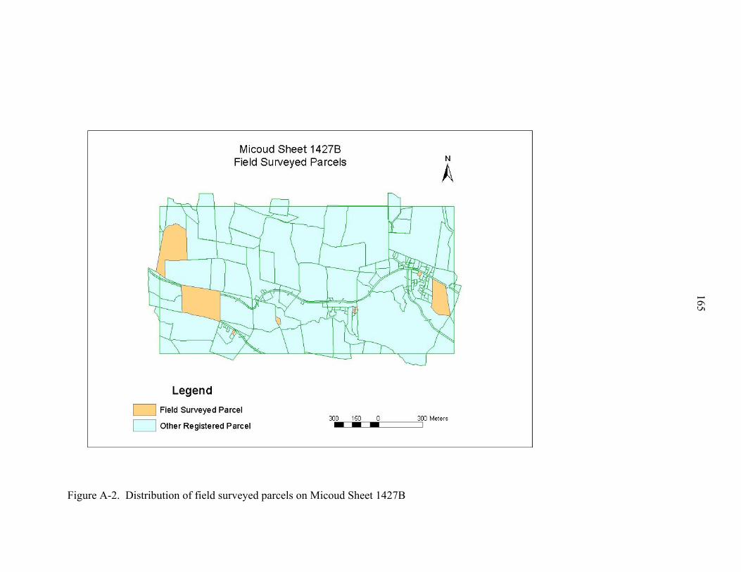
Figure A-2. Distribution of field surveyed parcels on Micoud Sheet 1427B
165

Figure A-3. Distribution of field surveyed parcels on Micoud Sheet 1428B
166
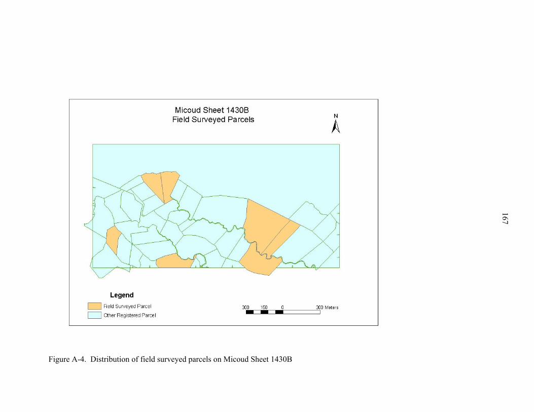
Figure A-4. Distribution of field surveyed parcels on Micoud Sheet 1430B
167
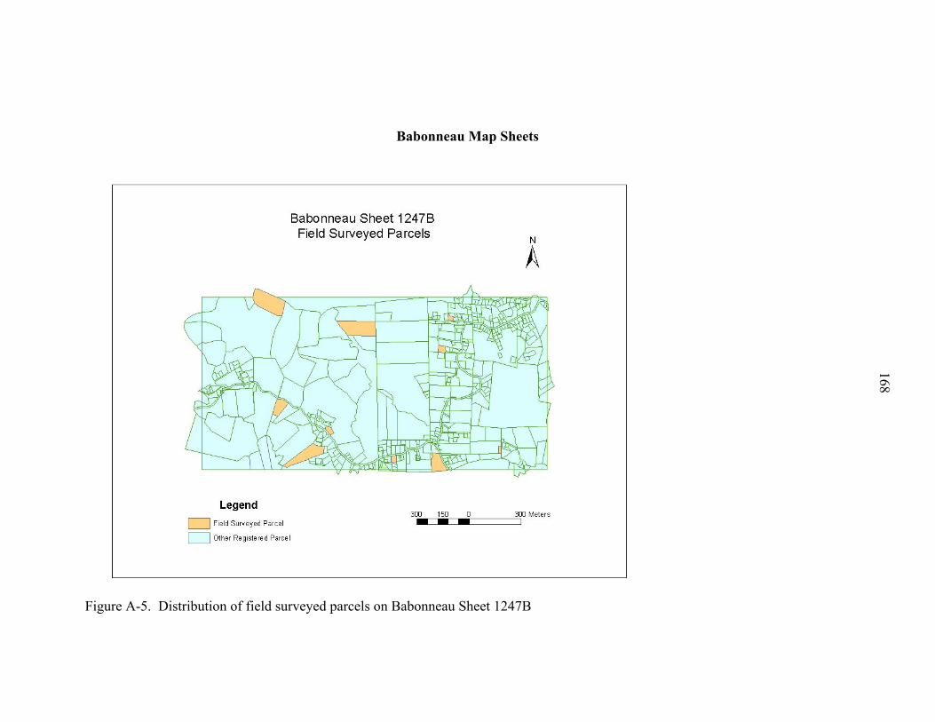
168
Babonneau Map Sheets
Figure A-5. Distribution of field surveyed parcels on Babonneau Sheet 1247B
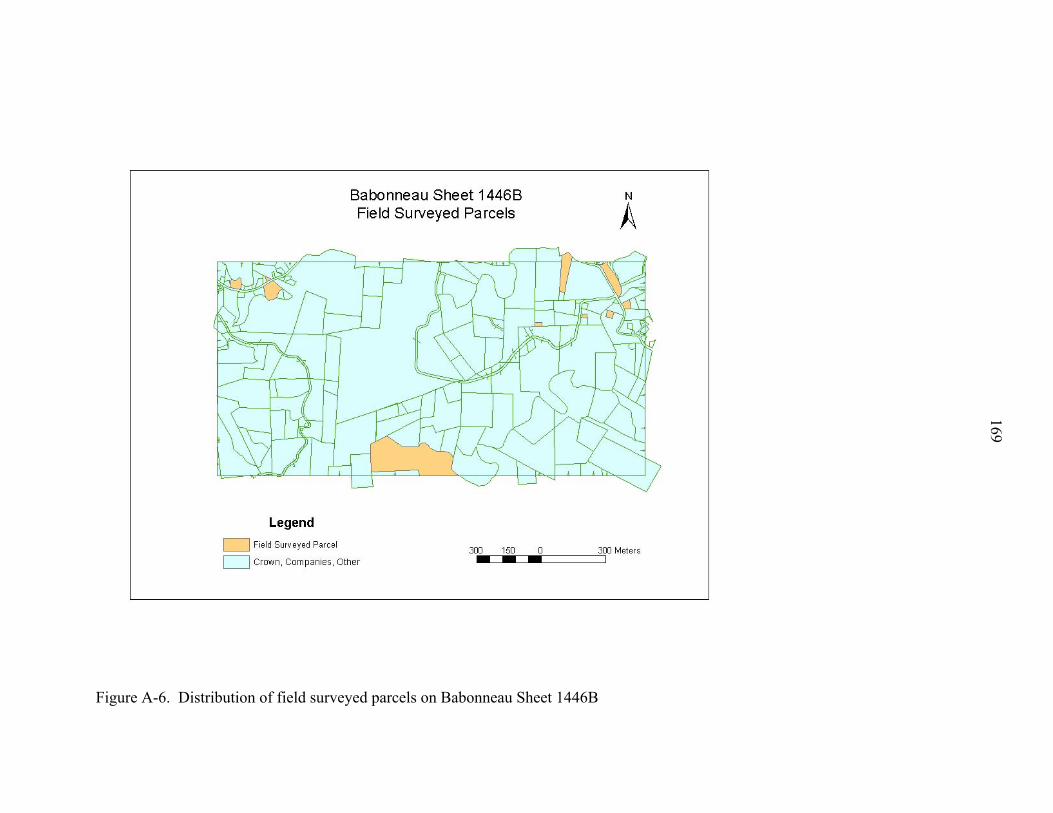
Figure A-6. Distribution of field surveyed parcels on Babonneau Sheet 1446B
169
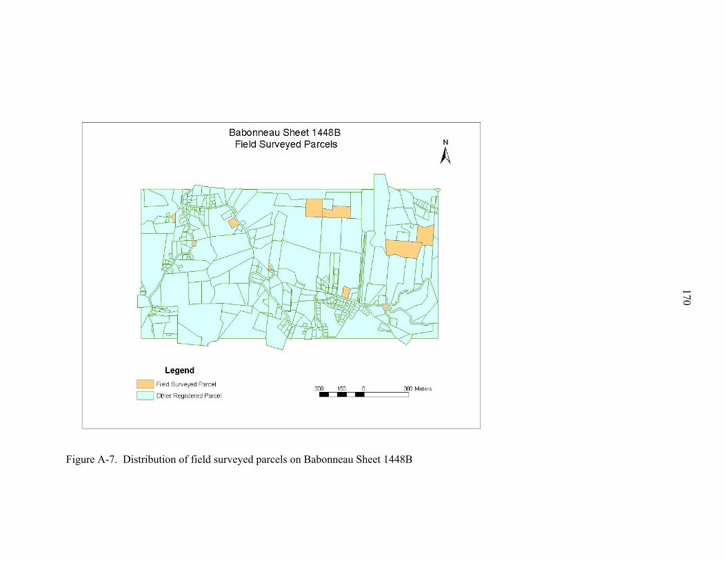
Figure A-7. Distribution of field surveyed parcels on Babonneau Sheet 1448B
170

APPENDIX B QUESTIONNAIRES USED IN THE RESEARCH
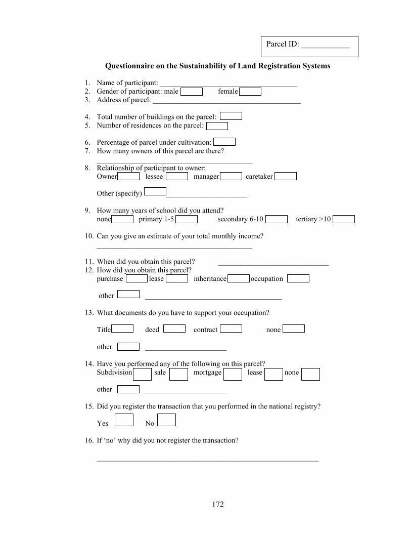
172
Questionnaire on the Sustainability of Land Registration Systems
1. Name of participant: _____________________________________ 2. Gender of participant: male female3. Address of parcel: ________________________________________
4. Total number of buildings on the parcel: 5. Number of residences on the parcel:
6. Percentage of parcel under cultivation: 7. How many owners of this parcel are there?
__________________________________________ 8. Relationship of participant to owner:
Owner e manager caretaker
Other (specify) ______________________
9. How many years of school did you attend? none primary 1-5 secondary 6-10 tertiary >10
10. Can you give an estimate of your total monthly income?
__________________________________________
11. When did you obtain this parcel? ______________________________ 12. How did you obtain this parcel?
purchase lease inheritance occupation other _____________________________________
13. What documents do you have to support your occupation?
deed contract none other ______________________
14. Have you performed any of the following on this parcel? Subdivision sale mortgage lease none other ______________________
15. Did you register the transaction that you performed in the national registry? Yes
16. If ‘no’ why did you not register the transaction? ____________________________________________________________
Parcel ID: ____________
No
Title
lessee
lesse
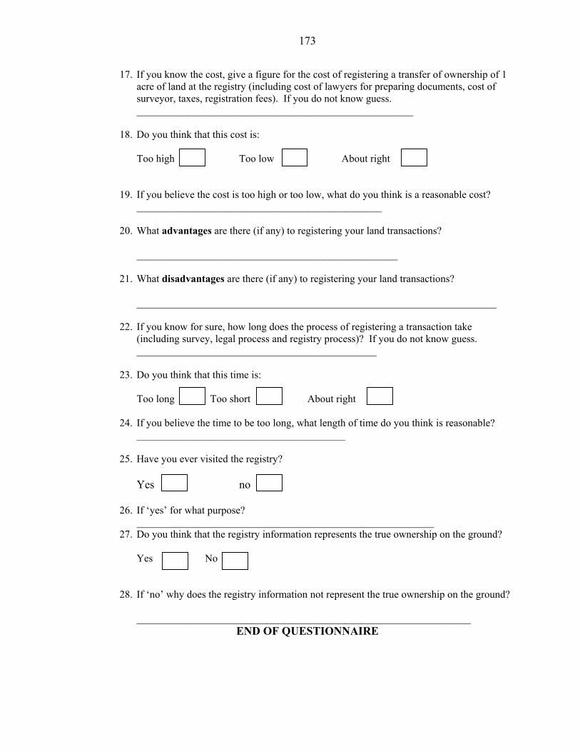
173
17. If you know the cost, give a figure for the cost of registering a transfer of ownership of 1 acre of land at the registry (including cost of lawyers for preparing documents, cost of surveyor, taxes, registration fees). If you do not know guess. _____________________________________________________
18. Do you think that this cost is:
Too high Too low About right
19. If you believe the cost is too high or too low, what do you think is a reasonable cost? _______________________________________________
20. What advantages are there (if any) to registering your land transactions?
__________________________________________________
21. What disadvantages are there (if any) to registering your land transactions? _____________________________________________________________________
22. If you know for sure, how long does the process of registering a transaction take (including survey, legal process and registry process)? If you do not know guess. ______________________________________________
23. Do you think that this time is: Too long Too short About right
24. If you believe the time to be too long, what length of time do you think is reasonable? ________________________________________
25. Have you ever visited the registry?
no
26. If ‘yes’ for what purpose?
_________________________________________________________ 27. Do you think that the registry information represents the true ownership on the ground?
Yes
28. If ‘no’ why does the registry information not represent the true ownership on the ground?
________________________________________________________________ END OF QUESTIONNAIRE
No
Yes
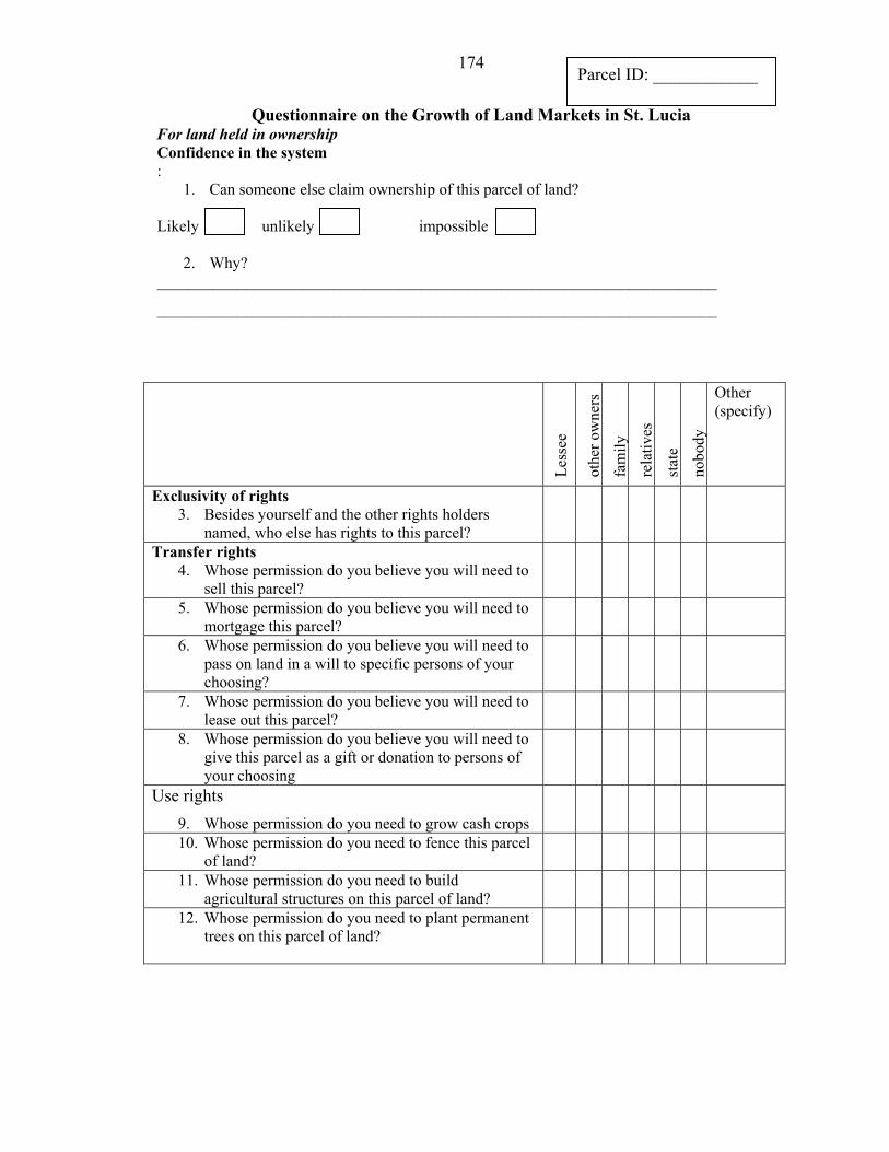
174
Questionnaire on the Growth of Land Markets in St. Lucia For land held in ownership Confidence in the system :
1. Can someone else claim ownership of this parcel of land?
unlikel impossible
2. Why? ______________________________________________________________________
______________________________________________________________________
Less
ee
othe
r ow
ners
fa
mil
Likely y
y re
lativ
es
stat
e no
bod y
Other (specify)
Exclusivity of rights 3. Besides yourself and the other rights holders
named, who else has rights to this parcel?
Transfer rights 4. Whose permission do you believe you will need to
sell this parcel?
5. Whose permission do you believe you will need to mortgage this parcel?
6. Whose permission do you believe you will need to pass on land in a will to specific persons of your choosing?
7. Whose permission do you believe you will need to lease out this parcel?
8. Whose permission do you believe you will need to give this parcel as a gift or donation to persons of your choosing
Use rights 9. Whose permission do you need to grow cash crops
10. Whose permission do you need to fence this parcel of land?
11. Whose permission do you need to build agricultural structures on this parcel of land?
12. Whose permission do you need to plant permanent trees on this parcel of land?
Parcel ID: ____________
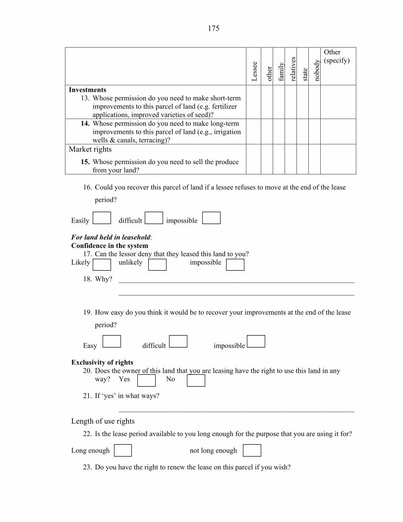
175
Less
ee
othe
r fa
mil y
re
lativ
es
stat
e no
bod y
Other (specify)
Investments 13. Whose permission do you need to make short-term
improvements to this parcel of land (e.g. fertilizer applications, improved varieties of seed)?
14. Whose permission do you need to make long-term improvements to this parcel of land (e.g., irrigation wells & canals, terracing)?
Market rights 15. Whose permission do you need to sell the produce
from your land?
16. Could you recover this parcel of land if a lessee refuses to move at the end of the lease
period?
difficult mpossible
For land held in leasehold: Confidence in the system
17. Can the lessor deny that they leased this land to you? unlikel impossible
18. Why? _________________________________________________________________
_________________________________________________________________
19. How easy do you think it would be to recover your improvements at the end of the lease
period?
difficult impossible
Exclusivity of rights
20. Does the owner of this land that you are leasing have the right to use this land in any way? Yes No
21. If ‘yes’ in what ways?
_________________________________________________________________
Length of use rights 22. Is the lease period available to you long enough for the purpose that you are using it for?
Long enough not long enough
23. Do you have the right to renew the lease on this parcel if you wish?
Easy
y Likely
iEasily
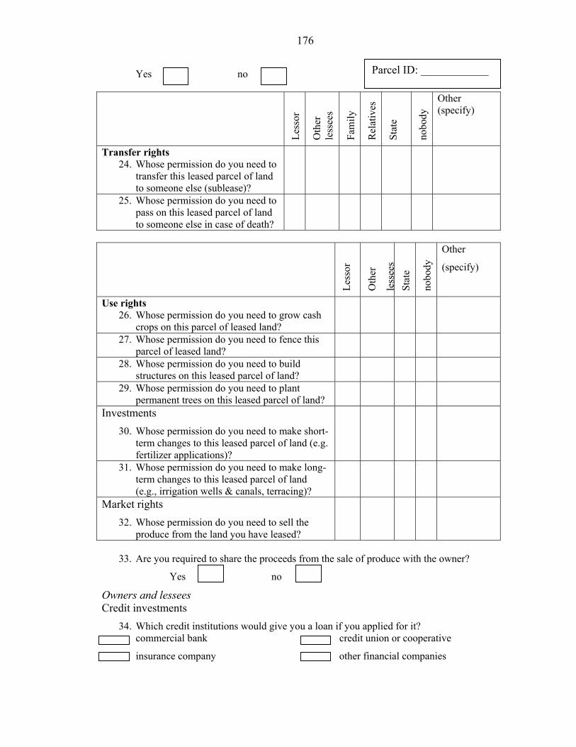
176
Y n
Less
or
Oth
er
less
ees
Fam
ily
Rel
ativ
es
Stat
e
nobo
dy
Other (specify)
Parcel ID: ____________
Transfer rights 24. Whose permission do you need to
transfer this leased parcel of land to someone else (sublease)?
25. Whose permission do you need to pass on this leased parcel of land to someone else in case of death?
Less
or
Oth
er
less
ees
Stat
e
nobo
dy
Other
(specify)
Use rights 26. Whose permission do you need to grow cash
crops on this parcel of leased land?
27. Whose permission do you need to fence this parcel of leased land?
28. Whose permission do you need to build structures on this leased parcel of land?
29. Whose permission do you need to plant permanent trees on this leased parcel of land?
Investments 30. Whose permission do you need to make short-
term changes to this leased parcel of land (e.g. fertilizer applications)?
31. Whose permission do you need to make long-term changes to this leased parcel of land (e.g., irrigation wells & canals, terracing)?
Market rights 32. Whose permission do you need to sell the
produce from the land you have leased?
33. Are you required to share the proceeds from the sale of produce with the owner?
Ye n
Owners and lessees Credit investments
34. Which credit institutions would give you a loan if you applied for it? commercial bank union or cooperative
insurance company financial companies other
credit
o s
o es
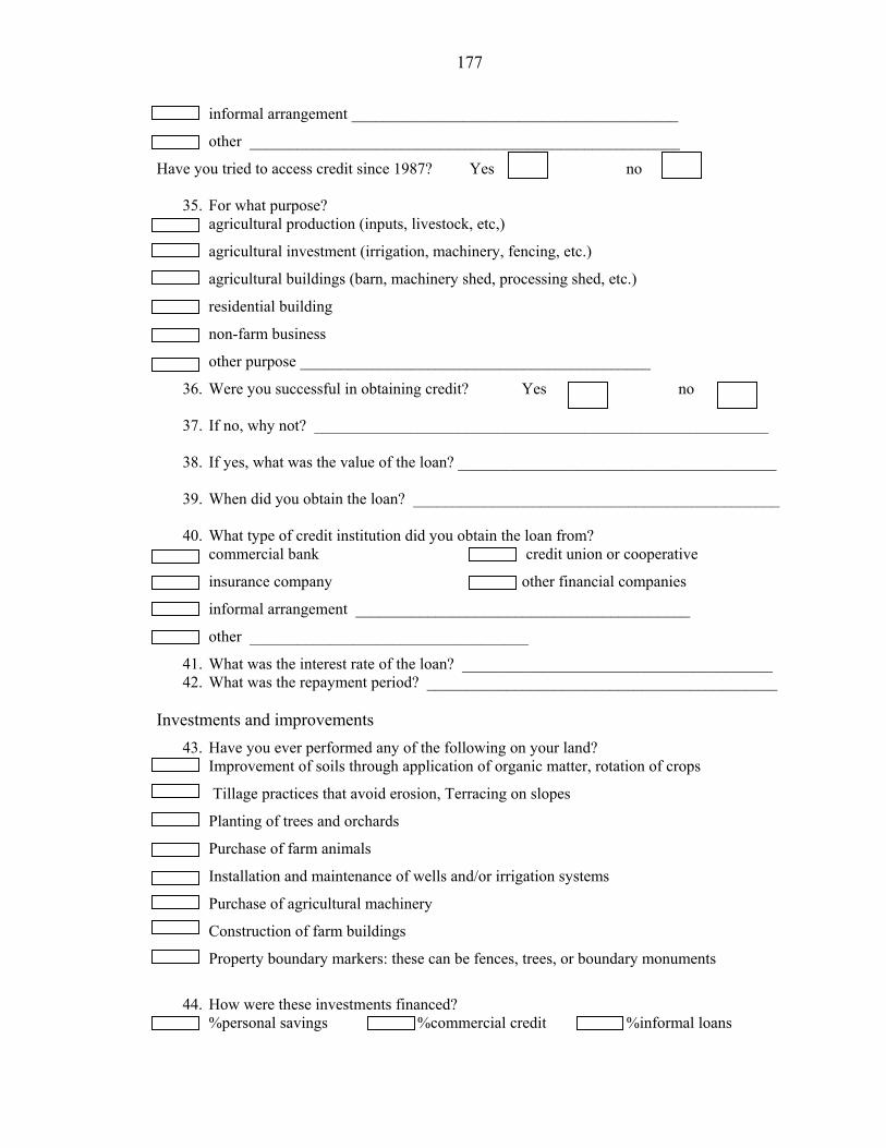
177
informal arrangement _________________________________________
other ______________________________________________________
Have you tried to access credit since 1987? Yes no
35. For what purpose? agricultural production (inputs, livestock, etc,)
agricultural investment (irrigation, machinery, fencing, etc.)
agricultural buildings (barn, machinery shed, processing shed, etc.)
residential building
non-farm business
other purpose ____________________________________________
36. Were you successful in obtaining credit? Yes no
37. If no, why not? _________________________________________________________
38. If yes, what was the value of the loan? ________________________________________
39. When did you obtain the loan? ______________________________________________
40. What type of credit institution did you obtain the loan from? commercial bank credit union or cooperative
insurance company financial companies
informal arrangement __________________________________________
other ___________________________________
41. What was the interest rate of the loan? _______________________________________ 42. What was the repayment period? ____________________________________________
Investments and improvements
43. Have you ever performed any of the following on your land? Improvement of soils through application of organic matter, rotation of crops
Tillage practices that avoid erosion, Terracing on slopes
Planting of trees and orchards
Purchase of farm animals
Installation and maintenance of wells and/or irrigation systems
Purchase of agricultural machinery
Construction of farm buildings
Property boundary markers: these can be fences, trees, or boundary monuments
44. How were these investments financed?
%personal savings %commercial credit %informal loans
other
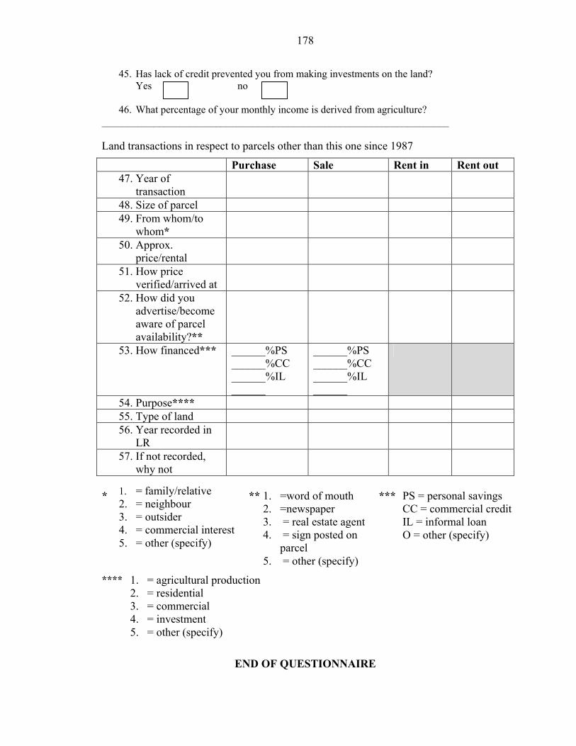
178
45. Has lack of credit prevented you from making investments on the land? Y n
46. What percentage of your monthly income is derived from agriculture? ___________________________________________________________________ Land transactions in respect to parcels other than this one since 1987
Purchase Sale Rent in Rent out 47. Year of
transaction
48. Size of parcel 49. From whom/to
whom*
50. Approx. price/rental
51. How price verified/arrived at
52. How did you advertise/become aware of parcel availability?**
53. How financed*** ______%PS ______%CC ______%IL ______
______%PS ______%CC ______%IL ______
54. Purpose**** 55. Type of land 56. Year recorded in
LR
57. If not recorded, why not
* ** *** ****
END OF QUESTIONNAIRE
1. = family/relative 2. = neighbour 3. = outsider 4. = commercial interest5. = other (specify)
PS = personal savings CC = commercial creditIL = informal loan O = other (specify)
1. = agricultural production 2. = residential 3. = commercial 4. = investment 5. = other (specify)
1. =word of mouth 2. =newspaper 3. = real estate agent 4. = sign posted on
parcel 5. = other (specify)
o es

APPENDIX C DISTRIBUTION OF TENURE TYPES IN STUDY AREAS
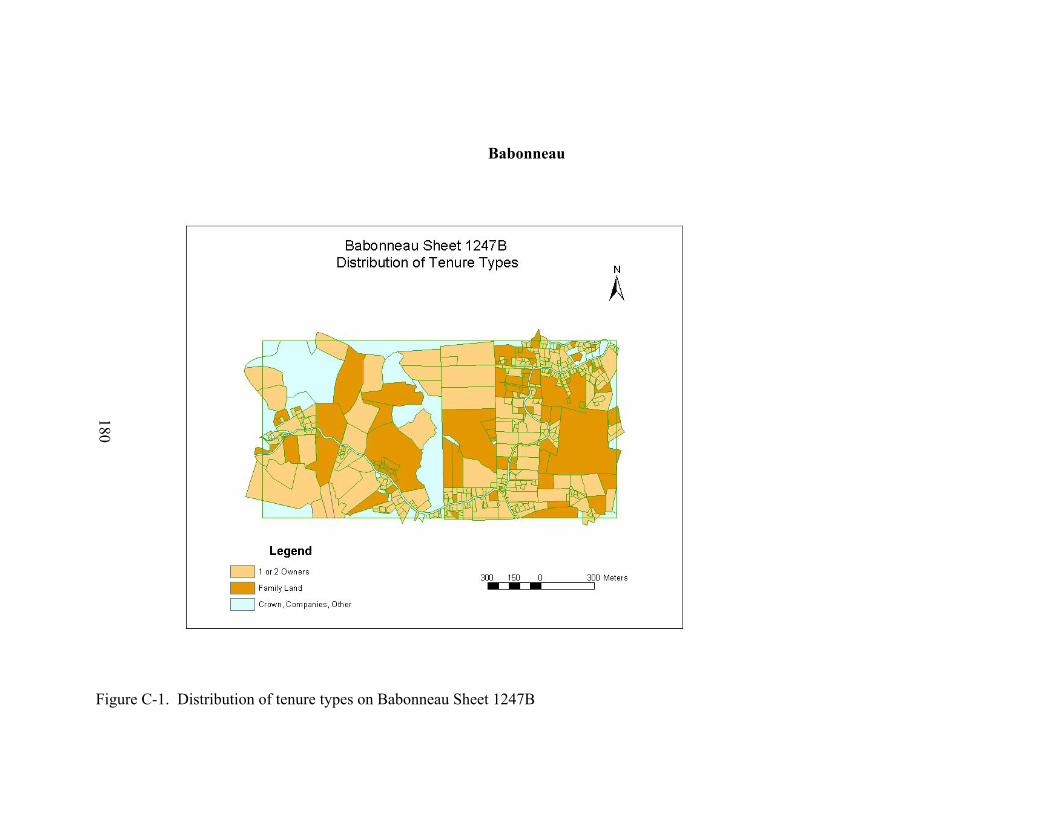
180
Babonneau
Figure C-1. Distribution of tenure types on Babonneau Sheet 1247B
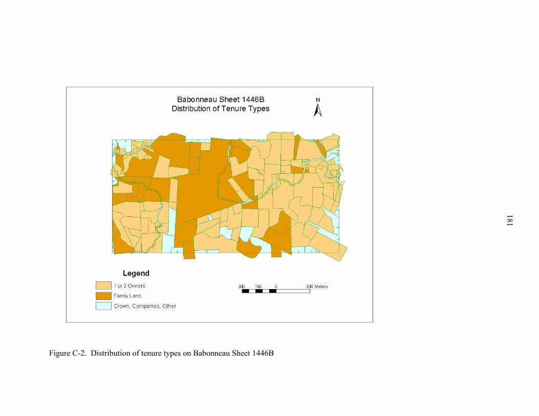
Figure C-2. Distribution of tenure types on Babonneau Sheet 1446B
181
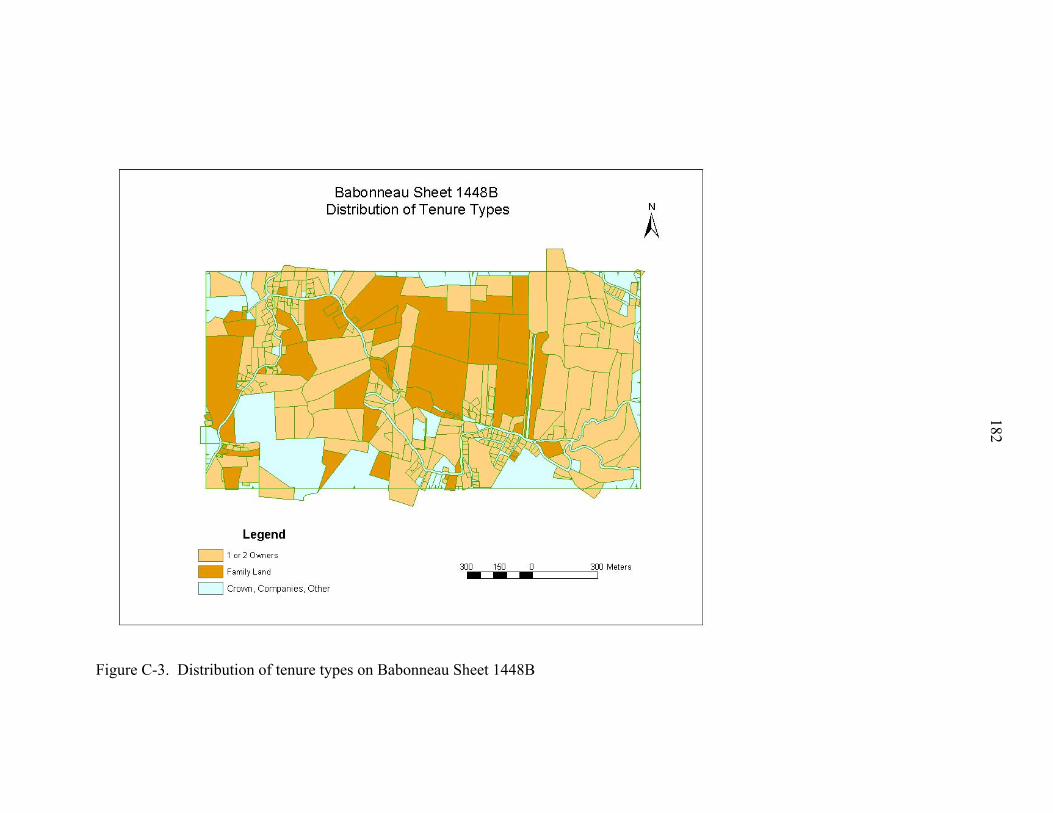
Figure C-3. Distribution of tenure types on Babonneau Sheet 1448B
182
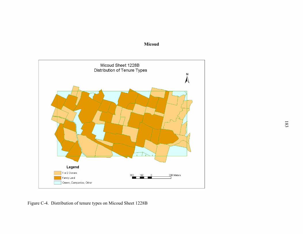
183
Micoud
Figure C-4. Distribution of tenure types on Micoud Sheet 1228B
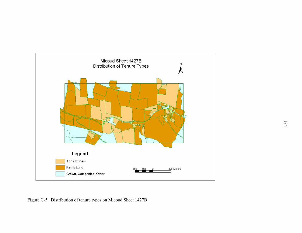
Figure C-5. Distribution of tenure types on Micoud Sheet 1427B
184

Figure C-6. Distribution of tenure types on Micoud Sheet 1428B
185
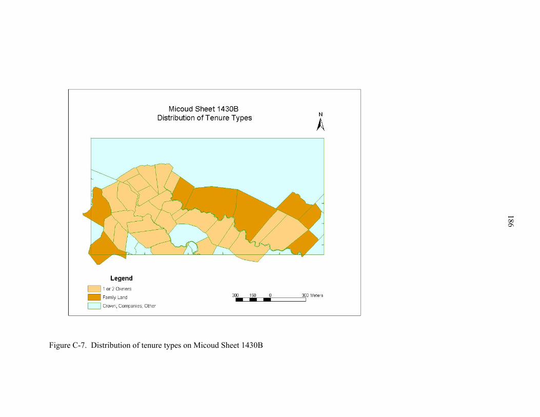
Figure C-7. Distribution of tenure types on Micoud Sheet 1430B
186

APPENDIX D DISTRIBUTION OF SALES BY TENURE TYPE IN STUDY AREAS
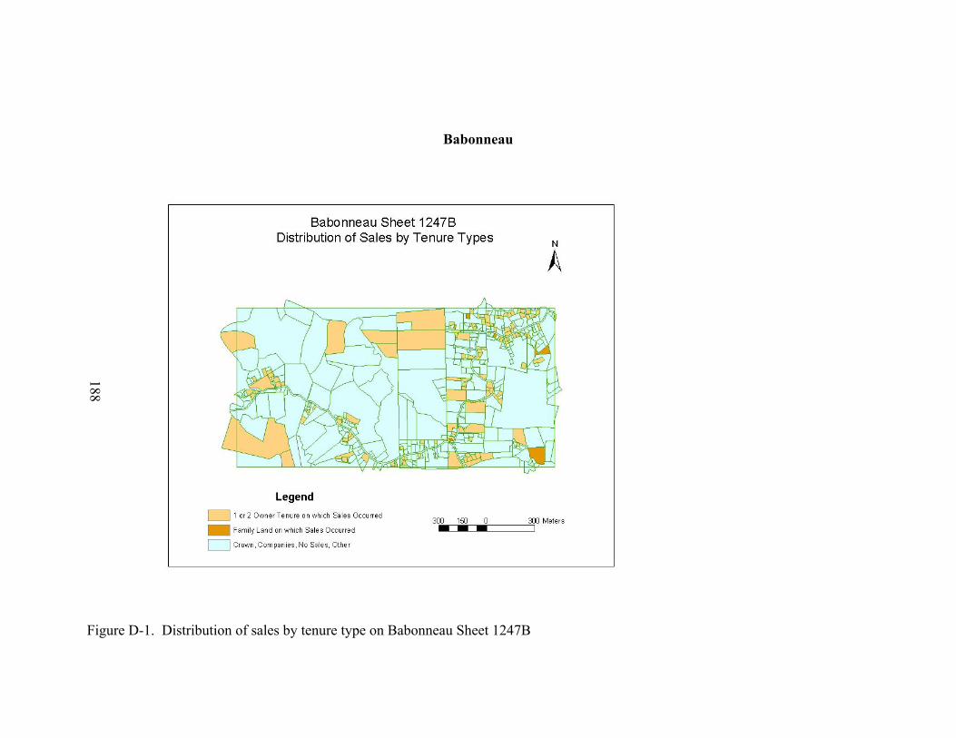
188
Babonneau
Figure D-1. Distribution of sales by tenure type on Babonneau Sheet 1247B

Figure D-2. Distribution of sales by tenure type on Babonneau Sheet 1446B
189
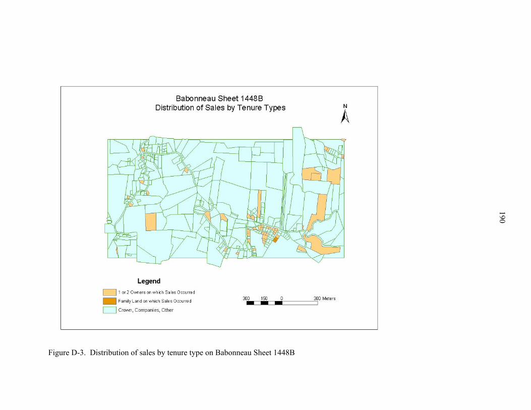
Figure D-3. Distribution of sales by tenure type on Babonneau Sheet 1448B
190
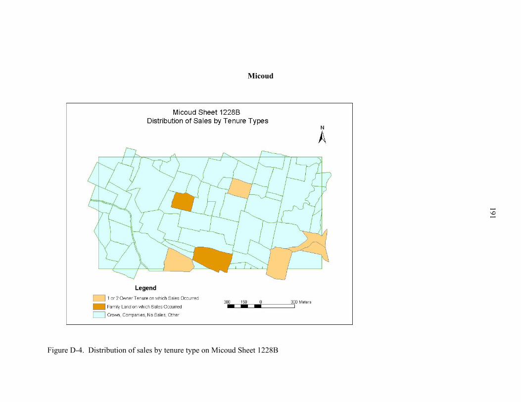
191
Micoud
Figure D-4. Distribution of sales by tenure type on Micoud Sheet 1228B

Figure D-5. Distribution of sales by tenure type on Micoud Sheet 1427B
192
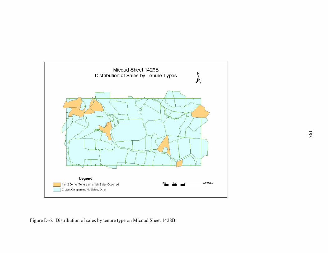
Figure D-6. Distribution of sales by tenure type on Micoud Sheet 1428B
193
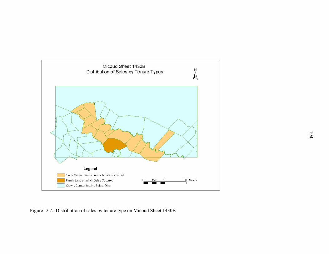
Figure D-7. Distribution of sales by tenure type on Micoud Sheet 1430B
194
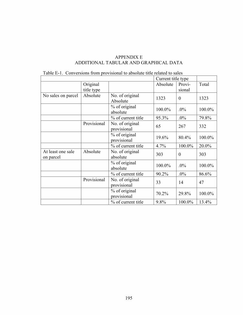
APPENDIX E ADDITIONAL TABULAR AND GRAPHICAL DATA
Table E-1. Conversions from provisional to absolute title related to sales Current title type Original
title type Absolute Provi-
sional Total
No sales on parcel Absolute No. of original Absolute 1323 0 1323
% of original absolute 100.0% .0% 100.0%
% of current title 95.3% .0% 79.8% Provisional No. of original
provisional 65 267 332
% of original provisional 19.6% 80.4% 100.0%
% of current title 4.7% 100.0% 20.0% At least one sale on parcel
Absolute No. of original absolute 303 0 303
% of original absolute 100.0% .0% 100.0%
% of current title 90.2% .0% 86.6% Provisional No. of original
provisional 33 14 47
% of original provisional 70.2% 29.8% 100.0%
% of current title 9.8% 100.0% 13.4%
195
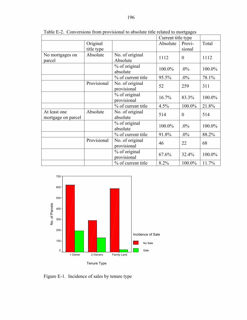
196
Table E-2. Conversions from provisional to absolute title related to mortgages Current title type Original
title type Absolute Provi-
sional Total
No mortgages on parcel
Absolute No. of original Absolute 1112 0 1112
% of original absolute 100.0% .0% 100.0%
% of current title 95.5% .0% 78.1% Provisional No. of original
provisional 52 259 311
% of original provisional 16.7% 83.3% 100.0%
% of current title 4.5% 100.0% 21.8% At least one mortgage on parcel
Absolute No. of original absolute 514 0 514
% of original absolute 100.0% .0% 100.0%
% of current title 91.8% .0% 88.2% Provisional No. of original
provisional 46 22 68
% of original provisional 67.6% 32.4% 100.0%
% of current title 8.2% 100.0% 11.7%
Tenure Type
Family Land 2 Owners 1 Owner
No.
of P
arce
ls
700
600
500
400
300
200
100
0
Incidence of Sale
No Sale
Sale
Figure E-1. Incidence of sales by tenure type
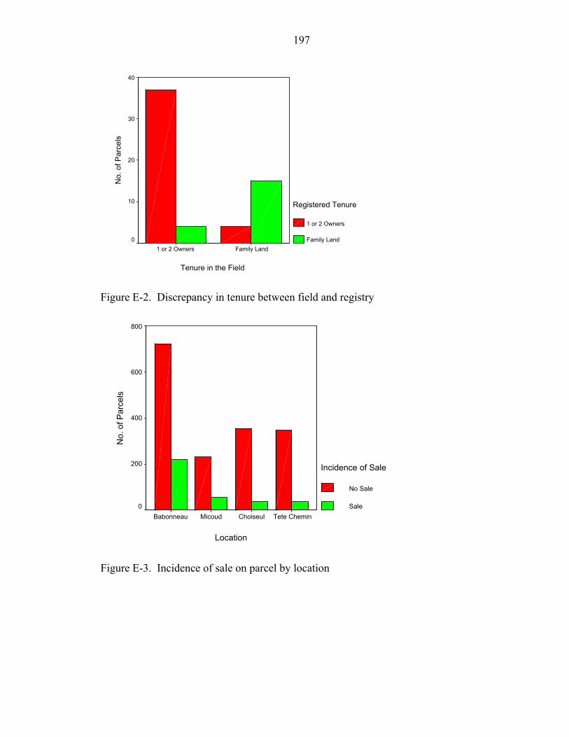
197
Tenure in the Field
Family Land1 or 2 Owners
No.
of P
arce
ls
40
30
20
10
0
Registered Tenure
1 or 2 Owners
Family Land
Figure E-2. Discrepancy in tenure between field and registry
Location
Tete CheminChoiseulMicoudBabonneau
No.
of P
arce
ls
800
600
400
200
0
Incidence of Sale
No Sale
Sale
Figure E-3. Incidence of sale on parcel by location
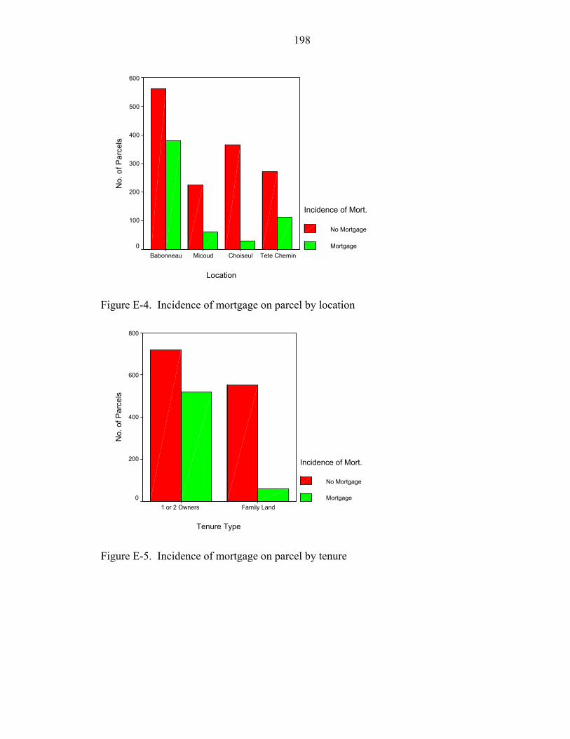
198
Location
Tete CheminChoiseulMicoudBabonneau
No.
of P
arce
ls
600
500
400
300
200
100
0
Incidence of Mort.
No Mortgage
Mortgage
Figure E-4. Incidence of mortgage on parcel by location
Tenure Type
Family Land1 or 2 Owners
No.
of P
arce
ls
800
600
400
200
0
Incidence of Mort.
No Mortgage
Mortgage
Figure E-5. Incidence of mortgage on parcel by tenure
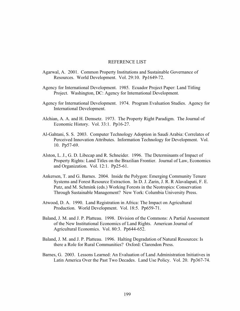
REFERENCE LIST
Agarwal, A. 2001. Common Property Institutions and Sustainable Governance of Resources. World Development. Vol. 29:10. Pp1649-72.
Agency for International Development. 1985. Ecuador Project Paper: Land Titling Project. Washington, DC: Agency for International Development.
Agency for International Development. 1974. Program Evaluation Studies. Agency for International Development.
Alchian, A. A. and H. Demsetz. 1973. The Property Right Paradigm. The Journal of Economic History. Vol. 33:1. Pp16-27.
Al-Gahtani, S. S. 2003. Computer Technology Adoption in Saudi Arabia: Correlates of Perceived Innovation Attributes. Information Technology for Development. Vol. 10. Pp57-69.
Alston, L. J., G. D. Libecap and R. Schneider. 1996. The Determinants of Impact of Property Rights: Land Titles on the Brazilian Frontier. Journal of Law, Economics and Organization. Vol. 12:1. Pp25-61.
Ankersen, T. and G. Barnes. 2004. Inside the Polygon: Emerging Community Tenure Systems and Forest Resource Extraction. In D. J. Zarin, J. R. R Alavalapati, F. E. Putz, and M. Schmink (eds.) Working Forests in the Neotropics: Conservation Through Sustainable Management? New York: Columbia University Press.
Atwood, D. A. 1990. Land Registration in Africa: The Impact on Agricultural Production. World Development. Vol. 18:5. Pp659-71.
Baland, J. M. and J. P. Platteau. 1998. Division of the Commons: A Partial Assessment of the New Institutional Economics of Land Rights. American Journal of Agricultural Economics. Vol. 80:3. Pp644-652.
Baland, J. M. and J. P. Platteau. 1996. Halting Degradation of Natural Resources: Is there a Role for Rural Communities? Oxford: Clarendon Press.
Barnes, G. 2003. Lessons Learned: An Evaluation of Land Administration Initiatives in Latin America Over the Past Two Decades. Land Use Policy. Vol. 20. Pp367-74.
199
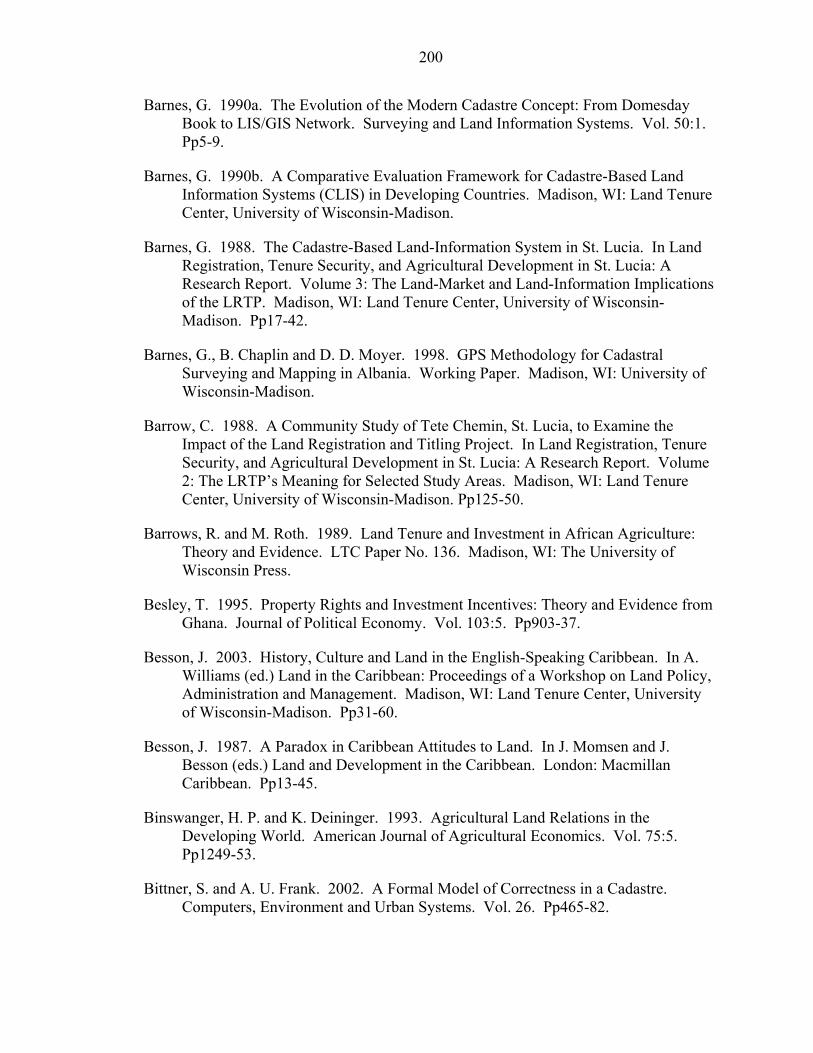
200
Barnes, G. 1990a. The Evolution of the Modern Cadastre Concept: From Domesday Book to LIS/GIS Network. Surveying and Land Information Systems. Vol. 50:1. Pp5-9.
Barnes, G. 1990b. A Comparative Evaluation Framework for Cadastre-Based Land Information Systems (CLIS) in Developing Countries. Madison, WI: Land Tenure Center, University of Wisconsin-Madison.
Barnes, G. 1988. The Cadastre-Based Land-Information System in St. Lucia. In Land Registration, Tenure Security, and Agricultural Development in St. Lucia: A Research Report. Volume 3: The Land-Market and Land-Information Implications of the LRTP. Madison, WI: Land Tenure Center, University of Wisconsin-Madison. Pp17-42.
Barnes, G., B. Chaplin and D. D. Moyer. 1998. GPS Methodology for Cadastral Surveying and Mapping in Albania. Working Paper. Madison, WI: University of Wisconsin-Madison.
Barrow, C. 1988. A Community Study of Tete Chemin, St. Lucia, to Examine the Impact of the Land Registration and Titling Project. In Land Registration, Tenure Security, and Agricultural Development in St. Lucia: A Research Report. Volume 2: The LRTP’s Meaning for Selected Study Areas. Madison, WI: Land Tenure Center, University of Wisconsin-Madison. Pp125-50.
Barrows, R. and M. Roth. 1989. Land Tenure and Investment in African Agriculture: Theory and Evidence. LTC Paper No. 136. Madison, WI: The University of Wisconsin Press.
Besley, T. 1995. Property Rights and Investment Incentives: Theory and Evidence from Ghana. Journal of Political Economy. Vol. 103:5. Pp903-37.
Besson, J. 2003. History, Culture and Land in the English-Speaking Caribbean. In A. Williams (ed.) Land in the Caribbean: Proceedings of a Workshop on Land Policy, Administration and Management. Madison, WI: Land Tenure Center, University of Wisconsin-Madison. Pp31-60.
Besson, J. 1987. A Paradox in Caribbean Attitudes to Land. In J. Momsen and J. Besson (eds.) Land and Development in the Caribbean. London: Macmillan Caribbean. Pp13-45.
Binswanger, H. P. and K. Deininger. 1993. Agricultural Land Relations in the Developing World. American Journal of Agricultural Economics. Vol. 75:5. Pp1249-53.
Bittner, S. and A. U. Frank. 2002. A Formal Model of Correctness in a Cadastre. Computers, Environment and Urban Systems. Vol. 26. Pp465-82.
201
Central Statistical Office of St. Lucia. http://www.stats.gov.lc/main5.htm. Accessed June 2004.
Bittner, S., A. von Wolff and A. Frank. 2000. The Structure of Reality in a Cadaster. In Proceedings of 23rd International Wittgenstein Symposium. Pp88-96.
Bloch, P. 2003. Economic Impact of Land Policy in the English Speaking Caribbean. In A. Williams (ed.) Land in the Caribbean: Issues of Policy, Administration and Management in the English Speaking Caribbean. Madison, WI: Land Tenure Center, University of Wisconsin-Madison. Pp 13-30.
Bloch, P. 2000. Potential for Rural Property Markets. In H. Lemel (ed.) Rural Property and Economy in Post-Communist Albania. New York: Berghahn Books. Pp75-91.
Brasselle, A-S., F. Gaspart and J-P. Platteau. 2002. Land Tenure Security and Investment Incentives: Puzzling Evidence from Burkino Faso. Journal of Development Economics. Vol. 67. Pp373-418.
Bruce, J. W. 1998. Review of Tenure Terminology. Tenure Brief. No. 1. Madison, WI: Land Tenure Center, University of Wisconsin-Madison.
Bruce, J. W. 1986. Land Tenure Issues in Project Design and Strategies for Agricultural Development in Sub-Saharan Africa. LTC Paper No. 128. Madison, WI: Land Tenure Center, University of Wisconsin-Madison.
Bruce, J. W. 1983. Family Land Tenure and Agricultural Development in St. Lucia. LTC Research Paper. No. 79. Madison, WI: Land Tenure Center, University of Wisconsin-Madison.
Burns, T., C. Grant, A. Brits and K. Nettle. 2003. Preliminary Report – Comparative Study of Land Administration Systems: Critical Issues and Future Challenges. Land Equity International. www.landequity.com.au/pdfs/Global-synth-document.pdf Accessed June 2004.
Carter, M. and P. Olinto. 1996. Getting Institutions Right for Whom? The Wealth differentiated Impacts of Land Titling on Agricultural Investment and Productivity in Paraguay. Working Paper. Madison, WI: Land Tenure Center, University of Wisconsin-Madison.
Chan, T. O. and I. P. Williamson. 1999. The Different Identities of GIS and GIS Diffusion. International Journal of Geographical Information Science. Vol. 13:3. Pp267-81.
Crichlow, M. 1988. Choiseul: A Study of Land Tenure in an Area of Intensive Agriculture. In Land Registration, Tenure Security, and Agricultural Development in St. Lucia. Volume 2: The LRTP’s Meaning for Selected Study Areas. Madison, WI: Land Tenure Center, University of Wisconsin-Madison. Pp85-124.
Central Statistical Office (CSO). 2003. National Accounts: Economic Indicators.
202
Dale, P. F. 1976. Cadastral Surveys Within the Commonwealth. London: HMSO.
Dale, P. and J. McLaughlin. 1999. Land Administration. Oxford: Oxford University Press.
Dale, P. and J. McLaughlin. 1988. Land Information Management An Introduction with Special Reference to Cadastral Problems in Third World Countries. Oxford: Clarendon Press.
Deininger, K. and H. Binswanger. 1999. The Evolution of the World Bank’s Land Policy: Principles, Experience, and Future Challenges. World Bank Research Observer. Vol. 14:2. Pp247-76.
Deininger, K., E. Zegarra and I. Lavadenz. 2003. Determinants and Impacts of Rural Land Market Activity: Evidence from Nicaragua. World Development. Vol. 31:8. Pp1385-404.
Demsetz, H. 1967. Toward a Theory of Property Rights. The American Economic Review. Vol. 57:2. Pp347-59.
De Soto, H. 2000. The Mystery of Capital. London: Bantam Press/Random House.
De Soto, H. 1989. The Other Path. New York: Harper and Row.
Deterville, H. 1988. Saint Lucia Land Registration Act 1984: An Examination of New Registration Procedures. In Land Registration, Tenure Security, and Agricultural Development in St. Lucia: A Research Report. Volume 1: Overview of Land Tenure Patterns and Effects of the Land Registration and Titling Project. Madison, WI: Land Tenure Center, University of Wisconsin-Madison. Pp49-76.
De Zeeuw, F. 1997. Borrowing of Land: Security of Tenure and Sustainable Land Use in Burkina Faso. Development and Change 28:3. Pp583-95.
Dickerman, C. 1988. Urban Land Tenure Patterns and Issues. In Land Registration, Tenure Security, and Agricultural Development in St. Lucia. Volume 2: The LRTP’s Meaning for Selected Study Areas. Wisconsin-Madison: Land Tenure Center, University of Wisconsin-Madison. Pp151-64.
Dowson, E. and V. L. O. Sheppard. 1968. Land Registration. London: HMSO.
Dujon, V. 1997. Communal Property and Land Markets: Agricultural Development Policy in St. Lucia. World Development. Vol. 25:9. Pp1529-40.
Dujon, V. 1995. National Actors Against World Market Pressures: Communal Land, Privatization and Agricultural Development in the Caribbean. PhD Dissertation. Madison, WI: University of Wisconsin-Madison.
203
Feder, G., and A. Nishio. 1999. The Benefits of Land Registration and Titling: Economic and Social Perspectives. Land Use Policy. Vol. 15:1. Pp25-43.
Feder, G. and T. Onchan. 1987. Land Ownership Security and Farm Investment in Thailand. American Journal of Agricultural Economics. May 1987. Pp311-20.
Feder, G., T. Onchan, Y. Chalamwong and C. Hongladaron. 1988. Land Policies and Farm Productivity in Thailand. Baltimore, MD: The Johns Hopkins University Press.
Feeny, D. 1988. The Development of Property Rights in Land: A Comparative Study. In R. Bates. (ed.) Toward a Political Economy of Development. Pp272-99. Berkeley and Los Angeles, CA; London: University of California Press.
Fernandes, E. 2002. The Influence of de Soto’s The Mystery of Capital. Land Lines. Vol. 14:1. Pp5-8.
Fédération Internationale des Géomètres. 1995. FIG Statement on the Cadastre. International Federation of Surveyors. http://www.fig7.org.uk/publications/cadastre/statement_on_cadastre.html Accessed June 2004.
Finley, D., K. Siderelis, D. Grant and A. Bregt. 2000. Four Cases. In R. Groot and J. McLaughlin (eds.) Geospatial Data Infrastructure: Concepts, Cases and Good Practice. Oxford: Oxford University Press. Pp245-68.
Fourie, C. and H. van Gysen. 1995. Constructing Cadastral Reform Theory in South Africa. Geomatica. 49:3. Pp315-28.
Frank, A. G. 1969. The Development of Underdevelopment. In J. T. Roberts and A. Hite (eds.) From Modernization to Globalization. Perspectives on Development and Social Change. Malden, MA: Blackwell. Pp160-8.
Freyfogle, E. T. 2002. The Tragedy of Fragmentation. Valparaiso Law Review. Vol. 36:2. Pp307-37.
Furubotn, E. and S. Pejovich. 1972. Property Rights and Economic Theory: A Survey of Recent Literature. Journal of Economic Literature. Vol. 10:4. Pp1137-62.
Gavian, S., and M. Fafchamps. 1996. Land Tenure and Allocative Efficiency in Niger. American Journal of Agricultural Economics. 78. Pp460-71.
Gilbert, A. 2002. On the Mystery of Capital and the Myths of Hernando De Soto: What Difference Does Legal Title Make? Journal of Planning Literature. 17:2. Pp262-331.
204
Honduras. Development and Change. Vol. 29:1. Pp81-106.
Gomes, P. I. 1988. Rural Castries Community Study: Land Tenure in an Urban Periphery. In Land Registration, Tenure Security, and Agricultural Development in St. Lucia: A Research Report. Volume 2: The LRTP’s Meaning for Selected Study Areas. Madison, WI: Land Tenure Center, University of Wisconsin-Madison. Pp1-22.
Grafton, R. Q. 2000. Governance of the Commons: A Role for the State? Land Economics. Vol. 76:4. Pp504-17.
Green, J. K. 1987. Evaluating the Impact of Consolidation of Holdings, Individualization of Tenure and Registration of Title: Lessons from Kenya, Land Tenure Center, LTC Paper No. 129. Madison, WI: Land Tenure Center, University of Wisconsin-Madison.
Groot, R. and J. McLauglin. 2000. Geospatial Data Infrastructure. Concepts, Cases and Good Practice. Oxford: Oxford University Press.
Hardin, G. 1968. The Tragedy of the Commons. Science. 162. Pp1243-8.
Harrison, P, 1992. What is Going Right with African Agriculture? In Obasanjo, O., d’Orville, H. (eds.). The Challenges of Agricultural Production and Food Security in Africa. Washington, DC: Crane. Pp129-38.
Henry, J. F. 1999. John Locke, Property Rights, and Economic Theory. Journal of Economic Issues. Vol. 33:3. Pp609-24.
Hofstede, G. 1991. Cultures and Organizations: Software of the mind. New York: McGraw-Hill.
Hofstede, G. 1980. Culture’s Consequences: International Differences in Work-related Values. London: Sage Publications.
Holstein, L., J. McLaughlin and S. Nichols. 1985. Check-list for Evaluating Cadastral Systems. Occasional Paper. Fredericton, New Brunswick: University of New Brunswick, Fredericton.
Inter-American Development Bank (IDB). 2003. Projects. IDB. http://www.iadb.org/. Accessed June 2004.
Inter-American Development Bank (IDB). 1986. Jamaica Land Titling Project: Feasibility Report. Washington, DC: IDB.
International Monetary Fund. 1999. IMF Concludes Article IV Consultation With St. Lucia. International Monetary Fund. http://www.imf.org/external/np/sec/pn/1999/pn9931.htm. Accessed June 2004.
Jansen, K. and E. Roquas. 1998. Modernizing Insecurity: The Land Titling Project in
205
Judge, R. P. 2002. Restoring the Commons: Toward a New Interpretation of Locke’s Theory of Property. Land Economics. Vol. 78: 3. Pp331-8.
Kombe, W. J. and V. Kreibich. 2000. Reconciling Informal and Formal Land Management: An Agenda for Improving Tenure Security and Urban Governance in Poor Countries. Habitat International. 24. Pp231-40.
Land Tenure Center. 1988. Land Registration, Tenure Security, and Agricultural Development in St. Lucia: A Research Report. Madison, WI: Land Tenure Center, University of Wisconsin-Madison.
Larsson, G. 1991. Land Registration and Cadastral Systems: Tools for Land Information and Management. Essex, England: Longman Scientific and Technical.
Lemel, H. 1988. Land-Use Intensity and Investment: Evidence from the LRTP Baseline Survey. In Land Registration, Tenure Security, and Agricultural Development in St. Lucia: A Research Report. Volume 1: Overview of Land Tenure Patterns and Effects of the Land Registration and Titling Project. Madison, WI: Land Tenure Center, University of Wisconsin-Madison. Pp77-108.
Leonard, R. and K. Narintarakul Na Ayutthaya. 2003. Thailand’s Land Titling Programme: Securing Land for the Poor. Paper presented at “Politics of the Commons” International Conference, July 11-14 2003. http://dlc.dlib.indiana.edu/archive/00001150/ Accessed June 2004.
Liverpool, N. J. O. 1986. Registration of Title to Land in the Commonwealth Caribbean. In Proceedings of a Symposium on Land Registration, Tenure Reform and Land Information Systems. Castries, St. Lucia. 6-8 October 1986. Castries: Organization of American States. Pp42-56.
Liverpool, N. J. O. 1982. Land Laws and Their Relationship to Farmer Incentives and Productivity. In F. W. Alleyne (ed.) Land Tenure and Development in the Lessor Developed Countries of the CARICOM. Cave Hill: Faculty of Social Sciences, The University of the West Indies, Cave Hill.
Locke, J. 1690. Two Treatises of Government—An Essay Concerning the True Original Extent and End of Civil Government. No place: No publisher.
López, R. 1996. Land Titles and Farm Productivity in Honduras. College Park, MD: Department of Agricultural and Resource Economics, University of Maryland, College Park.
Land Tenure Center. 1990. Security of Tenure in Africa. Madison, WI: Land Tenure Center, University of Wisconsin-Madison.
206
Information Systems: A Local Government Case Study. Public Administration Review. Vol. 56. Pp554-67.
Lummaux, J. C. 1997. GDI, La Meilleure ou la Pire des Choses. Reston, VA:The Global Spatial Data Infrastructure Secretariat. http://www.gsdi.org/docs1997/97_gsdi3.html http://www.gsdi.org/docs1997/97_jclpaper.html Accessed June 2004.
Maitland, C. 1998. Global Diffusion of Interactive Networks: The Impact of Culture in C. Ess and F. Sudweeks (eds.) Proceedings Cultural Attitudes Towards Communication and Technology ’98, University of Sydney, Australia. Pp268-86.
Maseyk, J. 1993. Cadastral Reform-Some NZ Initiatives to Reform Cadastral Management. New Zealand Surveyor. Vol. 33:282. Pp376-84.
McLaughlin, J. 1999. Land Administration and Globalization. Presented at the UN-FIG Conference on Land Tenure and Cadastral Infrastructures for Sustainable Development, Melbourne, Australia 25-27 October 1999.
McLaughlin, J., W. Wells and S. Nichols. 1994. The Aboriginal Land Tenure in North America: Forging New Relationships with the Land. South African Journal of Surveying and Mapping. Vol. 22:5. Pp299-308.
McMurtry, J. 1997. How Unexamined Premises Lead to World Oppression: John Locke, the Theory of Private Property and Money. Canadian Social Studies. Vol. 31. Pp114-5.
Migot-Adholla, S. E., G. Benneh, F. Place and S. Atsu. 1994a. Land, Security of Tenure, and Productivity in Ghana. In J. W. Bruce and S. E. Migot-Adholla (eds.) Searching for land Tenure Security in Africa. Dubuque, IA: Kendall/Hunt Publishing Co. Pp97-118.
Migot-Adholla, S. E., F. Place and W. Oluoch-Losura. 1994b. Land, Security of Tenure, and Productivity in Kenya in J. W. Bruce and S. E. Migot-Adholla (eds) Searching for land Tenure Security in Africa. Dubuque, IA: Kendall/Hunt Publishing Co. Pp119-40.
Migot-Adholla, S. E., P. Hazell, B. Blarel, and F. Place. 1991. Indigenous Land Rights Systems in Sub-Saharan Africa: A Constraint on Policy? World Bank Economic Review. 5: 1. Pp155-75.
Moor, G. M. 1996. Tenure Security and Productivity in the Zimbabwean Small Farm Sector: Implications for South Africa. Pietermaritzburg: Department of Agricultural Economics, University of Natal, Pietermaritzburg.
National Research Council. 1980. Need For a Multi-Purpose Cadastre. Washington, DC.: National Academy Press.
Nedovic, Z. and D. R. Godschalk. 1996. Human Factors in Adoption of Geographic
207
Pp29-86.
Newsted, P., S. Huff and M. Munro. 1998. Survey Instruments in Information Systems. MIS Quarterly. Pp553-4.
Oestereich, J. 2000. Land and Property Rights: Some Remarks on Basic Concepts and General Perspectives. Habitat International. 24. Pp221-30.
Onsrud, H. J. and J. K. Pinto. 1991. Diffusion of Geographic Information Innovations. International Journal of Geographic Information Systems. Vol. 5:4. Pp447-68.
Ordnance Survey. 2004. Service Delivery Agreement. Ordnance Survey. http://www.ordnancesurvey.co.uk/oswebsite/aboutus/reports/sda/servicedeliveryagreement.pdf Accessed June 2004.
Ostrum E. 1990. Governing the Commons: The Evolution of Institutions for Collective Action. Cambridge: Cambridge University Press.
Ott, R. L., and M. Longnecker. 2001. An Introduction to Statistical Methods and Data Analysis. Pacific Grove, California: Duxbury.
Palmer, D. W. 1996. Incentive-Based Maintenance of Land Registration Systems. PhD Dissertation. Gainesville, FL: University of Florida.
Payne, G. 2002. Introduction. In G. Payne (ed.) Land, Rights and Innovation. London: ITDG Publishing. Pp3-22.
Pender, J. L. and J. M. Kerr. 1994. The Effect of Transferable Land Rights on credit, Land Investment and Use: Evidence from South India. Provo, UT: Department of Economics, Brigham Young University.
Pinckney, T. C., and P. K. Kimuyu. 1994. Land Tenure Reform in East Africa: Good, Bad, or Unimportant? Journal of African Economies. 3:1. Pp1-28.
Place, F. and S. E. Migot-Adholla. 1998. The Economic Effects of Land Registration on Smallholder Farms in Kenya: Evidence from Nyeri and Kakamega Districts. Land Economics. Vol. 74:3. Pp360-73.
Place, F. and P. Hazell. 1993. Productivity Effects of Indigenous Land Tenure Systems in Sub-Saharan Africa. American Journal of Agricultural Economics. 75:1. Pp10-9.
Place, F., M. Roth and P. Hazell. 1994. Land Tenure Security and Agricultural Performance in Africa: Overview of Research Methodology. In J. Bruce and S. Migot-Adholla (eds.) Searching for Land Tenure Security in Africa. Dubuque, IA: Kendall/Hunt.
Platteau, J. P. 1996. The Evolutionary Theory of Land Rights as Applied to Sub-Saharan Africa: A Critical Assessment. Development and Change. Vol. 27.
208
June 2004.
Rattanabirabongse, V., R. A. Eddington, A. F. Burns and K. G. Nettle. 1998. The Thailand Land Titling Project—Thirteen Years of Experience. Land Use Policy. Vol. 15:1. Pp3-23.
Registrar General’s Department. 1995. Institutional Strengthening of the Registrar General’s Department Land Registry—Diagnostic Study. Government of Trinidad and Tobago. Typescript.
Roberts, J. T. and A. Hite. 2000. Editors’ Introduction. In J. T. Roberts and A. Hite (eds) From Modernization to Globalization. Perspectives on Development and Social Change. Malden, MA: Blackwell. Pp1-23.
Rogers, E. 1995. Diffusion of Innovation. 4th ed. New York: The Free Press.
Rogers, E. 1983. Diffusion of Innovation. 3rd ed. New York: The Free Press.
Roth, M. and D. Haase. 1998. Land Tenure Security and Agricultural Performance in Southern Africa. Madison, Wisconsin: Land Tenure Center. http://www.wisc.edu/ltc/live/bassaf9806a.pdf Accessed June 2004.
Roth, M. J., J. Cochrane and W. Kisamba-Mugerwa. 1994a. Tenure Security, Credit Use, and Farm Investment in the Rujumbura Pilot Land Registration Scheme, Uganda. In J. W. Bruce and S. E. Migot-Adholla. (eds.) Searching for Land Tenure Security in Africa. Dubuque, IA: Kendall/Hunt Publishing Co. Pp169-98.
Roth, M. J. Unruh and R. Barrows. 1994b. Land Registration, Tenure Security, Credit Use, and Investment in the Shehelle Region of Somalia. In J. W. Bruce and S. E. Migot-Adholla (eds.). Searching for Land Tenure Security in Africa. Dubuque, IA: Kendall/Hunt Publishing Co. Pp199-230.
Rousseau, J. 1754. Discours sur l'Origine et le Fondement de l'Inégalité Parmi les Hommes. No place: No publisher.
Roux, L. and M. Barry. 2001. Using Video Imagery in Land Tenure Information Systems: A Study of a Communal Property Association in the Village of Algeria, South Africa. Geomatica. Vol. 55:1. Pp47-55.
Ruoff, T. B. F. 1957. An Englishman Looks at the Torrens System. Sydney: Law Book Co.
St. Lucia Government Statistics Department. 2004a. St. Lucian Statistics. St. Lucia Government Statistics Department. http://www.stats.gov.lc/agri2.htm Accessed June 2004.
St. Lucia Government Statistics Department. 2004b. St. Lucian Statistics. St. Lucia Government Statistics Department. http://www.stats.gov.lc/main4.htm Accessed

209
St. Lucia Government Statistics Department. 2004c. St. Lucian Statistics. St. Lucia Government Statistics Department. http://www.stats.gov.lc/pop22.htm Accessed June 2004.
Saul, M., 1993. Land Custom in Bare: Agnatic Corporation and Rural Capitalism in Western Burkina. In: Bassett, T. J., Crummey, D. E. (eds.) Land in African Agrarian Systems. Madison, WI: University of Wisconsin Press. Pp75-100.
Simpson, S. R. 1976. Land Law and Registration. London: Cambridge University Press.
Stanfield, D. 1988a. Theoretical and Methodological Framework. In Land Registration, Tenure Security, and Agricultural Development in St. Lucia: A Research Report. Volume 1: Overview of Land Tenure Patterns and Effects of the Land Registration and Titling Project. Madison, WI: Land Tenure Center, University of Wisconsin-Madison. Pp1-20.
Stanfield, D. 1988b. The LRTP: Evaluation of Procedures and Outcomes. In Land Registration, Tenure Security, and Agricultural Development in St. Lucia: A Research Report. Volume 1: Overview of Land Tenure Patterns and Effects of the Land Registration and Titling Project. Madison, WI: Land Tenure Center, University of Wisconsin-Madison. Pp21-48.
Steudler, D., I. Williamson, J. Kaufmann and D. Grant. 1997. Benchmarking Cadastral Systems. The Australian Surveyor. Vol. 42:3. Pp87-106.
Stoter, J. and M. Salzmann. 2003. Towards a 3D Cadastre: Where Do Cadastral Needs and Technical Possibilities Meet? Computers, Environment and Urban Systems. 27. Pp395-410.
Stringer, R. 1988. Changes in the Land Market: Has the LRTP Laid a More Solid Groundwork for the Functioning of the Land Market? In Land Registration, Tenure Security, and Agricultural Development in St. Lucia: A Research Report. Volume 3: The Land-Market and Land-Information Implications of the LRTP. Madison, WI: Land Tenure Center, University of Wisconsin-Madison. Pp1-12.
Thomson, J. T., D. H. Feeny and R. J. Oakerson. 1986. Institutional Dynamics: the Evolution and Dissolution of Common Property Resource Management. In National Research Council, Proceedings of the Conference on Common Property Resource Management. Washington, DC: National Academy Press. Pp391-424.
Thornburg, J. 1988a. Micoud: Land Tenure in a Banana Growing Region. In Land Registration, Tenure Security, and Agricultural Development in St. Lucia: A Research Report. Volume 2: The LRTP’s Meaning for Selected Study Areas. Madison, WI: Land Tenure Center, University of Wisconsin-Madison. Pp23-84.

210
Washington, DC: World Bank.
Thornburg, J. 1988b. Agricultural Lending Policies of Commercial Institutions in St. Lucia. In Land Registration, Tenure Security, and Agricultural Development in St. Lucia: A Research Report. Volume 3: The Land-Market and Land-Information Implications of the LRTP. Madison, WI: Land Tenure Center, University of Wisconsin-Madison. Pp43-57.
Toulmin, C. and J. Quan. 2000. Evolving Land Rights, Policy and Tenure in Africa. London UK: DFID/IIED/NRI.
United Aerial Mapping Incorporated. 1988. Land Registration and Titling Project: Final Report. UAM.
Unruh, J. D. 2002. Poverty and Property Rights in the Developing World: Not as Simple as We Would Like. Land Use Policy. 19. Pp275-6.
U.S. Agency for International Development/Organization of American States. 2003. http://www.landnetamericas.org/ Accessed June 2004.
Van den Toorn, W. and E. de Man. 2001. Anticipating Cultural Factors of GDI. In R. Groot and J. McLaughlin (eds.). Geospatial Data Infrastructure Concepts, Cases and Good Practice. New York: Oxford University Press.
Van der Molen, P. 2002. The Dynamic Aspect of Land Administration: An Often-Forgotten Component in System Design. Computers, Environment and Urban Systems. 26. Pp361-81.
Wade, R. 1988. Village Republics: Economic Conditions for Collective Action in South India. Oakland: ICS Press.
Williamson, I. P. 2001. Land Administration “Best Practice” Providing the Infrastructure for Land Policy Implementation. Land Use Policy. 18. Pp297-307.
Williamson, I. and C. Fourie. 1998. Using the Case Study Methodology for Cadastral Reform. Geomatica. 52:3. Pp283-95.
Williamson, I. and L. Ting. 2001. Land Administration and Cadastral Trends—A framework for Re-engineering. Computers, Environment and Urban Systems. Vol. 25: 4-5.
World Bank Group. 2003. Projects and Programs. World Bank Group. http://www.worldbank.org/ Accessed June 2004.
World Bank. 2001. Land Policy and Administration: Lessons Learned and New Challenges for the Bank’s Development Agenda. Washington, DC: World Bank.
World Bank. 2000. Project Appraisal Document on a Proposed Loan in the Amount of US$47.9 Million to the Republic of Panama for a Land Administration Project.
211
World Bank. 1997. Belize Land Administration Project: Plan of Operations for a Technical Assistance Loan. Washington, DC: World Bank.
Zevenbergen, J. 1998. The Interrelated Influence of the Technical, Legal and Organizational Aspects on the Functioning of Land Registrations (Cadastres). In Proceedings of FIG XXI International Congress. Pp130-45. Brighton: Commission 7/International Federation of Surveyors.
BIOGRAPHICAL SKETCH
Charisse Griffith-Charles was born in Trinidad and Tobago in the West Indies. She
earned a BSc. in land surveying in 1986 from the University of the West Indies, St.
Augustine, and an MPhil. in land surveying in 1999 also from the University of the West
Indies, St. Augustine. Between BSc. and MPhil degrees, she worked at the Lands and
Surveys Division of the Government of Trinidad and Tobago, earning a license to
perform cadastral surveying within the territory of Trinidad and Tobago in 1989 and
gaining experience in performing cadastral and geodetic surveying, land administration
and cartography at the national level. She then moved on to lecture at the Department of
Surveying and Land Information from 1998 to 2002 before receiving a Fulbright
Scholarship to pursue a PhD in geomatics at the University of Florida.
212