bolivia land titling project...report for the bolivia land titling program (bltp). the bltp project...
TRANSCRIPT

Bolivia Land Titling Project Contract No. PCE-I-820-99-0003-00 RAISE IQC Task Order No. 820 ________________________________________________________ BLTP Quarterly Progress Report: First Quarter 2005 Submitted to: U.S. Agency for International Development/Bolivia Submitted by: Chemonics International Inc. May 5, 2005 _______________________________________________________________________ This publication was made possible through support provided by the U.S. Agency for International Development, under the terms of Award No. PCE-I-820-99-00003-00 Task Order No. 820 of the Rural and Agricultural Incomes with a Sustainable Environment, (RAISE) IQC. The opinions expressed herein are those of the author(s) and do not necessarily reflect the views of the U.S. Agency for International Development.
CONTENTS Executive Summary 3 SECTION I Background 4 SECTION II Land Titling 5 SECTION III Strategic Objectives 11 ANNEX A Performance Monitoring Chart

1st QUARTER CY 2005 QUARTERLY REPORT
BOLIVIA LAND TITLING QUARTERLY REPORT: JANUARY- MARCH 2004
Executive Summary
This Quarterly Report is divided into three sections: background, executive summary and strategic objectives. The background section provides a brief description and history of the project. The executive summary contains pie charts summarizing titling progress since April 2004; both by number of hectares and number of property titles. The third section briefly describes titling progress in the reporting period by strategic objective and highlights major actions taken. The attached annex graphically depicts work plan progress during the quarter.
PAGE 3 OF 17 JANUARY 1, 2005 – MARCH 31, 2005
1st QUARTER CY 2005 QUARTERLY REPORT
SECTION I Background A. General Project Information
This report, covering the period of January 1, through March 31st, 2005, is the sixth quarterly report for the Bolivia Land Titling Program (BLTP). The BLTP project (Contract No. PCE-I-820-99-0003-00, Task Order 820) was signed by USAID/Bolivia and Chemonics International Inc. on November 6, 2003, with project implementation starting in December, 2003. The task order is expected to last 30 months, finalizing on May 5, 2006. The overall objectives are to improve the security of property rights through land titling, and to expand individual access to land markets and the full benefits of land ownership. To achieve this objective, the project is supporting the National Institute of Agrarian Reform (INRA) and the Property Registry System (DDDR) in their respective efforts to title and register all properties in the Cochabamba Tropics. The project provides financial and technical assistance to INRA Cochabamba, INRA Nacional, and the Sacaba offices of the DDRR to strengthen and develop their institutional capacity to issue and register property titles. The project has four strategic objectives: 1). Develop and Strengthen INRA’s Institutional Capacity; 2). Develop and Strengthen DDRR’s Institutional Capacity; 3). Develop and Implement and Outreach Dissemination Program; 4) Develop and strengthen the municipalities’ capacity in land titling. B. Expected Results
The titling process is divided into two phases or stages: the first phase is known as Saneamiento (ownership verification) which is done on the ground and it involves the property owner and neighbors. The second phase known as Titulacion, or Titling, is the processing of all the documentation needed to register and issue a property title. In terms of results, the BLTP was assigned to assist INRA and the DDRR in the completion of the entire titling process (Ownership Verification and Titling) of 5,000 properties in an area covering 100,000 hectares under INRA’s plans I and II; and to assist INRA and the DDRR carry out the titling phase of an additional 25,000 property titles in an area covering 465,000 hectares under INRA’s plan III, which was assigned to the European Union’s PRAEDAC project for ownership verification. Early in 2004 it became evident that the titling situation in the Chapare was quite distinct from the assumptions according to which the BLTP was designed and the target results which had been previously established. Two major differences exist between the original assumptions at the conception of the project and the on the ground reality. First, the target area assigned to BLTP initially contained less than the 5,000 titles target specified in the Chemonics contract. To fulfill the contract objectives, an additional 1,027 properties covering an area of 12,000 hectares were assigned to Chemonics so that the 5,000 target could be reached. This addition is known as Plan
PAGE 4 OF 17 JANUARY 1, 2005 – MARCH 31, 2005
1st QUARTER CY 2005 QUARTERLY REPORT
IIb. Second, PRAEDAC has not been able to deliver to INRA the documentation of the 25,000 properties, for which it was responsible under Plan III, for further processing with Chemonics assistance. At the end of the current quarter, given the difficulties that PRAEDAC has encountered in delivering ownership verification documentation to INRA, and given the fact that INRA had considerable idle capacity, the Institutional Coordinating Mechanism decided to make the following adjustment to the titling plans for the Cochabamba Tropics. The BLTP project was asked to assist INRA carry out the entire titling process for 3,000 properties in a new area covering some 50,000 hectares within the so called “Zona Roja” and other areas not touched by PRAEDAC. Chemonics/INRA developed Plan IV to work in these new areas. The BLTP project is no longer responsible for assisting INRA process the titles of the properties whose ownership was verified by PRAEDAC. The European Union committed PRAEDAC to financing both phases: ownership verification and tilting under a revised Plan III lowering the target to 25,000 properties in an area covering 465,000 hectares to 8,700 properties covering an area of 150,000. With these changes, the BLTP is expected to achieve the following numerical results before May 2006:
• 5,000 ( plus or minus 10%) titles in plans I, II and IIb covering 100,000 hectares • 3,000 (plus or minus 10%) titles in Plan IV covering an additional 50,000 hectares.
PAGE 5 OF 17 JANUARY 1, 2005 – MARCH 31, 2005

1st QUARTER CY 2005 QUARTERLY REPORT
SECTION II Land Titling The following series of pie charts, divided into the seven major steps involved in the process of titling, summarize the status of land titling in April 2004, the end of this quarter. In this report we are reporting progress only in the plans we are responsible for: Plan I, IIa, and IIb. Thus “global status of titling” reflects work in the areas covered only by these plans, not Plan III, for which PRAEDAC is now solely responsible. Whenever information is made available, we will include this area in the global status in an annex. Starting in the next quarterly report, we will include Plan IV which has just been authorized by the CTO. There are three sets of four pie charts each. Each set contains the status of every step in the titling process expressed in percentages both by hectares and by properties in April 2004 and in this quarter. Please also note that ownership verification refers to Community Campaign; Field Work, Technical and Legal Evaluation; and Public Presentation of results as represented in the graphs, while Titling refers to Final Resolution; Titling; and Registration. The three sets of figures correspond to
BLTP Titling Global progress Titling Plan I and II Titling Plan IIb
Progress is measured by moving from step one to step seven. The higher the percentages in the final steps, the closer INRA is to completing the process. A. Global Progress – Figures 1A and 1B
Figures 1A and 1B depict the status of titling in the Plans for which BLTP is responsible: Plans I and IIa and IIb which cover 98,383 hectares and contain 5,000 land plots. In April of 2004 at the start of BLTP intervention, over 61% of all land plots in Plan I and Plan II were in the ownership verification phase. By March 2005, the number of land plots in the same phase had been reduced to 35%, including the land plots incorporated under Plan IIb late in 2004. A reduction in the number of land plots in the Ownership verification phase is to say that the field work in land plots had been advanced through the Public Presentation Of Results It is expected that by the end of June 2005, ownership verification will be complete for Plans I, II and IIb.
PAGE 6 OF 17 JANUARY 1, 2005 – MARCH 31, 2005

1st QUARTER CY 2005 QUARTERLY REPORT
Figure 1A: Titling Global - April 2004, in hectares
Not initiated12%
Community Campaign
0%
Field Work43%
Registration11%
Technical and Legal
Evaluation5%
Titling 0%
Public Presentation of
Results13%
Final Resolution
16%
Figure 1B: Titling Global - March 2005,in hectares
Not initiated0%
Community Campaign
1%
Field Work17%
Registration19%
Technical and Legal
Evaluation6%
Titling 7%
Public Presentation of
Results17%
Final Resolution
33%
Figure 1A: Titling Global - April 2004, in land plots
Not initiated20%
Community Campaign
0%
Field Work33%
Registration9%
Technical and Legal
Evaluation10%
Titling 1%
Public Presentation of
Results18%
Final Resolution
9%
Figure 1B: Titling Global - March 2005in land plots
Final Resolution
37%
Public Presentation of
Results20%
Titling 8%
Technical and Legal
Evaluation5%
Registration20%
Field Work9%
Community Campaign
1%
Not initiated0%
PAGE 7 OF 17 JANUARY 1, 2005 – MARCH 31, 2005
1st QUARTER CY 2005 QUARTERLY REPORT
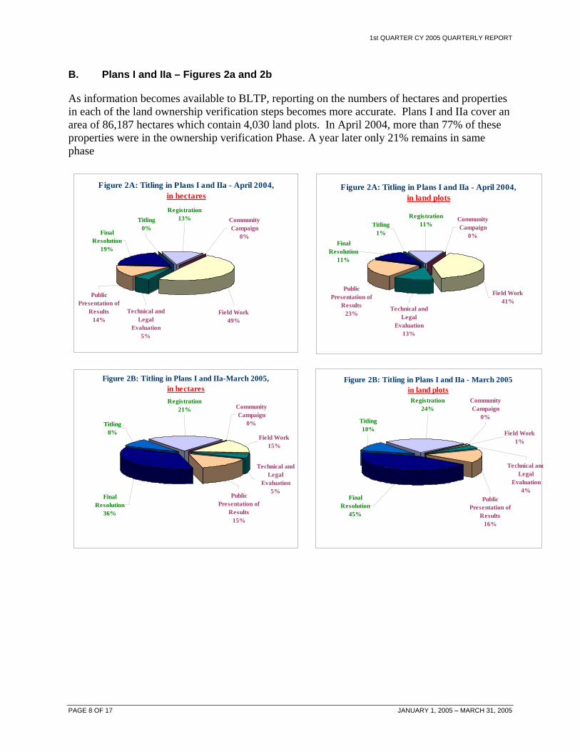
B. Plans I and IIa – Figures 2a and 2b
As information becomes available to BLTP, reporting on the numbers of hectares and properties in each of the land ownership verification steps becomes more accurate. Plans I and IIa cover an area of 86,187 hectares which contain 4,030 land plots. In April 2004, more than 77% of these properties were in the ownership verification Phase. A year later only 21% remains in same phase
Figure 2A: Titling in Plans I and IIa - April 2004, in hectares
Community Campaign
0%
Field Work49%
Registration13%
Technical and Legal
Evaluation5%
Titling 0%
Public Presentation of
Results14%
Final Resolution
19%
Figure 2B: Titling in Plans I and IIa-March 2005, in hectares
Community Campaign
0%
Field Work15%
Registration21%
Technical and Legal
Evaluation5%
Titling 8%
Public Presentation of
Results15%
Final Resolution
36%
Figure 2A: Titling in Plans I and IIa - April 2004, in land plots
Community Campaign
0%
Field Work41%
Registration11%
Technical and Legal
Evaluation13%
Titling 1%
Public Presentation of
Results23%
Final Resolution
11%
Figure 2B: Titling in Plans I and IIa - March 2005in land plots
Final Resolution
45%
Public Presentation of
Results16%
Titling 10%
Technical andLegal
Evaluation4%
Registration24%
Field Work1%
Community Campaign
0%
PAGE 8 OF 17 JANUARY 1, 2005 – MARCH 31, 2005

1st QUARTER CY 2005 QUARTERLY REPORT
C. Plan IIb – Figures 3a and 3b
Plan IIb was formulated so that the BLTP/INRA’s goal of 5,000 titles could be met. We started work in June of 2004 in 1,027 additional land plots covering an area of 12,195 hectares. It is in this area BTPL/INRA had the most success with streamlined procedures, cutting down the time needed for each step.
Figure 3A: Titling in Plan IIb - April 2004, in hectares
Not initiated100%
Community Campaign
0%
Field Work0%
Registration0%
Technical and Legal
Evaluation0%
Titling 0%
Public Presentation of
Results0%
Final Resolution
0%
Figure 3B: Titling in Plan IIb - March 2005,in hectares
Not initiated0%
Community Campaign
6%
Field Work34%
Registration0%
Technical and Legal
Evaluation10%
Titling 0%
Public Presentation of
Results35%
Final Resolution
15%
Figure 3A: Titling in Plan IIb - April 2004, in land plots
Final Resolution
0%Public
Presentation of Results
0% Titling 0%
Technical and Legal
Evaluation0%
Registration0%
Field Work0%
Community Campaign
0%
Not initiated100%
Figure 3B: Titling in Plan IIb - March 2005, in land plots
Not initiated0%
Community Campaign
5%
Field Work41%
Registration0%
Technical and Legal
Evaluation8%
Titling 0%
Public Presentation of
Results37%
Final Resolution
9%
PAGE 9 OF 17 JANUARY 1, 2005 – MARCH 31, 2005

1st QUARTER CY 2005 QUARTERLY REPORT
D. Plan III PRAEDAC/BPK – Figures 4a and 4b
As explained above, we are no longer reporting on Plan III, which is now the sole responsibility of PRAEDAC. However, when information becomes available, we will be pleased to include data from Plan II in an annex. Given the original goals of this project -- 465,000 hectares and 25,000 property titles -- the impact of Plan III in the overall situation of titling in the Chapare is considerable. As reported above, PRAEDAC has reevaluated its estimates several times of how many properties will be verified and in what areas. The latest estimates are that PRAEDAC will complete work in 150,000 hectares containing some 8,000 properties.
PAGE 10 OF 17 JANUARY 1, 2005 – MARCH 31, 2005

1st QUARTER CY 2005 QUARTERLY REPORT
SECTION III Strategic Objectives In this section we report on the specific achievements and activities during the quarter for each of the four strategic objectives. A. Strategic Objective 1: Develop and Strengthen INRA’s Institutional Capacity
A new FARA for six months, developed from previous experience, was signed with INRA Nacional. This FARA contains performance indicators that will facilitate and encourage performance monitoring and allow BLTP to stop payment when results are not delivered according to schedule. Consultant Dr. Mario Rodriguez completed his assignment with presentations to INRA’s executive Director and USAID, setting forth a comprehensive set of instruments for the re-engineering of INRA, including a Job Description Manual, Organization and Functions Manual, Job Valuation Manual, Comparative Summary of Salaries and INRA’s Job and Positions Evaluation.
A.1 INRA Cochabamba
The fourth FARA, which specifies the goals of each activity by month, was signed with INRA Cochabamba during the quarter. The agreement is for a one year period. The FARA continues to emphasize results. The emphasis on accountability for concrete results and the policy of using quarterly revisions to pressure INRA to deliver are strating to produce agreed results and the expected changes in INRA’s work culture.
BLTP provided INRA Cochabamba with all the necessary resources, both human and physical including the installation of an office to start operations in Villa Tunari. This office is the operations base to work in the new areas and also a major step by INRA to establish presence in the Tropics. The office started operation in mid-January.
A.2 Plan I and IIA
As previously explained the FARA contains specific goals for each month of the quarter. Table 1 shows the target and accomplishments for the quarter.
PAGE 11 OF 17 JANUARY 1, 2005 – MARCH 31, 2005

1st QUARTER CY 2005 QUARTERLY REPORT
Table 1. Plans I and IIa progress status for the quarter (January - March, 2005) Activty Indicator Responsible Party Target Achievement Percentage
N° of polygons with a Resolution fixing the price
Agrarian Supertrintendent
12 8 67% Public Presentation of Results N° of plots with Public
Exposition of Results and Conclusions
Villa Tunari INRA Office
1,167 689 59%
N° of polygons with Final Resolution
INRA Cochabamba 13 11 85% Final Resolution
N° of Resolutions signed by the country’s President
INRA Nacional Office
sin meta 7
N° of validated files sent to INRA National for titling
INRA Cochabamba 1 2 200% Titling
N° of files sent for titling and certifications
INRA Nacional 3 2 67%
Registered titles
N° of executive titles registered in DDRR
Derechos Reales Sacaba
735 261 36%
The reasons for not achieving 100 percent in each case illustrate how vulnerable the process is to minor disruptions: The first two activities were delayed because the Agrarian Superintendence Office moved from La Paz to Santa Cruz. The third activity target could not be accomplished because the President did not sign the Final Resolutions. This is a bottleneck that goes beyond the project control and continues to delay and sometimes stop the titling process.
A.3 Plan IIb
Plan IIb covers an area of over 12,000 hectares and contains 1,027 properties. The area was added to BLT’s work load so that the target of 5,000 properties and 100,00 hectares could be met.
Table 2 Plan IIB progress status for the quarter (January - March, 2005) Activity Indicator Responsible Party Target Achievement Percentage
N° of instructive resolutions published Villa Tunari Office 10 11 110% Community
Campaign N° public campaigns completed Villa Tunari Office 10 11 110%
Field Work N° of hectares with field work completed Villa Tunari Office 1,100 1,160 105%
Technical and Legal Evaluation
N° of hectares with legal/technical evaluation Villa Tunari Office 1,895 1,832 97%
N° of polygons with a resolution fixing a price
Agrarian Sunpertintendent 11 9 82% Public
Presentation of Results
N° of plots with Public Exposition of Results and Conclusions
Villa Tunari Office 227 88 39%
Final Resolution
N° of polygons with Final Ownership Verification Resolutions
INRA Cochabamba 1 3 300%
PAGE 12 OF 17 JANUARY 1, 2005 – MARCH 31, 2005

1st QUARTER CY 2005 QUARTERLY REPORT
Failing to meet the last three targets in the table was due primarily to the move of the Agrarian Superintendence to Santa Cruz and the disruption that this caused in routine procedures. The public presentation of Results could not be made because the Agrarian Superintendence did not issue the land price certificates.
During the quarter, the BLTP organized and implemented three workshops for INRA staff: 1) conflict resolution, 2) extension best practices, and 3) use of Total Station to measure land more accurately and quickly. During the three events a total of 70 participants, mostly INRA staff from the national and regional offices benefited from the workshops.
A.4 INRA Nacional
One important step in building INRA’s institutional capacity was the delegation of several functions by the National Office to the Cochabamba Departmental Office. The Departmental office was given the authority to deal directly with the Agrarian Superintendence to obtain land prices. This development speeds up the titling process by cutting down the time it took to go through the Nacional office to obtain the land price determinations required by law.
B. Strategic Objective 2: Develop and Strengthen Derechos Reales (DDRR’s) Institutional Capacity
DDRR currently has the capacity to process large number of titles. However, until INRA starts producing significant numbers of titles, BLTP support is limited to maintaining the installed capacity. For this reason the second FARA with DDRR was extended until the end of the year without major modifications. During the quarter, the DDRR office processed and registered 261 titles in a record 4 days demonstrating its enhanced capacity to rapidly and efficiently handle large volumes of titles.
C. Specific Objective 3: Outreach Dissemination Program
The communication strategy was modified to adapt to the changes in the distribution of tasks among the donors and the fact that BLTP is now working in new areas, areas that have traditionally been opposed to titling for political reasons. BLTP/INRA communications are key, directed to communities and local organizations and are mostly interpersonal in nature through an expert group of local extensionists, due to the high political sensitivities in the region.
D. Strategic Objective 4: Develop and strengthen the municipalities’ capacity
No activities were undertaken in under this objective. The contract was modified to reflect that fact under the current legal an institutional framework municipality has neither interest nor incentive to set up a rural cadastre, simply because they can not collect taxes from the majority of the rural property owners. BLTP work in this area will be limited to carrying out an assessment of the legal, institutional and policy frameworks that govern for municipal cadastres and make recommendations
PAGE 13 OF 17 JANUARY 1, 2005 – MARCH 31, 2005
PAGE
14 OF 17 JANUARY 1, 2005 – MARCH 31, 2005
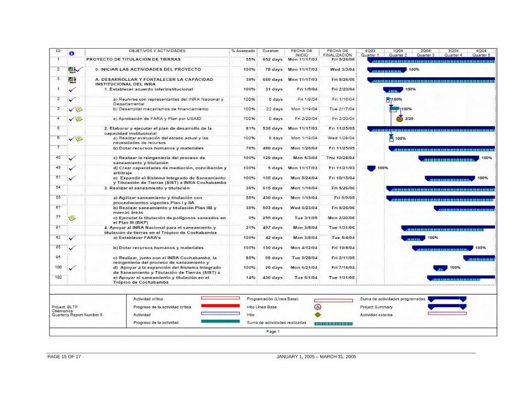
ANNEX A Performance Monitoring Chart
PAGE 15 OF 17 JANUARY 1, 2005 – MARCH 31, 2005

