the immense journey
TRANSCRIPT

The Immense Journey
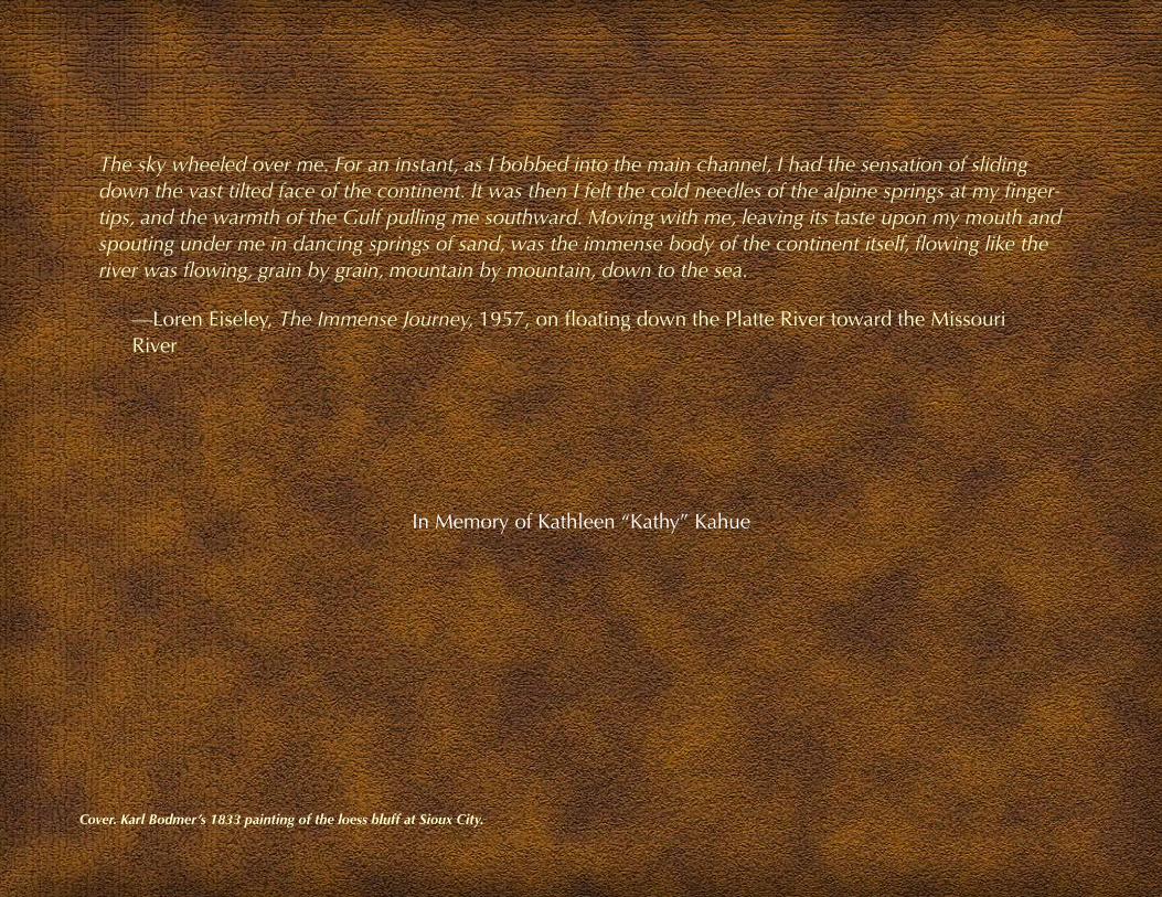
The sky wheeled over me. For an instant, as I bobbed into the main channel, I had the sensation of sliding down the vast tilted face of the continent. It was then I felt the cold needles of the alpine springs at my finger-tips, and the warmth of the Gulf pulling me southward. Moving with me, leaving its taste upon my mouth and spouting under me in dancing springs of sand, was the immense body of the continent itself, flowing like the river was flowing, grain by grain, mountain by mountain, down to the sea.
—Loren Eiseley, The Immense Journey, 1957, on floating down the Platte River toward the Missouri River
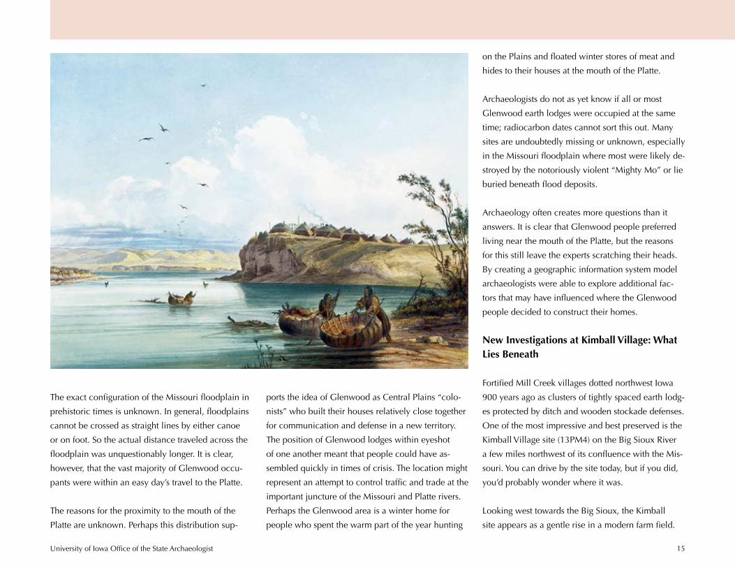
Cover. Karl Bodmer’s 1833 painting of the loess bluff at Sioux City.
In Memory of Kathleen “Kathy” Kahue

The Immense JourneyLoess Hills Cultural Resources Study
Lynn M. Alex
Major Contributions byMary J. Adair, Joe Alan Artz, Angela R. Collins, Jan Olive Full,
Richard L. Josephs, Kenneth L. Kvamme, Stephen C. Lensink, Wynema Morris,Cynthia L. Peterson, Melody K. Pope, Melanie A. Riley, Donna Roper,
Shirley J. Schermer, Andrew C. Sorensen, James L. Theler, Joseph A. Tiffany,
and William E. Whittaker
Design and Editorial Assistance byStephen C. Lensink
Funded by a grant received throughGolden Hills Resource Conservation and Development
directed by Shirley Frederiksenand staffed by Kathy Kahue and Elizabeth Birkel-Leddy
Additional support from theLoess Hills National Scenic Byway Council
and Western Iowa Tourism Region
2010
University of Iowa Office of the State Archaeologist 2
prehistoric Glenwood house lodges in the south and
palisaded Mill Creek villages in the north. These two
very different ancestral Plains Indian cultures provide
unparalleled opportunities to explore 300 years of
cultural diversity linked to landscape. Archaeologi-
cal events in the region are also tied to the struggle
for Native Indian rights—guiding the country along a
course ultimately lead-
ing to the protection and
reburial of American
Indian human remains.
The University of Iowa’s
Office of the State Ar-
chaeologist conducted a
study in 2008 and 2009
to identify important
Prologue
Known as one of North
America’s natural trea-
sures, the Loess Hills is also
one of our country’s archaeo-
logical gems. This unique
landscape harbors hundreds
of well-preserved earth lodge
dwellings and palisaded vil-
lages built by ancestral Plains Indians. The descen-
dants of these early Iowa farmers were first described
in the journals and accounts of 18th- and 19th-century
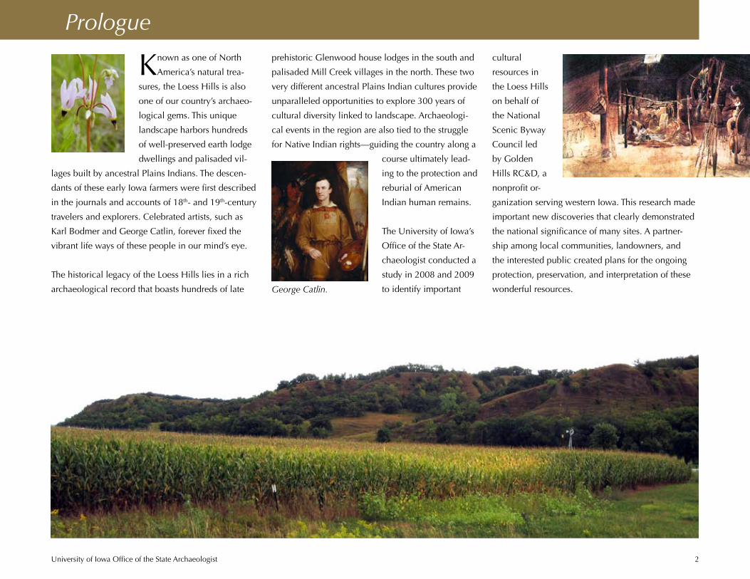
travelers and explorers. Celebrated artists, such as
Karl Bodmer and George Catlin, forever fixed the
vibrant life ways of these people in our mind’s eye.
The historical legacy of the Loess Hills lies in a rich
archaeological record that boasts hundreds of late George Catlin.
cultural
resources in
the Loess Hills
on behalf of
the National
Scenic Byway
Council led
by Golden
Hills RC&D, a
nonprofit or-
ganization serving western Iowa. This research made
important new discoveries that clearly demonstrated
the national significance of many sites. A partner-
ship among local communities, landowners, and
the interested public created plans for the ongoing
protection, preservation, and interpretation of these
wonderful resources.

University of Iowa Office of the State Archaeologist 3
Engagement: Communities Come Together
Before any professional archaeologist ever set a
well-worn boot heel in Iowa’s Loess Hills, area
residents, relic hunters, and antiquarians pioneered
the region’s archaeology. Landowners and collectors
filled boxes and frames with masses of stone points
and pottery and dug into house depressions and
village mounds. The arrival of Charles R. Keyes and
Ellison Orr, appointed to conduct the first statewide
archaeological survey in the 1920s, elevated these
endeavors to site recording. The two relied on local
residents, such as Paul Rowe in Mills County, and
organizations, like the Sioux City Academy of Sci-
ences, for information about collections and sites.
These efforts produced a basic understanding of the
area’s prehistory and drew the interest of profession-
als. Later the Sanford Museum in Cherokee and both
the Northwest Chapter and the Paul Rowe Chapter
of the Iowa Archeological Society made significant
contributions to Loess Hills’ archaeology.
This kind of personal commit-
ment and continuing interest
has inspired many communi-
ties to find ways to advance the
area’s early history and to share
it with others. This is perhaps
nowhere better demonstrated
than in the replica earth lodge
and related artifact exhibits
in the Mills County Historical
Museum in Glenwood. Inspired
by the carefully documented
artifact collections of Paul Rowe
and his colleagues, such as
D.D. Davis, grass roots efforts
financed, constructed,
and continue to main-
tain both the earth lodge
and the nearby museum.
Here most of the Rowe
collection, one of the
largest and most com-
prehensive of any from
the central Missouri
valley, is displayed.
Recognizing the valu-
able knowledge and generous enthusiasm of area
residents, the Loess Hills Cultural Resources Study
began with a series of community meetings intended
to outline the project and engage public input. A
community symposium hosted in Glenwood drew
archaeological experts from Wichita to Washington,
D.C., who shared their knowledge of the late prehis-
toric period of the southern Loess Hills. The questions
posed at this event guided subsequent research.
One of the most satisfying aspects of the Loess Hills
project was meeting with landowners and collectors.
Farmers proudly shared stone spear points found in
their gardens, while others displayed collections con-
taining hundreds of items families had been accumu-
lating for generations. Seasoned
collectors described sites
excavated by amateurs in the
1950s and 1960s, whose previ-
ous existence was unknown.
This information provided clues
to find buried intact sites and
helped the archaeologists learn
how prehistoric people utilized
the landscape. As a result, more
than a dozen new, possible
lodge locations came to light.
Paul Rowe.
University of Iowa Office of the State Archaeologist 4
The area’s prehistoric archaeology includes over
1,500 known sites found across seven counties and
spanning more than 12,000 years of human history.
Highlights include the earliest stone weapons lost or
discarded by Paleoindian hunters, the oldest known
Native American cemetery in Iowa, multitudes of late
prehistoric agricultural communities, and the ephem-
eral settlements of displaced tribes. It is the late pre-
The Loess Hills National Scenic Byway follows
the Missouri valley traversing some 220 miles
from Plymouth County in the north to Fremont
County in the south. As a boundary region between
the short grass plains and tall grass prairies and po-
sitioned along a major interior river corridor, the re-
gion is a place of deep history and rich archaeology.
Since the end of the last great Ice Age, people have
called the Loess Hills home. Transportation corridors
over land and along waterways, breath-
taking vistas, diverse biological com-
munities, narrow canyons, well-drained
slopes, springs, and rich agricultural soil
explain why people have been coming
to the region for as long as humans have
inhabited North America.
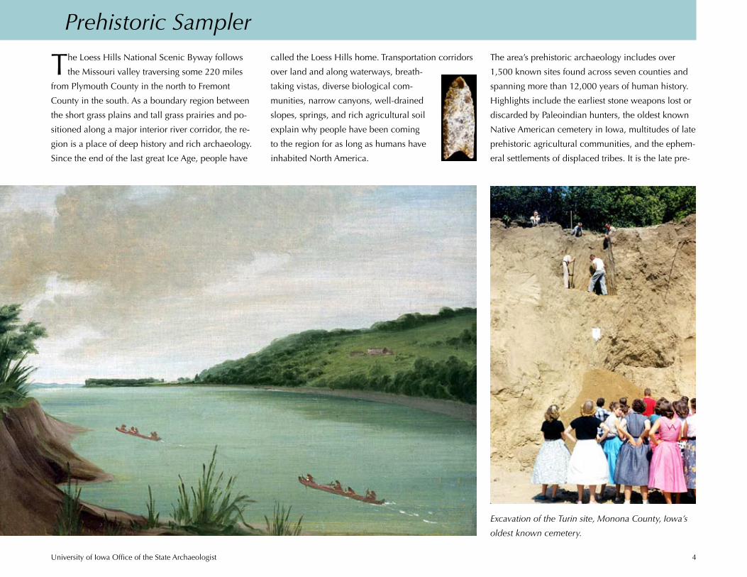
Prehistoric Sampler
Excavation of the Turin site, Monona County, Iowa’s
oldest known cemetery.
University of Iowa Office of the State Archaeologist 5
historic period, however, that
stands out, offering the visitor
a spectacular and contrastive
view into the lives of ancestral
Plains Indians.
Of all the known sites scat-
tered throughout the seven
Loess Hills counties, a major-
ity are prehistoric houses—earthen lodges—occupied
between A.D. 1000 and 1400, and antecedent to
the 19th-century villages described and illustrated
centuries later by
Meriwether Lewis,
William Clark,
George Catlin, and
Karl Bodmer. What
the cliff dwellings
of the ancestral
Pueblo peoples are
to Southwestern
archaeology, the
lodges of ancestral Plains villagers are to Midwest
and Plains archaeology—the seminal moment for the
emergence of the first sedentary farming societies.
Archaeologists estimate that as many as 1,000 earth
lodge dwellings once covered the hills and valleys in
the southern Glenwood locality, all within a 10-mile
radius of the confluence of the Platte and Missouri
rivers. At the northern end of the Loess Hills where
the Big Sioux and Missouri rivers meet is another fo-
cal point for a late prehistoric settlement called Mill
Creek.
Although the numbers of known sites in the Big
Sioux locality are overshadowed by the astonishing
number of dwelling sites in the south, the compact,
fortified Mill Creek villages formed virtual mini-tells
similar to ancient Mesopotamian mounds. And like
their Near Eastern counterparts, Mill Creek villages
developed as palimpsests of village debris and mud-
walled houses that over time elevated the surround-
ing flat valley floor 6–10 feet.
While both Mill Creek and Glenwood people lived
in semipermanent
communities, grew
corn, and devel-
oped a rich material
culture, they were
distinct societies
based on other fun-
damentally differ-
ent characteristics.
One of the most
important was community planning. Mill Creek vil-
lages were nucleated and fortified while Glenwood
settlements were dispersed and unfortified. Both Mill
Creek and Glenwood people maintained contacts
with distant communities, including those on the
Plains to the west and the Mississippi drainage to the
east. Both groups appear to have left the region at
slightly different times between A.D. 1200–1400.
House floor plan, excavated
lodge, Mills County.
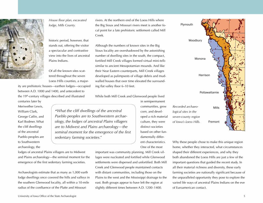
Recorded archaeo-
logical sites in the
seven-county region
of Iowa’s Loess Hills.
Plymouth
Woodbury
Monona
Harrison
Pottawattamie
Mills
Fremont
Why these people chose to make this unique region
home, whether they interacted, what circumstances
shaped their different experiences, and why they
both abandoned the Loess Hills are just a few of the
important questions that guided the recent study. In
all their material richness and diversity, these early
farming societies are nationally significant because of
the unparalleled opportunity they pose to explore the
varied life ways of ancestral Plains Indians on the eve
of Euroamerican contact.
“What the cliff dwellings of the ancestral Pueblo peoples are to Southwestern archae-ology, the lodges of ancestral Plains villagers are to Midwest and Plains archaeology—the seminal moment for the emergence of the first sedentary farming societies.”

University of Iowa Office of the State Archaeologist 6
Jewels in the Crown
numbers of bison bones found in the vil-
lages of these pedestrian hunters indicate
direct access to the herds. Village fortifica-
tions hint at anticipated external threats. Mill
Creek was involved with early Mississippian
trade from the east through Cahokia—North
America’s largest prehistoric metropolis
at the mouth of the Missouri River. They were also
positioned between Plains peoples to the west and
emerging Oneota societies to the east—people who
would soon follow them.
Mill Creek pottery.
Big Si
oux
Rive
r
Littl
e Si
oux R
iver
13PM248
13PM61
13WD402
13BV401
13OB2
13BV113CK81
13OB3
13PM4
13OB7
13CK1
13OB4
13CK21
13PM1
13CK15
13PM429/WD105
13BV3
13CK3
13CK47
13CK39
13PM65
13PM36
13CK401
13BV2
13PM60
13OB3
13CK80
13OB10
13PM7
13OB813OB31
13PM23
13OB11
13OB407
13BV5
13BV6
13CK64
13CK52
13OB26
13OB2913OB12
13PM37
13CK402
13PM17213PM127
13BV31
Legend
RiversBig and Little Sioux AreasSites
0 10 205 Miles
0 20 4010 Kilometers
±
Big Sioux Area
Little Sioux AreaI O W AI O W A
M I N N E S O T AM I N N E S O T AS O U T HS O U T HD A K O T AD A K O T A
N E B R A S K AN E B R A S K A0 100 200 km
In the extraordinarily rich artifacts recovered from
dozens of Mill Creek and Glenwood sites, we
recognize objects familiar to the Plains Indian village
way of life as it persisted for almost a millennium.
The hide, feathers, wood, quill work, cloth, and
sinew that comprised the tools, clothing, and orna-
ments of these early people have long since perished.
Nevertheless, surviving items in stone, bone, pottery,
and shell offer a well-rounded view of prehistoric
technology and a glimpse into a rich symbolic and
ceremonial life.
These were settled agrarian communities, and like
any town or farmstead that persists over the decades,
they permanently imprinted the landscape with the
remnants of houses, fortifications, cemeteries, fields,
and the ordinary detritus of daily life. Mill Creek
peoples were focused bison hunters and horticul-
turalists. Their tightly spaced lodges within fortified
villages and extensive middens suggest long-term,
sedentary occupations lasting decades. The large
Location of Mill Creek sites in northwest Iowa. The
Loess Hills study identified 14 villages and burial sites
in the Big Sioux locality.
Bird’s-eye view of a fortified Mill Creek village.

University of Iowa Office of the State Archaeologist 7
!
")
!
!
")
")
")
")
")
")")
")
")
")
")
!
")
")
")
")")
")
")
")
")")
")
") ")")")")")
")")")")
!
")
")
")
")
")
")")
")
!
")
!
!!
!
")
")
")
")
")
")!")")
")")
")
")
")")
")
")")
")
")
")
")
")
") ")
")
")
")")
")")")")
")
")")")
")
")")
")
")
")")
")
")
")
")
")")")
")
")
")
")
")
")
!
")
")
")")")
")
")
")")
")
")
")
")")
")
")
")
")")
")
")")
")
")
")
")
")
")
!
")
")
")
") ")
")
")
")
")")")")")!!
!!")")
")! ")
")")
")!")")
")")
")
!
!
!!")")
")")")")")")")")
")
")
")
!")
") ")
")")")")
")
")!")")")")
")
") ")")")")
")
")!!")
")")
") !
")
!!
")
")
!
")
!!")
") ")
")
")
")
")
!
!
")")
")")
")")
")")
")")
")!
")
")
")
")
!
!
!
!!!
")
")
")
")!
")
!
")")")")
!
")")
")
PAGE
MILLS
POTTAWATTAMIE
FREMONT
MONTGOMERY
±0 3 6 9 121.5Miles
0 4 8 12 162Kilometers
All Recorded Nebraska Phase Sites in the Geographic Area
as of 7/10/2009
n = 275
NRHP MPDF"Geographic Area"
Earthlodges
Other
")Council Bluffs
Glenwood
Thurman
Glenwood people built widely dispersed,
unfortified homesteads located immediately
south of the Mill Creek culture area, and
they largely, if not entirely, postdate the Mill
Creek occupation. Glenwood communities
appear to have had a very broad diet, har-
vesting some large game but also apparently
foraging for anything edible. Artifacts in
these sites suggest a relationship with later Mississip-
pian and Oneota groups.
Mill Creek lasted for 100 to 200 years as a partici-
pant in the Mississippian trade emanating through
Cahokia. By the time Cahokia waned, diminished
bison herds coupled with competition from neigh-
boring groups, likely created a decline in large game.
With timber resources exhausted, this may explain
the disappearance of the Mill Creek culture, leaving
an open and depleted landscape whose fringes were
utilized by Glenwood foragers.
Glenwood pottery.
Location of Glenwood sites in southwest Iowa. The
Loess Hills study confirmed at least 298 lodges at 275
sites in a three-county area.
Glenwood people may have survived, without
competition from other groups, in a region with little
large game and a low human population for nearly
two centuries. They too then disappeared or were
perhaps absorbed by developing Oneota societies.
Mill Creek villages were likely organized along
social and kinship lines different from those of the
scattered Glenwood homesteads. And, each society
had access to and utilized resources in distinct ways.
On the face of it, however, their everyday tools seem
remarkably similar.
Artist’s reconstruction of two
Glenwood lodges.
University of Iowa Office of the State Archaeologist 8
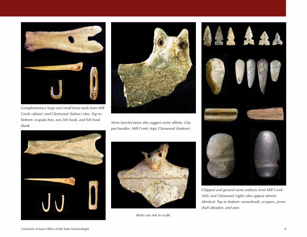
Complementary large and small bone tools from Mill
Creek (above) and Glenwood (below) sites. Top to
bottom: scapula hoe, awl, fish hook, and fish hook
blank.
Chipped and ground stone artifacts from Mill Creek
(left) and Glenwood (right) sites appear almost
identical. Top to bottom: arrowheads, scrapers, arrow
shaft abraders, and axes.
More fanciful items also suggest some affinity. Clay
pot handles: Mill Creek (top) Glenwood (bottom).
Items are not to scale.

University of Iowa Office of the State Archaeologist 9
Other Mill Creek and Glenwood artifacts are
distinctly different. These differences reflect access
to specific raw materials, variations in manufacturing
techniques, the nature and timing of external
contacts, and cultural preferences and traditions. A small handful of exquisitely beautiful bone, antler,
and shell items, perhaps offers clues to the aesthetics,
ceremony, and ideology of these early communities.
They also suggest directions of trade.
University of Iowa Office of the State Archaeologist 10
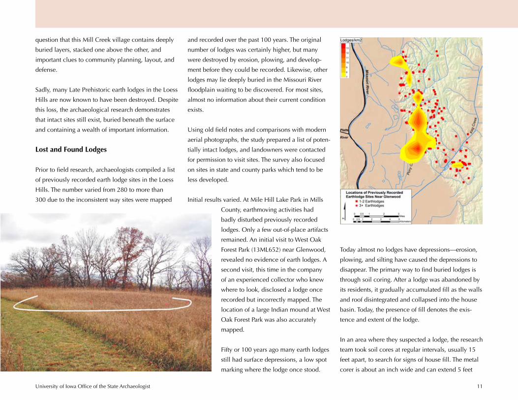
Archaeological Discoveries: What Did We Find?
Archaeology always begins with questions. The
recent Loess Hills study set out both to de-
termine the scope of archaeological resources in
the seven-county area and to answer a very basic
question—do important, intact Late Prehistoric earth
lodge sites still exist? If all of the sites that make Loess
Hills’ archaeology unique were documented and
excavated in the early and mid-20th century, what
is left to discover or rediscover? Has development,
erosion, looting, plowing, and terracing destroyed or
damaged all sites?
To find out the answers in the time allotted for the
project, the research team conducted a selective
survey of the region, visiting 34 sites including 13
previously recorded ones. These 13 were chosen for
a revisit because state records indicated that they
might still be intact and because their owners permit-
ted access.
Working quickly, often with the help of local col-
lectors including members of the Iowa Archeologi-
cal Society, archaeologists visited site locations,
inspecting the surface for artifacts. They probed the
ground with soil corers and augers looking for buried
items and signs of prehistoric features such as pits
and hearths. Often these visits proved disappointing.
Sites were gone or irreparably disturbed. Fortunately,
others remained intact, holding promise for revealing
their secrets of the past. Despite more than a century
of archaeological work in the area, landowners and
local collectors showed the team several brand new
sites never before recorded.
Test excavations at four Mills County lodge sites—
three on private property north of Glenwood and
one at Pony Creek Park—uncovered intact deposits
containing buried hearths, artifact scatters, house
floors, and the pattern of lodge walls and support
posts. And, mapping the geographical location of all
Glenwood sites revealed an intriguing new pattern.
Auger testing, survey, and remote sensing investi-
gations at the Kimball Village site north of Sioux
City produced tantalizing results. There is now no
University of Iowa Office of the State Archaeologist 11
question that this Mill Creek village contains deeply
buried layers, stacked one above the other, and
important clues to community planning, layout, and
defense.
Sadly, many Late Prehistoric earth lodges in the Loess
Hills are now known to have been destroyed. Despite
this loss, the archaeological research demonstrates
that intact sites still exist, buried beneath the surface
and containing a wealth of important information.
Lost and Found Lodges
Prior to field research, archaeologists compiled a list
of previously recorded earth lodge sites in the Loess
Hills. The number varied from 280 to more than
300 due to the inconsistent way sites were mapped
and recorded over the past 100 years. The original
number of lodges was certainly higher, but many
were destroyed by erosion, plowing, and develop-
ment before they could be recorded. Likewise, other
lodges may lie deeply buried in the Missouri River
floodplain waiting to be discovered. For most sites,
almost no information about their current condition
exists.
Using old field notes and comparisons with modern
aerial photographs, the study prepared a list of poten-
tially intact lodges, and landowners were contacted
for permission to visit sites. The survey also focused
on sites in state and county parks which tend to be
less developed.
Initial results varied. At Mile Hill Lake Park in Mills
County, earthmoving activities had
badly disturbed previously recorded
lodges. Only a few out-of-place artifacts
remained. An initial visit to West Oak
Forest Park (13ML652) near Glenwood,
revealed no evidence of earth lodges. A
second visit, this time in the company
of an experienced collector who knew
where to look, disclosed a lodge once
recorded but incorrectly mapped. The
location of a large Indian mound at West
Oak Forest Park was also accurately
mapped.
Fifty or 100 years ago many earth lodges
still had surface depressions, a low spot
marking where the lodge once stood.
Today almost no lodges have depressions—erosion,
plowing, and silting have caused the depressions to
disappear. The primary way to find buried lodges is
through soil coring. After a lodge was abandoned by
its residents, it gradually accumulated fill as the walls
and roof disintegrated and collapsed into the house
basin. Today, the presence of fill denotes the exis-
tence and extent of the lodge.
In an area where they suspected a lodge, the research
team took soil cores at regular intervals, usually 15
feet apart, to search for signs of house fill. The metal
corer is about an inch wide and can extend 5 feet

University of Iowa Office of the State Archaeologist 12
deep. When suspected lodge fill was encountered, it
was probed at closer intervals to estimate the lodge’s
shape and dimensions. The soils in the core were
analyzed to determine what types of soil filled the
lodge and how deep the fill extended into the house
basin. A hand auger was sometimes used to recover
artifacts from a larger, 8-inch-wide auger hole.
Sometimes soil cor-
ing, if done at a close
interval, could reveal
the detailed shape
of the lodge. Coring
a 1-meter grid over
the Woodfield Earth
Lodges site (13ML102)
produced a surprising result. It was actually two
lodges, a very large lodge to the southwest, and a
smaller one to the northeast. Plowing had eaten away
the northeast edge of the smaller lodge.
Exploring Lodges through Excavation
After confirming lodges through soil coring, the
archaeologists conducted excavations—sometimes
beneath tents sheltered from winter field conditions.
The twin lodges at the Woodfield Earth Lodges site
and a nearby lodge, site 13ML98, were each ex-
plored with a 1-meter square test unit.
Archaeologists hand-dug test units in 5- or 10-cen-
timeter-thick increments or levels, with all soil care-
fully screened through wire mesh to recover small
artifacts and bones. Larger artifacts and features such
as hearths, pits, and artifact scatters were mapped
in place. Soil samples were collected from features
and processed through a water flotation machine to
retrieve tiny seeds and bones—evidence of prehis-
toric diet.
The fill above the northeast lodge floor at the
Woodfield Earth Lodges site contained large, charred
timber chunks, evidence that the house had burned.
The pottery found in this lodge represented a style
archaeologists think is older than the ceramics found
in the southwest lodge. This indicates that people
lived in the northwest lodge first. The larger south-
west lodge contained no evidence of burning, but
also produced fewer artifacts, demonstrating that the
residents lived here for a shorter time.
At 13ML98, north of the twin lodges on the same
ridge, excavation revealed an interesting soil filling
the prehistoric house basin. The soil in the west half
of the test unit was dry and compact, while that in
the east half was moist and soft. Comparison with
aerial photos from the 1930s showed that an old field
road once crossed the center of the lodge. The lodge
depression was apparently filled in during the early
20th century to accommodate the road. This road
explained the difference in the soil fill. The dry soil
in the west half of the test unit lay beneath the field
road and was compacted from the weight of heavy
wagons.
0 2 4 6 8 10 m
Depth of fill cm below surface
Soil core location
N
Lodges
University of Iowa Office of the State Archaeologist 13
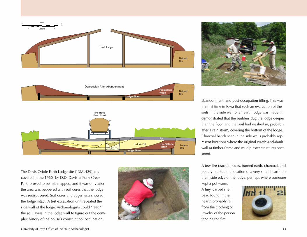
The Davis Oriole Earth Lodge site (13ML429), dis-
covered in the 1960s by D.D. Davis at Pony Creek
Park, proved to be mis-mapped, and it was only after
the area was peppered with soil cores that the lodge
was rediscovered. Soil cores and auger tests showed
the lodge intact. A test excavation unit revealed the
side wall of the lodge. Archaeologists could “read”
the soil layers in the lodge wall to figure out the com-
plex history of the house’s construction, occupation,
abandonment, and post-occupation filling. This was
the first time in Iowa that such an evaluation of the
soils in the side wall of an earth lodge was made. It
demonstrated that the builders dug the lodge deeper
than the floor, and that soil had washed in, probably
after a rain storm, covering the bottom of the lodge.
Charcoal bands seen in the side walls probably rep-
resent locations where the original wattle-and-daub
wall (a timber frame and mud plaster structure) once
stood.
A few fire-cracked rocks, burned earth, charcoal, and
pottery marked the location of a very small hearth on
the inside edge of the lodge, perhaps where someone
kept a pot warm.
A tiny, carved shell
bead found in the
hearth probably fell
from the clothing or
jewelry of the person
tending the fire.
Ap
PrehistoricWash
Lodge Floor
NaturalSoil
Two-TrackFarm Road
1-x-1 TU
Ap
Historic Fill PrehistoricWash
Lodge Floor
NaturalSoil
Ap
NaturalSoil
0
0
10
2
FEET
METERS
Earthlodge
Depression After Abandonment

University of Iowa Office of the State Archaeologist 14
Ten Miles from the Platte: Why Here?
Between A.D. 1200 and 1400, Indian people of the Nebraska
phase of the Central Plains tradition occupied southwestern Iowa.
Central Plains tradition sites extend from Kansas across Nebraska
to Iowa. These sites are common throughout eastern Nebraska
and up and down the Missouri River bluffs. In Iowa archaeolo-
gists refer to them as the Glenwood culture. The Nebraska phase
people in southwest Iowa built some 300 earth lodges in a geo-
graphical cluster centered on the lower parts of Pony Creek and
Keg Creek in Mills County. The density of lodges in this compara-
tively small area at the very edge of the Central Plains tradition
has interested archaeologists for more than a century.
By mapping Central Plains earth lodge sites in southwest Iowa,
an interesting pattern emerges. Glenwood sites are widely dis-
persed across the landscape but the vast majority occur within
10 miles of the Platte River, as measured via a straight line across
the Missouri River floodplain and following the stream valleys
into the Loess Hills. Tracing an outline of the limits of the 10-mile
radius shows that this is effectively the limits of Glenwood earth
lodge sites in Iowa, with a few additional lodges spaced up and
down the east side of the Missouri bluffs.
If Glenwood represents the spread of the Central Plains tradition
eastward, why does it cluster around the mouth of the Platte?
Earlier studies typically looked only at the location of sites not
their geographical limits. The recent study showed that although
Glenwood lodges occupy all landforms within this area, their
builders did have preferences. Living in close proximity to the
mouth of the Platte appears to have been an important one. And,
earth lodges are not distributed evenly across the region. The
highest density of lodges per square kilometer occurs along Pony
Creek.
University of Iowa Office of the State Archaeologist 15
The exact configuration of the Missouri floodplain in
prehistoric times is unknown. In general, floodplains
cannot be crossed as straight lines by either canoe
or on foot. So the actual distance traveled across the
floodplain was unquestionably longer. It is clear,
however, that the vast majority of Glenwood occu-
pants were within an easy day’s travel to the Platte.
The reasons for the proximity to the mouth of the
Platte are unknown. Perhaps this distribution sup-
ports the idea of Glenwood as Central Plains “colo-
nists” who built their houses relatively close together
for communication and defense in a new territory.
The position of Glenwood lodges within eyeshot
of one another meant that people could have as-
sembled quickly in times of crisis. The location might
represent an attempt to control traffic and trade at the
important juncture of the Missouri and Platte rivers.
Perhaps the Glenwood area is a winter home for
people who spent the warm part of the year hunting
on the Plains and floated winter stores of meat and
hides to their houses at the mouth of the Platte.
Archaeologists do not as yet know if all or most
Glenwood earth lodges were occupied at the same
time; radiocarbon dates cannot sort this out. Many
sites are undoubtedly missing or unknown, especially
in the Missouri floodplain where most were likely de-
stroyed by the notoriously violent “Mighty Mo” or lie
buried beneath flood deposits.
Archaeology often creates more questions than it
answers. It is clear that Glenwood people preferred
living near the mouth of the Platte, but the reasons
for this still leave the experts scratching their heads.
By creating a geographic information system model
archaeologists were able to explore additional fac-
tors that may have influenced where the Glenwood
people decided to construct their homes.
New Investigations at Kimball Village: What Lies Beneath
Fortified Mill Creek villages dotted northwest Iowa
900 years ago as clusters of tightly spaced earth lodg-
es protected by ditch and wooden stockade defenses.
One of the most impressive and best preserved is the
Kimball Village site (13PM4) on the Big Sioux River
a few miles northwest of its confluence with the Mis-
souri. You can drive by the site today, but if you did,
you’d probably wonder where it was.
Looking west towards the Big Sioux, the Kimball
site appears as a gentle rise in a modern farm field.
University of Iowa Office of the State Archaeologist 16
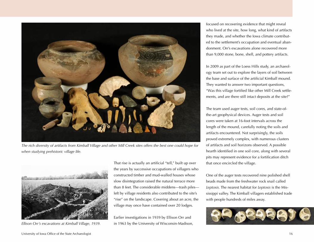
focused on recovering evidence that might reveal
who lived at the site, how long, what kind of artifacts
they made, and whether the Iowa climate contribut-
ed to the settlement’s occupation and eventual aban-
donment. Orr’s excavations alone recovered more
than 9,000 stone, bone, shell, and pottery artifacts.
In 2009 as part of the Loess Hills study, an archaeol-
ogy team set out to explore the layers of soil between
the base and surface of the artificial Kimball mound.
They wanted to answer two important questions,
“Was this village fortified like other Mill Creek settle-
ments, and are there still intact deposits at the site?”
The team used auger tests, soil cores, and state-of-
the-art geophysical devices. Auger tests and soil
cores were taken at 16-foot intervals across the
length of the mound, carefully noting the soils and
artifacts encountered. Not surprisingly, the soils
proved extremely complex, with numerous clusters
of artifacts and soil horizons observed. A possible
hearth identified in one soil core, along with several
pits may represent evidence for a fortification ditch
that once encircled the village.
One of the auger tests recovered nine polished shell
beads made from the freshwater rock snail called
Leptoxis. The nearest habitat for Leptoxis is the Mis-
sissippi valley. The Kimball villagers established trade
with people hundreds of miles away.
That rise is actually an artificial “tell,” built up over
the years by successive occupations of villagers who
constructed timber and mud-walled houses whose
slow disintegration raised the natural terrace more
than 8 feet. The considerable middens—trash piles—
left by village residents also contributed to the site’s
“rise” on the landscape. Covering about an acre, the
village may once have contained over 20 lodges.
Earlier investigations in 1939 by Ellison Orr and
in 1963 by the University of Wisconsin-Madison,
The rich diversity of artifacts from Kimball Village and other Mill Creek sites offers the best one could hope for
when studying prehistoric village life.
Ellison Orr’s excavations at Kimball Village, 1939.

University of Iowa Office of the State Archaeologist 17
Styles of prehistoric pottery and other
artifacts changed over long periods
of time just as we see changes in
modern technology. The hundreds of
pottery fragments recovered from top
to bottom at Kimball Village actually
appear very similar with few chang-
es, evidence suggesting that the
village was occupied for a compara-
tively short time, perhaps only a few
generations. Once the inhabitants
exhausted nearby resources such
as timber, they likely would have
moved to a new spot.
The limited test investigations at
Kimball, lasting only a week, pro-
duced some interesting results. The
site appears to be far more complex
than first reported. The soils above
the base of the mound contain soil
horizons and artifact concentrations
suggesting the site was rebuilt several
times, each time raising the village a
foot or two higher.
To enhance the limited field study, a
specialized team from the University
x
x
x
o
0-910-2425-4950-7475-99100-149150-199200+
Averaged artifact count per 10-cm level;soil cores (SC) and Orr unit (Orr Sec 14) estimated.
Minor artifact clusterProbable living floorProbable pit or ditch feature
xop
pp
ppp
p
ppp
p
o
o
o
o
o
x
o
Vertical Scale Only
0 cm
25 cm
50 cm
75 cm
100 cm
125 cm
150 cm
175 cm
Depth
200 cm
225 cm
250 cm
METERS
FEET0
0 50
200
Horizontal Scale Only
SC1
AT1
AT2
AT3
AT4
AT5
AT6
AT7
AT8
AT9
AT10
SC3
AT12
AT13
SC6
SC7
SC2 Orr S
ec 14
Mean-der
Approximate location of lodgeas magnetometersuggested by
Mean-der orditch?
possible ditches living surfaces?
possible final lodges
Vertical Exaggeration Reduced
original surface
Living Surface
Living Surface
Living Surface
Living Surface
Original Surface
Modern Surface
Stratigraphic profile, Kimball Village,
2009. Shows site deposits still intact
and evidence for rebuilding.
University of Iowa Office of the State Archaeologist 18
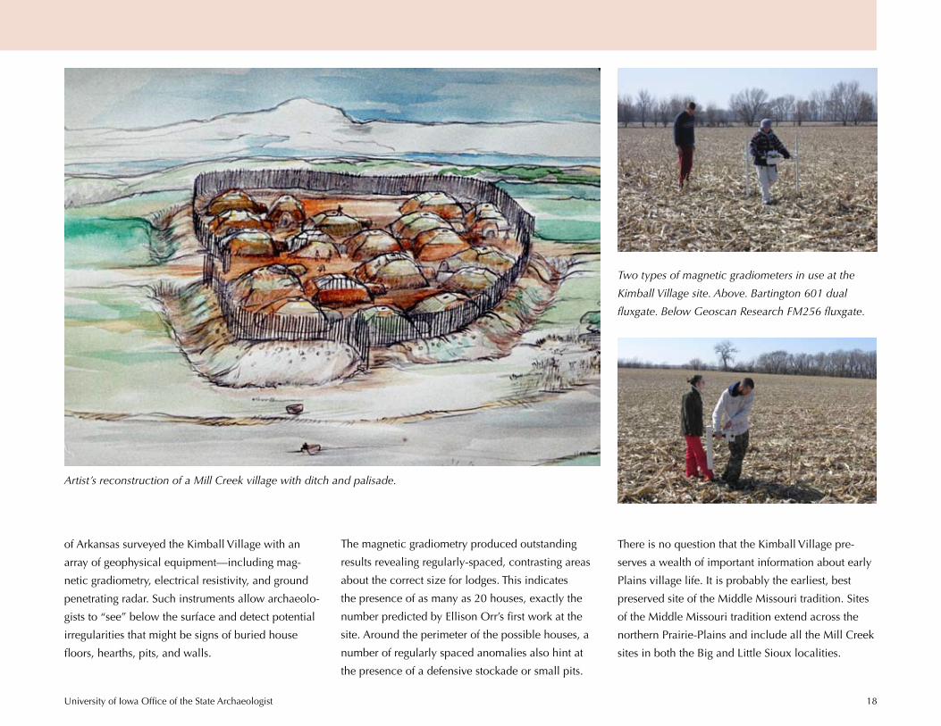
of Arkansas surveyed the Kimball Village with an
array of geophysical equipment—including mag-
netic gradiometry, electrical resistivity, and ground
penetrating radar. Such instruments allow archaeolo-
gists to “see” below the surface and detect potential
irregularities that might be signs of buried house
floors, hearths, pits, and walls.
Two types of magnetic gradiometers in use at the
Kimball Village site. Above. Bartington 601 dual
fluxgate. Below Geoscan Research FM256 fluxgate.
The magnetic gradiometry produced outstanding
results revealing regularly-spaced, contrasting areas
about the correct size for lodges. This indicates
the presence of as many as 20 houses, exactly the
number predicted by Ellison Orr’s first work at the
site. Around the perimeter of the possible houses, a
number of regularly spaced anomalies also hint at
the presence of a defensive stockade or small pits.
There is no question that the Kimball Village pre-
serves a wealth of important information about early
Plains village life. It is probably the earliest, best
preserved site of the Middle Missouri tradition. Sites
of the Middle Missouri tradition extend across the
northern Prairie-Plains and include all the Mill Creek
sites in both the Big and Little Sioux localities.
Artist’s reconstruction of a Mill Creek village with ditch and palisade.
University of Iowa Office of the State Archaeologist 19
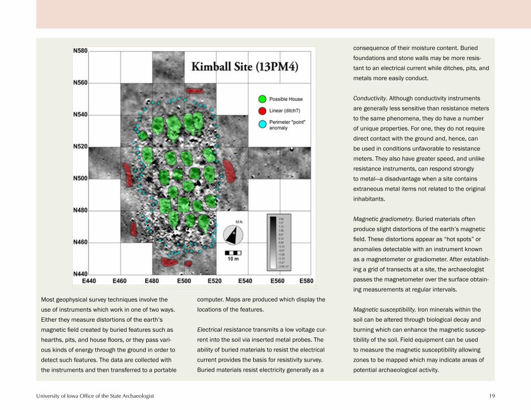
Most geophysical survey techniques involve the use of instruments which work in one of two ways. Either they measure distortions of the earth’s magnetic field created by buried features such as hearths, pits, and house floors, or they pass vari-ous kinds of energy through the ground in order to detect such features. The data are collected with the instruments and then transferred to a portable
computer. Maps are produced which display the locations of the features.
Electrical resistance transmits a low voltage cur-rent into the soil via inserted metal probes. The ability of buried materials to resist the electrical current provides the basis for resistivity survey. Buried materials resist electricity generally as a
consequence of their moisture content. Buried foundations and stone walls may be more resis-tant to an electrical current while ditches, pits, and metals more easily conduct.
Conductivity. Although conductivity instruments are generally less sensitive than resistance meters to the same phenomena, they do have a number of unique properties. For one, they do not require direct contact with the ground and, hence, can be used in conditions unfavorable to resistance meters. They also have greater speed, and unlike resistance instruments, can respond strongly to metal—a disadvantage when a site contains extraneous metal items not related to the original inhabitants.
Magnetic gradiometry. Buried materials often produce slight distortions of the earth’s magnetic field. These distortions appear as “hot spots” or anomalies detectable with an instrument known as a magnetometer or gradiometer. After establish-ing a grid of transects at a site, the archaeologist passes the magnetometer over the surface obtain-ing measurements at regular intervals.
Magnetic susceptibility. Iron minerals within the soil can be altered through biological decay and burning which can enhance the magnetic suscep-tibility of the soil. Field equipment can be used to measure the magnetic susceptibility allowing zones to be mapped which may indicate areas of potential archaeological activity.

University of Iowa Office of the State Archaeologist 20
During the summer of 2009, 21st-century tech-
nology encountered the 13th century in western
Iowa, and the results are outstanding. Airborne Light
Detection and Ranging (LiDAR) is a remote sensing
technology used to gather elevation data over a large
area. Iowa is one of the first states to have LiDAR,
and the Loess Hills study represents the first use of
LiDAR to detect late prehistoric lodge sites.
Picture an aircraft mounted with a device that scans
the ground
surface with an
invisible laser.
Like sunlight, the
laser light can
filter between
tree branches
and sometimes
through leafed-
out tree canopy.
The elevation of
an object or the
surface is determined by the time it takes the laser
pulse to reflect back to a sensor on the plane. The el-
evation data includes tops of buildings, tree branch-
es, cars, and, in this instance, the subtle depressions
created by well preserved earth lodges in Mills and
Pottawattamie counties!
Some of the southwest Iowa sites had escaped the
attention of collectors and archaeologists for over
100 years. LiDAR was able to detect lodges due to
the slight elevation differences created by the house
depressions and because laser light is reflected less
intensely from the moist, organic-rich soil within the
house depressions. As a result the depressions appear
darker than the surrounding surface.
Using a geographic information system (GIS), maps
of soils, topography, and archaeological sites were
layered atop one another and linked to a computer
database of information about each of these features.
LiDAR images, manipulated by a GIS, enhanced the
view of features not obvious from ground level. These
images revealed:
129 lodge depressions at 73 sites (previously •
only 86 lodges were recorded at these sites),
66 potential new lodge depressions,•
8 lodge sites never precisely located, and •
20 lodge sites previously identified only as •
artifact scatters.
The efficacy of LiDAR in locating sites not only sur-
passed expectations but provided new insights into
the arrangement of Glenwood earth lodges. In the
course of the study, a dozen suspected lodges were
found to be paired depressions similar to the twin
lodges at site 13ML102.
Taking a GIS a step farther, archaeologists used the
layers of information about site locations such as
proximity to streams, slope, and soil type, to model
the environmental preferences Glenwood people
may have had in selecting areas for habitation. The
goals of the study were to explore on what kind of
land lodges are usually found, and what kind of land
Glenwood people preferred when deciding where to
build. A GIS allowed the study to compare and cal-
culate the values to study the relationship between
lodges and the landscape.
!(!(
!(
!(
!(
!(
!(
!(
!(
!(
!(
!(
!(!(
!(
!(
!(
!(
!(
!(
!(
!(!(!(
!(
!(
!(
!(
!(
!(
!(
!(
!(
!(
!(
!(
!(
!(
!(
!(
!(
!(!(
!(
!(
!(
!(
!(
!(!(!(
!(
!(
!(
!(
!(
!(
!(
!(
!(!(
!(
!( !(
!(
!(
!( !(
!(
!(
!(
!(
!(
!(!(
!(
!(
!(
!(
!(
!(
!(
!(!(!(!(
Archaeological preserve
Recorded sites detectedby LiDAR in Mills County
¯
0 1 2 Miles
!(
21st-Century Technology Meets the 13th Century

University of Iowa Office of the State Archaeologist 21
Glenwood culture was agrarian
and the people lived in houses
that were partially subterranean.
From these clues, variables such
as a soil’s erodibility (house walls
and crops should not slump) and
solar insulation (crops need good
sunlight) could be tested to see
if they affected lodge placement.
Other factors reflected more
universal preferences. People
generally like living on relatively
flat surfaces, not slopes, and shel-
ters usually face away from harsh
winter winds. Did the location of
lodges relate positively to such
variables?
The results of the modeling not
only provided answers about
which environmental settings
were chosen or avoided by Glen-
wood people in situating their
houses, but also produced a map
showing where there would be
high to low potential for finding
a lodge site. Now we know that
Glenwood people:
built on slope• s as steep as 15 degrees,
avoided flat open terrain and built within 1300 •
feet of perennial streams,
preferred slopes that received the most sun-•
light during the growing season, and
preferred areas with• neutral to acidic soils.¹12 meters
19 meters
Three potential earthlodge depressions north of 13ML5
Understanding these settlement preferences provides
insight into the nature of the Glenwood culture. The
last two strongly suggest that houses were built close
to fields, something previously suspected but now
supported by the new evidence.
While the high percentage of destroyed Glenwood
sites in the Loess Hills is lamentable, the results of
both LiDAR and modeling indicate that many more
sites exist. And now we have clues where to look!
!(
!(
!(
!(
!(
!(
!(
!(
!(
!(
!(
!(
!(
!(
!(!(
!(
!(
!(!(!( !(
!(!(!(!( !(
!(
!(
!(
!(!(
!(
!(
!(
!(
!(
!(
!(!(!(
!(
!(
!(
!(
!(
!(
!(
!(
!(
!(!(
!(
!(
!(
!(
!(
!(
!(
!(
!(
!(
!(
!(
!(
!(!(!(
!(
!(
!(
!(
!(
!(
!(
!(!(
!(
!(
!(
!(
!(
!(
!(
!(!(
!(
!(
!(
!(
!(
!(
!(
!(
!(
!( !(
!(
!(
!(
!(
!(
!(
!(
!(
!(
!(
!(
!(!(!(!(
!(
!( !(
!(
!(
!(
!(
!(
!( !(
!(!(!(!(!( !(!(!(
!(
!(
!(
!(!(
!(
!(
!(
!(!(
!(
!(
!(
!(!(
!(
!(
!( !(
!(
!(!(
!(
!(!(
!(
!(
!(
!(
!(
!(
!(!(
!(
!(
!(
!(
!(
!(
!(
!(
!(
!(
!(
!(
!(
!(
!(
!(
!(
!( !(
!(
!(
!(
!(
!(
!(
!(
!(
!(
!(
!(
!(
!(
!(!(
!(
!(
!(
!(
!(
!(
£¤275
£¤34
Areas with Higher Potential ThanRandom Chance for Earthlodges
Two-class modelLower probability than chance
Higher probability than chance
0 1 2 Miles
0 1 2 Kilometers
ÜLoess Hills boundary
Highways
Glenwood boundary
Earthlodge Sites!(
!(
!(
!(
!(
!(
!(
!(
!(
!(
!(
!(
!(
!(
!(
!(!(
!(
!(
!(!(!( !(
!(!(!(!( !(
!(
!(
!(
!(!(
!(
!(
!(
!(
!(
!(
!(!(!(
!(
!(
!(
!(
!(
!(
!(
!(
!(
!(!(
!(
!(
!(
!(
!(
!(
!(
!(
!(
!(
!(
!(
!(
!(!(!(
!(
!(
!(
!(
!(
!(
!(
!(!(
!(
!(
!(
!(
!(
!(
!(
!(!(
!(
!(
!(
!(
!(
!(
!(
!(
!(
!( !(
!(
!(
!(
!(
!(
!(
!(
!(
!(
!(
!(
!(!(!(!(
!(
!( !(
!(
!(
!(
!(
!(
!( !(
!(!(!(!(!( !(!(!(
!(
!(
!(
!(!(
!(
!(
!(
!(!(
!(
!(
!(
!(!(
!(
!(
!( !(
!(
!(!(
!(
!(!(
!(
!(
!(
!(
!(
!(
!(!(
!(
!(
!(
!(
!(
!(
!(
!(
!(
!(
!(
!(
!(
!(
!(
!(
!(
!( !(
!(
!(
!(
!(
!(
!(
!(
!(
!(
!(
!(
!(
!(
!(!(
!(
!(
!(
!(
!(
!(
£¤275
£¤34
Earthlodge Predictive Model
Ü
Probability ofSite Occurrence
Unlikely
Very low possibility
Possible
Moderately possible
Highly possible
0 1 2 Miles
0 1 2 Kilometers
!( Earthlodge Sites
Loess Hills boundary
Highways
Glenwood boundary
University of Iowa Office of the State Archaeologist 22
To document the research
potential of these collections,
the recent Loess Hills project
conducted a number of spe-
cialized analyses on materi-
als previously excavated at
Mill Creek and Glenwood
sites. The results surprised
the experts and demonstrate
that older collections can still
produce answers about the
origins and challenges of a
new agrarian way of life on
the eastern Plains.
Pottery and Radiocarbon Dating
Thin cross-sections made
from pottery pieces—pot
sherds—recovered from five different Glen-
wood lodges were examined with a polarizing
optical microscope. A geologist analyzed the
thin sections to identify and characterize the
mineral grains in the clay as well as the clay
matrix itself. All compared favorably with
clay deposits available in Mills County. This
evidence strongly suggests that these sherds
came from vessels that were manufactured
locally not brought from elsewhere as previ-
ously suspected. Glenwood potters were not
just receiving ideas from other communities
but contributing to regional developments in
technology such as pottery making.
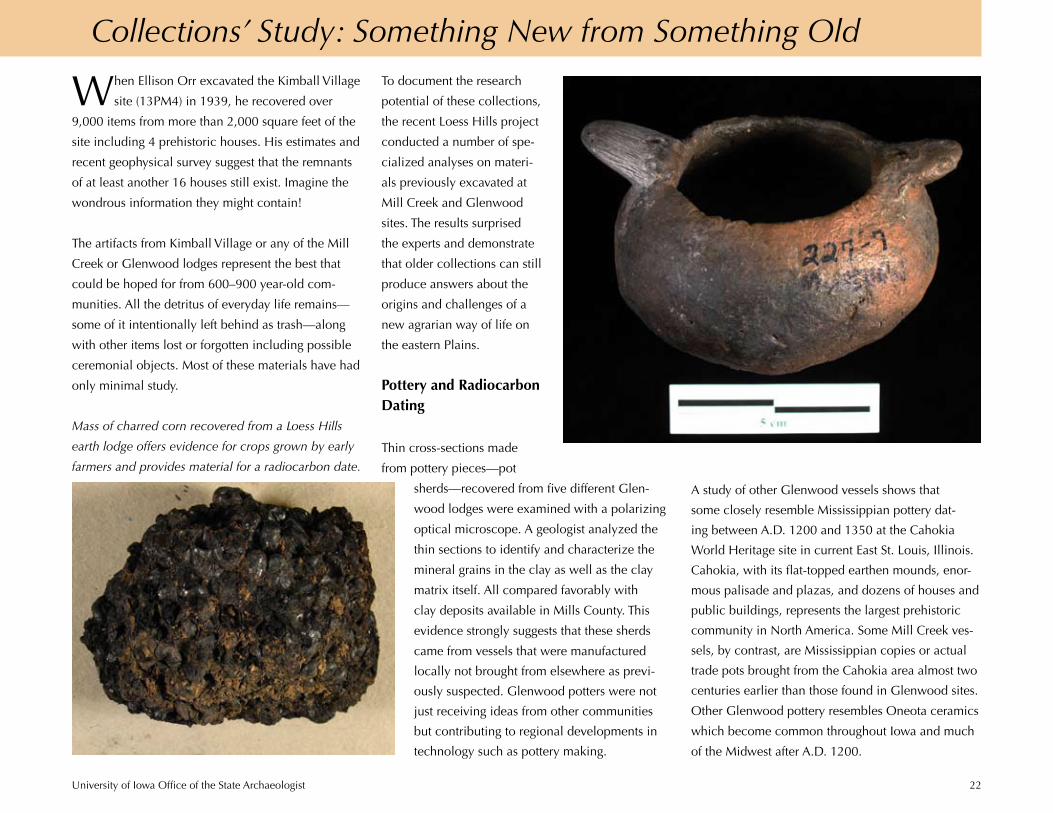
Collections’ Study: Something New from Something Old
When Ellison Orr excavated the Kimball Village
site (13PM4) in 1939, he recovered over
9,000 items from more than 2,000 square feet of the
site including 4 prehistoric houses. His estimates and
recent geophysical survey suggest that the remnants
of at least another 16 houses still exist. Imagine the
wondrous information they might contain!
The artifacts from Kimball Village or any of the Mill
Creek or Glenwood lodges represent the best that
could be hoped for from 600–900 year-old com-
munities. All the detritus of everyday life remains—
some of it intentionally left behind as trash—along
with other items lost or forgotten including possible
ceremonial objects. Most of these materials have had
only minimal study.
A study of other Glenwood vessels shows that
some closely resemble Mississippian pottery dat-
ing between A.D. 1200 and 1350 at the Cahokia
World Heritage site in current East St. Louis, Illinois.
Cahokia, with its flat-topped earthen mounds, enor-
mous palisade and plazas, and dozens of houses and
public buildings, represents the largest prehistoric
community in North America. Some Mill Creek ves-
sels, by contrast, are Mississippian copies or actual
trade pots brought from the Cahokia area almost two
centuries earlier than those found in Glenwood sites.
Other Glenwood pottery resembles Oneota ceramics
which become common throughout Iowa and much
of the Midwest after A.D. 1200.
Mass of charred corn recovered from a Loess Hills
earth lodge offers evidence for crops grown by early
farmers and provides material for a radiocarbon date.

University of Iowa Office of the State Archaeologist 23
Re-analysis of all available radiocarbon dates from
Glenwood and related sites on the Plains, also part
of the Loess Hills study, supports conclusions about
the age of Glenwood as suggested by the pottery
cross-dating. Glenwood culture apparently spanned
a period of A.D. 1200–1400 in southwestern Iowa,
beginning later and lasting longer than Mill Creek.
More Connections: Pipestone
Figuring out the source of materials used by ancient
people tells us where and how far they had to travel
to acquire desirable raw material or with whom they
might have traded. Among the artifacts found in earth
lodge sites throughout the Loess Hills are pipes, pen-
dants, and small animal-shaped objects fashioned
from red pipestone. As part of the recent study, many
of the pipestone items from Mill Creek and Glen-
wood collections were subjected to a specialized
analysis to determine the source of this raw material.
On the face of it, red pipestone, no matter where it
comes from, appears similar. In fact depending on
its source, pipestone has a unique mineral composi-
tion or fingerprint. Using a portable infrared mineral
analyzer (PIMA), geologists and archaeologists were
able to determine the original source of 76 pipestone
artifacts from Mill Creek and Glenwood sites. All but
six were made of catlinite, derived from the famous
deposits at Pipestone, Minnesota, which are still
quarried today by descendant peoples.
The PIMA analysis shows us how important the Min-
nesota pipestone was to Mill Creek and Glenwood
people. Even so, since five of the pipestone items
probably came from sources in Kansas, and one
piece of pipestone scrap from a Glenwood site possi-
bly came from Wisconsin, we know that their owners
traveled or traded in other directions as well.
George Catlin’s 1836 sketch of the pipestone quarries in southwestern Minnesota.

University of Iowa Office of the State Archaeologist 24
living near, and used by, the site’s
residents.
The primary source of animal
protein at Wall Ridge came from
three large mammals—bison (Bison
bison), elk (Cervus elaphus), and
deer (Odocoileus sp.). There were,
however, fewer of these species
present at 13ML176 than found at
other Glenwood sites. In contrast aquatic animals
were abundant—nearly 13,000 fish bones represent-
ing at least 21 varieties and about 400 individual
fish alone! Over half of these were species of catfish,
but others included gar, sturgeon, paddle fish, and
smaller varieties such as suckers and sunfish. The
identification of mussel shells and many shore birds
underscored the extent to which the Wall Ridge resi-
dents depended on aquatic resources.
Taken together, this most recent analysis suggests that
Wall Ridge differs markedly in the array of aquatic
species such as birds, fish, and mussels when com-
pared to Glenwood sites located inland along the
nearby Keg and Pony Creek drainages. It is evident
that this lodge was situated by the occupants to take
advantage of locally available animal resources with-
in both the Loess Hills and the Missouri floodplain.
The broad array of animals eaten, and the fewer
numbers of large mammals present, also hint at the
possibility that the Wall Ridge hunters were experi-
encing a period of large game depletion during the
site’s occupation. Understanding whether this was
actually the case may ultimately help explain why
Glenwood people abandoned southwestern Iowa.
While the Wall Ridge faunal study suggests that fewer
numbers of large game were hunted by the residents,
there is no question that people there were process-
ing these animals
for meat and hides.
A pilot microwear
study was conducted
on a sample of stone
scrapers from Wall
Ridge and two other
Glenwood houses
using an optical
microscope. The
results revealed the
presence of the kind
of polish along the
tool edges consistent
with their having been used against a soft material.
Experimental studies have demonstrated that such a
pattern typically results from hide working. Analysis
of similar scrapers from a Mill Creek site produced
comparable results. Unambiguous traces of hafting
on many of these scrapers, also visible under the mi-
croscope, shows that some would have been bound
into a handle.
Over 60 percent of the chipped stone tools from Wall
Ridge were made of chert that came from within a
50-mile radius of the site. Lesser numbers were made
of materials transported from sources 145 miles to
the southwest. Does the location of the chert sources
Making a Living
Animal bones, charred seeds, and artifacts tell us
about prehistoric diet, economy, and environment.
The recent Loess Hills study gave researchers an
opportunity to review and conduct new analyses
of these materials from existing collections.
Especially important were materials from Wall
Ridge (13ML176), a Glenwood lodge. The site was
excavated in 1984 prior to its destruction for use as
a highway barrow. It is, in fact, the only Glenwood
house site carefully excavated with stratigraphic
control from the modern surface to the lodge floor
and subfloor pits. Analysis of the recovered data has
been an ongoing project ever since.
Wall Ridge sits on the western border of the Loess
Hills which serve as the eastern valley wall of the
Missouri Valley. With the bones of more than 100
vertebrate and invertebrate species recovered in
excavation, the Wall Ridge fauna offers a “time cap-
sule” of the local and regional animal communities

University of Iowa Office of the State Archaeologist 25
also suggest the direction and distance Glenwood
people might have traveled to hunt large game?
Could Glenwood and Mill Creek people have been
preparing and trading dressed and perhaps painted
or quilled hides with Mississippian and other groups?
Red ocher, or iron oxide pigment, and ash residue
remained on some of the scrapers suggestive of
coloring used in decorating hides. Sharpened bone
awls—probably hide working tools— also occur in
profusion at these sites.
Choice of Diet
Ongoing paleobotanical study of charred seeds and
other plant remains from earth lodge sites indi-
cates that both wild and cultivated plants provided
more than half the required daily caloric intake for
Glenwood and Mill Creek peoples. Identified crops
include the indigenous weedy annuals of marshelder
(Iva annua), sunflower (Helianthus annuus), goose-
foot (Chenopodium berlandieri), little barley (Hor-
deum pusillum), and wild cucurbit (Cucurbita pepo
var ovifera); introduced crops of maize (Zea mays),
squash (Cucurbita pepo), and beans (Phaseolus vul-
garis); and the probable crops of maygrass (Phalaris
caroliniana) and erect knotweed (Polygonum
erectum). This evidence, together with the garden-
ing tools and storage pits found in the house sites
themselves, demonstrates the importance of farming
to these early Plains people.
Despite what we already know about such crops,
the potential exists for additional research on plant
remains and on the economic significance of agri-
culture itself. Such study would help better refine the
nature of the cultivated varieties and their relative
importance over time and among settlements. In
addition, the full extent of wild seeds, nuts, and roots
selected and utilized by Mill Creek and Glenwood
peoples is unknown. Such research has the potential
to offer a better and more comprehensive under-
standing of prehistoric Plains plant use as well as
contribute to contemporary issues of agricultural
sustainability.
The results of these brand new studies are pre-
liminary in nature. They underscore, however, the
potential that existing collections have to contribute
to a more refined and detailed understanding of the
economy, social interaction, community structure,
external contacts, and material culture of these early
sedentary Plains communities.
Carbonized
food residue
on a pot
sherd, a clue
to ancient
diet.
Starchy seeds
and greens of
chenopod or
goosefoot, a
crop grown
by ancient
Iowans.
Litka site, a Mill Creek garden and the only known
prehistoric field on the Plains.
Bone awl.
University of Iowa Office of the State Archaeologist 26
Historic Gateway
Imagine a great number of cabins and tents, made
of the bark of trees, buffalo skins, coarse cloth,
rushes and sods, all of a mournful and funeral
aspect, of all sizes and shapes, some supported by
one pole, others having six, and with the covering
stretched in all the different styles imaginable, and
all scattered here and there in the greatest confu-
sion, and you will have an Indian village. (Father
Pierre-Jean De Smet quoted in The Life of Father
De Smet, 1915:83 by E. Laveille)
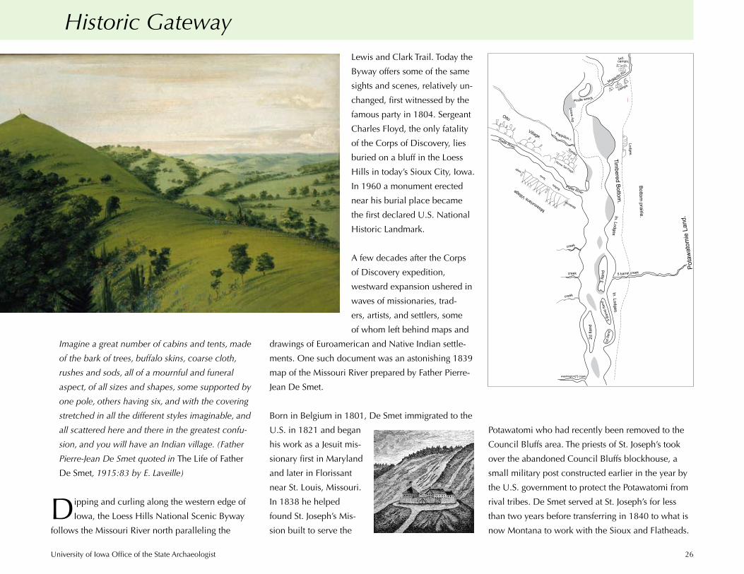
Dipping and curling along the western edge of
Iowa, the Loess Hills National Scenic Byway
follows the Missouri River north paralleling the
Lewis and Clark Trail. Today the
Byway offers some of the same
sights and scenes, relatively un-
changed, first witnessed by the
famous party in 1804. Sergeant
Charles Floyd, the only fatality
of the Corps of Discovery, lies
buried on a bluff in the Loess
Hills in today’s Sioux City, Iowa.
In 1960 a monument erected
near his burial place became
the first declared U.S. National
Historic Landmark.
A few decades after the Corps
of Discovery expedition,
westward expansion ushered in
waves of missionaries, trad-
ers, artists, and settlers, some
of whom left behind maps and
drawings of Euroamerican and Native Indian settle-
ments. One such document was an astonishing 1839
map of the Missouri River prepared by Father Pierre-
Jean De Smet.
Born in Belgium in 1801, De Smet immigrated to the
U.S. in 1821 and began
his work as a Jesuit mis-
sionary first in Maryland
and later in Florissant
near St. Louis, Missouri.
In 1838 he helped
found St. Joseph’s Mis-
sion built to serve the
Otto
Village.Platte River. Tombs.
Pappillon r.
Horse Tail Flags.
Platte River.
MissouriansVillage Buffalo
Tents
Medecine
bags
creek
creek
creek
washington[?] creek
2dIla
nd
1st I
land
5Ba
rrel I
land
In. Lodges.
3Ila
nd 5 barrel creek
Pota
wato
mie
Land
.
Bottomprairie.In. Lodges
Timbered
Bottom.
Lodges.
Musquito Riv.
camps.
camps.Ind.
dry
wood
.
Pirate wreck 6
Potawatomi who had recently been removed to the
Council Bluffs area. The priests of St. Joseph’s took
over the abandoned Council Bluffs blockhouse, a
small military post constructed earlier in the year by
the U.S. government to protect the Potawatomi from
rival tribes. De Smet served at St. Joseph’s for less
than two years before transferring in 1840 to what is
now Montana to work with the Sioux and Flatheads.
University of Iowa Office of the State Archaeologist 27
De Smet’s biography and letters
document the dangers and hard-
ships of life in Iowa in the 1830s.
It is, however, his remarkable
map of the Council Bluffs area,
rediscovered in the course of the
recent Loess Hills study, which
offers clues to the original loca-
tion and descriptions of Indian
settlements, trading houses, and
other features including tombs
and a shipwreck.
Although De Smet mapped the course of the Mis-
souri River from the Big Sioux to below the mouth of
the Platte, he only depicted cultural features in the
southern reaches of this territory. And while his work
was crude, the approximate location of both the
natural and cultural features he drew can be inferred
by aligning with more recent maps and by compari-
son with the archaeological site file at the University
of Iowa. A number of historic Indian sites recorded
in the site file appear to match those portrayed by De
Smet.
In 1853 Mormon migrants also passed through the
Loess Hills area, and their camps are an important
part of the historical and archaeological inventory.
Attracted to the rich agricultural potential of the Mis-
souri valley, a group of Mormons split from the main
wagon train and camped in an area known as Prepa-
ration Canyon, now a state park in Monona County.
Some continued their trek west, but others chose to
settle in the Loess Hills.
In 1859 Abraham Lincoln ascended the hills at
Council Bluffs to scout locations for the First Trans-
continental Railroad completed in 1869. Council
Bluffs later became the eastern terminus for the
1,774-mile-long rail line joining the Midwest to the
Pacific Ocean.
In 1865 the Steamboat Bertrand sank just 20 miles
north of Omaha, Nebraska, en route from St. Louis
carrying supplies to the goldfields of Montana,
depositing a treasure trove of information on 19th-
century life for archaeologists to uncover a 100
years later. Today the Steamboat Bertrand Collection,
housed at the DeSoto Bend National Wildlife Refuge,
represents the only public collection of excavated
cargo from a sunken steamboat. The U.S. Fish and
Wildlife Service maintains this Loess Hills related
collection under the Preserve America mandate that
focuses attention on nationally significant archaeo-
logical resources.
Steamboat Bertrand under excavation in DeSoto Bend National Wildlife Refuge in 1969.
University of Iowa Office of the State Archaeologist 28
Protecting Ancient Human Remains: A Tale of Three Sites
American Indian sites in Iowa, particularly burial
mounds, drew the early interest of antiquar-
ians and would-be archaeologists, and before the
close of the 19th century looting and exploration
had destroyed many. By the 1960s the practice of
exhibiting human skeletal remains in museums ran
headlong into American Indian activism. Protecting
the physical remains and the spirits of the ancestors
represented both a sacred trust and a challenge in
the pursuit of equal rights and self-determination for
American Indian people.
Inadvertent discoveries of human remains at three
locations in the Loess Hills in the early 1970s pro-
pelled Iowa to become the first state in the Nation
to provide legal protection for all human remains
regardless of age or origin found on public or private
land, and for the reburial of native Indian remains.
This offered a model for legal changes in other states,
ultimately presaging the 1990 passage of the federal
Native American Grave Protection and Repatriation
Act (NAGPRA).
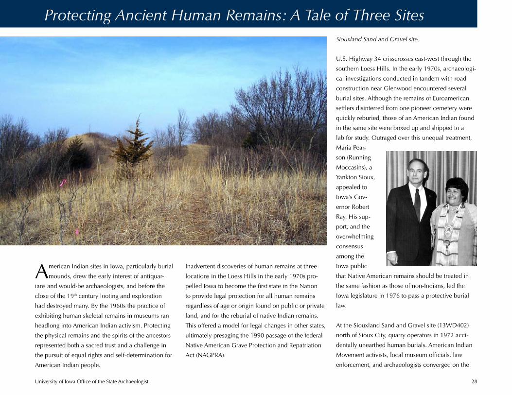
U.S. Highway 34 crisscrosses east-west through the
southern Loess Hills. In the early 1970s, archaeologi-
cal investigations conducted in tandem with road
construction near Glenwood encountered several
burial sites. Although the remains of Euroamerican
settlers disinterred from one pioneer cemetery were
quickly reburied, those of an American Indian found
in the same site were boxed up and shipped to a
lab for study. Outraged over this unequal treatment,
Maria Pear-
son (Running
Moccasins), a
Yankton Sioux,
appealed to
Iowa’s Gov-
ernor Robert
Ray. His sup-
port, and the
overwhelming
consensus
among the
Iowa public
that Native American remains should be treated in
the same fashion as those of non-Indians, led the
Iowa legislature in 1976 to pass a protective burial
law.
At the Siouxland Sand and Gravel site (13WD402)
north of Sioux City, quarry operators in 1972 acci-
dentally unearthed human burials. American Indian
Movement activists, local museum officials, law
enforcement, and archaeologists converged on the
Siouxland Sand and Gravel site.

University of Iowa Office of the State Archaeologist 29
site. Unfortunately, dissent-
ing viewpoints and armed
confrontation produced
a standoff resulting in the
destruction of important
cultural information from
a burial complex where as
many as 200 individuals
may have been interred.
Marine shell artifacts and
pottery found with the dead
indicated that their own-
ers, possibly late prehistoric
residents of nearby Mill Creek communities, had
traded with Mississippian people hundreds of miles
to the east and south. Recently, the Iowa Natural
Heritage Foundation purchased remaining portions
of the Siouxland Sand and Gravel cemetery and sur-
rounding areas to incorporate into Stone State Park.
The 1975 discovery of human burials in the borrow
area for the new Lewis Central School, just outside
Council Bluffs, again engaged law enforcement,
Indian activists, and archaeologists. The new State Ar-
chaeologist, Duane Anderson, contacted Maria Pear-
son for advice and assistance. She served as a liaison
with other Indian leaders who agreed to the removal
and reburial of the remains by a local undertaker.
On learning that the disinterments would take place
via bulldozer and backhoe, the Indian leaders chose
archaeologists to remove the remains using hand
tools instead. Indian leaders also permitted a physical
anthropologist to briefly examine the remains near by
the site prior to their reburial.
This event marked a turning point in Indian-archaeol-
ogists relations. The procedures followed in this case
to identify, analyze, and report the discoveries set a
precedent for the legal process still used in Iowa for
the handling and reburial of ancient human remains.
While the history of disease, injury, diet, population
demographics, social alliances, and warfare may be
written in the bones of ancient peoples, the study
Base of an imported, incised, egg-shell thin vessel
from 13WD402.
Lewis Central School site.
University of Iowa Office of the State Archaeologist 30
Iowa’s current legal requirement to
examine and report on all such mate-
rials before they are reburied consid-
erably increases our knowledge
about ancient peoples. In addition,
the Loess Hills discoveries and the
events which followed showed
the country that American Indians
and archaeologists could collabo-
rate in a respectful relationship to
achieve common goals.
of such remains also speaks to sacred places and
cultural values, both past and present. Prior to the
passage of Iowa’s reburial laws, this kind of study
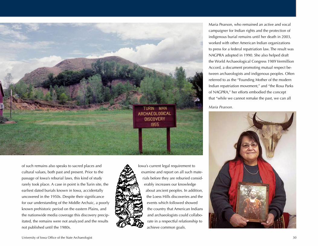
rarely took place. A case in point is the Turin site, the
earliest dated burials known in Iowa, accidentally
uncovered in the 1950s. Despite their significance
for our understanding of the Middle Archaic, a poorly
known prehistoric period on the eastern Plains, and
the nationwide media coverage this discovery precip-
itated, the remains were not analyzed and the results
not published until the 1980s.
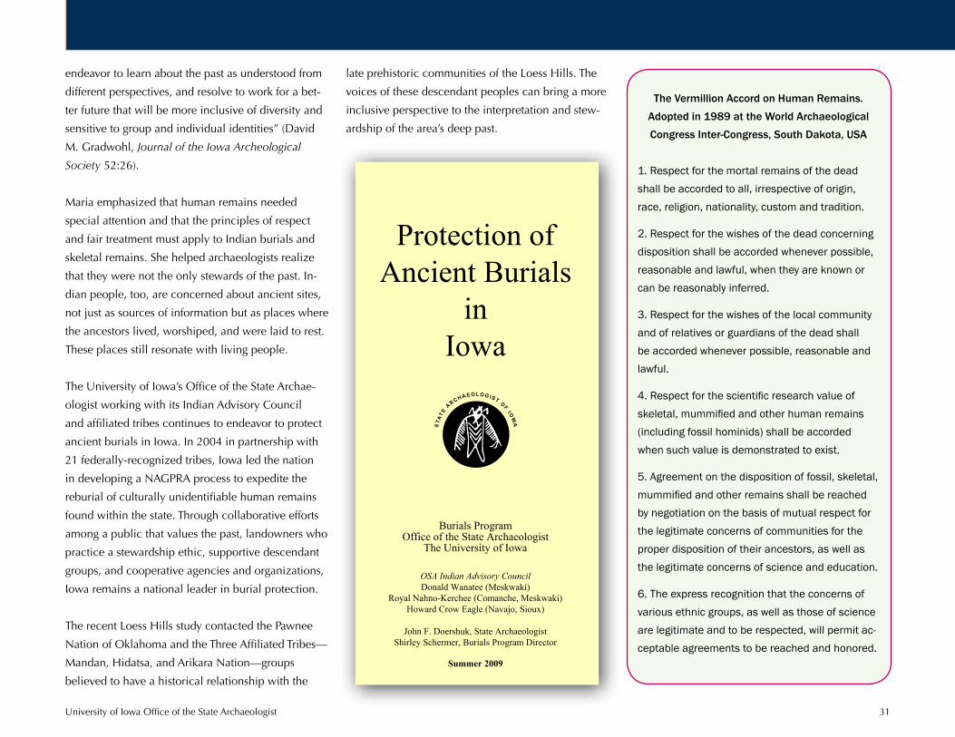
Maria Pearson, who remained an active and vocal
campaigner for Indian rights and the protection of
indigenous burial remains until her death in 2003,
worked with other American Indian organizations
to press for a federal repatriation law. The result was
NAGPRA adopted in 1990. She also helped draft
the World Archaeological Congress 1989 Vermillion
Accord, a document promoting mutual respect be-
tween archaeologists and indigenous peoples. Often
referred to as the “Founding Mother of the modern
Indian repatriation movement,” and “the Rosa Parks
of NAGPRA,” her efforts embodied the concept
that “while we cannot remake the past, we can all
Maria Pearson.
University of Iowa Office of the State Archaeologist 31
endeavor to learn about the past as understood from
different perspectives, and resolve to work for a bet-
ter future that will be more inclusive of diversity and
sensitive to group and individual identities” (David
M. Gradwohl, Journal of the Iowa Archeological
Society 52:26).
Maria emphasized that human remains needed
special attention and that the principles of respect
and fair treatment must apply to Indian burials and
skeletal remains. She helped archaeologists realize
that they were not the only stewards of the past. In-
dian people, too, are concerned about ancient sites,
not just as sources of information but as places where
the ancestors lived, worshiped, and were laid to rest.
These places still resonate with living people.
The University of Iowa’s Office of the State Archae-
ologist working with its Indian Advisory Council
and affiliated tribes continues to endeavor to protect
ancient burials in Iowa. In 2004 in partnership with
21 federally-recognized tribes, Iowa led the nation
in developing a NAGPRA process to expedite the
reburial of culturally unidentifiable human remains
found within the state. Through collaborative efforts
among a public that values the past, landowners who
practice a stewardship ethic, supportive descendant
groups, and cooperative agencies and organizations,
Iowa remains a national leader in burial protection.
The recent Loess Hills study contacted the Pawnee
Nation of Oklahoma and the Three Affiliated Tribes—
Mandan, Hidatsa, and Arikara Nation—groups
believed to have a historical relationship with the
late prehistoric communities of the Loess Hills. The
voices of these descendant peoples can bring a more
inclusive perspective to the interpretation and stew-
ardship of the area’s deep past.
The Vermillion Accord on Human Remains.
Adopted in 1989 at the World Archaeological
Congress Inter-Congress, South Dakota, USA
1. Respect for the mortal remains of the dead shall be accorded to all, irrespective of origin, race, religion, nationality, custom and tradition.
2. Respect for the wishes of the dead concerning disposition shall be accorded whenever possible, reasonable and lawful, when they are known or can be reasonably inferred.
3. Respect for the wishes of the local community and of relatives or guardians of the dead shall be accorded whenever possible, reasonable and lawful.
4. Respect for the scientific research value of skeletal, mummified and other human remains (including fossil hominids) shall be accorded when such value is demonstrated to exist.
5. Agreement on the disposition of fossil, skeletal, mummified and other remains shall be reached by negotiation on the basis of mutual respect for the legitimate concerns of communities for the proper disposition of their ancestors, as well as the legitimate concerns of science and education.
6. The express recognition that the concerns of various ethnic groups, as well as those of science are legitimate and to be respected, will permit ac-ceptable agreements to be reached and honored.
OSA Burials Program
The OSA Burials Program is involved in numerous field projects throughout Iowa. Museums, other repositories, and individuals also submit their collections to the OSA for examination and reburial. Since 1976, the program has handled over 2,000 projects in 98 of Iowa’s 99 counties. Field projects result in the discovery of many new sites and acquisition of new information on previously recorded sites. Field work involves verification of reports of possible burials or mounds, as well as examination of mounds or mound groups and other burials that are threatened by erosion, construction or quarrying activities, or vandalism. Many sites require periodic monitoring on an ongoing basis. Preservation of sites is always the preferred treatment. In cases where significant sites are threatened, the State Archaeologist has the authority (Code of Iowa, 263B.9) to deny permission to disinter. The results of analyses of human remains are published in order to disseminate the information obtained under the OSA’s statutory obligation to publish educational and scientific reports. Burials Program reports, which are filed with the Iowa Department of Health, integrate cultural and physical information recovered and serve to establish the significance of sites under investigation. The remains of over 1,200 individuals have been reburied since the program began. A cemetery on state-owned land was dedicated and set aside for this purpose in 1977. A second cemetery was established in 1979, a third in 1987, and a fourth in 1991. Remains are reinterred in the cemetery nearest to the original burial site, and a ceremony is held at or shortly after each reburial in accordance with the wishes of the Indian Advisory Council. Repatriation of tribally affiliated remains is conducted in compliance with the federal Native American Graves Protection and Repatration Act. The OSA Burials Program is dedicated to the protection of burial sites and human remains, to the reburial of ancient human remains, and to achieving a greater understanding of Iowa’s past. Regular consultation with the OSA Indian Advisory Council is a critical element of the program. All Iowans are served through the program’s protection of Iowa’s heritage.
“In Mesquakie religion our creator put us on this earth (not in Europe or Africa, but here). The earth is the ultimate repository for all people. . . . .The Mesquakie have adapted to modern ways, but our burials have not changed. All burials remain the same, inviolate.” Don Wanatee, 1980 Planning Seminar on Ancient Burial Grounds. “The Indian point of view on exhumation can be stated in simple terms. Basically there is rarely a good reason for removal of the dead from the ground where they have rested so long and when it does become necessary those human remains should be reburied as soon as possible and in a proper and dignified manner. . . . Our ancestors were human and we want them left alone. . . . We Indians respect our ancestors. They are present in our ceremonies and we call upon them for help to live our lives helping one another. . . . [They] were once people who once walked on earth, loved, prayed, took care of their families, died and were buried. . . . We believe that the dead should stay buried. There is enough land for everything that needs to be done so that a few acres left for our dead won't cause anyone to starve.” Maria Pearson, paper entitled The Indian Point of View: Exhumation and Reburial. “More Indians have died in Iowa over the centuries than anyone or any people today can ever remember the names of. Whole tribes have disappeared without leaving their names for our own generation. . . . I say it is possible, to see some of those old timers as living, breathing, thinking, feeling personalities with beliefs, fears, hopes, and prayers. In that sense those individuals are not really dead. If we can see them as real people, they are not really dead.” Robert L. Hall, anthropologist, 1983 Symposium on the Study of Ancient Human Skeletal Remains in Iowa. “Indians and scientists both have many good reasons for wanting to protect and preserve ancient burial sites. We need to form a partnership and work together toward common goals. We are allies and we must work side-by-side against the forces of erosion, development, looting and other factors that eliminate ancient burial grounds.” Duane Anderson, former State Archaeologist, 1980 Planning Seminar on Ancient Burial Grounds. University of Iowa Nondiscrimination Statement: The University of Iowa does not discriminate in its educational programs and activities on the basis of race, national origin, color, religion, sex, age, or disability. The University also affirms its commitment to providing equal opportunities and equal access to University facilities without reference to affectional or associational preference. For additional information on nondiscrimination policies, contact the Coordinator of Title IX and Section 504 in the Office of Affirmative Action, telephone 319-335-0705, 202 Jessup Hall, the University of Iowa, Iowa City, Iowa, 52242-1316.
Protection of
Ancient Burials in
Iowa
Burials Program
Office of the State Archaeologist The University of Iowa
OSA Indian Advisory Council Donald Wanatee (Meskwaki)
Royal Nahno-Kerchee (Comanche, Meskwaki) Howard Crow Eagle (Navajo, Sioux)
John F. Doershuk, State Archaeologist
Shirley Schermer, Burials Program Director
Summer 2009

University of Iowa Office of the State Archaeologist 32
Descendant Voices
Thanks to archaeology, Plains Indian tribes can
look to the distant past and feel a strong sense of
kinship and identity with those people of long ago.
The recent Loess Hills study of Glenwood and Mill
Creek sites shows continuity between these earlier
residents and various Plains tribes today. It is the
earth lodge dwelling in particular that makes that
connection. While this does not relate to every Plains
tribe, it does lend credence to those claiming certain
areas of the state of Iowa as their ancestral home
lands.
Among these is the Umonhon*—Omaha Tribe—a
Dhegiha-Siouan-speaking people now located on a
small reservation in northeastern Nebraska and west-
ern Iowa. Tribal memory claims that the Umonhon
People migrated westward following buffalo herds to
their present-day Iowa and Nebraska region. On the
Iowa side, this would place them in and around the
Loess Hills. Chiwere-Siouan-speaking Ioway, Oto,
and Missouri; a number of Dakota-Siouan bands;
and the Pawnee who spoke a Caddoan language
represent other peoples living in this same region.
Land was claimed by one tribe or another based on
continuous usage—occupation and hunting— and by
warfare.
We cannot confirm that the builders and occupiers of
the Mill Creek and Glenwood earth lodge dwellings
were the direct ancestors of the Umonhon People or
any other Plains tribe. The best one can do is to find
the common connections with the past—the tradition
of earth lodge building being one of them. We will
look at a year in the life of the Umonhon circa A.D.
1500 as a good example of earth lodge builders and
dwellers.
For the Umonhon, earth lodge dwellings were built
as a part of the life way of a hunting and somewhat
agrarian tribe. Being somewhat agrarian meant the
Tribe planted primarily maize along with other foods
such as squash and beans. These were harvested after
the great summer buffalo hunt, and the harvesting
was left to the women. Women were responsible for
bringing in the produce from their own small garden
plots. While the great hunt was the main tribal en-
terprise, nothing precluded individual families from
1718 map, Guillaume Delisle, depicts location of the
Maha—Omaha—and other resident people including
the Aiaouez (Ioway) near the confluence of the Mis-
souri River and Big Sioux (here R. du Rocher).
—Wynema MorrisIndependent Scholar
Omaha Tribal Member

University of Iowa Office of the State Archaeologist 33
augmenting that diet from time to time with other
fresh game, fish from the rivers, and wild fowl. Alto-
gether, the diet of the early buffalo-hunting Umon-
hon appears to be rather balanced.
This annual economic cycle exemplifies the dual
nature of the tribal life way which was both seden-
tary and on the move pursuing the buffalo herds. The
Umonhon People developed very sophisticated forms
of social and political structures in order to maintain
their survival as a tribe. As such, each year they lived
in a strict formal manner during the buffalo hunt and
in a more relaxed, informal manner shortly there
after.
It was as part of this more informal manner that the
earth lodge dwelling plays a dominant role. Because
earth lodges were more permanent, they were used
primarily during the cold winter months. During
this time, families, relatives, and, perhaps, even
close friends tended to gather in various areas to
live in close proximity to one another. In the earth
lodge configuration, the entrance to the dwellings
could face any direction. That is, the location of the
entrance was not dictated by the strict formality dur-
ing the summer hunt which required the entrance to
the tipi dwelling to face east. And, unlike tipi living,
more than one nuclear family could live in an earth
lodge.
It was during this time that the tribe broke into small-
er social groups of family, relatives, and friends. This
was when they could literally choose their neighbors.
Choosing one’s neighbor also extended to the earth
lodge dwelling itself, whose residents included at
least one nuclear family, perhaps grandparents from
both sides of the house, and a favorite cousin, uncle,
or aunt. Living arrangements would be close but not
necessarily cramped. Because it was by choice, get-
ting along with one another was probably easier than
the formal lifestyle of tipi dwelling while on the hunt.
Generally, within the tribe itself, usage of certain
areas was never contested. If a family or groups of
people left vacant the area they had occupied a year
earlier, then others would come and simply take it
over. It was the same with the women’s garden plots.
Year after year, if a woman used a certain plot of land
as the garden for her family, then it was considered
hers. If it appeared that she had abandoned it, then it
was taken and used by others.
During times of peace without consideration for
defense, earth lodge dwellings could be built in
favorite areas where other smaller game was plentiful
and water was readily available—despite its hav-
ing to be hauled. It would be the opposite during
times of inter-tribal warfare when fortification was a
definite consideration. At times when life was very
dangerous, uncertain, unpredictable, and unforgiv-
ing, protection of the family was paramount. The
building of a lodge would have fallen upon the male
members of the families living in the lodges. Again,
unlike tipi dwelling, where the tipi and everything in
it belonged to the women of the tribe, the earth lodge
dwelling was the construction domain of the men.
Left. Historic
Pawnee earth
lodge village of
1871. Below.
Detail of Pawnee
earth lodge.

University of Iowa Office of the State Archaeologist 34
The memories and stories told among the various
tribes recall times from their collective past. Living as
a tribe, both as hunters moving about on the Plains
during the summer and as settled people living in
the earth lodge dwellings during the winter, memo-
ries would be relayed in stories, legends, and myths.
Certainly, the ability to build an earth lodge dwelling
would be a skill that was most necessary and passed
along from generation to generation.
Constructing an earth lodge remained a skill well
into the early 1900s, long after the Umonhon were
firmly settled within the land base strictly prescribed
in the last treaty of 1854. By this time, all tribal
people lived in houses built upon their allotted lands
and scattered throughout the reservation. Gone for-
ever were the summer buffalo hunts, tipi, and earth
lodge living.
The writer’s father, who was born in 1909, however,
tells a story involving an earth lodge. Despite no
longer living in them, they appear to have been built
for other purposes. In this particular instance, the
earth lodge was used by various medicine men or
shamans, in which to practice their skills.
My father said he was about eight years old when
he and two playmates watched one of the medicine
men enter a nearby earth lodge. Becoming curious,
even knowing who the man was, the young boys
decided to spy upon his activities. The boys crept
silently up to the lodge and found a small crack in
the outer wall. Digging as silently as they could, they
created a small peephole that allowed them to see
inside. As each boy took
his turn, he gave a silent
cry and fled the area im-
mediately.
Being the last and now
only boy to take his turn
at the peephole, my fa-
ther wondered what was
so scary as to frighten his
playmates away. Peering
into the earth lodge, at
first he saw only a small
fire in the middle of the
lodge. After his eyes
adjusted, he said he was
staring directly into the
eyes of a grizzly bear!
The bear was standing
upright and “dancing” to
and fro when it turned
toward the peephole and
stared directly back at
my father. Of course, he
now understood that this
is what had frightened
his playmates and sent
them scurrying away so
suddenly, and he followed suit. After all, they had
seen a man enter the lodge and now in his place was
a bear!
Although this story sounds incredible and echoes the
shape-shifting stories among most American Indian
tribes, its outcome illustrates the tangible reality of
the incident to the people involved. Upon returning
to the safety of his home, my father told no one of his
escapade. The next day, however, one of the village
leaders came to visit his grandparents who raised
him. They were told what had happened and then
University of Iowa Office of the State Archaeologist 35
could now go to
their earth lodge
dwellings for the re-
mainder of the year
until the flowering
of certain plants the
following spring
marked the cycle
of the summer hunt
again.
The dwelling was
built primarily
from memory, and
only after it was
completed, did
the Omahas call
in the “experts”
from one of the
nearby colleges to
confirm that it had
been constructed “correctly”. To see and actually
enter an earth lodge such as the one constructed in
1978 was an amazing experience. It was larger than
what most pictures reflect and actually appeared to
be comfortable. Covering the doorway would have
been a large buffalo hide to keep out cold winter
air. A fire pit built in the very center afforded both
light and warmth to cold winter days and nights. The
fire would have functioned as the cooking hearth as
well. Sleeping and lounging areas surrounded the fire
place. Despite the informality of earth lodge living
tribal people and visitors were encouraged to enter
and exit the dwelling in a clock-wise manner.
fined. The recompense went to the medicine man
who had informed the village leader. Needless to say,
my grandparents were very upset with my father.
This story and many others suggest that some earth
lodge dwellings continued to be used as ceremo-
nial centers. In 1978 the Umonhon built their last
earth lodge dwelling upon their He’dewachi dance
grounds. He’dewach was the dance to give thanks for
a successful hunt. Traditionally, it was the last large
social gathering of the Umonhon after the summer
buffalo hunt. It served as a social marker ending the
formal tipi dwelling time and signaling that people
This last earth lodge dwelling built by the Umon-
hons, although indeed very sturdy, gradually decayed
from lack of interest and use by the tribal people.
Today, it is difficult to see the outline of the exact
spot of its construction.
This chapter started out thanking archaeology for
the studies done in unearthing these ancient dwell-
ings. Although it is difficult to link the distant past
to current tribes today, the tie remains due to the
tradition of some Plains Indian peoples in construct-
ing earth lodges. To claim earlier earth lodge dwellers
as the direct ancestors of these specific tribes is too
uncertain, but remnants of this past perhaps can be
gleaned by observing and learning from those tribes
today. Archaeological discoveries in collaboration
with tribal knowledge more richly informs this effort,
and gives the people of Iowa a reason to be proud of
our collective past.
*Where the author has used the term Umonhon, it must be
clarified that this could have included people from the other re-
lated Dhehiga-speaking tribes—Ponca, Quapaw, Kansa, Osage,
and Umonhon. According to various Umonhon elders, the Oto
and Ioway would also be included in this grouping. By the time
of the Lewis and Clark expedition in 1804, however, the Ioway
and Umonhon were long separate tribes that often warred
upon each other. Only the Ponca and the Umonhon appeared
to have maintained close ties and often intermarried with one
another. Yet, there is a story told by the Ioway that they are
the ones to have given the Umonhon people their name. It
bespeaks of a time when the Ioway were considered part of this
larger grouping of Dhegiha-speaking peoples.

University of Iowa Office of the State Archaeologist 36
Architectural Gems
tory to the present. Such properties illustrate trends
in agriculture, industry, and urban development, and
reflect the personal story of important figures and
events.
A limited survey conducted along
the Byway through the seven coun-
ties of the Loess Hills identified 139
buildings or properties as having
historical or architectural interest.
Of these, 13 have already been
nominated to the National Register
of Historic Places. Examples include
the William Haner Polygonal Barn
near Pisgah, Mann School No.
2 near Moorhead, and the Tabor An-
tislavery Historic District in Tabor.
With additional study, others could
be nominated. Such places relate
to important historical themes in
Loess Hills’ history including the
Lewis and Clark expedition, west-
ward rolling frontier, Underground
Railroad, growth of railroads, rise
and demise of towns, western Iowa
agriculture, and state and county
government and services.
The following specific buildings or properties identi-
fied in the survey offer just a sampling of the archi-
tectural gems recommended for additional study.
School houses, churches, farmsteads, bridges,
highways, railroad depots, grain elevators, barns,
commercial buildings, and homes—some still occu-
pied, others long abandoned—extend Loess Hills his-
Knox Church, Sidney vicinity,
Fremont County. Rural, abandoned
wooden church eligible for the
National Register of Historic Places.

University of Iowa Office of the State Archaeologist 37
Left. Argyle Street potential
residential district, Hamburg,
Fremont County. Several blocks of
this Hamburg residential district
spanning a century from 1850 to
1950, show promise as a historic
district.
Right above. Tabor Congregational Church, Fremont and Mills counties. An 1870s church
notable for both architecture and history, and featured in A. T. Andreas’ Illustrated Historical
Atlas of the State of Iowa, 1875.
Left. Holly Springs gym and auditorium, Woodbury
County. This education facility suggests both
architectural interest as a late “PWA Moderne”
building (a variant of Art Deco) and historical interest
as a remnant of the Holly Springs community, and
perhaps, the effects of school consolidations.

University of Iowa Office of the State Archaeologist 38
Left. Farmstead, Belvedere Township, Monona
County. This historic farmstead dates at least to the
1890s and has an impressive set of barns including
an extended monitor-roof hay barn with pass-through
side sheds for livestock.
Below. Old Lincoln Highway, Honey Creek vicinity,
Pottawattamie County. A cluster of older highway
features in this general vicinity may be associated
with the historic route of the Lincoln Highway,
America’s first transcontinental road.
Left. Logan potential commercial district,
Harrison County. Two dozen commercial
buildings, one currently on the National
Register of Historic Places.

University of Iowa Office of the State Archaeologist 39
Pisgah potential commercial district, Harrison County.
Pisgah’s main commercial district today shows the effects of the arrival of
the automobile in the early 20th century and improvements to the highway
through town. It also contains historic buildings from an earlier era that
revolved around the railroad and a less mobile local population.
Brick and stone homes of Thurman, Fremont County. Vernacular
masonry houses like this one are common in this small town. They
date from 1840 to1870 and have architectural interest.

University of Iowa Office of the State Archaeologist 40
Octagonal barn building, Tabor, Fremont County.
Intriguing large wooden building with eight irregular
sides and capped with a monitor roof suggests both
historical and architectural significance.
Missouri Valley potential commercial district, Har-
rison County. One of the larger communities along
the Loess Hills Byway, Missouri Valley’s Main Street
district appears vibrant today.
University of Iowa Office of the State Archaeologist 41
Greek Revival house south of Thurman, Fremont
County. This fine example of a Greek Revival-style
house, dating to 1861, is clearly eligible for the
National Register of Historic Places.
“The Brick,” Moorhead, Monona County. An impressive
town founders’ residence from the 1870s.
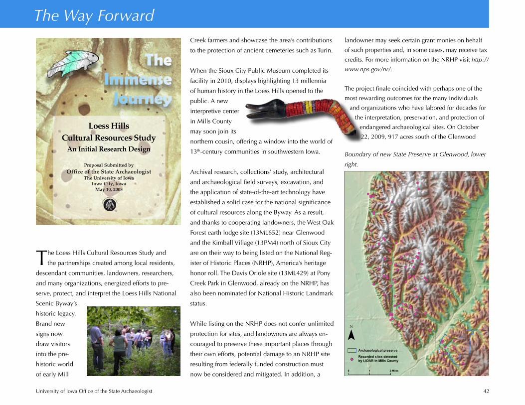
University of Iowa Office of the State Archaeologist 42
landowner may seek certain grant monies on behalf
of such properties and, in some cases, may receive tax
credits. For more information on the NRHP visit http://
www.nps.gov/nr/.
The project finale coincided with perhaps one of the
most rewarding outcomes for the many individuals
and organizations who have labored for decades for
the interpretation, preservation, and protection of
endangered archaeological sites. On October
22, 2009, 917 acres south of the Glenwood
Creek farmers and showcase the area’s contributions
to the protection of ancient cemeteries such as Turin.
When the Sioux City Public Museum completed its
facility in 2010, displays highlighting 13 millennia
of human history in the Loess Hills opened to the
public. A new
interpretive center
in Mills County
may soon join its
northern cousin, offering a window into the world of
13th-century communities in southwestern Iowa.
Archival research, collections’ study, architectural
and archaeological field surveys, excavation, and
the application of state-of-the-art technology have
established a solid case for the national significance
of cultural resources along the Byway. As a result,
and thanks to cooperating landowners, the West Oak
Forest earth lodge site (13ML652) near Glenwood
and the Kimball Village (13PM4) north of Sioux City
are on their way to being listed on the National Reg-
ister of Historic Places (NRHP), America’s heritage
honor roll. The Davis Oriole site (13ML429) at Pony
Creek Park in Glenwood, already on the NRHP, has
also been nominated for National Historic Landmark
status.
While listing on the NRHP does not confer unlimited
protection for sites, and landowners are always en-
couraged to preserve these important places through
their own efforts, potential damage to an NRHP site
resulting from federally funded construction must
now be considered and mitigated. In addition, a
The Way Forward
The Loess Hills Cultural Resources Study and
the partnerships created among local residents,
descendant communities, landowners, researchers,
and many organizations, energized efforts to pre-
serve, protect, and interpret the Loess Hills National
Scenic Byway’s
historic legacy.
Brand new
signs now
draw visitors
into the pre-
historic world
of early Mill
Loess HillsCultural Resources Study
An Initial Research Design
Proposal Submitted byOffice of the State Archaeologist
The University of IowaIowa City, Iowa
May 10, 2008
Boundary of new State Preserve at Glenwood, lower
right.
!(!(
!(
!(
!(
!(
!(
!(
!(
!(
!(
!(
!(!(
!(
!(
!(
!(
!(
!(
!(
!(!(!(
!(
!(
!(
!(
!(
!(
!(
!(
!(
!(
!(
!(
!(
!(
!(
!(
!(
!(!(
!(
!(
!(
!(
!(
!(!(!(
!(
!(
!(
!(
!(
!(
!(
!(
!(!(
!(
!( !(
!(
!(
!( !(
!(
!(
!(
!(
!(
!(!(
!(
!(
!(
!(
!(
!(
!(
!(!(!(!(
Archaeological preserve
Recorded sites detectedby LiDAR in Mills County
¯
0 1 2 Miles
!(
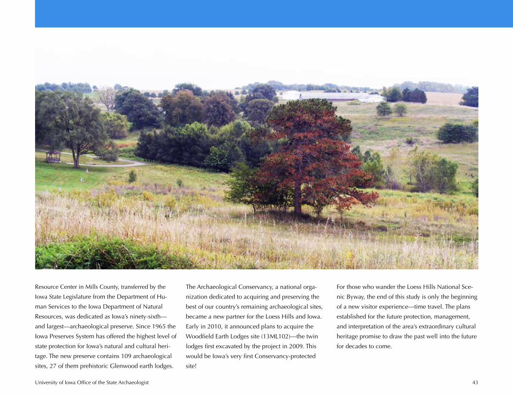
University of Iowa Office of the State Archaeologist 43
Resource Center in Mills County, transferred by the
Iowa State Legislature from the Department of Hu-
man Services to the Iowa Department of Natural
Resources, was dedicated as Iowa’s ninety-sixth—
and largest—archaeological preserve. Since 1965 the
Iowa Preserves System has offered the highest level of
state protection for Iowa’s natural and cultural heri-
tage. The new preserve contains 109 archaeological
sites, 27 of them prehistoric Glenwood earth lodges.
The Archaeological Conservancy, a national orga-
nization dedicated to acquiring and preserving the
best of our country’s remaining archaeological sites,
became a new partner for the Loess Hills and Iowa.
Early in 2010, it announced plans to acquire the
Woodfield Earth Lodges site (13ML102)—the twin
lodges first excavated by the project in 2009. This
would be Iowa’s very first Conservancy-protected
site!
For those who wander the Loess Hills National Sce-
nic Byway, the end of this study is only the beginning
of a new visitor experience—time travel. The plans
established for the future protection, management,
and interpretation of the area’s extraordinary cultural
heritage promise to draw the past well into the future
for decades to come.

University of Iowa Office of the State Archaeologist 44
Acknowledgements
Many local landowners, librarians, historians, private
collectors, colleagues, and organizations contributed
valuable assistance to this project. Their efforts
advanced the understanding and preservation of
cultural resources in the Loess Hills. Special thanks
to:
John Batt, Parks Department, City of Council BluffsBrenda Beier and family, GlenwoodWilliam Billeck, Smithsonian InstitutionDonald Blakeslee, Wichita State UniversityPeter Bleed, University of NebraskaRobert Bozell, Archaeology Laboratory, Augustana
CollegeEd Cambridge, GlenwoodHarlan “Sam” Collins, Council BluffsTerry Craig, Mills County MuseumSam Davis, GlenwoodKathy Dirks, Loess Hills National Scenic Byway CouncilKjertsi Emerson, Illinois Archaeological SurveyThomas Emerson, Illinois Archaeological SurveyHoward and Gertrude Ettleman, PercivalRichard Fishel, Illinois Archaeological SurveyJerad Getter, Mills County Conservation Board Kathy Gourley, Loess Hills National Scenic Byway
CouncilDavid Gradwohl, Iowa State UniversityWilliam Green, Logan Museum of AnthropologySteve Hansen, Sioux City Public MuseumDale Henning, Iowa CityJohn Hotopp, Louis Berger Group, Inc.Randall Hughes, Illinois State Geological SurveyPat Hume, Loess Hills National Scenic Byway CouncilHarold Johnston, TurinDoug Kuhlmann, Loess Hills National Scenic Byway
CouncilGrace Linden, Sioux City Public MuseumBrad Logan, Kansas State UniversityJohn Ludwickson, Nebraska State Historical SocietyKevin Mayberry, Loess Hills National Scenic Byway
CouncilJosh McConaughy and the Archaeological Conservancy Carrie Merritt, Mills County Historical MuseumDennis Michel, Loess Hills National Scenic Byway
CouncilDennis Miller, Silver City
Mark Monson, Loess Hills National Scenic Byway Council
Vergil Noble, Midwest Archeological Center, National Park Service
Patricia O’Brien, Kansas State UniversityPawnee Nation of OklahomaShirley Phillips, Loess Hills National Scenic Byway
CouncilRobert and Kathryn Rasmus, Sioux City Lauren Ritterbush, Kansas State UniversityCarol Smith, Council BluffsJason Titcomb, Sanford Museum and PlanetariumTheresa Weaver-Basye, Sioux City Public MuseumMichele Walker, Loess Hills National Scenic Byway
CouncilJohn Whipple, Fremont CountyColleen Wilbur, Loess Hills National Scenic Byway
CouncilPaul Williams, HintonSarah Wisseman, Illinois Archaeological SurveyLarry Zimmerman, Indiana University-Purdue Univer-
sityCouncil Bluffs Public LibraryGathering Place, SidneyGlenwood Earth lodge SocietyGlenwood Senior CenterIowa Department of Natural Resources Mills County Conservation BoardMills County Museum and Historical SocietyMonona County Conservation BoardSioux City Public LibraryTallgrass Historians, L.C.Three Affiliated Tribes–Mandan, Hidatsa, Arikara NationRuth’s Country Inn, MagnoliaWestfield Community Center
The project was ably completed due to the efforts of
additional colleagues at the University of Iowa Office
of the State Archaeologist:
Chérie Haury-Artz, Tricia Bender, John Cordell, Matthew Cretzmeyer, Mary De La Garza, John Doershuk, Colleen Eck, John Hall, John Hedden, Daniel Horgen, Julianne Loy Hoyer, Linda Langenberg, Carl Merry, Elizabeth Niec, Adam Newman, Michael Perry, Kayla Resnick, Christy Rickers, Clayton Schuneman, Anton Till, Kevin Verhulst
Image Notes
All images for educational purposes only. Catlin
paintings, Smithsonian American Art Museum, digital
images. Other images, photographs, and maps,
University of Iowa Office of the State Archaeologist,
unless otherwise noted:
Cover. Missouri at Sioux City, Karl Bodmer, 1833, American Sabbatical.com.
Page 1. George Catlin, William Fisk, 1849; Interior of a Hut of a Mandan Chief, Karl Bodmer, 1833–1834, Wikimedia Commons.
Page 2. Paul Rowe, family of Paul Rowe.Page 4. Belle Vue, Indian Agency of Major Dougherty,
870 Miles above St. Louis, George Catlin, 1832.Pages 7, 11. Reconstruction of two Glenwood lodges,
Angela R. Collins.Page 15. Mih-Tutta-Hangkusch, a Mandan Village, Karl
Bodmer, 1843–1844, Wikimedia Commons.Page 23. Pipestone quarry on the Coteau des Prairies,
George Catlin, 1836–1837.Page 25. Chenopodium plant and seeds, Wendy and
Michael Scullin; Litka site, Mary Helgevold.Page 26. Blackbird’s [Omaha] Grave, a Back View,
Prairies Enameled with Flowers, George Catlin, 1832; Blockhouse, later St. Joseph’s Mission, Council Bluffs, attributed to George Simon, Early Days at Council Bluff, Charles H. Babbitt 1916.
Page 27. Reverend Father Pierre Jean De Smet (1801–1873) Catholic missionary to Indian Territory, Mathew Brady, Wikimedia Commons.
Page 32. Map, Guillaume Delisle, 1718, Library of Congress, Geography & Map Division.
Page 33. Pawnee village, W. H. Jackson, 1871 http://www.firstpeople.us/; Indians Mud Lodge, William S. Prettyman, Date unknown, Oklahoma State Uni-versity Archives, Digital Library http://digital.library.okstate.edu/encyclopedia/entries/P/PA022.html.
Page 34. Medicine Man, Performing His Mysteries Over a Dying Man, George Catlin, 1832.
Page 35. Reconstructed 17th-century Wampanoag home at the “Wampanoag Homesite,” Plimouth Plantation, Plymouth, Massachusetts, Karin Goldstein, curator of collections.
Pages 36–41. Architectural photographs, Tallgrass Historians, L.C., Iowa City.Page 43. New State Preserve at Glenwood, Golden
Hills RC&D, Oakland.