the history of the earth the evolution of the continents
TRANSCRIPT

The History of the Earth
The evolution of the continents

The evolution of the continents
We have a good idea of the history of the continents over the past 600 million years.
Based on:
Paleomagnetic studies: positions of continents with respect to the poles.
Geological studies: similarities and differences of rocks on different continents and interpretations of ancient depositional environments.
Paleontological studies: similarities and differences of fossil organisms on different continents.
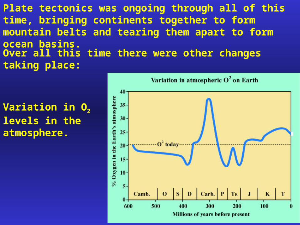
Plate tectonics was ongoing through all of this time, bringing continents together to form mountain belts and tearing them apart to form ocean basins.
Over all this time there were other changes taking place:
Variation in O2 levels in the atmosphere.

Variation in global temperature.

Variation in sealevel on several scales.

"Plate tectonic maps and Continental drift animations byC. R. Scotese,PALEOMAP Project (www.scotese.com)"
Several continental reconstructions are used in the lecture slides but are not available here. These slides are available at:

Cambrian Period
Gondwanaland: a supercontinent made up of South America, Africa, Australia, Antarctica, India and portions of other continents.
Located near the south pole.
Extensive glaciers covered much of Gondwanaland.
Part of Nova Scotia wasAttached to Gondwanaland.

North America, Europe, Siberia and Asia were all separate.
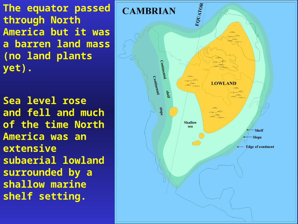
The equator passed through North America but it was a barren land mass (no land plants yet).
Sea level rose and fell and much of the time North America was an extensive subaerial lowland surrounded by a shallow marine shelf setting.

Ordovician Period
The separate continents were beginning to collide due to plate movement.
North America and Europe were coming together

Northern Appalachians began to form due to compressive force with plate convergence.
A trench along the northwestern margin of North America formed a volcanic island arc complex.
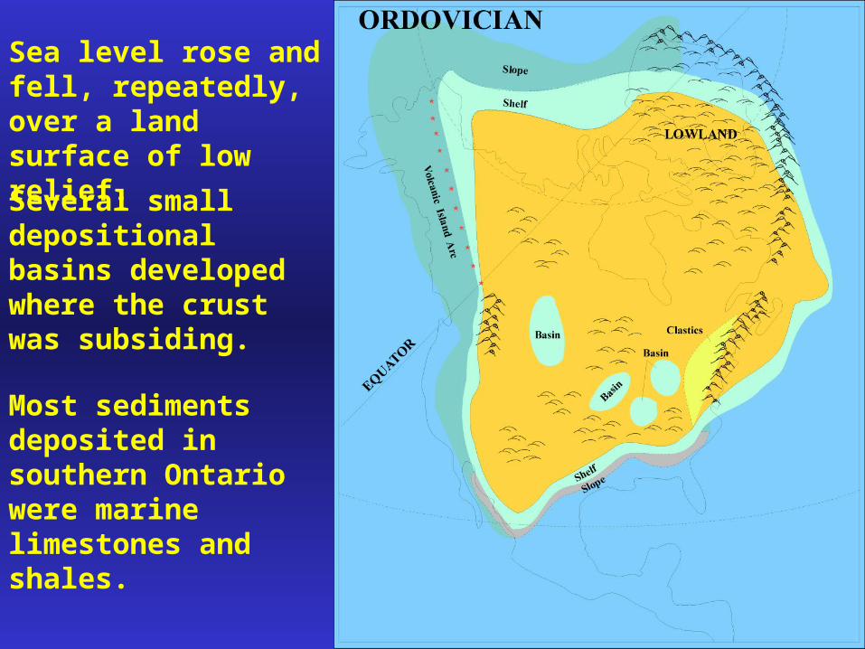
Sea level rose and fell, repeatedly, over a land surface of low relief.
Several small depositional basins developed where the crust was subsiding.
Most sediments deposited in southern Ontario were marine limestones and shales.

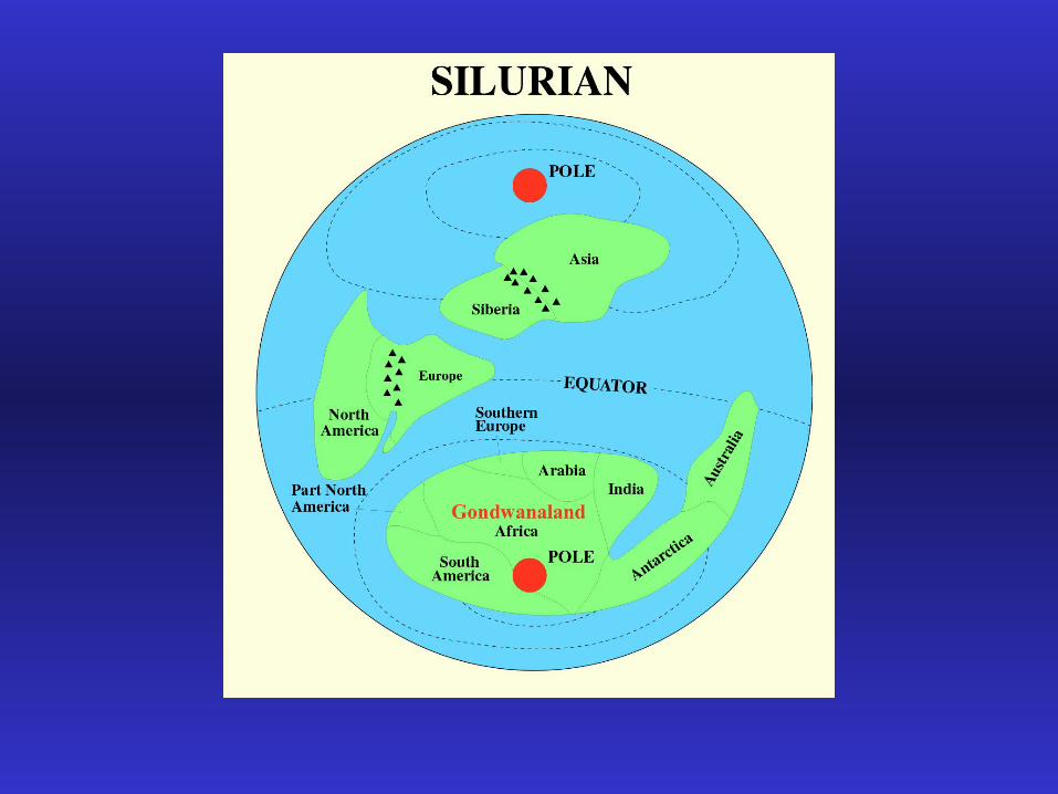
Silurian Period
North America and Europe joined (completing the central and northern Appalachians) by the end of the Silurian.
The Siberian/Asian continent was converging on Europe.
The North America/Europe continent began to approach Gondwanaland.

An extensive trench and volcanic arc developed along the east coast of North America.
Taconialand was the growing mountain range that was forming due to compressive forces associated with convergence of North America and Europe.

Southern Ontario received shales and sandstones that were eroded from the rising mountains.
55% of the natural gas produced in Ontario comes from Silurian sandstones.

In later Silurian time mountain building diminished and limestones were deposited in southern Ontario.
Rocks exposed along the Niagara Escarpment are all of Silurian age.
Much of western Canada was covered by a shallow sea in which limestones were deposited.

Devonian Period
Continued approach of North America towards Gondwanaland.
N. America, Europe, Asia and Siberia were beginning to form a second supercontinent: Laurasia.
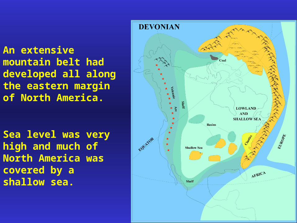
An extensive mountain belt had developed all along the eastern margin of North America.
Sea level was very high and much of North America was covered by a shallow sea.
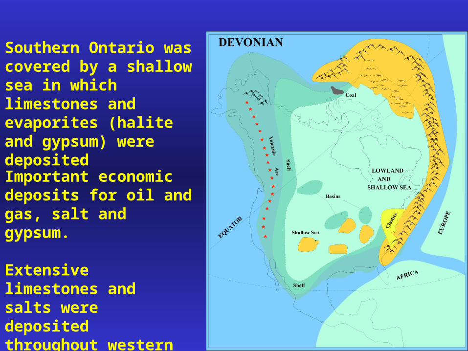
Southern Ontario was covered by a shallow sea in which limestones and evaporites (halite and gypsum) were deposited
Important economic deposits for oil and gas, salt and gypsum.
Extensive limestones and salts were deposited throughout western Canada.

A large limestone reef complex extended over much of Alberta.
These reef deposits are important sources of oil and gas today.
Oceanic crust continued to subduct along the west coast of North America (volcanic arc complex).

Carboniferous Period
Continents continue to come together.
African Gondwanaland collided with North America forming the southern Appalachian Mountains.
Much land mass near equator: abundant land plants, increased atmospheric O2.

Most of North America was covered by shallow seas or swampy lowlands.
Much of North America’s coal deposits were formed at this time.

Permian Period
Asia collides with Europe to form the Ural Mountains.
One large supercontinent (called Pangea) forms with the merging of Laurasia and Gondwanaland.
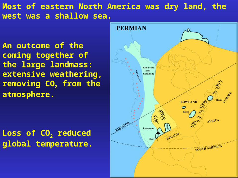
Most of eastern North America was dry land, the west was a shallow sea.
An outcome of the coming together of the large landmass: extensive weathering, removing CO2 from the atmosphere.
Loss of CO2 reduced global temperature.

Extensive volcanism in Siberia (related to collision): Siberian Traps, a flood of basaltic lava, 2 million cubic kilometres.
This extensive volcanic activity may have produced dust that further reduced the Earth’s temperature.
Lands were dry and cool, reducing plant cover and reducing O2 in the atmosphere.

Sea level was particularly low.
Permian ended with the most dramatic mass extinction in Earth history: up to 95 percent of marine life died off.
Pangea persisted and a second major mass extinction marks the end of the Triassic Period.
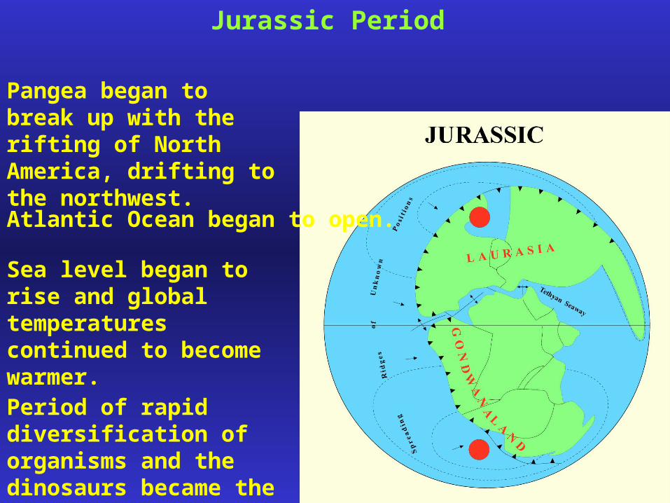
Jurassic Period
Pangea began to break up with the rifting of North America, drifting to the northwest.
Atlantic Ocean began to open.
Sea level began to rise and global temperatures continued to become warmer.
Period of rapid diversification of organisms and the dinosaurs became the dominant group.
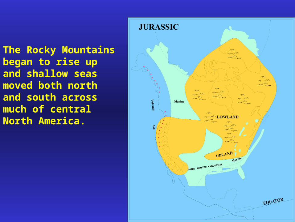
The Rocky Mountains began to rise up and shallow seas moved both north and south across much of central North America.

Cretaceous Period
Continents continued to move apart.
The Rocky Mountains went through a major period of construction in the Early Cretaceous.
Small land masses on the subducting Pacific Plate collided with North America.
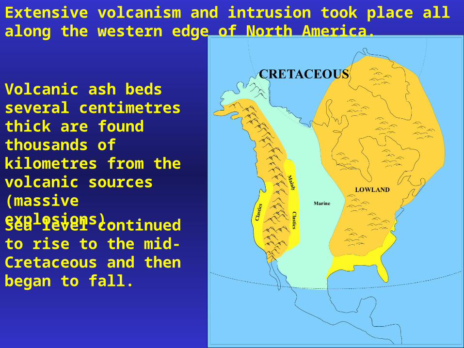
Extensive volcanism and intrusion took place all along the western edge of North America.
Volcanic ash beds several centimetres thick are found thousands of kilometres from the volcanic sources (massive explosions).
Sea level continued to rise to the mid-Cretaceous and then began to fall.
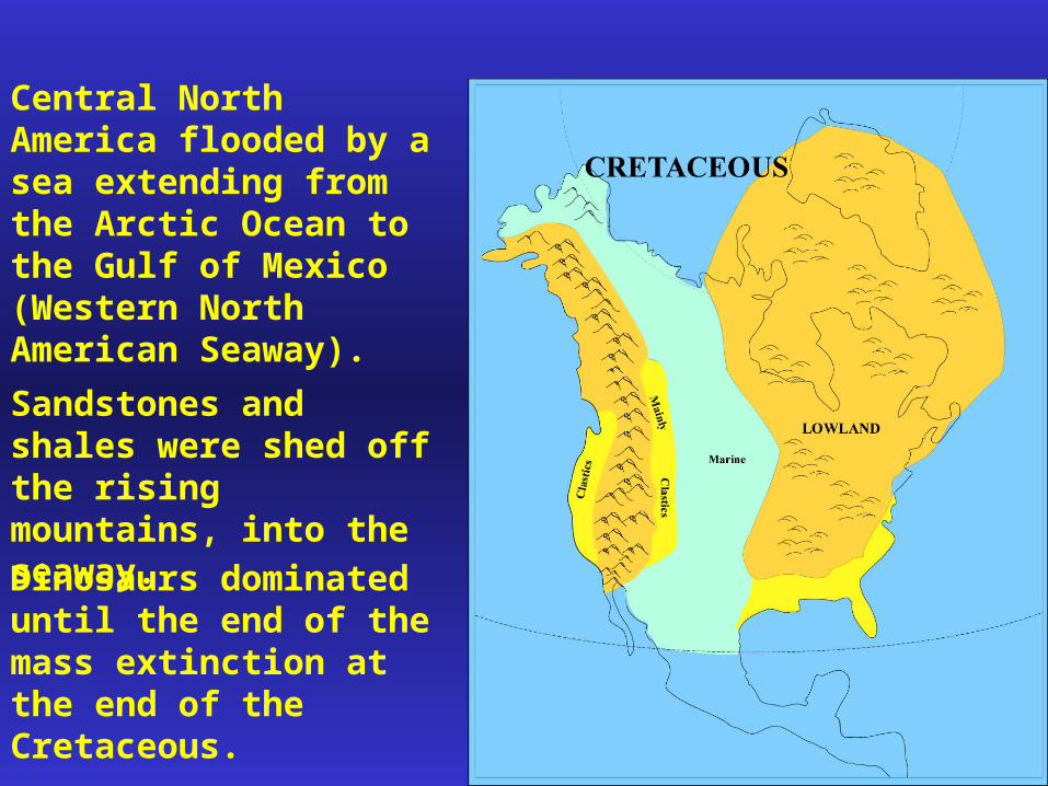
Central North America flooded by a sea extending from the Arctic Ocean to the Gulf of Mexico (Western North American Seaway).
Sandstones and shales were shed off the rising mountains, into the seaway.
Dinosaurs dominated until the end of the mass extinction at the end of the Cretaceous.

Cenozoic Era
North & South America, Australia and Antarctica spread away from Pangea, further opening the Atlantic Ocean.
Africa collided with Europe; India collided with Asia.
The early Cenozoic was another period of mountain building in the Rocky Mountains (more small collisions).

Mammals diversified and became the dominant group of organisms.

4 Billion years from now………..
The sun explodes, Earth is finished….