the geology of the timna valley with emphasis on …
TRANSCRIPT

THE GEOLOGY OF THE TIMNA VALLEY WITH EMPHASIS ON COPPER
AND MANGANESE MINERALIZATIONUPDATING AND CORRELATION WITH THE EASTERN MARGINS
OF THE DEAD SEA RIFT
Amit Segev, Michael Beyth
and Miriam Bar-Matthews
Report G .S .il14/92 Jerusalem, March 1992

...
Ministry of Energy and Infrastructure Geological Survey of Israel
TIIE GEOLOGY OF THE TIMNA VALLEY WITH EMPHASIS ON COPPER AND MANGANESE MINERALIZATION -UPDATING AND CORRELATION WITH THE EASTERN
MARGINS OF THE DEAD SEA RIFf
by
Amit Segev, Michael Beyth and Miriam Bar-Matthews
Rep. No. GS1/14/92 Jerusalem, March 1992

List of Contents Page
Abstract ....................................................................................................................... 1
Physiography ............................................................................................................... 2 Previous work .............................................................................................................. 2 Stratigraphy ................................................................................................................. 4
The Precambrian basement .............................................................................. 4 The Yrun Sui Group ......................................................................................... 4 The Kurnub Group ......................................................................................... 11
The Judea Group ............................................................................................ 12
The Mount Scopus and Avedat Groups ......................................................... 15 The Dead Sea Group ...................................................................................... 15 Summary ........................................................................................................ 16
Structural Geology .................................................................................................... 16 Introduction ....................... : ............................................................................ 16 The Trunad Fault ............................................................................................ 16 Dead Sea Rift ................................................................................................. 16 The Internal Structure of the Timna Valley ................................................... 16 Summary ........................................................................................................ 17
Mineralization ........................................................................................................... 19 Introduction .................................................................................................... 19 Metallic mineralizations in the crystalline basement.. ................................... 19 Mineralization within the Timna Formation .................................................. 19 Copper in the Shehoret Formation ................................................................. 22 Copper in the Kurnub Group ......................................................................... 23 Summary ........................................................................................................ 27
Acknowledgments ..................................................................................................... 28 References ................................................................................................................. 28

List of Tables Page
Table 1. Comparison of nomenclatures proposed by various authors for the strati gmphy for the Lower Cambrian in Timna Valley .................................. 8
Table 2. Concentrations of metalliferous clements in the Sa.'\gon Member. Timna Fonnation ............................................................................................. 8
Table 3. Chemical analyses of copper veinlets within the dolomitic lithofacies,
site 250 (see Fig. 9) ........................................................................................ 21
Table 4. Chemical analyses of metalliferous mineralizations within the Arnie
and Avrona foonations, Timna Valley .......................................................... 25 Table 5 . The average values of some metalliferous elements in iron concretions
in the Avrona Fonnation (20 samples, from Ayalon et al.. 1983) ................. 26 Table 6. Summary of copper occurrences on both sides of the southern
Dead. Sea Rift ................................................................................................. 27
List of Figures Page
Fig. 1. Location map and main fault pattern of the southern Dead Sea Rift ............... 3 Fig. 2. Paleogeography of the marine Cambrian after reverse structural
reconstruction of about 100km left-lateral strike slip ...................................... 5 Fig. 3. Cohunnar section of Timna Valley .................................................................. 7
Fig. 4. Schematic diagmm showing: a) lithofacies relations in the Sasgon
Member. b) Field relations ............................................................................. 10
Fig. 5. Columnar section of the Amir and A vrona formations
(from Weissbrod, 1970) ................................................................................ 13
Fig. 6. Stages in the development of the volcano-sedimentary
feature of the' Barak Formation ("the Crazy Wall"), Timna Valley
(from Weissbrodetal., 1989) ........................................................................ 14
Fig. 7. Block diagmm of the main faults in Timna Valley ........................................ 18 Fig. 8. Geological events at Timna Valley: 1) Late Lower Cambrian,
after marine regression. 2) Late Devonian, before uplift, maximal depth of burial about 2.5km. 3) Eocene, the end of the Tethyan
transgression. 4) Recent. For legend see also Fig. 6 ...................................... 20
Fig. 9. Sites of ancient mining activity (after Rothenberg, 1988) in Timna Valley ............................................................................................. 24

1
il::1 nYJmli1 n"1J lj)')1 "TN ,mJ'YJ "r.m mlJ1.l 0)1 o'n')I' ilniln limn nllj)::1
nJYJ 1N1.l n"1'0'::1 il11.l') In'Nil 'YJ il'l"'N'lil .m1nN n"""om m!)li:m::1 ilnYJlI) 0'::1' O"i'Nl, O"i"O il'1n::1'::10' )I».ln n)li'::1::1 ')I:.'n::1 'N'~' nJ'i)J ll)Ji'il IN)J .1947 0,'l11N 'YJ il'~t'''l'1.l ""1 m:1j)lI::1 SO-il mlYJ:1 .n\!.lmli1 m'J1.l m"lI!)' 'YJj)il:1 lj)'lI:1
il'i"lI:1 n':1'''''!l1.llj) ilTl::1l1 Nm 'nJ'li1 n",m .:1nlnil' In'N:1 lj)n1.lil ,nil In'N::1
nllj)l 'YJ ilj)'nOj)om (0"1::l1.lj) "l1.l ml'~n' YJl1 Oll) il'!)ll'010tm nN n1.lJ01.lil
nl1r.l:1 n"'::1j)1.l m1'n" lnN'\!.Iil' nm\!.lil n'l'~n::1 n\!.l"lnJil n"~l"')'1.l' YJ11 OlllllJ'Jn .il:1'lIil nlly :1
'00'::1 mTll' ,11J'n 1lIl,nnn 01"::l1.lj) "l1.l ,nllnYJl )llJ'Jn ,il1.l'YJ '1"I1.lll m"~n
: -~l"j)il ,mil 'l::lN .11"lIil Ol'l:11.li"1!)il1.l O"01.ll1.lil O'lI'Oil O":1n 'll onlap ':1) 'll '1::l1m ,:1'll'J n"::ln' ,J',\!.IYJ ,(11.30' ill'l:1l1 ,l'1.lN :ml'~n) O"~!)ill n""'l1N lI'1'lil lIlJ'Jn:1 .0"NmN"!) 0'''lJ'J'10 ,\!.I 1"1.l 2,500-J ''lJ )1'1'1 1"~1.lil ':1'O"N n,,'lJ1.l
.n1ln\!.l nl'~n ?YJ 1,nnnil "1!)' 111 ilN1lJ lI'l1.l ~i")Jil , l'lI'lJ ,CO'1 1')I)J) lJ1Xl::1 01')J ~U:l l"!)lN)J )lJr.m ll)li':l ,~ ill:l)Jil O'~ll ''')1 n1l)J:l' ,1m' O'Jml ")I)J O"'N""i"'''O O'~U ''')1 oni)Jl :1')I)J)J ,1'!)~)J
,n'1.lil 0' lIi'l nJ1l11.l1.l 0'1'11'
n,,!ln ~IQ O'O');),~nn on 1H'N·l )llY.lm nlQlnln n"~t"'l'Y.l' "i'Y.ln ')1'0
"lI!) ilJml il"01!)1.l0::1 m"Y.lln,i1m mO'1.ln ,o"z.onlj? ,0"Oll'!)N O'J'~)j1n:1 .lImn 0'n1NMil ll».l' ll~'nJil '!i::11Xl ,~ ll'!)'Oil il'~)lil' l)Jll1 )li'::1il '1::1~ "'~::1l ,1U<?
Nm 01 0111 )lmn nlli':1 l'!)~::1 l,nnnil l'i'mli'il 'YJ Ol'01.ll1.lill pn' .lImn nl'~n:1
l'i"nli' ,'m "nil 'l:lN:1' lIlJ::)n nl'~n:i 1ll1.l' n'lJ"Inl ?YJ il1'lJ)lil' ili'i) ,ilO)Jil ':I"iln,
·1,mn
ABSTRACT
The Timna Valley, the area of the ancient king Solomon mines, has been geologically studied since 1947 ,mainly dwing the operation of the Timna Copper Mines. The presentrepon includes the stratigraphy (with emphasis on the Cambrian writs) and the structure of the Timna Valley with emphasis on the copper mineralization and its correlativeoccWTences in the eastern Arava Valley
The Timna Fm., together with the Amudei Shelomo Fm., onlap a paleo-relief of the Precambrian crystallinerocks~ The TimnaFormation is conformably over1ain by the continental, fluviatile middle Cambrian(?) Shchorct Formation. The Mesozoic clastic sequence of the Kurnub Group was deposited on a regional erosive unconformiLy. which Lruncatcd abouL 2,sOOm of Late Paleozoic sedimentary sequence.
Structurally the Timna Valley ~ a high elevated internal magmatic core. cut on its eastern side by the Dead Sea rift .
The dolomites of the Timna Fonnationare the main source-rocks for copper and manganese mineralization in the area. Epigenetic. hydrothermal activity that occurred mainly along faults and lineaments of the Late Cenozoic Dead Sea rift. caused the [mal major enrichment of these metals. It is possible that Lower Cretaceous magmatic activity in the northern Timna Valley also contributed to the metallic rcmobilization and enrichcmcnt process.

2
PHYSIOGRAPHY
The Timna Valley, is an erosional horse-shoe shaped or half a "Makhtesh", bounded by steep cliffs on all sides except on the east, where it is open toward the southcrn Arava Valley. This valley is around 1Ox9km; its core is a topographical and structural high of Precambrian igneous rocks (magmatic massif, Har Timna, 5x3km) which is elongated in an E-W direction (Fig. 1).
The magmatic massif is surrounded by gently outward dipping (3-10 degrees) Lower Paleozoic to Upper Cretaceous sedimentary rocks. The lower parts Of the cliffs, which are up to 470m bigh, are built by the sandstones of the Lower Cretaceous Kurnub Group, and the upper parts, by the limestones and dolostones of the Upper Cretaceous Judea Group.
The Timna area is drained by seven eastward-running ephemeral streams: N. Nimra, N. Raham and N. Gadna, which drain the southern parts, including Hat Hahklil (409m in elevation); N. Nehushtan, which drains the southern parts of Hat Timna (448m); N. Timnn, which drains the northern parts of Hat Timna and the southern Hat Mikhrot area; N. Mangan and N. Sasgon which drain the northern parts of the valley including the northern Hat Mikhrot (334m) and Har Sasgon (297m) areas.
PREVIOUS WORK
The geological mapping of the southern Negev, including the Timna Valley, was done by Shaw (1947), Bentor and Vroman (1955), Bartov (1967). Garfunkel (1970). and Segev and Beyth (1983, 1986). Additional detailed mapping of mining regions within the Timna Valley was carried out by the geologists of the Timna Copper Mines. Detailed structural mapping was done by Mart and Horowitz (1981). The magmatic core ofHar Timna was mapped and studied by Zlatkineand Wurzburger (1957) and Beyth (1987b), and dated by Halpern and Tristan (1981), Bielski and Kolodny (1981), Bielski (1982) and Kroner and Beyth (1990). The stratigraphic units used in the mapping were mainly based on Bartura (1966), Weissbr9d (1969a,b; 1981) and Segev (1984, 1986a). The Hthoslratigraphy of the classic Paleozoic sequence (liN ubian Sandstones") was slUdied by Weissbrod (1981), thaL of the Cambrian marine sequence by Segev (1986a), andSegev and Sass (1989). On the basis of paleontological sLudies of the laLLer sequencc: a.tri1obites(parnes, 1971),andb. brachiopods (Cooper, 1976),aLowerCambrianagewas determined for this marine sequence.
Studies concerning the copper and manganese ores were made by Bentor (1952, 1956), Sturm (1953), MeLoad (1959), Milton (1966), Wurzburger (1967, 1970), Magarltz (1969), Bartora and Wurzburger (1974), Bar-Matthews (1986,1987), Segev (1986a,b) and Beyth (1987a). Copper mineralization in the Kurnub Group was studied by Keidar (1984).
Assuming a sinistral movement along the Dead Sea Rift (Freund, 1965) and that Feinan is the eastern continuation of the Timna Valley (Garfunkel, 1981, and Fig. 2), the works carried out on the easLern side of the rift also have

,../ . ,j j~.
,tI"!.."
W::fl '~YITA~~IN' UA~~"L",'I ~ CAMttAIAN
-fAUl.T
o 20 km bed I
3
60
Fig. 1. Location map and main fault pattern of the southern D~d S~ Rifl
11111'

4
important bearing for the present study. Bender (1965,1974) mapped the eastern margins of the Dead Sea Rift, including Lhe copper minesofFeinan-Wadi
Dana; Manganese mineralization in these areas was studied by Boom (1969); Basta and Sunna (1971,1972), Bigot (1982) and Heitkemper (1988) studied the copper and manganese mineralizations in the same areas.
Geochemical investigations were carried out in the Timna Valley by Ayalon et ale (1985), Segev (1986a), Beyth et ale (1988), and on the Jordanian side, by Burgath et ale (1984).
For further infonnation on previous work, see the Geological Research Bibliography of the Aravaand Elatregion (Bartov and Arad, 1989).
STRATIGRAPHY
Precambrian Basement
The magmatic rocks in the Timna area are in the northern margin of the Arabo-Nubian Massif (Bentor, 1961, 1985). A wide range of shallow intrusives and dikes ultramafic rocks to alkali granites constitute the Har Timna magmatic complex. This complex was studied by Zlatkine and Wurzburger (1957); Beyth (1987b) and Shpitzer et ale (1989; Fig. 3).
Detailed mapping and petrographic studies (Shpitzcr et al .• 1989) of a critical section in the northern part of the Hat Timna complex enable classifying the intrusive rocks inlO Lhree main groups: a) basic/ulLrclbasic (pyroxenehornblende-olivine-peridotites and pyroxene- hornblende-olivine- norites); b) intermediate (diorites, monzodiorites, monzonites, quartz monzo-diorite); and c) acidic (porphyritic calc- alkaline granites, perthitic alkali granites and albite-orthoclase alkali granites). .
The contacts between the basic/ultrabasic rocks and the intermediate rocks are gradual, whereas those between these two groups and the acidic rocks arc sometimes sharp and sometimes gradual. The contacts between rocks in the intennediate group are always gradual, with the exception of a quartz monzo-diorite body, which is located in the south of the area studied. This intrusion cuts all the other plutonic rock-types including the dikes of acidic composition.
Dikes can be classified into four main types: a) acidic (alkali rhyolites); b) basic to intermediate (dolerite to andesite), c) composite dikes, and d)doleritic dikes. The above-mentioned quartz-monzo-diorite intrusion is younger than the N-striking acidic dikes, but older than the NE-striking basic to intermediate ones.
Field relations between the various groups of rocks derme their evolutionary history as follows: 1. Calc-alkaline granite; 2.basic/ultrabasic and intermediate; 3. alkali granite; 4. N-striking dikes; 5. quartz monzo-diorite; 6. NEstriking dikes; 7. Doleritic dike.
Electron microprobe analyses of olivines, biotites and amphiboles from the various groups of rocks (Shpitzer et al., 1989) yield significant variations in Mg/Fe ratios. As the rocks become more acidic the Mg/Fe ratios of the major iron and magnesium-bearing phases decrease. This corresponds to the calc-alkaline AFM trend shown by whole-rock chemical analyses (Beyth, 1987b).
Ore minerals show a transformation from chromite in the basic/ultrabasic group to magnetite in the acidic rocks. Clinopyroxenes in peridotites have a high Cr~03 content of 0.70%. which is generally considered as indicating a mantle source. The mineral chemistry dalJ1 and field relations support a genetic model of calc-alkaline differentiation of the basic/ultrabasic-intermediate-calc-alkaline groups.
Uplift and peneplanation during the Lower Cambrian marked the end of the evolution of the crystalline basement
Yam Sui Group IntroducdoQ The exposed Lower Paleozoic (mainly Cambrian) sedimentary sequence, the Yam Suf Group in southern Israel,
which reaches a maximal thickness of 220m (Fig.3) represents an accumulation of mainly clastic platfonn sediments (Weissbrod. 1969. 1981).
Weissbrod (1981) suggested a few criteria to differentiate the various clastic units of the Paleozoic-Mesozoic sequence in southern Israel and the adjacent countries. The most important of the mineralogical criteria are the amount

5
of feldspars and the heavy mineral assemblages. The Lower Paleozoic sequences in the Timna Valley are composcc1 of arkosic and subarkosic sandstones and
characterized by tourmaline, zircon, rutile, apatite and barite.
r:l [)iWl ~ 1"·1 .. (0'+"01 I..!..!J
t N
~., .... ,. ." ...... '.1. ."4""' ... ".... ..H., .... . ........ 1111 ........ ., , ...... ,,..
Q ... , .. OOf'phf'" i,,,_'rUI, lult Uot ... .,oICGItIC'.
Po • .,...,'"
1.'f.,I". aa4 .. 1a1l'O" .. ee foeh
Fig. 2. Paleogeography of the marine Cambrian after reverse SU'Uctural rcconsU'Uction of about lookm left-lateral strike slip

6
Amudei Shelomo Formation. The Amudei Shelomo Formation was studied in the Timna Valley by Karcz and Key (1966) and Karcz et al. (1971). This formation is composed of fine-grained to grit size, rounded and poorly sorted, brown red and gray subarkose, with lenses or beds of quartzitic pebble-conglomerate.
Often the crystalline basement is overlain by a base conglomerate, and close to the Amudei ShelomoPillars (coord. 145500/908700) angular granitic boulders, of up to 2m in diameter, were described by Karcz and Key (1966). In places. mainly close to the lower contact, a bed of dark red, brown micaceous silts (paleosols?) about 1m thick was found. The subarkosic sandstones are composed of quartz grains (up to 90%), feldspar, mainly microcline (up to 15%), lithic fragments, (up to 10%) and heavy minerals. Large to medium scale trough and planar cross stratification, from 5-2SOcm thick and 0.2-10.Ocm wide, are common.
The sands and conglomerates of this formation were deposited in a fluviatile environment, on a widespread erosional unconfonnity (usually peneplaned), with a relief of up to 90m deep in the Timna area. These overlie the Precambrian basement with main directions of paleo-channels running E-W and NW-SE. The upper contact is regular.
The age of the Amudei Shelomo Formation is constrained by the Rb-Sr age of 525-535 Ma (Early Cambrian) of the alkaline volcanic rocks, which terminated the Precambrian magmatism (Segev, 1987), and the biostratigraphical Upper Georgian (late Lower Cambrian; Parnes, 1971) age for the overlying marine Timna Formation.
Timna Formation Introduction Since the Timna Fonnation was found to have the greatest potential for metallic mineralizations, especially eu
and MIl. its rock units are dealt with in detail. The deposition of this fonnation marks the rust Phanerozoic marine transgression in the Middle East It was
dcscribedin southcm Israclby Bcotor (1952),Picard (1953),Nevo(1954),Barturaand Zcmel(1956),Bartura(1966), Weissbrod (1969a,b), Garfunkel (1970), Segev (1984, 1986a) and Segev and Sass (1989).
Theformation crops out on both sides of the Dead Sea Rift Valley: in southern Israel (Fig. 1) in the vicinity ofTimna Valley ,Hat AmramandElatcontinuing to southeastern Sinai; on the Jordanian side from Feinan to the northcrnDcad Sea (BJanckenhorn, 1914; King, 1923; Picard, 1943; Bcnder, 1974; Bigot, 1982).
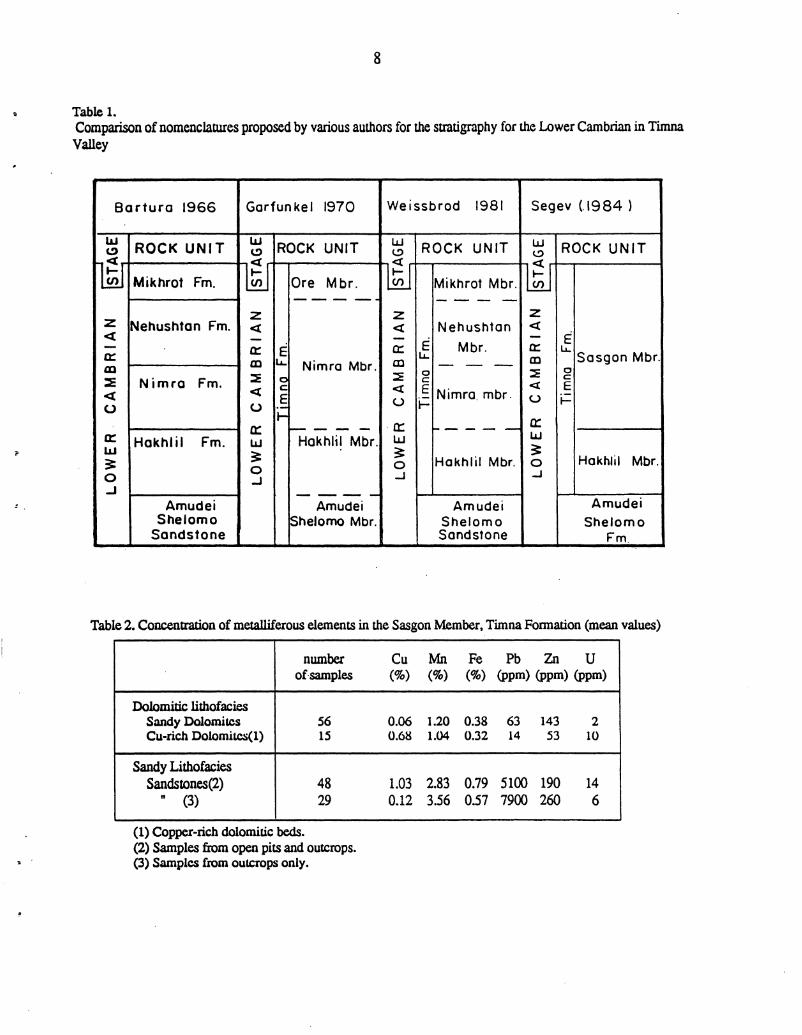
The TimnaFormation was subdivided by Segev (1984), on the basis of the newer geological mapping (Segev and Beyth, 1983) and a better understanding of the field relationships. The previous subdivision and the various nomenclatures are presented in Table 1.
Hakhlil Member The Hakhlil Member is the lowest member and is composed of four sub-units (from bottom to top):
A.Base conglomerate (0-3.75m thick) - pink to brown polymictic conglomerate with poorly sorted, angular rhyolitic fragments, which are up to 20cm in diameter, and well rounded, well sorted quartzitic pebbles up to Scm in diameter.
B.Laminar sandstone (1.7-Sm) - wen laminated red sandstone, fine-gmined to grit The cement is mainly carbonatic in the western areas of the .Timna Valley.
C. Carbonatic unit (1.2-8.5m)-altemating beds off me-grained sandstone to grit, cemented by dolomite and calcite, _ and sandy dolomites. These beds exhibit cross-stratified internal structures,ripple marks, crawl marks, mudcracks
und pscudomorphic structures after halite crystals. The carbonate layers are inlCrbcddcd with red, purple and green siltstones and shales, in places with manganese oxides.
D. Silty shaly unit (3~m) - varicolored shales and silts containing thin beds and lenses of limestone and dolomite, forming a soft morphology, which serve as a good marker for the upper Hakhlil Member contact. The lower boundary of the Hakhlil Member, where it directly overlies (onlap relationships) the crystalline
basement, is an angular unconformity (lIar Timna, western Timna Valley). The boundary with Amudei Shelomo Formation is conformable. The upper boundary with the Sasgon Member is also conformable.
Sasgon Member The Sasgon Member, which constitutes the upper part of the Timna Formation, displays three lithofacies (Segev,
1984): the lower dolomitic (previously Nimra Member) and sandy (previously "Zebra" or Nehushtan Member)

lithofacies. which occupy lateral stratigmphicpositions. whereas the third. known as the shaly lithofacies (previously Mikhrot Mcmbcr).ovcrlies the twolowcroncs (Figs. 4a and b).
In a few sites in the eastern Timna Valley the lowel' part of the Sasgon Member is composed of a sandstone and grit bed with a few well-rounded quartzitic pebbles. It is found cast of Hat Mikhrot. south of open pit 'r and west ofHar Hakhlil. The maximal thickness of this bed is 7.Sm. and it wedges out westward within a short distance. a) Dolomitic Lithofacies:
This Wlitin the Timna Valley consists of well-bedded sandy dolomiLCS and dolomitic sandsLoncs; its maximum thickness is 28m. Sedimentary structuIes of laminar stromatolites, cross-stratification. ripple marks and fossil remnants are very common in the study area. indicating shallow water and marine environment of deposition (Segev .198&1. Segev and Sass. 1989).
The acid soluble phase of the sandy dolomites bas a relatively high metal content (Table 2). Most of the dolomites have an average coppel' content of about 0.06%. Higher values. averaging 0.68%. are found in copper-rich dolomitic beds commonly showing stromatolitic structures and containing tine detrital components.
The manganese content of the dolomites situated within the dolomite crystals is significantly high (1.7-2.8%). Slightly high zinc (-l4Oppm) and uranium values also cbaracterize most of these rocks. The uraniumcontcntin thecommon sandy dolo-
. mites highly fluctuates. ranging from 0.8ppan Lo 10.6ppan; Lho avcmge value ill about 2ppm. The above-mentioned copper-rich horlzonscontain signiflCandy high uraniwncontents.rangingfromS1031ppm U in the whole horizon.
7
AGE ROC k UNITS
.L .L
130 GEROFIT Fm.
eL~~Ls ~ TURONIAN r:l~~[~=~-~l:
U. CRETACEOUS
100 ORA SHAI.E
-I-~~==---.J : ·L~r:-. - - ,,-
CENOMANIAN 130 I""r--""""'r""i HAZERA Fm.
L L L L :.~:;.~:.:~:.~:.:
o ..
I.. CRETACEOUS
". ;.~\;i·· ".. ,- ~ - - - - -1----'r.~'"" .. .:.:..:...,.:._=_.:1 .• ------1 ~
CAMBRIAN
?
IIIDDI.E
CAII,RIAN
?
PRECAMBRIAN BASEMENT
(t'~92!7 m,~,)
50 : :-:-::::::-: AMIR 'm.
+ to .,
• + • . .. . - .. ,. . . . . of .. .........
a: ~
"
1-.+. ·119neou s rocks I·;::: .. :::;] Sandstone 8 ColomitB
E5!ll.imestone ( ..... 0'''''1 Marl
1:.°0"1 Conglomerate
/0 01 Mega fauna 1=-=1 SlIale
CU, Mn, P, U - copper, monqone$e, pllospllale and uranium mineralizations
Fig. 3. Columnar section of Timna Valley
8
Table l. Comparison of nomenclatures proposed by various authors for the stratigraphy for the Lower Cambrian in Timna Valley
Bartura 1966 Garfunkel 1970 Weissbrod 1981 Segev (.1984 )
w ROCK UNIT
w ROCK UNIT w ROCK UNIT lJJ ROCK UNIT C) C) c..!) c..!)
r® Mikhrot Fm. ~ Ore Mbr. ~ Mikhrot Mbr. lili ---- --- -z z z z Nehushtan Fm. <t <t Nehushtan <t
<t - - - E - a: E a:: E Mbr. a: lL. a:: Lt.. lL. (Il Sasgon Mbr.
(Il Nimra Mbr. (Il - - -CD ~ 0 ~ 0
:::E Nimra Fm. ~ ~ c: c <t E <t E
<t <t E Nimra. mbr. u i= u u It: u I-
.0:: 0:: 0:: ~- - - 1-----a:: Hakhlil Fm. w Hakhlil Mbr. w w
w ~ ~ ~
~ 0 0 Hakhlil Mbr. 0 Hakhlil Mbr. 0 ...J ...J ...J
.J ----Amudei Amudei Amudei Amudei
SheJomo Shelomo Mbr. Shelomo Shelomo Sandstone Sandstone Fm
Table 2. Concentration of metalliferous elements in the Sasgon Member, Timna Ponnation (mean values)
number of samples
Dolomitic lithofacies Sandy Dolomites 56 eu-rich DolomilCS(l) IS
Sandy Lithofacies Sandstones(2) 48
n (3) 29
(1) Copper-rich dolomitic beds. (2) Samples from open pits and outcrops. (3) Samples from outcrops only.
Cu Mn (%) (%)
0.06 1.20 0.6H 1.04
1.03 2.83 0.12 3.56
Fe Pb Zn U (%) (ppm) (ppm) (ppm)
0.38 63 143 2 0.32 14 53 10
0.79 5100 190 14 0.57 7900 260 6

9
b) Sandy Lithofacies: The sandy lithofacies (manganese-rich sandstones) is made up of fme- grained to gritty subarkoses. cemented by
manganese oxides. clay minerals and often by authigenic fluorapatite. Although it may attain a maximum thickness of 21m it is generally 5-7m thick:.
This lithofacies displays a wide range of secondary structures. such as steeply inclined strata, deformed and contorted lamination. collapse structures. poorly sorted breccias and intrafonnational faults (Segev. 1986a; Segev and Sass. 1989).
The metal content in the acid soluble fraction of these rocks (Table 2) is usually higher than that of the dolomitic lithofacies. Copper. in the form of silicates, carbonates and phosphates, constitutes an average content of 0.12%. Rocks with a higher Cu content (up to 1.5%) (Bartura and Wurlburger, 1974; Segev and Sass, 1990) are found in both the sandy and shaly lithofacies, and until recently, were considered worth mining.
The average manganese content in these sandstones is 2.83%, forming manganese oxides, mainly hollandite. cryptomelane. pyrolw;ite and coronadite (Bar-Matthews. 1986, 1987).
The main uranium accumulations in the sandy lithofacies are associated with the fluorapatite cement forming discordant veinlets and non-continuous lenses varying in size from a few centimeters to several tens of meters. The P lOS content in these phosphate-rich sandstones varies from several percent to >30% in phosphorite concretions. The common P content wilhin the copper orcs, as defined by Bru-sky (1978), is 0.34-0.43%. c) Shaly Lithofacies:
The shaly lithofacies. overlying both the dolomitic and the sandy lithofacies, has a uniform thickness of 1.5-2m, and consists of clays. siltstones and fine-grained subarkoses. These rocks are usually light green, red or brown. but in places they are black and mottled due to ~ganese mineralization. The shales are often contorted and the base of the overlying Shehoret Formation is brecciated.
In places, cryptocrystalline fluorapatite (micritic phosphorite; Bar- Matthews. 1986) forms small (tens of centimeters long and up to 15cm thick) lenses in one or two horizons in the shaly lithofacies commonly containing 400-75Oppm U, and in one lense (probably of secondary origin) up to 4000ppm U (Segev and Beyth, 1983). Similar phosphate-rich shales were found in the Feinan region, SW Jordan (Heitkemper, 1988), indicating wide distribution of this phenomenon. and perhaps, a sedimentary origin of this feature.
Summary Based on detailed facies analysis, sedimentologicalo, petro~phical and geochemical studies. Segev (1986a) and
Segevand Sass (1989) concluded that these lateral transitions between the dolomitic and the sandy lithofacies are not depositional. They suggested that the sandy lithofacies is the in-situ insoluble residue (secondary product) of the sandy dolomites, and was formed by epigenetic dissolution (karstification) of the carbonate (dolomitic) fraction caused by circulating, heated-up acidic groundwater ascending through faults and jOints.
The retention of the original manganese, copper, zinc and uranium (which were already enriched in the original dolostones), as part of the insoluble residue, together with the sand grains was an additional consequence of this dissolution process. The resulting enrichment of these elements was modified by local redistribution and formation of cements, nodules and inegular veins.
The composition and the sedimentological features of the Cambrian marine. including the Hakhlil and Sasgon members, in the study area represent shallow walCr and intertidal marine environments in restriclCd marginal basins.
The TimnaFormation, together with the Amudei Shelomo Formation, on lap the palco-relief of Ihe Precambrian crystalline rocks. As a result, the Timna Formation decreases in thickness from 45m in the western Timna Valley to zero in the northern part and toward the south. in Har Amram, approximately 7km south of the Timna Valley.
The TimnaFonnation is conformably overlain by the continental, fluviatile, Middle Cambrian(?).lower Shehoret Formation (Weissbrod,1969a,b).
Sbeboret Formation In southern Israel and Sinai the ShehoretFormation was divided into three members (Weissbrod, 1969a,b; 1981).
according to color and sedimentological criteria (from top to bottom): Variegated Member, White Member. Multicolored Member ("Cassata").

a.
b.
o
Shehore I Fm.
E ... c(
z ::E
I-
Mbr.
ROKIiIl Mbr.
f.f:::·:1 Sondy dolomile
f!.;:;·tn Sandy limes lone
b.:.::).l Sandstone
10
r::~:\\Grit and conglomerate
r:~~l Sills tone
1=:=\Shale
, ... \ Cheri lenses
BphOSPharite
Cu - Copper mineralization
R Cross bedded sandstone t~?::~ql'n'raformolional breccia Mn - Manganese mineralization
., - Megofossil:. traces
"®. Dolomitic lithofacies.
20m
Scale
® Sandy lilhofacies. © Shalt lilhofocies.
- [:":.:. .1 Top tlakhlil Mbr.
E:Z] Dolomitic lithofacies
1:·;.;-:1 Sandy lithofacies
Fig. 4. Schematic diagram showing: a) lithofacies relations in the Sasgon Member. b) Field relations

11
The formation fonns steep, reddish cliffs above the brown to black, massive or soft Tunna Fonnation. Only in the Timna Valley is the lower Multicolored Member found.
The Multicolored Member is composed of alternating ledges of yellowish fine to coarse-grained subarkose. grit and pebble, with beds of reddish brown silt and clay. The White Member. which crops out south of Har Amram. is composed almost entirely of fine-grained arkose. The sandy beds of the Variegated Member are cross-bedded while the silty-clay beds are horizontally laminated.
The rocks of the upper and the lower members of the,Shehoret Formation were deposited in a fluviatile environment, whereas those of the middle member were Probably deposited in a marine environment (Weissbrod, 1981).
In the Timna Valley the lower contact of the ShehoretFonnation with the shaly lithofacies of the Sasgon Member is conformable, and is typified by contortion of the shales and brecciation of the sandstones. In places with high basementrelief(northem Timna Valley and Har Amram) the Multicolored Mcmbcrdircctlyovcrlics the Prccambrian basement (onlap relations).
The upper contact with the Arnir Formation is an erosional regional Wlconfonnity (Weissbrod, 1981) and could not always be exactly identified during the mapping of the TImna area.
In the Timna Valley the thickkness of the ShehoretFormation ranges from 35m in the southern part to 25m in the northern part. Its age, as indicated by regional correlation, is Middle Cambrian(?) (Weissbrod. 1981).
,Kurnub Group Introduction The Mesozoic clastic sequence in the Timna area. the Kurnub Group, about 200m thick, was deposited on a
regional erosive unconformity, which truncated about 2,s00m of an Ordovician to Lower Cretaceous sedimentary sequence (Weissbrod, 1981; Weissbrod and Gvirtzman. 1988). These clastic sequences (probably of Lower Cretaceous), are composed of quartz arenites. with the most stable transparent heavy minerals.
Amir Formation The Amir Formation is mainly composed of white friable. very fine-grained sandstones. subroWlded to
subangular. and moderately well sorted (Fig 5). Coarse grains and granules of quartz are randomly distributed. The formation commonly has a kaolinitic matrix and is cemented by amorphous silica The formation is thinly bedded . and laminated, with cross-bedding and recumbent cross-bedding and ripple marks. Thin layers of variegated micaceous siltstone appear mainly in the middle part of the formation (Weissbrod. 1981). The lower and upper contacts of the Amir Formation are unconformable. The fonnation overlies the Shehoret Formation and is overlain by the A vrona Fonnation. The lower boundary is generally regular and in places in the Timna area it cannot be easily distinguished from the Shehoret Formation without close examination. whereas the upper boundary is clearly defined (Weissbrod. 19698). The formation is devoid of fossils and its age is uncertain. Due to its stratigraphic position it is assumed (Weissbrod.1970; Weissbrod and Sneh, 1990) to be of Lower Cretaceous age. Steinitz. Bartov andEyal (1992) suggested that the Arnir Pm. in W. Zalaqa. Sinai. is older than Circa 270Ma
The Arnir Formation in the Timna Valley forms white yellowish cliffs with a dark brown patina overlying the reddish cliffs of the Shehoret Ponnation. It reaches a thickness around 37m at coord. 1427/9096.
A vrona Formation The names A vrona and Samar formations were suggested by Weis.llbrodetal. (1992). The A vrana Formation consists mainly of gray. white and yellowish quartzose sandstones. which are medium to
fme-grained, subrounded to rounded. and moderately to poorly sorted (FigS). The sandstones. which are thickly bedded. are commonly cross-bedded. and contain abundant thin layers of grit and quartzite pebbles. Scattered pebbles. granules and coarse grains occur equally. Gray or violet siltstone layers appear mainly in the upper part of the unit, whereas in its lower part. a copper mineralization zone is evident (Weissbrod, 1970). This type of mineralization was the main source of ores for the ancient copper exploitation (see below).
The Avrona Formation is poorly cemented by calcite. It is characterized by grayish weathered crust, and by

12
rounded cliffs, often with arches. This formation unconformably overlies the Amir Formation; the unconfonnity is manifested in a lithological change and an irregular surface, and in places includes a basal conglomerate. The upper contact is also unconformable, whereas the A vrona white sandstones grade to the variegated siltstones and sandstones of the Samar Fonnation. The boundary is generally regular, but in places such as in the Timna area, volcanoclastic sediments (termed "Crazy Wall" Barak Fm. by Bartura, 1956) cut across this formation as well as the Arnir and Shehoret formations.
The formation is about 60m at coord. 1427/9096. It has been assigned to the Lower Cretaceous on the basis of regional stratigraphic considerations (Weissbrod, 1970, 1981; Weissbrod and Sneh, 1990).
Samar Formation (see Avrona Fm ) The Samar Formation is mainly composed of violet, brown and whitish, fme-grained sandstones which alternate
with variegated siltstone layers that appear mainly in the lower part of the formation (Weissbrod, 1992). Itranges in thickness from 80m(?) to about 150m, at coord. 1428/9092. The lower boundary, as noted above, is unconfonnable and the upper contact with the overlying Cenomanian marine carbonates also seems to be unconformable, but this may also be due to facies changes. The age of the formation is presumed to be Lower Cretaceous, but its uppermost part may be Lower Cenomanian.
BqrakEormation ("Cra;y Wall" "KirMeshu~q") A special feature, mainly within the A vrana Formation with continuations down to the Lower Cambrian Timna
Formation was described and was mapped (Segev and Beyth, 1983) in a few places at the northern edge of the Timna Valley (coords. 1471/9135; 1460/9130; 1488/9134 and 1496/9131).
This clastic sequence consists of local brecciated materials, basaltic fragments, all poorly sorted and notably angular. The following vertical succession is distinguished (Weissbrod et aI., 1989, Fig. 6).
Unit 1 - A coarse. polymict breccia of local sandstones. granites and dolomites, together with fragmented basalts • . All components are highly angular. Sandstone blocks are the largest component, reaching 1.5m in
diameter. The finer fractions are dominated by weathered basalt Overall color of this unit is reddish. and it is up to 13m thick. .
Unit 2 - A somewhat finer breccia (fragments up to IOcm), dominated by weathered basaltic clasts of alkaline composition. but with original texture and mineralogy sU'Ongly obliterated by alteration. Overall color is green to black; maximum thickness is 20m.
Unit 3 - A non-stratified. poorly sorted arenite with granule- to gravel-size clasts of we8thered basalt, diminishing upward. Unit color changes from greenish to yellow. It reaches up to 20m in thickness.
Unit 4 - Fine-grained sediments, dolostone and chert up to 2m thick overlain by paleosol.
This feature was suggested, flISdy. to be a fossil river (Bartura, pers. comm •• 1980) cutting through the Avrona and the Amirformations. In a reappraisal of the "Crazy Wall" Weissbrod et al.(1989} suggested an Early Cretaceous volcanoclastic event. The volcanoclastic nature of the sediments. together with the geometry of the depression it fills - unique in Lhis entire section -suggcsts a fossil explosion pipe wiLll possible linear offshoots, refilled wiLll its own ejecta which underwent some transport and weathering.
Beyth and Segev (1983) found these volcanoclastic rocks in close genetic association with the basaltic plug (east ofHar Milchrot). which was dated by the K·Ar method and yielded Lower Cretaceous dates of 10702 and 9902Ma. Volcanism of this age is well known in a great number of localities in Israel.
Judea Group
Introduction The Judea Group in the Timna area includcs the Upper Cretaceous Cenomanian Hazcra Formation, the Turonian
Ora and Gerofit formations and the Zihor Formation mainly from Lhe Coniacian. This group, which comprises thick platform carbonatic sediments, builds up the upper part of the escarpments

[[B ...... ::
~ r=a 1-.:---1 -----
AMIR FORMATION Trlbulary a/ Nollal Shellarel
m
Coorca • ... .1., .... 3
40
·30
20
10
Coord • • 438/894. o
londslone ~ , / ,,' " orko.lc
dolo mil. ~~!.::~·;·::~r:t londy
·.1111. one -- .ill ,
•.• ,.10". - - cl0J" 't
13
AVRONA FORMATION
Hor Ami r
m
50
40
30
10
C.o,d.1440/89U O~:-:,!:;-:;;r---------
0-0. pobbl •• ... 'orma.ion or
~···~;I~)t..1 member boundary
.tJ."'."'tij erosl" bldd,nQ
-./of. 'fo uncanlarmi I 'J
, 011il plnnl'
.. ., p' ODI.mollc 'nUllt
. Fig. S. Columnar section of the Amir and Avrona formations (from Weissbrod 1970)

til o o !xl U to(
f-. !xl 0:: U
0:: !xl 3: o ..J
~vrona Fill >.,
u .... 1-1 III III -u .... a. ttl
2
-. .. .. .. .. ............... - ..
:.:: / Woo : ~ .".: :::~ ••• : ... - ..
~ Cher-t
Ed Dolomite
[8 Sandstone with .... 0 : I .., .. ., small basaltic f C'Bgments
13t~;3 Volcaniclastic bC'eccia (mainly volcanic components)
~ Volcaniclastic bC'eccia - .... (mainly sedimentar-y components)
3
.~ . .. ... .. :. -, ... :, ~,. ; .... : ... "" .. ",- " ............... :. ~::
.. .. .. .. .. "':'::. : :··::-.'S;~a;· 'F~ ".: ....... :" .... : .. : : " .. ~ ...... " ....... " ..
ffZJ Volcaniclastic bt'9ccia ',1 (pyroclastic)
rnJ Vent br-eccia
[IJ Basaltic pll:g
fZJJ :.;! :":::. Sandstone
~ Clay
Fig. 6. Stages in the development of the volcano-sedimentary feature of the Barak Fonnation ("the Cnzy Wall"), Tirrma Valley (from Weissbrod et al" 1989)
"
Fm.

"
15
surrounding the Timna Valley . . The Judea Group, as indicated by the rock types and fossils, reflects a shallow marine environment The amount
of clastic, sand material increases southward, indicating proximity to the continent. In Turonian time. at the time of the deposition of the Ora Shale, the Negev was divided into a few depositional basins, some of which were evaporitic (Freund, 1962).
This part of the sedimentary sequence in the Timna Valley does not include any significant metallic mineralization, and is described fIrst briefly here. For more detailed information see Arkin and Braun (1965) and Bartov etal. (1972), among others.
Haura Formation The Hazera Formation was divided (Arkin and Braun, 1965) into members: Hevyon, En Yorqe'am, Zatit and
Yotvata. The En Yorqe 'am is marly, whereas the others are composed mainly oflimestones (Bartov etal., 1972). The HazeraFormation is up to 120m thick and forms upper parts of the Zuqe Timnacliffs. The formation is of Cenomanian age.
Ora Shale Formation The lower part of the Ora Shale is composed of greenish marls and gypswn with a few thin interbeds of nodular
limestone and gypsum. The upper part contains red shales and gypsum (Freund, 1962). It is about 100m thick and is of Lower Turonian age.
The aera/it FOrmation The lower part of the Gerofit Formation is composed of contorted shales and marls; the upper part is built of
dolomite and limestone ledges whose uppermost parts consist of calcarenites, chert and fossiliferous limestone (Eckstein, 1963). The formation is lOO-130m thick; its age is Upper Turonian (Lewy, 1989).
Zihor Formation TheZihor Formation is composed of brown-yellowish marls and soft limestones, dolomites and clays witharenitic
sandstones (Sakal, 1967). It is of Coniacian age (Lewy, 1975) and is known from the southern Negev and Sinai; It is 20 to 30m thick.
Mount Scopus and Avedat Groups
There are only very small sporadic outcrops of these groups in the Timna area, along N. Raham (Bartov, 1967) and, therefore, they are not described in this work.
The Dead Sea Group
Large areas of the Timna Valley are covered with undifferentiated conglomerates. The oldest are of Miocene age (Garfunkel, 1970). These conglomerates are 20m thick at the western boundary of the Arava Valley, at open pit "P", where Lhey overlie Lhe Varicolored Member of the Shehoret Formation, and 40m at open pit "N", where Lhey overlie the diorite and the Timna Formation. At the western boundary of Lhe Timna Valley around Lhe Red Canyon (coord. 1431/9111) they reach a thickness of about 10m along ancient river valleys.
River terraces and talus and their relation to changes in the geomorphic regime at Zuqe Timna were studied in detail by Gerson and Grossman (1985), Finkelstein-Grossman (1982) and Gerson (1982).
In the Timna Valley colluvial-derived deposits (debris-flow texture) and alluvial (stratifIed, lenticular and well sorted) sediments in rather "wide-braided flood plains, were deposited during the Pleistocene, when a mature fluvial regime prevailed. Sand was deposited with very little limestone gravel, during the period of almost no talus activity in the Late Holocene to present dry phase. During the last 4,000 to 5,000 years there were no extreme climatic fluctuations, the talus gullied and stripped away and large amounts of sand were transported and deposited in a flood plain. During the Holocene an interfluvial climale predominated and coarse LO poorly sorted sediments were deposited.

16
Summary
The geological history of the Timna Valley is schematically summarized in Fig.8. The major events which could also have influenced the copper mineralization arc: The Cambrian marine ingression; the post Devonian truncation; the lower Cretaceous magmatic event; the Miocene rifting.
STRUCTURAL GEOLOGY
Introduction
The Timna Valley is situated on the western margin of the Dead Sea Rift (a strike-slip fault with a left-lateral movement of about lookm (e.g .• Freund et al .• 1970; Garfunkel. 1981; Fig. 1) north of ilS junction with the Tamad Fault (a regional E-W fault from the Gulf of Suez to the Arava Valley).
The Tamad Fault
The Tamad Fault is the southernmost fault of an E-W transversal fault system crossing the southern Negev and central Sinai. In the Negev area the downthrow of the northern blocks is usually O-loom. A few domall,P structures close to and contemporaneous with this fault were mapped by Bartov (1974). The fault forms a boundary between the southern Har Amram block and the northern Timna Valley block. The southern block and the adjacent area is intensively faulted in a N-S direction, whereas the northern block is more tabular.
The TamadFault is probably a dextral strike-slip fault with an estimated 2.5km lateral movement (Bartov, 1974 and Garfunkel, 1970). Close to the Aravaits strike changes from E-W to ENE-WSW. They suggested that the change of the strike was due to a northward movement of the southern block during activation of the Dead Sea transform.
This fault is probably a Precambrian structure rejuvenated in the Miocene predating the Dead Sea Rift, and hence its continuation in the eastern margins of the Arava. According to Freund etal. (1970) and Garfunkel (1981) it is the Wadi Dana Fault (Fig.l).
The Dead Sea Rift
The Dead Sea Rift system is a Leaky Transform Fault, more than l000km long. that is younger than the Tamad Fault.. and which was formed by the breakup of the once continuous Arabo-African craton. It is a sinistral strike-slip. fault system in which the eastern Jordanian block (Arabian Plate) moved about 100km northward (Quennel. 1959; Freund, 1965, among others).
The continental breakup was accompanied by widespread, predominantly basaltic, volcanism that began in the Oligocene, mainly 30-20Ma ago (Meneisy and Keuzer, 1974; Coleman el al., 1977 and SLcinilZ el al .• 1978. among others), while major rift faulting began only after 20Ma ago, i.e., in the Miocene. Garfunkel (1981) suggested that this sinistral movement took place during an initial Miocene phase (60km movement), and a younger Plio-Pleistocene phase (40km movement). Also important was extensive uplifting of the new plate margins. which is generally 1-2km along the Arava. but increases southward. reaching 3-5km close to the Red Sea and even more in the Dead Sea.
The greater part of the Dead Sea transform is marked by a conspicuous morphotectonic depression, 10-20km wide, generally delimited by normal faults, and partly filled by sediments. The present physiography was formed by the latest tectonic phase, which continues up to the present.
The Internal Structure o/the Timna Valley
The recent morphotectonic shape of the Timna Valley is a half cirque with a structurally high core. Bentor (1952) described it as a "Makhtesh" with an elevated, hard, magmatic core, Bar Timna.
Of the older tectonic movements the most prominent are: a) the Precambrian faults (Zlatkine and Wurzburger, 1957) and dilataLional dikes which inlIudcd the Timna G ... .lniLe posl592 m.y.; b) uplift and pcneplanation during the

17
Lower Cambrian (Garfunkel.1980); c) vertical movements during Paleozoic and Mesozoic times. which are reflected by unconfonnities at the top of the Shehoret Formation and the base of the Avrona Member in the Timna Valley (Weissbrod. 1981) and probably movements associated with the magmatic activity during Lower Cretaceous age (Beyth and Segev. 1983; Weissbrod et al., 1989).
Mart and Horowitz (1981) divided the Timna Valley into six tectonic blocks (Beer Ora, Nimra. Hakhlil, Nehushtan. Mt. Timna and MUllan) and described three gmbcns (NehushLan, Ruham and ArJ.va) surrounding the central block of Hac Timna. Later, Segev and Beyth (1983), divided this area into the following eleven tectonic blocks (Fig. 7): 1) Raham; 2)Hakhlil; 3)Nimra; 4)Gadna; 5)"Step Faults"; 6)Hac Timna: 7)Arava; 8)N. Timna Graben; 9)N. Tunna; lO)Northwestern Timna; 11) Mikhrot.
This division was made along main faults that caused significant different structural levels, sometimes with significant differences in their internal fault and joint systems.
Reverse Fault System Stotin ~ in a ENE Direction A few of the faults str.iking ENE and delimiting some of the tectonic blocks were identified as reverse faults: a)
the southern Hac Hakhlil fault (striking N65 E) was mapped as a reverse fault by Garfunkel (1970); b) in the southern "Step Fault" block a reverse fault was described by Bentor (pers. comm., 1971; and Beyth et al., 1990), whereas the eastern continuation of this fault line, the southern Hac Timna fault, is completely buried under young conglomerates. Because of its location and direction, Segev and Beyth (1983) interpreted it as a reverse fault; c) part of the northwestern Hac Timna fault and northern Nahal Timna fault were described as possible reverse faults (Segev and Beyth, 1983) based on their geological position, the parallel joint system within the nearby crystalline rocks, and the trend of these faults.
fault anti/oint SJtstems Within the Tectonic Blocks The predominant internal fault system strikes SE to NW (315-345 degrees azimuth); most of the faults are nonnal,
and some of the main faults delimit the tectonic blocks. Some faults at the "Step Fault" block, which is associated with small grabens, were identified as small dextral strike-slip faults.
A rose diagram of the fault directions in the Timna Valley depicts the relations between the nonnal fault and joint systems and the reverse faults (-90 degrecs), as well as the ungle between the laller syslcms and main direction of the Dead Sea Rift system (azimuth 15 -20 , which is about 4S degrees).
Summary
Benter and Vroman (1955) described the Timna Valley as a domal structure, cut on its eastern side by the Dead Sea rift, with an internal magmatic core, whereas the scdimenlary sequence on lOp of il inclined oUlward (5-10' degrees) radially. The dome was considered to be the product of vertical uplift. In the absence of a radial fault system, which is expected from such a domal structure, and in view of the onhogonal fault pallcrn at Hac Timna, Mart and Freund (1977) negated the domal model. Later on, Mart and Horowitz (1981) suggested that due to the drag of the sinistral strike-slip faulting along the Dead Sea rift (as suggested by Garfunkel, 1970), the Hac Timna block was displaced diagonally northward and upwards.
A model for the uplifting of the Har Timna block (Segev,1986; Fig.7) suggested an uplifting reverse fault system normal to the main compressional stress, whose directions are similar to the Dead Sea stress field (E yal and Reches, 1983).

Har Timna Block
Fig. 7. Block diagram of the main faults in Timna Valley
Nort~western Block
Har Mikhrot
Block
...... 00
19
MINERALIZATION
Introduction
Copper mineralizaton in the Timna Valley was found from the Precambrian igneous rocks through the Cambrian sediments, and up to the Lower Cretaceous sandstones. In ancient times copper was exploited mainly in the top Amir and base A vrona formations whereas the modern mining activities produced copper from the Cambrian host rocks. Copper minexalizations outside the Timna Valley were exploited in ancient times along the margins of the Dead Sea Rift (Fig.l) from Feinan in the north (Fig. 2) to the Gulf ofElat in the south. The major locations outside the Timna Valley are Feinan, W. Abu Khusheiba, Har Amram and south of W. Shehoret.
Metallic mineralizations in the crystalline basement
In the first detailed study of the Timna Massif, Zlatkine and Wurzburger (1957) reported the presence of chrysocolla (CuSi03·2HP) and chalcocite (Cu2S) in rocks very near the contact with Paleozoic sediments. They suggested that this mineralization may have originated by a percolaLion of copper-rich soluLions which originated in Lbe chalcocite-bearing sediments.
Wurzburger (1967, 1970) reported the presence of hypogene sulphides and oxides in rocks of the mafic "Deshe" area. The porphyritic calc-alkaline granite contains: chalcopyrite (CuFeSl ), digenite (Cu,SJ, chalcocite, covellite (CuS), whereas the alkali rhyolitic dikes contain only chaIcocite-covellite. Both occurrences are considered to be hydrothermal in origin, but the latter assemblage may have formed at a lower temperature. The alteration products are green minerals, mainly paratacamite (C~[OH]3CI), malachite (C~[C03][OH]2) and chrysocolla Pyrite (FeS]) and its oxidation product hematite (Fep,> occur in alkali rhyolitic dikes. The olivine gabbro conLains pyrrhotite (FeS)-pentlandite ([Ni,Fe],SJ chaicoparite and two forms of magnetite (Fep J, chromian - early stage of non chromian - low temperature. The Ni-Fe-Cu sulphide assemblage is considered to be an early magmatic liquid sulphide segregation and relatively late sulphide crystallization.
In the eastern side of Wadi Arava, in Jordan, Burgath et aI. (1984) explored the Precambrian-Early Cambrian volcanic rocks, which have an andesitic to rhyolitic composition. Copper mineralization was found in these rocks mainly in two areas: Wadi Abu Khusheiba and Wadi Abu arqa. Sulphidic copper ores (chalcopyrite-chalcocitecove11ite) occurin andesitic and rhyolitic dikes and in the breccia formed at the beginning of the extrusive phase. They appear together with cuprite-tenorite-malachite and chrysocolla along flow textures of the rhyolitic dikes and along fractures in the basement close to the contact with the rhyolites. The authors assumed that the primary mineralization in these volcanic rocks are sulphidic. Although copper mineralization is common, mining of the copper does not appear to be economic (Burgath et aI., 1984).
Mineralization within the Timna Formation
The Dolomitic Lithofacie~. All dolostones in the Timna basin contain anomalous high copper values (averaging 0.06% Cu), whereas a few dolomitic horizons (showing stromatolitic structures), mainly at the lower part of this unit, host str.1tiform copper mincr.uizaLion. These cuprifcrous dolostoncs ("pre- dolomitic copper horizon" according to Bentor, 1952) were found in most of the well-preserved ouLCrOpS of the dolomitic lithofacies throughout Lhe Timna Valley (Segev, 19800). They occur as greenish beds 13-100cm thick with a copper content ranging between 0.22% and 1.77% (0.68% on the average). The copper mineralization occurs as thin undulating laminae, less than Imm thick, and as thin veins, similar in composition, which commonly cut across a few laminae. Paratacamite is the predominant copper mineral in these horizons with minor amounts of small dark gray copper sulphide nodules (up to 20mm long and 5mm thick). The sulphide is djurleiLc (Cu\.8~AgO.05S) surroWldcd by a greenish (oxidized) rim composed of paratacamite and malachite. Segev and Sass (1989) suggested that the initial stratiform copper mineralization in the dolostones was copper sulphide, which took place in a reducing bottom marine environment (syngenetic mineralization), that was probably due to the presence of organic matter in algal mats. The paratacamite and malachite represent a later diagenetic process of oxidation, which resulted in a local, small-scale redistribution into secondary minerals.

20
4. RECENT
~ f ' , , ~ ... '/" ,- ..... ,='" " .... ;; " , ::z:. I i I r:t'IXr-"I~ 1 i ,.I II i 1 i I I I i 1 i I i I i 1 i. I 1_"Jw,:L
~¥#/::'r"J,/~.:,;:-=?=/.::'.J.~/, J./.'.rJr,.J.;t,:'p I,' ',',' , '. . ,
" , .. ,
+ • + + +
601&10
3. EOCENE
....... ' . . . . . . . .
• 7.
'-. '-' ... -, . , ,
~ .... -' .
• + + + + + +
+.+.+++ 607 tlO
2. L.ATE DEVONIAN
+ •
• + + + +
+ + + + + • • •
607110
Timna granile
1. L.ATE L.OWER CAMBRIAN
-' .. - .. '. . ..
v + + +
"Zt7
Amram and Nesllef Valcanics
-.Miocene - Recent
__ E_ocene Upper Cro IOCROUS
I II """It I
LrOIQCOUUI
eroded Ordovician to Devonian sediments
(about 2500m)
Middle - Upper (1) Combrian
Lower Cambrian
Precambrian basement
Fig. 8. Geological events at Timna Vallcy: 1) Late Lower Dmbrian. after marine regression. 2) Late Devonian. before uplift, maximal depth of burial about 2.5km. 3) Eocene, the cnd of the Tethyan Lransgression. 4) Recent. For
legend see also Fig. 6
21
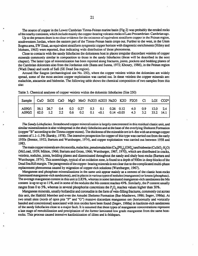
The source of copper in the Lower Cambrian Tunna-Feinan marine basin (Fig.2) was probably the eroded rocks of the ncarby continent, which include mainly the copper-bearing volcanic rocks of Late Precambrian- Cambrian age.
Up to the present there is no clear evidence for the cxisLCncc of equivalent stratiform copper in the Feinan region, southwestern Jordan, where the eastern part of the Timna-Feinan basin crops out. Further to the west, in the Umm Bogma area, SW Sinai, an equivalent stratiform syngenetic copper horizon with diagenetic enrichments (Hilmy and Mohsen, 1965) were reported, thus indicating wide distribution of these phenomena.
Close to contacts with the sandy lithofacies the dolostones host in places irregular discordant veinlets of copper minerals commonly similar in composition to those in the sandy lithofacies (these will be described in the next chapter). The latter type of mineralization has been reported along fractures, joints, pockets and bedding planes of the Cambrian dolomites also from the Jordanian side (Basta and Sunna, 1972; Khoury, 1986), in the Feinan region (Wadi Dana) and north of Safi (SE Dead Sea region).
Around lIar Sasgon (archaeological site No. 250), where the copper veinlets within the dolomites are widely spread, some of the most ancient copper exploitation was carried out. In these veinlets the copper minerals are: malachite, atacamite and bisbeeite. The following table shows the chemical composition of two samples from this site:
Table 3. Chemical analyses of copper veinlets within the dolomitic lithofacies (Site 250)
Sample CuO Si02 CaO MgO MnO Fc203 Al203 Na20 K20 nos CI LOI C02*
AS90/1 56.1 26.7 0.4 0.3 0.27 0.3 0.1 0.26 0.12 4.0 0.9 12.0 2.4 AS90/2 62.0 1.2 2.2 0.6 0.2 0.1 <0.1 0.14 <0.05 4.3 3.2 33.2 14.1
The Sandy Lithofacies. St.ratabound copper minerali7.ation is largely conccntrat.cd in this residual clastic unit, and similar mineralization is also widespread in the shaly lithofacies and at the base of the overlying Shehoret Formation (copper"B" according to the Timnacopper mines). The thickness of the mineable ore is 4-8m with an average copper content of 1.1-1.5% (Barsky, 1978). The intensive prospection for copper of this type was carried out from the early 1950s (Bentor, 1952; Bartura and Wurzburger, 1974), and copper exploitation was carried out between 1958 and 1983.
Themaincoppermineralsarechrysocolla,malachite,pseudomalachite(Cu,[POJ2[OH].Jandbisbeeite(CuSi03·~O) (McLoad, 1959; Milton, 1966; Bartura and Gross, 1966; Wurzburger, 1967, 1970), which are distnbuted in cracks, vein1ets, nodules, joints, bedding planes and disseminated throughout the sandy and shaly host-rocks (Bartura and Wurzburger, 1974). This assemblage, typical of an oxidation zone, is found to a depth of 900m in deep blocks of the Dead SeaRiftmargin. The paragenesis of the copper- bearing minerals is not clear due to the complicated mUtti-phase replacement phenomena caused by migration of copper-rich solutions (Wurzburger, 1967).
Manganese and phosphate mineralizations in the same unit appear mainly as a cement of the clastic host-rocks (laminated manganese-rich sandstones), and in places in various lypcsofnodu1cs (manganese) or lenses (PhosphaLC). The aventge manganese content in this unit is 2.83%, whereas in some laminat.cd manganese-rich sandstones the Mn content is up to up to 11 %, and in some of the nodules the Mn content reaches 49%. Similarly, the P content usually ranges from 0 to 5%, whereas in several phosphorite concretions the P2.0, reaches values higher than 30%.
Manganese minerals, usually hollandite and coronadite in the form of vein-filling fractures, commonly cut across this unit, the Hakhlil Member and even the Amudei Shelomo Formation (Bar-Matthews, 1986; Segev, 1986a). At two small sites (north of open pits "F' and "0") massive discordant manganese ore (horizontally and vertically banded and concretional) associated with iron oxides have been found (Segev, 1986a) in kaolinite-rich sandstones of the sandy lithofacies close to a major faulL It is assumed that these types of manganese concentrations represent a late stage of remobilization and precipitation of the former laminated low grade manganese from the same hostrocks. This process caused intensive kaolinitization of illites and k-feldspars.

22
In several sites uraniwn enrichments (up to 4000 ppm) were found within some of the manganese assemblages and/or the phosphorites.
Detailed mineralogical arid geochemical study of the manganese and phosphorite assemblages in this sequence was done by Bar-Matthews (1986, 1987).
According to the epigenetic mode of fonnation suggested for the sandy lithofacies host-rocks (Segev, 1986a; Segev and Sass, 1989), the hOSLed mineralizaLions musL also be epigenctic in origin, and arc asswncd La be associated with the Dead Sea rifting processes of Neogene age (Segev, 1986a,b; Beyth, 1987a). ,
In the Feinan region varve-like manganese accumulations in the upper third of the Lower Cambrian Dolomite Limestone Shale Unit (equivalent to the Timna Formation; Basta and Sunna, 1972) are probably the manganese mineralization equivalent to the sandy lithofacies in the Timna area. Khoury (1986) described it as irregular impregnations of shales, limestones and dolomite following bedding planes, joints and fractures and is found as irregular concretions and spots occurring as pervasive replacement of the sandstone matrix. Massive manganese ore ("concretionary type" aftcrKhoury, 1986), either sLrucLUrcless, hard banded, or soft, highly crysLalline, were found in the same stratigraphic position (Boom, 1986; Basta and Sunna, 1972; Khoury, 1986). According to Khoury (1986) the precipitation of this massive manganese ore took place as open space filling controlled by locally developed fractures and breccias at the base of the coarse-grained to conglomeratic sandstones (probably the equivalent of the lower Sasgon Member) as well as by irregular openings parallel to the uppermost shale beds (shaly lithofacies) which are due to compaction and/or tectonic dislocations of the host unit For further discussion of these features see the next chapter.
The Shaly Lithofacies. Stratabound copper mineralization like that described in the sandy lithofacies is widespread in the shaly lithofacies. In addition, various types of manganese nodules, were reported mainly around Hac Mikhrot, (Bentor, 1952, 1956; MagarilZ, 1969; Bar-Mauhews, 1986, 1987; and Segev, 1986a,b). These nodules vary in size and shape, from round (lcm to about 30cm) to l~nticular (up to 0.5m long and 15cm thick), and was classified in two groups (Bar- Matthews. 1987) according to their mineralogical and chemical composition.
K-Ar dating of three nodules (Segev et aI., 1992a) indicated Lower Cretaceous age for their formation (same age and the same locality as the basaltic plug), which was overprinLcd by the young (Neogene) hydrothermal processes. It is still possible that some manganese nodules formed by diagenetic processes duri~g Cambrian Lime (as was suggested by Bar- Matthews, 1987) and was later replaced by epigenetic processes. Hence the very high manganese amounts within the Lower Cambrian carbonate sequence served as an easily available source for manganese when reactive solutions affected the Timna Formation.
The same process may explain the formation of the manganese ores in the Jordanian side with two differences: a) The amount of iron is much higher and b) the amount of lead is much lower. Thus further study is needed to . differentiate the various types and phases of manganese precipitation in this part of the section.
In places cryptocrystalline fluorapatite occurs as small (tens of centimeters long and up to 15cm thick) stratifonn lenses in one or two horizons. These lenses commonly contain 400-750 ppm U (Segev and Beyth, 1983). Similar phosphate-rich shales in the Feinan area, SW Jordan, were reported by Heilkemper (1988). Secondary discordant phosphorite lenses, usually similar to those in the sandy lithofacies, containing up to 4000ppm U were also found in a few places. The genesis of the secondary lenses is asswned to be similar to that suggested for the epigenetic sandy lithofacies (Segev, 1986b). whereas the stratiform phosphate-rich shales containing the micritic phosphorite is probably synsedimentary in origin (Bar-Matthews, 1987).
Copper in the Shehoret Formation
The Lower Member. In the Timna Valley Bentor (1952) and Weissbrod (1981) reported the existence of copperrich horizons ("Copper B") usually in the lower part of Shehoret Formation. The copper minerals impregnate the brecciated fluviatile sandstones and form lenses (tens of centimeters in size); all have the same mineralogical composition as described for the sandy lithofacies. Segev (1986b) and Segev and Sass (1989) attributed this type of copper mineralization to the epigenetic remobilization and precipitation of secondary copper minerals within the

23
sandy and shaly lithofacies. In this "Copper B" case the upward migration brought the opper minerals to higher stratigraphic levels.
The equivalent copper mineralization in the Feinan region was described by Basta and Sunna (1972) and Khoury (1986) as Lhe copper mincr.wzation in the VarieguLCd SundslOne Shale U nit. The greenish and bluish copper minerals occur as a cementing component. f1lling in cracks, fissure-filling veinlets and occasionally as small patches.
The Middle (White) Member. This member does not exist in the Timna Valley or further to the north. South oflfar Amram it crops out in onlaprelations with the alkaline volcanic basement rocks. Sedimentary structurcsandscolithos fossils in it led Lillich (1963); Bender (1968) and Weissbrod and Sneh (1992) to suggest a marine littoral environment of deposition for these white. fine-grained sandstones. Copper mineralization associated with scolithos remnants were found by Weissbrod near Nahal Shehoret Two stratiform copper-rich horizons (4m interval), 2-1Ocm thick and several meters long. were found in the middle part of this member. Small spherical nodules (1-1 Omm diameter), often in aggregates. comprise the central part of the horizons. Only in a few nodules were primary copper sulphides identif1ed. In most cases cuprite and malachite are the predominant minerals in this assemblage. The most extensive mineralized area of this type is Wadi Abu Khusheiba in the eastern Arava Valley (German Geological Mission. unpublished reports. 1961-1963; Basta and Sunna, 1972; among others). The copper was diffused or found as copper nodules (up to 20cm in diameter). composed of primary chalcocite. bornite and chalcopyrite with secondary minerals of cuprite and malachite. Malachite occurs as a thin coating on pebbles in the basal conglomerates of this unit. or in the groundmass between these pebbles (Basta and Sunna, 1972). In the very close vicinity sulphidic copper ores (chalcopyrite. chalcocite and covellite) occur in andesitic and rhyolitic dikes and in the volcanic breccia (Burgath et al.. 1984). The primary assemblage appears together with copper oxides (cuprite and tenorite). malachite. and ehrysocolla. Most of these basement rocks belong to the latest Precambrian-Cambrian volcanism of about 523-535 Ma (Segev. 1987). Bender (1965) suggested that the copper mineralization in the whole Cambrian sequence is syngenetic with the sediments in which it is found. and the origin of the copper is probably associated with the contemporary volcanism. On the contrary, Basta and Sunna (1972) suggested epigenetic underground processes during the Late Tertiary uplift of the area. in which copper leached from the oxidation zone and inflltrated down to the water table. where it reprecipitated as a copper sulphide within the white sandstones. The time interval retwcen the Cambrian vol~nism and the Middle Cambrian host-rocks precludes Bender's theory of contemporary relationships.
Lillich (1963) described this stratiform copper ore par.ulel to Ihe bedding. running more than a few kilometers, as unrelated to the structure and suggested synsedimentary precipitation of copper as sulphides. in distinct horizons where anaerobic conditions prevailed. Therefore the erosion of the copper-bearing basement rocks in the very close vicinity during the Middle(?) Cambrian marine transgression supplied the copper to the Abu Khusheibaand Shehoret . areas. The main differences between the White Member mineralization and that of the Lower Cambrian stratiform copper hosted by the Timna Formation are the lack of carbonate minerals and its geographic position (at that time the Timna-Feinan basin was already covered by the lower member of the Shehoret Formation).
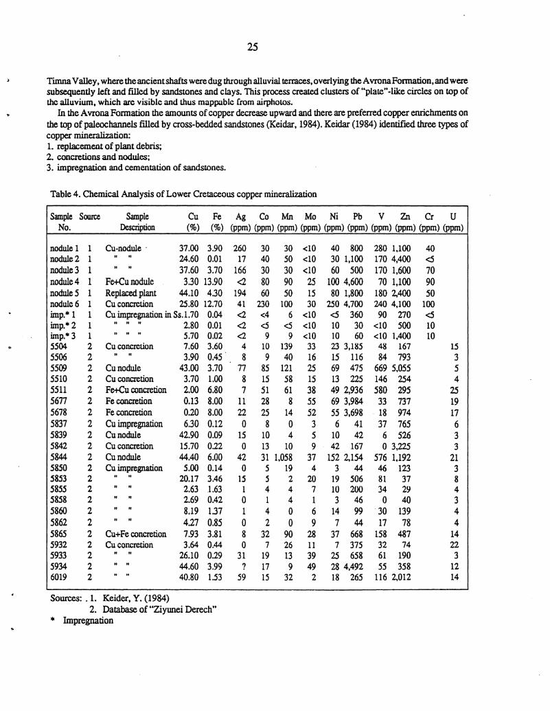
Copper in the Kurnub Group
The copper ores mined in ancient times in the Timna Valley are hosted mainly at the base (up to 15m) oftheAvrona Formation. and to a lesser extent at the top of Arnie Formation (both formations are of Lower Cretaceous age?). These mineralizations are widespread in the western Timna Valley (Fig. 9; archaeological sites: 7.9.16.19,20,22,210,211) and less so toward the north (sites: 24,88,186) and south (sites: 66,95.96,97). Similar mineralization was also found farther to the south, near Amudei Amram and east of Nahal Roded.
The best indicator for the existence of this copper mineralization is the ancient mining and prospection sites in the

• Ancient $ite • Excavated sile
914 0 Model sulVey area o Area of mine shatts
912
906
904
f r " t
24
Fig. 9. Sites of ancient mining activity (after Rothenberg. 1988) in Tirnna Valley
25
Timna Valley, where the ancient shafts were dug through alluvial terraces, overlying the A vronaFormation, and were subsequently left and filled by sandstones and clays. This process created clusters of "plate"-like circles on top of Lhe alluvium, which arc visible and Lhus mappable from airphOlOS.
In the A vrona Fonnation the amounts of copper decrease upward and there are preferred copper enrichments on the top of paleochannels filled by cross-bedded sandstones (Keidar, 1984). Keidar (1984) identified three types of copper mineralization: 1. replacement of plant debris; 2. concretions and nodules; 3. impregnation and cementation of sandstones.
Table 4. Chemical Analysis of Lower Cretaceous copper mineralization
Sample Source Sample Cu Fe Ag Co Mn Mo Ni Pb V Zn Cr U No. Description (%) (%) (ppm) (ppm) (ppm) (ppm) (ppm) (ppm) (ppm) (ppm) (ppm) (ppm)
nodule 1 1 Cu-nodule . 37.00 3.90 nodule 2 1 " " 24.60 0.01 nodule 3 1 " " 37.60 3.70 nodule 4 1 Fe+Cu nodule 3.30 13.90 nodule 5 1 Replaced plant 44.10 4.30 nodule 6 1 Cu concretion 25.80 12.70 imp.*l 1 Cu impregnation in Ss.1.70 0.04 imp.*2 1 " " " 2.80 om imp.*3 1 " " " 5.70 0.02 5504 2 Cu concretion 7.60 3.60 5506 2 " " 3.90 0.45 5509 2 Cunodule 43.00 3.70 5510 2 Cu concretion 3.70 1.00 5511 2 Fe+Cu concretion 2.00 6.80 56n 2 Fe concretion 0.13 8.00 5678 2 Fe concretion 0.20 8.00 5837 2 Cu impregnation 6.30 0.12 5839 2 Cunodule 42.90 0.09 5842 2 Cu concretion 15.70 0.22 5844 2 Cunodule 44.40 6.00 5850 2 Cu impregnation 5.00 0.14 5853 2 " " 20.17 3.46 5855 2 " " 2.63 1.63 5858 2 " " 2.69 0.42 5860 2 " " 8.19 1.37 5862 2 " " 417 0.85 5865 2 Cu+Fe concretion 7.93 3.81 5932 2 Cu concretion 3.64 0.44 5933 2 .. .. 26.10 0.29 5934 2 .. .. 44.60 3.99 6019 2 .. .. 40.80 1.53
Sources: .1. Keider, Y. (1984) 2. Database of'Liyunei Derech"
* Impregnation
260 30 30 17 40 50
166 30 30 <2 80 90
194 60 50 41 230 100 <2 <4 6 <2 <5 <5 <2 9 9 4 10 139 8 9 40
77 85 121 8 15 58 7 51 61
11 28 8 22 25 14 0 8 0
15 10 4 0 13 10
42 31 1,058 0 5 19
15 5 2 1 4 4 0 1 4 1 4 0 0 2 0 8 32 90 0 7 26
31 19 13 ? 17 9
59 15 32
<10 40 800 280 1.100 40 <10 30 1,100 170 4,400 <5 <10 60 500 170 1,600 70
25 100 4,600 70 1,100 90 15 80 1,800 180 2,400 50 30 250 4.700 240 4.100 100
<10 <5 360 90 270 <5 <10 10 30 <10 500 10 <10 10 60 <10 1,400 10
33 23 3,185 48 167 15 16 15 116 84 793 3 25 69 475 669 5.055 5 15 13 225 146 254 4 38 49 2,936 580 295 25 55 69 3,984 33 737 19 52 55 3,698 18 974 17 3 6 41 37 765 6 5 10 42 6 526 3 9 42 167 o 3,225 3
37 152 2,154 576 1,192 21 4 3 44 46 123 3
20 19 506 81 37 8 7 10 200 34 29 4 1 3 46 0 40 3 6 14 99 30 139 4 9 7 44 17 78 4
28 37 668 158 487 14 11 7 375 32 74 22 39 25 658 61 190 3 49 28 4,492 55 358 12
2 18 265 116 2.012 14

26
. The greenish concretions and nodules are spherical to elliptical with mean diameters of about 3cm. Both have inner cores composed of low temperature chalcocite and covellite, surrounded by two rings of detrital quartz, cemented by malachite, less atacamite, and iron oxides. The concretions have a well-crystallized core (plant material replaced by copper minerals), and the amount of quartz grains increases away from the center. This feature does not exist in the nodules where the quartz grains are homogeneously distributed.
The copper impregnations and cements are predominantly composed of malachite, which replaces the original kaolinitic cement, and atacamite.
On the one hand, the wide distribution of copper accumulations close to the contact between the Arnir and A vrona formations may indicate a stratigraphic and/or a lithologic control. On the other hand, in many sites the copper mineralization is emplaced along small fractures and faults, which may indicate a structural control. North of Nahal Mangan (coorcL1493/9136) this mineralization is emplaced along faults cutting the Arnir and Shehoret formations. The copper in this site was mined in ancient time in open quarries and underground mines.
The copper content in the concretions (Table 4) reach about 44% Cu, and is associated with Zn (up to 5000ppm), Pb (up to 4700ppm) and Ag (up to 26Oppm). Iron oxides, mainly hematite, is closely associated with the copper sulphides. There arc no cl~ paragenetic relationships between them and in places chalcocite replaced hematite and vice versa. At the base of the Avrona Formation, many fossiliferous (ferruginous) trees composed of hematite (Fe.pJ and geothite (FeOOH) were found and studied by Ayaion et ai.( 1985). The distribution of this phenomenon in the Timna Valley is similar to that of the copper mineralizations, and the geochemical assemblage is presented in the following table:
Table 5. The average values of the geochemical assemblage of the iron concretions (N=20; Ayalon et al., 1985)
Fe Cu Co Mo Ni P Pb Zn U (%) (%) ppm ppm ppm ppm (%) (%) ppm
Mean 25.42 1.10 140 405 340 400 1.43 0.48 60 S.D. 11.19 0.89 90 490 295 700 0.77 0.38 30
This assemblage is characterized by a high iron content, associated with high concretions oflead, copper and zinc and to a lesser extent molybdenum, nickel, cobait and uranium. Part of the lead identified within the ferruginous trees is wulfenite (PbMoO J. The minerals, which are enriched in ferruginous trees, probably adsorbed on the iron (which acts as a scavenger).
Keidar (1984) suggested an epigenetic model for the copper and iron mineralizations within the Kurnub Group, in which the copper dissolved from the Precambrian basement and the Timna Formation, was transported mainly as chloride complexes, and precipitated in the A vrona Formation as a result of reducing conditions caused by disintegration of plant material in an anaerobic environment. Later most of the copper sulphides allCred to malachite by supergene processes. The textural relationships between the copper minerals and the host-rock as well as the noncoalification of the plant debris led Keidar to conclude that the copper mineralization took place prior to a thick deposition above the base A vrona Fonnation. New data concerning the Lower Cretaceous magmatism in the Timna Valley (Beyth and Segev, 1983; Weissbrod et al., 1989; and Segev et al., 1992b) suggest genetic relations between this volcanic activity and the copper mineralization in the Kurnub Group. This, however, docs not preclude the possibility that this mineralization type is also caused by the Dead Sea rifting processes. The summary of the various occurrences of copper mineralization along the southern Dead Sea Rift are presented in Table 6.
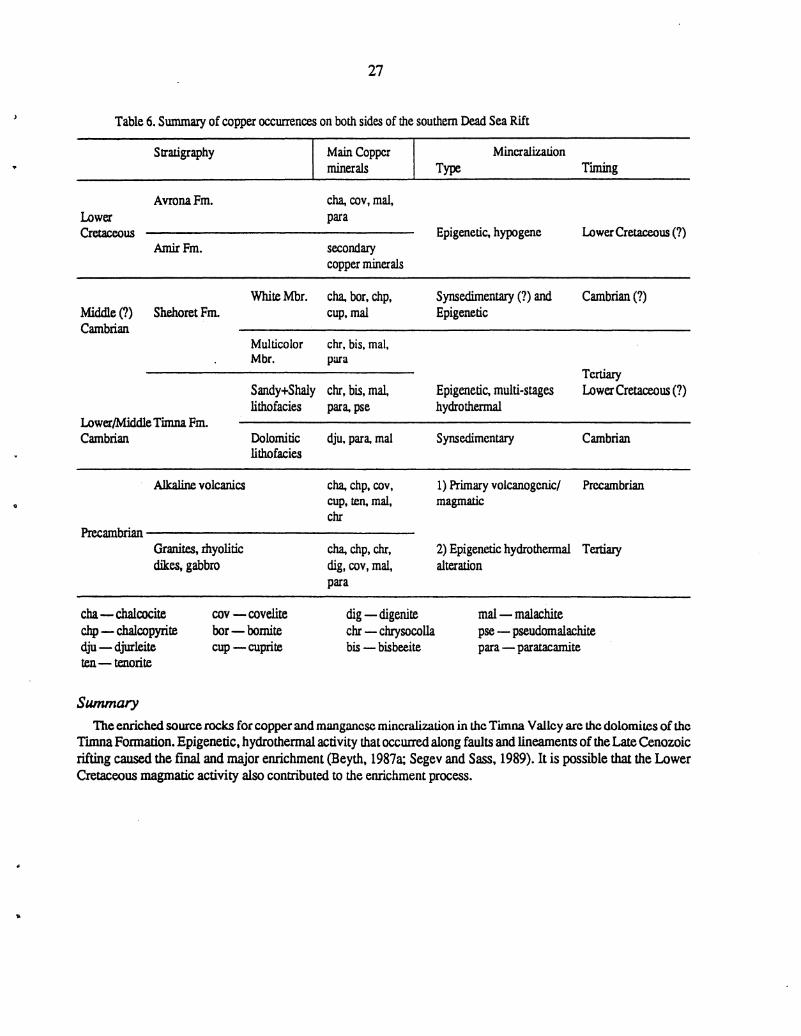
27
Table 6. Summary of copper occurrences on both sides of the southern Dead Sea Rift
Stratigraphy Main Copper minerals
AvronaFm. chao COV, mal, Lower para Cretaceous
AmirFm. secondary copper minerals
WhiteMbr. chao bor, chp, Middle (1) Shehoret Fm. cup, mal Cambrian
Multicolor chr, bis, mal, Mbr. para
Sandy+Shaly chr, bis, mal, lithofacies para, pse
Lower/Middle Timna Fm. Cambrian
Alkaline volcanics
Dolomitic lithofacies
dju, para, mal
chao chp, cov. cup, ten. mal, chr
~ammum------------------------------
Granites, rhyolitic dikes, gabbro
clla - chalcocite chp - chalcopyrite dju - djurleite ten - tenorite
Summary
COy - covelite bor-bomite cup - cuprite
cha, chp, chr, dig, COV, mal, para
dig - digenite chr - chrysocolla bis - bisbeeite
Mineralization Type
Epigenetic, hypogene
Synsedimentary (1) and Epigenetic
Epigenetic. multi-stages hydrothermal
Synsedimentary
Timing
Lower Cretaceous (1)
Cambrian (1)
Tertiary Lower Cretaceous (?)
Cambrian
1) Primary volcanogenicl Precambrian magmatic
2) Epigenetic hydrothermal Tertiary alteration
mal- malachite pse - pseudomalachite para - paratacamite
The enriched source rocks for copper and manganese mineralization in the Timna Valley are the dolomiles of the Timna Fonnation. Epigenetic, hydrothennal activity that occurred along faults and lineaments of the Late Cenozoic rifting caused the fInal and major enrichment (Beyth, 1987a; Segevand Sass, 1989). It is possible that the Lower Cretaceous magmatic activity also contributed to the enrichment process.

28
ACKNOWLEDGEMENTS
The authors wish to thank S. Levi for dmfting the figures, B. Katz for editorial assistance in improving the manUSCI'ipt,.and Laser Pages Publishing (1992) Ltd for their typesetting.
This worlCis a partial result of a joint project between the Geological Survey and the Soreq Nuclear Research Center.
REFERENCES
Arkin, Y.,Braun,MandStarlnsky,A., 1965. Type sections of Cretaceous fonnations in theJerusalem-BetShemesh area. !sr. Geol. Surv., Stratigr. Sec. no. 7,42 p.
Arkin, Y. and Braun, M, 1965. Type section of Upper Cretaceous fonnations in the northern Negev (southern Israel). !sr. Geol. Surv., Stratigr. Sec. no. 2a, 19 p.
Ayalon, A., Beyth, M and Vulkan, U., 1985. Geochemistry of radioactive mineralization occurrences in the Timna Valley. Trans. Instn. Min. Metall. (Scct B.: Appl. Eanh ScL), 94: B197-B201.
Bar-Matthews, M., 1986. Mincr.ilization of uranium and oLhcr meLals in Lhc Timna Formation, Timna Valley. Ph.D. thesis, The Hebrew University of Jerusalem, 108 p. (in Hebrew, with English abstract).
Bar-Matthews, M, 1987. The genesis of uranium in manganese and phosphorite assemblages, Timna Basin, Israel. Geol. Mag •• 124: 211-229.
Barsky, Z., 1978. Composite exploitation of manganese and copper in Timna. 4th Mining Engin. Coni., Zefa!, pp. 215-217 (in Hebrew).
Bartov, Y., 1967. The geology of the Beer Ora area. M.Sc. thesis, The Hebrew University of Jerusalem. 39 p. (in Hebrew).
Bartov, Y •• 1974. The structural and paleogeographical study of the central Sinai faults and domes: Ph.D. thesis. The Hebrew University of Jerusalem, 143 p. (in Hebrew, with English summary).
Bartov, Y., Eyal. Y., Garfunkel, Z. and Steinitz; G., 1972. Late Cretaceous and Tertiary stratigraphy of southern Israel: !sr.J. Earth Sci. 21: 69-97.
Bartov, Y. and Arad, V., 1989. Arava and Elat region - bibliography of geological research. !sr. Geol. Surv. Rep. GSJ/15/89. 91 p.
Bartura, Y •• 1956. Timna, Nubian sandstone report; Isr. Geol. Surv. Rep., 12 p. (in Hebrew). Bartura, Y., 1966. Type sections of Paleozoic fonnations in the Timnaarea. Isr. Geo!. Surv. Stratigr. Sect, 3: 12 p. BartUIa, Y., 1978. Drillholes for copper prospection in the Arava area, 1970-1976: Timna Copper Mines. 5 p. Bartura. Y. andZemel,M., 1956. Geological study ofTimna-ElatBlock. Isr. Geo!. Surv. Rep. no. 1.7 p. (in Hebrew). Bartura, Y. amd Gross, S., 1966. On the minerals of the copper deposit at Timna (in Hebrew). !sr. GeoL Surv. Rep.
MP/167/66: 11 p. Bartura Y.andWiiIzburger. U.,1974. The Timna copper deposit In: P. Bartholome(Editor),Gisementsstratiformes
et provinces cuproferes. Societe Geologique de Belgique: 277-285. Busta, B. and Sunnu, B .• 1971. Mincralogy and modc of occurrcncc of coppcr orcs in Wadi Araba. Jordan. Bxtrait
Bull. Inst d'Egypte, Tome Ln. 119-224. Basta,E~and Sunna, B., 1972. The manganese mineralization atFeinan District, Jordan. Bull. Fac. of Sci., University
. of Cairo, 44: 1.1-126. . Bender,F., 1965.ZurGeologiederKupfererzvorkommen am Ostrand des Wadi Araba, Jordanien . Geol.lb.83: 181-
208. Bender, F., 1968. Geologie von Jordanien - Stuttgart. Beilr. Z. Region Geologie der Erde •• 7.230 p. Bender. F., 1974. Explanatory Notes on the geological map of the Wadi Araba. Jordan. (Scale 1.100,000.3 Sheets).
Geol. Jahrb •• Hannover, Rheihe B, no. 10, 62 p. Bentor. Y.K.. 1952. Report on the Copper and Manganese Deposits in Wadi Menayeh. Isr. Geo!. Surv. Rep. 34 p.
Bentor, Y .K..1956. The manganese occwrences at Timna (southern Israel). A lagoonal deposit. 20th Intern. Geol. Congo Symp., 2: 157-172.

29
Bentor. Y X. 1961. Petrographical outline of the Precambrian in Israel. Isr. Res. Counc .• Bull., lOG (1-2): 19-64. Bentor. Y.K •• 1985. The crustal evolution of the Arabo-N ubian massif with special reference to the Sinai Peninsula.
Precambrian Res .• 28: 1-74. D Bentor, Y.K. and Vroman, A.,195S. The Geological map of the Negev, 1:100,000, Sheet 24, Elat. Isr. Geol. Surv.
Beyth, M., 1987a. Mineralization related to rift systems: examples from the Gulf of Suez and the Dead Sea Rift. Tectonophysics, 141: 191-197.
Beyth, M.. 1987b. The Precambrian magmatic rocks ofTimna Valley, southern Israel. Precambrian Res., 36: 21-38. Beyth, M. and Segev, A., 1983. Lower Cretaceous basaltic plug in the Timna Valley. Isr. J. Earth Sci., 32: 165-166. Beyth, M., Starinsky, A. and Lazar, B., 1984. Low temperature geothennal waters, Timna, southern Israel. !sr. Geol.
Surv. Current Res., 1983-4: 17-'2IJ. Beyth, M., Shirav, M., Halicz, L. and Bogoch, R., 1988. Geochemical orientation survey of Har Timna, southern
Israel. Isr. Geol. Surv. Rep. GSI/15/88, 47 p. Beyth, M.. Shpitzer. M. and Matthews. A., 1990. The magmatic rocks of Hac Timna (in Hebrew). Guidebook for
geological field trips in the Elat area; Isr. Geo!. Soc. Ann. Meet. pp. 27-33. Bielski, M .• 1982. Stages in the evolution of thc Arabian-Nubian massif in Sinai. Ph.D. thesis, The Hebrew
University, Jerusalem . .155 p. (in Hebrew. with English summary). Bielski. M. and Kolodny, Y .• 198!. Geological correlation between the basement rocks in Heletz Deep and the Arabo
Nubian massive in the E1at area. Final report submitted to Earth Science Research Administration. Bigot, M., 1982. Quelques donnees sur l'environement geologique et la gitologie des occurrences cupra
manganesiferes du Wadi Araba (Royaume Hashemite de Jordanie). Fr .• Bur. Rech. Geol. Minieres, Bull. Ser. II, (1-2): 153-163.
Blanckenhorn, M., 1914. Syrien, Ambien, Mesopotamien. Heidelberg, Winter'a Universitaetsbuchhandlung (Handbuch der Regionalen Geol., 5, No, 4), IS9p.
Bogoch, R. and Wwzburger. U., 1973. Borcholc cores in thc "Dcshc" area Timna Massif. Isc. Gool. Surv. Rep. MP 512/78, 13p.
Boom, G. VanDen. 1969. Zur geologie und Genese der ManganeIZ-vorkommen in Wadi Dana. Beih. Geol. lb., 81: 161-176.
Burgath. K.P., Hagen, D. and Siewers, G., 1984. Geochemistry, geology and primary copper mineralization in Wadi Araba. Jordan. Geo!. lb .• 53: 3-53.
Coleman, R.G .• Fleck, R.I., Hedge, C.E. and Ghent, E.D., 1977. The volcanic rocks of southwest Saudi Arabia and the opening of the Red Sea. Saudi Arabia Mineral Resources Bull. 22-D: 1-30.
Cooper.G.A •• 1976.LowerCambrian brachiopods from the Rift Valley (Israel and Jordan). J. Paleont, 50, (2): 269-289.
Eckstein, Y .• 1963. The geology of the Gerofit area. Isr. Geol. Surv. Rep. Hydro/6/63 (in Hebrew), 41 p. EyaI, Y. and Reches, Z •• 1983. Tectonic analysis of the Dead Sea rift region since the Late Cretaceous based on
mesostructures. Tectonics, 2, (3): 167-185. Fmkelstein-Grossman, S •• 1982. Stream sediments in extremely arid areas - evidence for environmental changes
(Timna Valley, southern Negev. Israel) M.Sc. thesis, The Hebrew University, Jerusalem (in Hebrew). 106 p. Freund, R.. 1962. Problems in the stratigraphy of the Cenomanian-Turonian in Israel. Ph.D. thesis, The Hebrew
University. Jerusalem (in Hebrew. English abstract), 189 p. Freund,R..1965. A model of structural developmentofIsrael and adjacent areas since Upper Cretaceous times. Geol.
Mag. 102: 189-205. Freund, R., Garfunkel, Z .• Zak, I., Goldberg. M., Weissbrod, T. and Derin, B., 1970. The shear along the Dead Sea
Rift. Roy. Soc. Lond., Philos. Trans., Ser. A,267: 107-130. Garfunkel,Z., 1970. The tectonics of the western southern Arava; a contribution to the understanding of rifting. Ph.D.
thesis. The Hebrew University, Jerusalem (in Hebrew, English abstracl), 204 p. Garfunkcl, Z •• 1980. Contribution to the geology of the Precambrian of the Elal area. Isr. J. Earth Sci. 29:25-40. Garfunkel, Z., 1981. Internal structure of the Dead Sea leaky transfonn (rift) in relation to plate kinematics.
Tectonophysics, 80: 81-108. General Geol. Mission, 1961-63.
30
Gerson. R.. 1982. Talus relicts in desert: A key to major climatic fluctuations. Isr. J. Earth Sci.. 31: 123-132. Gerson. R. and Grossman. S .• 1985. Paleomorphology and morphotectonics along the southern Arava Valley.
(Excursion 2), lsr. Geol. Soc. Meet.: 131-147. Halpern, M. and Tristan, N., 1981. Geochronology of the Arabian-Nubian Shield in southern Israel and eastern Sinai.
J. Geol., 89: 639-648. Heitkemper, E., 1988. Kupfervererzungen in Kambrischen sedimenten des Fenan-Gabietes, SW Jordanien. Diplom.
Ruhr Univ., Bodhum, 61p. Hilmy, H. E. and Mohsen, L.A., 1965. Secondary copper minerals from west-central Sinai. J. Geol. U.A.R., 9: 1-
12. Karcz, I. and Key. CA, 1966. Note on the pre-Paleozoic morphology of the basement in the Timna area (southern
Israel). !sr. J. Earth Sci .• 15: 47-56. Kartz. I .• Weiler, Y. and Key, C.A., 1971. Lithology and environment of deposition of the Amudei Shelomo
sandstone/N.S.P./ in Nahal Shani, Elat: !sr. J. Earth Sci. 20: 119-124. Keidar, Y., 1984. Mineralogy and petrography of copper nodules in the Upper White Nubian sandstone in the Timna
Valley (in Hebrew, English abstract). M.Sc. thesis, Ben Gurion Univ. of the Negev, 101 p. Khoury, H. N.,1986. On the, origin of stratabound copper-manganese deposits in Wadi Ar.lba, Jordan. Dirasal. XIII,
7: 227-247. King, W.B.R., 1923. Cambrian fossils from the Dead Sea. Geoi. Mag. 60:507-514. Kroner. A. and Beyth, M. 1990. Single zircon ages for Late Precambrian magmatic rocks of Hac Timna.!sr. Geo.
Soc. Ann. Meet.. p. 51. Lewy. Z .• 1975. The geological history of southern Israel and Sinai during the Coniacian. Isr. J. Earth-Sei.. 24: 19-
43. Lewy. Z .• 1988. Lithostratigraphic subdivision of the Hazera Fonnation (Late Albian-Late Cenomanian) in the
Negev. southern Israel. !sr. J. Earth Sci .• 37, no. 4: 205-210. Lewy. Z .• 1989. CorreIat 1969. Trace elements in manganese ores in south Israel. M.Sc. thesis. The Hebrew
University, Jerusalem (in Hebrew), 40 p. Mart. J. and Freund, R.. 1977. Locating new copper deposits at the Timna area. The Hebrew University. Jerusalem
(in Hebrew). 51 p. Mart. J. and Horowitz, A., 1981. The tectonics of the Timna region, southern Israel and the evolution of the Dead
Sea Rift. Tectonophysics, 79: M.Sc. thesis, The Hebrew University, Jerusalem (in Hebrew), 40 p. Mart. J. and Freund, R., 1977. Locating new copper deposits at the Timna area. The Hebrew University. Jerusalem
(in Hebrew). 51 p. Mart. J. and Horowitz. A.. 1981. The tectonics of the Timna region. southern Israel and the evolution of the Dead
Sea Rift. Tectonophysics, 79: 165-199. McLoad, B.H.. 1959. Microscopic examination of some Timna minerals. "Mahtsavei Israel". Unpubl. Rep. Meneisy. MY. and Kreuzer. H., 1974. Potassium-argon ages of Egyptian basaltic rocks. Geol. Jahrb. 09:21-31. Milton. C •• 1966. Copper and manganese mineralogy of Israel. U.S.G .S •• Unpubl. Rep. Minster. T. and Fraser. A.G .• 1982. Authigenic kaolinite in the Amir Formation. southern Negev • Israel. Isr. J. Emth
Sci. 31: 1-7. Nevo. E .• 1954. Report on the Paleozoic of the Elat region. lsr. Geol. Surv. Rep .• 15 p. Parnes, A .• 1971. Late Lower Cambrian Trilobites from the Timna area and Hac Amram (southern Negev. Israel).
!sr. 1. Earth Sci.. 20: 179-205. Picard, L .• 1943. Structure and evolution of Palestine with comparative notes on neighbouring countries. Geol. Dept.
Hebrew University. Jerusalem 4:143 p. Picard, L.. 1953. Silurian in the Negev (Israel). Int Geol. Congr .• 19th. Alger 1952. Sect 2, Fasc. 2: 179-183. Qucnnell. A.M .• 1959. Tectonics of the Dead Sea rifL. InL Geo!. Congr. 20th. Mexico. 1956 - Assoc. Surv. Gool.
Afr •• 385-405. Rosenthal. E •• 1965. On the hydrogeological conditions in the Yotvataarea (in Hebrew). Isr. Geol. Surv .• Rep.Hydro/
6/64.5 p.

11
31
Rothenberg, B., 1988.The Egyptian Mining Temple at Timna; Inst Archaeo-Metallurgical Studies, Uni. College London. 317 p.
Sakal, E •• 1967. The geology of Rekhes Menuha (in Hebrew). M.Sc. Thesis Hebrew Univ .• Jerusalem. 80 p. Segev. A.. 1984. Lithostratigraphy and paleogeography of the marine Cambrian in southern Israel and southwestern
Jordan. !sr. J. Earth Sci .• 33: 26-33. Segev. A., 19863.. Lithofacies relations and mineralization occurrences in the TimnaFormation, Timna Valley. Ph.D.
thesis, The Hebrew University, Jerusalem (in Hebrew, English abstract). 118 p. Segev. A .• 1986b. Syngenetic copper-enriched dolostones as a source for epigenetic copper mineralization in
sandstones and shales (TiJnna, Israel) Canad. Miner. (abstr.), 24: 206. Segev, A. 1987. The age of the 1atestPrecambrian volcanism in southern Israel, northeastern Sinai and southwestern
Jordan - a re-evaluation. Precambrian Res., 36: 277-285. Segev, A. and Beyth, M., 1983. Preliminary repon on the geology of the Timna Valley and its radioactive
mineralization. !sr. Geo!. Surv. Rep. ME 2/83, 36 p. Segev, A. and Beyth, 1986. Timna Valley, geological map. Isr. Geol. Surv. Segev, A. and Sass, E., 1989. Lithofacies and thickness control by epigenetic dissolution - the dolomitic Timna
Formation, Cambrian, southern Israel. Sediment. Geo!., 63: 109-126. Segev, A. and Sass, E., 1989. Copper-enriched syngenetic dolostones asa source for epigenetic copper mineralization
in sandstones and shales (Timna, Israel)~ Geol. Assoc. Canada, Spec. Pub. 36: 647-665. Segev, A. Halicz,L., Steinitz, G. andLang, B., 1992a. K-Ar geochronology of manganese nodules from the Cambrian
Timna Formation, Hat Mikhrot, Timna Valley. Isr. Geol. Soc. Annu. Meet Ashqelon: 128-129. Segev, A., Rybakkkov, M., Weissbrod, T. and Beyth, M., 1992b. The Lower Cretaceous magmatic activity in the
Timna Valley: evidence from a detailed magnetic survey. Isr. Geol. Soc. Annu. Meet, Ashqelon, p.130. Shaw, S.H., 1947. Southern Palestine, geological map on a scale of 1:250,000 with explanatory notes. Jerusalem,
Government Printer. 42 p. Shpitzer. M., Beyth. M. and Matthews, A .• 1989. Evidence for magmatic differentiation in the Timna intrusive
complex. Israel Geo!. Soc. Ann. Meet., Ramot. 52. Steinitz. G., Bartov. Y. and Hunziker, J.C .• 1978: KlAr age determinations of some Miocene-Pliocene basalts in
Israel: their significance to the tectonies of Rift Valley. Geol. Mag. 115: 329-340. Steinitz,G.Bartov, Y.andEyal,M.,1992.KK-ArandAr.ArdatingofPenno-TriassicmagmatisminSinaiandIsrael
initial results. !sr. GeoL Soc. Ann. Meet., Ashqelon. p. 147. Stmm, E., 1953. Possible origin of manganese ore in the Negev. Isr. Res. Counc. Bull .• 3(3): 177-191. Weissbrod, T •• 1969a. The Paleozoic of Israel and adjacent countries; Part I - the subsurface Paleozoic stratigraphy
of southern Israel. !sr. GeoL Surv. Bull., 47: 23 p. Weissbrod, T., 1969b. The Paleozoic of Israel and adjacent countries; Part II - The Paleozoic outcrops in southern
Sinai and their correlation with those of southern Israel. Isr. Geol. Surv. Bull., 48: 32p. Weissbrod. T., 1970. The stratigraphy of the Nubian Sandstone in southern Israel (Timna-Elatarea). Isr. Geol. Surv.
Rep. OD/2fl0:22 p. Weissbrod, T., 1981. The Paleozoic of Israel and adjaccnl countries (lithostr'dtigraphic sLudy). Ph.D. Lltesis. The
Hebrew University. Jerusalem (in Hebrew. English abstract), 276 p. Weissbrod, T., 1992. In: Druckman et al. The Geological Map of the Elat area 1:100,000 scale (suggested). Weissbrod, T. and Gvirtzman, G., 1988. The Late Devonian event in the Near East Cour. Forsch. Int. Senckenberg,
100: 221-233. Weissbrod, T., Segev, A., Beyth, M. and Theron. J .N., 1989. An Early Cretaceous volcanoclastic event: Reappraisal
of the "Crazy Wall" at Timna.!sr. Geol. Soc., Annu. Meet. Ramot: 166-167. Weissbrod, T. nd Sneh, A.. 1990. Tidal and Fluviatile environments of deposition of the Cambrian and Lower
Cretaceous Nubian sandstones at Hat Arnie slopes. Isr. Geo!. Soc. ArulU. Meet., Elat, Geo!. Field Trips No. D 7: 88-94.
Wiirzburger. U., 1967. The occurrence of sulphides in the Timna Massif and secondary copper minerals in the Timna copper deposit, Negev (southern Israel). Imperial College, unpub. Rep., 7Op.
Wiirzburger, U., 1970. Copper silicates in the Timna ore deposit. Isr. J. Chern., 8: 443-457. Z1atkin, A. and Wurzburger, U .• 1957. Eruptive rocks ofTimna (Negev). Isr. Geol. Surv., Bull., 14: 41p.
