geology of the tarim basin with special emphasis on
TRANSCRIPT
Geology of the Tarim Basin with special emphasis on petroleum deposits, Xinjiang Uygur Zizhiqu, Northwest China
By
K. Y. LeeU.S. Geological Survey
Reston, Virginia
Open-File Report 85-616
This report is preliminary and has not been reviewed for conformity with U.S. Geological Survey editorial standards and stratigraphic nomenclature.
1985
CONTENTSPage
Abstract 1Introduction 2
Regional setting 6Purpose, scope, and method of report 6
S t rat igraphy 6Jr r e""D inian QSinian 8Paleozoic 10
Lower Paleozoic 11Upper Paleozoic 12
Mesozoic 15Tr ias s i c 15Jurassi c 16Cretaceous 17
Cenozoic 18Tertiary 18Quat e rnar y 2 0
Structure 21Kuqa Foredeep 21Northern Tarim Uplift 21Eastern Tarim Depression 24Central Uplift 24Southwestern Depression 26Kalpin Uplift 26Southeastern Faulted Blocks 27
Evolution of the basin 27Petroleum and coal deposits 36
Petroleum 36Source rocks 36Reservoir rocks 44Cap rocks 45Types of trap 47Potential and description of known oil and gas fields 47
Occurrence 50Potential 50
Summary and conclusions 52References cited 54

ILLUSTRATIONSPage
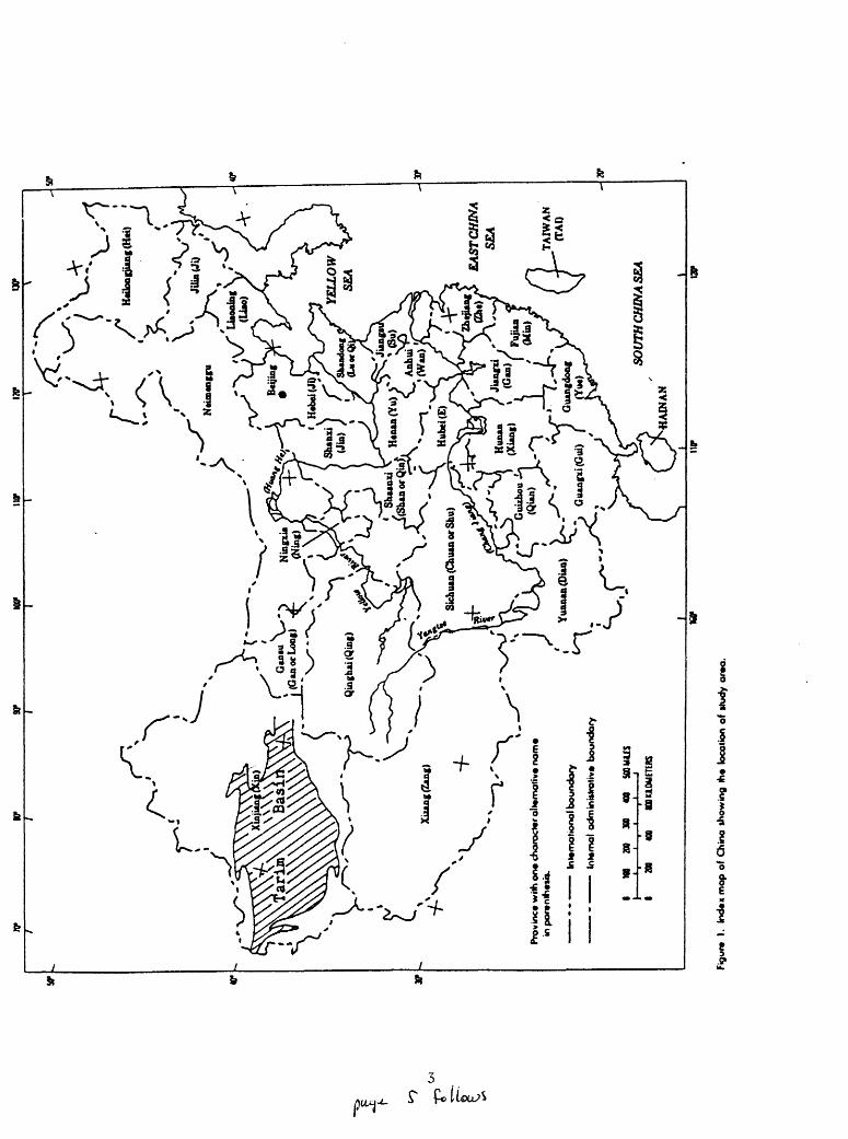
Figure 1. Index map of China 3
2. Geologic map of the Tarim (Talimu) basin, Xinjiang,northwest China 4
3. Airborne magnetic anomaly contours in Ta 94. Principal structural units 225. Sketch isopachs of the earth's crust 236. Depth to the magnetic basement rocks 25
7. Isopachs of the Paleozoic and Sinian strata 298. Isopachs of the Cenozoic and Mesozoic strata 309. Isopachs of the Jurassic strata 32
10. Isopachs of the Cretaceous strata 3311. Isopachs of the Eogene (Paleogene) strata 3412. Isopachs of the Neogene strata 3513. Schematic cross section of structure and stratigraphy of
the Kuqa foredeep 43
14. Schematic cross section of structure and stratigraphy ofthe Bachu-Keyeya area 43
15. Stratigraphic columnar sections of the Upper Triassiccoal-bearing Taliqike Formation in the Kuqa foredeep 51
TABLES
Table 1. Orogenic cycles of China 5
2. Stratigraphic correlation of the Tarim basin 73. Chemical analyses of the source rocks from Tarim basin 394. Evolution of the source rocks in the Tarim basin 415. Characteristics of crude oil in the Tarim basin 426. Porosity and permeability of principal reservoir rocks
in the Tarim basin 46
ii

Geology of the Taritn Basin with special emphasis on petroleum deposits, Xinjiang Uygur Zizhiqu, Northwest China
By
K. Y. Lee
ABSTRACT
This report presents general information on the geology of the Tarim basin with special emphasis on petroleum deposits. The basin covers about 563,000 km2 with a basin-fill of sediments amounting to 2,301,000 km3 . It is generally confined within lat 37°10 f -42°00 T N. and long 75°00 T -93°00 T E.
Tarim basin evolved on a craton and acquired its individuality relative to the Tian Shan geosyncline on the north and the Kunlun geosyncline on the south during the Late Carboniferous Variscan orogeny. The basin reached full development, including the marginal foredeeps both to the north and to the south, in the Neogene owing to the Himalayan orogeny.
The Archean continental nucleus, trending northeasterly, occupied most of the southern part of the basin. This continental nucleus came into contact with an extensively faulted east-west magmatic arc of basic to ultrabasic plutonic rocks on the north. The nucleus was enlarged in early Late Proterozoic time to the present Tarim continental block by Proterozoic accretion onto both the north and south margins (Wang and Qiao, 1984). Subsequently, deposition of platform marine sedimentary cover on the nucleus occurred from the Sinian to Upper Paleozoic Permian. The processes of sedimentation were associated closely with geotectonic movements, especially in relation to the deeply seated basement faults within the Tarim block.
Principal structural units in the present-day Tarim basin are the Kuqa Foredeep, the Northern Tarim Uplift, the Eastern Tarim Depression, the Central Uplift, the Southwestern Depression, the Kalpin Uplift, and the Southeastern Faulted Blocks. Current petroleum exploration is concentrated in the Northern Tarim Uplift, the Southwestern Depression, the Central Uplift, and the Kuqa Foredeep. The Eastern Tarim Depression is particularly favorable for future petroleum exploration.
Potential petroliferous source rocks in the basin are the marine asphaltene carbonate rocks, shale, and mudstone of the Early Cambrian, Early Ordovician, Early Silurian, Early Devonian, Carboniferous, Late Cretaceous, and Paleogene ages; continental lacustrine mudstone, shale, and oil shale of the Late Permian and Triassic ages; and transitional marine and continental mudstone of the Miocene age.
The reservoir rocks are chiefly sandstone, conglomerate, and fractured, cavernous, algal-matted and bioherm-reef limestone and dolomite, of which the carbonate rocks are present chiefly in sedimentary sequences of Late Sinian, Cambrian, Ordovician, Carboniferous, and Early Permian age.

Dominant and potential types of traps in the basin are anticlinal fold, faulted anticline, stratigraphic unconformity and onlap as well as overlap, and bioherm-reef complexes. Cap rocks are mainly shale, gypsum beds, mudstone, and, locally, rock salt. It is believed that the petroleum potential in the Tarim basin is substantial.
The potential for coal resources is unknown. Triassic and Jurassic coal beds are mined at Kuqa and Luntai in the Kuqa Foredeep; Jurassic coal is mined locally at Yutian in the southeastern part of the Southwestern Depression.
INTRODUCTION
Tarim (Talimu) basin is the largest interior basin in China and borders the geosynclinal foldbelts on the north and the south (figs. 1 and 2). The basin developed on a craton, and acquired its individuality during the Late Carboniferous Variscan orogeny (Huang and others, 1980, p. 39; Wang and others, 1983, p. 295) (table 1). The latest evolution into the north- and south-margin foredeeps began during the Jurassic Yanshanian deformation and extended through the Tertiary Himalayan orogeny (Wang and others, 1983, p. 295- 296.
The basement rocks of the Tarim basin are mostly exposed around the edges of the basin; they consist of Archean garnet-biotite schist, biotite-quartz schist and granitoid gneiss; and pre-Sinian Proterozoic quartz schist, mica schist, quartzite, amphibolite, phyllite, marble, crystalline carbonate rocks, and meta-volcanic rocks.
These crystalline rocks are overlain by: 1) the Upper Proterozoic Sinian dolomite, argillaceous limestone, tillite, feldspathic sandstone, conglomerate, siltstone, slate, shale, marl, and volcanic breccia; 2) marine Cambro-Ordovician carbonate rocks, Lower Silurian sandstone, siltstone, and limestone, Devonian sandstone and conglomerate, and Carboniferous-Permian carbonate and detrital rocks; and 3) continental fluvial and lacustrine sedimentary sequences of Triassic to Tertiary age, with intervening Upper Cretaceous and Paleogene marine sedimentary sequences in the west and southwest parts of the basin. Quaternary alluvial, fluvial, eolian, and glacial deposits are widespread throughout the basin (fig. 2).
Petroleum exploration likely will be concentrated in the northern, eastern, and southwestern parts of the basin. The light fraction of oil and gas was generated in mature and highly mature stages from the mudstone, limestone, shale, and algal dolomite of Paleozoic age; however, from source rocks of the Triassic to Paleogene age, oil and gas are known to be high in paraffin and commonly are formed in a less mature stage than petroleum from older rocks.
Bituminous coal deposits occur only in the Carboniferous, Permian, Triassic, and Jurassic sedimentary sequences of limited areas throughout the Tarim basin.
f
A
,^V
1/
H«i
looo
unc(
Hti)
.'
/^
A
\^ N
(Gan
orL
ooi)
-rf-
/
/ TA
IWA
N
/ 4-^
fT
AI)
Pro
vinc
e w
ilh o
n*
char
acte
r al
tern
ativ
e n
am
* in
po
r»n
ih«»
a.
Inte
rnat
ion
al b
ou
nd
an/
Inte
rnal
od
min
Mtr
oti
v* b
ou
nd
ary
I NO
20
0 30
0 «0
U
OU
US
I 20
0 40
0 nO
UO
MET
lftS
I.
Ind
ex m
ap o
f C
hin
a sh
ow
ing
ih
* lo
cati
on
of
itu
dy
are
a.
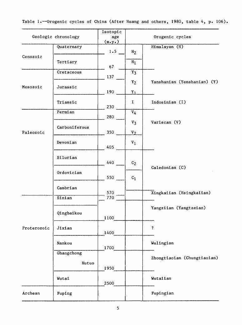
Table 1. Orogenic cycles of China (After Huang and others, 1980, table 4, p. 106)
Geologic
Cenozoic
Mesozoic
Paleozoic
Proterozoic
Archean
chronology
Quaternary
Tertiary
Cretaceous
Jurassic
Triassic
Permian
Carboniferous
Devonian
Silurian
Ordovician
Cambrian
Sinian
Qingbaikou
Jixian
Nankou
Ghangchong
Hutuo
Wutai
Fuping
Isotopic age
(m.y.)
1.5
67
137
190
230
280
350
405
440
550
570770
1100
1400
1700
1950
2500
H2
Hi
Y3
Y2
YI
I
V4
V3
V?
Vl
C2
Cl
Orogenic cycles
Himalayan (H)
Yanshanian (Yenshanian) (Y)
Indosinian (I)
Variscan (V)
Caledonian (C)
Xingkaiian (Hsingkaiian)
Yangziian (Yangtzeian)
?
Wulingian
Zhongtiaoian (Chungtiaoian)
Wutaiian
Fupingian

Regional Setting
Tarim sedimentary basin is an east-west rhombic-shaped depression that covers about 563,000 km2 . It is mostly confined within lat 37°10'-42°00' N. and long 75°00 I -93°00 I E. and is bordered by the Kunlun Shan and Altun Shan on the south and the Tian Shan on the north. The center of the basin is a rainless, dune-covered desert, the Taklimakan Shamo. Average elevation of the basin floor is about 1,200 m. Settlement is confined to oases on alluvial fans that spread out from the base of the adjacent mountain ranges on the fringes of the basin.
Purpose, Scope, and Method of the Report
The purpose of this report is to provide a synthesis with perspective of current available literature on the basic geology of Tarim basin and to show the relationship of petroleum and coal deposits to that geology. Information on petroleum geology is general in nature but with a somewhat detailed coverage of the Kuqa area and the southwestern part of the basin. The Pinyin system from the Gazetteer of the People's Republic of China (Defense Mapping Agency, 1979) is used for Chinese name transliteration, and the Chinese dictionary is used for those names not listed in the Gazetteer. In some cases, a conver sion of the Pinyin system to the Wade-Giles system is made in parentheses; and also, other forms of transliterations of some prominent geographic names are shown in parentheses.
STRATIGRAPHY
The stratigraphy of Tarim basin consists of marine and continental sequences of Sinian, Paleozoic, Mesozoic, and Cenozoic sedimentary rocks as well as Pre-Sinian metamorphosed sedimentary and igneous rocks (Chinese Academy of Geological Sciences, 1982). Early Paleozoic marine platform deposits are widespread beneath a younger sedimentary cover, consisting chiefly of Late Paleozoic basin-wide marine strata and Mesozoic and Cenozoic continental sedimentary rocks. Early Cenozoic Paleogene deposits are present generally in limited areas within the basin, whereas Late Tertiary Neogene deposits are widely distributed. Discussion of the stratigraphy is concen trated in the Kalpin-Kuqa-Kuruktag areas of the northern part of the basin and the Kashi-Yutian areas of the southwestern parts of the basin, where somewhat detailed stratigraphic studies have been reported (table 2). It is essential to notice that the following description of the stratigraphy of Tarim basin is concise and brief due to the lack of detailed published regional stratigraphy.

Pre-Sinian
The pre-Sinian has been defined on the basis of airborne magnetic surveys (Zhang, 1982; Wang and others, 1983) (figs. 2 and 3), and consists of the Proterozoic and Archean raetamorphic complexes. The Archean stratig raphy in the basin consists of garnet gneiss, granitoid gneiss, and ferru ginous quartzite (Wang and others, 1983, p. 295). This metamorphic sequence is indicated by a northeasterly-trending magnetic anomaly belt confined to the area south of lat 40° N. (fig. 3). This magnetic field consists of broad positive anomalies alternating with negative anomalies. The magnetic susceptibility of areal metamorphosed rocks is generally 400 x 10""" cgs with the maximum up to 1000 x 10~6 CgS (Wang and others, 1983, p. 294). This field is truncated by an east-west oriented central-high magnetic belt on the north. Thickness of this sequence is estimated to be 8,000 m (Wang and others, 1983, p. 295).
The central-high magnetic belt is 1,100 km long and 60 to 80 km wide and is confined to the area between Kashi on the west and Argan on the east. This belt consists chiefly of basic to ultrabasic plutonic rocks with magnetic intensity ranging from 200 to 350 gammas. The depth of burial is estimated to be from more than 12 km to more than 30 km (Wang and others, 1983; p. 294). This feature is inferred to be a magmatic arc (magnetic belt), which is probably dated in Late Archean or Early Proterozoic.
The Lower Proterozoic rocks are identified chiefly by negative magnetic anomaly fields (fig. 3) in the area between Aksu on the west and Korla on the east in the northern part, and in the foothills along the front of Kunlun Shan and Altun Shan in the southern basin border (fig. 2). This sequence consists of biotite-quartz-schist, biotite-schist, marble, hornblende-schist, sericite-schist, and granitic rocks with spilitic series. These rocks are generally separated from the Archean rocks by an unconformity (Chinese Academy of Geological Sciences, 1982; p. 23-25). In the foothills along the southern part of Tian Shan, this metamorphic sequence is indicated also by a negative magnetic anomaly field. The magnetic susceptibility of these rocks generally ranges from 50 to 100 x 10~6 cgs. Calculated depth of burial of granite is about 7 km (Wang and others, 1983, p. 294; Zhang, 1982).
Sinian
In the Kashi-Yutian areas of the southwestern part of the basin, the Sinian system is represented by the Saitula Group, which is undifferentiated and consists of shallow marine carbonate and detrital sedimentary rocks, locally slightly metamorphosed. In the lower part, the Saitula is composed chiefly of sandstone and slate interbedded with limestone and marl; in the middle part, of stromatolitic limestone containing slate and tuff; and in the upper part, of dolomite and stromatolitic limestone intercalated with slate and sandstone. This unit is 800 m thick and is unconformably overlain by Lower Paleozoic marine sedimentary sequences (table 2) (fig. 2) (Chinese Academy of Geological Sciences, 1982, p. 58).

75°
I
78°
I
81'
84*
87»
89" I
- 4
2*
[orl
a
140
KK.O
MET
ERS
_ 4
0"
3
8°
Fig
ure
3.
Airborn
e m
agnetic
anom
aly
con
tour
s in
AT
a o
f th
e T
arim
(T
alim
u)
basi
n, X
injia
ng
, N
W C
hina
(a
fter
Wangand o
ther
s, 1
983;
fig
ure
4-9
-56)
.
Bas
in b
ou
nd
ary
Ne
ga
tive
anom
aly
(
J)
Pos
itive
anom
aly
In the Kalpin-Kuqa-Kuruktag areas of the northern part of the basin, the Sinian system is represented by the Kuruktag Group, which is divided into the Lower Sinian Beiyixi, Zhaobishan, Aleitonggou, and Teruiaiken Formations and the Upper Sinian Zamoketi, Yukengou, Shuiquan, and Hangaerqiaoke Formations (table 2) (fig. 2). The type stratigraphic section of the Sinian is located in the Kuruktag (Wang and Liu, 1980, p. 95). The Beiyixi Formation consists of 1,480 m of glacial tillite, sandstone, tuffaceous sandstone, siltstone, tuff, spilitic rocks, and volcanic breccias. This sedimentary sequence unconformably overlies the Middle Proterozoic metamorphosed sequence. The Zhaobishan Formation is made up of 540 m of feldspathic sandstone, sandstone, and slate. The Aleitonggou Formation, in the lower part, comprises slate, coarse and conglomeratic sandstone, and quartzite; in the middle part, consists of grayish-green, thin-bedded slate intercalated with feldspathic quartzite; and in the upper part, is made up of felsite-porphyry, felsitic volcanic rocks, and pyroclastic rocks. This unit is 580 m thick. The overlying Teruiaiken Formation, in the lower part, consists of black, calcareous mudstone and tillite, grading upward into black slate intercalated with thick-bedded impure limestone, spilite and pyroclastic rocks; and in the upper part, of tillite-bearing mudstone, tillite, gray and black slate, feldspathic quartzite, and sandy conglomeratic detrital rocks. The formation is overlain unconformably by the Upper Sinian Zamoketi Formation. The unit is 1,760 m thick.
The Upper Sinian Zamoketi Formation consists of 770 m of quartzose sandstone, siltstone, and slate intercalated with conglomeratic sandstone and, locally, blocky limestone. The Yukengou Formation comprises 580 m of chiefly gray slate and grayish-green sandy slate and siltstone intercalated with calcareous shale and marl. The Shuiquan Formation consists chiefly of 100 m of gray thin-bedded limestone, sandy laminated shale, and quartzose sandstone. The Hangeerqiaoke Formation is made up chiefly of 400 m of glacial tillite with varved clay beds in the upper part. The unit is disconformably overlain by the Lower Cambrian Xiaoerbulake Formation.
Paleozoic
The Paleozoic stratigraphy consists chiefly of marine platform sedimentary sequences, which are generally widely distributed throughout the Tarim basin and unconformably overlie the Upper Proterozoic strata. A detailed stratigraphic study was published for the Kalpin area of the northern part of the basin (Chinese Academy of Geological Sciences, 1982; Kang, 1981; Wang and Tan, 1981; and Yi and Jiang, 1980). In the Yecheng area of the southwestern part of the basin, the Carboniferous and Permian stratigraphy was studied in detail (Chinese Academy of Geological Sciences, 1982; Yi and Jiang, 1980). The Devonian and the Lower Paleozoic stratigraphy was reported in a general study (Chinese Academy of Geological Sciences, 1982; Institute of Geology, Academia Sinica, 1956; and Wang and Liu, 1980). The Paleozoic stratigraphy is divided in ascending order into the Lower and Upper Paleozoic sedimentary sequences. Regional discussion includes the Kashi-Yutian areas of the southwestern part of the basin and the Kalpin-Kuqa-Kuruktag areas of the northern part of the basin (table 2) (fig. 2).
10

Lower Paleozoic
Lower Paleozoic stratigraphic sequences in the Kashi-Yutian areas of the southwestern part of the basin are undifferentiated and consist, in the lower part, of basal coarse conglomerate and dark-gray, quartz phyllite and carbona ceous graptolite-bearing slate containing chert beds; in the middle part, of black, fine- to coarse-grained graywacke; and in the upper part, of gray, crystalline limestone and schist. Crinoid, brachiopod and Halysites fauna are found in the limestone. Locally, various types of volcanic rocks are present (Institute of Geology, Academia Sinica, 1956, p. 117-118). In this region, the Lower Paleozoic strata are unconformably overlain by Middle Devonian sedimentary rocks. Thickness of the Lower Paleozoic strata is more than 4,200 m (table 2).
In the Kalpin area of the northern part of the basin, Lower Paleozoic stratigraphic sequences are differentiated in ascending order into the Cambrian, Ordovician, and Silurian systems. Each system is then divided into individual series as below (table 2).
The Cambrian sytem is divided in ascending order into the Lower, Middle, and Upper Series (table 2) (fig. 2).
The Lower Cambrian series is represented in ascending order by the Xiaoerbulake and the Wusongger Formations (Chinese Academy of Geological Sciences, 1982) (table 2). The Xiaoerbulake Formation consists of 183 m of gray limestone, dolomite, and asphaltene-dolomite, which grade downward into a carbonaceous basal shale with siliceous phosphorite beds. Fossil fauna of this formation are Shizhudiscus, Jingyangia, Metaredlichoides, Tianshanocephalus and Kepingaspis. The Wusongger Formation is made up of 115 m of argillaceous, cherty, and nodular limestone intercalated with shale, siltstone, and sandstone. Fauna include Drepanopyge, Palaeolenus, and Paokania.
The Middle Cambrian series is represented in ascending order by the Shayilike Formation and the lower part of the Awatage Formation (Chinese Academy of Geological Sciences, 1982) (table 2). The Shayilike Formation consists of 100 m of gray, argillaceous and cherty limestone in part having clastic texture and containing fossil fauna, Chittidilla and Paragraulos. The lower part of the Awatage Formation comprises red, gypsum-bearing mudstone, clayey siltstone, and argillaceous limestone intercalated with dolomitic and cherty limestone.
The Upper Cambrian series is represented by the upper part of the Awatage Formation. Lithology of the upper part consists of gray, cherty limestone interbedded with yellowish-brown, argillaceous limestone. Total thickness of the Awatage Formation is 143 m (Chinese Academy of Geological Sciences, 1982).
The Ordovician system is divided in ascending order into the Lower and Upper Ordovician series (table 2) (fig. 2).
11

The Lower Ordovician series is represented in ascending order by the Quilitage Group and the lower part of the Saergan Formation (Chinese Academy of Geological Sciences, 1982) (table 2). The Quilitage Group is divided into the lower and upper stratigraphic units. The lower unit consists of 290 to 600 m of cherty, blocky dolomite and dolomitic limestone. The upper unit is made up of 178 m of gray, blocky and banded limestone and marl, which contain fossil fauna: Eucalymene quadrata, Dideroceras wahlenbergi, and Aphetoceras lobatum. The lower part of the Saergan Formation consists of black shale intercalated with lenticular limestone, which contain the Lower Ordovician fossil fauna Pterograptus elegans and Isograptus armatus.
The Upper Ordovician series is represented in ascending order by the upper part of the Saergan Formation and the Kanling, the Qilang and the Yinggan Formations (table 2). The upper part of the Saergan Formation is made up of black shale intercalated with lenticular limestone, which contain the Upper Ordovician fossil fauna Nemagraptus gracilis and Glassograptus hincksii. Total thickness of the Saergan Formation is 14 m (Chinese Academy of Geological Sciences, 1982). The Kanling Formation consists of 17 m of yellowish- to reddish-gray nodular limestone and marl containing fossil fauna Birmanites hupeiense and Sinoceras chinense. The Qilang Formation comprises 160 m of grayish-green siltstone and marl, containing fossil fauna Ancistroceras fengxiangense and Remopleurides amphitryonoides. The Yinggan Formation consists of 34 m of black mudstone intercalated with siltstone and is disconformably overlain by the Lower Silurian Kepingtage Formation. The unit contains Orthograptus quadrimucronatus.
The Silurian system is represented by the Lower Silurian Kalpintag Formation. In this region, this series is disconformably overlain by the Middle Devonian Tataaiertage Formation (table 2) (fig. 2).
The Kalpintag Formation consists of 400 to 2,200 m of a series of variegated detrital sedimentary deposits of sandstone, shale, and mudstone, locally intercalated with intermediate and acidic volcanic and pyroclastic rocks. Characteristic fossil fauna are: Climacograptus angustus (Pern.) and Glyptograptus persculptus (table 2).
Upper Paleozoic
The Upper Paleozoic stratigraphy of the Tarim basin is divided in ascending order into the Devonian, Carboniferous, and Permian systems, which are widely distributed in the basin and described as follows (table 2):
The Devonian system of Tarim basin consists of the Middle and Upper Devonian Series. The Lower Devonian sedimentary sequences are generally missing in both the southwestern and northern parts of the basin because of widely emergent land masses within the basin during the Caledonian orogeny. Generally the Devonian strata are unconformably overlain by Lower Carboniferous sedimentary beds (table 2) (fig. 2).
In the Kashi-Yutian areas of the southwestern part of Tarim basin, the Middle and Upper Devonian sedimentary sequences are undifferentiated (table 2).
12
In the lower part, they consist of interbeds of limestone and shale, locally dolomitic limestone with fossil fauna Stringocephalus and Stromatopora; in the upper part, they comprise chiefly green, tuffaceous, sandy, fossil plant- bearing shale, tuff, volcanic porphyrite, and conglomerate (Institute of Geology, Academia Sinica, 1956, p. 117). Thickness of the Devonian beds is 60 to 1,000 m.
In the Kalpin-Kuqa-Kuruktag areas of the northern part of the basin, the Devonian stratigraphy is divided into the Middle and Upper Devonian series (table 2). The Middle Devonian of the region is represented by the Tataaiertage Formation. This formation was deposited in a shallow marine shoreline environment and consists of 750 m of brownish-red and green siltstone, shale, sandstone, and slate with fossil fauna Lingula, Lepidodendropsis and Euomphalus.
The Upper Devonian in the Kalpin-Kuqa-Kuruktag areas of the northern part of the basin, however, is represented in ascending order by the Yimugangtawu and the Kezileitage Formations (table 2). The Yimugangtawu Formation comprises 350 m of reddish-orange marl and siltstone intercalated with thin-bedded sandstone. The Kezileitage Formation consists of 250 m of brick-red, quartzose sandstone and siltstone.
The Carboniferous System consists chiefly of marine platform sedimentary sequences throughout the basin. The carboniferous strata are thicker in the western part of the basin than in the eastern part (Yan and others, 1983, p. 1201-1215). In the following discussion, this system is divided into the Lower and Upper Carboniferous series (Chinese Academy of Geological Sciences, 1982, p. 187-214) (table 2) (fig. 2).
The Lower Carboniferous strata in the Kashi-Hotan areas of the southwestern part of the basin are represented by the Huoshilafu Formation. In the lower part, this formation is made up of shale, siltstone, and sandstone intercalated with limestone, and in the upper part, of gray, fossiliferous limestone. Fossil fauna are: Yuanophy1lum sp., Lithostrotion sp., Arachnolasma sp., Dibunophyllum sp., Hexaphyllia sp., and Gigantoproductus gigantea. The unit is 818 m thick.
The Lower Carboniferous strata in the Kalpin-Kuqa-Kuruktag areas of the northern part of the basin are represented by the Nugusibulake Group. In the lower part, this group consists of mudstone, conglomeratic sandstone, and limestone containing Schuchertella kolaohoensis and Eochoristites, and in the upper part, of limestone and sandstone intercalated with gypsum beds containing the fossil fauna Kueichouphyllum and Gigantoproductus. The unit is 2,135 m thick in the area between Aksu and Korla.
The Upper Carboniferous strata in the Kashi-Hotan areas of the southwestern part of the basin disconformably overlie the Lower Carboniferous strata and, in ascending order, are represented by the Kalawuyi, the Azigan, and the Tahaqi Formations (table 2). The Kalawuyi Formation comprises 113 to 160 m of lime stone and mudstone intercalated with sandstone and containing fossil fauna Profusulinella sp., Fusulinella sp., Ivanovia podolskiensis, and Anchignathodus minutus. The Azigan Formation consists of 74 to 140 m of thick-bedded limestone intercalated with small amounts of detrital sedimentary rocks, containing fossil
13
fauna Fusulina sp. and Protriticites sp. The Tahaqi Formation is made up of 169 to 700 m of light-gray, thick-bedded limestone containing fossil fauna Pseudoschwagerina sp., Quasifusulina sp., and Triticites sp.
The Upper Carboniferous strata in the Kalpin-Kuqa-Kuruktag areas of the the northern part of the basin are well exposed in the Kalpin area and discon- formably overlie the Lower Carboniferous strata. In ascending order, this series is represented by the Biegentawu Group and the Kaladaban and the Kangkelin Formations. The contact relationship of these three units is disconformable. The Beigentawu Group is made up of 325 m of limestone and sandstone containing the Martinia cf. glabra. The Kaladaban Formation consists chiefly of 600 m of blackish-gray sandstone and shale, intercalated with conglomeratic sandstone at the top of the formation. The Kangkelin Formation consists of 1,915 m of limestone intercalated with sandy mudstone, containing fossil fauna Pseudoschwagerina, Schwagerina, Quasifusulina, and Choristites.
The Permian strata of the Tarim basin are conformable with the underlying Carboniferous strata in the Kashi-Yutian areas of the southwestern part of the basin, but are disconformable in the Kalpin-Kuqa-Kuruktag areas of the northern part of the basin (table 2). This system of the basin consists of Lower Permian regressive marine platform sedimentary strata and Upper Permian continental sedimentary sequences.
In the following discussion this system is divided into the Lower and Upper Permian Series (table 2) (Chinese Academy of Geological Sciences, 1982) (fig. 2).
The Lower Permian strata in the Kashi-Yutian areas of the southwestern part of the basin are represented in ascending order by the Keziliqiman, the Balikelike, and the Kalundaer Formations. The Keziliqiman Formation consists of 190 m of a series of variegated interbeds of mudstone, sandstone, and siltstone. The unit is absent in the northern part of the basin. The Balikelike Formation comprises chiefly 185 m of basalt, containing mudstone and limestone. Fossil fauna of the sedimentary sequence include the Nankinella orbicularia and Productus uralicus. The Kalundaer Formation consists chiefly of 366 to 1,304 m of variegated mudstone and sandstone with limestone and basaltic flows. Fossil plants from this formation are the Annularia stellata and the Sphenophyllum thoni
The Lower Permian strata in the Kalpin-Kuqa-Kuruktag areas of the northern part of the basin are represented in ascending order by the Balikelike and the Kalundaer Formations. Excellent stratotype profiles are exposed in the vicinity of Kalpin and in the area north of the Kuqa depression (Institute of Geology, Academia Sinica, 1956, p. 110). The Balikelike Formation consists of 150 to 200 m of black and gray, dense fossiliferous limestone intercalated with dark-gray, calcareous shale and basal red claystone. Fossil fauna are: Styliophyllum denticulatum Huang, Enteletes kayseri Waagen, Productus sinensis Chern, Pseudoschwagerina tumida Licharev, and Schwagerina cf moelleri Schell- wien. The Kalundaer Formation comprises chiefly 300 to 400 m of green, fine grained calcareous thin-bedded sandstone and sandy shale intercalated with reddish-brown, gray marl, light-gray, thin-bedded limestone, and, locally, thin coal beds. Fossil biota are: Callipteris sp. and Wentzelella subtimorica Huang.
14
The Upper Permian continental deposits in the Kashi-Yutian areas of the southwestern part of the basin are represented by the Daliyaoer Formation. This formation is made up of 140 to 430 m of red and green banded sandstone and siltstone with basal conglomeratic sandstone. Fossil fauna include Darwinuloides and Darwinula.
The Upper Permian strata in the Kaplin-Kuqa-Kuruktag areas of the northern part of the basin are represented by the Bilongleibaoguzi Group (Chinese Academy of Geological Sciences, 1982). This group generally consists of about 400 m of flysch sedimentary sequences. In the lower part, it comprises black, thick-bedded shale intercalated with black, thin-bedded chert, impure limestone, and sandstone; in the upper part, green, purple shale and gray, fissile, calcareous shale interbedded with sandstone. In the area between Kuqa and Akau, the group locally contains asphaltene shale and oil shale.
Mesozoic
The Mesozoic strata of the Tarim basin consist chiefly of continental sedimentary sequences, which unconformably overlie Paleozoic sequences through out the basin. The Mesozoic stratigraphy is divided in ascending order into the Triassic, Jurassic, and Cretaceous systems. Regional discussion includes the Kashi-Yutian areas of the southwestern part of the basin and the Kalpin- Kuqa-Kuruktag areas of the northern part of the basin (table 2) (Kang, 1981) (fig. 2).
Triassic
The Triassic system unconformably overlies the Permian strata and is irregularly distributed throughout the basin. The Triassic strata in the Kashi-Yutian areas of the southwestern part of the basin are represented by the Middle and Upper Triassic Series. The Lower Triassic is missing. The Triassic strata in the Kalpin-Kuqa-Kuruktag areas of the northern part of the basin are represented by a complete sedimentary sequence, especially in the Kuqa area where the thickest Triassic strata are recorded (fig. 2) (table 2).
The Lower Triassic strata are represented by the Ehuobulake Group only in the Kalpin-Kuqa-Kuruktag areas of the northern part of the basin. In the Kashi-Yutian areas of the southwestern part, Middle Triassic sedimentary beds directly overlie, unconformably, the Upper Permian Daliyaoer Formation. The Ehuobulake Group is undifferentiated and consists of 145 to 532 m of grayish- purple sandy mudstone and grayish-green sandstone with basal conglomerate. Fossils are Polygrapta and Brachygrapta.
The Middle Triassic strata in the Kashi-Yutian areas of the southwestern part of the basin are represented by the Shalitashi Formation, which is of upper Middle Triassic age (Kang, 1981, p. 331). This formation consists of 1,314 m of gray and brown conglomerate intercalated with sandstone and very thin coal beds.
15
The Middle Triassic strata in the Kalpin-Kuqa-Kuruktag areas of the northern part of the basin are represented by the Karamay Formation of the the Xiaoquangou Group. This formation consists of 200 to 890 m of grayish- green conglomerate and sandstone containing fossil plants, Bernoullia and Danaeopsis.
The Upper Triassic strata in the Kashi-Yutian areas of the southwestern part of the basin are represented by the Kangsu Formation. In the lower part, this formation consists of sandstone conglomerate, and in the upper part, of gray sandstone and shale with coal beds and plant fossils. The unit is 1,500 m thick.
The Upper Triassic strata in the Kaplin-Kuqa-Kuruktag area of the northern part of the basin are represented in ascending order by the Huangshanjie and the Taliqike Formations of the Xiaoquangou Group. The Huangshanjie Formation comprises 10 to 675 m of grayish-green, grayish-black claystone, marl, shale, and sandstone, containing the plant fossil Neocalamites. The Taliqike Formation consists of 71 to 487 m of gray conglomerate, sandstone, and claystone with thick coal beds. Fossil plants are Clathropteris and Cardiopteridium.
Jurassic
The Jurassic system is conformable with the underlying Triassic strata in the southwestern part of the basin, but is disconformable in the northern part. The Jurassic strata are, nevertheless, well distributed in the northern part. In both the southwestern and northern parts, the Jurassic system is divided into the Lower, Middle, and Upper Jurassic Series (fig. 2) (table 2).
The Lower Jurassic strata in the Kashi-Yutian areas of the southwestern part of the basin are represented by the Yangye Formation, which is of Lower- Middle Jurassic age. This formation consists of 1,030 m of gray, blackish-gray shale and sandstone with coal beds.
The Lower Jurassic strata in the Kalpin-Kuqa-Kuruktag areas of the northern part of the basin are represented in ascending order by the Ahe and the Yangxia Formations, which are well exposed north of Kuqa and attain a maximum thickness of 1,215 m. The Ahe Formation consists of 100 to 518 m of light-gray conglomerate and conglomeratic sandstone intercalated with thin to thick coal beds with abundant plant fossils. The Yangxia Formation comprises 175 to 697 m of gray, coarse-grained sandstone intercalated with marl, claystone, and coal beds.
The Middle Jurassic strata of the southwestern part of the basin are also represented by the Yangye Formation, which has been described above.
In the Kalpin-Kuqa-Kuruktag areas of the northern part of the basin, the Middle Jurassic strata are represented in ascending order by the Kezileinuer (Kezileidier) and the Qiketai Formations. The Kezileinuer Formation comprises 133 to 874 m of grayish-green, grayish-black mudstone, silty mudstone, carbon aceous shale, and sandstone intercalated with thick coal beds in the upper part. This formation contains plant fossils Coniopteris and Phoenicopsis;
16
pelecypods Ferganoconcha, Tutuella and Sibereconcha; and ostracods Darwinula and Timiriasevia. The formation contains mineable coal beds in the vicinity of Kuqa. The Qiketai Formation comprises 0 to 178 m of grayish-green mudstone, marl, and oil shale with abundant plant fossils.
The Upper Jurassic strata in the Kashi-Yutian areas of the southwestern part of the basin are represented in ascending order by the Taerga and the Kuzigongsu Formations. The Taerga Formation consists of 533 m of grayish-green and orange-red mudstone and sandstone. The Kuzigongsu Formation is made up of 430 m of gray sandstone and conglomerate.
The Upper Jurassic strata in the Kalpin-Kuqa-Kuruktag areas of the northern part of the basin are represented in ascending order by the Qigu and the Gelaza Formations, which are well exposed in the Kuqa area and reach a maximum thickness of 498 m. The Qigu Formation comprises 50 to 406 m of orange-red, blocky mudstone. The Gelaza Formation is made up of 2 to 92 m of purplish-gray conglomerate and conglomeratic sandstone.
Cretaceous
The Cretaceous system is unconformable with the underlying Jurassic strata in the southwestern and northern parts of Tarim basin. The Lower Cretaceous continental deposits are well distributed in the southwestern and the northern parts, and thin Lower Cretaceous continental sedimentary cover is present in eastern Tarim and the central part of the basin. The Upper Cretaceous marine deposits occur only in the southwestern part of the basin and the Kalpin area. The Upper Cretaceous continental sedimentary sequences are concentrated in the area northwest of Kuqa (figs. 2) (table 2). This system is divided into the Lower and Upper Cretaceous Series.
The Lower Cretaceous strata in the Kashi-Yutian areas of the southwestern part of the basin are represented by the Kezileisu Group (Kang, 1981, p. 331). In the lower part, this group consists of orange-brown conglomerate, and in the upper part, of orange-red sandstone. The unit is 220 to 890 m thick.
The Lower Cretaceous strata in the Kalpin-Kuqa-Kuruktag areas of the northern part of the basin is represented in ascending order by the Yageliemu, the Shushandong, and the Baxigai Formations, which in the Kuqa area are well exposed and reach an average thickness of 1,450 m (figs. 2 and 7) (Kang, 1981, p. 332). The Yageliemu Formation consists 27 to 300 m of purplish-red conglomerate, conglomeratic sandstone and sandstone, containing the fossil ostracod Darwinula contracta. The Shushandong Formation comprises 890 to 1,150 m, in the lower part, of purplish-red, blocky mudstone, and in the upper part, of orange-red mudstone and grayish-green sandstone with fossil ostracods. The Baxigai Formation is made up of 172 to 410 m of orange-red sandstone.
The Upper Cretaceous strata in the Kashi-Yutian areas of the southwestern part of the basin consist of marine shallow-water and shoreline sedimentary sequences, and are represented in ascending order by the Kukebai, the Wuyitake, the Yigeziya, and the Tuyiluoke Formations of the Yengisar Group, which has
17

a maximum thickness of 1,560 m in this region (Chinese Academy of Geological Sciences, 1982; Rang, 1981, p. 331). The Kukebai Formation consists of 120 m of grayish-green mudstone and gypsum beds with fossil fauna Cytherella and Paracypris. The Wuyitake Formation comprises 70 m of variegated and red mudstone. The Yigeziya Formation consists of an unknown thickness of thin- to thick-bedded limestone, blocky and argillaceous limestone, and marl. Fossil fauna are Exogyra, Placenticeras placenta. The Tuyiluoke Formation is made up of 47 m of orange-red mudstone containing gypsum beds.
The Upper Cretaceous strata in the Kalpin-Kuqa-Kuruktag areas of the northern part of the basin are well exposed in the Kuqa area and represented by the Bashijiqike Formation. This formation consists of 61 to 215 m of brownish-red sandstone and conglomerate.
Cenozoic
The Cenozoic strata of Tarim basin consist of marine and continental sedimentary sequences that unconformably overlie the Mesozoic sedimentary sequences throughout the basin. A description of the Tertiary stratigraphy is generally limited to the Kashi-Yutian areas in the southwestern part of the basin and the Kalpin-Kuqa-Kuruktag areas in the northern part of the basin (table 2) (fig. 2). As to the Quaternary stratigraphy, a general statement is given on the scope basin-wide.
Tertiary
The Tertiary System consists of the Lower Tertiary Paleogene marine sedimentary sequences and the Upper Tertiary Neogene deposits of the marine and continental Miocene and continental Pliocene sedimentary rocks (Chinese Academy of Geological Sciences, 1982, p. 386-388) (fig. 2). The Paleogene consists of the Paleocene, Eocene, and Oligocene, and the Neogene comprises the Miocene and Pliocene (table 2). A stratigraphic description is given below.
The Paleocene strata in the Kashi-Yutian areas of the southwestern part of the basin are represented in ascending order by the Aertashi Formation and the lower part of the Qimugen Formation of the Kashi Group (table 2). The Aertashi Formation consists chiefly of 40 to 50 m of white, blocky crystal line gypsum beds intercalated with a small amount of dolomitic limestone. In the lower part, the Qimugen Formation consists of 100 m of grayish-green mudstone and siltstone intercalated with thin-bedded, fossiliferous limestone, and in the upper part, of 30 to 50 m of lagoonal gypsum-bearing mudstone and orange-red, calcareous sandstone. The lower part of this unit is Paleocene in age, whereas the upper part is of Eocene age. Fossil fauna of the lower part are: Globiqerina varianta, Globorotalia pseudobulloids, Ostrea ballovacina, and 0_» hemiglobosa.
The Paleocene strata in the Kalpin-Kuqa-Kuruktag areas of the northern part of the basin are represented by the Talake Formation of the Kumugeliemu Group, which is well exposed in the west of the Kuqa area. This formation consists chiefly of gypsum beds intercalated with dolomitic limestone and
18
orange-red, grayish-green mudstone, sandstone, and conglomerate. Fossil fauna in the limestone are: Modiolus elegans and Potamides sp. The thickness of this unit is unknown, but the Kumugeliemu Group averages 500 m thick and ranges from 120 to 940 m (Kang, 1981, p. 332), including the thickness of the Eocene Xiaokuzibai Formation (table 2).
The Eocene strata in the Kashi-Yutian areas of the southwestern part of the basin are represented in ascending order by the upper part of the Qimugen Formation and the Kalataer, the Wulagen, and the Bashibulake Formations of the Kashi Group. The lithology of the upper part of the Qimugen Formation is given under the heading "Paleocene" (table 2). In the lower part, the Kalataer Formation consists of gray limestone and mudstone intercalated with gypsum beds, and in the upper part, of gray, fossiliferous limestone, bioclastic limestone, and calcareous sandstone. Fossil fauna of the unit are: Ostrea (Turkostrea) turkestanensis, JO. Or.) afghnica, Sokolowia esterhazyi, Meretrix (Pitaria) globulasa, Reussela cf. secans, and Cibicides celebrus. Thickness of the unit is from 38 to 135 m. The Wulagen Formation comprises 20 to 50 m of green mudstone intercalated with bioclastic limestone and gypsum beds. Fossil fauna of this unit are: Sokolowia esterhazyi, Liostrea kokanensis, Ostrea plicatea, Ficus crassitria, Cibicides artemi, and Reussela secans. The Bashibulake Formation is made up of 343 to 433 m of purplish-red mudstone, siltstone, and sandstone, locally intercalated with grayish-green mudstone, sandy mudstone, and scattered gypsum beds. Fossil fauna of this unit are: Platygena asiatica, Ferganea sp., Chlamys sumsarica, Anomalinoides vialovi, A. subbotinae Nonion laevis, N. annulatum, and Heterolepa almaensis.
The Eocene strata in the Kalpin-Kuqa-Kuruktag areas of the northern part of the basin are represented by the Xiaokuzibai Formation of the Kumugeliemu Group, which is well exposed west of the Kuqa area. This formation consists of gray, orange-red conglomerate and sandstone with sandy mudstone near the top of the sequence. Fossil fauna are Corbula sp. and Ephedripites- Ulmoideiptes (table 2).
The Oligocene strata in the Kashi-Yutian areas of the southwestern part of the basin are represented by the Keluoziyi Formation. This formation has a late Oligocene to early Miocene age and unconforaably overlies the Kashi Group in this region (table 2). In the lower part, the Keluoziyi Formation consists chiefly of brown, yellowish-red mudstone, containing gypsum beds and foraminifera fauna, and in the upper part, of interbeds of brownish-red mudstone and grayish-green sandstone. Thickness of this unit ranges from 280 to 4,500 m (table 2).
The Oligocene strata in the Kalpin-Kuqa-Kuruktag areas of the northern part of the basin are represented in ascending order by the Suweiyi Formation and the lower part of the Jidike Formation, which has a late Oligocene to early Miocene age. In the Kuqa area, the Suweiyi Formation conformably overlies the Xiaokuzibai Formation (table 2). The Suweiyi consists of 30 to 570 m of interbeds of brownish-red sandstone and mudstone containing gypsum and salt beds. In the lower part, the Jidike Formation comprises interbeds of orange-red sandstone and mudstone, which contain late Oligocene fish fauna Tungtingchthys and Meliaceoidites-Ephedripites-Pinaceae, and in the upper part, interbeds of orange-red, grayish-green siltstone and mudstone intercalated
19

with siltstone and, locally, gypsum beds. The unit ranges from 333 to 1,133 m thick.
The Miocene strata in the Kashi-Yutian areas of the southwestern part of the basin are represented in ascending order by the upper part of the Keluoziyi Formation and the Anjuan and Pakabulak Formations. The lithology of the upper part of the Keluoziyi Formation is given under the heading "Oligocene 1 (table 2) The Anjuan Formation is made up chiefly of 490 to 2,140 m of orange-red and grayish-green mudstone, gypsum beds, and sandstone. Fossil fauna include Anomalina sp. and Hemicyprinoeus valvaetumidus* The Pakabulake Formation consists chiefly of 210 to 3,065 m of light-orange and grayish-purple mudstone and sandstone.
The Miocene strata in the Kalpin-Kuqa-Kuruktag areas of the northern part of the basin are represented in ascending order by the upper part of the Jidike Formation and the Kangcun Formation. The lithology of the upper part of the Jidike Formation is given under the heading "Oligocene" (table 2). In the lower part, the Kangcun Formation comprises interbeds of grayish-brown sandstone and mudstone intercalated with banded siltstone and claystone, and in the upper part, brownish-red sandstone intercalated with conglomerate. The unit is 120 to 1,760 m thick.
The Pliocene strata in the Kashi-Yutian areas of the southwestern part of the basin are represented by the Artux Formation. This formation consists chiefly of 220 to 3,400 m of grayish-orange, grayish-yellow, sandy, ostracod- bearing mudstone and sandstone.
The Pliocene strata in the Kalpin-Kuqa-Kuruktag areas of the northern part of the basin are well exposed in the area of Kuqa and are represented by the Kuqa Formation. In the lower part, this formation is composed of mudstone, and in the upper part, of brownish-red, yellowish-gray, ostracod- bearing siltstone intercalated with conglomeratic sandstone. The unit is 300 to 2,900 m thick (table 2).
Quaternary
The Quaternary System of the Tarim basin has not yet been studied in detail. This system is divided in ascending order into the Pleistocene and Holocene Series (table 2).
The Pleistocene strata of Tarim basin are extensively distributed and consist of glacial, interglacial outwash, fluvial, and eolian detrital deposits of till, clay, silt, sand, and gravel. The unit ranges from 10 to 3,000 m thick (table 2).
The Holocene strata of Tarim basin comprise chiefly alluvial, diluvial, eolian, and lacustrine detrital deposits of clay, silt, sand, gravel, and, locally, evaporites. Generally these sediments are deposited in the form of coalescing fans along the mountain front around the basin, the flood plains of stream beds, and the playa flats and desert dunes scattered throughout the interior of the basin. The unit is generally 150 m thick (table 2).
20

Structure
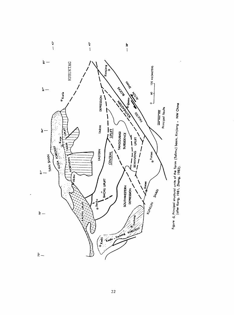
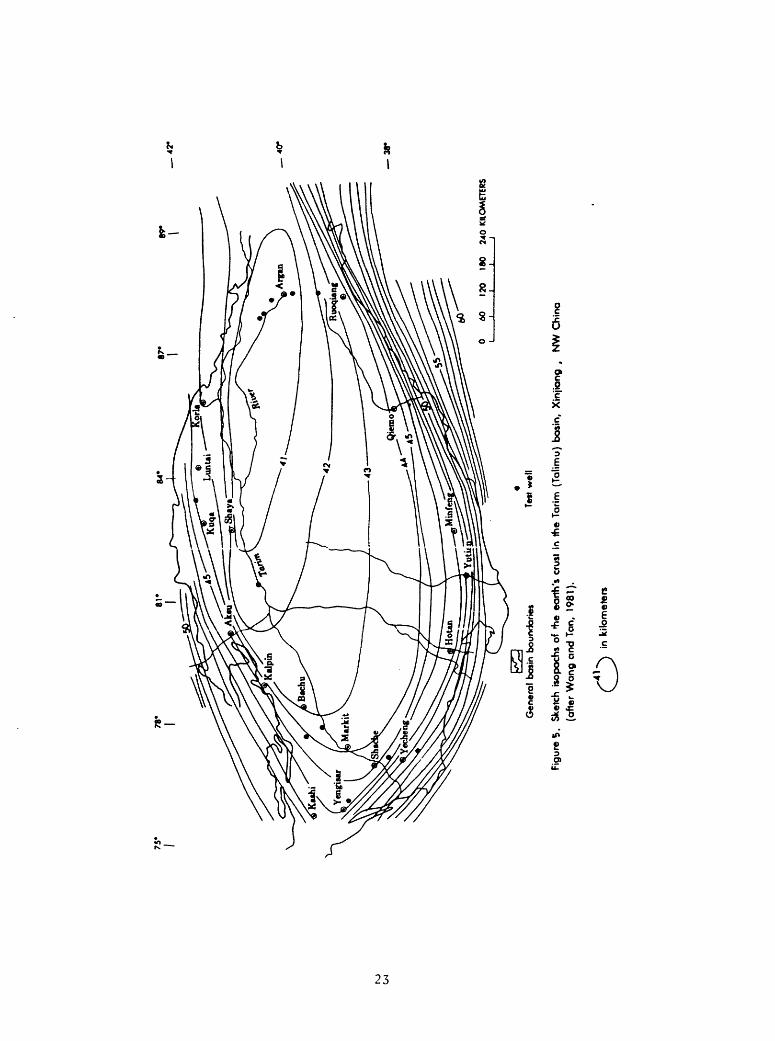
The structural features of the polyphase tectonism in the Tarim basin are bounded on the north by the Tian Shan foldbelt, on the west and south by the Kunlun foldbelt, and on the southeast by the Altun foldbelt (fig. 4). The continental crust of this platform ranges in thickness from less than 41 km in the east to about 51 km around the basin border (fig. 5). In the transitional zone between the platform and the geosynclines adjacent to the basin, it is about 52 to 54 km (fig. 5). The fault systems consist, outside the basin, of the large-scale regional Pamir-Kunlun, Tian Shan, and Altun Shan strike-slip faulting systems, and inside the basin, the north-easterly trending units, the east-west units, and the northwest units (Molnar and Tapponnier, 1978; Huang and others, 1980; Bally and others, 1980; Kang, 1981; Wang and Tan, 1981). Most of them were formed during the Himalayan orogeny and presumably played major roles in the migration and accumulation of oil and gas deposits. These deep seated faulting systems truncated the basin border on the north, the west, the south, and the southeast. On the basis of geophysical and geological data, the Tarim basin is delineated into seven principal structural units: 1) Kuqa Foredeep, 2) Northern Tarim Uplift, 3) Eastern Tarim Depression, 4) Central Uplift, 5) Southwestern Depression, 6) Kalpin Uplift, and 7) South eastern Faulted Blocks (figs. 2 and 4).
Kuqa Foredeep
The Kuqa Foredeep, with a steep rim on the north, is an east-west trough; its evolution began in Early Mesozoic deformation and extended through the Neogene Himalayan movement (table 1). It covers about 30,000 km^ (Wang and others, 1983, p. 298). This depression is bounded on the north by the Tian Shan fault system and on the south by the Northern Tarim Uplift south of Kuqa city. The Mesozoic and Cenozoic sedimentary cover is more than 9,500 m thick. The coal-bearing sedimentary sequences of the Triassic and Jurassic ages reach a thickness of about 4,200 m and have an east-west distibution with depocenters in the central part of the depression, but by Neogene time they shifted south wards (Wang and others, 1983, p. 295-298). From north to south, four sets of exposed anticlinal structure developed. The northern sets are tightly folded and change southward into broad folds. In the northeast, the Yiqikelike (Ichkelik) (Tash-Arik) oil field was discovered in one of the exposed anticline structural sets (fig. 4).
Northern Tarim Uplift
The Northern Tarim Uplift is an east-west trending faulted continental block, bounded on the north by the Kuqa Foredeep, on the south and the west by the Eastern Tarim Depression, and on the east by the Kuruktag faulted block west of Korla. This uplift is a northward dipping gentle monocline that formed in the Proterozoic with about 2,000 m of Paleozoic sedimentary cover (Wang and others, 1983, p. 299). During the Indosinian and Yanshanian movements, this highland was broken further into faulted blocks by northerly- and northwesterly-trending faults. Subsequently the faulted blocks received a sedimentary cover of 4,000 to 7,000 m of chiefly Cretaceous and Cenozoic
21
75
89'
KU
RU
KTA
G
BC
IMIN
FEN
G
UPL
IFT
X
60
120
KIL
OM
ETE
RS
40
*
3
8'
Prin
cip
al
fau
lts
m (Tolimu
)
75
3
8*
180
240
KILO
MET
ERS
Ge
ne
ral
ba
sin
bo
un
da
rie
sTe
st w
ell
Fig
ure
5.
Ske
tch
isop
ochs
of
>he
ea
rth
's c
rust
in
the
Tar
im (
Talim
u)
basi
n, X
injia
ng
,
NW
Chin
a
(after
Wa
ng
and T
an,
1981
).
in k
ilom
ete
rs

ages (Yang, 1983, p. 217-218) (fig. 4). On the west, intermediate to basic intrusions were located at a depth of about 4 km (Zhang, 1982, p. 250).
Eastern Tarim Depression
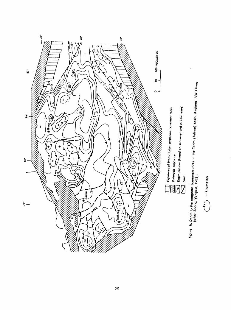
The Eastern Tarim Depression is an east-west trending rhombic sag and formed in Late Paleozoic (fig. 4) (Wang and others, 1983, p. 299). This depression is about 400 km long and 180 km wide and is bounded on the north by the Northern Tarim Uplift, on the west by the Kalpin Uplift, on the east by the Kuruktag faulted block south of Korla, and on the south by the Central Uplift, where it is bounded by an east-west deeply seated faulting system, indicated by positive magnetic anomalies (fig. 3) and a magnetic basement at a burial depth of 15 km (fig. 6). In the depression, the earth's crust is about 41 km thick, which represents the thinnest crustal thickness throughout the Tarim Basin (fig. 5) and suggests the possibility of a relatively high heat flow favorable for generating petroleum deposits. This depression was transected by the northwest and northeast faulting systems along the border areas. Total sedimentary cover ranges from 7,000 to 12,000 m thick (Yang, 1983, p. 218).
Central Uplift
The Central Uplift is a large positive structural feature in the south- central part of Tarim basin, bounded on the north by the Eastern Tarim Depression and on the south by the Southwestern Depression and the South eastern Faulted Blocks (fig. 4). This feature became positive chiefly during the late Variscan orogeny (Kang, 1981; Zhang, 1982; Yi and Jiang, 1981) and was an eroding landmass during the period of the Mesozoic and Early Cenozoic; in the Pliocene, it was transected by the northeast faulting system (fig. 4). Sedimentary cover consists chiefly of the Paleozoic and Cenozoic strata and is generally less than 5,000 m thick (Yang, 1983, p. 217). The depth of burial of the magnetic basement is 2 to 4 km (Zhang, 1982, p. 248). This structural unit consists of the Bachu Uplift, the Tanggubasi Subsidence, and the Beiminfeng Uplift.
The Bachu Uplift formed during the Caledonian orogeny and expanded during the Variscan orogeny (Yi and Jiang, 1980, p. 27). It is located in the north western part of the Central Uplift (fig. 4). This uplift was transected further by the Pliocene north-northeastern Himalayan faulting system (fig. 6). A faulting system to the east of Bachu was encountered by exploration drilling. The upthrown block of this system is on the west and the downthrown block is on the east. Generally, total displacement is about 1,000 m. Sedimentary cover on the west consists of more than 3,900 m of exposed sedimentary sequences ranging in age from Sinian to Permian. Sedimentary covers on the east consist of thin Paleozoic strata and a series of more than 2,000 m of Upper Tertiary sedimentary rocks. In both the western and eastern blocks of the Bachu, Mesozoic sedimentary sequences are generally absent (Wang and others, 1983, p. 299; Wang and Tan, 1981, p. 8). In the Bachu Uplift, two test wells were drilled with depths ranging from 2,339 to 2,845 m. These wells penetrated 900 m of dark-gray Carboniferous limestones, some cavernous. The bottoms of the wells are in the Devonian (Wang and others, 1983, p. 299).
24
38*
100
KIL
OM
ETE
RS
II |
11
Exp
osur
es o
f P
reco
mbr
ion
crys
talli
ne b
asem
ent
rock
s
Pal
eozo
ic e
xpos
ures
Dep
th c
onto
ur (
base
d on
sea-leve
l and i
n ki
lom
ete
rs)
Fau
lt
Fig
ure
b. D
epth
to
the
magnetic
base
ment
rock
s in
the
Tor
im (T
alim
u)
basi
n, X
injia
ng
, N
W C
hin
a
(aft
er
Zh
an
g,
Yo
ng
xia
, 19
82).
C
^)
tn k
ilom
ete
rs

The Tanggubasi Subsidence is a faulted depression (fig. 4) and acted as a seaway during the Upper Cretaceous sea transgression, on the basis of airborne magnetic anomalies showing a relatively deep burial depth of the Tanggubasi basement (fig. 6) (Yang, 1983, p. 217). Chinese geologists believe that Mesozoic-Paleogene marine evaporite-bearing sediments are present in this depression (Kang, 1981, p. 330; Wang and others, 1983, p. 295-297).
The Beiminfeng Uplift is bounded on the north by the Tanggubasi Subsidence, on the west and south by the Southwestern Depression and the Southeastern Faulted Blocks, and on the northeast by the Eastern Tarim Depression (fig. 4). Details of this unit are not available, but it is believed by the author that the reactivation of the Altun northeastern strike-slip faulting system in Pliocene likely was responsible for the faulting of the southern border along the Beiminfeng Uplift.
Southwestern Depression
The Southwestern Depression formed during the early episode of the Variscan orogeny and has received preliminary exploration for petroleum deposits (Kang, 1981). It is an asymmetrical depression with a relatively gentle slope on the northeast flank and a steeper slope on the southwest (figs. 4, 6, 8, 10, 11, and 12). This depression trends northwest and south east and covers 105,000 km^ (fig. 4). Depth of burial of the crystalline basement in the depression ranges from 12 to 15 km (Zhang, 1982, p. 248). During the Himalayan orogeny, three parallel sets of anticlinal structures developed along the Kunlun Shan front, and subsequently the Miocene Kekeya oil field south-southwest of Yecheng was discovered in one set of these anticlinal structures. As the latest episode of the Himalayan movement occurred in Pliocene to Pleistocene, the structure of the Kashi area became more complex because of the effects of intense tectonic activity at the intersection of the Tian Shan on the north and the Kunlun Shan on the south. The Kashi-Yecheng foredeep then acquired its present configuration (fig. 4). Three isoclinal fold groups of Pliocene anticlinal structures formed consisting of 35 anticlinal folds (Wang and Tan, 1981, p. 8-9). These anticlinal folds are asymmetrical to the northeast and trend northwest with steep limbs near the basin border. The Karato oil field, northwest of Kashi, was discovered in one of the anticlinal folds (Petroconsultants, 1978).
Kalpin Uplift
The Kalpin Uplift defines the northwestern margin of the Tarim basin, but this unit is not part of the present day tectonic basin. In this region, thick Paleozoic sedimentary sequences are exposed; those Paleozoic sedimentary sequences are the continuation of the platform lithofacies of the Kuqa Fore- deep as well as the Kashi-Yecheng Foredeep (fig. 4). Mesozoic strata are thin to absent. The area was uplifted during the Variscan movement and remained an emergent landmass during most of Mesozoic time (fig. 4) (Zhang, 1982, fig. 7).
26

Southeastern Faulted Blocks
The Southeastern Faulted Blocks are bounded on the southeast by the Altun Shan, on the north by the Central Uplift and the Eastern Tarim Depres sion, and on the northwest by the Southwestern Depression (fig. 4). Initial development of the Southeastern Faulted Blocks was controlled by the Precambrian deeply seated Altun transform fault system, indicated by thick Late Proterozoic carbonate deposits along the front of the Altun Shan (Wang and others, 1983, p. 295; Huang and others, 1980), and subsequently by the Qiemo fault system; but it has since reached its present configuration in Pliocene and Pleistocene during the latest episode of the Himalayan orogeny (Wang and others, 1983, p. 295-300).
EVOLUTION OF THE BASIN
The Tarim basin is a rhombic-shaped intermontane depression which evolved on a pre-Sinian craton. The following discussion is based on available regional stratigraphic records and lithologic association in relationship to the tectonics.
The pre-Sinian stratigraphy in Tarim basin has been studied on the basis of airborne magnetic surveys (table 2) and consists of Archean metamorphics and Pre-Sinian Proterozoic metamorphics, clastic sediments, and submarine medium- to basic-volcanic rocks (fig. 3). During the Archean, a northeast- trending continental nucleus of crystalline hornblende gneiss and schist was formed by intense folding and regional metamorphisin in most of the southern part of the craton. This crystalline terrane of eugeosynclinal deposits was the initial development stage of the Tarim continental segment, and on the north it was in contact with a deeply faulted east-west magmatic arc of basic to ultrabasic plutonic rocks. This magmatic arc is indicated by a positive magnetic anomaly field and is considered to be an Upper Archean suture zone resembling the subduction zone along the northern Inner Mongolia magmatic arc of the northern Sino-Korean platform (Wang and others, 1983, p. 294-295).
During the Lower Proterozoic, the Archean cratonic-cored continental segment was further enlarged by accretion of complicated rock assemblages onto the older continental nucleus along both its northern and southern edges during the subduction of ocean crust. The process of accretion is indicated by the presence of the magmatic arcs of granitic plutonic rocks in both the northern and southern parts of the basin. During the subduction the Altun transform fault zone was active along the front of the Altun Shan. This fault zone possibly delimited the southeastern border of the Tarim continental segment (Wang and others, 1983, p. 295).
In early Upper Proterozoic, sedimentation and tectonic movement gradually reached a balance, and deposition on the craton proceeded in a low-energy regime (Wang and others, 1983, p. 295; Wang and Tan, 1981, p. 1-4). Southward subduction created the Aksu-Kuruktag magmatic arc on the north, and the northward subduction formed a Lower Proterozoic magmatic arc along the south western border. Subsequently, a series of 2,000 to 5,000 m of Sinian marine and continental sediments, glacial tillite, and volcanic rocks was deposited
27
chiefly west of Aksu and east of Korla in the north of the basin and in the Kashi-Hotan areas of the southwestern part of the basin (fig. 7) (table 2); a thick carbonate rock sequence was deposited along the Altun front on the southeast.
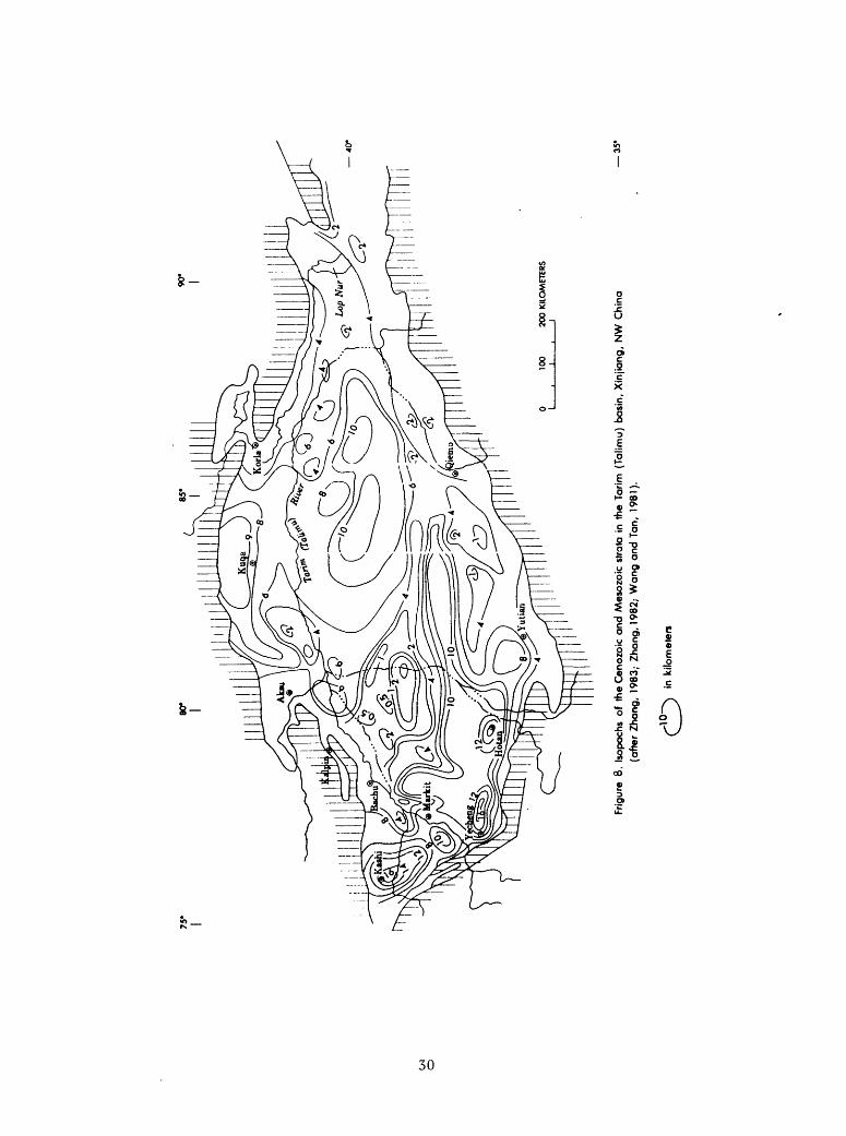
Paleozoic marine platform deposits of carbonate rocks and detrital sedimentary rocks cover more than 600,000 km^ in the Tarim basin; the total thickness of the Paleozoic sedimentary rock cover ranges from 3,000 to more than 6,000 m (fig. 7), but about 500,000 km^ are located beneath a sedimentary cover of 500 to more than 16,000 m of Mesozoic and Cenozoic strata (fig. 8).
During Cambrian and Ordovician time, the central Tian Shan geosyncline contained more than 7,000 m of pelagic limestone, siliceous argillite, and carbonaceous shale (Wang and others, 1983, p. 295). Southward into the present day basin, there were 1,300 to 3,000 m of platform rock assemblages of lime stone, dolomite, marl, and fine detrital rocks (table 2) (Yi and Jiang, 1980, p. 27). During that time, the east-west-trending anticline and syncline folds of the Precambrian basement were preserved, and the development of Tarim platform was controlled by north-south compressive stress (Yang, 1983, p. 215). In the Silurian period, the central Tian Shan to the north became an active eugeosynclinal belt with a Caledonian basic to ultrabasic magmatic arc to the northwest of Kalpin Uplift (fig. 4) (Wang and Tan, 1981, p. 2). A series of 6,000 m of pelagic to shallow marine carbonate and detrital sedimentary rocks was deposited in the Tian Shan trough, and a marine shoreline Lower Silurian sedimentary sequence of 440 to 2,200 m accumulated in the Kalpin and Aksu areas in the northern part of the platform. To the south of Tarim, the Kunlun geosyncline received a series, of unknown thickness, of miogeosynclinal carbonate sedimentary rocks suggesting tectonic stability during that time.
During the Late Paleozoic, the Devonian terrane on the platform was an emergent landmass consisting of 60 to 1,000 m of a continental red bed series, which disconformably overlies the Lower Silurian strata and is unconformably and disconformably overlain by Lower Carboniferous sedimentary beds. The Caledonian Bachu Uplift and its surrounding depressions received 500 to 1,065 m of Carboniferous shallow marine and shoreline carbonate and detrital rocks with some coal beds; elsewhere within the basin, the extensive Carboniferous platform carbonate rock assemblages, with mudstone, are fossil- iferous and reach a thickness of 600 to 1,500 m, locally about 5,000 m in the Kalpin area (Yi and Jiang, 1980, p. 27-28) (table 2) (fig. 7). In Early Permian, the marine sea regressed from most of the platform, but just to the southwest of the platform, a series of more than 1,000 m of marine mudstone and limestone was reported in the Kashi-Yutian area. By Late Permian, continental red beds covered most of the Tarim. The Bachu Uplift was faulted with fissure basalt eruption. Both the Tian Shan and the Kunlun geosynclines were tectonically active forming foldbelts accreting presumably on the Tarim block during the Carboniferous and Permian Variscan deformation. The Late Permian Variscan movement, however, was documented by widespread Upper Permian molasse deposits in the Tian Shan and basin-wide uplift occurring in the Tarim (Yi and Jiang, 1980, p. 28).
28

NJ
<£>
0 10
0 20
0 KI
LOM
ETER
S
Figu
re 1
. Is
opoc
hs o
f th
e P
aleo
zoic
an
d S
inio
n st
rata
in
the
Tori
m (
Tolim
u) b
asin
, X
injio
ng
, N
W C
hina
(o
fter
Zho
ng,
1982
; W
on
g a
nd
Tan
, 19
81).
40*
35'
in k
ilom
eter
s
75'
Frig
ure
8. I
sopo
chs
of
the
Cen
ozoi
c an
d M
eso
zok
stra
ta i
n th
e Ta
rim
(T
alim
u)
basi
n, X
injia
ng
, N
W C
hin
a
(aft
er Z
han
g,
1983
; Z
han
g,
1982
; W
ang
an
d T
an,
1981
).
3
5-
in k
ilom
eter
s

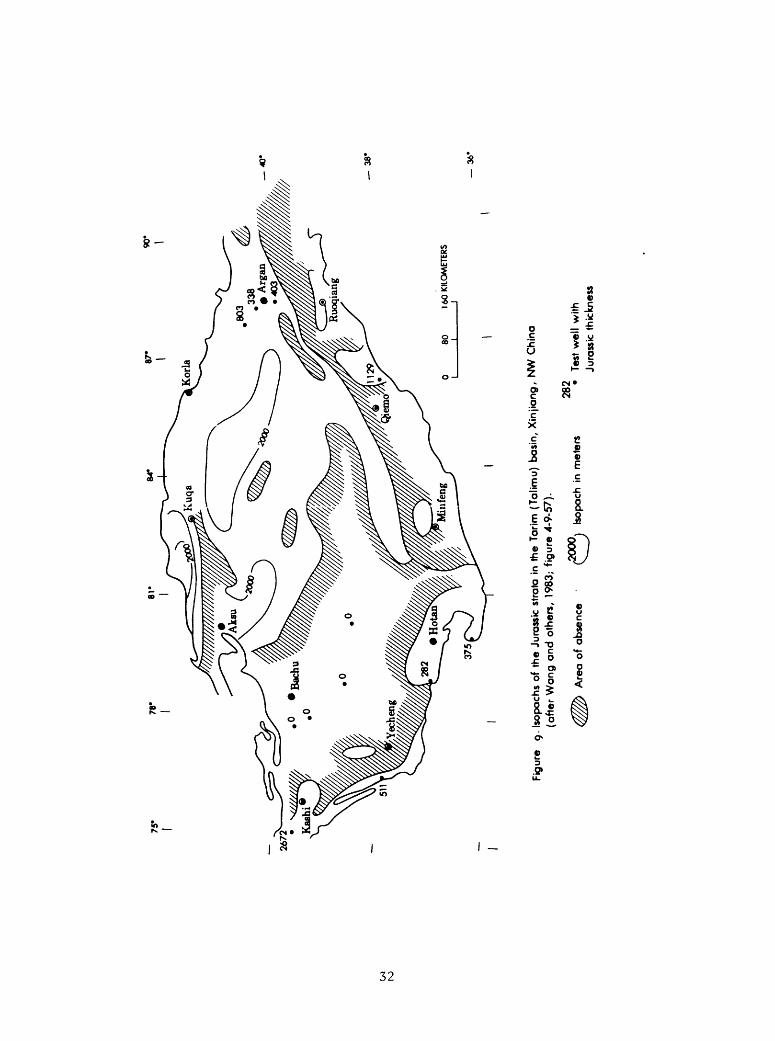
The Mesozoic sedimentary rock cover of Tarim basin consists of 600 to about 7,000 m of Triassic, Jurassic, and Lower Cretaceous continental detrital, coal-bearing clastic sedimentary rocks and upper Cretaceous marine limestone and mudstone (table 2) (figs. 8, 9, and 10). The Triassic coal-bearing clastic sedimentary rocks are recorded as more than 1,200 m thick in the Kuqa and Kashi-Yecheng foredeeps (table 2). As erosion and denudation continued extensively throughout the region in Jurassic time, fluvial and lacustrine deposits of 280 to about 3,000 m of coal-bearing clastic sedimentary rocks were deposited in the Kuqa Foredeep, in the Kashi-Yecheng Foredeep of the Southwestern Depression, in most parts of the Eastern Tarim Depression, and in parts of the Northern Tarim Uplift, as well as in the south of the Central Uplift (table 2) (figs. 4 and 9). Generally, the Jurassic coal-bearing sedimentary sequence is about 2,000 m thick. During the Jurassic, the Yanshanian movement contributed to further development of the Eastern Tarim Depression as well as the Tanggubasi Subsidence in the Central Uplift (figs. 4, 8, and 9). During the Cretaceous, the Upper Cretaceous marine strata reached a maximum thickness of more than 1,500 m in the Kashi area of the Southwestern Depression (fig. 10). Generally, the Cretaceous continental and marine sedimentary sequences are missing in most of the Central Uplift and the Southeastern Faulted Blocks of the basin (fig. 10).
During the Cenozoic, the Himalayan orogeny (table 2) contributed to the evolution of the Tarim basin into its present configuration. At the beginning of Early Tertiary, continental collision between the Indian and Eurasian plates, with a northward subduction of the Indian plate in Miocene in the south, caused the Pamir thrust faulting toward the north and the northwesterly Karakoram strike-slip faulting in the Kunlun Shan (Wang and others, 1983; Tapponier, 1983; Bally and others, 1980; Stocklin, 1977, p. 333-353; Molar, 1978, p. 5361-5375; and Dewey and Burke, 1973, p. 683). Those movements promoted rapid subsidence of the basin foredeeps (fig. 4) and rejuvenation of uplifting and faulting of Karakorum-Kunlun Shan and Tian Shan, accompanied by numerous newly formed folds and faults throughout the basin (figs. 2 and 4).
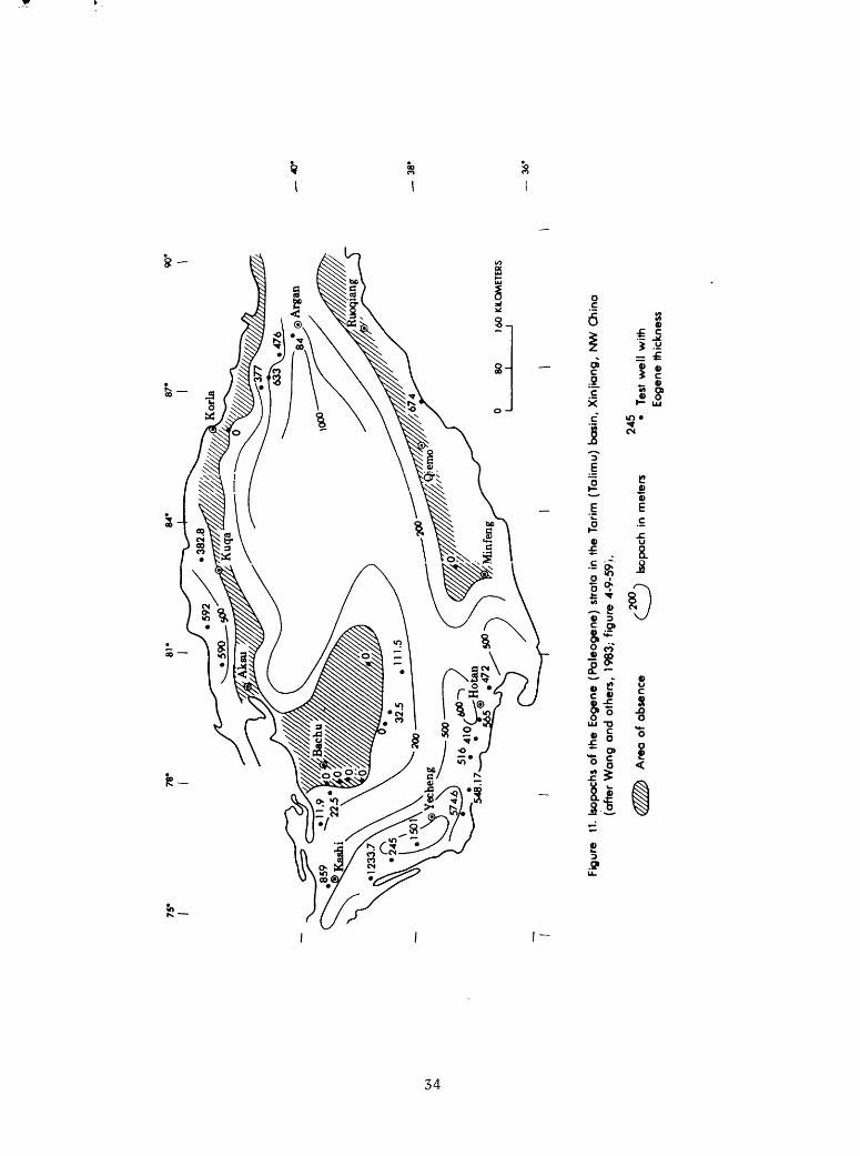
During the Paleogene (Eogene), the Paleocene sea transgression was extensive and covered the Southwestern Depression. Through a southwestern sea-way, the Tanggubasi Subsidence, the sea reached the Eastern Tarim Depression. The depocenters of those marine sedimentary sequences were in areas northwest of Yecheng and due west of Argan (fig. 11). As the Himalayan movement progressed on into the Miocene, the sea completely withdrew from the basin.
During the Neogene, the Kuqa and Kashi-Yecheng foredeeps developed into their present form (fig. 4). The depocenters of the molasse sedimentary facies, 4,000 to 8,000 m thick, are located in the southeast of Kashi, in the south of Yecheng, and the southeast of Hotan of the Southwestern Depression, so-called the Kashi, Yecheng, and Hotan sags (fig. 12). In the Kuqa foredeep, the molasse depocenters are situated in areas west of Kuqa and south-southeast of Aksu. Along the front of the Altun Shan in the southeast, a minor depo- center is located in the area between Qiemo and Ruoqiang (fig. 12). In the central part of the basin, detrital red beds about 2,000 to 3,000 m thick are reported (Wang and others, 1983, p. 297).
31
75*
78
'
0 80
16
0 KI
LOM
ETER
S I_
__
__
I__
__
_I
3
8'
36'
Fig
ure
9.
Isop
achs
of
the
Jur
assi
c st
rata
in
the
Tar
im (
Talim
u)
basi
n, X
injia
ng
, N
W C
hina
(a
fter
Wa
ng
and o
ther
s, 1
983;
fig
ure
4-9
-57)
.
Are
a o
f ab
senc
e20
00*w
u.
;n m
ete
rs
Te
st w
ell
with
Jura
ssic
thi
ckne
ss

75'
Oi
O-i
40*
38'
36'
Fig
ure
<o.
Isop
ochs
of
the
Cre
toce
ous
stra
ta i
n th
e T
arim
(T
alim
u)
basi
n, X
injio
ng
, N
W C
hina
(a
fte
r W
an
g a
nd o
the
rs,
1983
; fig
ure
4-9
-58).
Are
a o
f ab
senc
e. bo
poch
in
met
ers
350
Test
well
with
Cre
tace
ous
thic
knes
s
75*
78*
40*
38'
36'
Fig
ure
11.
Isop
ochs
of
the
Eog
ene
(Pa
leo
ge
ne
) st
rata
in
the
Tar
im (
Ta
limu
) ba
sin,
Xin
jian
g,
NW
Chi
na
(after
Wa
ng
an
d o
the
rs,
1983
; fig
ure
4-9
-59
).
200
245
(^ff
lb
Are
a o
f ab
senc
e (^
^
bopa
ch i
n m
eter
s
Test
well
with
Eog
ene
thic
knes
s

Ln
75*
I
78
3965
_
40
'
3
8'
3
6'
Fig
ure
12.
Isop
achs
of
the
Neogene s
trat
a in
th
e T
arim
(T
alim
u)
basi
n, X
injia
ng
, N
W C
hina
(a
fter
Wang a
nd
oth
ers,
198
3; f
igure
4-9
-60)
.
,50
0.
(^ j
in m
eter
s25
8 Te
st w
ell
with
Ne
og
en
e t
hick
ness

PETROLEUM AND COAL DEPOSITS
Tarim basin is one of the largest and least explored inland basins of the world. The central platform area of the basin is covered by active sand dunes, occupying an area about 324,000 km^ with heights 50 to 300 m above the basin floor. Access to the basin is generally very difficult.
During the early part of this century, petroleum exploration and small scale drilling were concentrated in the Kuqa foredeep and in the Wugia area, northwest of Kashi of the Southwestern Depression (Kudo, 1966). Since the 1950 T s, large scale exploration and drilling were carried out by Chinese geologists. Subsequently, the Yiqikelike and Dongqiulitake oil fields in the Kuqa foredeep and the Kekeya oil field were discovered in the Yecheng area of the Southwestern Depression. Currently, test wells are being drilled within the basin. Thick coal-bearing strata are in the Triassic and Jurassic sedimentary sequences. Mineable Triassic and Jurassic bituminous coal beds are, at present, known only in the Kuqa foredeep (Han and Yang, 1980, p. 274- 275; Department of Coal Teaching and Researches, Wuhan College of Geology, 1980, p. 100-101).
The petroleum potential of Tarim basin is believed to be very large. A reliable estimate for both petroleum and coal resource potential, however, depends on further detailed exploration and analysis.
Petroleum
Petroleum deposits in the Tarim basin have been known to occur in areas northeast and northwest of Kuqa in the Kuqa Foredeep, in areas of Wuqia north west of Kashi and Kekeya south-southeast of Yecheng in the Southwestern Depression, and in the area south of Bachu in the Central Uplift. Generally, source, reservoir, and cap rocks range in age from Sinian to Neogene. Since the discovery of a high flow-rate well, 7,000 BOPD and 50 x 10 6 CFGPD (C. D. Masters, personal communication, 1984), in the Ordovician carbonate rocks southeast of Kuqa in the northern part of the Northern Tarim Uplift, in September 1984, prospecting activities have taken on a new interest.
Source Rocks
Potential source rocks of petroleum deposits in the basin occur chiefly in the sedimentary sequences of Paleozoic to Paleogene age. The Upper Sinian algae-rich carbonate rocks 500 m thick could generate oil and gas deposits (Yi and Jiang, 1980, p. 30). Organic geochemical data provide general information on the evolution of organic matter, as well as correlation of source rocks with crude oil.
36

The Paleozoic potential source rocks are found in the marine sedimentary sequences of the Lower Cambrian, Lower Ordovician, Lower Silurian, Carboniferous, and Lower Permian carbonate rocks, shale, and mudstone and Upper Permian continental shale. The Mesozoic and Lower Tertiary (Paleogene) source rocks are continental deposits of the Triassic, Jurassic, and Lower Cretaceous mudstone, shale, and oil shale, and Upper Cretaceous and Paleogene marine limestone and mudstone (table 2).
The Lower Cambrian source rocks consist of 150 to 200 m of phosphate- bearing, dark carbonaceous shale, and dark sapropelic asphaltene limestone (Yi and Jiang, 1980, p. 30). They are well exposed in the Kuruktag and Kalpin areas of the northern basin border (table 2). Yi and Jiang (1980, p. 30) further inferred that these rock types are present in the northern and southern parts of Tarim basin. The Ordovician source rocks in the Kalpin area comprise about 410 m of gray, fossiliferous, argillaceous limestone and black, graptolite-bearing shale. In the same area, the Lower Silurian is represented by about 500 m of dark graptolite-bearing shale (table 2).
The Carboniferous source rocks are 150 to 500 m of dark, grayish-black, bioclastic, argillaceous crystalline and reef limestones, black mudstone, and dark, argillaceous shale which are known to be present in the Bachu area of the Central Uplift, the Kashi-Hotan areas of the Southwestern Depression, and the margin of the Kalpin Uplift (Kang, 1981) (fig. 4) (table 2). The source rocks in the Lower Permian regressive marine deposits are 50 to 300 m of grayish-black, argillaceous shale and limestone of the Kalundaer Formation in the Kashi-Hotan areas of the Southwestern Depression and in the Kalpin and Bachu areas of the northern part of the basin (Kang, 1981, p. 337) (table 2). Wang and Tan (1981, p. 7) inferred that the Upper Permian continental source rocks of the Dalongkou Group are present in the Eastern Tarim Depression.
The Mesozoic source rocks are 200 to 400 m of Upper Triassic lacustrine and swamp deposits of grayish-black, carbonaceous shale, mudstone, and marl of the Huangshanjie Formation, which is reported to be present in the Kuqa Foredeep and the Eastern Tarim Depression (Kang, 1981, p. 337) (table 2). The Lower and Middle Jurassic lacustrine and swamp deposits of 200 to 600 m of dark-gray, grayish-black mudstone, shale, oil shale, and marl are present in the Kashi and Hotan areas of the Southwestern Depression, in the area of Kuqa as well as in areas southeast of Aksu and southwest of Korla of the Eastern Tarim Depression (fig. 4) (Kang, 1981, p. 337-338) (table 2). Generally the Jurassic source rocks are missing in the Central Uplift, and the Lower Cretaceous is less favorable for source rock throughout the basin.
The Upper Cretaceous and Paleogene source rocks are 200 to 400 m of marine lagoonal deposits of dark-gray, grayish-green and gray mudstone, bioclastic limestone, and limestone, of which the thickest sequences were drilled in the Kashi-Yecheng areas of the Southwestern Depression and in the areas northeast of Aksu and northwest of Kuqa of the Kuqa Foredeep (figs. 10 and 11) (Kang, 1981, p. 338) (table 2). In addition, the Miocene source rocks are represented by 70 to 200 m, locally 446 m, of the transitional facies of lacustrine and lagoonal deposits of gray, grayish-green, brownish- gray, calcareous mudstone, silty mudstone, and marl of the Anjuan Formation
37
in the Southwestern Depression and of the Jidike Formation in the Kuqa Foredeep (Rang, 1981, p. 338) (table 2).
Data on organic geochemistry of the Lower Paleozoic source rocks are based on work done by Yi and Jiang (1980, p. 29-31), and data on the upper Paleozoic, Mesozoic and Tertiary source rocks are taken from Lu (1981, p. 32- 36) (table 3).
Yi and Jiang (1980, p. 29-31) provided some random geochemical data from the surface samples in the Kalpin area for the Lower Paleozoic source rocks (table 3). As compared with data of Upper Paleozoic Carboniferous and Permian source rocks, from the surface samples in the Southwestern Depression and the Kalpin area and the subsurface samples from the Bachu area, the content of organic carbon and asphalt of the Lower Ordovician limestone and Lower Silurian mudstone is relatively low, except the Upper Ordovician mudstone which has organic carbon content of 1.40 percent but asphalt content of 0.0064 percent (table 3). The authors believed that the evolution of soluble organic matter in the Lower Paleozoic source rocks reached a highly mature stage, indicated by the OEP value 0.91 from the basal Silurian mudstone (Yi and Jiang, 1980, p. 31).
Lu (1981, p. 32-33) provided a rather systematic statement on organic geochemistry of the Carboniferous, Permian, Upper Triassic-Jurassic, Upper Cretaceous-Paleogene, and Miocene source rocks from 80 undifferentiated surface and subsurface samples in the Kashi-Yecheng areas of the Southwestern Depression and in the Kuqa Foredeep (table 3). These samples were collected from the basin border and do not represent the true value of the source rocks within individual depressions. Upper Triassic to Jurassic source rocks possess a high standard for petroleum generation, which is indicated by the organic carbon, 1.31 percent; chloroform asphalt, 0.168 percent; and hydro carbon ranging from 500 to 800 ppm. A large number of remaining source rocks shown in table 3 are generally below the standard for petroleum generation. Hu (1981, p. 359-368) and Yan and others (1983, p. 1201-1215) believe that although the Jurassic lacustrine source rocks are rich in organic matter, they are confined only to parts of the Kashi-Yutian areas and the Kuqa Foredeep. The Carboniferous and Permian source rocks are relatively low in organic- matter content, but they are generally thick and extensively distributed. They consider that the Upper Cretaceous and Paleogene source rocks have moderate organic-matter content but they are limited in distribution.
As to the types of Kerogen, the Upper Cretaceous-Paleogene mudstone and carbonate rock and the Carboniferous-Lower Permian limestone represent a sapropelic-type of kerogen. Chemical data show the Upper Cretaceous-Paleogene source rocks contain a total hydrocarbon (saturated hydrocarbon and aromatic hydrocarbon) of 52 percent; ratio of saturated hydrocarbon and aromatic hydrocarbon of 2.63; and H/C, 1.91 and 0/C, 0.313 from one sample of kerogen (table 3) (Lu, 1981, p. 32).
38

Tab
le
3.-
-Ch
em
ical
analy
ses
of
the
sourc
e ro
cks
from
th
e
Tar
im
(Tal
imu
) B
asi
n,
Xin
jian
g,
Nort
hw
est
Ch
ina
(aft
er
Yi
and
Jian
g,
19
80
; L
u,
1981).
Age Hi
K2-
P(E)
Tr3-
J
P2 C-PJ
C-PI si °2 °1
Source
rocks
Mud stone
Mud stone
and
car
bonate
rock
s
Mud stone
and
shale
Mud stone
and
marl
Lime
ston
e
Muds
tone
Muds
tone
Mud stone
Limestone
Organic
carbon
(Z)
0.36
0.14
1.31
0.43
0.11
0.51
0.13
1.40
0.03
Chloroform
asph
alt
(Z)
0.012
0.009
0.16
8
0.04
0.00
2
0.00
8
Saturated
hydrocar
bon
(Z)
35.4
37.7
37.7
45.3
36.5
-25.
6
23.3
-20.
9
Aromatic
hydrocar
bon
(Z)
7.6
14.3
11.1
19.5
12.0
-11.
4
20.7-17.3
Nonhydro-
carbon
(5)
50.3
34.7
37.5
29.5
35.4-35.3
35.4
-29.
9
Asphalt
(Z)
6.7
__'
12
.1
13.2 5.6
18.0-31.2
19.9-31.9
5.9
x 10"3
6.48 x
10~3
5.0
x 10"4
Satu
rate
d Aromatic
hydro-
hydro
carbon
carbon
4.65
2.63
3.4
2.32
3.04-2.23
1.12-0.89
Kerogen
elements
H/C
1.91
0.81
0.61
0/C
0.313
0.083
0.101
S" (Z)
0.02
0.05
0.01
Remarks
80 subsurface and
surface
samples
coll
ecte
d fr
om the
test wells
and
outc
rops
al
ong
the
basin
border in
th
e north
and
southwest
part of Tarim
Basi
n (Lu, 19
81,
table
1, p. 32
).
Chiefly
sapropel-type
of so
urce
rock
s of
th
e Lo
wer
and
Midd
leOrdovician an
d the
basal
part
of the
Lowe
r Silurian from the
Kalpin ar
ea in
the
northwest
part
of TarLm Ba
sin
(Yi
and
Jiang, 1980,
p. 30).
NI,
M
ioce
ne.
K
2~P
(E),
U
pper
C
reta
ceous-
Pal
eogen
e (E
ogen
e).
Trj
-J
(T-j
-J),
U
pper
T
riass
ic-J
ura
ssic
.P2
» U
pper
P
erm
ian
. C
-Pj,
C
arb
on
ifer
ou
s-L
ow
er
Per
mia
n.
Sj,
L
ower
S
iluri
an.
62,
Upp
er
Ord
ovic
ian.
Oj,
L
ower
O
rdovic
ian.

Carboniferous-Lower Permian mudstone, however, represents a humus type of kerogen, which is characterized by the H/C, 0.61, and 0/C, 0.101, of kerogen elements and containing total hydrocarbon, 38 to 44 percent; the ratio of saturated hydrocarbon and aromatic hydrocarbon is 0.89 to 1.12 (table 3) (Lu, 1981, p. 32).
Jurassic mudstone and shale are the mixed sapropel-humus type of kerogen, which is characterized by the H/C, 0.81, and 0/C, 0.083, of kerogen elements and having total hydrocarbon, 4.9 percent; the ratio of saturated hydrocarbon and aromatic hydrocarbon is 3.41. Because the content of organic matter varies considerably in Jurassic source rocks, some of the mudstone and shale have the characteristics of a humus-type of kerogen (table 3) (Lu, 1981, p. 32).
As to the maturation of soluble organic matter in source rocks in the Tarim basin, the geothermal gradient is reported to be 1.74° C per 100 m, and the average surface temperature is 10°C (Yi and Jiang, 1980, p. 31). The geothermal gradient and burial depth directly affect the maturity evolution of soluble organic matter. Although the geothermal gradients of the source rocks from the Kashi-Yecheng areas of the Southwestern Depression and the Kalpin-Kuqa area in the northern part of the basin, within individual strati- graphic sequences, are not available, the maturity of soluble organic matter in these types of kerogen is tentatively discussed in accordance with chemical data and vitrinite reflectance (tables 3 and 4) (Lu, 1981, p. 33).
In Jurassic source rocks from the Kuqa Foredeep, Kashi-Wuqia, and Yecheng areas of the Southwestern Depression, the evolution of organic matter is in a mature stage with crude oil formation, as is indicated by the relatively low content of nonhydrocarbon and asphalt and the high content of total hydrocarbon with a measured vitrinite reflectance ranging from 0.53 to 1.02 (table 4).
In Upper Cretaceous-Paleogene source rocks from the Kashi and Yecheng areas of the Southwestern Depression and the Awat-Luntai areas of the Eastern Tarim Depression and the Northern Tarim Uplift, organic matter evolved into a highly mature stage with the formation of light oil and wet gas. Chemically, it is very low in nonhydrocarbon content and low in asphalt, but high in total hydrocarbon with a reflectivity of 1.39 measured from kerogen (table 4).
In Carboniferous-Lower Permian source rocks from the Kashi-Yutian areas of the Southwestern Depression, the Kalpin-Kuqa area of the Kalpin Uplift and the Kuqa Foredeep, and the Bachu Uplift of the Central Uplift, organic matter evolved into an over-mature stage with the formation chiefly of dry gas; it is characterized by a very low content of nonhydrocarbon and low total hydrocarbon but a very high content of asphalt with a measured vitrinite reflectance ranging from 1.54 to 1.75 (table 4).
The source rocks and crude oil correlation are studied on the basis of the physicochemical nature of both crude oil and source rocks. Four types of crude oil from the oil fields in the Kuqa Foredeep and the Southwestern Depression are defined tentatively for source-rock and crude-oil correlation (Lu, 1981, table 3, p. 33-35) (table 5). Type I represents the Jurassic and Cretaceous crude oil from the Yiqikelike oil field north of Kuqa in the Kuqa Foredeep (fig. 13). Type II represents the Cretaceous and Miocene crude oil
40
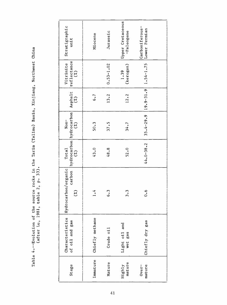
Table 4. Evolution of
th
e source ro
cks
in th
e Tarim (Talimu) Ba
sin,
Xinjiang,
Northwest China
(after Lu,
1981,
table
2, p. 33
).
Stag
e
Immature
Mature
Highly
mature
Over
mature
Characteristics
of oil
and
gas
Chiefly methane
Crude
oil
Light
oil
and
wet
gas
Chiefly dry
gas
Hydrocarbon/organic
carbon
(%)
1.4
6.3
3.3
0.6
Total
hydrocarbon
(%)
43.0
48.8
52.0
44.0-38.2
Non-
hydrocarbon
(%)
50.3
37.5
34.7
35.4-29.9
Asphalt
(%) 6.7
13.2
12.2
19.9-31.9
Vitrinite
reflectance
(%)
0.53-1.02
1.39
(ker
ogen
)
1.54-1.75
Stratigraphic
unit
Miocene
Jurassic
Upper Cretaceous
-Paleogene
Carboniferous-
Lower Permian

Table
5. Characteristics of crude
oil
in the
Tarim
(Talimu) Ba
sin,
Xi
njia
ng,
Northwest
China
(aft
er Lu
, 1981,
table
3, p. 34).
Prod
ucing
loca
lity
and
crud
e-oi
l type
Kuqa
Foredeep
Sout
hwestern
Depression
I. Yiqikelike
oil
field
III.
Do
ngqi
u-litake
oil
field
II.
Kela
tuo
oil
fiel
d
IV.
Keke
yaoil
field
Age
of reservoir
rock
Midd
le Jura
ssic
Miocene
Mioc
ene
Miocene
Color
Gree
n
Yellowish
white
Blac
kish
-brown
Brownish-
yell
ow
Spec
ific
gravity
0.82
7
0.786
0.82
3
0.76
8
Viscosity
(cen
tipo
ise
/30°C)
2.9
1.0
4.8
1.5
Sulphur
(%)
0.01
0.01
0.04
Wax
(Z)
7.8
11.2 7.3
Satu
rate
d hydrocarbon
(%)
80.3
72.3
70.2
91.3
Aromatic
hydrocarbon
(Z)
14.4
27.7
12.5 4.5
Non-
hydrocarbon
(Z)
5.1
12.2 3.5
Asphalt
(Z)
0.1
5.1
0.7
Distillate
300°C
(Z) 66 93 51 78
Remarks
Lu,
(1981, p. 33
-35)
classified four types
of cr
ude
oil:
I. Yi
qike
like
, II.
Kela
tuo,
III. Dongqiulitake,
and
IV.
Kekeya.
Type
s I an
d II characterize
cont
inen
tal
prim
ary
orig
infr
om the
Jura
ssic
so
urce
rock.
Pristane/phytane,
3.41-
5.05;
Vanadium/nickel, 0.857.
Type
s II
I and
IV ar
e ma
rine
seco
ndar
y hi
ghly
mature cr
ude
oil.
Pristane/phytane,
1.41
-2.71;
Vanadium/nickel, 1.5-4.
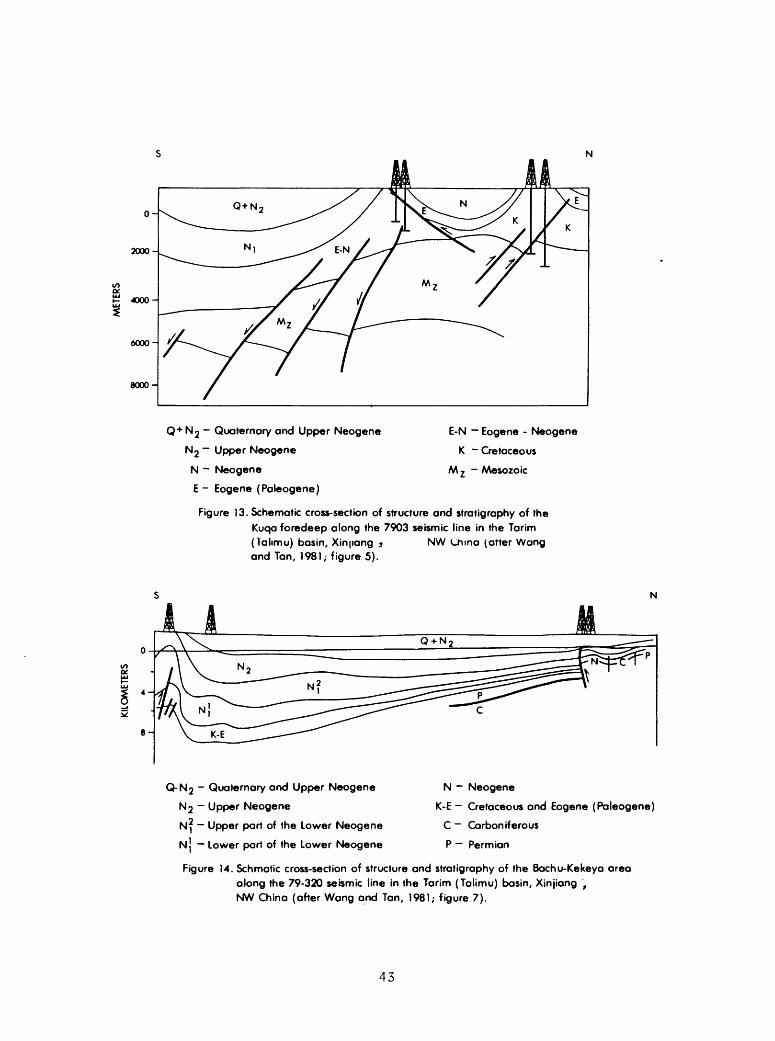
2000-
4000-
6000-
8000-
Q + N 2 - Quaternary and Upper Neogene
N 2 ~ Upper Neogene
N - Neogene
E - Eogene (Paleogene)
E-N Eogene - Neogene
K - Cretaceous
M 2 ~ Mesozoic
Figure 13. Schematic cross-section of structure and stratigraphy of the Kuqa foredeep along the 7903 seismic line in the Tarim (Tahmu) basin, Xinpang j NW China (after Wang and Tan, 1981; figure 5).
Q-N 2 - Quaternary and Upper Neogene
N 2 - Upper Neogene
N^ Upper part of the Lower Neogene
NJ Lower part of the Lower Neogene
N Neogene
K-E - Cretaceous and Eogene (Paleogene)
C ~ Carboniferous
P Permian
Figure 14. Schmatic cross-section of structure and stratigraphy of the Bachu-Kekeya area along the 79-320 seismic line in the Tarim (Talimu) basin, Xinjiang , NW China (after Wang and Tan, 1981; figure 7).
43

from the Kelatuo oil field northwest of Kashi (Kashgar) in the Southwestern Depression. Type III represents the Miocene crude oil from the Dongqiulitake oil field north of Baicheng in the Kuqa Foredeep. Type IV represents the Paleogene and Miocene crude oil from the Kekeya oil field south-southwest of Yecheng in the Southwestern Depression (figs. 4 and 14).
Types I and II are continental and of primary origin and have a close affinity with Jurassic continental source rocks. The mass spectra of isopre- noids from crude oil of both the Yiqikelike and Kelatao oil fields resemble those of the Jurassic source rocks; also the carbon isotopes, C-"- , of those crude oils are nearly similar to those of Jurassic source rocks. The pristane and phytane ratio of the Yiqikelike crude oil is 3.41 to 5.05, and the vanadium and nickel ratio is 0.857 (Lu, 1981, p. 34). These data show a continental origin for both type I and type II crude oil.
Type III and IV crude oil are in a highly mature status. They are degraded crude oil, and generally it is difficult to make a source-rock and crude-oil correlation. Both crude oils are derived from marine source rocks, as indicated by the low pristane and phytane ratios, 2.71 and 1.41, and the high vanadium and nickel content, 4 and 1.5 to 2.6, respectively (Lu, 1981, p. 35). On the basis of carbon isotopes C^, type III crude oil probably has an affinity with Jurassic-Cretaceous and Cretaceous-Tertiary source rocks, and type IV crude oil probably has a close affinity with Upper Cretaceous- Paleogene source rocks.
Reservoir Rocks
In the Tarim basin, potential reservoir rocks of petroleum deposits are the sandstone, conglomerate, and carbonate rocks of the Upper Sinian, Paleozoic, Jurassic, Cretaceous, and Tertiary sedimentary sequences. The resource potential is very large, but reliable assessment of petroleum reserves has yet not been determined and needs further detailed data. At present, oil and gas fields are known mainly in the Kuqa Foredeep and the Southwestern Depression (fig. 4) (table 2). Information is not available on the areal size of individual fields, and data are not available on reservoir, reserves, and production of each field.
Principal potential reservoir rocks in the Tarim basin are the sandstone and conglomerate of the Lower Silurian, Devonian, Carboniferous, Permian, Lower and Middle Jurassic, Cretaceous, and Tertiary age, in which the Lower Silurian, Devonian, Carboniferous, and Lower Permian reservoir rocks are undifferentiated in table 2. The carbonate reservoir rocks are chiefly confined in sedimentary sequences of the Upper Sinian, Cambrian, Ordovician, Carboniferous, and Lower Permian age, which are undifferentiated in table 2. Carbonate reservoir rocks are generally fractured, locally cavernous, and partially contain skeletal grains in the algal mat and the bioherm-reef complex, as indicated by test wells in the northeastern flank of the Bachu uplift, which penetrated a 900-m thick dark-gray Carboniferous limestone with caverns and small amounts of gas (Wang and Tan, 1981, p. 8; Meyerhoff, 1984, p. 322 and 1982, p. 209-215).
44
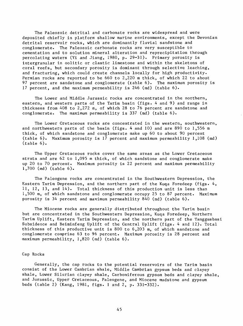
The Paleozoic detrital and carbonate rocks are widespread and were deposited chiefly in platform shallow marine environments, except the Devonian detrital reservoir rocks, which are dominantly fluvial sandstone and conglomerate. The Paleozoic carbonate rocks are very susceptible to cementation and to solution mineral alteration and reprecipitation through percolating waters (Yi and Jiang, 1980, p. 29-31). Primary porosity is intergranular in oolitic or clastic limestone and within the skeletons of coral reefs, but secondary porosity is dominant through selective leaching, and fracturing, which could create channels locally for high productivity. Permian rocks are reported to be 660 to 2,220 m thick, of which 22 to about 97 percent are sandstone and conglomerate (table 6). The maximum porosity is 17 percent, and the maximum permeability is 246 (md) (table 6).
The Lower and Middle Jurassic rocks are concentrated in the northern, eastern, and western parts of the Tarim basin (figs. 4 and 9) and range in thickness from 408 to 2,272 m, of which 28 to 76 percent are sandstone and conglomerate. The maximum permeability is 337 (md) (table 6).
The Lower Cretaceous rocks are concentrated in the western, southwestern, and northwestern parts of the basin (figs. 4 and 10) and are 890 to 1,556 m thick, of which sandstone and conglomerate make up 60 to about 90 percent (table 6). Maximum porosity is 17 percent and maximum permeability 1,108 (md) (table 6).
The Upper Cretaceous rocks cover the same areas as the Lower Cretaceous strata and are 62 to 1,095 m thick, of which sandstone and conglomerate make up 20 to 70 percent. Maximum porosity is 22 percent and maximum permeabilityI,700 (md) (table 6).
The Paleogene rocks are concentrated in the Southwestern Depression, the Eastern Tarim Depression, and the northern part of the Kuqa Foredeep (figs. 4,II, 12, 13, and 14). Total thickness of this production unit is less than 1,500 m, of which sandstone and conglomerate occupy 25 to 87 percent. Maximum porosity is 34 percent and maximum permeability 840 (md) (table 6).
The Miocene rocks are generally distributed throughout the Tarim basin but are concentrated in the Southwestern Depression, Kuqa Foredeep, Northern Tarim Uplift, Eastern Tarim Depression, and the northern part of the Tanggusbasi Subsidence and Beiminfeng Uplift of the Central Uplift (figs. 4 and 12). Total thickness of this productive unit is 800 to 6,203 m, of which sandstone and conglomerate comprise 63 to 96 percent. Maximum porosity is 28 percent and maximum permeability, 1,820 (md) (table 6).
Cap Rocks
Generally, the cap rocks to the potential reservoirs of the Tarim basin consist of the Lower Cambrian shale, Middle Cambrian gypsum beds and clayey shale, Lower Silurian clayey shale, Carboniferous gypsum beds and clayey shale, and Jurassic, Upper Cretaceous, Paleogene, and Miocene mudstone and gypsum beds (table 2) (Rang, 1981, figs. 1 and 2, p. 331-332).
45

Table 6. Porosity an
d permeability of
principal reservoir ro
cks
in th
e Tarim (T
alim
u) Basin, Xi
njia
ng,
Northwest China (a
fter
Ra
ng,
1981
, table
6, p. 339).
Age
N!
P(E) K2
K!
Jl-2 P
Thickness (m)
Total
ofreservoir
rock
s (m
)
800-
6,20
3
<1,5
00
62-1,095
890-1,556
408-2,272
660-2,220
Sandstone &
conglomerate
(%)
63-9
6
25-87
20-7
0
60-9
0
28-7
6
22-97
Thickness of
single
bed
(m)
Range
2-20
0.5-6
0.3-10
0.3-60
1-19
1-5
Maximum
325
275
210
456 53 84
Porosity
(%)
Range
5-25
1-23
6-19
5-16
5-25
2-13
Maximum
28 34 22 17 28 17
Permeability
(md)
Range
1-20
0
1-11
6-500
<1-90
<l-5 <1
Maximum
1,82
0
840
1,70
0
1,10
8
337
246
Remarks
Data from th
e Bureau of
th
e Xinjiang Petroleum
Administration
(Ran
g, 19
81).
N]_,
Mi
ocen
e.
P(E),
Paleogene
P, Permian.
, Upper
Cretaceous
, Lower
Cretaceous
. J].-2» Lower-Middle Jurassic

Types of Trap
The types of trap in the oil and gas pools of the Tarim basin are differentiated as below on the basis of drilling exploration in the South western Depression, the Kuqa Foredeep, and the Bachu Uplift of the Central Uplift (fig. 4). They are structural and stratigraphic traps including bioherm-reef complexes in carbonate rock terranes.
Structural traps in the Tarim basin are those developed in doubly plunging anticlines, exemplified by the Kekeya oil field south-southwest of the Yecheng in the Southwestern Depression, and produced by faulting of both normal and reverse faults with closures, an example in the basin being the Yiqikelike oil field in the Kuqa Foredeep. In this field, normal and reverse faults developed along the axial plane of anticlines, and petroleum migrated upward along the fault plane and accumulated in the upthrown block. A petroleum trap associated with fractures of the structure in the basin has been reported by the recent discovery on the North Tarim Uplift (fig. 4).
Stratigraphic traps in the Tarim basin are generally associated with unconformities, which are widespread throughout the basin (table 2). In the western part of the Southwestern Depression, the oil- and gas-bearing Cretaceous beds onlap over the Pre-Sinian metamorphic complexes, as well as the Miocene Jidike beds in the Kuqa Foredeep locally over the Middle Jurassic strata (Kang, 1981, p. 339). This type of stratigraphic trap could be found in the Bachu Uplift of the Central Uplift, where the Lower Ordovician dolomite and reef-limestone formed isolated anticlinal hills unconformably overlain by the Cenozoic strata (Yi and Jiang, 1980, p. 32).
The bioherm-reef carbonate rock trap has been considered to be present around the Bachu Uplift of the Central Uplift and in the Kashi area of the Southwestern Depression (Yi and Jian, 1980, p. 33; Kang, 1981, p. 339).
Potential and description of known oil and gas fields
Petroleum potential of the Tarim basin is substantial. Generally, detailed studies on the lithofacies, organic geochemistry of source rocks, and prospect drilling within individual structural units of the basin are not available; an estimated ultimate petroleum recovery of the basin, therefore, is not provided in this report.
Some oil and gas fields are concentrated in the Kuqa Foredeep and in the Kashi-Yecheng areas of the Southwestern Depression (fig. 4) (table 2). Scattered exploratory drilling has been done in the basin. Detailed informa tion on oil and gas fields is not available. Some known oil and gas fields are described briefly below (Petroconsultants, S.A., 1978).
In the Kuqa Foredeep, information on the oil and gas fields is adapted from Petroconsultants (1978), unless another information source is cited. Oil fields are the Ichkelik, the Kan, and the Tarlaq; gas fields consist of the Kosaptok and the Kumger fields. The Ichkelik should be spelled out as
47

"Yiqikelike" by the Chinese Pinyin system. The Dongqiulitake oil field probably is a new field. The characteristics of crude oil are listed in table 5 (Lu, 1981, table 3, p. 34) (fig. 13).
The Ichkelik oil field, discovered in 1958, is located approximately at lat 41°44 ! N., long 83°45 ! E. with an average ground-level elevation of 1,200 m, The field is 25 km long and 5 km wide. Reservoir rocks are the Miocene clayey sandstone and conglomerate, producing gas, and the Middle Jurassic fine- to medium-grained sandstone, producing oil. Pools are trapped in an elongated asymmetrical anticline. The depth to top pay is approximately 600 m to the Miocene gas and about 1,100 m to the Middle Jurassic oil. Characteristics of crude oil are shown in table 5.
The Kan oil field, abandoned in 1976, is located approximately at lat 41°55 ! N., long 83°35'E., with an average ground-level elevation of 1,500 m, The reservoir rocks are the Paleogene fine- to coarse-grained sandstone and argillaceous sandstone. The oil pool is trapped by the steeply, 70°-80°- dipping, overturned faulted anticline and the onlapping lenses. The net pay is 2 to 5 m thick; porosity of reservoir rock is 20 to 25 percent. Gravity of the crude oil is 39.8° API at 15°C. Viscosity is 1.70 cs at 38°C. Pour point is -7.8°C. Sulfur content is 0.09 percent. It is a mixed-base type.
The Taqlaq oil field, abandoned in 1976, is located approximately at lat 4l°35 ! N, long 80°15 ! E., with an average ground-level elevation of 1,700 m, The reservoir rocks are the Lower Cretaceous sandstone and conglomerate. The pool is trapped in a faulted anticline with onlapping sandstone lenses. The depth to top pay is approximately 20 to 30 m. The porosity of reservoir rocks is 25 to 30 percent. Gravity of the crude oil is 31° API at 15°C. Viscosity is 8.5 at 38°C. Sulfur content is 0.28 percent. It is a napthenic to mixed- base type.
The Kosaptok gas field was shut-in in 1976 and is located approximately at lat 41°32 ! N, long 82°25 ! E., with an average ground-level elevation of 1,600 m. The reservoir rock is the Miocene and Jurassic fine- to medium- grained sandstone with an anticlinal trap. Approximate depth to the top pay is 1,000 m. The ultimate reserves of gas are 40,000 billion cubic feet.
The Kumger gas field was shut-in in 1976 and is located approximately at lat 41°30' N, long 81°35 ! E., with an average ground-level elevation of 1,600 m. The reservoir rock is the Miocene and Jurassic fine- to medium- grained sandstone with an anticlinal trap. Approximate depth to top pay is 1,000 m. The ultimate reserves of gas are 30,000 billion cubic feet.
Recently, in the Northern Tarim Uplift, a test well, Chacan No. 2, was drilled in the Shaya area southeast of Kuqa on an upthrown fault block by the Bureau of Northwestern Petroleum Geology of the Ministry of Geology and Mineral Resources. This well encountered oil and gas deposits at a depth of 5,391.18 m from the Lower Ordovician fractured limestone. Initial production on test is 7,000 BOPD and 50 x 10 6 CFGPD (personal communication with C. D. Masters, 1984) (Remin Ribao, Sept. 25, 1984).
48

Information of petroleum fields in the Southwestern Depression is scarce. Two known oil and gas fields are the Kelatuo (Karato) in the Kashi area and the Kekeya oil and gas field in the Yecheng area (fig. 14).
According to Petroconsultants (1978), the Kelatuo oil field was discovered in 1918 and shut-in in 1976. It is located approximately at lat 39°30' N, long 75°30' E., with an average ground-level elevation of 1,200 m. The field is 6 km long and 3 km wide. Reservoir rock is the Miocene sandstone with an anticlinal trap. Approximate depth to top pay is 1,000 m. It was water drive. Characteristics of crude oil are listed in table 5.
The Kekeya oil and gas field is located approximately in the south- southwestern part of Yecheng. Reservoir rock is the continental turbidity current Miocene sandstone of the Pakabulak Formation (table 2) (Qiu, 1984). The pool is trapped in an anticline with stratigraphic onlap. Detailed information of the field is not available. Characteristics of crude oil are listed in table 5.
Favorable reservoir rocks for further exploration of petroleum deposits in the Tarim basin are the carbonate rocks and well sorted sheet sandstone bodies deposited in shallow marine, nearshore, and deltaic environments along the sloping terrain on the northeastern flank of the Southwestern Depression, in the Eastern Tarim Depression, the Northern Tarim Uplift, and around the northeastern flank of the Bachu Uplift in the Central Uplift region (fig. 4).
49
Coal
Coal deposits in the Tarim basin are generally unexplored and occur chiefly in the Middle Triassic to Middle Jurassic sedimentary sequences (table 2). The coal is a good quality bituminous coal. In the Kuqa Foredeep, Triassic coal was extensively mined. Jurassic coal was mined locally at Luntai near the southern border of the Kuqa Foredeep and in the vicinity of Yutian in the southeastern part of the Southwestern Depression (figs. 4 and 15)
Occurrence
In the Kuqa Foredeep, coal beds are confined to the Upper Triassic Taliqike Formation of the Xiaoqucangou Group (table 2) (fig. 15) (Department of Coal Teaching and Research, Wuhan College of Geology, 1980, v. 2, fig. 111-88, p. 101), and to the Lower Jurassic Yangxia Formation and the Middle Jurassic Kezileinuer (Kezileidier) Formation (table 2).
The Taliqike Formation contains 13 mineable coal beds reaching up to 25 m thick in the vicinity of Kuqa. This coal-bearing sedimentary sequence thins out toward the margin of the Kuqa Foredeep (fig. 15) (Department of Coal teaching and Research, Wuhan College of Geology, 1980, v. 2, p. 100). The Yangxia Formation contains several coal beds. The coal thickness and number of coal beds increase from the west to the east in the Kuqa Foredeep. Mineable coal beds reach up to more than 20 m thick. Locally, near the top of this coal-bearing sequence, 20 to 50 m of oil shale and carbonaceous mudstone are present (Ran and Yang, 2980, v. 2, p. 302). The coal-bearing Kezileinuer Formation increases its thickness from the west to the east in the Kuqa Foredeep and contains more than 10 mineable coal beds in the Kuqa and Luntai areas, totaling about 10 m thick (Ran and Yang, 1980, v. 2, p. 302).
In the Southwestern Depression, coal deposits are confined to the Middle Triassic Shalitashi Formation, the Upper Triassic Kangsu Formation, and the Lower to Middle Jurassic Yangye Formation (table 2). The Shalitashi Formation contains thin coal beds. The Kansu Formation has thick coal beds near the top of the sequence. The Yangye Formation contains several coal beds, which are locally mined at Yutian. The coal beds form lenses. Mineable coal generally ranges from several m to more than 10 m thick, and locally about 30 m (Ran and Yang, 1980, p. 302).
Potential
At present, rich coal deposits of the Tarim basin are known in the Kuqa Foredeep. Detailed investigations on coal resources are not available; therefore no attempt is made to present a potential of coal deposits in this report. The author believes mineable Jurassic coal beds can be found in the vicinities of Kashi and Hotan in the Southwestern Depression as well as in the Eastern Tarim Depression.
50

Ahe Formation
Baicheng - Kuqa
(Shula)
Ahe FormationTier
Taliqike
Formation
\
ILL1.Conglomerate. 2.Medium-grained sandstone. 3.Fine-grained sandstone. 4. Mudstone and siltstone. 5.Coal bed.
Figure 15. Columnar sections of the Upper Triassic coal-bearing Taliqike Formation in the Kuqa foredeep of the Tarim basin, Xinjiang,Northwest China (after Department of Coal Teaching and Researches,Wuhan College of Geology,I960; Figure III - 88, p.101)
51
SUMMARY AND CONCLUSIONS
The Tarim basin covers 563,000 km^ and evolved on a craton through polyphase tectonism. The crystalline basement is recognizable as a conti nental segment during the early Late Proterozoic. Subsequently, deposition of platform marine sediments from Sinian through Lower Permian time occurred, dominantly, in shallow marine environments. The Tarim acquired elements of its present configuration during the Caledonian and Variscan orogenies and developed its prominent present foredeeps during the Himalayan orogeny. Syntectonic deposition of the sedimentary cover, especially of the Cenozoic age, played a major role during the sedimentation.
The Archean continental nucleus of crystalline metamorphic complexes formed in most of the southern parts of the platform and was in contact with an east-west magmatic arc on the north. During the Proterozoic, the Archean continental nucleus further enlarged to develop the Tarim continental segment by Proterozoic accretion onto the older continental nucleus from both the northern and southern parts of the basin. The northeasterly trending Altun transform fault zone in the southeastern part of the basin limits the Tarim continental segment to the southeast.
The Paleozoic marine platform deposits of carbonate rocks and detrital sedimentary rocks cover more than 600,000 km^ of which about 500,000 km^ are located beneath a sedimentary cover of 500 to more than 16,000 m of Mesozic and Cenozoic strata. Total thickness of the Paleozoic sedimentary rock cover is estimated from 3 to more than 6 km. Because of the effects of the Caledonian orogeny, the Middle and Upper Silurian strata are missing in the basin. At the end of the Permian, in connection with the Variscan movement, the Tarim was uplifted basinwide and partially denuded.
During most of the Mesozoic and Cenozoic, the Tarim basin occupied a distal position with respect to shallow Tethys seaway across South Europe, the Near East, and South Asia and received an influx of continental detrital sediments from adjacent highlands around the basin; but by Upper Cretaceous time, transgressive shallow Tethys seas from the southwest reached as far as the southwestern part of Tarim basin and continued intermittently into early Miocene (personal communication with C. D. Masters, 1985).
The Mesozoic sedimentary cover is about 600 to 7,000 m thick. The thickest sedimentary sequences are concentrated in the Kuqa Foredeep and the Southwestern Depression.
The Cenozoic strata of the Tarim basin consist of 1,400 to 9,000 m of Tertiary marine and continental carbonate and detrital rocks, and of the Quaternary continental detrital sediments. The Cenozoic sedimentary cover is widely distributed throughout the basin. The thickest Tertiary molasse sedimentary sequences are in the foredeep along the fronts of the Kunlun Shan and Tian Shan.
52
Principal structural units are the Kuqa Foredeep, the Northern Tarim Uplift, the Eastern Tarim Depression, the Central Uplift, the Southwestern Depression (including the Kashi-Yecheng Foredeep), the Kalpin Uplift, and the Southeastern Faulted Blocks. Current petroleum exploration is concen trated in the Kuqa Foredeep, the Southwestern Depression, and the Northern Tarim Uplift. Future favorable areas for petroleum exploration are the south-sloping flank on the eastern side of the Southwestern Depression, in the Eastern Tarim Depression (especially its north flank adjacent to the Northern Tarim Uplift), and around the east and northeast flanks of the Bachu Uplift of the Central Uplift.
Source rocks of the petroliferous structural units in the Tarim basin are chiefly the marine sedimentary sequences of the Carboniferous, Lower Permian, Upper Cretaceous, and Paleogene asphaltene carbonate rocks, shale and mudstone; continental lacustrine deposits chiefly of the Jurassic mudstone, shale and oil shale; and marine and continental transitional deposits of the Miocene. According to Lu (1981, table 2, p. 33), overmature dry gas was generated from the source rocks of the Carboniferous-Lower Permian; the highly mature light oil and wet gas, from the Upper Cretaceous-Paleogene source rocks; the mature crude oil, from the Jurassic mudstone, marl, and oil shale; and the immature methane, from the Miocene mudstone.
Reservoir rocks are chiefly sandstone, conglomerate, and fractured, cavernous, algal-matted and bioherm-reef limestone and dolomite, of which the carbonate rocks are present principally in the sedimentary sequences of the Upper Sinian, Cambrian, Ordovician, Carboniferous, and Lower Permian age. Generally, Paleozoic well sorted, marine detrital and carbonate reservoir rocks are widely distributed in the basin. Deep drilling for exploration is needed for the discovery of large oil and gas pools.
Dominant and potential types of trap are the anticlinal folds, faulted anticlines, stratigraphic unconformity and onlap as well as overlap; and fractures and bioherm-reef complexes in the carbonate rocks. Cap rocks are chiefly shale, gypsum beds, and mudstone. It is believed that the petroleum potential of the basin is substantial.
At present, the Triassic and Jurassic coal beds are mined at the Kuqa and Luntai in the Kuqa Foredeep. The Jurassic coal is mined locally at Yutian in the southeastern part of the Southwestern Depression.
53
REFERENCES CITED
Bally, A. W., Alien, C. R., Geyer, R. B., Hamilton, W. B., Hopson, C. A.,Molnar, P. H., Oliver, J. E., Opdyke, N. D., Plafker, George, and Wu. F. T.,1980, Notes on the geology of Tibet and adjacent areas - Report of theAmerican Plate Tectonics Delegation to the People's Republic of China:U.S. Geological Survey Open-file Report 80-501, 100 p.
Chinese Academy of Geological Sciences, 1982, An outline of the stratigraphyin China: Beijing, China, Geological Publishing House, Stratigraphy ofChina, v. 1, 18 figs, and 20 tables, 445 p. (in Chinese with Englishsummary).
Defense Mapping Agency, 1979, Gazetteer of the People's Republic of China:Geographic Names Data Base Division, Washington, D. C. 20315, 919 p.
Department of Coal Teaching and Researches, Wuhan College of Geology, 1980,[Coal Geology]: Beijing, China, Geological Publishing House, v. 2, 296 p.(in Chinese).
Dewey, J. F., and Burke, Kevin, C. A., 1973, Tibetan, Variscan, and Precambrianbasement reactivation: Products of Continental Collission: Journal ofGeology, v. 81, no. 6, p. 683-692.
Han Dexin and Yang Qi, chief editors, 1980, [Coal geology of China]: Beijing,China, Coal Industry Press, v. 2, 415 p. (in Chinese).
Hu Boliang, 1981, On the organic geochemical characteristics and oil-sourcecorrelations in Tarim basin: Oil and Gas Geology, v. 2, no. 4,p. 359-368 (in Chinese with English abstract).
Huang Jiqing (Huang, T. K.), Ren Jishun, Jiang Chunfa, Zhang Zhengkun, andQin Deyu, 1980, The geotectonic evolution of China: Beijing, China,Science Press, 124 p. (in Chinese with English titles).
Institute of Geology, Academia Sinica, 1956 [Earth Strata]: Beijing, China,Science Press, 693 p.
Kang Yuzhu, 1981, Geological characteristics of petroleum in Tarim Basin: Oiland Gas Geology, v. 2, no. 4, p. 329-340 (in Chinese with English abstract).
Kudo, T. , 1966, [Petroleum resources of China]: Institute of Asian EconomicAffairs, Research Materials on Overseas Investments, v. 9, 61 p. (inJapanese).
Lu Minggang, 1981, Source of oil for the western part of the Tarim Basin:Acta Petrolei Sinica, v. 2, no. 3, p. 31-36 (in Chinese with Englishabstract).
Meyerhoff, A. A., 1982, Petroleum basins of the Union of Socialist SovietRepublics and the People's Republic of China and the politics of petroleum:Petroleum Exploration Society of Australia, Distinguished Lecture Series,341 p., 140 figs.
________ 1984, Carboniferous oil and gas generation in the Eastern Hemisphere- 11: Journal of Petroleum Geology, v. 7, no. 3, p. 313-328.
Molnar P. H., and Tapponnier, P., 1978, Active tectonics of Tibet: Journal ofGeophysical Research, v. 83, p. 5361-5375.
Petroconsultants S.A., 1978, Oil and gas data sheets: Geneva, Switzerland,4 pages each.
Qiu Dongzhon, 1984, Turbidite in the 4-5th members of Pakabulak Formation inKekeya oil field: Oil and Gas Geology, v. 5, no. 1, p. 55-591 (inChinese with English abstract).
Stocklin, J., 1977, Structural correlation of the Alpine ranges between Iranand central Asia: Mem.h.Ser. Soc. Geol. France, no. 8, p. 333-353.
Wang Hongzhen and Liu Benpei, 1980, [Historical Geology]: Beijing, China,Science Press, 352 p. (in Chinese).
54
Wang Hongzhen and Qiao Xiufu, 1984, Proterozoic stratigraphy and tectonicframework of China: Geological Magazine, v. 121, no. 6, p. 599-614.
Wang Yichang and Tan Shidian, 1981, The evolution and hydrocarbon-bearingprospects of Tarim plate structure: Petroleum Exploration and Development,no. 3, p. 1-9 and 59 (in Chinese with English titles).
Wang Shangwen, Zhang Wanxuan, Zhang Houfu, and Tan Shidian, 1983 [PetroleumGeology of China]: Beijing, China, Petroleum Industry Press, 348 p.(in Chinese)
Yan Yugui, Yang Shizhuo, Hu Boliang, Wen Changqing, and Jin Huijuan, 1983,Some problems concerning petroleum geology of the Tarim basin: ScientiaSinica Series B, v. 16, no. 11, p. 1201-1215.
Yang Hua, 1983 [Magnetic fields and future petroleum prospecting in the Tarimbasin]: in [Tectonics and evolution of the Mesozoic and Cenozoic basinsin China], Zhu Xia, ed., Beijing, China, Science Press, p. 212-219(in Chinese).
Yi Ronglong and Jiang Shengbang, 1980, The oil and gas potential in thePaleozoic of Tarim Basin: Oil and Gas Geology, v. 1, no. 1, p. 26-36(in Chinese with English abstract).
Zhang Yongxia, 1982, The characteristics of regional geological structure ofTarim Basin, China: Acta Geophysica Sinica, v. 25, no. 3, p. 243-251(in Chinese with English abstract).
Zhang Wenyou, Chief Compiler, 1983, The marine and continental tectonic mapof China and its environs: Beijing, China, Science Press, 1:5,000,000,6 sheets (in Chinese and limited English edition).
55