the european hf radar inventory -...
TRANSCRIPT

THE EUROPEAN HF RADAR INVENTORY
Writing team:
Julien Mader1, Anna Rubio
1, J.L. Asensio
1 Antonio Novellino
2, Marco Alba
2 Lorenzo Corgnati
3, Carlo
Mantovani3, Annalisa Griffa
3, Patrick Gorringe
4, Vicente Fernandez
4
1 AZTI Marine Research, Pasaia, Spain
2 ETT, Genova, Italy
3 Institute of Marine Sciences, National Research Council of Italy, Pozzuolo di Lerici, Italy
4 EuroGOOS AIBL, Brussels, Belgium
Contributors:
Name Institution Country
Mando de Jong Rijkswaterstaat The Netherlands Carlo Mantovani CNR-ISMAR Italy
Hezi Gildor The Institute of Earth Sciences Israel Cariou Valérie SHOM France
Jochen Horstmann Helmholtz-Zentrum Geesthacht Germany Silvia Piedracoba University of Vigo Spain
Carlo Brandini Consorzio LaMMA - CNR Italia Anne-Claire Bennis University of Caen France
Julien Mader AZTI, Euskalmet, Basque Government Spain Giuseppe Ciraolo University of Palermo Italy
Simone Cosoli OGS Italy Daniel Conley Plymouth University United Kingdom
Michael Hartnett National University of Ireland, Galway Ireland Kai Christensen Norwegian Meteorological Institute Norway
Vlado Dadic Institute of Oceanography and Fisheries Croatia Enrique Álvarez Puertos Del Estado Spain Branko Cermelj National Institute of Biology Slovenia
Bee Berx Marine Scotland Science United Kingdom Aldo Drago University of Malta Malta
Pedro Montero INTECMAR Spain Anna Konstantinidou Hellenic Centre for Marine Research Greece
Emma Reyes SOCIB Spain Carlos Fernandes Instituto Hidrografico Portugal
Céline Quentin MIO, AMU-CNRS-IRD-UTLN France Enrico Zambianchi University of Naples Parthenope Italy
Louis Marié IFREMER France Carlos Barrera PLOCAN Spain Thomas Helzel HELZEL Messtechnik Germany Jorge Sanchez Qualitas Remos Spain Mikko Lensu Finnish Meteorological Institute Finland Yaron Toledo Tel-Aviv University Israel Maja Jeromel Slovenian Environment Agency Slovenia
Publication date 15 Sep 2016 (Updated version 30 Jan 2017)
Please cite this document as: MADER J., RUBIO A., ASENSIO J.L, NOVELLINO A., ALBA M., CORGNATI L.,
MANTOVANI C., GRIFFA A., GORRINGE P., FERNANDEZ V. (2016) THE EUROPEAN HF RADAR INVENTORY.
EUROGOOS PUBLICATIONS.

The European HF Radar Inventory
1
Foreword
The inventory of the different HF radar systems operating in Europe has been gathered
thanks to the survey launched by the EuroGOOS HFR Task Team, in the framework of
INCREASE and JERICO-NEXT projects. We are very grateful to all the people who
kindly provided the information of their radar and related activities.
This publication summarizes the main results of the European HF radar survey.
EuroGOOS HFR Task Team will keep it as living document to be updated each time new
information concerning existing or future systems is made available. Please do not
hesitate to contact [email protected] if you detect any necessary update on the current
contents.
Index
1 Introduction .......................................................................................................... 2
2 Overview to the European HFR systems ........................................................... 3
2.1 General view of EU HFR systems ................................................................. 3
2.2 HFR systems operation and maintenance ..................................................... 6
2.3 Existing data formats and QA/QC protocols .................................................. 7
2.4 HFR surface ocean current data sharing protocols ........................................ 8
3 HFR current data uses and users in Europe ...................................................... 9
4 Bibliography ....................................................................................................... 13
5 Acknowledgments ............................................................................................. 14
ANNEX 1 – The HFR survey ..................................................................................... 15
ANNEX 2 – Main characteristics of European HFRs .............................................. 20

The European HF Radar Inventory
2
1 Introduction
The accurate monitoring of ocean surface transport, which is inherently chaotic and
depends on the details of the surface velocity field at several scales, is key for the
effective integrated management of coastal areas, where many human activities
concentrate. This has been the main driver for the growth of coastal observatories along
the global ocean coasts.
Among the different measuring systems, coastal High Frequency Radar (HFR) is the
unique technology that offers the means to map ocean surface currents over wide areas
(reaching distances from the coast of over 200km) with high spatial (a few kms or higher)
and temporal resolution (hourly or higher). Consequently, the European HFR systems
are playing an increasing role in the overall operational oceanography marine services.
Their inclusion into CMEMS is crucial to ensure the improved management of several
related key issues as Marine Safety, Marine Resources, Coastal & Marine Environment,
Weather, Climate & Seasonal Forecast.
The main potential of HFR resides in the fact that these systems can offer high temporal
and spatial resolution current maps, matching the need for operational
monitoring/forecasting of ocean transports and their applications to several Marine
Strategy Framework Directive’s (MSFD) objectives.
Around 400 HFR sites have been already installed worldwide, and used in a diverse
range of applications (see Paduan and Washburn, 2013, and Roarty et al., 2016). In
Europe, the number of HFR systems is growing with over 50 HFR sites currently
deployed and a number in the planning stage.
In Europe, the use of HFR systems is growing with over 50 HFRs currently deployed and
a number in the planning stage. In order to build an up-to-date inventory of operational
HFR systems and operators the EuroGOOS HFR TaskTeam in close collaboration with
the INCREASE and JERICO-Next projects, launched a European survey to diagnose
the present status of different HFR systems available in Europe.
The survey consisted in 46 questions oriented to provide information on four areass:
- Contact people for each network or system
- Technical information on the network, number, names, locations, working
parameters of the sites (including questions on maintenance procedures and
experience of interference problems)
- Technical information about the data formats, sharing protocols and policies,
QA/QC and processing
- Areas of application of the data and identified users (including specific questions
related to data assimilation)
The survey was launched in June 17th and was set to the EuroGOOS HFR Task Team
expert’s mail-list, including JERICO-Next collaborators and other identified key actors. It
was closed July 27th, gathering responses from 28 European institutions and information
on more than 70 HFR systems.
The complete survey can be consulted in Annex 1.

The European HF Radar Inventory
3
2 Overview to the European HFR systems
The INCREASE EU HFR survey gathered information from 28 institutions, 23 of whose
are operators of ongoing or past HFR networks. A total of 72 sites (conforming 28
networks) were listed from the survey results, 52 of those sites are ongoing (20
networks). Within the remaining sites there are 9 past installations (3 past networks) and
12 future installations (5 new networks). The information provided in the following
describes several aspects of the ongoing and past HFR networks (N=23) and their
corresponding sites (N=60). Although we believe this survey provides a very complete
view of the HFR activity in Europe we are aware of some additional past HFR
installations which were not listed here, because they were very short term or
experimental installations or they have been not identified by the users of the survey
(e.g. two HFRs were operated close to the Rhone river mouth, NW Mediterranean, at
least from June 2006 to January 2007, see Schaeffer et al. 2011).
2.1 General view of EU HFR systems
Based on the responses provided, 92% (48) of the ongoing installations (52) are meant
to be permanent. The remaining systems are temporary, with undefined dates of end of
use. Figure 1 shows the location of the systems listed by the survey, with a graphical
representation of the footprint areas for each antenna.
The distribution of the identified ongoing and past networks (N=23) amongst the ROOS
areas is: 52% (12) in MONGOOS, 26% (6) in IBIROOS and 22% (5) in NOOS. In terms
of number of sites MONGOOS is again the most densely populated, it contains 31 sites
(52%). While IBIROOS and NOOS contain 17 sites (28%) and 12 sites (20 %),
respectively.
Figure 2 shows the evolution in time of the number of HFR systems in Europe, following
the current inventory. The number of systems is growing with time and the plans show
the increase to continue in the next year.
In addition to the general statistics presented here, a complete characterization of the
existing systems has been performed, and it is presented in the corresponding tables of
Annex 2. Most of the EU HFR networks are (or have been) operated for several years
and are built of 2 sites, on average. The used systems range from very high frequency
systems like the one in Ria de Vigo, working at frequencies of 46.5 MHz (thus providing
horizontal resolution for total currents coarser than 200 m) to long range systems
working at 4.5 MHz (providing horizontal resolution of 5 km) used in Spain or UK. They
offer typically temporal resolution of 1 hour or less and variable spatial coverage
depending on their working frequency (see Figure 1).

The European HF Radar Inventory
4
FIGURE 1: MAP WITH THE LOCATION OF THE 72 EU HFR SITES LISTED IN THE SURVEY, AND
THEIR RADIAL COVERAGE (REPRESENTED BY THE CIRCLES SCALED TO TYPICAL RADIAL
RANGE ASSOCIATED TO THE FREQUENCY OF OPERATION OF EACH OF THE SYSTEMS) .
GREEN: ONGOING; RED: PAST; YELLOW: FUTURE INSTALLATIONS.

The European HF Radar Inventory
5
FIGURE 2: EVOLUTION OF THE NUMBER OF EU HFR OPERATIONAL RADARS WITH TIME. THE
BOLD BLACK LINE SHOWS THE NUMBER OF OPERATIONAL SYSTEMS PER YEAR (Y AXIS). THE
TIMELINE OF THE EU SYSTEMS, FOLLOWING THE INVENTORY, IS PROVIDED BY THE
DISCONTINUOUS LINES. PAST SYSTEMS ARE PLOTTED IN RED, FUTURE SYSTEMS IN YELLOW
AND PRESENT SYSTEMS IN GREEN. THE NAME OF THE NETWORKS AS PROVIDED IN THE
SURVEY IS GIVEN BESIDE THE CORRESPONDING SITES’ TIMELINES.
Only 28 % of the systems are connected to European Data System - EMODnet Physics
(Figure 3). Some of them through other national networks like Puertos del Estado and
some other are also included in other National and International Networks like: MOOSE
Network: www.moose-network.fr; GEO Global High Frequency Radar Network:
http://marine.rutgers.edu/~hroarty/GEO/ESRI and IBERORed: www.iberoredhf.es.
The European HF Radar Inventory
6
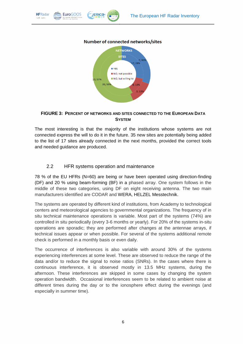
FIGURE 3: PERCENT OF NETWORKS AND SITES CONNECTED TO THE EUROPEAN DATA
SYSTEM
The most interesting is that the majority of the institutions whose systems are not
connected express the will to do it in the future. 35 new sites are potentially being added
to the list of 17 sites already connected in the next months, provided the correct tools
and needed guidance are produced.
2.2 HFR systems operation and maintenance
78 % of the EU HFRs (N=60) are being or have been operated using direction-finding
(DF) and 20 % using beam-forming (BF) in a phased array. One system follows in the
middle of these two categories, using DF on eight receiving antenna. The two main
manufacturers identified are CODAR and WERA, HELZEL Messtechnik.
The systems are operated by different kind of institutions, from Academy to technological
centers and meteorological agencies to governmental organizations. The frequency of in
situ technical maintenance operations is variable. Most part of the systems (74%) are
controlled in situ periodically (every 3-6 months or yearly). For 20% of the systems in-situ
operations are sporadic; they are performed after changes at the antennae arrays, if
technical issues appear or when possible. For several of the systems additional remote
check is performed in a monthly basis or even daily.
The occurrence of interferences is also variable with around 30% of the systems
experiencing interferences at some level. These are observed to reduce the range of the
data and/or to reduce the signal to noise ratios (SNRs). In the cases where there is
continuous interference, it is observed mostly in 13.5 MHz systems, during the
afternoon. These interferences are skipped in some cases by changing the system
operation bandwidth. Occasional interferences seem to be related to ambient noise at
different times during the day or to the ionosphere effect during the evenings (and
especially in summer time).
The European HF Radar Inventory
7
2.3 Existing data formats and QA/QC protocols
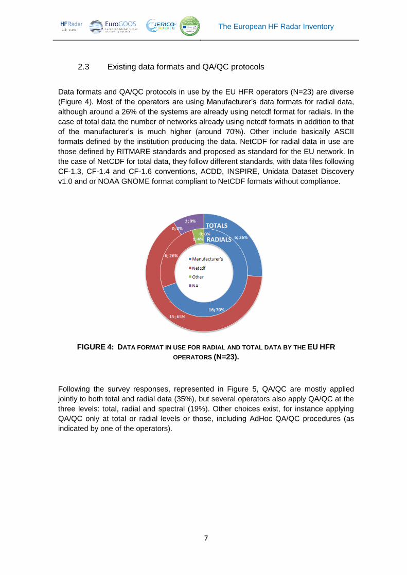
Data formats and QA/QC protocols in use by the EU HFR operators (N=23) are diverse
(Figure 4). Most of the operators are using Manufacturer’s data formats for radial data,
although around a 26% of the systems are already using netcdf format for radials. In the
case of total data the number of networks already using netcdf formats in addition to that
of the manufacturer’s is much higher (around 70%). Other include basically ASCII
formats defined by the institution producing the data. NetCDF for radial data in use are
those defined by RITMARE standards and proposed as standard for the EU network. In
the case of NetCDF for total data, they follow different standards, with data files following
CF-1.3, CF-1.4 and CF-1.6 conventions, ACDD, INSPIRE, Unidata Dataset Discovery
v1.0 and or NOAA GNOME format compliant to NetCDF formats without compliance.
FIGURE 4: DATA FORMAT IN USE FOR RADIAL AND TOTAL DATA BY THE EU HFR
OPERATORS (N=23).
Following the survey responses, represented in Figure 5, QA/QC are mostly applied
jointly to both total and radial data (35%), but several operators also apply QA/QC at the
three levels: total, radial and spectral (19%). Other choices exist, for instance applying
QA/QC only at total or radial levels or those, including AdHoc QA/QC procedures (as
indicated by one of the operators).

The European HF Radar Inventory
8
FIGURE 5: DATA LEVELS USED FOR QA/QC PROCEDURES BY THE EU HFR OPERATORS
(N=23).
Most of the operators (N valid answers= 14) use the Least Square Method (>90%) to
produce totals, but other methods like OMA (Kaplan & Lekien, 2007) are also quite
extended (around 30% of the responses). The most common software used for
combining radials into totals is the one provided by the manufacturers (in around 68% of
the cases, N valid answers= 19) although other tools like the matlab HFR_toolbox (26%)
and specific software developed by the operators (19%) are used in other cases in
addition or as alternative to manufacturer’s software.
2.4 HFR surface ocean current data sharing protocols
The most part of the networks (70%) are applying an open data policy with no
restrictions of use (Figure 6). From those, 14 operators are providing free and open data
under no specific licensing. Two networks, operated by CNR-ISMAR, are offering their
data under Creative Commons Attribution 4.0 International License (see
http://creativecommons.org/licenses/by/4.0). The remaining 30% of the data are not all
fully restricted. For some networks there is free access to the data depending on the final
user (for instance, data is open for academic use or ), or the resolution of the product (so
only high resolution products are restricted and only available upon request). Other data
are only available upon request and in one case data are restricted but near-real time
visualization and validation of the current maps are available at the institution web.
FIGURE 6: DATA POLICY (N=23)

The European HF Radar Inventory
9
Concerning the online availability of the data from the listed networks, while the 75% of
the real time data are online, only the 51% of the historical data are (Figure 7). The most
used protocol to put the data online is the THREDDs, although other possibilities coexist
(e.g. using WMS-Web Map Service through the operator webpage, or other protocols
like ftp; Some data are available through the institutions’ data server or portals).
FIGURE 7: DATA AVAILABILITY AND DATA SHARING PROTOCOLS (N=23)
3 HFR current data uses and users in Europe
As revealed by the increasing literature in Europe concerning HFR reflects ongoing
efforts towards the applications in different sectors: oils spill management (Abascal et al.
2009; Bellomo et al., 2016), marine litter (Basurko et al. 2016), search and rescue (Orfila
et al. 2015, Solabarrieta et al. 2016) and data assimilation (e.g. Marmain et al, 2014;
Barth et al. 2008, 2011; Iermano et al., 2016; Stanev et al. 2015).
Following the information gathered from the HFR networks participating in the
INCREASE survey, several additional applications of HFR data to different sectors in
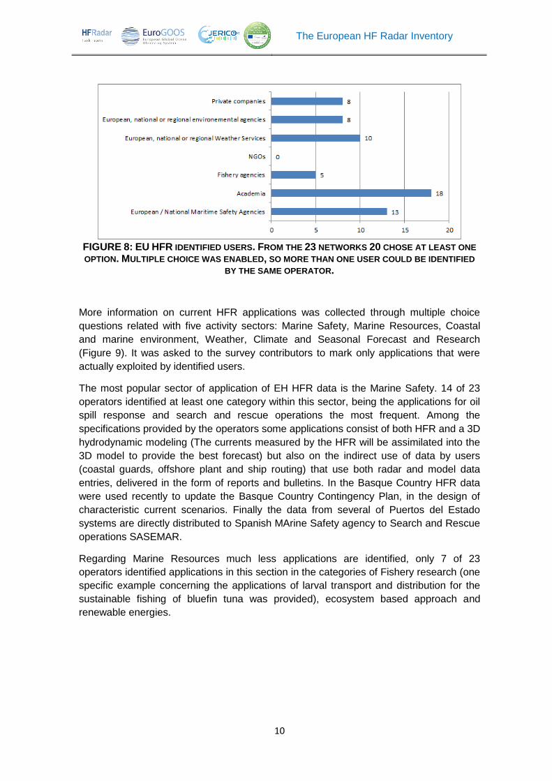
Europe are in progress and there is a number of well-established users (Figure 8). 20 of
23 operators chose at least one option between the listed users of their data among
different activity sectors. The most popular identified user is the Academia, followed by
European or National Maritime Safety Agencies and Weather Services. Some specific
users were by Spanish operators: the Spanish Maritime Safety Agency SASEMAR and
Ports Authorities through Puertos del Estado networks.
The European HF Radar Inventory
10
FIGURE 8: EU HFR IDENTIFIED USERS. FROM THE 23 NETWORKS 20 CHOSE AT LEAST ONE
OPTION. MULTIPLE CHOICE WAS ENABLED, SO MORE THAN ONE USER COULD BE IDENTIFIED
BY THE SAME OPERATOR.
More information on current HFR applications was collected through multiple choice
questions related with five activity sectors: Marine Safety, Marine Resources, Coastal
and marine environment, Weather, Climate and Seasonal Forecast and Research
(Figure 9). It was asked to the survey contributors to mark only applications that were
actually exploited by identified users.
The most popular sector of application of EH HFR data is the Marine Safety. 14 of 23
operators identified at least one category within this sector, being the applications for oil
spill response and search and rescue operations the most frequent. Among the
specifications provided by the operators some applications consist of both HFR and a 3D
hydrodynamic modeling (The currents measured by the HFR will be assimilated into the
3D model to provide the best forecast) but also on the indirect use of data by users
(coastal guards, offshore plant and ship routing) that use both radar and model data
entries, delivered in the form of reports and bulletins. In the Basque Country HFR data
were used recently to update the Basque Country Contingency Plan, in the design of
characteristic current scenarios. Finally the data from several of Puertos del Estado
systems are directly distributed to Spanish MArine Safety agency to Search and Rescue
operations SASEMAR.
Regarding Marine Resources much less applications are identified, only 7 of 23
operators identified applications in this section in the categories of Fishery research (one
specific example concerning the applications of larval transport and distribution for the
sustainable fishing of bluefin tuna was provided), ecosystem based approach and
renewable energies.

The European HF Radar Inventory
11
a)
b)
c)
d)
FIGURE 9: EU HFR APPLICATIONS WITHIN FOUR ACTIVITY SECTORS: A) MARINE SAFETY, B) MARINE RESOURCES, C) COASTAL AND MARINE ENVIRONMENT AND D) WEATHER AND
CLIMATE FORECAST. FROM 23 OPERATORS 14,7, 11 AND 12 CHOSE AT LEAST ONE OF THE
AVAILABLE OPTIONS FOR A), B), C) AND D), RESPECTIVELY. MULTIPLE CHOICE WAS ENABLED, SO MORE THAN ONE APPLICATION WITHIN THE SAME OR DIFFERENT SECTORS COULD BE
IDENTIFIED BY THE SAME OPERATOR.
In addition to water quality monitoring and pollutions control other two applications in the
sector of Coastal and Marine Environment were identified: Leisure activities (sail and
swimming competitions) and indirect use of data for estimating marine litter
concentrations that may be accumulated by local hydrodynamic conditions (for
Universities and National/Regional Environmental Agencies). 11 of 23 operators
identified at least one application in this field, being the use of HFR data for pollution
control de most popular.
In the field of weather forecast almost all of those operators that identified at least one
application in this sector (12 of 23) were referring to the use of data for model validation
and half of them to the use of the data for data assimilation.
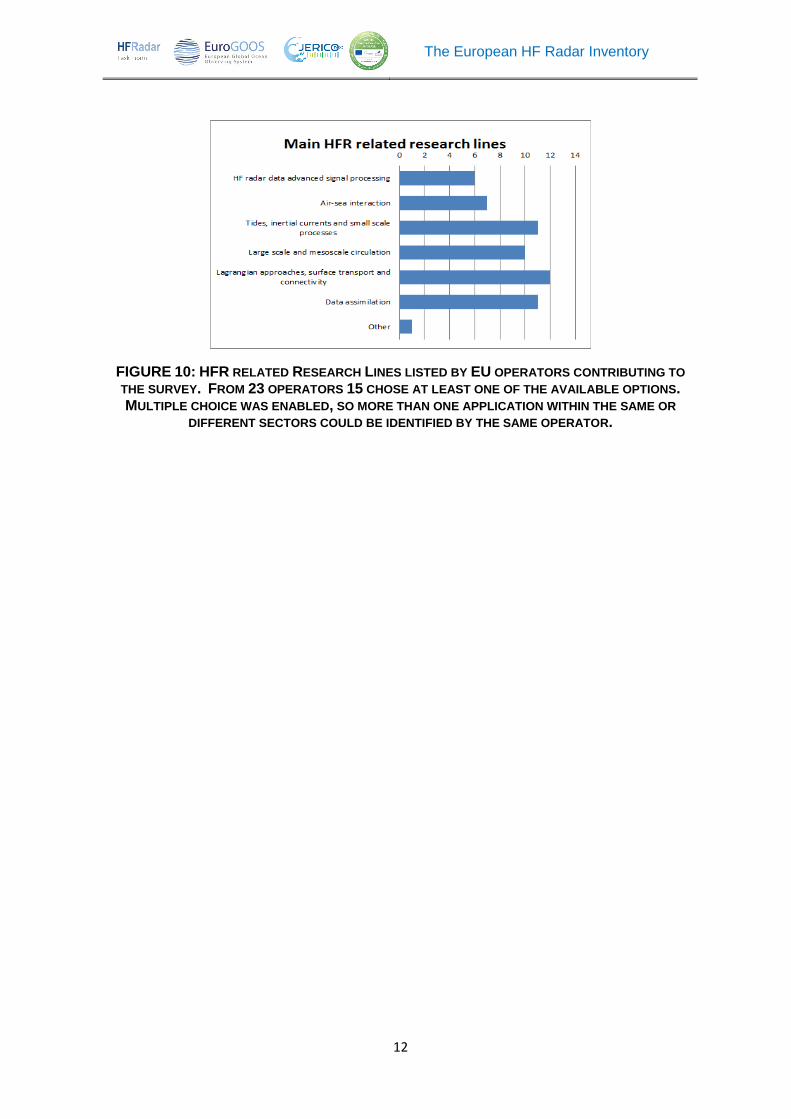
Finally, concerning HFR related research, the most popular research lines are those
related to Lagrangian approaches to surface transport and connectivity, the research on
data assimilation and small scale and mesoscale ocean processes (figure 10). The most
part of the categories presented are related with HFR surface current data, one user
added an additional research lines related with the spatial wave measurements for
research and marine renewable energy application.
The European HF Radar Inventory
12
FIGURE 10: HFR RELATED RESEARCH LINES LISTED BY EU OPERATORS CONTRIBUTING TO
THE SURVEY. FROM 23 OPERATORS 15 CHOSE AT LEAST ONE OF THE AVAILABLE OPTIONS. MULTIPLE CHOICE WAS ENABLED, SO MORE THAN ONE APPLICATION WITHIN THE SAME OR
DIFFERENT SECTORS COULD BE IDENTIFIED BY THE SAME OPERATOR.
The European HF Radar Inventory
13
4 Bibliography
Abascal A.J., Castanedo, S., Medina, R., Losada, I.J., Alvarez-Fanjul. E. 2009. Application of HF radar currents to oil spill modelling. Mar Pollut Bull. 58(2):238-48. doi: 10.1016/j.marpolbul.2008.09.020
Barth A, Alvera-Azcárate, A., Beckers, JM., Staneva, J., Stanev, E.V., Schulz-Stellenfleth, J., 2011. Correcting surface winds by assimilating HFR surface currents in the German Bight, Oc Dyn, 2011, 61, 5, 599;
Barth, A., A. Alvera-Azcárate, and R. H. Weisberg, 2008, Assimilation of high-frequency radar currents in a nested model of the West Florida Shelf, J. Geophys. Res., 113, C08033, doi:10.1029/2007JC004585.
Basurko O.C. , Gorka Gabiña, Marga Andrés, Anna Rubio, Ainhize Uriarte, Iñigo Krug, Fishing for floating marine litter in SE Bay of Biscay: Review and feasibility study, Marine Policy, Volume 61, November 2015, Pages 103-112, ISSN 0308-597X, http://dx.doi.org/10.1016/j.marpol.2015.07.010.
Bellomo L. , Griffa, A., Cosoli,S. , Falco P.,. Gerin,R, Iermano,I., Kalampokis,A., Kokkini, Z. , Lana, A., Magaldi,M. G., Mamoutos,I., Mantovani, C., Marmain,J., E. Potiris, J. M. Sayol, Y. Barbin, M. Berta, M. Borghini, A. Bussani, L. Corgnati, Q. Dagneaux, J. Gaggelli, P. Guterman, D. Mallarino, A. Mazzoldi, A. Molcard, A. Orfila, P.-M. Poulain, C. Quentin, J. Tintoré, M. Uttieri, A. Vetrano, E. Zambianchi, V. Zervakis. “Toward an integrated HF radar network in the Mediterranean Sea to improve search and rescue and oil spill response: the TOSCA project experience”. Journal of Operational Oceanography vol.8 (2), pp. 95–107, (2015). Doi: 10.1080/1755876X.2015.1087184
Iermano. 2016. Impacts of a 4-dimensional variational data assimilation in a coastal ocean model of southern Tyrrhenian Sea. J Mar. Sys. 154: 157-171;
Marmain, J., A. Molcard, P. Forget, and A. Barth. 2014, Assimilation of HF radar surface currents to optimize forcing in the North Western Mediterranean sea, Nonlinear Process. Geophys., 21, 659–675, doi:10.5194/npg-21-659-2014.
Orfila, A.; Molcard, A.; Sayol, J.M.; Marmain, J.; Bellomo, L.; Quentin, C.; Barbin, Y. 2015. Empirical Forecasting of HF-Radar Velocity Using Genetic Algorithms, Geoscience and Remote Sensing, IEEE Transactions on , vol.53, no.5, pp.2875-2886, doi: 10.1109/TGRS.2014.2366294.Paduan. and Shulman (2004), HFR data assimilation in the Monterey Bay area, J. Geophys. Res., 109, C07S09
Paduan and Washburn, 2013. High-Frequency Radar Observations of Ocean Surface Currents. Annual Review of Marine Science, Vol 5.
Roarty, H., L. Hazard, and E. A. Fanjul (2016), Growing network of radar systems monitors ocean surface currents, Eos, 97, doi:10.1029/2016EO049243. Published on 5 April 2016
Solabarrieta, L., Frolov, S., Cook, M., Paduan,J., Rubio, A., González,M., Mader, J., Charria, G., 2016. Skill assessment of HF radar-derived products for lagrangian simulations in the Bay of Biscay. J. Atmos. Oceanic Technol., 0, doi: 10.1175/JTECH-D-16-0045.1.
Stanev 2015. Blending Surface Currents from HFR Observations and Numerical Modeling: Tidal Hindcasts and Forecasts, J Atm Oc Tech, 2015, 32, 2, 256
The European HF Radar Inventory
14
5 Acknowledgments
This work has been partially supported by JERICO_NEXT (Joint European Research
Infrastructure network for Coastal Observatory – Novel European eXpertise for coastal
observaTories, H2020 Contract#654410), INCREASE (Innovation and Networking for
the integration of Coastal Radars into EuropeAn marine Services - CMEMS SE 2016)
projects and the European Marine Observations and Data Network - EMODnet
Physics (MARE/2012/10 Lot 6 Physics – SI2.656795). The work of A. Rubio and J.
Mader was also supported by the Directorate of Emergency Attention and Meteorology
of the Basque Government. The work of CNR-ISMAR was also partially supported by
the Italian Flagship project RITMARE. We are very grateful to all the people who kindly
provided the information about their radar and related activities.

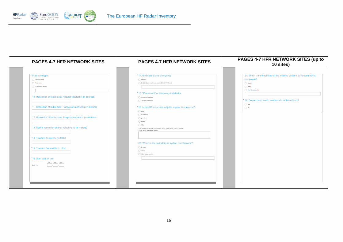
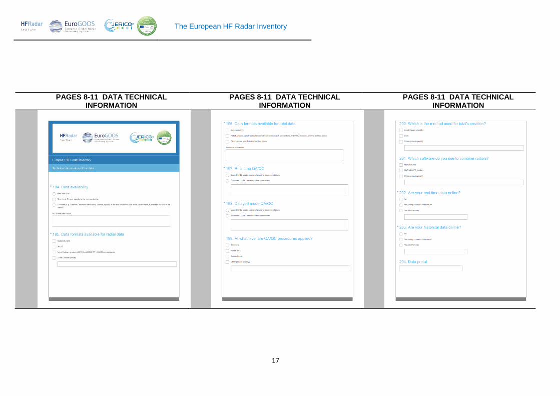
ANNEX 1 – The HFR survey
PAGE 1 - INTRODUCTION PAGES 2-3 CONTACT INFORMATION PAGES 4-7 HFR NETWORK SITES
The European HF Radar Inventory
16
PAGES 4-7 HFR NETWORK SITES PAGES 4-7 HFR NETWORK SITES PAGES 4-7 HFR NETWORK SITES (up to
10 sites)
The European HF Radar Inventory
17
PAGES 8-11 DATA TECHNICAL INFORMATION
PAGES 8-11 DATA TECHNICAL INFORMATION
PAGES 8-11 DATA TECHNICAL INFORMATION

The European HF Radar Inventory
18
PAGES 8-11 DATA TECHNICAL INFORMATION
PAGES 8-12 DATA TECHNICAL INFORMATION
PAGES 13-15 APLICATIONS

The European HF Radar Inventory
19
PAGES 13-15 APLICATIONS PAGES 13-15 APLICATIONS PAGE 16 CLOSING INFORMATION
The European HF Radar Inventory
20
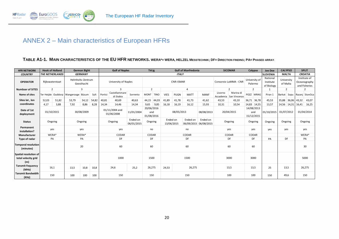
ANNEX 2 – Main characteristics of European HFRs
TABLE A1-1. MAIN CHARACTERISTICS OF THE EU HFR NETWORKS. WERA*= WERA, HELZEL MESSTECHNIK; DF= DIRECTION FINDING; PA= PHASED ARRAY.
HFR NETWORK Joe Doe
COUNTRY SLOVENIA
OPERATOR
National
Institute
of Biology
Numbser of SITES 1
Name of sites Ter Heijde Ouddorp Wangerooge Büsum Sylt PorticiCastellammare
di StabiaSorrento MONT TINO VIES PUGN MATT MANF
Livorno
Accademia
Marina di
San VincenzoPOZZ MRAG Piran 1 Barkat Sopu Razanj Stončica
52,03 51,82 53,79 54,12 54,82 40,81 40,69 40,63 44,15 44,03 41,89 41,78 41,73 41,62 43,53 43,10 36,71 36,78 45,53 35,88 36,06 43,32 43,07
4,17 3,88 7,92 8,86 8,28 14,34 14,46 14,34 9,65 9,85 16,18 16,19 16,12 15,93 10,31 10,54 14,83 14,55 13,57 14,56 14,31 16,41 16,25
Date of 1st
deployment11/01/2004 08/08/2013 01/10/2015
StatusEnded on
06/01/2015
Ended on
06/09/2015
Ended on
06/08/2015Ongoing
Permanent
installation?yes
Manufacturer
Type of radar PA
Temporal resolution
(minutes)
Spatial resolution of
total velocity grid
(m)
Tansmit Fequency
(MHz)13,5 10,8 10,8 25,2 24,53 25
Tansmit Bandwidth
(KHz)100 100 100 150
Gulf of Naples
University of Naples
3
yes
CODAR
DF
60
1000
150
26,275
no
CODAR
DF
60
1500
150
01/11/2004 and
01/06/2008
Ongoing
24,6
ITALY
Gulf of Manfredonia
4
CNR-ISMAR
08/05/2013
Ended on
13/06/2015
Sites lat , lon
coordinates
THE NETHERLANDS GERMANY
2
University
of Malta
MALTA
German Bight
Helmholtz-Zentrum
Geesthacht
2 3
01/10/2015
Hook of Holland
Rijkswaterstaat
16,1
150
Ongoing
yes
WERA*
PA
30/08/2009
Ongoing
yes
WERA*
PA
20
DF
60
1500
26,275
150
TirLig
2
20/06/2016
and
01/08/2016
Ongoing
no
CODAR
100
13,5
3000
60
49,6
13,5
DF
yes
Ongoing
01/07/2012
CALYPSO
DF
CODAR
yes
Ongoing
SICOMAR
Consorzio LaMMA - CNR
2
20/04/2015
Calypso
University of
Palermo
2
100
13,5
3000
60
DF
CODAR
01/04/2014
Ongoing
yes
WERA*
PA
yes
Ongoing
14/08/2013
and
15/12/2015
Institute of
Oceanography
and Fisheries 2
SPLIT
30
5000
26,275
150
CROATIA

The European HF Radar Inventory
21
TABLE A1-1. MAIN CHARACTERISTICS OF THE EU HFR NETWORKS. WERA*= WERA, HELZEL MESSTECHNIK; DF= DIRECTION FINDING; PA= PHASED ARRAY(cont.)
HFR NETWORK GOLFO DE CÁDIZ
COUNTRY
OPERATOR
Numbser of SITES 1
Name of sites FORM GALF SALOU ALFACADA VINAROZ CEUTAPUNTA
CARNEROTARIFA MAZAGÓN SILLEIRO FISTERRA Vilán Prior
Ria de
VigoSUBR Matxitxako Higer
São
JuliãoEspichel Sagres Alfanzina
Vila real de
Santo
38,67 38,95 41,06 40,67 40,46 35,90 36,08 36,00 37,13 42,10 42,88 43,16 43,57 42,20 42,25 43,45 43,38 38,67 38,41 36,99 37,08 37,18
1,39 1,22 1,17 0,83 0,48 -5,31 -5,43 -5,61 -6,83 -8,90 -9,27 -9,21 -8,31 -8,80 -8,86 -2,75 -1,78 -9,33 -9,21 -8,55 -8,44 -7,44
Date of 1st
deployment01/07/2014 21/02/2013 11/06/2013 01/01/2016 01/01/2012 01/08/2010
Status Ongoing
Permanent
installation?yes
Manufacturer CODAR
Type of radar DF
Temporal resolution
(minutes)60
Spatial resolution of
total velocity grid (m)1500 6000 5000
Tansmit Fequency
(MHz)13,5 13,5 13,5 26,275 26,275 26,275 13,5 46,5 46,8 12,43 12,923 12,4698
Tansmit Bandwidth
(KHz)90 90 90 150 150 150 100 29,4 29 800,2 800 80,878 69,849 99,259
DF
60
1500
Instituto Hidrografico
5
Ongoing
yes
CODAR
80,878
13,5
01/01/2010
1400
National HF Network
PORTUGAL
40
4,525
Puertos del Estado
2
3000
yes
CODAR
DF
60
1000
CODAR CODAR
DF
90,069 50
13/04/2011
Ongoing
yes
CODAR
DF
60
6000
4,463
DF
60
15/07/201107/01/2014 15/07/2010
60
13,5
187 5000
4,463
3000
60 30 60
DF DF DF
CODAR CODAR CODAR
yes yes yesyes yes
Ongoing Ongoing OngoingOngoing Ongoing Ongoing
01/06/2012 01/04/2010 01/01/2009
2
Sites lat , lon
coordinates
23 3 22
SOCIBUniversity
of VigoAZTI
Ria de Vigo Basque CountryESTRECHO DE GIBRALTARDELTA DEL EBRO GALICIA
INTECMAR
IBIZA CHANEL
SPAIN

The European HF Radar Inventory
22
TABLE A1-1. MAIN CHARACTERISTICS OF THE EU HFR NETWORKS. WERA*= WERA, HELZEL MESSTECHNIK; DF= DIRECTION FINDING; PA= PHASED ARRAY (cont.)
HFR NETWORK Torungen
COUNTRY NORWAY
OPERATOR
Norwegian
Meteorological
Institute
Numbser of SITES 1
Name of sites ANTARES DYFAMEDPointe de
Garchine
Pointe de
Brézellec Torungen Pendeen Perranporth SUMB NRON
Mutton
IslandSpiddle
Inish
Oirr
Loop
Head
42,95 43,50 48,50 48,07 58,40 50,16 50,34 59,85 59,39 53,25 53,24 53,06 52,56
6,00 7,25 -4,78 -4,66 8,79 -5,67 -5,18 -1,28 -2,38 9,05 9,30 9,52 9,92
Date of 1st
deployment15/11/2011 01/09/2015 25/05/2016
Status Ongoing Ongoing OngoingEnded on
09/08/2014
Ended on
09/01/2014Permanent
installation?yes yes yes
Manufacturer WERA* CODAR CODAR
Type of radarDF on 8 receiving
antenna DF DF
Temporal resolution
(minutes)60 90 60
Spatial resolution of
total velocity grid
(m)
3000 0
Tansmit Fequency
(MHz)16,175 13,45 13,5
Tansmit Bandwidth
(KHz)50 50 75 350 375
Plymouth University
2
Iroise
FRANCE
BRAHAN
UK
Wave Hub HF Radar
01/05/2006
2 2
Sites lat , lon
coordinates
SHOM
100
no
WERA*
PA
60
12,4
10
2000
PA
WERA
1000
12
yes
36,8
no
49,6
01/09/2013
2
DF
60
500
25
300
CODAR
DF
60
2000
CODAR
Ongoing
13,54,5
MIO, AMU-CNRS-IRD-UTLN
MOOSE HF radar
01/02/2011 and
01/04/2011
Marine Scotland Science
Ongoing
yes
5000
Ireland West Coast_Radars
National University of Ireland
4
01/03/2012 01/09/2015
IRELAND
Ongoing