the celestial sphere, angles, and positions - uwyo.edudavec/teaching/astro1050summer2013/2... ·...
TRANSCRIPT

The Celestial Sphere, Positions, and
Angles
Objectives:
• Develop a coordinate system
• How do you measure distances on a sphere

The Celestial Sphere
Earth at center of very large sphere
Because sphere is so large, observer, is also at center (figure not to scale).
Stars in fixed positions on sphere

Extend the Earth’s
Equator
• Celestial Equator: Extension of the Earth’s equator.
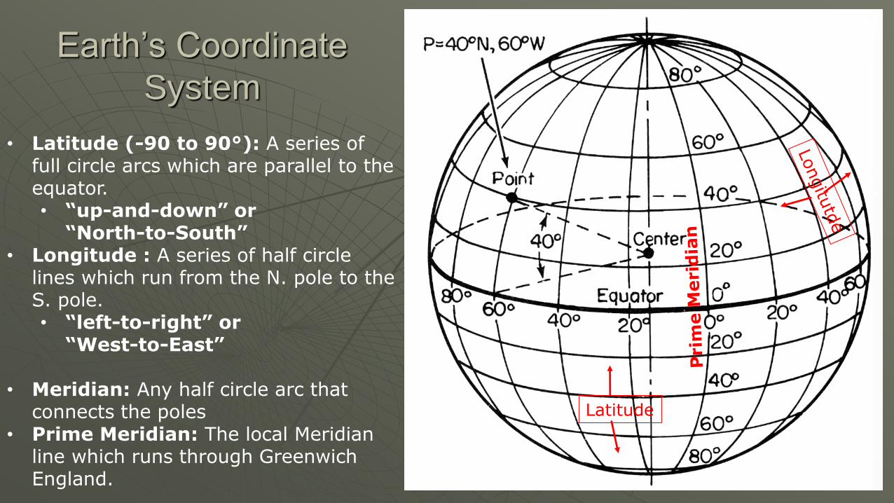
Earth’s Coordinate
System
• Latitude (-90 to 90°): A series of full circle arcs which are parallel to the equator.• “up-and-down” or
“North-to-South”• Longitude : A series of half circle
lines which run from the N. pole to the S. pole. • “left-to-right” or
“West-to-East”
• Meridian: Any half circle arc that connects the poles
• Prime Meridian: The local Meridian line which runs through Greenwich England.
Latitude

Extend the Earth’s Coordinate System
• Celestial Coordinate System:
• Declination (0-90°): The north/south positions of points on the celestial sphere. “Latitude”
• Right Ascension (0-24 hrs): The east/west positions of points on the celestial sphere. “Longitude”
• These two give the location of any object on the sky
Dec=90°
Dec=0°

Local Horizon Coordinate System
Horizon: Where the Ground meets the sky
Azimuth (0 - 360°)
• Horizontal direction (N,S,E,W)
N = 0 °, E = 90°,
S = 180°, W = 270°
Altitude
• “Height” above horizon
• Horizon = 0°, Zenith = 90°
• “Local Declination”
horizon
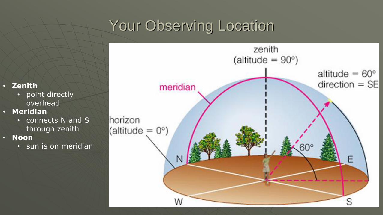
Your Observing Location
• Zenith • point directly
overhead• Meridian
• connects N and S through zenith
• Noon• sun is on meridian

TPS (reports?)
Which of the following locations on the celestial sphere is closest to the South Celestial Pole?
A. RA= 14 hr dec= +88°
B. RA= 14 hr dec= -88°
C. RA= 23 hr dec= +02°
D. RA= 6 hr dec= +24°

• Which of the following coordinates in your local horizon system (Laramie, WY) is closest to the North Celestial Pole?
A. Az. = 45 deg, Alt. = 85°
B. Az. = 220 deg, Alt. = 15°
C. Az. = 0 deg, Alt. = 45°
D. Az. = 100 deg, Alt. = 85°

Tip: For Northern Hemisphere
Observers Only
Altitude of North Star = Approximate Latitude
If you measure the altitude of Polaris in the sky to be 20°, this means you are observing from approximately 20° N Latitude (or + 20° Latitude). You could be, for example, in Mexico City…
Laramie: Latitude = + 41°
Laramie

Angular Separation & Size
Two stars are separated by an angle of 24°as seen by the observer.
We say the “angular separation is 24 degrees.”

Examples
5°

The Northern Sky
What would happen if we walked north (really far)?
Find a reference star:
• The pointer stars from the Big Dipper point to Polaris (the North Star)

Measure the
Circumference
of Earth
Air Distance:
Lar Shively Arpt, Laramie, WY to
Natrona Cty Intl Arpt, Casper, WY
Distance 108 miles
1.5 degrees
Laramie Casper

Measuring the Circumference of Earth
108 miles (on earth) = 1.5 degrees (on celestial sphere)
108/1.5 = 72 (miles/degree)
Circumference (miles) = 72 (miles/degree) * 360 (degrees)
=25,000 miles let’s check
1.5°

Lecture Tutorial (LT)
Position

• From a latitude of 90° N, the altitude of the North Celestial Pole is ____ above the horizon?
A. 45°
B. 90°
C. 20°
D. 0°

You measure the altitude of Polaris to be approximately 35°. Looking along the meridian, how many degrees from the zenith will you find the celestial equator?
A. 35°
B. 45°
C. 55°
D. 65°

• Where would the
observer look to see
the star indicated by
the arrow?
A. High in the NortheastB. High in the SoutheastC. High in the Northwest D. High in the Southwest
Celestial Sphere
Celestial Sphere Rotation
Celestial Sphere Rotation
Celestial Sphere
Star A
Star B
1
1
3
2
2
4
4
3
Figure 2
Horizon