the brooklyn waterfront: building for a resilient and
TRANSCRIPT

Vassar CollegeDigital Window @ Vassar
Senior Capstone Projects
2014
The Brooklyn Waterfront: Building for a Resilientand Sustainable FutureIan Leidner
Follow this and additional works at: http://digitalwindow.vassar.edu/senior_capstone
This Open Access is brought to you for free and open access by Digital Window @ Vassar. It has been accepted for inclusion in Senior CapstoneProjects by an authorized administrator of Digital Window @ Vassar. For more information, please contact [email protected].
Recommended CitationLeidner, Ian, "The Brooklyn Waterfront: Building for a Resilient and Sustainable Future" (2014). Senior Capstone Projects. Paper 381.

THE BROOKLYN WATERFRONT: BUILDING FOR A RESILIENT AND SUSTAINABLE FUTURE
Ian Leidner April 21, 2014
Senior Thesis
Submitted in partial fulfillment of the requirements for the Bachelor of Arts in Urban Studies
______________________ Adviser, Brian Godfrey
______________________
Adviser, Tobias Armborst

II
Table of Contents List of Figures..…………………………………………………………………………...III
Reference Map……………………………………………………………………………V
Chapter 1: Introduction……………………………………………………………………1 Chapter 2: New York Waterfront History………………………………………………..12 Chapter 3: New Development and Brooklyn Waterfront History………………………..24 Chapter 4: Superstorm Sandy…………………………………………………………….34 Chapter 5: Resilient Design Solutions…………………………………………………....44 Chapter 6: Conclusion……………………………………………………………………58 References Cited………………………………………………………………………….65

III
LIST OF FIGURES Figure 1: “New York City Neighborhoods.” Map, n.d. New York City Department of City Planning. 18 April 2014. Figure 1.1: “Waves at Rockaway Beach.” Photograph, 29 October 2012. A Stronger More Resilient New York. Web. 16 April 2014. Figure 1.2: “Brooklyn Waterfront Floodplain Projections.” Map, 11 June 2013. FEMA-CUNY Institute for Sustainable Cities. Web. 16 April 2014. Figure 1.3: “Water Topping Bulkheads in Bay Ridge, Brooklyn.” Photograph, 29 October 2012. A Stronger More Resilient New York. Web. 16 April 2014. Figure 2.1: “Lower Manhattan 1920.” Photograph, n.d. historiadenuevayork.wordpress.com. Web. 11 April. 2014. Figure 2.2: “Brooklyn Navy Yard.” Photograph, n.d. Wikipedia.org. Web. 11 April 2014. Figure 2.3: Yamashita, Michael S. “Battery Park City.” Photograph n.d. Architectural Record. Web. 25 Mar. 2014. Figure 2.4: “World Trade Center.” Photograph, n.d. Wikipedia.org. Web. 11 April 2014. Figure 3.1: “Vision 2020.” Photograph, 14 March 2011. New York City Department of City Planning. Web. 16 April 2014. Figure 3.2: Leidner, Ian. “Williamsburg Waterfront Development.” Photograph, 12 July 2013. Figure 3.3: “Domino Sugar Development.” Photograph, n.d. ny.curbed.com. Web. 11 April. 2014. Figure 4.1: “Flood Inundation.” Map, 11 June 2013. FEMA. Web. 16 April 2014. Figure 4.2: “Hurricane Sandy Hits New York.” Photograph, 29 Oct. 2012. Wikipedia.org. Web. 11 April 2014. Figure 4.3: “Hurricane Sandy Subway Flooding.” Photograph, n.d. Inhabit.com. Web. 25 Mar. 2014. Figure 4.4: “Sandy Flooding in Red Hook, Brooklyn.” Photograph, n.d. Wikipedia.org. Web. 11 April 2014. Figure 5.1: “Thames Flood Protection Barrier.” Photograph, n.d. Nature.com. Web. 25 Mar. 2014.

IV
Figure 5.2: SCAPE Landscape. “Oystertechture.” Rendering, 16 November 2009. Rising Currents. Web. 11 April 2014. Figure 5.3: HR&A Advisors. “Dense Urban Edge: Red Hook, Brooklyn.” Diagram, n.d. rebuildbydesign.org. Web. 11 April 2014. Figure 5.4: BIG TEAM. “Long-Term Perspective – Harbor District: Red Hook.” Diagram, n.d. Rebuildbydesign.org. Web. 11 April 2014. Figure 6.1: “Integrated Flood Protection.” Rendering, 11 June 2013. A Stronger More Resilient New York. Web. 16 April 2014. Figure 6.2: “Newtown Creek Surge Barrier.” Rendering, 11 June 2013. A Stronger More Resilient New York. Web. 16 April 2014. Figure 6.3: “Far Rockaway Relief Effort.” Photograph, 11 June 2013. A Stronger More Resilient New York. Web. 16 April 2014.

V
Figure 1: New York City

1
CHAPTER 1: INTRODUCTION
Hurricane Sandy dramatically and tragically revealed the extreme vulnerability of New
York City’s expansive shoreline in late 2012. The “super-storm,” which made landfall in the
New York metropolitan area on the evening of October 29th, battered the city and its surrounding
areas with high winds, rain and powerful waves and storm surges. Fifty-one square miles,
equivalent to 17 percent of New York’s total landmass, was flooded by Sandy’s storm surge,
which exceeded 15 feet above mean low tide in South Beach Staten Island and 13 feet at Sea
Gate, Brooklyn (DCP 2013, 13). From New Yorkers to City Government to the Federal
Government, the havoc wreaked by Sandy on America’s largest metropolis was a stern and
uneasy wake up call. The storm added new urgency and direction to discussions regarding
climate change, sea level rise and the survival of urban shorelines. In an opinion piece for the
New York Times published a year after Hurricane Sandy hit, author Kevin Baker perhaps best
expresses the atmosphere of a post-Sandy New York, writing, “One of the great things about
New York used to be how easy it was to ignore the natural world…No More”(Baker 2013, 1).
In the decade preceding the storm, New York and New Yorkers had been fostering a
relationship with the waterfront that was healthier than it had ever been in the past. New Yorkers
were utilizing and enjoying the amenities the waterfront has to offer like never before,
establishing a mutually beneficial rapport. The man with the vision and the responsibility for
New York’s push towards the waterfront in the 21st Century was former Mayor Michael
Bloomberg. Mayor Bloomberg called the waterfront New York’s sixth borough and championed
its rehabilitation throughout his 12 years in office. Through numerous initiatives and partnership
with the Department of City Planning, Bloomberg facilitated the construction of parks, luxury
high rises and small businesses along a then derelict waterfront that had lain dormant for much of

2
the second half of the 20th Century. In 2011, the Department of City Planning released Vision
2020:New York City Comprehensive Waterfront Plan. This 10-year plan outlined a
comprehensive wide-range and site-specific course of action for opening up the New York
waterfront in conjunction with the vision of then Mayor Bloomberg. Vision 2020 exhibits the
city’s commitment to transforming New York’s 520-mile shoreline into a safer, more accessible
space that serves a diverse range of activities.
In the middle and late 20th Century, the New York waterfront and the city as a whole
experienced significant deindustrialization. The once productive shores of Lower Manhattan and
Northern Brooklyn
were rendered
obsolete by a need
for more space and
by modern
technology such as
the standard
shipping container.
New York
experienced a
serious identity
crisis; once the most productive port in the world, the city’s development subsequently pointed
inward and shifted its focus from blue collar to white-collar work. Although sea level rise and
climate change were not yet a major concern, serious doubt was cast over the waterfront’s future.
The waterfront in New York slipped into a period of dereliction; crime and vice ran rampant in
Figure 1.1: Waves at R
ockaway
Beach, Q
ueens

3
the shadows of abandoned factories and machinery that had formed the backbone of the city’s
economy for centuries.
Today the shady, lawless waterfront of the late 20th Century is increasingly becoming a
distant memory. Although it is both encouraging and captivating to see the waterfront restored as
it has been, the threat of storms like Sandy is a startling reality moving forward. Bloomberg
rightly described Sandy as “the worst natural disaster ever to hit New York City”(DCP 2013, 1).
Although a devastating storm, all signs from climate experts point to the prospect of significantly
stronger and more frequent storms in the near future. Forty-three New Yorkers died as a result of
Hurricane Sandy and if nothing is done in response, more can be expected to perish in the years
to come (DCP 2013, 11). With these things in mind, is it irresponsible and foolish to continue
pushing people and businesses closer to the water’s edge? Has reopening one of New York’s
great resources put people in danger under the guise of bettering their way of life? What can we
and what have we learned from the experience of Hurricane Sandy to better defend New York
from the inevitability of climate change?
In this thesis I address these questions and others regarding the past, present and future of
the New York waterfront. Examining the current dialogue regarding the city’s defense against
rising sea levels and stronger storms, I focus particularly on the political ecological debate over
the best and most responsible ways to fortify the shoreline. I look at a select number of
infrastructural proposals from public and private entities and analyze their feasibility and
supposed efficacy. The waterfront area of Northern Brooklyn stretching from the Newtown
Creek and the Greenpoint neighborhood, south to the Gowanus Canal and the Red Hook
neighborhood serves as an area of particular focus. This choice of focus is based on an interest in
the new layers of population growth and physical development in this waterfront area. The

4
unique mix of history, industry and contemporary development makes the Northern Brooklyn
waterfront a fascinating area of study. In this specific area and New York as a whole I look at
some of the implications of climate change while contemplating the role of shoreline design in
the city’s struggle to survive. Although Hurricane Sandy was an incredible tragedy, it also
represents an important opportunity to change and protect New York and its waterfront for the
future especially in the context of contemporary growth along the shore.
The focus of discussions regarding waterfront development has inexorably been changed
to one regarding how to protect the city from flooding. Every aspect of city life is threatened by
extreme weather as Hurricane Sandy demonstrated. In the interest of being as concise and to the
point as possible, I have chosen to focus my discussion on a select number of flood protection
measures along the Northern Brooklyn waterfront. Rather than chronicling the individual
measures store and building owners can take to protect themselves, I look at infrastructural plans
from private and public institutions that address a multiplicity of potential climate dangers. Every
part of the waterfront is different and therefore requires unique and individualized attention. The
Department of City Planning and private firms like SCAPE Landscape and BIG TEAM
recommend a wide variety of infrastructural measures to cope with New York’s complex
geography. In some places, low-tech solutions are sought such as beach nourishment whereas in
other areas, a hi-tech piece of machinery like a moveable floodgate is warranted. In this thesis I
go beyond a summary of infrastructural proposals to a discussion of the circumstances that
directed certain firms and agencies towards the solutions they recommend.

5
Guiding my discussion of
history and contemporary design
solutions is an interest in how
flood preventative design can
serve a variety of functions. This
thesis explores the potential for
the discourse on flood
preventative design to include
concerns regarding how the built
environment can be improved as
well. In New York, flood
preventative design has been
pushed to the forefront due to
recent extreme weather events.
What I advocate in this context is
that we not lose sight of the
elements of the built environment that make New York so special. We must ensure that the
inevitability of infrastructural improvement doesn’t harm the city’s everyday social and built
ecology. This thesis ponders the possibility for flood preventative attitudes and design to not just
maintain the status quo, but to actually improve the city’s built environment through thoughtful
and creative planning and design. Before previewing the chapters to come, I want to pose two
questions that will guide later discussion and debate. First, what elements of the built
Figure 1.2: Brooklyn W
aterfront Floodplain Projections

6
environment protected the shoreline during Sandy by working beyond their intended use?
Second, can designing for flood protection benefit other areas of the built environment?
Chapter 2 covers the history of the New York waterfront, starting with the founding of
New Amsterdam by the Dutch in the 17th Century. Although the 17th Century might not seem to
bear any significance for a contemporary conversation, it is important when considering the
inexorable link between New York and its waterfront that persists today. The waterways of New
York and the surrounding areas form one of the finest natural harbors in the world. When the
Dutch and later the British took over Manhattan island, the small city that would become New
York grew quickly due to the ample space and ease of access this harbor provided. New York
was indeed destined to be a waterfront city, its economic health and strength tied directly to the
commercial activity the shoreline supported.
Even from its earliest days, development along the waterfront flourished in the form of
small wooden piers for the on loading and offloading of ship borne cargo. By the early 19th
Century New York had surpassed Philadelphia as the largest city in the United States and was
due for exponential growth by the middle of the century. New York rose to national and global
commercial supremacy primarily due to the blue-collar work along the Lower Manhattan and
later Northern Brooklyn waterfronts. In the context of my waterfront discussion, the most
important impact was major physical growth along the waterfront and the filling in of marshy
areas to create more space for commercial activity. The piers, concrete bulkheads and landfill
that expanded and hardened the shoreline increased the size of Lower Manhattan by 33 percent
(Bone 2003, 35). Marshes, wetlands and beaches that could have protected the city from storm
surges and waves were obliterated, enabling people and businesses to move closer to the waters
that would later threaten it. As then Commissioner of the now defunct Department of Docks said

7
in 1919, “the city has encroached at nearly every point on the original high water line” (Bone
2003, 41).
Chapter 2 concludes with a look at the period of deindustrialization that occurred in New
York during the 20th Century following the conclusion of the Second World War. As New
York’s waterfront was rendered obsolete by new technology and a need for more space. The void
left by the evacuation of commerce was quickly filled by crime and vice. I examine the
waterfront’s history through this period of destitution and conclude at the turn of the 21st
Century, which represents the starting point of its contemporary revival. This chapter looks
primarily at Manhattan because it was the focus of the early history of waterfront development in
New York. In the next chapter I look closely at the projects and policies of Mayor Bloomberg
followed by a specific discussion of Northern Brooklyn, the development of which lies squarely
in the future.
Chapter 3 examines the role of former Mayor Michael Bloomberg, in changing
perceptions and spurring development along New York’s shore. Bloomberg described the
waterfront as the city’s sixth borough and made its revitalization a priority during his time in
office. In all five boroughs, major improvements were made to waterfront parks and new ones
such as Brooklyn Bridge Park were begun, allowing the general public better access to the water
than ever before. Along with the Department of City Planning, the Mayor worked to rezone
almost 40 percent of the city, including many waterfront neighborhoods (Schuerman 2013). The
most noteworthy resolution came in 2005, pertaining to the Williamsburg-Greenpoint waterfront,
which now boasts luxury high rises and esplanades in an area formerly known more for dormant
industry and polluted waters.

8
Contemporary Brooklyn has experienced a population and development boom; the streets
of Northern Brooklyn are dotted with new housing developments, shops and restaurants. In
neighborhoods like DUMBO, Williamsburg and Red Hook, much of this development has
occurred very close to the water’s edge. Brooklyn is following a timeline similar to that of
Manhattan regarding industrialization, deindustrialization, dereliction and today massive growth.
By the turn of the 20th Century, Brooklyn was home to the most commercially productive
waterfront in the city. When industry evacuated Brooklyn in the middle of the 20th Century, it
left dangerous and unsightly scars. The waterfront today is littered with industrial fossils like the
Domino Sugar Factory. Furthermore the waters of the Newtown Creek and Gowanus Canal have
been labeled as superfund sites based on their high contaminant levels. Contemporary Brooklyn
development along the waterfront is now concerned with how to negotiate the fractured
landscape industry left behind.
Chapter 4 addresses the particularities of Hurricane Sandy with regard to the storm’s
unique characteristics and the destruction it caused in the New York metropolitan region.
Hurricane Sandy’s storm surge flooded 51 square miles or 17 percent of New York’s total land
mass. In places like Far Rockaway and Coney Island, powerful waves battered developments
that were built right up to the shore, inundating businesses and residences. Neighborhoods as far
from the ocean as East Harlem were flooded due to low land elevation and no protection along
the shoreline. As the authors of the Stronger, More Resilient New York plan note, “The storm
was a reminder of how interconnected the city’s systems are”(DCP 2013, 14). Indeed what
affected one part of the city often had ramifications for many others due to this infrastructural
and ecological reality. Although Hurricanes are often associated with pouring rain and high
winds, neither of those were major factors in the destruction Sandy caused. It was the storm

9
surge and subsequent flooding, as high as six feet in parts of Northern Brooklyn that resulted in
the greatest loss of life and property.
Chapter 4 deals with the particular characteristics of Hurricane Sandy and what made it
such a damaging and powerful storm. Partnered with that discussion is a brief look at the realities
of climate change and sea level rise. Although it is easy to call Sandy a once in a lifetime storm
due to its unlucky arrival at high tide, undeniable facts regarding earth’s changing climate render
this assumption false. From what we know about global warming, more powerful and frequent
extreme weather events
like Hurricane Sandy can
be expected to impact the
New York metropolitan
area in the near future. At
a local level, this chapter
looks at the specific ways
in which Sandy affected
the city and serves as a
basis for discussion in the
next chapter about what flood preventative design principles are being adopted to prevent
flooding from storms like Sandy in the future.
Chapter 5 addresses the design ideas and initiatives from the Department of City
Planning and private firms that seek to limit the damage of flooding from storms in the future. In
the past few years, “resiliency” has become the mantra of rebuilding and protecting the
waterfront after Hurricane Sandy. The Department of City Planning (DCP) sees waterfront
Figure 1.3: Water Topping B
ulkheads in Bay R
idge, B
rooklyn

10
infrastructure plans designed with “resiliency” in mind as the most cost-effective and flexible
method for protecting the New York waterfront from extreme weather. Resiliency entails
building shoreline infrastructural elements that do not necessarily keep out every drop of water;
instead they bend but do not break. Therefore the DCP proposes a more integrated approach,
which uses ideas for protecting the city from flooding as an opportunity to improve other aspects
of the built environment. Protecting New York from disaster should not entail sacrificing the
built and social environment that makes it worth saving. In the context of this thesis’s focus on
the Northern Brooklyn waterfront, I scrutinize the many facets the Department of City
Planning’s flooding initiatives for the area. For example these initiatives propose movable levee
systems for Red Hook along the water while concurrently advocating better transportation
connections with the neighborhood. This exemplifies an approach that seeks to improve life in
New York during the vast majority of the year when extreme weather is not an imminent threat.
Flood resilient design goes beyond the planning of the City government; private
landscape architecture and architecture firms form a major component of the dialogue. This
chapter looks at some of the proposals from design firms that seek to add their varied expertise to
the task of protecting New York. Competitions such as Rebuild by Design, funded by the
Department of Housing and Urban Development (HUD) have brought together a diverse array of
architecture and design teams ranging from European imports such as Rem Koolhaas’s OMA
and New York based Interboro Partners. Plans from the firms in this competition warrant
discussion because of their multifaceted approach and understanding of urban ecology beyond a
singular built levee or wall. While some have jumped to conclusions about the necessity for
massive floodgates and levees like those in Rotterdam or London, this thesis intends to highlight
the unique circumstances of flood protection in New York. Indeed there is no “one-size-fits-all”

11
when it comes to these matters, a fact emphasized by the diversity and ingenuity of proposals
from the DCP, SCAPE Landscape Architecture and the Rebuild by Design Competition. New
York is stronger than the sum of its parts and this attitude extends to protecting the city from
flooding, a movement that looks to integrate with everyday life rather than serve as an affliction.
In the final concluding chapter, this thesis proposes a better understanding of the New
York waterfront, its vulnerabilities and the people who are working to ensure its prosperity in the
future. Hurricane Sandy brought the seemingly mighty city to its knees, fundamentally changing
the conversation about development in New York. As the former head of the Department of City
Planning Amanda Burden said, “We are a water city…we have to embrace it”(Baker 2013, 7).
Although I do not propose any design solutions of my own, I hope to further an understanding of
New York’s waterfront history and how flood protection can be parlayed into improving our
neighborhoods and communities. Through my discussion and analysis, I demonstrate how we
can embrace the waterfront with a development approach that is mindful of flood protection and
how it can benefit the built environment at the same time.

12
CHAPTER 2: NEW YORK WATERFRONT HISTORY
Before I delve into the complexities of contemporary issues regarding the waterfronts of
New York City and more specifically Brooklyn, I look into the history of the waterfront to
substantiate an informed discussion of its present and future. Although the focus of this paper is
the Brooklyn waterfront and climate change implications for that specific edge, the history of the
New York waterfront is a much wider discussion than that of just Brooklyn. Indeed Manhattan
was the center of commercial activity along the waterfront until its small size rendered it
obsolete in the face of new technology like the standard shipping container and increased scale.
Compared with its historic roots as a major shipping port, New York’s waterfront commercial
activity is a mere fraction of its former self. Today economic activity occurs primarily inland,
which raises issues regarding what to do with the skeletons of industry that dot the waterfront. I
seek to answer questions regarding the history of New York’s waterfront and what events
resulted in the creation of the waterfront in its contemporary form and function.
The waterways and waterfronts of New York City are perhaps its most valuable asset.
The rivers, tidal straits and landmasses of New York form one of the world’s great natural
harbors, allowing for a variety of commercial, industrial and infrastructural activities along its
520-mile long coast. The New York waterfront is a dynamic and constantly evolving space that
has undergone many changes in function and form since merchants of the Dutch West India
Company received a grant for all of the land of Manhattan (then Nieu Nederlandt) in 1623.
Indeed New York owes its meteoric rise from a small Dutch trading port in the mid-17th Century
to its status as the largest commercial port in the world by the turn of the 20th Century to its
complex and diverse geography. As in any major urban area, the geography of New York City
has been drastically altered over the course of its modern history to support its constant

13
evolution. For New York to expand in such rapid fashion, hills had to be leveled, holes dug and
trees uprooted. The New York Bay that Giovanni Verrazano gazed upon, calling it the “beautiful
lake” has been rendered unrecognizable by the efforts of urban development (Bone 2003, 19).
Indeed no inch of New York has been left untouched by human development, however the
element of its geography that has experienced the greatest and most drastic alteration is the
waterfront.
Manhattan Island south of City Hall is today 33 percent larger than it was in 1623 when
the Dutch first acquired the
land (Buttenwieser 1987,
21). Although the shape
and size of the five
boroughs that we know
today is primarily the
result of efforts that began
in the early 19th Century,
the extension of land
beyond existing borders is a practice as old as the city itself. Following the transference of
ownership of unencumbered lands to the City of New York under the Dongen Charter of 1687,
the city’s limits were extended from the high to the low water mark. This permitted the extension
of inhabitable land into space formerly underwater at the discretion of the land’s owner. The
construction of a new wharf between the high water mark at Pearl Street and the low water mark
at Water Street marked the first instance of the use of landfill in the city following the Dongen
Charter’s passage. Although early 17th and 18th Century waterfront development was on a
Figure 2.1: Lower M
anhattan Circa 1920

14
relatively small scale, it is important to consider the significance of the precedent that such
waterfront infill and building set. To this end, Bone comments, “In spite of its hospitable terrain,
enlarging and transforming the shape of New York City has been a persistent endeavor since the
earliest times” (Bone 2003, 156).
To serve the demands of a rapidly expanding metropolis and port, the physical
boundaries of the small island of Manhattan, and to a lesser extent Brooklyn, also had to expand.
According to Kevin Bone, “By 1800, most of the southern tip of Manhattan had been ringed with
bulkhead and landfill…adding 729 acres of new land”(Bone 2003, 27). Beyond the addition of
land to the island’s perimeter, marshy areas further north were also filled. 14th Street in
Manhattan, today a bustling thoroughfare with a Subway line beneath its roadbed, was allegedly
bisected by water at high tide before being filled in. The earth and rubble used to fill in marshes
and add land to the shoreline was made conveniently available by extensive and rapid inland
construction and excavation. Earth excavated to make way for office and residential buildings
was quickly returned to the earth in the form of shoreline additions. As New York rose to
commercial preeminence during the course of the 19th Century, the waterfront was transformed
to accommodate the activities that accompanied such a status. Waterfront infrastructure was built
in an unorganized and frenzied fashion that played host to the equally frayed human activity of
loading and unloading ships.
The finger pier became the most popular form of waterfront infrastructure, extending
land as far as 1,000 feet into the water in some cases. Hundreds of piers lined the coastline of
Manhattan, developing what Anne Buttenwieser described as its “sawtooth
appearance”(Buttenwieser 1987, 39). Kevin Bone noted that the “Haphazard design stood
opposed to the rational landscape of gridded streets and vertical towers” of Manhattan (Bone

15
2003, 135). Though important infrastructural elements of a growing shipping and commercial
power, these piers were not well built and were subject to theft, fire and weather, which took a
particular toll on those with wooden supports and frames. The greatest detriment to the
waterfront was the complete lack of organization; there was no coherent plan or vision for what
shape the waterfront would take. Leisure activity was far from mind on the generally unpleasant
waterfront which, harbored crime, filth, disease and garbage. In response to the poor conditions
and disunity of the waterfront, the city established The Department of Docks in 1870. As Mary
Beth Betts writes, “The need to regulate and plan the physical fabric of the booming metropolis
had by now been recognized”(Bone 2003, 42). The establishment of the Department of Docks
was an extraordinary step for the New York Waterfront, which led to the implementation of the
first comprehensive waterfront plan the city had ever seen.
Charge of The Department of Docks was given to George McClellan, a former Civil War
general and a formidable engineer. In 1871 under his supervision, the department released its
master plan for the New York waterfront, exercising unprecedented power to unify the disjointed
coastline of the mid-19th Century. His master plan included guidelines for the improvements of
dock construction through the use of modern materials and building practices. The infrastructure
required to support modern pier building was the centerpiece of the master plan; a riverwall
stretching around Manhattan from West 61st Street to East 51st Street. The Department of Docks
committed itself and the city to commercial shipping along the waterfront, their fates inexorably
linked. When shipping and commercial activity in Manhattan became obsolete at the turn of the
20th Century, so too did the Department of Docks (Bone 2003, 80). A need for more land than
the small and crowded East Side of Manhattan offered spelled the beginning of the end for its
commercial prominence. With space a primary concern, commercial activity shifted to

16
Manhattan’s West Side and Brooklyn, which could provide the land and facilities commercial
interests required.
While the commercial prowess of Manhattan was in decline by the end of the 19th
Century, Brooklyn was rising. Just like in Manhattan, widespread landfill and pier construction
completely changed the landscape of the Brooklyn shoreline in the interest of fostering
commercial activity. Bone comments that landfill added “literally hundreds of acres of port-
related facilities to
Brooklyn that included
enormous basins, dry
docks, storage warehouses
and thousands of feet of
piers”(Bone 2003, 167).
The Brooklyn waterfront
from the Newtown Creek to
Sunset Park was extremely
productive during the first
half of the 20th Century
following the incorporation of the City of New York in 1898. One of the most productive periods
for the waterfront was the years the United States was involved in World War II. The Brooklyn
Navy Yard employed nearly 100,000 men and women who were responsible for the construction
of a large portion of the Naval fleet employed during the conflict. The post World War II period
was however not nearly as productive for the Navy Yard and the waterfront of the city as whole.
Indeed the waterfront as a commercial entity was quickly shrinking towards the point of
Figure 2.2: Brooklyn N
avy Yard

17
obscurity, an unfathomable prospect considering its productivity just a decade before. However
the straw that broke the camel’s back was the advent of the modern shipping container. This
technological advancement in shipping quickly became an industry standard, rendering the piers,
warehouses and wharves of the New York waterfront obsolete.
The modern shipping container demanded certain infrastructure that the narrow
Manhattan and Brooklyn waterfronts could not supply. Most importantly shipping operations
required vast amounts of open space for loading and unloading of massive cargo ships. With
New York unable to provide what the shipping industry needed, the container port was moved to
Elizabeth, New Jersey. Aside from shipping, New York and in particular Brooklyn also
experienced serious deindustrialization. Although some light and heavy industries still exist in
the five boroughs today, it is a mere shadow of those operations of the 19th and early 20th
Centuries. New York City had become too expensive and more importantly could not offer the
amount of land corporations craved. Many moved to inland areas of the United States while
some left altogether for overseas. Indeed New York on many different levels was forced to
reckon with the prospect of a deindustrialized and non-commercialized waterfront. Furthermore
other questions were raised as to what was to come of the massive steel and concrete vestiges
that industry left behind.
What would become of the New York waterfront post industry? Although there were no
comprehensive plans for the waterfront’s future in the decades immediately following the
conclusion of the Second World War, there was one man with a vision and the power to have it
take shape. That man was Robert Moses, the master builder of New York, who held numerous
positions from 1924 until 1968 and singlehandedly reshaped much of the city’s built
environment. According to Bone, Moses’ projects “were driven primarily by the need to provide

18
anchorage or to connect his complex network of bridges and expressways…” any park or
waterfront esplanade was a mere byproduct of other massive projects (Bone 2003, 177). Moses
contended in defense of his projects, “Instead of blocking off waterfront from the public, the
most casual honest survey will show that 106 miles of waterfront property have been opened up
and preserved for public use.” Many were skeptical, particularly those with an eye towards the
environmental impacts of large-scale topographical alteration. Regardless of the factualness of
Moses’ statement, his projects and others were increasingly reviewed and discussed in an
environmental context; for the first time the environmental impact of years of industry and
massive building projects was considered.
Environmental awareness about the New York waterfront reached an important point in
the early 1970’s with the passing of the Clean Water Act of 1972. Bone remarks that the passing
of the Clean Water Act was an important first step in the reclamation of waterfront for public
use. He writes, “Its restoration to health suggests that its primary post-shipping era use will most
likely accommodate New Yorkers’ great need for recreational options”(Bone 2003, 204).
Following the passage of the Clean Water Act, New York once again began to think about its
relation to the water and the waterfront, both of which were rendered invisible by commerce and
industry. Although it was an important step, Raymond W. Gastil contends that the completion of
two major waterfront building projects and the blocking of another were the true signifiers of a
changing relationship with and perception of the New York waterfront.
On December 15th, 1973 a dump truck plunged through the old Miller Highway,
which stretched the length of Manhattan’s West Side. In a controversial decision, the
federal government proposed a new 4.2 mile, six-lane highway with a projected price tag of
$2.3 billon (Bone 2003, 217). After a protracted legal battle, plans for “Westway” were

19
defeated and a proposal for a more modest road with significant parkland was instituted
instead. Defeating another project that aimed to keep New Yorkers away from their
waterfront demonstrated how attitudes were changing. It also highlighted the newfound
power of the community to trump federally supported infrastructural projects. There were
however two major development projects that were completed along the waterfront on
Manhattan’s Westside, the World Trade Center complex and Battery Park City that as
Gastil argues, restored New York’s status as a waterfront metropolis.
Completed in 1973, the seven building World Trade Center (WTC) complex was an
impressive addition to the New York City skyline. At the center of the WTC were two massive
skyscrapers that stretched 1,350 feet into the sky, surpassing the Empire State Building as the
two tallest buildings in America. At first the buildings were much reviled due to their scale,
design and perceived impact on Lower Manhattan. Although they later became to be seen as a
defining symbol of the city and a major tourist attraction, Raymond W. Gastil insists that from
the start their presence completely reshaped New York City. He writes, “While they [WTC] had
a great presence on the skyline from every direction, their most powerful and iconic impact was
from the water, where the blue horizontal foreground meets the vertical city. With the twin
towers’ completion in 1973, the towers had, with two monumental strokes, revived New York’s
image as a waterfront metropolis (Gastil 2002, 25). Indeed the most iconic view of the buildings
and of the city itself became that of Lower Manhattan from across the Hudson River; water gave
way to land, which gave way to two steel behemoths. The WTC was a monument to work, but a
different kind than traditionally occurred on the waterfront. The WTC was a white-collar place
of work that reminded New York of the potential for a working waterfront while also providing
space for leisure and serving as an “iconic front yard for the city”(Gastil 2002, 26).

20
The second development Gastil focuses on is Battery Park City (BPC). First conceived of
in 1966, Battery Park City was built entirely on landfill excavated to make way for the World
Trade Center. BPC demonstrated that New York had recovered from the “long drunk of
industrialization,” which denied the realization of the waterfront’s potential (Gastil 2002, 39).
BPC combined residential, work and leisure interests into a well built, well kept neighborhood
that extended the
Manhattan grid to the
newly formed shoreline
rather than rejecting inland
areas. Perhaps the most
important element of BPC
is the mile long esplanade
that hugs the coast of the
Hudson River. Gastil
commented that the esplanade of BPC “restated the possibility of pleasure without menace or
desuetude for the city’s waterfront.” In the context of a discussion about Hurricane Sandy,
Battery Park City deserves praise. While dozens of square miles of the city flooded, BPC
survived because of the esplanade and parkland buffer included in its design. Although BPC is
located in a particularly vulnerable location, the esplanade, elevation, flora and benches that its
designers included to serve leisure ends also turned out to be valuable assets for flood protection.
Indeed Battery Park City has set an important example for current and future developments in
how to save lives and protect valuable assets under the moniker of everyday improvement.
Figure 2.3: Battery Park C
ity

21
In the decades following the opening of Battery Park City, thousands of plans have been
proposed for waterfront housing, office space and parks. Hudson River Park now runs from
Rector Street to 59th Street instead of a six-lane highway. Just to the North, a massive luxury
condominium complex, the work of billionaire real estate magnate Donald Trump, sits almost at
the water’s edge. New York’s failed bid for the 2012 Olympics included extensive use of
waterfront areas for the construction of the Olympic village and other sporting infrastructure. In
1993, Mayor Dinkins proposed a comprehensive waterfront plan that mandated the inclusion of
public space in any private development project along the waterfront. This mandate has become
an important part of 21st Century waterfront development in the city.
In the Williamsburg neighborhood of Brooklyn as recently as 2003 there was only half of
a square mile of waterfront legally available for public use. (Bone 2003, 277) Today a public
esplanade, built by private developers in exchange for the construction of residential towers
offers magnificent, panoramic views of Manhattan. Mayor Bloomberg has made public
waterfront accessibility a centerpiece of his mayoral tenure and personally oversaw the rezoning
of 40 percent of the entire city, much of that land along the shore. Indeed New York City has
entered a new era of waterfront accessibility and development. The piers, warehouses and
wharves of industry have been repurposed and now better the existence of all New Yorkers,
rather than barring them from experiencing their waterfront as in the previous two centuries.
The shoreline today is still lined with relics of industry, rotting piers, abandoned
warehouses and toxic waste. In Greenpoint, Brooklyn a 17 million-gallon underground oil spill
was discovered, just one of many scars industry left behind (Bone 2003, 275). Most importantly
however for a discussion of Brooklyn and New York’s vulnerability to flooding is how
waterfront development has hardened the edges of the city. Between 1953 and 1973 the New

22
York shore lost over 5,000 acres of tidal wetland and 47,000 acres overall since the practice of
landfilling was begun (Bone 2003, 31). Tidal marshes were the five boroughs’ natural defense
against flooding; with the potential to absorb the energy from storm surges and manage flooding.
Today the edges of Manhattan and Brooklyn are nearly completely artificial, lacking any of the
flooding defense nature provides. Therefore we must ask: by developing the waterfront and
building further into the sea, is the city and developers putting more people at risk?
Although the city’s lack of natural defenses renders it vulnerable to flooding damage, a
hard edge is not necessarily
a bad thing, if it is utilized
in a constructive manner.
Battery Park City by all
geographic indications is
located directly in harms
way. But when waves
battered and flooded other
coastal areas in the city,
BPC survived because
esplanades, trees, benches and other park elements soften its hard edge inland. Similarly in
Williamsburg, while other parts of the Northern Brooklyn waterfront flooded, the most built up
waterfront areas persevered because of a similar built character. What these two examples
demonstrate is how a variety of well-placed and well thought out designs can work in concert to
protect an area even if the edges are hard and there are people in harms way. Though Industry
and wanton development stripped the waterfront of its natural defenses a century and a half ago,
Figure 2.4: World Trade C
enter

23
today the opportunity to build a resilient coast has presented itself. Later in this thesis I explore
some of the best ideas from public and private interests that propose everything from oyster
farms to movable levees to effectively protect the waterfront and the future of its development.

24
CHAPTER 3: NEW DEVELOPMENT AND
BROOKLYN WATERFRONT HISTORY
During his 12-year tenure as Mayor of New York City, former Mayor Michael
Bloomberg was responsible for one of the most remarkable building booms in New York City’s
history. The sheer number and scale of the buildings and infrastructural projects started and
completed during his time in office are undoubtedly the greatest and most tangible elements of
his legacy. Under the direction of Mayor Bloomberg and Amanda Burden, the director of the
Department of City Planning, 40 percent of the entire landmass of the City of New York was
rezoned (Schuerman, 2013). Among the largest projects Bloomberg had a hand in was the
rebuilding of the World Trade Center site, jump-starting of the Second Avenue Subway Project
and the building of three new sports stadiums in The Bronx, Queens and Brooklyn. Bloomberg’s
built vision for New York is for the moment continuing unabated during the first months of his
successor, Bill de Blasio’s term. Other ongoing projects include East Side Access for the Long
Island Railroad and several “super-tall” residential towers for the “superrich” along 57th street in
Manhattan.
The massive building projects of the Bloomberg era have attracted billions of dollars in
investment and helped New York keep pace with global competitors such as Shanghai and
London. While positive in many ways, Bloomberg’s policies are not undeserved of criticism. He
inarguably promoted the agendas of the superrich while neglecting the needs and concerns of
poor minorities. Indeed behind the facade of skyscrapers and luxury hotels is an endangered
populace, often forgotten by Bloomberg’s initiatives. Bloomberg was however very brave in his
promotion of big projects considering the tragic precedent to his mayoral inauguration, the 9/11
attacks. Steve Spinola, president of the Real Estate Board of New York recalls, "There was

25
clearly concern after 9-11: would the city be safe? What would we do about terrorism?"
(Schuerman, 2013). By building big and trying to attract big events such as the Olympics in
2012, Bloomberg restored faith in the city.
Mayor Bloomberg always thought big in his efforts to raise New York’s status. Although
New York’s bid for the 2012 Summer Olympics failed and the games were awarded to London,
an international urban competitor, it had significant consequences for the future of the city. The
Olympic games are one of the most capital intensive and challenging infrastructural events that a
city and greater metropolitan area can take on. In order to support an international event of an
Olympic magnitude, a great building boom was required. New York’s Olympic bid is relevant to
this thesis because of its unique building plan. Many of the large infrastructural projects required
to support the games were slated for construction along the water’s edge. Among them was the
main Olympic Stadium, which was to be located over train yards on Manhattan’s West Side,
steps from the Hudson River. These plans signaled Bloomberg’s and the city’s commitment to
revitalizing the waterfront, which became one focus of his building and rebuilding efforts during
his Mayoral tenure.
In 2011 the Department of City Planning released Vision 2020, a comprehensive
approach to revitalizing the decrepit post-industrial waterfront that was once the driver of the
city’s commercial prowess. Bloomberg described the waterfront as the city’s “sixth borough,”
intrinsically tying its health and future development to that of the city as a whole (New York
City, 2011). As the previous chapter conveyed, since the middle of the 20th Century, much of the
formerly industrial New York waterfront has laid dormant. Vision 2020 takes aim at the
crumbling waterfront, offering an assortment of improvement strategies and policies. The plan
officially defines itself as “an unprecedented effort to prepare the city for one million more

26
residents, strengthen our economy, combat climate change, and enhance the quality of life for all
New Yorkers”(New York City, 2011).
In Chapter Two of the Vision 2020 plan, the authors address some achievements along
the waterfront since the first Comprehensive Waterfront Plan was released in 1992 under Mayor
Giuliani. Since 1992, nearly half of the New York Waterfront has been made publicly accessible,
220 miles in total and 1,250 acres of land were acquired on the waterfront for conversion into
parkland. A 350-mile greenway plan was laid out for the five boroughs in 1993, which has
exceeded expectations in terms of breadth and success. One such greenway that runs the length
of Manhattan on its West Coast
is now the busiest bike
thoroughfare in the world.
Under Bloomberg, $6 billion
was allocated for upgrading of
wastewater treatment plants
and another $1 billion set aside
for dealing with sewer overflow. Perhaps the most prominent aspect of waterfront improvement
initiatives since 1992 and especially since 2002 when Bloomberg came to office is the rezoning
of waterfront areas for major residential development.
A walk along one of the new waterfront greenways or parks in any of the five boroughs
will reveal the consequences of recently enacted zoning changes. Buildings for commercial and
residential use are developed closer and closer to the water’s edge and in some cases create new
borders by use of landfill. 20 years ago the waterfront was defined by dereliction, crime and vice;
today it draws high real estate prices in tune with the prospect of unmatched and unobstructed
Figure 3.1: Vision 2020

27
New York vistas. Battery Park City, a revolutionary concept in its time, has been joined by
hundreds of new luxury towers along the Queens and Brooklyn waterfront, which have so
recently shaken the stigma of industry.
Before addressing development along the Northern Brooklyn waterfront in the 21st
Century, a look back to its industrial and commercial past is essential. Issues related to Brooklyn
were briefly addressed in the previous chapter, which focused primarily on Manhattan’s
waterfront history. Brooklyn’s waterfront however developed later than Manhattan’s, with the
former reaching its most productive point owing in part to the latter’s decline. In the first half of
the 19th Century, decades before the incorporation of the City of New York, Brooklyn was a
sparsely populated area made up primarily of farmland. The first significant population increases
to occur were concentrated primarily in Northern Brooklyn in the neighborhood known today as
Brooklyn Heights. Residents of Brooklyn Heights were primarily commuters of some financial
stature who worked in Lower Manhattan during the day and returned to the quieter, less densely
populated shores of Brooklyn by way of the old Fulton Ferry. Technological advancement and
industry’s need for more space would soon replace the idyllic shores of Brooklyn and ferry rides
with working piers and massive bridges.
Following the completion of the Brooklyn Bridge in 1883 and subsequent completion of
the Manhattan and Williamsburg Bridges, people and business burst out of crowded streets of
Lower Manhattan and across the East River into Brooklyn. Toward the end of the 19th century,
manufacturing enterprises drastically increased in scale. In 1890, Brooklyn had 10,623 factories,
according to the Census, with 93,275 full-time workers; by 1909, there were over 145,000 people
employed (Ambrose, Crowley and Ward). Just 50 years removed from its divorce from the town
of Bushwick, the neighborhood of Williamsburg ballooned to 250,000 residents making it one of

28
the city’s most populated areas. Residents
there were employed by a number of large
factories such as the iconic Domino Sugar
Factory. Other heavier industries such as oil
refinement were attracted to the three-mile
long Newtown Creek, just to the north of
Greenpoint, which separates Queens from
Brooklyn. Following in Manhattan’s
footsteps, Brooklyn became one the most
productive waterfronts in the world.
Technology and a need for space, which first
attracted industry to Brooklyn would
inevitably lead to its and the waterfront’s downfall.
Brooklyn maintained its industrial and commercial prowess up through the end of World
War II, although the seeds of deindustrialization had already been sown. The war was a lone
bright spot for industry in Brooklyn particularly in the Navy Yard, which occupies a significant
portion of the waterfront between the Vinegar Hill and Williamsburg neighborhoods. A
workforce that reached a peak of 70,000 during United States involvement in the conflict built
hundreds of warships in the Brooklyn Navy Yard (Ambrose, Crowley and Ward). After the war
however the Navy Yard along with the rest of the Northern Brooklyn waterfront experience
significant deindustrialization. By 1966 all military activity had left the Navy Yard and it was
decommissioned. The cramped quarters of Brooklyn’s piers were rendered inadequate as
industries and commercial entities sought larger land plots and better connections with sea traffic
Figure 3.2: William
sburg Waterfront D
evelopment

29
and rail lines. The evacuation of industry from the waterfront resulted in significant job loss and
loss of livelihood for residents of neighborhoods that had depended on Brooklyn factories and
warehouses.
As the rate of deindustrialization began to increase during the 1950’s and 60’s, major
infrastructural projects began to replace the once productive factories and warehouses that
powered New York’s economy just decades before. Master builder Robert Moses erected the
Brooklyn-Queens Expressway along the Brooklyn waterfront, taking advantage of derelict
industrial sites. The massive highway proved a death sentence for many of the waterfront
neighborhoods addressed in this paper. A quick glance at the path it carved through Brooklyn
reveals the extent of the damage it caused and the isolation it cast the waterfront into. Red Hook
in particular was completely cut off from the rest of the borough by new highway construction.
In addition, substations and power plants such as those in Vinegar Hill and Ravenswood, Queens
were constructed at the water’s edge, physically barring residents from interaction with it. Even
if one could make it to the waterfront, the water had become horribly polluted by a century of
unchecked industry, which flourished at the expense of New York’s water ecology.
By 1980 the Brooklyn waterfront reached its lowest point. With the advent of the modern
shipping container, Brooklyn’s commercial facilities were rendered nearly obsolete. Shipping
operations moved across New York Harbor to Elizabeth, New Jersey, which above all else had
ample space rendering it a more productive spot than cramped Williamsburg or Red Hook. The
Brooklyn waterfront lay dormant, scarred by decades of industry that left behind toxic waste,
vacant buildings and rusting mechanical eyesores. At the turn of the 20th Century however, the
Brooklyn waterfront and New York as a whole were headed towards a period of rebirth and
prosperity. Although industry left behind aged buildings and waste, some of the better-made

30
structures in neighborhoods such as DUMBO proved appealing to adventurous New York
professionals. The rebirth and repopulation of the Northern Brooklyn waterfront was however
just a trickle at the time. It took the 2005 rezoning resolution in the Williamsburg-Greenpoint
neighborhood to open the floodgates for population development throughout the entire borough.
In 2005 the Williamsburg-Greenpoint waterfront was far from a coveted real estate
location. Kevin Bone notes that in 2003, the only public waterfront access in the area was at
Grand Ferry Park, which occupied a half-acre plot of land at the foot of Grand Street (Bone
2003, 277). Just to the south however, progress was being made on Brooklyn Bridge Park, which
is connected to the DUMBO neighborhood and projects out into the East River. Encouraged by
the major success of Hudson River Park in Manhattan, progress on Brooklyn Bridge Park was
accelerated under Bloomberg and is now slated to cover five piers, stretching far south of its
initial location. There were indeed major steps taken to make the waterfront more accessible to
the public in Northern Brooklyn prior to 2005, but the Williamsburg-Greenpoint rezoning efforts
were a major turning point. Enacted by the Department of City Planning, this rezoning opened
up the derelict, formerly industrial Northern Brooklyn waterfront to large-scale residential
development.
With its striking views of the Manhattan skyline and New York Harbor it is surprising
that the Brooklyn waterfront didn’t begin to attract major investment until less than a decade ago.
Before the turn of the 21st Century however Brooklyn was a different place, poorer, more
dangerous and suffering from the effects of deindustrialization. Beginning with renovated lofts in
old warehouses in the DUMBO neighborhood, wealthy residents and businesses began moving
to and investing in the waterfront. Today the waterfront from Astoria, Queens south to Red Hook
is dotted with glass high rises, all pushing closer and closer to bodies of water that were so

31
recently shunned. Unfortunately, a full discussion of why luxury residential development has
embraced the Brooklyn waterfront so thoroughly is beyond the scope of this work. It is important
however to consider the implications of increasing development, investment and population
density right at the water’s edge in light of the realities of climate change and the devastation of
Hurricane Sandy.
It seems counterintuitive and negligent to build residences and locate businesses in flood
zones that have the highest risk for flooding, like those along the waterfront. Kevin Baker writes
in his piece “City of Water,” by the city’s own estimates some 800,000 residents live on
territory, roughly a quarter of the city, that will be on a flood plain by 2050. Yet Mr. Bloomberg
has sworn to defend “every inch” of the city and dismissed any alternative strategy as “retreat”
(Baker 2013, 5). In this case Mayor Bloomberg is mostly referring to areas such as Howard
Beech and Breezy Point in Queens, but the circumstances of that statement also apply to
Northern Brooklyn. New York has no interest in moving away from the water; a brave yet
stubborn attitude the city prides itself on. In regard to the flooding caused by Hurricane Sandy,
positive examples from the storm demonstrate that there is no reason for retreat. In fact along the
Northern Brooklyn waterfront, new development seemingly in harms way actually helped to
protect neighborhoods and its residents.
According to New York flood maps, areas of Williamsburg that lie at the edge of the East
River are far less susceptible to flooding than areas further inland. “Williamsburg was protected
by greater elevation and waterfront parks and esplanades that shoulder the impact of the storm
surge” according to the Department of City Planning (DCP 2013, 246). Elevation aside, the
waterfront parks and esplanades that protected Williamsburg were a byproduct of the 2005
zoning resolution. A stipulation for developers wanting to build big on the Williamsburg

32
waterfront is that they must include some form of publicly accessible park. Though seemingly a
dangerous proposition, flood maps confirm that new building on the waterfront protected homes
and businesses rather than putting more in harms way. New buildings which adhere to 1983-
flood protection standards fare far better in harsh weather conditions, compared with older
buildings that make up 91 percent of all buildings in the Brooklyn-Queens waterfront area (DCP
2013, 241).
Although Sandy caused widespread destruction, the attitude of elected officials and the
lucrative nature of the waterfront will continue to fuel development. Formerly derelict industrial
sites like that of the old Domino Sugar Factory, which closed down in 2004, are prime targets. In
the case of Domino, staunch opposition to the construction of luxury high rises on that site is
beginning to wane, outmatched by the money and resolve of private developers and government
interests (Yee 2013, 2). Designed by SHoP architects the Domino Sugar plant in South
Williamsburg seems destined to join the Williamsburg Edge complex to the North as part of a
new luxury skyline.
In the context of
this thesis’s
discussion, the role
of shoreline flood
protective measures
is taken into
consideration when
thinking about new development. Waterfront development thrives on unlimited views, access to
water and relative tranquility. It would then beguile the Department of City Planning to find
Figure 3.3: Dom
ino Redevelopm
ent R
enderings

33
flood protection measures that preserve the waterfront’s best characteristics that make it so
lucrative. While some call for massive mechanical levees, an integrated approach enhances the
built environment and character of a neighborhood while concurrently protecting it and future
investment from flooding.

34
CHAPTER 4: SUPERSTORM SANDY
By almost every measure Hurricane Sandy was the worst natural disaster ever to hit New
York City. Although it was not the strongest or the deadliest Atlantic Hurricane to ever hit the
East Coast of the United States, it caused $68 billion in damages, surpassed only by the $125
billion in damage resulting from Hurricane Katrina. In New York City alone, Sandy was
responsible for 43 deaths and $19 billion of damage. Furthermore 51 square miles of the city was
flooded, which accounts for 17 percent of New York’s total landmass. The storm, which made
landfall on the evening of October 29th, 2012, left two million residents of the New York
metropolitan area without power for days and in some cases weeks (DCP 2013, 11). This chapter
explores why Hurricane Sandy was so powerful and destructive and takes a brief look at the
modern truths regarding global climate change.
High winds and torrential downpours is generally the destructive weather associated with
Hurricanes. Storm strength is officially classified based on wind speed, which determines
whether a weather system is considered a tropical storm or a hurricane, categorized level one
through five. By those measures however, Hurricane Sandy was not a particularly strong storm.
Sandy’s winds barely reached Category One status and subjected the New York area to relatively
small amounts of rainfall. The most destructive aspect of Sandy was the storm surge that
accompanied its arrival on the East coast, largely as a result of the storm’s massive size. At the
time it made landfall in New York it was over 1,000 miles wide, three times the size of
Hurricane Katrina when it struck New Orleans in 2005 (DCP 2013, 11).
Although it sounds cliché, Hurricane Sandy was in many ways a “perfect storm.” Beyond
its massive size, a seemingly preplanned combination of factors combined to morph Sandy from
a weakening Atlantic Hurricane into the deadly storm that the Northeast experienced. Sandy

35
Figure 4.1: FEMA Flood Inundating Map
36
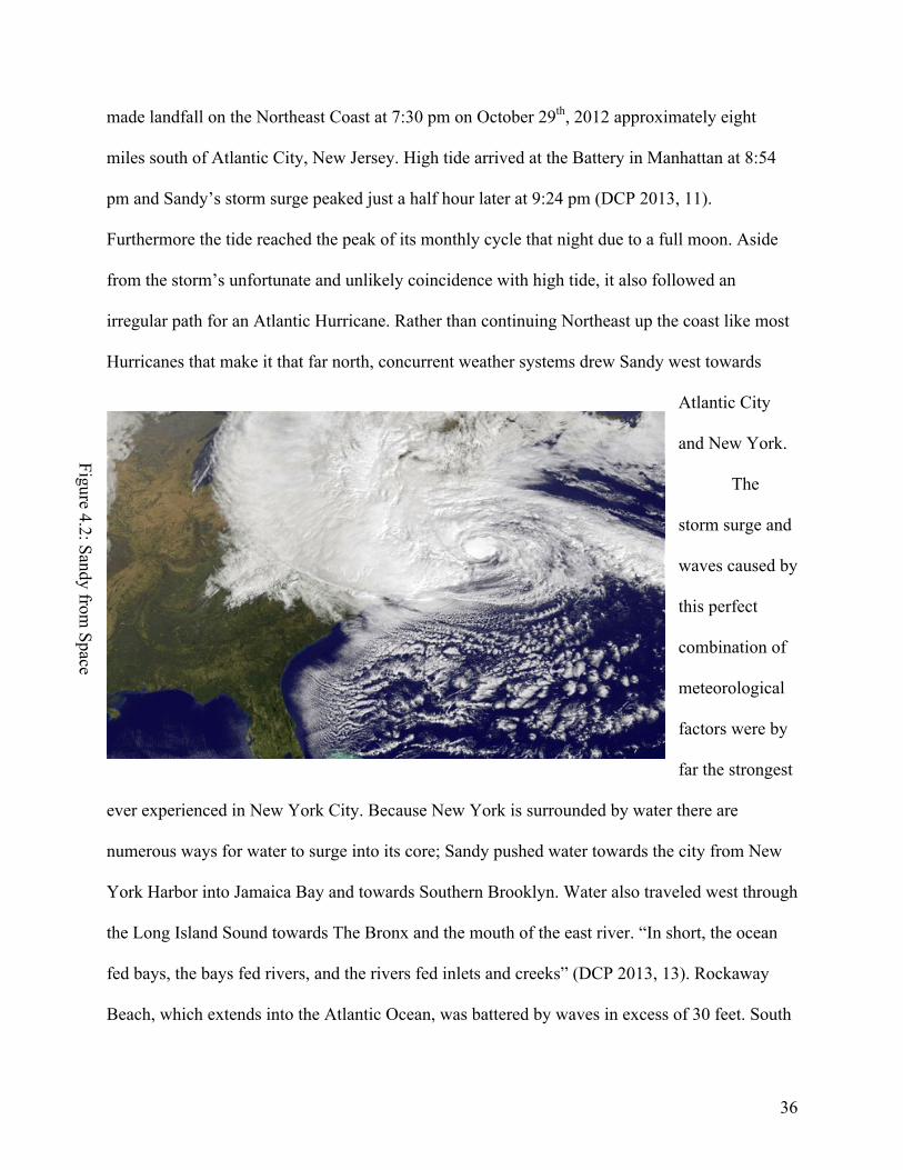
made landfall on the Northeast Coast at 7:30 pm on October 29th, 2012 approximately eight
miles south of Atlantic City, New Jersey. High tide arrived at the Battery in Manhattan at 8:54
pm and Sandy’s storm surge peaked just a half hour later at 9:24 pm (DCP 2013, 11).
Furthermore the tide reached the peak of its monthly cycle that night due to a full moon. Aside
from the storm’s unfortunate and unlikely coincidence with high tide, it also followed an
irregular path for an Atlantic Hurricane. Rather than continuing Northeast up the coast like most
Hurricanes that make it that far north, concurrent weather systems drew Sandy west towards
Atlantic City
and New York.
The
storm surge and
waves caused by
this perfect
combination of
meteorological
factors were by
far the strongest
ever experienced in New York City. Because New York is surrounded by water there are
numerous ways for water to surge into its core; Sandy pushed water towards the city from New
York Harbor into Jamaica Bay and towards Southern Brooklyn. Water also traveled west through
the Long Island Sound towards The Bronx and the mouth of the east river. “In short, the ocean
fed bays, the bays fed rivers, and the rivers fed inlets and creeks” (DCP 2013, 13). Rockaway
Beach, which extends into the Atlantic Ocean, was battered by waves in excess of 30 feet. South
Figure 4.2: Sandy from Space

37
Beach Staten Island experienced the highest storm surge in the city, with water rising 15 feet
above the normal mean water line. In Sea gate, Brooklyn, water rose 13.3 feet and at the
Gowanus Canal, water levels exceeded 11 feet above the normal mean due to the storm surge
(DCP 2013, 42).
The New York waterfront experienced extensive damage due to the extreme nature of
Sandy’s storm surge. According to the A Stronger, More Resilient New York plan released by the
New York City Department of City Planning in July of 2013, “the urban character of New York
City magnified the impact of the flooding.” More than 443,000 New Yorkers were living in the
areas that Sandy flooded when the storm struck. 88,700 buildings in total are located in the
storm’s inundation zone, consisting of over 300,000 homes and approximately 23,400 businesses
(DCP 2013, 13). Furthermore much of the city’s critical infrastructure like hospitals, nursing
homes, power facilities, transportation facilities and wastewater treatment plants is located in
flood zones. Six hospitals were closed, 500 miles of roadways were damaged and the 14th Street
substation in Manhattan was completely compromised due to an explosion caused by a reaction
between electricity producing machines and salt water. Although drinking water wasn’t severely
impacted, 10 of the 14 wastewater treatment plants operated by the Department of
Environmental Protection released either untreated or partially untreated sewage into the city’s
waterways (DCP 2013, 17).
Although the focus of this thesis is flood protection proposals for the Northern Brooklyn
waterfront that maintain resilient principles, it is important to first consider how flooding from
Sandy impacted vital infrastructural elements in the city. Indeed one of the most profound
impacts of Sandy’s storm surge and subsequent flooding was on New York’s subway system,
considered to be the backbone of the city and one of its greatest assets. Every subway tunnel

38
between Manhattan and Brooklyn, and Brooklyn and Queens was compromised and rendered
unusable for days afterwards. In the case of the R and G trains, regular subway service won’t
return until the end of 2014 because of the need for repairs. In a New York Times Magazine
feature on the MTA’s response to Sandy, the author commented, “Sandy made M.T.A. workers
look like a bunch of children racing around the beach as waves came in toward their sand castle.
Sometimes it felt that way to them too. The Federal Transit Administration describes Sandy as
the nation’s worst transit disaster”(Sullivan 2013, 3).
In the aftermath
of Sandy’s path of
destruction, the
Department of
Buildings (DOB)
tagged 800 buildings
across the city as being
structurally damaged by
Sandy. Over 100 of the
lost homes and
businesses along the waterfront were lost to fire, another destructive but limited and indirect
impact of flooding from the storm (DCP 2013, 14). Of the buildings that were tagged by the
DOB, those that suffered the greatest damage were older, one story light frame buildings.
Although buildings of this type make up only 18 percent of structures along the waterfront, they
account for 73 percent of all buildings tagged by the DOB. High rises on the other hand suffered
significantly less structural damage than smaller, older buildings. Critical design flaws in many
Figure 4.3: 86th Street Station.
Gravesend, B
rooklyn

39
high-rise buildings such as the location of infrastructure on basement levels still resulted in
losses of power or heat.
One building type that suffered significant mechanical but limited structural damage was
New York Housing Authority (NYCHA) buildings, which in many cases are located close to the
water’s edge. “More than 400 New York City Housing Authority buildings containing
approximately 35,000 housing units lost power, heat, or hot water during Sandy”(DCP 2013, 14).
NYCHA buildings, many of which are 70 years old and were in a state of poor repair prior to
Sandy’s arrival suffered greatly. “Perhaps more so than in any other place in the city, the loss of
power for people living in public housing projects forced a return to a primal existence”
(Buckley 2012, 1). The authors continue, “Thousands of public housing residents in New York
City defied evacuation orders because they underestimated the ferocity of Hurricane Sandy; now
they make up a city within a city, marked by acute need” (Buckley 2012, 2). One housing
development, the Red Hook houses in the Red Hook neighborhood of Brooklyn, which the
article specifically refers to, suffered perhaps the most from hurricane related flooding.
The Red Hook houses are just one of many vulnerable built elements along the Northern
Brooklyn waterfront. The Department of City Planning locates the focus area of this thesis in a
larger waterfront context that includes Long Island City, Queens and Sunset Park, Brooklyn just
south of Red Hook and the Gowanus Canal. According to the Stronger, More Resilient New York
plan, the Brooklyn-Queens waterfront area that they highlight contains 8,600 businesses that
employ over 77,200 people. In the aftermath of Hurricane Sandy, nearly one third of all the
businesses and more than half of the employees of those businesses were affected by the storm
(DCP 2013, 244-245). Encompassed in commercial land usage along the waterfront is industry,
which accounts for 22 percent of Brooklyn-Queens waterfront buildings. In the Brooklyn Navy

40
Yard, parts were flooded with four to six feet of water from the adjacent East River and $75
million of equipment and inventory were lost (DCP 2013, 248).
While most areas were flooded by water from the East River and New York harbor, the
neighborhoods of Greenpoint, East Williamsburg and Gowanus suffered flooding from a
different source. These areas were in fact relatively unaffected by the East River storm surge, yet
still experienced significant flooding. In Gowanus, damage to the neighborhood was the result of
storm waters topping bulkheads along the Gowanus Canal, which stretches 1.8 miles North into
mainland Brooklyn. Further North in East Williamsburg and Greenpoint the Newtown Creek
was responsible. Both the Newtown Creek and Gowanus Canal are narrow waterways that serve
primarily industrial functions. Since the early days of waterfront commercial activity in
Brooklyn, they were modified to promote a variety of light and heavy industrial practices. In
both cases, the banks of these industrial canals were flattened decades before and any natural
characteristics were eliminated. This all contributed to what the Department of City Planning
calls “backdoor flooding.” The low-lying nature of the surrounding land paired with the two
waterways’ altered ecology exposed adjacent neighborhoods to flood waters and caused
significant inland damage.
Aside from the inland, backdoor flooding that the Newtown Creek and Gowanus Canal
exposed adjacent neighborhoods to, they also pose a significant health threat. The long and
active history of heavy industrial operations along the shores of these two waterways has had
harmful effects on the quality of their waters. In the past 10 years, both waterways have been
tagged by the Environmental Protection Agency (EPA) as superfund sites, a designation and
action plan reserved for the dirtiest water in the United States. When the Newtown Creek and
Gowanus Canal overflowed during Hurricane Sandy, millions of gallons of highly polluted water

41
flowed into the streets, homes and businesses of nearby neighborhoods. Although a study
performed by the Department of Environmental Protection in Sandy’s aftermath concluded that
conditions in surrounding areas were generally safe, the potential of a biohazard emergency
provides strong impetus for the clean up of these two waterways. This danger also increases the
urgency for flood protective measures to be taken along the Newtown Creek and Gowanus Canal
to prevent water, polluted or not, from flooding nearby neighborhoods.
Hurricane Irene, which made landfall in New York on August 28th, 2011, lulled New
Yorkers into a false sense of
security regarding the city’s
ability to survive dangerous
weather systems. Although a
significant storm, Irene didn’t
flood the subway and New
York recovered much quicker
than it has been able to from
Sandy. It is however
noteworthy that two powerful storms struck New York City directly in a little over a year’s time,
a sign of what we can expect in the future. Hurricane Sandy was a devastating storm that altered
the lives of millions and changed the way politicians, planners and architects look at the city; no
longer an invincible metropolis. More than anything Sandy exposed New York’s extreme
vulnerability to flooding. When talking about extreme weather events in the future, the question
is no longer if, but when?
Figure 4.4: Flooding in Red
Hook, B
rooklyn

42
The New York City Department of City Planning has paid close attention to the realities
of climate change and global warming, which tell us that Hurricane Sandy was not an anomalous
occurrence. According to the resiliency report, “since 1900, sea levels have risen more than a
foot in New York City, primarily due to climate change. As sea levels continue to rise, coastal
storms will cause flooding over a larger area and at increased heights than they otherwise would
have”(DCP 2013, 30). 2012, the year in which Sandy was spawned, was the warmest year ever
recorded in New York City, a full degree warmer than the previous record holder. The authors
also write, “since the industrial revolution, carbon dioxide levels have increased forty percent.
Since the late 1970s, global average temperatures have increased by approximately 1 degree
Fahrenheit and the volume of sea ice in the Arctic during the month of September has declined
by almost 80 percent” (DCP 2013, 27). All together this paints a troubling picture of the future of
our planet and provides significant incentive for creative design ideas that will help protect New
York City from the near inevitability of powerful future storms and more frequent flooding.
The Department of City Planning outsourced a cost benefit and future risk analysis to the
Swiss insurance company Swiss Re to aid in their plans for flood protection. According to the
Swiss Re study, “models project that expected annual losses in New York City of $1.7 billion
today will grow to $4.4 billion in current dollars by the 2050s”(DCP 2013, 35). What this means
is that the amount of damage the city can expect on a yearly basis today nearly triples over the
course of the next 40 years. By 2050 and even sooner, more and more of the city can expect to
experience significant flooding and damage, while those parts inundated by Sandy will suffer
more so than ever before. In the next chapter I explore some of the design solutions proposed by
the Department of City Planning and private design firms to help protect New York City and the

43
surrounding metropolitan area. In their design efforts, private and public entities are striving to
make New York more “resilient,” a fuller definition of which is forthcoming.

44
CHAPTER 5: RESILIENT DESIGN SOLUTIONS
The historical, geographical and meteorological discussions and analysis in this thesis
underscore the imperative for good design solutions to the challenges facing the New York
waterfront in the 21st Century. After decades of industrial and commercial productivity followed
by half a century of dormancy and dereliction, people and businesses are moving to and
investing in the New York waterfront. The “Coastal Analysis” chapter of A Stronger, More
Resilient New York begins, “In the 21st Century, New York and New Yorkers have embraced the
waterfront in a new and exciting way… New developments, parks, housing and business have all
moved closer to the water’s edge.” The writers concede however that, “this move towards the
water brings with it new Challenges, many associated with climate change” (DCP 2013, 40). It is
with these challenges related to climate change that this thesis is most concerned: how can New
York continue to develop its waterfront safely with the destructive force of Hurricane Sandy in
mind? In this chapter I look at some of the best and most interesting ideas from public and
private sources regarding how to effectively respond to the immanency of the threat of climate
change.
Before Hurricane Sandy, the threat of flooding caused by a massive storm was regarded
as an unlikely possibility. Parts of the city had been flooded before, but the city always bounced
back quickly and was never severely inundated. Hurricane Irene, which struck in August 2011,
raised the possibility of widespread destruction from an Atlantic Hurricane but damage and
losses were relatively limited. Extreme weather in the form of Nor’easter storms causes limited
flooding and disrupts transportation service but water has never risen above 10.5 feet, the level at
which the subway floods (DCP 2013, 14). As the previous chapter noted, water reached 15 feet
above mean levels in some parts of Staten Island and 13 feet in parts of Brooklyn. As a result,

45
the subway flooded for first time, with water rising well above the 10.5-foot threshold. The
widespread destruction Sandy left in its wake left many wondering, would New York retreat or
rebuild? Unsurprisingly New York decided to rebuild. The question then became how would it
be done?
New York was undeniably unprepared for a storm of Sandy’s magnitude. Since a storm
like Sandy had never hit the city before, New Yorkers doubted one ever could; the city thought it
was invincible. For the metropolises of countries like the Netherlands and England however,
flooding is a historic
problem and is treated as
an inevitability. In the
Netherlands, the
government spends $1.3
billion annually on flood
preventative measures,
which has helped to
finance the country’s vast,
hi-tech flood prevention system that protects the low-lying country (Higgins 2012, 1). Peter Glas,
president of the Dutch Association of Regional Water Authorities told the New York Times, he
was dismayed by images on television of darkened, waterlogged buildings in Lower Manhattan,
and wondered how the area would have fared if it “had a Dutch approach to the problem”
(Higgins 2012, 1).
The modern methods of the Dutch are certainly noteworthy and exemplify the type of
attitude we must take towards flood prevention in New York. “The Dutch way of thinking is
Figure 5.1: Thames Flood G
ate: London, England

46
completely different from the U.S., where disaster relief generally takes precedence over disaster
avoidance,” said Wim Kuijken a Dutch government official (Higgins 2012, 2). Mr. Kuijken is
correct in his assessment of American attitudes; it is indeed time to consider how disasters can be
avoided, rather than just waiting to clean up the pieces afterwards. There are those that believe
we should replicate the massive flood barriers that protect cities like Rotterdam and London. A
better understanding of New York’s unique geography and the realities of resorting to such hi-
tech and expensive measures is necessary before diving into such a massive infrastructural
project.
According to the Department of City Planning, “There have been proposals for massive
seawalls that would in theory protect most of the city from a storm surge” (DCP 2013, 48) One
such proposal entails the construction of three walls, one across the Narrows between Brooklyn
and Staten Island, one at Arthur Kill in Staten Island and a third at the Upper Reaches of the East
River. These barriers would be normally navigable, raising their levees only when the threat of a
storm was imminent. For some the supposed simplicity of an all-encompassing flood barrier is
appealing. There are however multiple drawbacks to a massive plan such as the proposed $25
billion price tag, years of design and bureaucratic debates, potentially horrific environmental
impacts and the disruption of New York attractions like Rockaway Beach and Coney Island
(DCP 2013, 49). Even after they’re built, there is no guarantee that such drastic measures will
even work. All the potential negative outcomes associated with a massive floodwall led the
Department of City Planning to make a major decision about the future of flood protection in
New York. They say:
“Given this, the City believes that the right approach to coastal protection is an integrated
system of discrete coastal projects, that together would constitute the elements of a

47
multilayered approach also involving resiliency measures for buildings and protections
for critical infrastructure” (DCP 2013, 50).
This statement reveals that the government of the City of New York intends to focus on
smaller scale interventions, aimed at “resiliency.” Resiliency has become one of the buzzwords
of both public and private efforts to protect New York from flooding. A resilient approach to
flood design does not necessarily entail complete prevention of floodwaters reaching New York
streets and buildings. Instead it advocates a comprehensive, multi-faceted approach that allows
the city to absorb some of a storm’s impact and help it recover quickly. What we learned from
the impacts of Hurricane Sandy is that different coastal areas face a different set of risks and
circumstances that can’t be solved by applying a single, all-encompassing solution. The
Department of City Planning describes the advantages of their integrated approach as being
three-fold. First, it diversifies the city’s exposure to different technologies, reducing the chance
of devastating total failure such as with the levees in New Orleans during Hurricane Katrina.
Second, it is scalable to available resources. And third, projects can be started right now to
protect New Yorkers in the short run rather than relying on a large project that won’t be
complete for decades (DCP 2013, 50).
The integrated approach that the DCP champions combines hundreds of smaller
infrastructural elements that will work in concert to protect vulnerable parts of the city. In the
Hurricane Sandy report, the authors briefly outline the use and intended effect of a dozen of the
smaller-scale infrastructural elements they plan to implement and the specific areas in the city
where each built entity will be placed. These projects range in scale from beach nourishment, the
process of adding sand to beaches to improve their health and durability, to hard rock shoreline
barriers called revetments. The Department of City Planning grouped the implementation of

48
some shorter term and less expensive plans into an ambitious Phase One, made up of 37 unique
initiatives.
With unlimited financial support and manpower the DCP could implement all the
infrastructural plans it wants to immediately. However because of budget constraints and the
“fluid nature of climate change and sea level rise,” the possibility of building everything at once
is rendered unfeasible (DCP 2013, 57). To effectively address the Department’s lengthy to-do
list, a cost-benefit analysis was employed to determine which areas are at the greatest risk. The
DCP writes, “some of the earliest initiatives will take place in high risk areas such as Rockaway
Beach where there is a planned process of beach nourishment as well as the addition of
revetments and bulkheads in other high risk areas such as Staten Island and southern Brooklyn.
These are areas that are vulnerable to waves as well as flooding, the receding waters take sand
with them”(DCP 2013, 58).
Out of the 37 initiatives that comprise Phase One of the Department of City Planning’s
waterfront protection plan, only three address flooding concerns in my focus area, the Northern
Brooklyn Waterfront. Furthermore these three initiatives are located towards the bottom of the
list at numbers 23, 25 and 26. Although Northern Brooklyn is included in Phase One, areas that
suffered greater damage as a result of Hurricane Sandy and are likely to suffer similar damage in
the near future were given clear priority. While Red Hook, Brooklyn suffered serious and
widespread damage because of Sandy; areas like Rockaway Beach and Tottenville, Staten Island
were clearly devastated to a greater degree. The DCP understands that it can do more, faster and
with greatest effect in the city’s most vulnerable areas.
I want to turn now to a discussion of those initiatives slated for the Northern Brooklyn
Waterfront. A full summary of the 37 initiatives that comprise Phase One is beyond the scope of

49
this paper, however a fuller discussion of the implications of its geographic priorities is
forthcoming. Initiative 25 in Phase One addresses a vital piece of the city’s energy and electrical
infrastructure, the Farragut Substation located in Vinegar Hill. This large substation, which
supplies power to 1.25 million customers in New York, is built directly adjacent to the East
River, rendering it extremely vulnerable to any fluctuation in water level (DCP 2013, 58).
Although it didn’t flood during Hurricane Sandy, it is located in one of the highest flood risk
zones. To deal with the threat of flooding damage, the DCP recommends the construction of a
floodwall along the substation’s perimeter. A floodwall is, a “permanent vertical barrier” that
provides “a higher level of surge protection for vulnerable neighborhoods and critical
infrastructure” (DCP 2013, 54). In this specific instance, the use of a permanent, singular entity
is warranted because of its non-residential character. In many other cases, less obstructive means
are called for.
Initiative 26 of the DCP’s Phase One deals with the Newtown Creek, the industrial
waterway that separates Queens from Brooklyn and is fed by the East River. Issues related to the
Newtown Creek were raised in Chapter Four due to the extensive flooding it caused and the
extreme pollution of its waters. The Newtown Creek contributed to a phenomenon called
“backdoor flooding” because its waters flooded areas further inland to a greater degree than
waterfront areas adjacent to the larger East River. The scourge of industry left the banks of the
creek barren and unable to repel rising waters, which topped bulkheads and flowed unabatedly
into Greenpoint and East Williamsburg. Although the Newtown Creek doesn’t support the same
level of industrial and commercial activity it once did, it is still an active waterway with
numerous heavy industries lining its shores. This fact led the Department of City Planning to its

50
conclusion about how to protect the areas surrounding it from overflowing waters; a local storm
surge barrier.
The Department of City Planning prescribes a local storm surge barrier to protect against
flooding while also taking into consideration the activity of the creek. The DCP describes them
as, “Large moveable in-water gates that connect with levees or floodwalls on adjacent shores.
They are retracted to allow for normal maritime activities during non-storm times and are closed
in advance of extreme weather to protect inland areas” (DCP 2013, 56). The implementation of a
storm barrier at the mouth of the Newtown Creek is a relatively expensive infrastructural piece in
the context of other more “integrated approaches,” however the commercial activity of the creek
demands such a plan. Outside of the citywide Phase One initiatives, there is a separate but related
set of initiatives that apply only to the Brooklyn-Queens waterfront area as isolated by the DCP.
Brooklyn-Queens initiative four supports private investments that reduce flood-risk along the
Creek until the surge barrier is completed. Furthermore under initiative two, the DCP calls for a
feasibility study for a similar type of barrier at the mouth of the Gowanus Canal, which shares
many of the same characteristics as the Newtown Creek.
Under the auspices of the citywide Phase One and the eleven initiatives specifically
called for along the Brooklyn-Queens waterfront, the neighborhood of Red Hook receives the
most attention. Formerly one of the most dangerous, destitute and run-down neighborhoods in
the city, suffering from deindustrialization among other urban illnesses, Red Hook has been the
site of considerable contemporary development. A fascinating variety of people and businesses
now populate the neighborhood; small artisan shops, a Fairway market and an Ikea have recently
joined the massive NYCHA Red Hook houses. As Chapter Four discussed, the peninsular shape
and unprotected geographic location subjected Red Hook to some of the worst flooding of

51
anywhere in the city during Hurricane Sandy. Six feet of water filled some streets in the
neighborhood, inundating the aged Red Hook houses and causing millions of dollars in property
damage. Because of the unique location and diverse array of activities and people the
neighborhood supports, the Department of City Planning has taken a markedly different
approach to flood resiliency there as opposed to the sites previously mentioned.
An integrated flood protection approach is advocated by the Department of City Planning
for implementation in neighborhoods like East Harlem and the Lower East Side in Manhattan
and Red Hook, Brooklyn among others. The idea behind an integrated approach is to protect a
given neighborhood from flooding without disrupting its unique built, social and economic
character. According to the DCP, an integrated flood protection system “combines traditional
flood walls with landscaping features; benches, park walls, flood-proofed buildings, drainage
improvements…”(DCP 2013, 54). As the Department’s plans demonstrate, flood protection
measures can be utilized for neighborhood improvements beyond their primary stated task.
Drainage improvements, landscaping features and park benches to name a few all serve valuable
functions in non-storm conditions. Indeed many of the flood protective elements advocated by
the DCP are preexisting features of the built environment that if utilized correctly can serve a
variety of functions.
Another important element of the integrated approach is deployable floodwalls, which are
“useful because in non-storm times, they are invisible and can be put up in time for a storm
(DCP 2013, 54). This is another important feature that demonstrates the DCP’s understanding of
the unique character of the different waterfront neighborhoods in New York. To protect the
Farragut Substation, a permanent levee was recommended because it is a piece of infrastructure
that doesn’t support the daily activities of residents, business owners or tourists. In contrast, Red

52
Hook is a vibrant, quickly developing residential neighborhood with thousands of homes,
restaurants and businesses both small and large. The implementation of a permanent levee or
other large infrastructural element would undoubtedly disrupt the flow of daily life in Red Hook.
Besides the disruption it would cause in terms of the circulation of pedestrians and vehicles, a
steel and concrete behemoth would block waterfront views, break with the primarily low-rise
brick building character of
the neighborhood and
generally intimidate the
local populace.
“Integration” is at
the forefront of the
Department of City
Planning’s efforts to protect
vibrant neighborhoods from
flooding while at the same time preserving their unique built character. Hurricane Sandy exposed
New York City’s weaknesses, but it also highlighted many of its strengths. These strengths
reside in certain preexisting infrastructure that helped repel advancing floodwaters beyond their
intended use value. We cannot forget what makes New York great in our pursuit of protecting it
from the inevitabilities of climate change and the strong storms it will cause. Using flood
protective elements to strengthen the day-to-day fabric of our city makes sense because it serves
a variety of purposes. Therefore I cannot advocate investment in mammoth seawalls because
they have no value beyond their intended use and are likely to impinge on scarce and valuable
municipal resources.
Figure 5.2: SCA
PE Oystertechture

53
Highlighting the importance of flood resilient design in New York is the attention it has
drawn from architecture and landscape architecture firms from around the world. In this chapter I
discuss two separate initiatives that bring together some of the best firms with the best ideas
about flood protective design. The first is Rising Currents an exhibit and interactive dialogue
curated by the Museum of Modern Art at their Queens location, PS1. The Second is the Rebuild
By Design competition, funded by the United States Department of Housing and Urban
Development (HUD) in the aftermath of Hurricane Sandy. Rising Currents was on display in
2009 and shows impressive insight into the realities of climate change and foresight with regard
to the events of Hurricane Sandy. The exhibit brought together five different design teams that
were each assigned a location around the New York metropolitan area and tasked with
developing “soft-infrastructure”(Bergdoll 2011, 13). The stated intention of the five different
projects MoMA supported was to, “ameliorate the effects of climate change by mimicking nature
and accepting a blurring of the edge between land and water”(Bergdoll 2011, 14).
The areas of the New York metropolitan area addressed were Lower Manhattan, Liberty
State Park in Jersey City, Kill Van Kull between Bayonne, New Jersey and Staten Island and the
Sunset Park, Bay Ridge and Red Hook neighborhoods of Brooklyn. For the purposes of this
paper I address the proposal for Red Hook from the New York based landscape architecture firm
SCAPE. Led by Kate Orff, the SCAPE team presented a set of initiatives aimed at widespread
and innovative wildlife conservation. 150 years ago before industrialization poisoned the waters
surrounding New York, the Bay Ridge flats off the coast of Brooklyn were ripe with high quality
oysters. With this history in mind, Orff writes, “Engaging issues of water quality, encroaching
tides, and community based development, the team proposes to nurture the already active
revitalization of a long-lost natural oyster reef in phased process…”(Bergdoll 2011, 90).

54
SCAPE’s plan takes into account numerous benefits that could be gleaned from the
revitalization of oyster reefs in New York waters. An inexpensive and simple wood and rope
structure would nurture oysters in a “clean and revitalized Gowanus Canal” (Bergdoll 2011, 90).
Considering the Gowanus Canal’s status as a superfund site, it is implausible to think of it a
viable location for Oyster growth. Orff however has extreme faith in the abilities of these small
creatures to purify water; one oyster can filter up to 50 gallons of water per day (Orff 2010).
Furthermore these Oyster farms are constructed in a way that attenuates wave impact, protecting
the areas surrounding the Gowanus canal that were flooded during Sandy. Waterfront parks and
walkways, demonstrating a multiplicity of benefits for the public good in Red Hook and beyond,
will complement the construction of Oyster farm infrastructure. Although a markedly different
approach to flood resilient design, employing a number of ecological elements the Department of
City Planning doesn’t recommend for Red Hook, both plans intend to protect the city while at
the same time contributing to the community in non-storm times.
The Rebuild by Design competition, funded by HUD, was initiated in the aftermath of
Hurricane Sandy. The competition includes entries from a prestigious international array of
design teams like Rem Koolhaas’s OMA from Rotterdam, Netherlands and Interboro Partners
from Brooklyn, headed by Tobias Armborst. The scope of the designs for this competition
extends far beyond the reaches of New York City into New Jersey and Long Island. Out of the
ongoing projects, the Northern Brooklyn waterfront receives relatively little attention.
Considering the massive Federal Investment, it is unsurprising that the design teams are focusing
on areas that were inundated by Hurricane Sandy to the greatest degree. Although the Northern
Brooklyn waterfront suffered significant damage from Sandy and stands to be inundated in the

55
future, it was spared relative to parts of Staten Island, Southern Brooklyn and the Jersey Shore.
The one part of my focus area that is mentioned is Red Hook.
One team that has taken on the task of addressing Red Hook is HR&A Advisors, Inc
along with Cooper, Robertson & Partners. In their assessment of Red Hook’s flood
vulnerabilities, they highlight an industrial past that left the shoreline vulnerable to flooding.
They reference the initiatives planned for implementation by the Department of City Planning as
part of their integrated approach, noting however that they will take time and that Sandy
uncovered other unaddressed vulnerabilities. These vulnerabilities include “gaps in commercial
corridors; exposure of Red Hook Houses public housing complexes; and a lack of connectivity
between Red Hook and the rest of the City”(RBD, 2013). They advocate a variety of measures
that can be implemented in the short term to protect Red Hook until some of the larger, public
initiatives are completed. These included, “flood protection for existing stores and buildings
along Van Brunt Street…development of new public housing to relocate ground flood tenants to
high elevations in new structures”(RBD 2013). The design team hopes to create better
connections between Red Hook and adjacent neighborhoods, a link that is severed by the Hugh
L. Carey (Brooklyn-
Battery) Tunnel.
Recognition of the
shortcomings of the
Department of City
Planning’s initiatives for
Red Hook demonstrates the
importance of public-
Figure 5.3: HR
&A
Red
Hook Plan

56
private partnerships in the interest of achieving flood protection goals. Although some of the
plans suggested by HR&A Advisors, Inc won’t be completed in the short term, like the
construction of new public housing buildings, others like flood protection for Van Brunt Street
are certainly feasible. The combination of public and private short and long-term goals is
undoubtedly the best way to achieve goals of protecting a neighborhood like Red Hook from
flooding while preserving its unique built and social character. BIG TEAM, another design team
that is participating in the Rebuild by Design program also recognizes the vulnerabilities of Red
Hook and offers some generalized solutions for its protection. They call for the need to “retrofit
existing buildings, harden and diversify critical infrastructure and revitalize commerce”(RBD
2013). These goals would be achieved through the implementation of a Resilient Community
District (RCD) strategy that would deeply engage local residents. The RCD would further the
design team’s goals of creating “spectacular public waterfront parks…substantial new affordable
housing and…enhanced transit connections to job centers of Downtown Brooklyn and Lower
Manhattan…”(RBD 2013).
Public initiatives from the Department of City Planning and private design team efforts
demonstrate a commitment to the waterfront in terms of flood protection and preservation of
existing communities. New York can be protected from flooding without inundating the city with
a disruption of another kind, giant floodwalls and levees. Analysis of these plans also shows that
a discussion of Northern Brooklyn in the context of flood protection for the whole city is of
importance, but not the priority. The Northern Brooklyn waterfront experienced significant
damage but was relatively unscathed when considering areas like Far Rockaway, Breezy Point
and Coney Island. Indeed over the next decade many of the flood protection initiatives advocated
by the DCP, SCAPE, BIG TEAM and HR&A will be implemented, but those for the most

57
vulnerable areas unsurprisingly
get priority. As the DCP writes
early in A Stronger, More
Resilient New York, there
simply is not enough money to
do everything the Department
wants to immediately, and
because of this some areas
must be prioritized. Other
areas are certainly not forgotten, but short-term climate change realities force our hand in
consideration of which neighborhoods will receive aid first.
Figure 5.4: BIG
TEAM
Red
Hook Plan

58
CHAPTER 6: CONCLUSION
Perhaps one of the best lessons we can learn from the research presented in this thesis is
that often times New York City has protected itself from flooding without necessarily realizing it
was doing so. Consider Battery Park City or Northern Williamsburg where thousands of people
were spared from the worst of Sandy’s wrath because of built elements located right in harm’s
way. Indeed waterfront esplanades, parks and modern buildings built closer and closer to the
water are a theoretical hazard. However a few positive examples from Hurricane Sandy prove
that flood protection and everyday built improvement inherently go hand in hand. Hurricane
Sandy has provided us with an opportunity, to not only protect New York from the inevitability
of extreme weather but to improve the social and built character of our city along the way. Flood
resilient design is not a one sided discussion about concrete walls and massive floodgates, it is a
conversation about how a park bench or waterfront park can stop waves and serve vital
recreational purposes too.
The second chapter of this thesis paper provided a historical precedent for a
contemporary discussion of modern waterfront development and extreme weather vulnerability.
Perhaps the most important legacy of four centuries of commercial and industrial development
Figure 6.1: Integrated Flood Protection

59
along the waterfront is the hardened edges they created to serve their needs. Wetlands and
marshes that formed an important part of New York’s aqueous ecology were filled in and
therefore compromised in their ability to protect the shoreline. The storm surges and waves from
Hurricane Sandy reached the New York waterfront at full strength because there were no natural
or artificial elements standing in the way. When confronted with a hardened edge, like those that
ring much of Manhattan and Brooklyn, the water easily topped bulkheads and flowed freely into
the streets, basements and subway stations of the city.
Early in this thesis I try to understand the history of the New York waterfront and why
development since the early 19th Century rendered the city so vulnerable to extreme weather like
Hurricane Sandy. An interrogation of waterfront history, which centered on industrialization,
deindustrialization and hardening edges, also elicited some exciting revelations about the
strengths of New York’s vast coastline. One of those strengths is Battery Park City, the late 20th
Century residential and business development that escaped Sandy relatively unscathed. Battery
Park City demonstrated the protective power of esplanades and parkland, proving that building
close to the water doesn’t necessarily have to be a risky endeavor. Turning now towards Chapter
3 and contemporary development particularly in Brooklyn, developments on the waterfront there
also proved to be resilient in the face of the storm.
Along the Northern Brooklyn waterfront, the Williamsburg Edge development and
numerous others that have sprung up in recent years appear to be located directly in harm’s way.
However, compared with other waterfront parts of Brooklyn, the Williamsburg neighborhood
fared particularly well in no small part because of the density of development along its shore.
Waterfront esplanades that were constructed in connection with residential developments
actually broke the powerful waves of the East River during the storm, turning a potential liability

60
into a surprising strength. In the context of the large scale and lucrative development that has
occurred along the waterfront in recent years, the flooding from Hurricane Sandy could have
served a deadly blow. Instead, design considerations for leisure activity proved to be important
flood prevention elements that now serve as an example for future developments about how their
investment can be protected. Hurricane Sandy doesn’t mean we have to retreat from the water, it
just highlights the need
for thoughtful
waterfront design that
puts flood protection at
the forefront of
developmental
considerations.
The extent to
which New Yorkers
have embraced the parks, kayak clubs and other waterfront activities of the 21st Century pays
homage their love of the waterfront. For the better part of the second half of the 20th Century, the
waterfront was an assemblage of crumbling infrastructure, toxic waste sites and chain-link
fences. Highways were built and proposed where chess tables, flowerbeds and bike paths should
have been. Today and for the past decade, New York has been making significant strides towards
the creation of the leisure waterfront New Yorkers want and deserve. Complicating this renewed
waterfront rapport is the realities of climate change, made painfully apparent by Hurricane
Sandy. New Yorkers want to keep utilizing all the waterfront has to offer, which makes efforts to
fortify the shore in unobtrusive ways so important.
Figure 6.2: New
town C
reek R
endering

61
Hurricane Sandy caused unprecedented damage throughout the New York City area. Not
only did 43 New Yorkers perish in the floods and fires, but also hundreds of thousands of others
suffered from infrastructural failure, property damage and from a feeling of insecurity in their
homes and places of work. When Hurricane Sandy flooded 51 square miles of New York, killed
power to all of Lower Manhattan and caused $19 billion in damage in the city alone, an utter
lack of preparedness was revealed. Author May Joseph, a resident of Greenwich Village in
Manhattan who suffered personal hardship as a result of the storm had harsh words for New
York and the way it handles disaster. She writes, “New York…is inexcusably behind the times
when it comes to being prepared for climate change. For a city of its scale and import, it has little
to offer the world, regarding how cities can improve their infrastructure. Instead, New York is an
example of environmental hubris”(Joseph 2013, 205-6). This is one of the most damning
assessments of the city; one that cuts to the core of everything New York thinks it is and aspires
to be.
Joseph comments elsewhere in her book, “Hurricane Sandy marks a major turning point
in New York City’s history, equivalent in seismic shift to the impact that 9/11 wrought upon the
city” (Joseph 2013, 2). Indeed the way New Yorkers think has been fundamentally altered by the
deadly and damaging impact of Hurricane Sandy. Everything that is built or invested in must be
done so with careful consideration of the inevitabilities of future extreme weather events. All
indications from climate scientists, insurance calculations and damage projections point to an
increase in the extent of damage future storms will cause. Swiss Re estimates that $1.7 billion in
damage today will be $4.4 billion by the year 2050 as a result of rising sea levels and increased
storm frequency (DCP 2013, 35). According to the Department of City Planning, one dollar
invested in flood prevention today will see a four-dollar return. On both a personal level, as

62
Joseph provides, and a statistical level offered by Swiss Re and the DCP, there is incredible
impetus for investing in thoughtful and effective flood resilience measures now.
While this thesis goes to great lengths to the assess the damage and shortcomings of New
York when faced with extreme weather events like Hurricane Sandy, it is also mindful of the
city’s incredible strengths that the storm exposed as well. Those strengths include the parts of the
waterfront like Battery Park City that managed to survive the storm due to superior design and
higher elevations. Those strengths also include the built elements of the Brooklyn waterfront that
repelled floodwaters and protected inland areas beyond their intended use. Beyond the level of
infrastructure however lies perhaps the city’s greatest strength in the face of extreme tragedy,
New Yorkers’ sense of community, civic pride and dedication to the city. While Joseph was
angry and dismayed by New York’s lack of preparation to deal with Hurricane Sandy, she was
also overwhelmed by the kindness of fellow New Yorkers. She admits being struck by the
“extraordinary social cohesiveness of friends and strangers from across New York who…offered
solace in the desolate underworld of disaster” (Joseph 2013, 210).
It is this sense of community that excites Alexandros Washburn, former head of design
for the Department of City Planning and a resident of Red Hook. In his neighborhood, one of the
hardest hit, a makeshift pizzeria was set up on the street. Neighbors helped each other in the
aftermath of the storm in inspiring ways in Red Hook and elsewhere. Writing about the Red
Hook Houses, journalists Cara Buckley and Michael Wilson painted an unpleasant picture of
living conditions in public housing after the storm. More importantly however is the numerous
neighborly acts they reported on as well. They write, “The residents cooked for each other, eager
to not waste food that was thawing fast…there was an impromptu outdoor barbecue for 25
people, with hamburgers, frankfurters and ribs sizzling on grills” (Buckley, Wilson 2012, 2). Eric

63
Klinenberg, professor of Sociology at New York University found when studying heatwaves in
Chicago, “networks of social cohesion are vital to surviving extreme events…”(Washburn 2013,
185). As these few example show, this was certainly the case in New York after Sandy.
Washburn writes in his book, “Much of the recovery effort since the flood has been
focused on just getting back to where we were. And where we were was unprotected…We have
to change”(Washburn 2013, 199). However we can’t respond by walling ourselves in. Flood
resilient design in New York has to take into account the unique built and social character of the
city that makes it worth
saving. We can build
massive, unsightly
floodgates and
propagate a city as
fortress mentality, but
likely at the cost of the
neighborhood
atmosphere and
community tightness New York fosters. For this reason, this thesis advocates flood resilient
design plans that are integrated into the existing built and social fabric of the city. Beyond
integration and continuation, flood resilient design can be harnessed to improve the city during
non-storm conditions.
The Northern Brooklyn waterfront is a microcosm for the larger conversation regarding
flood resilient design in the whole city. There we see a combination of hi-tech strategies, like the
floodgate at the mouth of the Newtown Creek and more local, lo-tech elements like improved
Figure 6.3 Relief Efforts in Far R
ockaway

64
parks in Red Hook. A closer look at Red Hook shows a concerted effort to protect the
neighborhood in ways that improve living conditions both in normal and extreme weather
conditions. A Rebuild by Design proposal by the firm HR&A suggests improving transit
corridors between geographically isolated Red Hook and the rest of Brooklyn. Better
connections could prove vital in an extreme weather situation because residents could evacuate
safely if needed and rescue workers and supplies could reach the neighborhood faster. Better
connections with the rest of Brooklyn would also markedly improve the lives of Red Hook
residents and business owners the majority of the time when extreme weather is not an imminent
concern.
Washburn writes in regard to resiliency and sustainability efforts in Singapore, “Projects
engineered to make the city more sustainable are designed also to make the city more livable”
(Washburn 2013, 194). Therein lies perhaps the most important goal planners, architects and
government officials should hope to achieve when contemplating how to protect the city from
flooding, resilient designs that benefit the city in extreme and normal conditions. Hurricane
Sandy was both an incredible tragedy and an incredible opportunity, but only if New York
improves rather than just returns to where it was. If we look only to protect the city from
flooding, we risk damaging the built environment, neighborhoods and communities that are the
city’s greatest strength. Therefore we are compelled to build and design flood resilient measures
that improve the lives of residents and business owners on a quotidian basis.

65
REFERENCES CITED Ambrose, Nicole, Jason Crowley, and Ward Dennis. "Overall History - Brooklyn/Queens Waterfront." Overall History - Brooklyn/Queens Waterfront. Historic Preservation Program at Columbia University GSAPP, n.d. Web. 23 Feb. 2014. Bagli, Charles V. "Plan to Redevelop Brooklyn Sugar Factory Hits Snag: De Blasio."The New York Times. N.p., 27 Feb. 2014. Web. 6 Apr. 2014. Baker, Kevin. "City of Water." The New York Times. N.p., 12 Oct. 2013. Web. Bergdoll, Barry. Rising Currents: Projects for New York's Waterfront. New York: Museum of Modern Art, 2011. Print. Bone, Kevin, Mary Beth. Betts, and Stanley Greenberg. The New York Waterfront: Evolution and Building Culture of the Port and Harbor. New York: Monacelli, 1997. Print. Buckley, Cara, and Michael Wilson. "In New York’s Public Housing, Fear Creeps In With the Dark." The New York Times. N.p., 2 Nov. 2012. Web. Buttenwieser, Ann L. Manhattan, Water-bound: Planning and Developing Manhattan's Waterfront from the Seventeenth Century to the Present. New York: New York UP, 1987. Print. Cope, Nick. Assessing the Red Hook Flooding. 2012. New York. Brownstoner. Web. 25 Mar. 2014. <http://www.brownstoner.com/blog/2012/10/assessing-the-red-hook-flooding/>. Dunlap, David W. "A Modern Flood Barrier Aims to Protect Verizon’s Landmark
Building." The New York Times. N.p., 30 Oct. 2013. Web. Flegenheimer, Matt. "For Subway Riders, Fallout From Hurricane May Last Years." The New York Times. N.p., 28 Oct. 2013. Web. Fountain, Henry. "Natural Allies for the Next Sandy." The New York Times. N.p., 28 Oct. 2013. Web. Gastil, Raymond. Beyond the Edge: New York's New Waterfront. New York, NY: Princeton Architectural, 2002. Print. Gill, John Freeman. "In Canarsie, a Coalition of the Tried and True." The New York Times. N.p. 8 Oct. 2013. Web. Godfrey, Brian J. 2001. “Redeveloping the Manhattan Waterfront.” From the Hudson to the Hamptons: Snapshots of the New York Metropolitan Area, pp. 49- 60, edited by I.M. Miyares, M. Pavlovskaya, and G.A. Pope. New York: Association of American Geographers.

66
Godfrey, Brian J. “Waterfronts of New York State.” New York State Encyclopedia, ed. Peter Eisenstadt and Laura-Eve Moss, Syracuse University Press, 2005, 1670-1672 Higgins, Andrew. "Lessons for U.S. From a Flood-Prone Land." The New York Times. N.p., 14 Nov. 2012. Web. Joseph, May. Fluid New York: Cosmopolitan Urbanism and the Green Imagination. Durham: Duke UP, 2013. Print. Louie, Elaine. "Three Feet High and Rising." The New York Times. N.p., 30 Oct. 2013. Web. "Rebuild by Design: Innovating Together to Create a Resilient Region." New York City Department of City Planning. A Stronger, More Resilient New York. NYC Special Initiative for Rebuilding and Resiliency, 11 June 2013. Web. New York City. PlaNYC 2030. By Michael Bloomberg. N.p., 31 Dec. 2013. Web. 23 Feb. 2014. Orff, Kate. Reviving New York's Rivers - with Oysters Dec. 2010. Kate Orff: Reviving New York's Rivers. Web. 06 Apr. 2014. <http://www.ted.com/talks/kate_orff_oysters_as_architecture?language=en>. Rebuild by Design: Innovating Together to Create a Resilient Region. Department of Housing and Urban Development, n.d. Web. 23 Feb. 2014. Schuerman, Matthew. "Bloomberg's Waterfront Development Comes Under Scrutiny from Sandy's Impact." WNYC.org. N.p., 5 Dec. 2012. Web. 23 Feb. 2014. Schuerman, Matthew. "New York, the Vertical City, Kept Rising Under Bloomberg."WNYC.org. N.p., 8 July 2013. Web. 23 Feb. 2014. Sullivan, Robert. "Could New York City Subways Survive Another Hurricane?" The New York Times. N.p., 23 Oct. 2013. Web. Washburn, Alexandros. Nature of Urban Design: A New York Perspective on Resilience. Washington: Island, 2013. Print. Yee, Vivian. "At Brooklyn’s Domino Sugar Site, Waning Opposition to Prospect of Luxury Towers." The New York Times. N.p., 16 Oct. 2013. Web.