the brooklyn waterfront greenway
TRANSCRIPT

THE BROOKLYN WATERFRONT GREENWAY
A 14-MILE ROUTE CONNECTING WATERFRONT COMMUNITIES AND DESTINATIONSSunset Park – 10/18/11
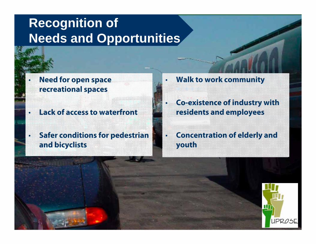
Recognition of Needs and Opportunities
• Need for open space recreational spaces
• Lack of access to waterfront
• Safer conditions for pedestrian and bicyclists
• Walk to work community
• Co-existence of industry with residents and employees
• Concentration of elderly and youth

• Space for:• Safe traveling• Walking• Playing • Talking and Sharing• Running• Cycling
• Opportunities for improved health
Community Visioning Results

Map of Community Vision

Timeline of Related Events1) 2005 – UPROSE begins facilitating
planning process for Greenway-Blueway
2) 2005 – Funding secured for park and master plan. Thanks to Rep. Nydia Velazquez!!!
3) 2006 - Brooklyn Greenway Initiative (BGI) begins advocating for the Brooklyn Waterfront Greenway (14 mile-waterfront path)
4) 2009- NYC Dept. of Transportation (DOT) hires a full-time project manager and consultant (RBA Group)
5) 2010-2011 DOT community workshops.

Implementation Plan Process1) Implementation Plan
Create a plan that guides Greenway development• Literature Review Report describing Gap Analysis
results• Site reconnaissance and field investigationsOutreach Meetings March 2010: Existing Conditions• Developed Preliminary Route AlternativesOutreach Meetings Summer/Fall 2010: Proposed Alternatives• Developed preferred routeOutreach Meetings 2011: Final Alternatives• Present Draft Implementation Plan• Develop Project Phasing/Implementation Plan
2) Preliminary DesignWork towards construction
• Engineering work
3) ImplementationContinue to implement throughout the process

Project Objectives:
•Physically separated path and walkway
•Proximity to the waterfront
•Connections to other facilities, both walking and cycling
•High-quality construction materials
•Design that is sensitive to the neighborhood context
•Design that is sensitive to both maintenance constraints and sustainable materials
Implementation Plan Process
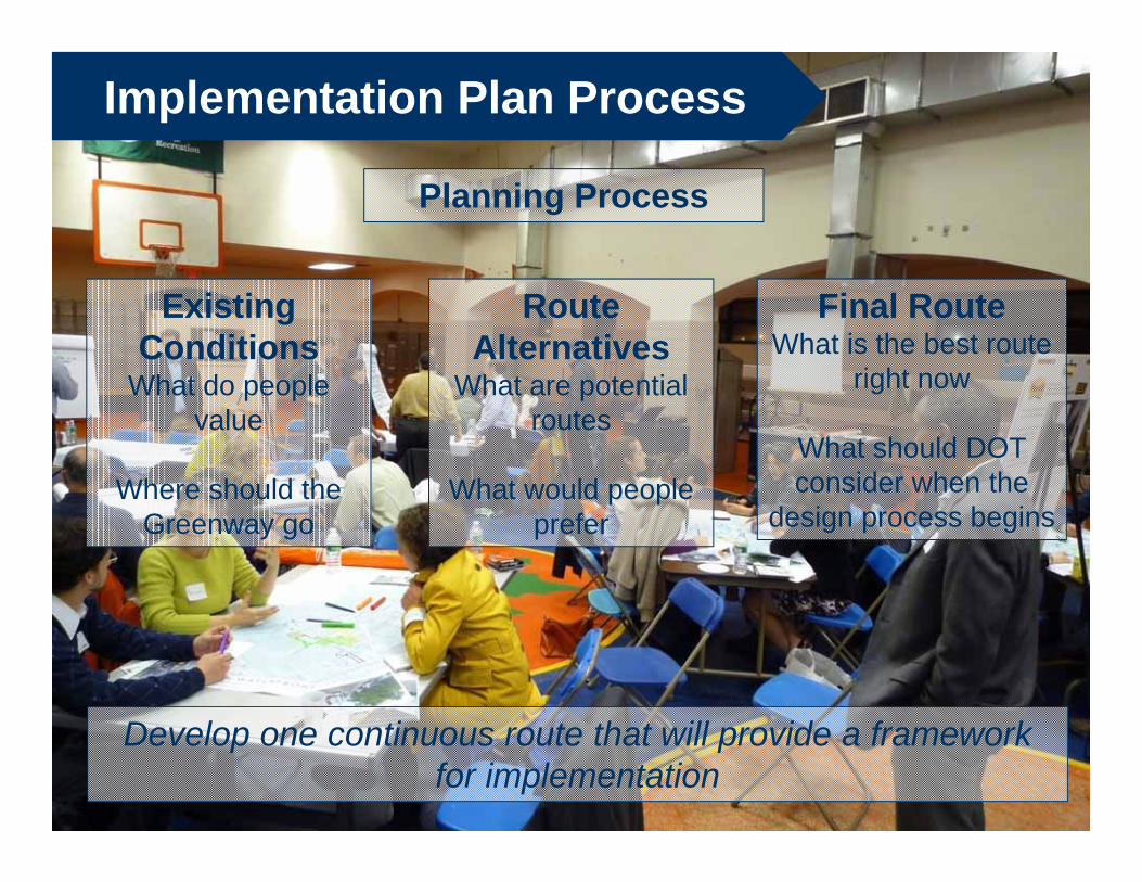
Implementation Plan Process
Existing Conditions
What do people value
Where should the Greenway go
Route Alternatives
What are potential routes
What would people prefer
Final RouteWhat is the best route
right now
What should DOT consider when the
design process begins
Develop one continuous route that will provide a framework for implementation
Planning Process

Implementation Plan Process
Develop Preferred RouteImplementation Plan will include
24 distinct capital projects
Initiate ProjectsWork with the Community,
Electeds and DDC to refine projects
and seek out money.
Implementation Process
Build!

Implementation Plan Process
The “preferred route” is the primary goal of this project•These capital projects are the focus of this plan •Projects are primarily along DOT Right of Way
“Future enhancement projects” are long-range goals.•These projects represent community desires, but ones that are out of the scope of the Implementation Plan•Not in DOT Right of Way

Implementation Plan ProgressGreenpoint/Williamsburg Route
Newtown Creek to Bushwick
Inlet
Bushwick Inlet to South

New Bridge – Future Enhancement
Potential New Connection to Queens Over Newtown Creek
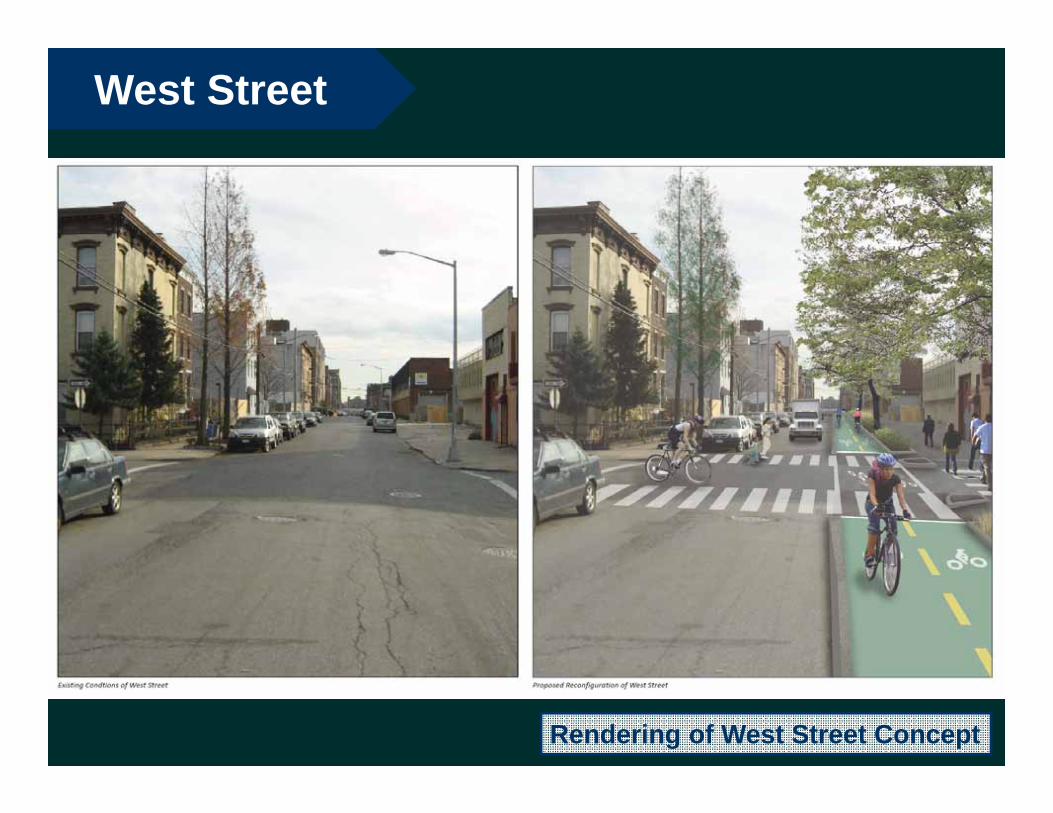
West Street
Rendering of West Street Concept

Bushwick Inlet Park

Kent Avenue

Implementation Plan Progress:Downtown Brooklyn Route

Flushing Avenue

Vinegar Hill
Washington Street Smooth, Bikeable Cobblestones

Brooklyn Bridge Park
Temporary Path at Montague Street

Implementation Plan Progress: Red Hook Route

Atlantic Avenue / Columbia Street

Van Brunt Street
11.5’4’4’ 10-15’11.5’8’6’ 3’
42’

Erie Basin Park / Ikea

Hamilton Avenue
to 39th Street
39th Street toOwl’s Head
Park
Implementation Plan Progress:Sunset Park Route

Hamilton Avenue

Bush Terminal Pier Park
Rendering of Future Park

Owl’s Head Park

SUNSET PARK WATERFRONT PREFERRED ROUTE
north
The Preferred Route consists of 6 Discrete Capital Projects
Also included are 2 Future Enhancement Projects

DISCRETE CAPITAL PROJECT:Gowanus Connector / Hamilton Avenue19
ROUTE CHOSENSmith Street to 29th Street along Hamilton Avenue & 3rd Avenue
WHY CHOSEN: Most Direct Route

Existing Conditions – Preferred RouteGowanus Connector / Hamilton Avenue19

Existing and Preferred Configurations Gowanus Connector / Hamilton Avenue
Existing
Proposed
19

Precedent (Tillary Street, Brooklyn)Gowanus Connector / Hamilton Avenue19
Precedent Photo: Tillary Street
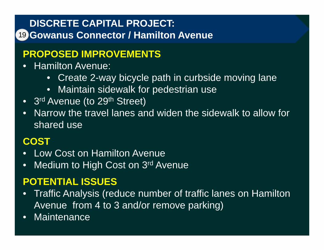
DISCRETE CAPITAL PROJECT:Gowanus Connector / Hamilton Avenue
PROPOSED IMPROVEMENTS • Hamilton Avenue:
• Create 2-way bicycle path in curbside moving lane• Maintain sidewalk for pedestrian use
• 3rd Avenue (to 29th Street)• Narrow the travel lanes and widen the sidewalk to allow for
shared use
COST• Low Cost on Hamilton Avenue• Medium to High Cost on 3rd Avenue
POTENTIAL ISSUES• Traffic Analysis (reduce number of traffic lanes on Hamilton
Avenue from 4 to 3 and/or remove parking)• Maintenance
19

Future Enhancement ProjectBike/Ped Bridge Over Gowanus Canal to Home Depot 19a
HomeDepot
WasteTransfer
AsphaltPlant

Future Enhancement ProjectBike/Ped Bridge Over Gowanus Canal to Home Depot 19a
Asphalt Plant WasteTransfer Home
Depot
Development Site
Operable Bridge

PRECEDENT:Small Moveable Bridges
Precedent Photo

DISCRETE CAPITAL PROJECT:Sunset Park North – 29th to 39th Streets20
ROUTE CHOSEN29th Street and 2nd Avenue
WHY CHOSENEarliest opportunity to go from 3rd to
2nd Avenue2nd Avenue has excess capacity and
no turn conflicts to the water

Existing Conditions – Preferred RouteSunset Park North – 29th Street20

Proposed Condition – Preferred RouteSunset Park North – 29th Street20
Precedent Photo: Sands St29th Street Concept Drawing
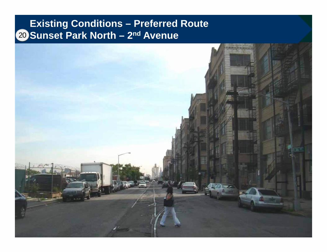
Existing Conditions – Preferred RouteSunset Park North – 2nd Avenue20

Existing and Proposed ConfigurationsSunset Park North
Existing
Proposed
20

Existing and Proposed ConfigurationsSunset Park North20

DISCRETE CAPITAL PROJECT:Sunset Park North – 29th Street to 39th Street
PROPOSED IMPROVEMENTS • 29th Street
• Create multi-use path separated from traffic by landscaped median
• 2nd Avenue Street• Fully reconstruct west sidewalk as a landscaped multi-
use path
COST• High Cost – full depth roadway reconstruction on 2nd Ave
including removal of cobble stones and railroad tracks, etc.
POTENTIAL ISSUES• Coordination with Federal Prison on 29th Street• Maintenance
20

DISCRETE CAPITAL PROJECT:Bush Terminal Piers Connector 43rd / 44th Street21
ROUTE CHOSEN2nd Avenue 43rd/44th Street – One Way Pair
WHY CHOSENSufficient space for dedicated bike
lanes on 2nd Avenue
43rd and 44th Streets offer first available east-west access from 2nd Avenue to proposed Bush Terminal Park entrance at 43rd Street and 1st Avenue

Existing Condition Photo:Bush Terminal Piers Connector 2nd Avenue @ 43rd Street21

Existing and Proposed ConfigurationsBush Terminal Piers Connector / 2nd Avenue Bike Lanes21
Existing
Proposed

Existing Condition PhotoBush Terminal Piers Connector – 43rd Street21
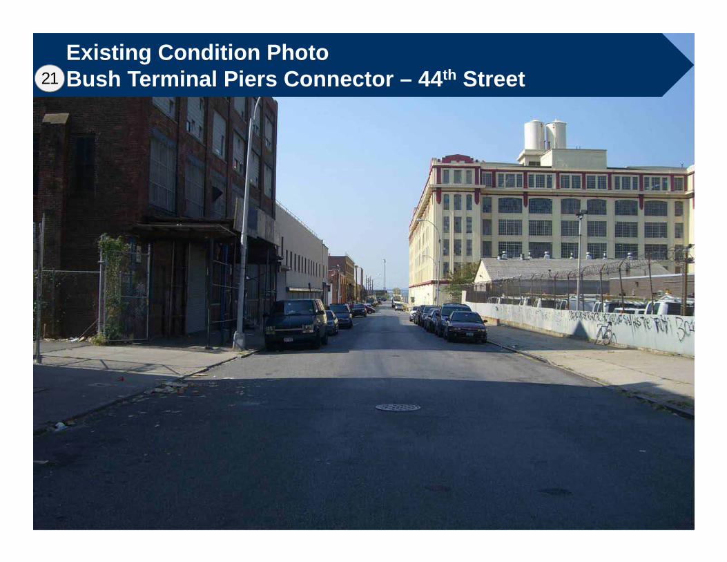
Existing Condition PhotoBush Terminal Piers Connector – 44th Street21

DISCRETE CAPITAL PROJECT:Bush Terminal Piers Connector 43rd / 44th Street21
PROPOSED IMPROVEMENTS • 2nd Avenue:
• Install dedicated bicycle lanes • Plant street trees
• 43rd Street and 44th Street• Install dedicated bicycle lanes and/or shared lane
markings• Install bike route signage
COST• Low Cost
POTENTIAL ISSUES• Not ideal greenway cycling experience – on-street route
shared with truck traffic
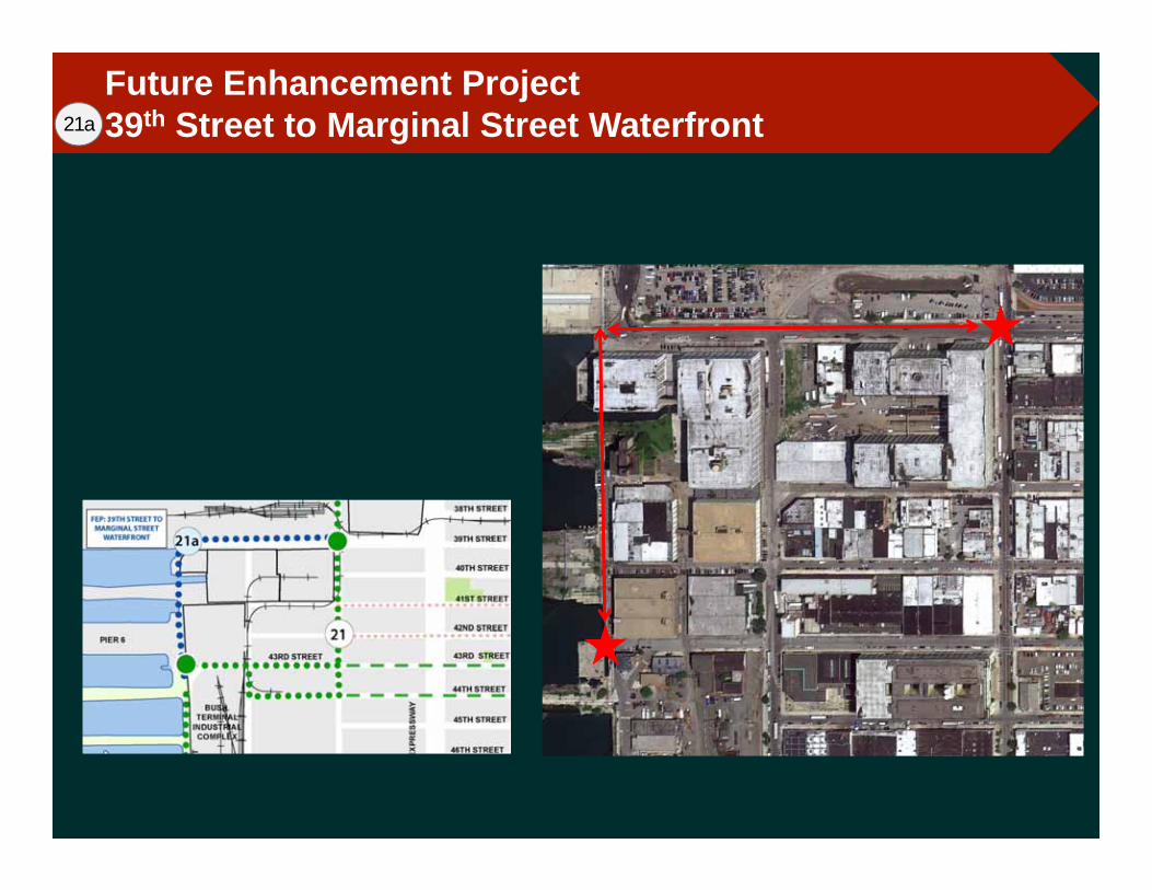
Future Enhancement Project39th Street to Marginal Street Waterfront21a

Future Enhancement Project39th Street to Marginal Street Waterfront21a
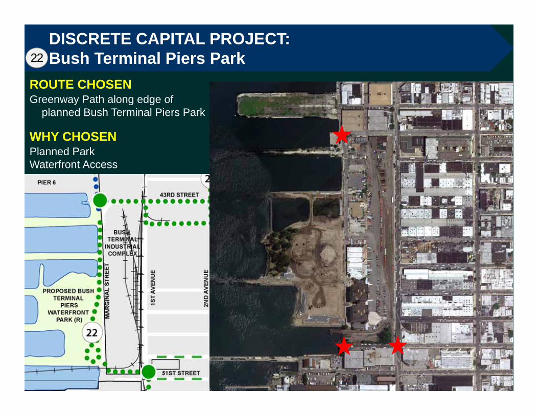
DISCRETE CAPITAL PROJECT:Bush Terminal Piers Park22
ROUTE CHOSENGreenway Path along edge of
planned Bush Terminal Piers Park
WHY CHOSENPlanned ParkWaterfront Access

DISCRETE CAPITAL PROJECT:Bush Terminal Piers Park22
Under DesignProposal contingent on public access to Marginal Street
Rendering of Future Park

DISCRETE CAPITAL PROJECT:Sunset Park South23
ROUTE CHOSEN1st Avenue 58th Street
WHY CHOSENProximity to Waterfront and 58th Street PierCalm Traffic Conditions

Existing Conditions on 58th Street, 1st to 2nd AvenueSunset Park South23
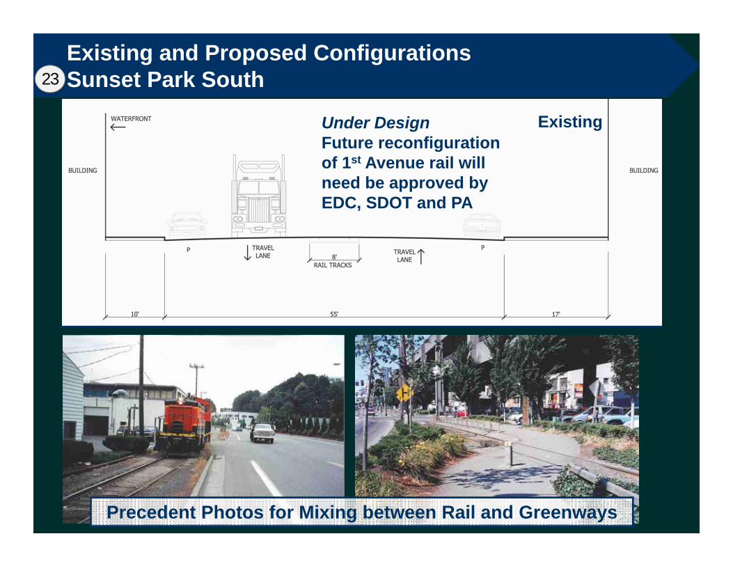
Existing and Proposed ConfigurationsSunset Park South23
ExistingUnder DesignFuture reconfiguration of 1st Avenue rail will need be approved by EDC, SDOT and PA
Precedent Photos for Mixing between Rail and Greenways

DISCRETE CAPITAL PROJECT:Sunset Park South – 1st Ave, 51st to 58th Streets & 58th St23
PROPOSED IMPROVEMENTS • 1st Avenue (51st Street to 58th Street)
• Widen west sidewalk to accommodate construction of landscaped two-way multi-use path
• 58th Street• Install dedicated bicycle lanes
COST• High Cost on 1st Avenue• Low Cost on 58th Street
POTENTIAL ISSUES• Coordination with rail operations on 1st Avenue• Design needs approval from EDC, SDOT, PA• Parking and loading loss; requires outreach to local
businesses

DISCRETE CAPITAL PROJECT:Owl’s Head Connector24
ROUTE CHOSEN2nd Avenue from 58th Street to
Wakeman Place Wakeman Place from 2nd Ave to
Owls Head Park
WHY CHOSENOnly available route

Existing Conditions – Preferred RouteOwl’s Head Connector – 2nd Avenue from 58th St to Wakeman Pl24

Existing and Proposed ConfigurationsOwl’s Head Connector – 2nd Avenue from 58th St to Wakeman Pl24

Existing Conditions – Preferred RouteOwl’s Head Connector – Wakeman Place24

Existing and Proposed ConfigurationsOwl’s Head Connector – Wakeman Place24
Existing
Proposed

DISCRETE CAPITAL PROJECT:Owl’s Head Connector24
PROPOSED IMPROVEMENTS • 2nd Avenue (58th Street to Wakeman Place)
• Convert west sidewalk into a landscaped two-way multi-use path, including two bridge crossings
• Wakeman Place• Narrow the roadbed and widen the north sidewalk to
create two-way multi-use path
COST• Medium to High Cost
POTENTIAL ISSUES• ‘Greenway’ construction on bridges on 2nd Avenue• Dangerous roadway intersections at either end of existing
Greenway path in/along edge of Owl’s Head Park

SUMMARY
6 DISCRETE CAPITAL PROJECTS• Gowanus Connector - Hamilton Ave, 3rd Ave• Sunset Park North – 29th St, 2nd Ave (to 39th St)• Bush Terminal Piers Connector – 2nd Ave, 39th St (to
43rd St), and 43rd/44th Sts• Bush Terminal Piers Park• Sunset Park South – 1st Ave (51st St to 58th St), 58th St• Owl’s Head Connector – 2nd Ave (South of 58th St),
Wakeman Pl
2 FUTURE ENHANCEMENT PROJECTS• Gowanus Bicycle and Pedestrian Bridge and 19th Street
Connector• 39th Street to Marginal Street Waterfront
Questions? ThankYou