the 1886 charleston earthquake - the lost colony … · the 1886 charleston earthquake ... and that...
TRANSCRIPT
Fred Willard 1
The 1886 Charleston EarthquakeBy Fred L. Willard
The Charleston Earthquake of 1886 was the largest quake to hit the
southeastern United States in recorded history. It struck at 9:50 PM on Au-
gust 31, 1886, and caused severe damage to Charleston, South Carolina. The
quake was felt along the whole East Coast and major structural damage of
buildings was reported as far north as southern Virginia, and West Virginia.
The tremors were felt as far away as Tybee Island, Georgia, Cuba, Boston, Chi-
cago, Bermuda and New Orleans. The story got worldwide attention, and even
Queen Victoria herself expressed condolences (Talwani power point).
It was the largest tectonic event ever recorded in the southeastern United
States. Even though there are few faults in the region, the shaking seen in the
1886 quake would seem to confirm the potential for repetitions of the sinking
of land areas far away from the epicenter, whether from liquefaction or sand
settling. Because the probability of flooding of land is sporadic, seismic activity
can still be expected to create a continuing threat to the coastal areas along the
Atlantic Seaboard (Wikipedia).
The earthquake was estimated to be between 6.6 and 7.3 on the Richter
scale. Sand blows (geysers) were experienced throughout the affected area due
to liquefaction of the soil. This quake is still being investigated over 130 years
after the fact, because it occurred in an unusual location, and because there
were no previous records of such events occurring in this area, possibly due to
low population densities and poor communication. Similar faults appear all

Fred Willard 2
along the East Coast and were derived from the North American plate move-
ments caused from the breakup of Pangea and plate separation that has been
documented as millions and millions of years old (dnr.sc.gov).
For hundreds of millions of years, the forces of continental drift have re-
shaped the Earth. Continental drift is based on the idea that continents bump
into and slide over each other, and at some later time break apart. Today,
most people accept the theory Earth’s crust is broken into approximately
twelve enormous plates which float on hotter, softer rocks in the underlying
mantle. Heat from the Earth drives convection currents in the mantle, which
like sailing, moves the plates past each other very slowly; mere inches annual-
ly, carrying the continents and ocean basins with them as they drift about.
The majority of earthquakes worldwide occur at plate boundaries, when
plates stick and then jump past each other. These are known as transform
plate quakes (library.thinkquest.org). Charleston’s 1886 earthquake is a hea-
vily-studied example of an intraplate earthquake. An intraplate earthquake is
a quake that occurs within a plate, as opposed to a plate boundary (dpc.ucar).
It is believed such ancient faults remain active via forces exerted on them by
present-day motions of the North American plate. The exact mechanisms of
intraplate quakes are a subject of much ongoing research; over a thirty-five
year period, more than three hundred aftershocks from this event alone have
been recorded, and seismic activity today may still be part of the Charleston
1886 quake aftershocks, nearly a century and a half later (Wikipedia).
A first-hand account reported forty years after it happened still made

Fred Willard 3
headline news, even while during the horrific 1906 San Francisco Quake.
Lessons Learned from the Charleston QuakeFrom an article written by Paul Pickny published in the San Francisco Chronicle, of May 6,
1906.
“The day had been exceedingly hot and about 9:50 the first vibrations
were felt. The shockwaves violently accelerated and the buildings were thrown
like toy dollhouses. Frantic with terror, the people tried to run to the streets,
causing many of them to be crushed by the falling debris of chimneys and col-
lapsing stone and brick walls. One thunderous jolt did most of the damage,
and it was accompanied by an absolutely terrifying ‘Low, rumbling noise, un-
like anything ever heard before, which lasted about one minute’. Aftershocks
rolled through the city all night, and with each one the unknown of what was
going to happen stretched the nerves to a breaking point, causing many people
to go mad and lose their reason.
“The morning light gave a view that was never to be forgotten. There was
not a building in the entire city that escaped damage; most of them were just a
pile of rubble. Death and destruction were everywhere and by my own account
totaled 96 dead. To the distraught of the populace, stories were racing around
the countryside and through the city that a giant tidal ocean wave obliterated
the entire east coast, and that Florida had snapped off the continent and had
been washed away into the sea.
“Word arrived the next day that only minor damages were felt by most of
the Eastern Seaboard and that Charleston was hit the worst. Many after-
shocks wrenched thoughts back to that eventful and horrifying night, but ele-
Fred Willard 4
ven years later almost no sign of the event could be seen, and Charleston was
host to the magnificent South Carolina Interstate and West Indian Exposition.”
Dutton’s maps of the 1886 Charleston Earthquake show attenuated iso-
seismics with surface-wave magnitudes of up to 3.3 in coastal North Carolina
compared with the epicenter values of up to 7.7 near Charleston, South Caroli-
na. The southern area of this event presents a complex group of strike-slip
fault zones. The large size of the 1886-89 aftershock zone area gives support
for a consideration that the causative fault for the Charleston earthquake of
1886 is a shallow-dipping detachment (Wikipedia).
Two epicenters were reported by Dutton during the quake: one occurred
at Woodstock, a railroad stop on the Southern Railway leading into Charleston,
located twenty-one miles northwest of Charleston. The other was located at
Ravenel, a small town twenty-three miles southwest of Charleston. The vibra-
tions of the quake were felt over a total area of 2.5 million square miles, from
Cuba to New York, and Bermuda to the Mississippi River (archiver.rootsweb.
ancestry). Dutton’s maps can be found on the next two pages.
Dutton Map I
Fred Willard 5
Dutton Map II

Fred Willard 6
Many first-hand accounts of this earthquake have been found in news- papers and reports
that were accumulated many years after the event took place. Many of the reports were
summarized in Dutton’s report (1889), and Robinson and Talwani (1983). There were six
incidents of liquefaction found in the city on the peninsula, and maps of their occurrence were
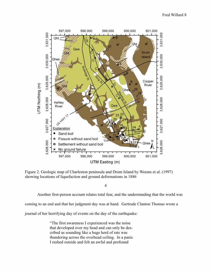
produced by Weems et al (1997) and can be found below.
Other materials were found of Dutton’s calculations, and in summary

Fred Willard 7
there seems to have been a total of twenty-seven cases of liquefaction and per-
manent ground deformation in the entire city of Charleston, and the cases are
grouped as: 1- land where sand and water was ejected., 2-locations of ground
displacement and 3- Locations that experienced settlement but did eject sand
or water. (See map below). The liquefaction ranges from small to large “sand
boils” and in addition to large amounts of soil filling cellarers. Interesting
accounts are also reported of large amounts of materials and water being
ejected from wells, and reported to have gone as high as twenty feet in the air.
Another interesting account was reported by the News & Courier of Charleston
on September 7, 1886 indicating that many people reported that their cellars
had unaccountably filled with water in most cases where this had never
happened before (http://earthquake.usgs.gov/research/external/reports/
06HQGR0058.pdf).
USGS Award Number 06HQGR0058
LIQUEFACTION MAP OF CHARLESTON, SOUTHCAROLINA BASED ON THE 1886 EARTHQUAKE
Final Report to the United States Geological Survey
By: Hossein Hayati and Ronald D. Andrus. Department of Civil EngineeringClemson University, Lowry Hall, Box 340911Clemson, South Carolina 29634-0911 USA
Fred Willard 8
Figure 2. Geologic map of Charleston peninsula and Drum Island by Weems et al. (1997)showing locations of liquefaction and ground deformations in 1886
4
Another first-person account relates total fear, and the understanding that the world was
coming to an end and that her judgment day was at hand. Gertrude Clanton Thomas wrote a
journal of her horrifying day of events on the day of the earthquake:
“The first awareness I experienced was the noise that developed over my head and can only be des-cribed as sounding like a huge herd of rats was thundering across the overhead ceiling. In a panic I rushed outside and felt an awful and profound
Fred Willard 9
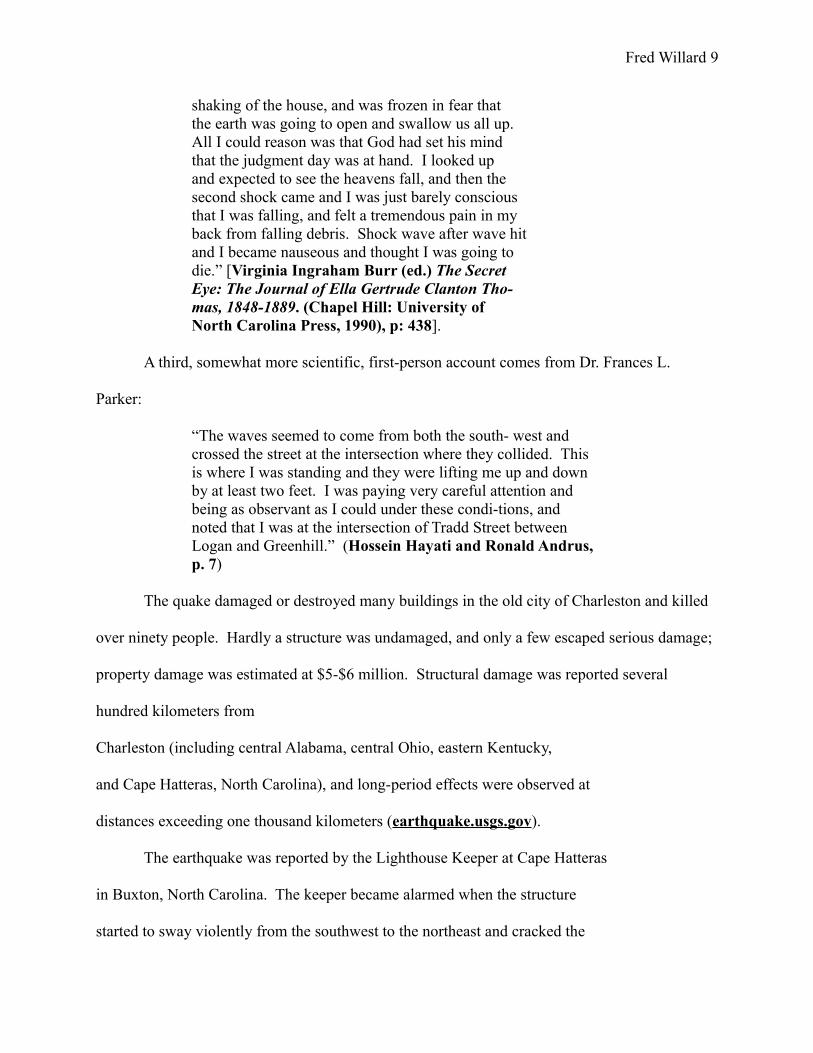
shaking of the house, and was frozen in fear that the earth was going to open and swallow us all up. All I could reason was that God had set his mind that the judgment day was at hand. I looked up and expected to see the heavens fall, and then the second shock came and I was just barely conscious that I was falling, and felt a tremendous pain in my back from falling debris. Shock wave after wave hit and I became nauseous and thought I was going to die.” [Virginia Ingraham Burr (ed.) The Secret Eye: The Journal of Ella Gertrude Clanton Tho-mas, 1848-1889. (Chapel Hill: University of North Carolina Press, 1990), p: 438].
A third, somewhat more scientific, first-person account comes from Dr. Frances L.
Parker:
“The waves seemed to come from both the south- west and crossed the street at the intersection where they collided. This is where I was standing and they were lifting me up and down by at least two feet. I was paying very careful attention and being as observant as I could under these condi-tions, and noted that I was at the intersection of Tradd Street between Logan and Greenhill.” (Hossein Hayati and Ronald Andrus, p. 7)
The quake damaged or destroyed many buildings in the old city of Charleston and killed
over ninety people. Hardly a structure was undamaged, and only a few escaped serious damage;
property damage was estimated at $5-$6 million. Structural damage was reported several
hundred kilometers from
Charleston (including central Alabama, central Ohio, eastern Kentucky,
and Cape Hatteras, North Carolina), and long-period effects were observed at
distances exceeding one thousand kilometers (earthquake.usgs.gov).
The earthquake was reported by the Lighthouse Keeper at Cape Hatteras
in Buxton, North Carolina. The keeper became alarmed when the structure
started to sway violently from the southwest to the northeast and cracked the
Fred Willard 10
glass in all windows of the structure. He gave the alarm and all members of
the crew evacuated the premises (Wikipedia). More interesting is the account
given by the local Native American Indians from the village of Whapopin (sic),
which is twenty-six miles due west of the lighthouse. This village was located
approximately five miles north of what is today Engelhard, North Carolina, and
was part of the original Mattamuskeet Indian Reservation (Barbara Midgette).
The Whapopin village consisted of about thirty homes and small farm
plots that were planted with corn at the time. The villagers retired the night of
August 31st with no hint of what was about to happen only an hour later. Sha-
king and vibrations alarmed the villagers as they abandoned their homes and
fled for higher ground. The morning light brought them back to their homes
and farms of fifty years (this community was settled in 1836), and to their utter
dismay, they found their houses and cornfields flooded with twenty-four inches
of water that never receded. The entire town, families and homes, were eventu-
ally transplanted to Engelhard where the descendents still live today. Lique-
faction submerged their village and the only reminder of Whapopin today is a
place on the map listed as Whapopin Creek, and a place called “Old Matta-
muskeet” (unpublished paper by Barbara Midgette (addenda), and Wiki-
pedia).
The Charleston 1886 earthquake was recorded here in North Carolina
but few historical records exist. It did affect the coastal area but, as outlined
above, communications to the outside world were not yet well-established.
There was no road network to the coastal area and wire service, although avai-
Fred Willard 11
lable to some areas, was not yet located in the lower Pamlico Counties of Hyde
and Dare. It was reported on the Outer Banks, but a few areas along the Croa-
tan Sound experienced life-changing events from this large quake that have not
been well documented (Wikipedia).
Even though there are few faults in the coastal North Carolina region, li-
quefaction or sand settling may occur from future events. Because of the pro-
bability of flooding of land as a result, as that which occurred to Whapopin,
sporadic seismic activity can be expected to create a continuing threat to the
integrity of the coastal areas along the Atlantic Seaboard, so this 1886 seismic
disturbance is of great interest and needs further study. South Carolinians
need to realize that South Carolina faces the possibility of a strong quake oc-
curing having its epicenter within our borders, at a predicted 500-year cycle.
We also need to realize that a major earthquake anywhere in the Eastern Uni-
ted States can have adverse effects on us, causing potentially irreversible dam-
age (dnr.sc.gov).
Citations/Reference Sources
1886 Charleston Earthquake. [http://enwikipedia.org/wiki/Charleston_earth-quake] Reviewed last: Fall of 2008
1886 South Carolina Earthquake Isoseismal Map. [http://www.eas.slu.edu/ Earthquake_Center/1886EQ/sc37.html] Reviewed last: Fall of 2008
1886 South Carolina Earthquake Damage Archival Photographs. [http://www. eas.slu.edu/Earthquake_Center/1886EQ/wjmjpgs/wjm_h5, 7, 10 & 13.html] (see Addenda)
Definition of Intraplate earthquake. [www.dpc.ucar.edu/VoyagerJr/glossary.

Fred Willard 12
html]. Reviewed last: Fall of 2008
Dutton: Isoseismals of the Charleston earthquake. Map. 1889
Earthquake Hazards, Earthquakes in South Carolina: Charleston earthquake of 1886. [http://www.dnr.sc.gov/geology/earthquake.htm] Reviewed last: Fall of 2008
Earthquake Hazards Program, Historic Earthquakes: Charleston, South Caroli-na. [http://earthquake.usgs.gov/regional/states/events/1886_09_01. php]. Reviewed last: Fall of 2008
FORT-L Archives: 1886 Charleston Earthquake. [http://archiver.rootsweb.an-cestry.com/th/read/FORT/2003-06/1056620204] Reviewed last: Fall of 2008
Midgette, Barbara. Unpublished paper Re 1886 Earthquake in possession of the author (see addenda)
Pickny, Paul. Lessons Learned from the Charleston Quake. San Francisco Chronicle. May 6, 1906.
Talwani, Pradeep. The Charleston Earthquake: Then and Now. Powerpoint Presentation. Dept. Geological Sciences, University of South Carolina. Reviewed last: Fall of 2008
Types of earthquakes. [http://library.thinkquest.org/03oct/01424/types_of_ earthquakes.htm]. Reviewed last: Fall of 2008
Addenda
Fissures, Mudslides, Damages, and Liquefaction Caused by the 1886 Quake

Fred Willard 13
"Thrown house, Summerville." (South Caroliniana Library Archives)
http://www.eas.slu.edu/Earthquake_Center/1886EQ/wjmjpgs/wjm_h10.html

Fred Willard 14
"Craterlet, Ten Mile Hill." (South Caroliniana Library Archives)
http://www.eas.slu.edu/Earthquake_Center/1886EQ/wjmjpgs/wjm_h5html
Fred Willard 15
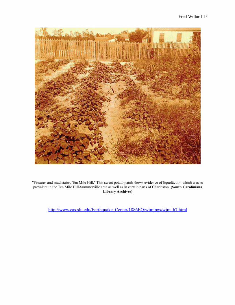
"Fissures and mud stains, Ten Mile Hill." This sweet potato patch shows evidence of liquefaction which was so prevalent in the Ten Mile Hill-Summerville area as well as in certain parts of Charleston. (South Caroliniana
Library Archives)
http://www.eas.slu.edu/Earthquake_Center/1886EQ/wjmjpgs/wjm_h7.html
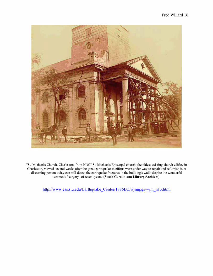
Fred Willard 16
"St. Michael's Church, Charleston, from N.W." St. Michael's Episcopal church, the oldest existing church edifice in Charleston, viewed several weeks after the great earthquake as efforts were under way to repair and refurbish it. A
discerning person today can still detect the earthquake fractures in the building's walls despite the wonderful cosmetic "surgery" of recent years. (South Caroliniana Library Archives)
http://www.eas.slu.edu/Earthquake_Center/1886EQ/wjmjpgs/wjm_h13.html