tering the tchee for land - welcome to the...
TRANSCRIPT

132
Miles
01.0
1.02.0
Daughtry’sC
reek
12 Mile C
reek
Thom
pson’s Cutoff
Lee’sLanding
Dem
i-JohnH
amm
ock
Frank
Huff’s
Pasture
BeautifulIsland
Trout Cr.
Quaker
Landing
Olga
ParkinsonF
erry
Devil’s E
lbow
Capt. C
utler
Marion H
endry
Hollingsw
orth
Sw
imm
ingP
en
H. S
tephens
Hollingsw
orth Ferry
J.M.
Stephens A
lex Longope
Hickory
Creek
Dr. Jas.
Kellum
G.
Thorp
Wm
. Loper
BeautifulIsland
Bayshore
Thom
pson’sC
utoff
OrangeR
iver
Tice
Trout Creek
Devil’s E
lbow
Olga
FranklinLock
Hickory
Creek
Daughtry’sC
reek
Note: T
he main river channel on the historic m
ap is colored blue to increase visibility. T
he same
historic channel has been interpreted in red over a m
odern (1995) aerial photograph mosaic, w
hich is positionally accurate, w
ith reference to the 1887 C
orps of Engineers m
ap for details.
ALTERING THECALOOSAHATCHEEFOR LANDAND WATERDEVELOPMENT
The Caloosahatchee [Caloosa = indigenous NativeAmericans who inhabited Southwest Florida, Hatchee =Seminole for ‘river’] is a microcosm of Southwest Florida’swaterways, in which multiple interests — striving to de-velop waterfront real estate, to create new land from for-merly overflowed swamplands, and to increase and im-prove the navigable waterways — have propelled devel-opment in many profound ways.The river between LakeOkeechobee (on the east) and Beautiful Island (on thewest) has been selected to illustrate the effects, both la-tent and direct, of land drainage and waterway construc-tion policies on waterfront and waterway uses.
Pre–developmentGeography
It is hard to recognize from today’s Okeechobee Wa-terway — with its abruptly cut banks and straight-lined,flood-controlled, navigation-optimized, dredged chan-nel — the once meandering, shifting, rope-bending, snag-laden course of the Caloosahatchee. Today, theCaloosahatchee is the western portion of the OkeechobeeWaterway, which stretches from Stuart, on the AtlanticOcean, to San Carlos Bay and the Gulf of Mexico.The route crosses the state via the St. Lucie River andCanal, Lake Okeechobee, and the Caloosahatchee (seeMap 1 in the Dredging History chapter). Map 1 inthe present chapter shows the antecedent river coursesuperimposed on the present waterway.

133
Cane M
ill
John E
nglish
Alva
Cypress C
reek
Sugar
Mills
J.B. M
cKinley
Eliza
Anders
Jos. A
nders Cane
Hendley’s
Landing
Perkins
Dr.
Anders
Jas. Banks
Wm
. Perkins
Mrs.
Solom
on
Fort
Sim
mons
Branch
Apiary
Robt.
LittleF
ort Denand
Jack’s Branch
Louis M
urray
Dun’s
Run
Dyer’s
Bee
Branch
Pollyw
og B
ranch
Hendry’s
Pasture
Bow
man
Cypress C
reek
Ow
anita
Alva
Fort
Sim
monds
Denaud
Jack’sB
ranch
Bee
Branch
Pollyw
og B
ranch
Map 1 (part 1).Caloosahatchee Channel, 1887 and 1995.
Note: The main river channel on the historicmap is colored blue to increase visibility.The same historic channel has beeninterpreted in red over a modern (1995)aerial photograph mosaic, which ispositionally accurate, with reference to the1887 Army Engineers map for details.

134
Miles
01.0
1.02.0
Patrick’s
Landing
Stew
ardsF
ort Thom
pson,C
apt. F. A. H
endry
Louis Murray
Lake Flirt
Deaum
an’s B
ranch
Coffee M
ill H
amm
ock
La Belle
Coffee M
ill H
amm
ock
Ortona
LockLong
Ham
mock
Creek

135
Sugar B
erry H
amm
ock
Lake Hikpochee
Lake O
keechobee
Lake Hicpochee
Moore
Haven
Lock
Lake O
keechobee
Map 1 (part 2).Caloosahatchee Channel, 1887 and 1995.

136
Land Use/Land C
over
Urban &
Built—
Up
Agriculture
Shrub, B
rushland, Rangeland
Upland F
orestW
aterW
etlandsM
angroveB
arren Land
Olga
Denaud
FranklinLock
Alva
Source: S
outhwest F
loridaW
ater Managem
ent District (1995)
Before human intervention, the Caloosahatchee origi-nated in a geologic basin known as Lake Flirt, located atFt. Thompson, approximately 2 miles east of La Belle.The formation was perched 4–10 feet (varying with sea-sonal water levels ) above the western Caloosahatchee val-ley, creating 0.9-mile-long rapids that fed theCaloosahatchee. To the east, ephemeral marshes season-ally connected a series of lakes. In the wet season (May–October), high water would spill out of the shallow bound-ary of Lake Okeechobee and sheet flow through theephemeral marshes and swamp forest to collect in severalsmaller lakes–Hicpochee (9,000 acres), Bonnet (500 acres)and Flirt (1,000 acres)–before spilling over the rapids andflowing into the Caloosahatchee and to the Gulf ofMexico. The Ft. Thompson Rapids set the head of navi-gation. The lower portion of Map 2, from the Black sur-vey of 1887, shows land use and land cover before majordevelopment occurred.
During the dry season (November–April), the regionof marshes surrounding Lake Hicpochee and the river-bed from that lake to the foot of Ft. Thompson Rapidswould dry up so much that a horse could be ridden in thechannel. Normal high water would raise the water leveldownstream by 2 feet at Ft. Thompson, 3 feet at Ft.Denaud (La Belle) and Alva, 2 feet at Olga and 1 foot atFt. Myers. Freshets caused by continuous heavy precipi-tation increased the water level to historic heights abovemean water of as much as 12 feet at Ft. Thompson, 17feet at Ft. Denaud, 14 feet at La Belle, 13 feet at Alva,and 6 feet at Ft. Myers.

137
Miles
02.5
2.55.0
La Belle
Ortona
Lock
Moore
Haven
LakeH
icpochee
LakeO
keechobee
Source: U
.S. A
rmy C
orps of Engineers,
Capt. W
.M. B
lack (1887)
Map 2.Land use/land cover along the Caloosahatchee, 1887 and 1995.

138
Figure 1. Four-point rope bend.
Figure 2. Water wheel irrigation.
These extreme, cyclical variations in stream flow con-tributed to the Caloosahatchee’s meandering course. Therewere 102 river-bends in the 64-mile stretch from Beauti-ful Island to Lake Okeechobee in the pre–developmentperiod (Table 1). Navigating the river was especially diffi-cult at the low-water stage. Some of the sharper mean-ders required the larger vessels to “warp-around,” thatis, to run their bow up on shore, attach a spring lineto trees, back down to a second point, swing aroundand go ahead at the next point, and so on until thebends were passed (Figure 1).
Torrential rains during the wet season dramatically in-creased the volume of discharge and sediment load, lead-ing to channel scouring and flooding of adjacent low-lands. During this period, coarser-textured sediments weredeposited both as point-bars on the inside of the mean-ders and along the banks of the natural levees. Channeldeepening occurred on the outer bends, and fresh, fine-textured alluvium was deposited on the adjoining flood-plain. At these high water stages, the meanderingCaloosahatchee in places cut across the necks of the me-ander spurs, shortened its course, and created abandonedmeanders or oxbows.
Land and waterway developments were slow to occurduring the 19th century. The Seminole Wars and the CivilWar were major deterrents to settlement expansion. Ex-tensive cattle grazing was a common land use. Small settle-ments did evolve along the river, usually occupying formermilitary outposts. Ft. Thompson was an important up-river location because of the ford where cattle drivescrossed the rapids en route to the shipping pier at PuntaRassa. The land cover along much of the river’s coursesouth of Ft. Thompson was in upland forest, scrub, grass-land, and some homesteads with small agricultural farms(Map 2). The lower portion of Map 1 highlights thenames of some of the homesteaders. Rudimentarywaterwheel-type irrigation systems permitted farmingduring the dry season (Figure 2).
aglO/dnalsIlufituaeB avlA/aglO elleBaL/avlAerooM/elleBaL
nevaHlatoT
seliM sdneB-reviR seliM sdneB-reviR seliM sdneB-reviR seliM sdneB-reviR seliM sdneB-reviR
reviRtnempoleved–erP 5.9 5 7.8 91 0.91 85 7.62 02 9.36 201
yawretaWeebohceekO 7.7 3 0.7 2 0.41 01 0.72 11 7.55 62
ecnereffiD 7.1- 2- 7.1- 71- 0.2- 84- 3.0+ 9- 2.8- 67-
Table 1.
Distance and number of river bends between pre–development and contemporary conditions along theCaloosahatchee/Okeechobee waterway.

139
Figure 3. SS City of Athens, 1910.
The winter freezes of 1892 and 1899 prompted NorthFlorida citrus growers to reestablish their groves south ofthe freeze line and in the Caloosahatchee Valley. Citrusproduction increased rapidly in subsequent years and thetransport of fruits and shipment of supplies became de-pendent on riverboat transport (Figure 3). Large catchesof fish were brought down the river from LakeOkeechobee, although the business did not become ex-tensive until after the railroad entered Ft. Myers, in 1904.
The 1880-90s was a period wherein the upper rivervalley represented the backbone of potential growth thatresided in its agricultural resources, but communities theredepended on the lower river course for transport and com-munication with service centers downstream. The key tosustainable regional growth rested on creating a schemeto manage the floods, which drove the early settlers fromtheir homes, damaged farmlands, and discouraged agri-cultural development.

140
The development history of the Caloosahatchee is arecord of competing and conflicting interests, some want-ing to control flooding by upland drainage and othersstriving to build an inland waterway for pleasure boatingand commercial use.
The record of government intervention by the Stateof Florida and federal agencies had its origins in the 1880s,with attempts to drain the overflowed lands adjoiningLake Okeechobee and to reduce and maintain water lev-
els in the river. By 1887, the Atlantic and Gulf CoastCanal and Okeechobee Land Company of HamiltonDisston had opened a channel, with a minimum cross-section of 22 feet by 5 feet, from Lake Okeechobee to theheadwaters of the Caloosahatchee at the western end ofLake Flirt. The Disston dredges were brought up-riverfrom Ft. Myers. Four of the most severe river bends westof Ft. Thompson were straightened in order to move thedredges upstream. The 4-mile stretch of rock-floored out-crops, including the Ft. Thompson Rapids west of LakeFlirt, was dynamited in order to deepen the channel. Aprovisional dam was built everyfew miles to the rear of thedredge to obtain sufficient wa-ter to float the equipment (Fig-ure 4). Disston’s work was notintended to benefit navigation.Indeed, since the contract withthe state included the drainageof the Caloosahatchee Valleyand confining the river to itsbanks, the dredged channel wasto have been closed and a leveeextended north–south just westof Lake Hicpochee. Nearly 2miles of this levee was con-structed when the companyceased operations and the chan-nel was never closed.
The net incidental result of Disston’s dredging opera-tion was to open up a water route for steamers some 300miles long from the Gulf of Mexico to the interior ofFlorida via the Caloosahatchee and Lake Okeechobee toKissimmee (Figure 5). But the dredged channel betweenFt. Thompson and Lake Okeechobee was not maintainedand shoals quickly appeared; boats drawing a mere 4 to 6inches grounded repeatedly in Bonnet Lake and Lake Flirt.More significantly, during the wet season, floodwatersfrom Lake Okeechobee rushed unrestricted down thechannel and caused severe flooding of the farms and cit-rus groves in the lower valley.
The dilemma facing the Caloosahatchee Valley at thattime, much as it is today, was to devise a scheme thatwould coordinate land drainage with river navigation.Residents in 1913, for example, believed that floodwa-ters could be mitigated by straightening the river’s courseand navigation could be improved by deepening the chan-nel, though attempts to straighten the river above Alvawould probably require building levees well back fromthe river banks which would deprive a greater part of thecitrus groves along the river from protection. The heatedbattle between land drainage and river navigation some-times raged beyond the rule of law. Makeshift dams builtby private interests across the canal between LakeHicpochee and Bonnet Lake were blown up by unknownparties. In 1902, the state approved an application to closethe canal but held Lee County responsible for all dam-ages. The Army Engineers, at that time, agreed with lo-cal and state government that navigation interests wereinsufficient to warrant federal waterway improvements.
By 1913, however, drainage operations by the stateelsewhere in central Florida had lowered the water levelin Lake Okeechobee so much that navigation in the up-per Caloosahatchee was seriously impaired and settlementswere being abandoned. In 1914, the river at its junctionwith the lake dried out and at La Belle there was only 1.5feet of water, not enough to allow the passage of com-mercial river traffic. The State of Florida dredged a 5-foot-deep by 40-foot-wide channel from Lake Okeechobeeto La Belle. The seesawing of natural events–flooding ofriver lowlands followed by shoaling of navigation chan-
Figure 5. Tow steamer Corona.
Land Reclamation orRiver Navigation?
Figure 4. River dredge.

141
nels–fostered ambivalent public policies and created alaissez-faire attitude which resulted in little prescriptiveaction or long-term planning.
Disastrous floods in 1922, 1923, 1926, and 1928caused the loss of many lives and considerable propertydamage in the Lake Okeechobee region. The federal gov-ernment authorized the Army Engineers in 1927 to sur-vey the Caloosahatchee drainage area and work with thestate’s Flood Control District (now the South FloridaWater Management District) to improve both flood pro-tection and navigation. This decision led to constructionof the Hoover Dike around Lake Okeechobee as well asthe dredging and channel straightening of theCaloosahatchee. The 1930s was a period of river dredg-ing and construction of drainage canals, navigation locksat Moore Haven and Ortona and pumping stations toremove excess water from adjoining river bottomlands.
As a result of this work, the Caloosahatchee upstreamfrom Beautiful Island was forever changed from the pic-turesque, meandering river which existed prior to 1881.It took on a new form, that of vertical-banked and straight-lined, flood-controlled, navigation-designed, dredgedchannel. It was also transformed into the federally autho-rized, Army Engineers-maintained Okeechobee Water-way (C-43 Canal), an intrinsic western component of theCross-State Ship Channel that links the Gulf of Mexicoto the Atlantic Ocean.
The Okeechobee Waterway was again modified in themid-1950s. The channel was enlarged to an 8-foot depthand 250-foot width. Bridge crossings were modernized.An additional lock and dam structure was built in 1962at Olga to assure a freshwater supply for Lee County andto prevent saltwater intrusion upstream.
In 1969, the structure was re-dedicated as the W.P.Franklin Lock in honor of Walter Prospect Franklin, alocal entrepreneur and concerned member of theOkeechobee Waterway Association. This lock artificiallysets the eastern limit of the Gulf ’s tidal influence for the
estuary, which historically extended to Ft. Denaud. Thewaterway was dredged again in the 1960s, but followingpassage of the Clean Water Act in 1972, the Army Engi-neers has restricted its functions to operation and annualmaintenance of the locks at Moore Haven, Ortona, andFranklin.
The Caloosahatchee today is still in serious need ofmanagement and maintenance. It faces many of the samevaried challenges of its past development and use, includ-ing competing demands for water by municipalities, agri-culture, commercial and recreational boating activities, andthe functional requirements of the natural aquatic system.In times of flooding, the Caloosahatchee is used as a con-duit for discharge with little regard for the downstreamimpacts of water quality and water volumes. In times ofdrought, water releases from Lake Okeechobee often donot maintain minimum flows necessary to support thecritical productive functions of natural systems nor do theyretain necessary water depths in the federal navigationchannel of Lake Okeechobee.
Resource managers with the South Florida Water Man-agement District view and treat this waterway as a drain-age and storage component of Lake Okeechobee and themulti-billion-dollar Comprehensive Everglades Restora-tion Project. Their concerns and program objectives areregional in scope and focus predominantly on water man-agement functions, primarily flood control and water sup-ply. Stakeholders and organizations concerned about thecondition of the waterway have recently called for federalassistance from the Army Engineers to address its naviga-tion and water-based eco-tourism needs by promotingcoordinated management and sustainable use.
Does history repeat itself? Can we learn from past mis-takes? Is there hope that both objectives–flood control andnavigation–can be realized in the 21st century to providefor sustainable management that protects the resourcesand allows for use by all citizens who live, work and recre-ate along this waterway?
1966 -
The Necessity to
Understand
the Sea
“But the influence of
the sea on man’s daily
life and on his future
well-being is so great
and still so poorly
comprehended that the
sea must be explored,
studied, and
understood so that it
can be taken into
account more
intelligently whenever
man is faced with any
problem relating to his
physical environment.”
—H. B. Stewart,“In Deep
Challenge,”1966.
—Published by Van
Nostrand,
NJ. p. 17.

142
Contemporary Geography
The scenic Caloosahatchee, the historic waterway thatfostered settlement of interior Southwest Florida, func-tions today as a thoroughfare for transiting recreationalboat traffic and a conduit for excess stormwater flows.Where once the river meandered, it is now a series ofstraight legs interrupted by 26 gentle bends (Map 1 andTable 1). Although one still, rarely, may encountersome tugs and barges, heavy commercial traffic of thepast eras is gone. Both the form and function of theriver have changed.
The Okeechobee Waterway and former vestiges of theCaloosahatchee lie side by side. About 35 abandonedmeanders are situated between Olga and La Belle andanother seven are in the estuarine portion of the riverdownstream from the Franklin Lock. The dichotomy ofthis landscape is striking: a straight-line, deep waterwaywith artificially configured banks, punctuated by intrigu-ing side loops, heavily vegetated, shoaled, and snag-laden.A comparison of spot soundings from the years 1887 and2002 shows the striking differences in water depths aschanneled river discharge bypassed the meanders (Map3). Today, nearly half of the meanders along the riverare not fully navigable because of siltation caused byreduced water flow through the bends. Shoreline resi-dences and boat docks are found on some, while oth-ers are quite pristine (see Changes on the Waterwayand Along the Waterfront).
Lake Hicpochee, now approximately 215 acres of openwater, is a mere relict of its past extent. Lake Flirt nolonger exists, though the area is being studied to deter-mine the feasibility of creating an above-ground reser-voir with a total storage capacity of approximately160,000 acre-feet (about 7 billion cubic feet). This pro-posed reservoir would be part of the Comprehensive Ev-erglades Restoration Plan, a multi-billion dollar fed-eral project to correct water flow problems created bydredging and channelizing the Okeechobee–Kissimmee–Everglades region.
There are recreational boat facilities along theOkeechobee Waterway. Some towns, like Moore Havenand La Belle, provide downtown docking for transientvessels. In-the-water boat storage is available at variouslocations within the freshwater section of the waterway;boats from northern states are left here during the sum-mer season protected from coastal storms.
The land use and cover that confronts the passingboater has been dramatically altered from the historic past.Major riverine forest tracts are gone, replaced by agricul-ture and urban built-up uses. High levees run parallel tothe waterway from Lake Hicpochee to the historic Ft.Thompson area, just east of La Belle (Map 2).
Map 3.Detailed plans showing water depths in the
Devil’s Elbow in 1887 and 2001.
Depths Measured in2001 by Florida Sea Grant(In Feet, Relative to Mean
Lower Low Water)
Detail of "The Devil’s Elbow," from the Army Engineers Map of 1887 (Depths in Feet, Relativeto Mean Low Water)
2534
11
29

143
Stabilized Oxbow Slopes, Denaud.
Ft. Myers riverfront.
Orange grove, packing house and the Caloosahatchee at Alva in 1912.

144
Map 4.Locations of photographs along the river.
Changes on the Waterwayand Along the Waterfront
The history of waterway changes is reflected in a recordof past and contemporary photographs referenced to spe-cific sites along the stretch of the river from BeautifulIsland to Moore Haven and the western rim of LakeOkeechobee (Map 4).
Trout Creek and Figure 9 captures the Devil’s Elbow onthe north shore. Located opposite the historic settlementof Olga, the Devil’s Elbow was an extremely tight rivermeander to navigate (thus its name), which required warp-ing by larger vessels in order to pass through the tight
Ft. Myers
Denaud
La Belle
LakeHicpochee
LakeOkeechobee
Olga
FranklinLock
OrtonaLock
MooreHaven
AlvaBeautiful
Island 6
17
8 910
13
141516
711, 12
18 19
20 21
22
Figure 6a. Old railroad trestle at Beautiful Island.
rope-bend. Water depths there, once 11-34 feet, have beenreduced to 7-9 feet as a result of waterway channelingthat bypassed this meander. Devil’s Elbow today is a fa-vored “hurricane hole” because of its relatively deep wa-ter, minimal fetch and protected location.
The view from the railroad trestle span at BeautifulIsland is very much the same today as in yesteryears (Fig-ures 6a, b). Shoreline land use on the Orange River, how-ever, has changed dramatically from citrus groves to resi-dential use (Figures 7a, b). Photo 8 shows the mouth of

145
Figure 7a. Steamer on the Orange River. Figure 7b. Contemporary Orange River shore.
Photo 9. The Devil’s Elbow, on the north shore, opposite Olga.
Figure 6b. Contemporary trestle at Beautiful Island.
Figure 8. A pre–development view of Trout Creek, a tributary of the Caloosahatchee.

146
Figure 11a. Former boat landing at Alva.
W. P. Franklin Lock is the western line of protectionlimiting storm surge from the Gulf and saltwater in-trusion (Figure 10). The river scene looking west fromAlva hasn’t changed much (Figure 11a, b), though the
Figure 10. W.P. Franklin Lock, 1968.
view years ago of the town with its historic swingbridge (Figure 12a) is different from its appearancetoday (Figure 12b).

147
Figure 11b. Today’s contemporary boat landing at Alva.
Figure 12a. Historic Alva bridge, view to west.
Figure 12b. Alva bridge, 2001.
148
Figure 13b. Contemporary view of Oxbow, West of Denaud.Figure 13a. Historic river near Ft. Denaud.
Figure 14a. Dr. Terrell house, Turners Landing today.
Figure 14b. Turners Landing in the early 1900s.
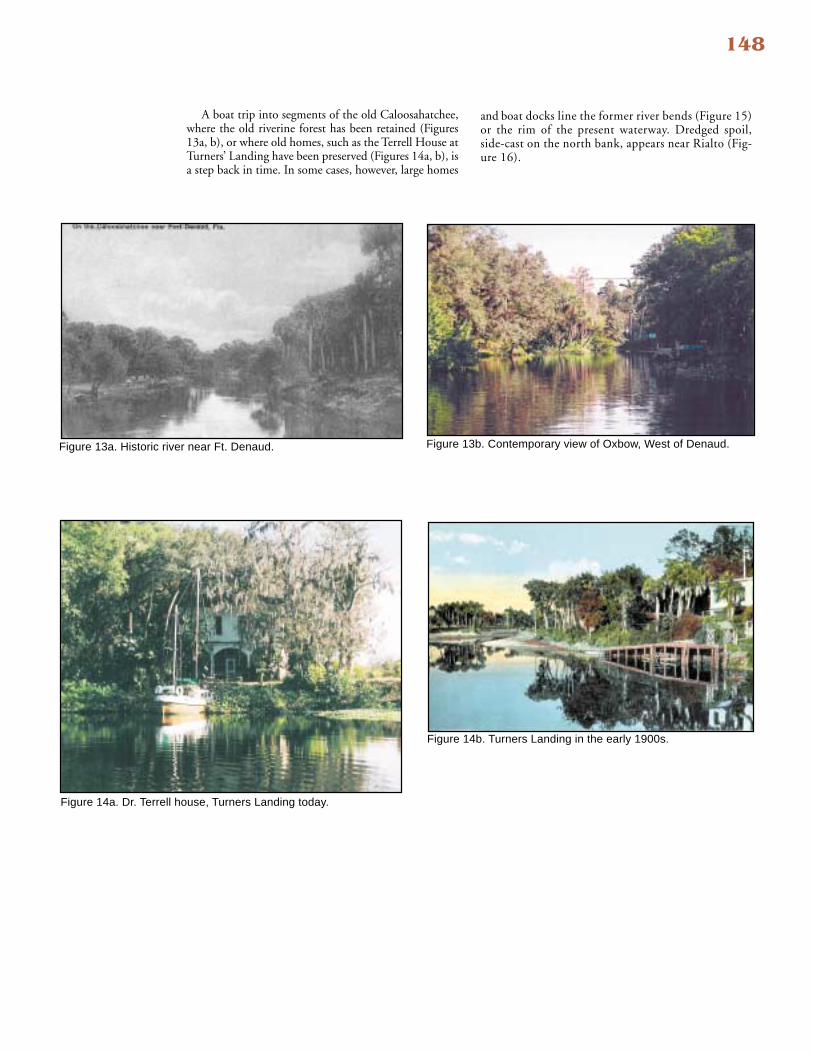
A boat trip into segments of the old Caloosahatchee,where the old riverine forest has been retained (Figures13a, b), or where old homes, such as the Terrell House atTurners’ Landing have been preserved (Figures 14a, b), isa step back in time. In some cases, however, large homes
and boat docks line the former river bends (Figure 15)or the rim of the present waterway. Dredged spoil,side-cast on the north bank, appears near Rialto (Fig-ure 16).

149
Figure 15. Rialto Oxbow (residential use).
Figure 16. Side cast spoil along waterway at Rialto.

150
Figure 17d. La Belle bridge (now).
Figure 17a. La Belle riverfront (then).
Old Everett Hotel(Now an Antique Store)
Figure 17b. La Belle Town dock (now).
Figure 17c. La Belle swing bridge (then).
La Belle, a historic river town, retains much of the charac-ter from bygone days especially along the waterfront (Figure17a, b), though the old swing bridge has been replaced bya bascule bridge (Figure 17c, d). Nothing remains fromFt. Thompson although a historic marker has been erected atits location; Ft. Thompson was probably destroyed by
dredging and portions of the settlement buried underspoil along the south bank of the waterway. Figure18ashows the flooded riverbanks years ago near Ft. Thomp-son, and Figure 18b is the cattle crossing at the Rapids.Lake Flirt no longer exists, but a number of dredgedbasins in that locale now harbor wet storage facilities(Figure 19).

151
Figure 18b. Cattle crossing at Ft. Thompson.
Figure 18a. River at Ft. Thompson.
152
Figure 19. Boats near former Lake Flirt.
Figure 20. Ortona Lock.
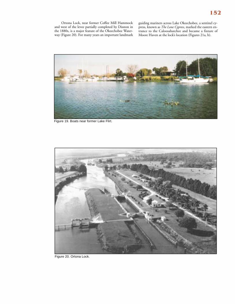
Ortona Lock, near former Coffee Mill Hammockand west of the levee partially completed by Disston inthe 1880s, is a major feature of the Okeechobee Water-way (Figure 20). For many years an important landmark
guiding mariners across Lake Okeechobee, a sentinel cy-press, known as The Lone Cypress, marked the eastern en-trance to the Caloosahatchee and became a fixture ofMoore Haven at the lock’s location (Figures 21a, b).

153
Figure 21b. Moore Haven lock.
Figure 21a. Lone cypress at the lake and canal junction.

154Epilogue
Caloosahatchee history is the extreme case of alteringland and water for coastal development in SouthwestFlorida. The river’s form and function over the past 100years have irrevocably changed. The historic river, whichwas relied upon by pioneers as a commercial artery fortransporting goods and services, had a meandering, shift-ing course subjected to flood and drought conditions.Today, it is the straight-channel, dredged, OkeechobeeWaterway, used by resource managers for flood controland by boaters transiting between the Eastern Seaboard
and Gulf Coast. Hidden behind the waterway’s artificiallyconfigured banks are isolated remnants of theCaloosahatchee’s meanders, some pristine, others alteredby development pressures from residential, agriculturaland recreational uses. The dichotomy of waterway andriver remain coupled by geography and history. The ques-tion of how this historic river and its water will be man-aged and provided to sustain the rich historical and eco-logical balance, which drives our current coastal economy,is a vexing enigma to this day.
Steamer Thomas A. Edison on a run up the Caloosahatchee to Ft. Myers during the early 1900s.

155
References
Published Reports
Alperin, Lynn M., 1983, “History of the Gulf Intra-coastal Waterway,” Navigation History NWS-83-9, Na-tional Waterways Study, U.S. Army Engineer Water Re-sources Support Center, Institute for Water Resources, U.S. Government Printing Office, Washington D.C., pp.44-48.
U.S. House of Representatives, 1879, “Examinationof Caloosahatchee River, Florida,” Report of the Chief ofEngineers, Vol. 2, Pt. 1, 46th Congress, 2nd Session, Doc.Vol. 2, No. 1, Pt. 2, pp. 863-869.
__________, 1907, “Report of Examination ofCaloosahatchee and Orange Rivers, Florida,” 60th Con-gress, 1st Session, Doc. No. 347, 7 pp.
__________, 1913, “Preliminary Examination ofCaloosahatchee River, Fla.,” 63rd Congress, 1st Session,Doc. No. 137, pp. 16-23.
__________, 1927, “Survey of Caloosahatchee RiverDrainage Area in Florida,” 69th Congress, 2nd Session,Report No. 1888, 3 pp.
Unpublished Reports
Black, W.M., 1887, “Condition of Caloosahatchee Basin,”letter to Chief of Engineers, U.S. Army, Washington, D.C.,March 30, 1887, file copy, No. 1155, 2; pp. 126-129 and 214-217, Federal Records Center, Southeast Region (Atlanta).
Clausen, C.J. et. al., 1980, “Cultural Resource Surveyof Portions of the Port La Belle Development Tract, Gladesand Hendry Counties, Fla.,” Survey Project 107 Preparedfor General Development Corporation, Miami, Fla., byCCC Enterprises, Inc., North Port, Fla.
Newspaper Articles
Ft. Myers News-Press, “Application to Close CanalGranted!” April 17, 1902.
Ft. Myers News-Press, “Hicpochee Canal Not Govern-ment Water,” May 8, 1902.
Newsletter Articles
Kimes, C.A., and L. C. Crocker, 1999, “A HistoricalOverview of the Caloosahatchee and its Watershed,” in Har-bor Happenings, Newsletter of the Charlotte Harbor Na-tional Estuary Program, Vol. 3, No. 1, Spring, pp. 8-13.
Scholle, Rae Ann, 1999, “Oxbows of the Caloosahatchee,”in Harbor Happenings, Newsletter of Charlotte Harbor NationalEstuary Program, Vol. 3, No. 1, Spring, p. 17.
Books
Grismer, Karl H., 1949, The Story of Fort Myers: TheHistory of the Land of the Caloosahatchee and SouthwestFlorida, St. Petersburg Printing Company, Inc., Fla.
Internet
Comprehensive Everglades Restoration Plan, June2002, http://www.evergladesplan.org/the plan/2lev_restoration_.plan.shtml
Dunn, Carl, 2002, “C-43 Basin Storage Reservoir, Part1,” in Comprehensive Everglades Restoration Plan(CERP), http://www.evergladesplan.org/pm/projects/proj)04.shtml
Other Sources
Lee County Government, 2002, A Resolution Re-questing the Support of the Southwest Florida Congres-sional Delegation in Securing Funding and Technical As-sistance from the U.S. Army Corps of Engineers for aReconnaissance Study of the Caloosahatchee From theGulf of Mexico to Lake Okeechobee, Florida, Resolu-tion No. 02-06-20, Ft. Myers, Fla.

156
Rivers, such as the Caloosahatchee, Estero, Imperial,and Cocohatchee, share a number of common physicalfeatures that affect navigation and land use along theirshorelines.
Viewed from the air, these streams display floodplainswith a meandering river course. During the pre–develop-ment period, when flood-control structures were uncom-mon, overbank flooding occurred during the rainy seasonas the meandering river would leave its existing channel andinundate part or all of its floodplain. Early settlers describedsuch events, wherein the increased flow kept the sedimentload suspended, with the river channel oftentimes indistin-guishable because of the floodwater’s turbidity.
The meandering habit of these rivers alternately cuts andfills the valley floor, depositing sediments on the inside ofbends and cutting away its banks on the outside, and in thisprocess, the whole meander migrates down-valley. The Blackmap (1887) displays many of the Caloosahatchee’s flood-plain features of the pre–development period, downstreamfrom Ft. Thompson (Figure 22). In time, the meandersdevelop narrow necks (Figure 22, a), and, in flood stages,the river may abandon, or cut-off, a meander loop (Figure
For Your Information...Physical Features of Southwest Florida Rivers andtheir Influence on Shoreline Use and Navigation
22, b). An oxbow lake forms (Figure 22, c) when theriver deposits sediments across the ends of the aban-doned channel.
In the active meanders, water pools along the outsidebend because the river undercuts the bank, which resultsin caving that allows the meander radius to grow. Depthsbecome shallow where the river crosses from one bend tothe next and creates shifting sand bars known as riffles.Riverboat captains during the heydays of 20th century de-velopment were familiar with these channel characteris-tics as they navigated through the shifting shoals andsought the deepwater pools in the outer bends. Largervessels were required to warp-around the tight rope-bends.Present day mariners seek out the remaining deepwaterpools as storm havens or “hurricane holes.”
Today, the lower Caloosahatchee, downstream fromBeautiful Island, is an estuary (subject to tidal influ-ence), but, in essence, it is a drowned river valley, in-undated during the post-glacial rise in sea level. Manyof its former river meanders are clearly visible alongthe shoreline (Figure 23, red dashed line).
Figure 22. Meanders in the Caloosahatchee, 1887.
Figure 23. Drowned River Valley features.
a
b
c
SanCarlos
Bay
PuntaRassa
RedfishPoint
Relict Meanders East of theFranklin Lock.

157
Another feature of these rivers is the delta formed wherethe velocity of the stream rapidly decreases as it flows intoa body of standing water. Distributary, intersecting, sec-ondary channels form where the main river channel di-vides and pushes out into the bay. The configuration ofthe shoreline influences the shape of the delta. TheCaloosahatchee delta, delineated by Shell Point at the apex(on the east) and a line drawn between Sword Point andPunta Rassa (on the west), has the characteristic delta-shape and is influenced by tidal currents flowing betweenMatlacha Pass and San Carlos Bay (Figure 24). Indeed,much of the shifting, shoaling character of the “Miser-able Mile” segment of the Gulf Intracoastal Waterwaythrough this area is attributable to tidal currents redis-tributing the river’s delta deposits. The aerial photographin Figure 25 predates the Gulf Intracoastal Waterway andclearly shows the many distributary channels (“d”) in thisarea. The main, navigable channel through the delta (“m”in Figure 25) shows the side-cast spoil placed along thenorth bank of the channel. This is a federally-main-tained channel that was first dredged by the Army En-gineers in 1882.
The Imperial River’s delta (Figure 26) extends acrosslower Estero Bay and abuts the barrier island. This deltahas proved to be an effective barrier to navigation. Shal-low-draft coastal vessels used one of the distributary chan-nels, the “Auger Hole,” during the early development pe-riod. In 1955, a private developer dredged a north-southchannel across the delta in order to provide boat accessbetween Estero Bay and Wiggins Pass.
Figure 26. Imperial River delta, 1999.
Figure 24. Chart of the Caloosahatchee delta.
Figure 25. Caloosahatchee delta, 1944.
ImperialRiver
"AugerHole"
Channel
ModernChannel
Caloosa-hatchee
RiverShellPoint
PuntaRassa
d
m
d
d m
San CarlosBay