teetonics and sedimentation ofthe meso- to neoproterozoic
TRANSCRIPT

Polarforschung 68: 267 - 274,1998 (erschienen 2000)
Teetonics and Sedimentation of the Meso- to NeoproterozoicTiman-Varanger Belt along the Northeastern Margin of Baltica
By Vsevolod G. Olovyanishnikov ', David Roberts? and Anna Siedleekat
THEME 8: Polar Urals, Novaya Zemlya and Taimyr: The Northern Connection of the Uralides
Summary: Extending from the Timans in the southeast to the Varanger Peninsula in the northwest, the Timan-Varanger Belt (TVB) comprises predominantlyterrigenous Neoproterozoic successions, defonned and metamorphosed at cornparatively low grade during the Timanian (Baikalian) orogeny, an event broadlyequivalent to the Cadomian 01' western Europe, In Neoproterozoic time the TVBformed the faul ted, extensional southwestern margin 01' an oceanic basin, thecentral parts 01' which are buried beneath the Palaeozoic and youngcr cover 01'the Pechora Basin. The major structural element 01' the basin margin is a NWSE-trending fault zone thar separated two domains 01' sedimentation; pericratonicto the southwest and basinal to the northeast, which show contrasts in both thickness and sedimentary fucies. In the Timan-Kanin-Pechora part 01' the basin, sedimentation began already in the Middle Riphean, and by Late Riphean time aprominent stromatolitie carbonate ramp formation had built up along the shelfmargin. In the NW Kola- Varanger region, however, sedimentation did not startuntil thc (?)Middle-Late Riphean. Thus, with time, the basin extendednorthwestwards anel sedimentation, including deposition ofVarangerian tillitesin the northwest, continued into the Vendian period. The fault zone which formedthe extensional margin of the basin was reactivated during the Timanian orogenyand again in later periods. The Timanian deformation in these exposed marginalareas involved basinal inversion, folding and oleavage development, arising fromSW-directed compressivc stresses, the main phasc 01' these movements datingto about 600-575 Ma, A variety 01' felsic to mafic plutons and dykes intrudedthe folded rocks 01' thc TVB.
Both seismic reflection and deep drill hole data have shown that Meso- to Neoproterozoic strata in the prc-Palaeozoic basement of thc Pechora Basin are moreintcnsivcly deformed and metamorphoscd and also include oceanic and arevolcanic scqucnccs and diverse plutonic rocks. Fragments 01' older basementterranes arc also present. Timanian deformation beneath the Pechora Basin wasthus much more intcnsc and involved the telcscoping 01' arcs, are roots andmicrocontinental terranes in a more complex accretionary zone, generally refcrrcd to as the Pechorskaya eollision zone.
INTRODUCTION
The Timanian mountain chain, an important regional elementin Circum-Barentsian geological structure, was first recognisedalmost precisely 100 years ago (RAMSAY 1899, TSCHERNYSCI-IEV1901). SCHATSKY (1935, 1958) further developed this early ideaand suggested that the chain represented part of a LatePrecambrian Baikalian fold belt which he called the
1 Institute of Gcology, Komi Research Centre, Ural Division, Russian Academy of Seienees, Pervomaiskaya 54, Syktyvkar, 167000 Russia.
Norges Gcologiske Undersokelse, N-7491 Trendheim. Norway
Manusript received 14 Deeember 1998, accepled 12 Ocrober 1999.
"Tirnanides'. Subsequent research by several Russian scientists,in particular ZHURAVLEV and co-workers (e.g. ZHURAVLEV &GAFAROV 1959, ZHURA VLEV & OSADCHUK 1960, 1962,ZHURAVLEV 1972) and RAZNITSYN (e.g., 1962, 1968), brought awealth of data and ideas on several aspects of the geology of theTimans and also on the relationship between this Neoproterozoicfold belt and the pre-Palaeozoic substratum of the Pechora Basin, In addition, several decades of research by GETSEN (summarised in OLOVYANISHNIKOV 1975, 1987, 1998) have resultedin further and considerable progress in our knowledge of thegeology of the Timanides,
The northwestern extension ofthe Timanian mountain chain waspostulated by RAMSAY (1899) and TSCHERNYSCHEV (1901) to occur along the northeastern Murmansk Coast of the Kola Peninsula, on Rybachi, Sredni and Kildin, and to continue far intonorthern Norway. Potential field and seismic ret1ection data inoffshore areas has confirmed the presence of these folded rocksimmediately northeast of Kola (e.g., BOGATSKY et al. 1996),Recently, a modified version of this idea, which had been accepted for decades in several large-scale geological interpretations, received new support from some of the results of a jointNorwegian-Russian research programme carried out during theyears 1989-95 on the coastal Neoproterozoic occurrences oftheKola Peninsula and on Varanger Peninsula in Norway (see inROBERTS & NORDGULEN 1995). The latter area, now inferred toexpose the northwesternmost segment of the proposed chain,had already been thoroughly mapped and studied by geologistsof the Geological Survey of Norway and other western workers since the mid-1960s. Finally, all three authors ofthis papertogether visited the Central Timans in 1995 (OLOVYANISHNIKOVet al. 1997).
The objective of this contribution is to outline the recent progress and understanding of this about 1800 km-long Neoproterozoic structural element occurring along the northeasternperimeter of the Baltic Shield and Russian Platform. In the textwhich follows we refer to Schatsky's "Timanides: as the TimanVaranger Belt (TVB) in which the Timans themselves constitute the geographically most extensive, southeastern part.
Note: Neoproterozoic = Late (Upper) Proterozoic = 1000 (900)Ma - 545 Ma = Late (Upper) Riphean and Vendian.Mesoproterozoic = 1600-1000 Ma = Lower (Early) and MiddIe Riphean.
267

STRATIGRAPHY AND SEDIMENTATION
Sediments and sedimentation realms: general features
The Meso- to Neoproterozoic strata of the Timan-Varanger Beltaccumulated in response to extensiona1 faulting along the northeastern perimeter of the Fennoscandian Shield. The predominantly terrigenous sedimentary successions also include anextensive be1t of carbonate rocks in the Timan-Kanin zone. Therocks are for the most part metamorphosed at on1y very lowgrade. On the Kanin Peninsula and in northern Timans, however, metamorphic grade reaches up to amphibolite facies, particularly in the cores of anticlines. Two parallel, NW-SEtrending, elongate, sedimentation domains are present adjacentto the major zone of faulting which played a crucia1 role in thedevelopment and character of sedimentation on either side ofthis structural element (Fig. 1). The fault zone exposed on theVaranger and Rybachi-Sredni Peninsulas, the TrollfjordenKomage1va Fault Zone (TKFZ) and Sredni-Rybachi Fault Zone(SRFZ), respectively, can be followed to the southeast along andjust off the coast of the Kola Peninsula, partly with the help ofgeophysical data. It then extends across the Kanin Peninsula andinto the Timans where it is known as the Central Timan Fault(CTF). It is fairly weIl documented that the CTF formed thesouthwestern margin of a Neoproterozoic (Riphean) basin buried beneath unconformably overlying Cambro-Ordovician rocksof the adjacent Pechora Basin where there are also several otherparallel faults. The prolongations of these other faults beneaththe Barents Sea are generally poorly known. The CTF-SRFZTKFZ, on the other hand, not only continues throughout theTiman-Varanger Belt but also clearly separates the two, abovementioned, distinct domains of sedimentation: pericratonic tothe southwest and basinal to the northeast, thelithostratigraphica1 successions of which show contrasts in boththickness and sedimentary facies towards the northwest.
A form of zonation in the Timans, involving lithology, contrasting thicknesses and degree of metamorphism, but not sedimentation domains, had, in fact, already been suggested some40 years ago (ZHURAVLEV & OSADCHUK 1960).
The lithological development of both the pericratonic and thebasinal successions ofVaranger, Rybachi, Sredni, Kildin, Kanin,and northern and centra1 Timans varies considerably alongstrike, a feature which is not unexpected in view of the greatdistances involved, the likely differential stresses operativealong the basin-margin faults, and a varying topography in theadjacent source areas. These variables, along with the fact thatthe ages of the successions are generally only roughly determined by microfossils and indirectly by isotopic ages oftransecting pre-Pa1aeozoic intrusions, make detailed correlationparticularly speculative. Although lithostratigraphic correlationshave been proposed by many geologists, it seems obvious thatlithologically similar units may weIl be diachronous, particularlyas such great distances are involved along the belt. In theTimans, a discontinuous belt of carbonate and carbonateterrigenous lithologies occurs between the pericratonicterrigenous successions to the southwest and the basinal to the
268
Z<t:
CI:w
~ co+ +
D cn-,-
~ 3 7
4 8
9
Fig. 1. Top: Outline map showing the Timan-Varanger Belt. KP - Kanin Peninsula; NT - Northern Timan; RP - Rybachi Peninsula; SP - Sredni Peninsula; VP- Varanger Peninsula; CTF - Central Timan Fault; ETF - East Timan Fault; WTF- West Timan Fault. The CTF is shown to continue to the Rybachi-Sredni andVaranger Peninsulas where it is called Sredni-Rybachi Fault Zone andTrollfjorden-Komagelva Fault Zone, respectively. Shaded areas show the outcrop of the Neoproterozoic rocks.Bottom: Simplified geological-structural map ofthe Timan Range and basementof the Pechora Basin. 1: Basement; 2: Pericratonic zone; 3: Carbonate shelfmargin; 4: Slope-to-basin zone; 5: Pechora collision zone 6: Outcrop of theMeso- to Neoproterozoic rocks; 7: Zone ofTimanian accretion, 8: Urals; 9: Lineof the section, shown in Figure 4. WTF: West Timan Fault (also called the PreTiman Fault); CTF: Central Timan Fault; ETF: East Timan Fault; NT: Northern Timan; PK: Pechora-Kozhva Fault; Kol. M.: L. Precambrian Kolguev massif or terrane; Kho.M.: L. Precambrian Khoreyver massif 01' terrane. Modifiedfrom OLOVYANISHNIKOV et al. (1997).
northeast. On Kildin Island, Varanger Peninsula and farther tothe west, within the Caledonides, equivalent Upper Ripheancarbonate units are also pressent.
The time span during which the discussed sedimentary rocks accumulated embraces more than 500 million years. Reso1ving the

history of the TVB in more detail would require stratigraphictechniques which are either not available (direct isotopic dating)or very general (biostratigraphy), a fact which poses fundamental problems in work on Precambrian (meta)sedimentary rocksin general.
Biostratigraphie evidence
Microfossils and columnar stromatolites provide the biostratigraphic evidence of the age of these diverse Neoproterozoicsuccessions. In arecent paper, OLOVYANISHNIKOV (1998, pp. 103108) presented an extensive review of all microfossils found inthe Neoproterozoic strata of the Timans and Kanin. Taxa ofacritarchs referred to in this synopsis were identified by severalscientists but only a few had been reported earlier (e.g. GETSEN& PIHOVA 1977). While the assemblages are suggestive mostlyof a Late Riphean to Terminal Riphean (Kudash) age, someforms, according to the author, do not preclude a partly Vendianage for the youngest sedimentary rocks both in central and innorthern Timans. However, in the revised list of microfossils (38forms), two ofthese forms are Cambrian contaminations and theremainder comprise partly Riphean acritarchs and partly formsof long stratigraphic range not suitable for stratigraphie work(Doc. M. Moczydlowska-Vidal, written communication 1998).Therefore, the postulated Vendian age of some of the strata incentral Timan is uncertain.
Microfossils extracted from the Neoproterozoic sections of thecoastal areas of Kola Peninsula (the Murmansk Coast in thenortheast and the Tiersky Coast on the White Sea) were studied in detail by Mikhailova (LYUBTSOV et al. 1989). She described a collection of 151 specimens comprising 43 forms ofacritarchs, ten of which were determined at generic level. Onlyeight of these forms are known to cross the Riphean-Vendianboundary; however, they are not diagnostic of the Vendian.Michailova (LYUBTSOV et al. 1989) concluded that the upperformations of the basinal zone of Rybachi may possibly beRiphean-Vendian due to the fact that the assemblage there isvery impoverished compared to the rich Riphean assemblagesfound elsewhere. This fact, however, in our view, is only whatcan be expected in a rapidly deposited, mostly coarse-grainedsuccession accumulated predominantly on a submarine fan(SIEDLECKA et al. 1995). SAMUELSSON (1995, 1997) examined anew collection of arcritarchs from Sredni and concluded thatthese pericratonic strata are of Late to Latest (Karatavian)Riphean age. In fact, only on the Varanger Peninsula haveVendian strata been positively identified in the pericratoniczone; and, in addition, in that particular area there also occur theweil known Varangerian tillites of earliest Vendian age. Theseare absent in the remainder of the Timan-Varanger Belt.
Columnar stromatolites, occurring in the carbonate formationsof the Timans, the Kanin Peninsula, the coastal areas of the KolaPeninsula and the pericratonic carbonates of northern Norway,all indicate a Late Riphean age for these carbonate accumulations (BERTRAND-SARFATI & SIEDLECKA 1980, RAABEN 1975,1994: 48, RAABEN et al. 1995). On Varanger Peninsula they are
unconformably overlain by the Early Vendian glacial deposits.
Isotopic ages
There is a considerable number of published isotopic ages on theintrusive and hypabyssal rocks of the central and northern Timansand the Kanin Peninsula, as weil as some ages on dolerite dykesthat transect the Upper Proterozoic deposits along thenorthwesternmost periphery of the Timan-Varanger Belt. AKIMOVA(1980) published a synopsis of 141 K-Ar (whole-rock) ages ofmagmatic rocks and 32 ages of metasedimentary rocks (wholerock and minerals) produced by several Russian authors since themid-1960s. Although the reliability of much of these data is indoubt, the majority ofthe ages indicate Late Riphean to Vendianminimum ages and thus they do not contribute to any refinementof the Neoproterozoic stratigraphy. They do, however, providesome information concerning the timing of metamorphic and deformation events. Recent work by ANDREICHEV (1998) on Rb-Srisotopic ages of intrusions from northern Timan shows that the majority of dates fall between 500 and 800 Ma, confirming theNeoproterozoic minimum age of the dissected strata. Of interest,however, is the 1100±39 Ma isochron age of a diabase transectingthe Proterozoic strata, indicating the possibility that also MiddleRiphean metasedimentary rocks may occur in this area. In this connection it is worth mentioning that AKIMOVA(1980) also reported23 whole-rock and mineral age detenninations of c. 1000-1500 Ma(even >2000 Ma in three cases), mainly of metadiabases anddiabases cutting the carbonate rocks of central Timan (AKIMOVA1980, Table 2, nos. 40-62 and p. 83). Another group of dates fürdiabases transecting the carbonate rocks (from borehole cores) liesin the range 600-700 Ma, which is in accord with the Late Ripheanage of the carbonate succession indicated by columnarstromatolites (see above). Assuming that the sampling and datingprocedures are reliable, these various data would suggest the presence of two separate carbonate successions, one of Early 01' MiddIe and the other of Late Riphean age. Recently, OLOVYANISHNIKOV(1998: 116-117), in his summary interpretation of the Meso- toNeoproterozoic stratigraphy ofthe Timans and Kanin Peninsula,has suggested that the carbonate rocks both in central Timan andfarther north are stratigraphically subjacent to the remainder of theUpper Precambrian successions. This suggestion is based on thehigh er metamorphic grade of the carbonate unit in central Timancompared to that of adjacent terrigenous units. Although this doesnot seem to constitute sufficient evidence it is, however, in accordance with the group of high radiometric ages reported by AKIMOVA(1980). There would thus appear to be a serious new implication,namely, that there are two carbonate successions in the Timans ofconsiderably different age.
This review of the data shows that the isotopic ages, which arerelevant to the timing of deformation that will be discussed laterin this contribution, do not provide any important evidence useful for refining the chronostratigraphy. The >1000 Ma ages ofmafic intrusive rocks, however, do confirm that sedimentationin the Tirnan- Varanger Basin commenced in LateMesoproterozoic time.
269

TECTONICS AND SEDIMENTATION: A TENTATIVEMODEL
Fig. 2: Tentative model for the dcvelopment of the Timan-Varanger Basin. A:initial rifting; B: Erosion of the footwall shoulders and aeeumulation of slopeto-basin deposits; C: shallow-marine pericratonic terrigenous sedimentation andstromatolitie reefs; D: accumulation of shelf-margin ramp carbonates; E: Deformation due to SW-direeted compressive stress (open arrow) and inversion ofbasin-marginal faults. CTF - Central Timan Fault; WTF - West Timan Fault.
Although we are fully aware that the stratigraphie record in partsof the belt is fragmentary and uncertain, we nevertheless believethat the data that are available are sufficient to warrant the presentation of a model integrating tectonics and sedimentation inthe Timan-Varanger Belt, taking into account the following criteria:1. The possible existence of strata older than Upper Riphean
in the central and northern Timans and on Kanin (see aboveand also e.g. GETSEN 1987, his Fig. 2);
2. The thicknesses and sedimentary facies of the pericratonicand basinal successions;
In response to the initial rifting and downfaulting (Fig, 2A),sedimentation probably began already in the Middle Riphean(?or earlier) in the Timans and Kanin Peninsula while in thenorthwest, along northeastern Kola and on Varanger, it did notstart until the Late Riphean. This suggests that the basin wasextending northwestwards with time. While the TVB representsthe southwestern marginal area of the opening and deepeningbasin, its more central areas now form the basement to thePechora Basin, which is a complex mosaic of oceanic crust, island are material and microcontinental fragments cut by Ripheanand Vendian (Timanian) plutons (BELYAKOVA & STEPANENKO1991, GETSEN 1991, BOGATSKY et al. 1996, GEE et al. 2000). Thisscenario is largely in agreement with a previous1y postulated'Timan-Ural Geosyncline Model', i.e., an extensive eugeoclinalbasin of which the Timan-Kanin zone constituted only the southwestern marginal part, closest to the craton beneath the RussianP1atform (e.g. ZHURAVLEV & GAFAROV 1959, ZHURAVLEV 1972,GETSEN 1987). Consequently, an alternative, previously suggested fixist 'Aulacogen Model', invo1ving a major graben,separated from the Polar Urals by a cratonic block (BOGDANOV1961, SCHATSKY 1964, SIEDLECKA 1975, IVANOV 1981), has nowbeen abandoned.
3. The geophysical data which help to link the separate areasof outcrop;
4. The weIl exposed and documented Neoproterozoic geologyof the Murmansk Coast and the Varanger Peninsula, whichserve in many respects as a 'key' to our understanding of theremainder of this extensive belt.
Within the TVB, i.e. the marginal part of the basin, truncationof the rift shou1ders and erosion on the footwall side occurredin response to the fault-generated relief, and the bypassingsediments were eventually accumu1ated in the slope-to-basinarea (Fig. 2B). Basinal accumulations in the Timans and onKanin are fine-grained, partly fine turbidites, a fact which indicates that the slope was gentle, and that subsidence and sedimentation were close to equilibrium (SIEDLECKA & ROBERTS1995). In the northwestern extremity of the basin, on the otherhand, there are both olistostromes and coarse turbidites in thebasinal zone, reflecting the existence of a steep slope with fastsubsidence and rapid to locally violent sedimentation (SIEDLECKAet al. 1995). As the relief gradually decreased the basinal sedimentation became slower and the basin filled out, while thepericratonic sedimentation started lapping off, with sedimentseventually accumulating upon the proximal part of the basinalinfill (Fig. 2C).
The final phase of sedimentation in the proposed model wascharacterised by slow sedimentation in the pericratonic areasonly, mainly reworking and gradually increasing the maturityof the shaIlow-marine clastics with little new sediment delivery. This situation created favourable conditions for the development of stromatolites and carbonate precipitation in the marine waters no longer heavily charged by suspended terrigenousfines. A rimmed terrigenous-carbonate ramp was thus created(Fig. 2D). The proposed succession of events provides an evolutionary framework to be tested, refined and modified by fur-
v-er
-\- +CTF-\' +
c+ + ++ +
+
0- . .
+ + + ++ + +
E
+ + ++ +
+ + ++ +
A
270
ther studies; it is thus a tentative model, and is not in any waydefinitive. Contacts between the facies zones (pericratonic, carbonate, basinal) in the Timans and on Kanin are everywherefaulted and it is only in the northwestern peripheral parts of thebasin that the pericratonic Upper Riphean sedimentary rocksactually rest upon the basinal deposits (erosional contact) andwhere the stromatolitic dolomites occur in the uppermost partof the fairly mature, pericratonic, terrigenous sedirnentary succession. We have, in this model, purposely excluded the possible existence of an older carbonate unit (see above) since moredocumentation is required in support of this hypothesis. In addition, there are unconformities, within the pericratonicsuccessions in particular, showing that there were varying ratesof sedimentation and subsidence. As a consequence, the detailedinfill his tory of the basin was much more complex than thatoutlined here.
A discussion of the abundant geophysical data that are availablefrom the Timan-Kanin-Pechora region is outside the scope ofthis paper. Prominent positive, linear, magnetic anomalies ofNW-SE trend parallel the regional strike in what is essentiallya 'magnetic minimum' domain. This anomaly trend is offsethere and there by concealed NE-SW-trending faults which are
believed to have controlled the intrusion and ultimate distribution of gabbroic, picritic and syenitic magmas. Kimberliticrocks, eruptive breccias and nepheline syenites have been reported from the areas of intersection of some of these NW-SEand NE-SW faults.
ASPECTS OF DEFORMATION AND METAMORPHISM
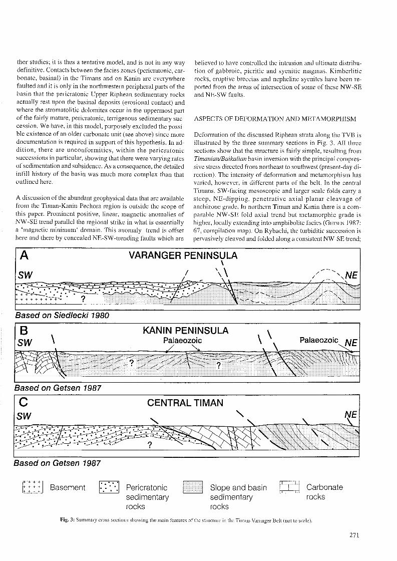
Deformation of the discussed Riphean strata along the TVB isillustrated by the three summary sections in Fig. 3. All threesections show that the structure is fairly simple, resulting fromTimanianlBaikalian basin inversion with the principal compressive stress directed from northeast to southwest (present-day direction). The intensity of deformation and metamorphism hasvaried, however, in different parts of the belt. In the centralTimans, SW-facing mesoscopic and larger-scale folds carry asteep, NE-dipping, penetrative axial-planar cleavage ofanchizone grade. In northern Timan and Kanin there is a comparable NW -SE fold axial trend but metamorphic grade ishigher, locally extending into amphibolite facies (GETSEN 1987:67, compilation map). On Rybachi, the turbiditic succession ispervasively cleaved and folded along a consistent NW-SE trend;
A VARANGER PENINSULA\
SW / \,\ /'- ........
NE/- / -....-.::;;;:::. .. . . . . . . . ."'~'/ ~ .. . .. . . . . . . '.-:' .~' . . .' ..~~ • • r. ,. . . . '. .. . .~.~~ . . .
+ +' • • :.~ ,-' : '.' • z; . . . " ..-;-/...+ + + + + + + +-"1' ?
Based on Siedlecki 1980
Bsw \
KANIN PENINSULAPalaeozoic \ \
\Palaeozoic NE
Based on Getsen 1987
cSW
Based on Getsen 1987
. .
CENTRAL TIMAN
. . .. ','
?
r:::l~ Basement 0····..... . . Pericratonic
sedimentaryrocks
~l2.J.2J Siope and basin
sedimentaryrocks
Carbonaterocks
Fig. 3: Summary cross scctions showing the main features of the structure in thc Timan- Varanger Belt (not to scale).
271
and the rocks are mostly in anchizone grade (RICE & ROBERTS1995). On Sredni and Kildin, diagenesis grade prevails. In eastern Varanger Peninsula, the NW-SE fold and cleavage trend isagain recognised northeast of the TKFZ, dying out to the west(ROBERTS 1995, 1996) where c. NE-SW-trending Caledonianstructures take over.
The section across the western parts of the Varanger Peninsula(Fig. 3A) shows that the basinal succession which crops outmainly northeast of the TKFZ is also present to the southwest,a feature which is easy to explain by on1ap during infilling ofthe basin. In addition, it has been shown that the pericratonicstrata there overlie the basinal Riphean sediments over part ofthe area, as documented by RICE (1994), while the bulk of thepericratonic succession, towards the southwest, rests directly onthe Lower Precambrian crystalline basement. The carbonatedeposits which terminate the pericratonic succession are notshown in this particular section. On the Kanin Peninsula, basina1deposits are separated from the Late Riphean stromatoliticdolomites occurring in the southwest by a vast area underlainby Palaeozoic strata which probably rest directly on basinalaccumulations (Fig. 3B). There are, however, no exposures toverify this interpretation, which is based solelyon geophysicaldata. Finally, the representative section from central Timanshows that the basinal succession, the carbonate formation andthe pericratonic strata are in contact along major faults (Fig. 3C).
Although we present a comparatively simple model for the origin of the rifted, extensional, southwestern passive margin ofthe Riphean basin and its subsequent syn-metarnorphic, cleavage-related deformation (see also Fig. 2E), isotopic ages indicate that deformation is likely to have occurred in more than oneLate Riphean-Vendian episode. The principal tectonothermalevent, however, coeval with basinal inversion, is ascribed towhat SCHATSKY (1958) defined as Baikalian orogenic movements, which he considered to be equivalent to the Cadomianepisode of crustal deformation in other parts of Europe.
GETSEN (1987: 60), on the basis of K-Ar mineral ages(amphibole, biotite, muscovite and K-feldspar), suggested thatthere were three episodes of metamorphism and magmatic activity in the northern Timan and Kanin Peninsula: at 680 ±20Ma, 600 ±5 Ma and 530 ±5 Ma. For Central Timan, this sameauthor (GETSEN 1987: 55) reported three groups of ages(isochrons derived from sericite, phlogopite and K-fe1dspar): at970 ±20 Ma, 725 ±25 Ma and 590 ±20 Ma. AKIMOVA(1980: 8384) also considered that there were several magmatic and metamorphic events but believed that the main episode of rnetamorphism and deformation occurred within the interval 570-680Ma. Another estimate, based on recalculated ages, was providedby MALKOV (1992) who considered that the main tectonometamorphic phase of the Timanides falls in the time range 600575 Ma; and a second metamorphie stage is put at c. 505-470Ma. The ages of c. 1000-1500 Ma, earJier reported by SIEDLECKA(1975: 329) and by AKIMOVA (1980), are also of interest in thelight of the recent Rb-Sr work by ANDREICHEV (1988) confirming the earlier conclusions on polyphase deformation. This involved emplacement of diabases and gabbrodiabases at 1100
272
±39 Ma, an olivine-kersantite gabbro at 702 ±45 Ma andsyenites and granites at c. 600 Ma. Finally, GEE et al. (2000)report single-zircon Pb-evaporation ages in the range c. 550-570Ma from post-tectonic granites and diorites taken from deepdrillcores in the Timanian 'collision zone' beneath the PechoraBasin. These Late Vendian ages confirm the model of aTimanian basement to the Pechora Basin.
Evidence from isotopic dating from the Rybachi-SredniVaranger region bearing on the age of the basina1 inversion andassociated penetrative cleavage is comparatively meagre atpresent, although work is in progress on dating the pervasivecleavage on Rybachi. A 4°Ar_39Ar laser microprobe study ondolerite dykes transecting the folds and cleavage on Rybachigave no definitive intrusive age, but suggested that they wereolder than Ordovician model ages (ROBERTS & ONSTOTT 1995).Palaeomagnetic data from these same dykes favoured a LateVendian to Cambrian age (TORSVIK et al. 1995). One solitarydyke from Sredni gave a similar palaeomagnetic age, while the4°Ar_39Ar analysis on this same dyke gave a minimum age of 546±4 Ma. This dyke cuts a diagenesis-grade compactional fabricthat has been Rb-Sr-dated to 610-620 Ma (GOROKHOV et al.1995). Illite fractions from along the SRFZ on Sredni haveyielded a Rb-Sr maximum age of 570 Ma (GOROKHOV et al.1995), which has been interpreted (ROBERTS 1996) as providingan approximate age for the basinal inversion in this part of theTiman-Varanger Belt.
Isotopic age determinations from Varanger Peninsula are fewin number. K-Ar whole-rock data on dolerite dykes cutting theLate Riphean to Early Vendian strata showed three age groupings: (a) c. 360 Ma, (b) c. 650 Ma and (c) 945-1945 Ma(BECKINSALE et al. 1975; recalcu1ated ages). One of the group (a)dykes has provided a U-Pb zircon upper-intercept age of c. 567Ma (ROBERTS & WALKER 1997). This particular dyke cuts acleavage which is interpreted as probably of Timanian age.While the Late Devonian K-Ar ages ofthis and possib1y otherdykes on Varanger may relate in some way to a Late Devonianthermal overprint event (see also LARSEN & TULLBORG 1998), thisdoes not reject the possibility that some dykes may have intrudedin Devonian time.
In summary, there is a good evidence in the Timans and Kanin,and now with support from isotopic studies on granites fromdeep drillcores beneath the Pechora Basin, that the peaktectonothermal phase of the Timanian orogeny in this part of theTVB occurred during approximately Mid Vendian time, c. 600575 Ma. Farther to the northwest, on Rybachi, Sredni and eastern Varanger, the temporal constraints at present are somewhatless precise. The character and trend of the foreland-facing folding and cleavage in these areas, however, are remarkab1y similar to those encountered in the Timans.
THE TIMANS AND BASEMENT OF THE PECHORA BASIN
New research, aided in particu1ar by seismic reflection data anddeep drillholes reaching pre-Palaeozoic rocks beneath the

Pechora Basin, have confirmed the northeastward extension ofthe Riphean-?Vendian sedirnentary succession of the Timansbeneath the several kilometres thickness of Palaeozoic andyounger cover rocks of this basin. The rocks there, however, aremore strongly deformed and metarnorphosed, and comprise notonly sediments but also volcanic rocks (including tholeiiticbasalts and volcanites of island are affinity) and intrusions.There are also fragments of an older basement present.BELYAKOVA & STEPANENKO (1991) demonstrated the development of intense magmatic activity related to the NW-SE zonation and concentrated along the Pechora-Kozhva Fault (theirmain deep-seated rift zone). Based on geophysical and now profuse deep drillhole data, BELYAKOVA & STEPANENKO (1991) andGETSEN (1991) suggested that the pre-Riphean crystalline basement was broken into a mozaic of microplates separated bysmall Riphean basins. Teetonic inversion, closing of the basins,collision of the blocks and magmatic activity have together produced the pre-Pa1aeozoic basement of the Pechora Basin, a result of Timanian orogeny involving the accretion and telescoping of new and old lithosphere along this part of the margin ofBaltica. Thus, an originally passive margin was transformed toan active one by Late Vendian time.
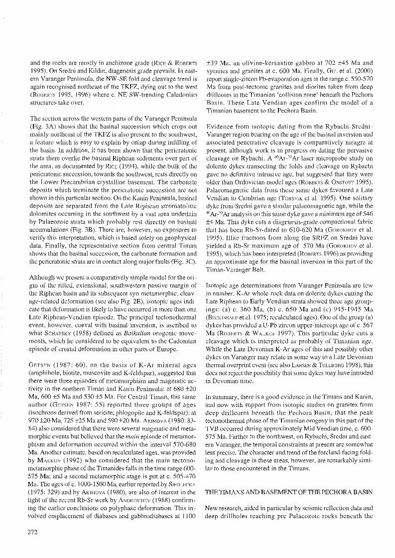
We show aspects of the new model in Fig. 4 as proposed morerecently by the first author (OLOVYANISHNIKOV et al. 1995). Themain map (Fig. 1) and schematic cross-section (Fig. 4) show theKolguev and larger Khoreyver massifs, interpreted as olderPrecambrian terranes, and the so-called Izhma 'rnicroplate ',which is the thinned and faulted northeasternmost part of theRussian Platforrn, rather than a truly separate micropIate. In thisscenario the entire Timan ridge between the Western and Eastern Timan Faults, and also including northern Timan and KaninKamen, is considered to represent the Timanian compressionalzone, situated transitionally between the Izhma 'microp1ate' beneath the basinal realm of the Tirnans, and the Russian platemargin proper (Figs. 1 and 4). The Central Timan Fault playedan important role at this time, functioning as a thrust which carried the low-grade basina1 (e.g., Vymskaya Ridge) successionsonto the sediments of the pericratonic zone, as for example thoseexposed in the Chetlaski Kamen. This is a situation which hasclear paralleIs with the deformation patterns observed on theRybachi-Sredni and Varanger Peninsulas. Farther northeast,beneath the Pechora Basin, there was a more cornplex, highergrade, Timanian deformation zone located between theKhoreyver terrane and the Izhma 'micropIate" the Pechorskayaco1lision zone. This also involved the volcanic are rocks (cf.
SW Izhma Khoreyver Novozhemelskaya NERussianPlatform 'micropiate' terrane terrane
!I
!I !I
!I100 km
!I!I !I !I !I !I L--...J
Fig. 4: Schematic reconstruction of the northeastern European Platform-TimanPechara region in latest Neoproterozoic/earliest Cambrian time. Crosses: continental crust; inverted V: 'basaltic layer'/upper mantle; conti nuaus lines withfolds: deformed Neoproterozoic sedimentary successions.
BELYAKOVA & STEPANENKO 1991) in what is believed, byBOGATSKY et al. (1996), to have represented an initial collisionbetween the Siberian plate and the extreme northeastern edgeof Ba1tica. Terrigenous red bed and tuffaceous deposits of(?)Late Vendian to Cambrian age in the Khoreyver terrane areconsidered by these same authors to represent molasse deposition following the Timanian orogeny. Elsewhere, beneath andmarginal to the Pechora Basin, Lower Ordovician and possiblyCambrian rocks are lying with marked unconformity above theTimanian deformed complexes.
ACKNOWLEDGEMENTS
We are gratefu1 to Doc. Malgorzata Moczydlowska-Vidal forher examination of the list of microfossils from the Timans andfor her opinion on the stratigraphie value of this assemblage. Wethank also Dr. Valentin Andreichev for making avai1able for ushis then unpublished Rb-Sr isotopic ages of rocks in the northern Timan. The comments of the referees, Drs. A. Larionov and1. Golonka, contributed to improvements to an early version ofthis paper. This account is a contribution to the ongoing workin the Europrobe Timpebar Project, and at the same time aprogress report on the collaboration between the GeologicalSurvey of Norway and the Komi Research Centre, RAS,Syktyvkar, Russia.
References
Akimova. G.N (1980): Geocbronology of Precambrian of Timan.- SovetskayaGeologia 12: 71-85 (in Russian).
Andreichev; \<A. (1998): Isotopic geochronology of the intrusive magmatism ofthe northern Timan.- RAS, Ural Division, Ekaterinburg, 90 pp.
Belyakova. L.T & Stepanenko, v.i. (1991): Magnetism i geodinamika Baikalidfundamenta pechorskoj sineklisy.- Izvestia AN SSSR, Seriegeologichcskaia, 106-117.
Bertrand-Sarfati, J. & Siedlecka. A. (1980): Columnar stromatolites of the terminal Preeambrian Porsanger Dolomite and Grasdal Formation ofFinnmark, north Norway.- Nor. Geo!. Tidsskr. 60: 1-27.
Bogatsky, VI., Bogdanov, NA., Kostyuchenko, SL, Sen in, ß. V, Sobolev, S.F.,Shipilov, E. V & Khain, VE. (1996): Teetonic map of the Barents Sea andthc northern part of European Russia: explanatory notes. - Institute of theLithosphere, Russ. Acad. Sei., Moscow, 101 pp.
Bogdanov, A.A. (1961): On some problems ofthe teetonics of Europe (in Russian).- Vestnik Moscovskogo Garnaga Instituta, Seriya Geologicheskaya,5.
Gee, D.G., Beliakova, L., Dovshikova, E., Larionov, A. & Pease, V (1999):Vendian intrusions in the basement beneath the Pechora Basin, norteasternBaltiea.- Polarforschung, this vo!.
Gelsen, VG. (1975): The bascmcnt structure of the northern Timan and KildinPeninsula.- .Nauka", Leningrad, 144 pp.
Gelsen, VG. (1987): Teetonics ofTiman (in Russian).- "Nauka", Leningrad, 170pp.
Gelsen, VG. (1991): Gcodynamie reeonstruction ofthe NE Europenn part oftheUSSR in Late Protcrozoic.- Gcotcctonika 5: 26-37 (in Russian)
Gelsen, VG. & Pihova, NG. (1977): Stratigraphy ofthc Riphcan deposits oftheccntral Timan.- Izv. AN SSSR., Scria Gcologichcskaya 6: 69-80.
Gorokhov, I.M, Turchenko, TM., Baskarov.A. V, Kutyavin, E.P., Melnikov, NN& Sochava, A. V (1995): A Rb-Sr study of multistage illitc generation inshales of the Pumanskaya aand Poropclonskaya Formations, Srcdni Peninsula, NW Kola Peninsula. (cxtcnded abstract).- Nor. Geo!. Unders. Spec.Pub!. 7: 330.
273

Ivanov, S.N. (1981): On Baikalides of the Urals and Siberia (in Russian).Geotektonika 5: 47-63.
Larsen, S. A. & Tullborg, E. L. (1998): Why Baltie Shield zireons yield latePalaeozoie, lower intereept ages on U-Pb eoneordia?- Geology 26: 912-922.
Lvubtsov, V V, Mikhailova, NS., Predovsky, A.A. (1989): Lithostratigraphy andmicrofossils of Late Preeambrian 01' the Kola Peninsula.- Kola SeientifieCentre AN SSSR, 129 pp. (in Russian).
Malkov, BA (1992): Timan Baikalieles: myth 01' reality? - Ukhta Braneh, USSRMineralogieal Soeiety, Syktyvkar, 21-29.
Olovyanishnikov, VG. (1998): Upper Preeambrian 01' Timan ancl Kanin Peninsula.- Inst.Geo!. Komi Seientifie Centre RAS, Ural Division, 163 pp. (inRussian).
Olovvanishnikov; \,1G., Bushuev, A.S. & Dokhsan 'vants, B.P. (1995): The structure of the eonjugation zone of the Russian and Pechora plates from gcologieal and geophysieal data.- Trans. (Doklady) Russian Aeael. Sei., EarthSei. Seetion 351 (8), 1228-1232.
Olovyanishnikov, VG., Siedlecka, A. & Roberts, D. (1997): Aspeets 01' the gcology of the Timans, Russia, anel linkages with Varanger Peninsula, NENorway (exteneleel abstraet).- Nor. Geo!. Unders. BuH. 433: 28-29.
Raaben. M.B. (1975): Upper Riphean as a unit 01' the general geologieal seale.Inst. Geo!. AN SSSR 273 "Nauka", Moseow, 247 p. (in Russian)
Raaben. M.B. (eel.) (1994): Stratigraphie glossary, Upper Preeambrian."Nauka", Moscow 347 p. (in Russian)
Raaben. M. B., Lvubtsov, V V & Predovsky, A.A. (1995): Correlation 01'strornatolitic fonnations of northern Norway (Finnmark) anel northwesternRussia (Kilelin Islanel anel Kanin Peninsula).- Nor. Geo!. Unelers. Spee. Pub!.7: 233-246.
Ramsav, W (1899): Neue Beitrage zur Geologie der Halbinsel Kola- Fennia 15:1-15.
Rarnitsyn, WA. (1962): Riphean eleposits 01' the Timans.- Trudy NlJGA 130 (19),(in Russian).
Rarnitsvn, WA. (1968): Strueture 01' the Cenrral Timans.- "Nauka" Leningrael.22Ö p. (in Russian). ~ .
Rice, A.H.N (1994): Stratigraphie overlap 01' the Late Proterozoie Vadse andBarents Sea Groups and eorrelation aeross the Trollfjorden-KomagclvaFault, Finnmark, North Norway.- Nor. Geo!. Tielsskr 74: 43-57.
Rice, A.H.N & Roberts, D. (1995): Very lew-grade metarnorphism 01' UpperProterozoie seelimentary rocks of the Rybaehi anel Sreelni Peninsula andKilelin Islanel, NW Kola region, Russia.- Nor. GeoI. Unelers. Spee. PubI. 7:259-270.
Roberts, D. (1995): Prineipal featurcs 01' the struetural geology 01' Rybaehi anel
Sreelni Peninsulas, Northwest Russin, anel some comparisons with VarangerPeninsula, North Norway.- Nor. Geo!. Unelers. Spee. Pub!. 7: 247-258.
Roberts, D. (1996): Caleelonian and Baikalian teetonic struetures on VarangerPeninsula, Finnmark, Norway, anel coastal areas 01' Kola Peninsula, NWRussia.- Nor. Geo!. Unelers. BuH. 431: 59-65.
Roberts. D. & Nordgulen, 0. (eels.) (1995): Geology of the eastern Finnmark western Kola Peninsula region.- Nor. GeoI. Undcrs. Spee. PubI. 7, 378 pp.
Roberts, D. & Onstott, T'C. (1995): 4°Ar_39Ar laser miereprobe analyses anelgcochemistry of elolerite dykes frorn the Rybaehi and Sreelni Peninsulas,NW Kola, Russia.- Nor. Geo!. Unelers. Spee. PubI. 7: 307-314.
274
Roberts, D. & walker; N. (1997): U-Pb zireon age 01' a elolerite elyke from nearHamningberg, Varanger Peninsula, North Norway, anel its regional signifi
eanee.- Nor. GeoI. Unelers. BuH. 432: 95-102.
Samuelsson, 1. (1995): Biostratigraphy of the Kilelin Islanel anel the Sreelni anelRybaehi Peninsulas, Kola, northwestern Russia - preliminary results (exteneled abstraet).- Nor. GeoI. Unders. Spee. PubI. 7: 327-329.
Scnnuelsson, J. (1997): Biostratigraphy anel palaeobiology 01' EarlyNeoproterozoie strata 01' the Kola Peninsula. Northwest Russia.- Nor. Geo!.Tielsskr. 77: 1-28.
Schatsky, NS. (1935): On teetonies ofthe Aretie (in Russian).- In: Geology aneleeonomic eleposits in Northern USSR, V,1 : 476-509)
Schatsky. NS. (1958): Les relations elu Cambrian avee le Protcrozoigne et lesplisserncnts Baikaliens.- In: Les relations entre Precambrian et Cambrian.CNRS ColI. Institute Paris 1957: 91-101.
Schatsky, NS. (1964): On flexures 01' the Donetz-type.- Izbr. Truely JI,"Nauka"544-552 (in Russian).
Siedlecka, A. (1975): Late Preeambrian stratigraphy and strueture 01' the northeastern margin 01' the Fennoseanelian Shielel (East Finnmark-Tirnan Region).- Nor. Geo!. Unelers. 316: 313-348.
Sicdlccka, A., Lvubtsov, VV & Negrutsa, vz. (1995): Correlation between Upper Proterozoie sueeessions in the Tannfjorden-Varangerfjorelen Region ofVaranger Peninsula, northern Norway, and on Sredni Peninsula anel Kilelin
Islanel in the northern coastal area of Kola Peninsula in Russia.- Nor. GeolUnelers. Spee. PubI. 7: 217-232.
Siedlecka, A. & Roberts, D. (1995): Report from a visit to the Komi Braneh 01'the Russian Aeaelemy of Scienees in Syktyvkar, Russia, anel frorn fielelworkin the central Timansd, August 1995.- NGU Report 95: 149,24 pp.
Siedlecki, S. (1980): Geologisk kart over Norge, Berggrunnskart Vadso M
I: 250000.- Nor. GeoI. Undcrs.
Torsvik, TH., Robens. D. & Siedlecka, A. (1995): Palaeomagnetie data fromsedimcntary rocks anel elolerite elykes, Kildin Island, Rybaehi, Sreelni andVaranger Peninsulas, MW Russia anel NE Norway: a rcview.- Nor. Geo!.
Undcrs. Spee. Pub!. 7: 315.326.
Tschernyschev, T. (1901): On geologieal strueture of the Timans anel on relation01' the Timan Fault to other regions of northern Europe.- ZapiskiMineralogieheskogo Obstcherva 34: 29-33 (in Russian).
Zhuravlev, Vs. (1972): Comparative tectonics ofthe Pechora, Caspian anel NorthSea exogonal depressions of the European Platform.- 232 Moscow"Nauka", 399 pp. (in Russian).
Zhuravlev, V S. & Gafarov, R.A. (1959): Seheme of tectonic of the north-eastRussian Platform.- Doklaely AN SSSR, Geologia 128, no. 5: 1023-1025 (inRussian).
Zhuravlev; VS. & Osadchuk, M.I. (1960): Structural anel facies zonation of theRiphean foleleel basemcnt of the Timans.- MOIP BuH., GeoI. Series 35,3:89-102 (in Russian with English Summary).
Zliuravl.ev, \~S. & Osadchuk, M.I. (1962): Tectonic position 01' thcKisloruchcskaya Formation in composition 01' the Riphean folded basement01' thc Timans.- Doklaely AN SSSR 146,5: 1156-1159 (in Russian).
Zhuravlev, \,1S., Zabrodin, \,1B., Raaben. M.E. & Chemvy, VG. (1966): Onstratigraphy 01' Basement ofthe Timans.- MOIP BuH., Geo!.Serics 41 ,2: 4975 (in Russian).